graphic1 - maharashtra
TRANSCRIPT


PREFACE
Infrastructure plays a catalytic role in the process of socio-economic development of a
State. Planning for infrastructure is one of the key elements of an effective policy framework. For
effective infrastructure planning, there is a need for a comprehensive database at one place. This
publication is an effort in this direction by the Directorate of Economics and Statistics, Government
of Maharashtra and has been brought out as per instructions of Ministry of Statistics and
Programme Implementation (MOSPI), Government of India and published after every two years.
The present publication is second in the series.
Presently eight broad sectors of infrastructure viz Transport, Energy, Communication,
Irrigation, Drinking Water supply and Sanitation, Storage, Education and Public health are covered
in the publication for the years 2011-12 and 2012-13.
I hope the publication will prove to be useful to the policy makers, planners and researchers
working in this field of infrastructure. It shall be DES’s endeavour to continuously improve the
publication both in content and design with the help of user feedback and data source agencies.
Mumbai A. D. Deo Director, November, 2014 Directorate of Economics and Statistics, Government of Maharshtra

Infrastructure Statistics 2011-12 & 2012-13
INFRASTRUCTURE STATISTICS OF MAHARASHTRA STATE 2011-12 & 2012-13
INDEX
Subject Page No. A. Introduction 1
B. Executive Summary 3
1. Transport Infrastructure
Road Transport
Rail Transport
Sea & Coastal Transport
Air Transport
13
2. Energy Infrastructure
Mining & Quarrying
Electricity
51
3. Communication Infrastructure Postal Communication
Telecommunication
67
4. Irrigation Infrastructure
Irrigation
73
5. Drinking Water Supply and Sanitation
Drinking Water Supply
Sanitation
77
6. Storage Infrastructure
Storage
83
7. Education Infrastructure
Infrastructure Facilities in School
87
8. Public Health Infrastructure
Medical facilities
93
Glossary 95

Infrastructure Statistics 2011-12 & 2012-13
INFRASTRUCTURE STATISTICS OF MAHARASHTRA STATE 2011-12 & 2012-13
CONTENTS Sr. No./ Table No.
Subject Page No.
1 2 3 I Transport Infrastructure
Road Transport 1.1 Road length by type of Roads in Maharashtra State 13 1.2 Districtwise Road length by Breadth 14 1.3 Summary of Road Length (2011-12) 15 1.4 Summary of Road Length (2012-13) 16 1.5 Districtwise length of National Highways 17 1.6 Districtwise length of Major State Highways 18 1.7 Districtwise length of State Highways 19 1.8 Districtwise length of Major District Roads 20 1.9 Districtwise length of Other District Roads 21
1.10 Districtwise length of Village Roads 22 1.11 Districtwise length of Total Roads 23 1.12 Districtwise Road Density by Area and Population 24 1.13 Districtwise Road Connectivity (2011-12) 25 1.14 Districtwise Road Connectivity (2012-13) 26 1.15 Categorywise Number of Motor Vehicles on Road 27 1.16 Districtwise Number of Motor Vehicles 2011-12 & 2012-13 28 1.17 Districtwise & Categorywise Number of Registered Motor Vehicles
2011-12 29
1.18 Districtwise & Categorywise Number of Registered Motor Vehicles 2012-13
32
1.19 Districtwise Number of Motor vehicles per lakh population and Percentage of Motor vehicles to Total Motor vehicles
35
Rail Transport 1.20 Districtwise Railway Route Kilometres 2011-12 & 2012-13 39 1.21 Districtwise Railway kilometerage per hundred sq. km. of
Geographical area 40
Sea & Coastal Transport 1.22 Physical performance Indicators at Mumbai Port Trust & Jawaharlal
Nehru Port Trust 41
1.23 Employment and Traffic Handled at Mumbai Port Trust & Jawaharlal Nehru Port Trust
42
1.24 Container Traffic Handled and Capacity Utilisation at Mumbai Port Trust 43 1.25 Passenger Traffic handled at Minor Ports (2011-12) 44
1.26 Passenger Traffic handled at Minor Ports (2012-13) 45 1.27 Cargo Traffic (Imports and Exports) handled at Minor Ports (2011-12) 46 1.28 Cargo Traffic (Imports and Exports) handled at Minor Ports (2012-13) 47

Infrastructure Statistics 2011-12 & 2012-13
Sr. No./ Table No.
Subject Page No.
1 2 3 Air Transport
1.29 Passenger and Freight Traffic handled by Airports 49
II Energy Infrastructure
Mining & Quarrying
2.1 Mineralwise and Districtwise Mines, Mineral Production and Value 51
Electricity
2.2 Installed Capacity, Generation & Consumption of Electricity 53
2.3 Districtwise Consumption of Electricity : 2011-12 55
2.4 Districtwise Consumption of Electricity : 2012-13 56
2.5 Districtwise Per Capita Consumption of Electricity : 2011-12 57
2.6 Districtwise Per Capita Consumption of Electricity : 2012-13 58
2.7 Districtwise Hydro Electric Projects Completed: 2011-12 59
2.8 Districtwise Hydro Electric Projects Completed: 2012-13 61
2.9 Installed capacity and Derated capacity of Thermal Power Station (As on 31st March 2012)
63
2.10 Installed capacity and Derated capacity of Thermal Power Station (As on 31st March 2013)
64
III Communication Infrastructure
Postal communication
3.1 Districtwise Number of Post offices: 2011-12 & 2012-13 67
3.2 Status of Computerisation and Modernisation of Post Offices: 2011-12 & 2012-13
68
3.3 Postal Employees and Gramin Dak Sewaks:2011-12 & 2012-13 69
Telecommunication
3.4 Number of Fixed Phones and Cell phone users 71
3.5 Districtwise and Service Providerwise Number of Fixed Phones and Public Call Office’s
72
IV Irrigation Infrastructure
Irrigation
4.1 Area under Irrigation in the State 73
4.2 Districtwise Irrigation potential created and Actual irrigated area (2011-2012)
74
4.3 Districtwise Irrigation potential created and Actual irrigated area (2012-2013)
75

Infrastructure Statistics 2011-12 & 2012-13
Sr. No./ Table No.
Subject Page No.
1 2 3 V Drinking Water Supply and Sanitation
Drinking Water Supply
5.1 Sources of Drinking Water as per Census 2001 & 2011 77
Sanitation
5.2 Availability and Types of Latrine Facility as per Census 2001 & 2011 81
VI Storage Infrastructure
Storage
6.1 Districtwise Number of Godowns and their capacity 83
6.2 Districtwise Number of Warehouses and their capacity 84
6.3 Districtwise Existing Export Facility Centre (As on March, 2013) 85
VII Education Infrastructure
Infrastructure Facilities in School
7.1 Districtwise Number of Schools and infrastructure facilities in schools (2011-12)
87
7.2 Districtwise Number of Schools and infrastructure facilities in schools (2012-13)
89
VIII Public Health Infrastructure
Medical Facilities
8.1 Medical facilities available through public and public aided institutions 2011-12 (01.01.2012)
93
8.2 Medical facilities available through public and public aided institutions 2012-13 (01.01.2013)
94


1
Infrastructure Statistics 2011-12 & 2012-13
Introduction
The Notion of Infrastructure
Infrastructure is basic physical and organizational structures needed for the operation of a society or enterprise or the services and facilities necessary for an economy to function. It is usually considered as public infrastructure that facilitates the economy and society to operate. Economic & urban planners distinguish two types of infrastructure i.e. economic infrastructure & social infrastructure. Economic infrastructure is defined as the infrastructure that promotes economic activity such as roads, highways, rail, airports, seaports, electricity, telecommunication, water supply & sanitation. Social infrastructure (such as schools, libraries, universities, clinics, hospitals, courts, museums, theatres, playgrounds, parks, fountains & statues) is defined as the infrastructure that promotes the health, education and cultural standards of the population- activities that have both direct and indirect impact on the welfare. Role of Infrastructure in Socio-economic Development World Development Report 1994 published by the World Bank under the title ‘Infrastructure for Development’ rightly mentions that the adequacy of infrastructure helps determine one country’s success and another’s failure in diversifying production, expanding trade, coping with population growth, reducing poverty or improving environmental conditions. Infrastructure provides people with the services they need and want. It is an input to production and raises the productivity of other factors. Infrastructure connects goods to the markets, workers to industry, people to services and the poor in rural areas to urban growth centres and lowers costs, enlarges markets and facilitates trade. Thus, infrastructure provides services that support economic growth by increasing the productivity of labour and capital thereby reducing the costs of production and raising profitability, production, income and employment.
A sound infrastructural foundation is the key to the overall socio-economic development of a State. This acts as a magnet for attracting additional investment into a state and thus provides a competitive edge to it over other States. Availability of adequate and efficient infrastructural set up not only promotes rapid industrialization but also improves the quality of life of the people of the State. Objectives of the publication
The main objective behind the compilation of this publication is to consolidate statistics pertaining to the sectors & sub-sectors of infrastructure in one place which will be a handy reference guide for planners, policy makers, researchers, business houses and the general public. Coverage of the publication
All the infrastructure items has been arranged in six broad categories of economic infrastructure i.e. Transport, Energy, Communication, Irrigation, Drinking water supply & Sanitation, Storage infrastructure and two categories of social infrastructure i.e. Education & Public Health.


3
Infrastructure Statistics 2011-12 & 2012-13
Executive Summary
Maharashtra is located in the north centre of peninsular India and has a coastline of 720 kms along the Arabian sea. The Sahyadri mountain ranges provide a physical backbone to the State on the west, while the Satpuda hills along the north and Bhamragad-Chiroli-Gaikhuri ranges on the east serve as its natural borders. The State encompasses an area of 3.08 lakh sq.km. and is the second largest State in India.. The State is divided into six divisions which are further divided into 36 districts. Brief summary of economic and social infrastructure in the State is as follows.
Transport Infrastructure Roads Road Transport is a very important segment of physical infrastructure and it has been witnessing exponential growth in the State as evidenced by increasing number of vehicles. A road network is vital to the economic development, trade & social integration. The road infrastructure in the State is managed by various local bodies including Public Works Department of the State, Municipal Corporation/Municipal Council/Nagar Panchayats, Cantonment Boards, Maharashtra State Board Development Corporation, Forest Department, Maharashtra Industrial Development Corporation (MIDC), City and Industrial Development Corporation etc. The total road length maintained by Public Works Department and Zilla Parishad in the State was 2.43 lakhs kms. upto March, 2013, of which surface road length was 2.23 lakh kms. The total road length per hundred sq. km. of geographical area was 79 km. & per lakh population was 213 km. in 2012-13. The total number of vehicles registered in the State was 2,14,88,152 and number of motor vehicles per lakh population was 18,819 in 2012-13. As on 31st March, 2013, about 97.6 per cent villages were connected by all weather roads & 1.7 per cent villages were connected by fair-weather roads. There are 41,126 villages in the State, out of which, 278 villages did not have any road connectivity. The Prime Minister Gram Sadak Yojana (PMGSY), a 100 per cent centrally sponsored scheme is being implemented in the State since 2000. Presently the scheme is being implemented by Rural Development Department through Maharashtra Rural Roads Development Association. The primary objective of PMGSY is to provide all-weather road connectivity to the un-connected habitations in the rural areas, with a population of 1,000 persons and above (500 and above for tribal areas). Under this scheme, out of target of 23,205 km. of road length to connect 8,121 habitations in the State, road length of 21,997 km. has been achieved connecting 7,640 habitations, upto March, 2013.
Maharashtra State Road Development Corporation (MSRDC) has undertaken the development of roads and allied infrastructure mainly through private participation. Most of the projects undertaken by MSRDC are on ‘Build, Operate and Transfer’ (BOT) basis and deal with
road projects, flyover projects, toll collection rights etc. Since inception, MSRDC has completed 18 projects with estimated cost of ` 7,187 crore incurring actual expenditure of ` 6,947 crore upto December, 2013.
Railways Railway is the lifeline of State’s transport infrastructure with its network of 6,226 km., comprising 5,661 km. of broad gauge lines & 459 km. of narrow guage lines & 106 km. of meter guage lines. The rail traffic in Maharashtra mainly falls under the following divisions of central, western, konkan, south-east central, south central. The railway route length per hundred sq.km. of geographical area as on 31st March, 2013 was 2.02 km. in the State. One of the most important project viz. the Mumbai Urban Transport Project (MUTP) spearheaded by Mumbai Metropolitan Region Development Authority(MMRDA) aims to develop world class infrastructure for an efficient, safe & sustainable railway system in Mumbai suburban.
4
Infrastructure Statistics 2011-12 & 2012-13
Sea & Coastal
The State of Maharashtra located on the west coast of India has 720 km. coastline. The State has two major ports i.e. Mumbai Port Trust (MbPT) & Jawaharlal Nehru Port Trust (JNPT) both located in Mumbai harbour. While Mumbai Port Trust has been acting as one of the major gateways for more than a century, Jawaharlal Nehru Port Trust has over the years since its establishment in 1990’s has emerged as a premier container handling port. The JNPT is India’s
largest container traffic port and is ranked 24th among the leading 100 international container ports. MbPT & JNPT handled 436.44 lakh tonnes and 459.9 lakh tonnes cargo traffic respectively up to December, 2013. There are 36 and 12 minor ports handling cargo and passenger traffic respectively.
Airport
The State of Maharashtra has 3 international airports viz. Mumbai, Pune, Aurangabad & Nagpur and 7 domestic airports. The State Government has incorporated Maharashtra Airport Development Company Limited (MADC) to play a lead role in the planning and implementation of the Multi-modal International Hub Airport at Nagpur (MIHAN project). The MIHAN project comprises of developing the existing airport of Nagpur as an international passenger and cargo hub airport. For economic feasibility of the project a Multi product Special Economic Zone (SEZ) abutting the boundary of the airport is also being developed. Air cargo services which commenced at Ojhar airport, Nashik in September, 2011 has helped to de-congest traffic at Mumbai airport and is a cost effective platform for export-import traders from industry segment such as horticultural products, pharmaceutical, automobile, engineering and fast moving consumer goods.
Energy Infrastructure
Mining & Quarrying
The number of mines in India which reported mineral production (excluding atomic mineral, petroleum (crude), natural gas and minor minerals) totalled 3,234 in 2010-11, of which 154 mines are in Maharashtra.
Energy
Power is a critical factor in infrastructure for sustained economic growth. The pace of growth greatly depends upon a commercially viable and efficient power sector. Installed capacity in the State was 24,873 MW which has increased by 22.1 per cent during 2012-13 as compared to 2011-12. Generation of electricity in the State was 88,139 Million Units during 2012-13 which was 1.48 per cent lesser than previous year.
Wind, solar, biomass, biogas, tidal, geo-thermal etc. are the renewable energy sources. In the State installed capacity of renewable energy sources was 4,789 MW during 2012-13.The State Government has notified Maharashtra Energy Development Agency (MEDA) as the designated agency to co-ordinate, regulate and enforce the provisions of Energy Conservation Act, 2001 within the State.
Communication Infrastructure
Communication facilitates exchange of commercial activities and integrates the State economically and socially. Posts and Telecommunication are the two main constituents of communication system.

5
Infrastructure Statistics 2011-12 & 2012-13
Postal Communication The postal communication system is viewed as the most dependable means of written communication. The services provided by post offices attract a large number of people from rural and urban areas due to easy accessibility & wide network of post offices. In the State one post office serves average population of 9255 people and covering an average area of approximately 24.42 km. There are 12,597 post offices in the State, out of which 1,799 are in urban areas and 10,799 post offices in rural areas during the year 2012-13.
Telecommunication Telecommunication is one of the prime support services needed for rapid growth and modernization of various sectors of the economy. Further, a reliable Telecommunication network can improve the productivity and efficiency of other sectors of the economy and enhance the quality of life.
The total number of landline connections in the State was 54.51 lakh in the year 2012-13. The number of cell phone users per lakh population upto March, 2013 in the State was 85,371. The wireline teledensity is 4.7 and wireless teledensity is 89.97 in Maharashtra State during 2011. The State has the largest internet subscriber base of 17.35 lakh & broadband subscriber base of 25.06 lakh as on 31st March, 2013.
Irrigation Infrastructure The gross & net irrigated area in the State during 2009-10 was 40.50 lakh hect. & 33.21 lakh hect. respectively. The percentage of Gross Irrigated Area to Gross Cropped Area was 17.9 per cent in 2009-10. The State Government has undertaken various major, medium & minor irrigation projects to create maximum irrigation potential. The State Government has initiated few reforms in irrigation sector, which include declaration of water policy, enactment of Water Resources Regulatory Authority, Management of Irrigation system by farmers & Water Users Associations.
Drinking Water Supply & Sanitation Infrastructure Providing a safe, convenient & sustainable water supply, combined with safe sanitation is considered to be one of the highest priorities for any development plan. Thus, water supply & sanitation plays an important role in development agenda of ensuring that everyone has access to efficient, responsive & sustainable water & sanitation services. Water & Sanitation have been recognized as the essential needs of human development and are also part of the Millennium Development Goals.
As per Census 2011, 67.9 per cent of households receive tap water, 14.4 per cent of households receives well water, 15.5 per cent of households receives handpump/tubewell water & 2.1 per cent of households receives water from other sources of water. As per Census 2011, 43.5 per cent of households have water closet latrines, 8.8 per cent of households have pit latrine, 0.9 per cent of households have other latrine facilities & 46.9 per cent of households have no latrines at all.
Storage Infrastructure Storage of goods is of vital importance not only in the agriculture sector but also in the industrial sector. Godowns play a vital role in the flow of goods from producers to consumers. It helps in combating annual and seasonal fluctuations in production and prices.
As on June, 2013, there are 1,024 godowns and 170 warehouses are available with storage capacity of 5.62 lakh MT and 13.06 lakh MT respectively.

6
Infrastructure Statistics 2011-12 & 2012-13
Education Infrastructure Education is the key parameter for inclusive growth and is the key instrument for social & economic transformation. The number of primary schools in the State has risen from 34,594 in 1960-61 to around 1,02,128 in 2012-13. The number of secondary and higher secondary institutes in the State has risen from 2,468 in 1960-61 to around 18,505 in 2012-13. Similarly the number of institutes offering higher education has seen a rise from 211 in 1960-61 to 3,277 in 2012-13. In all there are 1,02,128 schools in the States, of which, 90.17 per cent of schools having electricity, 49.54 per cent of schools having computers, 70.20 per cent of schools having ramps, 75.91 per cent of schools having playground, 68.86 per cent of schools having boundary wall, 39.28 per cent of schools having kitchen shed, 87.85 per cent of schools having common toilets and 97.32 per cent of schools having girls toilets. According to Elementary Education in India and Progress towards Universal Elementary Education Report (Flash Statistics 2012-13), the State ranks 10th at primary level and 8th at both upper primary & composite level with Education Development Index (E.D.I.) 0.58, 0.69 and 0.64 respectively.
Public Health Infrastructure The State is having a three-tier public health infrastructure. Under the primary tier, three types of health-care institutions are covered i.e. sub-centre, primary health centre & community health centre. The district level hospitals serve as a secondary tier, whereas, tertiary health care is provided by hospitals in urban areas which are equipped with technology for diagnostic & investigative facilities. There are 10,226 hospitals, 1816 primary health centres, 33,466 dispensaries, 193 primary health units, 92 TB hospitals & clinics in the State.(public & public aided)
*****

7
Infrastructure Statistics 2011-12 & 2012-13
Infrastructure Statistics of Maharashtra State ACCESS
1. Economic Infrastructure
2009-10 2010-11 2011-12 2012-13 Road Transport
Road Length (In k.m.) Total 2,40,040 2,41,712 2,42,919 2,43,172 National Highways 4,376 4,376 4,376 4,376 Major State Highways - - - 6,694 State Highways 34,102 34,103 34,157 27,528 Major District Roads 49,901 49,936 50,256 50,256 Other District roads 46,817 46,897 47,529 47,573 Village roads 1,04,844 1,06,400 1,06,601 1,06,745
Road Density (In k.m.)
Per 100 sq. km of area 78 79 79 79 Per lakh population 216 215 216 213
Registered Motor vehicles
Total (in thousands) 15,768 17,434 19,432 21,488 No. of motor vehicles per lakh population
14,272 15,560 17,293 18,819
No. of vehicles per km. road length
66 72 80 88
Registered Transport/passenger vehicles (in thousands)
Total 1,742 1,839 1,949 2,080 Multi/arti. Vehicles 342 356 377 402 L.M.V. 522 584 656 740 Buses 84 90 100 98 Taxies 168 168 176 184 L.M.V. auto rickshaws 626 640 640 655
Registered Non-transport vehicles (in thousands)
Total 14,026 15,595 17,483 19,408 Two-wheelers 11,182 12,429 13,922 15,457 Cars 1,790 2,027 2,327 2,612 Jeep 374 395 423 453 Omni bus 19 19 0 0 Tractors 332 371 420 462 Trailors 270 294 325 338 Others 60 61 68 86

8
Infrastructure Statistics 2011-12 & 2012-13
2009-10 2010-11 2011-12 2012-13 Rail Transport
Railway Route (In k.m.) Total 5,931.99 5,941.14 6,074.78 6,225.58 Broad Gauge 5,229.95 5,376.29 5,510.22 5,661.02 Meter Gauge 105.75 105.75 105.75 105.75 Narrow Gauge 596.29 459.10 458.81 458.81
Energy Consumption of electricity (In MU’s)
Total 70,498.59
78,559.72
96,154.38 99,440.04
Domestic 18,169.99 19,545.94
21,042.37
22,822.74
Industrial 30,537.97
34,073.27
35,980.70
36,433.04
Commercial 10,352.73
11,526.74
11,775.30
12,595.63
Public Service - - 3,210.76 3,576.06
Agriculture 6,136.65
7,667.22 21,574.64
20,837.68
Railways - - 2,229.43 2,388.86
Others 5,301.25
5,746.55 341.18 786.03
Per capita consumption of electricity (in Units/KWH) Total 638.08 699.10 846.66 864.07 Domestic 164.46 173.94 185.28 198.32 Industrial 276.40 303.22 316.82 316.58 Commercial 93.70 102.58 103.68 109.45 Public Service - - 28.27 31.07 Agriculture 55.54 68.23 189.97 181.07 Railways - - 1.96 20.76 Others 47.98 51.14 3.00 6.83
Communication
Postal offices (In numbers) Urban 1,418 1,419 1,801 1,799 Rural 11,177 11,183 10,797 10,799
Telecommunication ( in thousands) Fixed phone 6,338 6,160 5,503 5,306 PCOs (Local+ STD+ highway) 334 280 1,093 950
Irrigation
Irrigation potential created (in ‘000 h.a) Total 4,736.85 4,825.46 4825.46 4,925.74

9
Infrastructure Statistics 2011-12 & 2012-13
2. Social Infrastructure:
2009-10 2010-11 2011-12 2012-13 Major project 2,632.13 2,671.56 2,671.56 2,718.47 Medium project 845.69 854.74 854.74 867.06 Minor & lift irrigation & lift irrigation
1,259.03 1,299.16 1,299.16 1,340.21
Actual irrigated area (in ‘000 h.a)
Total 2,542.36 2,954.78 3,251.55 2,448.48 Major project 1,771.38 1,932.34 2,111.23 1,598.33 Medium project 366.57 446.52 467.88 343.17 Minor & lift irrigation & lift irrigation
404.41 575.92 672.44 506.98
Drinking Water Supply & Sanitation
(2001) (2011) Proportion of Households having (in percentage)
Tap water - - 64.0 67.9 Well Water - - 17.8 14.4 Hand Pump - - 15.8 15.5 Other source - - 2.4 2.1
(2001) (2011) Proportion of Households having (in percentage)
Water closet - - 21.9 43.5 Pit tank - - 8.9 8.8 Other latrine - - 4.3 0.9 No latrine - - 64.9 46.9
Storage No. of godowns 1,001 961 1,039 1,024 Capacity (In MT) 6,17,508 5,53,215 5,68,683 5,62,450 No. of warehouses - - 168 170 Capacity (In MT) - - 12,45,495 13,06,240
Education No. of schools 94,274 97,256 1,00,084 1,02,128
Public health 01-01-2009 01-01-2010 01-01-2011 01-01-2012
No. of hospitals 8,992 8,806 9,784 10,226 No. of PHC 1,818 1,816 1,816 1,816 No. of Dispensaries 19,572 31,100 33,278 33,466 No. of PHU 177 143 193 193 No. of TB hospitals 224 89 92 92 No. of beds in all institutions 1,58,703 1,77,429, 1,95,882 1,98,432
10
Infrastructure Statistics 2011-12 & 2012-13
ACCESS
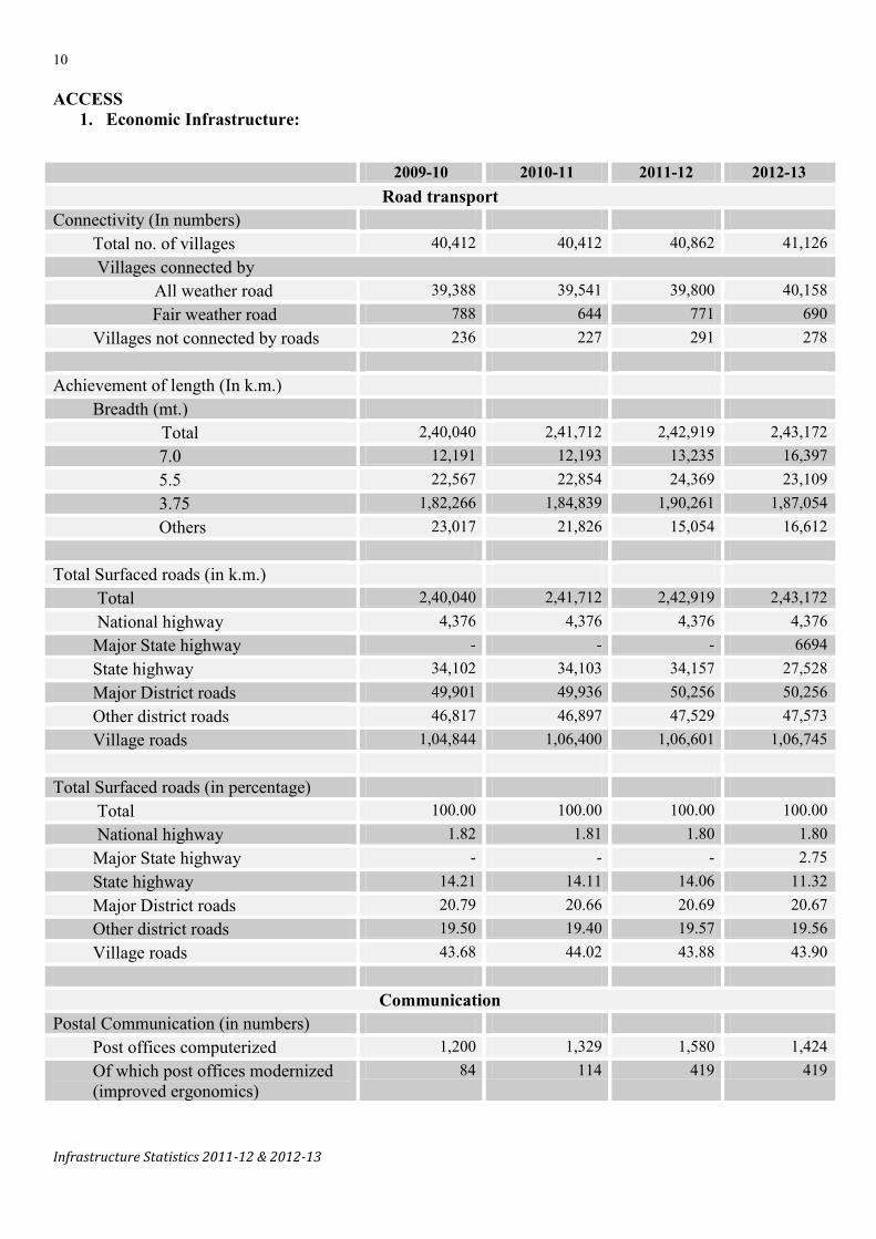
1. Economic Infrastructure:
2009-10 2010-11 2011-12 2012-13 Road transport
Connectivity (In numbers) Total no. of villages 40,412 40,412 40,862 41,126
Villages connected by All weather road 39,388 39,541 39,800 40,158 Fair weather road 788 644 771 690 Villages not connected by roads 236 227 291 278
Achievement of length (In k.m.)
Breadth (mt.) Total 2,40,040 2,41,712 2,42,919 2,43,172 7.0 12,191 12,193 13,235 16,397 5.5 22,567 22,854 24,369 23,109 3.75 1,82,266 1,84,839 1,90,261 1,87,054 Others 23,017 21,826 15,054 16,612
Total Surfaced roads (in k.m.) Total 2,40,040 2,41,712 2,42,919 2,43,172 National highway 4,376 4,376 4,376 4,376
Major State highway - - - 6694 State highway 34,102 34,103 34,157 27,528 Major District roads 49,901 49,936 50,256 50,256 Other district roads 46,817 46,897 47,529 47,573 Village roads 1,04,844 1,06,400 1,06,601 1,06,745
Total Surfaced roads (in percentage) Total 100.00 100.00 100.00 100.00 National highway 1.82 1.81 1.80 1.80
Major State highway - - - 2.75 State highway 14.21 14.11 14.06 11.32 Major District roads 20.79 20.66 20.69 20.67 Other district roads 19.50 19.40 19.57 19.56 Village roads 43.68 44.02 43.88 43.90
Communication Postal Communication (in numbers)
Post offices computerized 1,200 1,329 1,580 1,424 Of which post offices modernized (improved ergonomics)
84 114 419 419

11
Infrastructure Statistics 2011-12 & 2012-13
2. Social Infrastructure:
2009-10 2010-11 2011-12 2012-13 Percentage of actual irrigated area to irrigated potential created (in 000 ha)
53.67 61.23 67.38 49.71
Drinking Water Supply & Sanitation
(2001) (2011) Proportion of households having tap water (in percentage)
Treated - - - 83.0 Untreated - - - 17.0
2009-10 2010-11 2011-12 2012-13 Education
Proportion (%) of schools having Buildings 97.95 98.88 99.26 99.76 Water facilities 93.75 92.16 94.36 98.46 Electricity 74.61 77.44 80.69 90.17 Computers 39.42 40.80 44.54 49.54 Ramps 65.35 65.11 64.97 70.20 Play ground 67.66 63.13 63.38 75.91 Boundary wall 59.98 58.52 59.03 68.86 Kitchen shed 28.74 27.66 26.64 39.28 Common toilets 32.43 30.75 86.97 87.85 Girl toilets 69.63 71.71 76.09 97.32


13
Infrastructure Statistics 2011-12 & 2012-13
Road Transport
Table 1.1
Road length by type of Roads in Maharashtra State (Maintained by Public Works Department and Zilla Parishads)
(In km.)
Sr. No. Year
National highways
State highways
Major State
highways*
Major district roads
Other district roads
Village roads All roads
1 2 3 4 5 6 7 8 9 1 1980-81 2,945 18,949 - 25,233 25,404 68,600 1,41,131
2 1990-91 2,959 30,975 - 38,936 38,573 61,522 1,72,965
3 1995-96 2,958 32,249 - 40,514 40,733 68,829 1,85,283
4 2000-01 3,688 33,212 - 46,751 43,696 89,599 2,16,946
5 2005-06 4,367 33,571 - 48,987 45,226 99,279 2,31,430
6 2006-07 4,367 33,675 - 49,147 45,674 1,00,801 2,33,664
7 2007-08 4,367 33,800 - 49,393 45,886 1,02,149 2,35,595
8 2008-09 4,367 33,933 - 49,621 46,143 1,03,604 2,37,668
9 2009-10 4,376 34,102 - 49,901 46,817 1,04,844 2,40,040
10 2010-11 4,376 34,103 - 49,936 46,897 1,06,400 2,41,712
11 2011-12 4,376 34,157 - 50,256 47,529 1,06,601 2,42,919
12 2012-13 4,376 27,528 6,694 50,256 47,573 1,06,745 2,43,172
Source - Public Works Department, GoM
Note - (1) Unclassified roads included in village roads.
(2) The classification of road length upto 1987 was according to "Road Development Plan, 1961-81” and 1987-88 onwards it is according to "Road Development Plan ,1981-2001"
(3) * Road length statistics in this category has been introduced from year 2012-13 according to “R.D.P., 2001-2021”

14
Infrastructure Statistics 2011-12 & 2012-13
Table 1.2 Districtwise Road length by Breadth
(Maintained by Public Works Department and Zilla Parishads) (In km.) Sr. No.
District Achievement in Length 2012 Achievement in Length 2013 Breadth (mt.) 7.0 5.5 3.75 Other Total 7.0 5.5 3.75 Other Total
1 2 3 4 5 6 7 8 9 10 11 12 1 Mumbai
0 0 0 49 49 49 0 0 0 49 2 Mumbai Suburban 3 Thane 381 794 5,172 815 7,162 471 779 5,081 831 7,162 4 Raigad 496 578 4,181 144 5,399 631 545 4,079 144 5,399 5 Ratnagiri 375 435 6,558 0 7,368 604 638 6,126 0 7,368 6 Sindhudurg 131 657 5,393 0 6,181 277 570 5,334 0 6,181 Konkan Division 1,383 2,464 21,304 1,008 26,159 2,032 2,532 20,620 975 26,159 7 Nashik 739 1,309 11,462 674 14,184 982 1,066 11,492 674 14,214 8 Dhule 337 410 4,573 118 5,438 419 340 4,647 32 5,438 9 Nandurbar 170 448 4,054 0 4,672 416 216 4,040 0 4,672 10 Jalgaon 517 1,074 6,803 1,688 10,082 524 1,067 6,830 1,661 10,082 11 Ahmednagar 919 1,920 9,135 914 12,888 964 1,902 9,108 914 12,888 Nashik Division 2,682 5,161 36,027 3,394 47,264 3,305 4,591 36,117 3,281 47,294 12 Pune 756 937 12,144 239 14,076 959 834 12,106 237 14,136 13 Satara 213 900 7,140 1,794 10,047 213 900 7,155 1,779 10,047 14 Sangli 394 1,381 7,247 30 9,052 434 1,311 7,247 60 9,052 15 Solapur 1,225 922 11,216 22 13,385 1,320 832 11,216 22 13,390 16 Kolhapur 338 1,521 5,255 336 7,450 338 1,463 5,255 394 7,450 Pune Division 2,926 5,661 43,002 2,421 54,010 3,264 5,340 42,979 2,492 54,075 17 Aurangabad 477 683 7,291 1,386 9,837 495 659 7,249 1,434 9,837 18 Jalna 244 674 3,748 8 4,674 298 852 3,516 63 4,729 19 Parbhani 165 441 3,353 856 4,815 240 506 3,151 918 4,815 20 Hingoli 119 414 2,691 0 3,224 242 230 2,745 7 3,224 21 Beed 700 749 6,375 1,626 9,450 701 552 6,516 1,681 9,450 22 Nanded 438 614 8,774 376 10,202 816 352 8,495 539 10,202 23 Osmanabad 372 796 4,449 186 5,803 386 768 4,446 203 5,803 24 Latur 369 857 4,446 60 5,732 400 864 4,384 84 5,732 Aurangabad Divn 2,884 5,228 41,127 4,498 53,737 3,578 4,783 40,502 4,929 53,792 25 Buldhana 328 734 3,620 75 4,757 396 663 3,517 181 4,757 26 Akola 243 440 2,133 10 2,826 248 396 2,172 10 2,826 27 Washim 176 479 2,511 4 3,170 291 401 2,477 1 3,170 28 Amravati 455 827 5,352 125 6,759 565 750 5,319 149 6,783 29 Yavatmal 574 785 5,884 83 7,326 587 780 5,713 246 7,326 Amravati Divn. 1,776 3,265 19,500 297 24,838 2,087 2,990 19,198 587 24,862 30 Wardha 217 354 3,011 561 4,143 354 227 2,866 716 4,163 31 Nagpur 569 519 6,543 355 7,986 617 471 6,313 635 8,036 32 Bhandara 92 338 4,186 134 4,750 106 331 3,926 396 4,759 33 Gondiya 42 307 5,081 375 5,805 128 226 4,896 555 5,805 34 Chandrapur 401 502 5,769 974 7,646 497 1,191 4,946 1,012 7,646 35 Gadchiroli 263 570 4,711 1,037 6,581 429 427 4,691 1,034 6,581 Nagpur Division 1,584 2,590 29,301 3,436 36,911 2,131 2,873 27,638 4,348 36,990 Maharashtra State 13,235 24,369 1,90,261 15,054 2,42,919 16,397 23,109 1,87,054 16,612 2,43,172
Source - Public Works Department, GoM

15
Infrastructure Statistics 2011-12 & 2012-13
Table 1.3
Summary of Road Length (2011-12) (In km.)
Sr. No. District National
Highways State
Highways Major District
Roads Other District
Roads Village Roads
Total Roads
1 2 3 4 5 6 7 8 1 Mumbai
0 49 0 0 0 49 2 Mumbai Suburban 3 Thane 322 1,147 938 1,215 3,540 7,162 4 Raigad 232 1,265 669 796 2,437 5,399 5 Ratnagiri 275 902 1,423 1,384 3,384 7,368 6 Sindhudurg 108 719 1,007 1,007 3,270 6,181
Konkan Division 937 4,082 4,037 4,472 12,631 26,159 7 Nashik 235 1,690 2,265 2,400 7,594 14,184 8 Dhule 250 707 886 935 2,660 5,438 9 Nandurbar 45 666 1,095 693 2,173 4,672 10 Jalgaon 187 1,360 1,797 1,863 4,875 10,082 11 Ahmadnagar 201 1,875 2,890 3,350 4,572 12,888
Nashik Division 918 6,298 8,933 9,241 21,874 47,264 12 Pune 427 1,372 2,975 2,611 6,691 14,076 13 Satara 113 1,015 2,232 1,890 4,797 10,047 14 Sangli 30 968 2,199 2,810 3,045 9,052 15 Solapur 163 1,572 3,068 2,135 6,447 13,385 16 Kolhapur 110 893 1,632 2,140 2,675 7,450
Pune Division 843 5,820 12,106 11,586 23,655 54,010 17 Aurangabad 136 1,258 2,900 1,313 4,230 9,837 18 Jalna 22 1,287 1,339 817 1,209 4,674 19 Parbhani 77 653 1,238 740 2,107 4,815 20 Hingoli 30 527 872 514 1,281 3,224 21 Beed 193 1,197 1,644 1,443 4,973 9,450 22 Nanded 130 1,339 2,802 1,334 4,597 10,202 23 Osmanabad 207 926 1,432 1,270 1,968 5,803 24 Latur 0 886 1,548 1,348 1,950 5,732
Aurangabad Divn. 795 8,073 13,775 8,779 22,315 53,737 25 Buldhana 86 984 1,227 1,163 1,297 4,757 26 Akola 100 561 640 555 970 2,826 27 Washim 0 631 649 600 1,290 3,170 28 Amravati 76 1,459 1,539 1,219 2,466 6,759 29 Yavatmal 65 1,427 1,341 1,697 2,796 7,326
Amravati Division 327 5,062 5,396 5,234 8,819 24,838 30 Wardha 108 663 706 809 1,857 4,143 31 Nagpur 289 1,094 1,131 1,641 3,831 7,986 32 Bhandara 68 440 639 1,055 2,548 4,750 33 Gondiya 34 406 777 1,563 3,025 5,805 34 Chandrapur 0 877 1,566 1,743 3,460 7,646 35 Gadchiroli 57 1,342 1,190 1,406 2,586 6,581
Nagpur Division 556 4,822 6,009 8,217 17,307 36,911 Maharashtra State 4376 34,157 50,256 47,529 1,06,601 2,42,919 Source - Public Works Department, GoM

16
Infrastructure Statistics 2011-12 & 2012-13
Table 1.4
Summary of Road Length (2012-13) (In km.)
Source - Public Works Department, GoM
Sr. No. District
National Highways
Major State
Highways
State Highways
Major District Roads
Other District Roads
Village Roads
Total Roads
1 2 3 4 5 6 7 8 9 1 Mumbai
0 0 49 0 0 0 49 2 Mumbai Suburban 3 Thane 322 131 1,016 938 1,215 3,540 7,162 4 Raigad 232 150 1,115 669 796 2,437 5,399 5 Ratnagiri 275 235 667 1,423 1,384 3,384 7,368 6 Sindhudurg 108 154 565 1,007 1,077 3,270 6,181
Konkan Division 937 670 3,412 4,037 4,472 12,631 26,159 7 Nashik 235 478 1,212 2,265 2,400 7,624 14,214 8 Dhule 250 104 603 886 935 2,660 5,438 9 Nandurbar 45 232 434 1,095 693 2,173 4,672 10 Jalgaon 187 105 1,255 1,797 1,863 4,875 10,082 11 Ahmadnagar 201 347 1,528 2,890 3,350 4,572 12,888 Nashik Division 918 1,266 5,032 8,933 9,241 21,904 47,294 12 Pune 427 260 1,172 2,975 2,611 6,691 14,136 13 Satara 113 88 927 2,232 1,890 4,797 10,047 14 Sangli 30 104 864 2,199 2,810 3,045 9,052 15 Solapur 163 372 1,205 3,068 2,135 6,447 13,390 16 Kolhapur 110 35 858 1,632 2,140 2,675 7,450 Pune Division 843 859 5,026 12,106 11,586 23,655 54,075 17 Aurangabad 136 278 980 2,900 1,313 4,230 9,837 18 Jalna 22 213 1,074 1,339 817 1,264 4,729 19 Parbhani 77 112 541 1,238 740 2,107 4,815 20 Hingoli 30 155 372 872 514 1,281 3,224 21 Beed 193 214 983 1,644 1,443 4,973 9,450 22 Nanded 130 598 741 2,802 1,334 4,597 10,202 23 Osmanabad 207 39 887 1,432 1,270 1,968 5,803 24 Latur 0 148 738 1,548 1,348 1,950 5,732 Aurangabad Division 795 1,757 6,316 13,775 8,779 22,370 53,792 25 Buldhana 86 216 768 1,227 1,163 1,297 4,757 26 Akola 100 45 516 640 555 970 2,826 27 Washim 0 161 470 649 600 1,290 3,170 28 Amravati 76 272 1,187 1,539 1,243 2,466 6,783 29 Yavatmal 65 341 1,086 1,341 1,697 2,796 7,326 Amravati Division 327 1,035 4,027 5,396 5,258 8,819 24,862 30 Wardha 108 109 554 706 829 1,857 4,163 31 Nagpur 289 176 918 1,131 1,641 3,881 8,036 32 Bhandara 68 14 426 639 1,055 2,557 4,759 33 Gondiya 34 115 291 777 1,563 3,025 5,805 34 Chandrapur 0 338 539 1,566 1,743 3,460 7,646 35 Gadchiroli 57 355 987 1,190 1,406 2,586 6,581 Nagpur Division 556 1,107 3,715 6,009 8,237 17,366 36,990 Maharashtra State 4,376 6,694 27,528 50,256 47,573 1,06,745 2,43,172

17
Infrastructure Statistics 2011-12 & 2012-13
Table 1.5
Districtwise length of National Highways (Maintained by Public Works Department and Zilla Parishads)
(In km.) Sr. No.
District National Highways 2011-12 2012-13
Un surfaced
CC or BT
WBM Total surfaced
Total Un surfaced
CC or BT
WBM Total surfaced
Total
1 2 3 4 5 6 7 8 9 10 11 12 1 Mumbai 0 0 0 0 0 0 0 0 0 0 2 Mumbai Suburban 3 Thane 0 322 0 322 322 0 322 0 322 322 4 Raigad 0 232 0 232 232 0 232 0 232 232 5 Ratnagiri 0 275 0 275 275 0 275 0 275 275 6 Sindhudurg 0 108 0 108 108 0 108 0 108 108
Konkan Division 0 937 0 937 937 0 937 0 937 937 7 Nashik 0 235 0 235 235 0 235 0 235 235 8 Dhule 0 250 0 250 250 0 250 0 250 250 9 Nandurbar 0 45 0 45 45 0 45 0 45 45 10 Jalgaon 0 187 0 187 187 0 187 0 187 187 11 Ahmadnagar 0 201 0 201 201 0 201 0 201 201
Nashik Division 0 918 0 918 918 0 918 0 918 918 12 Pune 0 427 0 427 427 0 427 0 427 427 13 Satara 0 113 0 113 113 0 113 0 113 113 14 Sangli 0 30 0 30 30 0 30 0 30 30 15 Solapur 0 163 0 163 163 0 163 0 163 163 16 Kolhapur 0 110 0 110 110 0 110 0 110 110
Pune Division 0 843 0 843 843 0 843 0 843 843 17 Aurangabad 0 136 0 136 136 0 136 0 136 136 18 Jalna 0 22 0 22 22 0 22 0 22 22 19 Parbhani 0 77 0 77 77 0 77 0 77 77 20 Hingoli 0 30 0 30 30 0 30 0 30 30 21 Beed 0 193 0 193 193 0 193 0 193 193 22 Nanded 0 130 0 130 130 0 130 0 130 130 23 Osmanabad 0 207 0 207 207 0 207 0 207 207 24 Latur 0 0 0 0 0 0 0 0 0 0
Aurangabad Division 0 795 0 795 795 0 795 0 795 795 25 Buldhana 0 86 0 86 86 0 86 0 86 86 26 Akola 0 100 0 100 100 0 100 0 100 100 27 Washim 0 0 0 0 0 0 0 0 0 0 28 Amravati 0 76 0 76 76 0 76 0 76 76 29 Yavatmal 0 65 0 65 65 0 65 0 65 65
Amravati Division 0 327 0 327 327 0 327 0 327 327 30 Wardha 0 108 0 108 108 0 108 0 108 108 31 Nagpur 0 289 0 289 289 0 289 0 289 289 32 Bhandara 0 68 0 68 68 0 68 0 68 68 33 Gondiya 0 34 0 34 34 0 34 0 34 34 34 Chandrapur 0 0 0 0 0 0 0 0 0 0 35 Gadchiroli 0 39 18 57 57 0 39 18 57 57
Nagpur Division 0 538 18 556 556 0 538 18 556 556 Maharashtra State 0 4,358 18 4,376 4,376 0 4,358 18 4,376 4,376
Source - Public Works Department, GoM

18
Infrastructure Statistics 2011-12 & 2012-13
Table 1.6
Districtwise length of Major State Highways (Maintained by Public Works Department and Zilla Parishads)
(In km.) Sr. No.
District Major State Highways * 2011-12 2012-13
Un surfaced
CC or BT
WBM Total surfaced
Total Un surfaced
CC or BT
WBM Total surfaced
Total
1 2 3 4 5 6 7 8 9 10 11 12 1 Mumbai - - - - - 0 0 0 0 0 2 Mumbai Suburban 3 Thane - - - - - 6 125 0 125 131 4 Raigad - - - - - 0 150 0 150 150 5 Ratnagiri - - - - - 0 232 3 235 235 6 Sindhudurg - - - - - 0 154 0 154 154 Konkan Division - - - - - 6 661 3 664 670 7 Nashik - - - - - 0 478 0 478 478 8 Dhule - - - - - 0 104 0 104 104 9 Nandurbar - - - - - 0 232 0 232 232 10 Jalgaon - - - - - 0 105 0 105 105 11 Ahmadnagar - - - - - 0 347 0 347 347 Nashik Division - - - - - 0 1,266 0 1,266 1,266 12 Pune - - - - - 0 260 0 260 260 13 Satara - - - - - 0 88 0 88 88 14 Sangli - - - - - 0 104 0 104 104 15 Solapur - - - - - 0 372 0 372 372 16 Kolhapur - - - - - 0 35 0 35 35 Pune Division - - - - - 0 859 0 859 859 17 Aurangabad - - - - - 10 268 0 268 278 18 Jalna - - - - - 19 194 0 194 213 19 Parbhani - - - - - 13 99 0 99 112 20 Hingoli - - - - - 5 150 0 150 155 21 Beed - - - - - 4 210 0 210 214 22 Nanded - - - - - 36 562 0 562 598 23 Osmanabad - - - - - 11 28 0 28 39 24 Latur - - - - - 25 123 0 123 148 Aurangabad Divn. - - - - 123 1,634 0 1,634 1,757 25 Buldhana - - - - - 0 216 0 216 216 26 Akola - - - - - 0 45 0 45 45 27 Washim - - - - - 0 161 0 161 161 28 Amravati - - - - - 0 272 0 272 272 29 Yavatmal - - - - - 16 325 0 325 341 Amravati Division - - - - 16 1,019 0 1,019 1,035 30 Wardha - - - - - 0 109 0 109 109 31 Nagpur - - - - - 4 172 0 172 176 32 Bhandara - - - - - 0 14 0 14 14 33 Gondiya - - - - - 0 115 0 115 115 34 Chandrapur - - - - - 11 327 0 327 338 35 Gadchiroli - - - - - 0 355 0 355 355 Nagpur Division - - - - - 15 1,092 0 1,092 1,107 Maharashtra State - - - - - 160 6,531 3 6,534 6,694 Note - * Road length statistics in this category has been introduced from the year 2012-13 according to “R.D.P.,2001-2021”

19
Infrastructure Statistics 2011-12 & 2012-13
Table 1.7
Districtwise length of State Highways (Maintained by Public Works Department and Zilla Parishads)
(In km.) Sr. No.
District State Highways 2011-12 * 2012-13
Un surfaced
CC or BT
WBM Total surfaced
Total Un surfaced
CC or BT
WBM Total surfaced
Total
1 2 3 4 5 6 7 8 9 10 11 12 1 Mumbai
0 49 0 49 49 0 49 0 49 49 2 Mumbai Suburban
3 Thane 8 1,131 8 1,139 1,147 2 1,006 8 1,014 1,016 4 Raigad 16 1,242 7 1,249 1,265 16 1,092 7 1,099 1,115 5 Ratnagiri 0 889 13 902 902 0 657 10 667 667 6 Sindhudurg 0 719 0 719 719 0 565 0 565 565
Konkan Division 24 4,030 28 4,058 4,082 18 3,369 25 3,394 3,412 7 Nashik 1 1,688 1 1,689 1,690 0 1,211 1 1,212 1,212 8 Dhule 0 706 1 707 707 0 603 0 603 603 9 Nandurbar 0 666 0 666 666 0 434 0 434 434 10 Jalgaon 26 1,316 18 1,334 1,360 26 1,211 18 1,229 1,255 11 Ahmadnagar 2 1,844 29 1,873 1,875 2 1,506 20 1,526 1,528 Nashik Division 29 6,220 49 6,269 6,298 28 4,965 39 5,004 5,032 12 Pune 0 1,370 2 1,372 1,372 0 1,170 2 1,172 1,172 13 Satara 0 1,005 10 1,015 1,015 0 926 1 927 927 14 Sangli 10 958 0 958 968 10 854 0 854 864 15 Solapur 19 1,553 0 1,553 1,572 19 1,186 0 1,186 1,205 16 Kolhapur 9 876 8 884 893 9 845 4 849 858 Pune Division 38 5,762 20 5,782 5,820 38 4,981 7 4,988 5,026 17 Aurangabad 0 1,255 3 1,258 1,258 0 977 3 980 980 18 Jalna 0 1,279 8 1,287 1,287 0 1,074 0 1,074 1,074 19 Parbhani 0 653 0 653 653 0 541 0 541 541 20 Hingoli 0 527 0 527 527 0 372 0 372 372 21 Beed 0 1,197 0 1,197 1,197 0 983 0 983 983 22 Nanded 0 1,338 1 1,339 1,339 0 741 0 741 741 23 Osmanabad 0 926 0 926 926 0 887 0 887 887 24 Latur 0 882 4 886 886 0 734 4 738 738 Aurangabad Divn. 0 8,057 16 8,073 8,073 0 6,309 7 6,316 6,316 25 Buldhana 0 984 0 984 984 0 768 0 768 768 26 Akola 0 561 0 561 561 0 516 0 516 516 27 Washim 0 631 0 631 631 0 470 0 470 470 28 Amravati 0 1,429 30 1,459 1,459 0 1,157 30 1,187 1,187 29 Yavatmal 0 1,427 0 1,427 1,427 0 1,086 0 1,086 1,086 Amravati Division 0 5,032 30 5,062 5,062 0 3,997 30 4,027 4,027 30 Wardha 0 663 0 663 663 0 554 0 554 554 31 Nagpur 29 1,052 13 1,065 1,094 25 880 13 893 918 32 Bhandara 0 440 0 440 440 0 426 0 426 426 33 Gondiya 5 401 0 401 406 5 286 0 286 291 34 Chandrapur 2 872 3 875 877 0 536 3 539 539 35 Gadchiroli 60 1,212 70 1,282 1,342 0 857 130 987 987
Nagpur Division 96 4,640 86 4,726 4,822 30 3,539 146 3,685 3,715 Maharashtra State 187 33,741 229 33,970 34,157 114 27,160 254 27,414 27,528 Note - * includes both state and major state highway roads

20
Infrastructure Statistics 2011-12 & 2012-13
Table 1.8
Districtwise length of Major District Roads (Maintained by Public Works Department and Zilla Parishads)
(In km.) Sr. No.
District Major District Roads 2011-12 2012-13
Un surfaced
CC or BT
WBM Total surfaced
Total Un surfaced
CC or BT
WBM Total Surfaced
Total
1 2 3 4 5 6 7 8 9 10 11 12 1 Mumbai
0 0 0 0 0 0 0 0 0 0 2 Mumbai Suburban 3 Thane 32 868 38 906 938 32 868 38 906 938 4 Raigad 29 623 17 640 669 29 623 17 640 669 5 Ratnagiri 0 1,388 35 1,423 1,423 0 1,401 22 1,423 1,423 6 Sindhudurg 21 958 28 986 1,007 21 958 28 986 1,007
Konkan Division 82 3,837 118 3,955 4,037 82 3,850 105 3,955 4,037 7 Nashik 14 2,127 124 2,251 2,265 10 2,127 128 2,255 2,265 8 Dhule 47 825 14 839 886 45 825 16 841 886 9 Nandurbar 161 858 76 934 1095 161 858 76 934 1,095 10 Jalgaon 114 1,537 146 1,683 1,797 114 1,537 146 1,683 1,797 11 Ahmadnagar 44 2,419 427 2,846 2,890 44 2,419 427 2,846 2,890 Nashik Division 380 7,766 787 8,553 8,933 374 7,766 793 8,559 8,933 12 Pune 159 2,684 132 2,816 2,975 159 2,715 101 2,816 2,975 13 Satara 99 1,836 297 2,133 2,232 99 2,133 0 2,133 2,232 14 Sangli 117 1,955 127 2,082 2,199 117 2,082 0 2,082 2,199 15 Solapur 109 2,450 509 2,959 3,068 109 2,925 34 2,959 3,068 16 Kolhapur 96 1,455 81 1,536 1,632 96 1,536 0 1,536 1,632 Pune Division 580 10,380 1,146 11,526 12,106 580 11,391 135 11,526 12,106 17 Aurangabad 16 1,592 1,292 2,884 2,900 16 1,592 1,292 2,884 2,900 18 Jalna 2 932 405 1,337 1,339 2 932 405 1,337 1,339 19 Parbhani 21 843 374 1,217 1,238 21 843 374 1,217 1,238 20 Hingoli 0 623 249 872 872 0 707 165 872 872 21 Beed 8 1,586 50 1,636 1,644 8 1,586 50 1,636 1,644 22 Nanded 30 2,069 703 2,772 2,802 30 2,213 559 2,772 2,802 23 Osmanabad 0 1,253 179 1,432 1,432 0 1,282 150 1,432 1,432 24 Latur 0 1,502 46 1,548 1,548 0 1,502 46 1,548 1,548 Aurangabad Divn. 77 10,400 3,298 13,698 13,775 77 10,657 3,041 13,698 13,775 25 Buldhana 27 1,143 57 1,200 1,227 27 1,143 57 1,200 1,227 26 Akola 6 631 3 634 640 6 631 3 634 640 27 Washim 4 601 44 645 649 0 632 17 649 649 28 Amravati 0 1,291 248 1,539 1,539 0 1,447 92 1,539 1,539 29 Yavatmal 18 1,239 84 1,323 1,341 18 1,239 84 1,303 1,321 Amravati Division 55 4,905 436 5,341 5,396 51 5,092 253 5,345 5,396 30 Wardha 1 660 45 705 706 1 660 45 705 706 31 Nagpur 5 1,097 29 1,126 1,131 5 1,097 29 1,126 1,131 32 Bhandara 9 581 49 630 639 9 581 49 630 639 33 Gondiya 0 754 23 777 777 0 754 23 777 777 34 Chandrapur 2 1,328 236 1,564 1,566 2 1,328 236 1,564 1,566 35 Gadchiroli 13 729 448 1,177 1,190 13 940 237 1,177 1,190 Nagpur Division 30 5,149 830 5,979 6,009 30 5,360 619 5,979 6,009 Maharashtra State 1,204 42,437 6,615 49,052 50,256 1,194 44,116 4,946 49,062 50,256
Source - Public Works Department, GoM

21
Infrastructure Statistics 2011-12 & 2012-13
Table 1.9
Districtwise length of Other District Roads (Maintained by Public Works Department and Zilla Parishads)
(In km.) Sr. No.
District Other District Roads 2011-12 2012-13
Un surfaced
CC or BT
WBM Total surfaced
Total Un surfaced
CC or BT
WBM Total surfaced
Total
1 2 3 4 5 6 7 8 9 10 11 12 1 Mumbai
0 0 0 0 0 0 0 0 0 0 2 Mumbai Suburban
3 Thane 110 979 126 1,105 1,215 110 979 126 1,105 1,215 4 Raigad 13 635 148 783 796 13 635 148 783 796 5 Ratnagiri 15 1,158 211 1,369 1,384 15 1,165 204 1,369 1,384 6 Sindhudurg 15 647 415 1,062 1,077 15 647 415 1,062 1,077
Konkan Division 153 3,419 900 4,319 4,472 153 3,426 893 4,319 4,472 7 Nashik 58 1,395 947 2,342 2,400 58 1,395 947 2,342 2,400 8 Dhule 73 611 251 862 935 73 611 251 862 935 9 Nandurbar 51 495 147 642 693 51 546 96 642 693 10 Jalgaon 135 1,375 353 1,728 1,863 130 1,380 353 1,733 1,863 11 Ahmadnagar 362 2,042 946 2,988 3,350 362 2,042 946 2,988 3,350 Nashik Division 679 5,918 2,644 8,562 9,241 674 5,974 2,593 8,567 9,241 12 Pune 568 1,199 844 2,043 2,611 568 1,199 844 2,043 2,611 13 Satara 230 1,008 652 1,660 1,890 230 1,008 652 1,660 1,890 14 Sangli 713 1,615 482 2,097 2,810 713 1,615 482 2,097 2,810 15 Solapur 197 1,185 753 1,938 2,135 197 1,185 753 1,938 2,135 16 Kolhapur 480 1,394 266 1,660 2,140 480 1,394 266 1,660 2,140 Pune Division 2,188 6,401 2,997 9,398 11,586 2,188 6,401 2,997 9,398 11,586 17 Aurangabad 35 766 512 1,278 1,313 35 925 353 1,278 1,313 18 Jalna 19 361 437 798 817 19 361 437 798 817 19 Parbhani 20 390 330 720 740 20 390 330 720 740 20 Hingoli 0 285 229 514 514 0 431 83 514 514 21 Beed 33 1,079 331 1,410 1,443 33 1,079 331 1,410 1,443 22 Nanded 44 884 406 1,290 1,334 44 884 406 1,290 1,334 23 Osmanabad 52 862 356 1,218 1,270 52 911 307 1,218 1,270 24 Latur 14 1,097 237 1,334 1,348 14 1,100 234 1,334 1,348 Aurangabad Divn. 217 5,724 2,838 8,562 8,779 217 6,081 2,481 8,562 8,779 25 Buldhana 25 955 183 1,138 1,163 25 955 183 1,138 1,163 26 Akola 11 497 47 544 555 3 497 55 552 555 27 Washim 0 549 51 600 600 0 558 42 600 600 28 Amravati 34 928 257 1,185 1,219 34 928 281 1,209 1,243 29 Yavatmal 29 1,374 294 1,668 1,697 29 1,374 294 1,668 1,697 Amravati Division 99 4,303 832 5,135 5,234 91 4,312 855 5,167 5,258 30 Wardha 90 711 8 719 809 90 711 28 739 829 31 Nagpur 71 1,440 130 1,570 1,641 71 1,440 130 1,570 1,641 32 Bhandara 64 925 66 991 1,055 64 925 66 991 1,055 33 Gondiya 216 1,017 330 1,347 1,563 216 1,017 330 1,347 1,563 34 Chandrapur 61 840 842 1,682 1,743 61 1,154 528 1,682 1,743 35 Gadchiroli 0 827 579 1,406 1,406 0 896 510 1406 1,406 Nagpur Division 502 5,760 1,955 7,715 8,217 502 6,143 1,592 7,735 8,237 Maharashtra State 3,838 31,525 12,166 43,691 47,529 3,825 32,337 11,411 43,748 47,573
Source - Public Works Department, GoM

22
Infrastructure Statistics 2011-12 & 2012-13
Table 1.10
Districtwise length of Village Roads (Maintained by Public Works Department and Zilla Parishads)
(In km.) Sr. No
District Village Roads 2011-12 2012-13
Un surfaced
CC or BT
WBM Total surfaced
Total Un surfaced
CC or BT
WBM Total surfaced
Total
1 2 3 4 5 6 7 8 9 10 11 12 1 Mumbai
0 0 0 0 0 0 0 0 0 0 2 Mumbai Suburban
3 Thane 108 1,950 1,482 3,432 3,540 108 1,950 1,482 3,432 3,540 4 Raigad 194 1,441 802 2,243 2,437 194 1,441 802 2,243 2,437 5 Ratnagiri 205 2,121 1,058 3,179 3,384 205 2,160 1,019 3,179 3,384 6 Sindhudurg 82 1,529 1,659 3,188 3,270 82 1,574 1,614 3,188 3,270
Konkan Division 589 7,041 5,001 12,042 12,631 589 7,125 4,917 12,042 12,631 7 Nashik 1,010 2,203 4,381 6,584 7,594 1,010 2,,203 4,411 6,614 7,624 8 Dhule 466 1,149 1,045 2,194 2,660 466 1,149 1,045 2,194 2,660 9 Nandurbar 459 1,202 512 1,714 2,173 459 1,202 512 1,714 2,173
10 Jalgaon 1,269 1,584 2,022 3,606 4,875 1,269 1,584 2,022 3,606 4,875 11 Ahmadnagar 1,058 1,562 1,952 3,514 4,572 1,058 1,562 1,952 3,514 4,572 Nashik Division 4,262 7,700 9,912 17,612 21,874 4,262 7,700 9,942 17,642 21,904 12 Pune 2,351 2,227 2,113 4,340 6,691 2,351 2,227 2,113 4,340 6,691 13 Satara 1,135 1,614 2,048 3,662 4,797 1,135 1,614 2,048 3,662 4,797 14 Sangli 1,275 1,101 669 1,770 3,045 1,275 1,101 669 1,770 3,045 15 Solapur 1,112 2,435 2,900 5,335 6,447 1,112 2,435 2,900 5,335 6,447 16 Kolhapur 850 1,194 631 1,825 2,675 850 1,194 631 1,825 2,675 Pune Division 6,723 8,571 8,361 16,932 23,655 6,723 8,571 8,361 16,932 23,655 17 Aurangabad 190 1,088 2,952 4,040 4,230 190 2417 1,623 4,040 4,230 18 Jalna 65 422 722 1,144 1,209 65 422 777 1,199 1,264 19 Parbhani 160 517 1,430 1,947 2,107 160 517 1,430 1,947 2,107 20 Hingoli 90 471 720 1,191 1,281 0 600 681 1,281 1,281 21 Beed 1,143 1,355 2,475 3,830 4,973 1,143 1,355 2,475 3,830 4,973 22 Nanded 280 1,550 2,767 4,317 4,597 280 1,550 2,767 4,317 4,597 23 Osmanabad 92 949 927 1,876 1,968 92 949 927 1,876 1,968 24 Latur 52 1,071 827 1,898 1,950 52 1,071 827 1,898 1,950 Aurangabad Divn. 2,072 7,423 12,820 20,243 22,315 1,982 8,881 11,507 20,388 22,370 25 Buldhana 75 793 429 1,222 1,297 75 793 429 1,222 1,297 26 Akola 30 660 280 940 970 30 660 280 940 970 27 Washim 4 717 569 1,286 1,290 4 717 569 1,286 1,290 28 Amravati 190 1,284 992 2,276 2,466 190 1,284 992 2,276 2,466 29 Yavatmal 40 1,716 1,040 2,756 2,796 40 1,716 1,040 2,756 2,796 Amravati Divn. 339 5,170 3,310 8,480 8,819 339 5,170 3,310 8,480 8,819 30 Wardha 408 1,028 421 1,449 1,857 408 1,028 421 1,449 1,857 31 Nagpur 36 3,210 585 3,795 3,831 36 3,210 635 3,845 3,881 32 Bhandara 0 1,927 621 2,548 2,548 0 1,927 630 2,557 2,557 33 Gondiya 40 1,975 1,010 2,985 3,025 40 1,975 1,010 2,985 3,025 34 Chandrapur 119 1,530 1,811 3,341 3,460 119 1,569 1,772 3,341 3,460 35 Gadchiroli 0 1,223 1,363 2,586 2,586 0 1,399 1,187 2,586 2,586 Nagpur Division 603 10,893 5,811 16,704 17,307 603 11,108 5,655 16,763 17,366 Maharashtra State 14,588 46,798 45,215 92,013 1,06,601 14,498 48,555 43,692 92,247 1,06,745
Source - Public Works Department, GoM

23
Infrastructure Statistics 2011-12 & 2012-13
Table 1.11
Districtwise length of Total Roads (Maintained by Public Works Department and Zilla Parishads)
(In km.)
Sr. No
District Total Roads 2011-12 2012-13
Un surfaced
CC or BT
WBM Total Surfaced
Total Un surfaced
CC or BT WBM Total Surfaced
Total
1 2 3 4 5 6 7 8 9 10 11 12 1 Mumbai 0 49 0 49 49 0 49 0 49 49 2 Mumbai Suburban 3 Thane 258 5,250 1,654 6,904 7,162 258 5,250 1,654 6,904 7,162 4 Raigad 252 4,173 974 5,147 5,399 252 4,173 974 5,147 5,399 5 Ratnagiri 220 5,831 1,317 7,148 7,368 220 5,890 1,258 7,148 7,368 6 Sindhudurg 118 3,961 2,102 6,063 6,181 118 4,006 2,057 6,063 6,181
Konkan Divn. 848 19,264 6,047 25,311 26,159 848 19,368 5,943 25,311 26,159 7 Nashik 1,083 7,648 5,453 13,101 14,184 1,078 7,649 5,487 13,136 14,214 8 Dhule 586 3,541 1,311 4,852 5,438 584 3,542 1,312 4,854 5,438 9 Nandurbar 671 3,266 735 4,001 4,672 671 3,317 684 4,001 4,672 10 Jalgaon 1,544 5,999 2,539 8,538 10,082 1,539 6,004 2,539 8,543 10,082 11 Ahmadnagar 1,466 8,068 3,354 11,422 12,888 1,466 8,077 3,345 11,422 12,888 Nashik Division 5,350 28,522 13,392 41,914 47,264 5,338 28,589 13,367 41,956 47,294 12 Pune 3,078 7,907 3,091 10,998 14,076 3,078 7,998 3,060 11,058 14,136 13 Satara 1,464 5,576 3,007 8,583 10,047 1,464 5,882 2,701 8,583 10,047 14 Sangli 2,115 5,659 1,278 6,937 9,052 2,115 5,786 1,151 6,937 9,052 15 Solapur 1,437 7,786 4,162 11,948 13,385 1,437 8,266 3,687 11,953 13,390 16 Kolhapur 1,435 5,029 986 6,015 7,450 1,435 5,114 901 6,015 7,450 Pune Division 9,529 31,957 12,524 44,481 54,010 9,529 33,046 11,500 44,546 54,075 17 Aurangabad 241 4,837 4,759 9,596 9,837 251 6,315 3,271 9,586 9,837 18 Jalna 86 3,016 1,572 4,588 4,674 105 3,005 1,619 4,624 4,729 19 Parbhani 201 2,480 2,134 4,614 4,815 214 2,467 2,134 4,601 4,815 20 Hingoli 90 1,936 1,198 3,134 3,224 5 2,290 929 3,219 3,224 21 Beed 1,184 5,410 2,856 8,266 9,450 1,188 5,406 2,856 8,262 9,450 22 Nanded 354 5,971 3,877 9,848 10,202 390 6,080 3,732 9,812 10,202 23 Osmanabad 144 4,197 1,462 5,659 5,803 155 4,264 1,384 5,648 5,803 24 Latur 66 4,552 1,114 5,666 5,732 91 4,530 1,111 5,641 5,732 Aurangabad Divn. 2,366 32,399 18,972 51,371 53,737 2,399 34,357 17,036 51,393 53,792 25 Buldhana 127 3,961 669 4,630 4,757 127 3,961 669 4,630 4,757 26 Akola 47 2,449 330 2,779 2,826 39 2,449 338 2,787 2,826 27 Washim 8 2,498 664 3,162 3,170 4 2,538 628 3,166 3,170 28 Amravati 224 5,008 1,527 6,535 6,759 224 5,164 1,395 6,559 6,783 29 Yavatmal 87 5,821 1,418 7,239 7,326 103 5,805 1,418 7,223 7,326 Amravati Division 493 19,737 4,608 24,345 24,838 497 19,917 4,448 24,365 24,862 30 Wardha 499 3,170 474 3,644 4,143 499 3,170 494 3,664 4,163 31 Nagpur 141 7,088 757 7,845 7,986 141 7,088 807 7,895 8,036 32 Bhandara 73 3,941 736 4,677 4,750 73 3,941 745 4,686 4,759 33 Gondiya 261 4,181 1,363 5,544 5,805 261 4,181 1,363 5,544 5,805 34 Chandrapur 184 4,570 2,892 7,462 7,646 193 4,914 2,539 7,453 7,646 35 Gadchiroli 73 4,030 2,478 6,508 6,581 13 4,486 2,082 6,568 6,581 Nagpur Division 1,231 26,980 8,700 35,680 36,911 1,180 27,780 8,030 35,810 36,990 Maharashtra State 19,817 1,58,859 64,243 22,3102 2,42,919 19,791 1,63,057 60,324 2,23,381 2,43,172
Source - Public Works Department, GoM

24
Infrastructure Statistics 2011-12 & 2012-13
Table 1.12 Districtwise Road Density by Area and Population
(In Km.)
Sr. No.
District Road Density Per 100 sq. km. of area Per lakh population
2011-12 2012-13 2011-12 2012-13 1 2 3 4 5 6 1 Mumbai
8 8 0.39 0.35 2 Mumbai Suburban 3 Thane 75 75 65 75 4 Raigad 75 75 205 205 5 Ratnagiri 90 90 456 456 6 Sindhudurg 119 119 727 727
Konkan Division 85 85 91 89 7 Nashik 91 92 232 233 8 Dhule 76 76 265 265 9 Nandurbar 78 78 283 283
10 Jalgaon 86 86 238 238 11 Ahmednagar 76 76 284 284
Nashik Division 82 82 254 255 12 Pune 90 90 149 150 13 Satara 96 96 334 334 14 Sangli 106 106 321 321 15 Solapur 90 90 310 310 16 Kolhapur 97 97 192 192
Pune Division 94 94 230 229 17 Aurangabad 97 97 266 266 18 Jalna 61 61 239 241 19 Parbhani 77 77 262 262 20 Hingoli 67 67 274 274 21 Beed 88 88 366 366 22 Nanded 97 97 304 304 23 Osmanabad 77 77 350 350 24 Latur 80 80 234 234
Aurangabad Division 83 83 287 292 25 Buldhana 49 49 184 184 26 Akola 50 50 156 156 27 Washim 65 65 265 265 28 Amravati 55 56 234 235 29 Yavatmal 54 54 264 264
Amravati Division 54 54 221 212 30 Wardha 66 66 319 320 31 Nagpur 81 81 172 173 32 Bhandara 116 116 396 396 33 Gondiya 111 111 439 439 34 Chandrapur 67 67 347 347 35 Gadchiroli 46 46 613 613
Nagpur Division 72 72 314 294 Maharashtra State 79 79 216 213

25
Infrastructure Statistics 2011-12 & 2012-13
Table 1.13 Districtwise Road Connectivity (2011-12)
(In Numbers)
Sr. No. District Total Villages
Villages Connected by
all-weather roads
Villages Connected by fair-
weather roads
Villages not connected by
roads
1 2 3 4 5 6 1 Mumbai
0 0 0 0 2 Mumbai Suburban 3 Thane 1,747 1,720 12 15 4 Raigad 1,851 1,812 5 34 5 Ratnagiri 1,540 1,509 22 9 6 Sindhudurg 743 732 9 2 Konkan Division 5,881 5,773 48 60 7 Nashik 1,896 1,821 75 0 8 Dhule 678 676 0 2 9 Nandurbar 935 846 45 44 10 Jalgaon 1,485 1,315 167 3 11 Ahmednagar 1,578 1,577 0 1 Nashik Division 6,572 6,235 287 50
12 Pune 1,845 1,829 9 7 13 Satara 1,716 1,641 22 53 14 Sangli 724 724 0 0 15 Solapur 1,133 1,132 1 0 16 Kolhapur 1,204 1,198 5 1 Pune Division 6,622 6,524 37 61
17 Aurangabad 1,215 1,136 79 0 18 Jalna 958 952 2 4 19 Parbhani 808 808 0 0 20 Hingoli 663 656 7 0 21 Beed 1,269 1,262 7 0 22 Nanded 1,521 1,503 18 0 23 Osmanabad 801 801 0 0 24 Latur 914 914 0 0 Aurangabad Division 8,149 8,032 113 4
25 Buldhana 1,300 1,254 21 25 26 Akola 862 858 3 1 27 Washim 706 703 2 1 28 Amravati 1,679 1,679 0 0 29 Yavatmal 1,856 1,832 12 12 Amravati Division 6,403 6,326 38 39
30 Wardha 967 965 1 1 31 Nagpur 1,624 1,624 0 0 32 Bhandara 772 772 0 0 33 Gondiya 882 882 0 0 34 Chandrapur 1,498 1,492 6 0 35 Gadchiroli 1,492 1,175 241 76 Nagpur Division 7,235 6,910 248 77 Maharashtra State 40,862 39,800 771 291
Source - Public Works Department, GoM

26
Infrastructure Statistics 2011-12 & 2012-13
Table 1.14
Districtwise Road Connectivity (2012-13) (In Numbers)
Sr. No. District Total Villages
Villages Connected by
all-weather roads
Villages Connected by fair-weather
roads
Villages not connected by
roads
1 2 3 4 5 6 1 Mumbai
0
0
0
0 2 Mumbai Suburban 3 Thane 1,748 1,721 12 15 4 Raigad 1,860 1,812 17 31 5 Ratnagiri 1,541 1,509 23 9 6 Sindhudurg 743 732 9 2 Konkan Division 5,892 5,774 61 57 7 Nashik 1,900 1,818 82 0 8 Dhule 678 677 0 1 9 Nandurbar 935 864 28 43
10 Jalgaon 1,491 1,321 167 3 11 Ahmednagar 1,578 1,577 0 1 Nashik Division 6,582 6,257 277 48
12 Pune 1,845 1,833 5 7 13 Satara 1,716 1,642 21 53 14 Sangli 724 724 0 0 15 Solapur 1,133 1,132 1 0 16 Kolhapur 1,204 1,198 5 1 Pune Division 6,622 6,529 32 61
17 Aurangabad 1,307 1,293 14 0 18 Jalna 967 963 2 2 19 Parbhani 838 838 0 0 20 Hingoli 676 676 0 0 21 Beed 1,360 1,353 7 0 22 Nanded 1,559 1,541 18 0 23 Osmanabad 737 737 0 0 24 Latur 926 926 0 0 Aurangabad Division 8,370 8,327 41 2
25 Buldhana 1,297 1,256 19 22 26 Akola 862 859 2 1 27 Washim 706 703 2 1 28 Amravati 1,679 1,679 0 0 29 Yavatmal 1,856 1,839 8 9 Amravati Division 6,400 6,336 31 33
30 Wardha 967 965 1 1 31 Nagpur 1,628 1,628 0 0 32 Bhandara 779 779 0 0 33 Gondiya 893 893 0 0 34 Chandrapur 1,472 1,466 6 0 35 Gadchiroli 1,521 1,204 241 76 Nagpur Division 7,260 6,935 248 77 Maharashtra State 41,126 40,158 690 278
Source - Public Works Department, GoM

27
Infrastructure Statistics 2011-12 & 2012-13
Table 1.15
Categorywise Number of Motor Vehicles on Road
Sr. No. Class of vehicles 1971 1981 1991 2001 2011-12 2012-13
1 2 3 4 5 6 7 8
2 Motor cars, Jeeps & Station wagons 1,22,508 2,24,752 4,23,505 9,01,278 27,50,167 30,65,359
3 Taxi cabs 17,806 31,302 43168 86,438 1,75,797 1,84,066
4 Auto rickshaws 3,049 29,474 1,26,049 4,07,660 6,40,040 6,55,299
5 Stage carriages— 10,250 13,789 18,203 27,286 32,645 35,133
6 Contract carriages … 1,498 3,980 13,975 29,663 33,257
7 Lorries— 10,67,825 11,80,591
(i) Diesel engine 34,987 87,079 1,80,883 3,41,344 9,95,399 11,14,345
(ii) Petrol engine 21,791 18,005 13,774 57,317 61,379 61,082
(iii) LPG engine … … … … 562 726
(iv) CNG engine … … … … 10,485 4,438
8 Ambulances 441 925 2,233 4,025 10,557 11,792
9 School buses 491 594 1,025 1,714 17,781 19,845
10 Private service vehicles 810 2,171 4,622 5,815 9,451 10,094
11 Trailers 7,075 23,173 60,858 1,67,856 3,24,824 3,37,877
12 Tractors 7,821 24,079 61,088 1,72,578 4,19,291 4,61,932
13 Others 810 1,319 5,040 9,872 32,557 35,734
Total 3,11,669 804986 2640585 6607054 1,94,32,361 2,14,88,152
Motor vehicles per lakh of population 618 1,309 3,353 7,186 17,293 18,819
Number of vehicles per km. road length 5 6 15 31 80 88
Ambulances per lakh of Population 0.9 1.5 2.8 4.4 9 10
Source – Transport Commissioner Office, GoM Note: Trucks & Lorries including delivery vans, tankers
28
Infrastructure Statistics 2011-12 & 2012-13
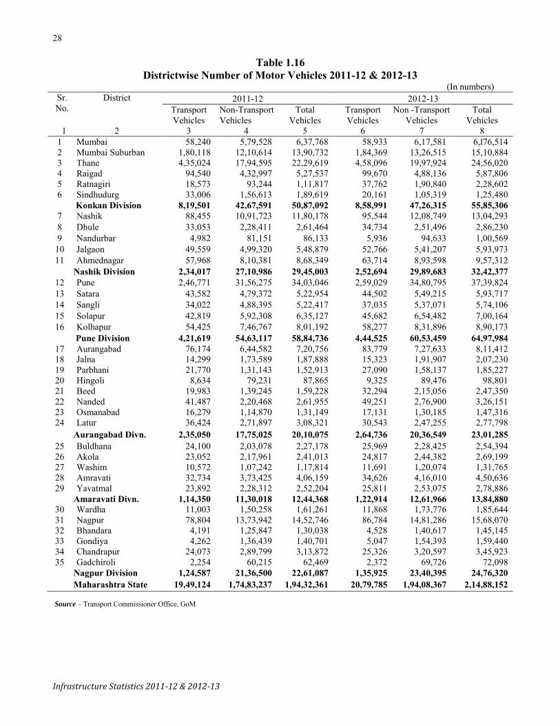
Table 1.16 Districtwise Number of Motor Vehicles 2011-12 & 2012-13
(In numbers) Sr. No.
District
2011-12 2012-13 Transport Vehicles
Non-Transport Vehicles
Total Vehicles
Transport Vehicles
Non -Transport Vehicles
Total Vehicles
1 2 3 4 5 6 7 8 1 Mumbai 58,240 5,79,528 6,37,768 58,933 6,17,581 6,l76,514
2 Mumbai Suburban 1,80,118 12,10,614 13,90,732 1,84,369 13,26,515 15,10,884 3 Thane 4,35,024 17,94,595 22,29,619 4,58,096 19,97,924 24,56,020 4 Raigad 94,540 4,32,997 5,27,537 99,670 4,88,136 5,87,806 5 Ratnagiri 18,573 93,244 1,11,817 37,762 1,90,840 2,28,602 6 Sindhudurg 33,006 1,56,613 1,89,619 20,161 1,05,319 1,25,480
Konkan Division 8,19,501 42,67,591 50,87,092 8,58,991 47,26,315 55,85,306 7 Nashik 88,455 10,91,723 11,80,178 95,544 12,08,749 13,04,293 8 Dhule 33,053 2,28,411 2,61,464 34,734 2,51,496 2,86,230 9 Nandurbar 4,982 81,151 86,133 5,936 94,633 1,00,569
10 Jalgaon 49,559 4,99,320 5,48,879 52,766 5,41,207 5,93,973 11 Ahmednagar 57,968 8,10,381 8,68,349 63,714 8,93,598 9,57,312
Nashik Division 2,34,017 27,10,986 29,45,003 2,52,694 29,89,683 32,42,377 12 Pune 2,46,771 31,56,275 34,03,046 2,59,029 34,80,795 37,39,824 13 Satara 43,582 4,79,372 5,22,954 44,502 5,49,215 5,93,717 14 Sangli 34,022 4,88,395 5,22,417 37,035 5,37,071 5,74,106 15 Solapur 42,819 5,92,308 6,35,127 45,682 6,54,482 7,00,164 16 Kolhapur 54,425 7,46,767 8,01,192 58,277 8,31,896 8,90,173
Pune Division 4,21,619 54,63,117 58,84,736 4,44,525 60,53,459 64,97,984 17 Aurangabad 76,174 6,44,582 7,20,756 83,779 7,27,633 8,11,412 18 Jalna 14,299 1,73,589 1,87,888 15,323 1,91,907 2,07,230 19 Parbhani 21,770 1,31,143 1,52,913 27,090 1,58,137 1,85,227 20 Hingoli 8,634 79,231 87,865 9,325 89,476 98,801 21 Beed 19,983 1,39,245 1,59,228 32,294 2,15,056 2,47,350 22 Nanded 41,487 2,20,468 2,61,955 49,251 2,76,900 3,26,151 23 Osmanabad 16,279 1,14,870 1,31,149 17,131 1,30,185 1,47,316 24 Latur 36,424 2,71,897 3,08,321 30,543 2,47,255 2,77,798
Aurangabad Divn. 2,35,050 17,75,025 20,10,075 2,64,736 20,36,549 23,01,285 25 Buldhana 24,100 2,03,078 2,27,178 25,969 2,28,425 2,54,394 26 Akola 23,052 2,17,961 2,41,013 24,817 2,44,382 2,69,199 27 Washim 10,572 1,07,242 1,17,814 11,691 1,20,074 1,31,765 28 Amravati 32,734 3,73,425 4,06,159 34,626 4,16,010 4,50,636 29 Yavatmal 23,892 2,28,312 2,52,204 25,811 2,53,075 2,78,886
Amaravati Divn. 1,14,350 11,30,018 12,44,368 1,22,914 12,61,966 13,84,880 30 Wardha 11,003 1,50,258 1,61,261 11,868 1,73,776 1,85,644 31 Nagpur 78,804 13,73,942 14,52,746 86,784 14,81,286 15,68,070 32 Bhandara 4,191 1,25,847 1,30,038 4,528 1,40,617 1,45,145 33 Gondiya 4,262 1,36,439 1,40,701 5,047 1,54,393 1,59,440 34 Chandrapur 24,073 2,89,799 3,13,872 25,326 3,20,597 3,45,923 35 Gadchiroli 2,254 60,215 62,469 2,372 69,726 72,098
Nagpur Division 1,24,587 21,36,500 22,61,087 1,35,925 23,40,395 24,76,320 Maharashtra State 19,49,124 1,74,83,237 1,94,32,361 20,79,785 1,94,08,367 2,14,88,152
Source – Transport Commissioner Office, GoM

29
Infrastructure Statistics 2011-12 & 2012-13
Table 1.17
Districtwise & Categorywise Number of Registered MotorVehicles 2011-12 (In numbers)
Sr. No.
District Transport/ Passenger vehicles Multi/
Arti.Veh. Trucks & Lorries
L. M. V. Goods Three
& four Wheelers
Buses
Taxis
L. M. V. Autorikshws (Passengers)
Total
1 2 3 4 5 6 7 8 1 Mumbai 2,498 15,596 6,937 33,209 0 58,240 2 Mumbai Suburban 5,290 38,373 6,021 20,939 1,09,495 1,80,118 3 Thane 1,01,391 1,41,789 18,654 40,244 1,32,946 4,35,024 4 Raigad 36,457 22,076 2,483 12,268 21,256 94,540 5 Ratnagiri 3,684 4,692 1,807 327 8,063 18,573 6 Sindhudurg 5,905 10,579 605 624 15,293 33,006
Konkan Division 1,55,225 2,33,105 36,507 1,07,611 2,87,053 8,19,501 7 Nashik 14,581 33,334 2,887 5,733 31,920 88,455 8 Dhule 9,152 8,780 1,156 2,763 11,202 33,053 9 Nandurbar 707 3,075 130 236 834 4,982 10 Jalgaon 6,912 14,676 1,407 2,936 23,628 49,559 11 Ahmednagar 11,693 28,592 1,613 4,970 11,100 57,968
Nashik Division 43,045 88,457 7,193 16,638 78,684 2,34,017 12 Pune 41,423 1,05,677 24,334 23,239 52,098 2,46,771 13 Satara 9,420 18,523 1,263 4,917 9,459 43,582 14 Sangli 7,969 15,934 1,220 1,371 7,528 34,022 15 Solapur 10,224 20,842 766 1,393 9,594 42,819 16 Kolhapur 15,587 21,809 2,331 929 13,769 54,425
Pune Division 84,623 1,82,785 29,914 31,849 92,448 4,21,619 17 Aurangabad 9,265 32,349 7,992 1,840 24,728 76,174 18 Jalna 2,219 5,938 421 682 5,039 14,299 19 Parbhani 4,307 5,670 543 442 10,808 21,770 20 Hingoli 1,531 2,582 280 337 3,904 8,634 21 Beed 3,179 8,782 608 71 7,343 19,983 22 Nanded 8,970 8,688 1,119 1,677 21,033 41,487 23 Osmanabad 4,359 6,216 419 918 4,367 16,279 24 Latur 8,178 12,870 831 1,342 13,203 36,424
Aurangabad Divn. 42,008 83,095 12,213 7,309 90,425 2,35,050 25 Buldhana 2,546 6,798 844 1,682 12,230 24,100 26 Akola 4,129 5,374 883 1,931 10,735 23,052 27 Washim 1,041 2,672 122 510 6,227 10,572 28 Amravati 6,798 7,848 1132 1,320 15,636 32,734 29 Yavatmal 4,530 5,787 954 1,235 11,386 23,892
Amaravati Divn. 19,044 28,479 3,935 6,678 56,214 1,14,350 30 Wardha 1,451 4,067 447 306 4,732 11,003 31 Nagpur 19,745 26,479 7,772 3,678 21,130 78,804 32 Bhandara 1,204 1,170 489 213 1,115 4,191 33 Gondiya 1,106 1,791 273 296 796 4,262 34 Chandrapur 9,011 6,110 1,117 939 6,896 24,073 35 Gadchiroli 321 869 237 280 547 2,254
Nagpur Division 32,838 40,486 10,335 5,712 35,216 1,24,587 Maharashtra State 3,76,783 6,56,407 1,00,097 1,75,797 6,40,040 19,49,124

30
Infrastructure Statistics 2011-12 & 2012-13
Table 1.17—Contd.
Districtwise & Categorywise Number of Registered MotorVehicles 2011-12 (In numbers)
Sr No District
Non- Transport Vehicles Two Wheelers Cars Jeeps Omni buses Tractors
1 2 9 10 11 12 13 1 Mumbai 3,38,794 2,31,687 8,414 0 129 2 Mumbai Suburban 8,00,569 3,89,826 18,082 0 551 3 Thane 12,41,813 4,76,703 45,131 0 2,130 4 Raigad 3,12,339 91,117 17,393 0 1,687 5 Ratnagiri 80,589 9,603 1,994 0 494 6 Sindhudurg 1,30,975 17,365 5,594 0 534
Konkan Division 29,05,079 12,16,301 96,608 0 5,525 7 Nashik 8,72,708 94,521 27,696 0 56,018 8 Dhule 1,83,449 14,409 3,832 0 13,341 9 ,Nandurbar 61,646 6,529 2,444 0 6,528 10 Jalgaon 4,21,727 25,930 8,334 0 23,273 11 Ahmednagar 6,76,345 43,952 19,734 0 37,392 Nashik Division 22,15,875 1,85,341 62,040 0 1,36,552 12 Pune 25,46,097 4,66,597 59,686 0 41,793 13 Satara 3,87,893 34,211 14,526 0 21,999 14 Sangli 4,01,526 37,141 15,219 0 18,055 15 Solapur 5,02,758 30,886 15,952 0 22,866 16 Kolhapur 6,21,483 61,511 19,877 0 20,408 Pune Division 44,59,757 6,30,346 1,25,260 0 1,25,121 17 Aurangabad 5,54,645 35,895 21,071 0 17,975 18 Jalna 1,46,038 7,484 4,197 0 9,380 19 Parbhani 1,10,283 6,545 5,630 0 5,404 20 Hingoli 63,776 4,140 3,495 0 4,608 21 Beed 1,13,555 4,256 10,004 0 6,440 22 Nanded 1,89,767 12,128 9,185 0 5,101 23 Osmanabad 90,644 6,714 4,233 0 8,017 24 Latur 2,21,788 18,770 10,802 0 11,917 Aurangabad Divn. 14,90,496 95,932 68,617 0 68,842 25 Buldhana 1,70,960 5,966 4,243 0 13,309 26 Akola 1,88,983 12,561 3,915 0 6,959 27 Washim 90,581 3,446 2,387 0 6,353 28 Amravati 3,30,951 20,896 5,543 0 9,247 29 Yavatmal 2,00,408 11,133 4,629 0 6,723 Amaravati Divn. 9,81,883 54,002 20,717 0 42,591 30 Wardha 1,33,069 6,143 2,811 0 5,076 31 Nagpur 12,04,998 1,09,357 35,472 0 12,074 32 Bhandara 1,08,288 4,453 1,823 0 6,984 33 Gondiya 1,20,133 5,379 2,498 0 4,654 34 Chandrapur 2,50,960 17,817 6,339 0 8,314 35 Gadchiroli 51,225 1,791 1,120 0 3,558 Nagpur Division 18,68,673 1,44,940 50,063 0 40,660 Maharashtra State 1,39,21,763 23,26,862 4,23,305 0 4,19,291

31
Infrastructure Statistics 2011-12 & 2012-13
Table 1.17—Contd. Districtwise & Categorywise Number of Registered Motor Vehicles 2011-12
(In numbers)
Sr No District
Non-Transport Vehicles Grand Total
(Transport + Non- Transport Vehicles) Trailors Others Total
1 2 14 15 16 17 1 Mumbai 82 422 5,79,528 6,37,768 2 Mumbai Suburban 124 1,462 12,10,614 13,90,732 3 Thane 11,015 17,803 17,94,595 22,29,619 4 Raigad 3,727 6,734 4,32,997 5,27,537 5 Ratnagiri 467 97 93,244 1,11,817 6 Sindhudurg 571 1,574 1,56,613 1,89,619
Konkan Division 15,986 28,092 42,67,591 50,87,092 7 Nashik 38,681 2,099 10,91,723 11,80,178 8 Dhule 12,725 655 2,28,411 2,61,464 9 Nandurbar 3,769 235 81,151 86,133 10 Jalgaon 19,331 725 4,99,320 5,48,879 11 Ahmednagar 29,175 3,783 8,10,381 8,68,349 Nashik Division 1,03,681 7,497 27,10,986 29,45,003 12 Pune 29,771 12,331 31,56,275 34,03,046 13 Satara 19,597 1,146 4,79,372 5,22,954 14 Sangli 15,303 1,151 4,88,395 5,22,417 15 Solapur 18,061 1,785 5,92,308 6,35,127 16 Kolhapur 21,195 2,293 7,46,767 8,01,192 Pune Division 1,03,927 18,706 54,63,117 58,84,736 17 Aurangabad 11,739 3,257 6,44,582 7,20,756 18 Jalna 6,019 471 1,73,589 1,87,888 19 Parbhani 2,869 412 1,31,143 1,52,913 20 Hingoli 3,116 96 79,231 87,865 21 Beed 4,849 141 1,39,245 1,59,228 22 Nanded 3,841 446 2,20,468 2,61,955 23 Osmanabad 4,808 454 1,14,870 1,31,149 24 Latur 8,152 468 2,71,897 3,08,321 Aurangabad Divn. 45,393 5,745 17,75,025 20,10,075 25 Buldhana 8,406 194 2,03,078 2,27,178 26 Akola 5,156 387 2,17,961 2,41,013 27 Washim 4,425 50 1,07,242 1,17,814 28 Amravati 6,290 498 3,73,425 4,06,159 29 Yavatmal 5,253 166 2,28,312 2,52,204 Amravati Division 29,530 1,295 11,30,018 12,44,368 30 Wardha 2,846 313 1,50,258 1,61,261 31 Nagpur 7,536 4,505 13,73,942 14,52,746 32 Bhandara 4,183 116 1,25,847 1,30,038 33 Gondiya 3,620 155 1,36,439 1,40,701 34 Chandrapur 5,658 711 2,89,799 3,13,872 35 Gadchiroli 2,464 57 60,215 62,469 Nagpur Division 26,307 5,857 21,36,500 22,61,087 Maharashtra State 3,24,824 67,192 1,74,83,237 1,94,32,361
Source – Transport Commissioner Office, GoM

32
Infrastructure Statistics 2011-12 & 2012-13
Table 1.18 Districtwise & Categorywise Number of Registered Motor Vehicles 2012-13
(In numbers)
Sr No. District
Transport/ Passenger vehicles Multi /Arti. Veh. Trucks
& Lorries
L M. V. Goods Three & four
Wheelers Buses Taxis
L M. V. Autorikshws (Passengers)
Total
1 2 3 4 5 6 7 8 1 Mumbai 2,089 15,891 6,415 34,358 0 58,933 2 Mumbai Suburban 5,464 39,270 5,487 22,557 1,11,591 1,84,369 3 Thane 1,06,089 1,58,551 19,266 40,073 1,34,117 4,58,096 4 Raigad 38,961 24,454 2,697 12,443 21,115 99,670 5 Ratnagiri 6,880 13,148 563 671 16,500 37,762 6 Sindhudurg 3,980 5,424 2,005 333 8,419 20,161
Konkan Division 1,63,463 2,56,738 36,433 1,10,615 2,91,742 8,58,991 7 Nashik 15,468 39,211 2,614 5,902 32,349 95,544 8 Dhule 9,498 9,681 1,120 2,816 11,619 34,734 9 Nandurbar 655 3,890 113 444 834 5,936 10 Jalgaon 7,068 16,373 1,288 3,056 24,981 52,766 11 Ahmednagar 12,908 33,119 1,516 5,111 11,060 63,714 Nashik Division 45,597 1,02,274 6,651 17,329 80,843 2,52,694 12 Pune 43,197 1,14,284 24,051 26,398 51,099 2,59,029 13 Satara 9,886 19,860 1,185 4,920 8,651 44,502 14 Sangli 8,559 18,023 1,131 1,402 7,920 37,035 15 Solapur 10,605 23,390 564 1,529 9,594 45,682 16 Kolhapur 16,661 24,346 2,286 1,037 13,947 58,277 Pune Division 88,908 1,99,903 29,217 35,286 91,211 4,44,525 17 Aurangabad 10,173 38,375 8,457 1,909 24,865 83,779 18 Jalna 2,430 6,510 339 720 5,324 15,323 19 Parbhani 5,381 7,451 436 459 13,363 27,090 20 Hingoli 1,539 2,986 251 204 4,345 9,325 21 Beed 5,575 14,895 672 390 10,762 32,294 22 Nanded 11255 11,997 1,082 1,861 23,056 49,251 23 Osmanabad 4,363 6,881 392 1,009 4,486 17,131 24 Latur 6,865 11,359 878 1,125 10,316 30,543 Aurangabad Divn. 47,581 1,00,454 12,507 7,677 96,517 2,64,736 25 Buldhana 2,730 7,626 713 1,771 13,129 25,969 26 Akola 4,366 6,326 768 1,957 11,400 24,817 27 Washim 1,169 3,109 76 509 6,828 11,691 28 Amravati 7,478 8,961 1,007 1,380 15,800 34,626 29 Yavatmal 4,778 6,881 939 1,320 11,893 25,811 Amravati Division 20,521 32,903 3,503 6,937 59,050 1,22,914 30 Wardha 1,538 4,852 428 308 4,742 11,868 31 Nagpur 22,334 30,699 7,855 4,138 21,758 86,784 32 Bhandara 1,230 1,478 433 220 1,167 4,528 33 Gondiya 1,400 2,232 319 300 796 5,047 34 Chandrapur 9,461 7,108 879 953 6,925 25,326 35 Gadchiroli 333 1,084 104 303 548 2,372 Nagpur Division 36,296 47,453 10,018 6,222 35,936 1,35,925 Maharashtra State 4,02,366 7,39,725 98,329 1,84,066 6,55,299 20,79,785

33
Infrastructure Statistics 2011-12 & 2012-13
Table 1.18—Contd.
Districtwise & Categorywise Number of Registered MotorVehicles 2012-13 (In numbers)
Sr No District
Non- Transport Vehicles
Two Wheelers Cars Jeeps Omni buses Tractors
1 2 9 10 11 12 13 1 Mumbai 3,65,689 2,42,259 8,417 0 129 2 Mumbai Suburban 8,69,593 4,33,803 21,073 0 72 3 Thane 13,96,242 5,19,454 45,547 0 2,320 4 Raigad 3,52,317 1,03,674 18,187 0 1,978 5 Ratnagiri 1,58,110 22,842 7,070 0 592 6 Sindhudurg 91,043 10,819 2,266 0 503
Konkan Division 32,32,994 13,32,851 1,02,560 0 5,594 7 Nashik 9,63,919 1,09,711 29,569 0 62,483 8 Dhule 2,01,773 16,768 4,368 0 14,582 9 Nandurbar 68,841 11,629 2,885 0 6,771 10 Jalgaon 4,57,815 28,502 9,226 0 24,882 11 Ahmednagar 7,46,096 51,299 21,583 0 39,916 Nashik Division 24,38,444 2,17,909 67,631 0 1,48,634 12 Pune 27,92,055 5,39,550 60,271 0 44,128 13 Satara 4,45,319 41,753 15,613 0 24,089 14 Sangli 4,39,162 42,928 16,686 0 20,649 15 Solapur 5,57,057 34,393 17,232 0 24,779 16 Kolhapur 6,90,878 69,188 20,172 0 25,747 Pune Division 49,24,471 7,27,812 1,29,974 0 1,39,392 17 Aurangabad 6,28,484 39,776 23,393 0 19,222 18 Jalna 1,61,947 7,939 4,911 0 10,303 19 Parbhani 1,32,249 8,661 7,388 0 6,171 20 Hingoli 72,882 4,646 3,762 0 4,903 21 Beed 1,75,604 8,345 13,609 0 10,279 22 Nanded 2,42,362 14,862 9,350 0 5,530 23 Osmanabad 1,03,367 7,516 4,650 0 9,173 24 Latur 2,02,802 17,820 9,584 0 10,090 Aurangabad Divn. 17,19,697 1,09,565 76,647 0 75,671 25 Buldhana 1,92,498 7,285 4,732 0 14,766 26 Akola 2,12,208 14,203 4,100 0 7,889 27 Washim 1,01,243 3,879 2,745 0 7,502 28 Amravati 3,67,592 24,768 5,714 0 10,778 29 Yavatmal 2,22,310 12,612 5,086 0 7,486 Amravati Division 10,95,851 62,747 22,377 0 48,421 30 Wardha 1,54,732 6,959 3,115 0 5,643 31 Nagpur 12,96,730 1,20,181 37,937 0 13,062 32 Bhandara 1,21,016 5,534 2,113 0 7,334 33 Gondiya 1,36,147 6,221 2,836 0 5,133 34 Chandrapur 2,77,769 19,959 6,877 0 9,012 35 Gadchiroli 59,322 2,241 1,313 0 4,036 Nagpur Division 20,45,716 1,61,095 54,191 0 44,220 Maharashtra State 1,54,57,173 26,11,979 4,53,380 0 4,61,932

34
Infrastructure Statistics 2011-12 & 2012-13
Table 1.18—Contd.
Districtwise & Categorywise Number of Registered MotorVehicles 2012-13 (In numbers)
Sr No. District
Non -Transport Vehicles Grand Total (Transport + Non - Transport Vehicles) Trailors Others Total
1 2 14 15 16 17 1 Mumbai 84 1,003 6,17,581 6,76,514
2 Mumbai Suburban 11 1,963 13,26,515 15,10,884 3 Thane 11,634 22,727 19,97,924 24,56,020 4 Raigad 3,781 8,199 4,88,136 5,87,806 5 Ratnagiri 593 1,633 1,90,840 2,28,602 6 Sindhudurg 478 210 1,05,319 1,25,480
Konkan Division 16,581 35,735 47,26,315 55,85,306 7 Nashik 39,977 3,090 12,08,749 13,04,293 8 Dhule 13,187 818 2,51,496 2,86,230 9 Nandurbar 4,177 330 94,633 1,00,569
10 Jalgaon 19,795 987 5,41,207 5,93,973 11 Ahmednagar 30,136 4,568 8,93,598 9,57,312
Nashik Division 1,07,272 9,793 29,89,683 32,42,377 12 Pune 30,304 14,487 34,80,795 37,39,824 13 Satara 20,666 1,775 5,49,215 5,93,717 14 Sangli 16,143 1,503 5,37,071 5,74,106 15 Solapur 18,614 2,407 6,54,482 7,00,164 16 Kolhapur 23,057 2,854 8,31,896 8,90,173
Pune Division 1,08,784 23,026 60,53,459 64,97,984 17 Aurangabad 12,510 4,248 7,27,633 8,11,412 18 Jalna 6,184 623 1,91,907 2,07,230 19 Parbhani 3,068 600 1,58,137 1,85,227 20 Hingoli 3,137 146 89,476 98,801 21 Beed 6,880 339 2,15,056 2,47,350 22 Nanded 4,145 651 2,76,900 3,26,151 23 Osmanabad 4,938 541 1,30,185 1,47,316 24 Latur 6,501 458 2,47,255 2,77,798
Aurangabad Divn. 47,363 7,606 20,36,549 23,01,285 25 Buldhana 8,800 344 2,28,425 2,54,394 26 Akola 5,361 621 2,44,382 2,69,199 27 Washim 4,581 124 1,20,074 1,31,765 28 Amravati 6,377 781 4,16,010 4,50,636 29 Yavatmal 5,347 234 2,53,075 2,78,886
Amravati Division 30,466 2,104 12,61,966 13,84,880 30 Wardha 2,895 432 1,73,776 1,85,644 31 Nagpur 7,916 5,460 14,81,286 15,68,070 32 Bhandara 4,409 211 1,40,617 1,45,145 33 Gondiya 3,763 293 1,54,393 1,59,440 34 Chandrapur 5,832 1,148 3,20,597 3,45,923 35 Gadchiroli 2,596 218 69,726 72,098
Nagpur Division 27,411 7,762 23,40,395 24,76,320 Maharashtra State 3,37,877 86,026 1,94,08,367 2,14,88,152
Source – Transport Commissioner Office, GoM

35
Infrastructure Statistics 2011-12 & 2012-13
Table 1.19
Districtwise Number of Motor vehicles per lakh population and Percentage of Motor vehicles to Total Motor vehicles
Sr. No.
District
Number of Motor vehicles per lakh population
Percentage of Motor vehicles to Total Motor vehicles
2011-12 2012-13 2011-12 2012-13 1 2 3 4 5 6 1 Mumbai 20,670 17,195 3.28 3.15 2 Mumbai Suburban 14,863 14,836 7.16 7.03 3 Thane 20,159 25,625 11.47 11.43 4 Raigad 20,026 22,588 2.71 2.74 5 Ratnagiri 6,923 11,431 0.58 1.06 6 Sindhudurg 22,317 12,254 0.98 0.58
Konkan Division 17,786 19,044 25.99 25.99 7 Nashik 19,324 22,160 6.07 6.07 8 Dhule 12,749 14,219 1.35 1.33 9 Nandurbar 5,226 6,505 0.44 0.47 10 Jalgaon 12,976 13,684 2.82 2.76 11 Ahmednagar 19,113 20,101 4.47 4.46
Nashik Division 15,851 17,481 15.09 15.09 12 Pune 36,090 43,871 17.51 17.40 13 Satara 17,410 17,933 2.69 2.76 14 Sangli 18,511 18,854 2.69 2.67 15 Solapur 14,710 15,432 3.27 3.26 16 Kolhapur 20,671 21,437 4.12 4.14
Pune Division 25,096 27,569 30.24 30.24 17 Aurangabad 19,473 23,764 3.71 3.78 18 Jalna 9,591 10,900 0.97 0.96 19 Parbhani 8,328 10,287 0.79 0.86 20 Hingoli 7,463 8,492 0.45 0.46 21 Beed 6,160 9,710 0.82 1.15 22 Nanded 7,793 9,621 1.35 1.52 23 Osmanabad 7,912 8,408 0.67 0.69 24 Latur 12,563 11,330 1.59 1.29
Aurangabad Divn. 10,731 12,493 10.71 10.71 25 Buldhana 8,784 9,668 1.17 1.18 26 Akola 13,287 14,010 1.24 1.25 27 Washim 9,841 10,958 0.61 0.61 28 Amravati 14,062 14,665 2.09 2.10 29 Yavatmal 9,097 9,625 1.30 1.30
Amravati Division 11,053 11,811 6.44 6.44 30 Wardha 12,397 12,736 0.83 0.86 31 Nagpur 31,218 32,707 7.48 7.30 32 Bhandara 10,833 10,839 0.67 0.68 33 Gondiya 10,639 11,266 0.72 0.74 34 Chandrapur 14,239 14,171 1.62 1.61 35 Gadchiroli 5,822 6,304 0.32 0.34
Nagpur Division 19,236 19,668 11.64 11.52 Maharashtra State 17,293 18,819 100.00 100.00

36
Infrastructure Statistics 2011-12 & 2012-13
Graph 1: Road length (k.m.)
0
50,000
100,000
150,000
200,000
250,000
300,000
1970-71 1980-81 1990-91 2000-01 2010-11 2012-13
Ro
ad len
gth
(k
m)
Graph 2: Categorywise Road Length in Mahrashtra State
0
20,000
40,000
60,000
80,000
100,000
120,000
1970-71 1980-81 1990-91 2000-01 2010-11 2012-13
Ro
ad L
engt
h (
km
)
National Highways State Highways
Major District roads Other district roads
Village roads

37
Infrastructure Statistics 2011-12 & 2012-13
Graph 4: No. of motor vehicles on road in Maharashtra State
31
1,6
69
80
4,9
86
2,6
40
,58
5
6,6
07
,05
4
17
,43
4,0
99
19
,43
2,3
61
21
,48
8,1
52
0
5,000,000
10,000,000
15,000,000
20,000,000
25,000,000
1971 1981 1991 2001 2010-11 2011-12 2012-13
Nu
mb
er o
f m
oto
r v
ehic
les
39,38839,541
39,800
40,158
39,000
39,200
39,400
39,600
39,800
40,000
40,200
40,400
2009-10 2010-11 2011-12 2012-13
Num
ber
of V
illag
esGraph 3: No. of villages connected by all-weather roads


39
Infrastructure Statistics 2011-12 & 2012-13
Rail Transport
Table 1.20
Districtwise Railway Route Kilometres 2011-12 & 2012-13 (In km.)
Sr. No. District
2011-12 2012-13 Broad Gauge
Narrow Gauge
Metre Gauge
Total Broad Gauge
Narrow Gauge
Metre Gauge
Total
1 2 3 4 5 6 7 8 9 10 1 Mumbai 101.34 0 0 101.34 101.34 0 0 101.34 2 Mumbai Suburban 3 Thane 307.10 0 0 307.10 307.10 0 0 307.10 4 Raigad 323.50 20.00 0 343.50 323.50 20.00 0 343.50 5 Ratnagiri 198.00 0 0 198.00 198.00 0 0 198.00 6 Sindhudurg 107.50 0 0 107.50 107.50 0 0 107.50
Konkan Division 1,037.44 20.00 0.00 1,057.44 1,037.44 20.00 0.00 1,057.44 7 Nashik 275.25 0 0 275.25 262.50 0 0 262.50 8 Dhule 49.68 0 0 49.68 49.68 0 0 49.68 9 Nandurbar 97.60 0 0 97.60 97.60 0 0 97.60
10 Jalgaon 351.67 55.57 0 407.24 407.24 55.57 0 462.81 11 Ahmednagar 213.68 0 0 213.68 213.68 0 0 213.68
Nashik Division 987.88 55.57 0.00 1,043.45 1,030.70 55.57 0.00 1,086.27 12 Pune 396.12 0 0 396.12 369.12 0 0 369.12 13 Satara 115.32 0 0 115.32 115.32 0 0 115.32 14 Sangli 143.89 0 0 143.89 143.89 0 0 143.89 15 Solapur 387.70 0 0 387.70 387.70 0 0 387.70 16 Kolhapur 47.10 0 0 47.10 47.10 0 0 47.10
Pune Division 1,090.13 0.00 0.00 1,090.13 1063.13 0.00 0.00 1,063.13 17 Aurangabad 107.25 0 0 107.25 107.25 0 0 107.25 18 Jalna 88.25 0 0 88.25 88.25 0 0 88.25 19 Parbhani 262.43 0 0 262.43 262.43 0 0 262.43 20 Hingoli 0.00 0 0 0.00 0.00 0 0 0.00 21 Beed 47.70 0 0 47.70 47.70 0 0 47.70 22 Nanded 225.61 0 0 225.61 225.61 0 0 225.61 23 Osmanabad 53.60 0 0 53.60 53.60 0 0 53.60 24 Latur 139.30 0 0 139.30 139.30 0 0 139.30
Aurangabad Division 924.14 0.00 0.00 924.14 924.14 0.00 0.00 924.14 25 Buldhana 84.75 0 0 84.75 84.75 0 0 84.75 26 Akola 176.60 59.45 76.65 312.70 176.60 59.45 76.65 312.70 27 Washim 0.00 0 29.10 29.10 0.00 0 29.10 29.10 28 Amravati 136.44 61.96 0 198.40 256.80 61.96 0 318.76 29 Yavatmal 97.46 66.92 0 164.38 97.08 66.92 0 164.00
Amravati Division 495.25 188.33 105.75 789.33 615.23 188.33 105.75 909.31 30 Wardha 103.00 34.42 0 137.42 103.00 34.42 0 137.42 31 Nagpur 261.82 133.70 0 395.52 276.82 133.70 0 410.52 32 Bhandara 65.11 9.70 0 74.81 65.11 9.70 0 74.81 33 Gondiya 205.64 0.00 0 205.64 205.64 0.00 0 205.64 34 Chandrapur 321.31 17.09 0 338.40 321.31 17.09 0 338.40 35 Gadchiroli 18.50 0.00 0.00 18.50 18.50 0.00 0.00 18.50
Nagpur Division 975.38 194.91 0.00 1,170.29 990.38 194.91 0.00 1,185.29 Maharashtra State 5,510.22 458.81 105.75 6,074.78 5,661.02 458.81 105.75 6,225.58
Source-Central Railway, South East Central railway, Western Railway, Konkan Railway Corporation

40
Infrastructure Statistics 2011-12 & 2012-13
Table 1.21
Districtwise Railway kilometerage per hundred sq. km. of Geographical area (In km.)
Sr. No. District
Railway kilometerage per hundred sq.km. of Geographical area area
2011-12 2012-13 1 2 3 4
1 Mumbai 16.81 16.81 2 Mumbai Suburban
3 Thane 3.21 3.21 4 Raigad 4.80 4.80 5 Ratnagiri 2.41 2.41 6 Sindhudurg 2.06 2.06
Konkan Division 3.44 3.44 7 Nashik 1.77 1.69 8 Dhule 0.69 0.69 9 Nandurbar 1.64 1.64
10 Jalgaon 3.46 3.93 11 Ahmednagar 1.25 1.25
Nashik Division 1.81 1.89 12 Pune 2.53 2.36 13 Satara 1.10 1.10 14 Sangli 1.68 1.68 15 Solapur 2.60 2.60 16 Kolhapur 0.61 0.61
Pune Division 1.90 1.86 17 Aurangabad 1.06 1.06 18 Jalna 1.14 1.14 19 Parbhani 4.22 4.22 20 Hingoli 0.00 0.00 21 Beed 0.45 0.45 22 Nanded 2.14 2.14 23 Osmanabad 0.71 0.71 24 Latur 1.95 1.95
Aurangabad Divn. 1.43 1.43 25 Buldhana 0.88 0.88 26 Akola 5.51 5.51 27 Washim 0.59 0.59 28 Amravati 1.62 2.61 29 Yavatmal 1.21 1.21
Amravati Divn. 1.71 1.98 30 Wardha 2.18 2.18 31 Nagpur 4.00 4.15 32 Bhandara 1.83 1.83 33 Gondiya 3.93 3.93 34 Chandrapur 2.96 2.96 35 Gadchiroli 0.13 0.13
Nagpur Divn. 2.28 2.31 Maharashtra State 1.97 2.02
Source-Central Railway, South East Central railway, Western Railway, Konkan Railway Corporation

41
Infrastructure Statistics 2011-12 & 2012-13
Sea & Coastal Transport
Table 1.22
Physical Performance Indicators at Mumbai Port Trust & Jawaharlal Nehru Port Trust
Sr. No.
Item MbPT JNPT
2011-12 2012-13 2011-12 2012-13
1 2 3 4 5 6
1 Vessels sailed (No.) 5,758 5,212 2,892 2,589
2 Average Pre-berthing waiting time (days) (Port a/c) 0.32 0.32 0.35 0.38
3 Average Turn round time (days) (Port a/c) 3.67 3.88 1.50 1.59
4 Percentage of idle time at berth to working time at berth 28.42 29.73 11.66 11.58
5 Output per ship berth days (tonnes) 7,729 9,017 25,762 26,308 Source – Mumbai Port Trust & Jawaharlal Nehru Port Trust

42
Infrastructure Statistics 2011-12 & 2012-13
Table 1.23
Employment and Traffic Handled at Mumbai Port Trust & Jawaharlal Nehru Port Trust
Sr.No. Item MbPT JNPT
2011-12 2012-13 2011-12 2012-13
1 2 3 4 5 6 1 Employment At Port (No.) 12,726 11,955 1,718 1,697
2 Cargo Traffic Handled (‘000 tonnes) 51,876 58,038 65,730 64,488
A Overseas
Loaded 5,108 5,156 28,699 28,240
Unloaded 29,036 29,776 31,201 32,272
Transshipment 7,785 8,708 661 512
Total 41,929 43,640 60,561 61,025
B Coastal
Loaded 2,336 4,798 3,357 2,293
Unloaded 3,017 1,836 1,545 1,170
Trans-shipment 8,904 7,764 266 …
Total 14,257 14,398 5,168 3,463
C Overseas and Coastal
Loaded 7,444 9,954 32,056 30,533
Unloaded 32,053 31,612 32,747 33,442
Trans-shipment 16,689 16,472 927 513
Total 56,186 58,038 65,730 64,488
3 Passenger Traffic Handled (in ‘ooo)
A Overseas
Embarked 2,932 3,160
Dis-embarked 1,767 2,452
Total 4,699 5,612
B Coastal
Embarked 0 0
Dis-embarked 0 0
Total 0 0
C Overseas and Coastal
Embarked 2,932 3,160
Dis-embarked 1,767 2,452
Total 4,699 5,612
Source- Mumbai Port Trust & Jawaharlal Nehru Port Trust
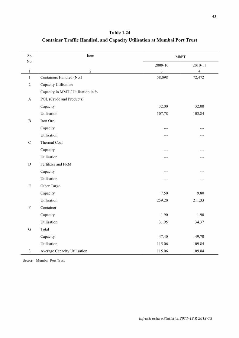
43
Infrastructure Statistics 2011-12 & 2012-13
Table 1.24
Container Traffic Handled, and Capacity Utilisation at Mumbai Port Trust
Sr. No.
Item MbPT
2009-10 2010-11 1 2 3 4 1 Containers Handled (No.) 58,098 72,472
2 Capacity Utilisation
Capacity in MMT / Utilisation in %
A POL (Crude and Products)
Capacity 32.00 32.00
Utilisation 107.78 103.84
B Iron Ore
Capacity --- ---
Utilisation --- ---
C Thermal Coal
Capacity --- ---
Utilisation --- ---
D Fertilizer and FRM
Capacity --- ---
Utilisation --- ---
E Other Cargo
Capacity 7.50 9.80
Utilisation 259.20 211.33
F Container
Capacity 1.90 1.90
Utilisation 31.95 34.37
G Total
Capacity 47.40 49.70
Utilisation 115.06 109.84
3 Average Capacity Utilisation 115.06 109.84
Source – Mumbai Port Trust
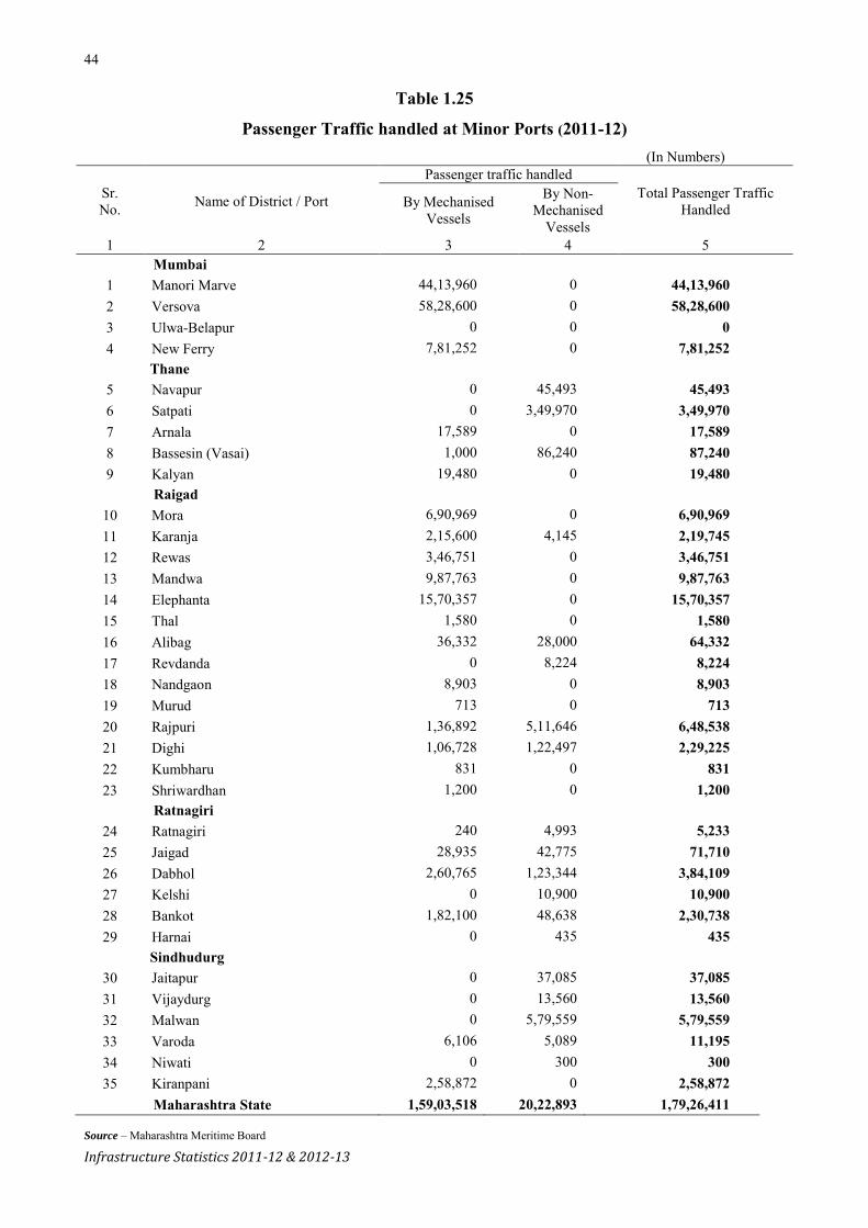
44
Infrastructure Statistics 2011-12 & 2012-13
Table 1.25
Passenger Traffic handled at Minor Ports (2011-12) (In Numbers)
Sr. No. Name of District / Port
Passenger traffic handled Total Passenger Traffic
Handled By Mechanised Vessels
By Non-Mechanised
Vessels 1 2 3 4 5
Mumbai 1 Manori Marve 44,13,960 0 44,13,960 2 Versova 58,28,600 0 58,28,600 3 Ulwa-Belapur 0 0 0 4 New Ferry 7,81,252 0 7,81,252
Thane 5 Navapur 0 45,493 45,493 6 Satpati 0 3,49,970 3,49,970 7 Arnala 17,589 0 17,589 8 Bassesin (Vasai) 1,000 86,240 87,240 9 Kalyan 19,480 0 19,480
Raigad 10 Mora 6,90,969 0 6,90,969
11 Karanja 2,15,600 4,145 2,19,745 12 Rewas 3,46,751 0 3,46,751 13 Mandwa 9,87,763 0 9,87,763 14 Elephanta 15,70,357 0 15,70,357 15 Thal 1,580 0 1,580 16 Alibag 36,332 28,000 64,332 17 Revdanda 0 8,224 8,224 18 Nandgaon 8,903 0 8,903 19 Murud 713 0 713 20 Rajpuri 1,36,892 5,11,646 6,48,538 21 Dighi 1,06,728 1,22,497 2,29,225 22 Kumbharu 831 0 831 23 Shriwardhan 1,200 0 1,200
Ratnagiri 24 Ratnagiri 240 4,993 5,233 25 Jaigad 28,935 42,775 71,710 26 Dabhol 2,60,765 1,23,344 3,84,109 27 Kelshi 0 10,900 10,900 28 Bankot 1,82,100 48,638 2,30,738 29 Harnai 0 435 435
Sindhudurg 30 Jaitapur 0 37,085 37,085 31 Vijaydurg 0 13,560 13,560 32 Malwan 0 5,79,559 5,79,559 33 Varoda 6,106 5,089 11,195 34 Niwati 0 300 300 35 Kiranpani 2,58,872 0 2,58,872
Maharashtra State 1,59,03,518 20,22,893 1,79,26,411
Source – Maharashtra Meritime Board

45
Infrastructure Statistics 2011-12 & 2012-13
Table 1.26
Passenger Traffic handled at Minor Ports (2012-13) (In Numbers)
Sr. No. Name of District / Port
Passenger Traffic Handled Total Passenger Traffic Handled By Mechanised Vessels By Non-Mechanised
Vessels 1 2 3 4 5
Mumbai 1 Manori Marve 45,80,590 0 45,80,590 2 Versova 58,70,200 0 58,70,200 3 Ulwa-Belapur 0 0 0 4 New Ferry 8,08,848 0 8,08,848
Thane 5 Navapur 0 27,633 27,633 6 Satpati 0 1,17,208 1,17,208 7 Arnala 16,838 0 16,838 8 Bassesin (Vasai) 17,674 97,386 1,15,060 9 Kalyan 21,090 0 21,090
Raigad 10 Mora 6,64,812 0 6,64,812 11 Karanja 2,12,885 1,235 2,14,120 12 Rewas 3,82,534 0 3,82,534 13 Mandwa 11,39,044 0 11,39,044 14 Dharamtar 0 0 0 15 Elephanta 17,47,628 0 17,47,628 16 Thal 9,241 0 9,241 17 Alibag 52,902 2,3803 76,705 18 Revdanda 0 6,884 6,884 19 Nandgaon 15,295 0 15,295 20 Murud 23,898 0 23,898 21 Rajpuri 1,28,303 4,91,468 6,19,771 22 Dighi 2,17,198 2,892 2,20,090 23 Kumbharu 3,220 0 3,220 24 Shriwardhan 760 0 760
Ratnagiri 25 Ratnagiri 0 9,547 9547 26 Jaigad 1,40,132 46,230 1,86,362 27 Dabhol 3,62,032 0 3,62,032 28 Kelshi 0 9,900 9,900 29 Bankot 2,41,405 555 2,41,960 30 Harnai 0 743 743
Sindhudurg 31 Varoda 251 4,734 4,985 32 Jaitapur 0 23,208 23,208 33 Vijaydurg 0 19,205 19,205 34 Malwan 0 6,43,750 6,43,750 35 Niwati 0 50 50 36 Kiranpani 2,32,010 0 2,32,010
Maharashtra State 1,68,88,790 15,26,431 1,84,15,221
Source – Maharashtra Meritime Board
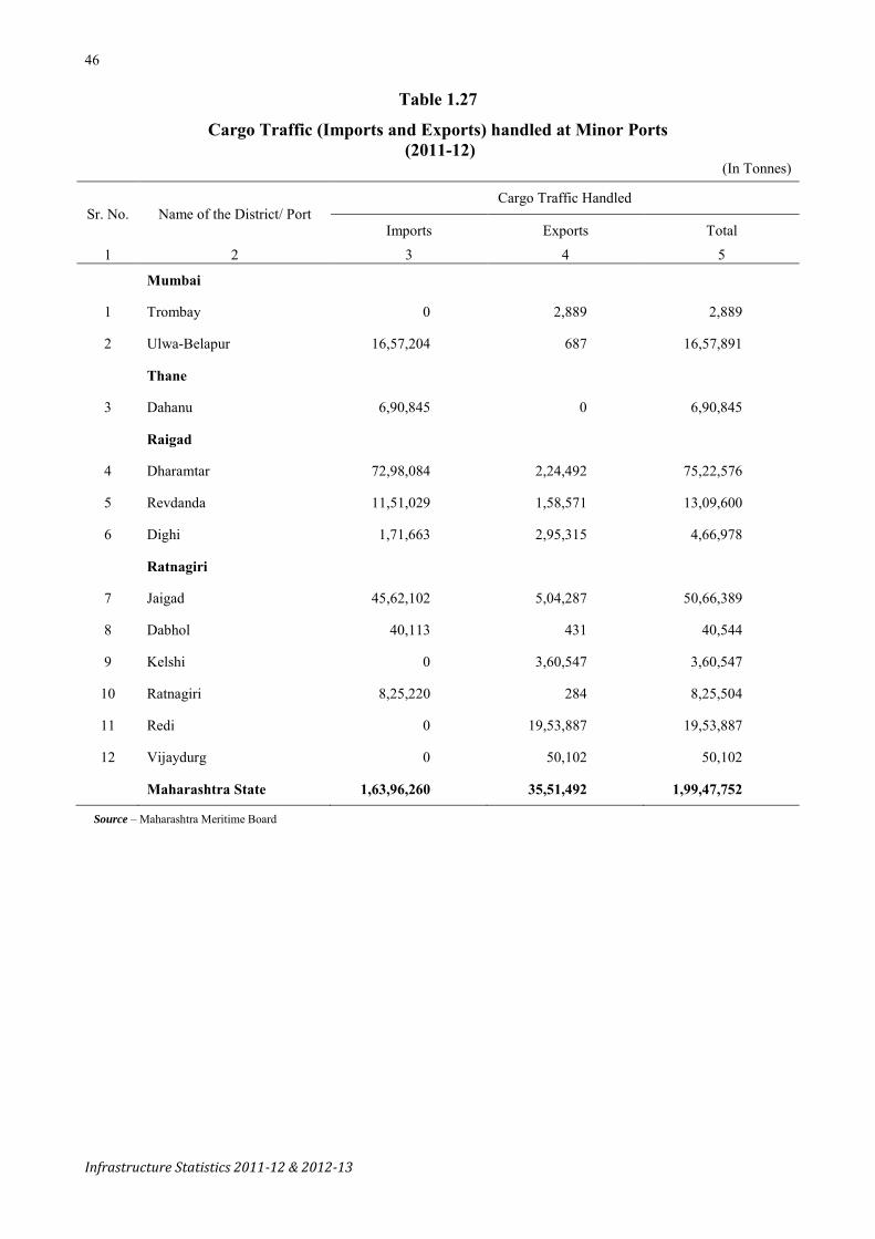
46
Infrastructure Statistics 2011-12 & 2012-13
Table 1.27
Cargo Traffic (Imports and Exports) handled at Minor Ports (2011-12)
(In Tonnes)
Sr. No. Name of the District/ Port Cargo Traffic Handled
Imports Exports Total
1 2 3 4 5
Mumbai
1 Trombay 0 2,889 2,889
2 Ulwa-Belapur 16,57,204 687 16,57,891
Thane
3 Dahanu 6,90,845 0 6,90,845
Raigad
4 Dharamtar 72,98,084 2,24,492 75,22,576
5 Revdanda 11,51,029 1,58,571 13,09,600
6 Dighi 1,71,663 2,95,315 4,66,978
Ratnagiri
7 Jaigad 45,62,102 5,04,287 50,66,389
8 Dabhol 40,113 431 40,544
9 Kelshi 0 3,60,547 3,60,547
10 Ratnagiri 8,25,220 284 8,25,504
11 Redi 0 19,53,887 19,53,887
12 Vijaydurg 0 50,102 50,102
Maharashtra State 1,63,96,260 35,51,492 1,99,47,752
Source – Maharashtra Meritime Board
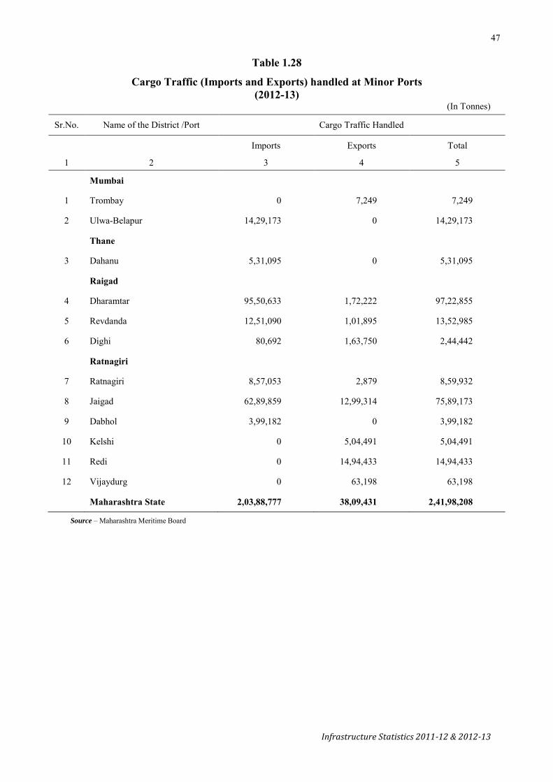
47
Infrastructure Statistics 2011-12 & 2012-13
Table 1.28
Cargo Traffic (Imports and Exports) handled at Minor Ports (2012-13)
(In Tonnes)
Sr.No. Name of the District /Port Cargo Traffic Handled
Imports Exports Total
1 2 3 4 5
Mumbai
1 Trombay 0 7,249 7,249
2 Ulwa-Belapur 14,29,173 0 14,29,173
Thane
3 Dahanu 5,31,095 0 5,31,095
Raigad
4 Dharamtar 95,50,633 1,72,222 97,22,855
5 Revdanda 12,51,090 1,01,895 13,52,985
6 Dighi 80,692 1,63,750 2,44,442
Ratnagiri
7 Ratnagiri 8,57,053 2,879 8,59,932
8 Jaigad 62,89,859 12,99,314 75,89,173
9 Dabhol 3,99,182 0 3,99,182
10 Kelshi 0 5,04,491 5,04,491
11 Redi 0 14,94,433 14,94,433
12 Vijaydurg 0 63,198 63,198
Maharashtra State 2,03,88,777 38,09,431 2,41,98,208
Source – Maharashtra Meritime Board


49
Infrastructure Statistics 2011-12 & 2012-13
Air Transport
Table 1.29
Passenger and Freight Traffic handled by Airports
Airports International / Domestic
Passenger Traffic (in Numbers)
Embarking Disembarking Total
2011-12 2012-13 2011-12 2012-13 2011-12 2012-13
1 2 3 4 5 6 7 8 Mumbai International 48,87,943 50,12,780 2,06,965 1,86,593 50,94,908 51,99,373 Domestic 1,05,45,260 1,01,88,822 91,546 88,946 1,06,36,806 1,02,77,768 Pune International 31,043 30,922 32,752 29,358 63,795 60,280 Domestic 16,44,225 16,35,399 15,90,007 16,04,061 32,34,232 32,39,460 Nagpur International 17,283 21,109 14,429 22,767 31,712 43,876 Domestic 7,48,497 6,09,499 7,18,050 6,09,546 14,66,547 12,19,045 Aurangabad International 2,995 3,162 0 0 2,995 3,162 Domestic 2,03,015 2,18,683 1,94,615 2,18,187 3,97,630 4,36,870 Kolhapur International 0 0 0 0 0 0 Domestic 4,007 349 4,156 351 8,163 700 Solapur International 0 0 0 0 0 0 Domestic 312 87 280 92 592 179 Nanded International 0 0 0 0 0 0 Domestic 29,136 25,337 28,949 24,116 58,085 49,453 Freight Traffic (in Tonnes)
Loaded Unloaded Total 2011-12 2012-13 2011-12 2012-13 2011-12 2012-13
Mumbai International 2,60,217 2,66,148 2,06,965 1,86,593 4,67,182 4,52,741 Domestic 98,742 93,476 91,546 88,946 1,90,288 1,82,422 Pune International 0 0 0 0 0 0 Domestic 1,25,16,586 1,03,98,954 1,16,15,939 94,60,419 2,41,32,525 1,98,59,373 Nagpur International 0 2,11,042 52,582 1,95,211 52,582 4,06,253 Domestic 18,91,426 16,77,687 28,08,214 31,22,399 46,99,640 48,00,086 Aurangabad International 0 0 0 0 0 0 Domestic 701 414 526 310 1227 724 Kolhapur International 0 0 0 0 0 0 Domestic 0 0 0 0 0 0 Solapur International 0 0 0 0 0 0 Domestic 0 0 0 0 0 0 Nanded International 0 0 0 0 0 0
Domestic 0 0 0 0 0 0
Source – Airport Authority of India


51
Infrastructure Statistics 2011-12 & 2012-13
Mining & Quarrying
Table 2.1
Mineralwise and Districtwise Mines, Mineral Production and Value
(Excluding Atomic Minerals) (Value in ` Thousand)
Minerals/District Unit 2010-11 2011-12 (P)
Mine Quantity Value Mine Quantity Value
1 2 3 4 5 6 7 8
All Minerals 161 6,38,90,822 154 6,29,41,524
Coal '000 t 55 39,336 5,36,28,800 57 39,159 5,31,12,600
All Districts '000 t 55 39,336 5,36,28,800 57 39,159 5,31,12,600
Bauxite t 15 21,33,736 5,49,201 13 19,37,898 5,05,268
Kolhapur t 5 11,68,220 3,23,348 6 11,14,044 3,06,568
Raigad t 6 3,37,456 55,317 4 3,54,700 70,176
Ratnagiri t 4 6,28,060 1,70,536 3 4,69,154 1,28,524
Chromite t 0 0 0 0 0 0
Bhandara t 0 0 0 0 0 0
Iron Ore '000 t 15 1,525 13,32,628 14 1,470 13,02,353
Chandrapur '000 t 3 71 48,931 3 58 51,064
Gadchiroli '000 t 2 9 9,514 2 1 500
Gondiya '000 t 4 8 7,186 4 31 14,615
Sindhudurg '000 t 6 1,437 12,66,997 5 1,380 12,36,174
Mangeneese Ore t 20 6,72,828 49,84,603 19 6,49,898 43,47,624
Bhandara t 4 4,50,843 32,68,145 4 4,41,813 29,07,993
Nagpur t 16 2,21,985 17,16,458 15 2,08,085 14,39,631
Corundum Kg. 0 0 0 0 0 0
Bhandara Kg. 0 0 0 0 0 0
Dolomite t 6 64,865 13,867 6 1,27,857 29,095
Chandrapur t 1 4,372 1,880 1 89,736 21,637
Nagpur t 4 18,022 4,657 4 16,581 4,113
Yavatmal Kg. 1 42,471 7,330 1 21,540 3,345
Felspar t 0 0 0 0 0 0
Sindhudurg t 0 0 0 0 0 0
Fireclay t 2 3,334 391 2 9,512 1,284
Amravati t 2 3,334 391 2 9,512 1,284
Fluorite( Graded) t 1 6,469 32,456 1 2,740 10,645
Chandrapur t 1 6,469 32,456 1 2,740 10,645
Kyanite t 4 2,407 2,084 1 53 45
Bhandara t 4 2,407 2,084 1 53 45
Sillimanite t 2 4,653 3,652 2 984 1,754
Bhandara t 2 4,653 3,652 2 984 1,754
Laterite t 0 0 0 1 6,500 553
Chandrapur t 0 0 0 1 6,500 553

52
Infrastructure Statistics 2011-12 & 2012-13
Table 2.1—Contd.
Mineralwise and Districtwise Mines, Mineral Production and Value
(Excluding Atomic Minerals)
(Value in ` Thousand)
Minerals/District Unit 2010-11 2011-12 (P)
Mine Quantity Value Mine Quantity Value
1 2 3 4 5 6 7 8
Limestone '000 t 21 9,905 11,20,117 19 11,330 13,47,140
Chandrapur '000 t 8 8,947 10,19,001 8 9,776 11,74,584
Yavatmal '000 t 13 958 1,01,116 11 1,554 1,72,556
Pyrophyllite t - 1,485 368 0 1,054 337
Bhandara t - 1,485 368 0 1,054 337
Quartz t 4 10,505 2,363 4 30,694 10,557
Bhandara t 3 10,369 2,344 3 19,726 7,834
Chandrapur t 1 136 19 1 10,502 2,625
Nagpur t - - - 0 466 98
Quartzite t - 2,455 614 0 1,944 588
Bhandara t - 2,455 614 0 1,944 588
Silica Sand t 13 2,56,817 65,828 12 2,81,043 96,396
Kolhapur t 5 27,222 5,818 4 12,607 2,205
Ratnagiri t 8 2,29,595 60,010 7 2,67,486 94,086
Sindhudurg t 0 0 0 1 950 105
Sand (Others) t 3 3,73,746 17,033 3 4,35,159 23,649
Chandrapur t 3 3,73,746 17,033 3 4,35,159 23,649
Shale t - 2,97,375 9,600 0 3,52,872 24,419
Chandrapur t - 2,28,859 2,517 0 1,30,487 1,606
Yavatmal t - 68,516 7,083 0 2,22,385 22,813
Sulphur t - - - - 54,850 -
Mumbai t - - - - 54850 -
Minor Minerals - - - 21,27,217 - - 21,27,217
All Districts - - - 21,27,217 - - 21,27,217
Source – Indian Bureau of Mines, Ministry of Mines, GoI t - Tonnes

53
Infrastructure Statistics 2011-12 & 2012-13
Electricity
Table 2.2
Installed Capacity, Generation & Consumption of Electricity
Item 1980-81 1990-91 2000-01 2009-10 2010-11 2011-12 2012-13
1 2 3 4 5 6 7 8
A. Installed capacity (Mega Watt)
A - 1 Installed Capacity in the State
(1) Thermal 2,771 6,462 8,075 8,825 9,665 10,366 13,946
(2) Renewable Energy … … … 2,807 3,408 4,198 4,789
(3) Hydro 1,317 1,552 2,874 2,916 3,366 3,066 3,066
(4) Natural Gas … 672 1,820 1,772 2,714 2,740 3,072
(5) Captive Power … … … 1,051 N.A. N.A N.A
(6) Oil Neg. Neg. Neg. --- --- --- ---
Total (A-1) 4,088 8,686 12,769 17,371 19,153 20,370 24,873
A - 2 State’s share in Installed Capacity of—
(1) National Thermal Power Corp. N.A. N.A. 2,048@ 4,578 4,686 5,102 5,831
(2) Nuclear Power Corporation N.A. N.A. 137 690 690 690 690
Total (A-2) N.A. N.A. 2,185 5,268 5,376 5,792 6,521
Total (A-1 + A-2) 4,088 8,686 14,954 22,639 24,529 26,162 31,394
B. Generation (Million Units) –
(1) Thermal 11,416 28,085 49,377 54,978 52,796 59,482 66,075
(2) Natural Gas … 2,730 6,943 15,322 18,729 17,207 10,242
(3) Hydro 6,448 5,615 4,889 5,654 6,374 6,851 5,980
(4) Renewable Energy … … … 5,026 5,118# 5,925 5,842
(5) Captive Power … … … 365 N.A. N.A. N.A.
(6) Oil Neg. Neg. Neg. … … … …
Total 17,864 36,430 61,209# 81,345 83,017 89,465 88,139
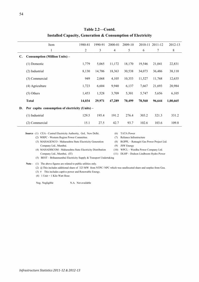
54
Infrastructure Statistics 2011-12 & 2012-13
Table 2.2—Contd.
Installed Capacity, Generation & Consumption of Electricity
Item 1980-81 1990-91 2000-01 2009-10 2010-11 2011-12 2012-13
1 2 3 4 5 6 7 8
C. Consumption (Million Units) –
(1) Domestic 1,779 5,065 11,172 18,170 19,546 21,041 22,831
(2) Industrial 8,130 14,706 18,363 30,538 34,073 36,486 38,110
(3) Commercial 949 2,068 4,105 10,353 11,527 11,768 12,635
(4) Agriculture 1,723 6,604 9,940 6,137 7,667 21,693 20,984
(5) Others 1,453 1,528 3,709 5,301 5,747 5,656 6,105
Total 14,034 29,971 47,289 70,499 78,560 96,644 1,00,665
D. Per capita consumption of electricity (Units) –
(1) Industrial 129.5 195.4 191.2 276.4 303.2 321.3 331.2
(2) Commercial 15.1 27.5 42.7 93.7 102.6 103.6 109.8
Source - (1) CEA - Central Electricity Authority, GoI, New Delhi. (6) TATA Power (2) WRPC - Western Region Power Committee. (7) Reliance Infrastructure (3) MAHAGENCO - Maharashtra State Electricity Generation (8) RGPPL – Ratnagiri Gas Power Project Ltd. Company Ltd., Mumbai. (9) JSW Energy (4) MAHADISCOM - Maharashtra State Electricity Distribution (10) WPCL – Wardha Power Company Ltd. Company Ltd., Mumbai, (IT) (11) DLHP – Dodson Lindboom Hydro Power (5) BEST – Brihanmumbai Electricity Supply & Transport Undertaking
Note - (1) The above figures are related to public utilities only. (2) @ This includes additional share of 323 MW from NTPC/ NPC which was unallocated share and surplus from Goa. (3) # This includes captive power and Renewable Energy. (4) 1 Unit = 1 Kilo Watt Hour. Neg. Negligible N.A. Not available

55
Infrastructure Statistics 2011-12 & 2012-13
Table 2.3
Districtwise Consumption of Electricity : 2011-12
(In MUs)
Sr. No. District
Consumption of Electricity
Domestic Industrial Commercial Public Service Agriculture Railways Others Total
1 2 3 4 5 6 7 8 9 10 1 Mumbai 6,593.1 2,534.61 6,267.02 128.55 0.04 831 156.67 16,510.99 2 Mumbai Suburban 3 Thane 3,880.95 9,193.70 1,822.78 695.86 48.45 318.62 14.67 15,975.03 4 Raigad 339.05 3,034.79 95.48 61.75 20.68 0.00 8.74 3,560.49 5 Ratnagiri 230.73 316.65 58.21 35.05 10.29 0.00 0.94 651.87 6 Sindhudurg 121.01 28.00 25.05 15.10 11.17 0.00 0.94 201.27 Konkan Division 11,164.84 15,107.75 8,268.54 936.31 90.63 1,149.62 181.96 36,899.65 7 Nashik 651.01 2,294.78 228.32 142.70 1,669.65 141.33 17.13 5,144.92 8 Dhule 183.66 273.40 41.13 44.57 524.41 27.95 1.32 1,096.44 9 Nandurbar 70.11 65.57 15.08 27.86 435.39 33.02 1.13 648.16 10 Jalgaon 402.32 633.28 94.63 102.85 1,689.71 149.93 5.26 3,077.98 11 Ahmednagar 321.26 567.56 113.35 82.81 2,611.56 0.00 4.22 3,700.76 Nashik Division 1,628.36 3,834.59 492.51 400.79 6,930.72 352.23 29.06 13,668.26 12 Pune 2,381.26 6,391.94 1,508.68 416.94 1,692.62 0.00 82.27 12,473.71 13 Satara 283.51 478.33 83.66 65.90 568.66 0.00 3.06 1,483.12 14 Sangli 274.41 492.27 77.93 66.40 923.09 0.00 9.70 1,843.80 15 Solapur 366.16 567.43 105.88 120.03 2,518.19 0.00 2.38 3,680.07 16 Kolhapur 436.72 2,092.19 127.29 122.06 535.92 0.00 3.76 3,317.94 Pune Division 3,742.06 10,022.16 1,903.44 791.33 6,238.48 0.00 101.17 22,798.64 17 Aurangabad 401.48 1,474.10 138.03 122.91 920.61 0.00 4.67 3,061.80 18 Jalna 109.25 1,042.15 20.59 25.32 467.20 0.00 4.87 1,669.38 19 Parbhani 115.94 57.48 20.27 29.61 613.66 0.00 1.90 838.86 20 Hingoli 54.24 29.54 7.70 17.18 435.44 0.00 0.04 544.14 21 Beed 148.18 94.12 28.51 138.54 1,052.50 0.00 1.06 1,462.91 22 Nanded 258.90 108.38 58.83 83.20 707.04 0.00 1.36 1,217.71 23 Osmanabad 127.26 54.36 17.59 51.86 710.37 0.00 0.42 961.86 24 Latur 199.37 107.02 43.82 107.54 707.27 0.00 1.40 1,166.42
Aurangabad Divn. 1,414.62 2,967.15 335.34 576.16 5,614.09 0.00 15.72 10,923.08 25 Buldhana 230.65 157.70 32.89 34.93 507.54 91.95 1.22 1,056.88 26 Akola 225.75 126.67 48.71 29.35 205.79 66.46 0.84 703.57 27 Washim 86.21 32.40 13.24 15.74 233.36 0.00 0.01 380.96 28 Amravati 353.92 142.45 68.49 70.26 501.13 78.34 1.20 1,215.79 29 Yavatmal 250.38 201.20 34.92 70.66 503.21 0.00 0.34 1,060.71 Amravati Divn 1,146.91 660.42 198.25 220.94 1,951.03 236.75 3.61 4,417.91 30 Wardha 212.15 501.80 39.44 28.29 132.68 102.18 0.46 1,017.00 31 Nagpur 1,053.43 1,726.48 408.93 172.04 277.82 163.53 6.93 3,809.16 32 Bhandara 142.15 237.63 18.04 15.21 136.68 37.74 0.39 587.84 33 Gondiya 118.94 59.58 37.15 10.49 78.21 70.69 1.26 376.32 34 Chandrapur 298.50 775.44 57.90 33.85 76.50 116.69 0.47 1,359.35 35 Gadchiroli 120.41 87.70 15.76 25.35 47.80 0.00 0.15 297.17 Nagpur Division 1,945.58 3,388.63 577.22 285.23 749.69 490.83 9.66 7,446.84 Maharashtra State 21,042.37 35,980.70 11,775.30 3,210.76 21,574.64 2,229.43 341.18 96,154.38
Source: (1) MAHADISCOM - Maharashtra State Electricity Distribution Company Ltd.(IT)
(2) BEST - Brihanmumbai Electricity Supply &Transport Undertaking
(3) TATA Power
(4) Reliance Infrastructure

56
Infrastructure Statistics 2011-12 & 2012-13
Table 2.4
Districtwise Consumption of Electricity : 2012-13 ( In MUs)
Sr. No. District
Consumption of Electricity
Domestic Industrial Commercial Public Service Agriculture Railways Others Total
1 2 3 4 5 6 7 8 9 10 1 Mumbai
6,946.01 2,613.76 6,497.78 126.57 0.05 853 140.12 17,177.29 2 Mumbai Suburban 3 Thane 4,296.39 9,658.22 1,940.60 753.81 58.18 337.19 80.94 17,125.33 4 Raigad 380.23 1,944.91 129.40 88.21 22.57 0.00 15.74 2,581.06 5 Ratnagiri 261.32 318.47 66.61 38.36 10.92 0.00 4.86 700.54 6 Sindhudurg 135.98 28.80 29.07 15.80 12.51 0.00 1.78 223.94
Konkan Division 12,019.93 14,564.16 8,663.46 1,022.75 104.23 1,190.19 243.44 37,808.16 7 Nashik 709.25 2,544.85 274.25 161.63 1,651.14 156.04 46.59 5,543.75 8 Dhule 199.74 321.20 45.46 51.10 560.17 29.58 6.32 1,213.57 9 Nandurbar 74.98 73.53 17.70 33.41 455.60 37.00 2.09 694.31
10 Jalgaon 418.55 647.47 89.61 110.69 1,536.99 181.56 38.86 3,023.73 11 Ahmednagar 338.50 612.43 129.09 109.46 2,439.41 0.00 27.02 3,655.91 Nashik Division 1,741.02 4,199.48 556.11 466.29 6,643.31 404.18 120.88 14,131.27 12 Pune 2,640.31 6,459.45 1,598.60 451.42 1,795.81 0.00 249.10 13,194.69 13 Satara 317.53 489.47 114.41 77.83 663.31 0.00 8.17 1,670.72 14 Sangli 307.07 528.45 85.68 74.62 1,075.12 0.00 20.86 2,091.80 15 Solapur 402.21 598.67 125.74 146.78 2,482.71 0.00 13.26 3,769.37 16 Kolhapur 472.17 2,290.19 143.86 125.21 587.36 0.00 13.23 3,632.02 Pune Division 4,139.29 10,366.23 2,068.29 875.86 6,604.31 0.00 304.62 24,358.60 17 Aurangabad 451.05 1,389.03 152.10 147.41 708.98 0.00 16.58 2,865.15 18 Jalna 125.04 1,207.13 25.05 28.76 368.79 0.00 7.30 1,762.07 19 Parbhani 133.10 70.02 24.91 39.66 525.65 0.00 1.55 794.89 20 Hingoli 63.81 28.23 9.69 24.75 389.85 0.00 0.16 516.49 21 Beed 175.78 109.40 33.82 79.90 835.88 0.00 3.43 1,238.21 22 Nanded 288.02 124.02 65.08 107.13 603.63 0.00 4.79 1,192.67 23 Osmanabad 115.51 51.41 22.21 57.50 661.48 0.00 1.12 909.23 24 Latur 209.13 113.04 53.02 127.92 715.44 0.00 4.80 1,223.35 Aurangabad Divn. 1,561.44 3,092.28 385.88 613.03 4,809.70 0.00 39.73 10,502.06 25 Buldhana 251.32 166.40 38.49 47.25 412.20 90.79 2.33 1,008.79 26 Akola 238.92 139.66 47.16 34.30 223.64 76.15 3.46 763.29 27 Washim 95.76 32.42 15.04 15.19 206.22 0.00 0.26 364.89 28 Amravati 384.98 151.00 83.74 76.86 525.60 90.62 6.16 1,318.96 29 Yavatmal 270.20 193.96 38.08 103.07 515.12 0.00 3.04 1,123.47 Amaravati Divn. 1,241.18 683.44 222.51 276.67 1,882.78 257.56 15.25 4,579.39 30 Wardha 226.47 529.05 39.58 31.27 142.17 105.68 9.18 1,083.40 31 Nagpur 1,168.61 1,822.80 470.68 199.28 285.03 184.96 35.60 4,166.96 32 Bhandara 144.01 216.69 21.33 15.96 142.50 41.71 12.26 594.46 33 Gondiya 126.47 63.38 74.52 11.29 86.97 76.79 1.92 441.34 34 Chandrapur 324.49 804.73 74.53 31.41 80.64 127.79 1.67 1,445.26 35 Gadchiroli 129.83 90.80 18.74 32.25 56.04 0.00 1.48 329.14
Nagpur Division 2,119.88 3,527.45 699.38 321.46 793.35 536.93 62.11 8,060.56 Maharashtra State 22,822.74 36,433.04 12,595.63 3,576.06 20,837.68 2,388.86 786.03 99,440.04
Source- (1) MAHADISCOM - Maharashtra State Electricity Distribution Company Ltd.(IT)
(2) BEST – Brihanmumbai Electricity Supply & Transport Undertaking
(3) TATA Power
(4) Reliance Infrastructure

57
Infrastructure Statistics 2011-12 & 2012-13
Table 2.5
Districtwise Per Capita Consumption of Electricity : 2011-12 (In Units/KWH)
Sr. No. District
Per capita consumption of electricity
Domestic Industrial Commercial Public Service Agriculture Railways Others Total
1 2 3 4 5 6 7 8 9 10 1 Mumbai
428.64 164.79 407.44 8.36 0.00 5.40 10.19 1,073.45 2 Mumbai Suburban 3 Thane 387.74 918.54 182.11 69.52 4.84 3.18 1.47 1,596.06 4 Raigad 135.06 1208.95 38.04 24.60 8.24 0.00 3.48 1,418.37 5 Ratnagiri 122.30 167.84 30.85 18.58 5.45 0.00 0.50 345.52 6 Sindhudurg 125.67 29.08 26.01 15.68 11.60 0.00 0.98 209.02
Konkan Division 363.08 491.31 268.89 30.45 2.95 3.74 5.92 1,199.98
7 Nashik 111.88 394.36 39.24 24.52 286.93 2.43 2.94 884.16 8 Dhule 94.28 140.34 21.11 22.88 269.19 1.43 0.68 562.83 9 Nandurbar 47.73 44.64 10.27 18.97 296.39 2.25 0.77 441.23 10 Jalgaon 95.38 150.13 22.43 24.38 400.58 3.55 1.25 729.69 11 Ahmednagar 70.45 124.47 24.86 18.16 572.72 0.00 0.93 811.58 Nashik Division 90.39 212.87 27.34 22.25 384.74 1.96 1.61 758.75 12 Pune 273.76 734.83 173.44 47.93 194.59 0.00 9.46 1,434.01 13 Satara 90.32 152.39 26.65 21.00 181.17 0.00 0.97 472.51 14 Sangli 93.38 167.51 26.52 22.59 314.11 0.00 3.30 627.41 15 Solapur 82.59 127.99 23.88 27.07 567.99 0.00 0.54 830.05 16 Kolhapur 108.00 517.38 31.48 30.18 132.53 0.00 0.93 820.49 Pune Division 160.92 431.00 81.86 34.03 268.28 0.00 4.35 980.44
17 Aurangabad 119.18 437.61 40.98 36.49 273.30 0.00 1.39 908.94 18 Jalna 60.10 573.31 11.33 13.93 257.02 0.00 2.68 918.37 19 Parbhani 65.90 32.67 11.52 16.83 348.82 0.00 1.08 476.82 20 Hingoli 49.05 26.71 6.96 15.54 393.77 0.00 0.04 492.07 21 Beed 60.96 38.72 11.73 57.00 433.00 0.00 0.44 601.85 22 Nanded 79.21 33.16 18.00 25.45 216.31 0.00 0.42 372.54 23 Osmanabad 76.41 32.64 10.56 31.14 426.51 0.00 0.25 577.51 24 Latur 84.39 45.30 18.55 45.52 299.37 0.00 0.59 493.72 Aurangabad Divn. 79.57 166.89 18.86 32.41 315.77 0.00 0.88 614.39 25 Buldhana 91.34 62.45 13.03 13.83 201.00 3.64 0.48 418.55 26 Akola 118.90 66.72 25.66 15.46 108.39 3.50 0.44 370.56 27 Washim 75.19 28.26 11.55 13.73 203.53 0.00 0.01 332.26 28 Amravati 117.34 47.23 22.71 23.29 166.14 2.60 0.40 403.08 29 Yavatmal 90.45 72.69 12.62 25.53 181.79 0.00 0.12 383.20 Amaravati Divn. 101.01 58.16 17.46 19.46 171.83 2.09 0.32 389.09 30 Wardha 150.35 355.63 27.95 20.05 94.03 7.24 0.33 720.75 31 Nagpur 213.21 349.43 82.76 34.82 56.23 3.31 1.40 770.95 32 Bhandara 111.72 186.76 14.18 11.95 107.42 2.97 0.31 461.99 33 Gondiya 88.99 44.58 27.80 7.85 58.52 5.29 0.94 281.57 34 Chandrapur 125.08 324.94 24.26 14.18 32.06 4.89 0.20 569.62 35 Gadchiroli 112.47 81.92 14.72 23.68 44.65 0.00 0.14 277.58 Nagpur Division 156.68 272.88 46.48 22.97 60.37 3.95 0.78 599.69 Maharashtra State 185.28 316.82 103.68 28.27 189.97 1.96 3.00 846.66

58
Infrastructure Statistics 2011-12 & 2012-13
Table 2.6
Districtwise Per Capita Consumption of Electricity : 2012-13 (In Units/KWH )
Sr. No. District
Per capita consumption of electricity
Domestic Industrial Commercial Public Service Agriculture Railways Others Total
1 2 3 4 5 6 7 8 9 10 1 Mumbai 441.99 166.32 413.47 8.05 0.00 54.28 8.92 1,093.03 2 MumbaiSuburban 3 Thane 421.70 947.97 190.47 73.99 5.71 33.10 7.94 1,680.88 4 Raigad 149.92 766.85 51.02 34.78 8.90 0.00 6.21 1,017.68 5 Ratnagiri 137.40 167.45 35.02 20.17 5.74 0.00 2.56 368.33 6 Sindhudurg 140.13 29.68 29.96 16.28 12.89 0.00 1.83 230.77
Konkan Division 383.87 465.13 276.68 32.66 3.33 38.01 7.77 1,207.46 7 Nashik 120.35 431.83 46.54 27.43 280.18 26.48 7.91 940.71 8 Dhule 101.45 163.14 23.09 25.95 284.52 15.02 3.21 616.39 9 Nandurbar 50.60 49.62 11.94 22.54 307.43 24.97 1.41 468.51 10 Jalgaon 98.14 151.81 21.01 25.95 360.38 42.57 9.11 708.98 11 Ahmednagar 73.53 133.03 28.04 23.78 529.88 0.00 5.87 794.12 NashikDivision 95.59 230.58 30.53 25.60 364.77 22.19 6.64 775.91 12 Pune 298.83 731.07 180.93 51.09 203.25 0.00 28.19 1,493.35 13 Satara 100.30 154.61 36.14 24.58 209.52 0.00 2.58 527.73 14 Sangli 103.42 177.97 28.86 25.13 362.08 0.00 7.03 704.48 15 Solapur 89.68 133.48 28.04 32.73 553.56 0.00 2.96 840.44 16 Kolhapur 115.46 560.02 35.18 30.62 143.63 0.00 3.24 888.14 Pune Division 175.80 440.27 87.84 37.20 280.50 0.00 12.94 1,034.55 17 Aurangabad 132.24 407.24 44.59 43.22 207.86 0.00 4.86 840.02 18 Jalna 68.14 657.85 13.65 15.67 200.98 0.00 3.98 960.28 19 Parbhani 74.79 39.34 14.00 22.28 295.36 0.00 0.87 446.65 20 Hingoli 57.20 25.30 8.69 22.19 349.45 0.00 0.14 462.97 21 Beed 71.65 44.59 13.79 32.57 340.73 0.00 1.40 504.73 22 Nanded 87.22 37.56 19.71 32.44 182.79 0.00 1.45 361.17 23 Osmanabad 68.74 30.60 13.22 34.22 393.67 0.00 0.67 541.11 24 Latur 87.62 47.36 22.22 53.60 299.77 0.00 2.01 512.58 Aurangabad Divn. 86.92 172.14 21.48 34.13 267.75 0.00 2.21 584.63 25 Buldhana 98.56 65.26 15.09 18.53 161.65 35.61 0.91 395.61 26 Akola 124.26 72.64 24.53 17.84 116.31 39.60 1.80 396.98 27 Washim 82.76 28.02 13.00 13.13 178.22 0.00 0.22 315.35 28 Amravati 126.12 49.47 27.43 25.18 172.18 29.69 2.02 432.08 29 Yavatmal 96.71 69.42 13.63 36.89 184.37 0.00 1.09 402.10 Amaravati Divn. 108.15 59.55 19.39 24.11 164.06 22.44 1.33 399.03 30 Wardha 158.80 370.97 27.75 21.93 99.69 74.10 6.44 759.69 31 Nagpur 232.64 362.87 93.70 39.67 56.74 36.82 7.09 829.52 32 Bhandara 112.19 168.81 16.62 12.43 111.01 32.49 9.55 463.10 33 Gondiya 93.86 47.04 55.30 8.38 64.54 56.99 1.42 327.53 34 Chandrapur 134.41 333.32 30.87 13.01 33.40 52.93 0.69 598.64 35 Gadchiroli 120.39 84.20 17.38 29.90 51.97 0.00 1.37 305.21 Nagpur Division 168.60 280.55 55.62 25.57 63.10 42.70 4.94 641.09 Maharashtra State 198.32 316.58 109.45 31.07 181.07 20.76 6.83 864.07

59
Infrastructure Statistics 2011-12 & 2012-13
Table 2.7
Districtwise Hydro Electric Projects Completed (2011-12)
Sr. No District Taluka / Name of Project completed
Installed Capacity
(Megawatt) 1 2 3 4 A- Govt. Projects
1 Thane Shahapur – Bhatsa 15.00 Shahapur – Ghatghar Udanchan Hydro-Electric Projects (Ahemadnagar /Akola) 250.00 Jawahar – Surya 6.00 Palghar – Surya Right Canal Cascade(Surya ujava Kalwa Prapat) 0.75
2 Raigad Mangaon – Bhira Avajal 80.00 Roha – Dolwahal 2.00
3 Ratnagiri Chiplun – Koyna level-3 320.00 4 Sindhudurg Sawantwadi – Terwanmedhe 0.20
Konkan Division 673.95 5 Nashik Igatpuri – Vaitarna Underground Electric House 60.00 Igatpuri – Vaitarna Dam Electric House 1.50 Dindori - Karanjwan 3.00
Nashik Division 64.50 6 Pune Bhor – Bhatghar 16.00 Maval – Pavana 10.00
Welhe – Khadkwasla 16.00 Junnar – Manikdoh 6.00 Ambegaon – Dinbhe 5.00
7 Satara Patan – Koyna level – 1&2 (Ratnagiri/Chiplun) 600.00 Patan – Koyna level – 4 (Ratnagiri/Chiplun) 1,000.00 Patan – Koyna Dam Electric House 40.00 Khandala – Veer 9.00 Satara – Yewateshwar 0.075 Satara – Kanher 4.00 Wai – Dhom 2.00
8 Sangli Shirala – Warna 16.00 9 Kolhapur Chandgad – Tillari 60.00 Radhanagari – Radhanagari 4.80 Radhanagari – Dhudhganga 24.00
10 Solapur Madha – Ujani 12.00 Pune Division 1,824.88 11 Aurangabad Paithan – Paithan 12.00 12 Parbhani Jintur – Yeldari 22.50 13 Beed Majalgaon – Majalgaon 2.25 Aurangabad Division 36.75 14 Akola Telhar – Wan 1.50 15 Amaravati Achalpur – Shahanoor 0.75 Amravati Division 2.25 Total of Govt. Projects 2,602.33

60
Infrastructure Statistics 2011-12 & 2012-13
Table 2.7—Contd..
Districtwise Hydro Electric Projects Completed (2011-12)
Sr. No District Taluka/Name of Project completed
Installed Capacity
(Megawatt) 1 2 3 4 B- Interstate Completed Project
1 Narmada (27% Share of Maharashtra)
Kewadicha – Sardar Sarovar Project 391.50
2 Nagpur Ramtek – Pench 53.00 Total –Interstate Project 444.50
C- Projects completed By Private 1 Thane Shahapur – Vajra Prapat 3.00 Konal Hydroelectric projects 5.00
Konkan Division 2 Ahmadnagar Akole – Bhandardara Electricity no.1 12.00 Akole – Bhandardara Electricity no.2 34.00
Nashik Division 3 Pune Bhor – Nira Devghar 6.00 Chasakman 3.00
4 Satara Karad – Tembhu Barej Hydroelectric projects 4.50 Pune Division 13.50 Total –Projects completed by Private 50.90
D- Projects Completed by Tata 1 Raigad Bhira 150.00 Khopoli 72.00 Bhivpuri 72.00 Bhira Undyachan project 150.00 Bhivpuri 3.00
Total – Projects Completed by Tata 447.00 Total -Maharashtra State (A to D) 3,561.33
Source- Water Resources Department, GoM

61
Infrastructure Statistics 2011-12 & 2012-13
Table 2.8
Districtwise Hydro Electric Projects Completed (2012-13)
Sr. No District Taluka / Name of Project completed
Installed Capacity
(Megawatt) 1 2 3 4 A- Govt. Projects
1 Thane Shahapur – Bhatsa 15.00 Shahapur – Ghatghar Udanchan Hydro-Electric Projects (Ahemadnagar/Akola ) 250.00 Jawahar – Surya 6.00 Palghar – Surya Right Canal Cascade(Surya ujava Kalwa Prapat) 0.75
2 Raigad Mangaon – Bhira Avajal 80.00 Roha – Dolwahal 2.00
3 Ratnagiri Chiplun – Koyna level-3 320.00 4 Sindhudurg Sawantwadi – Terwanmedhe 0.20
Konkan Division 673.95 5 Ahmadnagar Akole – Bhandardara Electrc House No.2 34.00 6 Nashik Igatpuri – Vaitarna Underground Electric House 60.00 Igatpuri – Vaitarna Dam Electric House 1.50 Dindori - Karanjwan 3.00
Nashik Division 98.50 7 Pune Bhor – Bhatghar 16.00 Maval – Pavana 10.00
Welhe – Khadkwasla 16.00 Junnar – Manikdoh 6.00 Ambegaon – Dinbhe 5.00
8 Satara Patan – Koyna level – 1&2 (Ratnagiri/Chiplun) 600.00 Patan – Koyna level – 4 (Ratnagiri/Chiplun) 1,000.00 Patan – Koyna Dam Electric House 40.00 Khandala – Veer 9.00 Satara – Yewateshwar 0.075 Satara – Kanher 4.00 Wai – Dhom 2.00
9 Sangli Shirala – Warna 16.00 10 Kolhapur Chandgad – Tillari 60.00
Radhanagari – Radhanagari 4.80 Radhanagari – Dhudhganga 24.00
11 Solapur Madha – Ujani 12.00 Pune Division 1824.88 12 Aurangabad Paithan – Paithan 12.00 13 Parbhani Jintur – Yeldari 22.50 14 Beed Majalgaon – Majalgaon 2.25 Aurangabad Division 36.75 15 Akola Telhar – Wan 1.50 16 Amaravati Achalpur – Shahanoor 0.75 Amravati Division 2.25 Total of Govt. Projects 2,636.33

62
Infrastructure Statistics 2011-12 & 2012-13
Table 2.8—Contd..
Districtwise Hydro Electric Projects Completed (2012-13)
Sr. No District Taluka/Name of Project completed
Installed Capacity
(Megawatt) 1 2 3 4 B- Interstate Completed Project
1 Narmada (27% Share of Maharashtra)
Kewadicha – Sardar Sarovar Project 391.50
2 Nagpur Ramtek – Pench 53.00 Total –Interstate Project 444.50
C- Projects completed By Private 1 Thane Shahapur – Vajra Prapat 3.00 2 Sindhudurg Kankawali – Devgad Hydroelectric projects 1.50 Konal Hydroelectric projects 10.00
Konkan Division 14.50 3 Ahmadnagar Akole – Bhandardara Electricity no.1 12.00 4 Nashik Nashik – Darna Hydroelectric projects 4.90
Nashik Division 16.90 5 Pune Bhor – Nira Devghar 6.00 Chasakman 3.00
6 Satara Karad – Tembhu Barej Hydroelectric projects 4.50 7 Sangli Shirala – Sonawade Hydroelectric projects 4.00 8 Kolhapur Ajara – Chitree Hydroelectric projects 2.00
Pune Division 19.50 Total –Projects completed by Private 50.90
D- Projects Completed by Tata 1 Raigad Bhira 150.00 Khopoli 72.00 Bhivpuri 72.00 Bhira Undyachan project 150.00 Bhivpuri 3.00
Total – Projects Completed by Tata 447.00 Total -Maharashtra State (A to D) 3,578.73
Source- Water Resources Department, GoM

63
Infrastructure Statistics 2011-12 & 2012-13
Table 2.9
Installed capacity and Derated capacity of Thermal Power Station (As on 31st March, 2012)
Sr. No. Power Station
Installed Capacity (MW) Derated Capacity (MW) Units Total Units Total
1 2 3 4 5 6 A- MAHAGENCO
1 Bhusawal - Nashik 1-0 420 1-0 420 2-210 2-210 3-210 3-210
2 Paras - Akola
1-0 500
1-0 500 2-0 2-0
3-250 3-250 4-250 4-250
3 Parli - Beed 1-0 1,130
1-0 1,130 2-0 2-0
3-210 3-210 4-210 4-210 5-210 5-210 6-250 6-250 7-250 7-250
4 Nashik - Nashik 1-140 630 1-125 630 2-140 2-125 3-210 3-210 4-210 4-210 5-210 5-210
5 Koradi - Nagpur 1-0 620 1-0 620 2-0 2-0 3-0 3-0 4-0 4-0
5-200 5-200 6-210 6-210 7-210 7-210
6 Khaparkheda - Nagpur 1-210 840 1-210 840 2-210 2-210 3-210 3-210 4-210 4-210
7 Chandrapur – Chandrapur 1-210 2,340 1-210 2,340 2-210 2-210 3-210 3-210 4-210 4-210 5-500 5-500 6-500 6-500 7-500 7-500
Total- MAHAGENCO 6,486 6,480 B-Tata Power 2,207 C-Reliance Infrastructure 500 Grand Total (A to C) 9,187
Source- (1) MAHAGENCO (2) TATA Power (3) Reliance Infrastructure (4) JSW Energy (5) WPCL

64
Infrastructure Statistics 2011-12 & 2012-13
Table 2.10
Installed capacity and Derated capacity of Thermal Power Station (As on 31st March, 2013)
Sr. No. Power Station
Installed Capacity (MW) Derated Capacity (MW) Units Total Units Total
1 2 3 4 5 6 A- MAHAGENCO
1 Bhusawal - Nashik 2-210 920 1-0 920 3-210 3-210 4-500 4-500
2 Paras - Akola
3-250 500 3-250 500 4-250 4-250
3 Parli - Beed 3-210 1,130 3-210 1,130 4-210 4-210 5-210 5-210 6-250 6-250 7-250 7-250
4 Nashik - Nashik 3-210 630 3-210 630 4-210 4-210 5-210 5-210
5 Koradi - Nagpur 5-200 620 5-200 620 6-210 6-210 7-210 7-210
6 Khaparkheda - Nagpur 1-210 1,340 1-210 1,340 2-210 2-210 3-210 3-210 4-210 4-210
5-500 5-500 7 Chandrapur - Chandrapur 1-210 2,340 1-210 2,340
2-210 2-210 3-210 3-210 4-210 4-210 5-500 5-500 6-500 6-500 7-500 7-500
Total- MAHAGENCO 7,480 7,480 B-Tata Power 2,207 C-Reliance Infrastructure 500 Grand Total (A to C) 7,487
Source- (1) MAHAGENCO (2) TATA Power (3) Reliance Infrastructure (4) JSW Energy (5) WPCL

65
Infrastructure Statistics 2011-12 & 2012-13
Graph 1: Installed Capacity of electricity in the State
51%
21%
13%
15%
Thermal Renewable Hydro Natural Gas
57%
19%
12%
12%
2011-12 2012-13
Graph 2: Generation of Electricity in the State
74%
12%
7%7%
Thermal Renewable Hydro Natural Gas
66%
19%
7%8%
2011-12 2012-13


67
Infrastructure Statistics 2011-12 & 2012-13
Postal Communication
Table 3.1
Districtwise Number of Post offices : 2011-12 & 2012-13
Sr. No. District
2011-12 2012-13 No. of Post Offices No. of Post Offices
Urban Rural Total Urban Rural Total 1 2 3 4 5 6 7 8 1 Mumbai 110 1 111 110 1 111 2 Mumbai Suburban 127 0 127 127 0 127 3 Thane 88 334 422 88 334 422 4 Raigad 49 410 459 49 410 459 5 Ratnagiri 15 648 663 15 649 664 6 Sindudurg 7 361 368 7 361 368
Konkan Division 396 1,754 2,150 396 1,755 2,151 7 Nashik 66 604 670 66 604 670 8 Dhule 20 19 39 20 20 40 9 Nandurbar 7 425 432 7 426 433
10 Jalgaon 282 250 532 282 250 532 11 Ahmednagar 29 636 665 29 636 665
Nashik Division 404 1,934 2,338 404 1,936 2,340 12 Pune 165 629 794 164 628 792 13 Satara 35 630 665 35 631 666 14 Sangli 30 389 419 30 389 419 15 Solapur 47 486 533 47 486 533 16 Kolhapur 45 517 562 45 517 562
Pune Division 322 2,651 2,973 321 2,651 2,972 17 Aurangabad 36 318 354 36 318 354 18 Jalna 49 127 176 49 127 176 19 Parbhani 179 15 194 179 15 194 20 Hingoli 108 6 114 108 6 114 21 Beed 16 314 330 16 314 330 22 Nanded 30 438 468 30 438 468 23 Osmanabad 14 269 283 14 269 283 24 Latur 13 276 289 13 276 289
Aurangabad Division 445 1,763 2,208 445 1,763 2,208 25 Buldhana 19 335 354 19 334 353 26 Akola 18 213 231 18 213 231 27 Washim 6 162 168 6 162 168 28 Amravati 36 418 454 36 418 454 29 Yavatmal 22 349 371 21 349 370
Amravati Division 101 1,477 1,578 100 1,476 1,576 30 Wardha 18 166 184 18 166 183 31 Nagpur 86 262 348 86 262 348 32 Bhandara 4 133 137 4 133 137 33 Gondiya 5 163 168 5 163 168 34 Chandrapur 17 311 328 17 311 328 35 Gadchiroli 3 183 186 3 183 186
Nagpur Division 133 1,218 1,351 133 1,218 1,350 Maharashtra State 1,801 10,797 12,598 1,799 10,799 12,597
Source-General Post Office,Mumbai

68
Infrastructure Statistics 2011-12 & 2012-13
Table 3.2
Status of Computerisation and Modernisation of Post Offices : 2011-12 & 2012-13 (In numbers)
Sr.No. District
2011-12 2012-13 Post Offices Computerised
Of which Post offices Modernised (Improving
Ergonomics)
Post Offices Computerised
Of which Post offices Modernised (Improving
Ergonomics) 1 2 3 4 5 6 1 Mumbai 110 0 110 1 2 Mumbai Suburban 122 3 122 6 3 Thane 102 1 102 1 4 Raigad 83 0 83 2 5 Ratnagiri 24 0 0 3 6 Sindudurg 27 0 0 1
Konkan Division 468 4 417 14 7 Nashik 97 8 98 10 8 Dhule 35 2 35 2 9 Nandurbar 21 1 21 1
10 Jalgaon 77 0 77 1 11 Ahmednagar 69 20 99 50
Nashik Division 299 31 330 64 12 Pune 164 57 112 3 13 Satara 36 1 0 2 14 Sangli 34 0 0 0 15 Solapur 76 237 72 238 16 Kolhapur 40 0 0 2
Pune Division 350 295 184 245 17 Aurangabad 55 2 55 4 18 Jalna 19 1 19 1 19 Parbhani 28 0 33 0 20 Hingoli 9 0 9 0 21 Beed 0 0 21 0 22 Nanded 47 1 52 2 23 Osmanabad 11 2 18 0 24 Latur 10 2 20 0
Aurangabad Division 179 8 227 7 25 Buldhana 36 4 35 6 26 Akola 31 0 31 1 27 Washim 14 1 14 1 28 Amravati 16 1 0 3 29 Yavatmal 40 1 39 3
Amaravati Division 137 7 119 14 30 Wardha 11 0 27 0 31 Nagpur 76 70 68 69 32 Bhandara 6 0 0 0 33 Gondiya 2 0 0 0 34 Chandrapur 16 3 16 5 35 Gadchiroli 36 1 36 1
Nagpur Division 147 74 147 75 Maharashtra State 1,580 419 1,424 419
Source-General Post Office,Mumbai

69
Infrastructure Statistics 2011-12 & 2012-13
Table 3.3
Postal Employees and Gramin Dak Sewaks 2011-12 & 2012-13
(In numbers)
Sr.No. District 2011-12 2012-13
Postal Employees
Gramin Dak Sevaks
Postal Employees
Gramin Dak Sevaks
1 2 3 4 5 6 1 Mumbai 4,537 3 4,561 3 2 Mumbai Suburban 4,408 26 4,428 59 3 Thane 1,662 535 1,689 518 4 Raigad 909 830 938 809 5 Ratnagiri 461 1,328 470 1,302 6 Sindudurg 310 669 276 660
Konkan Division 12,287 3,391 12,362 3,351 7 Nashik 1,000 989 978 979 8 Dhule 218 383 206 381 9 Nandurbar 86 258 90 247
10 Jalgaon 662 894 641 872 11 Ahmednagar 562 1,034 560 1,033
Nashik Division 2,528 3,558 2,475 3,512 12 Pune 2,091 1,334 2,088 1,334 13 Satara 553 1,127 504 1,088 14 Sangli 447 626 428 628 15 Solapur 521 857 510 859 16 Kolhapur 502 875 484 863
Pune Division 4,114 4,819 4,014 4,772 17 Aurangabad 460 462 428 462 18 Jalna 122 364 110 364 19 Parbhani 147 314 33 309 20 Hingoli 88 179 85 176 21 Beed 192 490 191 480 22 Nanded 303 762 281 762 23 Osmanabad 139 374 131 363 24 Latur 129 337 120 332
Aurangabad Division 1,580 3,282 1,379 3,248 25 Buldhana 300 608 201 598 26 Akola 263 435 236 433 27 Washim 69 290 69 295 28 Amravati 436 800 413 796 29 Yavatmal 250 681 230 688
Amravati Division 1,318 2,814 1,149 2,810 30 Wardha 204 359 179 351 31 Nagpur 1,076 599 1,088 584 32 Bhandara 112 285 117 268 33 Gondiya 99 333 89 321 34 Chandrapur 361 691 361 691 35 Gadchiroli 66 388 66 388
Nagpur Division 1,918 2,655 1,900 2,603 Maharashtra State 23,745 20,519 23,279 20,296
Source-General Post Office, Mumbai

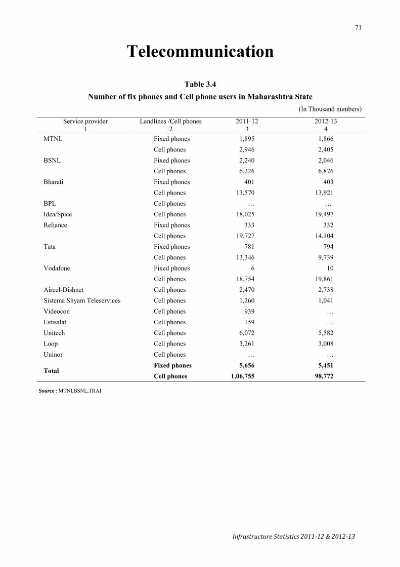
71
Infrastructure Statistics 2011-12 & 2012-13
Telecommunication
Table 3.4
Number of fix phones and Cell phone users in Maharashtra State (In Thousand numbers)
Source : MTNI,BSNL,TRAI
Service provider Landlines /Cell phones 2011-12 2012-13 1 2 3 4
MTNL Fixed phones 1,895 1,866 Cell phones 2,946 2,405
BSNL Fixed phones 2,240 2,046 Cell phones 6,226 6,876
Bharati Fixed phones 401 403 Cell phones 13,570 13,921
BPL Cell phones … … Idea/Spice Cell phones 18,025 19,497 Reliance Fixed phones 333 332
Cell phones 19,727 14,104 Tata Fixed phones 781 794
Cell phones 13,346 9,739 Vodafone Fixed phones 6 10 Cell phones 18,754 19,861 Aircel-Dishnet Cell phones 2,470 2,738 Sistema Shyam Teleservices Cell phones 1,260 1,041 Videocon Cell phones 939 … Estisalat Cell phones 159 … Unitech Cell phones 6,072 5,582 Loop Cell phones 3,261 3,008 Uninor Cell phones … …
Total Fixed phones 5,656 5,451 Cell phones 1,06,755 98,772

72
Infrastructure Statistics 2011-12 & 2012-13
Table 3.5
Districtwise and Service providerwise Number of Fixed Phones and Public Call Office’s
(In Thousand numbers)
Sr. No.
District /Service Provider Fixed Phones PCO’s ( Local + STD + Highway) 2011-12 2012-13 2011-12 2012-13
1 2 3 4 5 6 MTNL, Mumbai
1 Mumbai 539 528 25 24 2 Mumbai Suburban 993 981 59 54 3 Thane (Thane Municipal corporation) 343 334 13 12 4 Raigad ( Panvel,Uran, Nhava sheva) 19 23 849 800
BSNL 5 Thane-Kalyan 229 197 12 12 6 Raigad-Rural 52 47 2 2 7 Ratnagiri 56 50 6 5 8 Sindhudurg 35 34 3 3 9 Nashik 134 126 9 6
10 Dhule 47 42 3 2
11 Nandurbar 12 Jalgaon 99 89 7 6 13 Ahmednagar 88 80 8 8 14 Pune 349 340 26 13 15 Satara 77 64 7 4 16 Sangli 96 84 7 5 17 Solapur 74 70 9 8 18 Kolhapur 149 137 10 8 19 Aurangabad 73 67 7 7 20 Jalna 16 14 1 1 21 Parbhani
26 24 4 4 22 Hingoli 23 Beed 27 24 3 2 24 Nanded 32 28 4 3 25 Osmanabad 23 19 2 1 26 Latur 32 28 3 2 27 Buldhana 36 34 2 2 28 Akola
38 33 2 2 29 Washim 30 Amravati 50 47 2 2 31 Yavatmal 26 23 1 1 32 Wardha 22 20 0 0 33 Nagpur 138 126 3 3 34 Bhandara
30 29 1 1 35 Gondiya 36 Chandrapur 32 28 2 1 37 Gadchiroli 7 5 0 0
Bharati 401 403 - - Reliance 333 332 - - Tata 781 794 - -
Maharashtra State 5,503 5,306 1,093 950
Source: MTNL, BSNL, TRAI

73
Infrastructure Statistics 2011-12 & 2012-13
Irrigation
Table 4.1 Area under Irrigation in the State
(In ' 000 ha.)
Sr. No. Year
Area irrigated Intensity of
irrigated cropping
No. of irrigation
Wells ('000)
Net area irrigated per well
(ha.)
Gross cropped
area
Percentage of gross irrigated area to gross
cropped area Wells Other sources Net Gross
1 2 3 4 5 6 7 8 9 10 11
1 1985-86 1,162 787 1,949 2,420 124 914 1.27 20,569 11.8
2 1990-91 1,672 999 2,671 3,319 124 1,017 1.64 21,859 15.2
3 1995-96 1,870 1,010 2,880 3,550 123 1,229 1.52 21,504 16.5
4 2000-01 2,262 987 3,249 3,852 119 1,318 2.47 21,619 17.8
5 2001-02 2,146 990 3,136 3,727 119 1,322 2.37 20,991 17.8
6 2002-03 2,145 1,071 3,216 3,806 118 1,331 2.42 20,915 18.2
7 2003-04 1,914 1,030 2,944 3,636 123 N.A. N.A. 22,190 16.4
8 2004-05 1,942 1,001 2,993 3,665 125 N.A. N.A. 22,376 16.4
9 2005-06 2,077 1,070 3,147 3,810 118 N.A. N.A. 22,556 16.9
10 2006-07 2,109 1,137 3,246 3,958 122 N.A. N.A. 22,557 17.6
11 2007-08 2,151 1,160 3,311 4,037 122 N.A. N.A. 22,655 17.8
12 2008-09 2,115 1,140 3,255 3,970 122 N.A. N.A. 22,454 17.7
13 2009-10 2,159 1,162 3,321 4,050 122 N.A. N.A. 22,612 17.9
14 2010-11 N.A N.A N.A N.A N.A N.A N.A 23,175 N.A
15 2011-12 N.A N.A N.A N.A N.A N.A N.A 23,106 N.A
16 2012-13 N.A N.A N.A N.A N.A N.A N.A N.A N.A
Source – Commissionerate of Agriculture, GoM
Note - (1) Details may not add up to the totals due to rounding. (2) Intensity under Col. No. 7 is worked out by using the
formula (Col. No. 6 ÷ Col. No. 5) x 100. (3) Figures for the years 2003-04 to 2009-10 are provisional.
N. A. Not available

74
Infrastructure Statistics 2011-12 & 2012-13
Table 4.2
Districtwise Irrigation potential created and Actual irrigated area in Maharashtra 2011-12 (In’000 ha) Sr. No.
District Irrigation Potential created at the end of June,2011
Actual Irrigated area * 2011-12
Percentage of actual irrigated
area to irrigation potential created
Major Project
Medium Project
Minor Project & Lift Irrigation
Total Major Project
Medium Project
Minor Project & Lift Irrigation
Total
1 2 3 4 5 6 7 8 9 10 11 1 Mumbai 0.00 0.00 0.00 0.00 0.00 0.00 0.00 0.00 0.00 2 Mumbai Suburban 0.00 0.00 0.00 0.00 0.00 0.00 0.00 0.00 0.00 3 Thane 36.95 3.07 6.29 46.31 3.62 0.60 2.11 6.33 13.67 4 Raigad 9.07 5.2 7.05 21.32 1.27 0.13 1.43 2.83 13.27 5 Ratnagiri 0.00 6.02 12.00 18.02 0.00 0.09 0.24 0.33 1.83 6 Sindhudurg 7.05 3.43 4.47 14.95 0.16 0.08 0.37 0.61 4.08
Kokan Division 53.07 17.72 29.81 100.60 5.05 0.90 4.15 10.10 10.04 7 Nashik 124.47 39.43 49.16 213.06 115.76 14.68 21.60 152.04 4.08 8 Dhule 0.00 59.89 46.25 106.14 0.00 55.99 25.3 81.29 76.59 9 Nandurbar 0.00 30.13 56.03 86.16 0.00 18.69 9.59 28.28 32.82
10 Jalgaon 128.36 55.67 36.01 220.04 69.66 56.15 27.60 153.41 69.72 11 Ahmadnagar 235.32 28.05 89.80 353.17 351.64 22.96 24.26 398.86 112.94
Nashik Division 488.15 213.17 277.25 978.57 537.06 168.47 108.35 813.88 83.17 12 Pune 245.76 29.25 122.62 397.63 263.42 21.59 129.08 414.09 104.14 13 Satara 165.99 22.74 22.43 211.16 158.47 4.48 43.56 206.51 97.80 14 Sangli 194.79 19.63 50.68 265.10 39.66 3.16 100.84 143.66 54.19 15 Solapur 275.33 33.22 70.21 378.76 359.29 15.58 13.90 388.77 102.64 16 Kolhapur 186.61 89.62 35.73 311.96 117.88 60.57 32.33 210.78 67.57
Pune Division 1068.48 194.46 301.67 1564.61 938.72 105.38 319.71 1363.81 87.17 17 Aurangabad 50.16 40.5 42.04 132.70 46.8 19.98 16.52 83.30 62.77 18 Jalna 43.22 16.05 34.35 93.62 36.82 7.11 11.22 55.15 58.91 19 Parbhani 163.36 7.54 13.55 184.45 69.52 3.79 3.28 76.59 41.52 20 Hingoli 38.75 0.00 13.17 51.92 39.23 0.00 4.73 43.96 84.67 21 Beed 79.63 29.64 69.15 178.42 38.27 6.75 15.64 60.66 34.00 22 Nanded 128.88 21.24 50.53 200.65 83.1 5.90 10.78 99.78 49.73 23 Osmanabad 16.62 30.21 73.74 120.57 3.89 11.34 14.33 29.56 24.52 24 Latur 30.30 24.27 62.43 117.00 12.44 6.44 23.17 42.05 35.94
Aurangabad Divn. 550.92 169.45 358.96 1079.33 330.07 61.31 99.67 491.05 45.50 25 Buldhana 38.02 22.36 33.98 94.36 30.94 8.72 15.46 55.12 58.41 26 Akola 22.80 21.90 12.77 57.47 5.39 3.59 6.15 15.13 26.33 27 Washim 0.94 6.63 39.64 47.21 0.00 2.71 19.79 22.50 47.66 28 Amravati 55.23 29.79 24.22 109.24 30.52 9.44 9.89 49.85 45.63 29 Yavatmal 78.98 42.54 44.71 166.23 29.19 23.06 16.72 68.97 41.49
Amravati Divn. 195.97 123.22 155.32 474.51 96.04 47.52 68.01 211.57 44.59 30 Wardha 62.28 31.76 11.71 105.75 15.47 7.48 3.23 26.18 24.76 31 Nagpur 90.14 34.15 39.28 163.57 103.22 21.35 13.59 138.16 84.47 32 Bhandara 58.17 11.62 42.61 112.40 30.18 12.65 14.43 57.26 50.94 33 Gondiya 53.36 30.85 31.92 116.13 28.59 22.05 17.56 68.20 58.73 34 Chandrapur 20.58 28.34 39.54 88.46 15.88 20.77 18.68 55.33 62.55 35 Gadchiroli 30.44 0.00 11.09 41.53 10.95 0.00 5.06 16.01 38.55
Nagpur Divn. 314.97 136.72 176.15 627.84 204.29 84.30 72.55 361.14 57.52 Maharashtra State 2671.56 854.74 1299.16 4825.46 2111.23 467.88 672.44 3251.55 67.38
Source – Water Resource Department, GoM Note - * Includes well water, canal water, reservoir &lift irrigation by well

75
Infrastructure Statistics 2011-12 & 2012-13
Table 4.3 Districtwise Irrigation potential created and Actual irrigated area in Maharashtra: 2012-2013
(In ’000 ha) Sr. No.
District Irrigation Potential created at the end of June,2012
Actual Irrigated area 2012-13
Percentage of actual irrigated area to
irrigation potential created
Major Project
Medium Project
Minor Project & Lift
Irrigation
Total Major Project
Medium Project
Minor Project & Lift
Irrigation
Total
1 2 3 4 5 6 7 8 9 10 11 1 Mumbai 0.00 0.00 0.00 0.00 0.00 0.00 0.00 0.00 0.00 2 Mumbai Suburban 0.00 0.00 0.00 0.00 0.00 0.00 0.00 0.00 0.00 3 Thane 36.95 3.07 6.79 46.81 3.68 0.60 1.90 6.18 13.20 4 Raigad 9.07 5.20 7.18 21.45 0.87 0.18 1.39 2.44 11.38 5 Ratnagiri 0.00 6.02 12.41 18.43 0.00 0.09 0.26 0.35 1.90 6 Sindhudurg 7.29 4.05 4.47 15.81 0.12 0.11 0.54 0.77 4.87
Kokan Division 53.31 18.34 30.85 102.50 4.67 0.98 4.09 9.74 9.50 7 Nashik 128.91 39.48 49.47 217.86 89.46 11.51 19.55 120.52 55.32 8 Dhule 0.00 62.13 46.51 108.64 0.00 34.85 8.04 42.89 39.48 9 Nandurbar 0.00 31.90 56.87 88.77 0.00 19.99 9.11 29.10 32.78
10 Jalgaon 130.80 57.76 36.86 225.42 45.80 34.47 8.59 88.86 39.42 11 Ahmadnagar 235.32 28.05 90.38 353.75 219.33 5.87 11.43 236.63 66.89
Nashik Division 495.03 219.32 280.09 994.44 354.59 106.69 56.72 518.00 52.09 12 Pune 250.68 29.25 124.54 404.47 248.88 16.15 107.35 372.38 92.07 13 Satara 171.69 23.27 24.45 219.41 164.62 3.54 28.38 196.54 89.58 14 Sangli 194.83 19.63 69.77 284.23 38.63 1.75 112.15 152.53 53.66 15 Solapur 276.29 33.86 70.73 380.88 265.97 5.46 14.24 285.67 75.00 16 Kolhapur 186.79 89.62 36.15 312.56 119.07 57.99 27.02 204.08 65.29
Pune Division 1080.28 195.63 325.64 1601.55 837.17 84.89 289.14 1211.20 75.63 17 Aurangabad 50.16 40.87 42.61 133.64 12.66 0.88 0.91 14.45 10.81 18 Jalna 43.22 16.05 36.40 95.67 4.52 0.29 0.84 5.65 5.91 19 Parbhani 172.73 7.54 14.47 194.74 21.02 4.22 2.61 27.85 14.30 20 Hingoli 38.75 0.00 13.17 51.92 17.77 0.00 2.84 20.61 39.70 21 Beed 79.63 29.79 69.74 179.16 6.31 1.09 1.40 8.80 4.91 22 Nanded 131.66 22.43 51.15 205.24 47.09 3.60 7.23 57.92 28.22 23 Osmanabad 16.62 30.31 73.99 120.92 0.43 0.77 1.19 2.39 1.98 24 Latur 30.30 24.95 66.85 122.10 0.85 3.19 15.72 19.76 16.18
Aurangabad Divn. 563.07 171.94 368.38 1103.39 110.65 14.04 32.74 157.43 14.27 25 Buldhana 40.23 22.36 33.98 96.57 0.81 1.14 2.79 4.74 4.91 26 Akola 22.80 21.90 12.77 57.47 10.42 7.44 5.27 23.13 40.25 27 Washim 0.94 6.63 42.79 50.36 0.00 3.26 14.81 18.07 35.88 28 Amravati 55.23 29.79 24.22 109.24 25.03 11.47 11.00 47.50 43.48 29 Yavatmal 85.34 42.54 44.73 172.61 27.61 21.12 16.17 64.90 37.60
Amravati Divn. 204.54 123.22 158.49 486.25 63.87 44.43 50.04 158.34 32.56 30 Wardha 64.28 32.16 11.71 108.15 26.75 11.94 3.10 41.79 38.64 31 Nagpur 90.42 35.15 39.59 165.16 88.32 22.33 13.64 124.29 75.25 32 Bhandara 61.57 11.82 42.61 116.00 35.23 13.63 15.45 64.31 55.44 33 Gondiya 53.36 30.85 32.22 116.43 39.34 24.31 18.08 81.73 70.20 34 Chandrapur 22.17 28.63 39.54 90.34 16.14 19.93 19.26 55.33 61.25 35 Gadchiroli 30.44 0.00 11.09 41.53 21.60 0.00 4.72 26.32 63.38
Nagpur Divn. 322.24 138.61 176.76 637.61 227.38 92.14 74.25 393.77 61.76 Maharashtra State 2718.47 867.06 1340.21 4925.74 1598.33 343.17 506.98 2448.48 49.71
Source – Water Resource Department, GoM Note - * Includes well water, canal water, reservoir &lift irrigation by well


77
Infrastructure Statistics 2011-12 & 2012-13
Drinking Water Supply
Table 5.1 Sources of Drinking water as per Census 2001 & 2011
Sr. No.
District Total households Percent of Households having Tap water Well water
2001 2011 2001 2011 2001 2011 1 2 3 4 5 6 7 8
1 Mumbai 6,48,590 6,37,738 96.6 97.8 0.2 0.1 2 Mumbai Suburban 17,74,332 20,27,743 98.2 96.5 0.3 0.3 3 Thane 17,00,019 24,30,616 76.5 80.8 12.2 8.7 4 Raigad 4,71,628 5,96,514 56.7 73.9 27.6 12.9 5 Ratnagiri 3,66,605 3,93,379 41.0 60.5 42.9 28.9 6 Sindhudurg 1,90,278 2,05,119 22.3 30.7 68.5 62.1 7 Pune 14,39,610 20,76,607 75.2 80.6 13.2 8.9 8 Satara 5,46,458 6,39,999 69.2 73.4 13.2 10.1 9 Sangli 4,95,189 5,85,227 65.5 67.3 16.3 13.9
10 Kolhapur 6,90,523 8,21,483 76.9 85.4 8.1 4.9 11 Solapur 7,15,075 8,58,981 54.7 57.0 19.0 17.7 12 Ahmadnagar 7,42,065 9,01,748 47.9 50.4 35.6 30.2 13 Nashik 8,76,758 11,80,293 59.3 63.2 26.9 25.7 14 Dhule 3,29,868 4,08,700 75.1 83.9 10.4 7.1 15 Nandurbar 2,50,526 3,19,623 52.4 56.8 8.6 6.1 16 Jalgaon 7,30,063 8,91,657 85.4 88.7 5.1 4.5 17 Aurangabad 5,27,219 7,36,587 62.1 62.4 18.3 20.0 18 Jalna 3,01,485 3,88,116 43.9 41.4 23.1 27.8 19 Parbhani 2,83,603 3,60,186 39.1 41.2 12.3 13.7 20 Hingoli 1,81,035 2,27,041 26.1 35.9 23.5 20.8 21 Nanded 5,23,539 6,56,303 49.9 47.0 19.2 15.4 22 Beed 4,33,108 5,45,073 43.4 42.4 17.8 20.5 23 Osmanabad 2,93,109 3,48,760 50.1 56.6 8.9 9.3 24 Latur 3,73,283 4,74,149 54.0 58.4 10.4 11.3 25 Buldhana 4,43,878 5,53,031 51.0 54.1 27.7 24.1 26 Akola 3,13,390 3,91,135 60.3 58.7 15.2 9.0 27 Washim 2,02,762 2,57,892 37.0 41.1 40.6 37.5 28 Amravati 5,13,610 6,37,446 70.4 77.8 14.2 8.9 29 Yavatmal 5,08,706 6,40,385 40.7 43.9 34.9 29.1 30 Wardha 2,59,342 3,02,680 50.7 63.5 30.7 17.9 31 Nagpur 7,90,524 9,95,808 70.7 76.4 17.2 11.8 32 Bhandara 2,39,861 2,75,773 35.6 38.0 34.3 25.7 33 Gondiya 2,49,376 2,89,431 15.7 17.5 46.6 37.4 34 Chandrapur 4,51,981 5,29,612 36.3 40.6 31.4 21.0 35 Gadchiroli 2,05,751 2,45,745 17.2 19.5 40.5 36.3
Maharashtra State 1,90,63,149 2,38,30,580 64.0 67.9 17.8 14.4

78
Infrastructure Statistics 2011-12 & 2012-13
Table 5.1 -Contd..
Sources of drinking water : 2001 & 2011
Sr. No. District
Percent of Households having
Handpump/ Tubewell water
Other sources of water
Tap Water (2011) Well Water(2011)
2001 2011 2001 2011 Treated Untreated Covered Uncovered 1 2 9 10 11 12 13 14 15 16 1 Mumbai 2.1 1.2 1.0 0.9 97.9 2.1 66.0 34.0 2 Mumbai Suburban 1.0 0.7 0.4 2.4 97.3 2.7 49.6 50.4 3 Thane 9.4 8.9 1.9 1.5 94.5 5.5 20.9 79.1 4 Raigad 11.9 10.9 3.8 2.3 81.4 18.6 19.7 80.3 5 Ratnagiri 5.1 5.3 10.9 5.3 76.5 23.5 32.9 67.1 6 Sindhudurg 3.5 3.7 5.6 3.5 66.7 33.3 23.4 76.6 7 Pune 9.1 8.6 2.5 1.8 91.9 8.1 9.3 90.7 8 Satara 14.0 14.0 3.7 2.4 84.7 15.3 10.7 89.3 9 Sangli 15.6 16.8 2.5 2.0 87.6 12.4 8.0 92.0 10 Kolhapur 11.4 7.9 3.7 1.8 70.3 29.7 15.9 84.1 11 Solapur 23.2 22.5 3.1 2.9 82.3 17.7 7.1 92.9 12 Ahmadnagar 13.3 15.8 3.2 3.6 80.1 19.9 10.6 89.4 13 Nashik 11.0 8.9 2.9 2.2 83.0 17.0 8.2 91.8 14 Dhule 12.5 7.3 2.1 1.7 74.6 25.3 21.3 78.7 15 Nandurbar 31.5 29.7 7.5 7.3 51.5 48.5 14.7 85.3 16 Jalgaon 7.7 4.7 1.7 2.1 77.7 22.3 18.7 81.3 17 Aurangabad 17.6 14.4 2.0 3.1 80.9 19.1 7.8 92.2 18 Jalna 30.3 27.9 2.6 3.0 61.2 38.8 8.4 91.6 19 Parbhani 45.1 42.2 3.5 2.8 64.1 35.9 7.7 92.3 20 Hingoli 48.4 41.1 1.9 2.3 50.1 49.9 7.1 92.9 21 Nanded 27.5 34.0 3.4 3.1 57.5 42.5 10.7 89.3 22 Beed 36.7 34.5 2.1 2.6 70.7 29.3 6.5 93.5 23 Osmanabad 38.3 30.3 2.7 3.8 60.2 39.8 8.9 91.1 24 Latur 31.8 27.9 3.8 2.5 68.0 32.0 10.4 89.6 25 Buldhana 19.1 20.0 2.2 1.7 61.2 38.8 15.0 85.0 26 Akola 21.7 31.0 2.8 1.4 78.0 22.0 20.3 79.7 27 Washim 21.6 20.0 0.9 1.3 58.5 41.5 10.0 90.0 28 Amravati 14.1 12.3 1.3 0.9 81.0 19.0 23.5 76.5 29 Yavatmal 22.1 25.2 2.2 1.8 60.3 39.7 14.4 85.6 30 Wardha 17.7 18.1 0.9 0.6 72.9 27.1 19.1 80.9 31 Nagpur 11.3 10.9 0.8 0.9 86.2 13.8 34.9 65.1 32 Bhandara 29.7 35.8 0.5 0.6 66.0 34.0 24.5 75.5 33 Gondiya 37.4 44.8 0.3 0.3 67.6 32.4 29.3 70.7 34 Chandrapur 30.9 37.5 1.4 0.8 75.9 24.1 16.2 83.8 35 Gadchiroli 41.3 43.2 1.1 1.0 71.5 28.5 30.4 69.6 Maharashtra State 15.8 15.5 2.4 2.1 83.0 17.0 15.3 84.7
Source – Registrar General of India

79
Infrastructure Statistics 2011-12 & 2012-13
Graph 1: Drinking Water facility
64
17.8 15.8
2.4
67.9
14.4 15.5
2.10
10203040
50607080
Tap Water Well water Handpump/Tubewellwater
Other sources of water
Sources of Water
Perc
enta
ge o
f Hou
seho
lds
Census 2001 Census 2011

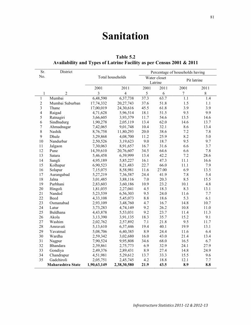
81
Infrastructure Statistics 2011-12 & 2012-13
Sanitation
Table 5.2 Availability and Types of Latrine Facility as per Census 2001 & 2011
Sr.
No. District
Total households Percentage of households having
Water closet Latrine Pit latrine
2001 2011 2001 2011 2001 2011 1 2 3 4 5 6 7 8
1 Mumbai 6,48,590 6,37,738 37.3 63.7 1.1 1.4 2 Mumbai Suburban 17,74,332 20,27,743 37.6 51.8 1.5 1.1 3 Thane 17,00,019 24,30,616 45.5 61.8 3.9 3.9 4 Raigad 4,71,628 5,96,514 18.1 51.5 9.5 9.9 5 Ratnagiri 3,66,605 3,93,379 11.7 54.6 13.5 14.6 6 Sindhudurg 1,90,278 2,05,119 13.4 62.0 14.6 13.7 7 Ahmadnagar 7,42,065 9,01,748 10.4 32.1 8.6 13.4 8 Nashik 8,76,758 11,80,293 20.0 38.6 7.2 7.8 9 Dhule 3,29,868 4,08,700 11.2 25.9 8.2 5.0 10 Nandurbar 2,50,526 3,19,623 9.0 18.7 9.5 9.7 11 Jalgaon 7,30,063 8,91,657 16.7 31.6 6.6 3.7 12 Pune 14,39,610 20,76,607 34.5 64.6 6.6 7.8 13 Satara 5,46,458 6,39,999 13.4 42.2 7.2 28.6 14 Sangli 4,95,189 5,85,227 16.1 47.3 11.1 16.6 15 Kolhapur 6,90,523 8,21,483 22.7 66.0 11.1 7.9 16 Solapur 7,15,075 8,58,981 11.6 27.00 6.9 13.5 17 Aurangabad 5,27,219 7,36,587 24.4 41.9 7.8 5.4 18 Jalna 3,01,485 3,88,116 7.0 20.3 8.5 15.5 19 Parbhani 2,83,603 3,60,186 10.9 23.2 10.1 4.8 20 Hingoli 1,81,035 2,27,041 4.5 18.3 8.3 13.1 21 Nanded 5,23,539 6,56,303 9.5 24.0 11.6 7.7 22 Beed 4,33,108 5,45,073 8.8 18.6 5.3 6.1 23 Osmanabad 2,93,109 3,48,760 4.7 16.7 14.8 10.7 24 Latur 3,73,283 4,74,149 9.2 26.2 10.8 11.0 25 Buldhana 4,43,878 5,53,031 9.2 23.7 11.4 11.3 26 Akola 3,13,390 3,91,135 18.3 35.7 15.2 9.1 27 Washim 2,02,762 2,57,892 7.1 21.8 9.5 11.7 28 Amravati 5,13,610 6,37,446 19.4 40.1 19.9 13.1 29 Yavatmal 5,08,706 6,40,385 8.9 24.4 11.6 6.4 30 Wardha 2,59,342 3,02,680 16.0 43.0 21.4 13.4 31 Nagpur 7,90,524 9,95,808 34.6 68.0 16.5 6.7 32 Bhandara 2,39,861 2,75,773 6.9 32.9 24.1 27.9 33 Gondiya 2,49,376 2,89,431 8.9 27.4 14.8 24.9 34 Chandrapur 4,51,981 5,29,612 13.7 33.3 15.5 9.6 35 Gadchiroli 2,05,751 2,45,745 4.2 18.8 12.1 7.7
Maharashtra State 1,90,63,149 2,38,30,580 21.9 43.5 8.9 8.8

82
Infrastructure Statistics 2011-12 & 2012-13
Table 5.2- Contd.. Availability and Types of Latrine Facility as per Census 2001 & 2011
Sr. No. District
Percentage of households having
Other latrine No latrine (using public latrine/open space)
2001 2011 2001 2011 1 2 9 10 11 12 1 Mumbai 5.3 1.8 56.4 33.0 2 Mumbai Suburban 4.4 1.8 56.5 45.3 3 Thane 6.0 1.3 44.5 33.0 4 Raigad 5.5 0.6 66.9 38.0 5 Ratnagiri 3.2 0.2 71.6 30.6 6 Sindhudurg 4.1 0.1 67.8 24.1 7 Ahmadnagar 3.5 0.6 77.5 53.9 8 Nashik 3.6 0.4 69.2 53.2 9 Dhule 1.9 0.3 78.7 68.8 10 Nandurbar 1.8 0.3 79.7 71.3 11 Jalgaon 3.3 0.3 73.4 64.5 12 Pune 5.3 1.4 53.6 26.2 13 Satara 3.5 0.3 75.8 28.9 14 Sangli 5.6 1.1 67.2 35.1 15 Kolhapur 4.0 0.6 62.3 25.5 16 Solapur 2.8 0.8 78.6 58.7 17 Aurangabad 6.4 1.7 61.4 51.1 18 Jalna 3.4 0.7 81.1 63.5 19 Parbhani 4.5 0.9 74.5 71.2 20 Hingoli 3.1 1.0 84.1 67.6 21 Nanded 3.3 1.4 75.6 66.9 22 Beed 2.7 0.4 83.2 74.9 23 Osmanabad 3.3 0.3 77.1 72.3 24 Latur 3.9 0.4 76.1 62.4 25 Buldhana 2.2 0.2 77.2 64.7 26 Akola 4.8 1.2 61.7 53.9 27 Washim 2.5 0.3 81.0 66.2 28 Amravati 4.0 0.5 56.7 46.3 29 Yavatmal 2.6 0.3 77.0 69.0 30 Wardha 3.5 0.3 59.1 43.3 31 Nagpur 9.7 1.0 39.2 24.3 32 Bhandara 4.4 0.4 64.5 38.8 33 Gondiya 2.6 0.2 73.8 47.6 34 Chandrapur 3.3 0.4 67.5 56.7 35 Gadchiroli 2.5 0.4 81.2 73.0 Maharashtra State 4.3 0.9 64.9 46.9
Source – Registrar General of India

83
Infrastructure Statistics 2011-12 & 2012-13
Storage
Table 6.1 Districtwise Number of Godowns and their capacity
Sr. No.
District Available Godowns As on March, 2012 As on March, 2013
Number Capacity (MT) Number Capacity (MT) 1 2 3 4 5 6 1 Mumbai 13 8,724 13 8,724 2 Mumbai Suburban 3 Thane 35 16,700 38 17,000 4 Raigad 62 25,800 62 25,800 5 Ratnagiri 45 16,050 45 16,050 6 Sindhudurg 14 6,550 14 6,550 Kokan Division 169 73,824 172 74,124
7 Nasik 28 17,200 28 17,200 8 Dhule 17 8,500 17 7,500 9 Nandurbar 26 13,000 25 12,500
10 Jalgaon 32 14,100 32 14,100 11 Ahmadnagar 76 49,100 76 50,850 Nashik Division 179 1,01,900 178 1,02,150
12 Pune 48 37,020 47 34,000 13 Satara 43 15,640 43 15,640 14 Sangli 29 13,760 29 13,760 15 Solapur 54 38,024 53 38,024 16 Kolhapur 22 10,450 21 9,850 Pune Division 196 1,14,894 193 1,11,274
17 Aurangabad 27 26,188 27 26,188 18 Jalna 28 18,700 25 17,650 19 Parbhani 21 9,300 21 9,300 20 Hingoli 11 6,600 11 6,600 21 Beed 35 25,110 35 25,050 22 Nanded 41 16,350 41 16,350 23 Osmanabad 30 17,000 30 17,000 24 Latur 27 19,700 27 19,700 Aurangabad Division 220 1,38,948 217 1,37,838
25 Buldhana 21 8,800 20 8,800 26 Akola 23 13,100 21 11,600 27 Washim 11 7,150 11 7,150 28 Amravati 29 11,750 29 11,750 29 Yavatmal 35 17,500 35 17,500 Amravati Division 119 58,300 116 56,800
30 Wardha 14 8,685 14 9,785 31 Nagpur 49 26,182 49 25,329 32 Bhandara 16 9,500 16 9,500 33 Gondiya 23 12,400 19 12,400 34 Chandrapur 33 15,000 29 14,200 35 Gadchiroli 21 9,050 21 9,050 Nagpur Division 156 80,817 148 80,264 Maharashtra State 1,039 5,68,683 1,024 5,62,450
Source- Food & Civil Supply Department,GoM

84
Infrastructure Statistics 2011-12 & 2012-13
Table 6.2 Districtwise Number of Warehouses and their capacity
Sr. No.
District Available Warehouses As on March, 2012 As on March, 2013
Number Capacity (MT) Number Capacity (MT) 1 2 3 4 5 6 1 Mumbai - - - - 2 Mumbai Suburban 3 Thane 1 2,000 2,000 4 Raigad 5 63,107 5 47,518 5 Ratnagiri 2 15,840 2 15,840 6 Sindhudurg 1 5,517 1 10,600 Kokan Division 9 86,464 9 75,958
7 Nasik 11 53,035 11 53,060 8 Dhule 5 37,680 6 57,580 9 Nandurbar 3 19,290 3 19,290
10 Jalgaon 13 99,491 13 1,23,176 11 Ahmadnagar 8 52,835 8 50,845 Nashik Division 40 2,62,331 41 3,03,951
12 Pune 8 63,080 8 63,697 13 Satara 6 63,133 6 73,148 14 Sangli 3 15,490 3 15,490 15 Solapur 12 90,431 13 88,160 16 Kolhapur 2 5,840 2 5,840 Pune Division 31 2,37,974 32 2,46,335
17 Aurangabad 9 46,008 9 46,008 18 Jalna 5 51,683 5 51,683 19 Parbhani 7 60,000 7 60,000 20 Hingoli 5 29,950 5 30,097 21 Beed 6 44,620 6 44,620 22 Nanded 5 46,601 5 46,601 23 Osmanabad 4 9,635 4 11,350 24 Latur 4 39,985 4 47,793 Aurangabad Division 45 3,28,482 45 3,38,152
25 Buldhana 7 63,138 7 65,425 26 Akola 4 18,820 4 18,820 27 Washim 4 24,810 4 24,810 28 Amravati 5 28,880 5 28,880 29 Yavatmal 7 51,758 7 44,723 Amravati Division 27 1,87,406 27 1,82,658
30 Wardha 4 45,460 4 48,140 31 Nagpur 3 36,428 3 35,651 32 Bhandara 2 11,589 2 11,259 33 Gondiya 2 7,900 2 7,900 34 Chandrapur 3 28,505 3 43,280 35 Gadchiroli 2 12,956 2 12,956 Nagpur Division 16 1,42,838 16 1,59,186 Maharashtra State 168 1,245,495 170 13,06,240
Source- Maharashtra State Warehousing Coprporation

85
Infrastructure Statistics 2011-12 & 2012-13
Table 6.3 Districtwise Existing Export FacilityCentre(As on March, 2013)
Sr. No
District Export Facility Centre Particulars/ Components
Capacity
1 2 3 4 5 1 Mumbai
Suburban Vapour Heat Treatment Facility, Navi Mumbai VHT 1.5 M.T./Hr.
Pre cooling 5 M.T./6Hr. Cold Storage 50 M.T. Material Handling
System 1.5 M.T./Hr.
2 Ratnagiri Alphonso Mango Export Facility Centre, Nachane Pre cooling 5 M.T./6Hr. Cold Storage 25 M.T. Ripening hamber 5 M.T. Material Handling
System 1.5 M.T./Hr.
3 Sindhudurg Alphonso Mango Export Facility Centre, Jamsande Pre cooling 5 M.T./6Hr. Cold Storage 25 M.T. Ripening hamber 5 M.T. Material Handling
System 1.5 M.T./Hr.
4 Nashik Pomegranate & Onion Export Facility Centre, Kalvan Pre cooling 5 M.T./6Hr. Cold Storage 50 M.T. Material Handling
System 1.5 M.T./Hr.
5 Jalgaon Banana Export Facility Centre, Raver (Savada) Cold Storage 25 M.T. Ripening Chamber 25 M.T. Material Handling
System 2 M.T./Hr.
6 Pune Agricultural Produce Export Facility Centre, Indapur Material Handling System
10 M.T./Hr.
Onion Storage Facility
500 M.T.
Fruits & Vegetables Export Facility Centre, Indapur Pre cooling 5 M.T./6Hr. Cold Storage 120 M.T. Pomegranate Export Facility Centre, Baramati Pre cooling 5 M.T./6Hr. Cold Storage 60 M.T. Material Handling
System 2 M.T./Hr.
Export Facility Centre, Talegaon Pre cooling 5 M.T./6Hr. Cold Storage 50 M.T. Pack House 800 Sq. Ft.
7 Jalna Keshar Mango Export Facility Centre Pre cooling 5 M.T./6Hr. Cold Storage 50 M.T. Ripening Chamber 1.5 M.T./Hr. Material Handling
System 5 M.T./ 6Hr.

86
Infrastructure Statistics 2011-12 & 2012-13
Table 6.3---Contd. Districtwise Existing Export FacilityCentre(As on March, 2013)
Sr. No
District Export Facility Centre Particulars/ Components
Capacity
1 2 3 4 5 8 Hingoli Banana Export Facility Centre, Basmatnagar Pre cooling 5 M.T./6Hr. Cold Storage 25 M.T. Ripening
Chamber 25 M.T.
Material Handling System
25 M.T./Hr.
9 Latur Keshar Mango & Pomegranate Export Facility Centre Pre cooling 5 M.T./6Hr. Cold Storage 100 M.T. Ripening
Chamber 5 M.T.
Material Handling System
1.5 M.T./Hr.
10 Wardha Orange Export Facility Centre, Ashti Pre cooling 5 M.T./6Hr. Cold Storage 25 M.T. Material
Handling System
1.5 M.T./Hr.
Source: Maharashtra State Agricultural Marketing Board, GoM

87
Infrastructure Statistics 2011-12 & 2012-13
Education
Table 7.1 Districtwise Number of schools & infrastructure facilities in schools : 2011-12
Sr. No. District
Number of
Schools
Percentage of Schools having
Buildings Water Facility
Electricity Computers Ramps
1 2 3 4 5 6 7 8 1 Mumbai 1,393 100.00 100.00 99.86 92.46 13.28 2 Mumbai Suburban 2,440 98.44 100.00 100.00 71.56 40.94 3 Thane 7,113 99.70 98.37 80.36 55.01 59.41 4 Raigad 3,708 98.46 97.76 82.79 31.50 75.22 5 Ratnagiri 3,289 99.76 96.87 90.97 37.76 79.72 6 Sindhudurg 1,763 99.89 92.34 92.85 42.60 79.24
Kokan Division 19,706 99.36 97.78 87.52 51.29 62.00 7 Nashik 5,157 99.73 100.00 53.50 38.34 67.29 8 Dhule 1,856 98.60 98.81 81.09 67.46 78.66 9 Nandurbar 1,938 97.27 97.52 63.93 31.79 68.78
10 Jalgaon 3,080 99.38 97.53 88.34 39.16 67.63 11 Ahmadnagar 5,026 98.71 90.01 86.83 40.15 74.65
Nashik Division 17,057 98.96 96.20 73.80 41.44 70.93 12 Pune 6,537 98.59 91.62 85.01 64.11 62.77 13 Satara 3,798 100.00 93.10 88.92 42.97 69.67 14 Sangli 2,705 100.00 88.58 79.82 52.01 71.42 15 Solapur 4,443 99.64 96.29 82.17 35.83 77.25 16 Kolhapur 3,481 98.97 100.00 86.53 54.81 56.39
Pune Division 20,964 99.31 93.88 84.70 51.18 67.14 17 Aurangabad 3,253 98.40 86.54 64.99 39.56 61.60 18 Jalna 2,036 99.21 90.67 63.26 28.49 64.19 19 Parbhani 1,773 98.42 77.38 75.30 42.53 62.55 20 Hingoli 1,132 98.32 93.46 56.01 45.58 74.38 21 Beed 3,174 98.96 80.81 64.02 36.83 60.62 22 Nanded 3,388 98.32 91.68 78.34 28.72 56.26 23 Osmanabad 1,669 98.98 87.84 80.41 47.33 63.15 24 Latur 2,387 99.29 95.64 72.39 46.46 55.93
Aurangabad Divn. 18,812 98.73 87.77 69.78 38.16 61.03 25 Buldhana 2,248 99.96 92.84 91.41 33.27 69.71 26 Akola 1,675 99.46 90.87 88.24 46.09 60.24 27 Washim 1,258 99.84 86.72 75.60 47.30 67.57 28 Amravati 2,742 99.96 98.29 74.07 36.87 64.95 29 Yavatmal 3,165 100.00 95.13 73.05 35.20 69.57
Amravati Division 11,088 99.88 93.85 79.61 38.24 66.82 30 Wardha 1,430 99.09 99.02 91.75 36.50 70.28 31 Nagpur 3,694 99.62 100.00 90.36 52.63 52.76 32 Bhandara 1,282 99.84 95.32 93.37 40.64 65.21 33 Gondia 1,590 100.00 100.00 96.04 36.35 61.01 34 Chandrapur 2,421 99.55 96.37 94.13 37.92 67.20 35 Gadchiroli 2,040 100.00 93.53 76.37 37.60 66.32
Nagpur Division 12,457 99.68 97.64 90.00 42.14 62.13 Maharashtra State 1,00,084 99.26 94.36 80.69 44.54 64.97

88
Infrastructure Statistics 2011-12 & 2012-13
Table 7.1---Contd. Districtwise Number of schools & infrastructure in schools : 2011-12
Sr. No.
District Percentage of Schools having
Play Ground Boundry Wall Kitchen Shed Common Toilets Girls Toilets 1 2 9 10 11 12 13 1 Mumbai 60.09 81.84 7.82 92.53 94.47 2 Mumbai Suburban 59.80 88.77 6.76 92.42 91.68 3 Thane 59.79 61.69 32.70 89.08 94.53 4 Raigad 63.35 45.06 8.06 90.45 90.75 5 Ratnagiri 20.34 65.86 4.17 97.11 85.80 6 Sindhudurg 25.69 68.24 6.47 94.90 71.07
Kokan Division 50.85 64.62 15.98 91.86 89.91 7 Nashik 71.24 54.24 37.21 93.93 45.22 8 Dhule 79.31 58.51 38.63 78.83 80.50 9 Nandurbar 50.52 43.96 42.47 79.21 72.34 10 Jalgaon 82.14 62.69 15.13 86.07 87.76 11 Ahmadnagar 64.25 44.97 13.31 89.08 41.78
Nashik Division 69.67 52.33 26.93 87.76 58.81 12 Pune 72.56 58.88 8.21 78.22 74.10 13 Satara 68.64 45.60 13.59 95.00 85.57 14 Sangli 76.71 54.49 29.21 91.90 86.99 15 Solapur 79.18 44.83 35.70 87.53 74.00 16 Kolhapur 62.34 50.90 14.91 90.00 88.22
Pune Division 72.09 51.61 18.83 86.95 80.17 17 Aurangabad 72.98 52.78 44.91 95.85 78.27 18 Jalna 61.35 43.27 54.86 83.10 86.15 19 Parbhani 62.27 49.63 41.29 63.11 67.12 20 Hingoli 57.51 55.21 52.03 89.66 85.69 21 Beed 58.73 42.03 53.34 74.39 67.64 22 Nanded 65.97 51.03 31.88 75.15 68.71 23 Osmanabad 71.48 50.99 32.89 75.25 83.16 24 Latur 70.30 63.13 48.76 85.21 87.26
Aurangabad Divn. 65.64 50.63 44.57 80.49 76.58 25 Buldhana 57.21 68.73 19.80 76.87 82.03 26 Akola 63.88 73.01 14.33 72.84 71.40 27 Washim 53.10 69.79 34.18 89.59 91.10 28 Amravati 65.50 75.05 26.08 80.09 44.31 29 Yavatmal 59.27 73.40 27.08 85.28 69.32
Amravati Division 60.39 72.39 24.23 80.90 68.50 30 Wardha 66.43 75.59 19.86 94.76 69.02 31 Nagpur 69.14 77.67 30.37 96.26 90.71 32 Bhandara 62.87 72.54 17.08 90.09 92.98 33 Gondia 68.68 60.13 14.91 96.10 97.23 34 Chandrapur 45.89 76.21 36.22 92.36 63.28 35 Gadchiroli 42.06 67.16 56.72 88.24 48.43
Nagpur Division 59.17 72.66 31.28 93.36 77.03 Maharashtra State 63.38 59.03 26.64 86.97 76.09
Source-Maharashtra Prathmik Shikshan Parishad,GoM,Mumbai

89
Infrastructure Statistics 2011-12 & 2012-13
Table 7.2
Districtwise Number of schools & infrastructure facilities in schools : 2012-13 Sr. No
District Number of Schools
Percentage of Schools having Buildings Water
Facility Electricity Computers Ramps
1 2 3 4 5 6 7 8 1 Mumbai 1,428 100.00 100.00 100.00 93.56 12.46 2 Mumbai Suburban 2,422 100.00 100.00 99.92 61.27 97.32 3 Thane 7,312 99.71 99.02 89.77 56.48 66.36 4 Raigad 3,773 99.68 99.97 95.28 33.74 80.49 5 Ratnagiri 3,304 99.97 99.64 97.09 40.89 94.40 6 Sindhudurg 1,762 100.00 99.55 98.07 43.87 84.62
Kokan Division 20,001 99.83 99.54 95.41 51.73 75.17 7 Nashik 5,198 99.87 100.00 96.48 40.38 73.70 8 Dhule 1,879 99.10 99.36 89.46 68.65 84.67 9 Nandurbar 1,972 99.39 99.24 67.24 34.69 69.83
10 Jalgaon 3,155 99.33 99.68 89.79 40.86 69.86 11 Ahmadnagar 5,065 99.72 97.22 95.30 94.37 82.90
Nashik Division 17,269 99.59 98.97 90.81 58.73 76.45 12 Pune 6,778 99.63 99.06 95.15 77.25 69.06 13 Satara 3,810 99.42 96.40 97.87 49.76 72.89 14 Sangli 2,782 100.00 98.96 92.16 53.41 77.97 15 Solapur 4,515 99.56 99.49 90.45 38.78 81.04 16 Kolhapur 3,517 99.83 100.00 93.86 58.17 67.16
Pune Division 21,402 99.66 98.82 94.04 58.01 73.11 17 Aurangabad 3,726 99.97 99.87 99.06 45.65 64.33 18 Jalna 2,076 99.81 97.40 78.28 31.70 72.88 19 Parbhani 1,843 99.40 83.34 85.35 44.11 61.58 20 Hingoli 1,146 100.00 100.00 67.36 47.38 74.96 21 Beed 3,220 99.60 89.01 72.14 35.37 55.71 22 Nanded 3,430 99.53 99.94 85.07 30.09 52.94 23 Osmanabad 1,686 99.88 100.00 91.04 48.75 70.70 24 Latur 2,444 99.88 98.81 84.62 47.18 57.82
Aurangabad Divn. 19,571 99.74 96.16 84.33 40.17 61.92 25 Buldhana 2,260 99.78 98.54 95.09 34.34 69.87 26 Akola 1,705 99.94 96.66 93.02 46.69 59.94 27 Washim 1,263 100.00 99.05 95.33 45.37 65.80 28 Amravati 2,758 99.93 99.96 79.33 38.00 64.90 29 Yavatmal 3,197 100.00 98.72 83.61 36.78 68.75
Amravati Division 11,183 99.93 98.71 87.63 39.07 66.35 30 Wardha 1,441 100.00 100.00 99.00 37.40 72.38 31 Nagpur 3,867 100.00 100.00 99.80 51.67 59.43 32 Bhandara 1,303 100.00 99.31 99.23 42.82 65.77 33 Gondiya 1,598 99.81 100.00 99.94 37.30 65.39 34 Chandrapur 2,446 99.84 98.24 97.71 40.02 67.83 35 Gadchiroli 2,047 100.00 95.16 81.09 38.45 67.07
Nagpur Division 12,702 99.94 98.81 96.91 42.96 65.15 Maharashtra State 1,02,128 99.76 98.46 90.17 49.54 70.20

90
Infrastructure Statistics 2011-12 & 2012-13
Table 7.2—Contd..
Districtwise Number of schools & infrastructure facilities in schools : 2012-13
Sr. No. District Percentage of Schools having
Play Ground Boundry Wall Kitchen Shed Common Toilets Girls Toilets 1 2 9 10 11 12 13
1 Mumbai 66.46 81.72 1.33 93.28 96.50 2 Mumbai Suburban 89.88 91.70 0.73 95.33 98.39 3 Thane 78.58 70.68 31.88 89.24 99.38 4 Raigad 68.57 61.04 15.48 90.56 99.18 5 Ratnagiri 94.34 93.64 13.65 97.06 99.03 6 Sindhudurg 34.45 97.62 12.88 87.34 99.60
Kokan Division 75.91 78.36 18.15 91.64 98.98 7 Nashik 73.87 54.00 47.58 94.02 98.31 8 Dhule 87.49 71.15 59.66 78.92 97.07 9 Nandurbar 49.80 44.88 60.85 83.62 98.17
10 Jalgaon 83.55 62.85 23.84 86.12 95.09 11 Ahmadnagar 84.68 67.54 50.84 89.28 96.21
Nashik Division 77.54 60.41 47.03 88.35 96.95 12 Pune 86.62 70.55 17.19 80.08 98.80 13 Satara 69.90 53.99 23.91 90.87 99.08 14 Sangli 92.42 78.94 34.69 89.90 94.36 15 Solapur 94.99 91.14 59.40 95.55 97.14 16 Kolhapur 77.62 64.34 28.52 90.16 97.36
Pune Division 84.68 72.02 31.43 88.20 97.69 17 Aurangabad 97.07 57.33 64.39 96.00 99.81 18 Jalna 63.10 44.36 72.21 83.43 98.22 19 Parbhani 61.91 53.07 56.65 64.46 89.47 20 Hingoli 56.98 56.46 63.96 89.88 100.00 21 Beed 62.48 42.58 71.40 74.53 90.62 22 Nanded 63.00 57.43 60.67 78.08 97.26 23 Osmanabad 92.82 56.52 59.73 75.50 98.52 24 Latur 79.71 70.01 69.31 85.39 97.42
Aurangabad Divn. 73.61 54.61 65.18 81.57 96.31 25 Buldhana 66.77 70.22 24.87 76.95 96.28 26 Akola 62.58 72.84 14.90 94.25 98.12 27 Washim 51.62 71.65 45.61 89.47 98.89 28 Amravati 64.29 75.53 29.30 80.38 97.93 29 Yavatmal 58.24 76.29 42.98 85.39 98.91
Amravati Division 61.37 73.83 31.96 84.26 98.01 30 Wardha 88.83 81.26 17.83 94.86 98.68 31 Nagpur 94.31 84.25 42.31 96.43 99.48 32 Bhandara 83.65 80.97 22.56 90.18 99.23 33 Gondia 73.40 62.20 27.16 95.93 99.00 34 Chandrapur 63.00 80.17 47.06 92.52 95.87 35 Gadchiroli 40.55 69.42 74.94 87.93 80.61
Nagpur Division 75.27 77.63 41.77 93.43 95.57 Maharashtra State 75.91 68.86 39.28 87.85 97.32
Source-Maharashtra Prathmik Shikshan Parishad, GoM,Mumbai
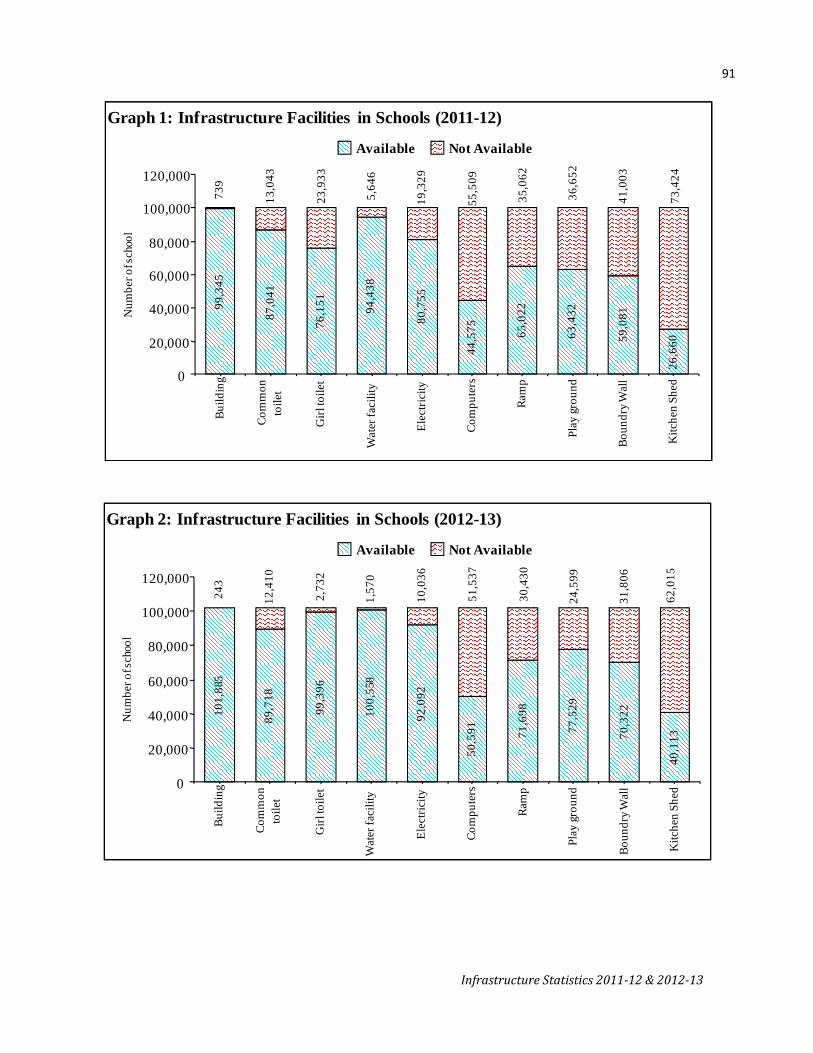
91
Infrastructure Statistics 201112 & 201213
Available Not Available
Graph 1: Infrastructure Facilities in Schools (2011-12)
99,3
45
87,0
41
76,1
51 94,4
38
80,7
55
44,5
75 65,0
22
63,4
32
59,0
81
26,6
6073
,424
41,0
03
36,6
52
35,0
62
55,5
09
5,64
6
23,9
33
13,0
43
739
19,3
29
0
20,000
40,000
60,000
80,000
100,000
120,000
Build
ing
Com
mon
toile
t
Girl
toile
t
Wat
er fa
cilit
y
Elec
trici
ty
Com
pute
rs
Ram
p
Play
grou
nd
Boun
dry W
all
Kitc
hen
Shed
Num
ber o
f sch
ool
Available Not Available
Graph 2: Infrastructure Facilities in Schools (2012-13)
101,
885
89,7
18
99,3
96
100,
558
92,0
92
50,5
91 71,6
98
77,5
29
70,3
22
40,1
13
10,0
36
243
12,4
10
2,73
2
1,57
0
51,5
37
30,4
30
24,5
99
31,8
06
62,0
15
0
20,000
40,000
60,000
80,000
100,000
120,000
Build
ing
Com
mon
toile
t
Girl
toile
t
Wat
er fa
cilit
y
Elec
trici
ty
Com
pute
rs
Ram
p
Play
grou
nd
Boun
dry W
all
Kitc
hen
Shed
Num
ber o
f sch
ool


93
Infrastructure Statistics 2011-12 & 2012-13
Public Health
Table 8.1
Medical facilities available through public and public aided institutions 2011-12 (1.1.2012) (In numbers)
Sr. No. District
Hospitals Primary Health Centres
Dispensaries Primary Health Units
TB Hospitals and Clinics
No. of Beds in all Institutions
1 2 3 4 5 6 7 8 1 Mumbai 775 0 749 0 23 37,088 2 Mumbai Suburban 3 Thane 1,095 79 2,411 23 1 13,086 4 Raigad 232 55 205 3 5 3,969 5 Ratnagiri 163 67 899 0 4 3,075 6 Sindhudurg 185 38 0 0 0 2,078 Konkan Division 2,450 239 4,264 26 33 59,296 7 Nashik 363 106 5,497 9 9 10,797 8 Dhule 172 41 365 0 1 4,042 9 Nandurbar 130 58 313 6 0 1,218
10 Jalgaon 451 77 1,983 0 1 7,350 11 Ahmednagar 300 96 1,888 5 2 6,286 Nashik Division 1,416 378 10,046 20 13 29,693
12 Pune 494 96 648 8 1 15,620 13 Satara 513 71 1,783 6 3 7,717 14 Sangli 238 59 1,329 2 0 4,855 15 Solapur 326 77 1,795 1 1 5,905 16 Kolhapur 600 73 1,310 6 2 8,673 Pune Division 2,171 376 6,865 23 7 42,770
17 Aurangabad 428 50 1,119 0 1 8,552 18 Jalna 448 40 1,982 2 0 6,622 19 Parbhani 151 31 650 4 1 1,872 20 Hingoli 27 24 197 5 0 653 21 Beed 87 50 1,188 4 1 4,007 22 Nanded 361 63 439 16 1 5,792 23 Osmanabad 51 42 665 0 1 1,364 24 Latur 221 46 426 6 1 3,729 Aurangabad Divn. 1,774 346 6,666 37 6 32,591
25 Buldhana 200 52 535 0 2 3,212 26 Akola 146 30 621 0 1 3,191 27 Washim 102 25 10 1 1 1,062 28 Amravati 259 56 451 20 1 4,736 29 Yavatmal 216 63 1,169 5 1 2,863 Amravati Division 923 226 2,786 26 6 15,064
30 Wardha 71 27 470 6 1 3,138 31 Nagpur 707 49 472 3 2 7,314 32 Bhandara 104 33 474 0 1 1,648 33 Gondia 50 39 395 8 1 1,105 34 Chandrapur 83 58 380 8 1 1,944 35 Gadchiroli 35 45 460 36 21 1,319 Nagpur Division 1,050 251 2,651 61 27 16,468 Maharashtra State 9,784 1,816 33,278 193 92 1,95,882
Source – Directorate of Health services, GoM

94
Infrastructure Statistics 2011-12 & 2012-13
Table 8.2
Medical facilities available through public and public aided institutions & 2012-13 (1.1.2013) (In numbers)
Sr. No. District Hospitals
Primary Health Centres
Dispensaries Primary Health Units
TB Hospitals
and Clinics
No. of Beds in all Institutions
1 2 3 4 5 6 7 8 1 Mumbai
775 0 749 0 23 37,088 2 Mumbai Suburban 3 Thane 1,095 79 2,411 23 1 13,086 4 Raigad 232 55 205 3 5 3,969 5 Ratnagiri 163 67 899 0 4 3,075 6 Sindhudurg 185 38 0 0 0 2,078 Konkan Division 2,450 239 4,264 26 33 59,296 7 Nashik 685 106 5,497 9 9 11,050 8 Dhule 183 41 365 0 1 4,042 9 Nandurbar 130 58 313 6 0 1,218
10 Jalgaon 451 77 1,983 0 1 7,350 11 Ahmednagar 300 96 1,888 5 2 6,284 Nashik Division 1,749 378 10,046 20 13 29,944
12 Pune 494 96 648 8 1 15,620 13 Satara 513 71 1,783 6 3 7,949 14 Sangli 238 59 1,329 2 0 4,855 15 Solapur 326 77 1,795 1 1 5,905 16 Kolhapur 600 73 1,310 6 2 8,673 Pune Division 2,171 376 6,865 23 7 42,966
17 Aurangabad 428 50 1,119 0 1 8,552 18 Jalna 557 40 1,982 2 0 8,119 19 Parbhani 151 31 650 4 1 1,872 20 Hingoli 24 24 180 5 0 677 21 Beed 87 50 1,188 4 1 4,007 22 Nanded 364 63 439 16 1 6,188 23 Osmanabad 51 42 665 0 1 1,364 24 Latur 221 46 426 6 1 3,729 Aurangabad Division 1,883 346 6,649 37 6 34,508
25 Buldhana 200 52 535 0 2 3,420 26 Akola 146 30 621 0 1 3,191 27 Washim 102 25 215 1 1 1,064 28 Amravati 259 56 451 20 1 4,712 29 Yavatmal 216 63 1,169 5 1 2,863 Amravati Division 923 226 2,991 26 6 15,250
30 Wardha 71 27 470 6 1 3,138 31 Nagpur 707 49 472 3 2 7,314 32 Bhandara 104 33 474 0 1 1,648 33 Gondia 50 39 395 8 1 1,105 34 Chandrapur 83 58 380 8 1 1,944 35 Gadchiroli 35 45 460 36 21 1,319 Nagpur Division 1,050 251 2,651 61 27 16,468 Maharashtra State 10,226 1,816 33,466 193 92 1,98,432
Source – Directorate of Health services, GoM

95
Infrastructure Statistics 2011-12 & 2012-13
GLOSSARY
Surfaced Road- A road with a hard smooth surface of bitumen or tar.
Highway- Is a main road for travel by the public between important destinations, such as cities and states.
National Highways- The arterial roads of the country for inter-state and strategic defence movements. They traverse the length and width of the country connecting the National and State Capitals, major ports and rail junctions and link up with border roads and foreign highways.
State Highways- (Land width 30.48M.-45.20M. Formation width 9.75 M) –The arterial roads in a state for inter-district movements. They traverse the length and width of a state connecting the state capital, District headquarters and important towns and cities and linkup with the National Highways and adjacent State Highways.
District Roads- The branch roads of the State and National Highways to serve as the main roads for intra-district movements. They traverse the length and breadth of a district to connect the areas of production and marketing in the district to one another and to the national highways.
Major District Roads- District Roads for which higher specifications are prescribed.
Other District Roads- District Roads for which lower specifications are prescribed.
Road Density- Road Length/ Geographical Area or Population of Maharashtra
Village Roads- These roads serve as the feeder roads of the other highways as well as the roads for inter village movements. They pass through rural area connecting the villages to one another and to the nearest District Roads, State Highways, National Highways, Railway Roads.
Registered Vehicles- Vehicle registration is usually the compulsory registration of a vehicle with a government authority. Vehicle registration's purpose is to facilitate government regulation, punishment, or taxation of motorists or vehicle owners.
Vehicles are often uniquely identified by a vehicle identification number.
Registered vehicles typically display a vehicle registration plate. Registration of vehicles in India is done by the local Regional Transport Offices (RTO) of that state. Commercial vehicles registered in one state cannot enter another state without a permit, which usually costs a lot. Passenger vehicles registered in one state, are allowed to pass through other state, but are not allowed to stay in another state for longer than 30 days.
Multi-axled/ Articulated Vehicles- A multi-axle bus is a bus or coach that has more than the standard two axles, usually three (tri-axle bus) or more rarely, four. An articulated vehicle is a vehicle which has a permanent or semi-permanent pivoting joint in its construction, allowing the vehicle to turn more sharply. There are many kinds of articulated vehicles, from heavy equipment to buses, trams and trains. Steam locomotives were sometimes articulated in that the driving wheels could pivot around turns. Buses are articulated to allow for a much longer bus which can still navigate within the turning radius of a normal bus. In a broader sense, any vehicle towing a trailer could be described as articulated (the word articulated comes from the Latin articulus : small joint).
Light Motor vehicles- Light Motor Vehicle means a transport vehicle or omnibus the gross vehicle weight of either of which or a motor car or tractor or road roller the unladen weight of any of which, does not exceed 6,000 Kilogram.

96
Infrastructure Statistics 2011-12 & 2012-13
Route kilometre- This represents the length of the railway open for traffic at the end of each year. In calculating the length of the route, double or more than double lines are counted only once. Or The distance between two points on the railway irrespective of the number of lines connecting them, viz. Single line, double line, etc.
Gauge- Indian Railways uses four rail gauges: 1,676 mm (5 ft 6 in) Broad Gauge (BG) (Indian gauge), 1,000 mm (3 ft 3 3⁄8 in) Metre Gauge (MG) and two Narrow Gauges, 762 mm (2 ft 6 in) and 610 mm (2 ft) .
Vessels- Vessels includes any ship or boat or any description of a vessel or boat.
Cargo loaded- Goods placed on a merchant ship for transport by sea.
Cargo unloaded- Goods taken off a merchant ship.
Trans-shipment- Cargo handled by a port, which is destined for some other port, by unloading this cargo from a merchant ship and loading it on to another to complete journey is termed as Trans-shipment Cargo. The cargo may even have dwell time ashore before its outward journey.
Pre-Berthing Waiting Time- This is the time taken by a ship from its arrival at the anchorage and reported to the reporting station till it arrives at the operational berth excluding time taken for inward movement. The average pre-berthing waiting time can be obtained by dividing the total pre-berthing waiting time of all cargo vessels sailed from the port during a period by the number of cargo vessels sailed during that period. Total Pre-Berthing Time of Vessels sailed Average Pre-Berthing Waiting Time - ---------------------------------------------------- Total Number of Vessels sailed Average Turn Round Time- Total time spent by a ship since its entry till its departure.
Idle time- Non-working time of ship (without loading or unloading of cargo) at berth.
Berth-Day- A day of occupation of berth (quay or mooring) by a ship.
Irrigation Potential Created- The total gross area proposed to be irrigated under different crops during a year by a scheme. The area proposed to be irrigated under more than one crop during the same year is counted as many times as the number of crops grown and irrigated.
Irrigation Potential Utilised- The gross area actually irrigated during reference year out of the gross proposed area to be irrigated by the scheme during the year.
Minor Irrigation (M.I.) Scheme- A scheme having CCA up to 2,000 hectares individually is classified as minor irrigation scheme.
Medium Irrigation Scheme- A scheme having CCA more than 2,000 hectares and up to 10,000 hectares individually is a medium irrigation scheme.
Major Irrigation Scheme- A scheme having CCA more than 10,000 hectares is a major irrigation scheme.
Mega Unit (MU)- MU is one million units of electricity where one unit is equal to one kilowatt hour. Abbreviations
CC- Cement Concrete BT- Black Top WBM- Water Bound Macadam CCA- Cultivable Command Area