gravesend station to cyclopark cycle route - kent · gravesend station to cyclopark cycle route. 29...
TRANSCRIPT
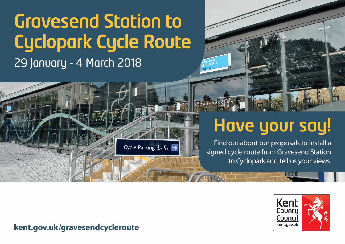
Gravesend Station to Cyclopark Cycle Route 29 January - 4 March 2018
Have your say!Find out about our proposals to install a
signed cycle route from Gravesend Station to Cyclopark and tell us your views.
kent.gov.uk/gravesendcycleroute

Introduction
Kent County Council (KCC) is proposing to create a signed cycle route from Gravesend Train Station to Cyclopark on Wrotham Road.
The proposed route aims to provide a quieter alternative to the existing cycle lane on the busy A227, used predominantly by experienced cyclists. By offering a quieter alternative journey the route aims to attract less experienced cyclists, allowing them to gain confidence whilst encouraging everyday cycling.
Gravesend Station to Cyclopark Cycle Route 29 January - 4 March 2018
What are we proposing?
The proposed cycle route was identified in a Feasibility Study by Sustrans, a UK charity making it easier for people to walk and cycle. Two routes linking Cyclopark with Gravesend Train Station were identified, a quiet route avoiding busier roads (being considered in this consultation) and another main route for more experienced riders. The Feasibility Study is available to view on the consultation website kent.gov.uk/gravesendcycleroute
The design for the new quieter cycle route aims to keep the route traffic free wherever possible by creating separate cycle lanes on the road or shared use pedestrian and cycle paths. However, some sections do need to be on the road due to the space. The proposed design has tried to ensure that this only occurs in quiet residential roads where off-road routing is not an option.
A shared use footway/cycleway is a wide footpath where cycling as well as walking is permitted. On a shared use facility, all permitted users have equal access; it does not have separate cycle lanes and footways marked out. An example of a shared use footway/cycleway is shown in the photo below:
Shared use footway/cycleways are identified by this symbol:
2
Gravesend Station to Cyclopark Cycle Route 29 January - 4 March 2018
3
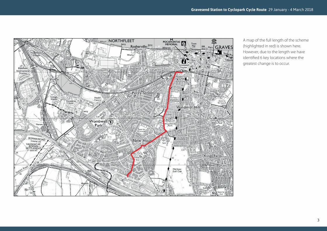
A map of the full length of the scheme (highlighted in red) is shown here.However, due to the length we have identified 6 key locations where the greatest change is to occur.

• On approach to Darnley Road/Pelham Road junction heading towards Gravesend Train Station the cycle route leaves the carriageway and a new 3m shared use path is to be created so cyclists can safely approach the junction
• Widen existing traffic island to improve the safety of the crossing for cyclists
• Move existing utilities, including street lighting, post box and water station, so that a shared use path can be created
• Restrict parking behind proposed shared use path to prevent conflicts between pedestrians, cyclists and vehicles
Location One: Gravesend Cycle Hub to Darnley Road/Pelham Road Junction
Gravesend Station to Cyclopark Cycle Route 29 January - 4 March 2018
4
Route from Gravesend Station to Cyclopark
Route from Cyclopark to Gravesend Station
KEY Start of Shared Use Path
ADirection Signage
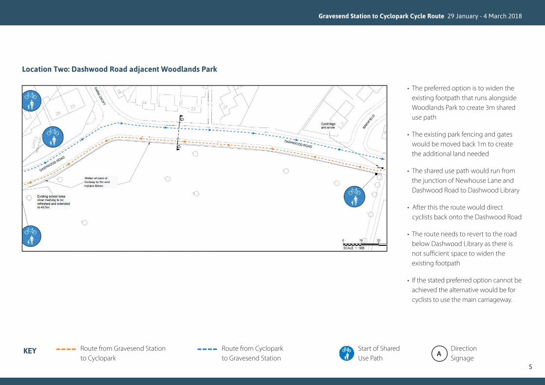
• The preferred option is to widen the existing footpath that runs alongside Woodlands Park to create 3m shared use path
• The existing park fencing and gates would be moved back 1m to create the additional land needed
• The shared use path would run from the junction of Newhouse Lane and Dashwood Road to Dashwood Library
• After this the route would direct cyclists back onto the Dashwood Road
• The route needs to revert to the road below Dashwood Library as there is not sufficient space to widen the existing footpath
• If the stated preferred option cannot be achieved the alternative would be for cyclists to use the main carriageway.
Location Two: Dashwood Road adjacent Woodlands Park
Gravesend Station to Cyclopark Cycle Route 29 January - 4 March 2018
5
Route from Gravesend Station to Cyclopark
Route from Cyclopark to Gravesend Station
KEY Start of Shared Use Path
ADirection Signage

• Construct a new shared use refugeisland (3m width) to provide a safercrossing point on New House Lane.
• The proposed crossing would belocated close to the junction withDashwood Road
• The current No Parking restrictions inplace for St Georges CE School will beextended to so that parked vehicles donot block the crossing point
Location Three: Lower New House Lane Crossing Point (Dashwood Road Junction)
Gravesend Station to Cyclopark Cycle Route 29 January - 4 March 2018
6
Route from Gravesend Station to Cyclopark
Route from Cyclopark to Gravesend Station
KEY Start of Shared Use Path
ADirection Signage

• Cyclists to be directed on the current Harden Road triangle before using the existing footpath to approach the crossing point
• Widen existing footway to 3m for shared use
• Widen existing informal crossing point on New House Lane to 3m to provide a shared use crossing facility
Location Four: Upper New House Lane Crossing Point (Harden Road)
Gravesend Station to Cyclopark Cycle Route 29 January - 4 March 2018
7
Route from Gravesend Station to Cyclopark
Route from Cyclopark to Gravesend Station
KEY Start of Shared Use Path
ADirection Signage

• Widen existing informal pedestrian crossing to 3m to provide a suitable shared use crossing facility
• Widen existing approach footways to prevent conflicts between pedestrians and cyclists
• Preferred option is to create a new 4m cycle track across the small piece of green space between Coldharbour Road and Bucks Cross Road. This will create a direct link to the continuation of the cycle route
• If the preferred option cannot be achieved the cycle route will continue along Coldharbour Road until the junction with Bucks Cross Road
Location Five: Coldharbour Road Crossing Point
Gravesend Station to Cyclopark Cycle Route 29 January - 4 March 2018
8
Route from Gravesend Station to Cyclopark
Route from Cyclopark to Gravesend Station
KEY Start of Shared Use Path
ADirection Signage

• Widen existing footway into greenspace to provide a 3m shared usecycle and footpath
• The preferred option is to widen thefootpath from land currently ownedby the housing developers. We arecurrently negotiating to see if thisis feasible
• Improve lighting along path betweenCyclopark and houses
• Demolish the existing retainingwall situated within the vegetationand replace with receding slope orearthwork (batter)
• Relocate existing utility infrastructureto enable widening of path
• If the preferred option cannot beachieved the route would continueto use the current footpath withoutit being widened and formallydesignated as shared use
Location Six: Point where cycle route enters Cyclopark
Gravesend Station to Cyclopark Cycle Route 29 January - 4 March 2018
9
Route from Gravesend Station to Cyclopark
Route from Cyclopark to Gravesend Station
KEY Start of Shared Use Path
ADirection Signage

The cycle route design will meet all national minimum design standards, including:
• Widening of the existing footpaths toa minimum of 2.5m.
• The installation of shared pedestrianfootway/cycleway signage wherenecessary throughout the lengthof the route.
• The relocation of existing signposts and street furniture to ensurepedestrian and cyclist movement isrelatively unobstructed.
An initial design stage safety audit has been completed and another one will be carried out at the construction stage.
KCC has secured funding from the Local Growth Fund, allocated by the South East Local Enterprise Partnership, Integrated Door-to-Door Services in Kent Thameside. We are proposing to use £180,000 of this funding for the proposed scheme.
Why do we want to do this work?
Cycling has many health benefits, both to the cyclists and the wider environment. The individual cyclist benefits from taking regular cardiovascular exercise in an open-air environment.
The construction of safe cycling routes away from main roads encourages those who may wish to cycle, but are less confident, to leave the car at home and cycle to their destination instead.
The more people encouraged to swap their car journey, the higher the reduction in CO2 emissions and the better it is for the environment. Increasing the number of cycle journeys has been shown elsewhere in England to reduce congestion, improve air quality, improve resident’s health and bring investment to an area. This route will provide an important alternative route to cycle to the town centre for work or leisure purposes instead of driving.
What about equality issues?
An Equality Impact Assessment (EqIA) has been undertaken to assess the possible impact, both positive and negative, of this proposed scheme on people with protected characteristics as defined in the Equality Act 2010. The EqIA will be updated after the consultation to take into account any relevant information received during this consultation. The EqIA is available to view on our website or on request.
Have your say!
We want to hear your views on this proposal.
To take part in the consultation, please complete the consultation questionnaire, which is available on our website kent.gov.uk/gravesendcycleroute
We have also created a virtual interactive exhibition where you can look at the scheme plan and give us your views. This is also available from the webpage.
Gravesend Station to Cyclopark Cycle Route 29 January - 4 March 2018
10

Consultation Events
We have organised two consultation events where members of the team will be available to answer your questions. These events are being held on the following days.
• Monday 12 February,Gravesend Civic Centre 2pm – 7pm
• Thursday 15 February,Cyclopark 10am – 4pm
Paper copies of the questionnaire, along with this document and the scheme plan are available from Gravesend Gateway (Gravesend Civic Centre, Windmill Street, Gravesend) and Cyclopark or on request by emailing [email protected]
Next steps
Following this consultation a report will be compiled summarising the analysis of the responses. This report will be made available to consultees. The consultation responses and EqIA will be used to inform the decision on whether to proceed with this scheme. The proposal will also be presented to the Gravesham Joint Transportation Board before construction begins.
If following this consultation the decision is taken to proceed with the proposed scheme, our intention is to start onsite during summer 2018. It is unlikely that road closures will be required as there will be limited work on the carriageway, however we will endeavour to ensure that any inconvenience is kept to a minimum.
Alternative formats
If you require this leaflet or any of the consultation material in an alternative format or language, please email [email protected] or call 03000 421553 (text relay service number: 18001 03000 421553). This number goes to an answering machine, which is monitored during office hours.
Gravesend Station to Cyclopark Cycle Route 29 January - 4 March 2018
11