great lakes hydrilla risk assessment
TRANSCRIPT

Global Environmental Specialists
ecology andenvironment, inc.
US Army Corpsof Engineers®
Buffalo DistrictBUILDING STRONG®
Great Lakes Hydrilla Risk AssessmentMarch 2016
Project Background: What is Hydrilla and Why is it a Problem?Hydrilla (Hydrilla verticillata) is a very aggressive aquatic invasive plant native to Korea. It is usually found rooted in shallow water (less than 25 feet deep) with long stems that can grow up to 30 feet in length and up to one inch per day. These stems branch at the water’s surface and grow horizontally, forming thick, dense mats. Hydrilla also produces tubers, small potato-like structures, which store food for the plant and allow it to overwinter in bottom sediments and sprout in the spring.
There are two types of hydrilla found in the United Sates - monoecious and dioecious. Monoecious hydrilla is better adapted to survive at higher latitudes than dioecious, and has been documented in the Great Lakes Basin.
What Does Hydrilla Look Like?
Key plant identification features:
■ Pointed, bright green leaves about 5/8 inch long with small teeth on the edges.
■ Leaves generally grow in whorls of 3 to 10 around the stem, though five leaves are most common.
■ Floating white flowers and small white-to-yellowish tubers attached to the roots.
Why is Hydrilla a Problem?
■ It is one of the world’s most invasive aquatic plants.
■ It spreads rapidly through several different methods, primarily by transport of plant fragments by water currents and recreational boats and trailers.
■ It produces tubers in sediment that remain viable for years, allowing the plant to overwinter and re-grow each spring, even when all aboveground parts of the plant are lost.
■ It can grow up to one inch per day.
■ It forms dense mats that block sunlight and displace native plants.
■ It clogs waterways and restricts water flow.
■ It decreases the amount of dissolved oxygen in the water which can lead to fish kills.
■ It impacts waterfowl feeding areas and fish spawning sites.
■ It can reduce sportfish populations due to loss of open water and native vegetation.
■ It interferes with boating, fishing, and swimming due to formation of thick surface mats.
■ It can harm the local economy by impacting tourism and waterfront property values.
Source: Leslie Mehrhoff, US Forest Service
Source: Cayuga Lake Watershed Network 2012
Leaves are small, sharply toothed
Lance-shaped leaves in whorls of 3-10
Tuber
Leaf margins have distinct, toothed edges

Global Environmental Specialists
ecology andenvironment, inc.
US Army Corpsof Engineers®
Buffalo DistrictBUILDING STRONG®
Project Overview: What is this Project and What Will it Do about Hydrilla?Hydrilla was recently discovered in the Cayuga Lake Inlet, Erie Canal, and Tinker Nature Park in New York State. It has also been documented in several waterbodies in Ohio, which has raised concerns about the spread of this invasive plant species throughout the Great Lakes Basin. To address these growing concerns, the U.S. Army Corps of Engineers (USACE), Buffalo District, is conducting a risk assessment to understand the potential for introduction and establishment of hydrilla in other areas of the Great Lakes Basin. This is a multi-year project that is expected to be completed in 2017.
What is a Risk Assessment?A risk assessment is a systematic process of evaluating the potential risks that may be involved in a particular activity; in this case, the introduction and spread of hydrilla.
Share Results• Distribute Results, Recommendations, and BMPs to Stakeholders, Resource Managers, and Other Interested Parties
Recommendations and Best Management Practices (BMPs)• Develop Recommendations for Prevention, Early Detection, and Rapid Response• Identify BMPs for Hydrilla Control
Impact Analysis• Quantify Environmental, Economic, and Social/Cultural Impacts
Risk Characterization
Great Lakes Hydrilla Risk Assessment Process
Evaluate Great LakesHabitat Features
Conduct DistributionalModeling
Conduct DispersalModeling
Create HydrillaOccurrence Database
Map Geographic Extent of Areas Susceptible to Hydrilla Invasion
• Rank Areas in Terms of Vulnerability to Invasions and Degree of Impact• Identify and Describe Limitations and Uncertainties of the Analysis
Conduct HydrillaGrowth Studies
Problem: Hydrilla spreads rapidly and impacts water quality, native aquatic communities, and how humans use waterbodies. Objective: Identify locations in the Great Lakes Basin that are most vulnerable to hydrilla invasion based on likelihood of introduction and habitat suitability. Extent: Emphasis is on Great Lakes themselves, but inland waterbodies also will be considered. Focus: Monoecious hydrilla, the biotype that favors cooler conditions and is already present in Great Lakes Basin.
Problem De�nition
RiskCharacterization
Analysis
RiskManagement
1
2
3
4St
akeh
olde
r Eng
agem
ent

Global Environmental Specialists
ecology andenvironment, inc.
US Army Corpsof Engineers®
Buffalo DistrictBUILDING STRONG®
The Risk Assessment Process: How Does it Work and What Will it Tell Us?
The risk assessment process for this project has four main steps. Stakeholder outreach is a key element of the risk assessment process. Identified stakeholders will be regularly engaged throughout the risk assessment process, beginning with the introduction of the project and its objectives, to incorporating existing knowledge and information from hydrilla specialists to benefit the risk assessment process, and finally to sharing and distributing the results of the risk assessment.
Problem Definition This initial step defines the problem; identifies the resources that may be at risk; and identifies the goals, extent, and focus of the assessment. Problem definition answers the following questions:
■ Why is Hydrilla a Problem? Hydrilla is a problem due to its ability to rapidly spread and cause adverse impacts on water quality, native plant and fish communities, recreation, and irrigation and hydropower generation.
■ What is the Goal of this Project? The primary goal of this project is to identify locations in the Great Lakes watershed most vulnerable to invasion by hydrilla based on likelihood of introduction and environmental suitability, and estimate impacts.
■ What is the Project Extent? The emphasis of the project is on the Great Lakes themselves, but inland waterbodies in the Great Lakes Basin also will be considered because hydrilla can spread from a single source location. Inland waterbodies will be considered on a regional level given the size of the Great Lakes watershed and large number of inland waterbodies.
■ What is the Project Focus? The project focuses on the monoecious hydrilla biotype, which is better adapted to survive at higher latitudes than the similar dioecious biotype, and has been documented in the Great Lakes Basin.
Analysis The second step in the risk assessment process includes documenting the extent of current hydrilla infestations and estimating the likelihood of introduction, establishment, and spread of hydrilla into new areas. Once areas of current and potential future infestations are identified, the magnitude of potential ecological, economic, and social/cultural impacts of hydrilla on the Great Lakes Basin will be estimated.
2A. Estimating Likelihood of Introduction, Establishment, and Spread of Hydrilla
The analysis phase will answer the following questions:
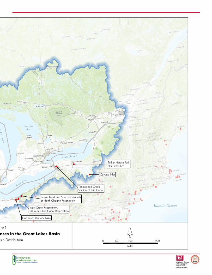
■ Where is hydrilla currently found in the Great Lakes Basin? – A database was created from four different sources of documented hydrilla occurrences and through outreach and interviews with state agency staff and others responsible for management of aquatic invasive species. Then, geographic information system (GIS)-based maps were developed from the database to illustrate the current extent of hydrilla in the Great Lakes Basin (see Figure 1). The database includes records across the United States and many parts of the world so the overall distribution of hydrilla can be understood.
■ Where is suitable habitat for hydrilla in the Great Lakes Basin? – To answer this question, distributional modeling will be conducted to predict where suitable habitat may occur. Distributional modeling uses environmental conditions that are correlated with the occurrence of an invasive species
2
1
Source: Louisiana Sea Grant Hydrilla tangled in a boat motor

Global Environmental Specialists
ecology andenvironment, inc.
US Army Corpsof Engineers®
Buffalo DistrictBUILDING STRONG®
in its native range to predict where it may become established in other areas. An area outside the native range of an invasive species may be at risk of establishment if environmental conditions in that area are similar to those in the native range. Distributional modeling will be conducted with specialized software programs that incorporate data on the native range of hydrilla. To supplement the modeling results, the project team also will evaluate Great Lakes habitat data for water depth, water temperature, sediment texture, depth of light penetration, and presence or absence of other submerged aquatic plants to identify areas where suitable habitat for hydrilla may occur.
■ What is the likelihood of hydrilla spreading into other areas of the Great Lakes Basin? – This question will be answered by conducting dispersal modeling. As a first step, the historical spread of hydrilla in other parts of the United States will be evaluated to identify important dispersal pathways; these pathways are likely to be important in the Great Lakes Basin. Potential pathways for hydrilla dispersal are likely to fall into two groups: natural processes (e.g., stream connections) and human-facilitated transport (e.g., recreational boating). To account for these processes, this project will develop a model of stream connectivity and another model that integrates the watersheds of the Great Lakes with human-facilitated vectors of dispersal. The models will be used to predict how natural and human-facilitated transport may spread hydrilla within and among waterbodies in the Great Lakes Basin.
■ How does hydrilla grow in northern climates and waters? – Scientists do not have extensive knowledge regarding how hydrilla grows in northern waters. Basic research is needed to determine how hydrilla is affected by temperature, competition with other aquatic plants, and photoperiod (day length). To fill these data gaps, experimental hydrilla growth studies are being conducted for this project to evaluate:
1. Hydrilla growth in southern versus northern climates;
2. The life cycle of hydrilla in northern conditions;
3. Competition between hydrilla and other aquatic plants currently present in the Great Lakes Basin; and
4. The effect of prolonged cold exposure on hydrilla tuber production and viability.
2B. Estimating Impacts of Hydrilla in the Great Lakes Basin
As noted above, the types of impacts that are caused by hydrilla infestations are generally based on literature and reports from other regions in the United States where hydrilla has become established. The same types of impacts are anticipated in areas in the Great Lakes Basin that are vulnerable to hydrilla invasion. Understanding the extent and magnitude of those potential impacts is a critical element of this project. The answers to the four questions outlined above in 2A will inform the project team about the location and size of areas in the Great Lakes basin that are vulnerable to hydrilla invasion. Once those areas are identified, the potential for impacts will be examined. GIS technology will be used to create maps showing areas in the Great Lakes Basin potentially susceptible to hydrilla invasion. The GIS maps will be used to describe and quantify the following impacts to the extent possible:
Source: Scott Kishbaugh, NYSDEC Hydrilla whorls up close
Potential hydrilla exposure pathways • Movement of recreational watercraft
carrying hydrilla
• Water flow
• Intentional release (e.g., disposal of aquarium contents)
• Disposal of dredged sediment that contains parts of a hydrilla plant

Global Environmental Specialists
ecology andenvironment, inc.
US Army Corpsof Engineers®
Buffalo DistrictBUILDING STRONG®
Risk Characterization The third step in the risk assessment process consists of two parts: estimating risk and analyzing uncertainties.
■ Estimating Risk – Areas in the Great Lakes Basin most at risk of introduction and establishment of hydrilla will be identified by integrating the results of the distributional modeling, dispersal modeling, and hydrilla growth studies; and evaluating Great Lakes habitat data. Combining these results will address the primary objective of the project, which is to identify locations that are most vulnerable to invasion based on likelihood of introduction and environmental suitability. Low and medium-risk areas will also be identified.
■ Analyzing Uncertainties – The project team will identify and describe limitations and uncertainties associated with modeling, plant growth studies, GIS mapping, and other project elements, and describe their effects on the results and conclusions of the assessment. Uncertainties may include limitations in data needed to support modeling efforts, limited resolution and coverage of habitat data for the Great Lakes, and uncertainties associated with assumptions made to complete the assessment.
Risk Management The fourth and final step of the project will focus on using what is learned to develop recommendations for prevention, early detection, and rapid response to reduce the risk of hydrilla spread, and to identify BMPs for hydrilla control. The recommendations and BMPs will be shared with various local, state, and regional stakeholders in the Great Lakes Basin so that a large, information-sharing network is created. High-risk areas will be priorities of outreach to prevent or minimize hydrilla introduction and, if hydrilla is introduced, to ensure early detection and effective management.
4
3
Environmental Impacts
• Water quality• Existing aquatic vegetation• Fish and aquatic invertebrates• Waterfowl and wildlife• Association of invasive species
and pathogens (microorganisms that cause disease)
• Water flow and flooding• Recreation (e.g., swimming,
boating, fishing)
Economic Impacts
• Costs to manage/ control hydrilla
• Reduced recreational opportunities
• Navigation and navigational dredging
• Hydroelectric power production• Changes in flood control costs• Water supply
Social/Cultural Impacts
• Traditional uses of the waterbodies and shorelines – subsistence hunting/gathering, cultural and spiritual practices, economic purposes
• Beachfront communities along the shorelines of the Great Lakes that serve recreational purposes

Global Environmental Specialists
ecology andenvironment, inc.
US Army Corpsof Engineers®
Buffalo DistrictBUILDING STRONG®
Atlantic Ocean
C A N A D AU N I T E D S T A T E SO F A M E R I C A
Lake Superior
LakeH
uron
Lake
Mic
higa
n
Lake Erie
Lake Ontario
GeorgianBay
Artificial Pond inMarinette County
(Eradicated)
West Creek Reservation;Ohio and Erie Canal Reservation
Coe Lake; Wallace Lake
Sunset Pond and Sanctuary Marshat North Chagrin Reservation
Tonawanda CreekSection of Erie Canal
Cayuga Inlet
Tinker Nature ParkHenrietta, NY
0 100 20050
Miles
L:\Buffalo\Hydrilla\Maps\MXDs\3_3_Hydrilla_Occurrence\Hydrilla_Occurrences_Great_Lakes_Basin.mxd 2/11/2016
Data Source: ESRI 2015; Barnes 2014; EDDMaps 2015; GBIF 2012, 2015; GLIN 2015; Ecology and Environment, Inc. 2015.
´KEY:
! Hydrilla – Documented Occurrences
Great Lakes Basin
Figure 3
Great Lakes Basin Distribution
Documented Hydrilla Occurrences in the Great Lakes Basin
Figure 1

Global Environmental Specialists
ecology andenvironment, inc.
US Army Corpsof Engineers®
Buffalo DistrictBUILDING STRONG®
What Will the Results Look Like and How Will They be Used?
This project will produce information that can be used to communicate the risks of hydrilla invasion and what can be done to prevent and control hydrilla. Information will take the form of:
Maps and Figures
■ Locations of current hydrilla infestations in the Great Lakes Basin.
■ Areas in the Great Lakes Basin vulnerable to hydrilla invasion – categorized as low-, medium-, or high-risk areas.
Technical Reports and Presentations
■ A hydrilla growth study technical report that describes study design and results, including how hydrilla grows in northern climates and competes with other plant species.
■ Distributional and dispersal modeling technical reports that describe modeling methods, model output, and interpretation.
■ A risk assessment technical report that presents and integrates the output of the distributional and dispersal modeling, evaluation of Great Lakes habitat data, and plant growth studies; a detailed impact analysis; and recommendations and BMPs.
Fact Sheets
■ Non-technical summary of the risk assessment, including methods, results, and conclusions.
■ Summary of recommendations and BMPs.
Who is the Project Team?The USACE, Buffalo District, along with the USACE Engineer Research and Development Center, and Ecology and Environment, Inc., have compiled a team of experts to complete the risk assessment. Team members include:
Who Can I Contact for More Information?
Team Member Project RoleUSACE, Buffalo District Project Management and Technical Oversight
USACE, Engineer Research Development Center Technical Guidance and Oversight
Ecology and Environment, Inc. Project Management, Risk Assessment Lead
Texas Tech University Distributional Modeling
University of Toledo Dispersal Modeling
North Carolina State University Hydrilla Growth Studies
Michael GreerU.S. Army Corps of Engineers, Buffalo District Regional Technical Specialist, Planning Branch [email protected] 716-879-4229
Kris EricksonEcology and Environment, Inc. Project Manager [email protected] 716-684-8060
1003
025.
0025
.02\
Gre
at L
akes
Hyd
rilla
Ris
k A
sses
smen
t Bro
chur
e.in
dd-G
RA-3
/31/
16