greater hume shire visitors guide
DESCRIPTION
Greater Hume Shire Visitor's guide covering the towns of Culcairn Henty Holbrook Jindera and Walla Walla as well as the villages of Burrumbuttock, Brocklesby, Gerogery, Morven, Walbundrie and Woomargama.TRANSCRIPT
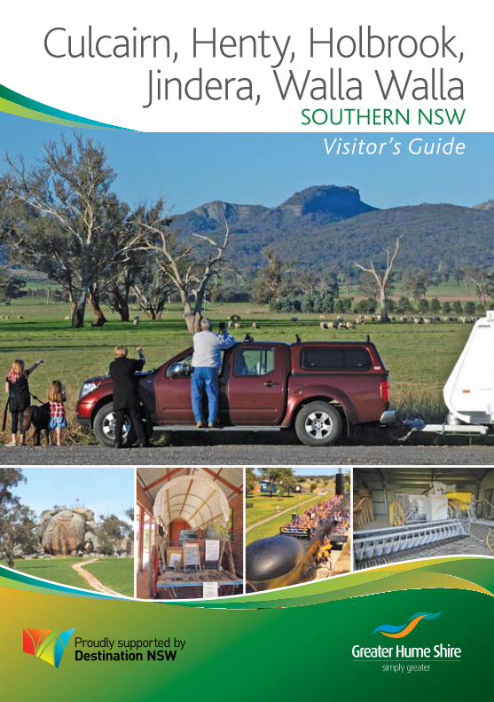
Culcairn, Henty, Holbrook,Jindera, Walla Walla
SOUTHERN NSWVisitor’s Guide
gREaTER HUmE SHiRE2
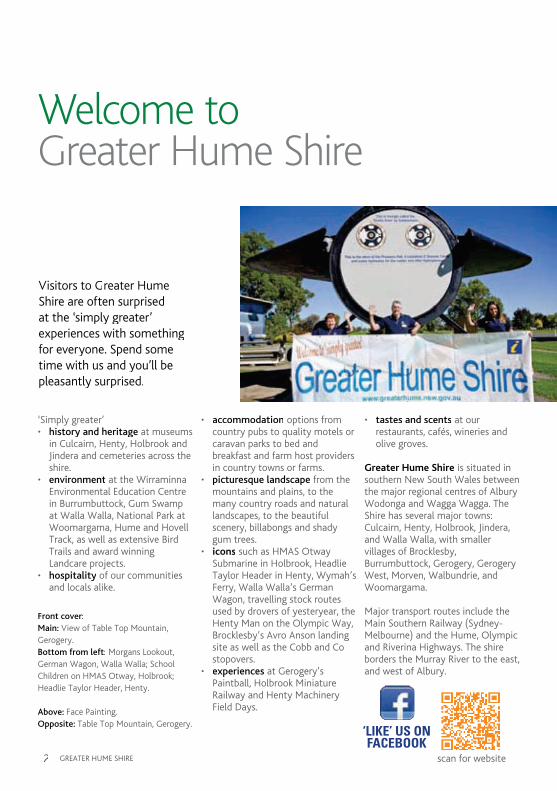
Welcome toGreater Hume Shire
Front cover:Main: View of Table Top mountain, gerogery.Bottom from left: morgans Lookout, german Wagon, Walla Walla; School Children on HmaS Otway, Holbrook; Headlie Taylor Header, Henty.
Above: Face Painting.Opposite: Table Top mountain, gerogery.
‘Simply greater’• history and heritage at museums
in Culcairn, Henty, Holbrook and Jindera and cemeteries across the shire.
• environment at the Wirraminna Environmental Education Centre in Burrumbuttock, gum Swamp at Walla Walla, National Park at Woomargama, Hume and Hovell Track, as well as extensive Bird Trails and award winning Landcare projects.
• hospitality of our communities and locals alike.
• accommodation options from country pubs to quality motels or caravan parks to bed and breakfast and farm host providers in country towns or farms.
• picturesque landscape from the mountains and plains, to the many country roads and natural landscapes, to the beautiful scenery, billabongs and shady gum trees.
• icons such as HmaS Otway Submarine in Holbrook, Headlie Taylor Header in Henty, Wymah’s Ferry, Walla Walla’s german Wagon, travelling stock routes used by drovers of yesteryear, the Henty man on the Olympic Way, Brocklesby’s avro anson landing site as well as the Cobb and Co stopovers.
• experiences at gerogery’s Paintball, Holbrook miniature Railway and Henty machinery Field Days.
• tastes and scents at our restaurants, cafés, wineries and olive groves.
Greater Hume Shire is situated in southern New South Wales between the major regional centres of albury Wodonga and Wagga Wagga. The Shire has several major towns: Culcairn, Henty, Holbrook, Jindera, and Walla Walla, with smaller villages of Brocklesby, Burrumbuttock, gerogery, gerogery West, morven, Walbundrie, and Woomargama.
major transport routes include the main Southern Railway (Sydney-melbourne) and the Hume, Olympic and Riverina Highways. The shire borders the murray River to the east, and west of albury.
Visitors to greater Hume Shire are often surprised at the ‘simply greater’ experiences with something for everyone. Spend some time with us and you’ll be pleasantly surprised.
‘LIKE’ US ON FACEBOOK
scan for website

Contents
gREaTER HUmE SHiRE 3
Disclaimer: Whilst every care has been taken, no responsibility is accepted for errors or omissions, their subsequent effects or the conditions of the articles advertised.
Photos throughout courtesy of Kathryn mitsch, Stephanie & Bruce Hankel, Di mcElwaine, Eastern Riverina Chronicle, Holbrook Landcare, Sarina Cevaal-Hewitt, Chris Tzaros, Picture australia and Lasting images.
Thanks to the contributors.
Designed and printed bySpecialty Press (albury) 02 6021 3366
November 2012.
4-8Steeped in History
9-13mountains to the Plains
14-17Culcairn
18-21Henty
22-25Holbrook
26-27Commander Holbrook
30Helpful information
31Visitor information
32-32District map
34Travel Distances
35-37Tours
38-41Jindera
42-45Walla Walla
46-51Our Villages
52Our Farming Communities
60greater Hume Shire Council
64Calendar of Events
JINDERA
ALBURY
WALBUNDRIE
HOLBROOK
CULCAIRN
HENTY
BURRUMBUTTOCK
MULLENGANDRA
WOOMARGAMAGEROGERY
WALLAWALLA
To Sydney
To Melbourne
Lake Hume
Murray River
GREATER HUME
greater Hume Shire’s accredited Visitor information CentrePO Box 99,Submarine Park, Wallace StreetHolbrook NSW 2644Ph: +61 02 6036 2422Fax: +61 02 6036 2422E: [email protected]: www.greaterhume.nsw.gov.au
To assist you, the town location of our attractions, accommodation and eating out venues are colour coded:
Culcairn = Henty =
Holbrook = Jindera =
Walla Walla = Other areas =

gREaTER HUmE SHiRE4
Steeped in History - A Pioneering Heritage
BiLLaBONgS aND gRaSSY SLOPESThe Wiradjuri tribes’ presence in this district is evident in the use of aboriginal names, especially in the name Billabong. Billabong Creek, which flows through greater Hume Shire, is the longest creek in australia, eventually flowing into the murray River. The creek was a source of food, from fish and yabbies to snakes and marsupials. grass seeds were collected by the women in their ‘coolamons’ and ground with grinding stones which weren’t carried from camp to camp but buried, and today are ploughed up by farmers. aboriginal artefacts such as the stone ‘hand axe’ indicate a presence up to
40,000 years ago. The stone axes were used to strip bark off gum trees to make canoes, shields and coolamons. most of these trees have disappeared through clearing and bushfires, but an occasional oval shaped scar, up to two metres by one metre, can be found. The Wiradjuri Tribes roamed between the murray and murrumbidgee Rivers during autumn migrating to Tumut to trade with the coastal tribes.
HUmE & HOVELL aND maJOR miTCHELLExplorers Hume & Hovell were probably the first Europeans to see the area and travelled through parts of the shire in the early 1800’s on their expedition south to Port Phillip (melbourne). Upon climbing Tabletop, Hume & Hovell cast their eyes around, noting the extensive grass cover over parts of the region and the potential for future grazing and development.
major mitchell passed through the
Riverina area in 1836 and reported on the lightly timbered, well watered lands which he referred to as ‘australia Felix’. Settlers with their stock, wagon, provisions and workmen followed the ‘major’s Line’, to select this good land. Hastened by a severe period of drought, which began in 1835 and lasted until 1844, ‘Squatters’ began settling on the great fertile country of the murrumbidgee and murray Rivers.
THE STaTiONSWithin 30 years the ‘major’s Line’ led to total settlement of the area. many small holdings supported large hard working families during trying conditions. The presence in a paddock of a group of pepper trees, gnarled fruit trees or a pile of stones is the only reminder that a plucky family lived there, willing to take on the land. From 1836 pastoral runs were being established, many with ill-defined boundaries. Early squatters took up country with no regard to
Travel back in time to when there was gold in them there hills,
Cobb & Co coaches rolled and bushrangers were lurking.
Above: Scar tree.Senior Sergeant Thomas Smythmemorial, Henty.Opposite: Timber Trestle Rail Bridge near Burrumbuttock.Pioneer Wagon, Walla Walla.

gREaTER HUmE SHiRE 5
area. Runs varied in size from 30,000 up to 350,000 acres, with names such as Walla Walla, Dudal Comer (Henty), Round Hill (Culcairn), Carabobala (morven), Yarra Yarra (Holbrook), gerogery, mountain Creek, mullengandra, Tabletop, Battery mountain (Table Top), Brae Springs (gerogery), Dights Forest (Jindera) , Piney Water Hole (Walbundrie), The Olives (moorwatha), Coppabella, Kinross (Holbrook), and Woomargama just to name a few.
SCOTTiSH ORigiNSDuring the 1800s many Scots were ousted from their traditional homelands by Scottish land owners and clan leaders wanting to use clan lands to graze sheep. Ships loaded with wool bound for Scottish mills were used on their return, to transport agricultural labourers and their families from the overcrowded Scottish highlands to australia. Scottish labourers were considered hard working and were encouraged to move to the area to work the large runs, with the Robertson Land act of 1861 also contributing to the inland migration of small settlers.
maD DaN mORgaN-BUSHRaNgERDaniel morgan was one of the more infamous characters in the history of this region. also one of the most feared and admired bushrangers of
australia’s past.
morgan born in Sydney in 1833 joined the NSW gold rush at Lambing Flat in 1853. Unsuccessful he turned to petty crime, was caught and given 6 years on the floating hulk ‘Success’ and on chain gangs in Sydney’s quarries. On release he returned to this region bushranging and became a hero to the working class and aboriginal population. He targeted station owners (squatters) who under paid or maltreated employees, robbed wealthy travellers and shared booty with the under privileged. morgan was literate and an excellent bushman. He had many hiding places and vantage points throughout our region. The most prominent being morgan’s Lookout, 6kms north of Walla Walla, which provided 360 degree views.
in august 1863 he held up mr Henry Baylis the Wagga Wagga police magistrate near Urana. morgan returned his purse and cheques on being informed by Baylis who he was. Baylis returned with police trackers, caught up with morgan, a gunfight ensured, Baylis was wounded. morgan later shot a shepherd known as Haley, whom he believed had betrayed his whereabouts. a reward of 200 pounds was offered for morgan’s capture.
On 19 June, 1864 he visited ‘Round Hill Station’, when departing morgan thought someone fired at him. He demanded manager Sam Watson step forward to be shot, mrs Watson protected her husband. morgan shot Watsons raised hand. Realising his mistake morgan ordered station hand John mcLean to ride to “Walla Walla Station’ to fetch Dr Stitt. Later suspecting that mcLean would alert troopers he rode after him, fired a warning shot but mortally wounded mcLean.
The NSW reward for his capture increased to 1,000.00 pounds. On 29 June he confronted Sergeant maginnerty near Coppabella, shot and killed him. morgan and accomplices ambushed trooper’s on 3 September at ‘Doodle Cooma Station’, mortally wounding their leader, Sergeant Smyth.
Victorian police dared morgan to cross the murray, he accepted and outsmarted them for four days. Sleep deprived he was surrounded and shot at ‘Peechelba Station’, 9 april 1865.
THE TREKWhen the country was opened up for smaller settlers with the passing of the Robertson Land act in 1861, many german families from South australia (where they had been finding it very difficult to buy good

gREaTER HUmE SHiRE6
Above: gerogery Station masters Residence; Bringing in the Sheaves. Opposite: auro anson, Brocklesby;St. Paul’s anglican Church, Jindera.
land) arrived by wagon train and settled in Jindera and the surrounding area. Word spread back to South australia of the fertile land available here and in January 1869, 56 people of german origin arrived in the region from Ebenezer, South australia. The group settled in the Walla Walla area, bringing their culture and customs with them as seen today throughout the region from the architecture of the Zion Lutheran Church in Walla Walla to the road and farm names dotted throughout the shire.
COBB & COCobb & Co ‘changing stations’ were established by 1877. The route for the run was Wagga Wagga, Cookardinia, morven, gerogery and albury, via mangoplah six times a week by 2 or 4 horse coach’s. Changing stations were set up as places where the horses were changed, passengers could take a break, perhaps stay the night at Squatters arms inn, Cookardinia or at the Round Hill Hotel, morven or have a drink, and were important meeting points for local communities, centres for news, deliveries of goods, refreshments and company. Cobb & Co. were undoubtedly the largest
firm contracted to convey mail, but were never granted any exclusive title to that role, and there were literally hundreds of other mail contractors operating all over the colony. You can visit the original Cobb & Co stables at the Round Hill Hotel in morven.
RiDiNg ON THE SHEEPS BaCK / REaPiNg THE gOLDEN EaRWith the big runs and development of smaller blocks the area became well known for its wool, wheat and meat production. in 1861 the Riverina region had carried 1 million sheep, by 1891 it carried 13 million. in the 1890s Walbundrie run had a 36 stand shed, and blade-shore from 60 to 80 thousand sheep a year. albury now had its own wool-buying and selling agencies with the year’s clip delivered by teams of up to 32 bullocks. Henty, Culcairn and gerogery were developed on the main Southern Line ensuring a close relationship with the railway, and becoming transportation and storage terminals for the expanding wheat industry. During the 1880s increasing amounts of wheat were grown, the drier climate of the region increased the gluten content and improved the baking quality, making it more competitive on the world market. german families who had settled around Walla Walla and Jindera were leaders in increasing output of wheat from the district. Wheat or chaff was harvested by the simple methods of
the scythe and the sickle, then progressed to the Sunshine Stripper (invented by Hugh V mcKay in 1865) before Headlie Taylor from Henty invented the Header in 1913, which revolutionised the whole of the grain producing industry across the world.
COmiNg OF THE RaiLWaYSOn 10 July, 1867, mr John Whitton, Engineer-in-Chief for Railways, presented a proposal to the Victorian and New South Wales governments to build a line linking melbourne and Sydney. By 1881 the line was completed and train ‘crossing’ stations established at Henty, Culcairn and gerogery, along with many subsidiary tracks to outlying villages, many of which can be seen by the road but are not now in use. The Wagga Wagga to albury line did not require heavy earthworks or bridges and with no curves to limit speed, grades could be kept to 1 in 80 with and against the load. The railway opened up the region ensuring produce and passengers alike a quicker journey to the major cities of australia.
iNDiaN HaWKERSindian Hawkers were quite numerous in the district at the turn of the 20th century. They were seen driving around selling goods from covered wagons drawn by two horses. Farmers and families in isolated areas were able to buy drapery and clothing. The children were delighted
gREaTER HUmE SHiRE 7
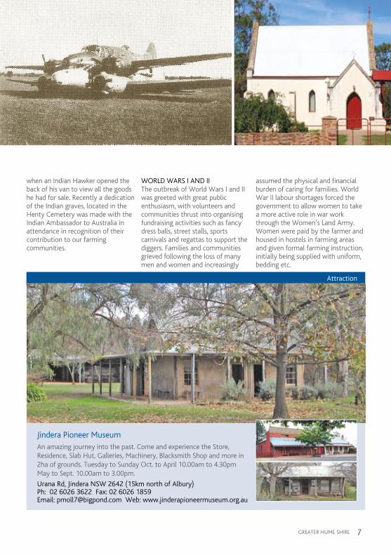
when an indian Hawker opened the back of his van to view all the goods he had for sale. Recently a dedication of the indian graves, located in the Henty Cemetery was made with the indian ambassador to australia in attendance in recognition of their contribution to our farming communities.
WORLD WaRS i aND iiThe outbreak of World Wars i and ii was greeted with great public enthusiasm, with volunteers and communities thrust into organising fundraising activities such as fancy dress balls, street stalls, sports carnivals and regattas to support the diggers. Families and communities grieved following the loss of many men and women and increasingly
assumed the physical and financial burden of caring for families. World War ii labour shortages forced the government to allow women to take a more active role in war work through the Women’s Land army. Women were paid by the farmer and housed in hostels in farming areas and given formal farming instruction, initially being supplied with uniform, bedding etc.
Attraction
Jindera Pioneer MuseumAn amazing journey into the past. Come and experience the Store, Residence, Slab Hut, Galleries, Machinery, Blacksmith Shop and more in 2ha of grounds. Tuesday to Sunday Oct. to April 10.00am to 4.30pm May to Sept. 10.00am to 3.00pm.
Urana Rd, Jindera NSW 2642 (15km north of Albury)Ph: 02 6026 3622 Fax: 02 6026 1859 Email: [email protected] Web: www.jinderapioneermuseum.org.au
Jindera Museum.indd 1 6/9/10 1:57:55 PM

gREaTER HUmE SHiRE8
anti-german feeling emerged with the outbreak of both the wars, and many germans living in australia were sent to internment camps. in townships where the majority of people were of german origin, the problems were not so bad, as they were allowed to retain their culture including Lutheran beliefs and german language. germanton was renamed Holbrook in august 1915 and during both wars many people viewed their german neighbours with suspicion, which was to continue until the end of World War ii.
Today anzac Day is commemorated at the many memorials throughout the shire dedicated to those who sacrificed their lives for australia. Stands of trees have also been planted in memory of our Diggers in a number of towns/villages in the shire, Walbundrie and Woomargama providing fine examples.
SOLDiER SETTLERSat the end of World Wars i and ii the government sponsored a scheme for settling returned men on the land. a significant share of the government’s £29,000,000 was used to purchase private land in this region. Large stations were purchased and divided up into Soldier Settler farms, averaging about 640 acres each. The new settlers either brought wives with them or married local girls, and displayed the camaraderie and zest learned during the hard years of the World Wars i and ii. as the years passed the weaknesses in the Soldier Settler Scheme revealed themselves, many returning to large towns due to climatic variances and cash depletion, however descendents of Soldier Settlers are still farming in the region.
gREaT DEPRESSiONThe great depression of the late twenties and thirties caused many farmers to go bankrupt. Thesituation was so serious that the government brought in the moratorium act so that interest only was paid, but no principal was needed to be repaid. There were many capable and learned men with university degrees, walking the shire roads looking for work. Where possible some farmers would offer a meal for labour as they were not able to hire them. The Henty man located on the Olympic Highway is dedicated as a memorial to ‘the men of the road during the great Depression’.
mUSEUmS aND CEmETERiESToday abundant samples of the early settlers’ life and labour is still evident within the museums and historical buildings throughout the shire.
These museums are Dolls museum (gerogery), Cellar mini museum (Henty), Observer Printery museum (Henty), Submarine museum (Holbrook), National museum of australian Pottery (Holbrook), Pioneer museum (Jindera), Station masters Residence (Culcairn) and Woolpack inn museum (Holbrook). Please go to our Tours Section for more details on opening times of our museums.
The shire has a number of cemeteries which provide an insight into the many varied cultural and religious backgrounds of our settlers. We invite you to go on the Shire Cemetery Tour. Tour guides are available at some cemeteries to provide an insight into the history of the area.
Why not spend some time and visit our ‘simply greater’ museums and experience the history and heritage of the region for yourself.
Above: St. Peter’s Lutheran Pioneer Cemetery, gerogery.Opposite: Wirraminna Environmental Education Centre, Burrumbuttock.The murray River at Talmalmo.

gREaTER HUmE SHiRE 9
A Natural Path from
the Mountains to the Plains
The eastern area of the shire features steeper and extensively vegetated (both remnant and plantation) country, changing to low rolling hills and plains country in the west. The highest point of the shire is mount Jergyle at 889 m located within the Woomargama National Park.
TaBLE TOP NaTURE RESERVE – BENamBRa NaTiONaL PaRK – YamBLa RaNgEThe outstanding geographical feature of the district is Table Top mountain, a group of three main peaks, emerging on the southern end of the Table Top Range. The actual Table Top peak is a flat plateau (a table top) rising to a height of 621 m (2037 feet). The other two peaks are Pulpit Rock 602 m (1975 feet) and Loka Peak or Rock 666.2 m (2185 feet). The shape of the mountain changes with the location of the viewer, from a series of three or four individual peaks, to
appearing as a single peak. From whatever angle, it is impossible not to be impressed by its beauty, enhanced by an array of ever-changing colours. The mountain was known by the aborigines who lived and hunted in this area as “mullyan-yar-gunyah” or “mullyanyandera” broadly translated as “the home or breeding place of eagles”.
many aboriginal artefacts have been recorded from this area. a cave that was reputedly used in the 1860s as a refuge for the notorious bushranger mad Dog morgan is also located here.
access to the area is by way of 4WD through private land. Table Top mountain Retreat is a privately owned part of the mountain. guided tours, bushwalking or 4WD access to look at the geology, flora, fauna, and history of Table Top mountain (including after dark tours) can be
arranged. Take a picnic or allow the Retreat owners to cater for your every need. Contact 02 6026 0529.
WOOmaRgama NaTiONaL PaRKWoomargama National Park is the largest protected area west of the great Dividing Range in south-eastern NSW and contains the largest remnant community of box woodlands on the South-West Slopes. it is an important haven for a large number of threatened and endangered species, such as the regent honeyeater, superb parrot, powerful owl, Booroolong frog and carpet python. it’s also home to the very rare wattle, acacia phasmoides. Parts of the park provide stunning views over the murray River, Riverina and South West Slopes.
The park was created in January 2001 and covers an area of 24,185 hectares. Norths Lookout is a natural granite platform that provides extensive views of the Upper murray
Experience our “land of sweeping plains and
rugged mountain ranges”.

gREaTER HUmE SHiRE10
Valley, the western face of the Snowy mountains and the Riverina. This area was once a tin mining extraction site and was also used by graziers during the early to mid 1900s.
access is via Tunnel Road, Woomargama. The Park has 4WD or motorcycle access only (only during dry weather). The Hume and Hovell Walking Track traverses the Park, following the Tin mines Trail for the majority of its length. There are over 100 km of trails to explore in the reserve system, however many trails terminate at private property and there is no legal access through private lands. Visitors are advised to only use Park trails and recommended access routes.
Woomargama National Park offers many activities such as bush walking, picnics, horse riding, photography, exploring cultural heritage, sightseeing, bird watching, 4WD driving and motorcycling. The Tin mines and Samual Bollard picnic
and camping areas (suitable for backpack and vehicle based camping, not caravans) are a stopping point on the Hume and Hovell Walking Track and include sealed pit toilets, shelters, wood BBQ’s (bring your own firewood), picnic tables and rain water tanks. Horse riding is permitted on Park trails, however overnight camping with horses is not permitted.
mORgaN’S LOOKOUTOn the Culcairn to Walla Walla Road, opposite Walla Park (formerly Walla Walla Station) is a massive white granite outcrop known as morgan’s Lookout. in what is otherwise low undulating country Dan morgan is alleged to have used this granite rock formation as a vantage point to watch for approaching police. it was also used
as a lookout for fires last century (a concern apparently exacerbated by fear of arson arising out of the disputes between graziers and shearers during the late 19th century). access is signposted via a private driveway; visitors can enjoy the magnificent 360 degree views of the region. There are many picnic spots around the rock formation and pit toilets are available.
agRiCULTURaL ENViRONmENT Farm Host Programgreater Hume Shire is predominantly agricultural and at various times of the year the countryside is alive with colour from oil seed and cereal crops or noisy with the bleating of lambs or mooing of calves. Visitors can enjoy real farming experiences in greater
Above from left: Canola kids;gum Swamp, Walla Walla.Right: Southern view from morgan’s Lookout, Walla Walla.Opposite top from left: Kids at Wirraminna Environmental Education Centre; Fields of ripened grain.Opposite right: Birdwatching in Woomargama National Park.

gREaTER HUmE SHiRE 11
Hume Shire through the Farm Host program. The program allows visitors to watch as the farm comes alive when feeding animals, or enjoy the vastness of the crops, or witness a sheep being shorn or a crop being harvested if you are there at the right time. Talk with traditional australian farmers and taste the delights of true country cooking, indulge in home baked cakes, roasts, or a delicious hamper for a picnic.
Spend a weekend, an evening or a day on the farm. Whether an individual/family (bookings preferred, one week’s notice) or bus, coach and touring groups (bookings, with at least two weeks notice, required for groups of 10 to 40 people, allocated to farms, with 2-4 guests per farm). Fees and rates on application. Contact one of our co-ordinators either Culcairn Farm Host Co-ordinator (covering Culcairn, Henty, Walla Walla, Jindera, Walbundrie, Brocklesby, Burrumbuttock areas) on Ph 02 6029 2240 or Holbrook Farm Host Co-ordinator (covering Holbrook, Cookardinia, Woomargama, mullengandra, Little Billabong, Carabost, morven areas) on Ph 02 6036 6137.
WiRRamiNNa ENViRONmENTaL EDUCaTiON CENTREWirraminna Environmental Education Centre was developed in 1995 as a 4 ha area featuring a large dam constructed in 1902 by Chinese labourers. The name ‘Wirraminna’ means ‘peace—quiet near still waters’. Originally a stock reserve and public watering place, Wirraminna provides opportunities for discovery and learning about the natural environment, the ecology of the local woodlands and the beauty of native plants for our gardens. a popular outing for schools, clubs and organisations, visitors to the region call in to explore the gardens and learn about our local environment. Extensive interpretative signage around the park tells the environment story.
Wirraminna has created and is maintained by a group of dedicated volunteers, and has been supported by a wide range of funding sources, including local government, local businesses, Natural Heritage Trust, private charities and Landcare australia. it has very strong links with Burrumbuttock Public School, and has been State and National winner of the Landcare Education award. in 2005 the Discovery Centre, a rammed earth building, was constructed and is used for school and community activities, providing displays, teaching and storage resources for regional schools and the Wirraminna
volunteers. a aquarium display of native fish has provided an exciting new window on the aquatic environment of the murray-Darling Basin. The Centre continually evolves, improving the story of the beauty and interest of our natural environment and how it can be protected and enhanced. Wetlands, bush and landscaped areas are linked by walking tracks to give visitors an experience of the great diversity of native plants and associated wildlife. For information and tours please contact02 6029 3319.

gREaTER HUmE SHiRE12
TRaVELLiNg STOCK ROUTES aND RESERVES (TSR’s)Travelling Stock Routes part of ‘The Long Paddock’ were established as an authorised thoroughfare for the walking of domestic livestock such as sheep or cattle from one location to another. Easily distinguished from an ordinary country road, the grassy verges on either side of the road are very much wider so the livestock may feed on the vegetation that grows on the verges as they travel. By law, the travelling stock must travel ‘six miles a day’ (approximately 10 kilometres per day), to avoid all the roadside grass from being cleared in a particular area. a TSR is a fenced paddock set aside at strategic distances to allow overnight watering (from bores, dams, windmills and troughs) and camping of stock.
Pioneered by colonial explorers and overlanders, many of the TSR’s were located along corridors that followed river systems, indigenous
trade routes and trails. Before the railways were extended cattle were often walked up to 3,220 kilometres (2,000 miles) on the main stock routes. These early drovers sometimes had to contend with droughts, dust storms, floods, poisonous plants and hostile aborigines. These established routes were recognised and dedicated as roads between the 1860s and 1890s. From the early 1900s the state governments established a program to develop stock route water facilities, each located the distance of a droving day apart.
TSR’s are also used as emergency refuges during floods and drought, local agistment, public recreation or as corridors for native vegetation ecosystems, providing a crucial habitat for flora and fauna, connectivity for many endangered species and ecosystems, thus providing a comprehensive sample of the landscape and biodiversity of eastern australia prior to the colonial period. Some of the shire’s more notable TSR’s such as Brittas, Henty, Back Creek, Kirndeen, King’s and Ten Chain are also part of our birdwatching trails. HUmE aND HOVELL WaLKiNg TRaCKThe Hume and Hovell Walking Track was developed as a government Bicentennial project in 1988. it is maintained by the Department of
Lands with the cooperation and assistance of Forests NSW and the National Parks and Wildlife Service. Discover the natural attractions, explore rugged bushland or visit one of many picnic and camping trackheads. The Walking Track follows the famous footsteps of Hamilton Hume and William Hovell on their expedition to Port Phillip (melbourne) in 1824. Stretching over 440 km between Yass and albury, the track offers a multitude of visually stunning and historically fascinating walking opportunities for outdoor enthusiasts. The track winds its way through the south of the shire and maps can be obtained from our Visitor information Centre or Lands Department contact02 6937 2700.
BiRDWaTCHiNgThere are a large number of birdwatching sites in greater Hume Shire. Some of these have been identified by the Riverina and South West Slopes Bird Route Project, which focuses on protecting and promoting remnant native woodland vegetation conducive to bird watching activities, bird watching sites and good visitor access.
Bird watching sites have been identified by the “Promotion, Rehabilitation & Restoration of Riverina Bird Habitats Project” of the Riverina and South West Slopes Natural Based Tourism group and
Top from left: Swift Parrot; Climbing morgan’s Lookout.Opposite top: Droving along ‘The Long Paddock’; Bush Stone Curlew; Sunset over the Shire.

gREaTER HUmE SHiRE 13
have been included in their booklet “Bird Trails of the Riverina and South West Slopes of NSW”. The project is funded by a grant from the NSW Environment Trust.
The identified sites are:– Woomargama National Park, Walla Walla “gum Swamp”, King’s, Henty, Back Creek, Brittas, Kirndeen, Ten Chain Travelling Stock Routes,
Wirraminna Environmental Education Centre, Henty government Dam Nature Reserve and Ten mile Creek (Holbrook). There are many birds which inhabit these sites including Noisy Friar Bird, Dusky Woodswallow, australian Hobby, grey Crowned Babbler, Weebill, Thornbill, Swift Parrot, King Parrot, gang gang Cockatoo, Speckled Warbler, Honeyeater,
Rufous Whistler, Brown Treecreeper, Sacred Kingfisher, Peaceful Dove, Rufous Songlark, Pardalotes, Crested Shrike-tit, golden Whistler, Flame Robin, Rainbow Bee-eater, Zebra Finch, White-browed Woodswallow, australian Pipit, Tawny Frogmouth, Bush Stone Curlew and Varied Sittella. For more information contact our Visitor information Centre on 02 6036 2422.

gREaTER HUmE SHiRE14
CULCAIRN - Oasis of the Riverina
Long a home and hunting ground for the Wiradjuri indigenous people, the area around present day Culcairn was not known by Europeans until November 1824, when Hume and Hovell passed through the area.
Several years elapsed before the squatters from the north moved into the area, hastened somewhat by the commencement of a great drought in 1835, which was not to be thoroughly broken until 1844.
The second important journey of exploration was made in 1836, when major Thomas mitchell, on returning to Sydney from Portland, crossed the murray River at Howlong and on the 20 October 1836, his journal tells us they passed gum Swamp (Walla swamp) and Back Creek (later
the boundary of Round Hill Station) and camped overnight on the Billabong Creek, making some 15 1/2 miles for the day. The camp site must have been somewhere between King’s Bridge and Kirndeen TSR’s downstream from Culcairn.
Pastoral settlement of the Culcairn district dates back to 1845 when Patrick Hill and James Creighton formed a sheep and cattle run, naming it Round Hill. Following a succession of owners, on the 15 September 1874 a transfer was made from “Henty and Neil” to Hon James Balfour, the founder of Culcairn. Culcairn is named after a large property in the former Shire of Kiltearn, north of inverness in Scotland. Kiltearn was the birthplace of Hon James Balfour’s mother, who donated land for a school and Presbyterian Church. mr Warwick Balfour, great-great grandson of the Hon James Balfour owns “Carabobala”, a remnant of the neighbouring Station “Carabobala”
which was formed by Elliott Heriot in 1842. Round Hill and Carabobala, both situated on the Holbrook side of Culcairn are still in existence, although today they are greatly reduced in both size and stature.
in 1878 contracts were let for the construction of the railway line between Wagga Wagga and albury, and the decision was taken to develop a number of towns along its route including Henty, Culcairn and gerogery. in September 1880 the first train operated from what is now Culcairn, then known as Round Hill. The Station master’s Residence was built in 1882, and from then on the town began to develop to what it is today The Station master’s Residence has now been redeveloped as a public museum. Culcairn became a ‘hub’ of the railway system with lines going to (Ten mile Creek) Holbrook, and also to Corowa in 1892. By 1915 there were 15 railway staff employed in Culcairn.
Above from left: Palms of Culcairn;Town Clock and Heritage Listed Buildings, Culcairn.
scan for website

MELVIL
LE
ST
WALBUNDRIE RD
HOLBROOK RD
BALFOUR ST
BALFOUR ST
ME
LVIL
LE
ST
BA
CK
HE
NT
Y R
D
RA
ILW
AY
PD
E
KIR
ND
EE
N S
T
HAMILTON ST
BAIRD ST
BAIRD ST
BLACK ST
KING ST
EDWARD ST
WA
TE
RW
OR
KS
RD
WATTLE ST
DOUGLAS ST
ELIZABETH ST
FIFIELD CL
HOY ST
DO
NA
LD
ST
FR
AS
ER
ST
BLA
IR S
TTH
OM
AS P
L
LYO
NS P
L
MAC TREBLEY PL
SOUTH ST
GO
RD
ON
ST
GO
RD
ON
ST
MU
NR
O S
T FE
DE
RA
L S
T
MU
NR
O S
T
CU
LC
AIR
N C
EM
ET
ER
Y R
D
FA
YE
CR
HO
Y S
TF
IFIE
LD
CL
VICTORIA ST
QUEEN ST
PRINCES ST
MELROSE ST
HOPETOUN ST
HENTY ST WEST HENTY ST EAST
OLY
MP
IC H
IGH
WA
Y
OLY
MP
IC H
IGH
WA
Y
show &sports ground
golf course
jubileepark
MC
BEA
N ST
M
CBEA
N S
T
BILLABONG CREEKBILLABONG CREEK
BILLABONG CREEK
ALBE RT ST
S
S
S
C
R
Policeto
WALBUNDRIE
to MORVEN
to GEROGERY
to HENTY
Fire
gREaTER HUmE SHiRE 15
Street Map of Culcairn
C
S
R
MELVIL
LE
ST
WALBUNDRIE RD
HOLBROOK RD
BALFOUR ST
BALFOUR ST
ME
LVIL
LE
ST
BA
CK
HE
NT
Y R
D
RA
ILW
AY
PD
E
KIR
ND
EE
N S
T
HAMILTON ST
BAIRD ST
BAIRD ST
BLACK ST
KING ST
EDWARD ST
WA
TE
RW
OR
KS
RD
WATTLE ST
DOUGLAS ST
ELIZABETH ST
FIFIELD CL
HOY ST
DO
NA
LD
ST
FR
AS
ER
ST
BLA
IR S
TTH
OM
AS P
L
LYO
NS P
L
MAC TREBLEY PL
SOUTH ST
GO
RD
ON
ST
GO
RD
ON
ST
MU
NR
O S
T FE
DE
RA
L S
T
MU
NR
O S
T
CU
LC
AIR
N C
EM
ET
ER
Y R
D
FA
YE
CR
HO
Y S
TF
IFIE
LD
CL
VICTORIA ST
QUEEN ST
PRINCES ST
MELROSE ST
HOPETOUN ST
HENTY ST WEST HENTY ST EAST
OLY
MP
IC H
IGH
WA
Y
OLY
MP
IC H
IGH
WA
Y
show &sports ground
golf course
jubileepark
MC
BEA
N ST
M
CBEA
N S
T
BILLABONG CREEKBILLABONG CREEK
BILLABONG CREEK
ALBE RT ST
S
S
S
C
R
Policeto
WALBUNDRIE
to MORVEN
to GEROGERY
to HENTY
Fire
Closer view of CBD
Major Road
Street/Road
Laneway/Proposed Road
Railway Line
Green Area/Parkland
Water Course
Bike Track
Accommodation
Bank/ATM
BBQ
C
Bird Watching
Bowling Club
Camping
Caravan Park
Cemetery
Community Hall
Disabled Access
Dog Off Leash Area
Fuel
Golf Course
S
R
Horse Riding
Hospital
Hotel
Library
Museum/Heritage
Picnic Table
Place of Worship
Playground
POLICE
Railway Station
Restaurant/Cafe
School
Supermarket
Swimming Pool
Tennis Courts
Toilets
Walking Track
Police

gREaTER HUmE SHiRE16
The first school was erected and opened in 1883, in a rough building between the site of the present school and the railway line. By 1890 the enrolments at the school had increased to 30. a new building was erected on the current site with the land being donated by the Balfour family of Round Hill.
One of the major landmarks of the town is the heritage listed Culcairn Hotel built in 1891. Originally single story, it also had stables and a coach house along with poultry pens and extensive gardens. The building was extended by mr FW Scholz in 1910 with the addition of a second story, an accommodation wing on the southern side (no longer there) and a shop on the northern corner. in its hay day the hotel had over 70 rooms. People were able to drive their coach or horse to Culcairn and stable it there while they caught the train to Sydney or melbourne. Passengers dined and overnighted at the hotel which was also the source of the town’s first power supply in 1909.
The first grocery business was apparently situated east of the railway line in Balfour Street, and a Chinese baker started the town’s first bakery, although it is not known
when these businesses were started.The area has always been a strong wheat growing district and in 1901 a wheat loading siding was built at the railway station, with further stacking sites added in 1913 and 1918. The responsibility for allocating spaces in the sheds was given to the Culcairn Farmers & Settlers association, with James Balfour being allocated 5 spaces in 1909. The current silos were erected in 1920.
The abikhair shops (currently the Central Café) were built in 1903. By 1905 there were two blacksmiths operating in town. The impressive row of heritage listed shops in Railway Parade were built by the owner of the Hotel, mr Scholz, between 1908 and 1910.
in 1906 Culcairn was chosen as the headquarters for the then newly formed Culcairn Shire, a role that
Attraction
Culcairn Craft Shop Opening Hours:
Monday to Friday 10am - 4pm and Saturday 9:30am - 2:30pm
Stocking locally handmade craft
items - Woodwork, Jams & Relishes, Knitting, Plants & more.
Staffed by Red Cross volunteers.
30 Balfour Street. Culcairn Ph: 02 6029 8633 B. Hoffman 02 6029 8265 J. Scheuner
CulcRwyCrftShp Advert.indd 1 2/11/12 12:46:05 PM

gREaTER HUmE SHiRE 17
continued until 2004 when it was amalgamated into greater Hume Shire Council.
Further development of Culcairn was halted by the outbreak of World War i, however, from the 1920s on, growth gained a new momentum. From 1926 the quest for a permanent water supply increased, and by 1932 a well had been sunk successfully and water was piped for the town supply.
Referred to as ‘The Oasis of the Riverina’, Culcairn today is a busy agricultural centre which is enhanced by its heritage buildings, such as the Culcairn Hotel,
Things to See and Do
n visit the Station master’s Residence museum (Open Saturday’s from 9 am to 4 pm or by appointment, contact 02 6029 8141).
n cycle around Culcairn’s 7 km walking and bicycle track.
n play a round of golf or game of tennis or go bowling.
n visit the town’s historical mural and make a wish in the well.
CULCaiRN iS a DESTiNaTiON FOR THE FOLLOWiNg TOURS:
• Cobb&CoWay• RoundtheTopCircuit• BirdwatchersTrek• BowlersDrive• GolfersSwing• EcoAdventure• CemeteryJourney• MuseumExploration
memorial Hall, Court House, Railway Station and Station master’s Residence and provides visitors with a range of recreation facilities with football, tennis and netball courts, public swimming pool, golf course, lawn bowls, cricket facilities and walking and bicycle tracks along with licensed clubs and picturesque parks and gardens.
Culcairn is also the home to multiple Olympic gold medallist, Equestrian andrew Hoy.
Top: majestic Culcairn Hotel; John mcLean’s grave, east of Culcairn.Opposite : Culcairn Library.Left: Street parade for Culcairn’s 125th Centenary Celebrations.
gREaTER HUmE SHiRE18
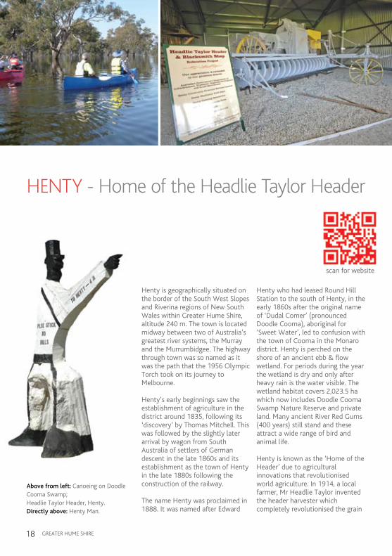
HENTY - Home of the Headlie Taylor Header
Henty is geographically situated on the border of the South West Slopes and Riverina regions of New South Wales within greater Hume Shire, altitude 240 m. The town is located midway between two of australia’s greatest river systems, the murray and the murrumbidgee. The highway through town was so named as it was the path that the 1956 Olympic Torch took on its journey to melbourne.
Henty’s early beginnings saw the establishment of agriculture in the district around 1835, following its ‘discovery’ by Thomas mitchell. This was followed by the slightly later arrival by wagon from South australia of settlers of german descent in the late 1860s and its establishment as the town of Henty in the late 1880s following the construction of the railway.
The name Henty was proclaimed in 1888. it was named after Edward
Henty who had leased Round Hill Station to the south of Henty, in the early 1860s after the original name of ‘Dudal Comer’ (pronounced Doodle Cooma), aboriginal for ‘Sweet Water’, led to confusion with the town of Cooma in the monaro district. Henty is perched on the shore of an ancient ebb & flow wetland. For periods during the year the wetland is dry and only after heavy rain is the water visible. The wetland habitat covers 2,023.5 ha which now includes Doodle Cooma Swamp Nature Reserve and private land. many ancient River Red gums (400 years) still stand and these attract a wide range of bird and animal life.
Henty is known as the ‘Home of the Header’ due to agricultural innovations that revolutionised world agriculture. in 1914, a local farmer, mr Headlie Taylor invented the header harvester which completely revolutionised the grain
Travel back in time to when there was gold in them
there hills, Cobb & lerking,
Above from left: Canoeing on Doodle Cooma Swamp;Headlie Taylor Header, Henty.Directly above: Henty man.
scan for website

gREaTER HUmE SHiRE 19
B
ARTS
CH A
VE
GR
UBBE
N RD
H
ENTY
SWA
MP R
D
KEIGHTLEY ST
SLADEN ST
HENTY PLEASANT HILLS RD
ANGASTON RD
HE
NT
Y
WA
LLA
RD
SLADEN ST EAST
LYNE ST
KEIGHRAN STFOX ST
GR
AH
AM
ST
OLY
MP
IC H
IGH
WA
Y
OLY
MP
IC H
IGH
WA
Y
DAY ST
SMART ST
ELM ST
HAYES ST
SPENCE ST
ROSLER PDE
YANKEE CROSSING RD
KIERATH ST
FOURTH ST
THIRD ST
SECOND ST
FIRST ST
SM
ITH
S
TH
EN
TY
SH
OW
GR
OU
ND
RD
CO
ME
R S
T
CO
ME
R S
T
ALLA
N S
T
TH
IRD
AV
ESE
CO
ND
AV
E
FIR
ST
AV
E
TH
IRD
AV
E
SE
CO
ND
AV
E
ALLA
N S
T
IVO
R S
T
SOUTH ST
sports & show ground
governmentdam reserve
doodle coomaswamp
henty memorial park
bicen
tenia
l par
k
BUCKARGINGAH CREEK
BUCKARGINGAH CREEK
S
S
C
R
golf course
Police
Fireto HOLBROOK
to CULCAIRN
to YERONG CREEK
to PLEASANT HILLS
Major Road
Street/Road
Laneway/Proposed Road
Railway Line
Green Area/Parkland
Water Course
Accommodation
Bank/ATM
BBQ
Bird Watching
Bowling Club
Camping
Caravan Park
Cemetery
Community Hall
Disabled Access
Dog Off Leash Area
Dump Point For Toilet Waste
Fuel
Golf Course
C
S
Horse Riding
Hospital
Hotel
Library
Museum/Heritage
Picnic Table
Place of Worship
Playground
POLICE
Railway Station
Restaurant/Cafe
School
Supermarket
Swimming Pool
Tennis Courts
Toilets
Visitor Information Point
Walking Track
R
Police
C
S
R
Street Map of Henty

gREaTER HUmE SHiRE20
industry around the world. in 2009 an authentic header harvester and blacksmith’s shop were relocated to Bicentennial Park, Olympic Highway. Open everyday with guided tours available by appointment.
The Whitlock Plough, another local innovation, was superior to australia’s famous ‘Stump Jump Plough’ though it is rarely recognised in australia’s list of innovations.
The Henty government Dam Nature Reserve is a delight for bird lovers, where up to 140 different bird species either make their home or migrate for the season. The Reserve is only 750 metres off the Olympic Highway (access along the Pleasant Hills Road). Two walking tracks through the reserve were developed by the Henty Rotary Club to allow
visitors to enjoy the native vegetation and regional wildlife and form a part of a Wildlife Corridor between Henty and Pleasant Hills. a picnic ground has been created by the Henty Rotary Club and the Doodle Cooma Landcare group have established a living seed bank from local species of flora. Still in its early stages, this site will become a mecca for those interested in australian Flora & Fauna. government Dam Nature Reserve is part of the Eastern Riverina Landcare Eco-tour which takes in 10 ecologically sensitive sites in and around the towns of Henty, Pleasant Hills, The Rock, mangoplah and Lockhart.
information about local bird species is now available, with some 140 species being recorded in the Henty District alone. Brochures and information can be obtained from
the library or Visitor information Points in Henty and in brochure boxes located at various sites on the tour, including the government Dam Nature Reserve.
During spring the district is a kaleidoscope of colour with fields of canola in full bloom for the Henty machinery Field Days when thousands of people come from near and far to see the latest in agricultural displays. The Henty machinery Field Days were first held in 1963, and now, this small town, annually hosts a 3 day Field Day with approximately 50,000 people attending. it is the largest event of its kind in the country.
Located between the towns of Henty and Culcairn on the Olympic Highway, is the Henty man. This man was originally shaped by an itinerant worker in the early 1930’s from a tree burnt out by a Swagman’s fire. it became a district landmark until it was destroyed by natural elements about 20 years later. Prior to Henty’s Centenary in 1986, it was decided by local identities to restore “The man” for that occasion, and this was done with the help of the former Culcairn Shire Council. at the Centenary celebrations it was dedicated by Cr Hugh mcKay to the “men of the road who, through no fault of their own had to walk the length and breadth of australia during the

gREaTER HUmE SHiRE 21
n visit the Cellar mini museum which includes Henty’s old telephone exchange and Observer Printery museum (watch the presses roll from yesteryear). Open 9 am to 5 pm, monday to Friday, 9 am to
12 noon on Saturdays or by appointment. Contact 02 6929 3302.
n view Headlie Taylor’s Header and Blacksmith’s Shop at Bicentennial Park, Olympic Highway. Open everyday, guided tours are available by appointment, contact 02 6929 3770.
n go bird watching at Henty government Dam Nature Reserve or Doodle Cooma Swamp Nature Reserve.
n stroll around the Henty Cemetery.
n take in the Henty Silos, which are the second oldest in country NSW, built in 1919 or the various well preserved heritage buildings.
HENTY iS a DESTiNaTiON FOR THE FOLLOWiNg TOURS:
• Cobb&CoWay• MountainstothePlains Expedition• BirdwatchersTrek• BowlersDrive• GolfersSwing• EcoAdventure• CemeteryJourney• MuseumExploration
great Depression seeking work. many being forced to beg for food to survive. many then regained their dignity by defending australia during World War ii, some never to return. Others enjoyed the better days of the 1950’s and 1960’s.”
With Henty’s rich heritage the Cellar mini museum, located beneath Henty’s iga Supermarket, is a must see. inside, you will find Henty’s past including the town’s old telephone exchange along with many items which will bring back memories for some, whilst to others, a new understanding of the past. The newly developed Observer Printery museum located in Lyre Street (behind Sladen Street, main street of Henty) is also an interesting visit. inside you will be able to understand and experience the way newspapers
of yesteryear were developed and produced, with many of the old printing presses still in working condition.
Refusing to succumb to the fate of many other small rural towns, Henty has an active community committed to the town’s development and was the first town in NSW to develop and successfully run its own bank, the Henty Community Bendigo Bank. Other recent developments include a community club, a hospital and nursing home, dedicated library with iT facilities and a Retirement Village, a striking testament to how rural communities can compete with their city and regional cousins for business and industry investment.
Opposite top: Henty man, Olympic Hwy; Home of Headlie Taylor Header and Blacksmith Shop, Henty.Opposite left: Doodle Cooma arms Hotel, Henty.Top from left: Visitors flock to Henty machinery Field Days;Henty Swimming Pool.Above: Entrance to Henty Showgrounds.
HENTYMACHINERY
FIELD DAYS
Celebrating 50 years in 2013September 17, 18 & 19.
HENTYHHHHHHHHHHEEEEEEEEEEEENNNNNNTTTTTTTTTTTTYYYYYYYYYYYYYYYYYYYYYYYYMACHIHHHHHHHEEEEEENNNNNNNNTTTTTTTTYYYYYYYYYYYYHHEENMMMMMMMMMMMMMMMMMMMAAAAAAAAAAAAAAAAAAAAAAAAAAAAAAAACCCCCCCCCCCCHHHHHHHHHHHHHHIIIIIIIIFIEMMMMMMMMAAAAAAAAAAAAAACCCCCCCCCCHHHHHIIIIIIMMMMAAAAAAACCCCCCCHHHIIFFFFFFFIIIIIIIIIIIIIIIEEEEEEEEEEEEEEEFFFFFFFFFFFFFFFFFFFIIIIIIIIIEEEEEEEEEEE
Celebrating 50 years in 2013September 17, 18 & 19.
www.hmfd.com.auwww.hmfd.com.au
Attraction
Things to See and Do

gREaTER HUmE SHiRE22
HOLBROOK - the Submarine Town
Holbrook is situated approximately half way between melbourne and Sydney on the Hume Highway and is primarily a service centre for the surrounding region and visiting highway traffic.
The Wiradjuri tribe called the Ten mile Creek, “Thug-wug-minnia-binnis” or “Thug-wug-mungyel-bingyel”, meaning something like “jumping waters” or “something to do with rock wallabies”. Hume & Hovell were the first white men to disturb their hunting and fishing land, when they crossed from Tumbarumba into the greater Hume Shire region on 10 November 1824. They likened the area to Camden Forest and called the highest point Friday mount(mt Pleasant). The Rev John Joseph
Therry was the first white man licensed to settle in the Holbrook area, being granted the “Billy Bong” lease in January 1837, which covered an area of 6400 acres, including the site of the present township of Holbrook, with its headquarters at “Yarra Yarra.’’
The first to settle on the present site of Holbrook were John and Elisabeth mitten who squatted on the north bank of the Ten mile Creek in early 1838. On 26 June 1839 John was granted a publican’s licence for the Woolpack inn. This was situated near Holbrook’s current swimming pool.
in april 1840 the Pabst family moved into Ten mile Creek. Johann Christopher Pabst, a german shepherd, arrived in australia in 1825 to work for the australian agricultural Company founded by John macarthur, the pioneer and founder of australia’s wool industry.
Travel back in time to when there was gold in them there hills,
Cobb & Co coaches rolled and bushrangers were lerking,
On 29 July 1840 he was granted the licence of the Woolpack inn, with Ellen running the Woolpack inn, while Johann was working as a shepherd and a coach driver. in 1840, travellers passing through the area referred to the hotel as “The germans” or “John the german’s.” The Post Office and Store was opened by James Ford on 1 January 1857. it was situated on the corner of murray and albury Streets.
in august 1858 surveyor Sam Parkinson surveyed the township calling it germanton which was gazetted in 1876. John Purtell built the Criterion Hotel (the present site of the Woolpack inn museum). The first licensee was John King, who came from the Criterion Hotel in albury. During the gold rush to the Kiandra diggings in the 1860’s, the Pabst family kept a store and sold bread to the travellers. This was near the site of the Holbrook Hotel. With the influx of new settlers from the
Top from left: Enjoying a light refreshment at the Planes, Trains & Submarines Festival, Holbrook; Hot air Ballooning near HmaS Otway, Holbrook.
scan for website

gREaTER HUmE SHiRE 23
RACECOURSE RD
RAC ECO
UR
SE
RD
MCLAUR
EN
CR
ES
ROSS ST
BOWLER ST
YARRA ST
YOUNG ST
SPURR ST
MURDOCH PLDIGGERS RD
HUME ST
HUME ST
HAY ST
MURRAY ST
MURRAY ST
YOUNG ST
BARDWELL ST
MACINNES ST
BOWLER ST
MILLSW
OOD RD
MILLSWOOD RD
BON
D S
T
WEL
TON
ST
CR
OFT
ST
PURT
ELL
STST
IRBE
CK S
T
WILS
ON S
T
KING
ST
WEB
B S
T
RAILW
AY P
DE
FLEE
T ST
SWIFT
ST
SWIFT
STFR
AMPTO
N ST
THOR
PE S
TBY
NG S
T
NYHA
N ST
WILLIAM
ST
DONALD
ST
PEEL
ST
VINE
ST
FORD
ST
SPR
ING
ST
TIP
RD
TIP
RD
BATH STBATH ST
RANKIN ST
RAYMOND ST
HO
LBR
OO
K W
AGG
A
RD
ALBU
RY S
T
ALBU
RY
ST
ALBU
RY S
T
JINGELLIC RD
MALA
BAR
RD
HUME HIGHWAYBYPASS 2013
HUME HIGHWAYBYPASS 2013
HU
ME
HIG
HW
AY
HUME HIGHWAYANDERSONS LN
MOUNTAIN
CREEK RD
WALLACE ST
BURGES LN
CO
RR
YS L
N
HAL
FOR
D D
RBR
UC
E ST
WALLACE ST
CULCAIRN HOLBROOK RD
PROSPECT ST
submarine
golf course
racecourse
to air park
sports & show ground
cricket & football ground
miniature railway
TEN MILE CREEK
TEN MILE CREEK
S
S
C
Police
Fire
to JINGELLIC
to WOOMARGAMA
to MORVEN
to TARCUTTA
to WAGGA WAGGA
C
S
POLICE
Restaurant/Cafe
School
Skate Park
Supermarket
Swimming Pool
Tennis Courts
Toilets
Walking Track
Police
C
S
Fuel
Golf Course
Horse Riding
Hospital
Hotel
Library
Museum/Heritage
Picnic Table
Place of Worship
Police
Major Road
Street/Road
Laneway/Proposed Road
Green Area/Parkland
Water Course
Proposed Bike Track
Accrediated Visitor Information Centre
Accommodation
Air Park
C
S
Police
C
BBQ
Bird Watching
Bowling Club
Camping
Caravan Park
Cemetery
Community Hall
Disabled Access
Dog Off Leash Area
Dump Point For Toilet Waste
S
Police
Street Map of Holbrook
C
S
R
RACECOURSE RD
RAC ECO
UR
SE
RD
MCLAUR
EN
CR
ES
ROSS ST
BOWLER ST
YARRA ST
YOUNG ST
SPURR ST
MURDOCH PLDIGGERS RD
HUME ST
HUME ST
HAY ST
MURRAY ST
MURRAY ST
YOUNG ST
BARDWELL ST
MACINNES ST
BOWLER ST
MILLSW
OOD RD
MILLSWOOD RD
BON
D S
T
WEL
TON
ST
CR
OFT
ST
PURT
ELL
STST
IRBE
CK S
T
WILS
ON S
T
KING
ST
WEB
B S
T
RAILW
AY P
DE
FLEE
T ST
SWIFT
ST
SWIFT
STFR
AMPTO
N ST
THOR
PE S
TBY
NG S
T
NYHA
N ST
WILLIAM
ST
DONALD
ST
PEEL
ST
VINE
ST
FORD
ST
SPR
ING
ST
TIP
RD
TIP
RD
BATH STBATH ST
RANKIN ST
RAYMOND ST
HO
LBR
OO
K W
AGG
A
RD
ALBU
RY S
T
ALBU
RY
ST
ALBU
RY S
T
JINGELLIC RD
MALA
BAR
RD
HUME HIGHWAYBYPASS 2013
HUME HIGHWAYBYPASS 2013
HU
ME
HIG
HW
AY
HUME HIGHWAYANDERSONS LN
MOUNTAIN
CREEK RD
WALLACE ST
BURGES LN
CO
RR
YS L
N
HAL
FOR
D D
RBR
UC
E ST
WALLACE ST
CULCAIRN HOLBROOK RD
PROSPECT ST
submarine
golf course
racecourse
to air park
sports & show ground
cricket & football ground
miniature railway
TEN MILE CREEK
TEN MILE CREEK
S
S
C
Police
Fire
to JINGELLIC
to WOOMARGAMA
to MORVEN
to TARCUTTA
to WAGGA WAGGA
Closer view of CBD
gREaTER HUmE SHiRE24
Robertson Land act in the late 1860s, the Pabst family opened the germanton Hotel on 2 November 1868. mrs. Pabst owned most of the land from the Presbyterian Church to the germanton Hotel.
The first Criterion Hotel was severely damaged by fire, twice, in april and September 1895. in November 1895 half of the Criterion
Hotel was rebuilt, which included a shop, billiard room, bar and bathroom. in September 1913 the second story was added to the Criterion Hotel. The Criterion or “Bottom Pub” continued to trade until 30 June 1965, the last licensee was Kevin murphy. February 1971 the Holbrook Promotion Committee purchased the building from Harry Jarvis for a museum. The Woolpack inn museum opened its doors on 18 December 1971. in april 1972 Sir Roden Culter VC officially opened the Woolpack inn museum.
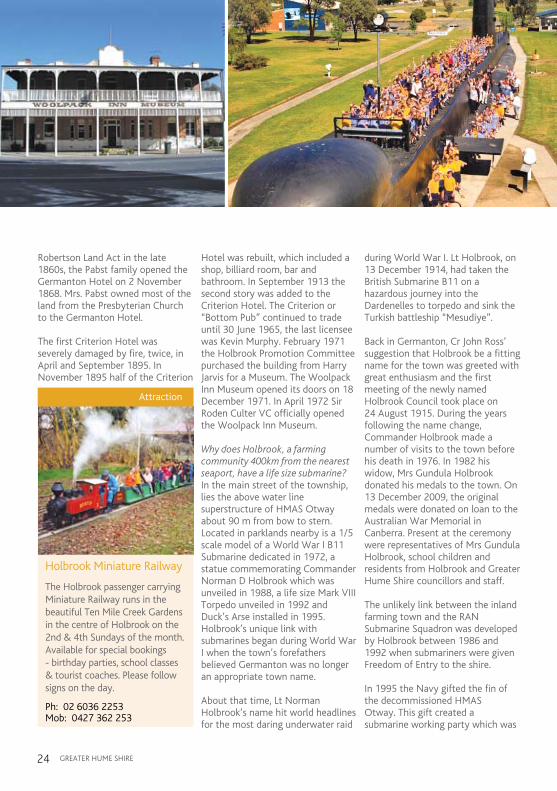
Why does Holbrook, a farming community 400km from the nearest seaport, have a life size submarine?in the main street of the township, lies the above water line superstructure of HmaS Otway about 90 m from bow to stern. Located in parklands nearby is a 1/5 scale model of a World War i B11 Submarine dedicated in 1972, a statue commemorating Commander Norman D Holbrook which was unveiled in 1988, a life size mark Viii Torpedo unveiled in 1992 and Duck’s arse installed in 1995.Holbrook’s unique link with submarines began during World War i when the town’s forefathers believed germanton was no longer an appropriate town name.
about that time, Lt Norman Holbrook’s name hit world headlines for the most daring underwater raid
during World War i. Lt Holbrook, on 13 December 1914, had taken the British Submarine B11 on a hazardous journey into the Dardenelles to torpedo and sink the Turkish battleship “mesudiye”.
Back in germanton, Cr John Ross’ suggestion that Holbrook be a fitting name for the town was greeted with great enthusiasm and the first meeting of the newly named Holbrook Council took place on 24 august 1915. During the years following the name change, Commander Holbrook made a number of visits to the town before his death in 1976. in 1982 his widow, mrs gundula Holbrook donated his medals to the town. On 13 December 2009, the original medals were donated on loan to the australian War memorial in Canberra. Present at the ceremony were representatives of mrs gundula Holbrook, school children and residents from Holbrook and greater Hume Shire councillors and staff.
The unlikely link between the inland farming town and the RaN Submarine Squadron was developed by Holbrook between 1986 and 1992 when submariners were given Freedom of Entry to the shire.
in 1995 the Navy gifted the fin of the decommissioned HmaS Otway. This gift created a submarine working party which was
Attraction
Holbrook Miniature Railway
The Holbrook passenger carrying Miniature Railway runs in the beautiful Ten Mile Creek Gardens in the centre of Holbrook on the 2nd & 4th Sundays of the month. Available for special bookings - birthday parties, school classes & tourist coaches. Please follow signs on the day.
Ph: 02 6036 2253 Mob: 0427 362 253
Miniature Rwy Advert.indd 1 13/8/10 8:49:32 AM

gREaTER HUmE SHiRE 25
Things to See and Do
n visit the Submarine Park and walk along HmaS Otway or go through the Submarine museum which now houses photographs, an amazing new 3D hologram depicting the exploits of Lieutenant Commander Holbrook, submarine components and mock areas of the submarine interior such as control room and living quarters and working periscope. Open 10 am to 4 pm, daily, contact 02 6036 2422.
n Woolpack inn museum - Provides a wonderful display evoking the pioneering past of Holbrook in themed rooms. There is also an extensive display of early transport and machinery used in the district, and several outside buildings which have been reconstructed on site. Open 9.30 am to 4.30 pm, each day, contact 02 6036 2131.
n National museum of australian Pottery - Dedicated to 19th and early 20th century australian Pottery. Over 1200 pieces are on display from over 120 australian pottery companies. Open 9.30 am to 4.30 pm Thursday to Tuesday. Closed Wednesdays and in august, contact 02 60363464.
n take a ride on Holbrook’s miniature Railway, located in the beautiful Ten mile Creek gardens. The train runs on the second and fourth Sunday of each month throughout the year, every Sunday during School holidays, and by arrangement for parties etc, contact 02 6036 2253.
n relax in Holbrook’s great parks including Ten mile Creek gardens, Submarine Park and Circus Flat.
n take a walk along ian geddes Bushwalk located on the western side of the highway, behind grimwoods Craft Store and Woolpack inn museum. This lovely tranquil bushland walk follows Ten mile Creek away from the highway. The entrance features a shelter with a map of the walk and the names and pictures of the birds which you are likely to observe as you meander along the trail. The walk can be comfortably completed in half an hour.
n stroll along albury Street (Hume Highway) and enjoy historic buildings of a bygone era such as the Court House, Police Station, and Knox Uniting Church or St Paul’s anglican Church.
n go for a skate in the skate park at Submarine Park.
HOLBROOK iS a DESTiNaTiON FOR THE FOLLOWiNg TOURS:
• Cobb&CoWay• RoundtheTopCircuit• MountainstothePlains Expedition• MurrayRiverExperience• BirdwatchersTrek• BowlersDrive• GolfersSwing• EcoAdventure• CemeteryJourney• MuseumExploration
formed to investigate ways of obtaining a real submarine and overseeing its erection, several thousand dollars was raised along with a generous gift from mrs gundula Holbrook. HmaS Otway was purchased creating the problem of moving the submarine inland, hence the structure was cut into sections and transported by semi-trailer down the Hume Highway. The spectacular, traffic
stopping inland submarine is a fitting memorial to those brave men who serve and have served in submarines in both war and peace. an official dedication of the Submarine memorial was staged during the Queen’s Birthday weekend on 7 June 1997 with mrs gundula Holbrook the official guest.
in 2013 Holbrook will be bypassed. However the township will still be
very accessible to passing traffic with convenient on and off ramps at either end of the township, making Holbrook the ideal stopover destination for the weary traveller, with its relaxing parks, ample car, RV and van parking, petrol stations, super markets and excellent eateries. also on offer are delightful antique and craft shops as well as interesting museums.
There are excellent sporting facilities, including the Equine Centre currently being developed at the Holbrook Racecourse to cater for polocrosse, pony club, campdraft and rodeo as well as other equine sports. The Sporting Complex, golf, bowls and swimming facilities provide for all sporting tastes.
a number of wineries are being developed to the east of Holbrook. The district is also very proud that Holbrook is home to one of the most successful Landcare programs in australia, having won many national awards.
The airpark on the outskirts of Holbrook sees a high level of activity and is particularly popular with ultralight pilots, and regularly sees pilots fly into its precinct in light planes from around the world.
Opposite top from left:Woolpack inn museum, Holbrook;School children on HmaS Otway, Holbrook.

gREaTER HUmE SHiRE26
November 1914 saw Lt Holbrook and His majesty’s Submarine (HmS) B11 (British B Class) part of a mixed flotilla of British and French ships and submarines patrolling from dusk to dawn off the entrance to the Dardanelles. B11s being of primitive design had a crew of 15, were 47 m long with a displacement of287 tons surfaced and 316 tons submerged. a single 16 cylinder,600 hp petrol engine gave a maximum surface speed of 12 knots and a 290 hp electric motor, fed from storage batteries, could produce 6 knots submerged for 1 hour (longer at slower speed).
in December 1914 a decision was made to send a submarine against the movement of shipping seen20 km further up the Straits from the entrance. The Straits were
covered by numerous guns at point blank range, with powerful searchlights sweeping the surface and at least 5 lines of mines moored across the Straits as well as those in the Narrows. a submarine fitted with guards around the hydroplanes and wires from bow/stern to the highest point on the conning tower could pass through the minefield by pushing the mooring wires aside.
at 3 am on 13 December 1914, the 26 year old Lt Holbrook and HmS B11 set off. at 4.15 am when B11 was 5 km from the entrance to the Straits, Lt Holbrook shut down the motor to await dawn when the searchlights were switched off. at5 am, Lt Holbrook started the engine and trimming down low in the water with just the conning tower above water, crept closer inshore. as first light appeared, B11 dived and proceeded submerged, navigating by the raised periscope. a strange vibration shook the boat , the mine guard around the port hydroplane
was bent out of shape, forcing Lt Holbrook to discard it before proceeding, thus exposing the hydroplane to the risk of hooking a mine. as dawn’s light grew, B11 sat exposed on the surface, fortunately calm, as the crew worked frantically to free the hydroplane. By 6 am, B11 was again submerged at periscope depth, on course up the Straits.
at 8.30 am, B11 trimmed to 25 m and entered the first minefield. For an hour they proceeded ‘blind’, conscious of the lines of mines overhead with the risk of the exposed hydroplane. at 9.30 am, Lt Holbrook guessed they were through the minefield and rose to periscope depth to fix their position. as Lt Holbrook swung the periscope around, he discovered they were further up the Straits than expected. a battleship came into view about 1.6 km away, bow on, too far for their 45 cm torpedoes. Lt Holbrook swung B11 90 degrees to starboard to close the range and to allow the
Commander Norman D Holbrook
A challenging underwater mission with a brave crew.
Top from left: Looking through the Periscope; a real Torpedo. Pioneers memorial; 3D Hologram depicting the story of Holbrook, Submarine museum.

gREaTER HUmE SHiRE 27
current to sweep him onto the battleship’s beam. Rising to periscope depth 5 minutes later, Lt Holbrook swung B11 to point at the battleship and fired two torpedoes. With the current now sweeping B11 dangerously inshore, Lt Holbrook swung to port and watched the torpedo tracks going straight, towards the battleship. Water closed over the lens and the submarine was violently shaken by the shock of an explosion.
The Turkish battleship “mesudiye”, although hit, began to fire at point blank range, fountains of water sprang up all around the periscope and the crack of shells was striking closely overhead. B11 was now in some difficulty, the compass tube was flooded and the current was sweeping her further inshore. Lt Holbrook was now deep inside the bay, with no compass, only land visible all around his periscope (only centimetres above the water), and after concentrating on the attack he had only a rough idea of his position. Lt Holbrook pointed the submarine on the estimated course and proceeded.
Ordering the boat to be dived to17 m as a torpedo boat appeared, the submarine hit bottom at 12 m. guessing his position by the charts, Lt Holbrook proceeded at full speed and for the next 10 minutes frequently touched bottom until finding deeper water. at 10.20 am Lt
Holbrook cautiously brought B11 to periscope depth and finding clear water, headed back down the Straits.
The long burst at full speed had taken a lot out of the battery and with safety still 28 km away,B11 was forced to proceed at slow speed. Without a compass B11 needed to be at periscope depth to navigate. The next hour was to be the most trying of the mission. B11 had dived for over 5 hours and the air was becoming foul. By noon they passed safely through the minefield, but they were right under the guns of the forts on either side. With about 14 km to safety and the battery almost as exhausted as the men, Lt Holbrook issued food and a lot of rum. at 1 pm, Lt Holbrook surfaced near a British destroyer. after 8 hours submerged, a long, long time in such a primitive submarine, the petrol engine refused to start, until the foul air in the boat had been ventilated. B11 then sailed on to safety.
B11 became the first submarine to sink an enemy warship in waters theoretically safe from attack. For this fine achievement Lt Holbrook was awarded the Victoria Cross and the French Legion of Honour; Lt T Winn, the 1st Lieutenant, the Distinguished Service Order (DSO) and the remainder of the crew either the Distinguished Service Cross (DSC) or the Distinguished Service medal (DSm)
THE CiTaTiON FOR THE ViCTORiaCROSS giVEN TO COmmaNDER HOLBROOK REaD:“Norman Douglas Holbrook, Lieutenant, Royal Navy, Date of act of Bravery: 13th December,1914. For most conspicuous bravery on 13th December when, in command of the SubmarineB11, he entered the Dardanelles and, notwithstanding the very difficult current, dived his vesselunder 5 rows of mines and torpedoed the Turkish Battleship “mesudiye”, which was guardingthe minefield. Lt Holbrook succeeded in bringing the B11 back, although assailed by gunfire andtorpedo boats, having been submerged on 1 occasion for 9 hours”.
CmDR HOLBROOK’S mEDaLSVictoria Cross (takes precedence over all other orders and medals; as of 2012, a total of 1360 VC’s have been awarded, of which 99 were australians).1914-20 British War medal1914-15 Star Victory medal1914-1919. Bronze Oak Leaf1939-1945 Defence medal1939-1945 War Service medalCoronation medal (King george Vi)Coronation medal (Queen Victoria)insignia of Chevaliar of the Legion of Honour.

Attraction
The Last Post Bookshop
Secondhand, rare and collectable books. Something for everyone.
Large range to select from. Well worth a visit.
106 Albury StreetHolbrook NSW 2644Ph: 02 6036 3006Mob: 0419 218 078E: [email protected]
COOL CATRegional Wine, Gourmet Food,Specialty Chocolate, Giftware.
139 Albury Street,Holbrook 2644Ph: 60 363053 Fax: 60 363057E: [email protected]
Regional Wine Gourmet Food Specialty Chocolates
AttractionsAttraction
Cool Cat
Regional Wine, Gourmet Food, Specialty Chocolate, Giftware
139 Albury St,Holbrook NSW 2644Ph: 02 6036 3053 Fax: 02 6036 3057E: [email protected]
Attraction
Henty Cellar Mini Museum
Situated in the cellar of Dales IGA Supermarket. A display of Trash & Treasure including the town’s old telephone exchange. Open business hours or by appointment. Gold coin donations welcome.
Les & Mary Dale9 Sladen St, Henty NSWPh: 02 69 29 3302 Fax: 02 6929 3433Mob: 0458 293 302
Attraction
Doll Museum & Historical Treasures
Housed in a charming historical church. Collecting for 60 years, offering a variety of dolls, teddies, prams, collectables and Australiana as well as a great arrangement of soft toys. Affordable prices.
Open 7 days, 9.00am to 5.00pm
5 Main St, GerogeryPh: 02 6026 0578
Attraction
Judy’s Dolls & Gifts
Specialising in quality giftware and craft supplies. Come in and browse through the range of patchwork fabric, quilts, haberdashery, knitting books and yarn and scrapbooking supplies.
You will also find handmade jewellery, dolls and gifts, and a large range of wooden toys.
23 Sladen St, Henty NSW 2658 Ph: 0427 293 228
Judy’s Dolls & Gifts
Open:Wed-Fri 10am-4pm
Sat 10am-1pm
gREaTER HUmE SHiRE28
Attraction
Wirraminna Environmental Education Centre
Originally a stock reserve and public watering place, it features a Learning and Discovery Centre wetlands, bush, and landscaped areas linked by walking tracks. Visitors can experience a diversity of native plants and wildlife.
Ph: 02 6029 3319Email: [email protected]: www.wirraminna.org
Attraction
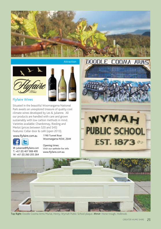
Flyfaire Wines
Situated in the beautiful Woomargama National Park awaits an unexplored treasure of quality cool climate wines developed by Les & Julianne. All our products are handled with care and grown sustainably with low carbon methods in mind. Varieties available: Chardonnay, Riesling and Merlot (prices between $20 and $45) Features: Cellar door & café (open 2013).
www.flyfaire.com.au
@: [email protected]: +61 (0) 407 908 499W: +61 (0) 260 205 264
1190 Tunnel RoadWoomargama NSW, 2644
Opening times:Visit our website for infowww.flyfaire.com.au
gREaTER HUmE SHiRE 29
Top Right: Doodle Cooma arms murial, Henty; Wymah Public School plaque. above: Horse trough, Holbrook.

gREaTER HUmE SHiRE30
CULTURE aND RELigiON greater Hume Shire is predominantly a rural community; the majority of the population has a European heritage, essentially British/Scottish and german. The predominant language of the shire is English with Christianity the largest religion. Residents of the shire enjoy an outdoor lifestyle of sport including football, tennis, cricket, croquet, bowls, golf, horse riding, swimming and recreation from bushwalking to leisurely drives through the countryside. BBQ’s and family orientated events are important. in many of our towns and villages you can catch performances by local musicians and see hand-made art and craft.
FaCiLiTiES ON OFFER
• accommodation (inc motels, country pubs, caravan parks, farm hosts, Bed & Breakfasts, camping grounds) in Culcairn, gerogery, Henty, Holbrook, Jindera, Lankey’s Creek Talmalmo, Walla Walla, Woomargama and Wymah.
• Eating Out from cafes to restaurants in Burrumbuttock, Culcairn, gerogery, Henty, Holbrook, Jindera, morven, Walbundrie, Walla Walla, Woomargama
• Public Toilets available in Brocklesby, Bungowannah, Burrumbuttock, Culcairn, gerogery, Henty, Holbrook, Jindera, mullengandra, Walbundrie, Walla Walla and Woomargama as listed on the National Public Toilet map.
• grey Water Dumps, free of charge, providing clean and safe disposal of black and grey water in Holbrook (Holbrook Caravan Park, Hume Highway, contact
02 6036 3100) and Henty (Bartsch avenue, just off the Olympic Way, contact
02 6929 3770).
• Community Halls in Brocklesby, Bungowannah, Burrumbuttock,
Carabost, Cookardinia, Culcairn, gerogery, Henty, Holbrook,
Jindera, Lankey’s Creek, mullengandra, Walbundrie, Walla Walla, Woomargama, Wymah and Yarra Yarra.
• Hospitals and/or medical Centres in Culcairn, Henty, Holbrook and Jindera.
• Post Offices in Brocklesby, Burrumbuttock, Culcairn, gerogery, Henty, Holbrook, Jindera, Walla Walla and Woomargama.
• Petrol Stations in Culcairn, Henty, Holbrook, gerogery, Walbundrie and Walla Walla.
• Churches of various Christian denominations throughout the shire.
• Playgrounds in Burrumbuttock, Brocklesby, Culcairn, gerogery, Henty, Holbrook, Jindera, Walla Walla, Walbundrie and Woomargama.
• BBQ facilities at Burrumbuttock, Culcairn, gerogery, Henty, Holbrook, Jindera, Walla Walla, Walbundrie and Woomargama.
Helpful Information
Top from left: inside the National museum of australian Pottery, Holbrook;Kids on ponies enjoying a leisurely ride.Table Top mountain;Kids enjoying australia Day celebrations.

gREaTER HUmE SHiRE 31
Visitor Information
Greater Hume Shire’s Accredited Visitor Information CentreSubmarine Park, Wallace Street,PO Box 99, Holbrook NSW 2644Ph: +61 02 6036 2422Fax: +61 02 6036 2422E: [email protected]: www.greaterhume.nsw.gov.au
Visitors are invited to contact our accredited Visitor information Centre to obtain additional information.
Greater Hume Shire’s Visitor Information Points Visitor information Points are located throughout greater Hume Shire so that visitor’s can access local tourist information such as maps, brochures and information on specific local events. Burrumbuttock general Store Urana Road, Burrumbuttock Ph: 02 6029 3240 Email: [email protected]
Central Cafe 48 Balfour St, Culcairn Ph: 02 6029 8464 Dale’s Highway Store 21 Railway Parade, Henty Ph: 02 6929 3201 Email: [email protected]
Doodle Cooma Craft Shop Railway Station, HentyPh: 02 6929 3712
gerogery Supply Store1 main Street, gerogeryPh: 02 6026 0540Email: [email protected]
Jindera Pioneer museum Urana Road, Jindera Ph: 02 6026 3622 Email: [email protected]
Walla Walla Store73 Commercial Street, Walla Walla Ph: 02 6029 2231Email: [email protected]
Woolpack inn museum 83 albury Street, HolbrookPh: 02 6036 2131Email: [email protected]
Woomargama Post Office Woomargama Way, WoomargamaPh: 02 6020 5262Email: [email protected]

Doodle Cooma
Gum Swamp
Swamp
Billabong Creek
Billabong Creek
Doodle CoomaDoodle Cooma
Hume and Hovell Walking Track
G
erog
ery R
d
Urana Rd Urana Rd
Tunnel R d
Lock
hart
Rd
Henty W
alla R
d
Walb undrie Rd
Walbundrie Rd
Henty Pleasant Hills R
Urana Rd
W agga Rd
Wagga Rd
Henty Cookardinia Rd
Culcairn Holbrook Rd
Jingellic Rd
ymah Rd
Cummings Rd
Wa ll
a
Wall
a
Jinde
ra Rd
Tumbar um ba Rd
M
URRAY VALLEY HIGH WAY
urngoogie
Mt Burrowa1300
Mt Lawson1041
MO
RG
AN
SR
I DG
E
Table Top Mountain
Burrowa-PineNational
Park
Mt LawsonState Park
Mt GranyaStatePark
Jarvis Ck Regional
Park
WoomargamaNational Park
Wodonga
Culcairn
Holbrook
To Wagga Wagga # To Sydney & Canberra &
To Melbourne $
Rutherglen
Jinder
W ah
BownaTalmalmo
Lankeys Creek
Carabost
Little Billabong
Cookardinia
Morven
HMAS Otwa
RosewoodEssential Oils
MorgansLookout
Paintball Albury Wodonga
Ferr
Zion
LutheranChurchc 1879
Wirraminna Environmental
Education Centre
r Landing Site
Henty MachinerField Daysome of
the Header
Camp Site
Walbundrie
Burrum ttock
Gerog
Brocklesby
Bulgandry
Alma Park
Mullengandra
Alb ry
Hong
Burr
u mbu
ttock
Rd
How ng
ndKy
wong
How
long
Rd
Lak Humee
e
Woomargam
a Way
y
erybu Woomargama
Jingellic
Walwa
ym
Mt B
H
a
lo
Ra
OLYM
PICHI
GHW
AY
HUME HIGHWAY
RIVERINA HIGHWAY
wol
YAMB
LA RA
NGE
Bena
mbr
a Nat
iona
l Par
k
W
d
y
y
Av o Anson
Station Masters Residence
Pioneer Museum
u
41
Walla Walla
HentyRefer Town Map
Refer Town Map
Refer Town Map
Refer Town Map
Refer Town Map
gREaTER HUmE SHiRE32
Accredited Visitor Information Centre
Visitor Information Point
Accommodation
Air Park
BBQ
Bird Watching
Boat Ramp
Camping
Caravan Park
Cemetery
Disabled Access
Fishing
Forest
National Park
Urban Area
Freeway (Divided Road)
Highway
Dirt RoadOther Sealed Road
4WD Track
RailwayRail Trail
Special Route
Legend
3020100 40 50 km
Forest
National Park
Urban Area
Freeway (Divided Road)
Highway
Dirt RoadOther Sealed Road
4WD Track
RailwayRail Trail
Special Route
Legend
3020100 40 50 km

Doodle Cooma
Gum Swamp
Swamp
Billabong Creek
Billabong Creek
Hume and Hovell Walking Track
G
erog
ery R
d
Urana Rd Urana Rd
Tunnel R d
Lock
hart
Rd
Henty W
alla R
d
Walb undrie Rd
Walbundrie Rd
Henty Pleasant Hills R
Urana Rd
W agga Rd
Wagga Rd
Henty Cookardinia Rd
Culcairn Holbrook Rd
Jingellic Rd
ymah Rd
Cummings Rd
Wa ll
a
Wall
a
Jinde
ra Rd
Tumbar um ba Rd
M
URRAY VALLEY HIGH WAY
urngoogie
Mt Burrowa1300
Mt Lawson1041
MO
RG
AN
SR
I DG
E
Table Top Mountain
Burrowa-PineNational
Park
Mt LawsonState Park
Mt GranyaStatePark
Jarvis Ck Regional
Park
WoomargamaNational Park
Wodonga
Culcairn
Holbrook
To Wagga Wagga # To Sydney & Canberra &
To Melbourne $
Rutherglen
Jinder
W ah
BownaTalmalmo
Lankeys Creek
Carabost
Little Billabong
Cookardinia
Morven
HMAS Otwa
RosewoodEssential Oils
MorgansLookout
Paintball Albury Wodonga
Ferr
Zion
LutheranChurchc 1879
Wirraminna Environmental
Education Centre
r Landing Site
Henty MachinerField Daysome of
the Header
Camp Site
Walbundrie
Burrum ttock
Gerog
Brocklesby
Bulgandry
Alma Park
Mullengandra
Alb ry
Hong
Burr
u mbu
ttock
Rd
How ng
nd
Kywo
ng H
ow lo
ng Rd
Lak Humee
e
Woomargam
a Way
y
erybu Woomargama
Jingellic
Walwa
ym
Mt B
H
a
lo
Ra
OLYM
PICHI
GHW
AY
HUME HIGHWAY
RIVERINA HIGHWAY
wol
YAMB
LA RA
NGE
Bena
mbr
a Nat
iona
l Par
k
W
d
y
y
Av o Anson
Station Masters Residence
Pioneer Museum
u
41
Walla Walla
HentyRefer Town Map
Refer Town Map
Refer Town Map
Refer Town Map
Refer Town Map
gREaTER HUmE SHiRE 33
Fuel
Horse Riding
Hotel
Lookout
Museum/Heritage
Picnic Table
Playground
Restaurant/Cafe
Tennis Courts
Toilets
Walking Track
Winery/Vineyard
Forest
National Park
Urban Area
Freeway (Divided Road)
Highway
Dirt RoadOther Sealed Road
4WD Track
RailwayRail Trail
Special Route
Legend
3020100 40 50 km
map courtesy of albury-Wodonga Regional Tourism Forum.
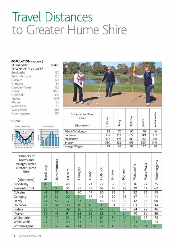
Travel Distancesto Greater Hume Shire
POPULATION (approx.)TOTaL SHiRE 10,423 TOWNS aND ViLLagES Brocklesby 150 Burrumbuttock 170Culcairn 1,121gerogery 80gerogery West 120Henty 1,078Holbrook 1,335Jindera 1,048morven 50Walbundrie 50Walla Walla 583Woomargama 150
CLimaTE
Brocklesby 0 13 48 35 74 77 28 56 16 27 75Burrumbuttock 13 0 35 22 52 64 16 43 19 14 62Culcairn 48 35 0 20 17 30 39 9 32 26 43Gerogery 35 22 20 0 37 49 20 28 37 14 41Henty 74 52 17 37 0 46 56 25 42 36 60Holbrook 77 64 30 49 46 0 64 22 61 56 14Jindera 28 16 39 20 56 64 0 47 34 22 46Morven 56 43 9 28 25 22 47 0 40 30 36Walbundrie 16 19 32 37 42 61 34 40 0 23 75Walla Walla 27 14 26 14 36 56 22 30 23 0 54Woomargama 75 62 43 41 60 14 46 36 75 54 0
Broc
kles
by
Burr
umbu
ttoc
k
Cul
cairn
Ger
oger
y
Hen
ty
Hol
broo
k
Jinde
ra
Mor
ven
Wal
bund
rie
Wal
la W
alla
Woo
mar
gam
a
Distances ofTowns and
Villages withinGreater Hume
Shire
(kilometres)
Cul
cairn
Hen
ty
Hol
broo
k
Jinde
ra
Wal
la W
alla
Albury/Wodonga 53 70 67 19 40 Canberra 305 311 277 349 331 Melbourne 377 394 389 342 368 Sydney 520 526 492 565 546 Wagga Wagga 79 62 82 117 98
Distances to MajorCities
(kilometres)
AVERAGE TEMPERATURE
Deg
rees
Cel
sius
35
30
25
20
15
10
5
0
Max
Min
Jan Feb MarApr
MayJun Jul Aug
SepOct
NovDec
AVERAGE RAINFALL
Mill
imet
res
100
90
80
70
60
50
40
30
20
10
0
Jan Feb MarApr
MayJun Jul Aug
SepOct
NovDec
Climate
Brocklesby 0 13 48 35 74 77 28 56 16 27 75Burrumbuttock 13 0 35 22 52 64 16 43 19 14 62Culcairn 48 35 0 20 17 30 39 9 32 26 43Gerogery 35 22 20 0 37 49 20 28 37 14 41Henty 74 52 17 37 0 46 56 25 42 36 60Holbrook 77 64 30 49 46 0 64 22 61 56 14Jindera 28 16 39 20 56 64 0 47 34 22 46Morven 56 43 9 28 25 22 47 0 40 30 36Walbundrie 16 19 32 37 42 61 34 40 0 23 75Walla Walla 27 14 26 14 36 56 22 30 23 0 54Woomargama 75 62 43 41 60 14 46 36 75 54 0
Broc
kles
by
Burr
umbu
ttoc
k
Cul
cairn
Ger
oger
y
Hen
ty
Hol
broo
k
Jinde
ra
Mor
ven
Wal
bund
rie
Wal
la W
alla
Woo
mar
gam
aDistances ofTowns and
Villages withinGreater Hume
Shire
(kilometres)
Cul
cairn
Hen
ty
Hol
broo
k
Jinde
ra
Wal
la W
alla
Albury/Wodonga 53 70 67 19 40 Canberra 305 311 277 349 331 Melbourne 377 394 389 342 368 Sydney 520 526 492 565 546 Wagga Wagga 79 62 82 117 98
Distances to MajorCities
(kilometres)
AVERAGE TEMPERATURE
Deg
rees
Cel
sius
35
30
25
20
15
10
5
0
Max
Min
Jan Feb MarApr
MayJun Jul Aug
SepOct
NovDec
AVERAGE RAINFALL
Mill
imet
res
100
90
80
70
60
50
40
30
20
10
0
Jan Feb MarApr
MayJun Jul Aug
SepOct
NovDec
Climate
gREaTER HUmE SHiRE34
Brocklesby 0 13 48 35 74 77 28 56 16 27 75Burrumbuttock 13 0 35 22 52 64 16 43 19 14 62Culcairn 48 35 0 20 17 30 39 9 32 26 43Gerogery 35 22 20 0 37 49 20 28 37 14 41Henty 74 52 17 37 0 46 56 25 42 36 60Holbrook 77 64 30 49 46 0 64 22 61 56 14Jindera 28 16 39 20 56 64 0 47 34 22 46Morven 56 43 9 28 25 22 47 0 40 30 36Walbundrie 16 19 32 37 42 61 34 40 0 23 75Walla Walla 27 14 26 14 36 56 22 30 23 0 54Woomargama 75 62 43 41 60 14 46 36 75 54 0
Broc
kles
by
Burr
umbu
ttoc
k
Cul
cairn
Ger
oger
y
Hen
ty
Hol
broo
k
Jinde
ra
Mor
ven
Wal
bund
rie
Wal
la W
alla
Woo
mar
gam
a
Distances ofTowns and
Villages withinGreater Hume
Shire
(kilometres)
Cul
cairn
Hen
ty
Hol
broo
k
Jinde
ra
Wal
la W
alla
Albury/Wodonga 53 70 67 19 40 Canberra 305 311 277 349 331 Melbourne 377 394 389 342 368 Sydney 520 526 492 565 546 Wagga Wagga 79 62 82 117 98
Distances to MajorCities
(kilometres)
AVERAGE TEMPERATURE
Deg
rees
Cel
sius
35
30
25
20
15
10
5
0
Max
Min
Jan Feb MarApr
MayJun Jul Aug
SepOct
NovDec
AVERAGE RAINFALL
Mill
imet
res
100
90
80
70
60
50
40
30
20
10
0
Jan Feb MarApr
MayJun Jul Aug
SepOct
NovDec
Climate
Brocklesby 0 13 48 35 74 77 28 56 16 27 75Burrumbuttock 13 0 35 22 52 64 16 43 19 14 62Culcairn 48 35 0 20 17 30 39 9 32 26 43Gerogery 35 22 20 0 37 49 20 28 37 14 41Henty 74 52 17 37 0 46 56 25 42 36 60Holbrook 77 64 30 49 46 0 64 22 61 56 14Jindera 28 16 39 20 56 64 0 47 34 22 46Morven 56 43 9 28 25 22 47 0 40 30 36Walbundrie 16 19 32 37 42 61 34 40 0 23 75Walla Walla 27 14 26 14 36 56 22 30 23 0 54Woomargama 75 62 43 41 60 14 46 36 75 54 0
Broc
kles
by
Burr
umbu
ttoc
k
Cul
cairn
Ger
oger
y
Hen
ty
Hol
broo
k
Jinde
ra
Mor
ven
Wal
bund
rie
Wal
la W
alla
Woo
mar
gam
a
Distances ofTowns and
Villages withinGreater Hume
Shire
(kilometres)
Cul
cairn
Hen
ty
Hol
broo
k
Jinde
ra
Wal
la W
alla
Albury/Wodonga 53 70 67 19 40 Canberra 305 311 277 349 331 Melbourne 377 394 389 342 368 Sydney 520 526 492 565 546 Wagga Wagga 79 62 82 117 98
Distances to MajorCities
(kilometres)
AVERAGE TEMPERATURE
Deg
rees
Cel
sius
35
30
25
20
15
10
5
0
Max
Min
Jan Feb MarApr
MayJun Jul Aug
SepOct
NovDec
AVERAGE RAINFALL
Mill
imet
res
100
90
80
70
60
50
40
30
20
10
0
Jan Feb MarApr
MayJun Jul Aug
SepOct
NovDec
Climate

Tours of Greater Hume Shire
Cobb & Co Way (1/2 to 1 day) – take an easier trip back in time when the coach rolled over flat terrain and tranquil creeks.
From Henty – 23 kms/30 mins – Cookardinia –24 kms/20 mins – Holbrook – 22 kms/20 mins – morven – 9 kms/10 mins – to Culcairn.
Landmarks along the way: Henty machinery Field Days’ Site, ruins of Squatter’s arms inn (before bridge at Cookardinia), Holbrook airpark, John mcLean’s grave at Round Hill, agricultural scenery and homesteads.
Round the Top Circuit (1/2 to 1 day) – drive around Table Top mountain and take in the different views of this majestic landmark.
From gerogery – 20 kms/16 mins – Culcairn –9 kms/10 mins – morven – 22 kms/20 mins –Holbrook – 14 kms/9 mins – Woomargama –9 kms/6 mins – mullengandra – 32 kms/27 mins –to gerogery.
Landmarks along the way: Table Top mountain, John mcLean’s grave at Round Hill, Woomargama National Park, St Luke’s Church mullengandra, Church of the Pioneers Bowna, agricultural scenery and homesteads.
mountains to the Plains Expedition (1 day) – watch as the landscape changes from mountains to gently rolling slopes and plains.
From Holbrook – 24 kms/20 mins – Cookardinia –23 kms/30 mins – Henty – 42 kms/45 mins – Walbundrie – 19 kms/16 mins – Burrumbuttock –14 kms/18mins – Walla Walla – 14 kms/18 mins – gerogery – 41 kms/34 mins – Woomargama –14 kms/9 mins – Holbrook
Landmarks along the way: Holbrook airpark, ruins of Squatter’s arms inn (before bridge at Cookardinia), Henty machinery Field Days’ Site, Doodle Cooma Swamp, Billabong Creek, morgan’s Lookout, gum Swamp, Table Top mountain, Church of the Pioneers Bowna, St Luke’s Church mullengandra, Woomargama National Park, agricultural scenery and natural terrain.
gREaTER HUmE SHiRE 35
Opposite page: Ladies golfing at Jindera;Above from left: Table Top mountain, gerogery;Station master’s Residence museum, Culcairn.

Tours of Greater Hume Shire
Trekkers Trip (1/2 to 1 day) – follow the trail of ‘The Trek’, view the farmlands where the german pioneers settled.
From Jindera – 16 kms/11 mins – Burrumbuttock –13 kms/19 mins – Brocklesby – 16 kms/12 mins –Walbundrie – 23 kms/21 mins – Walla Walla –14 kms/18 mins – gerogery.
Landmarks along the way: note the many german road and place names, morgan’s Lookout, Billabong Creek, gum Swamp, Table Top mountain.
murray River adventure (1/2 to 1 day) – wander along the mighty murray River from Hume Dam take either the Wymah Road (Bowna) or Tunnel Road (Woomargama).
From Bowna – 77 kms/57 mins – Jingellic –19 kms/14 mins – Lankey’s Creek – 36 kms/28 mins – Holbrook.
From Woomargama – 56 kms/52 mins – Jingellic –19 kms/14 mins – Lankey’s Creek – 36 kms/28 mins – Holbrook.
Landmarks along the way: Hume and Hovell Walking Track, Wymah Ferry, Woomargama National Park and the mighty murray River. There are spots signposted where you can moor a boat, canoe, go swimming and cast a line.
gREaTER HUmE SHiRE36
Top from left: Woomargama National Park;Classic Cars, Jindera Pioneer museum.Opposite top from left: XPT at Henty;Bike Track at Culcairn.

gREaTER HUmE SHiRE 37
Tours of Greater Hume Shire
Birdwatchers Trails – sites atBowna: Ten Chain TSR.Burrumbuttock: Wirraminna Environmental Education Centre.Culcairn: golf CommonHenty: Henty TSR, Nature Reserve, Doodle Cooma Swamp.Holbrook: Back Creek TSR, Ten mile Creek.Walbundrie: Brittas TSR, goombargana Hill.Walla Walla: gum Swamp Reserve , Bakers TSR, Walla Walla TSR, Kings TSR.Woomargama: Blue metal TSR, Woomargama National Park.
Bowlers Drive – Bowling Clubs located at Culcairn, Henty, Holbrook and Walla Walla.
golfers Swing – golf courses located at Culcairn, Henty, Holbrook and Jindera.
Cemetery Journey – Cemeteries at Burrumbuttock, Cookardinia, Culcairn, gerogery West, goombargana, Henty, Holbrook, Jindera, moorwatha, Walbundrie, Walla Walla and Woomargama.
Eco adventure – take in australia’s wild side of life at Wirraminna Environmental Education Centre and Burrumbuttock Walking Track, Woomargama National Park, Table Top mountain, morgans Lookout (Walla Walla), ian geddes Bush Walk (Holbrook), Hume and Hovell Walking Track (from Bowna to Lankey’s Creek), Billabong Creek along with our birdwatching sites.
museum and Heritage Exploration – explore our heritage and history at Brocklesby: avro anson displayCulcairn: John mcLean’s grave, Station master’s Residence and Centenary mural.Gerogery: Doll museum & Historical TreasuresHenty: Headlie Taylor Header display, Henty man Rest area, Thomas Smyth memorial grave, Cellar mini museum and Observer Printery museum.Holbrook: Submarine museum, Woolpack inn museum and National museum of australian Pottery.Jindera: Pioneer museum and CairnMorven: Cobb & Co StablesWalla Walla: german Pioneer Wagon, Lieschke’s Cairn, Old School House museum, Zion Lutheran Church.

Travel back in time to when there was gold in them there hills,
Cobb & Co coaches rolled and bushrangers were lerking,
gREaTER HUmE SHiRE38 gREaTER HUmE SHiRE 39
JINDERA - Home of the Pioneer Museum
Dights Forest was the name given to this area in 1837. The area which John Dight, a friend of Hamilton Hume, selected was 44,800 acres on which he grazed 960 head of cattle. The selection stretched from the murray River in the south to Table Top in the north east. Captain William Hovell passed through this district in 1857 and he stayed in Dights Forest Homestead which is now called “Drumwood”. John Dight died in 1867 at the age of 59 years.
in 1867, 126 acres of land was set aside for the village of Jindera. The town was gazetted in 1869 but it is not known how Jindera was chosen for its name. The first Post Office was called Jindera in 1870 and Frederick Baker was the first Postmaster at a salary of twelve
pounds ($24) per year. Jindera soon grew with various tradesmen establishing themselves, these included a general store, (Wagners, now the Pioneer museum), blacksmith, wheelwright, home nursing hospital, butcher, baker, police station, carpenter, dressmaker, public hall, four hotels, bush fire brigade, two schools, brass band, and park where a shelter shed was erected. This park had turnstiles at the entrance, a bicycle track, tennis courts, football oval and cricket pitch. There was also a racetrack for horse racing opposite the location of the original Public School.
Jindera also had a Town Common where most of the village people had a cow for the domestic milk supply. When fifty-six settlers (of german descent) arrived here in the 1860’s from South australia, they camped at the Four mile Creek to access a good supply of running
Travel back in time to when there was gold in them there hills,
Cobb & Co coaches rolled and bushrangers were lerking,
water. The women stayed at the camp while the men went to look for suitable land for selection, usually 40 acres in size. a Pioneer Cairn has been erected on the site of that original camp. The settlers considered the building of a church and school of the utmost importance. most of them had come to australia in order to escape religious persecution and to worship freely according to their faith.
The first Church of England was built in 1868 of mud and sticks with a straw roof, and replaced with a brick building in 1891. St John’s Lutheran Church was also built of mud and sticks at the corner of St John’s Cemetery. The present St John’s Lutheran Church was built in 1879 at a cost of 444 pounds 12 shillings ($889.72).
On 24 February 1872, mr Frederick Baker, on behalf of the residents of Jindera, applied for aid to be granted
Top from left: Pioneer Cairn, Jindera; Pioneer museum, Jindera.
scan for website
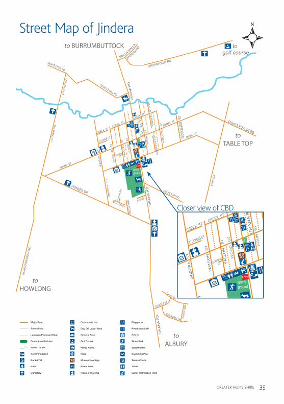
sports ground
villa
gegr
een
ANN DR
LAWRENCE
CT
DIGHTS FOREST RD
PIONEER DR
QUARTZ HILL RD
QUARTZ HILL RD
DIGHT ST
VIN
E D
R
BUN
GO
WAN
NAH
RD
UR
AN
A S
T
UR
AN
A R
D
UR
AN
A R
D
UR
AN
A R
D
GOUL
BURN
ST
GIB
SO
N S
T S
TH
GIB
SO
N S
T N
TH
MIT
CH
ELL
S
T
HO
UN
S
T
WO
OD
S
TFA
LLO
N S
T
WA
TS
ON
S
TJI
ND
ER
A S
T
JIN
DE
RA
S
T
PE
CH
AV
EKO
HN
PL
BRITTON CT
MOLKENTIN RD
MOLKENTIN RD
CREEK STCREEK ST
ST JOHN’S CT
CREEK ST
ADAMS ST
ADAMS ST
CITY OF
ALBURY
DAVIS DR
BE
GG
DRSCHOLZ ST
STOCKWELL DR
S
S
S
WALLA W
ALLA
JIN
DERA RD
DRUMWOOD RD
C
LU
TH
ER
RD
LU
TH
ER
RD
to golf course
Fire
to TABLE TOP
to BURRUMBUTTOCK
to ALBURY
to HOWLONG
gREaTER HUmE SHiRE gREaTER HUmE SHiRE 39
Street Map of Jindera
C
S
R
sports ground
villa
gegr
een
ANN DR
LAWRENCE
CT
DIGHTS FOREST RD
PIONEER DR
QUARTZ HILL RD
QUARTZ HILL RD
DIGHT ST
VIN
E D
R
BUN
GO
WAN
NAH
RD
UR
AN
A S
T
UR
AN
A R
D
UR
AN
A R
D
UR
AN
A R
D
GOUL
BURN
ST
GIB
SO
N S
T S
TH
GIB
SO
N S
T N
TH
MIT
CH
ELL
S
T
HO
UN
S
T
WO
OD
S
TFA
LLO
N S
T
WA
TS
ON
S
TJI
ND
ER
A S
T
JIN
DE
RA
S
T
PE
CH
AV
EKO
HN
PL
BRITTON CT
MOLKENTIN RD
MOLKENTIN RD
CREEK STCREEK ST
ST JOHN’S CT
CREEK ST
ADAMS ST
ADAMS ST
CITY OF
ALBURY
DAVIS DR
BE
GG
DRSCHOLZ ST
STOCKWELL DR
S
S
S
WALLA W
ALLA
JIN
DERA RD
DRUMWOOD RD
C
LU
TH
ER
RD
LU
TH
ER
RD
to golf course
Fire
to TABLE TOP
to BURRUMBUTTOCK
to ALBURY
to HOWLONG
Closer view of CBD
Major Road
Street/Road
Laneway/Proposed Road
Green Area/Parkland
Water Course
Accommodation
Bank/ATM
BBQ
Cemetery
Community Hall
Dog Off Leash Area
General Store
Golf Course
Horse Riding
Hotel
Museum/Heritage
Picnic Table
Place of Worship
C
S
Playground
Restaurant/Cafe
School
Skate Park
Supermarket
Swimming Pool
Tennis Courts
Toilets
Visitor Information Point

gREaTER HUmE SHiRE40
Travel back in time to when there was gold in them there hills,
Cobb & Co coaches rolled and bushrangers were lerking,
gREaTER HUmE SHiRE40
to a Provisional School conducted by mr george Henry greene who had built a mud and slab school on his land. By December 1874 plans for a small brick school were drawn up and a site of two acres had been granted for a school, and a further ten acres set aside as a reserve. On 20 December 1875, the contract for the erection of the school was finally signed. in six months the building was ready for occupation, and on 1 September 1876, mr Carl meyer, a Danish immigrant, commenced teaching with eighteen pupils enrolled. This is the official date of commencement of Public
School Education in Jindera.
The Lutheran pioneers of 1886 had barely unharnessed their horses from their covered wagons when they thought of the future of their children. They resolved to have a school, a Christian Day School - “St John’s Lutheran School”. The teaching of the Word of god was to be the centre of the learning programme. Pastor J.F. goessling was the school’s first teacher and used only the german language.
The Jindera government “Tank” was made in 1889 and gazetted as a Public Watering Place in 1890.it was made with pick and shovel, horse and dray. its capacity is about 18,000 cubic feet, and it has never run dry, although during the drought of 1913-1914 the Council restricted farmers to drawing water in small quantities and during the recent
drought the water level remained low however did not dry out.
During its heyday Jindera had four hotels. The “mill Hotel” was built opposite the Church of England, and was destroyed by fire in the late 1800’s. The hotel known as “The adelaide” was situated opposite the location of the original Public School, where a fig tree is said to have determined its location.“The Forest Hotel”, built in 1870, was first occupied by mr & mrs Carl Otto muller, and later bought by mr & mrs Ted Pye. The “Jindera Hotel” was the fourth, and is still operating, but because of a dispute between the owners and the breweries it was closed for two years, and reopened on 10 November, 1967, with Robert Kernaghan as the licensee. Whilst on the subject of hotels, it may be mentioned that most of the settlers had their own vineyards, and made their own wines, which meant fully-stocked cellars at all times.
Over the years Jindera has hosted many interesting visitors including the german Consul in theearly 1900’s when the gilsons were the licencees of the Jindera Hotel and in 1969 Dame Zara Holt was enthralled with the beautiful Riverina bluebells (Patersons Curse) on the road side near Jindera, so picked a large bunch of these beautiful flowers only to have them
Top from left: inside Wagner’s Shop, Jindera Pioneer museum;Jindera golf Course.Opposite from left: Classic Cars & Blacksmith’s Shop at Jindera Pioneer museum.Below: Netball action.
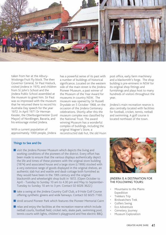
gREaTER HUmE SHiRE 41gREaTER HUmE SHiRE 41
Things to See and Do
n visit the Jindera Pioneer museum which depicts the living and working conditions of the pioneers of the district. Every effort has been made to ensure that the various displays authentically depict the life and times of these pioneers with the original store building (1874) and associated house and a large store (c1906) stocked with a very extensive range of goods displayed in the original shelves, an authentic slab hut and wattle and daub cottage both furnished as they would have been in the 19th century and the original blacksmith and wheelwright shop built in 1872. (Open October to april - Tuesday to Sunday 10 am to 4.30 pm and may to September- Tuesday to Sunday 10 am to 3 pm. Contact 02 6026 3622.)
n take a swing at the Jindera Country golf Club, a 9 Hole golf Course offering synthetic greens and wide fairways. Contact 02 6025 7160.
n stroll around Pioneer Park which features the Pioneer memorial Cairn
n relax and enjoy the facilities at the recreation reserve which include netball courts, football field, cricket nets, skate park, swimming pool, tennis courts with lights, children’s playground and free electric BBQ.
JiNDERa iS a DESTiNaTiON FOR THE FOLLOWiNg TOURS:
• MountainstothePlains Expedition• TrekkersTrip• BirdwatchersTrek• GolfersSwing• EcoAdventure• CemeteryJourney• MuseumExploration
taken from her at the albury-Wodonga Fruit Fly block. The then governor general, Sir Paul Hasluck, visited Jindera in 1970, and children from St John’s School and the Jindera Public School assembled at the museum to greet him. Sir Paul was so impressed with the museum that he returned there to record his australia Day speech for the year 1972. in april 1971 Dr Herman Kessler, the Oberburgermeister (Lord mayor) of Nordlingen, Bavaria, and his entourage visited Jindera.
With a current population of approximately 1000 people, Jindera
has a powerful sense of its past with a number of buildings of historical significance. Located on the western side of the main street is the Jindera Pioneer museum, a past winner of the museum of the Year award for museums in country NSW. The museum was opened by Sir Russell Drysdale on 5 October 1968, on the occasion of the Jindera Centenary celebrations. Shortly after this the museum complex was classified by the National Trust. The award winning museum has a wonderful complex of buildings, including the original Wagner’s Store, a reconstructed slab hut, the old Huon
post office, early farm machinery and a blacksmith’s forge. The shop building is pre-eminent in NSW for its original shop fittings and furnishings and plays host to many hundreds of visitors throughout the year.
Jindera’s main recreation reserve is also centrally located with facilities for football, cricket, tennis, netball and swimming. a golf course is located northeast of the town.
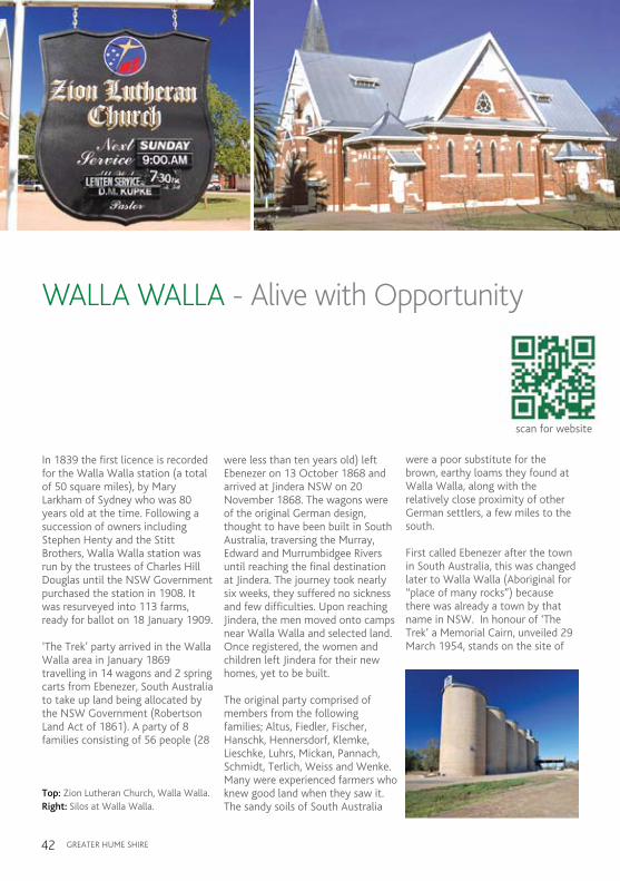
gREaTER HUmE SHiRE42
WALLA WALLA - Alive with Opportunity
in 1839 the first licence is recorded for the Walla Walla station (a total of 50 square miles), by mary Larkham of Sydney who was 80 years old at the time. Following a succession of owners including Stephen Henty and the Stitt Brothers, Walla Walla station was run by the trustees of Charles Hill Douglas until the NSW government purchased the station in 1908. it was resurveyed into 113 farms, ready for ballot on 18 January 1909.
‘The Trek’ party arrived in the Walla Walla area in January 1869 travelling in 14 wagons and 2 spring carts from Ebenezer, South australia to take up land being allocated by the NSW government (Robertson Land act of 1861). a party of 8 families consisting of 56 people (28
were less than ten years old) left Ebenezer on 13 October 1868 and arrived at Jindera NSW on 20 November 1868. The wagons were of the original german design, thought to have been built in South australia, traversing the murray, Edward and murrumbidgee Rivers until reaching the final destination at Jindera. The journey took nearly six weeks, they suffered no sickness and few difficulties. Upon reaching Jindera, the men moved onto camps near Walla Walla and selected land. Once registered, the women and children left Jindera for their new homes, yet to be built.
The original party comprised of members from the following families; altus, Fiedler, Fischer, Hanschk, Hennersdorf, Klemke, Lieschke, Luhrs, mickan, Pannach, Schmidt, Terlich, Weiss and Wenke. many were experienced farmers who knew good land when they saw it. The sandy soils of South australia
Travel back in time to when there was gold in them there hills,
Cobb & Co coaches rolled and bushrangers were lerking,
were a poor substitute for the brown, earthy loams they found at Walla Walla, along with the relatively close proximity of other german settlers, a few miles to the south.
First called Ebenezer after the town in South australia, this was changed later to Walla Walla (aboriginal for “place of many rocks”) because there was already a town by that name in NSW. in honour of ‘The Trek’ a memorial Cairn, unveiled 29 march 1954, stands on the site of
Top: Zion Lutheran Church, Walla Walla.Right: Silos at Walla Walla.
scan for website

gREaTER HUmE SHiRE 43
Street Map of Walla Walla
TOWNVIE
W A
VE
WALLA WALLA RD
QUEEN ST
WALLA WEST RD
WALL
A WAL
LA JI
NDER
A RD
HERMAN ST
SCHOLZ ST
WILLIAM ST
MA
RK
ET
ST
EDWARD ST
VICTORIA ST
WENKE ST
DO
UG
LAS
ST
STI
TT S
T
JACOB WENKE DR
MORGANS RD
LOOKOUT RD
SUNN
YSIDE
CRES
SUNNYS
IDE CR
ES
PIONEER DR
KOTZ
UR C
IR E
BENE
ZER
CT
to Gum SwampReserve
drive to Morgan’s Lookout
Walla WallaTSR
WALLA CEMETERY LN
KLEMKE AVE
CUMMINGS RD
SHORT ST
Sports Ground
RAILWAY ST
COM
MER
CIAL
ST
COM
MER
CIAL
ST
S
S
C
Police
Fire
Bicentenary ParkVerandah
at Police Station (accessible to public)
to CULCAIRN
to WALBUNDRIE
to BURRUMBUTTOCK
to JINDERAto GEROGERY
Major Road
Street/Road
Laneway/Proposed Road
Railway Line
Green Area/Parkland
Water Course
Accommodation
Bank/ATM
C
S
Police
C
BBQ
Bird Watching
Bowling Club
Cemetery
Community Hall
Dog Off Leash Area
Fuel
General Store
SHotel
Museum/Heritage
Picnic Table
Place of Worship
Playground
POLICE
Restaurant/Cafe
School
Swimming Pool
Tennis Courts
Toilets
Visitor Information Point
Walking Track
Winery/Vineyard
Police
C
S
R
TOWNVIE
W A
VE
WALLA WALLA RD
QUEEN ST
WALLA WEST RD
WALL
A WAL
LA JI
NDER
A RD
HERMAN ST
SCHOLZ ST
WILLIAM ST
MA
RK
ET
ST
EDWARD ST
VICTORIA ST
WENKE STD
OU
GLA
S S
T
STI
TT S
TJACOB WENKE DR
MORGANS RD
LOOKOUT RD
SUNN
YSIDE
CRES
SUNNYS
IDE CR
ES
PIONEER DR
KOTZ
UR C
IR E
BENE
ZER
CT
to Gum SwampReserve
drive to Morgan’s Lookout
Walla WallaTSR
WALLA CEMETERY LN
KLEMKE AVE
CUMMINGS RD
SHORT ST
Sports Ground
RAILWAY ST
COM
MER
CIAL
ST
COM
MER
CIAL
ST
S
S
C
Police
Fire
Bicentenary ParkVerandah
at Police Station (accessible to public)
to CULCAIRN
to WALBUNDRIE
to BURRUMBUTTOCK
to JINDERAto GEROGERY
Closer view of CBD

gREaTER HUmE SHiRE44
the historic tree where the men of ‘The Trek’ spent their first night, before selecting land. Unfortunately, the original historic tree no longer lives however a young descendant of the old gum tree now grows on the site.
The first Lutheran Church was built in 1872, the second one was built in 1889 and is now the church hall. The german heritage survives today with Walla Walla home to the Zion Lutheran Church. Built in 1924, it is the largest Lutheran Church in New South Wales and seats almost 600 people.
Standing close by is a faithfully restored replica of one of the german Wagons that made ‘The Trek’. Original german wagons were painted with a blue body and red wheels. This colour combination was first used in early Lutheran churches, with blue symbolising heavenly love or the colour of truth, and red representing the colour of blood or fire and symbolising confession as well as the Holy Spirit. german wagons typically had outward sloping sides and due to their weight and bulk (constructed from red or blue gum) could not be imported and thus were manufactured in australia.
at the turn of the twentieth century, Walla Walla was characterised by its close-knit community, together with
its preservation of the german language and the old ways. although World War i fostered a sense of nationalism (albeit strongly allied to the British Empire) this proved a challenging time for the Walla Walla community due to its ethnicity and the political issues of conscription and disenfranchisement from the electoral roll. Four local residents, including two Justices of the Peace and members of the Culcairn Shire Council were interned in the Holsworthy Concentration Camp. Tellingly, the honour board at the Walla Walla Soldiers memorial Hall describes the war as one against ‘Prussian militarism’ rather than germany. The outbreak of World War ii saw tensions resurfacing and attention was directed toward the Lutheran pastors in the region, rather than its civic leaders. This was because conscription was no longer the issue that it had been during World War i and some Lutheran pastors had shown pro-german sympathies with the resurgence of germany. These pastors were questioned and their activities were monitored.
The first school in Walla Walla was a congregational school established in 1873. instruction was conducted in german. This school operated from the original Zion Church building until 1883 when a mudbrick schoolhouse was opened. in 1885, the responsibility for educating the
local children was passed to the NSW Department of Public instruction. german-speaking classes continued to be conducted but only for several afternoons a week and then only until the outbreak of World War i.
St Paul’s College was opened in the church hall during 1948 to provide secondary education to Lutheran youth. in 1950 the school moved to its present campus and was one of the first co-educational boarding schools in NSW. Today St Paul’s College caters for students from all over greater Hume Shire and across australia and overseas. Students choose from a wide range of academic and practical subjects including agriculture on the school farm, and horsemastership at the school’s Equine Centre.
Six kilometres north of Walla Walla is morgan’s Lookout, an impressive white granite natural rock formation which was called “Wallan Wallan” by the local indigenous people. it is famous for having been a vantage point used by mad Dan morgan, who terrorised the district between 1860 and 1865. Today morgan’s Lookout is a popular spot for a picnic, and a challenge to climb the steps to the top of the lookout, where there is a spectacular 360° view of the surrounding countryside.also worth a visit is the gum Swamp Reserve, a high conservation

gREaTER HUmE SHiRE 45
Things to See and Do
n visit the majestic Zion Lutheran Church and view a replica of a german Wagon.
n go bowling or croquet striking at Walla Walla Bowling green
n taste the fine wines at the Walla Walla Winery, cellar door is open for free tastings and sales every weekend and on Public Holidays or by prior arrangement. Contact 02 6029 2128.
n relax and enjoy Bicentennial Park, which includes swimming pools, gardens and the recently restored 25 pounder gun.
n go birdwatching at Walla Walla gum Swamp Reserve.
n picnic at morgan’s Lookout and enjoy the incredible 360º views.
River Red gum wetland located 2 kms north of Walla Walla. The size and diversity of plants and trees at the Swamp provide many opportunities for wildlife. When the gum Swamp fills, many birds use it for breeding and foraging. 150 species of birds have been identified, these include the Brown Treecreeper, grey-Crowned Babbler, the Brolga and White-Bellied Sea
Eagle. it is also an ideal habitat for frogs and home to threatened species, including the Fishing Bat and Squirrel glider. There are tracks in the western portion of the gum Swamp Reserve (off Lookout Road) that allow easy access for walkers, and there is a picnic table located adjacent to the Swamp at Petrie’s Creek.
Nearby King’s Bridge Reserve is another significant high conservation area, well worth investigating, especially for bird watchers.
Walla Walla today is a busy agricultural and manufacturing centre whilst still retaining its quiet country image. Locally manufactured sheds are still being produced on the site of the famous old Heppner Wagon Factory. Walla Walla provides many family and sporting facilities such as football, cricket, netball, bowling, croquet, swimming and tennis, as well as the restored Walla Walla Literary institute and memorial Hall which caters for community events including plays, concerts, dinners, weddings and meetings.
WaLLa WaLLa iS a DESTiNaTiON FOR THE FOLLOWiNg TOURS:
• MountainstothePlainsExpedition
• TrekkersTrip• BirdwatchersTrek• BowlersDrive• EcoAdventure• CemeteryJourney• MuseumExploration
Opposite top: mural of ‘The Trek’, Walla Walla.Above from left: Bicentennial Park; Replica of german Pioneer Wagon, Walla Walla.

gREaTER HUmE SHiRE46
Our Villages
BrocklesbyBrocklesby began in 1870 when the maxwell Brothers secured the first blocks from goombargana Station and “The Olives”. in 1882 the Culcairn/Corowa rail line was built using large gangs of workmen housed in “tent cities”. The designated distance between railway stations was approximately 10 miles apart, land was purchased from mr mitchell, of “The Olives”, for railway yards and town development. The Brocklesby Hotel was built in 1878, with a larger substantial brick hotel being built in 1918. in 1881 the post office was opened in the hotel then transferred to the railway station in 1892 and by 1910 moved to a separate office/home on main Street. The Brocklesby Public School was opened in 1898.
Brocklesby’s main claim to fame occurred on Sunday morning 29 September 1940, when two avro anson training planes were involved in a mid air collision over Brocklesby. The planes were joined together in “pick a back” style with the impact of the top machine crushing the cockpit of the lower, leaving the landing gear untouched and the engine still running full throttle. Pilot Jack Hewson and observers Hugh Fraser and ian Sinclair ejected, leaving pilot Len Fuller to use his skills to steer the planes away from the town to a clear paddock, where the planes were landed without causing any more damage.
many tales from families on their way to church, with most never seeing a parachute before. With headlines in newspapers worldwide and unable to prove if the incident was caused by accident or carelessness, Fuller’s recommendation for a decoration was rejected. Located in Blacksmith
Explore our region and meet local characters who make
up this ‘simply greater’ area of Australia.
When in Brocklesby
n view the avro anson Display in Blacksmiths Park
n play some tennis
n let the children play at the playground
n or simply enjoy a BBQ
n enjoy an ale and some country hospitality at the Brocklesby Community Hotel
BROCKLESBY iS a DESTiNaTiON FOR THE FOLLOWiNg TOURS:
• TrekkersTrip• BirdwatchersTrek• CemeteryJourney
Top from left: Blacksmith Park, Brocklesby; Wirraminna Environmental Education Centre, Burrumbuttock.Opposite: making hay and having fun.
Park Brocklesby is a part of an engine and interpretative signage. a plaque relaying the historic story is situated at the landing site on Howlong/goombargana Road, Brocklesby.

gREaTER HUmE SHiRE 47
BURRUmBUTTOCK iS a DESTiNaTiON FOR THE FOLLOWiNg TOURS:
• TrekkersTrip• EcoAdventure• BirdwatchersTrek• CemeteryJourney
When in Burrumbuttock
n visit the Wirriaminna Environmental Education Centre, open everyday, access to the Discovery Centre is by appointment. Contact 02 6029 3253.
n play some tennis
n wander along the Burrumbuttock Walking Track, a 4.5 kilometre circuit track of the town
n let the children play at the playground
n or simply enjoy a BBQ in Schmidt Park
n enjoy an ale and some country hospitality at the Farmers inn Hotel
BurrumbuttockBurrumbuttock is home to the award winning Wirraminna Environmental Education Centre. The name ‘Burrumbuttock’ is believed to have aboriginal origins and the word ‘Burrum’ usually refers to water. Local belief, however, has the meaning as aboriginal for ‘Bullock’s Backbone’. From 1839 Burrumbuttock Station was originally 30,000 acres starting at Jindera gap passing through Burrumbuttock towards Walbundrie. Burrumbuttock was developed on a crossroad to Walbundrie, Brocklesby, Walla Walla and Howlong.
in 1880 the Farmers inn Hotel was established as a meeting place for locals and those passing through. in
1883 the Burrumbuttock Post Office was opened with the Burrumbuttock Store opening in 1921. in 1870 the first Holy Cross Lutheran Church was dedicated and in 1908 the present brick church was built and dedicated.
Burrumbuttock Public School was established in april 1888 with 14 children of mostly german residents. The school has now developed an award winning environmental education program through Wirraminna Environmental Education Centre. Developed in 1995, the 4 ha area featuring a large dam constructed in 1902 by Chinese labourers was named ‘Wirraminna’ meaning ‘peace—quiet near still waters’.

gREaTER HUmE SHiRE48
gerogerygerogery is a small village situated on the Olympic Highway and main Southern Railway Line. in its early history gerogery was developed as a major hub for transportation and storage of the expanding wheat and wool industry in the region. The main Southern Line was opened to gerogery on 1 September 1880, and to albury on 3 February 1881. The station building, goods shed and station master’s house were constructed in the early 1880’s and are now listed by the National Trust.
When in Gerogery
n visit gerogery Dolls museum and Historic Treasures. Contact 02 6026 0578
n play some tennis
n stroll around gerogery and view some of the railway heritage buildings
n enjoy an ale and some country hospitality at the gerogery Hotel
n or simply enjoy a BBQ in the park and let the children play at the playground
gEROgERY iS a DESTiNaTiON FOR THE FOLLOWiNg TOURS:
• TrekkersTrip• EcoAdventure• BirdwatchersTrek• CemeteryJourney
gerogery Public School opened on monday 11 February 1884 as the gerogery Railway Station Public School. gerogery West Public School, to the west of gerogery, was originally known as gerogery Public School and was opened in 1882 and finally closed in 1968. in the early 1870’s, german Lutheran school was opened to the west of gerogery township, this school was also closed in 1968. Today gerogery is a vibrant village at the base of Table Top mountain.
Top from left: Tennis anyone; Round Hill Hotel, morven;Left: gerogery Shop.Opposite: Cobb & Co. Stables, morven.

gREaTER HUmE SHiRE 49
When in Morven
n play some tennis
n enjoy an ale and some country hospitality at the Round Hill Hotel
mORVEN iS a DESTiNaTiON FOR THE FOLLOWiNg TOURS:
• Cobb&CoWay• RoundtheTopCircuit• BirdwatchersTrek• EcoAdventure• CemeteryJourney
morvenmorven sits beside Billabong Creek. The creek provides a vegetated wildlife corridor and pleasant outlook from the historic Round Hill Hotel, dating back to the 1850’s as a Cobb & Co Station (before the crossing of Billabong Creek). The decline of Cobb & Co came with the arrival of the railway line through Culcairn.
The original Bridge Hotel was built around 1868 and was purchased by John O’Donoghue in 1897, with the Hotel remaining in that family until 1959. The name was changed to the ‘Round Hill Hotel’ about this time. The hotel is still licensed and fully operational.
The morven Church was opened in 1874 and for 14 years was the only church in the district, offering both anglican and Presbyterian services. St Peters is still used and has recently been restored by the morven Community Committee. The church is still in the possession of the anglican Church, making it the oldest in the Diocese of the Riverina.
morven Public School was built in 1906, with a new building being constructed in 1928 to accommodate 52 pupils. The school closed in 1967 at which time there were only 9 pupils at the school.

gREaTER HUmE SHiRE50
WalbundrieKnown as the ‘crossroads’ of the Riverina, Walbundrie was a thriving gold rush town of several thousand people. Formerly called ‘Piney Range’, because of extensive stands of Cyprus Pines in the district, the village is now a rural service centre.
On 15 June 1855, the Bulgandra (or Walbundrie Reefs) gold field was proclaimed, eight miles from Piney Range, making Bulgandra the larger village. miners lived in tents and shacks and membership of the Working man’s Club rose to 250 and a Social Club with 190 members came into existence, which catered for miners and shearers from the outlying stations. (Bulgandra quietly declined along with the expectations of the gold miners.)
Walbundrie Public School commenced classes in January 1878, with the old schoolhouse erected in June 1879 at a cost of £446 and enrolments of up to 60 students it included a teacher’s residence. The building is a reminder of the town’s prosperity around the late 1800’s and is located on land at Walbundrie Showgrounds. The School was relocated in October 1923 to it’s existing site.
Students recall that between1900 – 1910 there were visits from a school
WaLBUNDRiE iS a DESTiNaTiON FOR THE FOLLOWiNg TOURS:
• RoundtheTopCircuit• MountainstothePlains Expedition• BirdwatchersTrek• EcoAdventure• CemeteryJourney
When in Walbundrie
n visit the old school house (can only view from outside building).
n enjoy an ale and some country hospitality at the Walbundrie Hotel
n play some tennis
doctor. a door was used as an operating table and tonsils were removed if a note from a parent had mentioned tonsillitis. Recovery was on the porch or on the wood-heap. One of the locals acted as an ambulance, transporting the children home in his spring cart.
The Walbundrie Show Society officially staged its first Show in 1911, beginning as a challengerace between horses owned by local station owners. Held over the creek in the “Wire Paddock”, the Show eventually moved to its present site next to the old stone school. Today the Showgrounds also provide for many other activities, including australian rules football, netball, cricket and special events. The Walbundrie Show is claimed to be the largest one-day show in the Riverina.

gREaTER HUmE SHiRE 51
WoomargamaWoomargama is a picturesque village nestled at the foothills of Woomargama National Park with access to the Upper murray region.
Early records show that Woomargama Public School opened in January 1873 and closed in February 1997. The Post Office was opened on 1 august 1875 and following a succession of venues is now located in the old Woomargama Public School building.
During the 1930s an initiative of the Holbrook Shire Council saw the building of a ‘tourist road’ (Tunnel Road) from Woomargama to Dora Dora, soaking up a large amount of Federal government labour and relief funding from the surrounding shires and from albury which required a large-scale project to start quickly in 1937. The project absorbed weekly rosters of up to 230 men and lasted two years,
WOOmaRgama iS a DESTiNaTiON FOR THE FOLLOWiNg TOURS:
• RoundtheTopCircuit• MountainstothePlains Expedition• BirdwatchersTrek• EcoAdventure• CemeteryJourney
When in Woomargama
n go bush walking, bird watching, horseriding, 4WD driving and off road motorcycling or simply take in the views at Woomargama National Park. Picnic, BBQ and camping areas (suitable for backpack and vehicle based camping).
n sample the wines and take in the views at Flyfaire Winery
n enjoy a BBQ and let the children play at the playground
n go fishing or experience the grandeur of the murray River
n enjoy an ale at the Woomargama Hotel
n play some tennis
bringing grants as high as £73,000. men deployed to the project had to bring their own cooking/eating utensils and provisions for 3 to 4 day work stints. Little other than picks and shovels were used, so as to prolong the job and to maximise the number who could be employed. However albury lobbied jealously and successfully for the project to end just short of completion of the full length or road.
The Woomargama National Park is located close to the town and is the largest protected area west of the great Dividing Range in south-eastern NSW and offers many activities such as bush walking, picnics, horse riding, photography, exploring cultural heritage, sightseeing, bird watching, 4WD driving and motorcycling.
in keeping with the environmental theme of the area, local community members have undertaken a ‘re-birding’ project to revegetate parts of the creek and the local Common for nature conservation.
Opposite top from left:Walbundrie Hotel;Dress ups for annual Concert.Left: Old Walbundrie School House.Below from left: Superb Parrot; Woomargama National Park.

gREaTER HUmE SHiRE52
Our Farming Communities
greater Hume Shire has a rich agricultural heritage, supported by active rural communities often centred around small public schools or community halls. From the mountains to the plains, our farming communities such as alma Park, Bethel, Bowna, Bungowannah, Carabost, Cookardinia, goombargana, Lankey’s Creek, moorwatha, mullengandra, Wymah, Yarra Yarra and Little Billabong showcase the agricultural abundance that has defined our shire. Whether you are driving, riding, cycling or even walking along our country highways and roads you will see our diverse agricultural industry, environment, landscape and heritage.
FaRm HOST PROgRamgreater Hume Shire has an extensive Farm Host Program for visitors to enjoy a day’s outing or stay an evening or weekend. Visitors can assist with feeding the animals, witness a sheep shorn or a crop being harvested or simply enjoy the agricultural scenery. Swap the noise of the highway for the laughing kookaburra or the squawking magpie, talk with real australian Farmers and hear their stories. indulge yourself with true australian country cooking from home baked cakes and roasts to a delicious hamper for a picnic. Catering for individuals and/or families (bookings are preferred, providing at least one week’s notice) or bus, coach and touring groups (bookings, with at least two weeks notice, are required for groups of 10-40 people, allocated to farms, with 2-4 guests per farm). Fees and rates on application. Contact one of our co-ordinators either Culcairn Farm Host Co-ordinator (covering
Explore our region and meet local characters who make
up this ‘simply greater’ area of Australia.
Culcairn, Henty, Walla Walla, Jindera, Walbundrie, Brocklesby, Burrumbuttock areas) on Ph 02 6029 2240 or Holbrook Farm Host Co-ordinator (covering Holbrook, Cookardinia, Woomargama, mullengandra, Little Billabong, Carabost, morven areas) on Ph 02 6036 6137.
WYmaH FERRYBuilt in 1946 the Wymah Ferry, is one of two remaining ferries across the murray. The other ferry, Speewa Ferry, is located near Swan Hill. The Wymah Ferry crosses the murray River approximately 45km east of albury at Wymah (NSW) / granya (Victoria). it is a two car ferry with a load limit of 11 tonnes however it is not suitable for caravans. Operating seven days a week the ferry runs 6 am to 9 pm (September to april) and 7 am to 8 pm (may to august. For up to date information on the operation of the Wymah Ferry contact mick’s Ferry Services on 02 6020 2038.
Top from left: Wymah Ferry; Cattle on the Horizon.Opposite: morning fog at Wantagong near Holbrook.

Accommodation
Jolly Swagman Motor Inn
Holbrook’s truly dog friendly motel with designated pet friendly rooms. All rooms are ground floor, spacious, well appointed and air conditioned with Foxtel and Wifi. Licensed restaurant, children’s play room and squash court. Ample off street parking for trailers.
46 Albury St, Holbrook NSW 2644Ph: 02 6036 3944 Email: [email protected]
Jolly Swagman Motel.indd 1 1/11/12 10:38:17 AM
Attraction
Table Top Mountain Experience
Table Top Mountain Experience involves a 2 hour guided walk to the summit (630 metres). Guided by Phil Rouvray, the history, geology, flora and fauna of the area is explored. Panoramic views of Lake Hume, Snowy Mountains and surrounds. Afternoon Tea provided. 30mins from Albury.
Cost: $25. P: 0428 216 595 www.tabletopmountainexperience.com
Table Top Mountain Exp.indd 1 16/11/12 11:50:03 AM
Accommodation
Wymah Hideaway
Small family owned park adjacent to Wymah Ferry and the Murray River. 8 Powered sites and various camping sites. Its great location provides activities such as boating, fishing and water-skiing or just sit back, relax and unwind enjoying the picturesque views.
David & Sue Gilcrist189 Wymah Ferry Road, Wymah. NSW 2640Ph: 02 6020 2035
Wymah Hideaway.indd 1 21/11/12 10:06:00 AM
gREaTER HUmE SHiRE 53
Attraction
Grimwood’s Store Craft Shop
A replica of the first store in Holbrook (Germanton), the shop sells craft, hand made by residents of the local and wider community. Located beside the Ten Mile Creek Bridge. Come in and be surprised! Open daily 9.30am to 4.30pm.
85 Albury Street, Holbrook Ph: 02 6036 2151
Grimwoods Advert.indd 1 6/11/12 11:12:34 AM
Accommodation
Woomargama Village Hotel Motel
Spend a night in comfortable and affordable accommodation in the peace and quiet of Woomargama Village. Just a short detour off the Highway, Woomargama is ideally located for an overnight stop or to experience the natural beauty of the nearby National Park and Upper Murray.
The motel is located adjacent the Hotel where you can enjoy a home style counter meal in a pokies free venue.
Woomargama Way Call us on Ph: 02 6020 5232
Hu
me Highway
Woomarg
ama W
ay
To Holbrook 15km
To Albury 45kmWe are here
N
WoomVillage.indd 1 1/11/12 10:32:49 AM

gREaTER HUmE SHiRE54
Accommodation
Kookaburra Cottage
Perfect for a romantic escape, a family or a group of friends. Set in the foothills of Table Top Mountain. A uniquely crafted two storey rammed earth Cottage. Rustic, cosy and romantic with an extensive native garden. Sleeps up to 6. All the comforts you require.
Contact: Elizabeth Paterson 0412509222 [email protected]
scan here to �ndout more today.www.greataussieholidaypark.com.au14 Hore Rd, Bowna NSW 2644
FREE CALL 1800 776 523
A holiday park full of adventure!
VILLAS CABINS LEISURE UNITS
ENSUITE SITES POWERED & UNPOWERED SITES
Located on the ba nks of La ke Hu me, Great
Aussie Holiday Pa rk is a n outdoor adventu re
playgrou nd - designed to offer you the u ltimate
holiday experience.
Great for a ll ages promisi ng great service, afforda ble a nd great
qu a lity a ccommodation for couple s, fa milie s a nd
la rge groups.We hope to see you soon.
Accommodation
Accommodation
Holbrook Settlers Motel
16 units. $70-$120. Situated half way between Sydney and Melbourne, ideal stopover for travellers. Family owned and operated, affordable tariff. Set well back from highway.
11293 Hume Hwy, Holbrook Ph: 02 6036 2855
Fax: 02 6036 2855E: [email protected] W: www.holbrooksettlersmotel.com
Accommodation
Henty Bed & Breakfast
Comfortable, early 1900’s ex-hotel, Large verandahs, 14 bedrooms, Function room, wood fires, TV room, Toy room, Enclosed pergola. Ideally suited for family gatherings. Washing & ironing facilities. Breakfast included in room rates. Pet friendly.
Warren & Elaine HeycoxPh: 02 6929 3021

gREaTER HUmE SHiRE 55
Accommodation
Glenndale Park Motel ★★★★
With queen pillow top beds, double glazed windows and climate control for a better nights sleep.
Easy, convenient parking, BBQ, pool and playground.
Clean, Cosy & Comfortable
Ph: 02 6036 2599E: [email protected]: www.budgetmotelchain.com.au
Welcome to
Accommodation
Holbrook Town Centre Motor Inn ★★★★
Family operated motel located 250m south of the PO. We have large, comfortable, quiet rooms. All rooms have electric blankets, reverse cycle air conditioning, Austar to units, tea & coffee making facilities. Room service available. Licensed Restaurant (closed Sundays and public hols).
Ph: 1800 100 040 Toll Free
Accommodation
Culcairn Motor Inn ★★★
Family operated motel with 12 guest rooms that are spacious, clean and comfortable. There is tea/coffee making facilities, reverse cycle air-conditioning, LCD TV’s, pool, BBQ area and convenient parking. Craig, Glenda & Jack Taylor
Ph: 02 6029 8233 E: [email protected] W: www.culcairnmotorinn.com.au
Accommodation
Holbrook Motor Village Tourist Park
We are 4-5 hours to Melbourne,5-6 hours to Sydney
PO Box 174, Holbrook NSW 2644Ph: 02 6036 3100 Email: [email protected]: www.holbrookmotorvillage.com.au
Park Facilities:• Enclosed Camp Kitchen with BBQ • Kiosk • Immaculate
Amenities & Laundry • Easy Access Facilities • Swimming Pool • Playground • Dog friendly* • Close to shops, pub and licensed restaurants • RS Club with restaurant, Bowls and Golf • Courtesy Bus Pickup to RS Club every Friday
and Saturday nights. *Conditions apply

gREaTER HUmE SHiRE56
G A R D E NG A R D E N SS
Accommodation
Orange Grove Gardens
Bed & Breakfast • Weddings • Functions • Events
Ph: 02 6029 8811 Ph: 02 6029 8811 Email: [email protected]: [email protected]: [email protected]: [email protected]: [email protected]: www.orangegrovegardens.com.auWeb: www.orangegrovegardens.com.auWeb: www.orangegrovegardens.com.auWeb: www.orangegrovegardens.com.au
Orange Grove
Orange Grove
Wagga Wagga
Holbrook
Albury
Wodonga
Culcairn
Henty
Yerong Creek
The Rock
OL
YM
PI
C
WA
Y H U ME H
I GH
WA
Y
Orange Grove
Orange Grove
Wagga Wagga
Holbrook
Albury
Wodonga
Culcairn
Henty
Yerong Creek
The Rock
OL
YM
PI
C
WA
Y H U ME H
I GH
WA
Y
Orange Grove
Orange Grove
Wagga Wagga
Holbrook
Albury
Wodonga
Culcairn
Henty
Yerong Creek
The Rock
OL
YM
PI
C
WA
Y H U ME H
I GH
WA
Y
Orange Grove
Orange Grove
Wagga Wagga
Holbrook
Albury
Wodonga
Culcairn
Henty
Yerong Creek
The Rock
OL
YM
PI
C
WA
Y H U ME H
I GH
WA
Y
Orange Grove
Orange Grove
Wagga Wagga
Holbrook
Albury
Wodonga
Culcairn
Henty
Yerong Creek
The Rock
OL
YM
PI
C
WA
Y H U ME H
I GH
WA
Y
N
W

Eating Out
Central Cafe.
Our friendly staff are here to welcome you, relax and enjoy your dining with us. Choose from our fresh cooked dine in or takeaway menu - with a huge range of specialty burgers - enjoy a Lavazza coffee or a cool drink or snack.
Open 7 days from 8am
48 Balfour Street Culcairn Ph: 02 6029 8464.
Central Cafe.indd 1 1/11/12 11:46:33 AM
gREaTER HUmE SHiRE 57
Eating Out
Jindera Hotel/Motel
The Jindera Hotel has a newly renovated bistro and bar area.
It is a family friendly hotel, it consists of a large outdoor area and function room.
Full TAB and Keno Facilities. 4 Motel units – reasonable rates.
21 Urana Road Jindera NSW 2642 Ph: 02 6026 3258
Jindera Hotel Motel.indd 1 6/11/12 11:39:32 AM
Eating Out
• Friday night raffles…. Fun night for the whole family• Social bowls on Wednesday afternoons and Sunday mornings …. All welcome
Culcairn Bowling and Recreation Club
Olympic Highway, Culcairn NSW 2660Ph: 02 6029 8461
• Kenny’s Chinese and Australian Restaurant .... Take aways also• Snooker room/Duke box and play stations • Pokies/KenoMembers and guest welcome
Culcairn Bowl.indd 1 24/10/12 11:48:49 AM

gREaTER HUmE SHiRE58
Eating Out
Holbrook Chinese Restaurant
LUNCH: Wednesday-Sunday 12pm-2pm DINNER: Tuesday-Sunday 5pm-9pm, BYO Beer/Wine Only. ($2 corkage applies to alcohol)
68 Albury St, Holbrook NSW 2644(Next to Police Station) Ph: 02 6036 2348
Holbrook Chinese Advert.indd 1 2/11/12 12:53:41 PM
Eating Out
Henty Community Club Ltd.
Open Wednesday - Sunday. Meals available: Friday, Saturday & Sunday Nights.
• 2 Bowling Greens • 18 Hole Golf Course
South St, Henty NSW 2658Ph: 02 6929 3250
Henty CommClub Advert.indd 1 11/8/10 2:51:21 PM
Eating Out
Holbrook RS Club Ltd.
The Holbrook Returned Servicemen’s Club Ltd. offers Members and Guests an 18 Hole Sand Green Golf Course and 2 Bowling Greens for use all year round. The Club Bistro is open 5 nights (Wed – Sun), Keno and A.T.M. facilities 7 days a week.
38 Swift St, Holbrook NSW 2644 Ph: 02 60362199
HolbrookRSL Advert.indd 1 13/9/10 1:07:18 PM
Eating Out
Round Hill Hotel, Morven
The best little country pub where the welcome is warm and the beer is cold!
• beer garden • family friendly • ideal venue for functions • evening meals Wed, Thu, Fri, Sat
• BBQ every Sunday
38 Coach Rd (Brownrigg St)Ph: 02 6036 5211 E: [email protected] www.roundhillhotel.com.au
“Come & Chill at Round Hill”
Round Hill Hotel Advert.indd 1 11/8/10 3:01:10 PM
Eating Out
Bowling & Recreation Club
Home base for Men’s & Ladies Lawn Bowls, Croquet, Pool.
Bonanza Draws and Restaurant Meals Friday nights. Auditorium and kitchen available for hire. Open 5pm daily. Join us for a drink and chat at our Family friendly meeting place.
5 Scholz StreetWalla Walla 2659Ph: 02 6029 2146
Walla Bowls Advert.indd 1 6/9/10 10:52:58 AM
Eating Out
Historical Gerogery Hotel
Loads of character, budget accommodation, cold beer, home cooked meals, cool outside beer garden in summer, open fires in winter, working blacksmith shop on request, morning & afternoon teas, formal dining room for functions. Coaches Welcome.
20 mins. north of Albury onOlympic HighwayPh: 02 6026 0516
Gerogery Hotel Advert.indd 1 19/8/10 2:06:42 PM

gREaTER HUmE SHiRE 59
Produce
Crunchy Seeds, Holbrook
A variety of dry roasted seeds in tamari & sweet chilli sauces. High in Protein, Iron, Calcium, Zinc, Vitamin E & Amino Acids. Low GI, Cholesterol free, Gluten free.
Woodland Harvest P.O.Box 183Holbrook NSW 2644 Ph/Fax: 02 6036 6125 Mob: 0417 069 836www.crunchyseeds.com.au
CrunchySeeds Advert.indd 1 6/11/12 12:01:57 PM
Eating Out
Submarine Café, Holbrook
Fast friendly service 7days from 8.30am to 5.00pm Serving quality coffee and range of teas. Gourmet food made fresh when ordered. Salads, focaccias, sandwiches, burgers, fish and chips, hot pot pies and more. Cakes, muffins, shop made biscuits. Family friendly, also with children’s menu. Clean toilets with change room and disabled access. Dining inside or alfresco on the deck overlooking the park and submarine.
Warren and Helen Thompson Ph: 02 6036 2211
Sub Cafe Advert.indd 1 1/11/12 12:25:24 PM
51 & 126 Albury Street. Holbrook NSW 2644
Trading at 2 GREAT locations
Holbrook Bakery Add Colour2012EDIT.pdf 24/10/12 11:59:26 AM
Eating Out
51 & 126 Albury Street. Holbrook NSW 2644
Trading at 2 GREAT locations
Holbrook Bakery Add Colour2012EDIT.pdf 24/10/12 11:59:26 AM
Holbrook Bakery.indd 1 24/10/12 12:10:18 PM

Greater Hume Shire Council
greater Hume Shire is a dynamic new shire which was constituted by proclamation on 26 may 2004. The new local government area comprises the former Culcairn Shire, former Holbrook Shire and approximately 81 percent of the area of the former Hume Shire. Located in southern New South Wales on the Victorian border, it shares a border with the municipalities of Wagga Wagga, Urana, Lockhart, Corowa, Tumbarumba and albury.
With an area of 5,939km2 and a population of approximately 10,400 persons, greater Hume Shire’s major townships are Culcairn, Henty, Holbrook, Jindera, and Walla Walla
with smaller villages in Brocklesby, Burrumbuttock, gerogery (including gerogery West), morven, Walbundrie and Woomargama.
The traditional role of the towns and villages of greater Hume is to service the productive rural industries in surrounding districts. The greater Hume Shire includes many first class agricultural districts primarily producing wool, wheat and other grains, lucerne, cattle and sheep.
One of greater Hume’s greatest and valued assets is its people. There is a strong commitment to community building, delivered through a range of social and physical projects aimed at assisting communities to develop networks, partnerships, structures and frameworks to support ongoing improvement to overall community
Travel back in time to when there was gold in them there hills, Cobb & Co coaches rolled and bushrangers were lerking,
identity, health and well-being. Emphasis is also placed on fostering community capacity through investment in young people.
Our Vision StatementLiving in an idyllic rural landscape that sets us apart, we draw on our passion and location to maintain a model community for people of all ages whilst building an economy that abounds with opportunity.
gREaTER HUmE SHiRE60
Top from left: BBQ Breakfast at greater Hume Shire australia Day celebrations; Football at Walbundrie.

Attraction
gREaTER HUmE SHiRE 61

gREaTER HUmE SHiRE62
Eating Out
Culcairn Bakery.indd 1 6/11/12 12:59:11 PM
Eating Out
FOR A GREAT NIGHT OUTOpen 7 Days 10am till late
Your Host: Pat Watson37 Railway Street, Culcairn NSW 2660Ph: 02 6029 8501
Culcairn Hotel
4 icy cold beers on tap. Accommodation available.Meals served 7 days a week, Lunch 12-2pm, Dinner 6-8.30pm. All day Wednesday $12 meals. Function Room available.
Culcairn Hotel.indd 1 21/11/12 9:50:35 AM
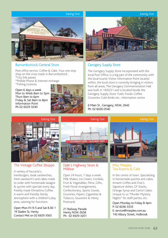
gREaTER HUmE SHiRE 63
Eating Out
Burrumbuttock General Store
Post office service. Coffee & Cake. Your one stop shop on the cross roads in Burrumbuttock . *City link passes *Mobile Phone & Internet recharge *Fishing Licences
Open 6 days a week Mon to Weds 8am to 5pm Thurs 8am to 6pm Friday & Sat 8am to 8pm Information Point Ph 02 6029 3240
Burrumbuttock General Store.indd 1 9/11/12 11:00:28 AM
Eating Out
Gerogery Supply Store
The Gerogery Supply Store Incorporated with the local Post Office, is a big part of the community with the local tourist Visitor Information Point located within, the local store is currently bringing in visitors from all areas. The Gerogery Commemoration Hall was built in 1920/21 and is located beside the Gerogery Supply Store. Fuels: Foods: Coffee: Groceries: Cold drinks etc.. Information centre
6 Main St , Gerogery, NSW, 2642 Ph: 02 6026 0540
Gerogery Supply Store Advert.indd 1 25/10/12 10:35:21 AM
Eating Out
The Vintage Coffee Shoppe
A variety of foccacia’s, hamburgers, steak sandwiches, fresh sandwich’s and cakes made to order with homemade lasagne & quiche with specials every day. Freshly made Dimattino Coffee. A warm and friendly family atmosphere with a children’s play area, catering for functions.
Open Mon-Fri 9-5 and Sat 8.30-1 19 Sladen St, Henty
Contact Mel on 02 6929 3565
The Vintage Coffee Shoppe Advert.indd 1 9/11/12 10:49:23 AM
Eating Out
Miss Marples Tea Rooms & Cafe
In the centre of town. Specialising in homemade quiches and cakes. Amanti Coffee and Chai’s. Signature dishes, GF Stacks, Orange Syrup and Carrot Cakes. Unique to us “Murder Mystery Nights” for staff parties, etc.
Open Monday to Friday 8-4pm P: 02 6036 3333 E: [email protected] 143 Albury Street, Holbrook
Miss Marples Advert.indd 1 9/11/12 10:56:17 AM
Eating Out
Dale’s Highway Store & Milkbar
Open 24 hours, 7 days a week. Milk Shakes, Ice Cream, Cordials, Fruit & Vegetables, Films, Gifts, Fresh Floral Arrangements, Confectionary, Sports Goods, Groceries, Papers, Cigarettes & Tobacco, Souvenirs & Henty Postcards
21 Railway Parade Henty NSW 2658 Ph: 02 6929 3201
Dales Highway Store Advert.indd 1 25/10/12 10:11:49 AM

January Australia Day Our australia Day Celebrations are
always family friendly fun, held in a different location within the shire each year.
February Henty Agricultural Show Horses, Cattle, Food, arts and Crafts,
there is something for all members of the family.
march Jingellic Agricultural Show Horses, Cattle, Food, arts and Crafts,
there is something for all members of the family.
Planes, Trains & Submarines Festival, Holbrook
Come along and join in the fun, there are lots of events and entertainment for all the family.
april Commander Holbrook Cup Race Meeting, Holbrook
a great day out with the family, or make it a social outing with business associates and friends.
Wymah Family Fun Day, Wymah Come and experience delicious home
cooking, family fun and relaxed country entertainment.
June Holbrook Sheep & Wool Fair Showcasing the sheep industry and its
industry leaders of the future.august Wirraminna Open day,
Burrumbuttock Visit one of australia’s top
Environmental Education Centres.
January Australia Day
Calendar of major EventsSeptemberSeptember Holbrook Annual Art ShowHolbrook Annual Art Show Come along and view the amazing art
and craft on display. Henty Machinery Field Days The Henty machinery Field Days attracts
visitors and exhibitors from several states.
October Culcairn Agricultural Show Horses, Cattle, Food, arts and Crafts,
there is something for all members of the family.
Walbundrie Agricultural Show Horses, Cattle, Food, arts and Crafts,
there is something for all members of the family.
Burrumbuttock Village Festival Come along and join in the fun at the
Burrumbuttock Village Festival. St Paul’s Annual Flower Show,
Holbrook You are invited to come and smell the
delightful perfume of our spring flowers.November Holbrook Agricultural Show Horses, Cattle, Food, arts and Crafts,
there is something for all members of the family.
December Jindera Pop the Top Festival a weekend of soft top/convertible heaven with drive-in movies, street parades and scenic touring.
For more information on these events and many more go to
www.greaterhume.nsw.gov.au