green belt review supporting document - kirklees...green belt boundary. how the green belt review...
TRANSCRIPT
Green Belt Review Supporting Document
April 2017
Planning Policy Group Investment and Regeneration Service
Kirklees Council PO Box B93
Civic Centre III Huddersfield HD1 2JR
1
Contents
Page
1 Introduction………………………………………………………………………………………………….. 2 2 Background…………………………………………………………………………………………………… 3 3 Identifying the Objectively Assessed Need for Housing in Kirklees………………. 3 4 Identifying the Objectively Assessed Need for Jobs in Kirklees…………………….. 4 5 Safeguarded Land…………………………………………………………………………………………. 5 6 Exceptional Circumstances……………………………………………………………………………. 5 7 The Kirklees Green Belt Review…………………………………………………………………….. 6
7.1 7.2 7.3 7.4 7.5 7.6 7.7
Introduction……………………………………………………………………………………………. 6 Green Belt in Kirklees in its Strategic Context………………………………………… 6 The Kirklees Green Belt Review Methodology……………………………………….. 7 Test 1: Degree of Constraint to Development………………………………………… 8 Test 2: Green Belt Purposes……………………………………………………………………. 12 Outcomes………………………………………………………………………………………………. 16 Test 3: Brownfield Land in the Green Belt……………………………………………… 16
8 Translating the Green Belt Review into a Site Allocation Methodology RAG Rating ……………………………………………………………………………………………………………
16
9 Examples of how the Green Belt Review is translated into a Site-Specific Green Belt Assessment………………………………………………………………………………….
20
10 Conclusion……………………………………………………………………………………………………..
25
Figures Figure 1 The Green Belt Review Test Sequence…………………………………………………………. 15 Figure 2 The Relationship between the Green Belt Review and the Site Allocation
Methodology…………………………………………………………………………………………………
19
Maps Map 1 Example 1: Green Belt Edge at Hartshead and Site Option H242………………… 20 Map 2 Example 2: Green Belt Edge MF14 and Site Option H96……………………………… 22 Map 3 Example 3: Site Option H3381………………………………………………………………………. 24 Map 4 Distribution of Accepted Green Belt Development Options Showing
Relationship to Sustainable Settlements………………………………………………………..
26
Appendices Appendix 1 Terrain Map of Kirklees Showing Digital Elevation Data………………………………… 27 Appendix 2 Green Belt Review Assessment Matrix………………………………………………………….. 28 Appendix 3 Accepted Development Options Wholly or Partly in the Green Belt……………… 29 Appendix 4 Rejected Development Options Wholly or Partly in the Green Belt………………. 32
2
1. Introduction
1.1 The purposes of this document are to set out the reasons why Kirklees Council
undertook a Green Belt Review in support of the Local Plan and to explain the assumptions underpinning the methodology that was used. The document will establish the link between the Green Belt Review and the objectively assessed need for jobs and housing and consequently what exceptional circumstances exist to justify the removal of accepted development options from the green belt.
1.2 The Green Belt Review is a method of assessing the green belt around settlements in
Kirklees to aid the overall assessment of development options as part of the preparation of the Local Plan. It does not, by itself, result in any amendment to the green belt boundary. How the Green Belt Review translates into the assessment of development options will be set out in this document.
1.3 The green belt information published as part of the Kirklees Local Plan is set out in
the following documents:
The Green Belt Review (April 2017). Sets out the methodology for reviewing the green belt and the outcomes of the assessment;
The Green Belt Edge maps. Illustrate the outcomes of the Green Belt Review;
Green Belt Review Supporting Document (April 2017). Gives more detailed guidance on the Green Belt Review methodology and sets out the links between the various elements of the green belt assessments;
Kirklees Local Plan Methodology Part 2: Site Allocation Methodology (April 2017). Explains how the Green Belt Review is translated into a site specific assessment RAG rating (red/amber/green) published as part of the appraisal of development options;
Accepted Site Options - Technical Appraisals (April 2017) and Rejected Site Options Report (April 2017). Give the site specific assessments of development options; and
Green Belt Boundary Changes (April 2017). Establishes the methodology for transferring the existing statutory green belt boundary into electronic format, gives the assessment of green belt sites that are not development options including sites submitted to the Council that are below the 0.4ha site size threshold (the small sites) and illustrates those areas of land that need to be removed from the green belt as a consequence of the acceptance of new allocations in the green belt.
1.4 No further information on the processes set out in the Green Belt Boundary Changes
document is contained in this supporting document. 1.5 The council considers that the approach to the review of the green belt in Kirklees,
which does not by itself result in an amendment to the green belt boundary, is relevant and proportionate to its role as supporting information to aid the comprehensive assessment of development options in the Local Plan.
3
2. Background 2.1 Areas to which green belt polices apply were first defined mainly on an interim basis
in the West Riding County Development Plan and Town Maps prepared in the 1960s and approved between 1970 and 1976. In Kirklees subsequent Local Plans in the 1980s for the Heavy Woollen District (north Kirklees), Huddersfield and Colne Valley identified detailed statutory green belt boundaries. The rest of the district was covered by the Kirkburton and Denby Dale Village Plans and the Holmfirth/Meltham Local Plan where policy, including green belt policy was approved for use in the determination of planning applications. The Kirklees Unitary Development Plan formally designated statutory green belt boundaries for the whole district when it was adopted in 1999.
2.2 The green belt in Kirklees has not been substantially reviewed for a considerable
length of time and the vast majority of both the statutory and non-statutory boundaries created in the 1980s still exist. Throughout this time the green belt has been successfully channelling development into the urban areas. In the past 11 years almost 85% of all housing completions within Kirklees have been on brownfield land. This figure reflects the past availability of brownfield development sites, the “brownfield first” policy in previous national planning guidance and the council’s restrictive approach to greenfield development during much of this period.
2.3 The National Planning Policy Framework (NPPF March 2012) now requires local
planning authorities to identify sufficient land in their Local Plans to ensure that ‘objectively assessed need’ (OAN) for market and affordable housing and for jobs is met in full, unless any adverse impacts of doing so would significantly and demonstrably outweigh the benefits, when assessed against the NPPF as a whole. To this end the Local Plan must establish the OAN for jobs and homes and consider where this need could be met. Largely as a consequence of both green belt policy and the presumption in favour of brownfield development the amount of suitable and deliverable development land outside of the green belt has significantly declined. Not all brownfield land will be either available or suitable for new housing development or to meet the modern requirements for business or industrial sites and premises. The Local Plan must demonstrate the availability of accepted development options and therefore that a willing landowner supports the development. It should be recognised that not all owners of brownfield sites wish to put their land forward for redevelopment and that often it is still in an operational use. The calculation of both the number of new homes required from housing allocations in the Local Plan and the amount of new employment land includes a windfall allowance to recognise that currently unallocated sites will still come forward across the plan period as sites become available.
3. Identifying the Objectively Assessed Need for Housing in Kirklees 3.1 The National Planning Policy Framework paragraph 47 sets out the requirement for
the Local Plan to identify and meet housing needs within the relevant housing market area. Evidence set out in the Kirklees Strategic Housing Market Assessment
4
(SHMA) (October 2016) shows that Kirklees is an appropriate housing market area for the purposes of local plan policy making. There has been effective co-operation with authorities adjoining Kirklees, as set out in the council’s Duty to Co-operate Statement (April 2017), but the council aims to meet the OAN from within the Kirklees district. None of the housing requirement is proposed to be accommodated by neighbouring authorities.
3.2 In accordance with National Planning Practice Guidance (NPPG), the starting point
for identifying objectively assessed need is the Communities and Local Government Household Projections. A series of Kirklees-specific scenarios were prepared, as detailed in the Kirklees SHMA and Housing Technical Paper (April 2017), resulting in a housing requirement of 1,730 dwellings per annum which amounts to 31,140 dwellings over the plan period (2013-31).
3.3 Table 5 of the Kirklees Local Plan Strategy and Policies document shows that the
Local Plan must allocate sufficient land to accommodate a further 21,328 dwellings in order to meet the requirement of 31,140 dwellings to 2031. In order to allocate the most suitable sites all potential new allocations were assessed following the methodology set out in the Kirklees Local Plan Methodology Part 2: Site Allocation Methodology. Through this approach suitable new housing allocations were found in the urban areas that could accommodate nearly 10,000 new dwellings. This left a shortfall of approximately 11,500 dwellings that would need to be accommodated outside of existing urban areas if the council were to meet in full the objectively assessed need for housing.
3.4 Detailed information relating to the housing requirement and land supply is set out
in the Kirklees SHMA (October 2016) and Housing Technical Paper (April 2017).
4. Identifying the Objectively Assessed Need for Jobs in Kirklees 4.1 National Planning Practice Guidance (NPPG) states that the primary objective of
identifying employment need is to identify the future quantity of land or floorspace required, including both the quantitative and qualitative needs for new development. It is important to ensure this process is proportionate and considers future scenarios that could be reasonably expected to occur. Kirklees falls within the Functional Economic Market Area of the Leeds City Region (LCR). Consequently, consideration has been given to the LCR Strategic Economic Plan (SEP) as well as the council’s own economic objectives set out in the Kirklees Economic Strategy (KES). In order to align with and enable the delivery of both SEP and KES objectives, the identified objectively assessed need is approximately 23,200 full time equivalent (FTE) jobs.
4.2 An integral part of the consideration of the objectively assessed need for jobs is the
need to provide for land on which those jobs can be created. Land requirement varies over different sectors of the economy and the type of land made available is of critical importance to meeting the need. The OAN of approximately 23,200 FTE jobs has been translated into a land requirement of 175 hectares and assessment
5
has indicated that a significant amount of that requirement, in particular the requirement for prime employment land, cannot be accommodated within the existing urban area. As with the OAN for housing, no part of the requirement is proposed to be accommodated by neighbouring authorities.
4.3 Detailed information relating to the employment land requirement in Kirklees is set
out in the Employment Technical Paper (April 2017).
5. Safeguarded Land 5.1 NPPF paragraph 85 states that where necessary local planning authorities should
identify areas of ‘safeguarded land’ between the urban area and the green belt, in order to meet longer-term development needs. These areas should be protected from permanent development so that green belt boundaries established in the Local Plan can endure well beyond the plan period. The Local Plan has identified 18 hectares of new safeguarded land on land outside of the existing urban areas.
6. Exceptional Circumstances 6.1 NPPF paragraph 83 states that green belt boundaries should only be altered in
exceptional circumstances through the preparation or review of the Local Plan. The Housing White Paper (February 2017) reiterates that protection for the green belt will remain strong and clarifies that green belt boundaries should only be amended in exceptional circumstances when local authorities can demonstrate that they have fully examined all other reasonable options for meeting their identified requirements. Scrutiny of the existing supply of both housing and employment land within the urban area of Kirklees has identified that green belt land must be considered if housing and employment requirements are to be met. This is in the context of policies protecting valuable open land within the urban areas (Urban Green Space), and that no part of the requirement is being exported to neighbouring authorities.
6.2 The National Planning Policy Framework paragraph 14 specifically addresses the
question of whether housing and economic needs can override the green belt constraint in the context of the preparation of a development plan. As the green belt is the only additional source of land that could accommodate the identified housing and employment requirements, the council has undertaken a Green Belt Review to determine whether any part of the Kirklees green belt is so fundamentally important that the harm caused by removal of land from it would outweigh the need to find land to meet OAN. The review has also been used to aid the comprehensive assessment of all development options in accordance with the Kirklees Local Plan site allocation methodology. This element is of vital importance both to demonstrate that all other non-green belt alternatives have been examined and because a planning judgement is required to determine whether the degree of harm to green belt purposes outweighs the need to provide new development land.
6
6.3 Only after due consideration of all relevant non‐green belt alternatives, the need to promote sustainable development patterns and a judgement that based on an individual site assessment the benefits of meeting objectively assessed need outweighs the harm to the green belt caused by the removal of land from it, can exceptional circumstances be shown that justify releasing land from the green belt.
6.4 This exceptional reason applies to the removal of any accepted development option
including those for housing, employment, mixed use and safeguarded land, as well as any further land removed from the green belt as a consequence of accepting a development option. Exceptional circumstances have been stated in the Accepted Site Options Technical Appraisal for every accepted development option that would result in the removal of land from the green belt. The site-specific exceptional circumstances that apply to the advertised changes to the position of the green belt boundary proposed as part of the exercises detailed in the Green Belt Boundary Changes document are set out in that document.
6.5 Development options rejected on green belt grounds are those where the benefits of
meeting objectively assessed needs are outweighed by the harm that would be caused to green belt purposes. In these cases, exceptional circumstances cannot be demonstrated to justify an amendment to the green belt boundary.
7. The Kirklees Green Belt Review 7.1 Introduction 7.1.1 The Kirklees Green Belt Review (April 2017) sets out the methodology used in the
review of the Kirklees green belt. This supporting document gives more detailed information concerning the methods and tests used and the assumptions that underpin them. It is very important to note that in itself the Kirklees Green Belt Review is not an exercise to revise the green belt boundary and it does not result in the removal of parcels of land from the green belt. It is an aid to the assessment of sites as part of a comprehensive site allocation methodology. How the Green Belt Review translates into a ‘RAG’ rating (red/amber/green) in the site assessment process is explained in this document at section 8.
7.2 Green Belt in Kirklees in its Strategic Context 7.2.1 National Planning Policy Framework paragraph 79 states that the fundamental aim
of green belt policy is to prevent urban sprawl by keeping land permanently open. The green belt serves 5 purposes:
To check the unrestricted sprawl of large built up areas;
To prevent neighbouring towns merging into one another;
To assist in safeguarding the countryside from encroachment;
To preserve the setting and special character of historic towns; and
To assist in urban regeneration by encouraging the recycling of derelict and other urban land.
7
7.2.2 Section 2 of the Green Belt Review (April 2017) sets out the strategic nature of the
Kirklees green belt in terms of the role it plays within the wider West Yorkshire green belt, and the varying degree to which the green belt within different parts of the district fulfils a green belt role and function. The review illustrates that there is a centralised ‘core’ comprising the major towns and cities of West Yorkshire, surrounded by a less heavily urbanised area characterised by expansive open land interspersed with villages. The role and function of the green belt around the urban areas of Huddersfield and in the north of Kirklees (in closest proximity to the neighbouring towns and cities of West Yorkshire) is therefore strategic; it maintains a degree of separation between the larger settlements within Kirklees and also separates these from other settlements in neighbouring authorities. Outside of the urban core the main functions of the green belt are to retain separation between individual settlements and to prevent encroachment into the surrounding countryside. While locally there may be areas of strongly performing green belt where the harm to the purposes of the green belt could outweigh the need to allocate new development land, in its general extent there is nothing to suggest that the Kirklees green belt could not accommodate the identified objectively assessed need for new development land.
7.3 The Kirklees Green Belt Review Methodology 7.3.1 Where the need for development cannot be accommodated in the non-green belt
area, new allocations will be considered firstly as an extension to an existing settlement. The green belt boundary was therefore subjected to a number of tests to determine the degree to which the boundary, or land immediately beyond the boundary is constrained such that settlement extension would be unlikely to be satisfactorily accommodated. For those areas most able to accommodate settlement extension, the degree to which that land performed a green belt role was then assessed. The chosen boundary lengths are defined by reference to points where the nature of the boundary changes significantly. Each length was assigned a unique reference number.
7.3.2 The review follows the sequence of tests set out below and is illustrated in figure 1.
Test 1 is a three part test and uses a RAG rating for each part of the test to assess constraints to potential settlement extension, establishing the ‘degree of constraint’ either on the green belt boundary itself or on land beyond the boundary. Only land assessed as green or amber at Test 1 progresses to Test 2, which is to assess land against green belt purposes;
Test 2a uses a RAG rating to determine whether a particular area of the green belt is functioning as a strategic gap maintaining separation between settlements. Only land assessed as green or amber at Test 2a and thereby deemed not to be a strategic gap undergoes three further tests, all using a RAG rating;
Test 2b (checking unrestricted sprawl), Test 2c (safeguarding the countryside from encroachment) and Test 2d (protecting the setting of historic assets).
8
7.3.3 The conclusion for each of the tests is given in the ‘Outcomes’ tables for every length
of green belt edge. These outcomes are published at Appendix 2a of the Green Belt Review (April 2017). Each assessed length of edge was also published on the ‘Green Belt Edge’ maps. It must be noted that the published position of this assessed edge is indicative only and does not represent the position of the statutory green belt boundary.
A further test (Test 3) was applied to some brownfield land on the edges of settlements and this will be explained at section 7.7 of this document.
7.3.4 In accordance with the Green Belt Review methodology any length of edge deemed
to be constrained at Test 1 (shown by a ‘red’ RAG rating) did not progress through to Test 2 so was not assessed against green belt purposes. Any length of edge deemed to constitute a strategic gap at Test 2a (shown by a ‘red’ RAG rating) did not progress through to tests 2b, 2c and 2d so was not assessed against further green belt purposes. In accordance with the site allocation methodology however, all green belt sites underwent a separate green belt assessment and may still have been shown to be acceptable if it could be demonstrated that their release would not significantly harm any green belt purpose and that the constraints identified either did not apply to the site or could be adequately mitigated or designed around. This applies to all green belt sites irrespective of their location relative to any particular green belt edge.
7.3.5 The Kirklees Green Belt Review also makes no attempt to dictate where new green
belt boundaries could be established. The extent of adjoining land taken into consideration depends on the features it contains and whether and how such features could form a new boundary. Unless specifically alluded to no boundary should be implied from the review itself.
7.4 Test 1: Degree of Constraint to Development 7.4.1 This consists of a three part test:
Test 1a topographical;
Test 1b physical; and
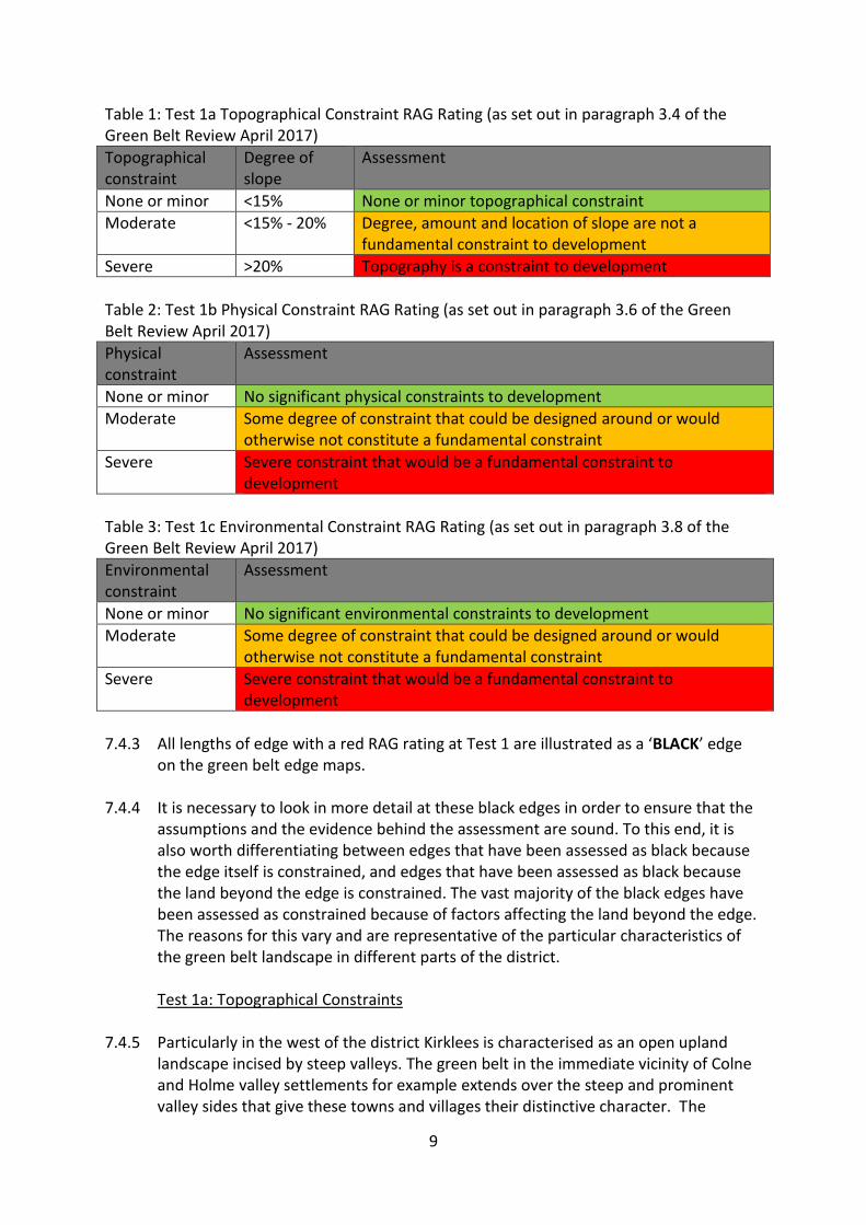
Test 1c environmental. 7.4.2 A ‘RAG’ rating was applied to each length at Test 1a, 1b and 1c to determine the
degree of constraint in accordance with the guidance set out in Tables 1, 2 and 3 below. All edges were assessed against all three parts of Test 1, irrespective of the presence of a red assessment in any one of the tests. This is because constraints noted along a length of green belt edge may not necessarily apply to a site that has been submitted to the council for consideration.
9
Table 1: Test 1a Topographical Constraint RAG Rating (as set out in paragraph 3.4 of the Green Belt Review April 2017)
Topographical constraint
Degree of slope
Assessment
None or minor <15% None or minor topographical constraint
Moderate <15% - 20% Degree, amount and location of slope are not a fundamental constraint to development
Severe >20% Topography is a constraint to development
Table 2: Test 1b Physical Constraint RAG Rating (as set out in paragraph 3.6 of the Green Belt Review April 2017)
Physical constraint
Assessment
None or minor No significant physical constraints to development
Moderate Some degree of constraint that could be designed around or would otherwise not constitute a fundamental constraint
Severe Severe constraint that would be a fundamental constraint to development
Table 3: Test 1c Environmental Constraint RAG Rating (as set out in paragraph 3.8 of the Green Belt Review April 2017)
Environmental constraint
Assessment
None or minor No significant environmental constraints to development
Moderate Some degree of constraint that could be designed around or would otherwise not constitute a fundamental constraint
Severe Severe constraint that would be a fundamental constraint to development
7.4.3 All lengths of edge with a red RAG rating at Test 1 are illustrated as a ‘BLACK’ edge
on the green belt edge maps. 7.4.4 It is necessary to look in more detail at these black edges in order to ensure that the
assumptions and the evidence behind the assessment are sound. To this end, it is also worth differentiating between edges that have been assessed as black because the edge itself is constrained, and edges that have been assessed as black because the land beyond the edge is constrained. The vast majority of the black edges have been assessed as constrained because of factors affecting the land beyond the edge. The reasons for this vary and are representative of the particular characteristics of the green belt landscape in different parts of the district.
Test 1a: Topographical Constraints
7.4.5 Particularly in the west of the district Kirklees is characterised as an open upland
landscape incised by steep valleys. The green belt in the immediate vicinity of Colne and Holme valley settlements for example extends over the steep and prominent valley sides that give these towns and villages their distinctive character. The
10
topographical constraint associated with these steep valley sides is severe. To be assessed as red the degree of slope must be >20% (1:5) and be on or very close to the edge of the settlement so that development impact on the valley side would be immediate. This level of constraint is illustrated by the black edges that surround much of Holmfirth, Marsden, Linthwaite and Slaithwaite. The same is true of much of the western side of Huddersfield which is constrained by steep slopes at Longwood Edge, Golcar, Milnsbridge, Scapegoat Hill and Lower Wellhouse. To the east Huddersfield is constrained by Dalton Bank and to the south by the steep slope south of Benomley. In the north and rural south of the district topographical constraints are less frequent, with a notable exception at Thornhill Edge. In these areas a red assessment at Test 1 is more likely to result from a physical or environmental constraint.
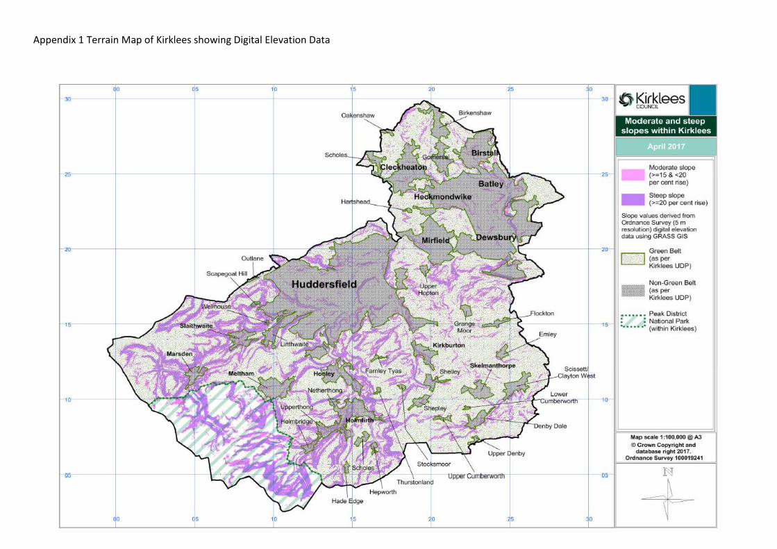
7.4.6 A terrain map illustrating the Digital Elevation Data used at Test 1a is shown at
Appendix 1.
Test 1b: Physical Constraints 7.4.7 Physical constraints to development can be found either on the boundary or on land
beyond the boundary.
Physical Constraints on Land beyond the Boundary 7.4.8 Physical constraints to development on land beyond the boundary include rivers and
other watercourses in close proximity to the settlement edge, canals, reservoirs and ponds, schools and school playing fields (Colne Valley High School, King James’s High School and Honley High School for example), the M62 motorway and other significant road infrastructure such as major road junctions, railways and railway infrastructure, mineral working, high pressure gas pipelines, other significant buildings such as industrial sites, areas of woodland in immediate proximity to the settlement, parks (Wilton Park, Oakwell Hall Country Park, Dewsbury Country Park, Beaumont Park being examples), cemeteries and crematoria, pylons carrying high voltage lines, sewage works, stadia, landfill sites and severely restricted or badly configured areas close to the district boundary such that new allocations could not be accommodated.
7.4.9 Test 1b also considers the presence of conservation areas, listed buildings and
ancient monuments. It is recognised that the preservation of the setting of individual historic assets is not a specified green belt purpose within the NPPF and for that reason edges are not assessed as red against physical constraints solely for the presence of a conservation area or listed building. However, it is also recognised that the presence of a listed building that could not be demolished or moved, and the need to take setting into account, is still a physical constraint to development and is correctly noted at Test 1b. Assessments made at Test 1b are based on a RAG rating and while constraints may be present they may not represent a severe constraint, perhaps due to their remoteness or sporadic nature. In these cases they are noted, and the edge assessed as either amber or green accordingly. Assuming that there are
11
no other constraints identified in Test 1a or 1c, the edge progresses through to be assessed against green belt purposes. It must also be remembered that the physical constraint may be assessed as red for a reason other than the historic asset. One such example is edge BS3, which is constrained by the presence of a cemetery immediately adjacent to the settlement edge and receives a red assessment for a physical constraint. Birstall Conservation Area extends into the green belt over the cemetery and its presence is noted at Test 1b, even though on its own this would not be sufficient to result in a red assessment.
7.4.10 There are two lengths of green belt edge however that do have a red assessment at
Test 1b. These are edge B/EB19 at Adwalton Moor Registered Historic Battlefield and edge MF8 Castle Hall Hill (motte and bailey castle) Scheduled Ancient Monument. In both these cases the green belt boundary either cuts through or immediately adjoins the scheduled area.
7.4.11 No lengths of green belt edge are assessed as red at Test 1b solely because of the
presence of a conservation area or listed building.
Physical constraint to the boundary 7.4.12 In the vast majority of cases the identified constraints are on land beyond the edge
of the settlement. In a number of areas however the boundary follows a watercourse, railway line, canal or the M62 motorway. These represent a physical barrier to the expansion of a settlement, even though land beyond them may be free of constraint to development. The watercourses include the River Calder, River Spen, River Colne, River Holme, River Dearne and Fenay Beck, along with numerous other smaller watercourses such as Grimescar Dike, Nann Hall Beck, Lodge Beck, Scotland Beck, Nova Beck and Meltham Dike. The individual assessment of any development option abutting an edge so constrained could still determine however that the site could be developed satisfactorily, although it is likely that the site would have a poor relationship with the existing settlement form. Many sites adjoining watercourses are also likely to be constrained by flood risk and to be associated with sensitive environmental habitats. Any corresponding environmental constraints are considered at Test 1c.
Test 1c: Environmental Constraints
7.4.13 The environmental constraints considered at Test 1c include buffer zones under high
voltage power lines, alongside high pressure gas pipelines and around landfill gas sites, areas at high risk of flooding, ‘hazard zones’ associated with industrial sites, areas affected by air quality issues and noise pollution, protected trees, protected species, Local Nature Reserves, Local Wildlife Sites and Local Geological Sites (formerly Sites of Wildlife Significance and Sites of Scientific Interest), the Peak
12
District National Park, the North Peak Environmentally Sensitive Area, Special Area of Conservation and Special Protection Area1, and Millennium Greens.
7.4.14 Any length of green belt edge considered to be constrained to the extent that it
receives a red rating for any part of Test 1 did not progress to Test 2 to be considered against green belt purposes.
7.5 Test 2: Green Belt Purposes 7.5.1 Lengths of edge that progressed through Test 1 were assessed against green belt
purposes in Test 2. One of the purposes of the green belt set out in paragraph 80 of NPPF is to prevent neighbouring towns merging into one another. In Kirklees this green belt purpose has always been, and will continue to be applied to green belt that prevents the merger of settlements, whatever their size. Whether land performs this role can be assessed based on the existing settlement form and the width of the existing gap. Land that functions as a strategic gap maintaining separation between settlements need not be assessed against further green belt purposes as it is considered that any land release would fundamentally undermine the role of the green belt and therefore that its green belt role and function is already strong. The remaining green belt purposes tested are based on a consideration of the degree to which land may check sprawl, safeguard the countryside from encroachment and protect the setting of historic assets. More information concerning this last test is given in paragraph 7.5.4 below.
Test 2a: Prevention of merger
7.5.2 Test 2a assessed all the lengths of green belt edge that progressed through the
process from Test 1 to determine whether land functioned as a strategic gap between settlements. A RAG rating was used so that land could be deemed to be part of an extensive gap between settlements (green), a narrow or restricted gap but where settlement extension could be accommodated (amber) or a strategic gap such that any land release could harm the purposes of including land in the green belt (red). Any length assessed as red did not progress to be considered against other green belt purposes.
7.5.3 All lengths of edge with a red RAG rating at test 2a are illustrated as a ‘RED’ edge on
the green belt edge maps.
Tests 2b, 2c and 2d 7.5.4 All lengths of edge that progressed through Tests 1 and 2a were assessed against
green belt purposes, namely to check the unrestricted sprawl of large built up areas (Test 2b), to assist in safeguarding the countryside from encroachment (Test 2c) and to preserve the setting of historic assets (Test 2d), following the considerations set
1 Peak District Moors Special Protection Area/South Pennine Moors Special Area of Conservation and North
Peak Environmentally Sensitive Area (now expired).
13
out in the Green Belt Review at paragraphs 3.16 to 3.20. It is recognised, and stated in the Green Belt Review document at paragraph 3.20 that one of the purposes of the green belt set out in NPPF is to preserve the setting and special character of historic towns of which there are none in Kirklees. However, for the purposes of the review of the Kirklees green belt this has been used to assess where green belt land preserves the setting of historic assets. The Kirklees Green Belt Review methodology allows for the degree to which development would impact on these assets to be combined with an assessment of green belt purposes to give an overall view of the role of the green belt in these areas. There are just two lengths of green belt edge that have been assessed as ‘red’ at test 2d, and these are B/EB18 for proximity to Adwalton Moor Registered Historic Battlefield and N7 at Newsome where development would impact on the setting of Castle Hill Scheduled Ancient Monument.
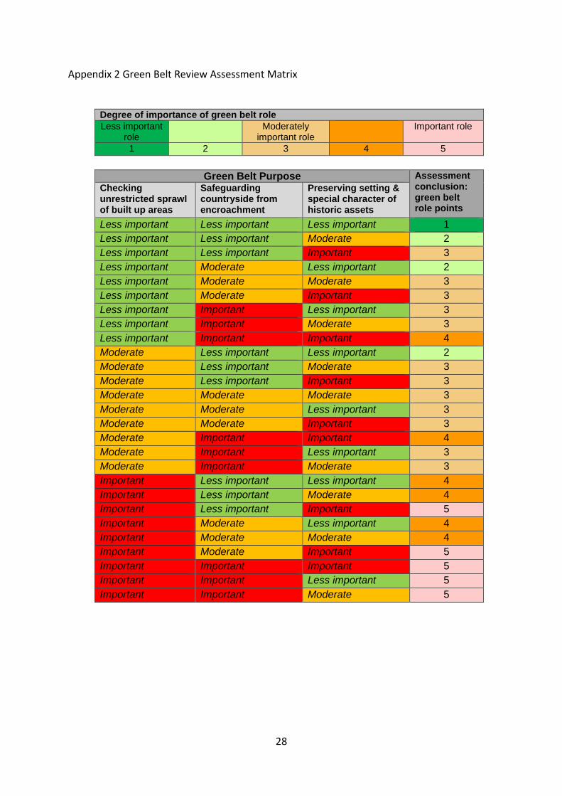
7.5.5 The results of these three tests were combined in a matrix (given at Appendix 1 of
the Green Belt Review and reproduced at Appendix 2 in this report) to arrive at a ‘score’ for each length, illustrating the degree to which each area performed a green belt role and function. The Assessment Matrix is a tool that allows a combination of three assessments to be translated into a single conclusion in a manner that it transparent and consistent. Any length of edge that includes at least one ‘red’ assessment for example, cannot score less than ‘3’. The matrix also allows weighting to be applied to the degree to which land is deemed to check sprawl, recognising this as the fundamental aim of green belt policy.
7.5.6 All lengths of edge assessed at Tests 2b, 2c and 2d were assigned a ‘score’ ranging
from green_1, where green belt role and function is least important, through yellow (amber) to pink_5, where green belt role and function is strongest and where most harm would be caused by removal of land from the green belt.
7.5.7 Table 4 below is taken from the Green Belt Review (paragraph 3.21) and summarises
the scoring for lengths of green belt edge. The test sequence and outcomes is also illustrated in Figure 1.
14
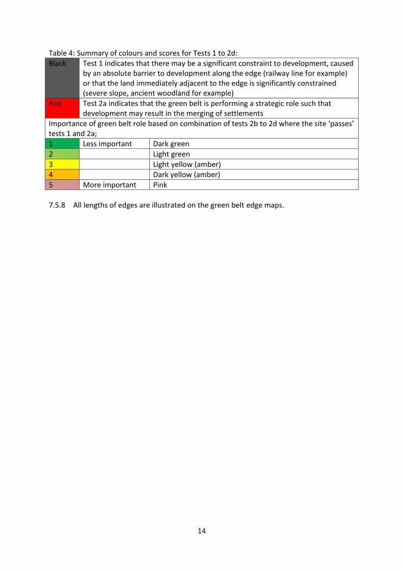
Table 4: Summary of colours and scores for Tests 1 to 2d:
Black Test 1 indicates that there may be a significant constraint to development, caused by an absolute barrier to development along the edge (railway line for example) or that the land immediately adjacent to the edge is significantly constrained (severe slope, ancient woodland for example)
Red Test 2a indicates that the green belt is performing a strategic role such that development may result in the merging of settlements
Importance of green belt role based on combination of tests 2b to 2d where the site ‘passes’ tests 1 and 2a;
1 Less important Dark green
2 Light green
3 Light yellow (amber)
4 Dark yellow (amber)
5 More important Pink
7.5.8 All lengths of edges are illustrated on the green belt edge maps.
15
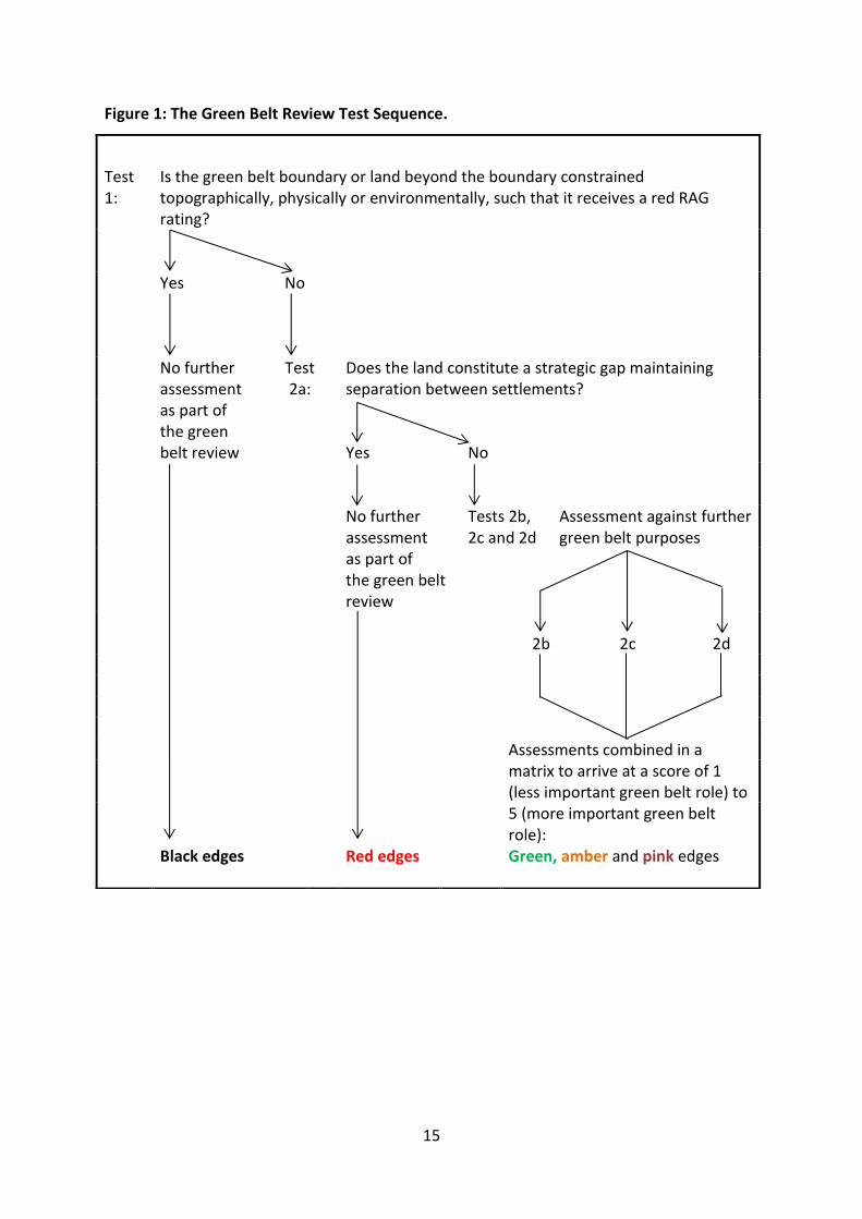
Figure 1: The Green Belt Review Test Sequence.
Test 1:
Is the green belt boundary or land beyond the boundary constrained topographically, physically or environmentally, such that it receives a red RAG rating?
Yes No
No further assessment as part of the green belt review
Test 2a:
Does the land constitute a strategic gap maintaining separation between settlements?
Yes
No
No further assessment as part of the green belt review
Tests 2b, 2c and 2d
Assessment against further green belt purposes
2b
2c
2d
Assessments combined in a
matrix to arrive at a score of 1 (less important green belt role) to 5 (more important green belt role): Green, amber and pink edges
Black edges
Red edges
16
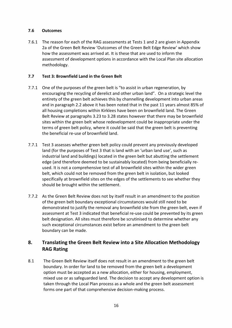
7.6 Outcomes 7.6.1 The reason for each of the RAG assessments at Tests 1 and 2 are given in Appendix
2a of the Green Belt Review ‘Outcomes of the Green Belt Edge Review’ which show how the assessment was arrived at. It is these that are used to inform the assessment of development options in accordance with the Local Plan site allocation methodology.
7.7 Test 3: Brownfield Land in the Green Belt 7.7.1 One of the purposes of the green belt is “to assist in urban regeneration, by
encouraging the recycling of derelict and other urban land”. On a strategic level the entirety of the green belt achieves this by channelling development into urban areas and in paragraph 2.2 above it has been noted that in the past 11 years almost 85% of all housing completions within Kirklees have been on brownfield land. The Green Belt Review at paragraphs 3.23 to 3.28 states however that there may be brownfield sites within the green belt whose redevelopment could be inappropriate under the terms of green belt policy, where it could be said that the green belt is preventing the beneficial re-use of brownfield land.
7.7.1 Test 3 assesses whether green belt policy could prevent any previously developed
land (for the purposes of Test 3 that is land with an ‘urban land use’, such as industrial land and buildings) located in the green belt but abutting the settlement edge (and therefore deemed to be sustainably located) from being beneficially re-used. It is not a comprehensive test of all brownfield sites within the wider green belt, which could not be removed from the green belt in isolation, but looked specifically at brownfield sites on the edges of the settlements to see whether they should be brought within the settlement.
7.7.2 As the Green Belt Review does not by itself result in an amendment to the position
of the green belt boundary exceptional circumstances would still need to be demonstrated to justify the removal any brownfield site from the green belt, even if assessment at Test 3 indicated that beneficial re-use could be prevented by its green belt designation. All sites must therefore be scrutinised to determine whether any such exceptional circumstances exist before an amendment to the green belt boundary can be made.
8. Translating the Green Belt Review into a Site Allocation Methodology RAG Rating
8.1 The Green Belt Review itself does not result in an amendment to the green belt
boundary. In order for land to be removed from the green belt a development option must be accepted as a new allocation, either for housing, employment, mixed use or as safeguarded land. The decision to accept any development option is taken through the Local Plan process as a whole and the green belt assessment forms one part of that comprehensive decision-making process.
17
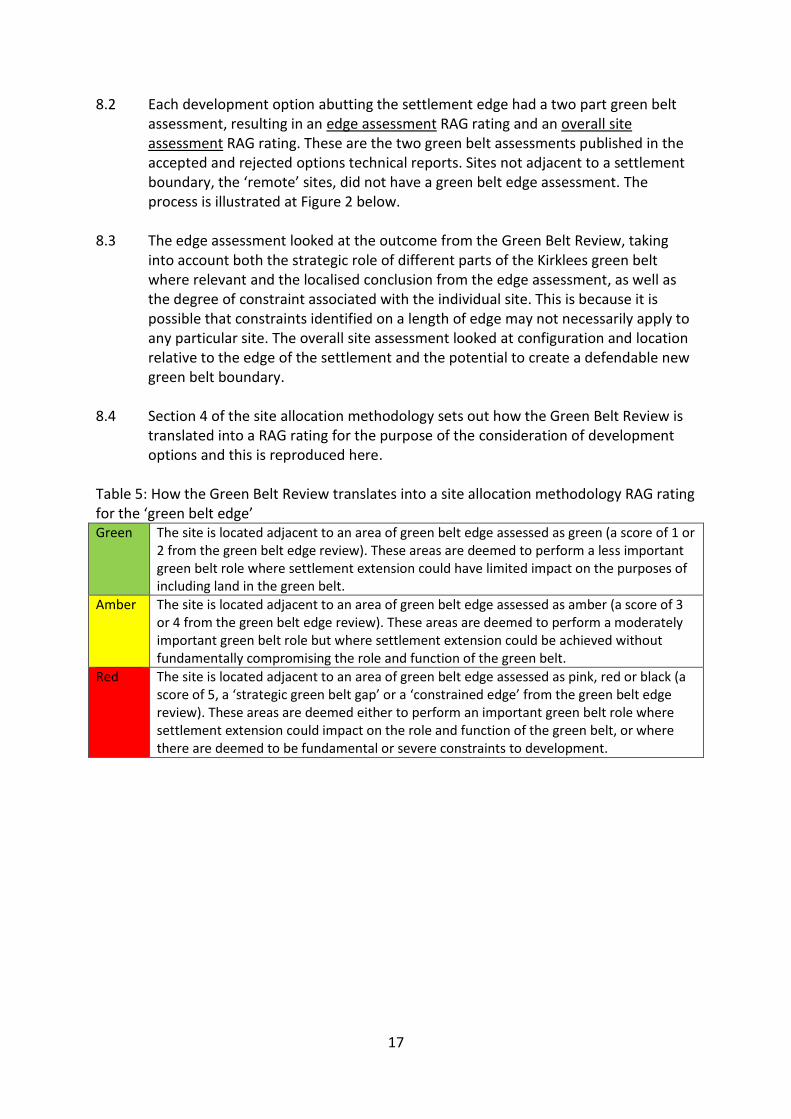
8.2 Each development option abutting the settlement edge had a two part green belt assessment, resulting in an edge assessment RAG rating and an overall site assessment RAG rating. These are the two green belt assessments published in the accepted and rejected options technical reports. Sites not adjacent to a settlement boundary, the ‘remote’ sites, did not have a green belt edge assessment. The process is illustrated at Figure 2 below.
8.3 The edge assessment looked at the outcome from the Green Belt Review, taking
into account both the strategic role of different parts of the Kirklees green belt where relevant and the localised conclusion from the edge assessment, as well as the degree of constraint associated with the individual site. This is because it is possible that constraints identified on a length of edge may not necessarily apply to any particular site. The overall site assessment looked at configuration and location relative to the edge of the settlement and the potential to create a defendable new green belt boundary.
8.4 Section 4 of the site allocation methodology sets out how the Green Belt Review is
translated into a RAG rating for the purpose of the consideration of development options and this is reproduced here.
Table 5: How the Green Belt Review translates into a site allocation methodology RAG rating for the ‘green belt edge’ Green The site is located adjacent to an area of green belt edge assessed as green (a score of 1 or
2 from the green belt edge review). These areas are deemed to perform a less important green belt role where settlement extension could have limited impact on the purposes of including land in the green belt.
Amber The site is located adjacent to an area of green belt edge assessed as amber (a score of 3 or 4 from the green belt edge review). These areas are deemed to perform a moderately important green belt role but where settlement extension could be achieved without fundamentally compromising the role and function of the green belt.
Red The site is located adjacent to an area of green belt edge assessed as pink, red or black (a score of 5, a ‘strategic green belt gap’ or a ‘constrained edge’ from the green belt edge review). These areas are deemed either to perform an important green belt role where settlement extension could impact on the role and function of the green belt, or where there are deemed to be fundamental or severe constraints to development.
18
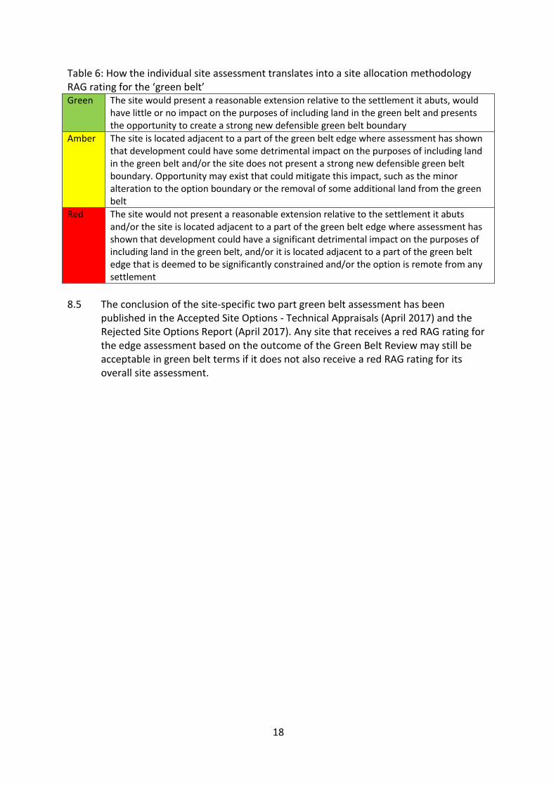
Table 6: How the individual site assessment translates into a site allocation methodology RAG rating for the ‘green belt’ Green The site would present a reasonable extension relative to the settlement it abuts, would
have little or no impact on the purposes of including land in the green belt and presents the opportunity to create a strong new defensible green belt boundary
Amber The site is located adjacent to a part of the green belt edge where assessment has shown that development could have some detrimental impact on the purposes of including land in the green belt and/or the site does not present a strong new defensible green belt boundary. Opportunity may exist that could mitigate this impact, such as the minor alteration to the option boundary or the removal of some additional land from the green belt
Red The site would not present a reasonable extension relative to the settlement it abuts and/or the site is located adjacent to a part of the green belt edge where assessment has shown that development could have a significant detrimental impact on the purposes of including land in the green belt, and/or it is located adjacent to a part of the green belt edge that is deemed to be significantly constrained and/or the option is remote from any settlement
8.5 The conclusion of the site-specific two part green belt assessment has been
published in the Accepted Site Options - Technical Appraisals (April 2017) and the Rejected Site Options Report (April 2017). Any site that receives a red RAG rating for the edge assessment based on the outcome of the Green Belt Review may still be acceptable in green belt terms if it does not also receive a red RAG rating for its overall site assessment.
19
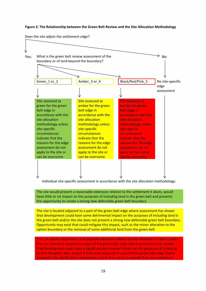
Figure 2: The Relationship between the Green Belt Review and the Site Allocation Methodology
Does the site adjoin the settlement edge?
Yes: What is the green belt review assessment of the boundary or of land beyond the boundary?
No
Green_1 or_2 Amber_3 or_4 Black/Red/Pink_5 No site-specific edge assessment
Site assessed as green for the green belt edge in accordance with the site allocation methodology unless site-specific circumstances indicate that the reasons for the edge assessment do not apply to the site or can be overcome
Site assessed as amber for the green belt edge in accordance with the site allocation methodology unless site-specific circumstances indicate that the reasons for the edge assessment do not apply to the site or can be overcome
Site assessed as red for the green belt edge in accordance with the site allocation methodology unless site-specific circumstances indicate that the reasons for the edge assessment do not apply to the site or can be overcome
Individual site-specific assessment in accordance with the site allocation methodology:
The site would present a reasonable extension relative to the settlement it abuts, would
have little or no impact on the purposes of including land in the green belt and presents the opportunity to create a strong new defensible green belt boundary
The site is located adjacent to a part of the green belt edge where assessment has shown
that development could have some detrimental impact on the purposes of including land in the green belt and/or the site does not present a strong new defensible green belt boundary. Opportunity may exist that could mitigate this impact, such as the minor alteration to the option boundary or the removal of some additional land from the green belt
The site would not present a reasonable extension relative to the settlement it abuts and/or
the site is located adjacent to a part of the green belt edge where assessment has shown that development could have a significant detrimental impact on the purposes of including land in the green belt, and/or it is located adjacent to a part of the green belt edge that is deemed to be significantly constrained and/or the option is remote from any settlement

20
9. Examples of how the Green Belt Review is translated into a Site-Specific Green Belt Assessment
9.1 The following section sets out three examples of how sites submitted to the council
for consideration through the Local Plan process have been assessed for their impact on green belt purposes.
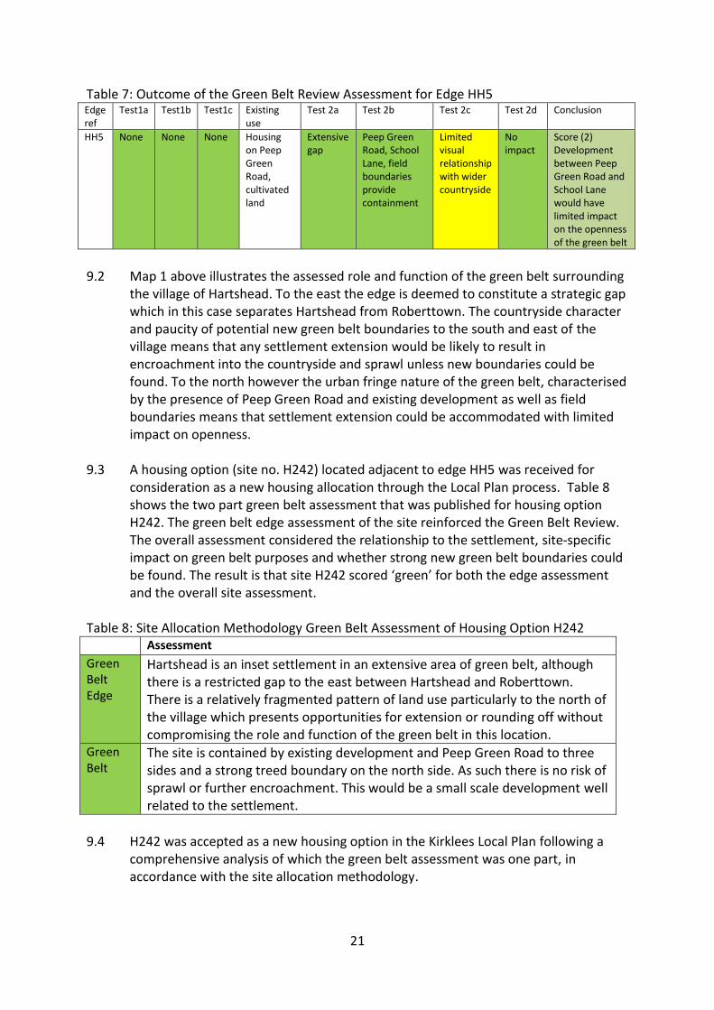
Example 1: Housing option H242 Peep Green Road Hartshead which abuts green belt edge HH5.
Map 1: Green Belt Edge at Hartshead and Site Option H242
21
Table 7: Outcome of the Green Belt Review Assessment for Edge HH5 Edge ref
Test1a
Test1b
Test1c
Existing use
Test 2a Test 2b Test 2c Test 2d Conclusion
HH5 None None None Housing on Peep Green Road, cultivated land
Extensive gap
Peep Green Road, School Lane, field boundaries provide containment
Limited visual relationship with wider countryside
No impact
Score (2) Development between Peep Green Road and School Lane would have limited impact on the openness of the green belt
9.2 Map 1 above illustrates the assessed role and function of the green belt surrounding
the village of Hartshead. To the east the edge is deemed to constitute a strategic gap which in this case separates Hartshead from Roberttown. The countryside character and paucity of potential new green belt boundaries to the south and east of the village means that any settlement extension would be likely to result in encroachment into the countryside and sprawl unless new boundaries could be found. To the north however the urban fringe nature of the green belt, characterised by the presence of Peep Green Road and existing development as well as field boundaries means that settlement extension could be accommodated with limited impact on openness.
9.3 A housing option (site no. H242) located adjacent to edge HH5 was received for
consideration as a new housing allocation through the Local Plan process. Table 8 shows the two part green belt assessment that was published for housing option H242. The green belt edge assessment of the site reinforced the Green Belt Review. The overall assessment considered the relationship to the settlement, site-specific impact on green belt purposes and whether strong new green belt boundaries could be found. The result is that site H242 scored ‘green’ for both the edge assessment and the overall site assessment.
Table 8: Site Allocation Methodology Green Belt Assessment of Housing Option H242
Assessment
Green Belt Edge
Hartshead is an inset settlement in an extensive area of green belt, although there is a restricted gap to the east between Hartshead and Roberttown. There is a relatively fragmented pattern of land use particularly to the north of the village which presents opportunities for extension or rounding off without compromising the role and function of the green belt in this location.
Green Belt
The site is contained by existing development and Peep Green Road to three sides and a strong treed boundary on the north side. As such there is no risk of sprawl or further encroachment. This would be a small scale development well related to the settlement.
9.4 H242 was accepted as a new housing option in the Kirklees Local Plan following a
comprehensive analysis of which the green belt assessment was one part, in accordance with the site allocation methodology.
22
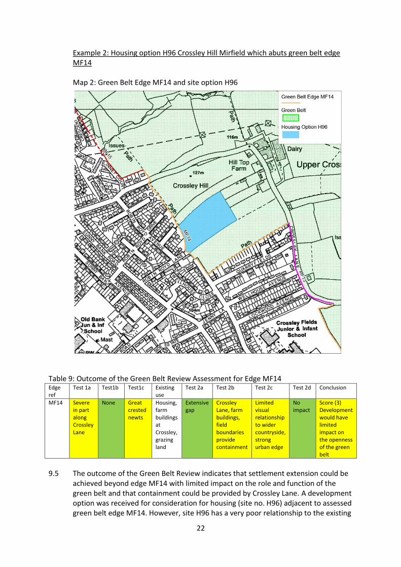
Example 2: Housing option H96 Crossley Hill Mirfield which abuts green belt edge MF14
Map 2: Green Belt Edge MF14 and site option H96
Table 9: Outcome of the Green Belt Review Assessment for Edge MF14 Edge ref
Test 1a Test1b Test1c Existing use
Test 2a Test 2b Test 2c Test 2d Conclusion
MF14 Severe in part along Crossley Lane
None Great crested newts
Housing, farm buildings at Crossley, grazing land
Extensive gap
Crossley Lane, farm buildings, field boundaries provide containment
Limited visual relationship to wider countryside, strong urban edge
No impact
Score (3) Development would have limited impact on the openness of the green belt
9.5 The outcome of the Green Belt Review indicates that settlement extension could be
achieved beyond edge MF14 with limited impact on the role and function of the green belt and that containment could be provided by Crossley Lane. A development option was received for consideration for housing (site no. H96) adjacent to assessed green belt edge MF14. However, site H96 has a very poor relationship to the existing
23
settlement pattern. The site allocation methodology states that options poorly configured in relation to the settlement could be assessed as ‘red’ for the impact on the green belt irrespective of the edge assessment. On its own the configuration of H96 would result in a projection of built form into the countryside setting to the detriment of openness. Alternatively, a very significant amount of additional land (in relation to the size of the option) would need to be removed from the green belt in order to give the option a better relationship to the settlement. Without knowing the availability of that additional land it could not be considered as a new housing allocation and therefore exceptional circumstances for the removal of the additional land could not be demonstrated. As a result site H96 scored ‘amber’ for the edge assessment, but ‘red’ for its overall site assessment.
Table 10: Site Allocation Methodology Green Belt Assessment of Housing Option H96
Assessment
Green Belt Edge
This is an extensive area of green belt that in this location helps to maintain separation between Mirfield, Roberttown and Heckmondwike. Locally the area is separated from the wider countryside by Crossley Lane but is similar in character and is visually linked. The existing settlement pattern does allow for settlement extension without compromising the role and function of the green belt in this area
Green Belt
This site sits in an area of green belt that appears as part of the wider countryside. The site is poorly configured relative to the settlement edge and would result in an isolated projection of built form to the detriment of the openness of the green belt in this location
9.6 H96 was rejected as a new housing option in the Kirklees Local Plan following a
comprehensive analysis of which the green belt assessment was one part, in accordance with the site allocation methodology.
Sites without a boundary with a settlement
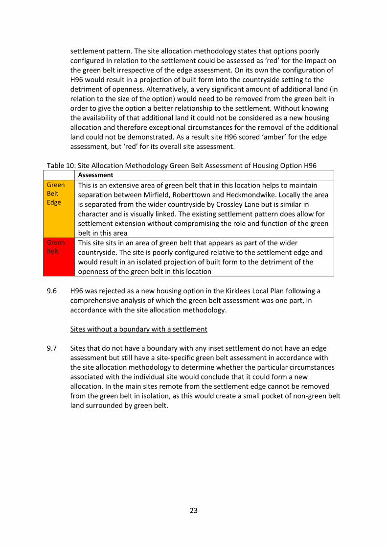
9.7 Sites that do not have a boundary with any inset settlement do not have an edge
assessment but still have a site-specific green belt assessment in accordance with the site allocation methodology to determine whether the particular circumstances associated with the individual site would conclude that it could form a new allocation. In the main sites remote from the settlement edge cannot be removed from the green belt in isolation, as this would create a small pocket of non-green belt land surrounded by green belt.
24
Map 3: Site Option H3381 Table 11: Site Allocation Methodology Green Belt Assessment of Housing Option H3381
Assessment
Green Belt Edge
N/A
Green belt
Removal of this site from the green belt would create a small pocket of non‐green belt land surrounded by green belt, which is contrary to the purposes of including land in the green belt. The site presents an open frontage along Blackmoorfoot Road which helps to maintain the character of this area as one of sporadic development which maintains the appearance of openness. Development would also reinforce merger with Linthwaite. The Local Plan strategy does not include the removal of Blackmoorfoot from the green belt.
9.8 H3381 was rejected as a new housing option in the Kirklees Local Plan following a
comprehensive analysis of which the green belt assessment was one part, in accordance with the site allocation methodology.
25
9.9 Appendices 3 and 4 list all the accepted and rejected green belt development options assessed for their potential as new allocations in the Kirklees Local Plan.
10 Conclusion
10.1 A review of the Kirklees green belt has been undertaken as part of the preparation of
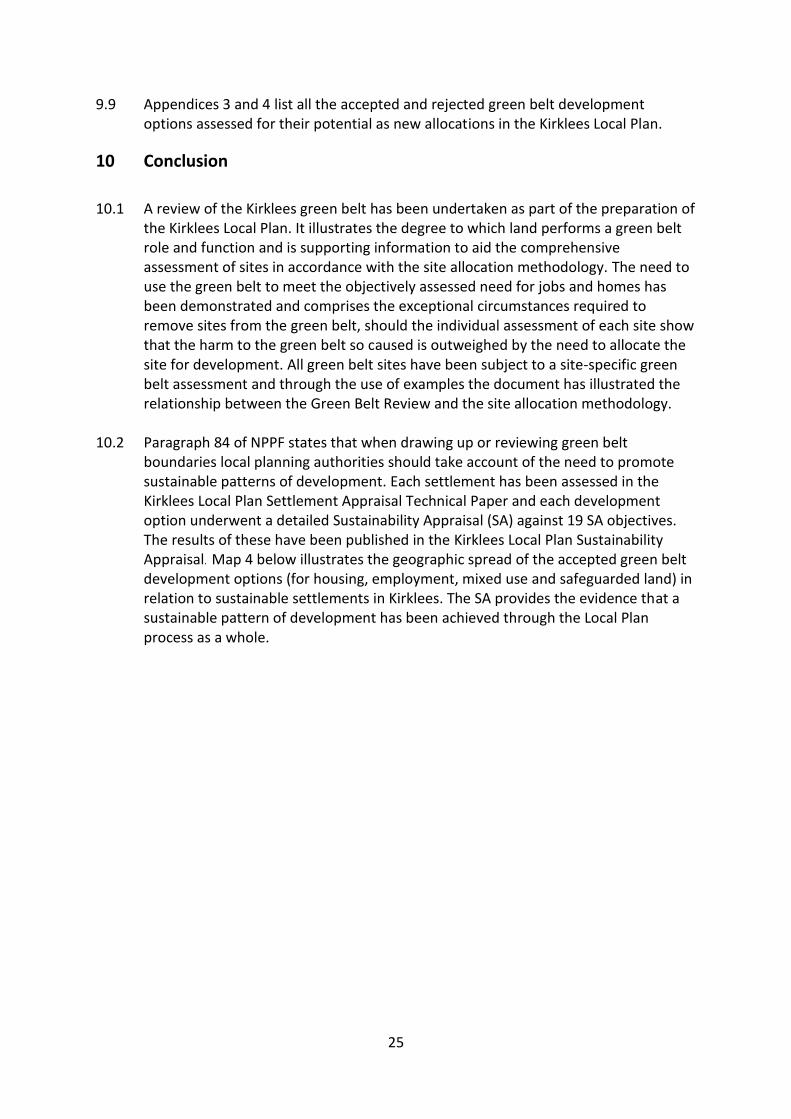
the Kirklees Local Plan. It illustrates the degree to which land performs a green belt role and function and is supporting information to aid the comprehensive assessment of sites in accordance with the site allocation methodology. The need to use the green belt to meet the objectively assessed need for jobs and homes has been demonstrated and comprises the exceptional circumstances required to remove sites from the green belt, should the individual assessment of each site show that the harm to the green belt so caused is outweighed by the need to allocate the site for development. All green belt sites have been subject to a site-specific green belt assessment and through the use of examples the document has illustrated the relationship between the Green Belt Review and the site allocation methodology.
10.2 Paragraph 84 of NPPF states that when drawing up or reviewing green belt
boundaries local planning authorities should take account of the need to promote sustainable patterns of development. Each settlement has been assessed in the Kirklees Local Plan Settlement Appraisal Technical Paper and each development option underwent a detailed Sustainability Appraisal (SA) against 19 SA objectives. The results of these have been published in the Kirklees Local Plan Sustainability Appraisal. Map 4 below illustrates the geographic spread of the accepted green belt development options (for housing, employment, mixed use and safeguarded land) in relation to sustainable settlements in Kirklees. The SA provides the evidence that a sustainable pattern of development has been achieved through the Local Plan process as a whole.
26
Map 4 Distribution of Accepted Green Belt Development Options Showing Relationship to Sustainable Settlements
10.3 The council considers that the approach to the review of the green belt in Kirklees is
relevant and proportionate to its role as supporting information to aid the comprehensive assessment of development options in the Local Plan.
27
Appendix 1 Terrain Map of Kirklees showing Digital Elevation Data
28
Appendix 2 Green Belt Review Assessment Matrix
Degree of importance of green belt role
Less important role
Moderately important role
Important role
1 2 3 4 5
Green Belt Purpose Assessment conclusion: green belt role points
Checking unrestricted sprawl of built up areas
Safeguarding countryside from encroachment
Preserving setting & special character of historic assets
Less important Less important Less important 1
Less important Less important Moderate 2
Less important Less important Important 3
Less important Moderate Less important 2
Less important Moderate Moderate 3
Less important Moderate Important 3
Less important Important Less important 3
Less important Important Moderate 3
Less important Important Important 4
Moderate Less important Less important 2
Moderate Less important Moderate 3
Moderate Less important Important 3
Moderate Moderate Moderate 3
Moderate Moderate Less important 3
Moderate Moderate Important 3
Moderate Important Important 4
Moderate Important Less important 3
Moderate Important Moderate 3
Important Less important Less important 4
Important Less important Moderate 4
Important Less important Important 5
Important Moderate Less important 4
Important Moderate Moderate 4
Important Moderate Important 5
Important Important Important 5
Important Important Less important 5
Important Important Moderate 5
29
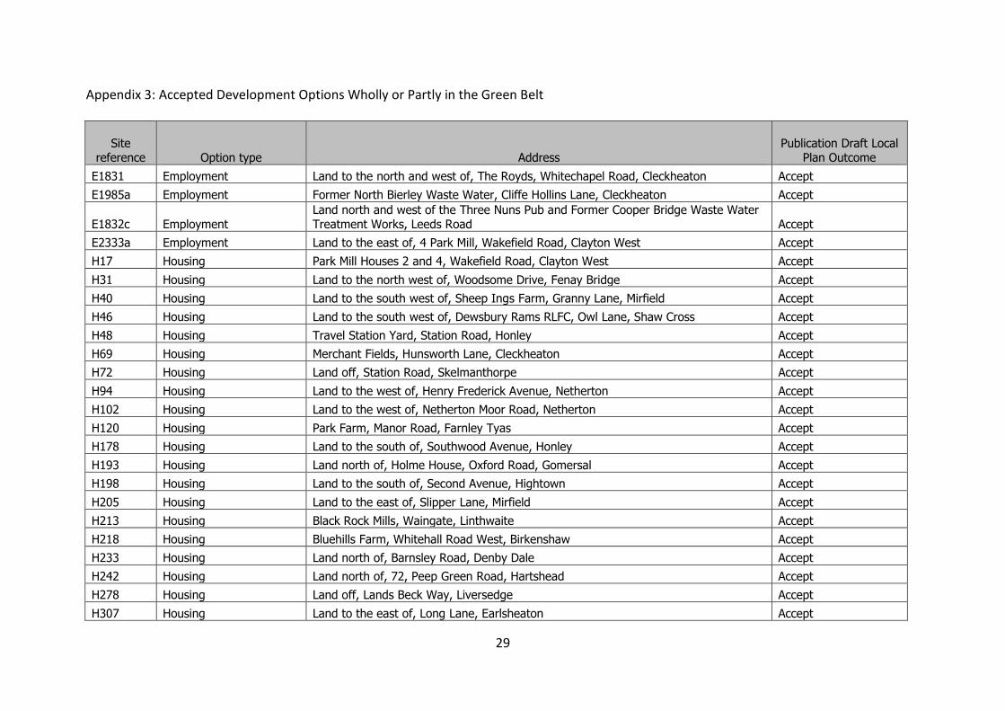
Appendix 3: Accepted Development Options Wholly or Partly in the Green Belt
Site reference Option type Address
Publication Draft Local Plan Outcome
E1831 Employment Land to the north and west of, The Royds, Whitechapel Road, Cleckheaton Accept
E1985a Employment Former North Bierley Waste Water, Cliffe Hollins Lane, Cleckheaton Accept
E1832c Employment Land north and west of the Three Nuns Pub and Former Cooper Bridge Waste Water Treatment Works, Leeds Road Accept
E2333a Employment Land to the east of, 4 Park Mill, Wakefield Road, Clayton West Accept
H17 Housing Park Mill Houses 2 and 4, Wakefield Road, Clayton West Accept
H31 Housing Land to the north west of, Woodsome Drive, Fenay Bridge Accept
H40 Housing Land to the south west of, Sheep Ings Farm, Granny Lane, Mirfield Accept
H46 Housing Land to the south west of, Dewsbury Rams RLFC, Owl Lane, Shaw Cross Accept
H48 Housing Travel Station Yard, Station Road, Honley Accept
H69 Housing Merchant Fields, Hunsworth Lane, Cleckheaton Accept
H72 Housing Land off, Station Road, Skelmanthorpe Accept
H94 Housing Land to the west of, Henry Frederick Avenue, Netherton Accept
H102 Housing Land to the west of, Netherton Moor Road, Netherton Accept
H120 Housing Park Farm, Manor Road, Farnley Tyas Accept
H178 Housing Land to the south of, Southwood Avenue, Honley Accept
H193 Housing Land north of, Holme House, Oxford Road, Gomersal Accept
H198 Housing Land to the south of, Second Avenue, Hightown Accept
H205 Housing Land to the east of, Slipper Lane, Mirfield Accept
H213 Housing Black Rock Mills, Waingate, Linthwaite Accept
H218 Housing Bluehills Farm, Whitehall Road West, Birkenshaw Accept
H233 Housing Land north of, Barnsley Road, Denby Dale Accept
H242 Housing Land north of, 72, Peep Green Road, Hartshead Accept
H278 Housing Land off, Lands Beck Way, Liversedge Accept
H307 Housing Land to the east of, Long Lane, Earlsheaton Accept
30
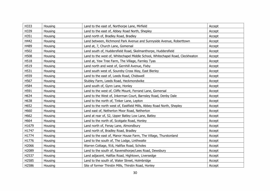
H333 Housing Land to the east of, Northorpe Lane, Mirfield Accept
H339 Housing Land to the east of, Abbey Road North, Shepley Accept
H351 Housing Land north of, Bradley Road, Bradley Accept
H442 Housing Land between, Richmond Park Avenue and Sunnyside Avenue, Roberttown Accept
H489 Housing Land at, 7, Church Lane, Gomersal Accept
H502 Housing Land south of, Huddersfield Road, Skelmanthorpe, Huddersfield Accept
H508 Housing Land to the west of, Whitechapel Middle School, Whitechapel Road, Cleckheaton Accept
H518 Housing Land at, Yew Tree Farm, The Village, Farnley Tyas Accept
H519 Housing Land north and west of, Gernhill Avenue, Fixby Accept
H531 Housing Land south west of, Soureby Cross Way, East Bierley Accept
H559 Housing Land to the east of, Leeds Road, Chidswell Accept
H567 Housing Stubley Farm, Leeds Road, Heckmondwike Accept
H584 Housing Land south of, Gynn Lane, Honley Accept
H591 Housing Land to the west of, Cliffe Mount, Ferrand Lane, Gomersal Accept
H634 Housing Land to the West of, Inkerman Court, Barnsley Road, Denby Dale Accept
H638 Housing Land to the north of, Tinker Lane, Lepton Accept
H652 Housing Land to the north west of, Eastfield Mills, Abbey Road North, Shepley Accept
H660 Housing Land east of, Netherton Moor Road, Netherton Accept
H662 Housing Land at rear of, 52, Upper Batley Low Lane, Batley Accept
H664 Housing Land to the north of, Scotgate Road, Honley Accept
H1679 Housing Land north of, Fenay Lane, Almondbury Accept
H1747 Housing Land north of, Bradley Road, Bradley Accept
H1774 Housing Land to the east of, Manor House Farm, The Village, Thurstonland Accept
H1776 Housing Land to the south of, The Lodge, Linthwaite Accept
H2066 Housing Warren Cottage, 916, Halifax Road, Scholes Accept
H2089 Housing Land to the south of, Ravensthorpe/Lees Road, Dewsbury Accept
H2537 Housing Land adjacent, Halifax Road, Hightown, Liversedge Accept
H2585 Housing Land to the south of, Water Street, Holmbridge Accept
H2586 Housing Site of former Thirstin Mills, Thirstin Road, Honley Accept
31
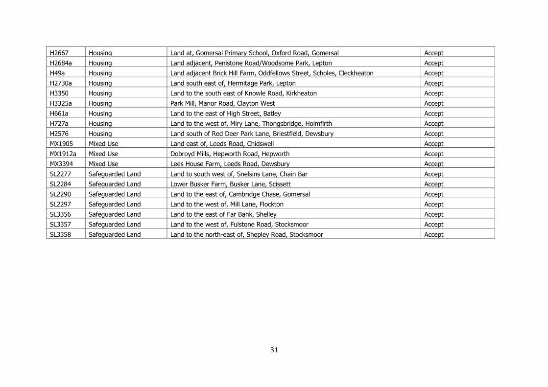
H2667 Housing Land at, Gomersal Primary School, Oxford Road, Gomersal Accept
H2684a Housing Land adjacent, Penistone Road/Woodsome Park, Lepton Accept
H49a Housing Land adjacent Brick Hill Farm, Oddfellows Street, Scholes, Cleckheaton Accept
H2730a Housing Land south east of, Hermitage Park, Lepton Accept
H3350 Housing Land to the south east of Knowle Road, Kirkheaton Accept
H3325a Housing Park Mill, Manor Road, Clayton West Accept
H661a Housing Land to the east of High Street, Batley Accept
H727a Housing Land to the west of, Miry Lane, Thongsbridge, Holmfirth Accept
H2576 Housing Land south of Red Deer Park Lane, Briestfield, Dewsbury Accept
MX1905 Mixed Use Land east of, Leeds Road, Chidswell Accept
MX1912a Mixed Use Dobroyd Mills, Hepworth Road, Hepworth Accept
MX3394 Mixed Use Lees House Farm, Leeds Road, Dewsbury Accept
SL2277 Safeguarded Land Land to south west of, Snelsins Lane, Chain Bar Accept
SL2284 Safeguarded Land Lower Busker Farm, Busker Lane, Scissett Accept
SL2290 Safeguarded Land Land to the east of, Cambridge Chase, Gomersal Accept
SL2297 Safeguarded Land Land to the west of, Mill Lane, Flockton Accept
SL3356 Safeguarded Land Land to the east of Far Bank, Shelley Accept
SL3357 Safeguarded Land Land to the west of, Fulstone Road, Stocksmoor Accept
SL3358 Safeguarded Land Land to the north-east of, Shepley Road, Stocksmoor Accept
32
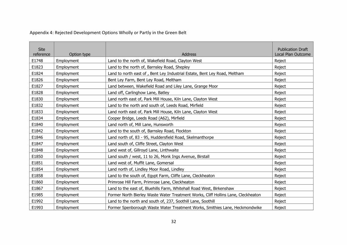
Appendix 4: Rejected Development Options Wholly or Partly in the Green Belt
Site reference Option type Address
Publication Draft Local Plan Outcome
E1748 Employment Land to the north of, Wakefield Road, Clayton West Reject
E1823 Employment Land to the north of, Barnsley Road, Shepley Reject
E1824 Employment Land to north east of , Bent Ley Industrial Estate, Bent Ley Road, Meltham Reject
E1826 Employment Bent Ley Farm, Bent Ley Road, Meltham Reject
E1827 Employment Land between, Wakefield Road and Liley Lane, Grange Moor Reject
E1828 Employment Land off, Carlinghow Lane, Batley Reject
E1830 Employment Land north east of, Park Mill House, Kiln Lane, Clayton West Reject
E1832 Employment Land to the north and south of, Leeds Road, Mirfield Reject
E1833 Employment Land north east of, Park Mill House, Kiln Lane, Clayton West Reject
E1834 Employment Cooper Bridge, Leeds Road (A62), Mirfield Reject
E1840 Employment Land north of, Mill Lane, Hunsworth Reject
E1842 Employment Land to the south of, Barnsley Road, Flockton Reject
E1846 Employment Land north of, 83 - 95, Huddersfield Road, Skelmanthorpe Reject
E1847 Employment Land south of, Cliffe Street, Clayton West Reject
E1848 Employment Land west of, Gillroyd Lane, Linthwaite Reject
E1850 Employment Land south / west, 11 to 26, Monk Ings Avenue, Birstall Reject
E1851 Employment Land west of, Muffit Lane, Gomersal Reject
E1854 Employment Land north of, Lindley Moor Road, Lindley Reject
E1858 Employment Land to the south of, Egypt Farm, Cliffe Lane, Cleckheaton Reject
E1860 Employment Primrose Hill Farm, Primrose Lane, Cleckheaton Reject
E1867 Employment Land to the east of, Bluehills Farm, Whitehall Road West, Birkenshaw Reject
E1985 Employment Former North Bierley Waste Water Treatment Works, Cliff Hollins Lane, Cleckheaton Reject
E1992 Employment Land to the north and south of, 237, Soothill Lane, Soothill Reject
E1993 Employment Former Spenborough Waste Water Treatment Works, Smithies Lane, Heckmondwike Reject
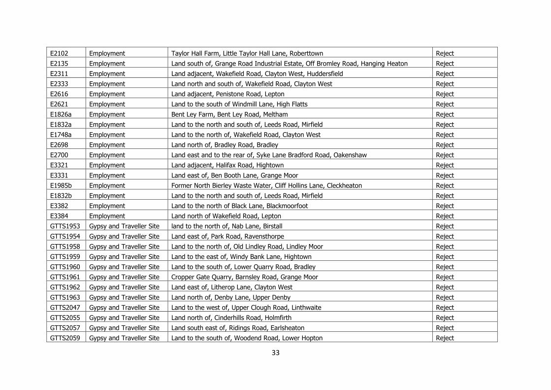
33
E2102 Employment Taylor Hall Farm, Little Taylor Hall Lane, Roberttown Reject
E2135 Employment Land south of, Grange Road Industrial Estate, Off Bromley Road, Hanging Heaton Reject
E2311 Employment Land adjacent, Wakefield Road, Clayton West, Huddersfield Reject
E2333 Employment Land north and south of, Wakefield Road, Clayton West Reject
E2616 Employment Land adjacent, Penistone Road, Lepton Reject
E2621 Employment Land to the south of Windmill Lane, High Flatts Reject
E1826a Employment Bent Ley Farm, Bent Ley Road, Meltham Reject
E1832a Employment Land to the north and south of, Leeds Road, Mirfield Reject
E1748a Employment Land to the north of, Wakefield Road, Clayton West Reject
E2698 Employment Land north of, Bradley Road, Bradley Reject
E2700 Employment Land east and to the rear of, Syke Lane Bradford Road, Oakenshaw Reject
E3321 Employment Land adjacent, Halifax Road, Hightown Reject
E3331 Employment Land east of, Ben Booth Lane, Grange Moor Reject
E1985b Employment Former North Bierley Waste Water, Cliff Hollins Lane, Cleckheaton Reject
E1832b Employment Land to the north and south of, Leeds Road, Mirfield Reject
E3382 Employment Land to the north of Black Lane, Blackmoorfoot Reject
E3384 Employment Land north of Wakefield Road, Lepton Reject
GTTS1953 Gypsy and Traveller Site land to the north of, Nab Lane, Birstall Reject
GTTS1954 Gypsy and Traveller Site Land east of, Park Road, Ravensthorpe Reject
GTTS1958 Gypsy and Traveller Site Land to the north of, Old Lindley Road, Lindley Moor Reject
GTTS1959 Gypsy and Traveller Site Land to the east of, Windy Bank Lane, Hightown Reject
GTTS1960 Gypsy and Traveller Site Land to the south of, Lower Quarry Road, Bradley Reject
GTTS1961 Gypsy and Traveller Site Cropper Gate Quarry, Barnsley Road, Grange Moor Reject
GTTS1962 Gypsy and Traveller Site Land east of, Litherop Lane, Clayton West Reject
GTTS1963 Gypsy and Traveller Site Land north of, Denby Lane, Upper Denby Reject
GTTS2047 Gypsy and Traveller Site Land to the west of, Upper Clough Road, Linthwaite Reject
GTTS2055 Gypsy and Traveller Site Land north of, Cinderhills Road, Holmfirth Reject
GTTS2057 Gypsy and Traveller Site Land south east of, Ridings Road, Earlsheaton Reject
GTTS2059 Gypsy and Traveller Site Land to the south of, Woodend Road, Lower Hopton Reject
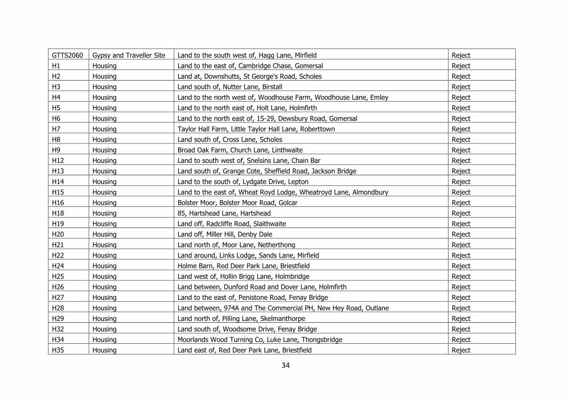
34
GTTS2060 Gypsy and Traveller Site Land to the south west of, Hagg Lane, Mirfield Reject
H1 Housing Land to the east of, Cambridge Chase, Gomersal Reject
H2 Housing Land at, Downshutts, St George's Road, Scholes Reject
H3 Housing Land south of, Nutter Lane, Birstall Reject
H4 Housing Land to the north west of, Woodhouse Farm, Woodhouse Lane, Emley Reject
H5 Housing Land to the north east of, Holt Lane, Holmfirth Reject
H6 Housing Land to the north east of, 15-29, Dewsbury Road, Gomersal Reject
H7 Housing Taylor Hall Farm, Little Taylor Hall Lane, Roberttown Reject
H8 Housing Land south of, Cross Lane, Scholes Reject
H9 Housing Broad Oak Farm, Church Lane, Linthwaite Reject
H12 Housing Land to south west of, Snelsins Lane, Chain Bar Reject
H13 Housing Land south of, Grange Cote, Sheffield Road, Jackson Bridge Reject
H14 Housing Land to the south of, Lydgate Drive, Lepton Reject
H15 Housing Land to the east of, Wheat Royd Lodge, Wheatroyd Lane, Almondbury Reject
H16 Housing Bolster Moor, Bolster Moor Road, Golcar Reject
H18 Housing 85, Hartshead Lane, Hartshead Reject
H19 Housing Land off, Radcliffe Road, Slaithwaite Reject
H20 Housing Land off, Miller Hill, Denby Dale Reject
H21 Housing Land north of, Moor Lane, Netherthong Reject
H22 Housing Land around, Links Lodge, Sands Lane, Mirfield Reject
H24 Housing Holme Barn, Red Deer Park Lane, Briestfield Reject
H25 Housing Land west of, Hollin Brigg Lane, Holmbridge Reject
H26 Housing Land between, Dunford Road and Dover Lane, Holmfirth Reject
H27 Housing Land to the east of, Penistone Road, Fenay Bridge Reject
H28 Housing Land between, 974A and The Commercial PH, New Hey Road, Outlane Reject
H29 Housing Land north of, Pilling Lane, Skelmanthorpe Reject
H32 Housing Land south of, Woodsome Drive, Fenay Bridge Reject
H34 Housing Moorlands Wood Turning Co, Luke Lane, Thongsbridge Reject
H35 Housing Land east of, Red Deer Park Lane, Briestfield Reject
35
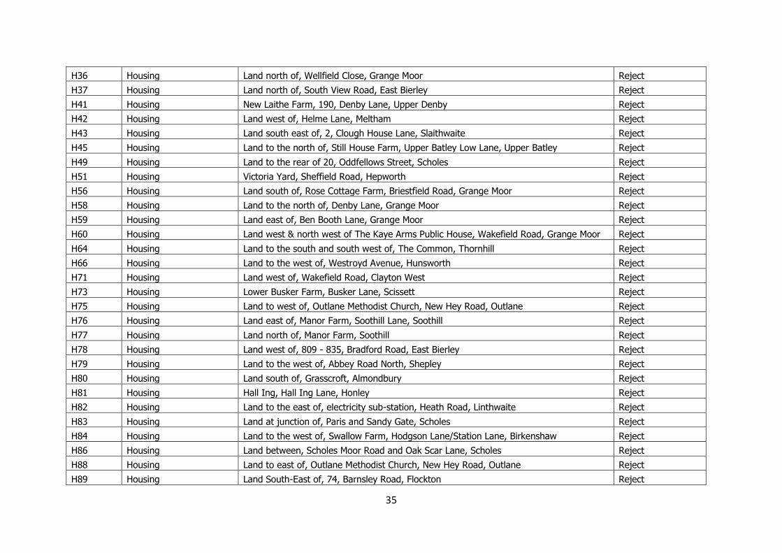
H36 Housing Land north of, Wellfield Close, Grange Moor Reject
H37 Housing Land north of, South View Road, East Bierley Reject
H41 Housing New Laithe Farm, 190, Denby Lane, Upper Denby Reject
H42 Housing Land west of, Helme Lane, Meltham Reject
H43 Housing Land south east of, 2, Clough House Lane, Slaithwaite Reject
H45 Housing Land to the north of, Still House Farm, Upper Batley Low Lane, Upper Batley Reject
H49 Housing Land to the rear of 20, Oddfellows Street, Scholes Reject
H51 Housing Victoria Yard, Sheffield Road, Hepworth Reject
H56 Housing Land south of, Rose Cottage Farm, Briestfield Road, Grange Moor Reject
H58 Housing Land to the north of, Denby Lane, Grange Moor Reject
H59 Housing Land east of, Ben Booth Lane, Grange Moor Reject
H60 Housing Land west & north west of The Kaye Arms Public House, Wakefield Road, Grange Moor Reject
H64 Housing Land to the south and south west of, The Common, Thornhill Reject
H66 Housing Land to the west of, Westroyd Avenue, Hunsworth Reject
H71 Housing Land west of, Wakefield Road, Clayton West Reject
H73 Housing Lower Busker Farm, Busker Lane, Scissett Reject
H75 Housing Land to west of, Outlane Methodist Church, New Hey Road, Outlane Reject
H76 Housing Land east of, Manor Farm, Soothill Lane, Soothill Reject
H77 Housing Land north of, Manor Farm, Soothill Reject
H78 Housing Land west of, 809 - 835, Bradford Road, East Bierley Reject
H79 Housing Land to the west of, Abbey Road North, Shepley Reject
H80 Housing Land south of, Grasscroft, Almondbury Reject
H81 Housing Hall Ing, Hall Ing Lane, Honley Reject
H82 Housing Land to the east of, electricity sub-station, Heath Road, Linthwaite Reject
H83 Housing Land at junction of, Paris and Sandy Gate, Scholes Reject
H84 Housing Land to the west of, Swallow Farm, Hodgson Lane/Station Lane, Birkenshaw Reject
H86 Housing Land between, Scholes Moor Road and Oak Scar Lane, Scholes Reject
H88 Housing Land to east of, Outlane Methodist Church, New Hey Road, Outlane Reject
H89 Housing Land South-East of, 74, Barnsley Road, Flockton Reject
36
H91 Housing Land west of, 132 - 168, Foxroyd Lane, Thornhill, Dewsbury Reject
H92 Housing Land to the north of, Crossley Lane, Mirfield Reject
H96 Housing Land to the north of, Quarryfields, Crossley Hill Reject
H97 Housing Land to the north of Park House Farm, The Common, Thornhill Lees Reject
H104 Housing Land to the south of, Norristhorpe Lane, Norristhorpe Reject
H106 Housing Land to the east of, 301, Woodhead Road, Holme Reject
H108 Housing Land to the east of, Hawkroyd Bank Road, Honley Reject
H109 Housing Land to the south of, 38, Duke Wood Road, Clayton West Reject
H113 Housing Land to the east of, Moor Lane, Birkenshaw Reject
H114 Housing Land to the east of, 34, Pike Law Road, Scapegoat Hill Reject
H115 Housing Land South of, 201 - 287, Whitechapel Road, Scholes Reject
H133 Housing Land to the north of, Woodside View, Burnlee Reject
H137 Housing Land to the north of, Burton Royd Lane, Kirkburton Reject
H139 Housing Land west of, Storthes Hall Lane, Kirkburton Reject
H140 Housing Land to north west of, 3, Two Gates, Slaithwaite Reject
H141 Housing Land between, South View and Hunsworth Lane, East Bierley Reject
H142 Housing Land west of, Chandler Lane, Honley Reject
H144 Housing Land west of, Chandler Lane, Honley Reject
H147 Housing Land to the south of, Cliffe Lane, Cleckheaton Reject
H148 Housing Land off, New Street, Cleckheaton Reject
H149 Housing Primrose Farm, Crossley Lane, Northorpe Reject
H153 Housing Holme Mills, West Slaithwaite Road, Slaithwaite Reject
H154 Housing Hay Royds Colliery, Wheatley Hill Lane, Clayton West Reject
H155 Housing Land east of, Far Common Road, Mirfield Reject
H156 Housing Land south of, Kinder Avenue, Cowlersley Reject
H157 Housing Land north of, 83 - 95, Huddersfield Road, Skelmanthorpe Reject
H158 Housing Land to the north west of, Northgate, Honley Reject
H159 Housing Netherley, Old Mount Road, Marsden Reject
H160 Housing Land east and to the rear of, Syke Lane Bradford Road, Oakenshaw Reject
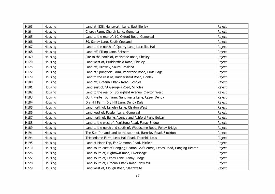
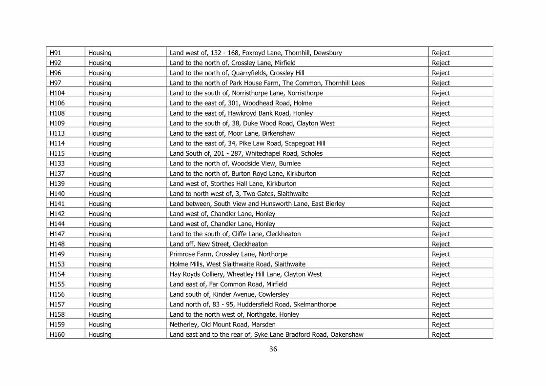
37
H163 Housing Land at, 538, Hunsworth Lane, East Bierley Reject
H164 Housing Church Farm, Church Lane, Gomersal Reject
H165 Housing Land to the rear of, 10, Oxford Road, Gomersal Reject
H166 Housing 39, Sandy Lane, South Crosland Reject
H167 Housing Land to the north of, Quarry Lane, Lascelles Hall Reject
H168 Housing Land off, Pilling Lane, Scissett Reject
H169 Housing Site to the north of, Penistone Road, Shelley Reject
H170 Housing Land west of, Huddersfield Road, Shelley Reject
H175 Housing Land off, Midway, South Crosland Reject
H177 Housing Land at Springfield Farm, Penistone Road, Birds Edge Reject
H179 Housing Land to the east of, Huddersfield Road, Honley Reject
H180 Housing Land off, Greenhill Bank Road, Scholes Reject
H181 Housing Land east of, St George's Road, Scholes Reject
H182 Housing Land to the rear of, Springfield Avenue, Clayton West Reject
H183 Housing Gunthwaite Top Farm, Gunthwaite Lane, Upper Denby Reject
H184 Housing Dry Hill Farm, Dry Hill Lane, Denby Dale Reject
H185 Housing Land north of, Langley Lane, Clayton West Reject
H186 Housing Land west of, Fusden Lane, Gomersal Reject
H187 Housing Land north of, Banks Avenue and Ashford Park, Golcar Reject
H188 Housing Land to the west of, Penistone Road, Fenay Bridge Reject
H189 Housing Land to the north and south of, Woodsome Road, Fenay Bridge Reject
H191 Housing The Sun Inn and land to the south of, Barnsley Road, Flockton Reject
H194 Housing Thistledome Farm, Lees Hall Road, Thornhill Lees Reject
H195 Housing Land at Moor Top, Far Common Road, Mirfield Reject
H210 Housing Land south east of Hanging Heaton Golf Course, Leeds Road, Hanging Heaton Reject
H226 Housing Land south of, Hightown Road, Liversedge Reject
H227 Housing Land south of, Fenay Lane, Fenay Bridge Reject
H228 Housing Land south of, Greenhill Bank Road, New Mill Reject
H229 Housing Land west of, Clough Road, Slaithwaite Reject
38
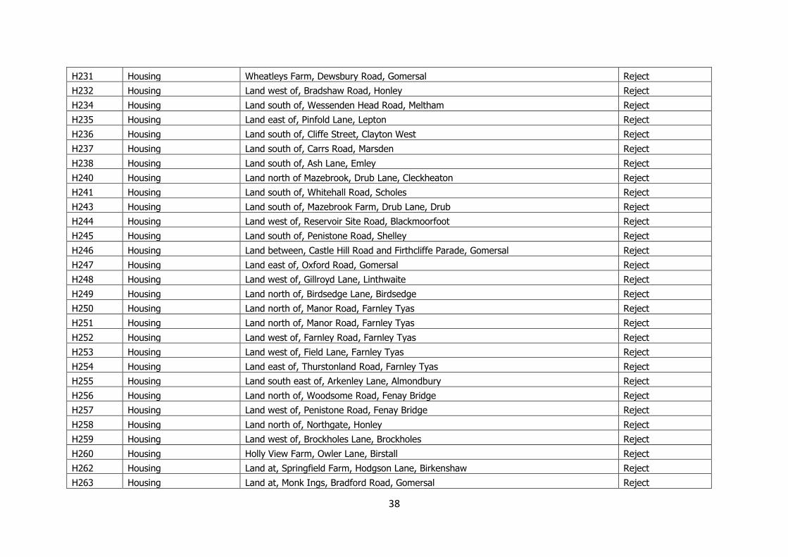
H231 Housing Wheatleys Farm, Dewsbury Road, Gomersal Reject
H232 Housing Land west of, Bradshaw Road, Honley Reject
H234 Housing Land south of, Wessenden Head Road, Meltham Reject
H235 Housing Land east of, Pinfold Lane, Lepton Reject
H236 Housing Land south of, Cliffe Street, Clayton West Reject
H237 Housing Land south of, Carrs Road, Marsden Reject
H238 Housing Land south of, Ash Lane, Emley Reject
H240 Housing Land north of Mazebrook, Drub Lane, Cleckheaton Reject
H241 Housing Land south of, Whitehall Road, Scholes Reject
H243 Housing Land south of, Mazebrook Farm, Drub Lane, Drub Reject
H244 Housing Land west of, Reservoir Site Road, Blackmoorfoot Reject
H245 Housing Land south of, Penistone Road, Shelley Reject
H246 Housing Land between, Castle Hill Road and Firthcliffe Parade, Gomersal Reject
H247 Housing Land east of, Oxford Road, Gomersal Reject
H248 Housing Land west of, Gillroyd Lane, Linthwaite Reject
H249 Housing Land north of, Birdsedge Lane, Birdsedge Reject
H250 Housing Land north of, Manor Road, Farnley Tyas Reject
H251 Housing Land north of, Manor Road, Farnley Tyas Reject
H252 Housing Land west of, Farnley Road, Farnley Tyas Reject
H253 Housing Land west of, Field Lane, Farnley Tyas Reject
H254 Housing Land east of, Thurstonland Road, Farnley Tyas Reject
H255 Housing Land south east of, Arkenley Lane, Almondbury Reject
H256 Housing Land north of, Woodsome Road, Fenay Bridge Reject
H257 Housing Land west of, Penistone Road, Fenay Bridge Reject
H258 Housing Land north of, Northgate, Honley Reject
H259 Housing Land west of, Brockholes Lane, Brockholes Reject
H260 Housing Holly View Farm, Owler Lane, Birstall Reject
H262 Housing Land at, Springfield Farm, Hodgson Lane, Birkenshaw Reject
H263 Housing Land at, Monk Ings, Bradford Road, Gomersal Reject
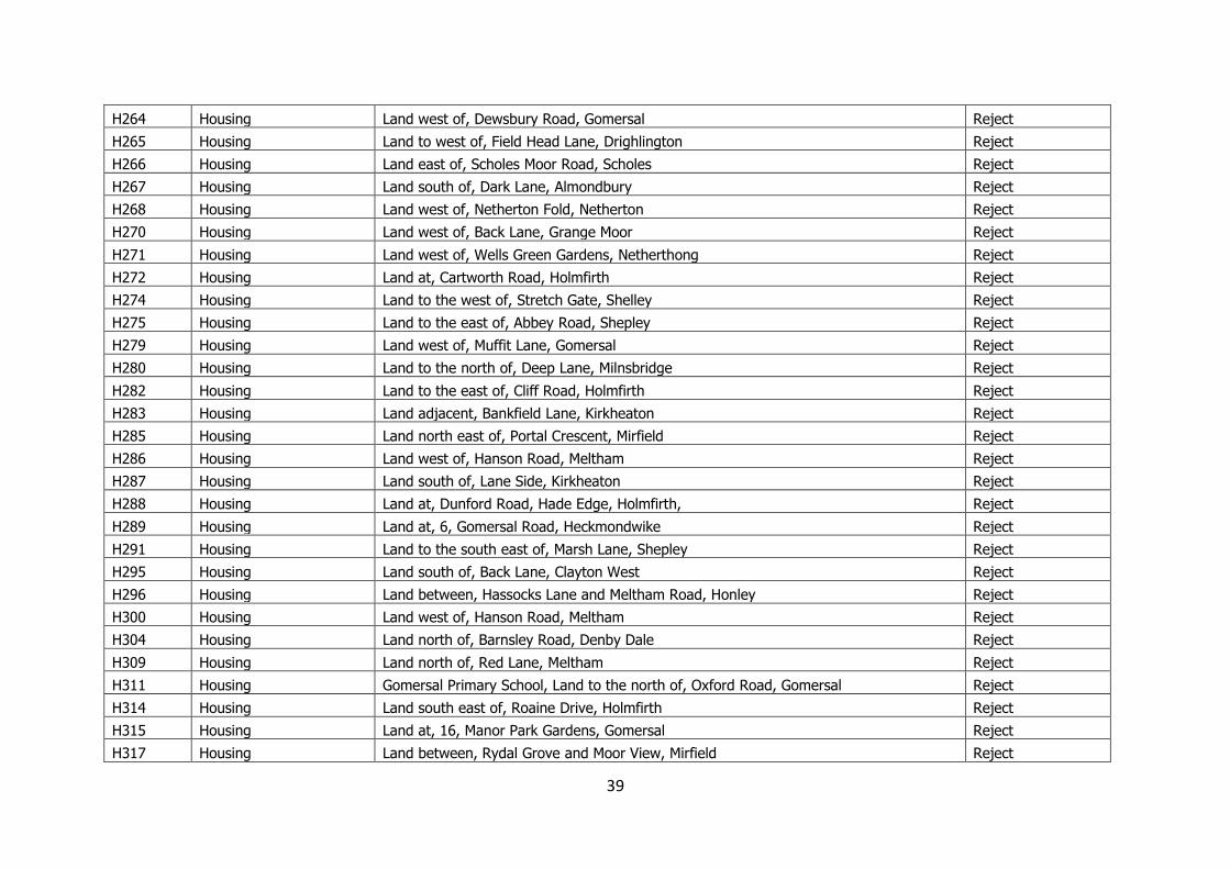
39
H264 Housing Land west of, Dewsbury Road, Gomersal Reject
H265 Housing Land to west of, Field Head Lane, Drighlington Reject
H266 Housing Land east of, Scholes Moor Road, Scholes Reject
H267 Housing Land south of, Dark Lane, Almondbury Reject
H268 Housing Land west of, Netherton Fold, Netherton Reject
H270 Housing Land west of, Back Lane, Grange Moor Reject
H271 Housing Land west of, Wells Green Gardens, Netherthong Reject
H272 Housing Land at, Cartworth Road, Holmfirth Reject
H274 Housing Land to the west of, Stretch Gate, Shelley Reject
H275 Housing Land to the east of, Abbey Road, Shepley Reject
H279 Housing Land west of, Muffit Lane, Gomersal Reject
H280 Housing Land to the north of, Deep Lane, Milnsbridge Reject
H282 Housing Land to the east of, Cliff Road, Holmfirth Reject
H283 Housing Land adjacent, Bankfield Lane, Kirkheaton Reject
H285 Housing Land north east of, Portal Crescent, Mirfield Reject
H286 Housing Land west of, Hanson Road, Meltham Reject
H287 Housing Land south of, Lane Side, Kirkheaton Reject
H288 Housing Land at, Dunford Road, Hade Edge, Holmfirth, Reject
H289 Housing Land at, 6, Gomersal Road, Heckmondwike Reject
H291 Housing Land to the south east of, Marsh Lane, Shepley Reject
H295 Housing Land south of, Back Lane, Clayton West Reject
H296 Housing Land between, Hassocks Lane and Meltham Road, Honley Reject
H300 Housing Land west of, Hanson Road, Meltham Reject
H304 Housing Land north of, Barnsley Road, Denby Dale Reject
H309 Housing Land north of, Red Lane, Meltham Reject
H311 Housing Gomersal Primary School, Land to the north of, Oxford Road, Gomersal Reject
H314 Housing Land south east of, Roaine Drive, Holmfirth Reject
H315 Housing Land at, 16, Manor Park Gardens, Gomersal Reject
H317 Housing Land between, Rydal Grove and Moor View, Mirfield Reject
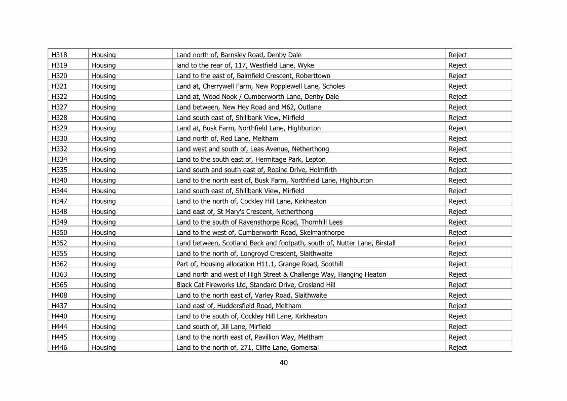
40
H318 Housing Land north of, Barnsley Road, Denby Dale Reject
H319 Housing land to the rear of, 117, Westfield Lane, Wyke Reject
H320 Housing Land to the east of, Balmfield Crescent, Roberttown Reject
H321 Housing Land at, Cherrywell Farm, New Popplewell Lane, Scholes Reject
H322 Housing Land at, Wood Nook / Cumberworth Lane, Denby Dale Reject
H327 Housing Land between, New Hey Road and M62, Outlane Reject
H328 Housing Land south east of, Shillbank View, Mirfield Reject
H329 Housing Land at, Busk Farm, Northfield Lane, Highburton Reject
H330 Housing Land north of, Red Lane, Meltham Reject
H332 Housing Land west and south of, Leas Avenue, Netherthong Reject
H334 Housing Land to the south east of, Hermitage Park, Lepton Reject
H335 Housing Land south and south east of, Roaine Drive, Holmfirth Reject
H340 Housing Land to the north east of, Busk Farm, Northfield Lane, Highburton Reject
H344 Housing Land south east of, Shillbank View, Mirfield Reject
H347 Housing Land to the north of, Cockley Hill Lane, Kirkheaton Reject
H348 Housing Land east of, St Mary's Crescent, Netherthong Reject
H349 Housing Land to the south of Ravensthorpe Road, Thornhill Lees Reject
H350 Housing Land to the west of, Cumberworth Road, Skelmanthorpe Reject
H352 Housing Land between, Scotland Beck and footpath, south of, Nutter Lane, Birstall Reject
H355 Housing Land to the north of, Longroyd Crescent, Slaithwaite Reject
H362 Housing Part of, Housing allocation H11.1, Grange Road, Soothill Reject
H363 Housing Land north and west of High Street & Challenge Way, Hanging Heaton Reject
H365 Housing Black Cat Fireworks Ltd, Standard Drive, Crosland Hill Reject
H408 Housing Land to the north east of, Varley Road, Slaithwaite Reject
H437 Housing Land east of, Huddersfield Road, Meltham Reject
H440 Housing Land to the south of, Cockley Hill Lane, Kirkheaton Reject
H444 Housing Land south of, Jill Lane, Mirfield Reject
H445 Housing Land to the north east of, Pavillion Way, Meltham Reject
H446 Housing Land to the north of, 271, Cliffe Lane, Gomersal Reject
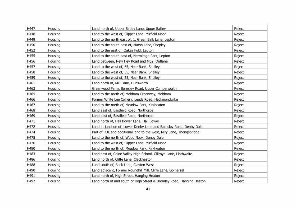
41
H447 Housing Land north of, Upper Batley Lane, Upper Batley Reject
H448 Housing Land to the west of, Slipper Lane, Mirfield Moor Reject
H449 Housing Land to the north east of, 1, Green Balk Lane, Lepton Reject
H450 Housing Land to the south east of, Marsh Lane, Shepley Reject
H452 Housing Land to the east of, Oakes Fold, Lepton Reject
H455 Housing Land to the south east of, Hermitage Park, Lepton Reject
H456 Housing Land between, New Hey Road and M62, Outlane Reject
H457 Housing Land to the west of, 55, Near Bank, Shelley Reject
H458 Housing Land to the west of, 55, Near Bank, Shelley Reject
H459 Housing Land to the west of, 55, Near Bank, Shelley Reject
H461 Housing Land north of, Mill Lane, Hunsworth Reject
H463 Housing Greenwood Farm, Barnsley Road, Upper Cumberworth Reject
H465 Housing Land to the north of, Meltham Greenway, Meltham Reject
H466 Housing Former White Lee Colliery, Leeds Road, Heckmondwike Reject
H467 Housing Land to the north of, Meadow Park, Kirkheaton Reject
H468 Housing Land east of, Eastfield Road, Northorpe Reject
H469 Housing Land east of, Eastfield Road, Northorpe Reject
H471 Housing Land north of, Hall Bower Lane, Hall Bower Reject
H472 Housing Land at junction of, Lower Denby Lane and Barnsley Road, Denby Dale Reject
H474 Housing Part of POL and additional land to the west, Miry Lane, Thongsbridge Reject
H475 Housing Land to the north of, Wood Nook, Denby Dale Reject
H476 Housing Land to the west of, Slipper Lane, Mirfield Moor Reject
H480 Housing Land to the north of, Meadow Park, Kirkheaton Reject
H483 Housing Land east of, Colne Valley High School, Gillroyd Lane, Linthwaite Reject
H486 Housing Land north of, Cliffe Lane, Cleckheaton Reject
H488 Housing Land south of, Back Lane, Clayton West Reject
H490 Housing Land adjacent, Former Roundhill Mill, Cliffe Lane, Gomersal Reject
H491 Housing Land north of, High Street, Hanging Heaton Reject
H492 Housing Land north of and south of High Street & Bromley Road, Hanging Heaton Reject
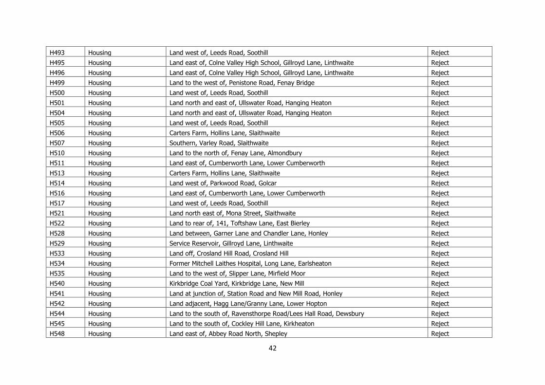
42
H493 Housing Land west of, Leeds Road, Soothill Reject
H495 Housing Land east of, Colne Valley High School, Gillroyd Lane, Linthwaite Reject
H496 Housing Land east of, Colne Valley High School, Gillroyd Lane, Linthwaite Reject
H499 Housing Land to the west of, Penistone Road, Fenay Bridge Reject
H500 Housing Land west of, Leeds Road, Soothill Reject
H501 Housing Land north and east of, Ullswater Road, Hanging Heaton Reject
H504 Housing Land north and east of, Ullswater Road, Hanging Heaton Reject
H505 Housing Land west of, Leeds Road, Soothill Reject
H506 Housing Carters Farm, Hollins Lane, Slaithwaite Reject
H507 Housing Southern, Varley Road, Slaithwaite Reject
H510 Housing Land to the north of, Fenay Lane, Almondbury Reject
H511 Housing Land east of, Cumberworth Lane, Lower Cumberworth Reject
H513 Housing Carters Farm, Hollins Lane, Slaithwaite Reject
H514 Housing Land west of, Parkwood Road, Golcar Reject
H516 Housing Land east of, Cumberworth Lane, Lower Cumberworth Reject
H517 Housing Land west of, Leeds Road, Soothill Reject
H521 Housing Land north east of, Mona Street, Slaithwaite Reject
H522 Housing Land to rear of, 141, Toftshaw Lane, East Bierley Reject
H528 Housing Land between, Garner Lane and Chandler Lane, Honley Reject
H529 Housing Service Reservoir, Gillroyd Lane, Linthwaite Reject
H533 Housing Land off, Crosland Hill Road, Crosland Hill Reject
H534 Housing Former Mitchell Laithes Hospital, Long Lane, Earlsheaton Reject
H535 Housing Land to the west of, Slipper Lane, Mirfield Moor Reject
H540 Housing Kirkbridge Coal Yard, Kirkbridge Lane, New Mill Reject
H541 Housing Land at junction of, Station Road and New Mill Road, Honley Reject
H542 Housing Land adjacent, Hagg Lane/Granny Lane, Lower Hopton Reject
H544 Housing Land to the south of, Ravensthorpe Road/Lees Hall Road, Dewsbury Reject
H545 Housing Land to the south of, Cockley Hill Lane, Kirkheaton Reject
H548 Housing Land east of, Abbey Road North, Shepley Reject
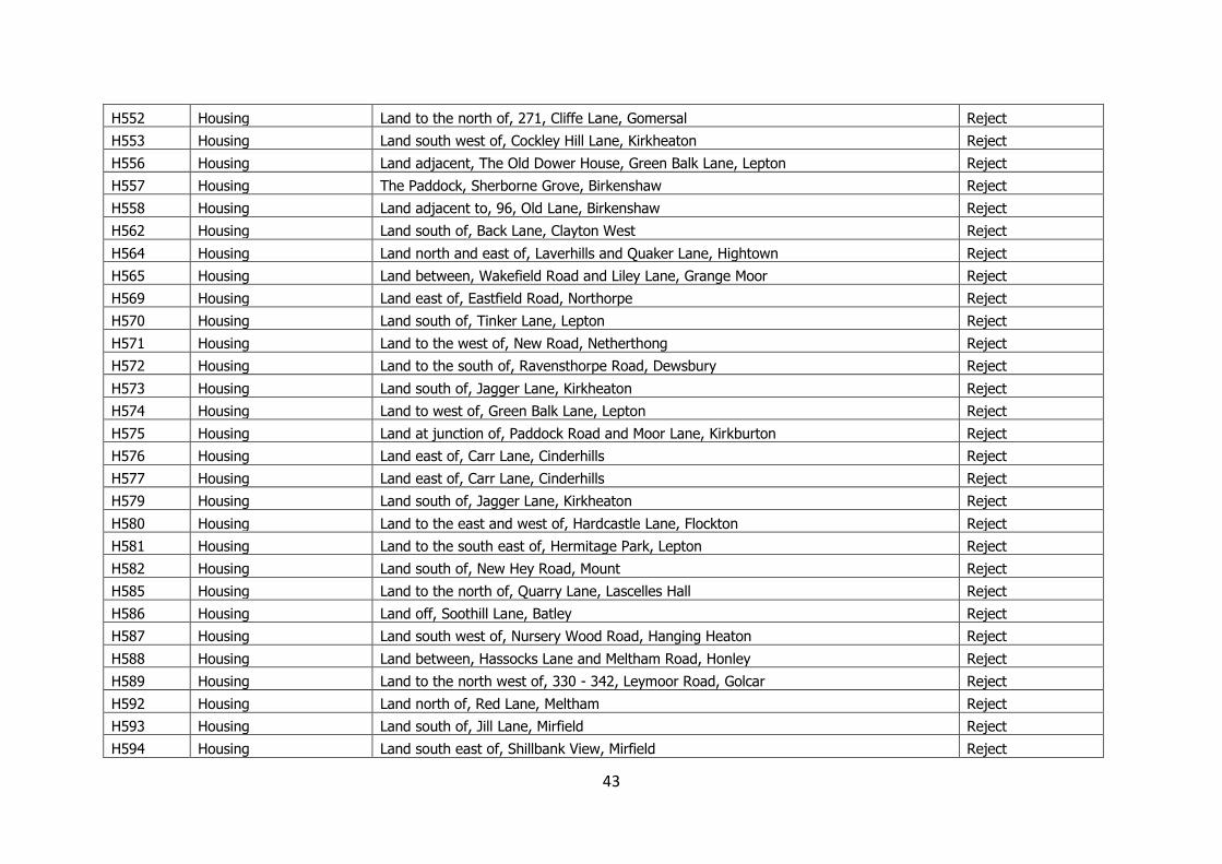
43
H552 Housing Land to the north of, 271, Cliffe Lane, Gomersal Reject
H553 Housing Land south west of, Cockley Hill Lane, Kirkheaton Reject
H556 Housing Land adjacent, The Old Dower House, Green Balk Lane, Lepton Reject
H557 Housing The Paddock, Sherborne Grove, Birkenshaw Reject
H558 Housing Land adjacent to, 96, Old Lane, Birkenshaw Reject
H562 Housing Land south of, Back Lane, Clayton West Reject
H564 Housing Land north and east of, Laverhills and Quaker Lane, Hightown Reject
H565 Housing Land between, Wakefield Road and Liley Lane, Grange Moor Reject
H569 Housing Land east of, Eastfield Road, Northorpe Reject
H570 Housing Land south of, Tinker Lane, Lepton Reject
H571 Housing Land to the west of, New Road, Netherthong Reject
H572 Housing Land to the south of, Ravensthorpe Road, Dewsbury Reject
H573 Housing Land south of, Jagger Lane, Kirkheaton Reject
H574 Housing Land to west of, Green Balk Lane, Lepton Reject
H575 Housing Land at junction of, Paddock Road and Moor Lane, Kirkburton Reject
H576 Housing Land east of, Carr Lane, Cinderhills Reject
H577 Housing Land east of, Carr Lane, Cinderhills Reject
H579 Housing Land south of, Jagger Lane, Kirkheaton Reject
H580 Housing Land to the east and west of, Hardcastle Lane, Flockton Reject
H581 Housing Land to the south east of, Hermitage Park, Lepton Reject
H582 Housing Land south of, New Hey Road, Mount Reject
H585 Housing Land to the north of, Quarry Lane, Lascelles Hall Reject
H586 Housing Land off, Soothill Lane, Batley Reject
H587 Housing Land south west of, Nursery Wood Road, Hanging Heaton Reject
H588 Housing Land between, Hassocks Lane and Meltham Road, Honley Reject
H589 Housing Land to the north west of, 330 - 342, Leymoor Road, Golcar Reject
H592 Housing Land north of, Red Lane, Meltham Reject
H593 Housing Land south of, Jill Lane, Mirfield Reject
H594 Housing Land south east of, Shillbank View, Mirfield Reject
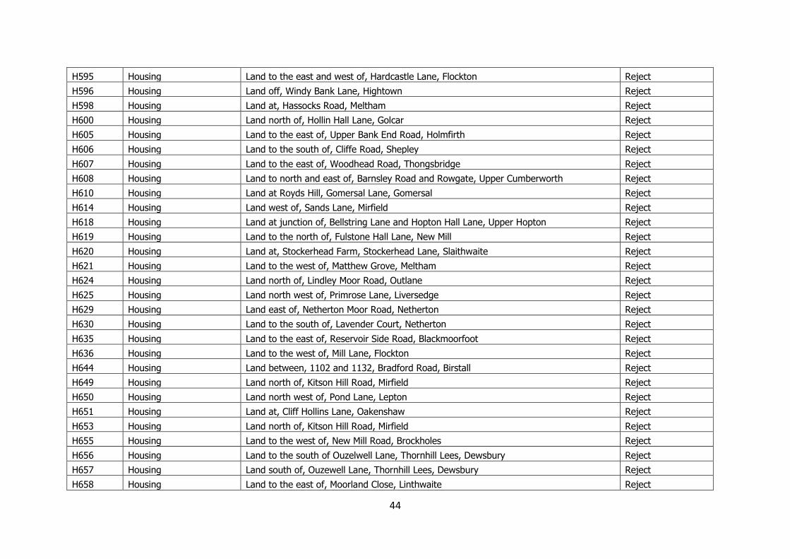
44
H595 Housing Land to the east and west of, Hardcastle Lane, Flockton Reject
H596 Housing Land off, Windy Bank Lane, Hightown Reject
H598 Housing Land at, Hassocks Road, Meltham Reject
H600 Housing Land north of, Hollin Hall Lane, Golcar Reject
H605 Housing Land to the east of, Upper Bank End Road, Holmfirth Reject
H606 Housing Land to the south of, Cliffe Road, Shepley Reject
H607 Housing Land to the east of, Woodhead Road, Thongsbridge Reject
H608 Housing Land to north and east of, Barnsley Road and Rowgate, Upper Cumberworth Reject
H610 Housing Land at Royds Hill, Gomersal Lane, Gomersal Reject
H614 Housing Land west of, Sands Lane, Mirfield Reject
H618 Housing Land at junction of, Bellstring Lane and Hopton Hall Lane, Upper Hopton Reject
H619 Housing Land to the north of, Fulstone Hall Lane, New Mill Reject
H620 Housing Land at, Stockerhead Farm, Stockerhead Lane, Slaithwaite Reject
H621 Housing Land to the west of, Matthew Grove, Meltham Reject
H624 Housing Land north of, Lindley Moor Road, Outlane Reject
H625 Housing Land north west of, Primrose Lane, Liversedge Reject
H629 Housing Land east of, Netherton Moor Road, Netherton Reject
H630 Housing Land to the south of, Lavender Court, Netherton Reject
H635 Housing Land to the east of, Reservoir Side Road, Blackmoorfoot Reject
H636 Housing Land to the west of, Mill Lane, Flockton Reject
H644 Housing Land between, 1102 and 1132, Bradford Road, Birstall Reject
H649 Housing Land north of, Kitson Hill Road, Mirfield Reject
H650 Housing Land north west of, Pond Lane, Lepton Reject
H651 Housing Land at, Cliff Hollins Lane, Oakenshaw Reject
H653 Housing Land north of, Kitson Hill Road, Mirfield Reject
H655 Housing Land to the west of, New Mill Road, Brockholes Reject
H656 Housing Land to the south of Ouzelwell Lane, Thornhill Lees, Dewsbury Reject
H657 Housing Land south of, Ouzewell Lane, Thornhill Lees, Dewsbury Reject
H658 Housing Land to the east of, Moorland Close, Linthwaite Reject
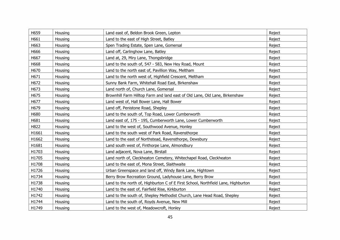
45
H659 Housing Land east of, Beldon Brook Green, Lepton Reject
H661 Housing Land to the east of High Street, Batley Reject
H663 Housing Spen Trading Estate, Spen Lane, Gomersal Reject
H666 Housing Land off, Carlinghow Lane, Batley Reject
H667 Housing Land at, 29, Miry Lane, Thongsbridge Reject
H668 Housing Land to the south of, 547 - 583, New Hey Road, Mount Reject
H670 Housing Land to the north east of, Pavillion Way, Meltham Reject
H671 Housing Land to the north west of, Highfield Crescent, Meltham Reject
H672 Housing Sunny Bank Farm, Whitehall Road East, Birkenshaw Reject
H673 Housing Land north of, Church Lane, Gomersal Reject
H675 Housing Brownhill Farm Hilltop Farm and land east of Old Lane, Old Lane, Birkenshaw Reject
H677 Housing Land west of, Hall Bower Lane, Hall Bower Reject
H679 Housing Land off, Penistone Road, Shepley Reject
H680 Housing Land to the south of, Top Road, Lower Cumberworth Reject
H681 Housing Land east of, 175 - 195, Cumberworth Lane, Lower Cumberworth Reject
H822 Housing Land to the west of, Southwood Avenue, Honley Reject
H1661 Housing Land to the south west of Park Road, Ravensthorpe Reject
H1662 Housing Land to the east of Northstead, Ravensthorpe, Dewsbury Reject
H1681 Housing Land south west of, Finthorpe Lane, Almondbury Reject
H1703 Housing Land adjacent, Nova Lane, Birstall Reject
H1705 Housing Land north of, Cleckheaton Cemetery, Whitechapel Road, Cleckheaton Reject
H1708 Housing Land to the east of, Mona Street, Slaithwaite Reject
H1726 Housing Urban Greenspace and land off, Windy Bank Lane, Hightown Reject
H1734 Housing Berry Brow Recreation Ground, Ladyhouse Lane, Berry Brow Reject
H1738 Housing Land to the north of, Highburton C of E First School, Northfield Lane, Highburton Reject
H1740 Housing Land to the east of, Fairfield Rise, Kirkburton Reject
H1742 Housing Land to the south of, Shepley Methodist Church, Lane Head Road, Shepley Reject
H1744 Housing Land to the south of, Royds Avenue, New Mill Reject
H1749 Housing Land to the west of, Meadowcroft, Honley Reject
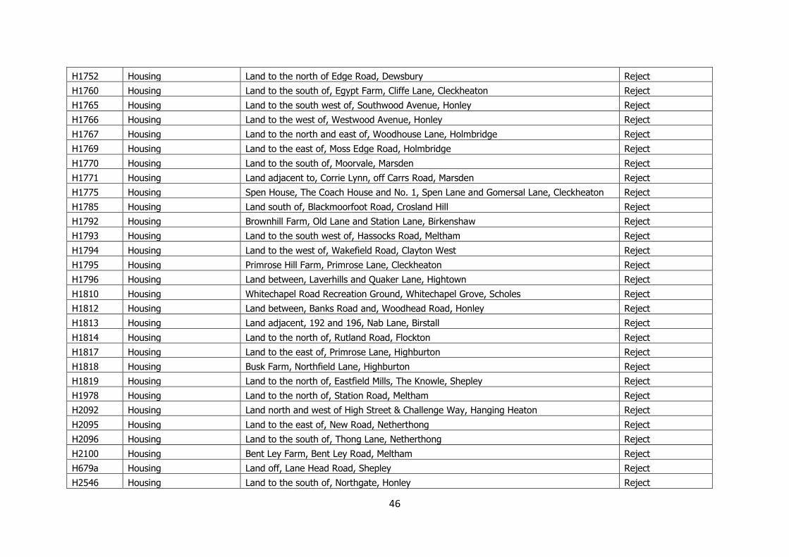
46
H1752 Housing Land to the north of Edge Road, Dewsbury Reject
H1760 Housing Land to the south of, Egypt Farm, Cliffe Lane, Cleckheaton Reject
H1765 Housing Land to the south west of, Southwood Avenue, Honley Reject
H1766 Housing Land to the west of, Westwood Avenue, Honley Reject
H1767 Housing Land to the north and east of, Woodhouse Lane, Holmbridge Reject
H1769 Housing Land to the east of, Moss Edge Road, Holmbridge Reject
H1770 Housing Land to the south of, Moorvale, Marsden Reject
H1771 Housing Land adjacent to, Corrie Lynn, off Carrs Road, Marsden Reject
H1775 Housing Spen House, The Coach House and No. 1, Spen Lane and Gomersal Lane, Cleckheaton Reject
H1785 Housing Land south of, Blackmoorfoot Road, Crosland Hill Reject
H1792 Housing Brownhill Farm, Old Lane and Station Lane, Birkenshaw Reject
H1793 Housing Land to the south west of, Hassocks Road, Meltham Reject
H1794 Housing Land to the west of, Wakefield Road, Clayton West Reject
H1795 Housing Primrose Hill Farm, Primrose Lane, Cleckheaton Reject
H1796 Housing Land between, Laverhills and Quaker Lane, Hightown Reject
H1810 Housing Whitechapel Road Recreation Ground, Whitechapel Grove, Scholes Reject
H1812 Housing Land between, Banks Road and, Woodhead Road, Honley Reject
H1813 Housing Land adjacent, 192 and 196, Nab Lane, Birstall Reject
H1814 Housing Land to the north of, Rutland Road, Flockton Reject
H1817 Housing Land to the east of, Primrose Lane, Highburton Reject
H1818 Housing Busk Farm, Northfield Lane, Highburton Reject
H1819 Housing Land to the north of, Eastfield Mills, The Knowle, Shepley Reject
H1978 Housing Land to the north of, Station Road, Meltham Reject
H2092 Housing Land north and west of High Street & Challenge Way, Hanging Heaton Reject
H2095 Housing Land to the east of, New Road, Netherthong Reject
H2096 Housing Land to the south of, Thong Lane, Netherthong Reject
H2100 Housing Bent Ley Farm, Bent Ley Road, Meltham Reject
H679a Housing Land off, Lane Head Road, Shepley Reject
H2546 Housing Land to the south of, Northgate, Honley Reject
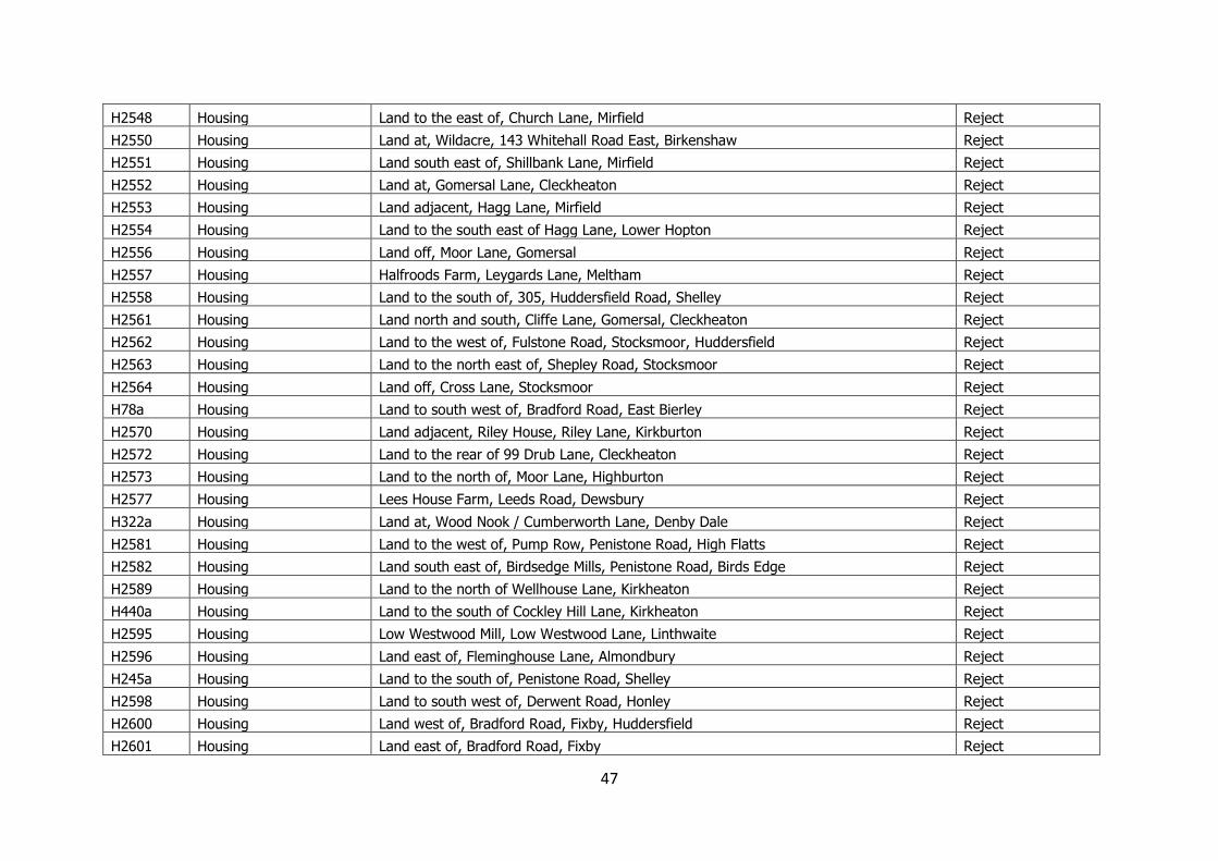
47
H2548 Housing Land to the east of, Church Lane, Mirfield Reject
H2550 Housing Land at, Wildacre, 143 Whitehall Road East, Birkenshaw Reject
H2551 Housing Land south east of, Shillbank Lane, Mirfield Reject
H2552 Housing Land at, Gomersal Lane, Cleckheaton Reject
H2553 Housing Land adjacent, Hagg Lane, Mirfield Reject
H2554 Housing Land to the south east of Hagg Lane, Lower Hopton Reject
H2556 Housing Land off, Moor Lane, Gomersal Reject
H2557 Housing Halfroods Farm, Leygards Lane, Meltham Reject
H2558 Housing Land to the south of, 305, Huddersfield Road, Shelley Reject
H2561 Housing Land north and south, Cliffe Lane, Gomersal, Cleckheaton Reject
H2562 Housing Land to the west of, Fulstone Road, Stocksmoor, Huddersfield Reject
H2563 Housing Land to the north east of, Shepley Road, Stocksmoor Reject
H2564 Housing Land off, Cross Lane, Stocksmoor Reject
H78a Housing Land to south west of, Bradford Road, East Bierley Reject
H2570 Housing Land adjacent, Riley House, Riley Lane, Kirkburton Reject
H2572 Housing Land to the rear of 99 Drub Lane, Cleckheaton Reject
H2573 Housing Land to the north of, Moor Lane, Highburton Reject
H2577 Housing Lees House Farm, Leeds Road, Dewsbury Reject
H322a Housing Land at, Wood Nook / Cumberworth Lane, Denby Dale Reject
H2581 Housing Land to the west of, Pump Row, Penistone Road, High Flatts Reject
H2582 Housing Land south east of, Birdsedge Mills, Penistone Road, Birds Edge Reject
H2589 Housing Land to the north of Wellhouse Lane, Kirkheaton Reject
H440a Housing Land to the south of Cockley Hill Lane, Kirkheaton Reject
H2595 Housing Low Westwood Mill, Low Westwood Lane, Linthwaite Reject
H2596 Housing Land east of, Fleminghouse Lane, Almondbury Reject
H245a Housing Land to the south of, Penistone Road, Shelley Reject
H2598 Housing Land to south west of, Derwent Road, Honley Reject
H2600 Housing Land west of, Bradford Road, Fixby, Huddersfield Reject
H2601 Housing Land east of, Bradford Road, Fixby Reject
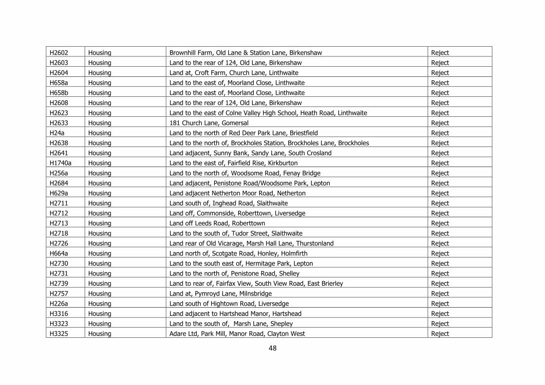
48
H2602 Housing Brownhill Farm, Old Lane & Station Lane, Birkenshaw Reject
H2603 Housing Land to the rear of 124, Old Lane, Birkenshaw Reject
H2604 Housing Land at, Croft Farm, Church Lane, Linthwaite Reject
H658a Housing Land to the east of, Moorland Close, Linthwaite Reject
H658b Housing Land to the east of, Moorland Close, Linthwaite Reject
H2608 Housing Land to the rear of 124, Old Lane, Birkenshaw Reject
H2623 Housing Land to the east of Colne Valley High School, Heath Road, Linthwaite Reject
H2633 Housing 181 Church Lane, Gomersal Reject
H24a Housing Land to the north of Red Deer Park Lane, Briestfield Reject
H2638 Housing Land to the north of, Brockholes Station, Brockholes Lane, Brockholes Reject
H2641 Housing Land adjacent, Sunny Bank, Sandy Lane, South Crosland Reject
H1740a Housing Land to the east of, Fairfield Rise, Kirkburton Reject
H256a Housing Land to the north of, Woodsome Road, Fenay Bridge Reject
H2684 Housing Land adjacent, Penistone Road/Woodsome Park, Lepton Reject
H629a Housing Land adjacent Netherton Moor Road, Netherton Reject
H2711 Housing Land south of, Inghead Road, Slaithwaite Reject
H2712 Housing Land off, Commonside, Roberttown, Liversedge Reject
H2713 Housing Land off Leeds Road, Roberttown Reject
H2718 Housing Land to the south of, Tudor Street, Slaithwaite Reject
H2726 Housing Land rear of Old Vicarage, Marsh Hall Lane, Thurstonland Reject
H664a Housing Land north of, Scotgate Road, Honley, Holmfirth Reject
H2730 Housing Land to the south east of, Hermitage Park, Lepton Reject
H2731 Housing Land to the north of, Penistone Road, Shelley Reject
H2739 Housing Land to rear of, Fairfax View, South View Road, East Brierley Reject
H2757 Housing Land at, Pymroyd Lane, Milnsbridge Reject
H226a Housing Land south of Hightown Road, Liversedge Reject
H3316 Housing Land adjacent to Hartshead Manor, Hartshead Reject
H3323 Housing Land to the south of, Marsh Lane, Shepley Reject
H3325 Housing Adare Ltd, Park Mill, Manor Road, Clayton West Reject

49
H29a Housing Land north of, Pilling Lane, Skelmanthorpe Reject
H3380 Housing Land to the north of Hopton Lane, Upper Hopton Reject
H3381 Housing Land to the north of Black Lane, Blackmoorfoot Reject
H3383 Housing Land north of Wakefield Road, Lepton Reject
H3386 Housing Bridge Mills, New Road, Holmfirth Reject
H3389 Housing Land west of Cockley Lane, Kirkheaton Reject
MX1902 Mixed Use Land east of, Field Head Lane, Drighlington Reject
MX1904 Mixed Use Grimescar Valley, Grimescar Road, Birchencliffe Reject
MX1908 Mixed Use Land between, Nutter Lane and Bradford Road, Gomersal Reject
MX1909 Mixed Use Land to the north east of, Meltham Mills, Meltham Mills Road, Meltham Reject
MX1912 Mixed Use Dobroyd Mills, Hepworth Road, Jackson Bridge Reject
MX1914 Mixed Use Merchant Fields, Hunsworth Lane, Cleckheaton Reject
MX1918 Mixed Use Former North Bierley WWTW, Cliff Hollins Lane, Cleckheaton Reject
MX1921 Mixed Use Land to the south of, Egypt Farm, Cliff Lane, Cleckheaton Reject
MX1925 Mixed Use Land off, Soothill Lane, Batley Reject
MX1927 Mixed Use Land north of, Whitehall Road, Scholes Reject
MX2617 Mixed Use Land to the north of, Kitson Hill Road, Mirfield Reject
MX2681 Mixed Use Land to the west of Penistone Road, Fenay Bridge Reject
MX3371 Mixed Use Land adjacent Penistone Road, Fenay Bridge Reject
SL2280 Safeguarded Land Land to the west of, Westroyd Avenue, Hunsworth Reject
SL2283 Safeguarded Land Land off, Station Road, Skelmanthorpe Reject
SL2286 Safeguarded Land Land at junction of, Paddock Road and Moor Lane, Kirkburton Reject
SL2289 Safeguarded Land Land to the south of, Cockley Hill Lane, Kirkheaton Reject
SL2291 Safeguarded Land Land north of, Holme House, Oxford Road, Gomersal Reject
SL2293 Safeguarded Land Land adjacent to, 96, Old Lane, Birkenshaw Reject
SL2294 Safeguarded Land Land adjacent Brick Hill Farm, Oddfellows Street, Scholes Reject
SL2296 Safeguarded Land Land to the east and west of, Hardcastle Lane, Flockton Reject
SL2299 Safeguarded Land Land south west of, Soureby Cross Way, East Bierley Reject
SL2300 Safeguarded Land Land at junction of, Paris and Sandy Gate, Scholes Reject
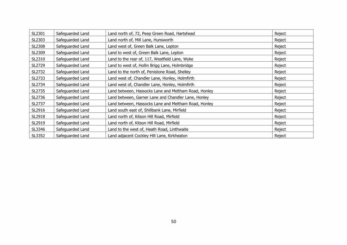
50
SL2301 Safeguarded Land Land north of, 72, Peep Green Road, Hartshead Reject
SL2303 Safeguarded Land Land north of, Mill Lane, Hunsworth Reject
SL2308 Safeguarded Land Land west of, Green Balk Lane, Lepton Reject
SL2309 Safeguarded Land Land to west of, Green Balk Lane, Lepton Reject
SL2310 Safeguarded Land Land to the rear of, 117, Westfield Lane, Wyke Reject
SL2729 Safeguarded Land Land to west of, Hollin Brigg Lane, Holmbridge Reject
SL2732 Safeguarded Land Land to the north of, Penistone Road, Shelley Reject
SL2733 Safeguarded Land Land west of, Chandler Lane, Honley, Holmfirth Reject
SL2734 Safeguarded Land Land west of, Chandler Lane, Honley, Holmfirth Reject
SL2735 Safeguarded Land Land between, Hassocks Lane and Meltham Road, Honley Reject
SL2736 Safeguarded Land Land between, Garner Lane and Chandler Lane, Honley Reject
SL2737 Safeguarded Land Land between, Hassocks Lane and Meltham Road, Honley Reject
SL2916 Safeguarded Land Land south east of, Shillbank Lane, Mirfield Reject
SL2918 Safeguarded Land Land north of, Kitson Hill Road, Mirfield Reject
SL2919 Safeguarded Land Land north of, Kitson Hill Road, Mirfield Reject
SL3346 Safeguarded Land Land to the west of, Heath Road, Linthwaite Reject
SL3352 Safeguarded Land Land adjacent Cockley Hill Lane, Kirkheaton Reject