green shorestm for coastal...
TRANSCRIPT
GREEN SHORESTM FOR COASTAL DEVELOPMENT CREDITS AND RATINGS GUIDE
for waterfront properties

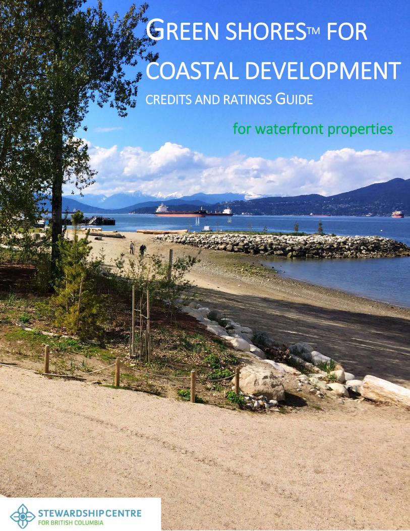
For more information regarding Green Shores contact: DG Blair Executive Director Stewardship Centre for BC [email protected] Tel. 866.456.7222 Cover photo: Jericho Beach Restoration, a Green Shores Gold rated project, City of Vancouver. Photo credit: Nick Page Credit: Nick Page

Green Shores for Coastal Development: Credits and Ratings Guide
GREEN SHORES FOR COASTAL DEVELOPMENT
CREDITS AND RATINGS GUIDE
A REFERENCE TO HELP MINIMIZE THE ENVIRONMENTAL IMPACT OF WATERFRONT PROPERTIES AND DEVELOPMENT
©2010
UPDATED JANUARY 2016
www.greenshores.ca
GREEN SHORES IS A PROGRAM OF THE STEWARDSHIP CENTRE FOR BRITISH COLUMBIA
www.stewardshipcentrebc.ca

Green Shores for Coastal Development: Credits and Ratings Guide
Acknowledgements The Green Shores for Coastal Development Credits and Ratings Guide was originally prepared by the Green Shores Technical Working Group in 2010. Drafts were reviewed by the Green Shores Advisory Committee and a Peer Review Workgroup. In addition, a number of skilled professionals volunteered their time to participate in the pilot project assessments. The contributions by members of these groups (Appendix 1) to the development of the rating credits are gratefully acknowledged. Major funding for the development of the Green Shores for Coastal Development Credits and Ratings Guide was provided by the Real Estate Foundation of British Columbia, the BC Hydro Bridge Coastal Restoration Program, the BC Ministry of Environment, and Environment Canada. The Guide was updated in January 2016.
Disclaimer The Stewardship Centre for BC provides the information in this guide and its website www.greenshores.ca for educational purposes only. Material contained within it carries no guarantee of any kind, express or implied. SCBC does not endorse, recommend or control linked websites and accepts no responsibility whatsoever for their contents or views. The Stewardship Centre for BC accepts no liability or blame for damages to any person or business entity because of using this guide, associated website, its information or any website linked to it. This guide is meant to complement but not replace other existing resources, including the BC Ministry of Environment’s Develop with Care series and Best Management Practices (BMPs). Following the guide also does not replace the need for due diligence regarding the legislative and regulatory requirements for completion of shoreline projects.

Green Shores for Coastal Development: Credits and Ratings Guide
Contents Introduction ............................................................................ 1
Overview of Green Shores for Coastal Development ............................................................................................. 3
Green Shores for Coastal Development Rating System .......................................................................................... 4
Using the Rating Process ........................................................................................................................................ 5
Prerequisites, Credits and Ratings Overview .......................................................................................................... 7
Prerequisites .......................................................................... 8
Prerequisite 1: Siting of Permanent Structures ...................................................................................................... 8
Prerequisite 2: Conservation of Critical or Sensitive Habitats .............................................................................. 13
Prerequisite 3: Riparian Zone Protection ............................................................................................................ 15
Prerequisite 4: Conservation of Coastal Sediment Processes.............................................................................. 18
Prerequisite 5: On-Site Environmental Management Plan .................................................................................. 22
Credits .................................................................................. 25
Credit 1: Site Design with Conservation of Shorezone ......................................................................................... 25
Credit 2: Shore Friendly Public Access.................................................................................................................. 28
Credit 3: Re-Development of Contaminated Sites ............................................................................................... 30
Credit 4: Climate Change Adaption Plan .............................................................................................................. 33
Credit 5: Rehabilitation of Coastal Habitats ......................................................................................................... 37
Credit 6: Rehabilitation of Coastal Sediment Processes ....................................................................................... 40
Credit 7: Enhanced Riparian Zone Protection ...................................................................................................... 42
Credit 8: Light Pollution Reduction ...................................................................................................................... 44
Credit 9: Integrated Stormwater Planning and Design ......................................................................................... 47
Credit 10: Innovation ........................................................................................................................................... 52
Credit 11: Outreach and Public Education ........................................................................................................... 54
Definitions ............................................................................. 56
Advisory Committees ............................................................ 61

Green Shores for Coastal Development: Credits and Ratings Guide
People love to live, work and play in places where water and land meet. Shorelines provide work, recreation, living space, mild climates and wonderful views.
Unfortunately, many of the natural features that make shorelines so attractive are often the casualties of human activities. Native trees, shrubs, and grasses are cleared to make way for development and views. Bulkheads, docks and piers displace beaches and alter natural shoreline processes. Loss of shoreline vegetation allows contaminants to flow directly into the water. Prime wildlife habitats disappear, taking with them birds, mammals, fish, and beneficial insects.
The good news is that people are finding new strategies for protecting waterfront properties while also protecting and restoring habitats. Instead of concrete and sheetpile, these practices use a combination of plantings, gravel and sand, logs, stones, setbacks, and slope modification to protect against shoreline erosion and provide access while respecting the ecological attributes of the shoreline.
(Adapted from Green Shorelines, City of Seattle, 2011).
Photo credit: The Watershed Company. Design by Paul R. Broadhurst + Associates

INTRODUCTION
Green Shores for Coastal Development: Credits and Ratings Guide 1
Introduction
Green Shores encourages the sustainable use of shoreline ecosystems through the development and delivery of educational workshops, seminars, and educational resources and research. A Green Shores approach restores the ecological features and functions of shoreline systems. Green Shores also provides associated science-based tools and best practices for shoreline property owners and managers to minimize the impacts of new developments and restore shoreline ecosystem function of previously developed sites. Green Shores is based on four guiding principles:
• Preserve the integrity or connectivity of shoreline processes • Maintain or enhance habitat diversity and function • Minimize or reduce pollutants to the environment • Reduce cumulative impacts to the shoreline environment.
Green Shores was developed in response to interest by local planners, civic officials, land developers, and property owners who participated in workshops on Coastal Shore Stewardship: A Guide for Planners, Builders and Developers (2002). Green Shores is a trademarked program of the Stewardship Centre for British Columbia (SCBC).
The key components of Green Shores in British Columbia are:
• Education and Outreach – To expand awareness of Green Shores by providing to educational workshops and training seminars to property owners, local governments, the professional community, and the general public
• Green Shores Resources and Technical Information – Based on current research, these resources can be used to protect and conserve shoreline ecosystem values and services. Key resources include:
• Credits and Ratings Guides – Based on the four Green Shores principles, these guides are intended for use by designers, builders, contractors, and property owners/managers to guide Green Shores project design and assess design performance. Green Shores for Coastal Development (GSCD) Credits and Ratings Guide is for municipal parks, mixed-use residential, and

INTRODUCTION
Green Shores for Coastal Development: Credits and Ratings Guide 2
institutional shoreline properties, while Green Shores for Homes (GSH) Credits and Ratings Guide is intended for use by residential shoreline property owners and the professionals and contractors that assist them to complete their shoreline projects. Both guides focus on positive steps to reduce the impact of development on shoreline ecosystems and to help restore natural shorelines.
• Research reports and resources relating to Green Shores on topics such as shoreline management, best practices, local government shoreline policies and bylaws, case studies, and project reports.
In addition, the Stewardship Centre offers support to BC communities and local governments to facilitate implementation of Green Shores through its Green Shores for Local Government Group and to youth, through its Green Shores for Youth initiative. Both primarily focus on education and outreach to these audiences.
What are the benefits of the Green Shores approach? It…
• beautifies shorelines, adding native vegetation, wildlife habitat, and access to waterfront activities
• makes shorelines more secure against erosion and flooding using alternatives to costly sea walls while still addressing owners’ concerns
• provides a wide range of benefits similar to LEED for Homes, BuiltGreen, and Sustainable Sites programs.
The Green Shores for Coastal Development Guide will be useful to: • Property owners, developers, real estate industry – Organizations with a vested financial
interest in shore property, associated buildings and their operation. • Professionals and professional associations – Professionals and firms offering
professional services such as building and landscape architecture, coastal and geotechnical engineering, surveying, biological assessment, etc.
• Construction contractors – Firms and industry associations involved in construction of shore structures such as pile driving, shore protection, dredging, etc.
• Non-profit organizations – Organizations with a special interest in coastal environment and management issues.
• Planners, regulators and elected officials – Federal, provincial and local governments involved in planning, policy, and management of marine coastal areas.
Green Shores for Coastal Development encourages adoption of sustainability principles in the design process. Sustainable design requires:
• A strong vision and commitment on the part of the client and the project team from the start of the project.

INTRODUCTION
Green Shores for Coastal Development: Credits and Ratings Guide 3
• The use of life-cycle thinking which brings the team to consider the impacts of the project over its entire life cycle. This goes beyond first cost consideration and provides clarity on the actual long-term cost of a project.
• The use of whole-system thinking which recognizes the interactions and relationships between different components and systems within a project and ensures that they work together.
• An in-depth understanding of the ecology of the site in order to take advantage of landscape features during early project planning. Taking advantage of the site’s natural features not only reduces local impact but can also avoid costs of development and infrastructure otherwise needed to overcome environmental challenges.
Overview of Green Shores for Coastal Development Green Shores for Coastal Development was developed following a review of existing Green Building rating and certification tools1. This review provided a summary of the fundamental characteristics of rating tools and made recommendations as to the preferred approach for developing a Green Shores rating and assessment tool. In general, this approach follows that taken by the LEED™ Green Building rating system. Some Green Shores for Coastal Development credits are adapted from LEED Canada and the US Green Building Council (LEED for Neighbourhoods or LEED-ND) and others have been developed specifically to meet Green Shores principles. Developments Addressed by Green Shores for Coastal Development Green Shores for Coastal Development applies to residential and commercial waterfront development projects as well as to infrastructure development (such as public walkways) and shore protection works in public spaces (parks and recreational areas). Green Shores for Coastal Development is not intended to be applied to major industrial developments that require a high degree of shore infrastructure (ports facilities, industrial plants) or commercial facilities or developments such as marinas, with a large requirement for ‘in water’ activities such as dredging. The Green Shores program recognizes that single residential waterfront lots account for the majority of shore developments. These properties present specific challenges for a rating system, particularly with respect to the degree of effort and cost required to address the rating credits through a rating process. Green Shores for Homes (2015) has been developed for this purpose. A Voluntary Program Like most other environmental ratings/certification programs (certified wood, certified seafood, Green Buildings) Green Shores is voluntary and relies on support from industry, government,
1 A Review of Existing Assessment and Rating Tools and their Applicability to the GREEN SHORES Project by Martine Desbois and Associates, available from SCBC

INTRODUCTION
Green Shores for Coastal Development: Credits and Ratings Guide 4
non-government organizations, building owners and the building sector for their adoption. By being voluntary the system is able to incorporate leadership and innovation into its framework, permitting development professionals concerned with the environmental issues to differentiate themselves in the market place. These volunteer programs can become mandatory when their application is required by a particular jurisdiction, generally local (municipal or regional) governments. Often a mandatory requirement relates to new buildings and developments tied to land purchase or lease, or a condition of rezoning or a master development agreement. On a broader scale, requirements within these voluntary programs may be incorporated into Development Permit Area or local zoning regulations. Geographic Scope Green Shores for Coastal Development was developed and piloted in British Columbia on the west coast of North America. As such it is directly applicable to coastal areas throughout the Pacific Northwest of the United States and Alaska (the Cascadia region). However, the rating system, with additional region-specific piloting, is intended to be applicable to all coastal systems and could be national or international in scope.
Green Shores for Coastal Development Rating System
The Green Shores for Coastal Development rating system has been developed as a tool for waterfront property owners and managers to develop their properties in a shore friendly way that meet the Green Shores guiding principles. After meeting certain prerequisites, a shoreline project can be assessed using a series of credits for which a project can achieve points. All of the prerequisites, credits and maximum points available are provided in the descriptions that follow. Prerequisites, Credits and Points The Green Shores for Coastal Development rating system is built on a similar format to the LEED rating system, in that a rating is obtained by meeting all prerequisite criteria as well as a specific number of optional credits. Prerequisites are essential criteria for a Green Shores for Coastal Development rating that can be generally accepted environmental best management practices as well as critical issues not addressed in current best management practices for shore developments. A number of credits are also required for a Green Shores rating. Documented achievement of the requirements outlined for a credit is rewarded by a number of points that contribute to the overall rating for the project. Application for any specific credit is at the discretion of the project’s design and construction team. A Green Shores for Coastal Development rating is achieved by meeting all prerequisites and an additional number of credit points. A shoreline project may achieve one of three rating levels:

INTRODUCTION
Green Shores for Coastal Development: Credits and Ratings Guide 5
Bronze, Silver, or Gold. The rating levels are set as a total of all applicable points rather than a percent of applicable points. Credit Format Each credit is presented according to the following format:
• Intent – Defines the objective or intent of the credit from a Green Shores perspective. • Context – The environmental or social context for the credit. • Requirement – The measure that must be achieved to meet the objective of the credit.
If a particular standard applies, it is specified in this section. • Submittal – The information required for submission by the applicant in order to assess
whether the objective of the credit has been met. • Strategies and Technologies – Provides ideas and suggestions for project design and
specifications. • Resources – Key websites and documents, both general and regional, that can assist the
design team in meeting the credit requirements.
Using the Rating Process
Figure 1. Steps in the GSCD rating process Stage One: Enrollment The applicants can enroll on-line at www.greenshores.ca or by contacting SCBC. It is recommended to enroll early in the project design and development process to maximize the benefits of using the Credits and Ratings Guide and to establish contact with the Stewardship Centre. Enrollment of a project provides access to essential information and tools such as the GSCD Template that outline the requirements for submittals for the finalized project. Enrollment will also provide access to technical assistance in the interpretation of the credits, if necessary. Stage Two: Project Design and Construction Once the project is enrolled, the project team will typically proceed with the design and construction of the project. Early on the team should become familiar with the requirements of each prerequisite and credit and ensure that, as the project progresses, all the documentation required for submittal, using the GSCD Template, is collected. Attempting to complete the
Stage OneEnroll and Initiate
Stage TwoProject Design and
Construction
Stage ThreeVerify and recieve
Award

INTRODUCTION
Green Shores for Coastal Development: Credits and Ratings Guide 6
submittals post-construction can be difficult and expensive, requiring duplication of effort. This can result in incomplete submittals that delay ratings and could result in a lower rating. The GSCD Template (prepared in spreadsheet format), which is received as part of the enrollment package, guide the team in the compilation of the appropriate documentation for each prerequisite and applicable credits. However, the Green Shores for Coastal Development Guide provides the most accurate information on the submittal requirements. If there is a conflict between the Guide and the GSCD Template, the Guide prevails. The GSCD Template contain a List of Submittals outlining the complete list of required documents, including an overall project narrative.
Stage Three: Verify and Receive Award Once the project is completed and all the documentation has been compiled, the applicant can submit their completed GSCD Template to the SCBC. The Stewardship Centre will then assign a GSCD verifier team to review the GSCD Template and documentation, including a site visit. Upon the completion of the verification process, qualifying projects will receive a Green Shores rating and Award.

INTRODUCTION
Green Shores for Coastal Development: Credits and Ratings Guide 7
Prerequisites, Credits and Ratings Overview
The five GSCD prerequisites, eleven optional credits (with 282 possible credit points), and three ratings levels are summarized below.
Prerequisites Prerequisite 1 Siting of Permanent Structures Prerequisite 2 Conservation of Critical or Sensitive Habitats Prerequisite 3 Riparian Zone Protection Prerequisite 4 Conservation of Coastal Sediment Processes Prerequisite 5 On-Site Environmental Management Plan
Credits Credit 1 Site Design with Conservation of Shore Zone 1 to 3 points Credit 2 Shore Friendly Public Access 1 point Credit 3 Re-Development of Contaminated Sites 1 point Credit 4 Climate Change Adaptation Plan 1 to 5 points Credit 5 Rehabilitation of Coastal Habitats 0.5 to 4 points Credit 6 Rehabilitation of Coastal Sediment Processes 2 to 3 points Credit 7 Enhanced Riparian Zone Protection 0.5 to 4 points Credit 8 Light Pollution Reduction 1 point Credit 9 Integrated Stormwater Planning and Design 1 to 4 points Credit 10 Innovation 1 to 2 points Credit 11 Outreach and Public Education 1 point
2 A total of 28 rather than 29 credit points are available as only 1 point can be obtained for bulkhead or riprap removal under Credits 5 and 6
Ratings Levels GSCD Bronze All Prerequisites plus 5 points GSCD Silver All Prerequisites plus 10 points GSCD Gold All Prerequisites plus 15 points

Prerequisites
Green Shores for Coastal Development: Credits and Ratings Guide 8
Prerequisites Prerequisite 1: Siting of Permanent Structures
Intent 1. To reduce the need for shore protection by locating permanent structures upland of areas
subject to erosion or flooding over the building design life. 2. To reduce the risk of property damage over the building design life. 3. To encourage the assembly of critical site-specific information to guide development design. Context Poorly sited buildings and structures are at highest risk from episodic events such as flooding from storm surges, severe wave damage, extreme rainfall and related shoreline impacts such as erosion. Keeping permanent structures out of high-risk areas is the most practical and cost effective way of reducing the threat to lives and property from floods and erosion. Appropriate siting of buildings and other permanent structures requires an understanding of the physical processes at the development site and reduces present and future costly requirements for habitat compensation and shore protection works. A comprehensive understanding of the physical processes affecting a site also eliminates conservatism in design, which can result in both unnecessary structures (such as hardening of the shoreline) and unnecessary costs. The Option B requirement recognizes that the requirements set out in Option A are not applicable to all situations and provides criteria for locating permanent structures on an appropriate shore site (e.g., non-eroding shores) in a manner that minimizes the need for future protective works. Applies to Any new permanent structure situated within the development property, although consideration of coastal processes beyond the property boundaries (both in the foreshore and along adjacent properties) will have to be considered when addressing Option B requirements and submittals.
Interpretive Note This prerequisite applies to the siting of new permanent structures on the development site. Pre-existing structures that do not meet this requirement are considered non-conforming. However, a non-conforming site will still have to meet the requirements of other prerequisites, in particular Prerequisite 4, which provides for compensatory measures if an adequate setback cannot be achieved due to existing site conditions.

Prerequisite 1: Siting of Permanent Structures REQUIRED
Green Shores for Coastal Development: Credits and Ratings Guide 9
Interpretive Notes As public bike trails and walkways are highly desirable elements of waterfront development, these structures do not have to meet the setback condition (15m) outlined above. However public walkways and bikeways shall meet the vertical elevation standard stipulated below and the requirements of other prerequisites (including the riparian and coastal sediment process prerequisites). To meet this credit a survey of the present natural boundary will be required. The natural boundary is best determined by surveying to a known vertical datum the elevation of the lower limit of terrestrial vegetation (see definition). This elevation may vary over the site depending on the degree and aspect of wave exposure and site geology. The upper limit of aquatic vegetation should not be used to determine the natural boundary as storm surge or wave run-up often extends beyond the limit of aquatic vegetation except in very protected areas. Salt marsh vegetation (e.g., Salicornia sp., Distichlis sp. Carex sp.) is often wetted at high tide and is considered aquatic vegetation for the purpose of determining the natural boundary. On altered shores (seawalls and riprap) there is often no terrestrial vegetation seaward of the crest of the altered shoreline and it is difficult to determine the elevation of the natural boundary. In this case it may be necessary to extrapolate the elevation of the natural boundary from an adjacent site, or use a physical indication such as higher high water large tide (HHWLT) plus an allowance for storm surge and wave influence effect, which will vary with site exposure.
Requirements – Option A3 Setbacks 1. Permanent structures should be setback a minimum of 15m (horizontal distance) from the
present natural boundary (as opposed to the registered land title boundary, which may be based on a pre-existing natural boundary).
2. Permanent structures located at the top of coastal banks or bluffs, where the toe of the bluff is exposed to coastal erosion, should be setback a horizontal distance equal to 3 times the vertical height of the bluff as measured horizontally from the toe of the bluff in addition to the 15m setback outlined in 1 above.
3. The setback must also meet or exceed setbacks established locally or regionally for environmental protection, hazard prevention or other reasons if these levels are more stringent than stipulated above.
3 Adapted from siting guidelines for waterfront in the Strait of Georgia (Section 3.5 of the BC Flood Hazard Areas Land Use Management Guidelines) http://www.env.gov.bc.ca/wsd/public_safety/flood/landuse_mgmt.html. The coastal flood hazard guidelines are subject to revision due to increasing concerns about sea level rise.

Prerequisite 1: Siting of Permanent Structures REQUIRED
Green Shores for Coastal Development: Credits and Ratings Guide 10
Vertical Elevation– The occupied portions of a building structure shall be at least 2m above the highest elevation of the present (as opposed to historically surveyed) natural boundary, and shall also meet or exceed flood construction levels established locally or regionally if these levels are more stringent than stipulated above. Requirements – Option B The Option A setback requirement may be modified for building sites of suitable substrate and exposure. Under Option B, the modified siting of any permanent structure must allow for 50 years (or the design life of the project, whichever is greater) of natural erosion, without the need for future shore protection to protect permanent structures. Submittals – Option A 1. The Letter Template signed by a Qualified Coastal Professional. 2. A scaled annotated site plan showing:
• Site elevations and contours relative to a defined vertical datum (geodetic or chart datum), at a minimum 1m contour interval.
• The surveyed natural boundary and its elevations, relative to a defined vertical datum (geodetic or chart datum).
• The local or regional flood construction level, if greater than 2m above the natural boundary.
• The location and elevations of all occupied portions of permanent structures relative to the vertical datum of the site plan.
• The location and elevation of a toe of bank or bluff subject to coastal erosion, relative to the vertical datum of the site plan.
Submittals – Option B 1. The Letter Template signed by a Qualified Coastal Professional. 2. A scaled annotated site plan showing the information required under the Option A submittal
above, as well as topographic or hydrographic survey of the intertidal portion of the development property shore, and, if appropriate, hydrographic survey or largest available scale hydrographic chart offshore of the project site.
3. Design basis report stating the proposed setback, justifying why it differs from the Option A requirements. This report should address the following: • Project or service life of the development. • Shoreline geology or character and, where appropriate, depth to bedrock or firm strata
and size distribution of surface sediments. • Description of the coastal processes on and adjacent to the project property within the
limits of the affected coastal reach.
Interpretive Notes On green field sites or previously developed sites without infill - infilling of low lying areas is not an acceptable approach to meet the vertical elevation prerequisite. On previously developed sites with existing infill - additional fill can be added to the building site to meet the vertical elevation requirement.

Prerequisite 1: Siting of Permanent Structures REQUIRED
Green Shores for Coastal Development: Credits and Ratings Guide 11
• Estimated mean rate of erosion or accretion for the site shoreline. • Tidal range and expected storm surge at site. • Chosen allowance for long-term sea level change for the project. • Exposure of site to winds and waves. • Exposure of the site to tidal or wave driven currents. • Design wave climate at the low tide waterline and the present natural boundary for the
expected water levels. • Wave run up elevation for design conditions, along the property shoreline and at any
proposed altered shoreline. • Any other appropriate documentation supporting the proposed setback. • Sources for listed information.
Strategies and Technologies The following considerations and planning activities will help address the credit requirement.
• Topographic and hydrographic survey data are key to addressing the submittal requirements, particularly for Option B. Use the relevant portion of the largest available scale hydrographic chart offshore of the project site. In most cases it will be necessary to conduct a site survey to determine site elevations throughout the intertidal frontage and over the site to define the elevation of significant features and the natural boundary relative to an accepted reference datum such as hydrographic chart datum or geodetic datum.
• Verify existing legal boundaries and determine if erosion or accretion has occurred since the original or pre-existing legal survey.
• Consider seasonal and annual changes to shore features within the shore section in which the development property is located. A beach shore can change considerably during the winter storm season. Site building structures to account for these changes. Consult air photos of the site taken at different times throughout the year and over longer intervals that span decadal-scale cycles of episodic natural phenomena.
• Assess coastal features and processes and identify potentially sensitive sites such as bluffs, beaches and spits.
• Look for pre-existing features such as culverts, creeks, landslide deposits or other hazards that could potentially effect building siting.
• Incorporate site features into building siting, for example locating a permanent structure on a section of bedrock shore will reduce the need for costly shore protection and may allow the building to be located closer to the water.
• Use existing regional models to account for sea level rise and other climate change effects over the life of the project.

Prerequisite 1: Siting of Permanent Structures REQUIRED
Green Shores for Coastal Development: Credits and Ratings Guide 12
Resources Projected Sea Level Changes for British Columbia in the 21st century http://www.env.gov.bc.ca/epd/climate/pdfs/sea-level-changes-08.pdf
Sea Level Rise in the Coastal Waters of Washington State http://www.cses.washington.edu/db/pdf/moteetalslr579.pdf
Coastal Stewardship Guide for Planners, Builders and Developers http://dev.stewardshipcanada.ca/sc_bc/stew_series/NSCbc_stewseries.asp
Tips for Waterfront Property Buyers http://www.ecy.wa.gov/programs/sea/pugetsound/buyer/buyer.html
Access Near Aquatic Areas – A guide to sensitive planning and design (freshwater focus, by approaches and principles and applicable to marine shores. http://www.dfo-mpo.gc.ca/Library/213410.pdf
Sustainable Urban Landscapes – Site Design Manual http://www.sustainable-communities.agsci.ubc.ca/projects/DesignManual.html
Sustainable Building Design; Principles, Practices and Systems http://www.gvrd.bc.ca/buildsmart/pdfs/sustainablebuilddesprinciplespracticessys4.pdf
The Shore Primer – A Cottager’s Guide to a Healthy Waterfront http://www.livingbywater.ca/building.html
Guides for Coastal Property Owners http://www.ecy.wa.gov/programs/sea/pubs/93-31/chap1.html
Puget Sound Shorelines – Buildings Guide http://www.ecy.wa.gov/programs/sea/pugetsound/building/building.html http://www.ecy.wa.gov/programs/sea/pugetsound/building/homesite.html
Environmental Planning and Development at the Site Level http://wlapwww.gov.bc.ca/wld/documents/bmp/urban_ebmp/EBMP PDF 3.pdf

Prerequisite 2: Conservation of Critical or Sensitive Habitats
REQUIRED
Green Shores for Coastal Development: Credits and Ratings Guide 13
Prerequisite 2: Conservation of Critical or Sensitive Habitats
Intent To conserve existing critical or sensitive natural features and functions of shore zone and protect endangered and threatened species and their habitats. Context Sensitive and critical fish and wildlife habitat are generally protected by federal (Fisheries Act, Species at Risk Act), provincial (Riparian Area Regulation) and local (Official Community Plans, Development Permit Areas) government regulations. The objective of this credit is to ensure that these regulatory conditions are met at the development site level. Applies to The shore zone of the project area, including the marine riparian zone and foreshore. Requirements No net loss of critical or sensitive habitats located within the development shore zone. Any losses of existing critical or sensitive habitats must be offset with on-site compensation works. Off-site compensation for losses to existing critical or sensitive habitats cannot be used to meet this credit requirement. Submittals 1. The Letter Template signed by a Qualified Environmental Professional. 2. A scaled map of the shore zone (riparian, intertidal and subtidal zones if ‘in water’ works are
planned) showing the location and extent of all critical or sensitive habitats in the shore zone in relation to the planned development works.
3. A copy of the approvals or permits from the appropriate regulatory agency or agencies demonstrating that no critical or sensitive habitats will be impacted or a copy of the approved on-site compensation plan demonstrating no net loss for any critical or sensitive habitats that will be impacted. The compensation plan must include an approved monitoring program to assess and confirm the functionality of any compensation habitats.
Strategies and Technologies
• Avoid fill or protective works in intertidal or subtidal areas with critical or sensitive habitats; work with designs that use valued habitat features as part of the shore protection or landscape design.
Interpretive Note Compensation options are limited to on-site areas as Green Shores principles require conservation of proper functioning conditions at the development site level as well as continuity of physical and biological processes and function within the reach of shore where the development is located.

Prerequisite 2: Conservation of Critical or Sensitive Habitats
REQUIRED
Green Shores for Coastal Development: Credits and Ratings Guide 14
• Site pile structures (docks, walkways, piers), over areas with little or no vegetation, use grated surfaces on pile structures placed over vegetative features to allow light penetration.
• Avoid landscaping or siting structures and roads in areas of marsh or wetlands. • Restore areas impacted by the development/construction activities, or previously
degraded areas (if needing to compensate for unavoidable habitat losses) to meet or exceed no net loss.
Resources Canadian Species at Risk Act (SARA) website http://www.dfo-mpo.gc.ca/species-especes/home_e.asp
BC Conservation Data Centre http://www.env.gov.bc.ca/cdc/
BC Sensitive Ecosystems Inventory http://www.env.gov.bc.ca/sei/
Fisheries and Oceans Operational Statements for Shore Zone Development http://www-heb.pac.dfo-mpo.gc.ca/decisionsupport/os/operational_statements_e.htm
Shoreline Structures – Environmental Design; A Guide for Structures along Estuaries and Large Rivers http://dev.stewardshipcanada.ca/sc_bc/stew_series/pdf/ShorelineStructures.pdf
Access Near Aquatic Areas – A guide to sensitive planning and design (freshwater focus with approaches and principles applicable to marine shores. http://www.dfo-mpo.gc.ca/Library/213410.pdf

Prerequisite 3: Riparian Zone Protection REQUIRED
Green Shores for Coastal Development: Credits and Ratings Guide 15
Prerequisite 3: Riparian Zone Protection Intent To conserve and restore marine riparian vegetation and its associated ecological services such as habitat for shore species, organic input to the nearshore environment, buffering the shore from erosional processes and retention of stormwater runoff. Context Shore developments can result in a reduction of coastal riparian features and functions shown in the accompanying figure, often by clearing and levelling naturally vegetated and sloped shores in order to improve water views or create desired features such as grassy level lawns. These ‘improvements’ can have deleterious impacts on site drainage, bird nesting and roosting habitat, bank stability, shading of intertidal areas by tree canopies and reduction of important organic inputs to foreshore areas. The nature of the riparian zone will vary with rainfall patterns, wind exposure, soil and shore type. For more protected shores the natural riparian zone often consists of a mixture of trees with overhanging canopy and salt tolerant shrubs. More exposed shores will have a higher proportion of shrubs and less overhanging tree canopy. Grasses and small shrubs dominate in the dryer, rocky shore areas that are common in the southern Gulf Islands. A preserved or restored riparian zone should, as best as practical, reflect the natural conditions of the site and region.
From J.Brennan and H. Culverwell. 2004. Marine Riparian: an assessment of riparian functions in marine ecosystems. Washington Sea Grant

Prerequisite 3: Riparian Zone Protection REQUIRED
Green Shores for Coastal Development: Credits and Ratings Guide 16
Interpretive Note The plan should include an explanation of how the conservation and restoration measures will maintain or enhance riparian features, function and conditions (e.g., will provide habitat of what type, stabilize loose sediments, improve water filtration, etc.).
Applies to The riparian zone or shore zone of the project area immediately above the natural boundary. Requirement 1. Conserve and/or restore (where needed) a riparian zone for a minimum width of 5m,
measured as a horizontal distance landward of the natural boundary, over a minimum of 50% of shore length. All development activities must occur outside the designated area.
2. Where restoration is needed, it would be conducted according to a re-vegetation plan/design prepared by a registered professional biologist or certified landscape architect with experience in coastal riparian ecosystems.
3. The plant species and design must match the natural system that is characteristic of the project site; e.g., exposed sandy, rocky, protected estuary, mudflats, coastal forest, etc. Native (indigenous) species are preferred but site-appropriate, non-native species may be used where this is advantageous (e.g., relative hardiness) or when native species cannot be acquired.
Submittals 1. The appropriate Letter Template signed by a Qualified Environmental Professional. 2. A scaled site plan showing the location and typical species composition of the existing
riparian zone indicating the portion (minimum 50% of shore length) to be conserved and, as needed, restored. The plan, or an accompanying report, should indicate how the conserved riparian zone will be protected during the construction phase (fencing, signage, etc.).
3. If planting is required, a vegetation or re-vegetation plan for the conserved and/or restored riparian zone prepared by a Qualified Environmental Professional, including selected plant species and landscape design.
4. Pre- and post-construction photographic documentation of the designated riparian zone.
Interpretive Notes While they may physically overlap on the project site, the protected riparian zone is independent of the setback for structures required under Prerequisite 1 (i.e., the riparian zone may form part of the setback). The riparian buffer may incorporate some stormwater infiltration design objectives to meet Credit 9. However, the stormwater infiltration structures must not compromise the other ecological services provided by a riparian buffer. The riparian prerequisite does not include intertidal re-vegetation, which is addressed in Credit 5.

Prerequisite 3: Riparian Zone Protection REQUIRED
Green Shores for Coastal Development: Credits and Ratings Guide 17
Strategies and Technologies • Avoid extending mowed lawn areas to the top of shore embankments. • Use natural riparian vegetation as landscape features. • Incorporate vegetation and natural resources into shore protection works, such as
anchored logs and riparian plantings on relatively protected shorelines. Resources Marine Riparian Vegetation Communities in Puget Sound http://www.pugetsoundnearshore.org/technical_reports.htm
The Shore Primer – How to Preserve Your Shore’s True Nature (freshwater focus) http://www.dfo-mpo.gc.ca/regions/CENTRAL/pub/shore-rive/page6-11_e.htm
The Living by Water Project http://www.livingbywater.ca/main.html
Shore Landscaping Tips http://www.ecy.wa.gov/programs/sea/pugetsound/building/landscape.html
Lists of Suitable Coastal Shore Riparian Vegetation http://www-heb.pac.dfo-mpo.gc.ca/publications/pdf/erosion_e.pdf http://dev.stewardshipcanada.ca/sc_bc/stew_series/pdf/ShorelineStructures.pdf (See Appendix) http://www.ecy.wa.gov/programs/sea/pugetsound/species/native.html

Prerequisite 4: Conservation of Coastal Sediment Processes
REQUIRED
Green Shores for Coastal Development: Credits and Ratings Guide 18
Prerequisite 4: Conservation of Coastal Sediment Processes Intent To ensure that shore development does not significantly alter sediment supply to the coastal environment or sediment transport within the coastal environment. Context Coastal properties are often ‘connected’ by longshore sediment transport, and alteration of sediment supply or blockage of sediment movement at the development property can cause erosion at nearby, ‘downstream’ properties. Impacts to alongshore sediment movement are usually caused by placement of structures (groynes, breakwaters) across the foreshore such that longshore sediment transport is disrupted. Erosion occurs naturally on many coastal properties, particularly coastal banks or bluffs and is an important element of the coastal sediment system because the eroded material is contributed to intertidal, subtidal and other nearshore features in the region. Developments on the upland may affect the natural supply of material to the shore. Most commonly, hardening of shores through seawall construction reduces the sediment supply to the shore zone, unless the shore is in a depositional zone. Applies to The development property (both upland and foreshore), although consideration of coastal processes beyond the property boundaries may have to be considered to meet requirements and submittals. Requirements 1. Longshore Sediment Transport
The proposed shore development must not alter the movement of sediment along the shore to such an extent that the risk of adverse impacts, including erosion, to the development site and adjacent properties is increased.
2. Shore Sediment Supply (a) Site development must be designed such that the
need for shore protection works is not required over the life of the project or a 50 year cycle of natural erosion, whichever is greater. OR
Interpretive Note Risk of adverse impacts is defined as the need for the development property or adjacent properties to install shore protection works over the design life of the project.

Prerequisite 4: Conservation of Coastal Sediment Processes
REQUIRED
Green Shores for Coastal Development: Credits and Ratings Guide 19
Interpretive Note Bedrock shores are resistant to erosion and do not contribute sediment to the coastal environment if the bedrock extends above wave washed areas. However, sediment may still pass along rocky shores as part of broader scale longshore sediment processes and could be impacted by hard structures (groynes, breakwaters) placed in the intertidal zone. If no ‘in water’ structures are planned, no impacts to coastal sediment transport are expected for rocky shores and, therefore, a sediment transport assessment is not required.
(b) If site features and development design do not allow (a) to be met, and shore protection works are required, then provide a design that will emulate natural sediment supply to the foreshore for a 50 year cycle of natural erosion or the life of the project, whichever is greater. The texture and size of the supplied material must be appropriate to the site (e.g., be similar in size and form to that which would be generated by natural erosion).
Submittals For rocky shores4 with no planned ‘in water’ structures: 1. The Letter Template signed by a Qualified
Coastal Professional stating that the site is comprised of rocky shore and that no ‘in water’ structures are planned that could impede sediment passage along the shore
For all other shore types: 1. The Letter Template signed by a Qualified
Coastal Professional stating that, over the design life of the project or 50 years, whichever is greater, the project has been designed such that the need to install shore protection works is unlikely or, if shore protection is required, the project incorporates mitigation designs to compensate for any potential impacts to natural sediment supply.
2. Coastal sediment transport assessment and mapping based on existing aerial photo interpretation, a low-tide site visit and supporting analysis showing:
• Dominant and seasonal sediment transport pathways and direction
4 Defined as more than 75% bedrock in the intertidal zone and supralittoral zone (the shore zone immediately above the high tide level, commonly kept more or less moist by waves or spray).
Interpretive Note In many cases the sediment transport mapping should encompass a larger area than the project shoreline, as coastal processes occur on a shore reach or drift cell scale. An advantage of this larger scale mapping is that such a report may be applicable to several properties within a shore reach or drift cell. Some protected sites may have insignificant coastal sediment processes. In these cases the sediment transport assessment should provide the rationale for concluding that sediment transport processes are not a significant consideration.

Prerequisite 4: Conservation of Coastal Sediment Processes
REQUIRED
Green Shores for Coastal Development: Credits and Ratings Guide 20
Interpretive Note Shore zones may be designated Development Permit Areas and any activities (protective structures, beach nourishment, etc.) may require a development permit issued by the local government. Shore protection structures or beach nourishment must not encroach beyond the existing natural boundary without provincial (use of Crown foreshore) and federal authorization (Fisheries Act and Navigable Waters Act).
on the project and adjacent properties. • Sediment sources relevant to the project property. • Sediment sinks or depositional areas that may be connected to the project property
or affected by changes to the pathways that transit the property frontage. 3. Supporting documentation including the following topics if relevant to the site:
• Pre-existing and existing stability (erosion/accretion rates) that establishes the most likely scenario for 50-years or the project life span.
• Property geology. • Expected sediment supply and transport behaviour following completion of proposed
works. • Proposed design and identification of mitigation strategies, including measures to
restore any disruption to the foreshore to the pre-existing elevation if erosion at the toe of protective structures may lower the beach elevation at the base of the structure.
• Proposed monitoring and sediment emulation plan if required.
• Where sacrificial materials are proposed, the volume, texture and form must be justified in terms of existing geology and stability calculations.
4. Any required permits or
authorizations from local, provincial or federal government agencies.
Strategies and Technologies Where erosion is of concern, consider beach berms or, if shore hardening is required, couple the protective structure with sacrificial material that is similar in composition to native site sediment to emulate the natural erosion process. This may include one or more of the following measures:
• Use a naturally sloped backshore and restore riparian vegetation. • Beach nourishment with appropriately designed beach slope and sand or gravel material
can reduce wave run-up and protect upland property. • Beach berms and anchored logs may provide sufficient shore protection in less exposed
areas. • Use buried hard material in the immediate upland as a setback ‘sea defence’, coupled
with beach nourishment or a beach berm.
Prerequisite 4: Conservation of Coastal Sediment Processes
REQUIRED
Green Shores for Coastal Development: Credits and Ratings Guide 21
• Use bioengineering techniques to stabilize and re-vegetate embankments. Shore protection structures that encroach beyond the existing natural boundary can also impact public access along the beach at high tide. In addition erosion at the toe of seawalls and riprap structures can lower the beach elevation at the base of the shore protection structure, impacting public access at higher tides. To reduce impacts to public access along the shore locate any necessary hard protection structures (seawalls or revetments) so that the entire structure is landward of the existing natural boundary and restore any disruption to the foreshore to the pre-existing elevation or higher. Resources Chapter Two - Coastal Shore Stewardship Guide http://dev.stewardshipcanada.ca/sc_bc/stew_series/NSCbc_stewseries.asp
Review of Alternative Shore Stabilization Projects in Puget Sound http://www.psat.wa.gov/Programs/shorelines/FinalPSAT9_15_06withphotos.pdf
Alternatives to Bulkheads http://www.ecy.wa.gov/programs/sea/pugetsound/building/bulkhead.html
The Tide Doesn’t Go Out Anymore http://www.southalabama.edu/cesrp/Tide.htm

Prerequisite 5: On-Sire Environmental Management Plan
REQUIRED
Green Shores for Coastal Development: Credits and Ratings Guide 22
Prerequisite 5: On-Site Environmental Management Plan
Intent Minimize impact of construction activity on coastal waters and valued and sensitive habitats and species. Context Construction-related sediment input to foreshore areas can negatively impact critical life cycle stages for fish and invertebrates (particularly egg incubation). Certain plants and filter feeding invertebrates are sensitive to increased sediment input. In addition, many contaminants are bound to sediment, so reducing sediment input also greatly reduces the risk of contaminant movement to foreshore areas. Applies to The development property and adjacent foreshore. Requirement Develop and follow an environmental management plan (EMP) specific to the project site, to multiple contract projects within a site, and/or multiple individual properties that includes the shoreline site. The EMP should include: 1. Sediment and erosion control during construction, including prevention of construction-related soil loss and reduction of sediment input to the receiving environment from construction-related run off and storm water. 2. Appropriate construction timing windows based on habitat use (e.g., fish presence, bird migration and breeding seasons, etc.). 3. Measures taken to prevent the risk of hazardous materials and contaminant spills, including oil, gas and hydraulic fluid. 4. Response plan and equipment available in the event of an accidental spill of hazardous materials. 5. Measures to prevent polluting the air with dust, smoke and other particulate matter, as applicable. 6. On site briefing and reporting requirements for environmental monitoring by a Qualified Environmental Professional. The environmental management plan should incorporate appropriate elements of the BCMOE Standards and Best Management Practices for Instream Works - Operational Best Management Practices for Stream Bank and Lakeshore Protection (http://www.env.gov.bc.ca/wld/documents/bmp/iswstdsbpsmarch2004.pdf) as well as Fisheries

Prerequisite 5: On-Sire Environmental Management Plan
REQUIRED
Green Shores for Coastal Development: Credits and Ratings Guide 23
and Oceans Canada Operational Statements (http://www-heb.pac.dfo-mpo.gc.ca/decisionsupport/os/operational_statements_e.htm) for any relevant construction activity (dock construction, beach maintenance). Submittals The applicable Letter Template signed by a Qualified Environmental Professional. A copy of the environmental management plan with documentation that the plan adheres to the referenced Best Management Practices. For constructed projects or projects under construction, copy of one or more Environmental Monitoring Reports, indicating compliance with the environmental monitoring plan.
Strategies and Technologies
• Reduce sedimentation during the construction phase by use of silt curtains and fences, sedimentation ponds, and reduction of soil runoff by riparian plantings and hydro seeding.
• Establish clearly defined construction boundaries so as to minimize disturbance and potential sediment run-off.
• Schedule work at appropriate times of year to lessen disruption to fish and fish habitat (contact local DFO office for information on construction timing windows) and bird nesting or migration periods (refer to BC’s Develop With Care manual and other provincial BMP guidelines – see resources below).
• Use staked or floating silt curtains, cofferdams, in stream weirs, or settling ponds. • Operate machinery in a manner that minimizes disturbance to the banks of the water
body and the receiving environment (machinery in clean condition, free of fluid leaks, use of vegetable based hydraulic fluids).
• Wash, refuel and service machinery and storing fuel and other materials for machinery at least 15m from the natural boundary or top of bank to prevent deleterious substances from entering the water.
• Keep an emergency spill kit on site, and ensure that project personnel (i.e., construction crew) are properly trained in its use and in spill reporting.
Resources Standards and Best Management Practices for Instream Works http://www.env.gov.bc.ca/wld/documents/bmp/iswstdsbpsmarch2004.pdf
Fisheries and Oceans Canada Operational Statements for Specific Construction Activities http://www-heb.pac.dfo-mpo.gc.ca/decisionsupport/os/operational_statements_e.htm
Slope Stabilization and Erosion Control Using Vegetation http://www.ecy.wa.gov/programs/sea/pubs/93-30/

Prerequisite 5: On-Sire Environmental Management Plan
REQUIRED
Green Shores for Coastal Development: Credits and Ratings Guide 24
Shore Property Construction http://www.ecy.wa.gov/programs/sea/pugetsound/building/construction.html
Erosion Control and Construction Management Sections of the Stream Stewardship Guide http://www.dfo-mpo.gc.ca/Library/189990.pdf
Section 3 Develop with Care: Environmental Guidelines for Urban and Rural Development in British Columbia http://www.env.gov.bc.ca/wld/documents/bmp/devwithcare2006/develop_with_care_intro.html
BC Ministry of Environment – Guidelines and Best Management Practices http://www.env.gov.bc.ca/wld/BMP/bmpintro.html

Credits
Green Shores for Coastal Development: Credits and Ratings Guide 25
Credits Credit 1: Site Design with Conservation of Shore Zone
Intent To reduce the need for shore protection structures through site design that leaves the shore zone free of development. Context The basic concept behind this credit is to designate the shore zone as ‘common area’ that buffers development from hazards associated with the shore zone while also buffering the shore zone from impacts of development. There are several potential benefits in moving development away from the shoreline:
• It reduces risks of flooding, storm surge and erosion to structural and property assets.
• It allows for preserving, restoring and/or enhancing shore zone habitats and processes.
• It can provide a community amenity – waterfront access – that is highly valued. Many people can enjoy an expanse of waterfront area rather than a few private owners on limited frontage.
• It affords the ability to locate common access points and facilities (e.g., docks, piers) in the best, lowest impact sites, avoiding the proliferation of individual facilities along the waterfront.
• Future lot owners can enjoy the water view without the higher taxes typically associated with waterfront property.
Applies to Site plans and subdivision designs affecting a shore area.
‘Clustered’ shoreline subdivision
Traditional shoreline subdivision

Credit 1: Site Design with Conservation of Shore Zone 1-3 POINTS
Green Shores for Coastal Development: Credits and Ratings Guide 26
Interpretive Note The conservation area/park may be publicly or privately owned but with the primary objective of protecting environmentally sensitive features and shoreline processes and, within those limits, provide for public access and enjoyment.
Requirements 1. Designate permanently a minimum of 75% of the
shoreline as a ‘common area’ subject to no development (other than for limited recreational use, as described below).
2. The designated area must have an average width of 7.5m or greater, measured as the horizontal distance landward of the natural boundary, with a minimum width of 3m at any given point.
Points are awarded on the following basis:
Nature of Common Area Points Typical urban or community park with pathways, dock, swimming beach, and other human-use facilities
1
Nature park with controlled access – boardwalk, viewing platform, small dock or beach, etc.
2
Conservation area with very limited public access, preservation and enhancement of native vegetation, etc.
3
Submittals 1. The applicable Letter Template signed by a Qualified Environmental Professional. 2. A site plan and report indicating:
• Location of development and shoreline common area. • Designation mechanism - e.g., dedication or conservation covenant to local government,
strata, non-government organization authorized to receive dedications or covenants, etc.
• A management plan for the shore zone area indicating environmentally sensitive areas and/or critical shore features and functions and how they will be protected.
• Type and design of public amenities – e.g., common water accesses (such as walkway, dock) instead of allowing for construction of several individual private accesses. Public access must be designed in environmentally sensitive manner – i.e., minimal footprint for designated use, avoid permanent damage or destruction to riparian vegetation, etc.

Credit 1: Site Design with Conservation of Shore Zone 1-3 POINTS
Green Shores for Coastal Development: Credits and Ratings Guide 27
Strategies and Technologies Clustering – Siting lots (in the case of a subdivision plan) or structures (in the case of a multi-use or higher density development plan) away from the shore zone to create open space – see accompanying figures. Clustering may or may not entail ‘density transfer’ or ‘density bonus’. Density transfer – This refers to locating the same number of units permitted under a given zone on a portion of the development parcel to allow the other portion to be retained as open space or some other community amenity. This can be achieved through using smaller lot sizes or higher density housing or building forms; e.g., duplex-fourplex, townhomes, patio homes, condominium, etc. instead of detached single-family housing. Density transfer may or may not require rezoning the parcel. Density bonus – Some local governments encourage or provide incentives for clustering through density bonusing – allowing additional units beyond that which would typically be allowed under zoning requirements in exchange for additional open space over and above the amount that would normally be required. Generally the additional open space cannot be land that would otherwise be undevelopable. Development agreements, covenants – A developer who dedicates the shoreline portion of a development parcel to a local government as a park or conservation area may wish to protect the interests of future landowners facing onto or over the shore area by negotiating provisions regarding amenities to serve future landowners (e.g., dock area), protection of views (e.g., limits on built facilities, height limits, view corridors) through development agreements or covenants.
Resources Thompson Nicola Regional District Lakeshore Development Guidelines 2004 http://tnrd.fileprosite.com/contentengine/launch.asp?ID=96&Action=bypass
Local Government Guide for Improving Market Housing Affordability in British Columbia 2005 http://www.housing.gov.bc.ca/housing/affordable/index.htm
Planning for housing, 2004: an overview of local government initiatives in British Columbia http://www.housing.gov.bc.ca/housing/planhouse/2004/
BC Office of Housing and Construction Standards. Density Bonus Provisions of the Municipal Act 1997 http://www.housing.gov.bc.ca/housing/BONUSDN/
Conservation Design – Randall Arendt http://www.greenerprospects.com/products.html
The Smart Growth Toolkit http://66.51.172.116/Default.aspx?tabid=159
Credit 2: Shore Friendly Public Access 1 POINT
Green Shores for Coastal Development: Credits and Ratings Guide 28
Credit 2: Shore Friendly Public Access
Intent To encourage appreciation of the marine environment, by providing for public access to, and enjoyment of, the shoreline and foreshore in ways that avoid or minimize negative impacts to natural systems and processes. Context This credit acknowledges the myriad of socio-economic values associated with coastal shores, and that with careful site planning and design, these values can be realized without compromising environmental values. Applies to The development property, both shore zone and upland. Requirements Develop and implement a shore access plan for enabling site use without compromising sensitive site features (e.g., riparian buffer, beach grass-dune community, bird nesting habitat, erodible slopes, etc.), prepared by a Qualified Environmental Professional. Submittals 1. The applicable Letter Template signed by a Qualified Environmental Professional. 2. A scaled site plan and accompanying report indicating how the following objectives will be
achieved: • Clear entrances/gateways. • Well defined public spaces. • Access control. • Viewpoints and sight lines as vantage points. • Protection of ecological services and features and physical processes, as applicable.
Strategies and Technologies
• Choose access points and routes on hardier terrain – e.g., rocky shores and bluffs. • Incorporate well designed and drained trails, to encourage their use over trampling
anywhere along the shoreline. • Design boardwalks to cross sensitive ecosystems such as coastal wetlands, sensitive
dune-grass ecosystems, sparsely vegetated coastal bluffs, etc. • Incorporate viewpoint platforms.

Credit 2: Shore Friendly Public Access 1 POINT
Green Shores for Coastal Development: Credits and Ratings Guide 29
Resources Access Near Aquatic Areas: A Guide to Sensitive Planning, Design and Management. 1996. Fraser River Action Plan and Ministry of Environment, Lands and Parks. 82 p.
Coastal Shore Stewardship: A Guide for Planners, Builders and Developers on Canada’s Pacific Coast. 2003 http://www.stewardshipcentre.bc.ca/
Shoreline Structures Environmental Design: a guide for Structures along Estuaries and Large Rivers. 2002 www.greenshores.ca/sites/greenshores/documents/media/108.pdf
Fisheries and Oceans Canada Operational Statements for dock construction, etc. http://www-heb.pac.dfo-mpo.gc.ca/decisionsupport/os/operational_statements_e.htm.
Green Shorelines: Bulkhead alternatives for a healthier Lake Washington http://www.seattle.gov/dpd/greenshorelines

Credit 3: Re-Development of Contaminated Sites 1 POINT
Green Shores for Coastal Development: Credits and Ratings Guide 30
Credit 3: Re-Development of Contaminated Sites
Intent5 To remediate degraded waterfront sites where development is complicated by environmental contamination. Re-development of these areas will reduce pressure on undeveloped land and help reverse existing impacts to shores, particularly contaminant input. Context Contaminated sites are generally managed by the provinces. In British Columbia, the Contaminated Sites Regulation defines a contaminated site as an area of land in which the soil or underlying groundwater or sediment contains a hazardous waste or substance in an amount or concentration that exceeds provincial environmental quality standards. Under the Regulation, the Province maintains a registry of contaminated sites and the status of their remediation as well as sites under investigation. The Environmental Management Act and Contaminated Sites Regulation also specify standards for acceptable remediation. The Federal Government regulates contaminated sites on federal Crown lands and non-federal contaminated sites for which the federal government has accepted some or all financial responsibility. Federal policy defines a contaminated site as “one at which substances occur at concentrations (1) above background (normally occurring) levels and pose or are likely to pose an immediate or long term hazard to human health or the environment, or (2) exceeding levels specified in policies and regulations”. There may be property cost savings as well as tax incentives to choosing to develop on previously contaminated sites. Applies to All upland within the property boundary of the proposed development. Requirements Develop on a contaminated site and provide remediation as required by provincial or federal contaminated site standards, whichever apply to the parcel. Submittals 1. The applicable Letter Template signed by a Qualified Environmental Professional with direct
experience in contaminated site assessment and remediation.
5 The intent of this credit is equivalent to the LEED contaminated site credit (e.g., SS Credit 3, LEED Canada-NC 1.1) and any site qualifying for this credit under LEED would automatically obtain the Green Shore credit.
Interpretive Note This credit can apply to sites which are not officially classified as contaminated but which meet provincial or federal criteria for a contaminated site.

Credit 3: Re-Development of Contaminated Sites 1 POINT
Green Shores for Coastal Development: Credits and Ratings Guide 31
2. Letter from the relevant regulatory agency, or an independent environmental assessment firm confirming that the site is or was classified as contaminated. OR If the site is not officially classified as contaminated, a letter or report from the relevant regulatory agency or an independent environmental assessment firm indicating that the site meets some or all of the criteria for a contaminated site.
3. Letter from the project engineer or party responsible for the remediation that remediation has been completed to the appropriate standard.
Strategies and Technologies Under the BC Contaminated Sites Regulation, developers may use a variety of generic and site-specific factors to decide whether a site is legally considered to be contaminated. They also have the right to choose from numeric or risk based standards when undertaking remediation. On Federal lands, remediation measures are determined according to a step-by-step process, beginning with a rough estimate of the contamination based on guidelines adopted by the Canadian Council of Ministers of the Environment (CCME). The final stage in the procedure process is an Environmental Site Assessment that uses field sampling and laboratory analysis to determine the type and level of contamination present. Specific strategies for remediation include pump-and-treat, bioreactors, land farming, capping and various forms of in-situ remediation. Resources BC Contaminated Sites Regulation http://www.qp.gov.bc.ca/statreg/reg/E/EnvMgmt/EnvMgmt375_96/375_96.htm
Ministry of Environment – Land Remediation Section (formerly Contaminated Sites) http://www.env.gov.bc.ca/epd/remediation/
A Compendium of Working Water Quality Guidelines for British Columbia (including Working Guidelines for Sediment) http://www.env.gov.bc.ca/wat/wq/BCguidelines/working.html
Canada – Federal Contaminated Sites Inventory http://www.tbs-sct.gc.ca/fcsi-rscf/home-accueil.aspx?Language=EN&sid=wu12213546663
The Canadian Council of Ministers of the Environment (CCME) – Contaminated Sites Publications http://www.ccme.ca/publications/list_publications.html#link4
Environment Canada – Canadian Environmental Quality Guidelines at a Glance (water, soil, sediment and tissue residue) http://www.ec.gc.ca/ceqg-rcqe/English/download/default.cfm

Credit 3: Re-Development of Contaminated Sites 1 POINT
Green Shores for Coastal Development: Credits and Ratings Guide 32
CCME – Guidance Manual for Developing Site-Specific Soil Quality Remediation Objectives for Contaminated Sites in Canada http://www.ccme.ca/assets/pdf/sqg_site_sp_guidance.pdf
WSDE (Washington State Department of Ecology) (1995) Sediment Management Standards http://www.ecy.wa.gov/programs/tcp/smu/sed_standards.htm

Credit 4: Climate Change Adaption Plan 1-5 POINTS
Green Shores for Coastal Development: Credits and Ratings Guide 33
Credit 4: Climate Change Adaption Plan
Intent To encourage consideration of climate change impacts in the planning and design of shore developments. Context This credit recognizes that while development density is increasing along the coast, global climate change represents a real threat to development through the following:
• Predicted sea level rise and with it, more extensive coastal inundation. • Higher wave heights and storm surge flooding. • Increased shoreline erosion. • Increased rainfall and runoff compounded by drainage problems due to higher
downstream sea levels. The intent is to encourage planning and design that will reduce the risk to existing and future coastal development from the effects of climate change, thereby reducing the need for future public and private expenditures for protection of any such development or of the environment.
Applies to All permanent structures, shore protection works and other development amenities situated within the shoreline area of the development property. Requirements 1. Documentation of projected change in the location of the natural boundary on the site due
to climate change over 50 years or the life of the project, whichever is greatest (1 point). 2. Documented measures that accomplish one or more of the following approaches to
adapting to climate change – see Strategies and Technologies for example measures for each approach: • Avoid (2 points). • Protect (1 point). • Accommodate (1 point). • Retreat (2 points).

Credit 4: Climate Change Adaption Plan 1-5 POINTS
Green Shores for Coastal Development: Credits and Ratings Guide 34
Submittals 1. The applicable Letter Template signed by a Qualified Coastal Professional. 2. A report describing the basis of the projection of the natural boundary through to the end of
the project life. This document will include evaluation of the expected wave and water level risks for the currently observed rates of sea level rise, including natural ground subsistence or rebound, as well as the nationally or provincially defined most likely predicted sea level rise due to global climate change. If relevant, the report should also address the expected effects of rainfall and associated surface runoff or groundwater flow and the expected effects on sediment supply in the coastal reach in which the property is located.
3. A site plan indicating the projected natural boundary location, related setbacks, structure locations and designs to meet one or more of the four approaches described above.
Interpretive Note A key element of this credit is to project changes in the natural boundary over the life of the project. Reference to national, regional or local projections of expected sea level rise (SLR) and the consequences of the associated climate change will be required. See Table 1 regarding SLR projections for various locations in British Columbia. Most climate scientists now consider that the high estimate of global sea level rise (third column in Table 1) should be used for climate change adaption planning. See Appendix A of Thompson, Bornhold and Mazzotti 2008 (http://www.dfo-mpo.gc.ca/Library/335209.pdf) for further detail on predicted sea level rise for various tide gauge and GPS stations in British Columbia. Changes in wave and storm surge regime, rainfall, stream flow, and sediment discharge may also need to be estimated. Because they tend to have less impact on the shoreline environment, Avoid and Retreat measures are generally preferred over Protect and Accommodate measures and therefore, are assigned 2 points.
Table 1: Estimated Relative Sea Level Rise by 2100 over 2007 levels for representative locations along BC’s coast. The “mean” estimate is based on a global mean SLR of 18-59 cm (from the IPCC 2007 estimates) and the “extreme high” estimate is based on a global mean SLR of 1 meter. Most climate scientists now consider that the high estimate of global sea level rise (third column in Table 1) should be used for climate change adaption planning. Source: Bornhold, 2008: http://www.env.gov.bc.ca/epd/climate/pdfs/sea-level-changes-08.pdf

Credit 4: Climate Change Adaption Plan 1-5 POINTS
Green Shores for Coastal Development: Credits and Ratings Guide 35
Strategies and Technologies Strategies for dealing with expected climate change are being developed around the world, but can be generally characterized as: 1. Avoid – For example: adequate setbacks based on Prerequisite 1, but from the projected
natural boundary rather than current natural boundary; or no development in portions of the site that would be inundated by predicted sea level rise and storm flooding.
2. Protect – In the context of Green Shores, this involves soft protection measures such as storm berms or dunes, beach replenishment and wetland restoration or creation. Use of Green Shores applicable measures are generally covered by other credits (such as Prerequisites 1 and 4, Credits 6 and 9). The difference for this credit is that the use of such measures must allow for predicted climate change effects in their design.
3. Accommodate – Continued occupation of coastal land while adjustments are made to structures and infrastructure to accommodate the effects of climate change. Measures include: • Raising structures above projected climate-change induced flood levels (i.e., higher than
existing Flood Construction Level requirements) in ways that meet Green Shores principles (e.g., piles, not fill).
• Redesigning existing structures (‘floodproofing’). • Designing restoration or rehabilitation works for rising sea levels (e.g., designing for
future elevation of constructed intertidal marshes). • Adjusting use to allow for periodic flooding (e.g., closure of public walkways). • Additional or specialized insurance to cover flood damage. • Entering into appropriate covenants that acknowledge the potential hazard and limit
liability of public agencies. Accommodation may also include measures to address other on-site issues. Low-lying coastal communities will face increasing difficulties draining treated wastewater and stormwater via traditional gravity-based systems, as these systems may ‘back up’ with rising seawater at their outlets. This will be exacerbated if more extreme precipitation events also occur as part of climate change.
4. Retreat – Includes measures such as: • Move existing permanent structures above the projected natural boundary, out of the
path of projected inundation. • Remove existing protective structures and, (a) establishing new, ‘soft’ protective
structures above the projected natural boundary, or (b) not re-establishing protective structures and allowing for future inundation of the shoreline area (e.g., creation of salt marsh).
• Allowing sufficient room for future retreat of the riparian zone. • Recognizing that property threatened by climate change will be abandoned when
conditions become intolerable. In some cases, resettlement, recombination of affected property boundaries and the adjustment of sub-boundaries may be a more cost-

Credit 4: Climate Change Adaption Plan 1-5 POINTS
Green Shores for Coastal Development: Credits and Ratings Guide 36
effective long-term option than protect or accommodate. ‘Rolling easements’ are a tool that allows for development in shoreline areas but without protective structures, and with the acknowledgement that the natural boundary will move inland over time, forcing retreat or even abandonment eventually.
Resources Projected Sea Level Changes for British Columbia in the 21st Century http://www.env.gov.bc.ca/epd/climate/pdfs/sea-level-changes-08.pdf
An Examination of factors affecting relative sea level change in British Columbia - http://www.dfo-mpo.gc.ca/Library/335209.pdf)
US Army Corps of Engineers – Incorporating Sea Level Change Considerations into Civil Works Programs – contains guidance on calculating sea level rise over a project life (to 2100) http://140.194.76.129/publications/eng-circulars/ec1165-2-211/entire.pdf
Climate Change Impacts and Adaptation: A Canadian Perspective http://www.adaptation.nrcan.gc.ca/perspective/coastal_1_e.php
Intergovernmental Panel on Climate Change http://www.ipcc.ch/ Sea level Rise in the Coastal Waters of Washington State http://www.cses.washington.edu/db/pdf/moteetalslr579.pdf
Green Shores Climate Change Issue Sheet www.greenshores.ca
Adapting to Coastal Climate Change – USAID report http://www.usaid.gov/our_work/cross-cutting_programs/water/docs/coastal_adaptation/adapting_to_coastal_climate_change.pdf
New Zealand Ministry for the Environment. 2008. Coastal Hazards and Climate Change: a Guidance Manual for Local Government in New Zealand. 2nd Edition revised by D. Ramsay and R. Bell. viii + 127 p.

Credit 5: Rehabilitation of Coastal Habitats 0.5-4 POINTS
Green Shores for Coastal Development: Credits and Ratings Guide 37
Credit 5: Rehabilitation of Coastal Habitats
Intent To recover ecosystem features, functions and processes by restoring or creating higher valued habitats, including critical or sensitive habitats. Context This credit is applicable to sites where previous development has impacted pre-existing conditions, including critical or sensitive habitats. At many sites pre-existing conditions are often unknown or, if known, restoration to pre-existing conditions is often not feasible. For these reasons the number of points awarded for this credit is based on the area and functional value of the restored or enhanced habitat, rather than the extent of pre-existing habitat restored. The remediation or habitat creation area should be restricted to lower valued or degraded habitat as it is not the intent of this credit to place rehabilitation works over functional natural habitat. For this reason it is important for the submittal report to document pre-existing habitat conditions at the rehabilitation sites. The environmental quality of the foreshore, particularly in port and harbours, may be degraded from historic upland or in-water (log booming, marinas, dockyard) sources. Storm drains and industrial outfalls (often at some distance from the site) may be sources of ongoing contamination. This credit is applicable to degraded areas where the source of degradation has been contained or eliminated. This may include foreshore areas adjacent to contaminated upland where contamination of the foreshore results from leaching from the upland site. In these cases, receipt of this credit depends on successful remediation of the upland in order to ensure that the source pathway(s) of contaminants or degrading material to the foreshore has been arrested. The credit also may be received for rehabilitation of historic degradation, such as log booming, that is not related to the adjacent upland. Applies to The shore zone of the project area, including riparian and foreshore areas. In certain cases enhancement of critical or sensitive habitat in areas extending beyond the development property boundary will be considered for this credit, if assurances can be made through covenants or other means that these rehabilitated areas will be maintained during future development. Requirements 1. Develop and implement a habitat rehabilitation plan for the restoration or creation of
habitats in the shore zone. 2. Develop a monitoring plan to assess and confirm the functionality of the restored or created
habitats. The monitoring plan must include benchmarks for habitat functionality, including viability, time frame and a financial commitment to complete the monitoring plan and implement remedial measures if required.

Credit 5: Rehabilitation of Coastal Habitats 0.5-4 POINTS
Green Shores for Coastal Development: Credits and Ratings Guide 38
As remediation opportunities are often limited by site conditions, no minimal threshold area for this credit is specified, however, the number of credit points awarded depends on the extent and type of habitat rehabilitation.
Habitat Rehabilitation
Applies to less than 10% of the shore length 0.5 points Applies to 10-25% of the shore length 1 point Applies to greater that 25% of the shore length 2 points Includes creation of critical or sensitive habitat 1 point
Includes removal of a shore pre-existing bulkhead (seawall) or riprap protection 1 point
Submittals 1. The Letter Template signed by a Qualified Environmental Professional 2. Habitat rehabilitation plan prepared to scale and
showing: • Pre-existing conditions of the rehabilitation area
within the development shore zone. • The type, location, area, elevation relative to
geodetic or chart datum, shore length of habitat created or restored.
• A short narrative report outlining the objectives of the plan and the strategies and technologies used to implement the plan (including photographic documentation of pre- and post- rehabilitation conditions).
• The monitoring plan used to assess and confirm the functionality of the restored or created habitats.
Strategies and Technologies Remediation of marine foreshores is not a common practice in Canada, and strategies and technologies are evolving. General strategies include removal or capping of degraded material. Removal requires that the degraded material is not re-mobilized and dispersed during high
Interpretive Note If the rehabilitation plan includes addressing contaminated sediments, include a letter from the relevant regulatory agency confirming that the site is classified as contaminated or provide documentation of the nature and level of contamination.
Interpretive Note Only 1 point for bulkhead or riprap removal will be awarded under both Credits 5 and 6 (e.g. if bulkhead removal results in rehabilitation of degraded habitat as well as coastal process, only 1 point will be awarded).

Credit 5: Rehabilitation of Coastal Habitats 0.5-4 POINTS
Green Shores for Coastal Development: Credits and Ratings Guide 39
tides. In intertidal areas removal is generally done at low tide, when the sediments are dry, and during appropriate operational windows to minimize impacts to marine resources and wildlife. Capping requires careful consideration of the type and amount of material to ensure that the material remains in place for the service life of the project or until natural sedimentation provides an appropriate cover of the degraded material. Choice of capping material also requires consideration of the value of the material as fish habitat, including the nature of any associated benthic community. A number of specific suggestions follow:
• Removal of bulkheads and riprap embankments to provide opportunities for remediation of intertidal marsh and beach grass areas as well as finer sediment habitats.
• Incorporate salt or brackish marsh terraces into the shore where conditions permit. • Add appropriately sized rock at key tidal elevations to enhance algal vegetation,
including canopy kelps (bull kelp and giant kelp). • Establish sand and fine gravel beaches for spawning by forage fish (sand lance and surf
smelt). • Dune grass plantings can be incorporated into sandy beach and gravel berms to enhance
habitat values. • Eelgrass beds can be restored by transplanting or seeding where conditions permit. • Wetlands restoration can be coupled with innovative stormwater treatment systems.
Resources Eelgrass Transplants http://www.stewardshipcentre.bc.ca/eelgrass/communities_connecting_2.pdf
Wetlands http://www.wcel.org/wcelpub/1996/11580/11580_what.html
Sand lance Spawning Beaches http://www.ecy.wa.gov/programs/sea/pugetsound/species/sandlance.html

Credit 6: Rehabilitation of Coastal Sediment Processes
2-3 POINTS
Green Shores for Coastal Development: Credits and Ratings Guide 40
Interpretive Note Only 1 point for bulkhead or riprap removal will be awarded under both Credits 5 and 6 (e.g. if bulkhead removal results in rehabilitation of degraded habitat as well as coastal process, only 1 point will be awarded).
Credit 6: Rehabilitation of Coastal Sediment Processes
Intent To reverse the impact of existing shore developments on coastal sediment processes. Context Many existing developments have altered sediment supply to and along the shore and adversely affected adjacent properties or coastal habitats, primarily by hardening shorelines and constructing groynes and breakwaters. In many cases the type and extent of shoreline hardening may be excessive for the required shore protection and site re-development offers the opportunity to rehabilitate coastal sediment supply and along shore transport pathways as well as valued habitat features (see Credit 5). In many cases the most effective rehabilitation may encompass a larger area than the project shoreline, as coastal processes occur on a shore reach or drift cell scale. Applicants are encouraged to partner with adjacent property owners, if appropriate, to enable a more effective and economical rehabilitation effort. Applies to The development property (both upland and foreshore), although consideration of coastal processes beyond the property boundaries may have to be considered to meet requirements and submittals. Requirements 1. Demonstrate the restoration of alongshore or
across shore sediment processes, either through removal of existing structures, provision of sacrificial sediment materials or other means-2 Points.
2. The remediation includes removal of pre-existing bulkhead (seawalls) or riprap protection -1 additional point.
Submittals 1. A Letter Template signed by the Qualified Coastal Professional. 2. The Prerequisite 4 submittal amended to also include:
• A design plan that outlines the rehabilitation initiative and the effect of the initiative on coastal sediment dispersal (using the description of coastal sediment balance and pathways provided in Prerequisite 4).

Credit 6: Rehabilitation of Coastal Sediment Processes
2-3 POINTS
Green Shores for Coastal Development: Credits and Ratings Guide 41
• Photographic documentation of the site before and after restoration. Strategies and Technologies
• Removal of existing bulkheads (seawalls) and riprap embankments and restoration of naturally sloping, vegetated shore.
• Removal of existing piers, groynes or other structures that impede alongshore sediment movement, or modification to allow future coastal sediments to bypass the obstacle.
• Use of sacrificial sediments to restore sediment supply to areas of shore where supply has been impeded by structural development.
Resources Shoreline Management and Stabilization Using Vegetation http://www.greenbeltconsulting.com/
Review of Alternative Shore Stabilization Projects in Puget Sound http://www.psat.wa.gov/Programs/shorelines/FinalPSAT9_15_06withphotos.pdf
Alternatives to Bulkheads http://www.ecy.wa.gov/programs/sea/pugetsound/building/bulkhead.html
Green Shores Case Example – Bulkhead Removal http://www.stewardshipcentre.bc.ca/stewardshipcanada/dynamicImages/1091_pilotreport_Selkirkfinal.pdf
Mitigating Shore Erosion on Sheltered Coasts http://www.nap.edu/catalog/11764.html
Controlling Erosion Using Vegetation http://www.ecy.wa.gov/programs/sea/pubs/93-30/using01.html - coastal http://www.em.gov.bc.ca/Mining/MiningStats/Aggregate BMP Handbook/BMPs/Bioengineering.pdf

Credit 7: Enhanced Riparian Zone Protection 0.5-4 POINTS
Green Shores for Coastal Development: Credits and Ratings Guide 42
Interpretive Notes The designated riparian zone does not need to be a continuous alongshore section (e.g., it can consist of two designated areas separated by a public access area). While they may physically overlap on the project site, the protected riparian zone is independent of the setback for structures required under Prerequisite 1; i.e., the riparian zone may form part of the setback. The riparian zone may incorporate some stormwater infiltration design objectives to meet Credit 10; however, the stormwater infiltration structures must not compromise the other ecological services provided by a riparian buffer. Riparian restoration does not include intertidal re-vegetation, which is addressed in Credit 5.
Credit 7: Enhanced Riparian Zone Protection
Intent To encourage developments to exceed the minimum riparian zone protection (Prerequisite 3), thereby furthering conservation and restoration of marine riparian vegetation and ecological function and creating examples of projects that use the riparian zone as a development asset. Context This credit is available for projects that are able to significantly exceed the prerequisite minimum 5m riparian zone over 50% of the shoreline length (see Prerequisite 3). For sites with existing riparian vegetation, the intent is to retain existing natural conditions and native species as much as possible. Removal of invasive species is encouraged, and limited planting of non-native, non-invasive species can be applied. On previously developed sites, the natural riparian zone may be minimal and restoration will be required. All development activities should occur outside the designated riparian zone. Public access to the designated riparian zone should be limited and carefully managed; e.g., incorporate walking paths constructed of permeable material at sites where impact to riparian function is negligible. Applies to The shore zone of the project area immediately above the natural boundary. Requirements Points are available for extending the protected, restored and/or enhanced riparian zone beyond the prerequisite minimum width of 5m and 50% of shoreline length (see Prerequisite 3) as follows:
• 0.5 point for each additional 15% of shoreline length of the development property shoreline – to a maximum of 1.5 points.
• 0.5 point for each additional 5m of riparian zone width – to a maximum of 2.5 additional points.

Credit 7: Enhanced Riparian Zone Protection 0.5-4 POINTS
Green Shores for Coastal Development: Credits and Ratings Guide 43
Submittals
Submittals are similar to Prerequisite 3.
1. The appropriate Letter Template signed by a Qualified Environmental Professional.
2. A scaled site plan showing the location and typical species composition of the existing riparian zone indicating the portion to be conserved and, as needed, restored. The plan, or an accompanying report, should indicate how the conserved riparian zone will be protected during the construction phase (fencing, signage, etc.).
3. If planting is required, a vegetation or re-vegetation plan for the conserved and/or restored riparian zone prepared by a Qualified Environmental Professional, including selected plant species and landscape design.
4. Pre- and post-construction photographic documentation of the designated riparian zone. Strategies and Technologies See Prerequisite 3. Resources See Prerequisite 3.

Credit 8: Light Pollution Reduction 1 POINT
Green Shores for Coastal Development: Credits and Ratings Guide 44
Credit 8: Light Pollution Reduction
Intent To reduce lighting impacts on species and ecosystem function within the shore zone. Context Many species of birds, fish and invertebrates using shore zone areas have distinct diurnal (day/night) and lunar cycle patterns of activity that can be disrupted by inappropriate lighting. Particularly important activities that can be disturbed by light pollution to the shore zone include shorebird and waterfowl roosting, invertebrate emergence at night from cover as well as fish and invertebrate spawning in foreshore areas. Overlit shore areas can make fish and invertebrates more vulnerable to predation, by attracting predators and making prey more visible to larger predators. Fish vision is sensitive to changes in light levels, and juvenile fish in particular will take a relatively long time to adjust to rapidly changing light levels. Light pollution takes three basic forms – skyglow, light trespass and glare. Skyglow, caused by poorly designed, unshielded or improperly aimed fixtures, drowns out the night sky. Light trespass is light that crosses property lines, generally outdoor lighting such as parking lot floodlights, and lighted walkways. Glare is the result of too much illumination being applied to one area. This credit primarily addresses light trespass and light glare within the shore zone. Applies to Lighting placed within the shore zone of the project area both above and below (e.g., dock lighting) the natural boundary. This credit is available to all developments including (a) those requiring new exterior lighting of the shore zone, (b) those retrofitting existing lighting in the shore zone and (c) projects for which no lighting within the shore zone is planned or required.
Requirements Within the shore zone above the natural boundary 1. Only light external areas of the site as required for safety and comfort. 2. Install automatic controls to turn off exterior lighting when sufficient daylight is available
and during night time hours when lighting is not required. 3. Use motion detectors to reduce exterior lighting levels within the shore zone by at least 50%
when no activity has been detected for 15 minutes. 4. Meet LEED for Neighbourhood6 light pollution reduction requirements for lighting zone 1
(LZ1) (Table 3 - GIB Credit 17).
6 Available at the US Green Building website http://www.usgbc.org/DisplayPage.aspx?CMSPageID=148 - 2

Credit 8: Light Pollution Reduction 1 POINT
Green Shores for Coastal Development: Credits and Ratings Guide 45
Interpretive Note The specified light trespass requirements (Requirement 5) apply to lighting placed both within and above the Shore Zone and to both the project property line and natural boundary.
Interpretive Note Coast Guard approved navigational aids are exempted
5. Meet LEED for Neighbourhood light trespass and uplight requirements for lighting zone 1 (Table 2 – GIB Credit 17 which require calculations) or the luminaire ratings specified for LZ1 in Table 4 – GIB Credit 17.
Within the shore zone below the natural boundary 1. Meet the requirements specified for the shore zone above the natural boundary, with the exception that the specified light trespass requirements apply to a line 2m seaward of any overwater structure such as docks and wharves.
Submittals 1. The Letter Template stating that all exterior lights have been designed in accordance with
the requirements of this credit and signed by the proponent’s responsible party. 2. Exterior lighting site plan. 3. Site lumen calculations necessary to demonstrate that the requirements 4 and 5 above
have been met. OR Documentation of luminaire ratings for lighting fixtures placed within the shore zone to demonstrate that the specifications for LZ1 provided in Table 4 – GIB Credit 17 have been met.
Strategies and Technologies
• Using lighting only if and where necessary for safety and comfort. • Planting or improving vegetation buffers between the light source and the shoreline to
screen light from the shoreline. • Angling outdoor lights downwards and away from shorelines, and replace fixtures that
scatter light in all directions. • Ensuring that lights are switched on only when needed, and use motion detectors. • Avoiding use of decorative lighting that is visible from shorelines, and re-position direct
lighting away from shorelines. • Shielding the light source. • Replacing lights on poles with low profile, low-level lamps so that the light source and
reflected light are not visible from the beach.

Credit 8: Light Pollution Reduction 1 POINT
Green Shores for Coastal Development: Credits and Ratings Guide 46
Resources Effects of Light Pollution on Wildlife http://svetlo.astro.cz/jnoles/UnderstandingtheEffectsofLightPollutiononWildlife.ppt
The New England Light Pollution Advisory Group (General information on outdoor lighting issues) http://cfa-www.harvard.edu/~graff/nelpag.html
Sensible Shoreland Lighting http://clean-water.uwex.edu/pubs/pdf/shore.lighting.pdf
Resource Info for Lighting on Sea Turtle Beaches (much is applicable to all shore habitats) http://www.broward.org/extension/uw_300.htm

Credit 9: Integrated Stormwater Planning and Design 1-4 POINTS
Green Shores for Coastal Development: Credits and Ratings Guide 47
Credit 9: Integrated Stormwater Planning and Design
Intent To reduce impacts to the receiving marine environment by on-site management of stormwater runoff. Context The landscape associated with the marine interface is typically a water shedding environment. If a stream transects a shoreline site, some runoff may be directed into the stream. However, in general, shoreline sites tend to be non-basin drainage areas, shedding water directly to the marine environment along the entire marine interface rather than as a point source discharge. The term applied to this slow discharge of water across a site is shallow interflow. Traditional engineering practices disrupt these slower processes through the development of faster, more efficient storm drain infrastructure, leading to the delivery of pollution laden water, scouring flows and lowering of water tables on the site and its riparian areas. Working with the natural site form and drainage processes is a better way to maintain and enhance the ecology and physical characteristics of these dynamic shoreline and foreshore landscapes. The objectives of this credit are to recharge as much rainwater as possible to the ground so as to maintain shallow interflows, and to reduce pollution loads entering the marine environment. To do this requires a variety of planning, site design, landscape design and engineering Best Management Practices (BMPs) to:
• Work with site features and functions (i.e., drainage patterns, slope, soil conditions, etc.) to better manage runoff and pollution.
• Minimize impervious surface area and maximize areas of absorbent soils. • Use soil and vegetation as contaminant filters and treatment mechanisms. • Retain valuable existing vegetation or replacing vegetation that needs to be removed. • Continue to supply moisture to this vegetation. • Reduce the potential for shoreline and foreshore erosion caused by the use of one large
outfall discharge. • Reduce the risk of significantly disrupting salinity regimes in contained bays and
estuarine environments. • Maintain groundwater flows, thereby reducing the risk of salt water intrusion to upland
soils and water tables. • Avoid nutrient- or contaminant-laden runoff by careful management of fertilizers,
pesticides, petroleum products, etc. in adjacent upland areas. • Minimize the need for stormwater infrastructure through better development,
circulation and on-site rainwater management planning and design practices. • Enhance degraded landscapes and restore landscape functions (natural infiltration
process, groundwater recharge, re-establish drainage patterns, etc.).

Credit 9: Integrated Stormwater Planning and Design 1-4 POINTS
Green Shores for Coastal Development: Credits and Ratings Guide 48
Applies to The development property and adjacent foreshore as well as consideration of upland inputs such as streams, seeps, groundwater flow and human-made stormwater structures. Requirements Develop and implement a comprehensive stormwater management plan for the project that, through infiltration, evapotranspiration, reuse and other source control BMPs, captures and treats on-site the rainfall volumes listed in the table below. These Rainfall Capture Targets are based on the Average Annual Rainfall Event (AARE), the rainfall event that occurs once per year, on average. A rainfall event is defined as total daily rainfall – i.e., mm of rainfall accumulated over 24 hours. For example, if the recorded AARE is 60 mm, to obtain 4 points under this credit requires measures that will capture and treat 54 mm of rainfall.7
Percentage of Average Annual Rainfall Event (AARE) to be Captured on Site Points
75% 1 80% 2 85% 3 90% 4
To determine the AARE for a project site, projects may use applicable regional rainfall data, run an approved stormwater model (e.g., the Water Balance Model), or independently gather local rain gauge data and rank rainfall events. All of the water volume from rainfall events up to the 75, 80, 85 or 90 percentile must not be discharged to the marine environment or to surface waters that flow into marine waters (i.e., must be infiltrated, evapotranspired and/or re-used on site) - unless the runoff is harvested, re-used and then authorized for discharge into a stormwater treatment system. Any runoff in excess of the chosen Rainfall Capture Target must be discharged in a manner that:
• Does not erode or destabilize the shoreline or foreshore. • Does not cause significant sediment transport over and above natural levels in the
surrounding area. • For estuaries and contained bays with limited volume mixing, does not significantly
disrupt natural salinity regimes. 7 Managing rainfall based on AARE is approximately equivalent to managing runoff from storms with a 2-year return period (or storms that have a 50% chance of occurring in any given year), which is recommended under the federal Land Development Guidelines for the Protection of Aquatic Habitat (1992). This assumption results in conservative site design criteria, which can be optimized over time through continuous simulation modeling, and by monitoring the performance of demonstration projects (BC Ministry of Water, Land and Air Protection. 2002. Stormwater Planning: A Guidebook for BC: 6-9 - 10).

Credit 9: Integrated Stormwater Planning and Design 1-4 POINTS
Green Shores for Coastal Development: Credits and Ratings Guide 49
Submittals 1. Letter Template signed by a qualified professional. 2. A stormwater management plan that includes:
• An existing conditions site plan indicating form and function of the landscape and includes site contours, runoff flow paths and water bodies (wetlands, ponds, lakes, etc.), existing vegetation and general soil conditions. For highly modified sites, this plan should illustrate historical information as it relates to hydrological conditions on the site; e.g., wetlands, depressions, and marine environments that have been filled; pre-development flow paths based on site topography.
• A site design plan indicating the project’s development footprint and the location of planned stormwater management technologies and BMPs.
• The calculation and/or model and associated results used to calculate the applicable percentile rainfall event and water volume to be retained on site.
• The rainwater management BMPs to be employed, including design and specifications. Strategies and Technologies The general strategy is to design sites that fit the hydrologic environment and work with the natural landscape. To achieve this, it is important to understand how the site functions in its present and/or pre-development condition. In this way, the design team can more easily integrate building and site infrastructure design schemes while maintaining or enhancing site functions. This approach often identifies opportunities such as old drainage features, historical land and marine features, and intrinsic site values that are often overlooked. Integrated and sustainable designs should have low environmental impacts and pose no risks to humans. Examples include:
• Identify and work with sub-drainage patterns present on the site; runoff from one area should not be directed to other sub-drainage areas.
• Utilize Low Impact Development (LID) practices to reduce impervious surfaces and infrastructure development. Examples include clustering buildings to protect natural vegetated areas (see Credit 1), narrowing roads, creating more efficient road circulation patterns to reduce road length and impermeable surface area, enhance pedestrian and bicycle circulation to reduce automobile trips, etc.
• Direct runoff from impervious surfaces (roofs, driveways, walks, etc.) into designed landscape areas.
• Identify areas of permeable soils and develop as infiltration areas. • Consider filtration beds, infiltration swales, retention ponds, and rain gardens to
recharge on–site groundwater and limit runoff rate. In highly consolidated, high clay/silt soils, infiltration through a rain garden or other suitable treatment to an under drain over a reservoir, which then discharges to a storm drain may be appropriate treatment.

Credit 9: Integrated Stormwater Planning and Design 1-4 POINTS
Green Shores for Coastal Development: Credits and Ratings Guide 50
• Replace point (end of pipe) discharges to the foreshore with diffuse discharges alongshore to simulate natural seepages and reduce erosion potential.
• Re-establish shallow interflow drainage through the use of flow spreaders and other water dispersal BMPs.
• Use permeable materials such as permeable pavers, grass and gravel, structurally reinforced surfaces and other permeable hardscape surfaces for parking lots, driveways, plazas, patios and walkways.
• Create ‘green roofs’, which use soil and plants to absorb and evaporate water and slow runoff.
• Collect, store and recycle stormwater runoff from roofs (e.g., use for toilet flushing or irrigation).
• Avoid or minimize any pollution-generating surfaces, such as landscaping that will receive treatments of fertilizers or pesticide.
• Ensure adequate, clean/treated drainage to sensitive nearshore features that require freshwater input such as wetlands and intertidal marshes.
Resources BC Ministry of Water, Land and Air Protection. 2002. A Guidebook for British Columbia Stormwater Planning http://www.env.gov.bc.ca/epd/epdpa/mpp/stormwater/stormwater.html
BC Ministry of Environment Water Quality Municipal Best Management Practices http://www.env.gov.bc.ca/wat/wq/nps/BMP_Compendium/Municipal/Municipal_Home.htm
Water Balance Model Canada. http://www.waterbalance.ca/
Stormwater Source Control Design Guidelines 2005. Greater Vancouver Regional District. http://www.metrovancouver.org/services/wastewater/sources/Pages/StormwaterManagement.aspx
Landscape Planning and Environmental Applications, 4th Ed., 2005 W.M. Marsh, John Wiley & Sons, Inc.
City of Portland – Sustainable Stormwater Management http://www.portlandonline.com/bes/index.cfm?c=34598
Low Impact Development - Technical Guidance Manual for Puget Sound http://www.psp.wa.gov/downloads/LID/LID_manual2005.pdf
How does Low Impact Development Work? http://www.psat.wa.gov/Programs/LID/LID_works.htm
Low Impact Development Centre http://www.lowimpactdevelopment.org/
Rain Gardens: Improve Stormwater Management in Your Yard

Credit 9: Integrated Stormwater Planning and Design 1-4 POINTS
Green Shores for Coastal Development: Credits and Ratings Guide 51
http://www.cmhc-schl.gc.ca/en/co/maho/la/la_005.cfm
Green Roofs http://www.duluthstreams.org/stormwater/toolkit/greenroofs.html Puget Sound Action Team: Permeable Pavement http://www.psat.wa.gov/Publications/LID_studies/permeable_pavement.htm Also see local and regional government websites for guidelines pertaining to the stormwater management design in a specific locality

Credit 10: Innovation 1-2 POINTS
Green Shores for Coastal Development: Credits and Ratings Guide 52
Interpretive Notes For the riparian zone an innovation credit will only be considered for designs that exceed Credit 7. The applicant must be willing to make the innovation credit submittal publicly available on the Green Shores website or other public forum.
Credit 10: Innovation
Intent To encourage exceptional performance or design innovation exceeding the requirements set by the Green Shores rating system, or providing novel approaches to meeting the credit requirements. To encourage the sharing of innovation in coastal design. Context Green site planning and alternative shore protective designs are new and evolving, and suitable designs for specific sites and site conditions are not readily available to professionals or the public. The innovation credit is intended to encourage the project team to develop novel designs to meet specific conditions, and to build expertise and experience within the professional community with Green Shores approaches and designs. This credit includes exceeding Green Shores performance standards in specific credit categories as well as innovation in categories not specifically addressed by the rating system but which meet the guiding principles of Green Shores. Applies to The development property and adjacent foreshore. Requirements 1. For credits with a quantifiable performance measure – designs and techniques that: (a)
exceed the specified performance measure by 50% or (b) demonstrate a novel method of meeting the specified performance measure. OR For credits without a specific performance measure or a performance measure that cannot be exceeded (e.g., “conserve 100% of….”) – demonstrate a novel method of meeting the credit. OR Demonstration that the project design or planning process has addressed a specific issue or situation not covered by any Green Shores credit but which addresses Green Shores principles.
One point will be awarded for each innovation initiative – to a maximum of 2 points regardless of the number of innovative measures being considered.
Submittals 1. Letter Template signed by the proponent’s responsible
individual.

Credit 10: Innovation 1-2 POINTS
Green Shores for Coastal Development: Credits and Ratings Guide 53
2. Identify, in writing, the rationale for the proposed innovation credit and demonstrate how the approach or design meets the guiding principles of the Green Shores project as well as the requirements stated above. Provide an illustration of the design concept, photographic documentation of pre- and post-construction conditions if applicable. For innovative building siting or means of conserving or remediating coastal processes, provide a design basis report as outlined in this document under the respective credit categories.
3. Authorization by the proponent’s responsible individual to make the innovation credit information available publicly.
Strategies and Technologies Examples of approaches and designs qualifying for innovation credits include:
• New beach protection designs that meet Green Shores principles. • New and different ways of avoiding or mitigating development impacts on sensitive
habitats and species. • Imaginative public consultation processes that go beyond basic stakeholder consultation
and involves the community extensively and effectively. • A particularly comprehensive design process that involves a wide range of expertise in a
variety of methods and venues.

Credit 11: Outreach and Public Education 1 POINT
Green Shores for Coastal Development: Credits and Ratings Guide 54
Credit 11: Outreach and Public Education
Intent To enable the outreach and uptake of Green Shores design models by coastal property owners, developers, contractors, the professional community, and local government. Context Impacts to coastal ecosystems from waterfront development are not always well recognized by planners, developers and waterfront property owners. As a result shore protection works are frequently designed and built without full regard for their impact on the coastal ecosystem. Even when these impacts are recognized, appropriate designs to minimize impacts are not readily available. For these reasons communication of Green Shores design approaches and concepts to the professional community and public is essential in order to build awareness of coastal development issues as well as provide greater accessibility to resources and design expertise to address these issues. Applies to The development property and adjacent foreshore. Requirements Incorporate a Green Shores educational component into the project design, construction or post- construction phases which includes any two of the following elements. 1. A comprehensive signage program describing site values, coastal ecological and physical
processes and an explanation of how the site design works with these features. Signage should address how one or more Green Shores credits have been addressed.
2. A public outreach program including interpretive walks or tours, public lecture or multimedia series on the Green Shores design.
3. A coastal community stewardship program for building tenants, owners or site users. See Strategies and Technologies for further detail on these options. The outreach and educational component should occur over a medium to long-term basis (3 year minimum) and the size of the target audience for each element of the program should be stated. The applicant must be willing to publicly profile the project and design elements on the Green Shores website. Submittal 1. The applicable Letter Template signed by the party responsible for carrying out the
proposed educational/outreach action. 2. Written/or multimedia documentation of the outreach and educational initiatives of the
project which demonstrate Green Shores design approaches. Provide a project description for profiling on the Green Shores website using the Green Shores project description template.

Credit 11: Outreach and Public Education 1 POINT
Green Shores for Coastal Development: Credits and Ratings Guide 55
Strategies and Technologies
• Public signage on key shore issues, the project design concept and project performance. • Tours and interpretive walks. • An on-going coastal/community stewardship program for owners, occupants or site
users, such as establishment of an on-going beach cleanup program, support for citizen science or research projects, etc.
• Permanent or evolving demonstration project. • Information packages or workshops for future residents, as applicable.

Definitions
Green Shores for Coastal Development: Credits and Ratings Guide 56
Definitions Accretion – The gradual accumulation of sediments by natural causes (wave and tidal processes) in the foreshore and along the shoreline. Accretion at any specific site may be episodic and broken by periods of erosion that are often associated with large storm events. Beach Nourishment – A shore protection works in which sand or sediments lost by longshore drifts or erosion are replaced on a certain area of a beach. It involves the transportation of sand or other materials from other areas to the affected area. Beach nourishment can both protect upland from erosion and contribute to important coastal processes such as longshore drift. However many nourished beach must be maintained with the periodic addition of sediment as the sea will continue to erode it. Bulkhead – Seawall designed to keep land behind it from eroding, generally constructed of concrete, wood or metal sheet wall. Chart Datum – A horizontal plane below which the normal tide will seldom fall, defined in Canada as lowest normal tides and shown as the zero depth contour on hydrographic charts (see accompanying graphic at end of Definitions). Coastal Banks or Bluffs – Steep coastal slopes formed of unconsolidated material (sand and gravels) which may conceal underlying rock formations, in contrast to a cliff where rock formations are exposed. Coastal banks are generally less then 5m in height and coastal bluffs greater that 5m in height. Coastal Processes – Natural processes that shape the physical characteristics of shores There are three key coastal processes: 1. Waves – Wind waves are the primary force in the coastal zone, creating most of the erosion,
sediment transport and deposition that form beaches, sand spits, and other coastal shore features. 2. Sediment Movement – Sediment, where it is available on the coastal shore, is constantly moving
with the waves and currents towards, away from, and along the coast. 3. Water Levels – Water levels on the coast vary according to the twice-daily tides, surges caused by
storms, and, over longer periods of time, changes in western North American sea levels, due to climate change or other global events.
Compensation – Restoration, creation/replacement, and/or enhancement of coastal habitat undertaken expressly for the purpose of compensating for unavoidable habitat losses. On-site compensation refers to compensation activities completed within the development site; off-site compensation refers to such activities undertaken in an approved location outside the development site.

Definitions
Green Shores for Coastal Development: Credits and Ratings Guide 57
Contaminated Sites – A previously developed shoreline site (generally industrial) with contaminant levels that exceed regional, provincial or federal standards for residential/commercial development. Contaminants – Harmful or undesirable substances in sediment, water or air that pollute the environment. Critical or Sensitive Habitats 1. Areas providing important feeding, resting, spawning, nesting, rearing habitat for federal or
provincially designated rare or endangered species. 2. Federal, provincial or regionally designated Environmentally Sensitive/Significant Areas. 3. Valued foreshore habitats including estuaries, marshes, lagoons, eelgrass beds, kelp beds,
commercial/recreational/First Nation clam beds, tidal channels, important spawning and rearing areas for fish, seabirds and marine mammals.
Degraded Habitat – Where natural functioning habitat has been impacted by physical (placement of low valued material), chemical (contaminant) and biological (invasive species) means. Areas with a potential for greater ecological value given proper functioning conditions. Development Footprint – The total land area of a project site covered by buildings, streets, parking areas, and other typically impermeable surfaces constructed as part of the project. Erosion – A combination of processes in which materials of the earth’s surface are loosened, dissolved or worn away, and transported from one place to another by natural agents. Flood Construction Level – The Designated Flood Level plus the allowance for freeboard used to establish the elevation of the underside of a wooden floor system or top of concrete slab for habitable buildings. In the case of a manufactured home, the ground level or top of concrete or asphalt pad on which it is located, is be equal to or higher than the above described elevation (from BC Flood Hazard Area, Land Use Management Guidelines). Foreshore – The area of the shore that lies between the high and low water levels that is flooded daily by the tide, also termed intertidal. Filled Shore – A natural shore that has been altered by the addition of fill material such as sand, gravel or material of anthropogenic origin. Geodetic Datum – A vertical control datum referenced to the height of a primary tidal bench mark and generally reflects mean sea level but may vary locally from the site specific mean sea level due to local tidal conditions. In British Columbia geodetic datum is 1.8-3.5m higher than hydrographic chart datum.

Definitions
Green Shores for Coastal Development: Credits and Ratings Guide 58
Green Field – Natural shoreline that has not been impacted by human activity, specifically by the removal of marine riparian vegetation or construction of shore protection structures such as bulkheads or groynes. It is possible for a previously developed site with an existing natural shore to be designated a green field shore. Groyne – A wall built perpendicular to the shoreline, intended to trap sand and defect waves away from the beach. Sediments being carried by longshore drift will accumulate on the forward edge of a groyne and erode on the opposite side of the structure. Hardened Shore – A natural shore that has been altered by the addition of seawalls, riprap, sheet metal, concrete, rock or other ‘hard’ material or structure. Higher High Water (HHW) – The higher of the two daily high tides for diurnal or semi-diurnal tides. Higher High Water Large Tide (HHWLT) – The average of the highest high waters for each year of the 19-year prediction cycle referenced to Chart Datum. HHWLT for reference tidal stations are found in the Canadian Tide and Current Tables published by Canadian Hydrographic Service (see accompanying graphic at end of Definitions). Intertidal – The area of the shore that lies between the high and low water levels that is flooded daily by the tide, also termed foreshore. Invasive Species – A species that is non-native to the ecosystem under consideration and whose introduction is likely to cause economic or environmental harm (including harm to human health). Impervious Surfaces – Surfaces that do not permit infiltration of water to sub-surface areas and promote runoff of precipitation volumes. The term is used typically to refer to human-made surfaces (e.g., roofs, sidewalks, roads, driveways, etc.) but may also be natural surfaces (e.g., exposed bedrock). The imperviousness or degree of runoff potential can be estimated for different surface materials. Natural Boundary – The visible high water mark of any lake, river, stream or other water body where the action of water is so common and usual and so long continued as to mark on the soil a character distinct from that of its banks (from the BC Land Act). In coastal areas this is generally determined as the lower elevation of terrestrial vegetation (see accompanying graphic at end of Definitions). Permanent Structure – Any building or structure lawfully constructed, placed or erected on a secure and long lasting foundation on land in accordance with any local government bylaw or approval condition in effect at the time of construction, placement or erection. From the BC Riparian Area Regulation: http://www.qp.gov.bc.ca/statreg/reg/F/FishProtect/376_2004.htm Qualified Coastal Professional – An engineer, geoscientist or geotechnical engineer in good standing with his/her professional organization, acting within his/her abilities and with demonstrated experience and/or training pertaining to shore protection and coastal processes.

Definitions
Green Shores for Coastal Development: Credits and Ratings Guide 59
Qualified Environmental Professional – A professional habitat biologist, landscape architect, environmental land use planner or other suitably qualified professional in good standing with his/her professional organization, acting within his/her professional abilities with expertise in marine coastal ecology and habitat function.
Restoration (habitat) – Restoration is the process of repairing damage to the diversity and dynamics of ecosystems. Ecological restoration is the process of returning an ecosystem as closely as possible to pre-disturbance conditions and functions. Implicit in this definition is that ecosystems are naturally dynamic; it is therefore not possible to recreate a system exactly. The restoration process re-establishes the general structure, function, and dynamic but self-sustaining behavior of the ecosystem. While restoration aims to return an ecosystem to a former natural condition, rehabilitation (see below) implies putting the landscape to a new or altered use that supports the natural ecosystem mosaic. Willamette Restoration Initiatives, 1999
Rehabilitation (habitat) – Rehabilitation is intended to make the land useful again after a disturbance. It involves the recovery of ecosystem functions, processes and productivity in a degraded habitat. Rehabilitation does not necessarily re-establish the pre-disturbance condition, but does involve establishing geological and hydrologically stable landscapes that support the natural ecosystem mosaic. Adapted from Willamette Restoration Initiatives, 1999 Riparian Area or Zone – The area of transition that links marine aquatic and terrestrial ecosystems, and includes existing and potential marine riparian vegetation (defined below). The riparian area provides habitat for coastal species, organic input to the nearshore environment, a buffer for adjacent upland from coastal erosional processes, and retention of stormwater runoff (see accompanying graphic at end of Definitions). Riparian Vegetation – Trees, shrubs and grasses specifically adapting to the coastal riparian environment. In general these are species native to the site area, however may also include suitably adapted non-native (but non-invasive) plant species. Riprap – Broken (fractured) rock, cobbles, or boulders placed on earthen surfaces, such as the face of a dam or the bank of a stream, for protection against action of water (waves). Sedimentation – Soil particles suspended in water that settle on stream, lake or sea beds. Setback – The minimum distance requirement set by a government authority for location of a structure in relation to water bodies, wells, septic fields or other structures. Shores or Shore Zone – The area of the coast extending from the upper boundary of the riparian area (5-30m landward of the natural boundary) through the intertidal zone to chart datum elevation (see accompanying graphic). Shore Length – Length of the shore zone as measured along the natural boundary.
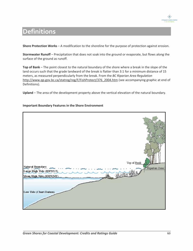
Definitions
Green Shores for Coastal Development: Credits and Ratings Guide 60
Shore Protection Works – A modification to the shoreline for the purpose of protection against erosion. Stormwater Runoff – Precipitation that does not soak into the ground or evaporate, but flows along the surface of the ground as runoff. Top of Bank – The point closest to the natural boundary of the shore where a break in the slope of the land occurs such that the grade landward of the break is flatter than 3:1 for a minimum distance of 15 meters, as measured perpendicularly from the break. From the BC Riparian Area Regulation http://www.qp.gov.bc.ca/statreg/reg/F/FishProtect/376_2004.htm (see accompanying graphic at end of Definitions). Upland – The area of the development property above the vertical elevation of the natural boundary. Important Boundary Features in the Shore Environment

Advisory Committees Green Shores Advisory Committee Erik Lees Lees and Associates Landscape Architects Scott Northrup Fisheries and Oceans Canada Alex Zimmerman Applied Green Consulting, Canada Green Building Council Michelle Gaudrey Fraser River Estuary Management Program Barron Carswell British Columbia Ministry of Environment, Ocean and Marine Fisheries Branch Mike Rogozinski Real Estate Foundation of British Columbia Doug Myers Puget Sound Action Team Barry Janyk Mayor of Gibsons, British Columbia Deborah Conner Georgia Strait Alliance Chris Jackson Islands Trust Rating Credit Peer Review Workgroup Jim Mitchell Coastal Engineer Michael Tarbotton Triton Consultants Ltd. Gary Williams G.L. Williams and Associates David Reid HB Lanarc Consultants Scott Murdoch Murdoch Landscape and Design Ltd. Don Howes DA Howes and Associates Peter Hardcastle Hillel Architecture Catherine Berris Catherine Berris and Associates Patrick Lucey Aqua-Scientific Consulting Ltd. Lindsay Jones Integrated Land Management Branch
Green Shores Technical Working Group
Brian Emmett Archipelago Marine Research Ltd.
John Readshaw SNC Lavalin Inc.
Harriet Rueggeberg
Gretchen Harlow

Pilot Program Assessors Rob Russell Habitat Biologist Pat Harrison Landscape Architect Cara MacDonald Landscape Architect Sarah Bonar Chatwin Engineering Susan Davidson SeaScience Rowland Atkins Golder Associates Berly Allen Cypress Creek Design Jim Mitchell Coastal Engineer Gina Lemieux Archipelago Marine Research Ltd. Brendan Holden Engineer Scott Murdoch Murdoch deGreef Inc. Jodi Harney Coastal Geologist Kathy Dunster Unfolding Landscapes