greenvale central precinct structure plan · • is a strategic plan which guides the delivery of a...
TRANSCRIPT
SOMERTON ROAD
PROVIDENCE ROAD
CARR
OLL
LAN
EBO
ND
S LA
NE
SECT
ION
RO
AD
FREN
CH R
OAD
BREN
DAN
RO
AD
MIC
KLEH
AM R
OAD
HILLVIEW ROAD
GREENVALERESERVE
GREENVALERESERVOIRPARK
WOODLANDSHISTORIC PARK
precinct boundaryarterial roadconnector streetkey local access streetsomerton road wideningconventional density residential
medium density residentialpotential catholic primary schoolunencumbered passive open space
unencumbered active open spaceencumbered open space - drainage
encumbered open space - conservationencumbered open space - Growling Grass Frog
category 2 habitatnative vegetation - EVC’snative vegetation - scattered treeswoodlands boundary road (19m defendable space)
wetland and retarding basinfuture urban areaexisting urban areanon urban area
0 100 200 300 N
1:5,000 @ A1
plan 3future urban structure
greenvale central precinct structure plan
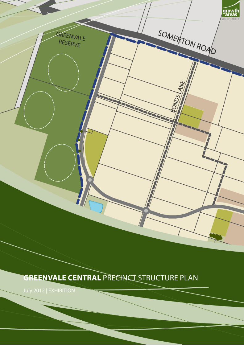
GREENVALE CENTRAL precinct Structure plan July 2012 | eXHiBitiOn

GREENVALE CENTRAL PRECINCT STRUCTURE PLAN
July 24, 2012 9:43 AMii INTRODUCTION

CONTENTS
1.0 IntroductIon 3
1.1 How to read this document 3
1.2 land to which this pSp applies 5
1.3 Background information 5
2.0 outcomes 7
2.1 Vision 7
2.2 Objectives 8
2.3 Summary land budget 11
3.0 ImplementatIon 13
3.1 image, character, and housing 13
3.2 Open space, natural systems, community facilities and bushfire management 15
3.3 transport and movement 27
3.4 Water and utilities 32
3.5 precinct infrastructure and development staging 33
4.0 appendIces 38
4.1 property Specific land Budget 38
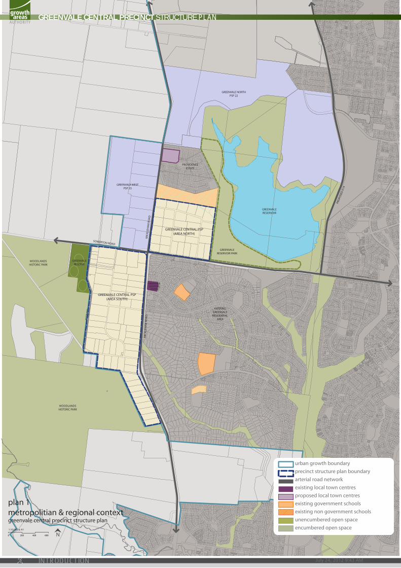
plans plan 1 Metropolitan & regional context 2
plan 2 precinct area 4
plan 3 Future urban structure 6
plan 4 land use budget 10
plan 5 image, character & housing 12
plan 6 Open space, natural systems, community facilities & bushfire management 16
plan 7 threatened species action 20
plan 8 road network 26
plan 9 public transport & walking trails 20
plan 10 road network implementation 34
tables table 1 Summary land use budget 11
table 2 Open space inventory 18
table 3 local road network implementation 35
table 4 precinct infrastructure plan 36
GREENVALE CENTRAL PRECINCT STRUCTURE PLAN
1
SOMERTON ROAD
SEC
TIO
N R
OA
D
MIC
KLEH
AM
RO
AD
GREENVALERESERVE
GREENVALERESERVOIR PARK
GREENVALERESERVOIR
EXISTINGGREENVALE
RESIDENTIALAREA
GREENVALESHOPPING
CENTRE
WOODLANDSHISTORIC PARK
WOODLANDSHISTORIC PARK
GREENVALE WESTPSP 23
GREENVALE CENTRAL PSP(AREA SOUTH)
GREENVALE CENTRAL PSP(AREA NORTH)
GREENVALE NORTHPSP 22
SOMERTON ROAD
PRO
POSE
D E
14
MIC
KLEH
AM
RO
AD
ROXB
URG
H P
ARK
DRI
VE
PROVIDENCEESTATE
plan 1metropolitian & regional context greenvale central precinct structure plan
urban growth boundaryprecinct structure plan boundaryarterial road networkexisting local town centresproposed local town centresexisting government schoolsexisting non government schoolsunencumbered open spaceencumbered open space
0 200 400 600 N1:10,000 @ A1
GREENVALE CENTRAL PRECINCT STRUCTURE PLAN
July 24, 2012 9:43 AM2 INTRODUCTION
The Greenvale Central Precinct Structure Plan (the PSP) has been prepared by the Growth Areas Authority in consultation with Hume City Council, Government agencies, service authorities and major stakeholders.
The PSP:
• is a strategic plan which guides the delivery of a quality urban environment
• sets the vision for how land should be developed, illustrates the future urban structure and describes the outcomes to be achieved by the future development
• outlines projects required to ensure that the future community, visitors and workers within the area are provided with timely access to services and transport infrastructure necessary to support a quality, affordable lifestyle
• details the form and conditions that must be met by future land use and development
• provides the framework for the use and development controls that apply in the schedule to the Urban Growth Zone and planning permits which may be granted under the schedule to the zone
• provides developers, investors and local communities with guidance about future development
• addresses the requirements of the Environment Protection and Biodiversity Conservation (EPBC) Act 1999 in accordance with an endorsed program under Part 10.
The PSP is informed by:
• State Planning Policy Framework set out in the Hume Planning Scheme and the Precinct Structure Planning Guidelines
• Local Planning Policy Framework of the Hume Planning Scheme
• Greenvale Central Native Vegetation Precinct Plan (the NVPP) which sets out requirements for the protection and management of native vegetation within the PSP area
• Greenvale Central Development Contributions Plan (the DCP) which sets out the requirements for development proponents to make a contribution toward infrastructure required to support the development of the precinct
• Greenvale Central Background Report (the Background Report), which provides information regarding the precinct, including its metropolitan and regional context, and summarises various background information relevant to the preparation of this document
• Biodiversity Conservation Strategy and Sub-regional Species Strategies for Melbourne’s Growth Areas (DSE, 2011).
1.1 HOw TO REAd THiS dOCumENTThis structure plan guides use and development where a planning permit is required under the Urban Growth Zone or another zone where that zone references this structure plan.
The Vision must inform all of the outcomes in the precinct.
Outcomes are what development of the precinct must achieve.
Requirements must be adhered to in developing the land. They will usually be included as a condition on a planning permit whether or incorporated into endorsed plans whether or not they take the same wording as in this structure plan.
Guidelines express how discretion will be exercised by the responsible authority in certain matters that require a planning permit.
Plans are a spatial expression of the outcomes. Development may take alternative forms from that described in plans, tables and figures provided it achieves the outcomes and meets the requirements in this structure plan.
Not every aspect of the land’s use and development is addressed in this structure plan and a responsible authority may manage development and use and issue permits as relevant under its general discretion.
1.0 intrOductiOn
GREENVALE CENTRAL PRECINCT STRUCTURE PLAN
3INTRODUCTION
SOMERTON ROAD
PROVIDENCE ROAD
SWAIN STREET
CARR
OLL
LA
NE
BON
DS
LAN
E
SEC
TIO
N R
OA
D
FREN
CH R
OA
D
BREN
DA
N R
OA
D
MIC
KLEH
AM
RO
AD
HILLVIEW ROAD
YUROKE ROAD
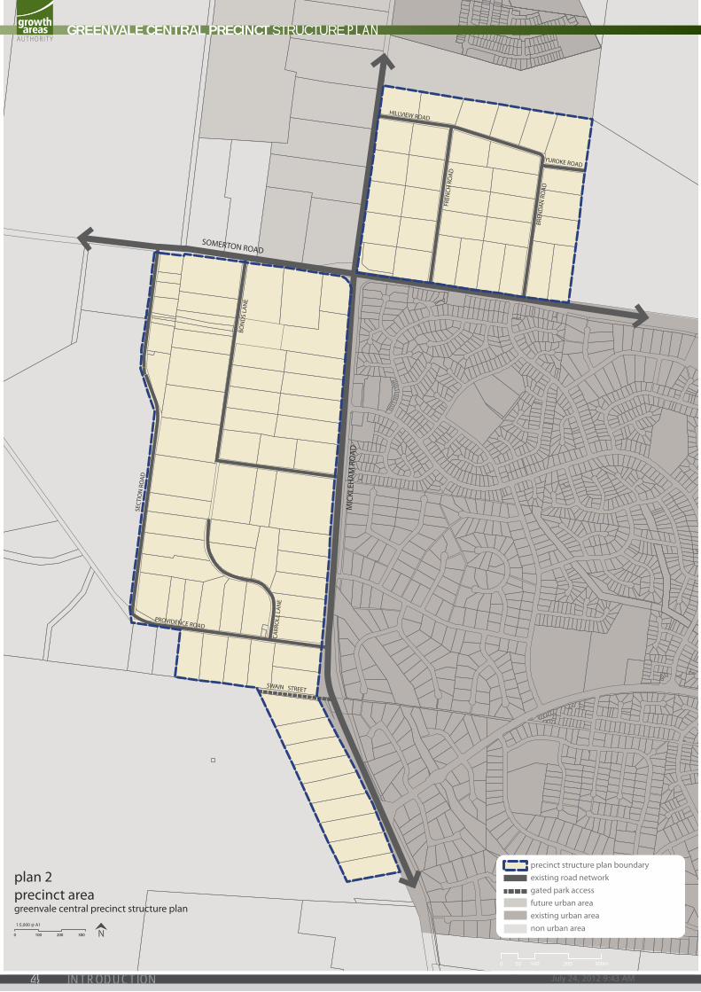
precinct structure plan boundaryexisting road networkgated park accessfuture urban areaexisting urban areanon urban area
0 100 200 300 N1:5,000 @ A1
plan 2precinct area greenvale central precinct structure plan
0 300m20010050
GREENVALE CENTRAL PRECINCT STRUCTURE PLAN
July 24, 2012 9:43 AM4 INTRODUCTION
1.2 land to whIch thIs psp applIesThe land to which the PSP applies is shown on Plan 2 and on the Hume Planning Scheme maps as Schedule 6 to the Urban Growth Zone. The PSP applies to approximately 236 hectares of land in two areas centred on the intersection of Mickleham Road and Somerton Road, Greenvale.
The northern area of the PSP is bound by Greenvale Reservoir Park to the east, Aitken College to the north, Mickleham Road to the west, and Somerton Road to the south. The southern area of the precinct is bound by Mickleham Road to the east, Somerton Road to the north, and the Urban Growth Boundary (Woodlands Historic Park and Greenvale Reserve) to the south and west.
1.3 background InformatIonDetailed background information on the PSP, area including its local and metropolitan context, history, landform and topography, drainage, biodiversity, open space and community facilities, are contained in background reports. This information has informed the preparation of the PSP.
GREENVALE CENTRAL PRECINCT STRUCTURE PLAN
5INTRODUCTION

SOMERTON ROAD
PROVIDENCE ROAD
CARR
OLL
LA
NE
BON
DS
LAN
E
SEC
TIO
N R
OA
D
FREN
CH R
OA
D
BREN
DA
N R
OA
D
MIC
KLEH
AM
RO
AD
HILLVIEW ROAD
GREENVALERESERVE
GREENVALERESERVOIR
PARK
WOODLANDSHISTORIC PARK
precinct boundaryarterial roadconnector streetkey local access streetsomerton road wideningconventional density residentialmedium density residentialpotential catholic primary schoolunencumbered passive open spaceunencumbered active open spaceencumbered open space - drainageencumbered open space - conservationencumbered open space - Growling Grass Frog category 2 habitatnative vegetation - EVC’snative vegetation - scattered treeswoodlands boundary road (19m defendable space)
wetland and retarding basinfuture urban areaexisting urban areanon urban area
0 100 200 300 N1:5,000 @ A1
plan 3future urban structuregreenvale central precinct structure plan
GREENVALE CENTRAL PRECINCT STRUCTURE PLAN
July 24, 2012 9:43 AM6 OUTCOMES
2.0 OutcOMeS
2.1 VIsIonTo create a neighbourhood that provides linkages with existing natural features and strong connections with nearby schools, recreational facilities, town centres and community amenities provided within Greenvale.
Greenvale Central will provide a mixture of housing choices whilst preserving native vegetation and maximising opportunities for integration with adjacent regional parks.
The precinct adjoins the western edge of Greenvale Reservoir Park, providing new residents outstanding access to 53 hectares of quality open space, walking trails, picnic facilities and playgrounds. The parkland’s sloping hills provide views toward the city and feature Brodies Lakes, a wetland home to extensive birdlife. Woodlands Historic Park, the western boundary to the southern part of the precinct, provides 700 hectares of woodland and grassland vegetation accessed via an extensive walking trail network. Features of the park include Gellibrand Hill, with its panoramic views across Port Phillip Bay and the Great Dividing Range, and the historic Woodlands Homestead complex.
Local parks provided within Greenvale Central will complement these regional open space assets. Running along the northern boundary of the precinct, Yuroke Creek and its immediate surrounds will provide quality open space resembling the adjacent Greenvale Reservoir Park. The co-location of native vegetation with retarding basin wetlands and parks will create a central parkland corridor, providing pedestrian links into the precinct from existing Greenvale. Native vegetation retention south of Providence Road will include tree reserves and direct residential frontages to Woodlands Historic Park, providing a unique amenity more accessible to the local community.
In addition to parks and corridors throughout the precinct, future residents will enjoy direct access to Greenvale Recreation Reserve, home to various local sporting clubs and the principal active recreation destination in the Greenvale area.
Immediately across Mickleham Road, the existing Greenvale neighbourhood features primary schools and community facilities, and Greenvale Shopping Centre offers a full-line supermarket, speciality retail and food outlets. Recent completion of two Precinct Structure Plans north of Greenvale Central (Greenvale West and Greenvale North) further ensures future residents will be close proximity to an array of community and retail activity within the corridor. Major Town Centres at Roxburgh Park, Craigieburn and Broadmeadows provide retail, entertainment, commercial, civic, education, recreation and community services of a regional scale.
Centred on Mickleham Road and Somerton Road, the precinct will enjoy convenient access to the Hume Highway and Western Ring Road, Melbourne Airport and the rail network via Roxburgh Park Station. Bus services running throughout the precinct will directly link Greenvale Central residents to all commercial and transit destinations within the corridor. Cycling and pedestrian movements via the extensive internal network of off-road and dedicated on-road trails will link the precinct with the regional parks, existing Greenvale and beyond.
The precinct will offer a diverse range of housing product to support a range of households and lifestyles. Medium density and small-lot housing will be positioned to maximise pedestrian access to areas of activity and amenity, and along the Principal Public Transport Network. The higher densities in the precinct will occur adjacent to Greenvale Shopping Centre, with additional medium density housing encouraged fronting the open space network. Conventional lots and traditional homes will be developed throughout the precinct, with larger blocks providing a unique, housing product south of Providence Road.
GREENVALE CENTRAL PRECINCT STRUCTURE PLAN
7OUTCOMES
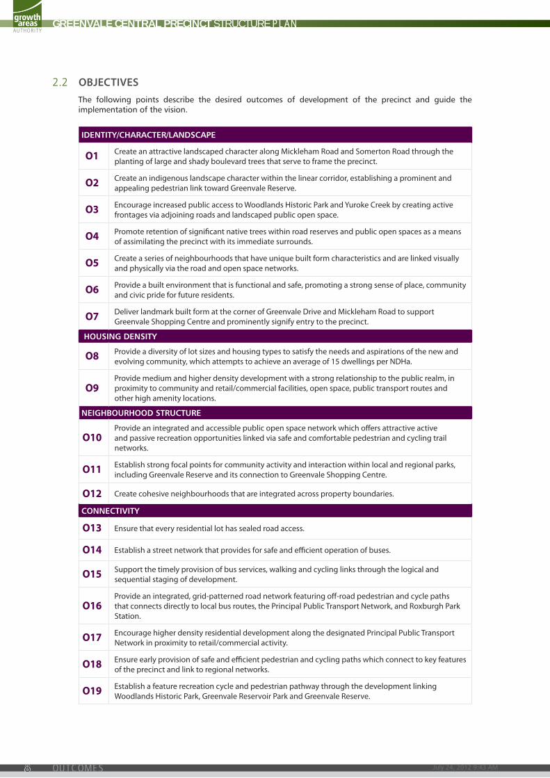
2.2 objectIVesThe following points describe the desired outcomes of development of the precinct and guide the implementation of the vision.
IDENTITY/CHARACTER/LANDSCAPE
O1 create an attractive landscaped character along Mickleham road and Somerton road through the planting of large and shady boulevard trees that serve to frame the precinct.
O2 create an indigenous landscape character within the linear corridor, establishing a prominent and appealing pedestrian link toward Greenvale reserve.
O3 encourage increased public access to Woodlands Historic park and Yuroke creek by creating active frontages via adjoining roads and landscaped public open space.
O4 promote retention of significant native trees within road reserves and public open spaces as a means of assimilating the precinct with its immediate surrounds.
O5 create a series of neighbourhoods that have unique built form characteristics and are linked visually and physically via the road and open space networks.
O6 provide a built environment that is functional and safe, promoting a strong sense of place, community and civic pride for future residents.
O7 deliver landmark built form at the corner of Greenvale drive and Mickleham road to support Greenvale Shopping centre and prominently signify entry to the precinct.
HOUSINGDENSITY
O8 provide a diversity of lot sizes and housing types to satisfy the needs and aspirations of the new and evolving community, which attempts to achieve an average of 15 dwellings per ndHa.
O9 provide medium and higher density development with a strong relationship to the public realm, in proximity to community and retail/commercial facilities, open space, public transport routes and other high amenity locations.
NEIGHBOURHOODSTRUCTURE
O10 provide an integrated and accessible public open space network which offers attractive active and passive recreation opportunities linked via safe and comfortable pedestrian and cycling trail networks.
O11 establish strong focal points for community activity and interaction within local and regional parks, including Greenvale reserve and its connection to Greenvale Shopping centre.
O12 create cohesive neighbourhoods that are integrated across property boundaries.
CONNECTIVITY
O13 ensure that every residential lot has sealed road access.
O14 establish a street network that provides for safe and efficient operation of buses.
O15 Support the timely provision of bus services, walking and cycling links through the logical and sequential staging of development.
O16 provide an integrated, grid-patterned road network featuring off-road pedestrian and cycle paths that connects directly to local bus routes, the principal public transport network, and roxburgh park Station.
O17 encourage higher density residential development along the designated principal public transport network in proximity to retail/commercial activity.
O18 ensure early provision of safe and efficient pedestrian and cycling paths which connect to key features of the precinct and link to regional networks.
O19 establish a feature recreation cycle and pedestrian pathway through the development linking Woodlands Historic park, Greenvale reservoir park and Greenvale reserve.
GREENVALE CENTRAL PRECINCT STRUCTURE PLAN
July 24, 2012 9:43 AM8 OUTCOMES
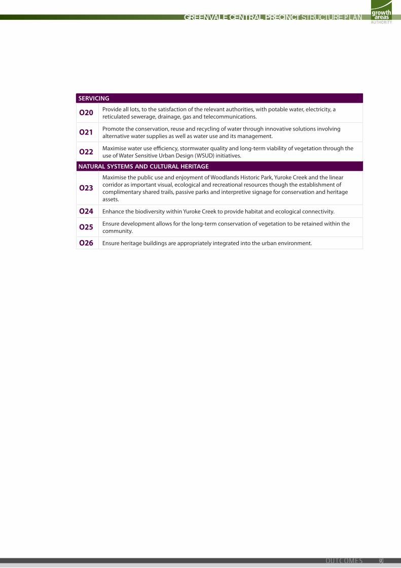
SERVICING
O20 provide all lots, to the satisfaction of the relevant authorities, with potable water, electricity, a reticulated sewerage, drainage, gas and telecommunications.
O21 promote the conservation, reuse and recycling of water through innovative solutions involving alternative water supplies as well as water use and its management.
O22 Maximise water use efficiency, stormwater quality and long-term viability of vegetation through the use of Water Sensitive urban design (WSud) initiatives.
NATURALSYSTEMSANDCULTURALHERITAGE
O23 Maximise the public use and enjoyment of Woodlands Historic park, Yuroke creek and the linear corridor as important visual, ecological and recreational resources though the establishment of complimentary shared trails, passive parks and interpretive signage for conservation and heritage assets.
O24 enhance the biodiversity within Yuroke creek to provide habitat and ecological connectivity.
O25 ensure development allows for the long-term conservation of vegetation to be retained within the community.
O26 ensure heritage buildings are appropriately integrated into the urban environment.
GREENVALE CENTRAL PRECINCT STRUCTURE PLAN
9OUTCOMES
1
2
3
4
567
8
9
10
11
12
131415
16
17
18
19
20
21
22
23
24
2526 27 28 29
3231
30
33
34
3536 37
38
39
40
41
42
4344
45
46
47
48
49
50
5152
53
54
5556
57
58
59
60
61
62 63 64 65 66
67
68
69
70
71
72
73
74
75
76
7778
79
80
81 82
105
106
107
108109
1009998
97
96
95
94
93
104
103
102
101
8887
86
85
84
8392
91
90
89
precinct boundaryarterial roadconnector streetkey local access streetsomerton road wideningconventional density residentialmedium density residentialpotential catholic primary schoolunencumbered passive open spaceunencumbered active open spaceencumbered open space - drainageencumbered open space - conservationwoodlands boundary road (19m defendable space)
wetland and retarding basinfuture urban areaexisting urban areanon urban areaproperty number
PROVIDENCE ROAD
CARR
OLL
LA
NE
BON
DS
LAN
E
SEC
TIO
N R
OA
D
FREN
CH R
OA
D
BREN
DA
N R
OA
D
HILLVIEW ROAD
GREENVALERESERVE
WOODLANDSHISTORIC PARK
SOMERTON ROAD
MIC
KLEH
AM
RO
AD
GREENVALERESERVOIR
PARK
0 100 200 300 N1:5,000 @ A1
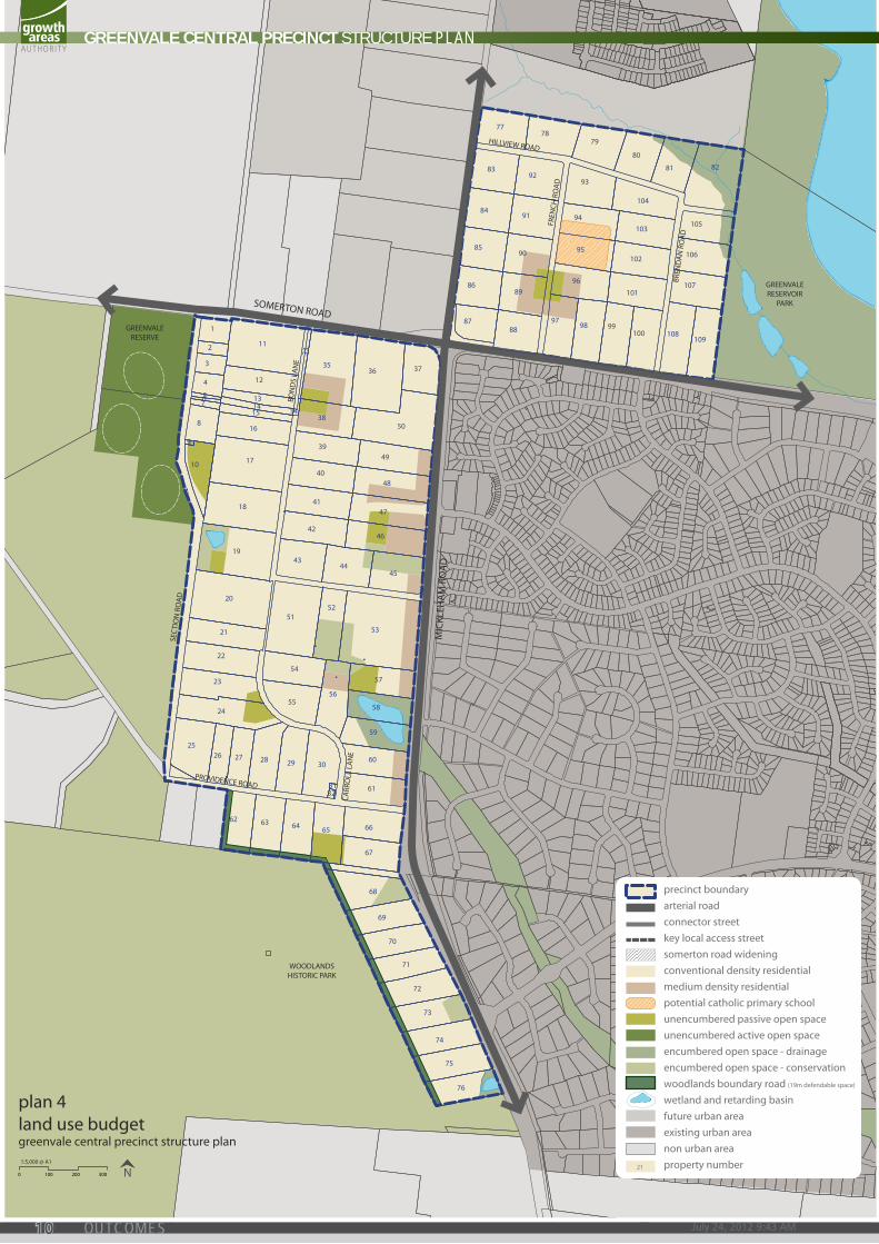
plan 4land use budgetgreenvale central precinct structure plan
21
GREENVALE CENTRAL PRECINCT STRUCTURE PLAN
July 24, 2012 9:43 AM10 OUTCOMES
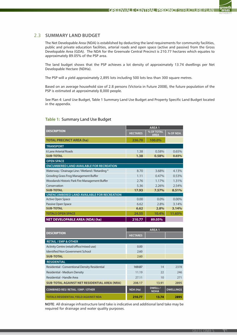
2.3 summary land budgetThe Net Developable Area (NDA) is established by deducting the land requirements for community facilities, public and private education facilities, arterial roads and open space (active and passive) from the Gross Developable Area (GDA). The NDA for the Greenvale Central Precinct is 210.77 hectares which equates to approximately 89.05% of the PSP area.
The land budget shows that the PSP achieves a lot density of approximately 13.74 dwellings per Net Developable Hectare (NDHa).
The PSP will a yield approximately 2,895 lots including 500 lots less than 300 square metres.
Based on an average household size of 2.8 persons (Victoria in Future 2008), the future population of the PSP is estimated at approximately 8,000 people.
See Plan 4: Land Use Budget, Table 1 Summary Land Use Budget and Property Specific Land Budget located in the appendix.
table 1: Summary land use Budget
NOTE: All drainage infrastructure land take is indicative and additional land take may be required for drainage and water quality purposes.
dESCRiPTiONarea 1
hectares % of total area % of nda
TOTAL PRECiNCT AREA (ha) 236.70 100.0%
transport
6 lane arterial roads 1.38 0.58% 0.65%SuB-TOTAL 1.38 0.58% 0.65%
open spaceencumbered land aVaIlable for recreatIonWaterway / drainage line / Wetland / retarding * 8.70 3.68% 4.13%Growling Grass Frog Management Buff er 1.11 0.47% 0.53%Woodands Historic park Fire Management Buff er 2.76 1.17% 1.31%conservation 5.36 2.26% 2.54%SuB-TOTAL 17.93 7.57% 8.51%unencumbered land aVaIlable for recreatIonactive Open Space 0.00 0.0% 0.00%passive Open Space 6.62 2.8% 3.14%SuB-TOTAL 6.62 2.8% 3.14%TOTALS OPEN SPACE 24.55 10.4% 11.65%
NET dEVELOPABLE AREA (NdA) (ha) 210.77 89.05%
dESCRiPTiONarea 1
hectares
retaIl / emp & other
activity centre (retail/offi ce/mixed use) 0.00
identifi ed non Government School 2.60
SuB-TOTAL 2.60
resIdentIal
residential - conventional density residential 169.87 14 2378
residential - Medium density 11.19 22 246
residential - Handle area 27.11 10 271
SuB-TOTAL AGAiNST NET RESidENTiAL AREA (NRA) 208.17 13.91 2895
combIned res/ retaIl / emp / other nda (ha) dwell / ndha dwellIngs
TOTALS RESidENTiAL YiELd AGAiNST NdA 210.77 13.74 2895
dESCRiPTiONarea 1
hectares % of total area % of nda
TOTAL PRECiNCT AREA (ha) 236.70 100.0%
transport
6 lane arterial roads 1.38 0.58% 0.65%SuB-TOTAL 1.38 0.58% 0.65%
open spaceencumbered land aVaIlable for recreatIonWaterway / drainage line / Wetland / retarding * 8.70 3.68% 4.13%Growling Grass Frog Management Buff er 1.11 0.47% 0.53%Woodands Historic park Fire Management Buff er 2.76 1.17% 1.31%conservation 5.36 2.26% 2.54%SuB-TOTAL 17.93 7.57% 8.51%unencumbered land aVaIlable for recreatIonactive Open Space 0.00 0.0% 0.00%passive Open Space 6.62 2.8% 3.14%SuB-TOTAL 6.62 2.8% 3.14%TOTALS OPEN SPACE 24.55 10.4% 11.65%
NET dEVELOPABLE AREA (NdA) (ha) 210.77 89.05%
dESCRiPTiONarea 1
hectares
retaIl / emp & other
activity centre (retail/offi ce/mixed use) 0.00
identifi ed non Government School 2.60
SuB-TOTAL 2.60
resIdentIal
residential - conventional density residential 169.87 14 2378
residential - Medium density 11.19 22 246
residential - Handle area 27.11 10 271
SuB-TOTAL AGAiNST NET RESidENTiAL AREA (NRA) 208.17 13.91 2895
combIned res/ retaIl / emp / other nda (ha) dwell / ndha dwellIngs
TOTALS RESidENTiAL YiELd AGAiNST NdA 210.77 13.74 2895
GREENVALE CENTRAL PRECINCT STRUCTURE PLAN
11OUTCOMES

PROVIDENCE ROAD
CARR
OLL
LA
NE
SEC
TIO
N R
OA
D
FREN
CH R
OA
D
BREN
DA
N R
OA
D
HILLVIEW ROAD
GREENVALERESERVE
WOODLANDSHISTORIC PARK
SOMERTON ROAD
MIC
KLEH
AM
RO
AD
GREENVALERESERVOIR
PARK
BON
DS
LAN
E
precinct boundaryarterial roadconnector streetkey local access streetsomerton road wideningconventional density residentialmedium density residentialpotential catholic primary schoolunencumbered passive open spaceunencumbered active open spaceencumbered open space - drainageencumbered open space - conservationnative vegetation - EVC’snative vegetation - scattered treeswoodlands boundary road (19m defendable space)
60.0m BAL 12.5 rated housingexisting heritage sitewetland and retarding basinfuture urban areaexisting urban areanon urban area
0 100 200 300 N1:5,000 @ A1
plan 5image, character & housinggreenvale central precinct structure plan
GREENVALE CENTRAL PRECINCT STRUCTURE PLAN
July 24, 2012 9:43 AM12 IMPLEMENTATION

3.0 iMpleMentatiOn
3.1 Image, character and housIng
IMAGE & CHARACTERREQUIREMENTS
R1 development along Yuroke creek and adjacent to the Woodlands Historic park, Greenvale reserve and the linear corridor must front the open space and avoid visual barriers such as continuous fencing.
R2 Housing is to front or otherwise address Mickleham road and Somerton road to the satisfaction of the responsible authority.
R3 Garages fronting a street must be set back a minimum of one metre from the front building line and must be less than half the width of the lot to a maximum of six metres, unless in strategic locations as agreed by the responsible authority.
R4 Fences forward of the building line must not be more than 1.2m in height.
R5 Street tree planting on declared arterial roads must be established in accordance with the clear zone guidelines to the satisfaction of Vicroads.
R6 Street trees must be provided on both sides of connector and local access streets at regular intervals and in accordance with the road cross-sections in this pSp.
R7 development adjacent to the Yuroke creek in not permitted to encroach upon the 1:100 year flood line.
R8 all public land areas must be planted to the satisfaction of the responsible authority.
GUIDELINES
G1 Significant elements of the landscape and built form should be used as focal points for key view lines and gateway locations. elements may include public pavilions, parks and reserves, including the linear corridor, Yuroke creek and Woodlands Historic park.
G2 Siting and design of built form should provide a sensitive interface along the Yuroke creek corridor and adjacent to Woodlands Historic park, Greenvale reserve and the linear corridor, particularly for higher density development. this can be achieved through appropriate architectural treatments such as muted colour tones, low scale front fencing and indigenous landscaping within the front setback.
G3 development adjacent to the linear corridor, Greenvale reserve, Woodlands Historic park, Yuroke creek and Greenvale reservoir park should front the open space. roads should generally frame these open space assets.
G4 Sites on prominent locations, particularly the corner of Mickleham road and Greenvale drive, should be developed with signature buildings.
G5 Street layout should generally be aligned to maximise connection and views to key destination points such as Greenvale reserve, Greenvale Shopping centre and the linear corridor.
G6 design of dwellings should add to the precinct character by providing an attractive street address which encourages passive surveillance and visual interest.
G7 indigenous tree species should be used where a street adjoins the Woodlands Historic park, Yuroke creek and Greenvale reservoir park, Greenvale reserve and the linear corridor.
G8 Street trees should establish continuous canopy, provide shaded streetscapes and frame view corridors upon maturity.
G9 Selection of street trees and landscaping should reinforce movement hierarchy and inform neighbourhood character.
G10 access roads should be aligned to create view corridors through to and along the linear drainage corridor and wetlands.
G11 Front fences should generally be low and partly transparent. corner lots should address both streets with low fences up to a minimum of five (5) metres behind the front building line
GREENVALE CENTRAL PRECINCT STRUCTURE PLAN
13IMPLEMENTATION
HOUSINGREQUIREMENTS
R9 achieve a minimum density of 14 dwellings per net developable Hectare (ndHa) across the entire precinct, excluding land south of providence road.
R10 residential development across the pSp must include a full range of dwelling densities as outlined in the pSp Guidelines, including lower density residential development in proximity to Woodlands Historic park.
R11 Medium (or higher) density housing must be maximised along Mickleham road adjacent to Greenvale Shopping centre and key amenity areas.
R12 residential lots of a width of seven (7) metres or less must only provide vehicle access via a rear laneway.
GUIDELINES
G12 individual developments should achieve an average density higher than the minimum of 14 dwellings per ndHa, excluding land south of providence road.
G13
precinct should deliver a broad range of dwelling typologies, which may include variations of:
• Multi-storey apartments
• terrace housing
• attached housing
• Semi-detached housing
• ancillary housing
• detached housing
G14 Medium density housing should be placed in areas of high amenity or activity. areas nominated for medium density should achieve an average density of 22 dwellings per ndHa.
G15 Medium density housing should include specialised housing forms such as retirement or an aged care facility in close proximity to Greenvale Shopping centre.
G16 lower density housing of 10 dwellings per ndHa should be encouraged south of providence road, providing larger lot sizes in direct proximity to Woodlands Historic park.
GREENVALE CENTRAL PRECINCT STRUCTURE PLAN
July 24, 2012 9:43 AM14 IMPLEMENTATION

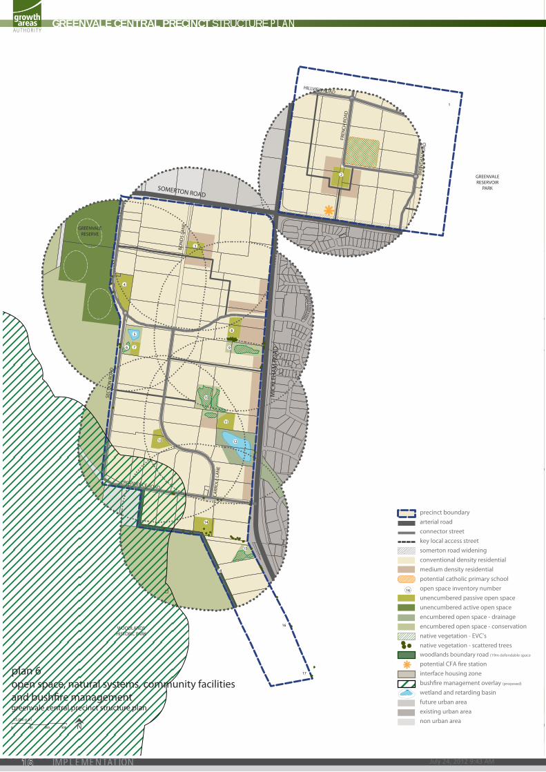
3.2 open space, natural systems, communIty facIlItIes and bushfIre management
OPEN SPACEREQUIREMENTS
R13 all open space, including encumbered drainage infrastructure, must abut a road unless otherwise addressed by an active frontage, including significant open space areas, to the satisfaction of the relevant authority.
R14 all landscaped areas must be designed for low maintenance to the satisfaction of the responsible authority.
R15
an alternative provision of land for passive open space to that shown in plan 6 is generally in accordance with this plan provided the passive open space (unencumbered) is:
• located so as not to reduce the walkable access to local parks demonstrated in plan 6
• able to supply the particular planned use for the reserve
• as far as practicable regular in form with a minimum average width of approximately 50 metres
• Fronted by a connector road or key local road on at least one side.
R16 development abutting open space must be well articulated and facilitate passive surveillance with windows, balconies and pedestrian access points.
R17 appropriately scaled lighting must be installed along all major pedestrian thoroughfares traversing public open space and cycling network to the satisfaction of the responsible authority.
R18 an appropriate mix of infrastructure in parks must be provided, such as playgrounds, shelters, seating, rubbish bins, BBQ/picnic facilities and toilets, to the satisfaction of the responsible authority.
R19 land designated for active and passive recreation reserves must be designed, finished and maintained to the satisfaction of the responsible authority prior to its transfer.
R20 Fencing of parkland must be low scale and permeable to facilitate public safety and surveillance.
GUIDELINES
G17 design of open spaces should be contemporary in nature, innovative and draw upon the precinct landscape design themes.
G18 local parks should provide infrastructure to cater for a broad range of users and support both structured and informal recreational activities.
G19 the design and layout of open space should maximise water use efficiency, storm water quality and long term viability of vegetation through the use of WSud initiatives, including opportunities to use water from wetlands for irrigation purposes.
G20 advice should be sought from qualified council staff regarding suitability of proposed tree species prior to confirming planting schedule.
G21 passive parks adjoining Woodlands Historic park should reflect and enhance nearby areas of conservation significance.
GREENVALE CENTRAL PRECINCT STRUCTURE PLAN
15IMPLEMENTATION
PROVIDENCE ROAD
CARR
OLL
LA
NE
BON
DS
LAN
E
SEC
TIO
N R
OA
D
FREN
CH R
OA
D
BREN
DA
N R
OA
D
HILLVIEW ROAD
GREENVALERESERVE
WOODLANDSHISTORIC PARK
SOMERTON ROAD
MIC
KLEH
AM
RO
AD
GREENVALERESERVOIR
PARK
precinct boundaryarterial roadconnector streetkey local access streetsomerton road wideningconventional density residentialmedium density residentialpotential catholic primary schoolopen space inventory numberunencumbered passive open spaceunencumbered active open spaceencumbered open space - drainageencumbered open space - conservationnative vegetation - EVC’snative vegetation - scattered treeswoodlands boundary road (19m defendable space
potential CFA �re stationinterface housing zonebush�re management overlay (proposed)
wetland and retarding basinfuture urban areaexisting urban areanon urban area
16
0 100 200 300 N1:5,000 @ A1
plan 6open space, natural systems, community facilities and bushre managementgreenvale central precinct structure plan
1
2
3
4
8
76
5
9
10
13
11
12
14
15
16
17
18
GREENVALE CENTRAL PRECINCT STRUCTURE PLAN
July 24, 2012 9:43 AM16 IMPLEMENTATION
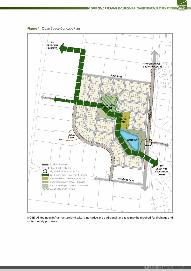
CONSERVATIONRESERVE
LOCALPARK
LOCALPARK
WATERWAY
TO GREENVALE
RESERVE
TO GREENVALERECREATION
CENTRE
TO GREENVALESHOPPING CENTRE
Providence Road
Bonds Lane
Mic
kleh
am R
oad
local road networkshared path networksignalised pedestrian crossinglinear open space movement corridorunencumbered passive open spaceencumbered open space - drainageencumbered open space - conservationnative vegetation - EVC’s
NOTE: All drainage infrastructure land take is indicative and additional land take may be required for drainage and water quality purposes.
figure 1: Open Space concept plan
GREENVALE CENTRAL PRECINCT STRUCTURE PLAN
17IMPLEMENTATION
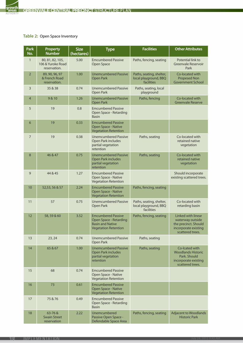
park no.
property number
size (hectares)
type facilities other attributes
1 80, 81, 82, 105, 106 & Yuroke road
reservation.
5.00 emcumbered passive Open Space
paths, fencing, seating potential link to Greenvale reservoir
park
2 89, 90, 96, 97 & French road
reservation.
1.00 unemcumbered passive Open park
paths, seating, shelter, local playground, BBQ
facilities
co-located with propesed non
Government School
3 35 & 38 0.74 unemcumbered passive Open park
paths, seating, local playground
4 9 & 10 1.26 unemcumbered passive Open park
paths, fencing co-located with Greenvale reserve
5 19 0.8 emcumbered passive Open Space - retarding Basin
6 19 0.33 emcumbered passive Open Space - native Vegetation retention
7 19 0.38 unemcumbered passive Open park includes partial vegetation retention
paths, seating co-located with retained native
vegetation
8 46 & 47 0.75 unemcumbered passive Open park includes partial vegetation retention
paths, seating co-located with retained native
vegetation
9 44 & 45 1.27 emcumbered passive Open Space - native Vegetation retention
Should incorporate existing scattered trees.
10 52,53, 56 & 57 2.24 emcumbered passive Open Space - native Vegetation retention
paths, fencing, seating
11 57 0.75 unemcumbered passive Open park
paths, seating, shelter, local playground, BBQ
facilities
co-located with retarding basin
12 58, 59 & 60 3.52 emcumbered passive Open Space - retarding Basin and native Vegetation retention
paths, fencing, seating linked with linear waterway outside
the precinct. Should incorporate existing
scattered trees.
13 23, 24 0.74 unemcumbered passive Open park
paths, seating
14 65 & 67 1.00 unemcumbered passive Open park includes partial vegetation retention
paths, seating co-lcated with Woodlands Historic
park. Should incorporate existing
scattered trees.
15 68 0.74 emcumbered passive Open Space - native Vegetation retention
16 73 0.61 emcumbered passive Open Space - native Vegetation retention
17 75 & 76 0.49 emcumbered passive Open Space - retarding Basin
18 63-76 & Swain Street reservation
2.22 unemcumbered passive Open Space - defendable Space area
paths, fencing, seating adjacent to Woodlands Historic park
table 2: Open Space inventory
GREENVALE CENTRAL PRECINCT STRUCTURE PLAN
July 24, 2012 9:43 AM18 IMPLEMENTATION
PASSIVE OPEN SPACE CONTRIBUTIONSREQUIREMENTS
R21
all land owners must provide a public open space contribution equal to 3.14% of net developable area (nda) upon subdivision of land in accordance with the following:
Where land is required for unencumbered open space purposes as shown in plan 5 and specified in table 2 and is less or equal to 3.14% of nda, that land is to be transferred to council at no cost
Where no land or less than 3.14% of nda is shown in plan 4 and specified in the property Specific land Budget, a cash contribution is to be made to council to bring total open space contribution to a value equal to 3.14% of nda
Where land required for unencumbered open space purposes as shown in plan 4 and specified in the property Specific land Budget (4.1 appendices) is more than 3.14% of nda, council will pay an amount equivalent to the value of the additional land being provided by that property
the value of land for equalisation purposes is to be assessed as an equivalent proportion of the value of the whole of the land, in accordance with Section 18 of the Subdivision Act 1988.
R22 a continuous shared trail of at least three metres in width must be provided within and along the boundaries of the linear corridor and demonstrate a relationship to the surrounding public space.
COMMUNITY INFRASTRUCTUREREQUIREMENTS
R23 Where the responsible authority is satisfied that land shown as a non-government school site is unlikely to be used for a non-government school, that land may be used for an alternative purpose which is generally in accordance with the pSp and consistent with the provisions of the applied zone.
GUIDELINES
G22 community facilities, local parks and playgrounds should be delivered in the early stages of development, maximising efficiency of designated space.
HERITAGEREQUIREMENTS
R24 prior to the commencement of development at 70 providence road Greenvale, temporary fencing must be erected to secure public safety and protect the significant fabric of the heritage site (prospect cottage).
GUIDELINES
G23 all development within or directly adjacent to the heritage sites and their environs (Methodist catholic church, 30 providence road Greenvale and prospect cottage, 70 providence road Greenvale) should be designed for the preservation and enhancement of the place’s cultural heritage values.
GREENVALE CENTRAL PRECINCT STRUCTURE PLAN
19IMPLEMENTATION
SEC
TIO
N R
OA
D
YUROKE ROAD
GREENVALERESERVE
WOODLANDSHISTORIC PARK
SOMERTON ROAD
MIC
KLEH
AM
RO
AD
GREENVALERESERVOIR
PARK
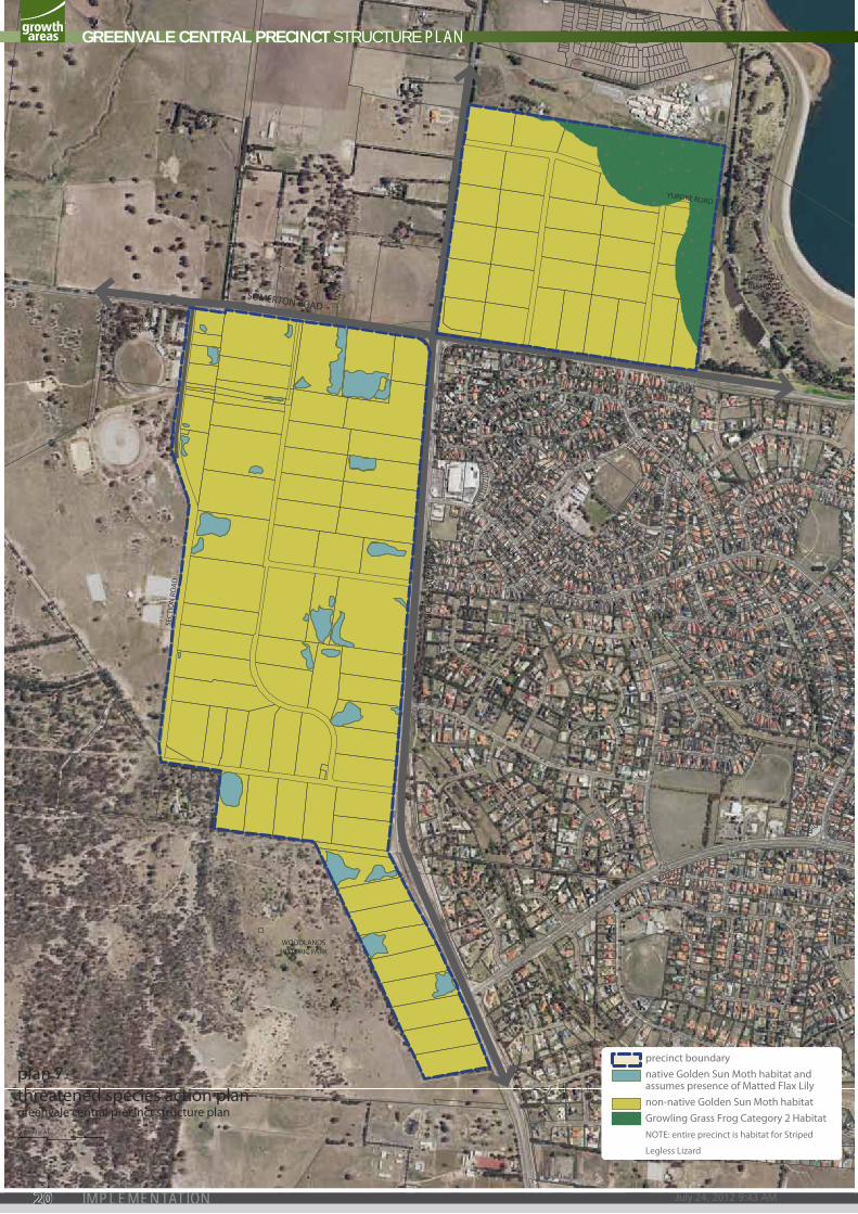
precinct boundarynative Golden Sun Moth habitat and assumes presence of Matted Flax Lilynon-native Golden Sun Moth habitatGrowling Grass Frog Category 2 HabitatNOTE: entire precinct is habitat for Striped
Legless Lizard 0 100 200 300 N
1:5,000 @ A1
plan 7threatened species action plangreenvale central precinct structure plan
GREENVALE CENTRAL PRECINCT STRUCTURE PLAN
July 24, 2012 9:43 AM20 IMPLEMENTATION
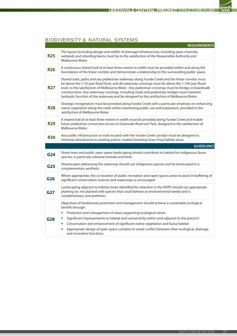
BIODIVERSITY & NATURAL SYSTEMSREQUIREMENTS
R25 the layout (including design and width) of drainage infrastructure, including open channels, wetlands and retarding basins must be to the satisfaction of the responsible authority and Melbourne Water.
R26 a continuous shared trail of at least three metres in width must be provided within and along the boundaries of the linear corridor and demonstrate a relationship to the surrounding public space.
R27
Shared trails, paths and any pedestrian walkways along Yuroke creek and the linear corridor must be above the 1:10 year flood level, and all waterway crossings must be above the 1:100 year flood level, to the satisfaction of Melbourne Water. any pedestrian crossings must be bridge or boardwalk constructions. any waterway crossings, including roads and pedestrian bridges must maintain hydraulic function of the waterway and be designed to the satisfaction of Melbourne Water.
R28 Strategic revegetation must be provided along Yuroke creek with a particular emphasis on enhancing native vegetation along the creek whilst maximising public use and enjoyment, provided to the satisfaction of Melbourne Water.
R29 a shared trail of at least three metres in width must be provided along Yuroke creek and enable future pedestrian connection across to Greenvale reservoir park, designed to the satisfaction of Melbourne Water.
R30 any public infrastructure or trails located with the Yuroke creek corridor must be designed to minimise disturbance to existing and/or created Growling Grass Frog habitat areas.
GUIDELINES
G24 Street trees and public open space landscaping should contribute to habitat for indigenous fauna species, in particular arboreal animals and birds.
G25 Streetscapes addressing the waterway should use indigenous species and be landscaped in a complementary aesthetic.
G26 Where appropriate, the co-location of public recreation and open spaces areas to assist in buffering of significant conservation reserves and waterways is encouraged.
G27 landscaping adjacent to habitat zones identified for retention in the nVpp should use appropriate planting (ie. not planted with species that could behave as environmental weeds and is complimentary and aesthetic).
G28
Objectives of biodiversity protection and management should achieve a sustainable ecological benefit through:
• protection and management of areas supporting ecological values
• Significant improvements to habitat and connectivity within and adjacent to the precinct
• conservation and enhancement of significant native vegetation and fauna habitat
• appropriate design of open space corridors to avoid conflict between their ecological, drainage and recreation functions.
GREENVALE CENTRAL PRECINCT STRUCTURE PLAN
21IMPLEMENTATION

BUSHFIRE MANAGEMENTREQUIREMENTS
R31 unless a subdivision meets the guidelines set out in either G29 or G30, it must provide defendable space between a fire threat identified on plan 6 of this precinct Structure plan and a dwelling to the satisfaction of the country Fire authority (cFa).
R32
Where a lot contains defendable space the following applies:
Before the statement of compliance is issued under the Subdivision Act 1988 the owner must enter into an agreement with the responsible authority under Section 173 of the Planning and Environment Act 1987 and make application to the registrar of titles to have the agreement registered on the title to the land under Section 181 of the act.
the agreement must set out the following matters:
• a building envelope and that a building must not be constructed outside of the building envelope.
• that a building must not be constructed on the lot unless it is constructed to 12.5 Bal.
the area of defendable space applicable to the lot with the following restrictions on vegetation during a declared fire danger period:
• Within 10 metres of a building, flammable objects (such as plants, mulches and fences) must not be located close to the vulnerable parts of the building (such as windows, decks and eaves).
• Grass must be no more than five centimetres in height.
• trees must not overhang or touch any part of a building.
• leaves and vegetation debris must be removed at regular intervals.
• Shrubs must not be planted under trees.
• plants greater than ten centimetres in height at maturity must not be placed directly in front of a window or other glass feature.
• a tree canopy must not be closer than two metres to another tree canopy.
• total tree canopies must cover no more than 15% of the area of the lot at maturity.
this does not apply where the cFa states in writing that a Section 173 agreement is not required for the subdivision or lot.
R33 provide a road network that enables at least two safe egress routes away from the fire hazard.
R34
For the purposes of clause 56.06-7, the requirements of the relevant fire authority are, unless otherwise approved by the cFa:
• constructed roads must be a minimum of 7.3m trafficable width where cars park on both sides, or:
• a minimum of 5.4m in trafficable width where cars may park on one side only.
• a minimum of 3.5m width with no parking and 0.5m clearance to structures on either side, and if this width applies, there must be passing bays at least 20m long, 6m wide, and located not more than 200m apart.
• roads must be constructed so that they are capable of accommodating a vehicle of 15 tonnes for the trafficable road width.
• the average grade of a road must be no more than 1 in 7 (14.4% or 8.1°).
• the steepest grade on a road must be no more than 1 in 5 (20% or 11.3°) with this grade continuing for no more than 50 metres at any one point.
• dips in a road must have no more than a 1 in 8 grade (12.5% or 7.1°) entry and exit angle.
• constructed dead end roads more than 60 metres in length from the nearest intersection must have a turning circle with a minimum radius of 8 m (including roll-over curbs if they are provided).
R35 planting in streets and public spaces within defendable space must be designed to take into account impact on fire risk.
R36
Before the commencement of works for a stage of subdivision a construction Management plan (cMp) that addresses Bushfire risk Management must be submitted to and approved by the responsible authority and the cFa. the cMp must specify, amongst other things:
• Measures to reduce the risk from fire within the surrounding rural landscape and protect residents from the threat of fire
• a separation buffer, consistent with the separation distances specified in aS3596-2009, between the edge of development and non-urban areas.
• How adequate opportunities for access and egress will be provided for early residents, construction workers and emergency vehicles.
GREENVALE CENTRAL PRECINCT STRUCTURE PLAN
July 24, 2012 9:43 AM22 IMPLEMENTATION
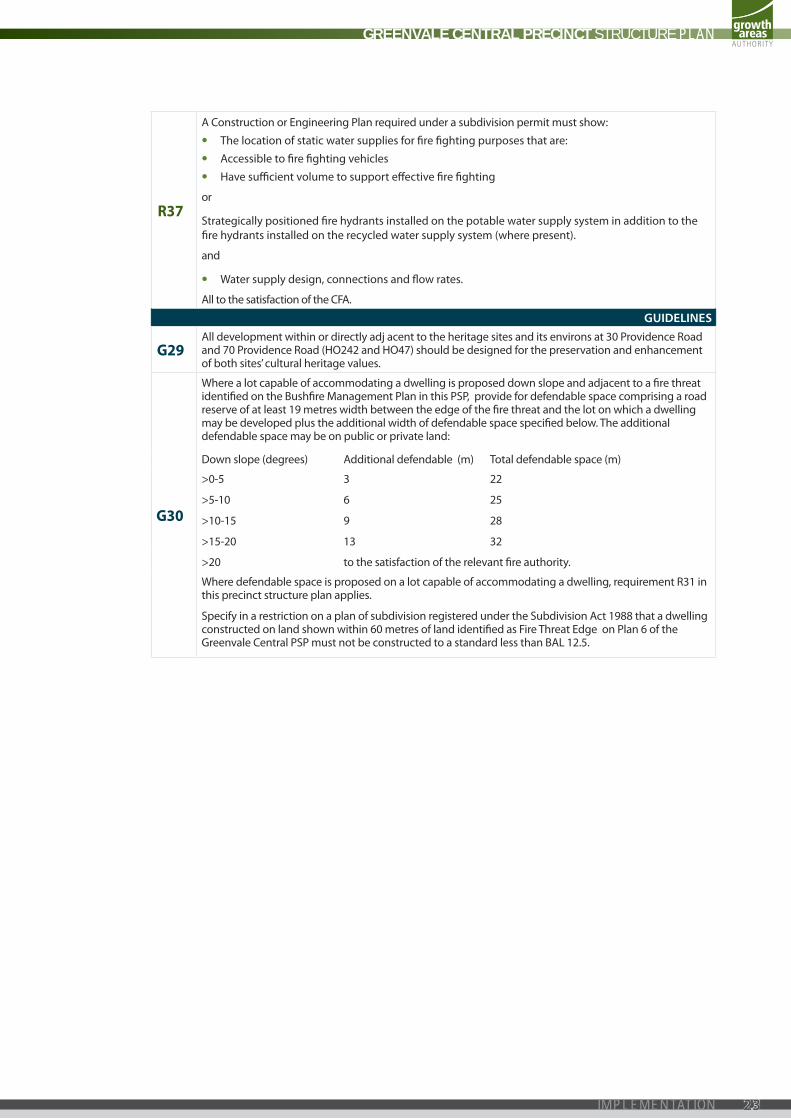
R37
a construction or engineering plan required under a subdivision permit must show:
• the location of static water supplies for fire fighting purposes that are:
• accessible to fire fighting vehicles
• Have sufficient volume to support effective fire fighting
or
Strategically positioned fire hydrants installed on the potable water supply system in addition to the fire hydrants installed on the recycled water supply system (where present).
and
• Water supply design, connections and flow rates.
all to the satisfaction of the cFa.
GUIDELINES
G29 all development within or directly adj acent to the heritage sites and its environs at 30 providence road and 70 providence road (HO242 and HO47) should be designed for the preservation and enhancement of both sites’ cultural heritage values.
G30
Where a lot capable of accommodating a dwelling is proposed down slope and adjacent to a fire threat identified on the Bushfire Management plan in this pSp, provide for defendable space comprising a road reserve of at least 19 metres width between the edge of the fire threat and the lot on which a dwelling may be developed plus the additional width of defendable space specified below. the additional defendable space may be on public or private land:
down slope (degrees) additional defendable (m) total defendable space (m)
>0-5
>5-10
>10-15
>15-20
3
6
9
13
22
25
28
32
>20 to the satisfaction of the relevant fire authority.
Where defendable space is proposed on a lot capable of accommodating a dwelling, requirement r31 in this precinct structure plan applies.
Specify in a restriction on a plan of subdivision registered under the Subdivision act 1988 that a dwelling constructed on land shown within 60 metres of land identified as Fire threat edge on plan 6 of the Greenvale central pSp must not be constructed to a standard less than Bal 12.5.
GREENVALE CENTRAL PRECINCT STRUCTURE PLAN
23IMPLEMENTATION
PROVIDENCE ROAD
CARR
OLL
LA
NE
BON
DS
LAN
E
SEC
TIO
N R
OA
D
FREN
CH R
OA
D
BREN
DA
N R
OA
D
HILLVIEW ROAD
GREENVALERESERVE
WOODLANDSHISTORIC PARK
SOMERTON ROAD
MIC
KLEH
AM
RO
AD
GREENVALERESERVOIR
PARK
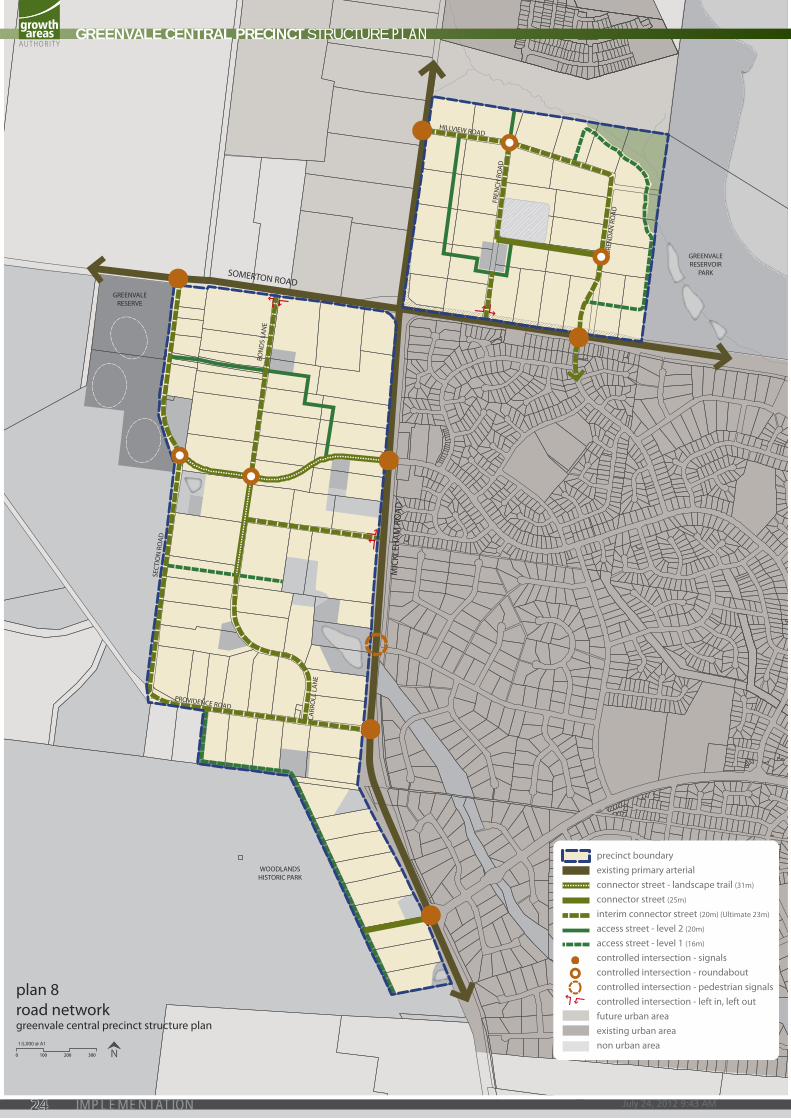
precinct boundaryexisting primary arterialconnector street - landscape trail (31m)
connector street (25m)
interim connector street (20m) (Ultimate 23m)
access street - level 2 (20m)
access street - level 1 (16m)
controlled intersection - signalscontrolled intersection - roundaboutcontrolled intersection - pedestrian signalscontrolled intersection - left in, left outfuture urban areaexisting urban areanon urban area
0 100 200 300 N1:5,000 @ A1
plan 8road networkgreenvale central precinct structure plan
GREENVALE CENTRAL PRECINCT STRUCTURE PLAN
July 24, 2012 9:43 AM24 IMPLEMENTATION

3.3 transport and moVement
TRANSPORT: STREET NETWORKREQUIREMENTS
R38 Street layouts of individual subdivisions must integrate to:
• Form a coherent movement network across the wider precinct
• ensure no dwelling is disadvantaged by poor access to open space or facilities.
R39 access to Mickleham road and Somerton road from connector and/or local access roads must be to the satisfaction of Vicroads.
R40 Staging of subdivisions is to provide for the timely connection of road links between properties and to the collector and arterial road network and the off-road pedestrian and bicycle network to the satisfaction of the responsible authority.
R41 roads must be constructed to property boundaries where inter-parcel connections are indicated in the structure plan, by any date or stage of development required or approved by the responsible authority.
R42 driveway access to lots fronting arterial or sub-arterial roads must be provided from local road or rear lanes only. Service roads may be considered in exceptional circumstances, subject to agreement of the coordinating road authority.
R43 Street blocks lengths must not exceed 200 metres. intervals between blocks may take the form of either a trafficable street or pedestrian passage of no less than four metres in width.
R44 roads must be constructed generally in accordance with road cross Section Figures 2, 3, 4, 5, 6 and 7.
GUIDELINES
G31 Street layouts should provide multiple convenient routes to major destinations such as Greenvale reserve, Greenvale Shopping centre and the arterial road network.
G32 use of cul-de-sacs should be discouraged given the existing fragmentation of land ownership within the precinct.
G33 intersections of local connector roads with Mickleham road and Somerton road should be designed to facilitate the safe and convenient movement of pedestrians and public transport between existing Greenvale and the new precinct.
G34 the street network should be developed to allow interim and ultimate access to the precinct, noting potential interim access from Mickleham road and Somerton road for the initial stages of development.
G35 the access level 2 road indicated to be provided on property 51 should include an additional 3 metres to allow shared path connections between Bonds lane and the linear corridor.
GREENVALE CENTRAL PRECINCT STRUCTURE PLAN
25IMPLEMENTATION
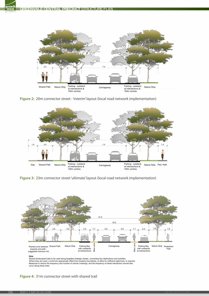
figure 2: 20m connector street - ‘interim’ layout (local road network implementation)
figure 4: 31m connector street with shared trail
figure 3: 23m connector street ‘ultimate’ layout (local road network implementation)
Shared Path Parking - outstandat intersections &100m centres
Nature Strip Carriageway Nature Strip
23.0
2.5 2.3 7.4 2.32.5 3.0
Parking - outstandat intersections &100m centres
1.5
Ped. PathGap
1.5
Shared Path Parking - outstandat intersections &100m centres
Nature Strip Carriageway Nature Strip
20.0
2.5 2.3 7.4 2.32.5 3.0
Parking - outstandat intersections &100m centres
Typically 3000-7,000VPD
Copyright, Growth Areas Authority, 2011 The state of Victoria does not warrant the accuracy or completeness of information in this publication and any person using or relying upon such information does so on the basis that the State of Victoria shall bear no responsibility or liability whatsoever for any errors, faults, defects or omission in the information.
Date:
20m Connector Optiongreenvale central precinct structure plan
May 2012
INTERIM
ULTIMATEShared Path Parking - outstandat intersections &100m centres
Nature Strip Carriageway Nature Strip
23.0
2.5 2.3 7.4 2.32.5 3.0
Parking - outstandat intersections &100m centres
1.5
Ped. PathGap
1.5
Shared Path Parking - outstandat intersections &100m centres
Nature Strip Carriageway Nature Strip
20.0
2.5 2.3 7.4 2.32.5 3.0
Parking - outstandat intersections &100m centres
Typically 3000-7,000VPD
Copyright, Growth Areas Authority, 2011 The state of Victoria does not warrant the accuracy or completeness of information in this publication and any person using or relying upon such information does so on the basis that the State of Victoria shall bear no responsibility or liability whatsoever for any errors, faults, defects or omission in the information.
Date:
20m Connector Optiongreenvale central precinct structure plan
May 2012
INTERIM
ULTIMATE
3.0 2.3 1.7 3.5 3.5 2.31.7
11.0 15.0 5.0
3.5 1.54.0
31.0
3.5 - 4.0
Shared Path
Bik
e La
ne
Parking Baywith outstandsat intersections
CarriagewayNature StripPlanted zone betweenproperty and path -
suggested minimum 4m
Connector Street - Residentialwith Shared Landscape Trail 31m Typically 3000-7,000VPD Current at 09-10-2010
PedestrianPath
NoteShared landscaped trails to be used along targetted strategic streets, connecting key destinations and activities.Where they are used, a minimum appropriate offset from property boundaries, to allow for sufficient sight-lines, is required.Measures to reduce the frequency and number of vehicle crossings, and the frequency of street intersection should alsooccur along these trails.
Bik
e La
ne
Nature StripParking Baywith outstandsat intersections
Copyright, Growth Areas Authority, 2011 The state of Victoria does not warrant the accuracy or completeness of information in this publication and any person using or relying upon such information does so on the basis that the State of Victoria shall bear no responsibility or liability whatsoever for any errors, faults, defects or omission in the information.
GREENVALE CENTRAL PRECINCT STRUCTURE PLAN
July 24, 2012 9:43 AM26 IMPLEMENTATION
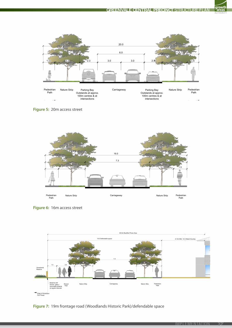
figure 5: 20m access street
figure 6: 16m access street
figure 7: 19m frontage road (Woodlands Historic park)/defendable space
20.0
3.21.5 2.3
4.7 6.0 4.7
3.0 2.3 3.2 1.53.0
Demonstration ExampleAccess Street Level 2 20m 2000-3000VPD Current at 19-07-2010
Carriageway Nature Strip PedestrianPath
Parking BayOutstands at approx.100m centres & at
intersections
Parking BayOutstands at approx.100m centres & at
intersections
PedestrianPath
Nature Strip
Copyright, Growth Areas Authority, 2011 The state of Victoria does not warrant the accuracy or completeness of information in this publication and any person using or relying upon such information does so on the basis that the State of Victoria shall bear no responsibility or liability whatsoever for any errors, faults, defects or omission in the information.
PedestrianPath
CarriagewayNature StripPedestrianPath
Nature Strip
1.5 1.5
16.0
2.73.0
4.5 7.3 4.2
Demonstration ExampleAccess Place / Access Street Level 1 16m <2000 VPD Current at 19-07-2010
Copyright, Growth Areas Authority, 2011 The state of Victoria does not warrant the accuracy or completeness of information in this publication and any person using or relying upon such information does so on the basis that the State of Victoria shall bear no responsibility or liability whatsoever for any errors, faults, defects or omission in the information.
PedestrianPath
CarriagewayNature Strip Nature Strip
1.52.73.0
7.5 7.3 4.2
SharedPath
19.0 Defendable space 41.0m BAL 12.5 Rated Housing
60.0m Bushfire Prone Area
Edge of GrasslandFire Threat
Bollards withaccess gates /removable bollardsat regular intervals
1.5 3.0
GrasslandsReserve
Typically 3000-7,000VPD
Copyright, Growth Areas Authority, 2011 The state of Victoria does not warrant the accuracy or completeness of information in this publication and any person using or relying upon such information does so on the basis that the State of Victoria shall bear no responsibility or liability whatsoever for any errors, faults, defects or omission in the information.
Date:
19m Bushfire Prone Area Access Street Level 1greenvale central precinct structure plan
May 2012
GREENVALE CENTRAL PRECINCT STRUCTURE PLAN
27IMPLEMENTATION
PROVIDENCE ROAD
CARR
OLL
LA
NE
BON
DS
LAN
E
SEC
TIO
N R
OA
D
FREN
CH R
OA
D
BREN
DA
N R
OA
D
HILLVIEW ROAD
GREENVALERESERVE
WOODLANDSHISTORIC PARK
MIC
KLEH
AM
RO
AD
SOMERTON ROAD
GREENVALERESERVOIR
PARK
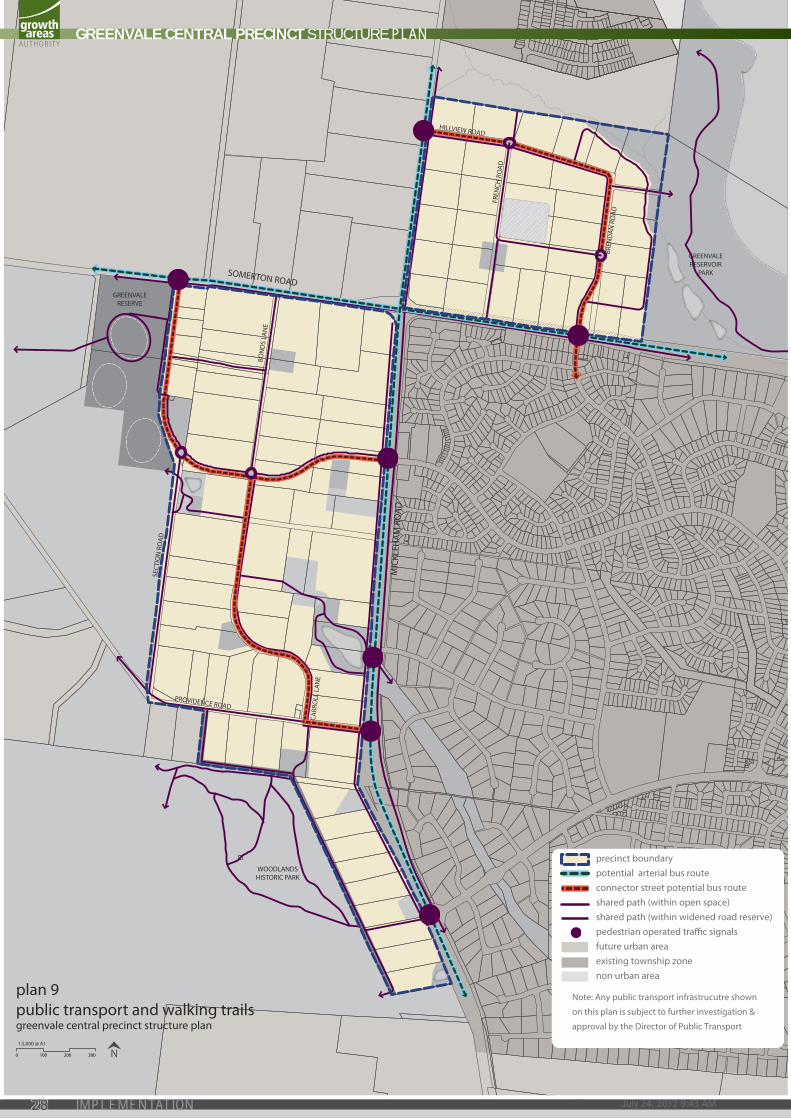
precinct boundarypotential arterial bus routeconnector street potential bus routeshared path (within open space)shared path (within widened road reserve)pedestrian operated trac signalsfuture urban areaexisting township zonenon urban area
Note: Any public transport infrastrucutre shown
on this plan is subject to further investigation &
approval by the Director of Public Transport
0 100 200 300 N1:5,000 @ A1
plan 9public transport and walking trailsgreenvale central precinct structure plan
GREENVALE CENTRAL PRECINCT STRUCTURE PLAN
July 24, 2012 9:43 AM28 IMPLEMENTATION

TRANSPORT: PUBLIC TRANSPORTREQUIREMENTS
R45
Bus stop facilities must be constructed by development proponents as part of the subdivision works (prior to the issue of a statement of compliance for the relevant stage) in accordance with the requirements of the public transport Guidelines for land use and development to the satisfaction of public transport Victoria (ptV). the department of transport is to nominate the location and type of bus stops to be provided by the developer.
R46 the bus stop facilities must be provided with dda compliant direct and safe pedestrian access connected to an existing pedestrian / shared path.
R47 the bus stop facilities must be designed as an integral part of activity centres and activity generating land uses, such as schools, sports fields and employment areas.
TRANSPORT: WALKING & CYCLINGREQUIREMENTS
R48 Walking and cycling networks must be constructed by development proponents as part of subdivision works.
R49 pedestrian paths must be shown on both sides of connector and access streets.
R50 pedestrian and cycle crossing points must be provided at all intersections and on key desire lines.
R51 cycle parking facilities are to be provided by development proponents in convenient locations at key destinations such as parks and activity centres.
GUIDELINES
G36 location of pedestrian and cycle paths should be located to provide for passive surveillance.
G37 cycle connections should be designed to allow for the safe and convenient transition between on-road and off-road networks.
GREENVALE CENTRAL PRECINCT STRUCTURE PLAN
29IMPLEMENTATION
3.4 water and utIlItIes
WATERREQUIREMENTS
R52 Final design and size of channels, retarding basins and water quality treatment infrastructure must be approved by both the responsible authority and Melbourne Water.
R53 development must be in accordance with the development Services Scheme prepared by Melbourne Water for the precinct.
R54 Storm water conveyance must be designed to the satisfaction of council and in accordance with the development Services Scheme prepared by Melbourne Water for the precinct.
R55 drainage systems must provide for a suitable buffer from urban development and contain ephemeral water bodies to enable the replication of natural flows and provide habitat for local species.
R56 development must conform to the relevant policies and strategies being implemented by council, Melbourne Water and the water retail authority, including any approved integrated Water Management plan.
R57 development must treat stormwater run-off to best practice standards, to the satisfaction of Melbourne Water.
GUIDELINES
G38 corridors and buffers along waterways should be designed and constructed to protect water quality, water function and public health and safety.
G39 integrated water management systems should be designed to maximise habitat values for local flora and fauna species.
UTILITIESREQUIREMENTS
R58 all lots must be provided with potable water, electricity, a reticulated sewerage, drainage, gas and telecommunications to the satisfaction of the relevant authority.
R59 all new electricity supply infrastructure (excluding substation and cables with a voltage greater than 66kv) must be provided underground.
R60 new substations must be identified at the subdivision design response stage to ensure effective integration with the surrounding neighbouring and to minimise amenity impacts.
R61 all dwellings and businesses must have access to the broadband network.
R62 if required, any pump station within the precinct must be designed to the satisfaction of the relevant water authority.
GUIDELINES
G40 electricity substations should be located outside of key view lines and screened with vegetation.
G41 the design of subdivision electricity infrastructure must consider the practicality of removing any existing above ground electricity lines by re-routing lines underground through the subdivision.
G42 if required, any pump station with the precinct should be designed to minimise visual impacts on the surrounding residential development.
GREENVALE CENTRAL PRECINCT STRUCTURE PLAN
July 24, 2012 9:43 AM30 IMPLEMENTATION
3.5 precInct Infrastructure and deVelopment stagIng
The Precinct Infrastructure Plan (PIP) at Table 4 sets out the infrastructure and services required to meet the needs of proposed development within the precinct. The infrastructure items and services are to be provided through a number of mechanisms including:
• Subdivision construction works by developers
• Agreement under Section 173 of the Planning and Environment Act 1987
• Utility service provider requirements
• Capital works projects by Council, State government agencies and non-government organizations.
ImplementatIonThe Road Network Implementation Plan and Table 3 set out the process by which road infrastructure must be delivered as part of the development within the precinct. Each infrastructure project is to the provided through subdivision construction works by developers.
Road infrastructure must be delivered in a sequence that provides future residents with immediate access to the arterial road network, irrespective of residential development staging within the precinct.
Implementation Areas are identified using a nomenclature system that identifies projects by street-based groups using letter (A, B, C, etc.) and their required staging numbers (1, 2 or 3). Owners within each Implementation Area are responsible for the provision of the associated road infrastructure as part of the subdivision construction works, except when engaging in ‘out-of-sequence’ development.
‘Out-of-sequence’ development is characterised as when a planning permit is issued for subdivision within a ‘Stage 2’ Implementation Area (2A, 2B, 2C, etc.) before a planning permit is issued for subdivision within a ‘Stage 1’ Implementation Area (1A, 1B, 1C, etc.). Should this occur, the relevant applicant is responsible for delivering the stages of road infrastructure as detailed in Table 3. This will be enforced via a condition on the planning permit and must be constructed in accordance with Road Cross Section Figure 2 of this PSP. Similarly, a subdivision permit within the ‘Stage 3’ Implementation Area will be required to construct both Stage 1 and Stage 2 road infrastructure.
GREENVALE CENTRAL PRECINCT STRUCTURE PLAN
31IMPLEMENTATION
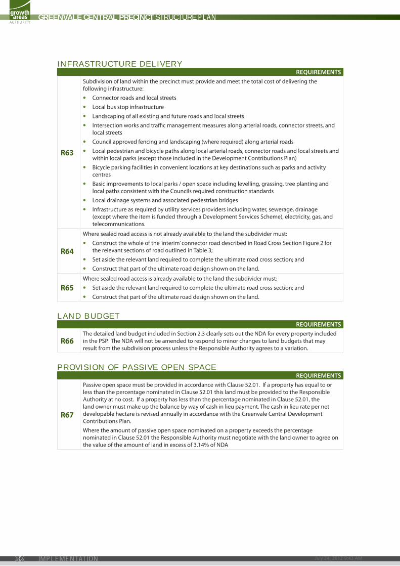
INFRASTRUCTURE DELIVERYREQUIREMENTS
R63
Subdivision of land within the precinct must provide and meet the total cost of delivering the following infrastructure:
• connector roads and local streets
• local bus stop infrastructure
• landscaping of all existing and future roads and local streets
• intersection works and traffic management measures along arterial roads, connector streets, and local streets
• council approved fencing and landscaping (where required) along arterial roads
• local pedestrian and bicycle paths along local arterial roads, connector roads and local streets and within local parks (except those included in the development contributions plan)
• Bicycle parking facilities in convenient locations at key destinations such as parks and activity centres
• Basic improvements to local parks / open space including levelling, grassing, tree planting and local paths consistent with the councils required construction standards
• local drainage systems and associated pedestrian bridges
• infrastructure as required by utility services providers including water, sewerage, drainage (except where the item is funded through a development Services Scheme), electricity, gas, and telecommunications.
R64
Where sealed road access is not already available to the land the subdivider must:
• construct the whole of the ‘interim’ connector road described in road cross Section Figure 2 for the relevant sections of road outlined in table 3;
• Set aside the relevant land required to complete the ultimate road cross section; and
• construct that part of the ultimate road design shown on the land.
R65 Where sealed road access is already available to the land the subdivider must:
• Set aside the relevant land required to complete the ultimate road cross section; and
• construct that part of the ultimate road design shown on the land.
LAND BUDGETREQUIREMENTS
R66 the detailed land budget included in Section 2.3 clearly sets out the nda for every property included in the pSp. the nda will not be amended to respond to minor changes to land budgets that may result from the subdivision process unless the responsible authority agrees to a variation.
PROVISION OF PASSIVE OPEN SPACEREQUIREMENTS
R67
passive open space must be provided in accordance with clause 52.01. if a property has equal to or less than the percentage nominated in clause 52.01 this land must be provided to the responsible authority at no cost. if a property has less than the percentage nominated in clause 52.01, the land owner must make up the balance by way of cash in lieu payment. the cash in lieu rate per net developable hectare is revised annually in accordance with the Greenvale central development contributions plan.
Where the amount of passive open space nominated on a property exceeds the percentage nominated in clause 52.01 the responsible authority must negotiate with the land owner to agree on the value of the amount of land in excess of 3.14% of nda
GREENVALE CENTRAL PRECINCT STRUCTURE PLAN
July 24, 2012 9:43 AM32 IMPLEMENTATION

This page has been left blank intentionally
GREENVALE CENTRAL PRECINCT STRUCTURE PLAN
33IMPLEMENTATION
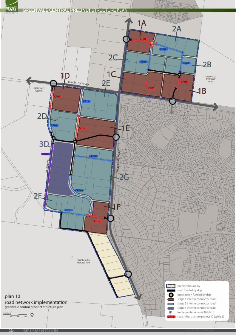
CR12
CR10
CR07
CR05
CR01
CR02
CR04CR06
CR11
CR08
CR14b
CR14a
CR13
CR09
CR03
SEC
TIO
N R
OA
D
GREENVALERESERVE
WOODLANDSHISTORIC PARK
SOMERTON ROAD
MIC
KLEH
AM
RO
AD
GREENVALERESERVOIR
PARK
1A2A
2E1D
2C
1C
2D
3D
2F
1B
1E
2G
1F
2B
precinct boundaryroad funded by dcpintersection funded by dcpstage 1 interim connector roadstage 2 interim connector roadstage 3 interim connector roadimplementation area (table 3)road infrastructure project ID (table 3)CR12
1F
plan 10road network implementationgreenvale central precinct structure plan
0 100 200 300 N1:5,000 @ A1
GREENVALE CENTRAL PRECINCT STRUCTURE PLAN
July 24, 2012 9:43 AM34 IMPLEMENTATION

ImplementatIon area
(area to be subdivided)
length of road to be
constructed
road Infrastructure
project name
road Infrastructure project descrIptIon
applIcable road cross
sectIon
affected propertIes(as per property
specific land budget)
area north
area 1a cr01 Hillview road West Hillview road: Mickleham road to French road and associated
roundabout
20m connector road (interim
standard)
77-78, 83, 92
area 2a cr01, cr02 Hillview road east Hillview road: French road to Brendan road
20m connector road (interim
standard)
79-82, 93, 104
area 1B cr03 Brendan road South
Brendan road: east-West connector road 1 (refer Greenvale central dcp)
20m connector road (interim
standard)
99-101, 107-109
area 2B cr03, cr04 Brendan road north
Brendan road: Hillview road to east-West connector road (refer
Greenvale central dcp)
20m connector road (interim
standard)
102-103, 105-106
area 1c cr05 French road South
French road: Somerton road to passive Open Space 2 (refer to table 2: Open space inventory) and associated left in/left out
access works
20m connector road (interim
standard)
86-89, 96-98
area 2c cr01, cr06 French road north French road: Hillview road to east-West connector road 1 (refer Greenvale central dcp)
20m connector road (interim
standard)
84-85, 96-98
area south
area 1d cr07 Section road north
Section road: Somerton road to southern boundary of property 6 (refer Greenvale central land
use Budget)
20m connector road (interim
standard)
1-7, 11-15
area 2d cr07, cr08 Section road central
Section road: north Boundary of property 7 to east-West connector road 2 (refer Greenvale central dcp)
20m connector road (interim
standard)
8-10, 16-18
area 3dcr07, cr08,
cr09 Or cr12, cr13, cr09
Section road South
Section road: east-West connector road 2 (refer
Greenvale central dcp) to providence road
20m connector road (interim
standard)19-24
area 1e cr10 Bonds lane South
Bonds lane: northern Boundary of property 39 (refer Gc luB)
to east-West connector 3 (refer Greenvale central dcp)
20m connector road (interim
standard)
39-42, 46-49
area 2e cr11 Bonds lane north
Bonds lane: Somerton road to Southern Boundary of property 38 (refer Gc luB) and associated
left in/left out access works
20m connector road (interim
standard)
33-38, 50
area 1F cr12 providence road east
providence road: carroll lane to Mickleham road
20m connector road (interim
standard)
60-61, 65-67
area 2F cr12, cr13 providence road West
providence road: Section road to carroll lane
20m connector road (interim
standard)
25-30, 62-64
area 2G
area 2G carroll lanecarroll lane: Bonds lane
extension (refer Greenvale central dcp) to providence road
20m connector road (interim
standard)
43-45, 51-59
cr14b Bonds lane
Bonds lane: Bonds lane extension (refer Greenvale
central dcp) to Mickleham road and associated left in/left out
access works
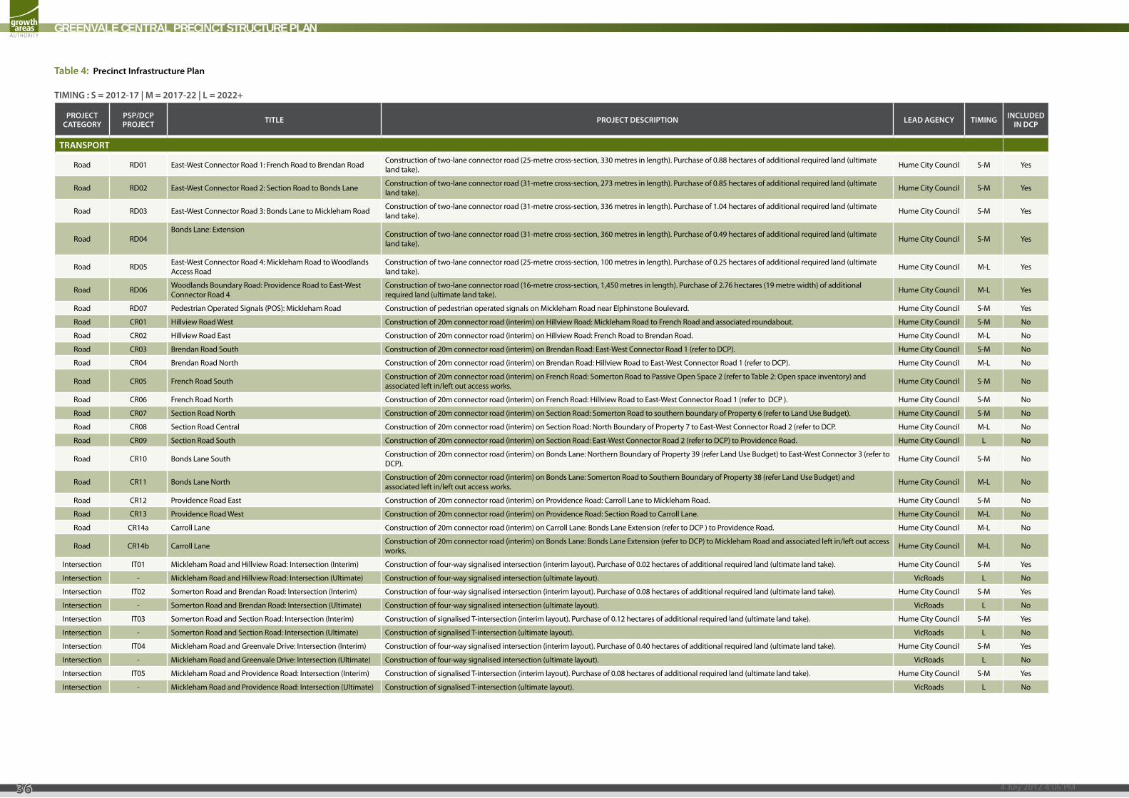
table 3: local road network implementation
GREENVALE CENTRAL PRECINCT STRUCTURE PLAN
35IMPLEMENTATION
4 July 2012 4:06 PM
GREENVALE CENTRAL PRECINCT STRUCTURE PLAN
36
TIMING : S = 2012-17 | M = 2017-22 | L = 2022+
ProjecT caTeGory
PSP/DcP ProjecT TITLe ProjecT DeScrIPTIoN LeaD aGeNcy TIMING INcLuDeD
IN DcP
TraNSPorT
Road RD01 East-West Connector Road 1: French Road to Brendan Road Construction of two-lane connector road (25-metre cross-section, 330 metres in length). Purchase of 0.88 hectares of additional required land (ultimate land take). Hume City Council S-M Yes
Road RD02 East-West Connector Road 2: Section Road to Bonds Lane Construction of two-lane connector road (31-metre cross-section, 273 metres in length). Purchase of 0.85 hectares of additional required land (ultimate land take). Hume City Council S-M Yes
Road RD03 East-West Connector Road 3: Bonds Lane to Mickleham Road Construction of two-lane connector road (31-metre cross-section, 336 metres in length). Purchase of 1.04 hectares of additional required land (ultimate land take). Hume City Council S-M Yes
Road RD04Bonds Lane: Extension Construction of two-lane connector road (31-metre cross-section, 360 metres in length). Purchase of 0.49 hectares of additional required land (ultimate
land take). Hume City Council S-M Yes
Road RD05 East-West Connector Road 4: Mickleham Road to Woodlands Access Road
Construction of two-lane connector road (25-metre cross-section, 100 metres in length). Purchase of 0.25 hectares of additional required land (ultimate land take). Hume City Council M-L Yes
Road RD06 Woodlands Boundary Road: Providence Road to East-West Connector Road 4
Construction of two-lane connector road (16-metre cross-section, 1,450 metres in length). Purchase of 2.76 hectares (19 metre width) of additional required land (ultimate land take). Hume City Council M-L Yes
Road RD07 Pedestrian Operated Signals (POS): Mickleham Road Construction of pedestrian operated signals on Mickleham Road near Elphinstone Boulevard. Hume City Council S-M Yes
Road CR01 Hillview Road West Construction of 20m connector road (interim) on Hillview Road: Mickleham Road to French Road and associated roundabout. Hume City Council S-M No
Road CR02 Hillview Road East Construction of 20m connector road (interim) on Hillview Road: French Road to Brendan Road. Hume City Council M-L No
Road CR03 Brendan Road South Construction of 20m connector road (interim) on Brendan Road: East-West Connector Road 1 (refer to DCP). Hume City Council S-M No
Road CR04 Brendan Road North Construction of 20m connector road (interim) on Brendan Road: Hillview Road to East-West Connector Road 1 (refer to DCP). Hume City Council M-L No
Road CR05 French Road South Construction of 20m connector road (interim) on French Road: Somerton Road to Passive Open Space 2 (refer to Table 2: Open space inventory) and associated left in/left out access works. Hume City Council S-M No
Road CR06 French Road North Construction of 20m connector road (interim) on French Road: Hillview Road to East-West Connector Road 1 (refer to DCP ). Hume City Council S-M No
Road CR07 Section Road North Construction of 20m connector road (interim) on Section Road: Somerton Road to southern boundary of Property 6 (refer to Land Use Budget). Hume City Council S-M No
Road CR08 Section Road Central Construction of 20m connector road (interim) on Section Road: North Boundary of Property 7 to East-West Connector Road 2 (refer to DCP. Hume City Council M-L No
Road CR09 Section Road South Construction of 20m connector road (interim) on Section Road: East-West Connector Road 2 (refer to DCP) to Providence Road. Hume City Council L No
Road CR10 Bonds Lane South Construction of 20m connector road (interim) on Bonds Lane: Northern Boundary of Property 39 (refer Land Use Budget) to East-West Connector 3 (refer to DCP). Hume City Council S-M No
Road CR11 Bonds Lane North Construction of 20m connector road (interim) on Bonds Lane: Somerton Road to Southern Boundary of Property 38 (refer Land Use Budget) and associated left in/left out access works. Hume City Council M-L No
Road CR12 Providence Road East Construction of 20m connector road (interim) on Providence Road: Carroll Lane to Mickleham Road. Hume City Council S-M No
Road CR13 Providence Road West Construction of 20m connector road (interim) on Providence Road: Section Road to Carroll Lane. Hume City Council M-L No
Road CR14a Carroll Lane Construction of 20m connector road (interim) on Carroll Lane: Bonds Lane Extension (refer to DCP ) to Providence Road. Hume City Council M-L No
Road CR14b Carroll Lane Construction of 20m connector road (interim) on Bonds Lane: Bonds Lane Extension (refer to DCP) to Mickleham Road and associated left in/left out access works. Hume City Council M-L No
Intersection IT01 Mickleham Road and Hillview Road: Intersection (Interim) Construction of four-way signalised intersection (interim layout). Purchase of 0.02 hectares of additional required land (ultimate land take). Hume City Council S-M Yes
Intersection - Mickleham Road and Hillview Road: Intersection (Ultimate) Construction of four-way signalised intersection (ultimate layout). VicRoads L No
Intersection IT02 Somerton Road and Brendan Road: Intersection (Interim) Construction of four-way signalised intersection (interim layout). Purchase of 0.08 hectares of additional required land (ultimate land take). Hume City Council S-M Yes
Intersection - Somerton Road and Brendan Road: Intersection (Ultimate) Construction of four-way signalised intersection (ultimate layout). VicRoads L No
Intersection IT03 Somerton Road and Section Road: Intersection (Interim) Construction of signalised T-intersection (interim layout). Purchase of 0.12 hectares of additional required land (ultimate land take). Hume City Council S-M Yes
Intersection - Somerton Road and Section Road: Intersection (Ultimate) Construction of signalised T-intersection (ultimate layout). VicRoads L No
Intersection IT04 Mickleham Road and Greenvale Drive: Intersection (Interim) Construction of four-way signalised intersection (interim layout). Purchase of 0.40 hectares of additional required land (ultimate land take). Hume City Council S-M Yes
Intersection - Mickleham Road and Greenvale Drive: Intersection (Ultimate) Construction of four-way signalised intersection (ultimate layout). VicRoads L No
Intersection IT05 Mickleham Road and Providence Road: Intersection (Interim) Construction of signalised T-intersection (interim layout). Purchase of 0.08 hectares of additional required land (ultimate land take). Hume City Council S-M Yes
Intersection - Mickleham Road and Providence Road: Intersection (Ultimate) Construction of signalised T-intersection (ultimate layout). VicRoads L No
Table 4: Precinct Infrastructure Plan

GREENVALE CENTRAL PRECINCT STRUCTURE PLAN
37
ProjecT caTeGory
PSP/DcP ProjecT TITLe ProjecT DeScrIPTIoN LeaD aGeNcy TIMING INcLuDeD
IN DcP
Intersection IT06 Mickleham Road and Barrymore Drive: Intersection (Interim) Construction of four-way signalised intersection (interim layout). Purchase of 0.33 hectares of additional required land (ultimate land take). Hume City Council M-L Yes
Intersection - Mickleham Road and Barrymore Drive: Intersection (Ultimate) Construction of four-way signalised intersection (ultimate layout). VicRoads L No
Intersection IT07 Brendan Road and East-West Connector Road 1: Intersection. Construction of roundabout (ultimate layout). Purchase of 0.20 hectares of additional required land (ultimate land take). Hume City Council S-M Yes
Intersection IT08 Section Road and East-West Connector Road 2: Intersection. Construction of roundabout (ultimate layout). Purchase of 0.39 hectares of additional required land (ultimate land take). Hume City Council S-M Yes
Intersection IT09 Bonds Lane and East-West Connector Road 3: Intersection. Construction of roundabout (ultimate layout). Purchase of 0.30 hectares of additional required land (ultimate land take). Hume City Council S-M Yes
PuBLIc TraNSPorTBus - Greenvale Central Bus Services Progressive extension of local bus services to service the precinct Hume City Council M-L Yes
Bus - Bus Stops Provision of bus stops to be delivered with local street system as part of subdivision construction approvals Hume City Council M-L Yes
coMMuNITy SerVIceSCommunity
Centre C01 Multi-purpose Community Centre (Greenvale West PSP). Expansion of multi-purpose community centre to include 1 addition pre-school room, 1 additional Maternal & Child Health (MCH) room, and additional community meeting space. Hume City Council M-L Yes
oPeN SPace
Active AR01 Playing Field (Greenvale Reserve). Construction of 1 playing services (AFL/cricket/soccer), car spaces, landscaping and related infrastructure as described by the Greenvale Reserve Master Plan (Hume City Council City Council). Hume City Council M-L Yes
Active AR02 Pavilion (Greenvale Reserve). Construction of pavilion (including all buildings works) to serve the playing field as described by the Greenvale Reserve Master Plan (Hume City Council City Council). Hume City Council M-L Yes
Active AR03 Netball Courts (Greenvale Reserve) Construction of 2 netball courts at Greenvale Reserve as described by the Greenvale Reserve Master Plan (Hume City Council City Council). Hume City Council S-M Yes
Active AR04 Tennis Courts (Greenvale Reserve) Construction of 2 tennis courts at Greenvale Reserve as described by the Greenvale Reserve Master Plan (Hume City Council City Council). Hume City Council S-M Yes
Active AR05 Playing Field 2 (Barrymore Road Reserve) Construction of 1 playing service (soccer) at Barrymore Road Reserve. Hume City Council M-L Yes
Active AR06 Pavilion 2 (Barrymore Road Reserve) Construction of pavilion (including all buildings works) to serve the playing field at Barrymore Road Reserve. Hume City Council M-L Yes
PassiveOpen Space 1 (Open Space
Inventory)
Emcumbered Passive Open Space - Growling Grass Frog Conservation Area
Hume City Council & Melbourne Water - No
Passive Open Space 2 Unemcumbered Passive Open Park Earthworks, drainage works, landscape construction, trail development and passive park development. Hume City Council - No
Passive Open Space 3 Unemcumbered Passive Open Park Earthworks, drainage works, landscape construction, trail development and passive park development. Hume City Council - No
Passive Open Space 4 Unemcumbered Passive Open Park Earthworks, drainage works, landscape construction, trail development and passive park development. Hume City Council - No
Passive Open Space 5 Emcumbered Passive Open Space - Retarding Basin Earthworks, drainage works, landscape construction, trail development and passive park development. Hume City Council - No
Passive Open Space 6 Emcumbered Passive Open Space - Native Vegetation Retention Hume City Council - No
Passive Open Space 7 Unemcumbered Passive Open Park Earthworks, drainage works, landscape construction, trail development and passive park development. Hume City Council - No
Passive Open Space 8 Unemcumbered Passive Open Park Earthworks, drainage works, landscape construction, trail development and passive park development. Hume City Council - No
Passive Open Space 9 Emcumbered Passive Open Space - Native Vegetation Retention Hume City Council - No
Passive Open Space 10 Emcumbered Passive Open Space - Native Vegetation Retention Hume City Council - No
Passive Open Space 11 Unemcumbered Passive Open Park Earthworks, drainage works, landscape construction, trail development and passive park development. Hume City Council - No
Passive Open Space 12 Emcumbered Passive Open Space - Retarding Basin and Native Vegetation Retention Earthworks, drainage works, landscape construction, trail development and passive park development. Melbourne Water - No
Passive Open Space 13 Unemcumbered Passive Open Park Earthworks, drainage works, landscape construction, trail development and passive park development. Hume City Council - No
Passive Open Space 14 Unemcumbered Passive Open Park Earthworks, drainage works, landscape construction, trail development and passive park development. Hume City Council - No
Passive Open Space 15 Emcumbered Passive Open Space - Native Vegetation Retention Hume City Council - No
Passive Open Space 16 Emcumbered Passive Open Space - Native Vegetation Retention Hume City Council - No
Passive Open Space 17 Emcumbered Passive Open Space - Retarding Basin Earthworks, drainage works, landscape construction, trail deveopment and passive park development works. Hume City Council - No
Passive Open Space 18 Unemcumbered Passive Open Space - Defendable Space Area Hume City Council - No
TIMING : S = 2012-17 | M = 2017-22 | L = 2022+
Table 4: Precinct Infrastructure Plan (continued)
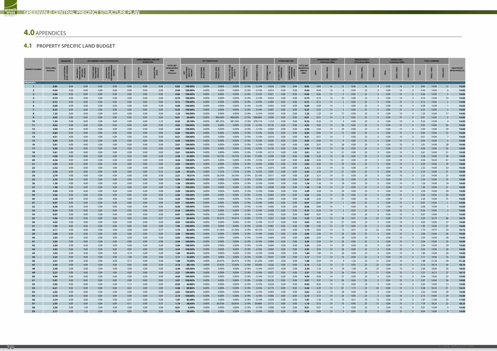
11 July 2012 2:21 PM
GREENVALE CENTRAL PRECINCT STRUCTURE PLAN
38
4.1 PROPERTY SPECIFIC LAND BUDGET
Property Specific Land Budget Template - September 2011 Property Specific Lot Yield
Note - input data where text is blueData is linked to global land budget & population / lot size table
TRANSPORT
6 LA
NE
ART
ERIA
L RO
AD
/ W
IDEN
ING
WA
TERW
AY
/ D
RAIN
AG
E LI
NE
/ W
ETLA
ND
/ RE
TARD
ING
YURO
KE C
REEK
EN
CUM
BERE
D
OPE
N S
PACE
WO
OD
LAN
DS
HIS
TORI
C PA
RK
FIRE
MA
NA
GEM
ENT
BUFF
ER
CON
SERV
ATI
ON
ACT
IVE
OPE
N
SPA
CE
PASS
IVE
OPE
N
SPA
CE
NET
DEV
ELO
PABL
E A
REA
% O
F PR
ECIN
CT
ACT
IVE
OPE
N
SPA
CE %
ND
A
PASS
IVE
OPE
N
SPA
CE %
ND
A
TOTA
L A
CTIV
E A
ND
PA
SSIV
E O
PEN
SP
ACE
%
OPE
N S
PACE
DEL
. TA
RGET
%
DIF
FERE
NCE
% N
DA
DIF
FERE
NCE
ARE
A
Ha
ACT
IVIT
Y CE
NTR
E /
COM
MER
CIA
L
IDEN
TIFI
ED N
ON
-G
OV
ERN
MEN
T SC
HO
OLS
NRH
a
DW
ELL
/ NRH
a
DW
ELLI
NG
S
NRH
a
DW
ELL
/ NRH
a
DW
ELLI
NG
S
NRH
a
DW
ELL
/ NRH
a
DW
ELLI
NG
S
NRH
a
DW
ELL
/ NRH
a
DW
ELLI
NG
S
1 0.83 0.00 0.00 0.00 0.00 0.00 0.00 0.00 0.83 100.00% 0.00% 0.00% 0.00% 3.14% -3.14% -0.026 0.00 0.00 0.83 0.83 14 12 0.00 25 0 0.00 10 0 0.83 14.00 12 14.00
2 0.44 0.00 0.00 0.00 0.00 0.00 0.00 0.00 0.44 100.00% 0.00% 0.00% 0.00% 3.14% -3.14% -0.014 0.00 0.00 0.44 0.44 14 6 0.00 25 0 0.00 10 0 0.44 14.00 6 14.00
3 0.66 0.00 0.00 0.00 0.00 0.00 0.00 0.00 0.66 100.00% 0.00% 0.00% 0.00% 3.14% -3.14% -0.021 0.00 0.00 0.66 0.66 14 9 0.00 25 0 0.00 10 0 0.66 14.00 9 14.00
4 0.74 0.00 0.00 0.00 0.00 0.00 0.00 0.00 0.74 100.00% 0.00% 0.00% 0.00% 3.14% -3.14% -0.023 0.00 0.00 0.74 0.74 14 10 0.00 25 0 0.00 10 0 0.74 14.00 10 14.00
5 0.12 0.00 0.00 0.00 0.00 0.00 0.00 0.00 0.12 100.00% 0.00% 0.00% 0.00% 3.14% -3.14% -0.004 0.00 0.00 0.12 0.12 14 2 0.00 25 0 0.00 10 0 0.12 14.00 2 14.00
6 0.09 0.00 0.00 0.00 0.00 0.00 0.00 0.00 0.09 100.00% 0.00% 0.00% 0.00% 3.14% -3.14% -0.003 0.00 0.00 0.09 0.09 14 1 0.00 25 0 0.00 10 0 0.09 14.00 1 14.00
7 0.23 0.00 0.00 0.00 0.00 0.00 0.00 0.00 0.23 100.00% 0.00% 0.00% 0.00% 3.14% -3.14% -0.007 0.00 0.00 0.23 0.23 14 3 0.00 25 0 0.00 10 0 0.23 14.00 3 14.00
8 1.23 0.00 0.00 0.00 0.00 0.00 0.00 0.00 1.23 100.00% 0.00% 0.00% 0.00% 3.14% -3.14% -0.039 0.00 0.00 1.23 1.23 14 17 0.00 25 0 0.00 10 0 1.23 14.00 17 14.00
TOTAL NET RESIDENTIAL
AREA Ha (NRA)
PROPERTY
PROPERTY NUMBERTOTAL AREA
(Hectares)
TOTAL NET DEVELOPABLE
AREA(Hectares)
ENCUMBERED LAND FOR RECREATIONUNENCUMBERED LAND FOR
RECREATIONTOTAL COMBINED
YIELD PER NET DEVELOPABLE Ha
KEY PERCENTAGES OTHER LAND USESCONVENTIONAL DENSITY
14 Dwell per NRHaMEDIUM DENSITY25 Dwell per NRHa
HANDLE AREA10 Dwell per NRHa
9 0.05 0.00 0.00 0.00 0.00 0.00 0.00 0.04 0.01 20.00% 0.00% 400.00% 400.00% 3.14% 396.86% 0.040 0.00 0.00 0.01 0.01 14 0 0.00 25 0 0.00 10 0 0.01 14.00 0 14.00
10 1.54 0.00 0.00 0.00 0.00 0.00 0.00 1.22 0.32 20.78% 0.00% 381.25% 381.25% 3.14% 378.11% 1.210 0.00 0.00 0.32 0.32 14 4 0.00 25 0 0.00 10 0 0.32 14.00 4 14.00
11 4.02 0.00 0.00 0.00 0.00 0.00 0.00 0.00 4.02 100.00% 0.00% 0.00% 0.00% 3.14% -3.14% -0.126 0.00 0.00 4.02 4.02 14 56 0.00 25 0 0.00 10 0 4.02 14.00 56 14.00
12 2.04 0.00 0.00 0.00 0.00 0.00 0.00 0.00 2.04 100.00% 0.00% 0.00% 0.00% 3.14% -3.14% -0.064 0.00 0.00 2.04 2.04 14 29 0.00 25 0 0.00 10 0 2.04 14.00 29 14.00
13 0.84 0.00 0.00 0.00 0.00 0.00 0.00 0.00 0.84 100.00% 0.00% 0.00% 0.00% 3.14% -3.14% -0.026 0.00 0.00 0.84 0.84 14 12 0.00 25 0 0.00 10 0 0.84 14.00 12 14.00
14 0.51 0.00 0.00 0.00 0.00 0.00 0.00 0.00 0.51 100.00% 0.00% 0.00% 0.00% 3.14% -3.14% -0.016 0.00 0.00 0.51 0.51 14 7 0.00 25 0 0.00 10 0 0.51 14.00 7 14.00
15 0.64 0.00 0.00 0.00 0.00 0.00 0.00 0.00 0.64 100.00% 0.00% 0.00% 0.00% 3.14% -3.14% -0.020 0.00 0.00 0.64 0.64 14 9 0.00 25 0 0.00 10 0 0.64 14.00 9 14.00
16 2.01 0.00 0.00 0.00 0.00 0.00 0.00 0.00 2.01 100.00% 0.00% 0.00% 0.00% 3.14% -3.14% -0.063 0.00 0.00 2.01 2.01 14 28 0.00 25 0 0.00 10 0 2.01 14.00 28 14.00
17 4.00 0.00 0.00 0.00 0.00 0.00 0.00 0.00 4.00 100.00% 0.00% 0.00% 0.00% 3.14% -3.14% -0.126 0.00 0.00 4.00 4.00 14 56 0.00 25 0 0.00 10 0 4.00 14.00 56 14.00
18 3.61 0.00 0.00 0.00 0.00 0.00 0.00 0.00 3.61 100.00% 0.00% 0.00% 0.00% 3.14% -3.14% -0.113 0.00 0.00 3.61 3.61 14 51 0.00 25 0 0.00 10 0 3.61 14.00 51 14.00
19 4.09 0.00 0.80 0.00 0.00 0.33 0.00 0.38 2.58 63.08% 0.00% 14.73% 14.73% 3.14% 11.59% 0.299 0.00 0.00 2.58 2.58 14 36 0.00 25 0 0.00 10 0 2.58 14.00 36 14.00
20 4.36 0.00 0.00 0.00 0.00 0.00 0.00 0.00 4.36 100.00% 0.00% 0.00% 0.00% 3.14% -3.14% -0.137 0.00 0.00 4.36 4.36 14 61 0.00 25 0 0.00 10 0 4.36 14.00 61 14.00
21 2.04 0.00 0.00 0.00 0.00 0.00 0.00 0.00 2.04 100.00% 0.00% 0.00% 0.00% 3.14% -3.14% -0.064 0.00 0.00 2.04 2.04 14 29 0.00 25 0 0.00 10 0 2.04 14.00 29 14.00
22 2.32 0.00 0.00 0.00 0.00 0.00 0.00 0.00 2.32 100.00% 0.00% 0.00% 0.00% 3.14% -3.14% -0.073 0.00 0.00 2.32 2.32 14 32 0.00 25 0 0.00 10 0 2.32 14.00 32 14.00
23 2.36 0.00 0.00 0.00 0.00 0.00 0.00 0.16 2.20 93.22% 0.00% 7.27% 7.27% 3.14% 4.13% 0.091 0.00 0.00 2.20 2.20 14 31 0.00 25 0 0.00 10 0 2.20 14.00 31 14.00
24 2.79 0.00 0.00 0.00 0.00 0.00 0.00 0.58 2.21 79.21% 0.00% 26.24% 26.24% 3.14% 23.10% 0.511 0.00 0.00 2.21 2.21 14 31 0.00 25 0 0.00 10 0 2.21 14.00 31 14.00
25 2.50 0.00 0.00 0.00 0.00 0.00 0.00 0.00 2.50 100.00% 0.00% 0.00% 0.00% 3.14% -3.14% -0.079 0.00 0.00 2.50 2.50 14 35 0.00 25 0 0.00 10 0 2.50 14.00 35 14.00
26 1.26 0.00 0.00 0.00 0.00 0.00 0.00 0.00 1.26 100.00% 0.00% 0.00% 0.00% 3.14% -3.14% -0.040 0.00 0.00 1.26 1.26 14 18 0.00 25 0 0.00 10 0 1.26 14.00 18 14.00
27 1.48 0.00 0.00 0.00 0.00 0.00 0.00 0.00 1.48 100.00% 0.00% 0.00% 0.00% 3.14% -3.14% -0.046 0.00 0.00 1.48 1.48 14 21 0.00 25 0 0.00 10 0 1.48 14.00 21 14.00
28 2.09 0.00 0.00 0.00 0.00 0.00 0.00 0.00 2.09 100.00% 0.00% 0.00% 0.00% 3.14% -3.14% -0.066 0.00 0.00 2.09 2.09 14 29 0.00 25 0 0.00 10 0 2.09 14.00 29 14.00
29 2.06 0 00 0 00 0 00 0 00 0 00 0 00 0 00 2.06 100.00% 0 00% 0 00% 0 00% 3 14% -3 14% -0 065 0 00 0 00 2.06 2 06 14 29 0 00 25 0 0 00 10 0 2 06 14 00 29 14.0029 2.06 0.00 0.00 0.00 0.00 0.00 0.00 0.00 2.06 100.00% 0.00% 0.00% 0.00% 3.14% 3.14% 0.065 0.00 0.00 2.06 2.06 14 29 0.00 25 0 0.00 10 0 2.06 14.00 29 14.00
30 2.20 0.00 0.00 0.00 0.00 0.00 0.00 0.00 2.20 100.00% 0.00% 0.00% 0.00% 3.14% -3.14% -0.069 0.00 0.00 2.20 2.20 14 31 0.00 25 0 0.00 10 0 2.20 14.00 31 14.00
31 0.07 0.00 0.00 0.00 0.00 0.00 0.00 0.00 0.07 100.00% 0.00% 0.00% 0.00% 3.14% -3.14% -0.002 0.00 0.00 0.07 0.07 14 1 0.00 25 0 0.00 10 0 0.07 14.00 1 14.00
32 0.06 0.00 0.00 0.00 0.00 0.00 0.00 0.00 0.06 100.00% 0.00% 0.00% 0.00% 3.14% -3.14% -0.002 0.00 0.00 0.06 0.06 14 1 0.00 25 0 0.00 10 0 0.06 14.00 1 14.00
33 0.24 0.00 0.00 0.00 0.00 0.00 0.00 0.00 0.24 100.00% 0.00% 0.00% 0.00% 3.14% -3.14% -0.008 0.00 0.00 0.24 0.24 14 3 0.00 25 0 0.00 10 0 0.24 14.00 3 14.00
34 0.07 0.00 0.00 0.00 0.00 0.00 0.00 0.00 0.07 100.00% 0.00% 0.00% 0.00% 3.14% -3.14% -0.002 0.00 0.00 0.07 0.07 14 1 0.00 25 0 0.00 10 0 0.07 14.00 1 14.00
35 3.96 0.00 0.00 0.00 0.00 0.00 0.00 0.37 3.59 90.66% 0.00% 10.31% 10.31% 3.14% 7.17% 0.257 0.00 0.00 3.59 2.68 14 38 0.91 25 23 0.00 10 0 3.59 16.79 60 16.79
36 4.05 0.00 0.00 0.00 0.00 0.00 0.00 0.00 4.05 100.00% 0.00% 0.00% 0.00% 3.14% -3.14% -0.127 0.00 0.00 4.05 4.05 14 57 0.00 25 0 0.00 10 0 4.05 14.00 57 14.00
37 1.95 0.00 0.00 0.00 0.00 0.00 0.00 0.00 1.95 100.00% 0.00% 0.00% 0.00% 3.14% -3.14% -0.061 0.00 0.00 1.95 1.95 14 27 0.00 25 0 0.00 10 0 1.95 14.00 27 14.00
38 2.11 0.00 0.00 0.00 0.00 0.00 0.00 0.37 1.74 82.46% 0.00% 21.26% 21.26% 3.14% 18.12% 0.315 0.00 0.00 1.74 0.83 14 12 0.91 25 23 0.00 10 0 1.74 19.75 34 19.75
39 2.00 0.00 0.00 0.00 0.00 0.00 0.00 0.00 2.00 100.00% 0.00% 0.00% 0.00% 3.14% -3.14% -0.063 0.00 0.00 2.00 2.00 14 28 0.00 25 0 0.00 10 0 2.00 14.00 28 14.00
40 2.03 0.00 0.00 0.00 0.00 0.00 0.00 0.00 2.03 100.00% 0.00% 0.00% 0.00% 3.14% -3.14% -0.064 0.00 0.00 2.03 2.03 14 28 0.00 25 0 0.00 10 0 2.03 14.00 28 14.00
41 2.04 0.00 0.00 0.00 0.00 0.00 0.00 0.00 2.04 100.00% 0.00% 0.00% 0.00% 3.14% -3.14% -0.064 0.00 0.00 2.04 2.04 14 29 0.00 25 0 0.00 10 0 2.04 14.00 29 14.00
42 2.04 0.00 0.00 0.00 0.00 0.00 0.00 0.00 2.04 100.00% 0.00% 0.00% 0.00% 3.14% -3.14% -0.064 0.00 0.00 2.04 2.04 14 29 0.00 25 0 0.00 10 0 2.04 14.00 29 14.00
43 2.03 0.00 0.00 0.00 0.00 0.00 0.00 0.00 2.03 100.00% 0.00% 0.00% 0.00% 3.14% -3.14% -0.064 0.00 0.00 2.03 2.03 14 28 0.00 25 0 0.00 10 0 2.03 14.00 28 14.00
44 2.03 0.00 0.00 0.00 0.00 0.19 0.00 0.00 1.84 90.64% 0.00% 0.00% 0.00% 3.14% -3.14% -0.058 0.00 0.00 1.84 1.84 14 26 0.00 25 0 0.00 10 0 1.84 14.00 26 14.00
45 2.25 0.00 0.00 0.00 0.00 1.08 0.00 0.00 1.17 52.00% 0.00% 0.00% 0.00% 3.14% -3.14% -0.037 0.00 0.00 1.17 1.17 14 16 0.00 25 0 0.00 10 0 1.17 14.00 16 14.00
46 2.51 0.00 0.00 0.00 0.00 0.17 0.00 0.46 1.88 74.90% 0.00% 24.47% 24.47% 3.14% 21.33% 0.401 0.00 0.00 1.88 0.64 14 9 1.24 25 31 0.00 10 0 1.88 21.26 40 21.26
47 2.45 0.00 0.00 0.00 0.00 0.00 0.00 0.29 2.16 88.16% 0.00% 13.43% 13.43% 3.14% 10.29% 0.222 0.00 0.00 2.16 1.23 14 17 0.93 25 23 0.00 10 0 2.16 18.74 40 18.74
48 2.40 0.00 0.00 0.00 0.00 0.00 0.00 0.00 2.40 100.00% 0.00% 0.00% 0.00% 3.14% -3.14% -0.075 0.00 0.00 2.40 1.32 14 18 1.08 25 27 0.00 10 0 2.40 18.95 45 18.95
49 2.27 0.00 0.00 0.00 0.00 0.00 0.00 0.00 2.27 100.00% 0.00% 0.00% 0.00% 3.14% -3.14% -0.071 0.00 0.00 2.27 1.83 14 26 0.44 25 11 0.00 10 0 2.27 16.13 37 16.13
50 4.04 0.00 0.00 0.00 0.00 0.00 0.00 0.00 4.04 100.00% 0.00% 0.00% 0.00% 3.14% -3.14% -0.127 0.00 0.00 4.04 4.04 14 57 0.00 25 0 0.00 10 0 4.04 14.00 57 14.00
51 3.97 0.00 0.00 0.00 0.00 0.00 0.00 0.00 3.97 100.00% 0.00% 0.00% 0.00% 3.14% -3.14% -0.125 0.00 0.00 3.97 3.97 14 56 0.00 25 0 0.00 10 0 3.97 14.00 56 14.00
52 2.05 0.00 0.00 0.00 0.00 1.13 0.00 0.00 0.92 44.88% 0.00% 0.00% 0.00% 3.14% -3.14% -0.029 0.00 0.00 0.92 0.92 14 13 0.00 25 0 0.00 10 0 0.92 14.00 13 14.00
53 6.21 0.00 0.00 0.00 0.00 0.63 0.00 0.00 5.58 89.86% 0.00% 0.00% 0.00% 3.14% -3.14% -0.175 0.00 0.00 5.58 4.39 14 61 1.19 25 30 0.00 10 0 5.58 16.35 91 16.35
54 2.02 0.00 0.00 0.00 0.00 0.00 0.00 0.00 2.02 100.00% 0.00% 0.00% 0.00% 3.14% -3.14% -0.063 0.00 0.00 2.02 2.02 14 28 0.00 25 0 0.00 10 0 2.02 14.00 28 14.00
55 2.10 0.00 0.00 0.00 0.00 0.00 0.00 0.00 2.10 100.00% 0.00% 0.00% 0.00% 3.14% -3.14% -0.066 0.00 0.00 2.10 2.10 14 29 0.00 25 0 0.00 10 0 2.10 14.00 29 14.00
56 2.24 0.00 0.00 0.00 0.00 0.37 0.00 0.00 1.87 83.48% 0.00% 0.00% 0.00% 3.14% -3.14% -0.059 0.00 0.00 1.87 1.36 14 19 0.51 25 13 0.00 10 0 1.87 17.00 32 17.00
57 2.05 0.00 0.00 0.00 0.00 0.11 0.00 0.75 1.19 58.05% 0.00% 63.03% 63.03% 3.14% 59.88% 0.713 0.00 0.00 1.19 0.73 14 10 0.46 25 12 0.00 10 0 1.19 18.25 22 18.25
58 2.00 0.00 1.99 0.00 0.00 0.00 0.00 0.00 0.01 0.50% 0.00% 0.00% 0.00% 3.14% -3.14% 0.000 0.00 0.00 0.01 0.01 14 0 0.00 25 0 0.00 10 0 0.01 14.00 0 14.00
59 2.17 0.00 1.53 0.00 0.00 0.00 0.00 0.00 0.64 29.49% 0.00% 0.00% 0.00% 3.14% -3.14% -0.020 0.00 0.00 0.64 0.64 14 9 0.00 25 0 0.00 10 0 0.64 14.00 9 14.00
4.0APPENDICES
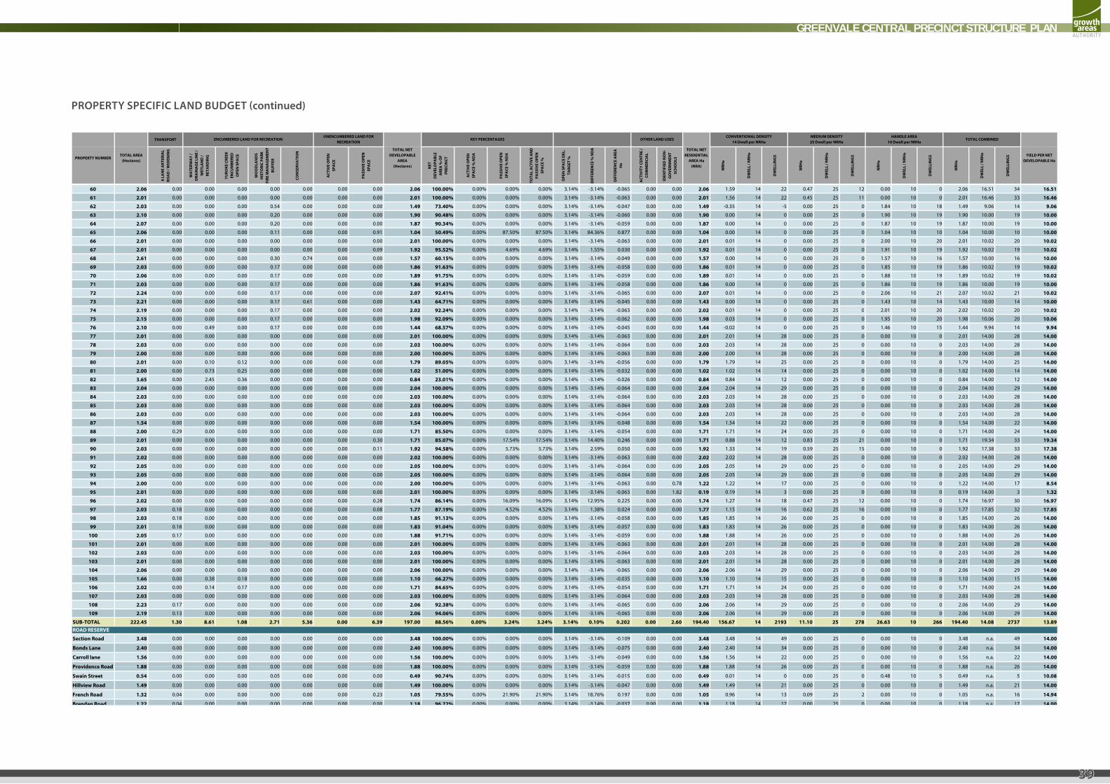
GREENVALE CENTRAL PRECINCT STRUCTURE PLAN
39
TRANSPORT
6 LA
NE
ART
ERIA
L RO
AD
/ W
IDEN
ING
WA
TERW
AY
/ D
RAIN
AG
E LI
NE
/ W
ETLA
ND
/ RE
TARD
ING
YURO
KE C
REEK
EN
CUM
BERE
D
OPE
N S
PACE
WO
OD
LAN
DS
HIS
TORI
C PA
RK
FIRE
MA
NA
GEM
ENT
BUFF
ER
CON
SERV
ATI
ON
ACT
IVE
OPE
N
SPA
CE
PASS
IVE
OPE
N
SPA
CE
NET
DEV
ELO
PABL
E A
REA
% O
F PR
ECIN
CT
ACT
IVE
OPE
N
SPA
CE %
ND
A
PASS
IVE
OPE
N
SPA
CE %
ND
A
TOTA
L A
CTIV
E A
ND
PA
SSIV
E O
PEN
SP
ACE
%
OPE
N S
PACE
DEL
. TA
RGET
%
DIF
FERE
NCE
% N
DA
DIF
FERE
NCE
ARE
A
Ha
ACT
IVIT
Y CE
NTR
E /
COM
MER
CIA
L
IDEN
TIFI
ED N
ON
-G
OV
ERN
MEN
T SC
HO
OLS
NRH
a
DW
ELL
/ NRH
a
DW
ELLI
NG
S
NRH
a
DW
ELL
/ NRH
a
DW
ELLI
NG
S
NRH
a
DW
ELL
/ NRH
a
DW
ELLI
NG
S
NRH
a
DW
ELL
/ NRH
a
DW
ELLI
NG
S
TOTAL NET RESIDENTIAL
AREA Ha (NRA)
PROPERTY NUMBERTOTAL AREA
(Hectares)
TOTAL NET DEVELOPABLE
AREA(Hectares)
ENCUMBERED LAND FOR RECREATIONUNENCUMBERED LAND FOR
RECREATIONTOTAL COMBINED
YIELD PER NET DEVELOPABLE Ha
KEY PERCENTAGES OTHER LAND USESCONVENTIONAL DENSITY
14 Dwell per NRHaMEDIUM DENSITY25 Dwell per NRHa
HANDLE AREA10 Dwell per NRHa
60 2.06 0.00 0.00 0.00 0.00 0.00 0.00 0.00 2.06 100.00% 0.00% 0.00% 0.00% 3.14% -3.14% -0.065 0.00 0.00 2.06 1.59 14 22 0.47 25 12 0.00 10 0 2.06 16.51 34 16.51
61 2.01 0.00 0.00 0.00 0.00 0.00 0.00 0.00 2.01 100.00% 0.00% 0.00% 0.00% 3.14% -3.14% -0.063 0.00 0.00 2.01 1.56 14 22 0.45 25 11 0.00 10 0 2.01 16.46 33 16.46
62 2.03 0.00 0.00 0.00 0.54 0.00 0.00 0.00 1.49 73.40% 0.00% 0.00% 0.00% 3.14% -3.14% -0.047 0.00 0.00 1.49 -0.35 14 -5 0.00 25 0 1.84 10 18 1.49 9.06 14 9.06
63 2.10 0.00 0.00 0.00 0.20 0.00 0.00 0.00 1.90 90.48% 0.00% 0.00% 0.00% 3.14% -3.14% -0.060 0.00 0.00 1.90 0.00 14 0 0.00 25 0 1.90 10 19 1.90 10.00 19 10.00
64 2.07 0.00 0.00 0.00 0.20 0.00 0.00 0.00 1.87 90.34% 0.00% 0.00% 0.00% 3.14% -3.14% -0.059 0.00 0.00 1.87 0.00 14 0 0.00 25 0 1.87 10 19 1.87 10.00 19 10.00
65 2.06 0.00 0.00 0.00 0.11 0.00 0.00 0.91 1.04 50.49% 0.00% 87.50% 87.50% 3.14% 84.36% 0.877 0.00 0.00 1.04 0.00 14 0 0.00 25 0 1.04 10 10 1.04 10.00 10 10.00
66 2.01 0.00 0.00 0.00 0.00 0.00 0.00 0.00 2.01 100.00% 0.00% 0.00% 0.00% 3.14% -3.14% -0.063 0.00 0.00 2.01 0.01 14 0 0.00 25 0 2.00 10 20 2.01 10.02 20 10.02
67 2.01 0.00 0.00 0.00 0.00 0.00 0.00 0.09 1.92 95.52% 0.00% 4.69% 4.69% 3.14% 1.55% 0.030 0.00 0.00 1.92 0.01 14 0 0.00 25 0 1.91 10 19 1.92 10.02 19 10.02
68 2.61 0.00 0.00 0.00 0.30 0.74 0.00 0.00 1.57 60.15% 0.00% 0.00% 0.00% 3.14% -3.14% -0.049 0.00 0.00 1.57 0.00 14 0 0.00 25 0 1.57 10 16 1.57 10.00 16 10.00
69 2.03 0.00 0.00 0.00 0.17 0.00 0.00 0.00 1.86 91.63% 0.00% 0.00% 0.00% 3.14% -3.14% -0.058 0.00 0.00 1.86 0.01 14 0 0.00 25 0 1.85 10 19 1.86 10.02 19 10.02
70 2.06 0.00 0.00 0.00 0.17 0.00 0.00 0.00 1.89 91.75% 0.00% 0.00% 0.00% 3.14% -3.14% -0.059 0.00 0.00 1.89 0.01 14 0 0.00 25 0 1.88 10 19 1.89 10.02 19 10.02
71 2.03 0.00 0.00 0.00 0.17 0.00 0.00 0.00 1.86 91.63% 0.00% 0.00% 0.00% 3.14% -3.14% -0.058 0.00 0.00 1.86 0.00 14 0 0.00 25 0 1.86 10 19 1.86 10.00 19 10.00
72 2.24 0.00 0.00 0.00 0.17 0.00 0.00 0.00 2.07 92.41% 0.00% 0.00% 0.00% 3.14% -3.14% -0.065 0.00 0.00 2.07 0.01 14 0 0.00 25 0 2.06 10 21 2.07 10.02 21 10.02
73 2.21 0.00 0.00 0.00 0.17 0.61 0.00 0.00 1.43 64.71% 0.00% 0.00% 0.00% 3.14% -3.14% -0.045 0.00 0.00 1.43 0.00 14 0 0.00 25 0 1.43 10 14 1.43 10.00 14 10.00
74 2 19 0 00 0 00 0 00 0 17 0 00 0 00 0 00 2 02 92 24% 0 00% 0 00% 0 00% 3 14% 3 14% 0 063 0 00 0 00 2 02 0 01 14 0 0 00 25 0 2 01 10 20 2 02 10 02 20 10 0274 2.19 0.00 0.00 0.00 0.17 0.00 0.00 0.00 2.02 92.24% 0.00% 0.00% 0.00% 3.14% -3.14% -0.063 0.00 0.00 2.02 0.01 14 0 0.00 25 0 2.01 10 20 2.02 10.02 20 10.02
75 2.15 0.00 0.00 0.00 0.17 0.00 0.00 0.00 1.98 92.09% 0.00% 0.00% 0.00% 3.14% -3.14% -0.062 0.00 0.00 1.98 0.03 14 0 0.00 25 0 1.95 10 20 1.98 10.06 20 10.06
76 2.10 0.00 0.49 0.00 0.17 0.00 0.00 0.00 1.44 68.57% 0.00% 0.00% 0.00% 3.14% -3.14% -0.045 0.00 0.00 1.44 -0.02 14 0 0.00 25 0 1.46 10 15 1.44 9.94 14 9.94
77 2.01 0.00 0.00 0.00 0.00 0.00 0.00 0.00 2.01 100.00% 0.00% 0.00% 0.00% 3.14% -3.14% -0.063 0.00 0.00 2.01 2.01 14 28 0.00 25 0 0.00 10 0 2.01 14.00 28 14.00
78 2.03 0.00 0.00 0.00 0.00 0.00 0.00 0.00 2.03 100.00% 0.00% 0.00% 0.00% 3.14% -3.14% -0.064 0.00 0.00 2.03 2.03 14 28 0.00 25 0 0.00 10 0 2.03 14.00 28 14.00
79 2.00 0.00 0.00 0.00 0.00 0.00 0.00 0.00 2.00 100.00% 0.00% 0.00% 0.00% 3.14% -3.14% -0.063 0.00 0.00 2.00 2.00 14 28 0.00 25 0 0.00 10 0 2.00 14.00 28 14.00
80 2.01 0.00 0.10 0.12 0.00 0.00 0.00 0.00 1.79 89.05% 0.00% 0.00% 0.00% 3.14% -3.14% -0.056 0.00 0.00 1.79 1.79 14 25 0.00 25 0 0.00 10 0 1.79 14.00 25 14.00
81 2.00 0.00 0.73 0.25 0.00 0.00 0.00 0.00 1.02 51.00% 0.00% 0.00% 0.00% 3.14% -3.14% -0.032 0.00 0.00 1.02 1.02 14 14 0.00 25 0 0.00 10 0 1.02 14.00 14 14.00
82 3.65 0.00 2.45 0.36 0.00 0.00 0.00 0.00 0.84 23.01% 0.00% 0.00% 0.00% 3.14% -3.14% -0.026 0.00 0.00 0.84 0.84 14 12 0.00 25 0 0.00 10 0 0.84 14.00 12 14.00
83 2.04 0.00 0.00 0.00 0.00 0.00 0.00 0.00 2.04 100.00% 0.00% 0.00% 0.00% 3.14% -3.14% -0.064 0.00 0.00 2.04 2.04 14 29 0.00 25 0 0.00 10 0 2.04 14.00 29 14.00
84 2.03 0.00 0.00 0.00 0.00 0.00 0.00 0.00 2.03 100.00% 0.00% 0.00% 0.00% 3.14% -3.14% -0.064 0.00 0.00 2.03 2.03 14 28 0.00 25 0 0.00 10 0 2.03 14.00 28 14.00
85 2.03 0.00 0.00 0.00 0.00 0.00 0.00 0.00 2.03 100.00% 0.00% 0.00% 0.00% 3.14% -3.14% -0.064 0.00 0.00 2.03 2.03 14 28 0.00 25 0 0.00 10 0 2.03 14.00 28 14.00
86 2.03 0.00 0.00 0.00 0.00 0.00 0.00 0.00 2.03 100.00% 0.00% 0.00% 0.00% 3.14% -3.14% -0.064 0.00 0.00 2.03 2.03 14 28 0.00 25 0 0.00 10 0 2.03 14.00 28 14.00
87 1.54 0.00 0.00 0.00 0.00 0.00 0.00 0.00 1.54 100.00% 0.00% 0.00% 0.00% 3.14% -3.14% -0.048 0.00 0.00 1.54 1.54 14 22 0.00 25 0 0.00 10 0 1.54 14.00 22 14.00
88 2.00 0.29 0.00 0.00 0.00 0.00 0.00 0.00 1.71 85.50% 0.00% 0.00% 0.00% 3.14% -3.14% -0.054 0.00 0.00 1.71 1.71 14 24 0.00 25 0 0.00 10 0 1.71 14.00 24 14.00
89 2.01 0.00 0.00 0.00 0.00 0.00 0.00 0.30 1.71 85.07% 0.00% 17.54% 17.54% 3.14% 14.40% 0.246 0.00 0.00 1.71 0.88 14 12 0.83 25 21 0.00 10 0 1.71 19.34 33 19.34
90 2.03 0.00 0.00 0.00 0.00 0.00 0.00 0.11 1.92 94.58% 0.00% 5.73% 5.73% 3.14% 2.59% 0.050 0.00 0.00 1.92 1.33 14 19 0.59 25 15 0.00 10 0 1.92 17.38 33 17.38
91 2.02 0.00 0.00 0.00 0.00 0.00 0.00 0.00 2.02 100.00% 0.00% 0.00% 0.00% 3.14% -3.14% -0.063 0.00 0.00 2.02 2.02 14 28 0.00 25 0 0.00 10 0 2.02 14.00 28 14.00
92 2.05 0.00 0.00 0.00 0.00 0.00 0.00 0.00 2.05 100.00% 0.00% 0.00% 0.00% 3.14% -3.14% -0.064 0.00 0.00 2.05 2.05 14 29 0.00 25 0 0.00 10 0 2.05 14.00 29 14.00
93 2.05 0.00 0.00 0.00 0.00 0.00 0.00 0.00 2.05 100.00% 0.00% 0.00% 0.00% 3.14% -3.14% -0.064 0.00 0.00 2.05 2.05 14 29 0.00 25 0 0.00 10 0 2.05 14.00 29 14.00
94 2.00 0.00 0.00 0.00 0.00 0.00 0.00 0.00 2.00 100.00% 0.00% 0.00% 0.00% 3.14% -3.14% -0.063 0.00 0.78 1.22 1.22 14 17 0.00 25 0 0.00 10 0 1.22 14.00 17 8.54
95 2.01 0.00 0.00 0.00 0.00 0.00 0.00 0.00 2.01 100.00% 0.00% 0.00% 0.00% 3.14% -3.14% -0.063 0.00 1.82 0.19 0.19 14 3 0.00 25 0 0.00 10 0 0.19 14.00 3 1.32
96 2.02 0.00 0.00 0.00 0.00 0.00 0.00 0.28 1.74 86.14% 0.00% 16.09% 16.09% 3.14% 12.95% 0.225 0.00 0.00 1.74 1.27 14 18 0.47 25 12 0.00 10 0 1.74 16.97 30 16.97
97 2.03 0.18 0.00 0.00 0.00 0.00 0.00 0.08 1.77 87.19% 0.00% 4.52% 4.52% 3.14% 1.38% 0.024 0.00 0.00 1.77 1.15 14 16 0.62 25 16 0.00 10 0 1.77 17.85 32 17.85
98 2.03 0.18 0.00 0.00 0.00 0.00 0.00 0.00 1.85 91.13% 0.00% 0.00% 0.00% 3.14% -3.14% -0.058 0.00 0.00 1.85 1.85 14 26 0.00 25 0 0.00 10 0 1.85 14.00 26 14.00
99 2.01 0.18 0.00 0.00 0.00 0.00 0.00 0.00 1.83 91.04% 0.00% 0.00% 0.00% 3.14% -3.14% -0.057 0.00 0.00 1.83 1.83 14 26 0.00 25 0 0.00 10 0 1.83 14.00 26 14.00
100 2.05 0.17 0.00 0.00 0.00 0.00 0.00 0.00 1.88 91.71% 0.00% 0.00% 0.00% 3.14% -3.14% -0.059 0.00 0.00 1.88 1.88 14 26 0.00 25 0 0.00 10 0 1.88 14.00 26 14.00
101 2.01 0.00 0.00 0.00 0.00 0.00 0.00 0.00 2.01 100.00% 0.00% 0.00% 0.00% 3.14% -3.14% -0.063 0.00 0.00 2.01 2.01 14 28 0.00 25 0 0.00 10 0 2.01 14.00 28 14.00
102 2.03 0.00 0.00 0.00 0.00 0.00 0.00 0.00 2.03 100.00% 0.00% 0.00% 0.00% 3.14% -3.14% -0.064 0.00 0.00 2.03 2.03 14 28 0.00 25 0 0.00 10 0 2.03 14.00 28 14.00
103 2.01 0.00 0.00 0.00 0.00 0.00 0.00 0.00 2.01 100.00% 0.00% 0.00% 0.00% 3.14% -3.14% -0.063 0.00 0.00 2.01 2.01 14 28 0.00 25 0 0.00 10 0 2.01 14.00 28 14.00
104 2.06 0.00 0.00 0.00 0.00 0.00 0.00 0.00 2.06 100.00% 0.00% 0.00% 0.00% 3.14% -3.14% -0.065 0.00 0.00 2.06 2.06 14 29 0.00 25 0 0.00 10 0 2.06 14.00 29 14.00
105 1.66 0.00 0.38 0.18 0.00 0.00 0.00 0.00 1.10 66.27% 0.00% 0.00% 0.00% 3.14% -3.14% -0.035 0.00 0.00 1.10 1.10 14 15 0.00 25 0 0.00 10 0 1.10 14.00 15 14.00
106 2.02 0.00 0.14 0.17 0.00 0.00 0.00 0.00 1.71 84.65% 0.00% 0.00% 0.00% 3.14% -3.14% -0.054 0.00 0.00 1.71 1.71 14 24 0.00 25 0 0.00 10 0 1.71 14.00 24 14.00
107 2.03 0.00 0.00 0.00 0.00 0.00 0.00 0.00 2.03 100.00% 0.00% 0.00% 0.00% 3.14% -3.14% -0.064 0.00 0.00 2.03 2.03 14 28 0.00 25 0 0.00 10 0 2.03 14.00 28 14.00
108 2.23 0.17 0.00 0.00 0.00 0.00 0.00 0.00 2.06 92.38% 0.00% 0.00% 0.00% 3.14% -3.14% -0.065 0.00 0.00 2.06 2.06 14 29 0.00 25 0 0.00 10 0 2.06 14.00 29 14.00
109 2.19 0.13 0.00 0.00 0.00 0.00 0.00 0.00 2.06 94.06% 0.00% 0.00% 0.00% 3.14% -3.14% -0.065 0.00 0.00 2.06 2.06 14 29 0.00 25 0 0.00 10 0 2.06 14.00 29 14.00
SUB-TOTAL 222.45 1.30 8.61 1.08 2.71 5.36 0.00 6.39 197.00 88.56% 0.00% 3.24% 3.24% 3.14% 0.10% 0.202 0.00 2.60 194.40 156.67 14 2193 11.10 25 278 26.63 10 266 194.40 14.08 2737 13.89
Section Road 3.48 0.00 0.00 0.00 0.00 0.00 0.00 0.00 3.48 100.00% 0.00% 0.00% 0.00% 3.14% -3.14% -0.109 0.00 0.00 3.48 3.48 14 49 0.00 25 0 0.00 10 0 3.48 n.a. 49 14.00
Bonds Lane 2.40 0.00 0.00 0.00 0.00 0.00 0.00 0.00 2.40 100.00% 0.00% 0.00% 0.00% 3.14% -3.14% -0.075 0.00 0.00 2.40 2.40 14 34 0.00 25 0 0.00 10 0 2.40 n.a. 34 14.00
Carroll lane 1.56 0.00 0.00 0.00 0.00 0.00 0.00 0.00 1.56 100.00% 0.00% 0.00% 0.00% 3.14% -3.14% -0.049 0.00 0.00 1.56 1.56 14 22 0.00 25 0 0.00 10 0 1.56 n.a. 22 14.00
Providence Road 1 88 0 00 0 00 0 00 0 00 0 00 0 00 0 00 1 88 100 00% 0 00% 0 00% 0 00% 3 14% 3 14% 0 059 0 00 0 00 1 88 1 88 14 26 0 00 25 0 0 00 10 0 1 88 n a 26 14 00
ROAD RESERVE
Providence Road 1.88 0.00 0.00 0.00 0.00 0.00 0.00 0.00 1.88 100.00% 0.00% 0.00% 0.00% 3.14% -3.14% -0.059 0.00 0.00 1.88 1.88 14 26 0.00 25 0 0.00 10 0 1.88 n.a. 26 14.00
Swain Street 0.54 0.00 0.00 0.00 0.05 0.00 0.00 0.00 0.49 90.74% 0.00% 0.00% 0.00% 3.14% -3.14% -0.015 0.00 0.00 0.49 0.01 14 0 0.00 25 0 0.48 10 5 0.49 n.a. 5 10.08
Hillview Road 1.49 0.00 0.00 0.00 0.00 0.00 0.00 0.00 1.49 100.00% 0.00% 0.00% 0.00% 3.14% -3.14% -0.047 0.00 0.00 1.49 1.49 14 21 0.00 25 0 0.00 10 0 1.49 n.a. 21 14.00
French Road 1.32 0.04 0.00 0.00 0.00 0.00 0.00 0.23 1.05 79.55% 0.00% 21.90% 21.90% 3.14% 18.76% 0.197 0.00 0.00 1.05 0.96 14 13 0.09 25 2 0.00 10 0 1.05 n.a. 16 14.94
Brendan Road 1.22 0.04 0.00 0.00 0.00 0.00 0.00 0.00 1.18 96.72% 0.00% 0.00% 0.00% 3.14% -3.14% -0.037 0.00 0.00 1.18 1.18 14 17 0.00 25 0 0.00 10 0 1.18 n.a. 17 14.00
Yuroke Road 0.36 0.00 0.09 0.03 0.00 0.00 0.00 0.00 0.24 66.67% 0.00% 0.00% 0.00% 3.14% -3.14% -0.008 0.00 0.00 0.24 0.24 14 3 0.00 25 0 0.00 10 0 0.24 n.a. 3 14.00
SUB-TOTAL 14.25 0.08 0.09 0.03 0.05 0.00 0.00 0.23 13.77 96.63% 0.00% 1.67% 1.67% 3.14% -1.47% -0.109 0.00 0.00 13.77 13.20 14 185 0.09 25 2 0.48 10 5 13.77 n.a. 192 13.93TOTAL 236.70 1.38 8.70 1.11 2.76 5.36 0.00 6.62 210.77 89.05% 0.00% 3.14% 3.14% 0.00 2.60 208.17 169.87 14 2378 11.19 25 280 27.11 10 271 208.17 14.07 2929 13.90
PROPERTY SPECIFIC LAND BUDGET (continued)

Growth Areas Authority Level 29, 35 Collins Street MELBOURNE VIC 3000www.gaa.vic.gov.au
partners in creating new communities