ground deformation at campi flegrei, italy: …...most recent movements occurred during the...
TRANSCRIPT

From: TROISE, C., DE NATALE, G. & KILBURN, C. R. J. (eds) 2006. Mechanisms of Activity and Unrest at LargeCalderas. Geological Society, London, Special Publications, 269, 141–157.0305-8719/06/$15.00 © The Geological Society of London.
Ground deformation at Campi Flegrei, Italy:implications for hazard assessment
FRANCESCA BELLUCCI1, JUDITH WOO2, CHRISTOPHER R. J. KILBURN2 &GIUSEPPE ROLANDI1
1Dipartimento di Geofisica e Vulcanologia, Università di Napoli, Via Mezzocannone 8,80034 Napoli, Italy
2Benfield Hazard Research Centre, Department of Earth Sciences, University CollegeLondon, Gower Street, London WC1E 6BT, UK (e-mail: [email protected])
Abstract: Campi Flegrei caldera, west of Naples in southern Italy, has an exceptionaldocumented record of ground deformation from Roman times onwards. Systematicrecording began in the nineteenth century. For earlier dates, information has been obtainedfrom archaeological studies and from contemporary descriptions of the locations of buildings,usually Roman, with respect to sea-level. Especially important have been accounts related tothe Serapis, a Roman market-place built in the second century BC and now incorporatedwithin the modern town of Pozzuoli. The long-term patterns of ground deformation haveconventionally been investigated on the premise that Campi Flegrei naturally tends to a stateof static equilibrium. This study argues that, instead, the area naturally tends to a steady rateof subsidence, at about 17 mm a−1. After this background rate has been removed, the dataindicate that a permanent uplift of some 33 m has occurred from Roman times (up until thepresent day: 2005 at the time of writing), attributable to the intrusion of 1.85 km3 of magma, ofwhich only 1% has been erupted. Uplift has occurred in three episodes, the third of whichis still in progress. The behaviour can be interpreted in terms of the intermittent ascentof magma between a reservoir of c. 102–103 km3 at depths of 8–15 km or greater, to amuch smaller, shallower system at depths of about 3–4 km. Should the current pattern ofdeformation follow previous trends, uplift is expected to continue for another 80–90 years,during which time Campi Flegrei will be characterized by an elevated possibility of eruption.
as subordinate lava domes. Most of theseeruptions expelled c. 0.1–1 km3 (DRE) of alkali-trachyte or phonolite; a small number have alsooccurred with volumes of c. 0.01 km3 (DRE),some of which erupted K-trachybasalt (Fig. 2;Rosi et al. 1983; Lirer et al. 1987).
Post-NYT events across the caldera floorhave been clustered in time: some 34 eruptionsoccurred between the NYT eruption and 9500 aBP, six eruptions between 8600 and 8200 a BP,and 16 eruptions between 4800 and 3800 a BP
(Di Vito et al. 1999). Since 3800 a BP, the onlyeruption in Campi Flegrei has been that ofMonte Nuovo in 1538 (Fig. 2; Rosi et al. 1983;Di Girolamo et al. 1984; Di Vito et al. 1999).
Campi Flegrei has also undergone severalepisodes of subsidence and uplift since the NYTeruption (Cinque et al. 1985; Rosi & Sbrana1987; Dvorak & Mastrolorenzo 1991). Themost recent movements occurred during theintervals 1969–1972 and 1982–1984 andinvolved, respectively, maximum uplifts of 1.7and 1.8 m. Although neither episode culminated
Campi Flegrei is a volcanic field immediately tothe west of Naples in southern Italy. Active for atleast 50 000 years (Cassignol & Gillot 1982; Rosi& Sbrana 1987), the field covers some 200 km2, ofwhich the south-central third is now submergedbeneath the Bay of Pozzuoli (Fig. 1). The area isdominated structurally by a caldera, 6 km across,produced during the eruption of the NeapolitanYellow Tuff (NYT), a 40 km3 (DRE: dense rockequivalent) ignimbrite of K-trachyte–phonolitecomposition (Rosi et al. 1983; Di Girolamo 1984;Orsi et al. 1995). This event is conventionallydated at about 12 000 a BP, although an older ageof 15 600 a BP has recently been proposed byDeino et al. (2004). Caldera collapse may alsohave occurred during eruption of the 150 km3
(DRE) Campanian Ignimbrite at about 39 000 aBP, although the link between Campi Flegrei andthis eruption remains controversial (Rosi et al.1983; Di Girolamo et al. 1984; D’Antonio et al.1999; Rolandi et al. 2003). Eruptions since theNYT event have produced mainly monogeneticstrombolian and hydromagmatic cones, as well

142 F. BELLUCCI ET AL.
in an eruption, they both raised concern aboutimminent volcanic activity. Indeed, a pressingquestion remains as to the precursory conditionsthat must be fulfilled for an eruption to takeplace.
In this paper, we reconsider the pattern ofground movements at Campi Flegrei since
Roman times, in order to identify constraintsfor better evaluating the likelihood of a futureeruption. The study builds on the comprehensivereview by Dvorak & Mastrolorenzo (1991),incorporating new data from historical docu-ments, as well as archaeological informationfrom Morhange et al. (1999) that has yet to be
Fig. 1. Location maps for key sites in Campi Flegrei. (a) Pozzuoli lies in the northern half of the caldera producedby the NYT eruption (large dashes); a larger caldera (small dashes), inferred from modern topography, has beenproposed as the source for the Campanian Ignimbrite (e.g. Rosi et al. 1983), although seismic tomographicsurveys have since suggested that this feature is superficial only (Judenherc & Zollo 2004). The principal eruptivecentres since the NYT eruption (solid lines) are scattered across the caldera floor. The Starza terrace (grey line)runs between Monte Nuovo (MN) and Solfatara (SO) parallel with the coast behind Pozzuoli. (b) Data forhistoric ground movements in Pozzuoli have been obtained from the Serapis archaeological site and from cavesby the Rione Terra. Also shown is the location of the Cantariello spring, which was closer to the coast in thefifteenth Century (Fig. 6), indicating a net ground uplift since that time.

143GROUND DEFORMATION AT CAMPI FLEGREI, ITALY
integrated into the volcanological literature. Thedata suggest that the district is naturally subsid-ing at about 17 mm a−1, and so, to investigate theprocesses controlling variations in deformationrate, this background value must first be sub-tracted from observed movements. The analysisthus contrasts with previous studies, all ofwhich have assumed implicitly that CampiFlegrei should naturally remain in a stationarycondition (e.g. Parascandola 1947; Dvorak &Mastrolorenzo, 1991; Morhange et al. 1999;Orsi et al. 1999).
The results support the argument ofMorhange et al. (1999) that Campi Flegrei under-went two episodes of major uplift betweenRoman times and the sixteenth century. Theuplift involved a total permanent displacement ofabout 33 m, and can be attributed to the injectionto shallow depth (about 3–4 km) of some 1.85km3 of magma – a volume 100 times greater thanthe amount expelled in 1538 by the only eruptionduring the same period (Di Vito et al. 1987). Theyalso suggest that the smaller uplifts since 1969represent the early stages of another majorepisode; if verified, this inference implies that,compared with the interval since 1538, thetwenty-first century will be characterized by anelevated probability of eruption.
Reconstructing ground movement in CampiFlegrei
Three key points of reference for reconstructingground movement in Campi Flegrei are locatedin and around modern Pozzuoli, on the coastof the Bay of Pozzuoli 13.5 km west of Naples(Fig. 1). These are: (1) the cliff of La Starza,which, set about 300 m inland, runs some 3 kmwest from Pozzuoli, subparallel with the coast-line; (2) Serapis, a Roman market-place built in200 BC in Pozzuoli; and (3) the old town ofPozzuoli (founded as a Greek colony by at leastthe sixth century BC), or Rione Terra, built on apromontory about 500 m south of Serapis(Fig. 1). These nearby locations are importantbecause levelling surveys since at least 1905(Dvorak & Mastrolorenzo 1991) suggest that theonshore pattern of elevation changes acrossCampi Flegrei has been remarkably consistent,with episodes of both subsidence and of upliftshowing a broadly radial decay in vertical defor-mation away from Pozzuoli to the edge of thevolcanic field. In detail, numerical simulationsby Troise et al. (2004) suggest that, due to thepresence of ring-faults around the caldera rim,the rate of radial decay during uplift will be
Fig. 2. Magnitude of eruptions from the Campi Flegrei caldera in the past 50 000 years. Solid circles representeruptions with known volumes, and straight lines those eruptions for which volumetric data are not available.Apart from the Campanian Ignimbrite and NYT eruptions (open circles), the majority of events with knownvolumes (both before and after caldera formation) have volumes of 0.1–1 km3 (shaded). Data from Di Girolamoet al. (1984), Lirer et al. (1987) and Di Vito et al. (1999).
144 F. BELLUCCI ET AL.
different from that during longer-term episodesof subsidence. Assuming similar patterns forearlier episodes of subsidence and uplift, there-fore, elevation changes inferred for the Pozzuolidistrict can be taken as representative scales fordeformation across the whole caldera.
Prehistoric ground movement
Raised marine terraces along the Starza cliffbehind Pozzuoli demonstrate that Campi Flegreihas experienced episodes of subsidence and ofuplift between the NYT eruption and Romantimes (Rosi et al. 1983; Di Girolamo et al. 1984;Cinque et al. 1985; Rosi & Sbrana 1987). Withinthe exposed cliff, Cinque et al. (1985) recognizedthree marine horizons, separated by sub-arealtephra layers. The lowest marine horizon hasbeen dated stratigraphically to about 8400 a BP
(Cinque et al. 1985), whereas a shell in the upper-most marine layer has a radiocarbon age of5345P150 a BP (Rosi & Sbrana 1987); accord-ingly, the three horizons must have beenseparated by at least two episodes of subsidencefollowed by hiatuses to produce the marineterraces. Starting at about 5345 a BP, all threehorizons were raised out of the sea. Today, theStarza terrace stands about 30 m above sea-level(Cinque et al. 1985).
The Starza terraces developed during a periodof low volcanic activity, between the clustersof eruptions during 8600–8200 a BP and 4800–3800 a BP. Thus, assuming in particular that theyoungest uplift that took place in 5345 a BP wascaused by movement of magma, it must also havecoincided with conditions favouring shallowmagma intrusion, rather than eruption. Such apossibility is of interest because, as discussedbelow, uplift since Roman times may have beentaking place under similar conditions.
Historic ground movement
Since the last Ice Age, mean sea-level in the Medi-terranean has been rising at an average rate of0.2–0.6 mm a−1, giving an increase in sea-level ofno more than 1 m since Roman times (Dvorak &Mastrolorenzo 1991). As shown below, sucha variation is negligible compared with thedisplacements inferred for Serapis, confirmingthat the movements are indeed the result ofchanges in ground level.
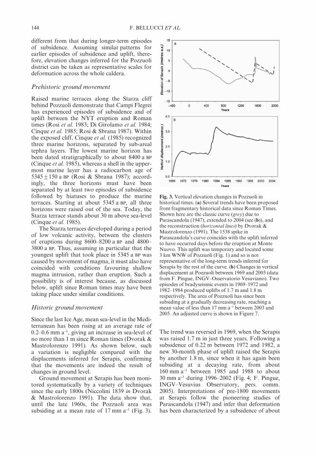
Ground movement at Serapis has been moni-tored systematically by a variety of techniquessince the early 1800s (Niccolini 1839 in Dvorak& Mastrolorenzo 1991). The data show that,until the late 1960s, the Pozzuoli area wassubsiding at a mean rate of 17 mm a−1 (Fig. 3).
The trend was reversed in 1969, when the Serapiswas raised 1.7 m in just three years. Following asubsidence of 0.22 m between 1972 and 1982, anew 30-month phase of uplift raised the Serapisby another 1.8 m, since when it has again beensubsiding at a decaying rate, from about160 mm a−1 between 1985 and 1988 to about30 mm a−1 during 1996–2002 (Fig. 4; F. Pingue,INGV–Vesuvius Observatory, pers. comm.2005). Interpretations of pre-1800 movementsat Serapis follow the pioneering studies ofParascandola (1947) and infer that deformationhas been characterized by a subsidence of about
Fig. 3. Vertical elevation changes in Pozzuoli inhistorical times. (a) Several trends have been proposedfrom fragmentary historical data since Roman Times.Shown here are the classic curve (grey) due toParascandola (1947), extended to 2004 (see (b)), andthe reconstruction (horizontal lines) by Dvorak &Mastrolorenzo (1991). The 1538 spike inParascandola’s curve coincides with the uplift inferredto have occurred days before the eruption at MonteNuovo. This uplift was temporary and located some3 km WNW of Pozzuoli (Fig. 1) and so is notrepresentative of the long-term trends inferred forSerapis by the rest of the curve. (b) Changes in verticaldisplacement at Pozzuoli between 1969 and 2005 (datafrom F. Pingue, INGV–Osservatorio Vesuviano). Twoepisodes of bradyseismic events in 1969–1972 and1982–1984 produced uplifts of 1.7 m and 1.8 mrespectively. The area of Pozzuoli has since beensubsiding at a gradually decreasing rate, reaching amean value of less than 17 mm a−1 between 2003 and2005. An adjusted curve is shown in Figure 7.

145GROUND DEFORMATION AT CAMPI FLEGREI, ITALY
12 m from 200 BC until sometime around 900 AD,followed by 12 m of uplift until the 1538 eruptionof Monte Nuovo, the most recent event in CampiFlegrei, and then about 4 m of subsidence untilthe first geodetic measurements in the early 1800s(Fig. 3; Dvorak & Mastrolorenzo 1991; Orsi et al.1999). Such interpretations, however, interpolatedata for the Pozzuoli district from before 530 AD
and after 1441 (Fig. 3; Dvorak & Mastrolorenzo1991), and so are poorly constrained betweenthese dates (a consequence of few documentssurviving the political turbulence of the period;Dvorak & Mastrolorenzo 1991). In the followingsections, we present new data covering theinterval 530–1441 (Table 1), including thosereported in the archaeological literature byMorhange et al. (1999).
Geology of the Pozzuoli area
The Pozzuoli area stands on a sequence of erup-tive units down at least to the Neapolitan YellowTuff (Lirer et al. 1983). At Rione Terra, the NYTconsists of layered pyroclastic deposits that dip25–30°S and indicate emplacement over a relictvolcanic structure. The NYT, in turn, is overlainby a thick, grey, incoherent and massive ashlayer, known locally as pozzolana, and then bysequences of marine deposits (laid down aftervolcano-tectonic collapses or extended periodsof subsidence; Cinque et al. 1985) and sub-arealfallout tephra from eruptions in Campi Flegrei(Di Girolamo et al. 1984).
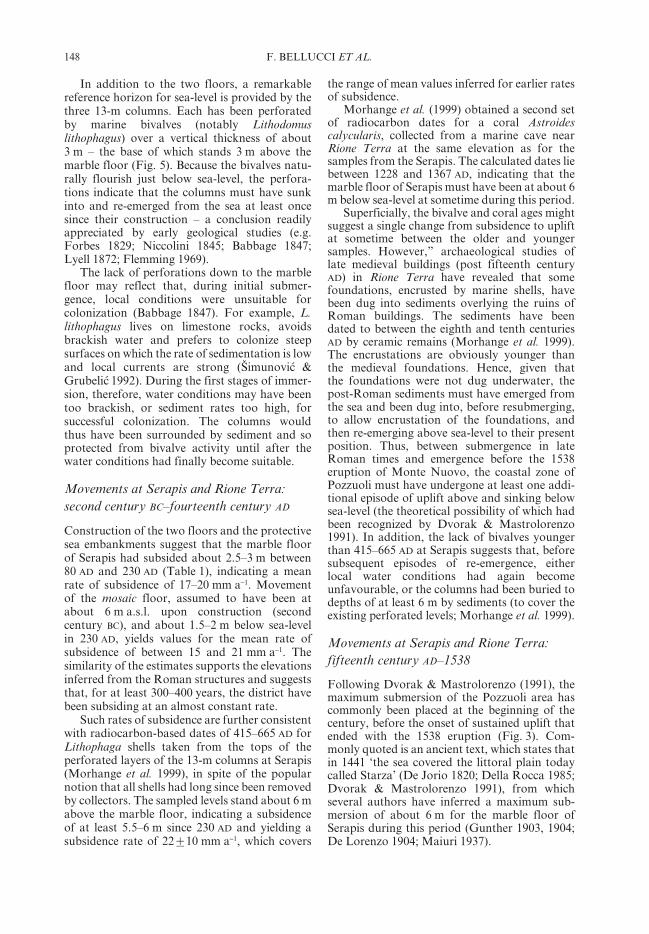
Towards the Serapis, drill cores show thatthe volcanic sequence is overlain by about 13 m
of reworked sediment (Fig. 4). The lower 6.8 mconsists of 4.3 m of gravel (composed of frag-ments of yellow tuff, pottery, tiles and marble)resting on 2.5 m of alluvial deposits with roundedfragments of pottery; the upper 6.2 m consists ofgrey, silty–sandy beds with small, and mostlyrounded, fragments of artifacts. The levels abovethe alluvial deposits are interpreted to be theremains of a Roman rubbish dump that extendedfrom the beach to the base of the Starza cliff.
The Serapis itself rests on the gravel layer. Theinitial dump may therefore have been designed asa surf-lip structure, providing the embankmenton which the Serapis was constructed; the lowestelevation of the original (mosaic) Serapis floorcan thus be estimated at about 5.8 m a.s.l. Thesmaller grain size and greater rounding of theupper 6.2 m suggests that this level marks areworked horizon, produced by increased waveaction after the area began to subside belowsea-level. Importantly, the drill cores provide noevidence for significant volcanic deposits ontop of the sediments. This conflicts withParascandola (1947), who identified some 3 m ofvolcanic material at the surface around Serapisand attributed the deposit to the 1538 eruptionof Monte Nuovo, about 3 km to the WNW.However, in addition to the drill cores, noevidence of such a volcanic horizon has beenfound by more recent field studies (De Vito et al.1987, 1999) and so it appears to be the result ofa misidentification. Accordingly, the depth ofburial of structures at Serapis has not been deter-mined by the emplacement of primary volcanicunits.
Fig. 4. Cross-section showing the stratigraphy of Serapis and surrounding area, looking NW (coast to left). Fourlayers can be distinguished: (1) 6.2 m of reworked yellow tuff and Roman artifacts in a sandy matrix (horizontallines); (2) 4.3 m of gravel beds, composed of reworked yellow tuff and fragments of marble, tiles and pottery ofRoman age (diagonal lines); (3) 2.5 m of alluvial deposits with rounded fragments of Roman pottery (white); and(4) 2.5 m of pyroclastic deposits with rounded pumice lapilli (cross-hatched). Layers 1–3 are interpreted as Romanwaste deposits. The black line marks approximate sea-level during the construction of Serapis; it also shows thatpart of Layer 3 was laid down underwater. During excavation, the columns of Serapis were found to be buried bythe Layer-1 deposits. The Cantariello thermal spring (Figs 1 & 6) lies about 130 m NE of Serapis (to the right).

146 F. BELLUCCI ET AL.
Reference horizons at Serapis
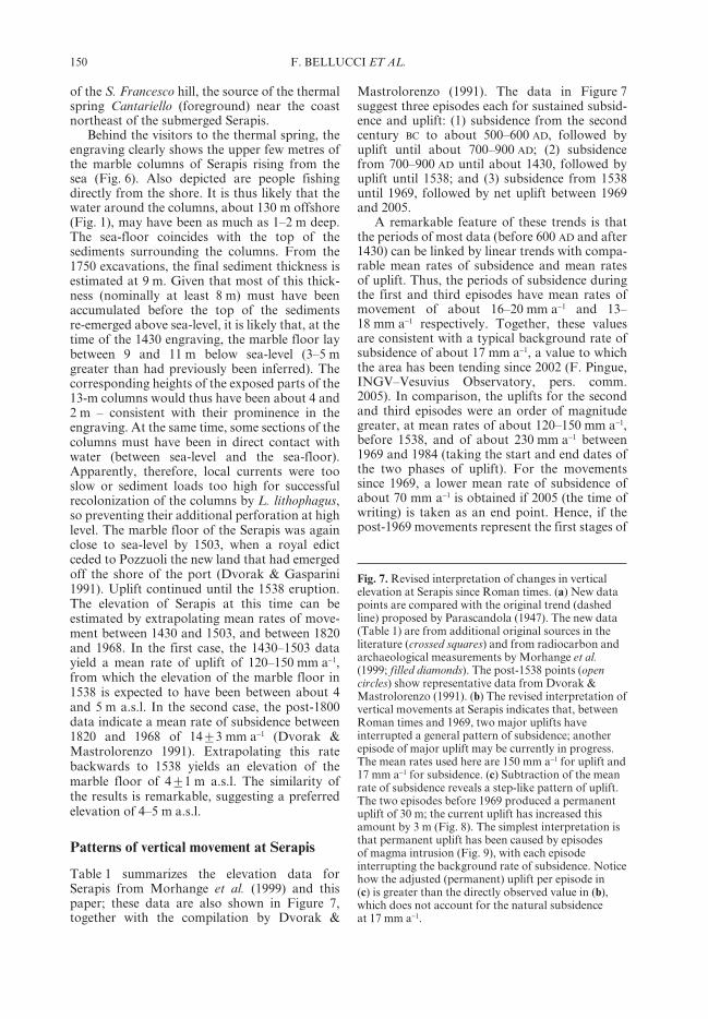
Excavations at Serapis began in 1750 (Breislak1792; Dvorak & Mastrolorenzo 1991). Coveringsome 55x70 m2, the site was buried by 9 m ofsediment. Today, it is dominated by three marblecolumns, each 13 m tall, at the northeastern endof the market (Fig. 5). The columns form part ofa temple, the Aedes Serapis, the foundations ofwhich mark the first stage of construction on thesite (according to an inscription found nearby,the Lex Parieti Facendo). The initial foundationsupported a mosaic floor, dated to the secondcentury BC (Levi 1969; Dvorak & Mastrolorenzo1991). The mosaic floor lies 2.11 m beneath asecond floor of marble, constructed around80 AD during the Flavian epoch (Maiuri 1937).Since a Roman drainage structure underlies themosaic floor by 0.66 m, the original mosaicfloor in 80 AD may have been at about 1 m abovesea-level (Sicardi 1979), indicating that thenew marble floor was about 3 m a.s.l. A central
rotunda with small standing columns (thePronao; Fig. 5) was added between the secondand third centuries AD, when the area was beingused as a market. During this period, two coastalembankments were built by Valerio Massimoin 230 AD, apparently to protect the site fromthe sea (Parascandola 1947; Dvorak &Mastrolorenzo 1991). This suggests that thecontemporary marble floor was close to sea-level(nominally about 0.5 m a.s.l.).
Table 1. Sources for estimating the elevation of the Serapis district
Year PRange Location Description Elevation of Range (m) Ref.*in years marble floor
of Serapis(m a.s.l.)
200 BC ? Serapis Marble floor built on at >5 m 8.1 2.5 3of gravel beds and 2.11 mabove mosaic floor
80 AD ? Serapis Construction of marble floor 3.1 1.0 3during the Flavian Epoch
203 8 Serapis Major restoration by Septimus 1.0 1.0 1Severus; construction of seaembankments
228 7 Serapis Major restoration by Alexander 0.5 1.0 1Severus; construction of seaembankments
430 97 Serapis Radiocarbon dating of mollusc -7.0 1.5 2borings on marble columns
791 97 Rione Terra Medieval foundation built on 1.5 1.5 2perforated Roman structure
1395 59 Rione Terra Radiocarbon dating of mollusc -7.0 1.5 2borings on walls of marine cave
1430 ? Serapis Parts of columns exposed in -10.0 1.0 3painting ‘Bagno del Cantariello’
1522 15 La Starza Engraving by Franz Hogenburg 1.0 1.0 3showed scene before 1538eruption and La Starza
1538 0 Pozzuoli Monte Nuovo eruption 4.0 1.0 1
Refs*: 1 = Dvorak & Mastrolorenzo (1991); 2 = Morhange et al. (1999); 3 = new data.
Fig. 5. The floor plan of Serapis (lower left) as drawnby Babbage (1847). The three standing columns(shaded circles) lie to the northwest (inland side) of thecentral rotunda, or Pronao. The columns (top andlower right) are 13 m high; each has been burrowedinto by L. lithophagus, leaving a zone of pockmarkingabout 3 m thick (dark horizons in photo), the base ofwhich is 3 m above the marble floor of the Serapis.The photo has been taken looking SW, towards thesea. (Photo: C. R. J. Kilburn.)

147GROUND DEFORMATION AT CAMPI FLEGREI, ITALY
148 F. BELLUCCI ET AL.
In addition to the two floors, a remarkablereference horizon for sea-level is provided by thethree 13-m columns. Each has been perforatedby marine bivalves (notably Lithodomuslithophagus) over a vertical thickness of about3 m – the base of which stands 3 m above themarble floor (Fig. 5). Because the bivalves natu-rally flourish just below sea-level, the perfora-tions indicate that the columns must have sunkinto and re-emerged from the sea at least oncesince their construction – a conclusion readilyappreciated by early geological studies (e.g.Forbes 1829; Niccolini 1845; Babbage 1847;Lyell 1872; Flemming 1969).
The lack of perforations down to the marblefloor may reflect that, during initial submer-gence, local conditions were unsuitable forcolonization (Babbage 1847). For example, L.lithophagus lives on limestone rocks, avoidsbrackish water and prefers to colonize steepsurfaces on which the rate of sedimentation is lowand local currents are strong (Šimunovica &Grubelica 1992). During the first stages of immer-sion, therefore, water conditions may have beentoo brackish, or sediment rates too high, forsuccessful colonization. The columns wouldthus have been surrounded by sediment and soprotected from bivalve activity until after thewater conditions had finally become suitable.
Movements at Serapis and Rione Terra:second century BC–fourteenth century AD
Construction of the two floors and the protectivesea embankments suggest that the marble floorof Serapis had subsided about 2.5–3 m between80 AD and 230 AD (Table 1), indicating a meanrate of subsidence of 17–20 mm a−1. Movementof the mosaic floor, assumed to have been atabout 6 m a.s.l. upon construction (secondcentury BC), and about 1.5–2 m below sea-levelin 230 AD, yields values for the mean rate ofsubsidence of between 15 and 21 mm a−1. Thesimilarity of the estimates supports the elevationsinferred from the Roman structures and suggeststhat, for at least 300–400 years, the district havebeen subsiding at an almost constant rate.
Such rates of subsidence are further consistentwith radiocarbon-based dates of 415–665 AD forLithophaga shells taken from the tops of theperforated layers of the 13-m columns at Serapis(Morhange et al. 1999), in spite of the popularnotion that all shells had long since been removedby collectors. The sampled levels stand about 6 mabove the marble floor, indicating a subsidenceof at least 5.5–6 m since 230 AD and yielding asubsidence rate of 22P10 mm a−1, which covers
the range of mean values inferred for earlier ratesof subsidence.
Morhange et al. (1999) obtained a second setof radiocarbon dates for a coral Astroidescalycularis, collected from a marine cave nearRione Terra at the same elevation as for thesamples from the Serapis. The calculated dates liebetween 1228 and 1367 AD, indicating that themarble floor of Serapis must have been at about 6m below sea-level at sometime during this period.
Superficially, the bivalve and coral ages mightsuggest a single change from subsidence to upliftat sometime between the older and youngersamples. However,” archaeological studies oflate medieval buildings (post fifteenth centuryAD) in Rione Terra have revealed that somefoundations, encrusted by marine shells, havebeen dug into sediments overlying the ruins ofRoman buildings. The sediments have beendated to between the eighth and tenth centuriesAD by ceramic remains (Morhange et al. 1999).The encrustations are obviously younger thanthe medieval foundations. Hence, given thatthe foundations were not dug underwater, thepost-Roman sediments must have emerged fromthe sea and been dug into, before resubmerging,to allow encrustation of the foundations, andthen re-emerging above sea-level to their presentposition. Thus, between submergence in lateRoman times and emergence before the 1538eruption of Monte Nuovo, the coastal zone ofPozzuoli must have undergone at least one addi-tional episode of uplift above and sinking belowsea-level (the theoretical possibility of which hadbeen recognized by Dvorak & Mastrolorenzo1991). In addition, the lack of bivalves youngerthan 415–665 AD at Serapis suggests that, beforesubsequent episodes of re-emergence, eitherlocal water conditions had again becomeunfavourable, or the columns had been buried todepths of at least 6 m by sediments (to cover theexisting perforated levels; Morhange et al. 1999).
Movements at Serapis and Rione Terra:fifteenth century AD–1538
Following Dvorak & Mastrolorenzo (1991), themaximum submersion of the Pozzuoli area hascommonly been placed at the beginning of thecentury, before the onset of sustained uplift thatended with the 1538 eruption (Fig. 3). Com-monly quoted is an ancient text, which states thatin 1441 ‘the sea covered the littoral plain todaycalled Starza’ (De Jorio 1820; Della Rocca 1985;Dvorak & Mastrolorenzo 1991), from whichseveral authors have inferred a maximum sub-mersion of about 6 m for the marble floor ofSerapis during this period (Gunther 1903, 1904;De Lorenzo 1904; Maiuri 1937).

149GROUND DEFORMATION AT CAMPI FLEGREI, ITALY
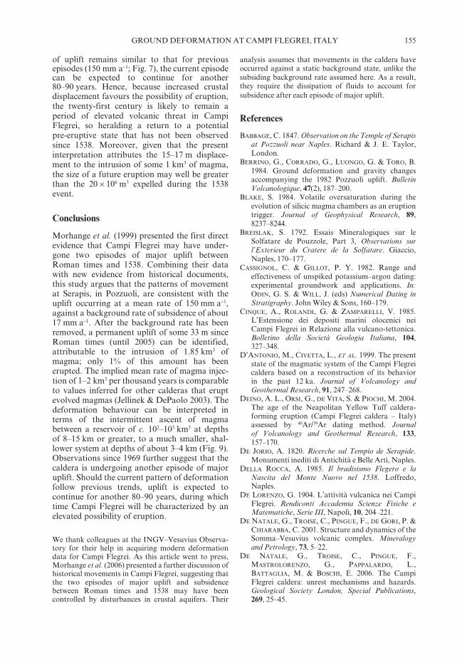
The maximum-depth estimates can be refinedby new data from the 1430 engraving Bagno delCantariello (Fig. 6), part of the famous BalneisPuteolanis of the Edinburgh Codex (Di Bonito &
Giamminelli 1992). The engraving depicts theRione Terra encircled by vertical yellow tuffwalls, from which the beach of Marina DellaPostierla extends (towards the viewer) to the base
Fig. 6. Engraving from 1430 of the Cantariello thermal spring and its surrounding area, looking approximatelySSW (Fig. 1). Rione Terra, the old town of Pozzuoli, is on the left. The tops of two of the columns at Serapis(about 130 m distant; Fig. 1) are clearly visible behind the figures in the foreground.
150 F. BELLUCCI ET AL.
of the S. Francesco hill, the source of the thermalspring Cantariello (foreground) near the coastnortheast of the submerged Serapis.
Behind the visitors to the thermal spring, theengraving clearly shows the upper few metres ofthe marble columns of Serapis rising from thesea (Fig. 6). Also depicted are people fishingdirectly from the shore. It is thus likely that thewater around the columns, about 130 m offshore(Fig. 1), may have been as much as 1–2 m deep.The sea-floor coincides with the top of thesediments surrounding the columns. From the1750 excavations, the final sediment thickness isestimated at 9 m. Given that most of this thick-ness (nominally at least 8 m) must have beenaccumulated before the top of the sedimentsre-emerged above sea-level, it is likely that, at thetime of the 1430 engraving, the marble floor laybetween 9 and 11 m below sea-level (3–5 mgreater than had previously been inferred). Thecorresponding heights of the exposed parts of the13-m columns would thus have been about 4 and2 m – consistent with their prominence in theengraving. At the same time, some sections of thecolumns must have been in direct contact withwater (between sea-level and the sea-floor).Apparently, therefore, local currents were tooslow or sediment loads too high for successfulrecolonization of the columns by L. lithophagus,so preventing their additional perforation at highlevel. The marble floor of the Serapis was againclose to sea-level by 1503, when a royal edictceded to Pozzuoli the new land that had emergedoff the shore of the port (Dvorak & Gasparini1991). Uplift continued until the 1538 eruption.The elevation of Serapis at this time can beestimated by extrapolating mean rates of move-ment between 1430 and 1503, and between 1820and 1968. In the first case, the 1430–1503 datayield a mean rate of uplift of 120–150 mm a−1,from which the elevation of the marble floor in1538 is expected to have been between about 4and 5 m a.s.l. In the second case, the post-1800data indicate a mean rate of subsidence between1820 and 1968 of 14P3 mm a−1 (Dvorak &Mastrolorenzo 1991). Extrapolating this ratebackwards to 1538 yields an elevation of themarble floor of 4P1 m a.s.l. The similarity ofthe results is remarkable, suggesting a preferredelevation of 4–5 m a.s.l.
Patterns of vertical movement at Serapis
Table 1 summarizes the elevation data forSerapis from Morhange et al. (1999) and thispaper; these data are also shown in Figure 7,together with the compilation by Dvorak &
Mastrolorenzo (1991). The data in Figure 7suggest three episodes each for sustained subsid-ence and uplift: (1) subsidence from the secondcentury BC to about 500–600 AD, followed byuplift until about 700–900 AD; (2) subsidencefrom 700–900 AD until about 1430, followed byuplift until 1538; and (3) subsidence from 1538until 1969, followed by net uplift between 1969and 2005.
A remarkable feature of these trends is thatthe periods of most data (before 600 AD and after1430) can be linked by linear trends with compa-rable mean rates of subsidence and mean ratesof uplift. Thus, the periods of subsidence duringthe first and third episodes have mean rates ofmovement of about 16–20 mm a−1 and 13–18 mm a−1 respectively. Together, these valuesare consistent with a typical background rate ofsubsidence of about 17 mm a−1, a value to whichthe area has been tending since 2002 (F. Pingue,INGV–Vesuvius Observatory, pers. comm.2005). In comparison, the uplifts for the secondand third episodes were an order of magnitudegreater, at mean rates of about 120–150 mm a−1,before 1538, and of about 230 mm a−1 between1969 and 1984 (taking the start and end dates ofthe two phases of uplift). For the movementssince 1969, a lower mean rate of subsidence ofabout 70 mm a−1 is obtained if 2005 (the time ofwriting) is taken as an end point. Hence, if thepost-1969 movements represent the first stages of
Fig. 7. Revised interpretation of changes in verticalelevation at Serapis since Roman times. (a) New datapoints are compared with the original trend (dashedline) proposed by Parascandola (1947). The new data(Table 1) are from additional original sources in theliterature (crossed squares) and from radiocarbon andarchaeological measurements by Morhange et al.(1999; filled diamonds). The post-1538 points (opencircles) show representative data from Dvorak &Mastrolorenzo (1991). (b) The revised interpretation ofvertical movements at Serapis indicates that, betweenRoman times and 1969, two major uplifts haveinterrupted a general pattern of subsidence; anotherepisode of major uplift may be currently in progress.The mean rates used here are 150 mm a−1 for uplift and17 mm a−1 for subsidence. (c) Subtraction of the meanrate of subsidence reveals a step-like pattern of uplift.The two episodes before 1969 produced a permanentuplift of 30 m; the current uplift has increased thisamount by 3 m (Fig. 8). The simplest interpretation isthat permanent uplift has been caused by episodesof magma intrusion (Fig. 9), with each episodeinterrupting the background rate of subsidence. Noticehow the adjusted (permanent) uplift per episode in(c) is greater than the directly observed value in (b),which does not account for the natural subsidenceat 17 mm a−1.

151GROUND DEFORMATION AT CAMPI FLEGREI, ITALY

152 F. BELLUCCI ET AL.
a major episode of uplift, it is plausible that theaverage rate in the long term will be similar tothat before 1538. Accordingly, it is inferred thatsustained uplift can occur at mean rates of about120–150 mm a−1.
The combined mean rates of subsidence andof uplift are consistent with the few data pointsavailable for uplift and subsidence during thefirst and second episodes respectively. Theinferred trends are shown in Figure 7, applyingmean rates of subsidence and uplift of 17 mm a−1
and 150 mm a−1 respectively. Although the trendsbetween 750 and 1430 are not well constrained,they have the value of simplicity by assuming thattheir behaviour lies within the ranges provided bythe better-constrained trends.
Magmatic intrusions beneath Campi Flegrei
The observation that vertical movements atSerapis have been dominated by subsidence atsimilar mean rates suggests that such behaviourrepresents a typical background state (possibly asa result of compaction in the crust or deepermagmatic system following formation of theNYT; e.g. Dvorak & Mastrolorenzo 1991),which occasionally has been punctuated byshorter, but much faster, intervals of uplift. Toinvestigate the nature of the uplifts, therefore, thebackground rate of subsidence must first besubtracted from the observed trends; this proce-dure contrasts with previous analyses, for whichit has been implicitly assumed that backgroundequilibrium corresponds to no movement.
The results show that the first two uplifts eachraised the Serapis by some 15–17 m (Fig. 7),almost ten times greater than the individualepisodes of uplift witnessed since 1969 (Fig. 8).Moreover, these displacements are permanent;they appear otherwise only when the backgroundrate of subsidence is ignored. Interpretations ofunrest since 1969 suggest that recent deformationhas been controlled by a small magma reservoirat a depth of 3–4 km, supplemented by pressurechanges in disturbed aquifers at shallower levels(De Natale et al. 1991, 2001, 2006 (this volume,pp. 25–45); Gaeta et al. 1998); of these mecha-nisms, magmatic intrusion yields a permanentdeformation, whereas the flow of water throughdisturbed aquifers is expected to yield an upliftfollowed by a decaying rate of subsidence untilthe geothermal system has returned to equilib-rium (Gaeta et al. 1998). Such a decay mayindeed be evident in the minor subsidence ofCampi Flegrei since 1984. Thus, as seen inFigure 8, following an initial adjusted uplift of
1.8 m between 1982 and 1984, Pozzuoli subsidedby about 0.5 m at a decreasing rate between 1984and the early 2000s, when the observed rate ofsubsidence returned to background values. Thesimplest explanation is that intrusion causedabout 1.3 m of permanent displacement, whereasthe disturbance of aquifers induced a further0.6 m of uplift that has since dissipated followingfluid migration through the crust.
Assuming a magmatic control, the permanent1982–1984 displacement can be attributed to theinjection of some 10x107 m3 of magma into thesmall reservoir (following Berrino et al. (1984)and Dvorak & Mastrolorenzo (1991)). If similarconditions have prevailed since Roman times,therefore, the total permanent uplift of about33 m indicates that some 1.85 km3 of magma hasbeen intruded at shallow depth. Of this amount,only about 1% has been erupted (during theformation of Monte Nuovo in 1538).
An immediate implication is that, since atleast Roman times, magmatic activity at CampiFlegrei has been dominated by intrusion, ratherthan eruption. Given that similar conditions mayhave operated during uplift of the Starza terrace(5345 BP) and before the onset of the lastmajor cluster of eruptions (4800–3800 a BP), it isconceivable that Campi Flegrei is again headingtowards a period of eruptive activity; in otherwords, the eruption of Monte Nuovo may be the
Fig. 8. Adjusted vertical displacement at Serapisbetween 1969 and 2005 (solid curve), after subtractinga background rate of subsidence of 17 mm a−1 (Fig. 7)from the measured deformation (dashed curve; Fig. 3).The adjusted curve indicates that no significantmovements occurred between 1972 and 1984, and that,by about 2000, the 1982–1984 uplift (of 1.8 m) haddecayed by about 0.5 m to a new equilibrium level.The permanent deformation is consistent with magmaintrusion from the start of uplift (see also De Nataleet al. (2006: this volume pp. 25–45)), whereas the 0.5 mdecay may reflect the dissipation of fluids fromdisturbed aquifers.

153GROUND DEFORMATION AT CAMPI FLEGREI, ITALY
first of a new cluster of events over the comingmillennia.
Also consistent with a possible return to erup-tive activity is that the mean rate of uplift since1969 has been comparable to the mean ratesinferred for the two previous episodes of upliftsince Roman times (Fig. 7). Even though the firstof these, in the Middle Ages, did not culminate ineruption, the fact that the second ended with theformation of Monte Nuovo in 1538 suggests thatconditions in Campi Flegrei are moving progres-sively towards a greater likelihood of eruption,possibly related to the increase in cumulativecrustal stretching. Alternatively, the potentialfor eruption may increase during each phase ofuplift, so that the lack of historical eruptionsmay simply be the product of statistical criteria,themselves controlled by variations in crustaland magmatic conditions.
The magmatic system feeding Campi Flegrei
A remarkable feature of the adjusted elevationchanges (Fig. 7) is that both episodes of majoruplift came to rest after similar total amountsof movement. Such a similarity may reflect afundamental constraint on the behaviour of themagmatic feeding system. Limiting constraintsmight be imposed by the reservoir receivingthe magma, or by the rate at which magma issupplied from deeper levels. The first constraintis unlikely, because each episode of intrusionstretches the crust, so bringing it closer to thecritical strain for bulk failure and the formationof a pathway from the reservoir to the surface(Kilburn & Sammonds 2005). Accordingly, thelimit to the permanent displacements of 15–17 mmust be linked to the volume of magma availablefor intrusion. This volume, in turn, must berelated to how magma is able to migrate upwardsfrom depth.
One possible model is shown in Figure 9. Itidentifies at least two reservoirs, the shallower ofwhich lies some 3–4 km below the surface(Berrino et al. 1984; De Natale et al. 2001). Thedeeper reservoir is supplied with magma until it isable to break the overlying crust. This conditionoccurs when the reservoir has accumulated anadditional volume of magma of about 1 km3.Upon crustal failure, the additional volumeescapes as a series of small batches, at a ratefaster than the arrival of new magma from depth.The deeper reservoir returns to a pressureequilibrium until another cubic kilometre ofnew material has accumulated for the cycle to berepeated. The periods of magma accumulationand escape would thus correspond to the
episodes of insignificant adjusted surface defor-mation (i.e., subsidence at background rates) andof major uplift (Fig. 7).
For such a model to be plausible, the deeperreservoir (1) must be large enough to accommo-date about 1 km3 of magma before its overpres-sure breaks the crust, and (2) must be sufficientlydeep so as to not induce significant ground defor-mation during episodes of magma accumulation.First-order estimates of reservoir volume anddepth can be obtained by assuming that thedeforming crust behaves elastically, and that,for magma to escape through new fractures,overpressures in the reservoir must reach c. 20–40 MPa (to overcome the crust’s tensile strengthand to open the fractures wide enough formagma to squeeze upwards; Blake 1984;Gudmundsson 1986; Rubin 1995; Jellinek &DePaolo 2003). In this case, the volumetric strain(DV/V) due to the accumulation of magma, ofvolume DV, into a reservoir of initial volume Vcan be approximated by:
DV/V ≈ DP/K (1)
where DP is the overpressure and K is the crust’sbulk modulus. For DV=1 km3, DP between 20and 40 MPa, and K=20 GPa (Jaeger 1969), eq.(1) gives a volume for the deep reservoir (≈KDV/DP) on the order of several hundred cubickilometres, which could be accommodated by adisc-shaped reservoir some 6–10 km in radiusand 1–2 km thick. The depth, f, of the reservoircan be estimated by assuming a maximum verti-cal ground deformation, Dhm, of less than 1 mduring the accumulation of DV of magma, andapplying Mogi’s model for elastic deformation(Mogi 1958):
Dhm/f=(15/16p) (V/f 3) (DP/K) (2)
(although designed for a spherical source, theMogi model yields results for vertical deforma-tion of the same order as those for a disc-shapedsource (approximated to a penny-shaped crack)at the same depth; Fialko et al. 2001). For Dhm
of less than 1 m, eq. (2) indicates depths of8–15 km or more for reservoir volumes of 200–800 km3. Although geophysical surveys have yetto explore to depths greater than about 8 kmbeneath Campi Flegrei, extensive sills have beeninferred to occur beneath Vesuvius, about 30 kmto the ESE, at depths of 12–15 km and, possibly,also to 35 km (Zollo et al. 1996; De Natale et al.2001). It is therefore plausible that, in addition toa reservoir at depths of 3–4 km, Campi Flegreiis underlain at depths greater than 8 km by azone of magma accumulation with a volume of

154 F. BELLUCCI ET AL.
hundreds of cubic kilometres; indeed, it is inter-esting to speculate on the possible role of such abody on caldera formation.
Future eruptions in Campi Flegrei
Deformation since 1969 suggests that CampiFlegrei is currently undergoing an episode of
major, intermittent uplift. By analogy with theuplifts in the Middle Ages and before 1538(Fig. 7) the episode may continue until thevertical displacement has achieved a totaladjusted value (after subtracting the backgroundrate of subsidence) of some 15–17 m, that is,some 12–14 m in addition to its displacementsince 1969 (Fig. 8). If the adjusted mean rate
Fig. 9. The patterns of vertical deformation since Roman times are consistent with a two-reservoir system beneathCampi Flegrei. Magma is fed persistently into the lower reservoir (a) until it has accumulated an excess volumeDV sufficient to cause the overlying crust to stretch and break. The excess volume escapes as a series of magmabatches (b) that intrude into the upper reservoir (c). The rate of escape is faster than the rate of magma supplyfrom depth, so that the lower reservoir returns to equilibrium until another excess volume DV has accumulatedand the cycle is repeated. Periods of magma accumulation in the lower reservoir do not induce significant surfacedeformation, whereas those of magma ascent generate significant, and permanent, surface uplift (lower right;compare with Fig. 7c). The implication is that, since at least Roman times, Campi Flegrei has been subject tomajor magma intrusion, even though accompanied by only a modest eruption in 1538.
155GROUND DEFORMATION AT CAMPI FLEGREI, ITALY
of uplift remains similar to that for previousepisodes (150 mm a−1; Fig. 7), the current episodecan be expected to continue for another80–90 years. Hence, because increased crustaldisplacement favours the possibility of eruption,the twenty-first century is likely to remain aperiod of elevated volcanic threat in CampiFlegrei, so heralding a return to a potentialpre-eruptive state that has not been observedsince 1538. Moreover, given that the presentinterpretation attributes the 15–17 m displace-ment to the intrusion of some 1 km3 of magma,the size of a future eruption may well be greaterthan the 20x106 m3 expelled during the 1538event.
Conclusions
Morhange et al. (1999) presented the first directevidence that Campi Flegrei may have under-gone two episodes of major uplift betweenRoman times and 1538. Combining their datawith new evidence from historical documents,this study argues that the patterns of movementat Serapis, in Pozzuoli, are consistent with theuplift occurring at a mean rate of 150 mm a−1,against a background rate of subsidence of about17 mm a−1. After the background rate has beenremoved, a permanent uplift of some 33 m sinceRoman times (until 2005) can be identified,attributable to the intrusion of 1.85 km3 ofmagma; only 1% of this amount has beenerupted. The implied mean rate of magma injec-tion of 1–2 km3 per thousand years is comparableto values inferred for other calderas that eruptevolved magmas (Jellinek & DePaolo 2003). Thedeformation behaviour can be interpreted interms of the intermittent ascent of magmabetween a reservoir of c. 102–103 km3 at depthsof 8–15 km or greater, to a much smaller, shal-lower system at depths of about 3–4 km (Fig. 9).Observations since 1969 further suggest that thecaldera is undergoing another episode of majoruplift. Should the current pattern of deformationfollow previous trends, uplift is expected tocontinue for another 80–90 years, during whichtime Campi Flegrei will be characterized by anelevated possibility of eruption.
We thank colleagues at the INGV–Vesuvius Observa-tory for their help in acquiring modern deformationdata for Campi Flegrei. As this article went to press,Morhange et al. (2006) presented a further discussion ofhistorical movements in Campi Flegrei, suggesting thatthe two episodes of major uplift and subsidencebetween Roman times and 1538 may have beencontrolled by disturbances in crustal aquifers. Their
analysis assumes that movements in the caldera haveoccurred against a static background state, unlike thesubsiding background rate assumed here. As a result,they require the dissipation of fluids to account forsubsidence after each episode of major uplift.
References
BABBAGE, C. 1847. Observation on the Temple of Serapisat Pozzuoli near Naples. Richard & J. E. Taylor,London.
BERRINO, G., CORRADO, G., LUONGO, G. & TORO, B.1984. Ground deformation and gravity changesaccompanying the 1982 Pozzuoli uplift. BulletinVolcanologique, 47(2), 187–200.
BLAKE, S. 1984. Volatile oversaturation during theevolution of silicic magma chambers as an eruptiontrigger. Journal of Geophysical Research, 89,8237–8244.
BREISLAK, S. 1792. Essais Mineralogiques sur leSolfatare de Pouzzole, Part 3, Observations surl’Exterieur du Cratere de la Solfatare. Giaccio,Naples, 170–177.
CASSIGNOL, C. & GILLOT, P. Y. 1982. Range andeffectiveness of unspiked potassium–argon dating:experimental groundwork and applications. In:ODIN, G. S. & WILL, J. (eds) Numerical Dating inStratigraphy. John Wiley & Sons, 160–179.
CINQUE, A., ROLANDI, G. & ZAMPARELLI, V. 1985.L’Estensione dei depositi marini olocenici neiCampi Flegrei in Relazione alla vulcano-tettonica.Bolletino della Società Geologia Italiana, 104,327–348.
D’ANTONIO, M., CIVETTA, L., ET AL. 1999. The presentstate of the magmatic system of the Campi Flegreicaldera based on a reconstruction of its behaviorin the past 12 ka. Journal of Volcanology andGeothermal Research, 91, 247–268.
DEINO, A. L., ORSI, G., DE VITA, S. & PIOCHI, M. 2004.The age of the Neapolitan Yellow Tuff caldera-forming eruption (Campi Flegrei caldera – Italy)assessed by 40Ar/39Ar dating method. Journalof Volcanology and Geothermal Research, 133,157–170.
DE JORIO, A. 1820. Ricerche sul Tempio de Serapide.Monumenti inediti di Antichità e Belle Arti, Naples.
DELLA ROCCA, A. 1985. Il bradisismo Flegero e laNascita del Monte Nuovo nel 1538. Loffredo,Naples.
DE LORENZO, G. 1904. L’attività vulcanica nei CampiFlegrei. Rendiconti Accademia Scienze Fisiche eMatematiche, Serie III, Napoli, 10, 204–221.
DE NATALE, G., TROISE, C., PINGUE, F., DE GORI, P. &CHIARABBA, C. 2001. Structure and dynamics of theSomma–Vesuvius volcanic complex. Mineralogyand Petrology, 73, 5–22.
DE NATALE, G., TROISE, C., PINGUE, F.,MASTROLORENZO, G., PAPPALARDO, L.,BATTAGLIA, M. & BOSCHI, E. 2006. The CampiFlegrei caldera: unrest mechanisms and hazards.Geological Society London, Special Publications,269, 25–45.

156 F. BELLUCCI ET AL.
DI BONITO, R. & GIAMMINELLI, R. 1992. Le Terme deiCampi Flegrei, Topografia Storica. Jandi SapiEditori, Milano-Roma.
DI GIROLAMO, P., GHIARA, M. R., LIRER, L., MUNNO,R., ROLANDI, G. & STANZIONE, D. 1984.Vulcanologia e petrologia dei Campi Flegrei.Bolletino della Società Geologia Italiana, 103,349–413.
DI VITO, M. A., LIRER, L., MASTROLORENZO, G. &ROLANDI, G. 1987. The 1538 Monte Nuovoeruption (Campi Flegrei, Italy). Bulletin ofVolcanology, 49, 608–615.
DI VITO, M. A., ISAIA, R., ET AL. 1999. Volcanism anddeformation since 12,000 years at the CampiFlegrei caldera (Italy). Journal of Volcanology andGeothermal Research, 91, 221–246.
DVORAK, J. J. & GASPARINI, P. 1991. History ofearthquakes and vertical ground movement inCampi Flegrei caldera, Southern Italy: comparisonof precursory events to the A.D. 1538 eruptionof Monte Nuovo and of activity since 1968.Journal of Volcanology and Geothermal Research,48, 77–92.
DVORAK, J. J. & MASTROLORENZO, G. 1991. Themechanisms of recent vertical crustal movementsin Campi Flegrei Caldera, southern Italy. USGSSpecial Paper, 263, 1–47.
FIALKO, Y., KHAZAN, Y. & SIMONS, M. 2001. Deforma-tion due to a pressurized horizontal circular crack inan elastic half-space, with applications to volcanogeodesy. Geophysical Journal International, 146,181–190.
FLEMMING, N. C. 1969. Archaeological evidence foreustatic change of sea level and earth movements inthe Western Mediterranean during the last 2000years. Geological Society of America, 109, 1–125.
FORBES, J. D. 1829. Physical notice in the Bay ofNaples; Number 5, on the Temple of Jupiter Serapisat Pozzuoli and the phenomena which it exhibits.Edinburgh Journal of Science, 1, 260–286.
GAETA, F. S., DE NATALE, G., ET AL. 1998. Genesis andevolution of unrest episodes at Campi Flegreicaldera: the role of thermal fluid-dynamicalprocesses in the geothermal system. Journal ofGeophysical Research, 103(B9), 20 921–20 933.
GUDMUNDSSON, A. 1986, Formation of dykes, feeder-dykes, and the intrusion of dykes from magmachambers. Bulletin of Volcanology, 47(3), 537–550.
GUNTHER, R. T. 1903. Earth-movements in the Bayof Naples. IV. The Phlegraean shore-line. TheGeographical Journal, 22, 269–286.
GUNTHER, R. T. 1904. Changes in the level of the city ofNaples. The Geographical Journal, 24, 191–198.
JAEGER, J. C. 1969. Elasticity, Fracture and Flow, Thirdedn, Chapman & Hall, London.
JELLINEK, M. A. & DEPAOLO, D. J. 2003. A model forthe origin of large silicic magma chambers,precursors of caldera-forming eruptions. Bulletin ofVolcanology, 65, 363–381.
JUDENHERC, S. & ZOLLO, A. 2004. The Bay of Naples(Southern Italy): Constraints on the volcanicstructures inferred from a dense seismic survey.
Journal of Geophysical Research, 109, B10312,doi:10.1029/2003 JB002876
KILBURN, C. R. J. & SAMMONDS, P. R. 2005. Maximumwarning times for imminent volcanic eruptions,Geophysical Research Letters, 32(24), L24313,doi: 10.1029/2005 GL024184
LEVI, D. 1969. Enciclopedia dell’arte antica, Classica eOrientale. Instituto della Enciclopedia Italiana.Treccani, Rome.
LIRER, L., LUONGO, G. & SCANDONE, R. 1987. Onthe volcanological evolution of Campi Flegrei.Transactions of the American Geophysical Union, 68,226–234.
LYELL, C. 1872. Principles of Geology. John Murray,London, 164–179.
MAIURI, A. 1937. Campi Flegrei. Instituto Poligraphicoe Zecca dello Stato, Rome.
MOGI, K. 1958. Relations between the eruptions ofvarious volcanoes and the deformations of theground surfaces around them. Bulletin of theEarthquake Research Institute, University of Tokyo,36, 99–134.
MORHANGE, C., BOURCIER, M., LABOREL, J.,GIALLANELLA, C., GOIRAN, J. P., CRIMACO, L. &VECCHI, L. 1999. New data on historical relative sealevel movements in Pozzuoli, Phlaegrean Fields,Southern Italy. Physics and Chemistry of the Earth(part A), 24, 349–354.
MORHANGE, C., MARRINER, N., LABOREL, J.,TODESCO, M. & OBERLIN, C. 2006. Rapid sea-levelmovements and noneruptive crustal deformationsin the Phlegrean Fields caldera, Italy. Geology, 34,93–96.
NICCOLINI, A. 1845. Descrizione della gran termaputeolana volgarmente detta Tempio di Serapide.Stamperia Reale, Naples.
ORSI, G., CIVETTA, L., D’ANTONIO, M., DI GIROLAMO,P. & PIOCHI, M. 1995. Step-filling and developmentof a three-layer magma chamber: the NeapolitanYellow Tuff case history. Journal of Volcanologyand Geothermal Research, 67, 291–312.
ORSI, G., CIVETTA, L., ET AL. 1999. Short-term grounddeformations and seismicity in the resurgent CampiFlegrei caldera (Italy): an example of activeblock-resurgence in a densely populated area.Journal of Volcanology and Geothermal Research,91, 415–451.
PARASCANDOLA, A. 1947. I Fenomeni Bradisismici delSerapeo di Pozzuoli. Stabilimento Tipografico G.Genovese, Naples.
ROLANDI, G., BELLUCCI, F., HEIZLER, M. T., BELKIN,H. E. & DE VIVO, B. 2003. Tectonic controls onthe genesis of ignimbrites from the CampanianVolcanic Zone, Southern Italy. Mineralogy andPetrology, 79, 3–31.
ROSI, M. & SBRANA, A. 1987. Phlegrean Fields.Consiglio Nazionale delle Ricerche, Rome.
ROSI, M., SBRANA, A. & PRINCIPE, C. 1983. ThePhlegraean fields: structural evolution, volcanichistory and eruptive mechanisms. Journal ofVolcanology and Geothermal Research, 17,273–288.

157GROUND DEFORMATION AT CAMPI FLEGREI, ITALY
RUBIN, A. M. 1995. Getting granite dikes out of thesource region. Journal of Geophysical Research,100(B4), 5911–5929.
SICARDI, L. 1979. Alcune osservazioni sulle tre fasistoriche del bradisisno puteolano rivelate dalSerapeo di Pozzuoli (Napoli). Bolletino della Societadei Naturale in Napoli, 88, 27–47.
ŠIMUNOVICa, A. & GRUBELICa, I. 1992. Biological andecological studies of the date shell (Lithophaga
lithophaga L.) from the eastern Adriatic Sea.Periodicum Biologorum, 94, 187–192.
TROISE, C., DE NATALE, G. & PINGUE, F. 2004. Non-linear effects in ground deformation at calderas dueto the presence of structural discontinuities. Annalsof Geophysics, 47(4), 1513–1520.
ZOLLO, A., GASPARINI, P. ET AL. 1996. Seismic evidencefor a low-velocity zone in the upper crust beneathMount Vesuvius. Science, 274, 592–594.