ground investigation report - ribblevalley.gov.uk · primrose village phase 2 clitheroe . ......
TRANSCRIPT
Ground Investigation Report Primrose Village Phase 2 Clitheroe Lancashire
Client Beck Developments Limited Engineer Little & Co Development Services Limited J11219A June 2014

Primrose Village Phase 2, Clitheroe, Lancs BB7 1BN Ground Investigation Beck Developments Limited Report
Ref J11219A Issue No 1 13 June 2014
i
Document Control
Project title Primrose Village Phase 2, Clitheroe, Lancs BB7 1BN
Project ref J11219A
Report prepared by
Sophie Koprowski BSc MSc FGS
Report checked by Mike Plimmer BSc MSc CGeol CSci FGS MIEnvSc
Report approved for issue by
Steve Branch BSc MSc CGeol FGS FRGS MIEnvSc
Issue No Status Date Approved for Issue
1 Final 13 June 2014
This report has been issued by the GEA office indicated below. Any enquiries regarding the report should be directed to the office indicated or to Steve Branch in our Herts office.
Hertfordshire tel 01727 824666 [email protected]
Nottinghamshire tel 01509 674888 [email protected]
Geotechnical & Environmental Associates Limited (GEA) disclaims any responsibility to the Client and others in respect of any matters outside the scope of this work. This report has been prepared with reasonable skill, care and diligence within the terms of the contract with the Client and taking account of the manpower, resources, investigation and testing devoted to it in agreement with the Client. This report is confidential to the Client and GEA accepts no responsibility of whatsoever nature to third parties to whom this report or any part thereof is made known, unless formally agreed beforehand. Any such party relies upon the report at their own risk. This report may provide advice based on an interpretation of legislation, guidance notes and codes of practice. GEA does not however provide legal advice and if specific legal advice is required a lawyer should be consulted.
© Geotechnical & Environmental Associates Limited 2014

Primrose Village Phase 2, Clitheroe, Lancs BB7 1BN Ground Investigation Beck Developments Limited Report
Ref J11219A Issue No 1 13 June 2014
ii
CONTENTS EXECUTIVE SUMMARY
Part 1: INVESTIGATION REPORT
1.0 INTRODUCTION 1 1.1 Proposed Development 1 1.2 Purpose of Work 1 1.3 Scope of Work 1 1.4 Limitations 2 2.0 THE SITE 2 2.1 Site Description 2 2.2 Previous Desk Study Findings 3 2.3 Other Information 3 3.0 EXPLORATORY WORK 4 3.1 Sampling Strategy 4 4.0 GROUND CONDITIONS 4 4.1 Topsoil/Made Ground 4 4.2 Glacial Till 4 4.3 Groundwater 4 4.4 Soil Contamination 6 4.5 Soil Gas 8
Part 2: DESIGN BASIS REPORT 5.0 INTRODUCTION 9 6.0 GROUND MODEL 9 7.0 ADVICE AND RECOMMENDATIONS 10 7.1 Spread Foundations 10 7.2 Excavations 10 7.3 Ground Floor Slabs 10 7.4 Pavement Design 11 7.5 Effect of Sulphates 11 7.6 Site Specific Risk Assessment 11 7.7 Waste Disposal 12 8.0 OUTSTANDING RISKS AND ISSUES 13 APPENDIX
Primrose Village Phase 2, Clitheroe, Lancs BB7 1BN Ground Investigation Beck Developments Limited Report
Ref J11219A Issue No 1 13 June 2014
iii
EXECUTIVE SUMMARY This executive summary contains an overview of the key findings and conclusions. No reliance should be placed on any part of the executive summary until the whole of the report has been read. Other sections of the report may contain information that puts into context the findings that are summarised in the executive summary.
BRIEF This report describes the findings of a ground investigation carried out by Geotechnical and Environmental Associates Limited (GEA) on the instructions of Little & Co Development Services Ltd, on behalf of Beck Developments Limited, with respect to the construction of around 80 two-storey houses with associated roads, pavements, private gardens and areas of soft landscaping. The purpose of the investigation has been to determine the ground conditions, to investigate the presence of contamination and to provide information to assist with the design of shallow foundations. A desk study has previously been carried out by GEA (Report ref: J11219, dated October 2011), and is referred to within this report where appropriate. PREVIOUS DESK STUDY FINDINGS The previous desk study indicated that the site has been used as open farmland since at least 1847. The land to the northeast was previously developed with a printworks and then later Primrose Mill which produced cotton. It is considered that any contamination resulting from this adjacent site is likely to have been remediated during its recent residential redevelopment. The desk study indicated that there is a historical landfill 112 m northeast of the site and an active landfill 478 m southwest of the site. The preliminary risk appraisal of the site showed that there is a low risk of there being a significant contaminant linkage at this site. GROUND CONDITIONS Beneath a limited thickness of topsoil or made ground, Glacial Till was encountered to the full depth of investigation. The made ground was generally found to extend to a depth of 0.30 m and to comprise brown slightly organic, slightly clayey sandy silt with occasional fragments of brick. In a single location in the east of the site, the made ground was found to extend to a depth of 1.0 m and comprised greyish brown sandy gravelly clay with whole bricks, slate, ceramic, metal and fabric fragments. Glacial Till comprising soft becoming firm orange-brown silty slightly sandy gravelly clay was encountered below the fill and was proved to a maximum depth of 5.45 m. Groundwater was encountered at a minimum depth of 2.4 m during the investigation, and has subsequently been monitored at a depths of between 1.09 m and the ground surface level. The results of contamination testing indicate no elevated concentrations contaminants with the topsoil/made ground. In a single location in the east of the site deeper made ground containing elevated concentrations of arsenic, lead and asbestos was encountered. Ground gas monitoring has not indicated any elevated concentrations of methane or carbon dioxide. RECOMMENDATIONS Spread foundations should provide a suitable foundation solution for the proposed new buildings and moderate width foundations bearing on the firm Glacial Till at a minimum depth of 1.0 m may be designed to apply a net allowable bearing pressure of 120 kN/m2. Contamination testing has indicated a single location where made ground should be removed to landfill, but no other remediation is considered necessary. Ground gas monitoring has indicated that no gas protection measures are deemed necessary at this site.

Primrose Village Phase 2, Clitheroe, Lancs BB7 1BN Ground Investigation Beck Developments Limited Report
Ref J11219A Issue No 1 13 June 2014
1
Part 1: INVESTIGATION REPORT This section of the report details the objectives of the investigation, the work that has been carried out to meet these objectives and the results of the investigation. Interpretation of the findings is presented in Part 2.
1.0 INTRODUCTION Geotechnical and Environmental Associates Limited (GEA) has been commissioned by Little & Co Development Services Ltd, on behalf of Beck Developments Limited, to carry out a ground investigation at this site, an open field off Primrose Road, Clitheroe. GEA has previously carried out a desk study for the site (report ref J11219, dated October 2011) which is referred to within this report where relevant. GEA has also previously carried out a desk study report (ref. J07352 dated April 2008) and a site investigation report (ref. J09126B, dated February 2010) for the site adjacent to the northeast, which was under construction with houses at the time of this investigation. These reports have been reviewed and referred to where relevant.
1.1 Proposed Development The proposed development comprises the construction of approximately 80 two-storey
houses, with associated roads, pavements, private gardens and areas of soft landscaping. This report is specific to the proposed development and the advice herein should be reviewed
if the proposals are amended. 1.2 Purpose of Work
The principal technical objectives of the work carried out were as follows:
to determine the ground conditions and their engineering properties;
to provide advice with respect to the design of shallow foundations;
to determine the soil gas regime at the site;
to provide further information on the degree of contamination of soils and groundwater beneath the site; and
to assess the risk that any such contamination may pose to the proposed development, its users or the wider environment.
1.3 Scope of Work
In order to meet the above objectives, a review of the findings of the previous desk study was carried out, followed by an intrusive ground investigation which comprised, in summary, the following activities: a series of eight boreholes advanced to depths of between 2.05 m and 5.45 m using a
tracked open-drive sampler;
a series of seven trial pits advanced to a maximum depth of 3.0 m using a tracked excavator;

Primrose Village Phase 2, Clitheroe, Lancs BB7 1BN Ground Investigation Beck Developments Limited Report
Ref J11219A Issue No 1 13 June 2014
2
standard penetration tests (SPTs), carried out at regular intervals in the boreholes, to provide additional quantitative data on the strength of the soils;
equivalent insitu CBR testing by means of a Mexe-Cone penetrometer;
installation of three gas and groundwater monitoring standpipes to depths 4.0 m and three subsequent monitoring visits over a period of two months;
laboratory testing of selected soil samples for geotechnical purposes and for the presence of contamination; and
provision of a report presenting and interpreting the above data, together with our
advice and recommendations with respect to the proposed development.
1.4 Limitations The conclusions and recommendations made in this report are limited to those that can be
made on the basis of the investigation. The results of the work should be viewed in the context of the range of data sources consulted, the number of locations where the ground was sampled and the number of soil, gas or groundwater samples tested; no liability can be accepted for information in other data sources or conditions not revealed by the sampling or testing. Any comments made on the basis of information obtained from the client or other third parties are given in good faith on the assumption that the information is accurate; no independent validation of such information has been made by GEA.
2.0 THE SITE 2.1 Site Description
The site is located approximately 1.5 km southwest of Clitheroe town centre and is accessed via a track which leads from Primrose Road. The site is bounded to the northwest by an embankment carrying a railway line, to the northeast by a site currently under development as Primrose Village Phase 1, whilst the southeastern boundary is formed by a track beyond which lies a private garden. Open farmland is present to the south, beyond which Pendleton Brook flows in a westerly direction. The site is approximately triangular in shape measuring 265 m southwest to northeast and 150 m northwest to southeast in maximum dimensions. The site may additionally be located by National Grid Reference 373540, 440730 and is indicated on the map extract overleaf. The site is occupied by open farmland and was in use for grazing at the time of the investigation. The surface of the site is gently undulating and generally slopes down to the south by around 10 m over 235 m. Beyond the site to the south the ground slopes more steeply down to the south and Pendleton Brook. Overhead power cables cross the site from the eastern corner to the southwestern corner of the site. A large manhole cover was noted to be present roughly in the centre of the site which provides access to a sewer crossing the site north to south.
Some evidence of fly tipping was noted in the eastern corner of the site and appeared to comprise demolition rubble.

Primrose Village Phase 2, Clitheroe, Lancs BB7 1BN Ground Investigation Beck Developments Limited Report
Ref J11219A Issue No 1 13 June 2014
3
The site is grassed with a few mature and semi-mature trees on the boundaries; the ground was noted as soft underfoot with rushes present in the northern corner of the site, indicative of poorer surface drainage in that area.
2.2 Previous Desk Study Findings The previous desk study indicated that no development has taken place on the site since at least 1847. At this time the railway line was present bounding the site to the northwest, as was a track to the southeast, open farmland to the south and buildings, possibly associated with the ‘Primrose Printworks’ to the northeast. By 1886 additional buildings were built beyond the northeastern boundary and were labelled ‘Primrose Mill (cotton)’. At some point between 1955 and 1964, houses were built on the northern side of the railway and the industrial buildings to the northeast were converted to storage depots. With the exception of the on-going construction of Primrose Village Phase 1 to the north, no significant changes to the site itself or its immediate surroundings have been noted on any subsequent maps up to the time of the site walkover or the ground investigation.
2.3 Other Information
The geological map of the area (sheet 68) indicates that the site is underlain by Glacial Till over the Clitheroe Limestone Formation. The superficial deposits are classified as an ‘Unproductive Stratum’ and the underlying Clitheroe Limestone is classified as a ‘Principal Aquifer’.

Primrose Village Phase 2, Clitheroe, Lancs BB7 1BN Ground Investigation Beck Developments Limited Report
Ref J11219A Issue No 1 13 June 2014
4
The desk study research indicated that there is a single historical landfill located 112 m to the northeast of the site with the operator listed as being the Stalwart Dying Company Limited and the waste listed as ‘deposited waste including unknown material’. In addition there is an active landfill, Henthorn Landfill site, located 478 m to the southwest which is licensed to accept household, commercial and industrial waste. The British Geological Survey, National Geoscience Information service indicates that the site falls within an area where less than 1% to 3% of homes are affected by radon emissions and that radon protective measures will not be necessary. The Health Protection Agency Indicative Atlas of Radon in England and Wales 2007 however indicates that the site lies within an area where 10% to 30% of homes are above the action level for radon emissions and therefore radon protection measures may be necessary. Groundwater is likely to be flowing in a generally south-westerly direction, towards the River Ribble which flows in a southerly direction to the west of the site.
3.0 EXPLORATORY WORK
In order to meet the objectives in Section 1.2, a series of eight boreholes was advanced to depths of between 2.05 m and 5.45 m using a tracked open-drive sampler and seven trial pits were excavated to a maximum depth of 3.0 m by a tracked excavator. Standard penetration tests (SPTs) were carried out in the boreholes at regular intervals to provide additional quantitative data on the strength of the soils samples were recovered for subsequent laboratory examination and testing. Equivalent in-situ CBR testing was carried out at nine locations by means of a Mexe-Cone penetrometer. All of the field work was carried out under the supervision of a geotechnical engineer from GEA. A selection of the soil samples recovered from the boreholes was submitted to a soil mechanics laboratory to undergo a programme of geotechnical testing, and to an analytical laboratory for a programme of contamination testing. Groundwater and gas monitoring standpipes were installed in the three boreholes to a depth of 4.0 m, and have been monitored on three occasions to date, over a period of two months. The borehole and trial pit records, gas and groundwater monitoring results and results of the laboratory analyses are appended, together with a site plan indicating the borehole positions. The Ordnance Datum (OD) levels shown on the borehole and trial pit records have been interpolated from spot heights shown on an unreferenced site survey drawing provided by Little & Co Development Services Ltd.
3.1 Sampling Strategy The boreholes were positioned on site by an engineer from GEA to provide coverage of the site in accessible areas whilst avoiding the areas of known buried services. Nine samples of made ground and four samples of natural soil were recovered and subjected to analysis of a suite of typical industrial contaminants, and one sample of made ground was screened for the presence of asbestos. The contamination analyses were carried out at an MCERTs accredited laboratory with the majority of the testing suite accredited to MCERTS standards. Details of the MCERTs accreditation and test methods are included in the Appendix together with the analytical results.

Primrose Village Phase 2, Clitheroe, Lancs BB7 1BN Ground Investigation Beck Developments Limited Report
Ref J11219A Issue No 1 13 June 2014
5
4.0 GROUND CONDITIONS The investigation has confirmed the expected ground conditions in that, beneath a limited thickness of topsoil / made ground, Glacial Till was encountered.
4.1 Topsoil/Made Ground
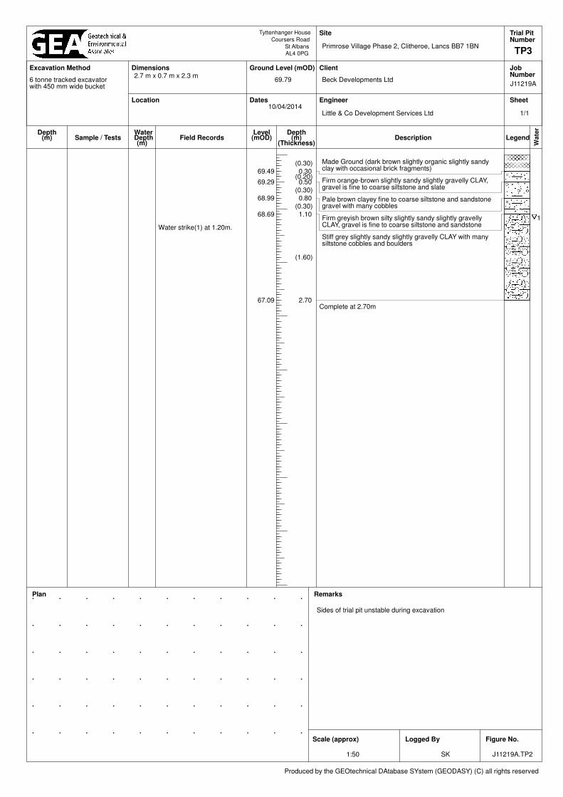
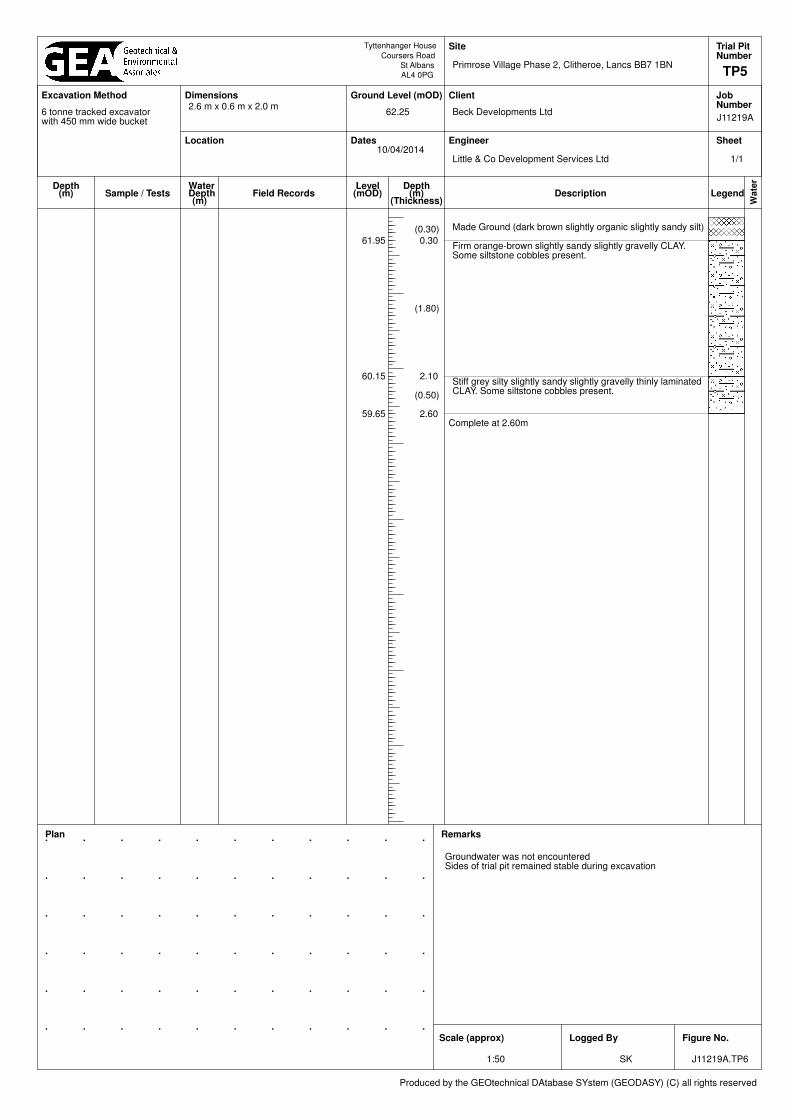
This stratum generally extended to a depth of 0.30 m (61.80 m OD) and comprised brown slightly organic, slightly clayey sandy silt, with occasional fragments of brick. At a single location in the east of the site, in Trial Pit No 7, made ground was found to extend to a depth of 1.0 m (63.50 m OD) and comprised greyish brown sandy gravelly clay with whole bricks, slate, ceramic, metal and fabric fragments. No visual or olfactory evidence of significant contamination was observed within the topsoil/made ground covering the site and nine samples of the made ground were analysed for a range of contaminants. Various extraneous fragments were found within the made ground in Trial Pit No 7 and hence a single sample of this soil has been screened for asbestos. The results are summarised in Section 4.4.
4.2 Glacial Till At the top of the slope in the north of the site a near surface layer of firm silty slightly sandy gravelly clay was encountered, which was overlying soft silty slightly sandy gravelly clay to a maximum depth of 1.9 m. Elsewhere firm orange-brown and greyish brown silty sandy gravelly clay with some cobbles was encountered to depths of between 0.4 m and 4.0 m. Stiff grey slightly sandy slightly gravelly clay with some siltstone cobbles was then encountered and proved to the maximum depth investigated, of 5.45 m. Laboratory index property testing has indicated the clay to be of highly variable plasticity with the corrected plasticity index determinations ranging from 7% to 41%. These results indicate that the soils have low to high volume change potential.
4.3 Groundwater Groundwater was encountered as seepages within the Glacial Till at depths of between 2.4 m and 4.9m. The results of the standpipe monitoring are shown in the table below.
Date Borehole No Depth to water (m)
[Level (m OD)]
10 April 2014 1 0.87
[66.05]
3 0.37
[70.23]
6 0.44
[64.06]
24 April 2014 1 1.09
[65.83]
3 0.52

Primrose Village Phase 2, Clitheroe, Lancs BB7 1BN Ground Investigation Beck Developments Limited Report
Ref J11219A Issue No 1 13 June 2014
6
Date Borehole No Depth to water (m)
[Level (m OD)]
[70.08]
6 1.07
[63.43]
9 May 2014 1 0.05
[66.87]
3 0.30
[70.30]
6 0.00 (ground level)
[64.50]
4.4 Soil Contamination
The table below sets out the values measured within eight samples of topsoil / made ground and four samples of natural soil that have been analysed for contaminant concentrations; all concentrations are in mg/kg unless otherwise stated.
Determinant Maximum concentration
recorded (mg/kg) Minimum concentration
recorded (mg/kg) Number of samples
below detection limit
pH 8.2 6.3 None
Arsenic 16 3.1 None
Cadmium 1.5 0.5 None
Chromium 87 8.8 None
Copper 110 7.9 None
Mercury 0.33 <0.05 3
Nickel 110 12 None
Lead 150 23 None
Selenium 0.6 <0.5 10
Zinc 170 17
Total Cyanide 0.3 <0.1 3
Total Phenols 0.5 0.4 8
Total Sulphate 0.23 0.03 None
Sulphide 24 <10 8
Total TPH (C10-C40) 79 <10 4
Benzo(a)pyrene 0.8 <0.1 8
Naphthalene <0.1 <0.1 All
Total PAH 7.7 <1.6 9
Total Organic Carbon % 8.7 1.2 None
Note: Figure in bold indicates concentration in excess of risk-based soil guideline values, as discussed below.
No elevated concentrations of contaminants were recorded, apart from a slightly elevated total PAH measured in Borehole No 3. However, none of the individual PAH compounds were elevated in that sample.

Primrose Village Phase 2, Clitheroe, Lancs BB7 1BN Ground Investigation Beck Developments Limited Report
Ref J11219A Issue No 1 13 June 2014
7
In addition to the samples tested above, a single sample of made ground was recovered from Trial Pit No 7 which was tested for a range of contaminants and screened for asbestos. The results indicate elevated concentrations of arsenic and lead, and the presence of chrysotile fibres.
4.4.1 Generic Quantitative Risk Assessment
The use of a risk-based approach has been adopted to provide an initial screening of the test results to assess the need for subsequent site-specific risk assessments. To this end contaminants of concern are those that have values in excess of a generic human health risk based guideline values which are either that of the CLEA1 Soil Guideline Value where available, or is a Generic Guideline Value calculated using the CLEA UK Version 1.06 software assuming a residential end use with plant uptake. The key generic assumptions for this end use are as follows: that groundwater will not be a critical risk receptor; that the critical receptor for human health will be young female children aged zero to six
years old; that the exposure duration will be six years; that the critical exposure pathways will be direct soil and indoor dust ingestion,
consumption of homegrown produce, consumption of soil adhering to homegrown produce, skin contact with soils and indoor dust, and inhalation of indoor and outdoor dust and vapours; and
that the building type equates to a two-storey small terraced house.
It is considered that these assumptions are acceptable for this generic assessment of this site. The tables of generic screening values derived by GEA and an explanation of how each value has been derived are included in the Appendix.
Where contaminant concentrations are measured at concentrations below the generic screening value it is considered that they pose an acceptable level of risk and thus further consideration of these contaminant concentrations is not required. However, where concentrations are measured in excess of these generic screening values there is considered to be a potential that they could pose an unacceptable risk and thus further action will be required which could include; additional testing to zone the extent of the contaminated material and thus reduce the
uncertainty with regard to its potential risk; site specific risk assessment to refine the assessment criteria and allow an assessment to
be made as to whether the concentration present would pose an unacceptable risk at this site; or
soil remediation or risk management to mitigate the risk posed by the contaminant to a
degree that it poses an acceptable risk.
1 Updated Technical Background to the CLEA Model (Science Report SC050021/SR3) Jan 2009 and Soil Guideline Value reports
for specific contaminants; all DEFRA and Environment Agency.

Primrose Village Phase 2, Clitheroe, Lancs BB7 1BN Ground Investigation Beck Developments Limited Report
Ref J11219A Issue No 1 13 June 2014
8
The results of the chemical testing indicate that the topsoil / made ground does not generally contain elevated concentrations of contaminants. The deeper made ground encountered in Trial Pit No 7, in the east of the site has been found to contain elevated arsenic and lead and was also found to contain asbestos. The significance of these results is discussed in Part 2 of this report.
4.5 Soil Gas
In order to provide an assessment of the requirement for gas protection measures, three monitoring visits have been conducted over a period of approximately one month. During all three visits the groundwater level was measured at depths of between ground level and 1.1 m indicating that the soil is essentially saturated with a very limited vadose zone. As such there is a very limited zone in which soil gas could be present and this zone is likely to be in connection with the air above. As the standpipes were sealed from ground level to approximately 1m depth to ensure that air entry could not occur it is considered likely that the slotted section of the standpipes would have been isolated from the limited zone of soil gas on all three occasions and as such that the result of the gas monitoring are not considered to be representative of the soil gas conditions. In this situation with such high groundwater conditions it is therefore recommended that the gas monitoring programme be terminated.

Primrose Village Phase 2, Clitheroe, Lancs BB7 1BN Ground Investigation Beck Developments Limited Report
Ref J11219A Issue No 1 13 June 2014
9
Part 2: DESIGN BASIS REPORT This section of the report provides an interpretation of the findings detailed in Part 1, in the form of a ground model, and then provides advice and recommendations with respect to foundation options and contamination issues. 5.0 INTRODUCTION It is understood that consideration is being given to the development of this site through the
construction of approximately 80 two-storey houses, with associated roads, private gardens and areas of soft landscaping.
6.0 GROUND MODEL
The previous desk study indicated that the site has not had a potentially contaminative history having been open farm land for the entirety of its recorded history. On the basis of the fieldwork, the ground conditions at this site can be characterised as follows: below limited thickness of topsoil / made ground, Glacial Till is present; the made ground generally extends to a depth of 0.3 m and comprises brown slightly
organic, slightly clayey sandy silt with occasional fragments of brick; in the east of the site made ground was found to extend to a depth of 1.0 m and to
comprise greyish brown sandy gravelly clay with whole bricks, slate, ceramic, metal and fabric fragments;
at the top of the slope in the north of the site and below a near surface layer of firm
clay the Glacial Till was found to be of a soft consistency to a depth of approximately 1.2 m to 1.9 m;
elsewhere, the Glacial Till generally comprises firm becoming stiff orange-brown and
greyish brown silty sandy gravelly clay which was proved to the maximum depth investigated, of 5.45 m;
the Glacial Till contains occasional siltstone cobbles;
seepages of groundwater were encountered within the Glacial Till at depths between
2.4 m and 4.9 m during drilling and groundwater has subsequently been measured at depths between 1.09 m and ground surface level
no elevated concentrations of contaminants have been found within the made ground
apart from in a single location in the east of the site where elevated arsenic, lead and asbestos was encountered within deeper made ground.

Primrose Village Phase 2, Clitheroe, Lancs BB7 1BN Ground Investigation Beck Developments Limited Report
Ref J11219A Issue No 1 13 June 2014
10
7.0 ADVICE AND RECOMMENDATIONS
The firm or stiff Glacial Till should provide a suitable bearing stratum for spread foundations carrying the anticipated light loads of the proposed two-storey houses.
7.1 Spread Foundations
Moderate width pad or strip foundations placed in the firm Glacial Till, bypassing the soft soils encountered in the north of the site or the deeper made ground encountered in the east of the site, should be suitable to support the proposed houses. Foundations should be placed at a minimum depth of 1.5 m, assuming that no restrictions are applied on planting of shrubs in the vicinity of foundations, and that a no planting zone is applied in accordance with Table 4 of NBHC Standards Chapter 4.2 (2014). If trees are excluded within the zone of influence shown in Table 2 of the NHBC guidance, the minimum depth can be reduced to 1.0 m subject also to the further advice on new tree and shrub planting as detailed in the NHBC guidelines. Foundations at these depths may be designed to apply a net allowable bearing pressure of 120 kN/m2, which incorporates an adequate factor of safety against bearing capacity failure and should ensure that settlement remains within normal tolerable limits. Foundations will need to be deepened in the vicinity of existing trees and where any new trees are proposed and National House Building Council (NHBC) guidelines should be followed in this respect. It would be prudent to assume a high shrinkability class for the clays due to the variability revealed by the laboratory testing unless additional testing is carried out in specific areas.. Where trees are to be removed the required founding depth should be determined on the basis of the existing tree height if it was less than 50% of the mature height and on the basis of full mature height if the height was more than 50% of the mature height. Where a tree is to be retained the final mature height should be adopted. Notwithstanding NHBC guidelines, all foundations should extend beyond the zone of desiccation. In this respect it would be prudent to have all foundation excavations inspected by a suitably experienced engineer. Due allowance should be made for future growth of the trees.
7.2 Excavations Instabilities and groundwater seepages were encountered during the trial pitting; therefore it may be necessary to provide lateral support for excavations in the short term and to adopt sump pumping techniques to deal with shallow water inflows. Where personnel are required to enter excavations, a risk assessment should be carried out and temporary lateral support or battering of the excavation sides will be required in order to comply with normal safety requirements.
7.3 Ground Floor Slabs Following the removal of the topsoil and made ground, consideration could be given to the adoption of ground bearing floor slabs placed in the natural firm Glacial Till, although it would be prudent to proof roll the formation level to identify any soft spots. Soft Glacial Till was identified in the north of the site which should be suitable for a lightly loaded ground floor slab. Alternatively a suspended floor slab should be used in this area. If the ground floor slabs are to be within the zone of influence of trees a fully suspended floor slab should be adopted over a void in accordance with NHBC guidelines.

Primrose Village Phase 2, Clitheroe, Lancs BB7 1BN Ground Investigation Beck Developments Limited Report
Ref J11219A Issue No 1 13 June 2014
11
The soil gas monitoring has indicated very high groundwater levels, and as such the thickness of unsaturated soils is limited. Any soil gas migrating from the landfill will therefore not migrate laterally due to the limited vadose zone, but will migrate upwards. Thus landfill gas migration will not occur over any significant distance. Further to this, gas monitoring carried out on the adjacent Phase 1 site, which is closer to the landfill, did not indicate any elevated concentrations of soil gas and no gas protection measures were deemed necessary. The desk study has shown that the site may fall within an area where radon protection may be necessary. It is therefore recommended that confirmation be sought from the local authority to ascertain the requirement for any radon protection measures.
7.4 Pavement Design Equivalent in-situ California Bearing Ratio (CBR) testing by means of a hand held MEXE
cone penetrometer has indicated a CBR value of between 2% and 5%. It is considered that a CBR value of 2% should be attainable within the near surface Glacial Till following a site strip. It is however, recommended that the formation level of all proposed paved areas be proof rolled and that any soft spots revealed by this rolling be removed and replaced with compacted granular material. The volume change potential results suggest that the materials at formation level will be frost susceptible and as such a road construction of minimum 450 mm is likely to be imposed by the local authority
7.5 Effect of Sulphates
Chemical analyses of selected samples have revealed generally low concentrations of total and soluble sulphate.Buried concrete should therefore be designed in accordance with Class DS-1 conditions of Table C2 of BRE Special Digest 1: SD1 Third Edition (2005). Mildly acidic to near neutral pH conditions have been measured and therefore on the basis of mobile groundwater conditions being assumed for buried concrete an ACEC classification of AC-2z may be adopted. The guidelines contained in the above digest should be followed in the design of foundation concrete.
7.6 Site Specific Risk Assessment The desk study has indicated that the site does not have a significant historical contaminative use and the results of contamination tests did not indicate any contamination to be present in the topsoil/made ground or natural soils. In view of these results it is considered that no remedial measures will be required across the site. However, elevated concentrations of arsenic and lead, and the presence of asbestos fibres have been indicated in the made ground found in a single location in the east of the site, in Trial Pit No 7. In order to prevent the requirement for protective and remedial measures at the site this fill material should ideally be removed from the site, although additional investigation should first be carried out to determine the extent of this material. . As asbestos has been detected within the soils at this location further chemical analysis is in any case needed to determine the percentage of fibres for waste classification purposes.

Primrose Village Phase 2, Clitheroe, Lancs BB7 1BN Ground Investigation Beck Developments Limited Report
Ref J11219A Issue No 1 13 June 2014
12
7.7 Waste Disposal
Any spoil arising from excavations or landscaping works, which is not to be re-used in accordance with the CL:AIRE guidance2, will need to be disposed of to a licensed tip. Under the European Waste Directive, waste is classified as being either Hazardous or Non-Hazardous and landfills receiving waste are classified as accepting hazardous or non-hazardous wastes or the non-hazardous sub-category of inert waste in accordance with the Waste Directive. Waste going to landfill is subject to landfill tax at either the standard rate of £80 per tonne (about £145 per m3) or at the lower rate of £2.50 per tonne (roughly £5 per m3). However, the classifications for tax purposes and disposal purposes differ and currently all made ground and topsoil is taxable at the ‘standard’ rate and only naturally occurring rocks and soils, which are accurately described as such in terms of the 2011 Order3, would qualify for the ‘lower rate’ of landfill tax.
Based upon on the technical guidance provided by the Environment Agency4 it is considered likely that the topsoil / made ground covering the site, as represented by the nine chemical analyses carried out, would be classified as non-hazardous waste under the waste code 17 05 04 (soils and stones not containing dangerous substances) and would be taxable at the standard rate. It is likely that the natural soils, if separated out, could be classified as an INERT waste also under the waste code 17 05 04. This material would be taxable at the lower rate, if accurately described as naturally occurring clay in terms of the 2011 Order on the waste transfer note. As the site has never been developed or used for the storage of potentially hazardous materials, it is likely that WAC leaching tests would not be required for such inert waste going to landfill. This would however need to be confirmed by the receiving landfill site. Further investigation is recommended to determine the extent of the fill material encountered in Trial Pit No 7, and further chemical testing is required to classify the material for waste disposal, as chrysotile asbestos fibres have been identified within samples tested. Waste containing asbestos is classified as being a ‘Hazardous Waste’ if it is found to contain more that 0.1% asbestos.
Under the requirements of the European Waste Directive all waste needs to be pre-treated prior to disposal. The pre-treatment process must be physical, thermal, chemical or biological, including sorting. It must change the characteristics of the waste in order to reduce its volume, hazardous nature, facilitate handling or enhance recovery. The waste producer can carry out the treatment but they will need to provide documentation to prove that this has been carried out. Alternatively, the treatment can be carried out by an approved contractor. The Environment Agency has issued a position paper5 which states that in certain circumstances, segregation at source may be considered as pre-treatment and thus excavated material may not have to be treated prior to landfilling if the soils can be “segregated” on site by sufficiently characterising the soils insitu prior to excavation.
The above opinion with regard to the classification of the excavated soils and its likely landfill taxable rate is provided for guidance only and should be confirmed by the receiving landfill once the soils to be discarded have been identified.
2 CL:AIRE (2011) The Definition of Waste: Development Industry Code of Practice Version 2, March 2011 3 Landfill Tax (Qualifying Material) Order 2011 4 Environment Agency (2008) Hazardous Waste: Interpretation of the definition and classification of hazardous waste. Technical
Guidance WM2 Second Edition Version 2.2, May 2008 5 Regulatory Position Statement (2007) Treating non-hazardous waste for landfill - Enforcing the new requirement Environment
Agency 23 Oct 2007

Primrose Village Phase 2, Clitheroe, Lancs BB7 1BN Ground Investigation Beck Developments Limited Report
Ref J11219A Issue No 1 13 June 2014
13
The local waste regulation department of the EA should be contacted to obtain details of tips that are licensed to accept the soil represented by the test results. The tips will be able to provide costs for disposing of this material but may require further testing.
If consideration were to be given to the re-use of the soil as a structural fill on this or another site, in accordance with the Code of Practice for the definition of waste, it would be necessary to confirm its suitability for use, its certainty of use and to confirm that only as much material is to be used as is required for the specific purpose for which it was being used. A materials management plan could then be formulated and a tracking system put in place such that once placed the material would no longer be regarded as being a waste and thus waste management licensing and landfill tax would not apply.
8.0 OUTSTANDING RISKS AND ISSUES
This section of the report aims to highlight areas where further work is required as a result of limitations on the scope of this investigation, or where issues have been identified by this investigation that warrant further consideration. The scope of risks and issues discussed in this section is by no means exhaustive, but covers the main areas where additional work is considered to be required.
The ground is a heterogeneous natural material and variations will inevitably arise between the locations at which it is investigated. This report has provided an assessment of the ground conditions based on the discrete points at which the ground was sampled, but the ground conditions should be subject to review as the work proceeds to ensure that any variations from the Ground Model are properly assessed by a suitably qualified person. Consultation with the local authority is required to ascertain if radon protection measures are required at this site. Excavations should be checked to confirm the absence of desiccation. Further investigation is recommended to determine the extent of the fill material encountered in the east of the site.
If during ground works any visual or olfactory evidence of contamination is identified it is recommended that further investigation be carried out and that the risk assessment is reviewed. These areas of doubt should be drawn to the attention of prospective contractors and further investigation will be required or sufficient contingency should be provided to cover the outstanding risk.

Primrose Village Phase 2, Clitheroe, Lancs BB7 1BN Ground Investigation Beck Developments Limited Report
Ref J11219A Issue No 1 13 June 2014
14
APPENDIX
Borehole Records
SPT Results Summary
Trial Pit Records
Mexe-Cone Results
Gas Monitoring Results
Geotechnical Laboratory Test Results
Chemical Analyses (Soil)
Generic Risk Guideline Values
Site Plan

Tyttenhanger House
Coursers Road
St Albans
AL4 0PG
Location
Ground Level (mOD)
Dates
Site
Client
Engineer
JobNumber
Sheet
Wate
r
LegendDescriptionDepth
(m)(Thickness)
Depth(m)
Level(mOD)Sample / Tests
Remarks Scale(approx)
LoggedBy
Figure No.
J11219A.BH1
1:50 SK
Primrose Village Phase 2, Clitheroe, Lancs BB7 1BN
Beck Developments Ltd
Little & Co Development Services Ltd
J11219A
BH1
Number
66.92
27/03/2014
Produced by the GEOtechnical DAtabase SYstem (GEODASY) (C) all rights reserved
Excavation Method Dimensions
WaterDepth(m)
Field Records
Open-drive percussive sampler (Terrier Rig)
1
Topsoil (brown slightly organic slightly clayey slightly sandy silt)
66.82 0.10(0.20)
Made Ground (brown silty sandy gravelly clay with fragments of siltstone and brick)
66.62 0.30
(1.60)
Soft orange-brown to brown silty slightly sandy gravelly CLAY, gravel is subrounded siltstone. Some siltstone cobbles present
65.02 1.90
(3.55)
Firm becoming stiff at 2.5 m grey silty slightly sandy gravelly CLAY, gravel is subrounded siltstone. Some siltstone cobbles present
61.47 5.45Complete at 5.45m
0.30 D1
0.70 D2
1.00-1.45 SPT(C) N=5 0,1/1,2,1,11.10 D3
1.50 D4
50 mm groundwater and gas monitoring pipe installed to 5.0 m with response zone from 1.0 m to 5.0 m
2.00-2.45 SPT(C) N=14 2,2/2,2,3,7
2.80 D5
3.00-3.45 SPT(C) N=15 2,2/3,4,4,4
3.80 D6
4.00-4.45 SPT(C) N=22 5,5/5,5,5,7
Water strike(1) at 4.70m.4.80 D7
5.00-5.45 SPT(C) N=18 2,2/3,5,5,5
1/1

Tyttenhanger House
Coursers Road
St Albans
AL4 0PG
Location
Ground Level (mOD)
Dates
Site
Client
Engineer
JobNumber
Sheet
Wate
r
LegendDescriptionDepth
(m)(Thickness)
Depth(m)
Level(mOD)Sample / Tests
Remarks Scale(approx)
LoggedBy
Figure No.
J11219A.BH2
1:50 SK
Primrose Village Phase 2, Clitheroe, Lancs BB7 1BN
Beck Developments Ltd
Little & Co Development Services Ltd
J11219A
BH2
Number
68.28
27/03/2014
Produced by the GEOtechnical DAtabase SYstem (GEODASY) (C) all rights reserved
Excavation Method Dimensions
WaterDepth(m)
Field Records
Open-drive percussive sampler (Terrier Rig)
1
(0.30) Topsoil (brown slightly organic slightly clayey slightly sandy silt)67.98 0.30
(0.90)
Soft orange-brown silty slightly sandy slightly gravelly CLAY, gravel is subrounded siltstone. Some siltstone cobbles present
67.08 1.20
(4.25)
Firm becoming stiff grey silty slightly sandy slightly gravelly CLAY, gravel is subrounded siltstone and sandstone. Some siltstone cobbles present
Large sandstone cobble at 4.8 m
62.83 5.45Complete at 5.45m
0.20 D10.30 D20.40 D3
0.90 D41.00-1.45 SPT(C) N=6 0,0/1,2,1,2
1.40 D5
2.00-2.45 SPT(C) N=16 2,3/3,4,4,52.10 D6
Water strike(1) at 2.40m.
3.00-3.45 SPT(C) N=25 2,3/4,5,6,103.10 D7
4.00-4.45 SPT(C) N=50 3,4/8,11,16,154.10 D8
5.00-5.45 SPT(C) N=37 4,5/8,12,9,8
1/1

Tyttenhanger House
Coursers Road
St Albans
AL4 0PG
Location
Ground Level (mOD)
Dates
Site
Client
Engineer
JobNumber
Sheet
Wate
r
LegendDescriptionDepth
(m)(Thickness)
Depth(m)
Level(mOD)Sample / Tests
Remarks Scale(approx)
LoggedBy
Figure No.
J11219A.BH3
1:50 SK
Primrose Village Phase 2, Clitheroe, Lancs BB7 1BN
Beck Developments Ltd
Little & Co Development Services Ltd
J11219A
BH3
Number
70.60
27/03/2014
Produced by the GEOtechnical DAtabase SYstem (GEODASY) (C) all rights reserved
Excavation Method Dimensions
WaterDepth(m)
Field Records
Open-drive percussive sampler (Terrier Rig)
1
(0.20) Topsoil (brown slightly organic slightly clayey slightly sandy silt)70.40 0.20
(1.20)
Firm orange-brown silty slightly sandy gravelly CLAY, gravel is subrounded siltstone. Some siltstone cobbles present
69.20 1.40
(4.05)
Stiff grey silty slightly sandy gravelly CLAY, gravel is subrounded siltstone. Some siltstone cobbles present
65.15 5.45Complete at 5.45m
0.20 D10.30 D2
0.90 D31.00-1.45 SPT(C) N=25 2,3/6,7,8,4
1.30 D4
1.70 D5
50 mm groundwater and gas monitoring pipe installed to 5.0 m
2.00-2.45 SPT(C) N=23 2,4/3,5,8,7
2.50 D6
3.00-3.45 SPT(C) N=27 3,3/6,7,6,8
3.50 D7
4.00-4.45 SPT(C) N=30 2,5/5,7,8,10
Water strike(1) at 4.50m.4.50 D8
5.00-5.45 SPT(C) N=26 6,8/7,6,6,7
1/1

Tyttenhanger House
Coursers Road
St Albans
AL4 0PG
Location
Ground Level (mOD)
Dates
Site
Client
Engineer
JobNumber
Sheet
Wate
r
LegendDescriptionDepth
(m)(Thickness)
Depth(m)
Level(mOD)Sample / Tests
Remarks Scale(approx)
LoggedBy
Figure No.
J11219A.BH4
1:50 SK
Primrose Village Phase 2, Clitheroe, Lancs BB7 1BN
Beck Developments Ltd
Little & Co Development Services Ltd
J11219A
BH4
Number
64.06
27/03/2014
Produced by the GEOtechnical DAtabase SYstem (GEODASY) (C) all rights reserved
Excavation Method Dimensions
WaterDepth(m)
Field Records
Open-drive percussive sampler (Terrier Rig)
1
(0.30) Topsoil (brown slightly organic slightly clayey slightly sandy silt)63.76 0.30
(5.15)
Firm becoming stiff at 2.5 m orange-brown becoming grey silty slightly sandy slightly gravelly CLAY, gravel is subrounded siltstone. Some siltstone cobbles present
58.61 5.45Complete at 5.45m
0.20 D10.40 D2
0.60 D3
0.90 D41.00-1.45 SPT(C) N=12 1,1/2,2,4,4
1.50 D5
2.00-2.45 SPT(C) N=13 1,2/2,4,3,4
2.50 D6
3.00-3.45 SPT(C) N=15 2,2/3,4,4,4
3.50 D7
4.00-4.45 SPT(C) N=15 3,3/3,4,4,4
4.50 D8
Water strike(1) at 4.90m.5.00-5.45 SPT(C) N=18 3,3/3,4,5,6
1/1

Tyttenhanger House
Coursers Road
St Albans
AL4 0PG
Location
Ground Level (mOD)
Dates
Site
Client
Engineer
JobNumber
Sheet
Wate
r
LegendDescriptionDepth
(m)(Thickness)
Depth(m)
Level(mOD)Sample / Tests
Remarks Scale(approx)
LoggedBy
Figure No.
J11219A.BH5
1:50 SK
Primrose Village Phase 2, Clitheroe, Lancs BB7 1BN
Beck Developments Ltd
Little & Co Development Services Ltd
J11219A
BH5
Number
67.00
27/03/2014
Produced by the GEOtechnical DAtabase SYstem (GEODASY) (C) all rights reserved
Excavation Method Dimensions
WaterDepth(m)
Field Records
Open-drive percussive sampler (Terrier Rig)
(0.30) Topsoil (brown slightly organic slightly clayey slightly sandy silt)66.70 0.30
(1.75)
Firm becoming stiff at 1.0 m brown silty slightly sandy very gravelly CLAY, gravel is fine to coarse subrounded siltstone
64.95 2.05Terminated at 2.05m
0.20 D10.40 D2
0.70 D3
Groundwater was not encountered
1.00-1.45 SPT(C) N=15 2,2/3,6,3,31.10 D4
1.80 D5
Refusal of sampler and SPT on siltstone cobble
2.00-2.06 SPT(C) 25*/2550/30
25/50
1/1

Tyttenhanger House
Coursers Road
St Albans
AL4 0PG
Location
Ground Level (mOD)
Dates
Site
Client
Engineer
JobNumber
Sheet
Wate
r
LegendDescriptionDepth
(m)(Thickness)
Depth(m)
Level(mOD)Sample / Tests
Remarks Scale(approx)
LoggedBy
Figure No.
J11219A.BH6
1:50 SK
Primrose Village Phase 2, Clitheroe, Lancs BB7 1BN
Beck Developments Ltd
Little & Co Development Services Ltd
J11219A
BH6
Number
64.50
27/03/2014
Produced by the GEOtechnical DAtabase SYstem (GEODASY) (C) all rights reserved
Excavation Method Dimensions
WaterDepth(m)
Field Records
Open-drive percussive sampler (Terrier Rig)
1
(0.30) Topsoil (brown slightly organic slightly clayey slightly sandy silt)64.20 0.30
(0.20)Firm orange-brown silty slightly sandy slightly gravelly CLAY, gravel is subrounded siltstone. Some siltstone cobbles present
64.00 0.50
(1.80)
Firm grey silty slightly sandy slightly gravelly CLAY, gravel is subrounded siltstone. Some siltstone cobbles present
62.20 2.30
(3.15)
Firm becoming stiff at 4.0 m grey silty slightly sandy slightly gravelly CLAY, gravel is subrounded siltstone. Some siltstone cobbles present
59.05 5.45Complete at 5.45m
0.20 D10.40 D2
0.60 D3
1.00-1.45 SPT(C) N=12 1,1/2,3,3,4
1.20 D4
1.80 D5
50 mm groundwater and gas monitoring pipe installed to 5.0 m
2.00-2.45 SPT(C) N=10 2,1/2,2,3,3
2.20 D6
2.70 D7
3.00-3.45 SPT(C) N=10 1,1/2,2,3,3
3.40 D8
4.00-4.45 SPT(C) N=15 2,2/4,3,4,4Water strike(1) at 4.10m.
4.40 D9
5.00-5.45 SPT(C) N=19 2,3/4,4,5,6
1/1

Tyttenhanger House
Coursers Road
St Albans
AL4 0PG
Location
Ground Level (mOD)
Dates
Site
Client
Engineer
JobNumber
Sheet
Wate
r
LegendDescriptionDepth
(m)(Thickness)
Depth(m)
Level(mOD)Sample / Tests
Remarks Scale(approx)
LoggedBy
Figure No.
J11219A.BH7
1:50 SK
Primrose Village Phase 2, Clitheroe, Lancs BB7 1BN
Beck Developments Ltd
Little & Co Development Services Ltd
J11219A
BH7
Number
62.10
28/03/2014
Produced by the GEOtechnical DAtabase SYstem (GEODASY) (C) all rights reserved
Excavation Method Dimensions
WaterDepth(m)
Field Records
Open-drive percussive sampler (Terrier Rig)
(0.30) Topsoil (brown slightly organic slightly clayey slightly sandy silt)61.80 0.30
(0.70)
"Stiff" orange-brown silty slightly sandy very gravelly CLAY, gravel is fine to medium subrounded siltstone. Possibly partially desiccated soil
61.10 1.00
(1.00)
Firm grey silty slightly sandy slightly gravelly CLAY, gravel is fine to cobble-sized subrounded siltstone
60.10 2.00
(1.00)
No recovery
59.10 3.00
(2.45)
Firm becoming stiff grey silty slightly sandy slightly gravelly CLAY, gravel is fine to cobble-sized subrounded siltstone and sandstone
56.65 5.45Complete at 5.45m
0.20 D10.40 D20.50 D3
Groundwater was not encountered
1.00-1.45 SPT(C) N=11 1,3/3,2,3,31.00 D41.30 D5
1.90 D62.00-2.45 SPT(C) N=14 2,2/3,3,4,4
3.00-3.45 SPT(C) N=15 2,2/3,4,4,4
3.50 D7
4.00-4.45 SPT(C) N=34 1,2/10,6,10,8
4.50 D8
5.00-5.45 SPT(C) N=42 2,2/4,4,12,22
1/1

Tyttenhanger House
Coursers Road
St Albans
AL4 0PG
Location
Ground Level (mOD)
Dates
Site
Client
Engineer
JobNumber
Sheet
Wate
r
LegendDescriptionDepth
(m)(Thickness)
Depth(m)
Level(mOD)Sample / Tests
Remarks Scale(approx)
LoggedBy
Figure No.
J11219A.BH8
1:50 SK
Primrose Village Phase 2, Clitheroe, Lancs BB7 1BN
Beck Developments Ltd
Little & Co Development Services Ltd
J11219A
BH8
Number
63.20
28/03/2014
Produced by the GEOtechnical DAtabase SYstem (GEODASY) (C) all rights reserved
Excavation Method Dimensions
WaterDepth(m)
Field Records
Open-drive percussive sampler (Terrier Rig)
(0.30) Topsoil (brown slightly organic slightly clayey slightly sandy silt)62.90 0.30
(1.50)
Firm becoming stiff at 1.0 m orange-brown silty slightly sandy slightly gravelly CLAY, gravel is subrounded siltstone. Some siltstone cobbles present
Siltstone boulder was encountered at 0.9 m
61.40 1.80
(2.65)
Stiff grey silty slightly sandy slightly gravelly CLAY, gravel is subrounded siltstone. Some siltstone cobbles present
58.75 4.45Complete at 4.45m
0.30 D1
0.50 D2
Groundwater was not encountered
1.00-1.45 SPT(C) N=18 2,5/3,4,5,6
1.50 D3
2.00-2.45 SPT(C) N=26 3,3/7,4,5,10
2.50 D4
3.00-3.45 SPT(C) N=26 4,4/4,7,7,8
3.50 D5
4.00-4.45 SPT(C) N=31 5,5/5,6,10,10
1/1

Tyttenhanger House
Coursers Road
St Albans
AL4 0PG
Standard Penetration Test Results
Produced by the GEOtechnical DAtabase SYstem (GEODASY) (C) all rights reserved
Job Number
J11219A
Sheet
Site : Primrose Village Phase 2, Clitheroe, Lancs BB7 1BN
Client : Beck Developments Ltd
Engineer : Little & Co Development Services Ltd
BoreholeNumber
Base ofBorehole
(m)
End ofSeating
Drive(m)
End ofTestDrive(m)
TestType
Seating Blowsper 75mm
1 2 1 2 3 4
Blows for each 75mm penetration
Result Comments
BH1 1.00 1.15 1.45 CPT 0 1 1 2 1 1 N=5
BH1 2.00 2.15 2.45 CPT 2 2 2 2 3 7 N=14
BH1 3.00 3.15 3.45 CPT 2 2 3 4 4 4 N=15
BH1 4.00 4.15 4.45 CPT 5 5 5 5 5 7 N=22
BH1 5.00 5.15 5.45 CPT 2 2 3 5 5 5 N=18
BH2 1.00 1.15 1.45 CPT 0 0 1 2 1 2 N=6
BH2 2.00 2.15 2.45 CPT 2 3 3 4 4 5 N=16
BH2 3.00 3.15 3.45 CPT 2 3 4 5 6 10 N=25
BH2 4.00 4.15 4.45 CPT 3 4 8 11 16 15 N=50
BH2 5.00 5.15 5.45 CPT 4 5 8 12 9 8 N=37
BH3 1.00 1.15 1.45 CPT 2 3 6 7 8 4 N=25
BH3 2.00 2.15 2.45 CPT 2 4 3 5 8 7 N=23
BH3 3.00 3.15 3.45 CPT 3 3 6 7 6 8 N=27
BH3 4.00 4.15 4.45 CPT 2 5 5 7 8 10 N=30
BH3 5.00 5.15 5.45 CPT 6 8 7 6 6 7 N=26
BH4 1.00 1.15 1.45 CPT 1 1 2 2 4 4 N=12
BH4 2.00 2.15 2.45 CPT 1 2 2 4 3 4 N=13
BH4 3.00 3.15 3.45 CPT 2 2 3 4 4 4 N=15
BH4 4.00 4.15 4.45 CPT 3 3 3 4 4 4 N=15
BH4 5.00 5.15 5.45 CPT 3 3 3 4 5 6 N=18
BH5 1.00 1.15 1.45 CPT 2 2 3 6 3 3 N=15
BH5 2.00 2.03 2.06 CPT 25 50 25*/25mm50/30mm
BH6 1.00 1.15 1.45 CPT 1 1 2 3 3 4 N=12
BH6 2.00 2.15 2.45 CPT 2 1 2 2 3 3 N=10
BH6 3.00 3.15 3.45 CPT 1 1 2 2 3 3 N=10
BH6 4.00 4.15 4.45 CPT 2 2 4 3 4 4 N=15
BH6 5.00 5.15 5.45 CPT 2 3 4 4 5 6 N=19
BH7 1.00 1.15 1.45 CPT 1 3 3 2 3 3 N=11
BH7 2.00 2.15 2.45 CPT 2 2 3 3 4 4 N=14
BH7 3.00 3.15 3.45 CPT 2 2 3 4 4 4 N=15
BH7 4.00 4.15 4.45 CPT 1 2 10 6 10 8 N=34
BH7 5.00 5.15 5.45 CPT 2 2 4 4 12 22 N=42
BH8 1.00 1.15 1.45 CPT 2 5 3 4 5 6 N=18
BH8 2.00 2.15 2.45 CPT 3 3 7 4 5 10 N=26
BH8 3.00 3.15 3.45 CPT 4 4 4 7 7 8 N=26
BH8 4.00 4.15 4.45 CPT 5 5 5 6 10 10 N=31
1 / 1

Tyttenhanger House
Coursers Road
St Albans
AL4 0PG
Location
Ground Level (mOD)
Dates
Site
Client
Engineer
JobNumber
Sheet
Wate
r
LegendDescriptionDepth
(m)(Thickness)
Depth(m)
Level(mOD)Sample / Tests
1:50 SK J11219A.TP1
Primrose Village Phase 2, Clitheroe, Lancs BB7 1BN
Beck Developments Ltd
Little & Co Development Services Ltd
J11219A
TP1
Number
65.74
10/04/2014
Produced by the GEOtechnical DAtabase SYstem (GEODASY) (C) all rights reserved
Plan.
.
.
.
.
.
.
.
.
.
.
.
.
.
.
.
.
.
.
.
.
.
.
.
.
.
.
.
.
.
.
.
.
.
.
.
.
.
.
.
.
.
.
.
.
.
.
.
.
.
.
.
.
.
.
.
.
.
.
.
.
.
.
.
.
.
Trial Pit
DimensionsExcavation Method
WaterDepth(m)
Field Records
Remarks
Scale (approx) Logged By Figure No.
6 tonne tracked excavator with 450 mm wide bucket
1.5 m x 0.6 m x 0.5 m
(0.30) Made Ground (pale brown slightly organic slightly sandy silt)
65.44 0.30(0.20) Stiff orange-brown mottled grey slightly sandy slightly
gravelly CLAY65.24 0.50
Terminated at 0.50m
Groundwater was not encountered Pit terminated on discovery and breakage of land drain which was fixed on site by land owner
1/1

Tyttenhanger House
Coursers Road
St Albans
AL4 0PG
Location
Ground Level (mOD)
Dates
Site
Client
Engineer
JobNumber
Sheet
Wate
r
LegendDescriptionDepth
(m)(Thickness)
Depth(m)
Level(mOD)Sample / Tests
1:50 SK J11219A.TP2
Primrose Village Phase 2, Clitheroe, Lancs BB7 1BN
Beck Developments Ltd
Little & Co Development Services Ltd
J11219A
TP2
Number
69.64
10/04/2014
Produced by the GEOtechnical DAtabase SYstem (GEODASY) (C) all rights reserved
Plan.
.
.
.
.
.
.
.
.
.
.
.
.
.
.
.
.
.
.
.
.
.
.
.
.
.
.
.
.
.
.
.
.
.
.
.
.
.
.
.
.
.
.
.
.
.
.
.
.
.
.
.
.
.
.
.
.
.
.
.
.
.
.
.
.
.
Trial Pit
DimensionsExcavation Method
WaterDepth(m)
Field Records
Remarks
Scale (approx) Logged By Figure No.
6 tonne tracked excavator with 450 mm wide bucket
2.9 m x 0.7 m x 2.8 m
1
(0.30) Made Ground (dark brown slightly organic slightly sandy silt with occasional brick fragments)69.34 0.30
(0.70)
Firm orange-brown slightly sandy slightly gravelly CLAY, gravel is fine to coarse siltstone and slate
68.64 1.00
(1.30)
Soft becoming firm orange-brown slightly sandy slightly gravelly CLAY, gravel is fine to coarse siltstone
67.34 2.30
(0.60)
Stiff becoming very stiff grey slightly sandy slightly gravelly CLAY, gravel is fine to coarse siltstone
66.74 2.90Complete at 2.90m
Water strike(1) at 1.00m.
Sides of trail pit unstable during excavation
1/1
Tyttenhanger House
Coursers Road
St Albans
AL4 0PG
Location
Ground Level (mOD)
Dates
Site
Client
Engineer
JobNumber
Sheet
Wate
r
LegendDescriptionDepth
(m)(Thickness)
Depth(m)
Level(mOD)Sample / Tests
1:50 SK J11219A.TP2
Primrose Village Phase 2, Clitheroe, Lancs BB7 1BN
Beck Developments Ltd
Little & Co Development Services Ltd
J11219A
TP3
Number
69.79
10/04/2014
Produced by the GEOtechnical DAtabase SYstem (GEODASY) (C) all rights reserved
Plan.
.
.
.
.
.
.
.
.
.
.
.
.
.
.
.
.
.
.
.
.
.
.
.
.
.
.
.
.
.
.
.
.
.
.
.
.
.
.
.
.
.
.
.
.
.
.
.
.
.
.
.
.
.
.
.
.
.
.
.
.
.
.
.
.
.
Trial Pit
DimensionsExcavation Method
WaterDepth(m)
Field Records
Remarks
Scale (approx) Logged By Figure No.
6 tonne tracked excavator with 450 mm wide bucket
2.7 m x 0.7 m x 2.3 m
1
(0.30) Made Ground (dark brown slightly organic slightly sandy clay with occasional brick fragments)69.49 0.30
(0.20)Firm orange-brown slightly sandy slightly gravelly CLAY, gravel is fine to coarse siltstone and slate
69.29 0.50
(0.30)
Pale brown clayey fine to coarse siltstone and sandstone gravel with many cobbles
68.99 0.80
(0.30)
Firm greyish brown silty slightly sandy slightly gravelly CLAY, gravel is fine to coarse siltstone and sandstone
68.69 1.10
(1.60)
Stiff grey slightly sandy slightly gravelly CLAY with many siltstone cobbles and boulders
67.09 2.70Complete at 2.70m
Water strike(1) at 1.20m.
Sides of trial pit unstable during excavation
1/1

Tyttenhanger House
Coursers Road
St Albans
AL4 0PG
Location
Ground Level (mOD)
Dates
Site
Client
Engineer
JobNumber
Sheet
Wate
r
LegendDescriptionDepth
(m)(Thickness)
Depth(m)
Level(mOD)Sample / Tests
1:50 SK J11219A.TP4
Primrose Village Phase 2, Clitheroe, Lancs BB7 1BN
Beck Developments Ltd
Little & Co Development Services Ltd
J11219A
TP4
Number
66.30
10/04/2014
Produced by the GEOtechnical DAtabase SYstem (GEODASY) (C) all rights reserved
Plan.
.
.
.
.
.
.
.
.
.
.
.
.
.
.
.
.
.
.
.
.
.
.
.
.
.
.
.
.
.
.
.
.
.
.
.
.
.
.
.
.
.
.
.
.
.
.
.
.
.
.
.
.
.
.
.
.
.
.
.
.
.
.
.
.
.
Trial Pit
DimensionsExcavation Method
WaterDepth(m)
Field Records
Remarks
Scale (approx) Logged By Figure No.
6 tonne tracked excavator with 450 mm wide bucket
3.0 m x 0.6 m x 2.0 m
(0.20) Made Ground (dark brown slightly organic slightly sandy silt)66.10 0.20
(0.20) Firm orange-brown slightly sandy CLAY65.90 0.40
(2.20)
Stiff grey silty CLAY, with occasional fine to coarse siltstone gravel
63.70 2.60
(0.40)Stiff grey silty slightly gravelly CLAY, gravel is fine to coarse siltstone
Siltstone cobble at 2.6 m 63.30 3.00
Complete at 3.00m
Groundwater was not encounteredSides of trial pit remained stable during excavation
1/1
Tyttenhanger House
Coursers Road
St Albans
AL4 0PG
Location
Ground Level (mOD)
Dates
Site
Client
Engineer
JobNumber
Sheet
Wate
r
LegendDescriptionDepth
(m)(Thickness)
Depth(m)
Level(mOD)Sample / Tests
1:50 SK J11219A.TP6
Primrose Village Phase 2, Clitheroe, Lancs BB7 1BN
Beck Developments Ltd
Little & Co Development Services Ltd
J11219A
TP5
Number
62.25
10/04/2014
Produced by the GEOtechnical DAtabase SYstem (GEODASY) (C) all rights reserved
Plan.
.
.
.
.
.
.
.
.
.
.
.
.
.
.
.
.
.
.
.
.
.
.
.
.
.
.
.
.
.
.
.
.
.
.
.
.
.
.
.
.
.
.
.
.
.
.
.
.
.
.
.
.
.
.
.
.
.
.
.
.
.
.
.
.
.
Trial Pit
DimensionsExcavation Method
WaterDepth(m)
Field Records
Remarks
Scale (approx) Logged By Figure No.
6 tonne tracked excavator with 450 mm wide bucket
2.6 m x 0.6 m x 2.0 m
(0.30) Made Ground (dark brown slightly organic slightly sandy silt)
61.95 0.30
(1.80)
Firm orange-brown slightly sandy slightly gravelly CLAY. Some siltstone cobbles present.
60.15 2.10
(0.50)
Stiff grey silty slightly sandy slightly gravelly thinly laminated CLAY. Some siltstone cobbles present.
59.65 2.60Complete at 2.60m
Groundwater was not encounteredSides of trial pit remained stable during excavation
1/1

Tyttenhanger House
Coursers Road
St Albans
AL4 0PG
Location
Ground Level (mOD)
Dates
Site
Client
Engineer
JobNumber
Sheet
Wate
r
LegendDescriptionDepth
(m)(Thickness)
Depth(m)
Level(mOD)Sample / Tests
1:50 SK J11219A.TP6
Primrose Village Phase 2, Clitheroe, Lancs BB7 1BN
Beck Developments Ltd
Little & Co Development Services Ltd
J11219A
TP6
Number
63.51
10/04/2014
Produced by the GEOtechnical DAtabase SYstem (GEODASY) (C) all rights reserved
Plan.
.
.
.
.
.
.
.
.
.
.
.
.
.
.
.
.
.
.
.
.
.
.
.
.
.
.
.
.
.
.
.
.
.
.
.
.
.
.
.
.
.
.
.
.
.
.
.
.
.
.
.
.
.
.
.
.
.
.
.
.
.
.
.
.
.
Trial Pit
DimensionsExcavation Method
WaterDepth(m)
Field Records
Remarks
Scale (approx) Logged By Figure No.
6 tonne tracked excavator with 450 mm wide bucket
3.0 m x 0.6 m x 2.0 m
(0.30) Made Ground (dark brown slightly organic slightly sandy clay)63.21 0.30
(1.70)
Firm orange-brown slightly sandy slightly gravelly CLAY, gravel is fine to coarse siltstone
61.51 2.00
(1.00)
Stiff grey silty slightly sandy slightly gravelly thinly laminated CLAY, gravel is fine to coarse siltstone
Cobbles of quartzite at 2.7 m
60.51 3.00Complete at 3.00m
Groundwater was not encounteredSides of trial pit remained stable during excavation
1/1

Tyttenhanger House
Coursers Road
St Albans
AL4 0PG
Location
Ground Level (mOD)
Dates
Site
Client
Engineer
JobNumber
Sheet
Wate
r
LegendDescriptionDepth
(m)(Thickness)
Depth(m)
Level(mOD)Sample / Tests
1:50 SK J11219A.TP7
Primrose Village Phase 2, Clitheroe, Lancs BB7 1BN
Beck Developments Ltd
Little & Co Development Services Ltd
J11219A
TP7
Number
64.50
10/04/2014
Produced by the GEOtechnical DAtabase SYstem (GEODASY) (C) all rights reserved
Plan.
.
.
.
.
.
.
.
.
.
.
.
.
.
.
.
.
.
.
.
.
.
.
.
.
.
.
.
.
.
.
.
.
.
.
.
.
.
.
.
.
.
.
.
.
.
.
.
.
.
.
.
.
.
.
.
.
.
.
.
.
.
.
.
.
.
Trial Pit
DimensionsExcavation Method
WaterDepth(m)
Field Records
Remarks
Scale (approx) Logged By Figure No.
6 tonne tracked excavator with 450 mm wide bucket
2.8 m x 0.6 m x 2.1 m
(0.20) Made Ground (dark brown slightly organic slightly sandy silt)64.30 0.20
(0.80)
Made Ground (greyish brown sandy gravelly clay with whole bricks, slate, concrete, ceramc, metal and fabric fragments)
63.50 1.00
(1.20)
Stiff grey sandy CLAY with many cobbles of siltstone
62.30 2.20
(0.60)
Stiff grey sandy CLAY with some cobbles of siltstone
Siltstone cobble at 2.6 m 61.70 2.80
Complete at 3.00m
0.60 D1
Groundwater was not encounteredSides of trial pit remained stable during excavation
1/1

Job Number
J111219A
Sheet
1/2
Depth CBR value Depth CBR value Depth CBR value Depth CBR value Depth CBR value
mm % mm % mm % mm % mm %
75 1 75 1 75 1 75 0 75 0
150 2 150 2.5 150 1 150 1 150 0.5
225 2 225 2.5 225 1.5 225 1 225 1
300 3 300 3 300 2 300 1.5 300 1.5
375 3 375 3.5 375 3 375 1.5 375 1.5
450 3 450 4 450 5 450 2 450 2
525 3.5 525 4 525 6 525 2 525 2
600 3.5 600 4 600 7 600 2.5 600 2
675 3.5 675 4.5 675 675 3 675 2
750 4 750 4.5 750 750 3 750 2.5
Remarks:
Test No
2
Test No
3
Site
Client
Engineer
Insitu CBR Test Results
Tyttenhanger House
Coursers Road
St Albans
Herts AL4 0PG
Beck Developments Ltd
Little & Co Development Services Ltd
Primrose Village Phase 2, Clitheroe, Lancs BB7 1BN
Results for CBR equivalent values from Mexecone penetromoter
Test No
1
Test No
4
Test No
5

Job Number
J11219A
Sheet
2/2
Depth CBR value Depth CBR value Depth CBR value Depth CBR value Depth CBR value
mm % mm % mm % mm % mm %
75 1 75 1 75 1.5 75 2 75 1
150 1 150 2 150 2 150 2.5 150 1.5
225 2.5 225 3 225 2.5 225 3 225 2
300 2.5 300 3 300 2.5 300 4 300 2.5
375 2.5 375 5 375 3 375 6 375 3
450 3 450 6 450 3 450 7 450 3
525 3.5 525 525 3.5 525 525 3.5
600 3.5 600 600 3.5 600 600 3.5
675 4 675 675 4 675 675 4
750 5 750 750 4.5 750 750 5
Remarks: Results for CBR equivalent values from Mexecone penetrometer
Primrose Village Phase 2, Clitheroe, Lancs BB7 1BN
Test No
6
Test No
9
Site:
Client:
Engineer:
Insitu CBR Test Results
Tyttenhanger House
Coursers Road
St Albans
Herts AL4 0PG
Beck Developments Ltd
Little & Co Development Services Ltd
Test No
10
Test No
7
Test No
8

Job Number
J11219A
Sheet
1/3
Date 10/04/2014 23/04/2014 09/05/2014
Air Temperature oC
20.0 17.0 16.0
Barometric
Pressure (mB)1013 1007 999
Visit No 1 2 3
Borehole No
Standpipe
Depth (m)5.00 5.00 5.00
Condition of
StandpipeGood Good Good
Combustible
gas (CH4)
% LEL
0 0
Combustible
gas (CH4)
% vol
0 0
Carbon
Dioxide
% vol
0.2 1.6
Oxygen
% vol20.4 20.2
Carbon
Monoxide ppm0 0
H2S ppm 0 0
Flow Rate
(max) l/hr0 0
Relative
Downhole
Pressure
Pa
0 0
Downhole
Temperature
°C
18.5 17.5
Water Level
m0.87 1.09 0.05
Remarks
High
groundwater
prevented gas
monitoring
Borehole No 1
Engineer Little and Co Development Services Ltd
Tyttenhanger House
Coursers Road
St Albans
AL4 0PG
Gas Monitoring
Site Primrose Village Phase 2, Clitheroe Lancs, BB7 1BN
Client Beck Developments Ltd

Job Number
J11219A
Sheet
2/3
Date 10/04/2014 23/04/2014 09/05/2014
Air Temperature oC
20.0 17.0 16.0
Barometric
Pressure (mB)1013 1007 999
Visit No 1 2 3
Borehole No
Standpipe
Depth (m)5.00 5.00 5.00
Condition of
StandpipeGood Good Good
Combustible
gas (CH4)
% LEL
0 0 0
Combustible
gas (CH4)
% vol
0 0 0
Carbon
Dioxide
% vol
0.9 0.9 0.3
Oxygen
% vol18.5 17.8 21.1
Carbon
Monoxide ppm4 0 0
H2S ppm 0 0 0
Flow Rate
(max) l/hr0 0 0
Relative
Downhole
Pressure
Pa
0 0 0
Downhole
Temperature
°C
15.0 18.0 16.0
Water Level
m0.37 0.52 0.30
Remarks
Engineer Little and Co Development Services Ltd
Borehole No 3
Tyttenhanger House
Coursers Road
St Albans
AL4 0PG
Gas Monitoring
Site Primrose Village Phase 2, Clitheroe Lancs, BB7 1BN
Client Beck Developments Ltd

Job Number
J11219A
Sheet
3/3
Date 10/04/2014 23/04/2014 09/05/2014
Air Temperature oC
20.0 17.0 16.0
Barometric
Pressure (mB)1014 1007 999
Visit No 1 2 3
Borehole No
Standpipe
Depth (m)5.00 5.00 5.00
Condition of
StandpipeGood Good Good
Combustible
gas (CH4)
% LEL
0 0
Combustible
gas (CH4)
% vol
0 0
Carbon
Dioxide
% vol
2.3 0.9
Oxygen
% vol18.8 20.4
Carbon
Monoxide ppm9 0
H2S ppm 0 0
Flow Rate
(max) l/hr0 0
Relative
Downhole
Pressure
Pa
0 0
Downhole
Temperature
°C
20.3 15.5
Water Level
m0.87 1.07 GL
Remarks
High
groundwater
prevented gas
monitoring
Engineer Little and Co Development Services Ltd
Borehole No 6
Tyttenhanger House
Coursers Road
St Albans
AL4 0PG
Gas Monitoring
Site Primrose Village Phase 2, Clitheroe Lancs, BB7 1BN
Client Beck Developments Ltd

Project Name: Samples Received:
Project Started:
Client: Testing Started:
Project No: Our job/report no: Date Reported:
Borehole
No:
Sample
No:
Depth
(m)
Moisture
content
(%)
Liquid
Limit
(%)
Plastic
Limit
(%)
Plasticity
Index
(%)
Passing
0.425
mm (%)
BH1 D5 2.80 11 24 12 12 59
BH2 D4 0.90 35 52 25 27 83
BH3 D5 1.70 14 29 14 15 60
BH4 D4 0.90 32 68 29 39 100
BH6 D4 1.20 27 67 25 42 98
BH7 D3 0.50 11 33 15 18 63
BH7 D5 3.50 14 24 13 11 54
BH8 D5 3.50 10 28 14 14 49
Summary of Test ResultsInitials: K.P
BS 1377 : Part 2 : Clause 5 : 1990 Determination of the plastic limit and plasticity index. Date: 15/04/2014
2519 BS 1377 : Part 2 : Clause 3.2 : 1990 Determination of the moisture content by the oven-drying method.
Test Report by K4 SOILS LABORATORY Unit 8 Olds Close Olds Approach Watford Herts WD18 9RU
Test Results relate only to the sample numbers shown above. Approved Signatories: K.Phaure (Tech.Mgr) J.Phaure (Lab.Mgr)
All samples connected with this report ,incl any on 'hold' will be stored and disposed off according to Company policy.Acopy of this policy is available on request. MSF-11/R2
Checked and
Approved
Grey silty CLAY
BS 1377 : Part 2 : Clause 4.4 : 1990 Determination of the liquid limit by the cone penetrometer method.
Description
Grey slightly fine sandy gravelly silty CLAY (gravel is fm and
sub-angular)
Dark brown slightly gravelly silty CLAY (gravel is fm and sub-
rounded)
Dark brown slightly fine sandy silty gravelly CLAY (gravel is
fmc and sub-angular)
Primrose Village, Phase 2, Clitheroe, Lancs, BB7 1BN
GEA
16457J11219A
K4 SOILS
Remarks
03/04/2014
04/04/2014
11/04/2014
15/04/2014
Dark grey slightly fine sandy gravelly silty CLAY (gravel is fmc
and sub-rounded to angular)
Grey slightly gravelly silty CLAY (gravel is fine and sub-
angular)
Dark brown slightly fine sandy silty gravelly CLAY (gravel is
fmc and sub-angular)
Grey slightly fine sandy silty gravelly CLAY (gravel is fmc and
sub-angular)

Project Name: K4 SOILS
Client: Project no:
Our job no: 16457
Borehole
No:
Sample
No:
Depth
m
pH Sulphate content
(g/l)
BH1 D5 2.80 7.5 0.15
BH3 D5 1.70 7.5 0.07
BH4 D4 0.90 7.7 0.11
BH7 D3 0.50 7.6 0.20
BH7 D5 3.50 7.5 0.16
BH8 D5 3.50 7.6 0.16
Summary of Test Results Checked and
Date Approved
15/04/2014 Initials : kp
Unit 8 Olds Close Olds Approach Watford Herts WD18 9RU
BS 1377 : Part 3 :Clause 5 : 1990
Determination of sulphate content of soil and ground water : gravimetric method
Description
Grey slightly fine sandy gravelly silty CLAY (gravel is fm and sub-angular)
Dark brown slightly fine sandy silty gravelly CLAY (gravel is fmc and sub-angular)
Grey silty CLAY
Dark brown slightly fine sandy silty gravelly CLAY (gravel is fmc and sub-angular)
Grey slightly fine sandy silty gravelly CLAY (gravel is fmc and sub-angular)
Dark grey slightly fine sandy gravelly silty CLAY (gravel is fmc and sub-rounded to
angular)
Primrose Village, Phase 2, Clitheroe, Lancs, BB7 1BN
GEA J11219A

Client
Our Reference
Client Reference
Contract Title
Description
Date Received
Date Started
Date Completed
Test Procedures
Notes
Approved By
Rob Brown
Certificate of AnalysisCertificate Number 14-02992
15-Apr-14
Geotechnical & Environmental Associates
Tyttenhanger House
Coursers Road
St Albans
Hertfordshire
AL4 0PG
14-02992
J11219A
Opinions and interpretations are outside the scope of UKAS accreditation. This
certificate is issued in accordance with the accreditation requirements of the United
Kingdom Accreditation Service. The results reported herein relate only to the material
supplied to the laboratory. Observations and interpretations are outside the scope of
ISO 17025. This certificate shall not be reproduced except in full, without the prior
written approval of the laboratory.
Business Manager
Primrose Village, Phase 2, Clitheroe, Lancs, BB7 1BN
12 Soil samples.
03-Apr-14
04-Apr-14
15-Apr-14
Identified by prefix DETSn (details on request).
Derwentside Environmental Testing Services Limited
Unit 2, Park Road Industrial Estate South, Consett, Co Durham, DH8 5PY
Tel: 01207 582333 • email: [email protected] • www.dets.co.uk Page 1 of 4 .

Summary of Chemical AnalysisSoil Samples
Our Ref 14-02992Client Ref J11219A
Contract Title Primrose Village, Phase 2, Clitheroe, Lancs, BB7 1BNLab No 629833 629834 629835 629836 629837 629838
Sample ID BH1 BH2 BH2 BH3 BH4 BH4Depth 0.20 0.20 0.30 0.20 0.20 0.40
Other ID 1 1 2 1 1 2
Sample Type D D D D D D
Sampling Date n/s n/s n/s n/s n/s n/s
Sampling Time n/s n/s n/s n/s n/s n/s
Test Method LOD Units
DETSC 2301# 0.2 mg/kg 5.2 14 6.4 15 15 4.5DETSC 2123# 0.2 mg/kg 1.4 2.2 1.5 2.8 2.3 2.0DETSC 2301# 0.1 mg/kg 0.7 1.0 1.0 1.2 1.1 0.8DETSC 2301# 0.15 mg/kg 10 47 12 61 40 8.8DETSC 2301# 0.2 mg/kg 20 63 21 110 75 14DETSC 2301# 0.3 mg/kg 32 150 54 110 120 24DETSC 2325# 0.05 mg/kg 0.07 0.21 0.09 0.28 0.27 < 0.05DETSC 2301# 1 mg/kg 12 39 14 56 26 17DETSC 2301# 0.5 mg/kg < 0.5 0.5 < 0.5 < 0.5 < 0.5 < 0.5DETSC 2301# 1 mg/kg 47 97 39 170 70 34
DETSC 2008# 8.2 6.9 7.4 6.3 7.0 8.2DETSC 2130# 0.1 mg/kg < 0.1 0.2 0.2 0.3 0.2 < 0.1DETSC 2002# 0.1 % 2.8 7.7 4.7 8.9 9.3 2.6DETSC 2002 0.1 % 1.6 4.5 2.7 5.2 5.4 1.5DETSC 2024# 10 mg/kg 16 24 < 10 < 10 12 16DETSC 2321# 0.01 % 0.09 0.23 0.13 0.16 0.17 0.06
DETSC 3311# 10 mg/kg 20 41 23 79 44 < 10
DETSC 3301 0.1 mg/kg < 0.1 < 0.1 < 0.1 < 0.1 < 0.1 < 0.1DETSC 3301 0.1 mg/kg < 0.1 < 0.1 < 0.1 < 0.1 < 0.1 < 0.1DETSC 3301 0.1 mg/kg < 0.1 < 0.1 < 0.1 < 0.1 < 0.1 < 0.1DETSC 3301 0.1 mg/kg < 0.1 < 0.1 < 0.1 1.2 < 0.1 < 0.1DETSC 3301 0.1 mg/kg < 0.1 < 0.1 < 0.1 0.8 0.2 < 0.1DETSC 3301 0.1 mg/kg < 0.1 < 0.1 < 0.1 0.4 < 0.1 < 0.1DETSC 3301 0.1 mg/kg < 0.1 < 0.1 < 0.1 0.2 < 0.1 < 0.1DETSC 3301 0.1 mg/kg < 0.1 < 0.1 < 0.1 0.3 < 0.1 < 0.1DETSC 3301 0.1 mg/kg < 0.1 < 0.1 < 0.1 1.6 < 0.1 < 0.1DETSC 3301 0.1 mg/kg < 0.1 < 0.1 < 0.1 < 0.1 < 0.1 < 0.1DETSC 3301 0.1 mg/kg < 0.1 < 0.1 < 0.1 0.9 0.3 < 0.1DETSC 3301 0.1 mg/kg < 0.1 < 0.1 < 0.1 < 0.1 < 0.1 < 0.1DETSC 3301 0.1 mg/kg < 0.1 < 0.1 < 0.1 0.5 < 0.1 < 0.1DETSC 3301 0.1 mg/kg < 0.1 < 0.1 < 0.1 < 0.1 < 0.1 < 0.1DETSC 3301 0.1 mg/kg < 0.1 < 0.1 < 0.1 0.2 < 0.1 < 0.1DETSC 3301 0.1 mg/kg < 0.1 < 0.1 < 0.1 1.5 0.4 < 0.1DETSC 3301 1.6 mg/kg < 1.6 < 1.6 < 1.6 7.7 < 1.6 < 1.6
DETSC 2130# 0.3 mg/kg < 0.3 0.5 < 0.3 < 0.3 < 0.3 < 0.3
ArsenicBoron (water soluble)CadmiumChromiumCopperLeadMercuryNickelSeleniumZinc
pHCyanide totalOrganic matterTotal Organic CarbonSulphideTotal Sulphate as SO4
EPH (C10-C40)
AcenaphtheneAcenaphthyleneAnthraceneBenzo(a)anthraceneBenzo(a)pyreneBenzo(b)fluorantheneBenzo(k)fluorantheneBenzo(g,h,i)peryleneChryseneDibenzo(a,h)anthraceneFluorantheneFluoreneIndeno(1,2,3-c,d)pyreneNaphthalenePhenanthrenePyrenePAH
Phenol - Monohydric
Metals
Inorganics
Petroleum Hydrocarbons
PAHs
Phenols
Page 2 of 4Key: # -MCERTS (accreditation only implied if report carries the MCERTS logo). n/s -not supplied.

Summary of Chemical AnalysisSoil Samples
Our Ref 14-02992Client Ref J11219A
Contract Title Primrose Village, Phase 2, Clitheroe, Lancs, BB7 1BNLab No
Sample IDDepth
Other IDSample Type
Sampling DateSampling Time
Test Method LOD Units
DETSC 2301# 0.2 mg/kgDETSC 2123# 0.2 mg/kgDETSC 2301# 0.1 mg/kgDETSC 2301# 0.15 mg/kgDETSC 2301# 0.2 mg/kgDETSC 2301# 0.3 mg/kgDETSC 2325# 0.05 mg/kgDETSC 2301# 1 mg/kgDETSC 2301# 0.5 mg/kgDETSC 2301# 1 mg/kg
DETSC 2008#
DETSC 2130# 0.1 mg/kgDETSC 2002# 0.1 %DETSC 2002 0.1 %DETSC 2024# 10 mg/kgDETSC 2321# 0.01 %
DETSC 3311# 10 mg/kg
DETSC 3301 0.1 mg/kgDETSC 3301 0.1 mg/kgDETSC 3301 0.1 mg/kgDETSC 3301 0.1 mg/kgDETSC 3301 0.1 mg/kgDETSC 3301 0.1 mg/kgDETSC 3301 0.1 mg/kgDETSC 3301 0.1 mg/kgDETSC 3301 0.1 mg/kgDETSC 3301 0.1 mg/kgDETSC 3301 0.1 mg/kgDETSC 3301 0.1 mg/kgDETSC 3301 0.1 mg/kgDETSC 3301 0.1 mg/kgDETSC 3301 0.1 mg/kgDETSC 3301 0.1 mg/kgDETSC 3301 1.6 mg/kg
DETSC 2130# 0.3 mg/kg
ArsenicBoron (water soluble)CadmiumChromiumCopperLeadMercuryNickelSeleniumZinc
pHCyanide totalOrganic matterTotal Organic CarbonSulphideTotal Sulphate as SO4
EPH (C10-C40)
AcenaphtheneAcenaphthyleneAnthraceneBenzo(a)anthraceneBenzo(a)pyreneBenzo(b)fluorantheneBenzo(k)fluorantheneBenzo(g,h,i)peryleneChryseneDibenzo(a,h)anthraceneFluorantheneFluoreneIndeno(1,2,3-c,d)pyreneNaphthalenePhenanthrenePyrenePAH
Phenol - Monohydric
Metals
Inorganics
Petroleum Hydrocarbons
PAHs
Phenols
629839 629840 629841 629842 629843 629844
BH5 BH5 BH6 BH6 BH7 BH80.20 0.40 0.20 0.40 0.20 0.30
1 2 1 2 1 1
D D D D D D
n/s n/s n/s n/s n/s n/s
n/s n/s n/s n/s n/s n/s
16 5.9 9.3 3.1 9.7 9.63.3 2.3 3.2 1.6 2.8 3.31.1 1.5 0.8 0.5 1.2 1.387 11 63 13 32 53
100 17 62 7.9 56 74120 37 84 23 83 89
0.26 < 0.05 0.22 < 0.05 0.18 0.3377 19 71 19 39 110
< 0.5 < 0.5 < 0.5 0.6 < 0.5 < 0.5160 61 100 17 86 140
6.4 7.2 7.2 8.0 7.4 7.50.3 0.2 0.2 < 0.1 0.2 0.27.2 2.0 15 2.1 10 134.2 1.2 8.7 1.2 6.0 7.6
< 10 < 10 < 10 < 10 < 10 < 100.16 0.06 0.17 0.03 0.11 0.12
< 10 < 10 61 < 10 35 16
< 0.1 < 0.1 < 0.1 < 0.1 < 0.1 < 0.1< 0.1 < 0.1 < 0.1 < 0.1 < 0.1 < 0.1< 0.1 < 0.1 < 0.1 < 0.1 < 0.1 < 0.1< 0.1 < 0.1 0.4 < 0.1 < 0.1 < 0.1< 0.1 < 0.1 0.2 < 0.1 0.3 < 0.1< 0.1 < 0.1 0.4 < 0.1 < 0.1 < 0.1< 0.1 < 0.1 0.2 < 0.1 0.5 < 0.1< 0.1 < 0.1 0.4 < 0.1 0.2 < 0.1< 0.1 < 0.1 0.4 < 0.1 0.2 < 0.1< 0.1 < 0.1 < 0.1 < 0.1 < 0.1 < 0.1< 0.1 < 0.1 1.1 < 0.1 0.7 < 0.1< 0.1 < 0.1 < 0.1 < 0.1 < 0.1 < 0.1< 0.1 < 0.1 0.4 < 0.1 < 0.1 < 0.1< 0.1 < 0.1 < 0.1 < 0.1 < 0.1 < 0.1< 0.1 < 0.1 < 0.1 < 0.1 < 0.1 < 0.1< 0.1 < 0.1 1.7 < 0.1 0.6 < 0.1< 1.6 < 1.6 5.2 < 1.6 2.5 < 1.6
0.4 < 0.3 0.4 < 0.3 < 0.3 0.5
Page 3 of 4Key: # -MCERTS (accreditation only implied if report carries the MCERTS logo). n/s -not supplied.

Information in Support of the Analytical ResultsOur Ref 14-02992
Client Ref J11219AContract Primrose Village, Phase 2, Clitheroe, Lancs, BB7 1BN
Containers Received & Deviating Samples
Lab No Sample ID
Date
Sampled Containers Received
Holding time exceeded for
tests
Inappropriate container for
tests629833 BH1 0.20 SOIL PT 1L (500g) Sample date not supplied Naphthalene, PAH FID, EPH/TPH
629834 BH2 0.20 SOIL PT 1L (500g) Sample date not supplied Naphthalene, PAH FID, EPH/TPH
629835 BH2 0.30 SOIL PT 1L (500g) Sample date not supplied Naphthalene, PAH FID, EPH/TPH
629836 BH3 0.20 SOIL PT 1L (500g) Sample date not supplied Naphthalene, PAH FID, EPH/TPH
629837 BH4 0.20 SOIL PT 1L (500g) Sample date not supplied Naphthalene, PAH FID, EPH/TPH
629838 BH4 0.40 SOIL PT 1L (500g) Sample date not supplied Naphthalene, PAH FID, EPH/TPH
629839 BH5 0.20 SOIL PT 1L (500g) Sample date not supplied Naphthalene, PAH FID, EPH/TPH
629840 BH5 0.40 SOIL PT 1L (500g) Sample date not supplied Naphthalene, PAH FID, EPH/TPH
629841 BH6 0.20 SOIL PT 1L (500g) Sample date not supplied Naphthalene, PAH FID, EPH/TPH
629842 BH6 0.40 SOIL PT 1L (500g) Sample date not supplied Naphthalene, PAH FID, EPH/TPH
629843 BH7 0.20 SOIL PT 1L (500g) Sample date not supplied Naphthalene, PAH FID, EPH/TPH
629844 BH8 0.30 SOIL PT 1L (500g) Sample date not supplied Naphthalene, PAH FID, EPH/TPH
Soil Analysis NotesInorganic soil analysis was carried out on a dried sample, crushed to pass a 425µm sieve, in accordance with BS1377.
Organic soil analysis was carried out on an 'as received' sample. Organics results are corrected for moisture and expressed on a dry weight basis.
The Loss on Drying, used to express organics analysis on an air dried basis, is carried out at a temperature of 28°C +/-2°C.
DisposalFrom the issue date of this test certificate, samples will be held for the following times prior to disposal :-
Soils - 1 month, Liquids - 2 weeks, Asbestos (test portion) - 6 months
Key: P-Plastic T-Tub
DETS cannot be held responsible for the integrity of samples received whereby the laboratory did not undertake the sampling. In this instance samples received may
be deviating. Deviating Sample criteria are based on British and International standards and laboratory trials in conjunction with the UKAS note 'Guidance on
Deviating Samples'. All samples received are listed above. However, those samples that have additional comments in relation to hold time and/or inappropriate
containers are deviating due to the reasons stated. This means that the analysis is accredited where applicable, but results may be compromised due to sample
deviations. If no sampled date (soils) or date+time (waters) has been supplied then samples are deviating. However, if you are able to supply a sampled date (and
time for waters) this will prevent samples being reported as deviating where specific hold times are not exceeded and where the container supplied is suitable.
Page 4 of 4

LABORATORY TEST REPORTResults of analysis of 1 sample
received 16 April 2014
J11219A - Primrose Village, Phase 2, Clitheroe, Lancs, BB7 1BNFAO
GEA
S. Koprowski
Tyttenhanger House
Coursers Road
St Albans Herts
AL4 0PG Report Date
28 April 2014
255987AK09633
TP7
D1
10/4/2014
0.6m
SOIL
2030 Moisture % M 37.6Stones content (>50mm) % M <0.02
2040 Soil colour M brownSoil texture M sandOther material M stones
2010 pH M 9.52300 Cyanide (total) 57125 mg kg-¹ M <0.502325 Sulfide (Easily Liberatable) 18496258 mg kg-¹ M 7.32625 Total Organic Carbon % M 3.62220 Chloride (extractable) 16887006 g l-¹ M 0.0202430 Sulfate (total) as SO4 mg kg-¹ M 140002450 Arsenic 7440382 mg kg-¹ M 53
Cadmium 7440439 mg kg-¹ M 0.62Chromium 7440473 mg kg-¹ M 38Copper 7440508 mg kg-¹ M 110Mercury 7439976 mg kg-¹ M 1.3Nickel 7440020 mg kg-¹ M 60Lead 7439921 mg kg-¹ M 480Selenium 7782492 mg kg-¹ M 0.28Zinc 7440666 mg kg-¹ M 290
2670 TPH >C5-C6 mg kg-¹ U < 0.1TPH >C6-C7 mg kg-¹ U < 0.1TPH >C7-C8 mg kg-¹ M < 0.1TPH >C8-C10 mg kg-¹ M < 0.1
*UnitsiCAS NoiDeterminandiSOPi
Matrix
Depth
Sample No
Sample ID
Chemtest LIMS ID
Login Batch No
Sampling Date
All tests undertaken between 22/04/2014 and 24/04/2014
* Accreditation status
This report should be interpreted in conjunction with the notes on the accompanying cover page.
Column page 1
Report page 1 of 2
LIMS sample ID range AK09633 to AK09633

LABORATORY TEST REPORTResults of analysis of 1 sample
received 16 April 2014
J11219A - Primrose Village, Phase 2, Clitheroe, Lancs, BB7 1BNFAO
GEA
S. Koprowski
Tyttenhanger House
Coursers Road
St Albans Herts
AL4 0PG Report Date
28 April 2014
255987AK09633
TP7
D1
10/4/2014
0.6m
SOIL
2670 TPH >C10-C12 mg kg-¹ M < 0.1TPH >C12-C16 mg kg-¹ M < 0.1TPH >C16-C21 mg kg-¹ M < 0.1TPH >C21-C35 mg kg-¹ M < 0.1Total Petroleum Hydrocarbons mg kg-¹ U < 10
2700 Naphthalene 91203 mg kg-¹ M < 0.1Acenaphthylene 208968 mg kg-¹ M < 0.1Acenaphthene 83329 mg kg-¹ M < 0.1Fluorene 86737 mg kg-¹ M < 0.1Phenanthrene 85018 mg kg-¹ M < 0.1Anthracene 120127 mg kg-¹ M < 0.1Fluoranthene 206440 mg kg-¹ M < 0.1Pyrene 129000 mg kg-¹ M < 0.1Benzo[a]anthracene 56553 mg kg-¹ M < 0.1Chrysene 218019 mg kg-¹ M < 0.1Benzo[b]fluoranthene 205992 mg kg-¹ N < 0.1Benzo[k]fluoranthene 207089 mg kg-¹ N < 0.1Benzo[a]pyrene 50328 mg kg-¹ M < 0.1Dibenzo[a,h]anthracene 53703 mg kg-¹ M < 0.1Indeno[1,2,3-cd]pyrene 193395 mg kg-¹ M < 0.1Benzo[g,h,i]perylene 191242 mg kg-¹ M < 0.1Total (of 16) PAHs mg kg-¹ M < 2
2920 Phenols (total) mg kg-¹ M <0.3
All tests undertaken between 22/04/2014 and 24/04/2014
* Accreditation status
This report should be interpreted in conjunction with the notes on the accompanying cover page.
Column page 1
Report page 2 of 2
LIMS sample ID range AK09633 to AK09633

Job Number
J11219A
Sheet
1 / 1
Residential with plant uptake
8
2.5
ContaminantGuideline
Value mg/kgData Source Contaminant
Guideline
Value mg/kgData Source
Arsenic 32 SGV Soluble Sulphate 0.5 g/l Structures
Cadmium 10 SGV Sulphide 50 Structures
Chromium (III) 3000 LQM/CIEH Chloride 400 Structures
Chromium (VI) 4.3 LQM/CIEH
Copper 2,330 LQM/CIEH Organic Carbon (%) 6 Methanogenic potential
Lead 450 withdrawn SGV Total Cyanide 140 WRAS
Elemental Mercury 1 SGV Total Mono Phenols 290 SGV
Inorganic Mercury 170 SGV
Nickel 130 LQM/CIEH Naphthalene 3.70 LQM/CIEH
Selenium 350 SGV Acenaphthylene 400 LQM/CIEH
Zinc 3,750 LQM/CIEH Acenaphthene 480 LQM/CIEH
Fluorene 380 LQM/CIEH
Benzene 0.18 SGV Phenanthrene 200 LQM/CIEH
Toluene 320 SGV Anthracene 4,900 LQM/CIEH
Ethyl Benzene 180 SGV Fluoranthene 460 LQM/CIEH
Xylene 120 SGV Pyrene 1,000 LQM/CIEH
Aliphatic C5-C6 55 LQM/CIEH Benzo(a) Anthracene 4.7 LQM/CIEH
Aliphatic C6-C8 160 LQM/CIEH Chrysene 8 LQM/CIEH
Aliphatic C8-C10 46 LQM/CIEH Benzo(b) Fluoranthene 6.5 LQM/CIEH
Aliphatic C10-C12 230 LQM/CIEH Benzo(k) Fluoranthene 9.6 LQM/CIEH
Aliphatic C12-C16 1700 LQM/CIEH Benzo(a) pyrene 0.94 LQM/CIEH
Aliphatic C16-C35 64,000 LQM/CIEH Indeno(1 2 3 cd) Pyrene 3.9 LQM/CIEH
Aromatic C6-C7 See Benzene LQM/CIEH Dibenzo(a h) Anthracene 0.86 LQM/CIEH
Aromatic C7-C8 See Toluene LQM/CIEH Benzo (g h i) Perylene 46 LQM/CIEH
Aromatic C8-C10 65 LQM/CIEH Total PAH 6.3 B(a)P / 0.15
Aromatic C10-C12 160 LQM/CIEH
Aromatic C12-C16 310 LQM/CIEH 1,1,1 trichloroethane (TCA) 12.9 LQM/CIEH
Aromatic C16-C21 480 LQM/CIEH tetrachloroethane (PCA) 2.1 LQM/CIEH
Aromatic C21-C35 1100 LQM/CIEH tetrachloroethene (PCE) 2.1 LQM/CIEH
PRO (C5 –C10) 646 Calc trichloroethene (TCE) 0.22 LQM/CIEH
DRO (C12 –C28) 66,490 Calc 1,2-dichloroethane (DCA) 0.008 LQM/CIEH
Lube Oil (C28 –C44) 65,100 Calc vinyl chloride (Chloroethene) 0.00064 LQM/CIEH
TPH 1000 tetrachloromethane (Carbon tetrachloride)0.039 LQM/CIEH
trichloromethane (Chloroform) 1.3 LQM/CIEH
Notes
Concentrations measured below the above values may be considered to represent 'uncontaminated conditions' which do not pose a risk to human
health. Concentrations measured in excess of these valuesindicate a potential risk, and thus require further, site specific risk assessment.
SGV - Soil Guideline Value, derived from the CLEA model and published by Environment Agency 2009
withdrawn SGV - Former SGV, derived from the CLEA 2000 model and published by DEFRA pending confirmation of new approach to modeling lead
LQM/CIEH - Generic Assessment Criteria for Human Health Risk Assessment 2nd edition (2009)derived using CLEA 1.04 model 2009
Calc - sum of nearest available carbon range specified including BTEX for PRO fraction
B(a)P / 0.15 - GEA experience indicates that Benzo(a) pyrene (one of the most common and most carcenogenic of the PAHs) rarely exceeds 15% of the total
PAH concentration, hence this Total PAH threshold is regarded as being conservative
Anions
Others
Trigger for speciated
testing
Generic Risk-Based Soil
Guideline Values
Tyttenhanger House
Coursers Road
St Albans
AL4 0PG
Chlorinated Solvents
Metals
Hydrocarbons
PAH
Little and Co Development Services Ltd
Client
Primrose Village Phase 2, Clitheroe Lancs, BB7 1BN
Beck Developments Ltd
Soil Organic Matter content %
Soil pH
Proposed End Use
Engineer
Site
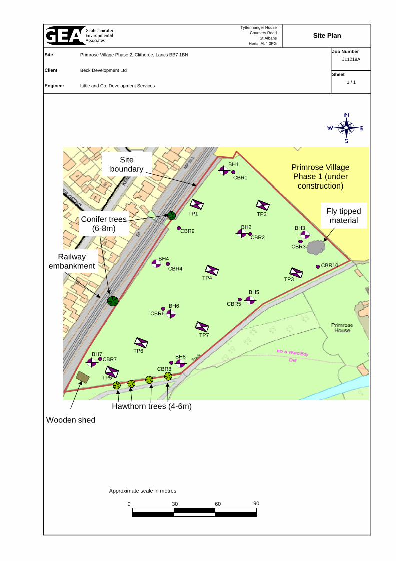
Job Number
J11219A
Sheet
1 / 1
Site Plan
Site
Client
Engineer
Tyttenhanger House
Coursers Road
St Albans
Herts AL4 0PG
Primrose Village Phase 2, Clitheroe, Lancs BB7 1BN
Beck Development Ltd
Little and Co. Development Services
Approximate scale in metres
0 60 90 30
Site boundary
BH1
BH4
BH7
BH6
BH8
BH5
BH2 BH3
TP1 TP2
TP3 TP4
TP5
TP6
TP7
Primrose Village Phase 1 (under construction)
Hawthorn trees (4-6m)
Conifer trees (6-8m)
Railway embankment
Fly tipped material
Wooden shed
CBR1
CBR2
CBR3
CBR10
CBR5
CBR4
CBR9
CBR6
CBR8
CBR7

Geotechnical & Environmental Associates (GEA) is an engineer-led and client-focused independent specialist providing a complete range of geotechnical and contaminated land investigation, analytical and consultancy services to the property and construction industries. We have offices at Tyttenhanger House Coursers Road St Albans AL4 0PG tel 01727 824666 [email protected] and Church Farm Gotham Road Kingston on Soar Notts NG11 0DE tel 01509 674888 [email protected] Enquiries can also be made on-line at www.gea-ltd.co.uk where information can be found on all of the services that we offer.