ground water brochure of banda …cgwb.gov.in/district_profile/up/banda.pdfground water brochure of...
TRANSCRIPT

GROUND WATER BROCHURE OF BANDA DISTRICT, U.P.
By T.K. Pant
Assistant Hydrogeologist
CONTENTS
Chapter Title Page No.
DISTRICT AT A GLANCE
..................2
1.0 INTRODUCTION
..................5
2.0 RAINFALL & CLIMATE
..................6
3.0 GEOMORPHOLOGY & SOIL
..................6
4.0 GROUND WATER SCENARIO
..................6
5.0 GROUND WATER MANAGEMENT STRATEGY
..................9
6.0 GROUND WATER RELATED ISSUES AND PROBLEMS
..................9
7.0 AWARENESS & TRAINING ACTIVITY
..................9
8.0 AREA NOTIFIED BY CGWB
..................9
7.0 RECOMMENDATIONS
..................10
PLATES:
I. INDEX MAP / ADMINISTRATIVE MAP OF BANDA DISTRICT, U.P.
II. DEPTH TO WATER LEVEL MAP (PREMONSOON) OF BANDA
DISTRICT, U.P.
III. DEPTH TO WATER LEVEL MAP (POSTMONSOON) OF BANDA
DISTRICT, U.P.
IV. GROUND WATER RESOURCE AND DRAFT OF BANDA DISTRICT,
U.P.
V. HYDROGEOMORPHOLOGICAL MAP OF BANDA DISTRICT, U.P.

2
DISTRICT AT GLANCE
1. GENERAL INFORMATION
i. Geographical Area (Sq. Km.) : 4460
ii. Administrative Division (as on 31.3.2008) a) Number of Tehsil b) Number of Block c) Number of Panchayat d) Number of Village
: : : :
4 8 71 694
iii. Population (as on 2001 census) : 15,01,610
iv. Average Annual Rainfall (mm) : 902
2. GEOMORPHOLOGY
Major Physiographic Units : Alluvial plain, marginal alluvial
and high land (hard rock)
Major Drainages : Yamuna, Ken & Baghain river
3. LAND USE (Ha.) Year 2008
a) Forest area : 5421
b) Net area sown : 336000
c) Cultivable area :
4. MAJOR SOIL TYPES : Clay, silt, sand and black cotton
soil
5. AREA UNDER PRINCIPAL CROPS (As on 2009)
Ha.
: Rabi : 275539 Kharif : 129966 Zaid : 203
6. IRRIGATION BY DIFFERENT SOURCES (Areas in ha. and Number of Structures)
Dugwells : 17413
Tubewells / Borewells 460 Nos. : 85121
Tanks / Ponds : 3272
Canals (Length = 1193 Km) : 50627
Other sources : 1371
Net Irrigated Area : 153804
Gross Irrigated Area : 169816

3
7. NUMBER OF GROUND WATER MONITORING WELLS OF CGWB (As on 2009)
No. of Dugwells : 23
No. of Piezometers : 01
8. PREDOMINANT GEOLOGICAL FORMATIONS : Bundelkhand granites unconformably overlain by lower surface Vindhyans unconformable overlain by quaternary alluvium.
9. HYDROGEOLOGY AND AQUIFER GROUP :
Major water bearing formation (Pre-monsoon Depth to water level during May’ 2009)
: Alluvium and Hard rock formation 2.75 to 26.95 mbgl
(Post-monsoon Depth to water level during Nov’ 2009) : 1.40-22.50 mbgl
Long term of water level trend in 10 years (2000-2009)
in m/year
Except ‘Matawndh’ all other areas are facing falling trend.
10. GROUND WATER EXPLORATION BY CGWB (As on 2008)
No. of wells drilled (EW, OW, PZ, SH, Total) : EW-13, SH-02
Depth Range (m) : 43.60-166.15 mbgl
Discharge (litres per second) : 13.84 to 35.00
Storativity (S) : -
Transmissivity (m2/day) : 1341 to 2236
11. GROUND WATER QUALITY (As on May 2008)
Presence of Chemical constituents more than permissible limit (e.g. EC, F, NO3, As, Fe)
: NO3
Type of water Potable except pockets.
12. DYNAMIC GROUND WATER RESOURCES
(2004)-in HAM
Annual Replenishable Ground Water Resources : 88095.48
Gross Annual Ground Water Draft : 29552.49
Projected Demand for Domestic Industrial Uses upto
2029
: 50247.33
Stage of Ground Water Development : 36.71%
13. AWARENESS AND TRAINING ACTIVITY : N.A.
Mass Awareness Programmes organized : -
Date -
Place -
No. of Participants -

4
Water Management Training Programme (Artificial Recharge) organized
-
Date : -
Place : -
No. of Participants : -
14. EFFORTS OF ARTIFICIAL RECHARGE &
RAINWATER HARVESTING
Projects completed by CGWB (No of Amount Spent) : Nil
Projects under technical guidance of CGWB (Numbers) : Nil
15. GROUND WATER CONTROL AND REGULATION :
Number of OE blocks : Nil
Number of critical blocks : Nil
Number of blocks notified : Nil
16. MAJOR GROUND WATER PROBLEMS AND
ISSUES
: Water logged and water depleted area.

5
GROUND WATER BROCHURE OF BANDA DISTRICT, U.P.
By T.K. Pant
Assistant Hydrogeologist
1.0 INTRODUCTION
Banda district lies between latitude 25000’00” and 25059’00” north and
longitude 80006’00” and 81000’00” east. Total geographical area of the district is
4460 sq. km. District headquarter is at Banda having 04 tehsils and 8 blocks. As per
the 2001 census the district has population of 1501610 of which 807320 males and
694290 females. Scheduled caste population is 311660 and scheduled tribe population
is 300. Literacy rate of the district is 54.2%.
Geologically the area comprises Precambrian Bundelkhand granites
unconfirmably overlain by Vindhyan are quaternary alluvium. The main and major
drainage of the district are Yamuna, Ken and Baghain which are part of Yamuna river
system.
Physiographically the area can be divided into three physiographic units–
(1) Alluvial Plain
(2) Marginal Alluvial
(3) High Land (Hard rock) area.
Agriculture is the main source of economy of the district. Both surface and
ground water are used for irrigation. The net irrigated area is 153804 Ha and the net
area sown is 336000 Ha, which shows that 45.77% area is irrigated by ground water
and the surface water while the rest depends on rainfall. Length of canal network in
the district is 1193 Km. and the number of government tubewells is 460.
Banda district is drained by Yamuna, Ken and Baghain rivers. River Yanuna
bifurcates the district Banda from Fatehpur in north and flows from west to east in the
entire district. River Ken meets Yamuna at Chilla. River Baghain also bifurcates
Banda from Chitrakoot in southeast.

6
The district was covered under hydrogeology and ground water reappraisal
studies in the A.A.P. (2003-04) by Dr. H.K. Pandey Sc. ‘B’.
2.0 RAINFALL & CLIMATE
The average annual rainfall is 902.00 mm. The climate is typical subtropical
penetrated by long and intense summers. About 80% of the annual rainfall is received
from south-west monsoon. May is the hottest month with mercury shooting upto
47.00C. With the advance of monsoon by mid June, temperature starts decreasing.
January is usually the coldest month with temperature going upto 5.80C.
The relative humidity is highest in August about 85% and lowest in April.
3.0 GEOMORPHOLOGY & SOIL
3.1 Geomorphology:
The district is characterised by alluvial, hard rock as well as marginal
alluvium. The district can be broadly classified into three physiographic units. (i) The
alluvial Plain, (ii) Marginal Alluvial, (iii) High Land Area.
3.2 Soil:
In Banda district loose sediments as well as black cotton soil is found. Black
cotton soil is prominent in the central part. Four major type of soil a) Rakar, b) Mar,
c) Kabar and d) Padua are dominant in the district.
4.0 GROUND WATER SCENARIO
The district is characterised by alluvium, marginal alluvium and hard rock
terrain. Ground water occurs in porous formation the sand gravel act secondary
porosity of fractures / joints.

7
4.1 HYDROGEOLOGY:
On the basis of hydrogeological information ground water occurs in
unconfined conditions in shallow depths and confined conditions in deeper depth in
alluvium. The thickness of alluvium varies from 45.00 to 200.00 mbgl in the district.
Granites (Bundelkhand) has also good potential and yield at economical discharge.
Ground water occurs in fractures and joints in the hard rock. The potential fractures
are encountered from around 28.00 to 96.00 meters in some places.
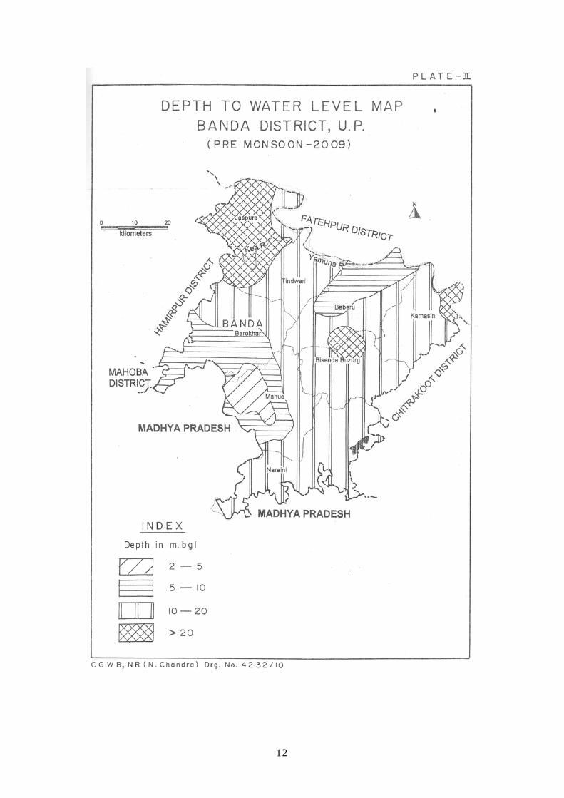
Depth To Water Level:
As per the depth to water level data of 27 permanent ground water monitoring
stations in the year 2009, pre monsoon water level ranges from 2.75 mbgl (Khurand)
to 26.95 mbgl (Bhitar Kerdera). In the post monsoon period, depth to water level
varies from 0.95 mbgl (Girwan) to 22.50 mbgl (Pailani). Water level fluctuation
varies from 0.0 in Rolyhdyajue to 8.02 m at Naraini. It is observed that the hilly and
rocky area the fluctuation is higher than the plain. Fluctuation is more where less
order streams are found.
Long Term Water Level Trend:
Long term water level trend records in the area from 27 national hydrographic
stations (2000-2009) in ten years show that (except Mataudh) all other wells are
showing declining trend. The falling trend ranges from 0.0979 m/yr (Girwan) to
1.5087 m/yr at Paprenda.
4.2 Ground Water Resource:
As per report on dynamic ground water resource of Banda district as on
31.2.2004. The annual ground water recharge of the district is 88095.48 Ham, the net
annual ground water availability is 80503.45 ham. The existing gross ground water
draft for all uses is 29552.49 ham. The net ground water availability for future
irrigation development is 50247.33 ham. The stage of ground water development is
36.71%. As per the estimates worked out, all the blocks of the district are in ‘Safe
Category’ (Table-1).

8
4.3 Ground Water Quality:
The electrical conductance is in the range of 570 to 2600 m/cm at 250C.
Total hardness is from 110 to 400 mg/lit. Fluoride ranges from 0.16 to 0.89 mg/lit and
Nitrate is upto 306 mg/l which is high. Phosphate is absent.
4.4 Status of Ground Water Development:
Ground water occurs in porous formation like sand, gravel and kankar in
alluvium while in secondary porosity in hard rock areas. The stage of ground water
development in the district is very low 36.71%. There are 460 number of government
tubewells, the maximum number is 151 in Tindwari block and minimum number is 02
in Naraini block.
The canal length is 1193 km in the district irrigating 50627 ha of land which is
35.04% of the net irrigated area which is marginally less than the previous (1/4/2000)
resource potential. CGWB has constructed 13 exploratory wells and 02 slimholes
under the exploratory programme. The yield of the borewells / tubewells range from
180 lpm to 3811 lpm with economical drawdowns.
A total number of 660 handpumps have been constructed in the district,
benefiting a population of 1257584 by state agency.
Table-1
DYNAMIC GROUND WATER RESOURCES OF BANDA DISTRICT, U.P. (As on 31.03.2004)
Sl. No.
Assessment Units-Blocks
Annual Ground Water
Recharge (in ham)
Net Annual Ground Water
Availability (in ham)
Existing Gross
Ground Water Draft For All Uses
(in ham)
Net Ground Water
Availability For Future Irrigation
Development (in ham)
Stage of Ground Water
Development (in %)
Category of Block
1. Baberu 10507.27 9456.54 3948.13 5414.40 41.75 Safe
2. Barokhar 13180.31 11862.28 4535.57 7218.72 38.24 Safe
3. Bisanda 12116.97 10905.27 2721.52 8118.95 24.96 Safe
4. Jaspura 5085.68 4577.11 2742.11 1769.71 59.91 Safe
5. Kamasin 10726.82 10190.48 2853.72 7268.81 28.00 Safe
6. Mahua 14389.28 12950.35 3713.91 9148.02 28.68 Safe
7. Naraini 8465.62 7619.06 3794.34 3734.37 49.80 Safe
8. Tindwari 13623.54 12942.37 5243.19 7574.34 40.51 Safe
TOTAL 88095.48 80503.45 29552.49 50247.33 36.71
9
5.0 GROUND WATER MANAGEMENT STRATEGY
5.1 Ground Water Development:
The stage of ground water development in the district is 36.71%. Leaving net
ground water availability for future irrigation 50247.33 ham. The maximum stage of
ground water development is in Jagura block 59.91% and minimum in Bilanda block
24.96%. All the 8 blocks are in the safe category.
5.2 Water Conservation Structure & Artificial Recharge:
In the northern alluvium area, the triangle of Banda-Baberu-Tindwari covered
by alluvium and is suitable for artificial recharge practices. Recharge wells and
percolation tanks can be made in the central part consisting of marginal alluvium.
Check dams should be constructed in hard rock area.
6.0 GROUND WATER RELATED ISSUES AND PROBLEMS
From the data of water level (NHS) for last ten years during pre and post
monsoon it is seen that area near Khurrand, Mefandh, Pargra area prone to water
logging. Except Mataudh all the other areas show falling trend with highest in
Paprenda and Kamasin area of the district.
7.0 AWARENESS & TRAINING ACTIVITY
Nil.
8.0 AREA NOTIFIED BY CGWB
Not notified.

10
9.0 RECOMMENDATIONS
Area south of Naraini and Badaura may be adopted for check dams and
subsurface dykes in perennial as well as seasonal Nalas.
Percolation tanks may be made to recharge ground water in hard rock areas.
Ground water withdrawal should be increased in blocks with very low degree
of development to avoid water logging problem.

11
12

13

14

15