grounding of abfc roebuck bay · checklist, the navigation pre-departure checklist and the bridge...
TRANSCRIPT
Grounding of ABFC Roebuck Bay Henry Reef, Queensland, on 30 September 2017
ATSB Transport Safety Report Marine Occurrence Investigation 335-MO-2017-009 Interim – 9 October 2018

Released in accordance with section 25 of the Transport Safety Investigation Act 2003
Publishing information
Published by: Australian Transport Safety Bureau Postal address: PO Box 967, Civic Square ACT 2608 Office: 62 Northbourne Avenue Canberra, Australian Capital Territory 2601 Telephone: 1800 020 616, from overseas +61 2 6257 4150 (24 hours) Accident and incident notification: 1800 011 034 (24 hours) Facsimile: 02 6247 3117, from overseas +61 2 6247 3117 Email: [email protected] Internet: www.atsb.gov.au
© Commonwealth of Australia 2018
Ownership of intellectual property rights in this publication Unless otherwise noted, copyright (and any other intellectual property rights, if any) in this publication is owned by the Commonwealth of Australia.
Creative Commons licence With the exception of the Coat of Arms, ATSB logo, and photos and graphics in which a third party holds copyright, this publication is licensed under a Creative Commons Attribution 3.0 Australia licence.
Creative Commons Attribution 3.0 Australia Licence is a standard form license agreement that allows you to copy, distribute, transmit and adapt this publication provided that you attribute the work.
The ATSB’s preference is that you attribute this publication (and any material sourced from it) using the following wording: Source: Australian Transport Safety Bureau
Copyright in material obtained from other agencies, private individuals or organisations, belongs to those agencies, individuals or organisations. Where you want to use their material you will need to contact them directly.
Page Change Date

› 1 ‹
ATSB – MO-2017-009
Interim factual report Sequence of events On 30 September 2017, at about 0025 Eastern Standard Time,1 the Australian Border Force cutter Roebuck Bay (ABFC Roebuck Bay) grounded on Henry Reef in the Great Barrier Reef, Queensland. The cutter was on a passage from Saibai Island in the Torres Strait Islands archipelago bound for Lizard Island, located about 71 nautical miles (NM) south-east of Cape Melville. The cutter sustained significant damage to the keel, stabiliser fins and propellers, with hull breaches in way of the storage void and tank compartment spaces. There were no reported injuries or pollution.
Pre-departure activities On 11 September 2017, the 38 m long ABFC Roebuck Bay (Figure 1) was alongside in Cairns, Queensland undergoing a routine crew change prior to commencing a 3-week patrol. Over the next 2 days, the cutter was prepared for the patrol with several start-of-patrol and pre-departure checks being completed by the cutter’s various departments. As part of these checks, the navigation officer completed the electronic chart display and information system (ECDIS) start-up checklist, the navigation pre-departure checklist and the bridge departure checklist.
Figure 1: ABFC Roebuck Bay
Source: Australian Border Force
Start of patrol On 13 September, ABFC Roebuck Bay departed Cairns to commence a patrol northward to the Torres Strait where it was to assume duties under the instructions of the Australian Maritime Border Operations Centre (AMBOC). The cutter was to remain in the strait, undertaking standing tasks and other duties as instructed by AMBOC, until 29 September when it was to depart the area for Cairns for the conclusion of the patrol.
On 17 September, while underway, at about 0200, one of three nodes2 on the cutter’s bridge malfunctioned and shut down while in use as a radar display. Attempts to re-boot the system
1 Eastern Standard Time (EST): Coordinated Universal Time (UTC) + 10 hours. 2 In this case, a console and associated computer system used to operate ECDIS and/or radar.

› 2 ‹
ATSB – MO-2017-009
failed and the cutter continued its patrol with two operational bridge displays, capable of being used interchangeably as an ECDIS or radar display.
On 25 September, at about 1549, ABFC Roebuck Bay dropped anchor off Saibai Island in the Torres Strait Islands archipelago. While at anchor, the cutter’s officers and crew performed routine duties and maintained anchor watches.
Passage planning On 26 September, the navigation officer began to work on the passage plan for the cutter’s return voyage to Cairns. The passage plan, based on a previously used plan, initially consisted of a passage from Saibai Island directly to Cairns with some standing operational taskings en route. The passage plan and associated briefs were completed and then presented to the cutter’s commanding officer (master)3 for approval.
The master reviewed the planned route on the ECDIS and made a few amendments. One of these amendments included moving a planned course alteration position (waypoint) about 0.2 NM south of its original position and another about 1 NM west of its original position (Figure 2) in the vicinity of Wreck Bay in the Great Barrier Reef. The amended waypoints were designated waypoint 19 (W19) and waypoint 20 (W20) in the passage plan’s waypoint list. When the master tried to save the amended route, the ‘Errors’ tab in the route tab folder of the ECDIS’s ‘Edit Route’ menu turned yellow indicating an error in the route. The master advised the navigation officer of his desired amendments to the route and of the error encountered. The navigation officer reviewed the route’s waypoint list in the ECDIS’s route editor table and determined the error to be an incorrect turn radius for one of the waypoints. The turn radius was amended, which cleared the error and the error tab reverted to its normal grey colour and changed to ‘No Error’. The master and navigation officer then reviewed the amended route visually and saved it with the master’s initials suffixed to the route name.
Figure 2: Image from ABFC Roebuck Bay's ECDIS
Image from ABFC Roebuck Bay’s ECDIS display taken after the grounding showing the previously used route and the amended route based on the changed waypoints W19 and W20. Source: Australian Border Force, annotated by the ATSB
3 Under Australian Border Force nomenclature, the master of an ABF vessel is known as the commanding officer.
› 3 ‹
ATSB – MO-2017-009
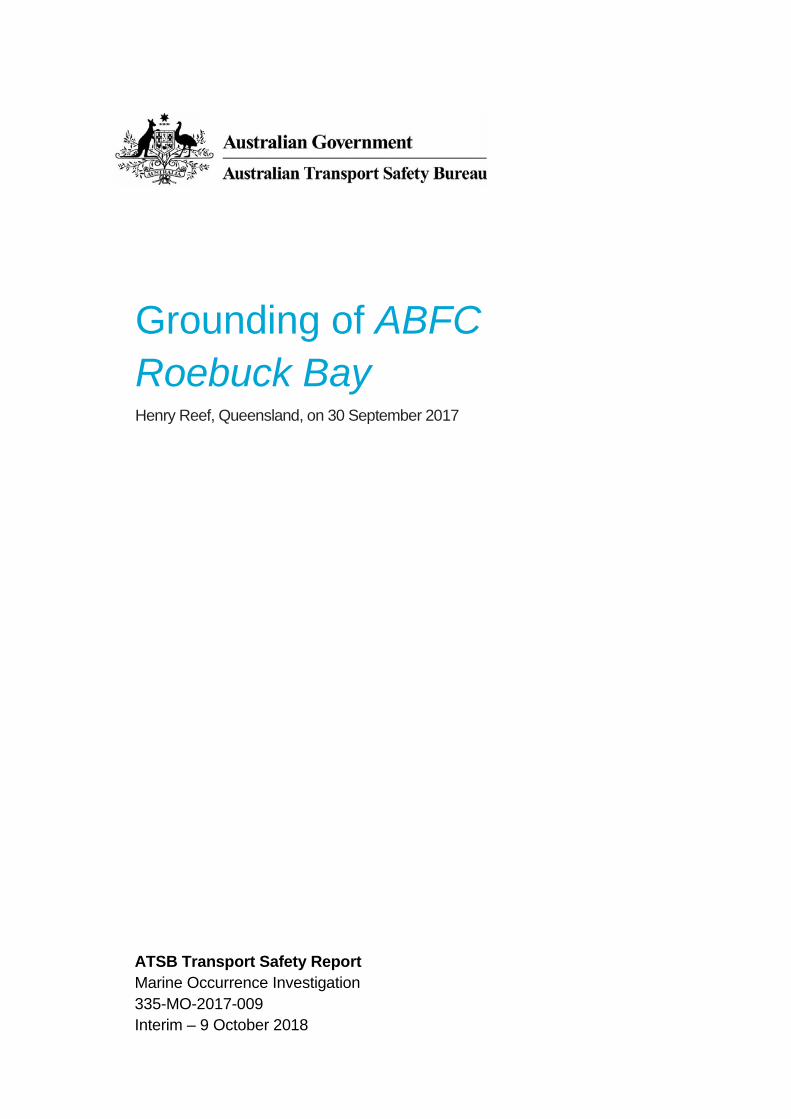
The master subsequently advised the navigation officer that the passage was to be split into two legs with a brief stop at Lizard Island, Queensland before continuing on to Cairns for the end of the patrol. The navigation officer split the master’s amended route into two separate routes, from Saibai Island to Lizard Island (Figure 3) and then from Lizard Island to Cairns. No further changes were made to the route plan. The two routes were then saved on the cutter’s ECDIS and named ‘Saibai to Lizard via Outer Reef’ and ‘Lizard to Cairns’.
Figure 3: Section of navigational chart Aus 4620 showing ABFC Roebuck Bay's amended planned route and key locations
Source: Australian Hydrographic Service, annotated by the ATSB

› 4 ‹
ATSB – MO-2017-009
On 28 September, a passage plan briefing was conducted. The cutter’s heads of department and officers of the watch were briefed on the details and requirements of the proposed passage from Saibai Island to Lizard Island and then through to Cairns.
Departure from Saibai Island On 29 September, at about 0953, ABFC Roebuck Bay weighed anchor and departed Saibai Island. The cutter had a maximum draught4 of about 2 m with the propellers and skegs drawing a further 0.2 m. The route plan ‘Saibai to Lizard via Outer Reef’ was loaded for monitoring on the cutter’s ECDIS. The cutter’s bridge watchkeeping teams comprised an officer of the watch (OOW) and an assistant officer of the watch performing the duties of a designated lookout.5 The bridge watchkeeping teams maintained a rotational 4-hour watch roster between 2000 and 0800 and a 3-hour watch roster between 0800 and 2000.
At about 2048, that evening, ABFC Roebuck Bay passed the location of a historic shipwreck, HMS Pandora, and finding nothing of concern, continued its passage south. The cutter’s standing tasks during the passage also included surveillance for unauthorised incursions and activities in the Great Barrier Reef Marine Park.
At about 2345, the OOW and lookout for the next watch (between 2400 and 0400 on 30 September) arrived on the bridge and shortly after took over the watch. The OOW was also the cutter’s navigation officer. The cutter was on autopilot on a heading of about 191º with a speed of about 16 knots.6 The night was partly cloudy with visibility recorded as 6 to 8 NM and the wind from the south-east at 20 knots with a 1 m sea and swell.
While on watch, the OOW was seated with the non-functioning display to his front and slightly to his left with the ECDIS display to his front and slightly to the right. The lookout was seated in front of the radar display (Figure 4). The OOW used the ECDIS to gain an appreciation of the cutter’s expected passage over their coming watch and briefed the lookout accordingly.
Figure 4: Locations of bridge team members at the time of grounding
Source: Australian Border Force, annotated by the ATSB
4 Draught is the vertical distance between the keel of the ship and the waterline at any position. 5 Under Australian Border Force nomenclature, a rating forming part of a navigational watch is known as an assistant
officer of the watch. 6 All ship speeds referred to in this report are ‘made good/over the ground’.
› 5 ‹
ATSB – MO-2017-009
On 30 September, at about 0004, the OOW altered ABFC Roebuck Bay’s heading7 to 132° when at W18. A few minutes later, at 0012, the heading was altered to 107° when at W19.
At about 0017, as ABFC Roebuck Bay approached W20 at a speed of about 16 knots, the OOW altered the cutter’s heading to 194°.
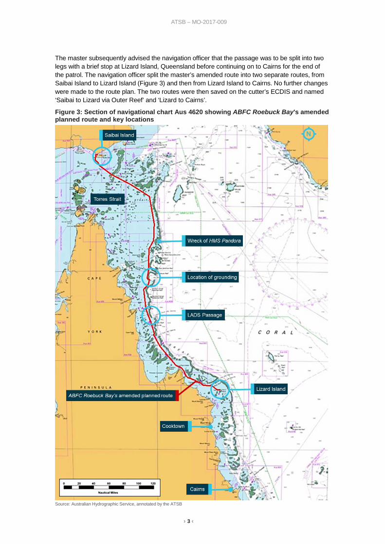
The grounding At about 0025, with the cutter about 15 m to port of the planned route, the bridge team felt a bump and a shuddering sensation through the cutter’s hull. Almost immediately after, ABFC Roebuck Bay abruptly grounded and came to a complete stop. The OOW and lookout were thrown out of their seats onto the display screens in front of them.
The master, woken by the impact of the grounding, went to the bridge and activated the general emergency alarm. The cutter’s crew mustered, accounted for all personnel and immediately began implementing damage control measures. Initial damage reports indicated that there was water ingress to the storage void space and the tank compartment immediately aft of it, while other spaces and compartments appeared to be intact (Figure 5).
Figure 5: Section of general arrangement plan showing affected spaces
Source: Australian Border Force, modified by the ATSB
7 All ship’s headings in this report are in degrees by gyrocompass with negligible error.
› 6 ‹
ATSB – MO-2017-009
Emergency response By about 0032, bilge pumping was underway and shortly after, at about 0038, an urgency signal was broadcast on the very high frequency (VHF) channel 16, with no response received. A few minutes later, an urgency signal was broadcast on VHF channel 14, the designated VHF channel for ships to contact REEFVTS.8 No response was received.
At about 0047, the master called AMBOC by satellite phone and advised them of the grounding. The master requested that AMBOC notify the Australian Maritime Safety Authority’s (AMSA) Joint Rescue Coordination Centre (JRCC) and the designated person ashore at the Australian Border Force (ABF).
At about 0050, ABFC Roebuck Bay broadcast a distress call over the cutter’s Inmarsat-C terminal and shortly after, the cutter’s anchor was deployed. Contact was also established with JRCC via satellite telephone and a situation report (SITREP) provided. Meanwhile, inspections by the cutter’s damage control party revealed hull breaches in the storage void space extending aft into the tank compartment. The damage control party also confirmed the integrity of the cutter’s fuel tanks and that there was no pollution.
At about 0115, JRCC tasked AMSA’s emergency towing vessel Coral Knight to respond to ABFC Roebuck Bay’s distress call. Coral Knight departed Normanby Sound, Queensland for Henry Reef about 15 minutes later with an estimated time of arrival of 1800 later that day. The merchant ship Toll Firefly and an Australian defence vessel were also tasked to divert and render assistance to ABFC Roebuck Bay.
By about 0514, Toll Firefly was on scene and standing by, with communications established. A few minutes later, the cutter started to shift and change heading as a result of the sea conditions and the imminent high water at about 0700. As a precaution, about ½ a shackle9 of anchor chain was walked out to allow the cutter to be kedged10 back onto the reef should it float into deeper water and start to sink.
At about 0605, shortly after first light, the cutter’s two tenders11 were launched to conduct a cursory survey of the waters in the immediate vicinity of the grounding. The survey indicated that there was deep water with depths of between 20 to 30 m at a distance of about 20 m astern of the cutter.
At 1127, an ABF aircraft conducted several passes of Henry Reef to obtain aerial photographs of ABFC Roebuck Bay aground (Figure 6). The weather remained relatively fair with the wind from the south-east at about 14 knots and a 1 m sea and swell.
8 The Great Barrier Reef and Torres Strait Vessel Traffic Service, operated by Maritime Safety Queensland as a Vessel
Traffic Service (VTS) authority approved by the Australian Maritime Safety Authority (AMSA). 9 One shackle equals approximately 27.5 m of chain. 10 Kedge: To move a ship or boat along by means of a hawser or chain attached to an anchor. 11 Tender: A small boat usually carried by a larger vessel for service or support, in this case, used for rescue, interception
and the deployment of boarding parties.

› 7 ‹
ATSB – MO-2017-009
Figure 6: ABFC Roebuck Bay aground on Henry Reef
Source: Australian Border Force
By about 1306 that afternoon, the Australian Defence Vessel Cape Inscription (ADV Cape Inscription) had arrived on scene. A damage control team with equipment was transferred to the cutter and Toll Firefly was released to resume their passage.
Re-floating of ABFC Roebuck Bay At about 1730, Coral Knight arrived on location. A 250 m long fibre tow line was connected to a towing point on the cutter’s stern and at about 1820, ABFC Roebuck Bay was towed stern first, off Henry Reef. The cutter’s anchor was also walked out and eventually slipped at the bitter end12 with a marker buoy attached.
Coral Knight and ABFC Roebuck Bay were manoeuvred alongside and made fast to each other. Coral Knight deployed its anchor to arrest the drift of the two vessels while personnel and damage control equipment were transferred and consolidated between the two vessels. On board ABFC Roebuck Bay, the water level in the flooded storage void space appeared to be stable and the completely flooded tank compartment was sealed off. There were several other leaks in various spaces including in the plant room and forepeak space but these were controlled using the cutter’s built-in bilge system or available portable pumps.
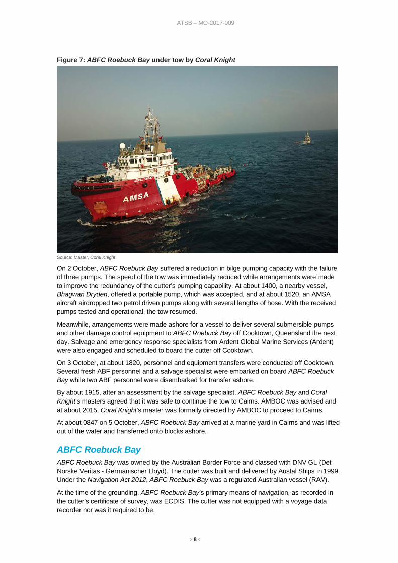
Passage to Cairns At about 2200, with the weather deteriorating to south-westerly winds at 20 knots and 2 m seas, a decision was made to commence towing ABFC Roebuck Bay immediately. By 2254, Coral Knight had weighed anchor and at about 2307, Coral Knight commenced towing ABFC Roebuck Bay in the general direction of Cairns. Regular rounds were conducted to inspect and pump affected spaces on board the cutter and shortly after midnight, all non-essential personnel were transferred to Coral Knight. The tow proceeded at an average speed of about 3.5 to 4 knots (Figure 7) and by midnight on 1 October, the tow had passed through LADS passage (Figure 3). Regular SITREPs were provided by Coral Knight’s master at roughly 3-hour intervals to all involved parties including AMBOC, AMSA and ABF interests.
12 The inboard end of the anchor cable that is secured to a strong point normally with some form of quick-release
arrangement to allow the cable to be safely slipped in the event of an emergency.
› 8 ‹
ATSB – MO-2017-009
Figure 7: ABFC Roebuck Bay under tow by Coral Knight
Source: Master, Coral Knight
On 2 October, ABFC Roebuck Bay suffered a reduction in bilge pumping capacity with the failure of three pumps. The speed of the tow was immediately reduced while arrangements were made to improve the redundancy of the cutter’s pumping capability. At about 1400, a nearby vessel, Bhagwan Dryden, offered a portable pump, which was accepted, and at about 1520, an AMSA aircraft airdropped two petrol driven pumps along with several lengths of hose. With the received pumps tested and operational, the tow resumed.
Meanwhile, arrangements were made ashore for a vessel to deliver several submersible pumps and other damage control equipment to ABFC Roebuck Bay off Cooktown, Queensland the next day. Salvage and emergency response specialists from Ardent Global Marine Services (Ardent) were also engaged and scheduled to board the cutter off Cooktown.
On 3 October, at about 1820, personnel and equipment transfers were conducted off Cooktown. Several fresh ABF personnel and a salvage specialist were embarked on board ABFC Roebuck Bay while two ABF personnel were disembarked for transfer ashore.
By about 1915, after an assessment by the salvage specialist, ABFC Roebuck Bay and Coral Knight’s masters agreed that it was safe to continue the tow to Cairns. AMBOC was advised and at about 2015, Coral Knight’s master was formally directed by AMBOC to proceed to Cairns.
At about 0847 on 5 October, ABFC Roebuck Bay arrived at a marine yard in Cairns and was lifted out of the water and transferred onto blocks ashore.
ABFC Roebuck Bay ABFC Roebuck Bay was owned by the Australian Border Force and classed with DNV GL (Det Norske Veritas - Germanischer Lloyd). The cutter was built and delivered by Austal Ships in 1999. Under the Navigation Act 2012, ABFC Roebuck Bay was a regulated Australian vessel (RAV).
At the time of the grounding, ABFC Roebuck Bay’s primary means of navigation, as recorded in the cutter’s certificate of survey, was ECDIS. The cutter was not equipped with a voyage data recorder nor was it required to be.
› 9 ‹
ATSB – MO-2017-009
The cutter’s bridge navigation equipment also included:
• two differential13 GPS receiver units • two radars with automatic radar plotting aid capability • an automatic identification system transceiver • echo sounder • gyrocompass • radio equipment • a bridge navigation watch alarm system.14 At the time of the grounding, ABFC Roebuck Bay was using official electronic navigational charts (ENCs) issued by the Australian Hydrographic Service. The cutter’s ECDIS units were updated on 23 September 2017 to the latest Australian ENC updates available at the time (Week 38-2017).
Operating crew At the time of the grounding, the cutter had a crew of 11 Australian nationals. The cutter’s complement of watchkeeping officers comprised the master, a deputy commanding officer, a navigation officer and a communications officer. Other crew included two engineering officers, four marine tactical officers and a cook.
The master held a valid Australian master’s certificate of competency and had 27 years at sea, initially with the Queensland water police and then, from about 2004, with the ABF and its predecessor. He had sailed as master primarily on Bay class cutters, since 2015 although he had acted in the role several times before. The master had completed a generic ECDIS training course in July 2014 and online type-specific ECDIS familiarisation training in December 2014.
The navigation officer held a valid Australian certificate of competency and had about 21 years at sea in various roles including fisheries investigations and compliance. He had been in the ABF for about 5 years and had sailed as an OOW, primarily on Bay class cutters, since December 2015. During this time, he served in the roles of navigation officer, deputy commanding officer and communications officer on a rotating basis. The navigation officer had completed generic ECDIS training in May 2016 and online type-specific ECDIS familiarisation training in June 2016.
The other two watchkeeping officers on board ABFC Roebuck Bay had also completed generic ECDIS training and type-specific ECDIS familiarisation training.
Damage to ABFC Roebuck Bay ABFC Roebuck Bay sustained serious damage as a result of the grounding rendering the cutter unseaworthy. The storage void space and tank compartment (Figure 5) were both breached and flooded in way of the keel section with significant seawater damage to all electrical fittings in the two spaces.
Externally, the port and starboard ride control fins were found holed and bent. Similarly, the port and starboard skegs were found breached with a loss of watertight integrity and both stern tubes had sustained misalignments. The port and starboard propeller blades were also found to have sustained extensive damage especially to the blade tips and both rudders showed minor deformation to the lower section of their trailing edges.
The cutter has since been repaired and, after a period of sea-trials, has returned to active service.
13 Differential global positioning systems are an enhanced form on GPS providing greater positioning accuracy than the
standard GPS. 14 A mandatory system, the bridge navigational watch alarm system (BNWAS) automatically alerts the master or another
qualified officer if the officer of the watch becomes incapable of performing the officer of the watch’s duties for any reason such as falling asleep or becoming otherwise incapacitated.
› 10 ‹
ATSB – MO-2017-009
Safety management system ABFC Roebuck Bay operated under a safety management system (SMS) instituted by the ABF and applicable to all ABF ships and associated personnel. The primary aim of the SMS was stated to be the promotion of the development and application of an organisational safety culture. The SMS was structured to be compliant with the International Management Code for the Safe Operation of Ships and for Pollution Prevention (ISM Code)15 as well as AMSA’s National Standard for Commercial Vessels. ABFC Roebuck Bay operated under the SMS and was subject to regular ABF internal audits to check the cutter’s compliance with the SMS.
The SMS was divided into seven volumes. The first volume contained general policies, principles, procedures and work instructions applicable to all vessels and staff. These included work instructions on passage planning, use of ECDIS and navigational standards expected of all ABF vessels. The other volumes contained procedures and instructions applicable to specific vessels or vessel classes.
ECDIS on board ABFC Roebuck Bay At the time of the grounding, ABFC Roebuck Bay, like most other ABF vessels, was equipped with a VisionMaster FT Naval ECDIS and radar system manufactured by Northrop Grumman Sperry Marine (NGSM).
The cutter was initially equipped with a Transas electronic chart system as a navigation aid, with paper charts as the primary means of navigation. However, in May 2017, as part of an upgrade of the cutter’s navigation suite, this was replaced by the VisionMaster FT Naval ECDIS and radar system, which operated on a naval version of the manufacturer’s commercial software. The VisionMaster FT system was installed and configured in a ‘Total Watch’ configuration. The system operated as part of a multi-node system utilising four nodes and four associated multi-function displays (three on the bridge and one on a deck below). The ‘Total Watch’ configuration meant that each node could be presented as either an ECDIS or radar display, as required.
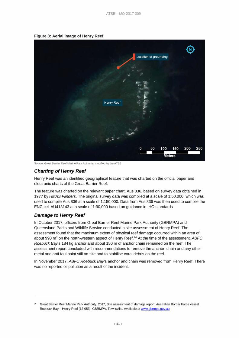
Henry Reef Henry Reef (Figure 8) is located about 45 NM north-east of Lockhart River, Queensland on the south-western side of Wreck Bay in the outer Great Barrier Reef. The reef is roughly between 400 to 600 m in diameter and rises sharply out of the surrounding waters of a depth between 20 to 30 m. In places, the reef has a shallow shelf at a depth of about 5 to 8 m with the reef gently sloping up to the reef crest on the eastern flank at or about the lowest astronomical tide.
15 International Maritime Organization, 2018, International Management Code for the Safe Operation of ships and for
Pollution Prevention (ISM Code) as amended, IMO, London.
› 11 ‹
ATSB – MO-2017-009
Figure 8: Aerial image of Henry Reef
Source: Great Barrier Reef Marine Park Authority, modified by the ATSB
Charting of Henry Reef Henry Reef was an identified geographical feature that was charted on the official paper and electronic charts of the Great Barrier Reef.
The feature was charted on the relevant paper chart, Aus 836, based on survey data obtained in 1977 by HMAS Flinders. The original survey data was compiled at a scale of 1:50,000, which was used to compile Aus 836 at a scale of 1:150,000. Data from Aus 836 was then used to compile the ENC cell AU413143 at a scale of 1:90,000 based on guidance in IHO standards
Damage to Henry Reef In October 2017, officers from Great Barrier Reef Marine Park Authority (GBRMPA) and Queensland Parks and Wildlife Service conducted a site assessment of Henry Reef. The assessment found that the maximum extent of physical reef damage occurred within an area of about 990 m2 on the north-western aspect of Henry Reef.16 At the time of the assessment, ABFC Roebuck Bay’s 184 kg anchor and about 150 m of anchor chain remained on the reef. The assessment report concluded with recommendations to remove the anchor, chain and any other metal and anti-foul paint still on-site and to stabilise coral debris on the reef.
In November 2017, ABFC Roebuck Bay’s anchor and chain was removed from Henry Reef. There was no reported oil pollution as a result of the incident.
16 Great Barrier Reef Marine Park Authority, 2017, Site assessment of damage report: Australian Border Force vessel
Roebuck Bay – Henry Reef (12-053), GBRMPA, Townsville. Available at www.gbrmpa.gov.au

› 12 ‹
ATSB – MO-2017-009
Ongoing investigation Since commencing the investigation, the ATSB has identified that it was more complex than initially envisaged. This has expanded the scope and depth of the investigation, which in turn has influenced the time taken to complete the investigation.
As part of the investigation, the ATSB interviewed ABF officers and crew, ABF shore staff and hydrographers from the Australian Hydrographic Service. The ATSB also obtained and analysed available ECDIS data, conducted ECDIS simulations and tests, and liaised with the ECDIS manufacturer.
ECDIS is a complex system comprised of software and hardware components developed to meet IMO and International Hydrographic Organization standards. Furthermore, the effective use of ECDIS for safe navigation relies upon the operator being fully familiar with the capabilities and limitations of ECDIS and electronic navigational charts (ENC).
As of July 2018, the fitting of ECDIS has become mandatory for almost all large merchant vessels and passenger ships. Going forward, the ATSB recognises that the use of ECDIS as the primary means of navigation only stands to increase. The investigation into the grounding of ABFC Roebuck Bay afforded the ATSB an opportunity to explore aspects of the operational use of ECDIS with relevance to the wider maritime industry extending beyond the ABF.
In the course of the investigation, the ATSB reviewed several aspects of ECDIS, training and chart compilation. These included:
• the route planning and route monitoring functions of the ECDIS • the understanding of these functions held by the cutter’s officers • the ECDIS software version installed and its implications • the process of ENC compilation and use of ENCs • the effectiveness of the various ECDIS training undertaken. The investigation is nearing completion and is at a stage where the final report is being drafted. Once the draft report has been completed, it will be subject to internal review before directly involved parties (DIPs) will be offered the opportunity to review and comment on the factual accuracy of the report. The final report will be released following the review of any DIP submissions.
The ATSB will bring any safety issues identified during the course of the investigation to the attention of those affected and seek safety action to address the issue.
______________ The information contained in this interim factual report is released in accordance with section 25 of the Transport Safety Investigation Act 2003 and is derived from the initial investigation of the occurrence. Readers are cautioned that new evidence will become available as the investigation progresses that will enhance the ATSB's understanding of the accident as outlined in this update. As such, no analysis or findings are included in this update.