groundwater sustainability plan - california department … worksh… · groundwater sustainability...
TRANSCRIPT
September 20, 2017Department of Water Resources
SGMAGroundwater Sustainability Plan Workshop
WelcomeDane Mathis, DWR South Central Region Office

Session 1

Sustainable Groundwater Management
Program OverviewTrevor Joseph, SGM Program

California’s Major Groundwater Milestones
5
1992 2002 2013 2014 2015 2020 2022
CASGEM Program
2003
AB 3030
SB 1938 CA Water Action Plan
GSPs(Non-Overdraft Basins)
GSPs(Basins in Overdraft)SGMA
2009 2010
Voluntary Groundwater Management(Non-Regulatory)
Service Area Planning Variable Levels of
Implementation Variable Authority Grant Incentives
Required Groundwater Management
(Regulatory)
Entire Basin Planning Required Implementation New GSA Authorities State Backstop (SWRCB)
2040/2042
AchieveSustainability
GoalAB 359

SGMA Overview
“A central feature of these bills is the recognition that
groundwater management in California
is best accomplished locally.“
Governor Jerry Brown, September 2014
Local Control

7
SGMA Overview
Groundwater Sustainability Plans Required for High and Medium
Priority Basins by 2020/22
Sustainability Groundwater Basins

Achieving Sustainable Yield and Avoidance of Undesirable Results
8
Lowering of GW LevelsReduction
of GW StorageSeawater Intrusion
Water Quality Degradation Land SubsidenceDepletion of
Interconnected Streams
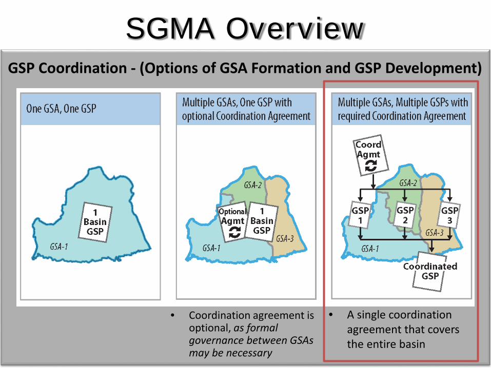
GSP Coordination - (Options of GSA Formation and GSP Development)
• Coordination agreement is optional, as formal governance between GSAs may be necessary
• A single coordination agreement that covers the entire basin
SGMA Overview

Planning Assistance- Facilitation
- GSA Support
Technical Assistance- Statewide Datasets, Analysis, and Tools
- Best Management Practices- Water Available for Replenishment Report
Financial Assistance- Prop 1
DWR SGMA Assistance
DWR Evaluation of
GSPs
Sustainable Groundwater Management
Engagement and Advisory Role Regulatory Role

DWR SGMA Program Activities
Implementation & Reporting
GSP Preparation &
Submission
GSP Review and
Evaluation
GSA Formation & Coordination
Phase 1 Phase 2 Phase 3 Phase 4
Technical Assistance
Financial Assistance ???Technical Assistance
~ July 1, 2017 GSAs 2015 Alt - 2020/2022 GSPs ~ + up to 2 yearsLocal Agency/GSA
Deadlines
Advisory Role Regulatory Role
Planning Assistance

Groundwater Sustainability Agency Formation StatusMark Nordberg, SGM Program

• More than 99.9 percent of SGMA basins are either covered by a GSA, an adjudicated area, federal or tribal land, or an Alternative.
• 264 local agencies, or combinations of local agencies, have GSA notifications posted (depends on how agencies are counted).
• 376 unique areas are being managed by GSAs.• 140 basins have GSAs:
• 108 basins are high or medium priority.• 32 basins are low or very-low priority (or have no priority yet).
• 22 high- or medium-priority basins submitted an Alternative Plan.• 11 basins that submitted an Alternative have full GSA coverage.• 9 basins do not have any GSAs formed – 2 basins have partial GSA
coverage.• 46 GSA notifications have been posted and withdrawn.
13
GSA Formation Summary

14
GSA Formation Summary
9/19/2017

15
GSA Formation Summary
9/19/2017

16
GSA Formation Summary

Assistance and EngagementTrevor Joseph, SGM Program

18
Technical and Planning Assistance
Assistance & Engagement
Tech. Services• Guidance & Education• Field Activities• Modeling Support
GSA Formation & Governance
Statewide & Basin Info• General SGMA Information• Bulletin -118 & 160• BMP’s & Guidance Docs.• Training/Outreach
Data• Data Collection• Data Distribution
Tools• Model Enhancements
Guidance, Data, & Tools
Education & Guidance Data & Tools
Com
pone
nts
Facilitation Services• Stakeholder Assessment• Meeting Facilitation• Consensus Building
GSP Eval.
DWR Outreach
GSP Implementation1
2 3
4
GSP Development & Submission
GSP Evaluation
Engagement and Advisory Role Evaluation Role

19
Services Offered through DWR Funded Professional Facilitators• Stakeholder identification and engagement• Meeting facilitation• Interest-based negotiation/consensus
building• Public outreach facilitation
Engagement – Development of GSPs• DWR regional office point of contacts by
basin• Basin specific meetings
Planning AssistanceFacilitation Support Services (FSS)
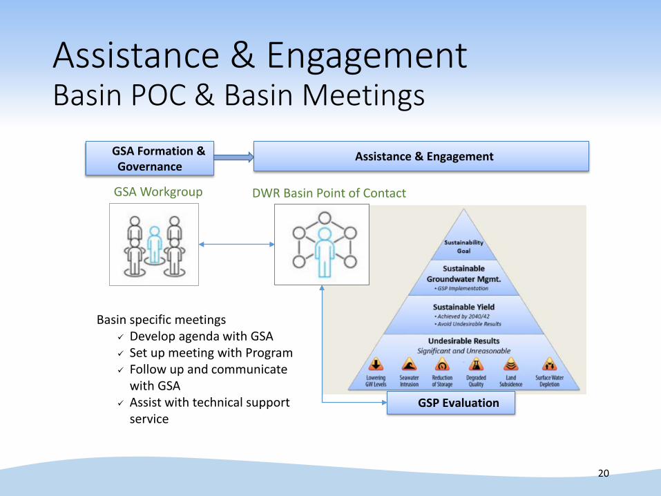
Assistance & EngagementBasin POC & Basin Meetings
20
DWR Basin Point of Contact
Assistance & Engagement
GSP Evaluation
GSA Formation & Governance
Basin specific meetings Develop agenda with GSA Set up meeting with Program Follow up and communicate
with GSA Assist with technical support
service
GSA Workgroup

South Central Region OfficeSGMA Regional Coordinator,
Amanda Peisch-Derby, P.E.
SGMAPOINT OF CONTACT

Mary Randall
PaulWells
Amanda Peisch-Derby
Brian Moniz

The POC will be the primary contact person for the high and
medium priority basins for SGMA technical support.


Basin Contacts@ Region Offices
INFORMATION BOOTHS

Guidance, Data & ToolsSteven Springhorn, SGM Program

27
SGM Program Implementation
Assistance & Engagement
Technical Services
GSA Formation & Governance
Statewide & Basin Info
Regional to Statewide
Data & Tools
Guidance, Data, & Tools
Education& Guidance Data & Tools
Facilitation Services
GSP Eval.
DWR Outreach
GSP Implementation1
2 3
4
GSP Development & Submission
GSPEvaluation
Advisory Role Evaluation Role
28
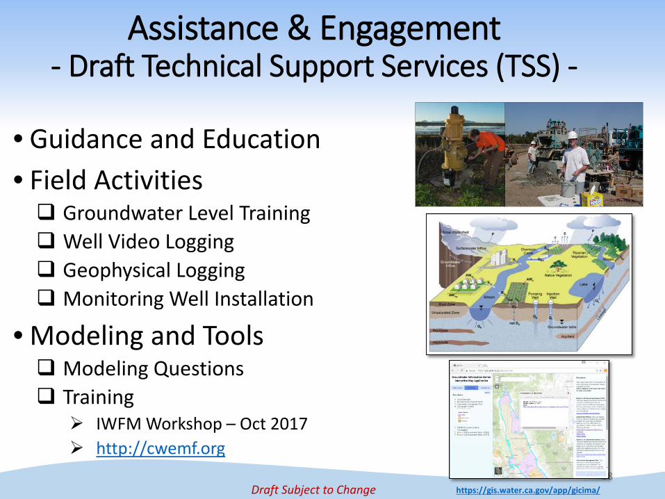
• Guidance and Education• Field Activities Groundwater Level Training Well Video Logging Geophysical Logging Monitoring Well Installation
• Modeling and Tools Modeling Questions Training
IWFM Workshop – Oct 2017 http://cwemf.org
https://gis.water.ca.gov/app/gicima/
Assistance & Engagement- Draft Technical Support Services (TSS) -
Draft Subject to Change

29
SGM Program Implementation
Assistance & Engagement
Technical Services
GSA Formation & Governance
Statewide & Basin Info
Regional to Statewide
Data & Tools
Guidance, Data, & Tools
Education& Guidance Data & Tools
Facilitation Services
GSP Eval.
DWR Outreach
GSP Implementation1
2 3
4
GSP Development & Submission
GSPEvaluation
Advisory Role Evaluation Role

30
History of Technical AssistanceTechnical Expertise
B-118-031952 B-118-80B-118-75
Reports
CA Water Plan
DWR Region Offices
Data, Tools, and Analysis
Integrated Regional Water Management

Data and Tools
31
http://www.water.ca.gov/groundwater/sgm/data_tools_reports.cfm
New Data, Tools, and Reports Webpage
1. Download Data
2. Groundwater ToolsInteractive MapsModeling Tools
3. Maps and ReportsSGMA BMPsStatewide GW Maps

Technical Assistance Fact Sheetshttp://water.ca.gov/groundwater/sgm/data_tools_reports.cfm
32
2. DWR Modeling Tools1. DWR Data, Tools, and Reports

33
Tools - Interactive Maps1. Groundwater Information Center2. Water Management Planning Tool3. Disadvantaged Communities Tool4. Basin Boundary ToolMore Tools will be added soon
Data & Tools
https://gis.water.ca.gov/app/gicima/
https://gis.water.ca.gov/app/boundaries/ https://gis.water.ca.gov/app/dacs/ https://gis.water.ca.gov/app/bbat/
1
2 3 4
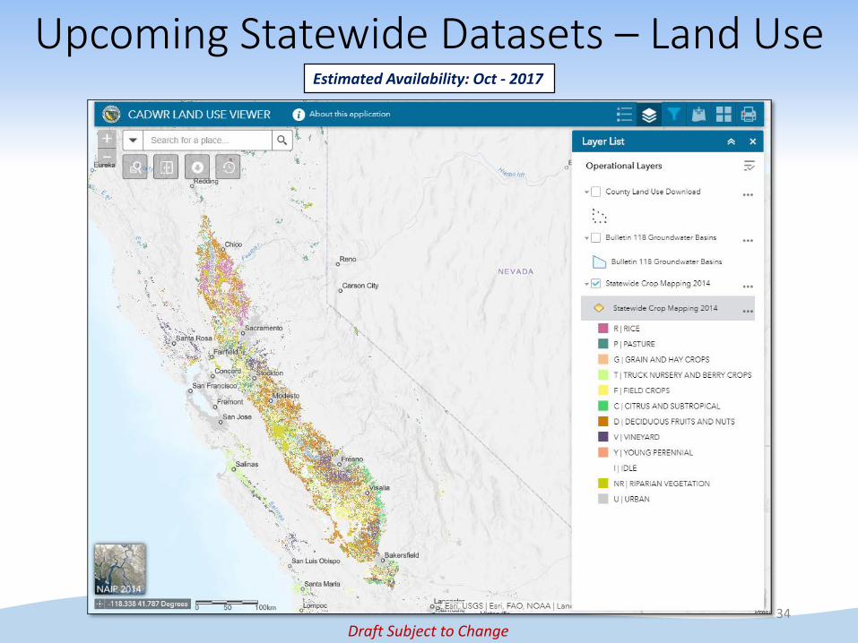
Upcoming Statewide Datasets – Land Use
34
Estimated Availability: Oct - 2017
Draft Subject to Change

Upcoming Statewide Datasets – Well Logs
35
Estimated Availability: Oct - 2017
Draft Subject to Change

36
Tools – DWR Models
• C2VSim – Fine Grid (Q1 2018)
• IWFM – (Currently Available)
Data and Tools
Draft Subject to Change

SGMA Implementation
37
Data Access Data Submittal
50 Yr Planning Horizon
+ Local Data
Tools
38
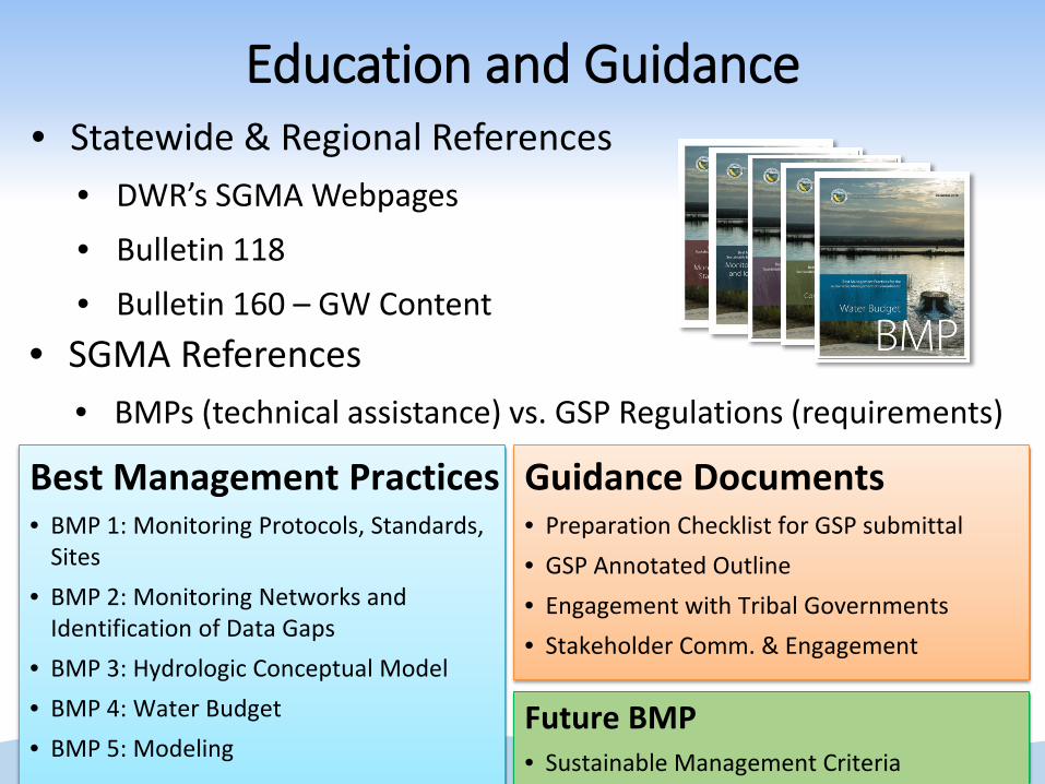
• Statewide & Regional References• DWR’s SGMA Webpages• Bulletin 118• Bulletin 160 – GW Content
• SGMA References• BMPs (technical assistance) vs. GSP Regulations (requirements)
Best Management Practices• BMP 1: Monitoring Protocols, Standards,
Sites• BMP 2: Monitoring Networks and
Identification of Data Gaps• BMP 3: Hydrologic Conceptual Model• BMP 4: Water Budget• BMP 5: Modeling
Guidance Documents• Preparation Checklist for GSP submittal• GSP Annotated Outline• Engagement with Tribal Governments• Stakeholder Comm. & Engagement
Education and Guidance
Future BMP• Sustainable Management Criteria

DWR Contacts & SGMA Resources
39
DWR Regional Offices:
Bill Ehorn - [email protected]
Bill Brewster - [email protected]
Dane Mathis - [email protected]
Tim Ross - [email protected]
DWR Sacramento:• Steven Springhorn
SGMA Resources• DWR SGMP Webpagewww.water.ca.gov/groundwater/sgm/index.cfm
• Subscribe to DWR SGMP Email Listwww.water.ca.gov/groundwater/sgm/subscribe.cfm
• DWR Data, Tools, and Reports Webpagewww.water.ca.gov/groundwater/sgm/data_tools_reports.cfm

Best Management PracticesTim Godwin, SGM Program
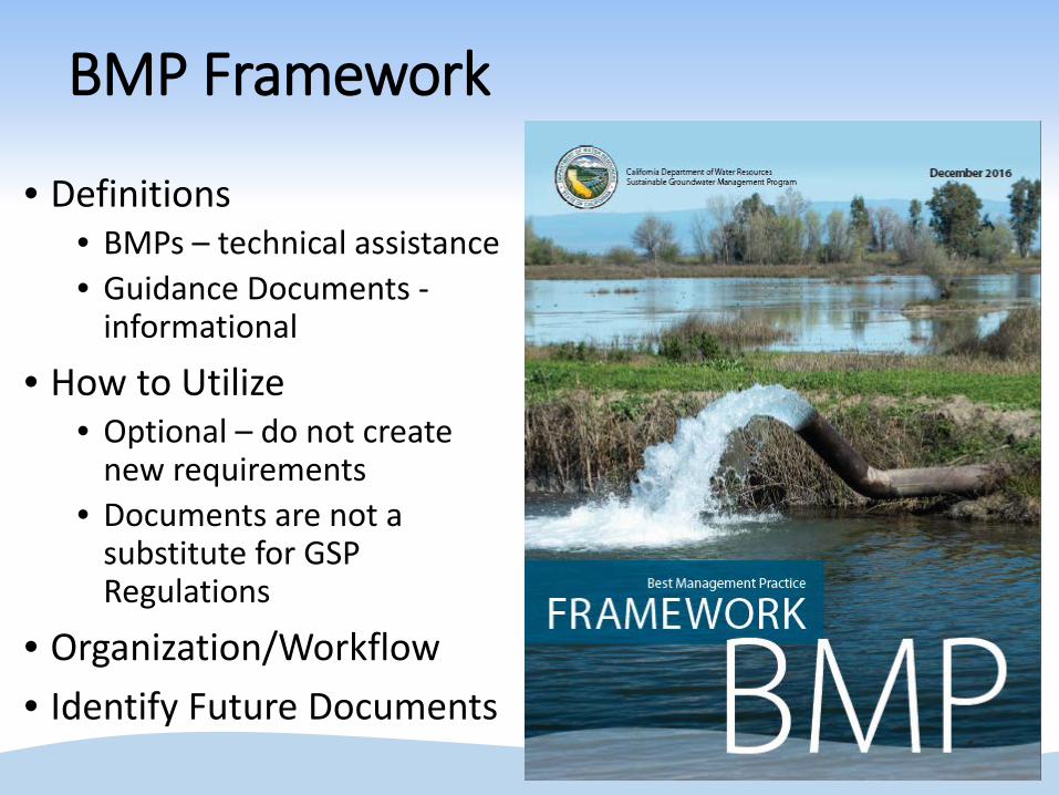
BMP Framework
• Definitions• BMPs – technical assistance• Guidance Documents -
informational
• How to Utilize • Optional – do not create
new requirements• Documents are not a
substitute for GSP Regulations
• Organization/Workflow• Identify Future Documents
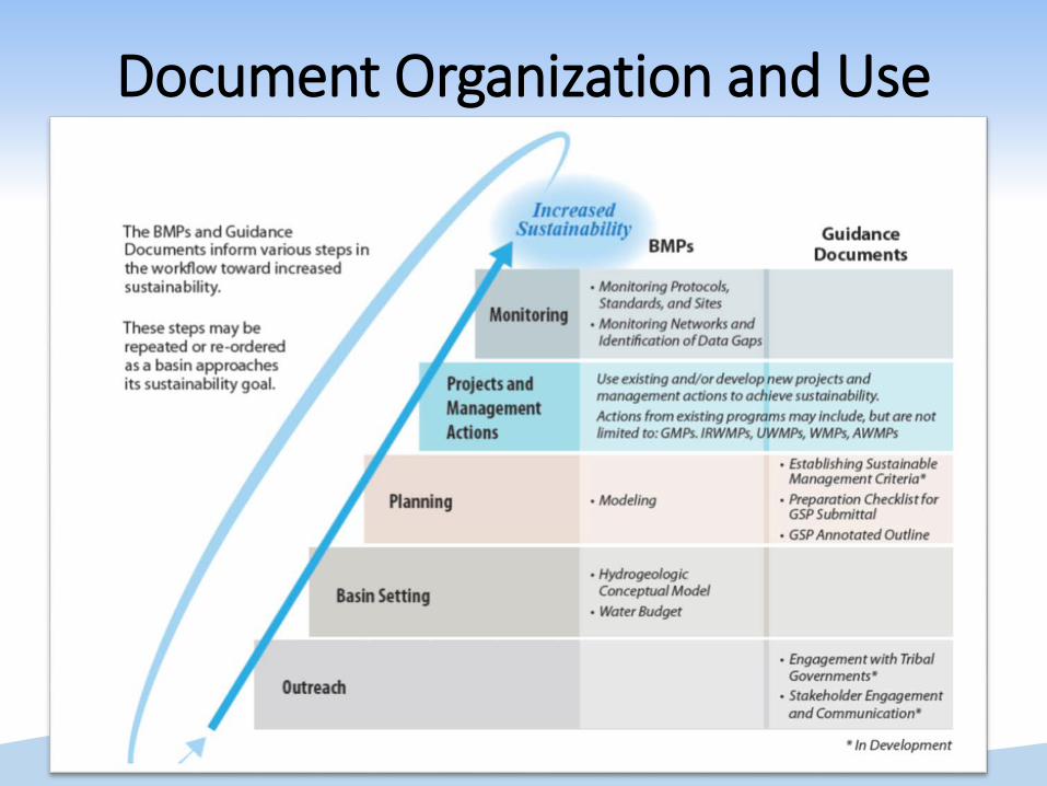
Document Organization and Use

Timeline

BMP # 1 – Monitoring Protocols, Standards, and Sites
• Protocols for:• Establishing
Monitoring Sites
• Measuring GW Levels
• Sampling GW Quality
• Monitoring Seawater Intrusion
• Measuring Streamflow
• Measuring Subsidence

BMP # 2 – Monitoring Networks and Identification of Data Gaps
• General Monitoring Networks
• Improvement of Monitoring Network
• Specific Monitoring Networks

BMP # 3 – Hydrogeologic Conceptual Model
• Characterizing Physical Components
• Geologic and structural boundaries
• Lateral boundaries
• Bottom of the basin
• Principal Aquifers and Aquitards
• Graphical Representation
• Mapping Requirements

BMP # 4 – Water Budget (WB)• General WB Requirements
• Certification
• WB Data, Information, and Modeling Requirements
• Defining Basin Area and Water Budget Systems
• Accounting and Quantification of WB Components
• Tabular and Graphical Representation of WB Components
• Defining WB Time Frames• Current, Historical, Projected

BMP # 5 – ModelingFundamentals• Types of Models, Software, Uses• Models Used for SGMA
Technical Assistance• Guiding Principles For Models• General Modeling Requirements
https://pubs.usgs.gov/fs/2015/3084/fs20153084.pdf
• Modeling Considerations• Addressing Sustainability Indicators
• Developing Water Budgets• Forecasting Future Conditions, Projects, Actions• Assessing Impacts on Adjacent Basins
• Groundwater Modeling Process• Related References and Guidance Material

Guidance DocumentsHong Lin, SGM Program

What are Guidance Documents
• Assist GSAs with GSP development • Not a substitute for SGMA or GSP regulations • Provide information to stakeholders• Not to create new requirements or obligations • Not to prescribe specific methods or procedure
50

DWR Guidance Documents
51

DWR Guidance Documents
52
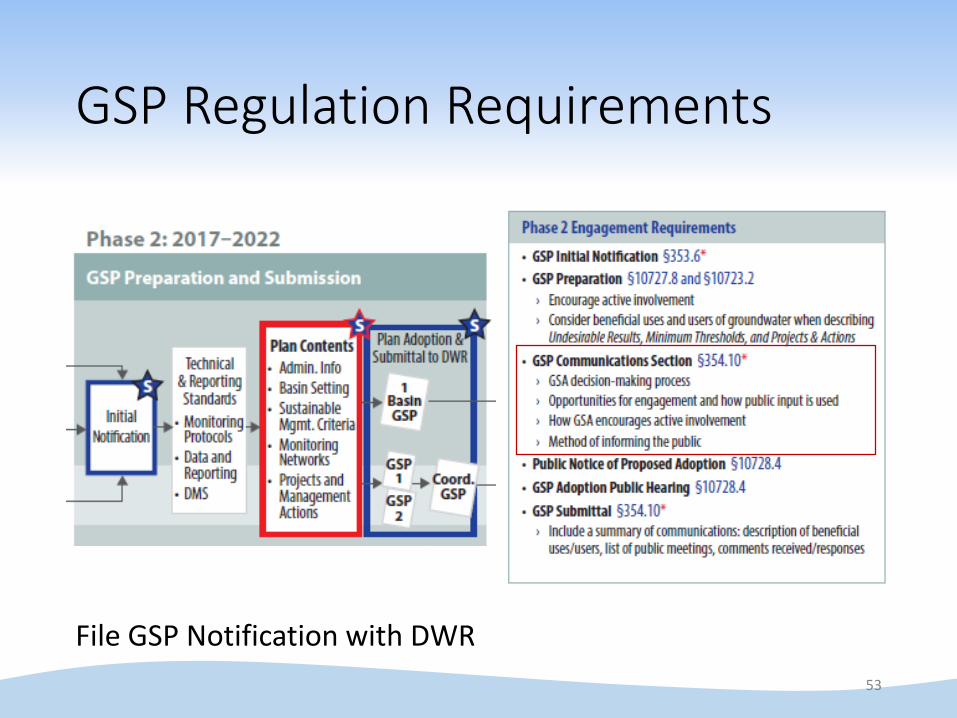
GSP Regulation Requirements
53
File GSP Notification with DWR

Communication & Engagement
54
Opportunities throughout Decision-Making process
Interests of ALL beneficial uses and users of groundwater
Active involvement of diverse social, cultural and economic elements of the population

An Example Process
55
SGMA workgroup Advisory committee Community outreach Public workshops

Methods and Tools
56
http://water.ca.gov/groundwater/sgm/digital_toolkit.cfm

Methods and Tools
57
Examples from Local SGMA Work Groups

Additional Resources
58

GSP Regulations Overview & Sustainable Management CriteriaCraig Altare, SGM Program
59

GSP Regulation Articles1. Introductory Provisions
2. Definitions
3. Technical & Reporting Standards
4. Procedures
5. Plan Contents
6. Department Evaluation & Assessment
7. Annual Reports and Periodic Evaluations by the Agency
8. Interagency Agreements
9. Alternatives
Required for All High and Medium
Priority Basins

Article 1. Introductory ProvisionsProvides regulation intent, authority, and methods and criteria used by the Department to evaluate those plans, alternatives, and coordination agreements and information required by the Department to facilitate that evaluation
§ 350.2. Applicability§ 350.4. General Principles
61
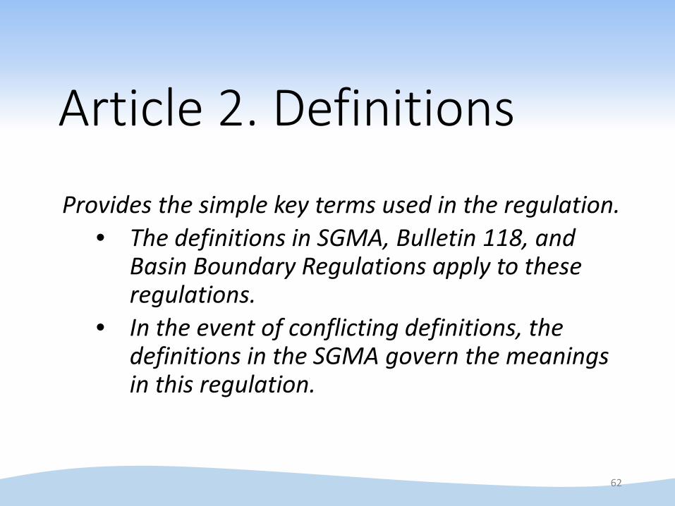
Article 2. Definitions
Provides the simple key terms used in the regulation.• The definitions in SGMA, Bulletin 118, and
Basin Boundary Regulations apply to these regulations.
• In the event of conflicting definitions, the definitions in the SGMA govern the meanings in this regulation.
62

Article 3. Technical and Reporting StandardsThis Article describes the monitoring protocols, standards for monitoring sites, and other technical elements related to the development or implementation of a Plan.
§ 352.2. Monitoring Protocols§ 352.4. Data and Reporting Standards§ 352.6. Data Management System
63

Article 4. ProceduresThis Article describes various procedural issues related to the submission of Plans and public comment to those Plans.
§ 353.2. Information Provided by the Department§ 353.4. Reporting Provisions§ 353.6. Initial Notification§ 353.8. Comments§ 353.10. Withdrawal or Amendment of Plan
64

Article 5. Plan Contents1. Administrative Information
§ 354.4. General Information§ 354.6. Agency Information§ 354.8. Description of Plan Area§ 354.10. Notice & Communication
2. Basin Setting§ 354.14. HydrogeologicConceptual Model§ 354.16. Groundwater Conditions§ 354.18. Water Budget§ 354.20. Management Areas
3. Sustainable Management Criteria
§ 354.24. Sustainability Goal§ 354.26. Undesirable Results§ 354.28. Minimum Thresholds§ 354.30. Measureable Objectives
4. Monitoring Networks§ 354.34. Monitoring Network§ 354.36. Representative Monitoring§ 354.38. Assessment & Improvement§ 354.40. Reporting Monitoring Data to the Department
5. Projects and Management Actions
§ 354.44. Projects & Management Actions
65
Undesirable ResultsSignificant and Unreasonable

Article 6: Evaluation and AssessmentThis Article describes the methodology and criteria used by the Department to evaluate and assess a Plan, periodically evaluate and assess the implementation of a Plan, or evaluate and assess amendments to a Plan.
§ 355.2. Department Review of Adopted Plans§ 355.4. Criteria for Plan Evaluation§ 355.6. Periodic Review of Plan By Department§ 355.8. Department Review of Annual Reports§ 355.10. Plan Amendments
66

Article 7. Annual Reports and Periodic Evaluations by the AgencyThis Article describes the procedural and substantive requirements for the annual reports and periodic evaluation of Plans prepared by an Agency.
§ 356.4. Annual Reports§ 356.6. Periodic Evaluation by Agency
67

Article 8. Interagency AgreementsThis Article describes the requirements for voluntary coordination agreements between agencies in different basins and mandatory coordination agreements between agencies within a basin developed pursuant to Water Code Section 10727.6.
§ 357.2. Interbasin Agreements§ 357.4. Coordination Agreements
68

Article 9. AlternativesThis Article describes the methodology and criteria for the submission and evaluation of Alternatives.
§ 358.2. Alternatives to Groundwater Sustainability Plans§ 358.4. Department Evaluation of Plan Alternatives
69

Article 5. Plan Contents1. Administrative Information
§ 354.4. General Information§ 354.6. Agency Information§ 354.8. Description of Plan Area§ 354.10. Notice & Communication
2. Basin Setting§ 354.14. HydrogeologicConceptual Model§ 354.16. Groundwater Conditions§ 354.18. Water Budget§ 354.20. Management Areas
3. Sustainable Management Criteria
§ 354.24. Sustainability Goal§ 354.26. Undesirable Results§ 354.28. Minimum Thresholds§ 354.30. Measureable Objectives
4. Monitoring Networks§ 354.34. Monitoring Network§ 354.36. Representative Monitoring§ 354.38. Assessment & Improvement§ 354.40. Reporting Monitoring Data to the Department
5. Projects and Management Actions
§ 354.44. Projects & Management Actions
70
Undesirable ResultsSignificant and Unreasonable

Sustainable Management Criteria
• Set by GSAs• Must be quantitative and define conditions under
which sustainable groundwater management occurs in the basin
• Based on information developed for Administrative Information and Basin Setting
• Supported by Monitoring Networks• Achieved by Projects and Management Actions• Upcoming Best Management Practice (BMP)
document

Sustainable Management Criteria
1. Minimum Thresholds2. Undesirable Results3. Measurable Objective4. Sustainability Goal

1. Minimum Thresholds
• Point at a representative monitoring site where conditions could become significant and unreasonable
• Develop for each sustainability indicator-or-
Use representative groundwater level for one or more sustainability indicator(s) (supported by a demonstration that the proxy is a reasonable substitute)
• Extent: representative monitoring sites

2. Undesirable Results
• The quantitative combination of minimum threshold exceedances that constitute a significant and unreasonable condition
• Extent: basinwide definition, based on minimum threshold exceedances at GSA-specified spatial scales

3. Measurable Objective (and Interim Milestones)• Quantitative objectives that take into account a
reasonable margin of operational flexibility• Interim milestones are set every five years• MO is achieved in 20 years• Extent: same network of representative
monitoring sites used for minimum thresholds

4. Sustainability Goal
• The sustainability goal states:• The objectives and desired conditions of the
groundwater basin, • Measures the GSA(s) will take to get to that desired
condition, and • How the measures planned will lead to success
• Ultimately, must result in elimination and avoidance of undesirable results
• Extent: single, basinwide goal

Example
• Following slides show a simplified example of the relationship between:
• minimum thresholds, • interim milestones and measureable objectives, and• undesirable results
• Example is for illustrative purposes only

Example – Minimum Threshold at One Representative Monitoring Site
Minimum Threshold
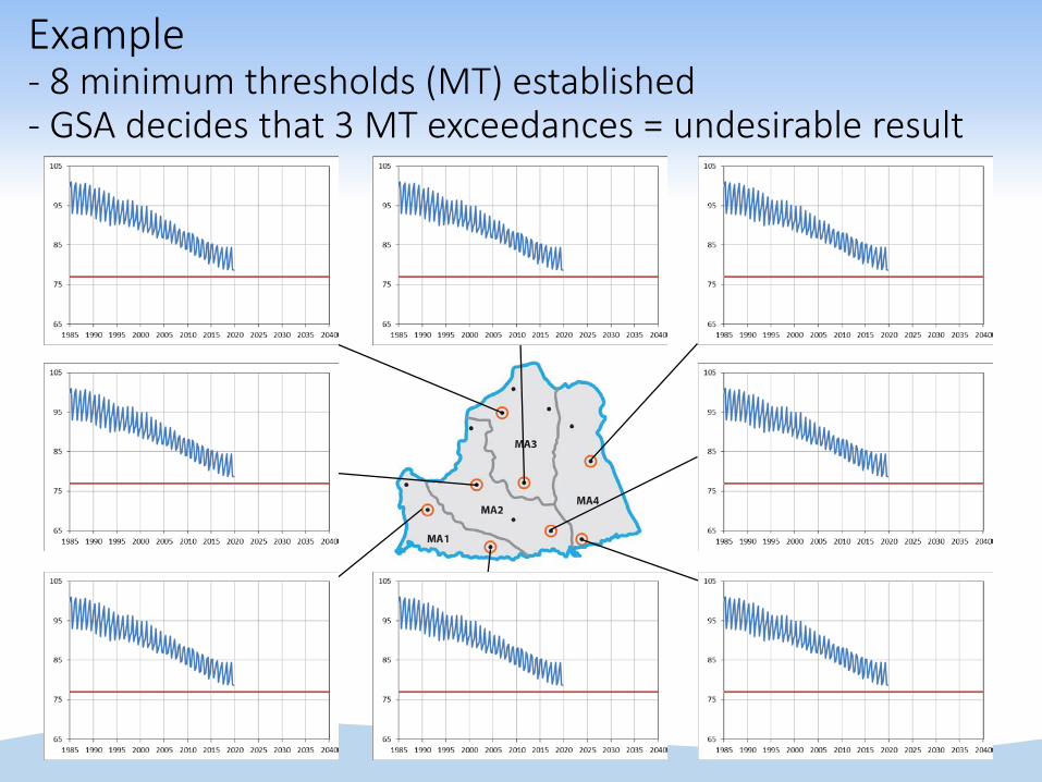
Example- 8 minimum thresholds (MT) established- GSA decides that 3 MT exceedances = undesirable result

Example – Scenario 1
• One well with MT exceedances after 5 years• No undesirable result

Example – Interim Milestones and Measurable Objective
Minimum Threshold
Interim Milestones
Measurable Objective

Example – Scenario 1
• No MT exceedances after 20 years• No undesirable result at any point in time
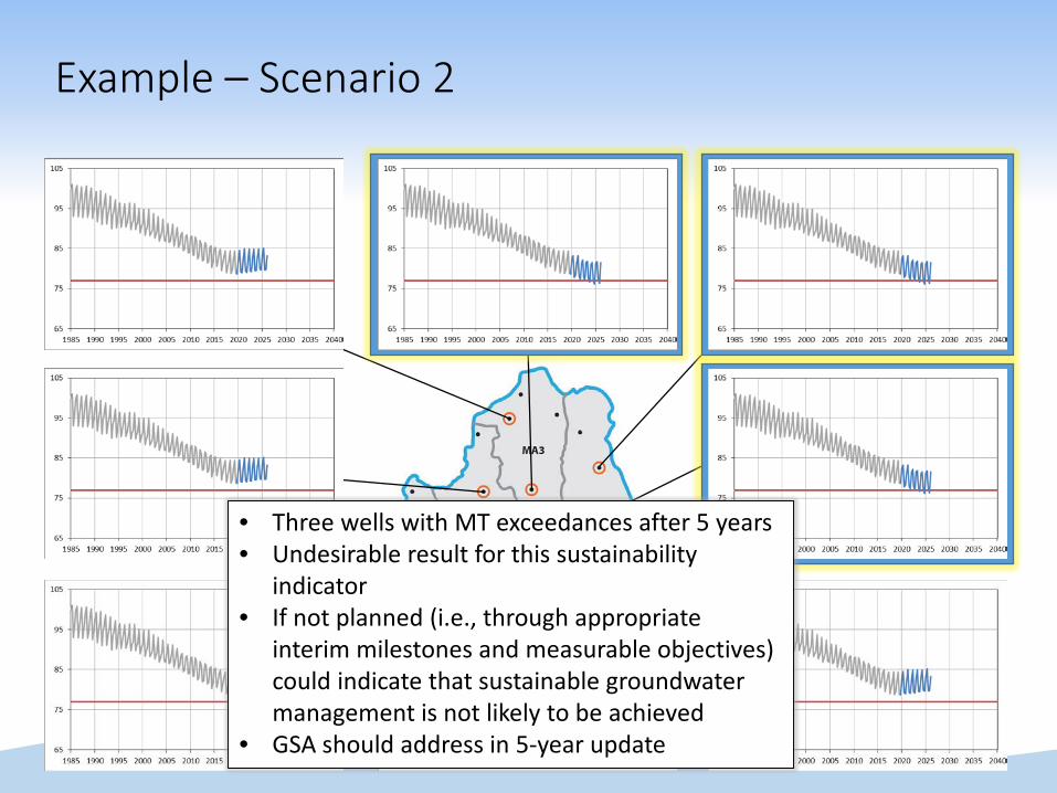
Example – Scenario 2
• Three wells with MT exceedances after 5 years• Undesirable result for this sustainability
indicator• If not planned (i.e., through appropriate
interim milestones and measurable objectives) could indicate that sustainable groundwater management is not likely to be achieved
• GSA should address in 5-year update

• No MT exceedances after 20 years• No undesirable result for this sustainability
indicator• Sustainable groundwater management for this
sustainability indicator
Example – Scenario 2
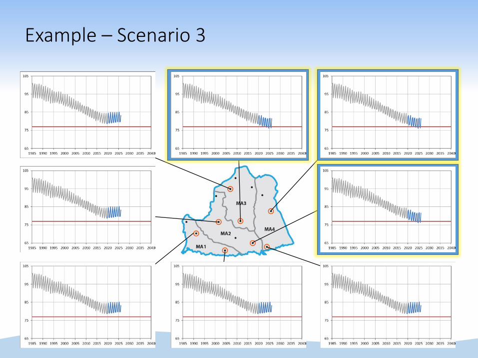
Example – Scenario 3

Example – Scenario 3
• Three MT exceedances after 20 years• Undesirable result for this sustainability
indicator through 2040• Basin has not achieved sustainable
groundwater management

Session 2
87
