gsa presentation
TRANSCRIPT
CONFIRMATION OF SUBSURFACE GEOLOGIC CONDITIONS OF THE UC BERKELEY STANLEY HALL REPLACEMENT PROJECT BY
CONSTRUCTION FIELD OBSERVATIONS
Presented by:William Godwin CEG, Ryan Shafer PE, and Chris Muller GE
MACTEC Engineering & Consulting, Inc.
Annual MeetingThe Geological Society of America
Seattle, Washington
November 2, 2003

Introduction
Purpose of Paper:Discuss the importance of geologic
mapping of large excavations that expose heterogenous materialsPresent engineering geologic
conditions of the project
Topics
Project Description Challenges Geotechnical Investigation Geologic Conditions Construction Methodology Geologic Mapping Conclusions

Project Description
Bay Area Hazard Zoneshttp://gmw.consrv.ca.gov/shmp

Site
Project Description
U.C. Berkeley Campus
N

Key ElementsReplacement of existing
classroom buildingAccommodate 3 basement
levels to -75 feetSeismic design to
withstand Mmax 7.1 on Hayward Fault 500 feet away
Project Description
Team UCB Capital Projects – Owner/Builder Zimmer Gunsul Frasca Partnership –
Architect BKF Engineers/Surveyors/Planners –
Civil Engineer MACTEC E&C – Geotechnical Engineer Rutherford & Chekene – Structural Engineer Pirooz Baraar Associates – Retention
Systems Engineer McCarthy – General Contractor
Project Description

Challenges
Urban environment Adjacent structures Complex ground conditions
and geology

Geotechnical Investigation
Exploration Plan

Geotechnical Investigation
Program Previous Investigations Deep coreholes Laboratory testing Geophysical surface surveys

Recommendations Stability Excavatability Dewatering Shoring design criteria
Geotechnical Investigation

Geologic Conditions
Local Fault Map
Geologic Conditions
Geologic Units and Structure Fill and Alluvium Greywacke Sandstone Shale and Mudstone Breccia Serpentinite and Melange Louderback Shear Zone
Construction Methodology
Demolition and excavation Dewatering Foundations Shoring

Construction Methodology
Demolition Excavation

Construction Methodology
Dewatering and Seepage Control

Construction Methodology
Foundations Micropiles Conventional
Footings and Structural Mat

Construction Methodology
South Wall Shoring Plan

Construction Methodology
Shoring Plan: Soil Nails

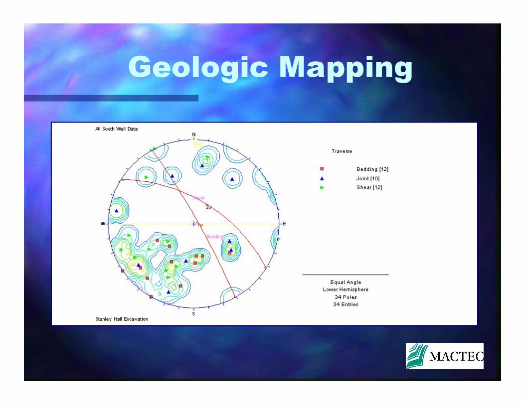
Geologic Mapping
Digital photography Sequential face mapping Seepage and overbreak Geologic contacts

Geologic Mapping
T
P
390.00
380.00
370.00
360.00
350.00
340.00
330.00
320.00
310.00
300.00
T
T
T
T
T
T
P
T
T
T
T
T T
T
T
T
T
T
T
ELEVATIONIN FEET
SOUTH WALL ELEVATION
Geologic Mapping

Geologic Mapping

Geologic Mapping
East Wall Mudstone Breccia/Melange
West Wall Interbedded Sandstone/Shale

Geologic Mapping
?
?
?
?? ?
S O U T H W A L L
DONNER LAB
GRAYWACKESANDSTONE
BRECCIATED
MUDSTONE
AND SHALE
INTERBEDDEDSANDSTONE AND SHALE
CARBONACEOUS
SHEARED AND
SERPENTINITE
SHALE WITH
Site Geology

Conclusions
Conditions: Interpreted vs. Actual– Bedrock contacts– Excavatability– Stability– Groundwater– Bonding strength– Wall movement

Conclusions
Identify potential unstable zones that could impact shoring system or worker safety
Presence of Louderback Shear zone and understanding of local geology
Integration of observational and construction methodology and applicability to future projects