gtech 361 lecture 04 referencing data to real locations
TRANSCRIPT

GTECH 361
Lecture 04
Referencing Data to Real Locations

Today’s Content
Two types of coordinate systems
Geographic
Projected

Today’s Objectives
name two types of coordinate systems identify components of each type of coordinate
system assign coordinate system information to a dataset set display units for a data frame and measure
distances on a map explain what a map projection is list the major categories of map projections list spatial properties that may be distorted when
different map projections are applied change the map projection for a data frame and
describe its effects

Geographic Coordinates
Graticule Latitude Longitude
Prime Meridian

The Earth’s Shape The ancient Greek’s mathematical
harmony
Simplest approximation: the sphere

The Earth as an Ellipsoid

Making of an Ellipsoid

The Earth’s Shape

Why Multiple Datums?

Geodetic Datums

Projected Coordinates
Flattening the Earth

Origin of X, Y Coordinates

Central Parallel

False Easting/northing

Coordinates in ArcGIS All geographic data have geographic
coordinates (lat/lon) Some may have projected
coordinates in addition to the geographic ones
ArcGIS assigns the coordinate system to a map based on the GCS or PCS of the first dataset loaded
Subsequent datasets are converted on-the-fly

Map and Display Units
Map units are determined by GCS or PCS GCS in degrees or decimal degrees PCS usually in feet or meters
Display units are determined by you They are defined as part of the data
frame

(Decimal) Degrees
Converting from degrees to decimal degrees1. Divide each value by the number of
minutes (60) or seconds (3600) in a degree
2. Add up the degrees to get the answer
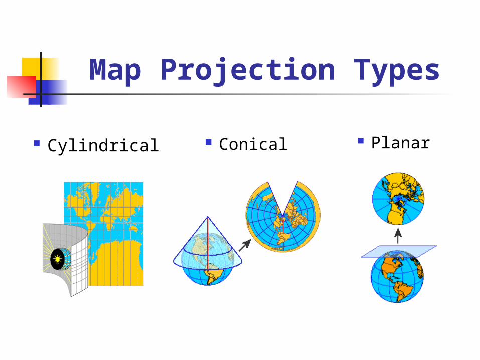
Map Projection Types
Cylindrical Conical Planar

Cylindrical Projections

Conic Projections

Planar Projections

Understanding Distortion
Distortion cannot be avoided; we have to choose from distortion of Shape
Area
Distance
Direction

Preserving Properties If two properties are to be preserved
then one is always direction
These properties are incompatible:
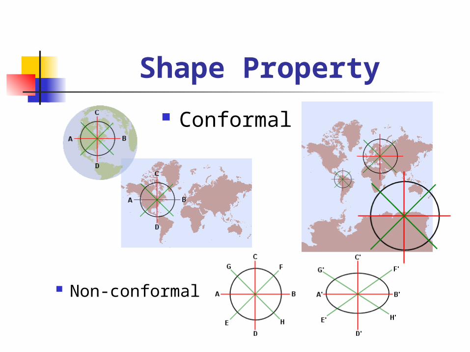
Shape Property
Conformal
Non-conformal

Area Property

Distance Property

Direction Property

Direction Property
Azimuthal map with shortest distance
Mercator with rhumb line or loxodrome
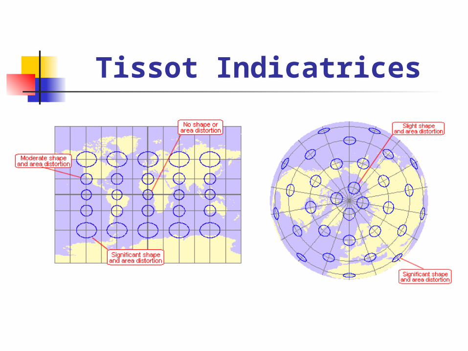
Tissot Indicatrices

Equatorial (normal) Aspect

Transverse Aspect

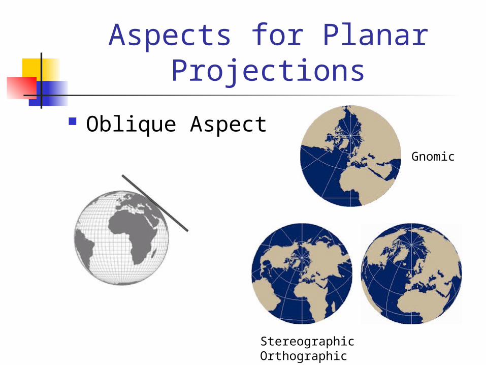
Oblique Aspect

Aspects for Planar Projections
PolarGnomic
Stereographic Orthographic

Aspects for Planar Projections
Equatorial AspectGnomic
Stereographic Orthographic
Aspects for Planar Projections
Oblique AspectGnomic
Stereographic Orthographic

Aspects for Conic Projections
Normal aspect

Polyconic Projection
Hassler, 1820sUS Coastal Survey

Perspective
Position of thelight source

Perspectives

Classifying Projections

Classifying Projections
Cylindrical straight parallels; straight meridians
Pseudo-cylindrical
straight parallels, curved meridians
Conicpartial concentric circles for parallels; straight meridians
Pseudo-conicpartial concentric circles for parallels; curved meridians
PlanarConcentric circles for parallels; straight meridians
Modified planarNo common appearance of parallels and meridians

Choosing a Map Projection
Conformal (shape-preserving) maps Topographic and cadastral Navigation Civil engineering Weather

Choosing a Map Projection
Area-preserving maps Population density Land use Quantitative attributes

Choosing a Map Projection
Scale-preserving mapsno map preserves true distance for all measurements Airline distances Distance from
epicenter of an earthquake
Cost calculations
Choosing a Map Projection
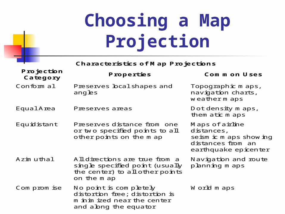
Characteristics of Map Projections
Projection Category
Properties Common Uses
Conformal Preserves local shapes and angles
Topographic maps, navigation charts, weather maps
Equal Area Preserves areas Dot density maps, thematic maps
Equidistant Preserves distance from one or two specified points to all other points on the map
Maps of airline distances, seismic maps showing distances from an earthquake epicenter
Azimuthal All directions are true from a single specified point (usually the center) to all other points on the map
Navigation and route planning maps
Compromise No point is completely distortion free; distortion is minimized near the center and along the equator
World maps

Components of a GCS
An angular unit of measure
A prime meridian
A datum, which includes a spheroid

Planar Coordinate Systems

Cartesian Coordinates
Calculate distance A-B

Universal Transverse Mercator
UTM zones

UTM Zones
.. as seen from the North Pole

UTM Projections Each zone uses a custom Transverse
Mercator projection with its own central meridian

Universal Polar Stereographic
Fills the holes of UTM in polar regions

State Plane Coordinate System

SPC
N-S zones use Transverse Mercator E-W zones use Lambert Conformal
Conic Maximal scale error is 1:10,000 NAD27 or NAD83 datum

Public Land Survey System
PLS are shown in purple

PLS It is used to locate areas, not points
It is not rigorous enough for spatial analysis like the calculation of distance or direction
It is not a grid imposed on a map projection (a system invented in a room), but lines measured on the ground by surveyors
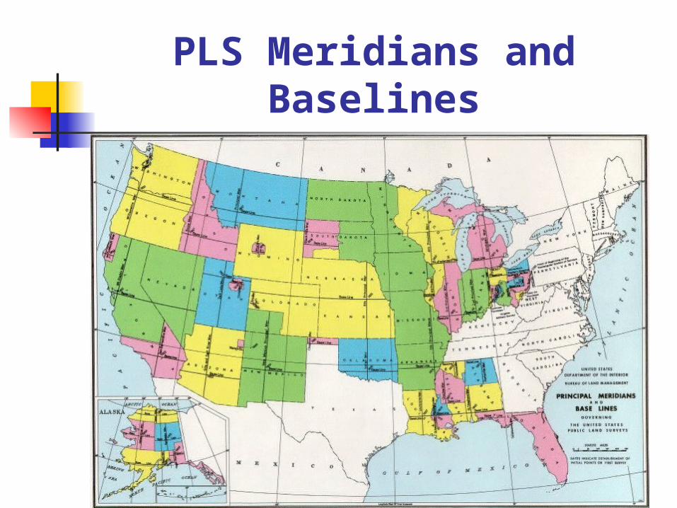
PLS Meridians and Baselines

PLS Area Unit Hierarchy

PLS Township Sections
A township is divided into 36 sections,each a square mile (640 acres)
A section is divided into 160-acre quarters, which can be further divided into halves, quarters, and so on