guide to the principal archaeological sites of the eastern ... · * institute of history,...
TRANSCRIPT

Archaeological coordination: Roland Besenval Director of research to the Centre National de la Recherche Scientifique, CNRS-France
With an article on recent history of Murghab by Hermann Kreutzmann***
* Institute of history, archaeology and ethnography, Academy of Sciences of Tadjikistan
** Institut National de Recherche Archéologique Préventive (INRAP-France) *** Institute of Geography, University of Erlangen-Nuernberg - Germany
sponsored by UNESCO project “Development of Cultural and Ecotourism in the mountainous regions of South and Central Asia”
Swiss Agency for Development and Cooperation, SDC
CNRS Centre National de Recherche Scientifique
Implemented by the Pamir High Mountains Integrated Project
Guide to the Principal Archaeological Sites of the Eastern Pamirs (Tajikistan)
By Vadim A. Ranov* and Cecile Veber**

- 2 -
Foreword The barren but romantic images of the Pamirs have inspired the few people lucky enough to set eyes upon this stark desert plateau – considered one of the great natural wonders of the world. Access to this scenic area has always been difficult but with shifting geo-political alignments coupled with infrastructure improvement, the Pamirs have now become more accessible to the traveller seeking adventure, natural surroundings and solitude. One rural development programme – Development of Culture and Ecotourism in the mountainous Regions of South and Central Asia – aims to bring economic development to the area by capitalizing on the unique natural and archaeological environment through promotion of a community-based eco-tourism framework. The project, implemented by the Pamir High Mountains Integrated Project, encourages local people to benefit economically from their environment while at the same time ensuring the protection of their cultural heritage through continued archaeological research. Human settlements have existed in the Pamirs for a few thousands years, and their archaeological remains are particularly vulnerable. Generating income through eco-tourism could facilitate the identification, protection and development of the remains. From a cross border perspective, this integration of cultural heritage preservation in a rural development programme could then be replicated in other areas, like Afghanistan (Wakhan), Kyrgyzstan and China. This programme is funded by UNESCO and Swiss Agency for Development and Cooperation (SDC) while the archaeological component is addressed by Centre National de la Recherche Scientifique (CNRS-France) and Institut National de Recherche Archéologique Préventive (INRAP-France). The archaeological programme is the result of collaboration between researchers from the Academy of Sciences of Tajikistan, CNRS and INRAP.
Roland Besenval Director of Research to the Centre National
de la Recherche Scientifique, CNRS-France

- 3 -
Table of Contents
Introduction......… … … … … … … … … … … 4
The road from Osh… … … … … … … … … .. 4
The road from Khorog… … … … … … … … . 4
General characteristics of the Pamirs… .. 5
Topography… … … … … … … … … … … … .. 5
Hydrology… … … … … … … … … … … … … . 5
Climate… … … … … … … … … … … … … … . 5
Flora and Fauna of the Pamirs… … … . 6
Archaeological evidence of Human Settlements in the Eastern Pamirs… .. 7
Seven Circuits to Discover the Main Archaeological Sites of the Eastern Pamirs... 8
Circuit 1 : Murghab - Jashhilkul – Murghab (1 – 2 days) ............................................... 8
Circuit 2 : Murghab – Shurali (or Shuraly) – Murghab (1 – 2 days) ............................... 11
Circuit 3 : Murghab – Karaart – Murghab (1 day) ......................................................... 13
Circuit 4 : Murghab – Shaymak – Murghab (1 day) ....................................................... 15
Circuit 5 : Murghab-Ak-Jilga-Murghab (1 day) ............................................................... 18
Circuit 6 : Murghab – Sasyk – Murghab (1 day) ............................................................ 21
Circuit 7 : Murghab – Jarty Gumbez – Murghab (2 days) .............................................. 22
Annex 23
Glossary … … … … … … … … … … … … … … … … … … … … … … … … … … … … … … … … … .. 23
Archaeological sites of the Eastern Pamirs Summary Table ........................................ 24
Overview map to the 7 circuits to archaeological sites in Murghab rayon...................... 25
Tourism and Conservation … … … … … … … … … … … … … … … … … … … … … … … … … … 26
History of Murghab town and the Pamir highway ......................................................... 27
All photographs unless otherwise noted by Cecile Veber Cover photographs: View of Zartoshkol range (approaching Shurali geoglyphs), E. Engel Building a Yurt in Pshart valley, (approaching Sasyk mining relics), T. Kraudzun Milk processing in Pshart, E. Engel Herding home the Yaks, Madian valley, T. Kraudzun
- 4 -
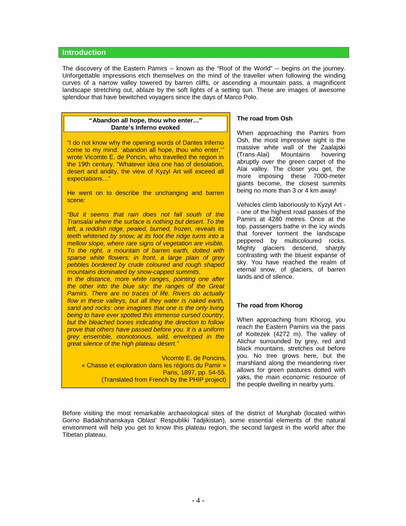
Introduction The discovery of the Eastern Pamirs -- known as the “Roof of the World” -- begins on the journey. Unforgettable impressions etch themselves on the mind of the traveller when following the winding curves of a narrow valley towered by barren cliffs, or ascending a mountain pass, a magnificent landscape stretching out, ablaze by the soft lights of a setting sun. These are images of awesome splendour that have bewitched voyagers since the days of Marco Polo.
The road from Osh When approaching the Pamirs from Osh, the most impressive sight is the massive white wall of the Zaalajski (Trans-Alai) Mountains hovering abruptly over the green carpet of the Alai valley. The closer you get, the more imposing these 7000-meter giants become, the closest summits being no more than 3 or 4 km away! Vehicles climb laboriously to Kyzyl Art -- one of the highest road passes of the Pamirs at 4280 metres. Once at the top, passengers bathe in the icy winds that forever torment the landscape peppered by multicoloured rocks. Mighty glaciers descend, sharply contrasting with the bluest expanse of sky. You have reached the realm of eternal snow, of glaciers, of barren lands and of silence. The road from Khorog When approaching from Khorog, you reach the Eastern Pamirs via the pass of Koitezek (4272 m). The valley of Alichur surrounded by grey, red and black mountains, stretches out before you. No tree grows here, but the marshland along the meandering river allows for green pastures dotted with yaks, the main economic resource of the people dwelling in nearby yurts.
Before visiting the most remarkable archaeological sites of the district of Murghab (located within Gorno Badakhshanskaya Oblast’ Respubliki Tadjikistan), some essential elements of the natural environment will help you get to know this plateau region, the second largest in the world after the Tibetan plateau.
“Abandon all hope, thou who enter… ” Dante’s Inferno evoked
“I do not know why the opening words of Dantes Inferno come to my mind: ‘abandon all hope, thou who enter,’” wrote Vicomte E. de Poncin, who travelled the region in the 19th century. “Whatever idea one has of desolation, desert and aridity, the view of Kyzyl Art will exceed all expectations… ” He went on to describe the unchanging and barren scene: “But it seems that rain does not fall south of the Transalai where the surface is nothing but desert. To the left, a reddish ridge, pealed, burned, frozen, reveals its teeth whitened by snow; at its foot the ridge turns into a mellow slope, where rare signs of vegetation are visible. To the right, a mountain of barren earth, dotted with sparse white flowers; in front, a large plain of grey pebbles bordered by crude coloured and rough shaped mountains dominated by snow-capped summits. In the distance, more white ranges, pointing one after the other into the blue sky: the ranges of the Great Pamirs. There are no traces of life. Rivers do actually flow in these valleys, but all they water is naked earth, sand and rocks: one imagines that one is the only living being to have ever spotted this immense cursed country, but the bleached bones indicating the direction to follow prove that others have passed before you. It is a uniform grey ensemble, monotonous, wild, enveloped in the great silence of the high plateau desert.”
Vicomte E. de Poncins, « Chasse et exploration dans les régions du Pamir »
Paris, 1897, pp. 54-55. (Translated from French by the PHIP project)

- 5 -
General characteristics of the Pamirs
The region is composed of the highest and most arid plateaus of Central Asia. Geographical characteristics and natural conditions are similar to those encountered in Tibet. Population density is low, and is mainly composed of Kyrgyz and Pamiri Tajik people who must battle cold, carving winds, extreme sun radiation, oxygen deficiency and shortage of food, as at these altitudes, plants like wheat, rice, and potatoes, do not grow easily.
Topography Despite the high altitudes, the Eastern Pamirs retain the features of moderate mountains, with little incised valleys and soft shapes. The most common morphology consists of valleys refilled with glacial and fluvial erosion of the slopes. Thus, the altitude difference between the bottom of the valleys and the peaks rarely exceeds 500 – 600 m. The high plateaus are usually surrounded by mountain ranges that reach an altitude of 6000 – 7000 m. Moraines, structures of glacial accumulation, are also common. Research on the geological stratifications has revealed four periods of glaciations in the Pamirs during the quaternary. Hydrology The Aksu River is the principle body of water shaping the region’s water network. Its source lies further south, in the Wakhan Valley in Afghanistan’s Badakhshan Province. The 218-kilometres river flows north into Murghab City and ends its course in Sarez Lake. The Pamir (117 km) and the Alichur (75 km) rivers also flow through the region. The first inhabitants of the area lived along the terraces of the river valleys, and remains of their civilization – including the Saka burial sites called kurgans – can still be visited today. Seasonal water flows – produced by snow and glacier melt in summer – provide an important source of water, especially for the human settlements dotted along these waterways. The lakes of Zor Kul, Yashil Kul and Rang Kul also serve as a source of fish and allow for the existence of nearby pasture and grazing lands.
Surface area: 38,442 km² Altitude: 3,400 – 7,465 m Average temperatures: Winter, -20° C
Summer, 11° C Annual Precipitation: 60 – 150 mm Terrain: Moderate mountains,
glacial moraines Population: 14,064 Population density: 0,37 inhabitants per km² Areas of human habitation: Mainly valleys between
3,500-4,500 meters.
Marco Polo’s Impressions “This plain, whose name is Pamir, extends fully 12 days’ journey. In all these twelve days there is no habitation or shelter, but travellers must take their provisions with them. No birds fly because of the height and the cold. And I assure you that, because of this great cold, fire is not so bright here nor of the same colour as elsewhere, and food does not cook well.” Source:The Travels of Marco Polo. Latham, R. (translation): Harmondsworth, Penguin Books 1958. Pages 79-80. Quoted from Shahrani: The Kirghiz and Wakhi of Afghanistan. University of Washington Press, 2002. Page 26-27. If the austerity and hardships of life on the high plateaus as described by the Venetian traveller have remained unchanged, the modes for access have greatly simplified the journey – which, nevertheless, represents an adventure even today.
Climate In Murghab District (“rayon”), the summers are short and fresh, and the winters long and icy. Average temperatures in January plunge to -20° C, with minimal temperatures of -50° C. Temperatures between day and night can differ up to 35° C. Strong southeastern winds begin to blow during the second half of the day, potentially bringing precipitation. But instead, they leave their burden on the lower slopes of the mountain ranges. As a result, the Eastern Pamirs is one of the most arid places on the planet, comparable to the Sahara, with precipitation ranging from 60 – 150 mm per year. The humidity of the air is also lower than in the hottest deserts, due to the high altitude.

- 6 -
Flora and Fauna of the Eastern Pamirs The Pamirs belongs to the same geo-botanical region as Tibet. Flora is classified by altitude into two strata: Flora Sub-alpine terrace (3500 – 4500 m) ? Small plants, such as desert absinth and teresken (Ceratoides papposa), a slow growing shrub.
The root is used as heating material and its mass harvest is responsible for continued desertification.
? Steppe grasses and small bushes of willow along waterways Alpine terrace (4300 – 4800 m) ? A diversity of “cushion plants,” the majority of which are xerophytes – plants with a physiology
adapted to arid climate. Fauna
Birds are abundant, both in quantity and diversity, but only 10 to 12 species are non-migratory. The most notable are wild geese (Indian goose), snow vultures and the Ulars of Tibet. Only some 15 species of mammals are present in the Pamirs. The most famous are the snow leopard, Marco Polo Sheep (locally referred to as arkhar), ibex (capra sibirica or Kiik), red marmot, and yak (bovis gruniens)
Marco Polo Sheep, Ovis ammon polii
Snow leopard, Uncia uncia Ibex, Capra sibirica
Yak, Bovis gruniens

- 7 -
The excavations have revealed a number of interruptions in human presence in the Eastern Pamirs. The oldest settlements go back to the Mesolithic to around 8500 B.C. The Paleolithic is not represented. In contrast to the larger part of the surrounding regions and other areas of the world, sites attributed to the Mesolithic are more numerous than those of the Neolithic, which is hardly represented at all. Very few signs of Bronze Age settlements (during the 2nd millennium and the beginning of the 1st B.C.) have been found. In 1972, V. Jukov studied the petroglyphs of Ak Jilga with figures of chariots, horsemen and humans resembling skeletons; these pictures are attributed to the Bronze Age.
Notable archaeological excavations in the Pamirs 1946 First archaeological research conducted by A.N.
Bernshtam 1947 Exacavation of Saka kurgans at Ak Beit and
Tamdy by Bernshtam
V.I. Ratsek, a traveller-mountaineer, published his archaeological observations
Excavations by B.A. Litvinskiy of kurgans across Eastern Pamirs, including those of the Yashil Kul and Zor Kul lakes and the valleys of Istyk and Jarty Gumbez
1956 V.A. Ranov began his survey of Stone Age
settlements, which lead to the discovery of Karatumshuk, the largest site of the period
1957 The highest habitation in the world, Oshkhona –
a Mesolithic settlement dating from 8500 BC – unearthed in the valley of the Markansu by V. Ranov. Excavations continued until 1960.
1958 Red pigment cave paintings found in Shakhty
cave, population thought to be contemporaries of Oshkona.
1964 M.A. Bubnova begins excavation (completed in
1975) of the medieval mining city of Bazar-Dara, situated in a narrow valley at almost 4000 m.
Kurgan excavation in Murghab by M.A. Bubnova,
who researched geoglyphs, or geometric stone figures found on the ground connected with Saka graves. These included the geoglyphs of Shurali and, more recently, those of Karaart on the shores of Lake Kara Kul.
Excavation of Djanshangoz, a settlement
bordering Eastern and Western Pamir, by M.A. Bubnova
1978 Excavation of Istyk Cave, dating from 7000 B.C.
and bearing signs of a different cultural group than the population living in Oshkhona-Markansu
1980 Jukov revisits Oshkhona
The following period, known as the emerging Iron Age, is particularly well represented in many kurgans placed on terraces along rivers and lakes, with a higher concentration in the southern part of the region. They have been attributed to the Saka period (8th – 3rd century B.C.) and are evidence of the presence of nomadic Scythian populations typically found further north. Litvinskii believes that these nomads managed to cross the barrier of the Hindu Kush to reach and settle in northern India, bringing with them their warrior traditions, strict social organisation (a prototype of India’s caste system) and the Indo-Iranian language. The famous archaeological remains of Central Asia, the monuments of the Kushan period (2nd century B.C. – 4th century A.D.) are completely absent from the Eastern Pamirs, as well as remains of Hephtalite dominion (5th – 8th century A.D.). The next oldest settlements known are those of the 11th century, cities of silver mines like Bazar-Dara or Sasyk. Most scientists believe that this second interruption of human presence in the Eastern Pamirs – between 3rd century B.C. and 11th century A.D. – was caused by a combination of climate change and overexploitation of grazing areas by the Saka. According to the botanist L.V. Sidorov, the surface area of pasturelands has diminished by more than half since the era of the Saka.
Archaeological Evidence of Human Settlements in the Eastern Pamirs Archaeological research in the Eastern Pamirs began in 1946 with an expedition headed by A.N. Bernshtam. Since then a number of excavations have taken place, the most noted of which are listed in the box below.

- 8 -
Circuit 1: Murghab – Yashil Kul – Murghab (1 – 2 days)
Murghab – Yashil Kul – Bolshoi Marjonai (Kurgans, great stone circles) – Bekbulat
(mausoleum) – Alichur Valley (hot springs, night in a yurt)
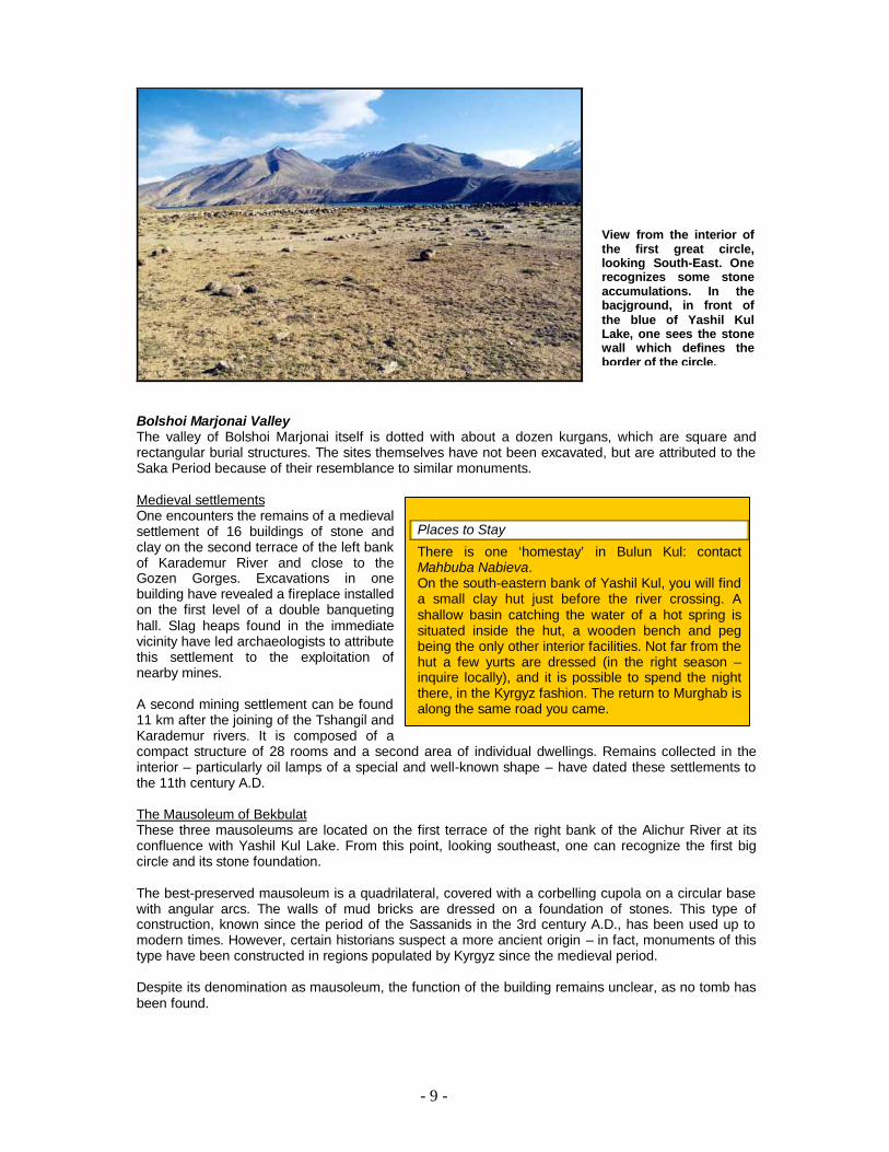
North of Yashil Kul Lake This region is comprised of the valleys belonging to the Karademur, Bolshoi Marjonai and Tshangil rivers. Ancient mines, settlements connected to mineral exploitation, tombs and funeral structures form the diversity of archaeological sites in this area. The great circles Three big circles are found on a platform overlooking the lake, at the mouth of the Bolshoi Marjonai River. The construction of the circular stone walls, which are situated at a distance of 250 – 300 m from one another, is believed to have taken place during the Bronze Age, or the end of the 2nd Millennium B.C., as two similar burial structures at the confluence of Lake Yashil Kul and Karademur River, have been attributed to this time. Excavations have not yielded any evidence as to the use of these circle formations. The monuments have been compared to the mysterious phenomenon of Megalithic. Archaeologists have suggested that the rock formations served as cenotaphs, united by a greater monument; others believe it to be the site of a solar sanctuary. With a diameter close to 63 m, the walls of the first circle are open at two points, one in the northwest, a second in the southeast. In the interior, one finds about 20 accumulations of rocks of various shapes (oval, four-angular, circular on two levels etc).
The second circle of 40 m of diameter contains no rock piles. The third circle has a diameter of 48 m. Along the wall of this circle, there are approximately 30 rock accumulations. The discovery of Chinese ceramics and coins attributed to the late 18th and early 19th century, has led to the theory that the site was reused, presumably as caravanserai, on the ancient Silk Road, which came from China along the Alichur Valley and continued west along the Gunt River. Funeral structures The funeral structures are situated on the second terrace of the northern shore of the lake, where the Karademur River meets the lake. They are composed of four-angular enclosures measuring a few square meters, built on two levels of mud bricks and filled up with earth. Some of these enclosures have an entrance and a small corridor. In one of them, a stone case has been erected, covered by a two-sectioned roof, and also made of stone. Skulls of horses were found next to the stone case, whilst ashes and a fireplace occupied the middle of the enclosure. Shards of ceramics found in this structure show similarities to those of the Bronze Age culture of the Andronovo people, who flourished in the plains of Kazakhstan and Siberia. A few hundred meters to the east, similar structures have remained unexplored.
Seven Tours to discover the main archaeological sites of the Eastern Pamirs To travel the seven proposed circuits you should plan for 8 – 10 days, depending on the chosen options. It is convenient to stop for a few days of rest in Murghab between tours.
Directions
Take the road M41 in direction of Khorog. After approximately 145 km, you should come to the crossroads for Yashil Kul Lake. 25 km after Alichur turn right Another 30 km on a good dirt road will take you to Yashil Kul Lake, first passing the smaller lake of Bulun Kul. In order to reach the northern shore of the Yashil Kul Lake, you have to cross the Alichur River at a ford situated to the extreme east of the lake (inquire locally on the water level). The track continues in medium difficulty, occasionally being difficult, following the right bank of the river. You will see the three mausoleums of Bekbulat, along with a more recent farmhouse. You can also observe a contemporary Kyrgyz cemetery with small constructions of dried bricks. The track then leaves the shore a bit and enters the valley of Bolshoi Marjonai. It is in this location that 3 great stone circles overlook the lake. The other archaeological sites are situated on the approach of the upper valley.
- 9 -
Bolshoi Marjonai Valley The valley of Bolshoi Marjonai itself is dotted with about a dozen kurgans, which are square and rectangular burial structures. The sites themselves have not been excavated, but are attributed to the Saka Period because of their resemblance to similar monuments. Medieval settlements One encounters the remains of a medieval settlement of 16 buildings of stone and clay on the second terrace of the left bank of Karademur River and close to the Gozen Gorges. Excavations in one building have revealed a fireplace installed on the first level of a double banqueting hall. Slag heaps found in the immediate vicinity have led archaeologists to attribute this settlement to the exploitation of nearby mines.
A second mining settlement can be found 11 km after the joining of the Tshangil and Karademur rivers. It is composed of a compact structure of 28 rooms and a second area of individual dwellings. Remains collected in the interior – particularly oil lamps of a special and well-known shape – have dated these settlements to the 11th century A.D. The Mausoleum of Bekbulat These three mausoleums are located on the first terrace of the right bank of the Alichur River at its confluence with Yashil Kul Lake. From this point, looking southeast, one can recognize the first big circle and its stone foundation. The best-preserved mausoleum is a quadrilateral, covered with a corbelling cupola on a circular base with angular arcs. The walls of mud bricks are dressed on a foundation of stones. This type of construction, known since the period of the Sassanids in the 3rd century A.D., has been used up to modern times. However, certain historians suspect a more ancient origin – in fact, monuments of this type have been constructed in regions populated by Kyrgyz since the medieval period. Despite its denomination as mausoleum, the function of the building remains unclear, as no tomb has been found.
Places to Stay
There is one ‘homestay’ in Bulun Kul: contact Mahbuba Nabieva. On the south-eastern bank of Yashil Kul, you will find a small clay hut just before the river crossing. A shallow basin catching the water of a hot spring is situated inside the hut, a wooden bench and peg being the only other interior facilities. Not far from the hut a few yurts are dressed (in the right season – inquire locally), and it is possible to spend the night there, in the Kyrgyz fashion. The return to Murghab is along the same road you came.
View from the interior of the first great circle, looking South-East. One recognizes some stone accumulations. In the bacjground, in front of the blue of Yashil Kul Lake, one sees the stone wall which defines the border of the circle.

- 10 -
Mausoleum of Bekbulat. General view. To the right is Yashil Kul Lake and to the left is the Alichur River.
Mausoleum of Bekbulat. Detail of the entrance of the monument with a shattered arc. The walls are made of bricks on a foundation of rocks. Access to the interior of the monument has been blocked fallen rock.

- 11 -
Circuit 2 : Murghab – Shurali – Murghab (1 – 2 days)
Murghab – Muzkol (pre-Soviet fortress) - Shurali (stone figures/geoglyphs) – meteorite craters
– Jalang (night in yurts) - Murghab
Shurali Valley The Shurali Valley is large and flat, with the Kokulbel River flowing to the extreme east. The traces of ancient occupation in the valley include a small Saka necropolis and a collection of intricate geoglyphs without comparison in the Pamirs. Geoglyphs The first grouping is situated on the second terrace of the Shurali River and is composed of 15 figures made of double triangles and rectangles with concave sides and wide angles, and one phallic figure. The second group is found near the mouth of the Kaltatur River and includes four figures, one of which represents the tip of an arrow.
The dimensions of the geoglyphs in both groupings are between 6 and 13 m in length. The composition and the construction of the figures are also similar. The construction starts with the outlining of the borders. The surface is then excavated to a depth of 20 – 25 cm and filled with small stones, which serve as a foundation. The surfaces are for the greater part divided into four parts by two rows of darker rocks, peeping out of the surface by 10 – 12 cm. The four parts are filled with dark rocks or, in alternating order, with white quartzite. The meaning and purpose of the geoglyphs remains problematic, and a variety of explanations have been suggested. The double triangular shapes have been associated with the shapes of animals, particularly the ibex, which is found on rock drawings. Astronomical studies of the figures have revealed that one of the figures indicates the spring and autumn equinox. Two other figures, including one resembling an arrow, indicate summer and winter solstice. The small, nearly rectangular geoglyphs resemble human shapes, vaguely reminding one of a head over a body of double triangles.
Most of the geoglyphs of the Eastern Pamirs are associated with the kurgans (attributed to the Saka period between the 8th and 3rd centuries B.C.), which suggests that they are contemporaries.
Directions
Drive north from Murghab on the M41 road for about 95 km. Turn left before a bridge crossing the plain in order to enter the Akbaital Valley, which in turn leads to the Muzkol River valley. Once you have crossed a vast plain, drive to the left (south south east), leaving Kara Kul Lake to the right and following the Kokulbel River. Red marmots are abundant in this area. A narrow passage leads to another vast plain that resembles a lunar landscape and is dominated by the Zartosh and Muzkol Peaks. Meteorite craters are situated near the south-western foothills. In order to reach the site of Shurali, cross the western part of the plain, following the track descending northwest, and then follow the Shurali Valley for several kilometres. The most stunning archaeological ensemble – 15 geoglyphs (stone figures) and some kurgans – is situated to the left of the track. Jalang is located about 10 km downstream from the source of Kokulbel River. To reach the place, on the way to Shurali, take the first valley right after the bifurcation leading to the Kara Kul Lake.
Places to Stay
Murghab ecotourism association is working with two Yurts in Jalang. Ask for Rainberde Kudaybergenov and Kanatali Pahyrov Alternatively, it is possible to stay in the META homestay in Kara Kul with Sadat Kasimova

- 12 -
Kurgans Kurgans constitute a small necropolis on the approach to the first site of figures. Some have been excavated and were attributed to the Saka period. Rock drawing along the river to Jalang There are some petroglyphs (rock drawings) on the rocks along the river, around the summer pasture (jailoo) of Jalang. Those that have been analyzed date to the Middle Ages.
Meteorite crater. In the background, the range of Zartosh and Muskol Peaks.
Shurali: typical figure (geoglyph) in shapes of double triangles composed of black stones and white quartzite. Photo: E. Engel

- 13 -
Circuit 3 : Murghab – Karaart – Murghab (1 day)
Murghab – Karaart (figures, kurgans) – Murghab
Karaart Sites I and II Site I The site is situated 1 km away from the hamlet of Karaart, near the Osh – Khorog road. The first complex is composed of 16 figures and 4 kurgans. Different coloured rocks (white and black) have been place in double triangles formations partitioned into 4 parts. The bigger, darker rocks mark their contours. The figures vary from 10 – 30 m in length to 6 – 8 m in width. Compared to those of Shurali, the geoglyphs are of much lower quality and and reveal slightly different motifs. The relationship, however, cannot be denied.
Site II Northwest of this first ensemble is a necropolis of 21 tombs accompanied by 3 geoglyphs.
A team headed by M. Bubnova in summer 2003 undertook excavations on a number of these kurgans. Bodies were found placed in cases of schist plates, some of which were covered by a wooden roof. One tomb contained the bones of two women. Amongst the objects found in the tomb were a small
Directions
From Murghab, drive in the direction of Osh on the M41 for approximately 140 km until you reach the small hamlet of Karaart, 8 km after the village of Kara Kul located on the shores of the Kara Kul Lake, the biggest lake of Tajikistan. Follow the road north past 9 or 10 electric poles, and then turn west toward the lake, following the tracks for about 500 m. There is no road. On these sands you should find the geoglyphs and kurgans of Site I. The kurgans of Site II are a few hundred meters away on a small mound.
An atypical four-angle geoglyph of Karaart composed of mostly of bright stones. In the distance is Kara Kul Lake and the peaks of the Transalai Mountains on the Kyrgyzstan border.

- 14 -
wooden hairpin (possibly an eyeliner pencil); a bowl made of china; glass, turquoise and lapis lazuli beads; two copper alloy bracelets and leather fragments. The corpses were laying in a west – east orientation. A man’s tomb contained fragments of an iron knife, a tip of an arrow made of copper alloy as well as sheep bones.
Stones, forming the first mound, covered the tomb chambers. A first circle of rocks and then, a second circle with a radius of one meter enclosed the mound. The whole structure was then covered by earth. Two rows of rocks departing from the outer circle acted as an entrance to the monument.
These constructions and their associated burial rites revealed through the tomb artefacts are come throughout Pamirs. They are attributed to the Saka period between the 8th and 3rd century B.C.
Karaart: Excavated kurgan. The two concentric circles and the stones formations covering the funeral chamber have been exposed. The perpendicular lines in the foreground show the symbolic entrance to the tomb.
Places to Stay
Karaart has two restaurants (Oshkhona) quite popular with truckers in transit between Osh, Murghab and Khorog. Overnight accommodation and full board is possible in Kara Kul with Sadat Kasimova

- 15 -
Circuit 4 : Murghab – Shayak – Murghab (1 day)
Murghab - Tokhtamish (geoglyphs, ruins) – Shaymak/Ak-Beit - Murghab
Tokhtamish Tokhtamish village lies on a low terrace on the right bank of the Aksu River, facing the junction with the Istyk River. To the west of the village, a bridge leads across the river. Following that track for several hundreds of meters, you’ll find two types of archaeological remains on your right (north). Cross-shaped geoglyph The geoglyph lays directly southwest of the ruins. It consists of two triangles meeting at a sharp angle. Two other smaller triangles have been similarly placed in a right angle to the two larger triangles, the whole thus forming a cross shape. The composition resembles Shurali and Karaart: stones laid out on the ground, according to their colour and forming the borders or the interior of the geoglyph. The triangles are, as often the case with similar figures, divided into two parts identical in size, one filled with black stones and the other with white, with the outer border composed of dark stones. The cross shape of the figure is unique.
The purpose of the geoglyphs is unknown, but uses have been suggested (solar calendar, memorial, cenotaph, etc.). Their date of origin is also unknown, but their proximity to kurgans suggests an attribution to the Saka period, i.e. 8th - 3rd century B.C.
Three groups of kurgans occupy various terraces surrounding the village. M.A. Bubovna has made extensive studies of the Pamirs’ geoglyphs.
Directions
The site of Ak-Beit is situated on the shores of the Aksu River. In order to get there from Murghab, take the south-eastern road which leads to Shaymak and Kulma Pass, the newly opened road to China. It is a fairly good dirt road, asphalted in some parts. Prior to arriving at Tokhtamish, you will encounter a military checkpost. Then drive past Tokhtamish and continue for another 40 km. After the hamlet of Shaymak a track to the west of the main road leads to the site of Ak-Beit. The site itself stretches on a low alluvial terrace over several hundred meters, with geoglyphs and kurgans irregularly distributed. Road construction has partly destroyed the site. In order to reach the archaeological site of Tokhtamish, return to the village and pass it heading west, and then follow the dirt track for 1 km after crossing the bridge over the Aksu River. The ruins and the figure are to the right (north), about 50 meters away from the track, which is bordered by contemporary earth extractions. One should visit the site towards the end of the day, when, just before sunset, the light on the surrounding foothills plunges the whole valley into a surreal atmosphere. During the day, the shores of the river are crowded with children and cattle. Don’t forget to bring insect repellent. Calculate 2 ½ - 3 hours from Murghab to Tokhtamish and another 1 - 1 ½ hours to Ak-Beit.
Tokhtamish. Figure in cross shape under excavation. It is composed of four triangles, each of which is parted into halves, one filled with dark rocks, the other one with light rocks.

- 16 -
Ruin complex The ruin complex to the north of the cross-shaped geoglyph is based on a quadrangular design marked by a wall surrounded by a ditch. Some of the walls are preserved up to a height of 2 meters. The circular foundations of small towers are recognizable. According to the oral heritage of the local people, the lucky proprietor of the compound was no other than Tokhtamish Bek, reigning over what probably served as a caravanserai.
A second group of buildings is situated two km upriver. These constructions were probably not erected before the 18th century.
Tokhtamish: Ruins of a caravanserai with walls composed of earth and rocks. Ak-Beit The necropolis of Ak-Beit is can be found 6 km north of Kyzyl Rabat, and just south of Shaymak, on the right side of a small tributary of the Aksu River. The complex occupies 3 km of the two lower terraces of the river. Out of reach of the inundated lowlands, it is home to some 100 kurgans, of which approximately 60 are on the first terrace. Ak-Beit was one of the first sites to be excavated in the 1950s. Started by A.N. Bernshtam, excavations were later undertaken by Litvinskii. Three types of tomb constructions can be found in Ak-Beit:
1) Elevations of round or oval boulders surrounded by a circle of stones 2) Mounds of earth or rectangular stones, bordered by one or two rings of stones 3) Round or oval masonry
Inside the tombs, the corpses were found in the foetal position. Among those tombs opened, around one-third were accompanied by cenotaphs. The richest kurgans contained arms of bronze and iron, swords, knives and arrow tips, as well as bronze, wood and ceramic pottery once filled with food provisions for the dead. This necropolis is attributed to the Saka period, 8th – 3rd century B.C.

- 17 -
Ak-Beit. General view of Aksu River. In the foreground a large figure composed of dark and bright rocks. In the distance the snowy mountains marking the Chinese border.

- 18 -
Circuit 5 : Murghab-Ak-Jilga-Murghab (1 - 2 days)
Murghab-Bazar-Dara (medieval mining town)- Ak-Jilga (petroglyphs)- Murgab (difficult road)
Bazar-Dara The creation of the town is directly linked with the silver crises that took place in Central Asia in the 11th century and which decided the Qarakhanids to re-exploit ancient mines and to look for additional silver deposits in the Oriental Pamirs, amongst others. The creation of these centres originated from the mining work. Their role was to organize and control the mining work and ore trading. The town, named Bazar-Dara by archaeologists, is on a promontory overlooking Ak-Jilga River and peaks at 3980 meters. The site encompasses houses, a caravanserai and a large administrative building. In the middle of these buildings, there is an open area thought to have been a sort of public square. There are in total 92 settlement units. Houses are separated by a central road and then some lanes. There is also a 130 x 110-meter construction with three isolated cells, each of which is composed of 4 to 6 rooms, with a domestic fireplace in the centre. The population is thought to have numbered around 1,700 people. In this part of town, according to M. Bubnova, were fire sanctuaries, meaning that mining exploitation was carried out by West Pamiris, and not the Kyrgyz. The anthropological results of the excavations of the town’s cemeteries confirmed this hypothesis. Two cemeteries found downstream of the
village contained more than 500 tombs, confirming long-term occupation.
Directions
From Murghab, take the road towards Khorog. The bifurcation for Bazar-Dara valley is, on the right, about 90 km (‘Ak Balik’), and then 30 km to the site. Up to the Bazar-Dara Pass (4685 m), the track is relatively passable, but becomes quite difficult after the pass. The junction for Ak-Jilga Valley provides a view of the opening towards Murghab Valley to the north and the pass leading to Lake Sarez, which is no longer passable for cars. The Ak-Jilga valley is narrow, windy and planted with small trees. The Bazar-Dara site is on an outcrop on the right bank. A few hundred meters below is the ancient cemetery of the town. Ak-Jilga petroglyphs are a few kilometres upstream, using the same track along the river. The drawings are on a black rock between the river and the road. Along the road, you will see remnants of the ancient silver mines in the cliffs. It will take around 5 hours to get there from Murghab.
Bazar-Dara: Houses surrounded by a wall of rocks. The river Ak Jilga can be seen in the background.

- 19 -
Some baths have been excavated on the outskirts of the town. They consist of domed constructions with a fireplace in one corner. A traditional heating system called can was used, involving clay Chinese sofas through which heated air tubes passed. Numerous leftovers of fruits and vegetables (peach, apples, grapes, etc) were found, confirming the close relationship and dependency of the town on more agriculturally productive regions such as the Ferghana Valley. Remnants of organic materials are exceptionally well preserved. Some are kept in the Dushanbe archaeological museum (material, leather, etc). Mining traces are still visible in the Ak-Jilga Valley in open-air mines and sometimes galleries. One can also still recognize slag heaps. The town would have existed during one century, around the 11th century.
Bazar-Dara : The walls of the houses are built of blocks of schist and granite. Ak-Jilga The grouping of petroglyphs known as Ak-Jilga occupy a long block of black schist of 23 x 19 m on the right bank of the Severnaya Ak-Jilga River. The rock lies at an altitude of 3,800 m. The geologist V.P. Bulin discovered the engravings in the early 1970s, and were subsequently analyzed first in 1971 by V.A. Zhukov, a member of V.A. Ranov’s expedition. There are more than one hundred engravings on this sole rock. They are displayed in various groups which can be interpreted in certain cases as representing scenes. The chronology of the groups is diverse. The central place of the first group on the western versant of the rock is occupied by a representation of four chariots followed by humans interpreted as the drivers, as one of them is showed holding reins in his hands. One of the chariots is unfinished, just as a fifth one a bit further on the rock. On the remaining ones, details of the elements of chariots (wheel, chassis, shaft, reins and, in one case, a yoke) are clearly visible, as are the harnesses composed of two horses each with triangular heads. This parade of chariots is without comparison in all the petroglyphs of Central Asia, making it a unique site of ancient art. Due to the fine style of the engravings and the filling of the figures with lines, the drawings have been attributed to the Bronze Age. Yet, this would represent one of the few evidences of this period in the Eastern Pamirs. It is only remains of the following period, especially burial sites of the Saka, which are
IMPORTANT: Given quality and delicacy of the engravings, under no circumstances should anything be written on the rock; nor should the figures be touched.

- 20 -
abundant. The oldest date back to the 8th – 6th century B.C. It might therefore be possible that the drawings are the fruits of the first Saka populations who came to the region in the first half of the first millennium B.C. The figurations of skeletons and animals in the same style not far from the chariots originate probably from the same period. They might be mythological representations, but to date it has been impossible to confirm this interpretation. On the southeastern face of the rock another group displays ibexes engraved in the Scytho-Sarmatian style, just as the large images of horses and schematic horsemen. The archers represented are armed with triangular bows, a shape predominant in Central Asia during the Achaemenid period (6th – 4th century B.C.) Another picture shows an archer with a beak shaped nose wearing a pointy hat reminding, according to Kuzima, those worn by the Saka, the Tigrakhauda – if it is not a bird mask.
Ak-Jilga: General view of the rock with the amassment of petroglyphs (the big black rock to the right). Detail (drawing by V.Ranov): Ak-Jilga : One of the four chariots with a driver holding the reins, and details of the construction (wheel, chassis, shaft, reins and, in one case, a yoke). With kind permission of the author
Places to Stay
After the petroglyphs, the track continues up to a marble quarry dating from the Soviet time. A ghost town of abandoned wooden huts is still there. You can spend the night in the smaller huts, as some of them still have stoves. If you bring camping equippment, there is a beautiful alpine lake inviting for a night under the clear Pamiri sky 2 km after the Bazar Dara pass. A yurt receives visitors in a summer pasture some 7 km after the bifurcation off the main road. Ask for the family of Ehsadkhan Aidarov

- 21 -
Circuit 6 : Murghab – Sasyk – Murghab (1 day)
Murghab – Sasyk (medieval mining city) – Murghab (difficult road)
Sasyk Sasyk was an important gold and silver mining centre in the western end of the Pshart Valley and is similar in structure to Bazar-Dara. Chronological attribution places the settlement in 9th century A.D. An exploitation of gold during the 19th century is also known. The site lies on a terrace on the right bank of the Sasyk River, just upstream of the confluence with the Pshart River. It is composed of two former settlements and a cemetery situated a little further downhill. The bigger of the settlements is just on the edge of the terrace, whereas the second is located 100 meter closer to the foot of the mountain. Both residential areas, of which the walls are still clearly visible, display several rooms. Some have had been equipped with an enclosure. Traces of exploitation of gold and silver exploitation are clearly visible in the vicinity. Small excavations reached the lower layers of the alluvial terrace abundant with the precious metal. Slag heaps of slag have been found on the site as well. It seems that Sasyk would have played a central role for all the western part of the valley of Pshart. Structures show many similarities to those of Bazar-Dara.
Sasyk: Parts of the inhabited complex. One distinguishes various rooms and remains of walls. In the background are the Pshart Mountains.
Directions
Follow the road from Murghab to Osh for about 10 km. After passing an old Kyrgyz cemetery situated to the right of the road, turn left down a dirt road towards the Pshart Valley. Sasyk is located 50 km from the main road.
Groups of yurts and herds of yaks occupy numerous valleys on the southern side of the track during the summer season.
Petroglyphs from the Saka Period can be found on the right side of the valley just before the Aktash Pass. Beyond the pass, the valley becomes narrower, and the road more difficult.
After multiple, and depending on the season difficult river crossings, the Sasyk Valley emerges on the left bank, 23 km after the pass. The ancient silver mining city of Sasyk is located on a terrace overlooking the confluence of the Sasyk and Pshart rivers

- 22 -
Circuit 7 : Murghab – Jarty Gumbez – Murghab (2 days) Murghab – Shakhty (rock paintings) – Jarty Gumbez (Kurgans, figures, hot springs, overnight
in hunters camp) – Murghab Shakhty The cave was accidentally discovered one stormy night in 1958 when archaeologists carrying out research nearby sought shelter in the cave. In the morning, they found themselves admiring these magnificent paintings, which were subsequently studied by V.A. Ranov. An excavation undertaken at the foot of the southern wall of the cave has brought to light the ancient soil, 1.6 m underneath the paintings. Red mineral pigment was used on the majority of the paintings, which cover 20 – 25 m² of one wall. Another panel of drawings was situated further down towards the entrance, but only fleeting traces of paint remain due to weathering. Three large figures are easily recognized. At first
glimpse they could be taken for bison, but according to zoologists they represent bears. Near the head and neck of the two figures one can recognize double-tipped arrows. A third figure is superimposed on the two first ones, in slightly darker shading. Other smaller drawings are harder to recognize. On the extreme left one can recognize a person composed of human feet with a bird-like body showing a beak (or a spear ?). Three very similar figures are placed underneath the last animal. These representations have been compared to the so-called claviform figures of Palaeolithic art. The chosen motifs and the semi-figurative style are, according to the research of G. Kuhn, closer to Palaeolithic art than the Mesolithic or Neolithic monuments known in the region. Yet, these paintings could not have been produced earlier than the first arrival of humans in the Eastern Pamirs after the end of the last glacial period (8000 – 5000 B.C.), setting the paintings firmly in the Mesolithic.
Directions Travel from Murghab in the direction of Khorog. After 25 km, a dirt road branches off the main road to the left (south). This track leads to the Shakhty caves and then Jarty Gumbez. The Shakhty cave is situated some 45 km from the main road. The site lies at 4200 m, home of the highest rock paintings in the world. Just after Kutatyr Pass (4276 m), the track follows the Istyk Valley. Jarty Gumbez is located 15 km to the south of the Shakhty cave.
Places to Stay
Kurgans are situated on the hills dominating the small village (camp of an international hunting company) of Jarty Gumbez. It is possible to spend the night in their small hotel with a pool fed by the mineral hot springs
IMPORTANT: To visit the rock paintings of Shakhty, please seek permission from the office of Murghab Ecotourism Association. These paintings, made of natural mineral pigments, are very fragile and should not be touched under any circumstances.
Shakhty: One of three big animal figures representing bears. An arrow has penetrated the upper part of the body.

- 23 -
Glossary
Bronze Age: A chronological period of the human development characterized by, among others, the use of bronze (a copper alloy most often associated with arsenic) for tools and weapons. The eastern, mountainous regions of Central Asia saw the Bronze Age from the second half of the second millennium to the beginning of the first millennium B.C.
Geoglyphs (or figures): Terms used to describe an archaeological structure made of white and black rocks placed in patterns on the ground. The shapes are generally geometrical, most often forming double triangles, the tips of their smallest angle facing each other. Most of the figures are associated with kurgan burial sites of the Saka Period.
Kurgans: Burial structures composed of a chamber covered by rock and earth. On the surface, they appear as circular or square formations of up to 1.5 m in height. They are characteristic burial places of nomadic people, and most kurgans in the Eastern Pamirs can be attributed to the Saka Period.
Mesolithic: This period starts with the end of the last ice age. According to excavations and radiocarbon dating analysis of artefacts found on the sites of Oshkhona and Istykskaya, this period is took place between 8000 – 5000 B.C. in the Eastern Pamirs. The era is characterized by the simultaneous use of Palaeolithic tools made of crude materials like quartzite, and more modern tools with regular blades cut out of more malleable materials like flint. The populations of the Mesolithic were nomadic hunters and gatherers who lived in the Pamirs only during the summer season.
Petroglyphs: Drawings done by engraving or chiselling rocky surfaces. Most of the drawings represent animals found in the Pamirs, such as ibex, sheep and yak. The most common scenes depict humans hunting with bows and arrows. The earliest known petroglyphs are attributed to the Bronze Age (site of Ak-Jilga). The technique itself was in use until modern times.
Saka: Saka is the term used to describe the Scythians of Central Asia. Of Indo-Iranian origin, they were a nomadic people herding livestock. According to B.A. Litvinskiy, they migrated to northern India and may have contributed to the writing of the Rig Veda, the famous Hindu epic detailing all rules of daily religious practice. The Saka Period corresponds to the Iron Age, 8th – 3rd century B.C..
Sassanids: Iranian dynasty reigning from the 3rd century A.D. until the arrival of Islam in the early 7th century. The period was marked by highly centralized government and flowering of culture. The state religion was Zoroastrianism. The end of the Sassanid Dynasty was marked by wars over the dominion of Central Asia with the Hephtalites.
Opened Kurgan in Sasyk
Geoglyph, Shurali
Winter view from Shahkty Cave
Detail of petroglyph, Jalang Valley
All pictures on this page: E. Engel

- 24 -
Archaeological Sites of the Eastern Pamirs
Summary Table
Site Hours from
Murghab Theme Datation
Karaart 3 Geoglyphs, kurgans Iron Age 8th - 3rd century BC
Shurali 4.5 Geoglyphs, kurgans Iron Age 8th - 3rd century BC
Yalang 3 Petroglyphs Middle Ages 11th century AD
Rang Kul 1 Cave
Bazar-Dara 5 Mining town Middle Ages 11th century AD
Ak-Jilga 5.5 Petroglyphs Bronze Age to Middle Ages 2000 B.C. to 1000 A.D. 18th century A.D.
Yashil Kul 4.5 Kurgans and megaliths Iron Age 8th - 3rd century BC
Mausoleum N/A Middle Ages 11th - 17th century A.D.
Sasyk 5 Mining town Middle Ages 11th century AD
Shakhty 2 Cave paintings Mesolithic 8000 to 5000 B.C.
Jarty Gumbez 4 Geoglyphs, kurgans Iron Age 8th - 3rd century BC
Tokhtamish 3 Geoglyphs, kurgans Iron Age 8th - 3rd century B.C. 19th century A.D.
Ak-Beit 4.5 Geoglyphs, kurgans Iron Age 8th - 3rd century BC

- 25 -
Overview map of the 7 circuits to the archaeological sites in Murghab region
©The Pamirs Archive, 2004

- 26 -
Tourism and Conservation
Cave paintings Only three sites with cave paintings are recorded in the Eastern Pamirs. The drawings were made with red colour, also known as Indian ink. They date from the first civilisation in the Eastern Pamirs during the 9th millennium BC.
The most grave threat to the paintings is rock weathering. The drawings were once more numerous and remains of red colour in other areas of the cave are still visible. However, the dry climate has done much to preserve the drawings.
Petroglyphs Petroglyphs, or drawings engraved in rock, are numerous throughout the Eastern Pamirs. Many date from the Bronze Age, but others were created in the Middle Ages. The practice of crafting petroglyphs was common even until modern times.
Many petroglyph sites have ancient drawings located near more contemporary engravings, often depicting the name of the more recent vandal. These inscriptions misrepresent the site, although this practice adds to the story of the rock.
Geoglyphs Geoglyphs (or figures) are abundant in the Eastern Pamirs. The figures are composed of stones of different size and colour, placed in geometrical patterns (often rectangles divided into quarters). They date from the Iron Age (8th – 3rd century B.C.), and are strongly associated with the kurgans, or Saka burial sites. Some geoglyphs represent humans, while others are aligned in special angles which suggest that they were used as solar calendars.
Plants have grown within these figures and are difficult to remove without damaging the stone pattern. Local inhabitants, who have taken away the bigger stones for construction purposes, have also caused damage.
However, the greatest risk to the monuments is tourist vehicles. From a car, the figures are hard to see and as a result, some visitors have caused irreversible damage to the stone patterns by driving over them. This risk is higher in winter, when snow obscures the stone structures.
Human constructions Buildings, such as the medieval mining towns, are at risk of damage, particularly if they have already been excavated (Bazar Dara). Stone walls can collapse if visitors climb on them. The same can be said for the megalith circles on the edge of Lake Yashil Kul.
The mausoleum of Bekbulat, on the border of Lake Yashil Kul is built with unfired brick and continues to be damaged by the elements. Please exercise caution when exploring this site as elevated archs are very fragile and could collapse at any time.
Kurgans – Saka burial sites built by piling up stones – are also at risk. Over the centuries, inhabitants have removed stones. Pillaging has also damaged the kurgans.
THE PHIP REQUESTS ALL VISITORS RESPECT THE ARCHAEOLOGICAL HERITAGE OF THE EASTERN PAMIRS:
? Please do not damage any of the sites and report any observed damage as soon as possible. ? Please follow your guide’s instructions. ? Please do not remove stones ? Please do not buy antiquities from local people.
If, as a visitor, you feel inclined to leave your mark, please pile rocks near the petroglyphs as Kyrgyz people do.
PLEASE DO NOT TOUCH THE PAINTINGS.
The cave paintings can be damaged by human touch. Oil on our fingers can damage the paint.
Please refrain from driving any closer than 100 m from the figures. It is much safer and culturally friendly to drive to the area, park the car and proceed on foot.

- 27 -
History of Murghab Town and the Pamir Highway
By Hermann Kreutzmann
During centuries the locality had been one among many grazing places of Kirghiz nomads on the river Aksu. Murghab´s place in world history commenced with the actions of early Russian military explorers who in 1891 founded an outpost in the Pamirs named Shah Jan. Two years later it was renamed Post Pamirski (3640m) and became one of the strategic spots from which the so-called "Great Game" between Russia and Great Britain then operated.
As the military and administrative headquarters of the Russian troops remained to be a stronghold for more than a century. In its early days a few Kirghiz yurt dwellers and Wakhi farmers found work with Russian soldiers providing meat, livestock products and transport services. Soon Post Pamirski became an exchange market for Russian goods and for traders from Kashgar and Osh.
The effects of the 1917 October Revolution in Russia were felt only after some delay in the Pamirs. By 1930, Murghab no longer functioned as an international trade centre as government regulations restricted trade with China and introduced a separate supply system. No tradesman from outside could compete with the cooperative shops and kolchoz distribution centres. All links with China and Afghanistan were subsequently severed for six decades.
Murghab gained in importance in 1934, when the magistrale between Osh and Khorog, one of the early major roads in the Inner Asian mountain belt, was completed,. Several households of Wakhi, Kirghiz and Bartangi settled in Murghab and found employment with administration, road works and transport departments. The development of Murghab as the centre of the Eastern Pamirs took off in the aftermath of the Pamir Highway. Infrastructure development, including agriculture, services and supplies, schools, hospitals etc. linked the Eastern
Pamirs with Soviet society and increased the development gap with neighbouring regions.
By the time of independence Murghab had grown to be the principal centre of the Eastern Pamirs. The end of Soviet subsidies and the withdrawal of the Russian military have led to a severe decline of living conditions and an increase in unemployment and migration. On the other hand, the reopening of a private bazaar and permission for individual trade have given rise to new opportunities for entrepreneurship within the state and across borders.
Businessmen from Murghab now engage in annual trade fairs with their Kyrgyz neighbours in Afghanistan, regularly visit the bazaars of Osh, and expect prosperity from the newly established road connection with Tashkurghan in China across Kulma Pass.
Murghab seen from Aq Suu River. Background: Pshart range. Photo: T.Kraudzun
View of Murghab bazaar. Photo : T.Kraudzun