guidelines for implementing local information systems...
TRANSCRIPT

II
Guidelines for Implementing Local Information Systems at the CoastCompiled as part of the Interreg COREPOINT Project November 2007

1
Guidelines for Implementing Local Information Systems at the Coast
Compiled as part of the COREPOINT WP4.6 Project November 2007
by:
Compiled and Co-ordinated by
CoastNet Sefton Coast Partnership Severn Estuary Partnership
University College CorkUniversity of Aberdeen Flanders Marine Institute- VLIZ
Marine and Coastal Environment Research Group
Cardiff University
School of Earth Ocean
and Planetary Sciences
Recommended Citation:COREPOINT: Stojanovic, T.A. (2007) Guidelines for Implementing Local Information Systems at the Coast.
COREPOINT and Cardiff University, Cardiff. Available online at:

2
ContentsIntroduction . . . . . . . . . . . . . . . . . . . . . . . . . . . . . . . . . . . . . . . . . . . . . . . . . . . . . . . . . 3
Information Systems Fail! . . . . . . . . . . . . . . . . . . . . . . . . . . . . . . . . . . . . . . . . . . . . . . 3
What Is A Local Information System? . . . . . . . . . . . . . . . . . . . . . . . . . . . . . . . . . . . . 4
Who Will Build And Implement An Information System? . . . . . . . . . . . . . . . . . . . . 4
What Will A Local Information System Look Like? . . . . . . . . . . . . . . . . . . . . . . . . . 5
Some Starter Questions: . . . . . . . . . . . . . . . . . . . . . . . . . . . . . . . . . . . . . . . . . . . . . . 6
(1) Do You Need An Information System? . . . . . . . . . . . . . . . . . . . . . . . . . . . . . . . 6
(2) What Amount Of Work Will It Take? . . . . . . . . . . . . . . . . . . . . . . . . . . . . . . . . . 6
(3) What Types Of Information Will Your System Hold? . . . . . . . . . . . . . . . . . . . . 6
Seven Key Actions For LIS Development: . . . . . . . . . . . . . . . . . . . . . . . . . . . . . . . . . 7
Justifying Information Systems . . . . . . . . . . . . . . . . . . . . . . . . . . . . . . . . . . . . . . . . . 8
Create Your System With Clear Purposes . . . . . . . . . . . . . . . . . . . . . . . . . . . . . . . . . 10
(How To) Involve Users From Beginning To End . . . . . . . . . . . . . . . . . . . . . . . . . . . . 13
(Begin To) Solve Technical Obstacles . . . . . . . . . . . . . . . . . . . . . . . . . . . . . . . . . . . . . 16
Deploy Appropriate Technologies . . . . . . . . . . . . . . . . . . . . . . . . . . . . . . . . . . . . . . . 20
Check For Quality Assurance . . . . . . . . . . . . . . . . . . . . . . . . . . . . . . . . . . . . . . . . . . . 22
Implementation And Training . . . . . . . . . . . . . . . . . . . . . . . . . . . . . . . . . . . . . . . . . . . 24
Conclusions . . . . . . . . . . . . . . . . . . . . . . . . . . . . . . . . . . . . . . . . . . . . . . . . . . . . . . . . . 25
Appendix 1 Functions Of Planning And Management At The Coast . . . . . . . . . . . . 26
Appendix 2 Glossary . . . . . . . . . . . . . . . . . . . . . . . . . . . . . . . . . . . . . . . . . . . . . . . . . . 31
Appendix 3 References And Further Information . . . . . . . . . . . . . . . . . . . . . . . . . . . 32

3
IntroductionThese guidelines have been prepared from the experience of six Local Coastal Partnerships in NW Europe attempting to develop Local Information Systems for the coast, in order to assist other partnerships in completing this task.
The coast (the interface where land meets sea) is a complex and changing environment, with a unique range of sustainability issues, and organisations having different responsibilities. The fact that there are many organisations and relevant datasets makes the development of Information Systems problematic, but they have great potential to support a more effective approach based on distributed systems1 and group decision-making2.
Information Systems Fail!An important, but little recognised fact, is that Information Systems can and often do fail. Coopers and Lybrand (1996) estimated that up to as much of 60% of information systems in the private sector fail. By failure we mean that:
The system is not taken up by users and the resource is not utilised•
T• he system does not adequately reflect the needs or working practices of users, so they continue using other resources, e.g. the internet and their desktop files
The system is unable to provide the information which is required•
T• he task is too ambitious and the system becomes discontinued
The COREPOINT team believes that one reason for these failures is the lack of capacity to apply the lessons learnt in the fields of information systems and information science to the design of new systems. This is why we have chosen to develop the following methodology, in order to provide a guide for all those interested in managing information for the coast, which will allow you to learn the lessons rather than repeat past mistakes.
1 Information and Communication Technology (ICT) tools held by a variety of organisations but linked by a common network.
2 Many decisions involve a series of accommodations between different responsible parties
Many data holders
Distributed systems & Group decision-making
Information Systems Fail
Avoid past mistakes and learn lessons
COREPOINT– Guidelines for Implementing Local Information Systems (WP4.6)

4
What is a Local Information System?There are many definitions of an information system:
“A set of technological, human, organizational, financial, and information resources organized in such a way to produce, archive, retrieve, modify, process, combine, represent, exchange and/or disseminate information with a view to reach the objectives the system is designed for” (Eurosion, 2004)
‘A system to support the administration of environment, resources and planning tasks by… making information available to executive and public through co-ordinating existing systems and investments by a common architecture’ (Gunther, 1998)
These definitions show the system is:
N1. ot limited to one Information and Communication Technology (ICT) tool, and nor do we prescribe which technologies should be used or which organisations should be involved.
T2. he approach is ‘User Led’ and is designed to be applicable to any scenario in the coastal zone.
B3. y ‘Local’ we mean that the system it is not national or centrally organised, or simply providing information for strategic decision-makers. It is built to support the efforts of local managers such as engineers, planners, tourism officers, developers, marine industries, harbour masters, environmental managers, conservationists, wardens, archaeologists and scientists3
I4. t could be based on the physiography of a natural system, such as an estuary.
W5. e do not mean a single data management tool that is used to manage the internal data holdings of one ‘office’, although many of the principles in these guidelines are relevant to that task.
Who will build and implement an Information System?These guidelines are written for any coastal practitioner group who are willing to work together to form a network for managing coastal information. A current network may already exist in the form of an association of Local Authorities or an ICM initiative.4 Initiatives may develop a range of core ‘services’ on behalf of their members, one such service is co-ordinating information on the coast. These guidelines are written to support that task. However, many local partnerships suffer from lack of long-term funding and therefore will need to gain the agreement of Government/NGO or private sector organisations to help them host and deliver an Information System for the coast.
3 According to a study by the Local Government Association in the UK, up to 80% of
decisions concerning the coastal zone are made are made at the local level
4 A number of partnerships like this have been formed since the 1980s in Europe by groups of
organisations coming together and seeking to establish an integrated approach to the planning and management for 50-300km stretches of coast or discrete ecosystems such as estuaries
System with a purpose.A Common Architecture to co-ordinate existing systems
Not one tool
User Led (not IT/data led)
Supports Local Managers
Involving a variety of organisations
Any group willing to Network
Role of ICZM Initiatives
Introduction

5
What will a Local Information System look like?We have used the definition of Gunter (1998) who presents the picture of an information system being made up from the building blocks of a pyramid, in order to build a basic picture of what a completed information system might look like.
E - Information Service D - Organising
A - Generic
C - Integrating
B - Base: Task Specific
A Generic: Base-layer information such as bathymetry, topography, infrastructure, cadastre, and jurisdiction, which give other data meaning in terms of their location, ownership and responsibility.B Base: Task-Specific information from monitoring instruments or surveillance providing
information such as physical, chemical and bacteriological water quality, landuse change and shoreline change, sediment, atmospheric, and biotic parameters. Could also include socio-economic survey data relevant to the coast.
C Integrating: Parts of the system which draw together base, generic and contextual information (reports, grey literature, databases, models, GIS, and policy documents) in order to enable analysis for the purposes of management.
D Organising: Information Technologies which are needed to inter-operate and connect the different parts of the system.
E Information Service: highly synthesised information including indicator sets, and tools such as the sustainability dashboard, which aim to provide an overview of strategic information to decision-makers.
These guidelines provide a blueprint for beginning to put together the building blocks of a full system.
Figure A: Elements of an Information System (based on Gunther, 1998)
Introduction

6
Some Starter Questions:Applying the guidelines. Key questions to help you start thinking about your own context:
1: Do you need an Information System?If you ask coastal practitioners in your area if they would like to have a single, well co-ordinated access point to a range of coastal information, they will very likely respond ‘Yes’. The following comments may prove typical:
“There is an amazing amount of information out there and you can’t see all of it, but you could have a system for managing it and getting at it better- direct access to focus in what you want- and I think that will be the key to dealing with it. Most people I talk to say they can’t cope with the information overload. You need the filters, and I think that is why we need some sort of information management/technology in place to help us” (Conservation Officer)
Coastal Stakeholders are aware that access to coastal data is ad hoc and could be better co-ordinated. A series of European reports have already concluded this5
2: What amount of work will it take?Setting up an information system is a long-term task. You can expect to develop a number of versions of the system before it is fully functional. Some of the most time consuming elements of establishing a system are data input, quality checking and solving technical obstacles (such as interoperability between systems). However, even a modest system can go a long way to improving information management by (1) Harmonising approaches to managing information amongst organisations (2) Highlighting key datasets and information to stakeholders (3) Providing a common platform for learning and rationalised delivery mechanisms.
3: What types of information will your system hold?At first you may be tempted to try and be as comprehensive as possible and collate all the information sources you know about. But we suggest that instead you focus on collating those datasets that are in most demand and making them available. This is a ‘service-oriented’ rather than ‘comprehensive’ approach.
What is the existing need?
Put the filters in place
A long term task
A Service approach not comprehensive approach
5 Centre for Earth Observation (1995); Smith System Engineering et al.(1996), Doody et al. (1998); Info Coast (1999); Millard and Sayers (2000)
Introduction

7
Seven Key Actions for LIS DevelopmentThe following sections of the report are organised into 7 key actions for Implementing Coastal Information Systems, based on the experiences of the partner organisations.
KEY ACTIONS WHY and HOW Page
1. Justifying Information Systems
Making the case: Accessibility, Co-operation, Public Accountability….
8
2. Having Clear Purposes Supporting Decisions: the difference between a filing system and an inter-organisational communication system.
10
3. Involving Users Mapping information resources, Modelling the decision making process, Including the public.
13
4. Solving Technical Obstacles
Metadata, Standards, Interoperability, Access Agreements, Object Taxonomies.
16
5. Deploying Technology Different tools: collecting, storing, analysing, visualising and communicating information. Distributed Information Systems.
20
6. Checking for Quality Assurance
Avoid ‘Rubbish In - Rubbish Out,’ Develop Information Policy.
22
7. Implementation and Training
Getting a system embedded into the daily practices of stakeholders.
24
Contents
8
Key Action 1
Justifying Information SystemsBuilding an Information System takes money, commitment from collaborators and determination…Without these, it is probably not worth building a tool if you are aiming for it to be useful for a variety of organisations. If these resources are not available, it may be better to focus on developing information policies (e.g. data exchange agreements) or getting internal information handling and management in order (e.g. contact databases, filing systems).
WHYBecause it takes, time, money and commitment it is important to build a case justifying why LIS is useful.
LegislationMany pieces of legislation and regulation relate to the coastal zone in some way, and have accompanying information requirements. The option exists for each organisation to develop their own information system or to jointly develop a tool for the coast, and enjoy economies of scale and benefits of collaboration.
The Cost of Not KnowingMajor issues face our coastal zones, including accelerated sea level rise, flooding and storminess, changes in coastal habitats and ecosystems, and environmental incidents and disasters. An information system forms the framework for developing better understanding about these issues, so that managers are better informed, and management leads to better outcomes for the environment and society. These are issues of national importance.
Good data custodianshipMany organisations have a large historical legacy of data holdings. If these files -and the corporate knowledge that is associated with them- are not properly conserved, this data can easily be lost or rendered obsolete. It is therefore important to put in place systems for the conservation of this data. There are a number of ways to maximise the ‘value’ of the data held by each institution:
• Developco-operativeagreementswithotheragencies
• Setupclearsystemsforpublicscrutiny
• Developknowledgeassetsandcapabilities
• Putinplacecontrol/evaluationsystems
Freedom of Information/Access to InformationUnder the Aarhus Convention and various national laws, the public have a right to access environmental information. This duty can prove onerous to organisations, but an LIS can be presented as a system to help disseminate information to the public and other enquirers, and reduce the administrative burden by taking a systematic approach.
K1: Justifying Information Systems

9
Importance of communication and engagement with publicOur coasts are assets of national importance and areas with unique sustainability issues. It is therefore important that all sectors of society become engaged with broader environmental issues, and understanding their responsibility in contributing towards good management of the coast. This entails providing the public with clear information, which must be pitched at the right level of interest, and use appropriate/innovative forms of communication. The LIS can be a mechanism to achieve this.
Benefits of Group LearningThe vast amounts of data concerning the coast (many terabytes per day worldwide) and the disparate and complex array of sources make it imperative that a collaborative approach is taken to managing information. Any ICM partnership should be trying to encourage group learning and mutual understanding- common management objectives and reduction of conflict will only be achieved through common understanding.
EXAMPLE: Sefton Technical Services Team- Coast Defence Database
Stage Issue Solution
1 Legislation The Sefton Council Technical Services Team has a duty to carry out works for the protection of land from erosion or the protection of low lying land from flooding, and work towards achieving reduced threat to people and their property within a sustainable development framework. As such, the Team is required to maintain a variety of datasets, including those on beach profiles and defence infrastructures. In order to rationalise these datasets and provide for good upkeep of the resource in line with the development of new technology, the Team has established the Sefton Coast Defence Database.
2 Cost of Not Knowing
Sea level rise and the potential increase of flood risk are part of a range of hazards which the technical services team is responsible for monitoring. There are a number of uncertainties to be resolved, which require ongoing collaboration and data exchange with regional scientists, consultancies and monitoring systems.
3 Good Custodianship
A series of over 2600 legacy datasets have been built up by the Sefton Team since such an organisation has been in existence, including hardcopy maps and charts from 18th century onward and aerial photos of the shoreline from 1940s onward. With the appointment of a new team and removal of office, there was a danger that much of this resource might be lost or destroyed if it was not properly catalogued.
4 Freedom of Information
The Sefton Team receives many requests from concerned residents and also school and university students about the shoreline. It has compiled a range of resources from baseline data, in order to deal with some of the more frequent types of request.
5 Engagement with Public
The Sefton Team has prepared a range of resources, at different levels of sophistication and language, to help communicate the state of the coastal defences and the long term evolution of the coastline to different interest groups.
6 Benefits of Group Learning
The Sefton Team has to interact with a range of coastal landowners from a major seaport, to golf courses and a National Trust recreation park, to keep one another mutually aware of developments. In a recent discussion with coastal landowners, the development of the Sefton Coast Database was important in providing evidence to decide on the setback of the public parking and access management to the shoreline.
K1: Justifying Information Systems
www.seftoncoast.org.uk

10
Key Action 2
Create your System with Clear PurposesExperience shows that you cannot build an information system in one attempt which will answer all the questions pertinent to coastal management. Therefore, it is very important to focus on some key purpose(s) for the information system, in order that coastal practitioners can clearly identify the system with a particular part of their work.
WHYWithin society, planning and management require a whole range of information for decision-making at the coast. Planning and management systems are established with a number of clear goals. For example, the goal of a system for nature conservation and habitat management can be said to ‘protect biodiversity and contribute to the maintenance of good conditions in habitats.’6
Coastal FunctionsIt is helpful to consider different management functions being performed which are especially applicable at the coast,7 These include: • ManagementofEcosystemHealth• WaterResourceManagement• PollutionControlandPrevention• NatureConservationandHabitatManagement• CoastalHazardManagement• Land-use/SpatialPlanningandDevelopmentControl(includingRegenerationand Management of special kinds of place, Resorts, Ports, Coastal Towns)• MarineSpatialPlanning/SeaUseManagement• ContingencyPlanning• EnvironmentalAssessmentandStrategicEnvironmentalAssessment(2diagrams)• ManagementofHeritage• ManagementofCoastalAccess• ClimateChangeAssessment
To this list can be added the functional goals of specific coastal industries (e.g. oil and gas, marine recreation and tourism, ports and shipping, marine renewable energy, aggregates and dredging, fisheries and aquaculture, shipbuilding/boat repair, communications, etc.). Aside from making profit, industry goals in the coastal zone often include allocation, environmental protection, health and safety.
Each function will have key questions they are seeking to ask and problems they are seeking to solve, which require the provision of information at various scales and stages of decision-making.
The graphics presented in Appendix 1 are intended to show some of the key features which must be managed for the functions listed above, and also demonstrate the important
6 UNEP (1996)
7 The idea of ‘functions’ is helpful in distinguishing the end goals or aims of any form of
management. The list presented draws on and expands an existing list of 6 key functions for Integrated Coastal Management outlined by Knecht (1997, p.36)
K2: Create your System with Clear Purposes

11
qualification that information requirements for management vary according to the different spatial scales at which they operate.
Current ArrangementsThe development of an integrated approach depends, to some extent, on good data management by individual organisations. Sectoral arrangements for managing data and information are currently being improved in the UK through a national Marine Environmental Data and Information Network which has established standard regulations to which registered key data centres must conform.
HOW
1: Consider which functions have political or environmental currency at the present time in your area. It is a good idea to improve information management at the coast for priority issues.
2: Identify the key partners who would be involved in developing the information system and gain their commitment.
3: Relate your information system to the work of management. Legislation, business, and policy needs ultimately drive the creation and use of information.
4: Think how an information system could support managers as they undertake key functions of management
5: Understand what enabling role an ICM initiative could play in co-ordinating information
K2: Create your System with Clear Purposes

12
EXAMPLE: Severn Estuary Partnership: Local Information System for Strategic Environmental Assessment
Stage Issue Solution
1 Vision The Severn Estuary Partnership (SEP) identified 3 functions on the Estuary for which coastal stakeholders needed better information management: Shoreline Management, Contingency Planning (dealing with marine accidents including oil spills) and Strategic Environmental Assessment.
1 Decision The SEP Management Group decided that Strategic Environmental Assessment (SEA) was the most timely area for intervention, since many professionals need to apply European legislation to their plans and policies, and would need assistance finding coastal information to conduct these SEAs.
2 Action The SEP gained the commitment of SEA Officers and strategic planners from the 14 Local Authorities around the Estuary, as well as Planning Officers and Flood Defence Officers in the Environment Agency.
3 Method The SEP convened a workshop with these partners and using Soft Systems Methodology (SSM) got the partners to ‘group model’ the stages which one would ‘ideally’ go through in conducting an SEA.
3 Resources Once a jointly agreed model had been established, the workshop began to explore the different information sources that could support each stage of the decision-making process. Some workshop members were able to inform others of information sources they were not aware of. For some stages, it was apparent that no data existed.
4 Output From the jointly agreed model, a series of over 150 information sources have been identified. These are now being co-ordinated (including all the coastal sections of local planning documents) in order to provide basic guidance about applying SEA to the coastal zone. The information system will be developed in the first stage as a series of links to other resources.
5 Ongoing development
Since the level of awareness about coastal issues varies amongst Planning officers within the local authorities, a series of workshops will be instituted for the ongoing development of the tool.
5 Long term security
The SEP has approached the South West Regional Observatory and Welsh Assembly Government to act as long term hosts and custodians of the information system.
www.sevenestuary.net/sep/
13
Key Action 3
How to Involve Users from Beginning to EndRelate your Information System to the work of coastal practitioners. A system that does this is called ‘user led.’ A system that doesn’t do this is called ‘data led.’ Data led systems often fail at the uptake stage because they have not been sophisticated in relating the design of the system to the everyday working practices of users.
WHYShared UnderstandingIntegrated Coastal Management is all about trying to improve co-operation and co-ordination between organisations that have responsibility for managing the coast. One way of achieving this is by getting people to use and develop an information system together. When organisations and wider stakeholders share an information system, they are developing a common information base, and therefore a common and mutually-informed understanding of coastal issues. Our understanding of coastal issues will grow over time, and as new information becomes available, the LIS can become a venue for learning and a repository for new data.
Information Systems Support Human SystemsSometimes developing an information system is viewed primarily as a technical task, but people are also an important part of information systems. The key ‘moment’ that any information system is seeking to support is where all sorts of data and information get combined with wisdom, experiences and ideas in order to come to a personal ‘decision’. In this sense, an information system could be said to be supporting and encouraging information flows between people.
Once the purpose(s) of your LIS have been selected (Stage 2), there is a rationale to involve those people who have an interest in that Function. It is important to involve people from the first stages so that their wishes, ideas and datasets(!) are reflected within the system.
HOW
1: Get the potential information system users together in an Information Network
2: It may be important to identify the need for an information system (current blocks and obstacles to information exchange, information flows and requirements, potential for collaboration)
3: Model the process of management using the ideas and concepts of the managers themselves- Soft Systems Methodology is a helpful technique for this (see Figure C below: this figure was produced over 3 iterations by a group of 16 coastal engineers to characterise the key stages for which they require information support, and by which data and information can be sorted)
4: Design the information system so that it supports the process of management, by helping to sort and deliver information to users at the appropriate stage of decision making.
K3: Involve Users from Beginning to End

14
EXAMPLE Essex Estuaries Initiative: Local Information System for Development Control at the Coast
Stage Issue Solution
1 Vision The Essex Estuaries Intiative (EEI) established an information network formed from representatives of about 60 public, private and voluntary organisations with responsibility for the management of the Essex coast.
1 Analysis The network convened a workshop to look at the need for better information management. The findings concluded that there was an overwhelming need for a more co-ordinated approach to information management, and that there was much duplication of effort/lack of knowledge due to the lack of a co-ordinated system for information management.
2 Action A group of planning professionals were approached to consider how there could be better information flows for statutory coastal planning.
3 Method A workshop was convened using Soft Sytems Methdology at which 40 stakeholders in small groups modelled the stages which a coastal planner would ideally go through in assessing a planning decision in the coastal zone. In some cases, neighbouring planners were able to inform one another of resources which they were unaware of. In other cases, coastal stakeholders made planners aware of strategic or local datasets which they felt planners should use in their deliberations.
3 Resources 152 key information resources were identified which were in existence and would be of use, ranging from GIS to hardcopy reports and contact details of key experts.
4 Output A metadata catalogue was completed for all these information resources, and where possible the resource was obtained and made available within a custom-designed information system.
4 Feedback The system was tested with users, and within feedback found that stakeholders were unhappy with the user friendliness of the tool and wanted additional functionalities for uploading new data.
K3: Involve Users from Beginning to End

15
1
Understand Forcing Factors and Pathways
2
Measure System Response
3b
Evaluate Consequences(to Natural Environment & Human infrastructure/
Assets) 3a
Understand Management Objectives
of landowners
4
Defi ne Risk (probability x consequence)
5
Identify Actions Which Remove Risk
6
Value Options against resources
7
Prioritise Actions
8Measure Success (including against
baseline of ‘do nothing’)
Figure C: The diagram above shows decision stages for Managing Coastal GeoHazards as defined by Coastal Practitioners, and forms a basis for information system design .
K3: Involve Users from Beginning to End

16
Key Action 4(Begin to) Solve Technical ObstaclesInformation systems can only work where a variety of technical obstacles have been solved.These obstacles relate both to policy and technical issues.
WHY
A range of technical obstacles arise due to:
• Theexistinglegacyofasectoralapproachtomanagingthecoast
• Thelackofstandards
• The general ad-hoc, ‘muddling through’ approach to managing coastal information, where it is collected “for a specific purpose, rather than a shared or even individually held bank of information, descriptive, qualitative or quantitative and data driven, to which policy documents can refer”8
It can be helpful to divide the obstacles into two broad categories and their associated solutions. Policy Issues include: information policy, legal constraints, supply chains, and cost of data. Technical Issues include: metadata, standards, data definitions, data formats, and interoperability.
HOW: POLICY ISSUES
Information PolicyMany examples are available of how environmental and marine organisations have set up information policies. The aim of these policies is to change behaviour within the organisation- to improve how people handle, manage, store and disseminate the vast amounts of information and to avoid loss or duplication. A communication strategy can lead to better provision for demand for different types of data and information by different users (see Table A below)
Legal ConstraintsData are associated with copyright, license, and confidentiality issues which all restrict re-use. An important response is to create an enabling framework through agreements such as ‘Memoranda of Understanding’ which can be signed between two organisations or by a network of organisations. This can deal with legal impediments to sharing data, whilst still maintaining a general duty of care.
Supply ChainsAnother approach to improving information management is to consider the blockages and obstacles to information flow within supply chains. Supply chains start with the major collectors of data, including mapping agencies, environmental agencies, government departments, universities and private companies including consultants. They also consider those organisations involved in value added aspect of supply chains, such as developing models or processing data in some way, and how the general communication along supply chains can be improved.
Cost of DataData from the coastal zone is usually costly to collect due to the constraints of the marine environment. Most data, including those data belonging to public agencies, are collected under a ‘Cost Recovery’ model. The situation in Europe is different to the USA. However, there is a potential to reduce costs through approaches such as shared licences or delayed releases of old data.
8 Quotation from UK Marine Recreation NGO
K4: Solve Technical Obstacles

17
HOW: TECHNICAL ISSUES
MetadataMetadata is a brief description of the characteristics of a data source, which allows a potential user to assess whether the source is relevant (See Figure D). A number of standards have been created to encourage data providers to catalogue their sources:
• ISO19115 (worldwide)
• Dublin Core (worldwide)
• Gemini 2.0 (UK)
• E-GMS (UK)
• FGDC Standards (US)
However, a potential problem is that these standards are generally designed with terrestrial data in mind, whereas marine data often have different dimensions (e.g. Latitude/Longitude) or different categories. Coastal Thesauri and Ontologies are being created to aid solutions to this problem. Cataloguing metadata can be a laborious task, and this puts the onus on those who commission research to define metadata at the primary phase, in order to help data re-use at later stages. Also creating appropriate repositories for the metadata, which may form part of an LIS, will help in improving the discovery of data.
InteroperabilityInteroperability concerns connectivity and information transfer among different sources. Ultimately it is about integrating different sources and presenting data to users in the way they need it. An example would be two databases held at different sites, which are able to be viewed from the single window, and which are able to mutually update contents. Advances in technology such as open standards and the development of web-technologies are increasingly enabling this kind of approach.
StandardsStandards (such as ISO19115 on Metadata- see Figure D) are important in defining universal approaches to using data and technologies. Data exchange formats such as XML, and bathymetric standards such as MOTIVE are important in defining a standard approach to collecting or presenting data so that it can be easily exchanged between different users or software.
Data Definitions/Data FormatsData definitions and standard formats are important for defining which variables should be used to accurately represent the environment. File conversion software can be important in allowing the transfer of data between different software, such as the widely used GIS software, ArcGIS and MapInfo.
Figure D: Metadata Records
K4: Solve Technical Obstacles

18
EXAMPLE Sefton Coast Partnership Information Management
Stage Issue Solution
1 Metadata The Sefton Coast Partnership has created a metadata catalogue of the information resources which have been deposited with their team. The catalogue involved over 2600 records and required 6+ person months of data entry.
1 Standards A number of choices of standard for metadata were available. The Sefton Coast Partnership chose the UK government standard Gemini, which also supplies an online tool for creating metadata records, called Metagenie. Changes to the standard (Version 2.0) half way through the cataloguing process entailed adding new fields to each record.
2 Input As with many metadata standards, the fields had to be modified to be applicable to the coastal zone. The selection of keywords relevant to the coastal environment in Gemini are inadequate, and further keywords had to be defined.
3 Catalogue The catalogue is available to anyone who is willing to visit the resource centre, and is an extremely important source of data to scan at the beginning of a new project. Efforts to web-enable the catalogue have not yet been carried out due to the high estimated cost: £30 000.
3 Development The data management put in place by the Sefton Coast Partnership is important for ensuring that decisions will be made on the basis of best available data, and the metadata record allows for checking the adequacy of this data. The data management in turn has allowed for the development of the Coast Defence database.
K4: Solve Technical Obstacles

19
Table A: The Data to Information Spectrum
The importance of developing an information policy/communication strategy which deals with the variety of demands.
Type Of User Information Demand
User Demand Type Of InformationSystem
Development
A: Information specialist
Raw data AnalysisFlexibility
LargeFlexible
Links to other packages
B: Policy analyst Raw data and pre-treated data (=information)
AnalysisGood accessibility
Compact Manageable
Macro Languages Interfaces to other packages
C: Policydecision-maker
Strategic information Good accessibility to usersWeighting and optimalisation models
Small andconcise
User friendly interfaceKey information
D: Interested citizenSpecial interest groups
Information Good accessibility to users
Small and concise
User friendly interface
Source: Scholten and van der Vlugt (1990)
K4: Solve Technical Obstacles

20
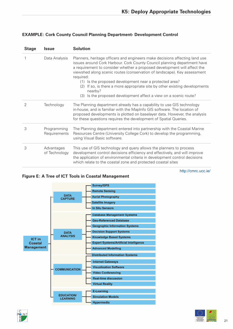
Key Action 5Deploy Appropriate TechnologiesThere is a great array of Information and Communication Technologies (ICT) which have vastly improved our ability to collect, store, analyse and disseminate coastal information. For consideration, we can divide these into the categories of Data Capture, Data Analysis, Communication and Education/Learning.
WHYWith such a vast array of technologies (see Figure E), the problem can be choosing how to spend limited finance. A range of options are available. Those with a low budget should not be discouraged from implementing a system. Low-technology solutions to information management can still make a significant difference, given the current lack of data co-ordination.
Linking Existing Technology: HarmonisationIn the case of Integrated Coastal Management, the important action is sometimes less about building new technology than improving inter-operability between existing tools owned by a variety of organisations. Some ICTs have a long history of use in the coastal zone, but remain unlinked to other data sources at national, regional and local levels or inaccessible to people outside a certain institution. One can envisage the situation being improved by these tools being linked together in a distributed system. This linking can be ‘tight’ or ‘loose’ coupling- ranging from using technology to allow IT tools to directly link with one another (like ‘Java’ programming language online), to simply agreeing to send regular updates of datasets by email.
Developing New ToolsThe choice of technologies should be guided by the functionalities required for the system, which is in turn dependent on the questions being asked. For example, if at some stage users want to consider change in the environment over time for their analysis, then they are likely to need modelling capability; if at another stage users want to convey complex information to the public, then they may choose visualisation technologies.
HOW
1: Consider which forms of data collection/analysis/visualisation are required to undertake the assessment being considered
2: Existing Technologies which users are familiar with are likely to be in demand.
3: Consider which technologies have a capability for in house development or are within budget, and related questions of hardware and software requirements
K5: Deploy Appropriate Technologies
21
EXAMPLE: Cork County Council Planning Department- Development Control
Stage Issue Solution
1 Data Analysis Planners, heritage officers and engineers make decisions affecting land use issues around Cork Harbour. Cork County Council planning department have a requirement to consider whether a proposed development will affect the viewshed along scenic routes (conservation of landscape). Key assessment required:
Is the proposed development near a protected area?(1) If so, is there a more appropriate site by other existing developments (2) nearby?Is the proposed development affect a view on a scenic route?(3)
2 Technology The Planning department already has a capability to use GIS technology in-house, and is familiar with the MapInfo GIS software. The location of proposed developments is plotted on baselayer data. However, the analysis for these questions requires the development of Spatial Queries.
3 Programming Requirements
The Planning department entered into partnership with the Coastal Marine Resources Centre (University College Cork) to develop the programming, using Visual Basic software.
3 Advantages of Technology
This use of GIS technology and query allows the planners to process development control decisions efficiency and effectively, and will improve the application of environmental criteria in development control decisions which relate to the coastal zone and protected coastal sites
http://cmrc.ucc.ie/Figure E: A Tree of ICT Tools in Coastal Management
K5: Deploy Appropriate Technologies

22
Key Action 6Check for Quality AssuranceIf an information system is to avoid the ‘Rubbish in- Rubbish Out’ syndrome, it must put in place checks to assure users about the quality of the content in the system.
WHYInformation exhibits a range of accuracy and timeliness.9 If the information is poor, this can lead to bad decision-making. However, all data are characterised by some level of uncertainty and if guidelines about the restrictions on applying data are recorded within metadata, this can allow for appropriate use. As system designers it will not always be possible to check the reliability of data, and it may be up to users to make an informed decision based on Quality Assurance.
Quality Assurance for technical data includes putting in place filters which will check parameters, sensors or methods to show that techniques and procedures are working to produce accurate information. For more subjective data, such as reports and projects, this involves establishing a peer review process or user-based rating.
Another important part of quality assurance is identifying gaps in information, so the LIS should provide an opportunity for coastal stakeholders to give feedback about the potential missing sources of data.
HOW
1: Establish clear links between data sources and custodians, encouraging maintenance and update
2: Encourage users to look at in-house procedures for quality assurance
3: Standardisation of records, through approaches such as metadata
4: Disclosure of limitations for datasets
5: Dissemination of Best Practice
6: Peer review and rating of usefulness of data sources, through intelligence technologies
9 and also precision and resolution- although these are not ‘quality’ issues
K6: Check for Quality Assurance

23
Stage Issue Solution
1 Maintenance The CoastWeb Portal requires Data Providers to be registered with the system before information can be uploaded and encourages keeping datasets up to date.
2 Quality Assurance
The CoastWeb portal requires a minimum set of standard fields (some mandatory and others optional) in order to provide a basic description of each information resource. Users are able to make a judgement about the quality of the data on the basis of the metadata supplied.
3 Information Retrieval and Standards
CoastWeb has developed an ontology for the coastal zone which allows linking between datasets and key concepts via a network of related terms. This enables intuitive searching of resources within the site according to users needs.
5 Dissemination and Peer Review
CoastWeb aims at encouraging confidence in the available information resources through 3rd party maintenance of the site by a Network Manager.
6 Intelligent Technologies
The volume of information on the portal means that intelligent technologies are important in helping guide the user to relevant information.
6 User Involvement
Approaches to user participation are designed into the system to encourage a feeling of ownership by the user community, which may help contribute to peer review of documents
www.coastweb.info
EXAMPLE The Coastweb portal from CoastNet and COREPOINT
K6: Check for Quality Assurance
Figure F: Maintaining the Quality of Coastal Information

24
Key Action 7Implementation and TrainingIt is one thing to design and build a Local Information System, it is another thing to implement it and get coastal stakeholders using it in their everyday practice.
WHYLocal Information Systems are often developed through a number of phases, with gradual improvements to both the user friendliness of the tool, and the quality of data. This is why it is important to involve users from beginning to end, so that (1) They have some familiarity or recognition of the Information system when they come to use the test version (2) They believe in what the Local Information System can achieve, and are therefore willing to provide data to populate it (3)Their ‘wish list’ of things the LIS can do is reflected in the design of LIS rather than dramatic difference between what they expect and what is delivered (or if not, they understand why their wishes were unrealistic/unreasonable).
The system can be considered to be successfully implemented when it is part of the working practices of users, in a way that the web and email have become central to work in the information society. Developers should have a vision of coastal stakeholders arriving at work, thinking about their present questions, and turning to the LIS for their analysis and communications needs.
As the system is improved, the developer will have a good understanding of the technology and the data sources, whereas partners may not be familiar with the approaches used to handle information. Providing ‘hands-on’ support to individual organisations is a necessary part of the LIS implementation. This may include some form of training through workshops, personal visits or telephone calls which can improve user’s confidence in the system.
HOW
1: Gain feedback on the User-Friendliness of the system
2: Develop User Guidance
3: Provide Training on the System
EXAMPLE: Integrated Marine Information System (IMIS) VLIZ (Flanders Marine Institute)
Stage Issue Solution
1 User Friendly Interface
The Flemish Marine Data and Information Centre hosts the Integrated Marine Information System holding 110 000 records of data from 1000s of organisations concerning marine science in the North Sea. Users are able to interrogate the system online.
2 User Guidance
Users are able to search the system through a series of modular windows which allow them to define different search criteria. The Data Centre provides a service to assist users, using online request forms and contact details.
4 Training for Data Input
The Marine Data and Information Centre visits contributing organisations at the rate of about one per month to encourage good data custodianship and provide training on completing quite complex records. This is part of an ongoing cycle to improve the quality of the data holdings and user involvement, and requires careful attention to Version Control.
www.vliz.be/EN/Date_Centre/FMDC_Where_to_find_data
K7: Implementation and Training

25
ConclusionsWhat Now?
The seven key actions should be formulated for your case and a project plan should be constructed:
Key Action Who to Involve
1 . Justifying Information Systems Involve a broad constituency
2 . Having Clear Purposes Involve a Group of Users
3 . Involving Users Involve a Group of Users
4 . Solving Technical Obstacles Involve IT Experts (use these guidelines to brief them) and Users
5 . Deploying Technology Involve IT Experts and Users
6 . Checking for Quality Assurance Involve IT Experts and Users
7 . Implementation and Training Involve a Group of Users
Conclusions

26
Ap
pen
dix
1 F
unct
ions
of
Pla
nnin
g an
d M
anag
emen
t at
the
co
ast
Ap
end
icie
s

27
Ap
end
icie
s

28
Ap
end
icie
s
29
Ap
end
icie
s

30
Ap
end
icie
s

31
Appendix 2 Glossary
Distributed Systems Hardware, Software and datasets located on different parts of a network but accessible from one place.
ICT Information and Communication Technologies (see figure E for examples)
ICM Integrated Coastal Management
Harmonisation Establishing standards so that data can be matched with other data
Interoperability Putting together different tools (at various levels of connectivity) and creating the software or hardware required to do this
Ontologies A set of definitions connected to one another in a giant ‘web’ which shows their relationships.
Sustainability Dashboard
Tool invented by Consultative Group on Sustainable Development Indicators to succinctly show performance on economic, social, and environmental issues
Thesauri Dictionaries of keywords with like terms
AcknolwedgementsOver 120 coastal stakeholders were engaged in workshops during the research. Many thanks to all those COREPOINT partners who contributed to the development of workshops and information systems and provided input to the development of the Guidelines. Particular thanks to: Graham Lymbery, Rhoda Ballinger, Natasha Barker, David Green, Alex Midlen, Beverley McClean, Manuela de los Rios, Paul Wisse, Michelle Newton, Tom Smith, John McKenna, Manuelle Philippe, Maria Ferreira, Alan Pickaver, Daryl Walsh, Dino Dawen, Simon Claus, Vanessa Sutton, Miguel Berteloot, Josu Ramirez, Ceri Morgan, Rachel Williams, Fiona McNie, Loveday Jenkin, Sangeeta McNair, Karen Bowler, Dave Potter, Martin LeTissier, Cathal O’Mahoney, Darragh OSuilleabhain, Sinisa Vukicevic, Val Cummins and Jeremy Gault.
Appendicies

32
Appendix 3 References And Further InformationInformation SystemsBeynon-Davies P 2002 Information systems: an introduction to informatics in organisations Palgrave, Basingstoke.
Checkland PB and Holwell S 1998 Information, Systems and Information Systems Wiley, Chichester.
Eurosion, 2004 Guidelines for implementing local information systems dedicated to coastal erosion management. A Report to DG Environment.
Gunther O 1998 Environmental Information Systems Springer-Verlag, Berlin.
PEMSEA 2005 Integrated information management system for coastal and marine environment user manual. PEMSEA Technical Report 16 GEF/UNDP/IMP Regional Programme on Building Partnerships in Environmental Management for the Seas of East Asia (PEMSEA), Quezon City, Philippines.
UNESCO 1997 Chapter 5 Information Systems in: Methodological Guide to Integrated Coastal Management IOC, Paris.
UNEP 1996 Guide to Information Management in the Context of the Convention on Biological Diversity. UNEP, Nairobi, Kenya.
European Reports on Managing Coastal InformationCentre for Earth Observation (CEO) 1995 Collect User Requirement from Experimental User Community on Coastal Zones. ACRI Consortium, Cedex, France.
Smith System Engineering Ltd, HR Wallingford and Southampton Oceanography Centre 1996 Final report on a study of the information requirements for Coastal Zone Management. Smith System Engineering. UK.
Doody JP, Pamplin CF, Gilbert C and Bridge L 1998 European Union Demonstration Programme on Integrated Management of Coastal Zones, Thematic Study F- Information Required for Coastal Zone Management. Report to the European Environment Agency, Copenhagen, Denmark.
InfoCoast 1999 Info-Coast 99 Symposium Report. Coastlink, Coastal Marine Observatory/ EUCC, Dover, UK.
Millard K and Sayers P 2000 Maximising the use and exchange of coastal data. A guide to best practice. CIRIA Report C541, UK.
Distributed SystemsCranefield S 2001 Integrating environmental information: Incorporating metadata in a distributed information system's architecture Advances in Environmental Research 5, 319-325.
Information ServicesClark JR 1996 1.6.9 Information Services in: Coastal Zone Management Handbook CRC Publishing Co. Boca Raton, Florida.
Justifying Information Systems: Good data custodianshipNational Archives Guidance on Digital Records: http://www.nationalarchives.gov.uk/electronicrecords/advice/default.htm#toolkits
Justifying Information Systems: Freedom of Information/Access to InformationArhus Convention: http://www.unece.org/env/pp/
EU Proposal for a new Directive on Access to Environmental Information Com (2000) 402 http://www.europa.eu.int/comm/environment/docum/00402_en.pdf
INSPIRE Directive 2007/2/EC http://www.ec-gis.org/inspire/directive/l_10820070425en00010014.pdf
Justifying Information Systems: Importance of communication and engagement with publicHaklay M 2002 Public environmental information: Understanding requirements and patterns of likely public use Area 34, 17-28.
Schroeder PC, Boudreau PR, Brehme CEW, Boyce AM, Evans AJ and Rahmani A 2001. The Gulf of Maine Environmental Information Exchange: Participation, observation, conversation Environment and Planning B: Planning and Design 28, 865-887.
Justifying Information Systems: Benefits of Group Learning and a Collaborative ApproachStojanovic TA 2004 Special Issue on Managing Coastal Information CoastNet Bulletin 8 (3)
Appendicies

33
Key Functions of Integrated Coastal ManagementKnecht R 1997 Integrated Coastal Zone Management for Developing Maritime Countries in Haq BU, Haq SM, Kullenberg G and Stel JH eds Coastal Zone Management Imperative for Maritime Developing Nations, Kluwer Academic Publishers, Dordrecht
Cicin-Sain B and Knecht RW 1998 Chapter 2 Definitions of Integrated Coastal Management and Fundamental Concepts in: Integrated Coastal and Ocean Management. Concepts and Practices Island Press Washington, D.C.
Vallega A 1999 Chapter 9 The Coastal Decision Making System in: Fundamentals of Integrated Coastal Management Kluwer/ Academic Press Dordrecht, Netherlands
Involving Users in Information System DesignCheckland PB and Holwell S 1998 Information, Systems and Information Systems. Wiley, Chichester.
Winter MC, Brown DH and Checkland PB 1995 A role for soft systems methodology in information systems development European Journal of Information Systems 4, 130-142
National Approaches to Coordinating Coastal InformationNational Oceanographic and Atmosphere Administration (NOAA) Coastal Services Centre, US http://www.csc.noaa.gov/
Atlantic Coastal Zone Information Steering Committee, Canada: http://aczisc.dal.ca/
MIDA, Irish Marine Digital Atlas, Ireland: http://mida.ucc.ie/contents.htm
Marine Data and Information Partnership, UK: http://www.oceannet.org/mdip/
Solve Policy Obstacles: Information PolicyFelleman, J. 1997. Deep Information. The Role of Information Policy in Environmental Sustainability. Ablex, US.
Example 1 Information Policy, Environment Agency, UK: http://www.environment-agency.gov.uk/business/444669/587179/1734119/513253/?version=1&lang=_e
Example 2 Memoranda of Agreement Chesapeake Bay Information Management System, US: http://www.chesapeakebay.net/cims/
Scholten H and van der Vlugt M 1990 A review of GIS applications in Europe, in Worrall L Geographic Information Systems: Developments & Applications Belhaven Press, London
Solve Policy Obstacles: Legal ConstraintsSee above: Justifying Information Systems: Freedom of Information/Access EUCC 2007 From Data to Information Coastline 16 (3/4)
Solve Policy Obstacles: Supply ChainsDyer B and Millard K 2002 A generic framework for value management of environment data in the context of integrated coastal zone management Ocean and Coastal Management 45 59-75
Solve Policy Obstacles: Cost of DataLonghorn R and Blakemore M 2003 Re-visiting the valuing and pricing of digital geographic information Journal of Digital Information 4.
Millard K, Brampton A, Brady A, Newcombe S, Vaughan R, Carelton C, Sauzade D, Kalaydijan R, Buisman E, Salz P, Cahill B and Monso JL 1998. Establishing the Value of Environmental Data Products. A guide to present practice in coastal zone management. HR Wallingford, Wallingford.
Solve Technical Obstacles: MetadataISO19115 (worldwide): http://www.iso.org/iso/en/CatalogueDetailPage.CatalogueDetail?CSNUMBER=26020&ICS1=35&ICS2=240&ICS3=70
Dublin Core (worldwide): http://www.dublincore.org/
Gemini 2.0 (UK): http://www.gigateway.org.uk/metadata/standards.html
E-GMS (UK): http://www.govtalk.gov.uk/schemasstandards/metadata.asp
FGDC Standards (US): http://www.fgdc.gov/standards
NOAA Arc View Metadata Collecto: http://www.csc.noaa.gov/metadata/download.html
NOKIS Metadata Information System for the North and Baltic Sea: www.nokis.org
Appendicies

34
Solve Technical Obstacles: Interoperability and HarmonisationCanessa RR, Butler MJA, LeBlanc C, Stewart C and Howes D 2007 Spatial Information Infrastructure for Integrated Coastal and Ocean Management in Canada Coastal Management 31 105 – 142
CEFAS 2004 Ten Questions on Interoperability. Coast Map News 6: http://www.cefas.co.uk/news-and-events/coast-map-news/coast-map-news-issue-6-(spring-2004).aspx
Longhorn, R., 2005. Chapter 9. Coastal Spatial Data Infrastructure. In: Bartlett, D., Smith, J. (Eds.), GIS for Coastal Zone Management. CRC Press, Boca Raton.
MOTIIVE, 2007. Data Harmonisation and Why it Matters to Coastal Managers. Report available from the MOTIIVE website: http://www.iode.org/motiivenew/index.php?option=com_content&task=view&id=5&Itemid=4
Solve Technical Obstacles: StandardsXML: Open Standard for sharing data across the internet
Spatial Standards: http://www.opengeospatial.org/
GML: Geography Mark Up Language- standard for spatial information
MOTIIVE Marine Overlays on Topography for Annex II Valuation and Exploitation, an EU 6th Framework RTD Project: http://www.motiive.net/
Solve Technical Obstacles: Data Definitions/Data FormatsESRI Marine Data Model: http://support.esri.com/index.cfm?fa=downloads.dataModels.filteredGateway&dmid=21
Marine Metadata Interoperability: http://marinemetadata.org/
Information and Communication Technology for the Coast: OverviewsMarine Data News Online Journal: http://newsweaver.co.uk/coastmapnews/
O’Regan PR 1996 The Use of Contemporary Information Technologies for Coastal Research and Management Journal of Coastal Research 12 (1) 192-204
Stojanovic TA 2005 Special Issue on Managing Coastal Information Coastnet Bulletin 8 (3)
Technology: Data CaptureInternational Oceanographic Commission 2003 The Integrated Strategic Design Plan for the Coastal Ocean Observations Module of the Global Ocean Observing System. GOOS Report No. 125. UNESCO, Paris
Klemas VV 2000 Improving the management of coastal ecosystems through management analysis and Remote Sensing/GIS Applications: experiences from the Delware region. Graduate College of Marine Studies, University of Delware, Delaware
Coasta Services Center (NOAA) 2008 Remote Sensing for Coastal Management. Url: http://www.csc.noaa.gov/crs/rs_apps/ Accessed on 01.12.2007
Technology: Database ManagementOlsen R, De Leon D and White AT 2005 Do biophysical studies and coastal databases enhance coastal management sustainability? Several Philippine cases Ocean and Coastal Management 48 411-426
Technology: Coastal GISCoastGIS Conference Series: http://www.coastgis.org/
Wright, D.J., Blongewicz, M.J., Halpin, P.N., Breman, J., 2007. Arc Marine: GIS for a Blue Planet. ESRI Press, Redlands, CA.
Bartlett, D.J., Smith, J.L., 2005. GIS for Coastal Zone Management. CRC Press, Boca Raton.
Green, D.R., King, S.D., 2003. Coastal and Marine Geo-Information Systems: Applying Technology to the Environment. Kluwer, Dordecht.
Kucera GL 1994 Object-Oriented Modeling of Coastal Environmental Information Marine Geodesy 18 183-196
Technology: ModelsLakhan, V.C. (ed.) 2003 Advances in Coastal Modeling. Elsevier Oceanography Series 67. Elsevier, Netherlands.
Appendicies
35
Technology: Decision-Support SystemsJones PD, Tyler AO and Wither AW 2002 Decision-support Systems: Do they have a Future in Estuarine Management? Estuarine and Coastal Shelf Science 55 993-1008
Oxley T, McIntosh BS, Winder N, Mulligan M and Engelen G 2004 Integrated modelling and decision-support tools: a Mediterranean example Environmental Modelling and Software 19 999-1010
Verbeek M and Wind HG 2001 The development of Decision Support Systems for interactive planning in ICZM in Europe. Lessons learned from WadBOS. INFRAM,
Van Kouwen F, Dieperink C, Schot P and Wassen M 2008 Applicability of decision support systems for integrated coastal zone management Coastal Management 36 19-34
Westmacott S 2001 Developing decision support systems for integrated coastal management in the tropics: is the ICM decision-making environment too complex for the development of a useable and useful DSS? Journal of Environmental Management 62 55-74
Wiggins SM 2007 Rationalisation of decision support for integrated coastal zone management Unpublished PhD Thesis Southampton University, Southampton
Technology: Expert SystemsMoore AB, Morris KP, Blackwell G, Gibson SE and Stebbing A 1998 An Expert System for Coastal Zone Management: a geomorphological case study Marine Pollution Bulletin 37 361-370
McGlade J and Hogarth AN 1997 SimCoast TM: an expert system for integrated coastal zone management and decision-making Paper presented at EU-NOAA Workshop on Managed Ecosystems Narragansett, RI 17-19 September 1997
Technology: VisualisationBrown, I., Jude, S.R., Koukoulas, S., Nicholls, R., Dickson, M., Walkden, M., 2006. Dynamic Simulation and Visualisation of Coastal Erosion. Computers, Environment and Urban Systems 30, 840-860.
Technology: Virtual RealityCOREPOINT 2007. A Template for Virtual Reality Simulations. Compiled as part of the COREPOINT Project. http://crc67.ucc.ie/corepoint/wp37
Technology: Internet and Internet GatewaysKay R and Christie P 2001 The Impact of the Internet on Coastal Management: An Initial Analysis Coastal Management 29 157-181
Technology: E-LearningFletcher S and Dodds W 2003 The Use Of A Virtual Learning Environment To Enhance ICM Capacity Building Marine Policy 27 241-247
Quality AssuranceWells DE, Cofino WP, Quevauviller P and Griepink B 1993 Quality Assurance of Information in Marine Monitoring; A Holistic Approach Marine Pollution Bulletin 26 (7) 368-375
Porter DE, Small T, White D, Fletcher M, Norman A, Swain D and Friedmann J 2004 Data management in support of environmental monitoring, research, and coastal management Journal of Coastal Research 20 Special Issue 45 9-16
Information System FailureLyytinen K 1988 Stakeholders, information system failures and soft systems methodology: an assessment Journal of Applied Systems Analysis 15 61-81
Coopers and Lybrand 1996 Managing Information Systems and Systems Risk: results of an international survey of large organisations. London: Coopers and Lybrand.
Appendicies