gunnison sage grouse centrocercus minimus conservation plan san
TRANSCRIPT
Gunnison Sage Grouse
Centrocercus minimus
Conservation Plan
San Juan County, Utah
May 2000

i
PREAMBLE
The Gunnison sage grouse (Centrocercus minimus) inhabits a limited area in Colorado andUtah. San Juan County is the only county in Utah where a Gunnison sage grouse populations arecurrently known to occur. On January 26, 2000, the U.S. Fish and Wildlife Service received apetition from the American Land Alliance requesting an emergency endangered species listingfor the Gunnison sage grouse. The petitioners cited increasing habitat fragmentation, reducedand limited population distributions, and low and declining localized populations as the primaryreasons justifying an emergency listing. Also in January, the U.S. Fish and Wildlife Servicebegan preparing a draft candidate and listing priority assignment form for Gunnison sage grouse.If approved, the species would be placed on a candidate list.
In 1972, a total of 175 males were counted strutting on leks in San Juan County. By 1999, thishad dropped to 43. In 1972, the sage grouse population in San Juan county was estimated to bebetween 583 and 1,050 birds. In 1999, the estimated population was between 143 and 258 birds.
The San Juan County Gunnison Sage Grouse Working Group (SWOG) was formed in 1996 forthe purpose of developing a conservation plan that could be implemented by state and federalwildlife resource agencies, private landowners, and local governments to benefit sage grousepopulations in the county. Implementation of the conservation Plan will ensure local ownershipin future management and land-use decisions; respect private property rights; and embracecommunity economic, cultural, and social values. This document identifies the conservationstrategies that have been and will continue to be implemented by private and public partners inSan Juan County to restore Gunnison sage grouse habitats and populations. Since SWOG wasformed, the number of strutting sage grouse males counted on the leks in 1999 (n = 43) hasincreased by 72% over 1997 (n = 25) counts.
This Plan has been initiated to conserve the species by reducing threats to the Gunnison sagegrouse, stabilizing the population, and maintaining its ecosystem. This document’s primarypurpose is to conserve this species by implementing voluntary conservation actions described inthis Plan.

ii
Table of Contents Page
PREAMBLE . . . . . . . . . . . . . . . . . . . . . . . . . . . . . . . . . . . . . . . . . . . . . . . . . . . . . . . . . . . . . . . . . iTABLE OF CONTENTS . . . . . . . . . . . . . . . . . . . . . . . . . . . . . . . . . . . . . . . . . . . . . . . . . . . . . . . iiLIST OF TABLES AND FIGURES . . . . . . . . . . . . . . . . . . . . . . . . . . . . . . . . . . . . . . . . . . . . . . ivI. PLAN BACKGROUND . . . . . . . . . . . . . . . . . . . . . . . . . . . . . . . . . . . . . . . . . . . . . . . . . . 1
A. Introduction and Purpose. . . . . . . . . . . . . . . . . . . . . . . . . . . . . . . . . . . . . . . . . . . . . . 1B. Plan Area Description and Boundary . . . . . . . . . . . . . . . . . . . . . . . . . . . . . . . . . . 1C. Plan Process . . . . . . . . . . . . . . . . . . . . . . . . . . . . . . . . . . . . . . . . . . . . . . . . . . . . . . 1D. Policies . . . . . . . . . . . . . . . . . . . . . . . . . . . . . . . . . . . . . . . . . . . . . . . . . . . . . . . . . . 2E. Definitions of Terms . . . . . . . . . . . . . . . . . . . . . . . . . . . . . . . . . . . . . . . . . . . . . . . 3F. List of Acronyms and Abbreviations . . . . . . . . . . . . . . . . . . . . . . . . . . . . . . . . . . . 6
II. PLAN DEVELOPMENT- HABITAT CONSERVATION ASSESSMENT . . . . . . . . . . 7A. Species Description . . . . . . . . . . . . . . . . . . . . . . . . . . . . . . . . . . . . . . . . . . . . . . . . 7B. Sage Grouse Status and Distribution . . . . . . . . . . . . . . . . . . . . . . . . . . . . . . . . . . . 7
Gunnison sage grouse distributions and population estimates . . . . . . . . . 7C. Factors Contributing to the Decline of Gunnison Sage Grouse Populations . . . . 11
Land use changes . . . . . . . . . . . . . . . . . . . . . . . . . . . . . . . . . . . . . . . . . . . 11Livestock grazing . . . . . . . . . . . . . . . . . . . . . . . . . . . . . . . . . . . . . . . . . . . 15
Water and wet meadows . . . . . . . . . . . . . . . . . . . . . . . . . . . . . . . . . . . . . 15 Conversion of lek sites . . . . . . . . . . . . . . . . . . . . . . . . . . . . . . . . . . . . . . . 16 Drought . . . . . . . . . . . . . . . . . . . . . . . . . . . . . . . . . . . . . . . . . . . . . . . . . . 16 Predation . . . . . . . . . . . . . . . . . . . . . . . . . . . . . . . . . . . . . . . . . . . . . . . . . 16 Pipeline developments . . . . . . . . . . . . . . . . . . . . . . . . . . . . . . . . . . . . . . . 17
Highways and other roads . . . . . . . . . . . . . . . . . . . . . . . . . . . . . . . . . . . . 18Lack of management . . . . . . . . . . . . . . . . . . . . . . . . . . . . . . . . . . . . . . . . 18Weeds . . . . . . . . . . . . . . . . . . . . . . . . . . . . . . . . . . . . . . . . . . . . . . . . . . . . 18
D. Goals and Objectives . . . . . . . . . . . . . . . . . . . . . . . . . . . . . . . . . . . . . . . . . . . . . . 18Goals . . . . . . . . . . . . . . . . . . . . . . . . . . . . . . . . . . . . . . . . . . . . . . . . . . . . 18Population objectives . . . . . . . . . . . . . . . . . . . . . . . . . . . . . . . . . . . . . . . . 18
Habitat objectives . . . . . . . . . . . . . . . . . . . . . . . . . . . . . . . . . . . . . . . . . . 19

iii
III. PLAN IMPLEMENTATION - CONSERVATION STRATEGIES . . . . . . . . . . . . . . . . 20A. Desired Plan Outcomes . . . . . . . . . . . . . . . . . . . . . . . . . . . . . . . . . . . . . . . . . . . . 20B. Habitat Enhancement Accomplishments . . . . . . . . . . . . . . . . . . . . . . . . . . . . . . . 20C. Priority Conservation Strategies . . . . . . . . . . . . . . . . . . . . . . . . . . . . . . . . . . . . . 21D. Summary of Priority Implementation Actions By Conservation Strategy . . . . . 23
Develop Public Support and Funding Base for the Conservation Plan. . 23 Monitoring and Evaluation . . . . . . . . . . . . . . . . . . . . . . . . . . . . . . . . . . . 23 Species Protection and Population Enhancement . . . . . . . . . . . . . . . . . . 24
Restoring and Improving Habitat Quality . . . . . . . . . . . . . . . . . . . . . . . . 25Reducing Physical Disturbances . . . . . . . . . . . . . . . . . . . . . . . . . . . . . . . 25
E. Implementation Schedules . . . . . . . . . . . . . . . . . . . . . . . . . . . . . . . . . . . . . . . . . . 26
V. SIGNATURES . . . . . . . . . . . . . . . . . . . . . . . . . . . . . . . . . . . . . . . . . . . . . . . . . . . . . . . . . 33
VI. REFERENCES . . . . . . . . . . . . . . . . . . . . . . . . . . . . . . . . . . . . . . . . . . . . . . . . . . . . . . . . 36
VII. APPENDICES . . . . . . . . . . . . . . . . . . . . . . . . . . . . . . . . . . . . . . . . . . . . . . . . . . . . . . . . . 37A. San Juan County Gunnison Sage Grouse Working Group Members . . . . . . . . . 37B. San Juan County Gunnison Sage Grouse Conservation Area Vegetation
Classifications. . . . . . . . . . . . . . . . . . . . . . . . . . . . . . . . . . . . . . . . . . . . . 37C. Habitat Mixture Seeded on CRP Land in San Juan County Gunnison
Sage Grouse Conservation Plan Area. . . . . . . . . . . . . . . . . . . . . . . . . . . . 40D. Appendix D . . . . . . . . . . . . . . . . . . . . . . . . . . . . . . . . . . . . . . . . . . . . . . . . . . . . . 41

iv
List of Tables and Figures
Table 1. Gunnison sage grouse lek counts (maximum numbers of males observed) in San Juan County, 1970-99 . . . . . . . . . . . . . . . . . . . . . . . . . . . . . . . . . . . . . . . . . . . 9
Table 2. Land use and vegetation changes in the San Juan County Gunnison Sage Grouse Conservation Area, 1984-1998. . . . . . . . . . . . . . . . . . . . . . . . . . . . . . . . . . . . . . . . . . . . . 14
Figure 1. Gunnison sage grouse Conservation Area. San Juan County, Utah. . . . . . . . . . . . . . . 5
Figure 2. 1984 Core Area vegetation types from LandSat 30m TM imagery. . . . . . . . . . . . . . 12
Figure 3. 1993 Core Area vegetation types from LandSat. 30m TM imagery. . . . . . . . . . . . . 13
Figure 4. Colorado Plateau Sage Grouse Data . . . . . . . . . . . . . . . . . . . . . . . . . . . . . . . . . . . . . . 22

1
I. PLAN BACKGROUND
A. Introduction and Purpose
The San Juan County Gunnison Sage Grouse Working Group (SWOG) was formed in 1996 toidentify and implement community-based conservation strategies to reverse the decline of sagegrouse populations in the county. From the onset, SWOG has sought wide local citizeninvolvement. SWOG consists of public management agencies, private landowners, localcitizens, and private conservation groups. A list of SWOG members can be found in Appendix A.
B. Conservation Area Description and Boundary
San Juan County is located in southeastern Utah and consists of 7,821 square miles (Figure 1). Approximately 6% of the county (324,921 acres) consists of 208 privately-owned farms whichare engaged in agriculture. In 1994, agriculture enterprises in San Juan County generated over$13 million in income, slightly over 10% of the county's total personal income. In 1996, SanJuan County ranked 5th among all Utah counties in total grain production with over 48,000 acresharvested.
The San Juan County Conservation Area (CA) boundary was delineated using current andhistoric habitats, sage grouse observations, and an assessment of the potential for remainingsagebrush areas in the county to provide suitable habitat. The CA encompasses rural areas, ruralresidential dwellings, and agricultural croplands. While it was necessary to include these areasbecause of their habitat potential, however, we make no inferences regarding any changes inexisting land use. Individual landowner participation, although strongly encouraged by SWOG,is strictly voluntary.
C. Plan Process
SWOG recognizes that most of the Gunnison sage grouse in the county depend heavily onprivate lands for habitat. Thus, the San Juan County Gunnison Sage Grouse Conservation Plan(Plan) is committed to conserving and enhancing Gunnison sage grouse populations that occuron privately-owned land in the county and contribute to the economic viability of farms, ranches,and the local community. This Plan consists of two parts. The first part is the HabitatConservation Assessment. The Assessment describes SWOG’s current understanding about thestatus of sage grouse distributions, habitat conditions, and factors that may be affecting sagegrouse populations in the county. Additional research is being planned to refine thisinformation. The second part is the Conservation Strategy. The Strategy identifies the Plan goalsand objectives, conservation actions, implementation schedules and responsibilities, evaluationguidelines, and monitoring requirements.
The Plan identifies conservation strategies to be implemented in guiding and coordinatingmanagement efforts across jurisdictional/land ownership boundaries to improve sage grouse

2
habitat conditions and reverse the decline of Gunnison sage grouse populations in the county. The Plan is designed to be adaptive. New information obtained or issues identified, will be usedto update the document and guide future implementation. This includes the results of ongoingmanagement and research activities implemented in the county to conserve the grouse or itshabitat where it occurs
D. Policies
Central to this conservation planning effort is the involvement and cooperation of locallandowners, citizens, community leaders, and resource agencies. SWOG agrees to workcollectively to implement appropriate management actions and activities that represent theinterests of all stakeholders. The Plan establishes a framework for coordinated management andcommunity-based grassroot support for the conservation of the species. SWOG agrees to:
C strive for the long-term commitment of its members to fund, support, collect,analyze, and use the data and/or information collected regarding the developmentand implementation of the Plan to guide resource management decisions.
C ensure maximum opportunity for public involvement in the planning and decision making process.
C create an atmosphere of cooperation among all stakeholders by maintaining anopen dialogue.
C implement actions identified in the Plan in a manner that achieves sage grouse population and habitat objectives and contribute to a stable and diverse economicbase in San Juan County.
C integrate public and private natural resource agency and organization efforts toachieve maximum efficiency and benefits in implementation of conservationactions identified in the Plan.

3
E. Definitions of Terms
Big sagebrush - includes Artemisia tridentata - big sagebrush; Artemisia tridentata ssp.vaseyana - mountain big sage; Artemisia tridentata ssp. Wyomingensis - Wyoming bigsagebrush.
Black sagebrush - Artemisia nova
Breeding complex - All lands within two miles of a known lek site. These areas providenesting sites and early brood rearing areas. Desired conditions include a canopy cover of 20-40% big sagebrush with an average height of 16 inches, 30% minimum grass canopy cover, and10% minimum forb canopy cover.
Brooding complex - All lands contained within a four mile radius of lek sites that includeriparian zones and wet meadows. The residual height of the vegetation in wet meadow areas isgreater than four inches between June 15 - July 31 on most (75%) of the area used as broodrearing habitat.
Brush management - Actions or activities conducted by SWOG to enhance sage grouse habitatby either increasing or decreasing sagebrush canopy cover. Actions or activities may includechemical treatments, planting, burning, and livestock grazing.
Buffer conservation area - This includes 155,000 acres of San Juan County that may offerpotential sage grouse habitat but is not currently known to be occupied (Figure 1).
Conservation easement - A non-possessing interest held by one person, group, or entity in landof another whereby the first person or entity is accorded partial use of the land for specificpurposes. An easement restricts but does not abridge the rights of the fee owner to the use andenjoyment of the land. Conservation easements may be implemented by SWOG to protect ormaintain habitat conditions of known Gunnison sage grouse lek sites and priority brood rearingareas.
Core conservation area - This includes 65,000 acres of habitat currently known to be occupiedby sage grouse. This area includes all active and historic lek sites, nesting, wintering, and broodrearing areas (Figure 1).
Corridors - These include areas that provide suitable habitat or exhibit the potential for thedevelopment of a suitable habitat that would serve as a travel corridor allowing birds to dispersebetween areas they presently occur. Corridors serve to reduce the effects of habitatfragmentation and allow for immigration and emigration between sub-populations and lek sites.
Fee title - The purchase of property and all associated property rights.
4
Lek or Lek Site - A specific area where sage grouse gather for display and mating in the spring.These areas are usually open areas that exhibit vegetation that is shorter than the surroundinghabitats. Lek sites are usually found on broad ridges, benches, or valley floors where visibilityand hearing acuity is excellent.
Lek Count - The high count of male sage grouse taken at 7-10 day intervals between late Marchand mid-May on all leks sites within the same lek area on the same day.
Livestock grazing management - The use and management of domestic livestock grazing toenhance sage grouse habitat conditions and/or reduce disturbance during critical nesting or broodrearing periods.
Off-Highway Vehicle (OHV) - Any motorized means capable of or designed for travel on orimmediately over land, water, or other natural terrain. Includes jeeps, 4-wheel drive vehicles,motorcycles, All Terrain Vehicles (ATV’s), and snowmobiles.
Predation management - Lethal and nonlethal actions or activities conducted by the properauthority with the permission of the land owner or manager that are designed to reduce theimpact of a specific predator or groups of predators on adult sage grouse, their nests, eggs,and/or young.
Strutting ground - see Lek
Wintering complex - All uplands available to sage grouse during the winter in conservationareas that remain relatively free of snow. Important areas during winters of deep snow aredrainages and other sites that exhibit tall sage brush, southerly or westerly aspects on slopesgreater than 5%. Other areas used during the winter include ridge tops and low sites (<5%slope) that are free of snow. Desired conditions for winter habitat include a minimum of 15%canopy cover of big sagebrush vegetation that averages 12 inches in height on southerly andwesterly aspects. Big sagebrush in drainages should exhibit a minimum of 30% canopy coverand averages 20 inches in height. Small areas that exhibit more dense sagebrush canopy cover(40% with an average height of 16 inches) should be interspersed throughout the wintering areaon south and west slope aspects.

5
Figure 1. Gunnison sage grouse Conservation Area. San Juan County, Utah.

6
F. List of acronyms and abbreviations
ATV - All Terrain VehicleAPHIS - Animal and Plant Health Inspection ServiceBI - Jack H. Berryman InstituteBLM - Bureau of Land ManagementBMP’s - Best Management PracticesCA - Conservation AreaCRP - Conservation Reserve ProgramFSA - Farm Services AgencyGIS - Geographic Information SystemGPS - Global Positioning SystemNGO - Non-Governmental OrganizationNRCS - Natural Resource Conservation ServiceOHV - Off-Highway VehicleRMEF - Rocky Mountain Elk FoundationPJ - Pinyon-JuniperPlan - The San Juan County Gunnison Sage Grouse Conservation PlanSWOG - San Juan County Gunnison Sage Grouse Working GroupTM - ThematicUDWR - Utah Division of Wildlife ResourcesUSU - Utah State UniversityUSDA WS - Wildlife ServicesUSFWS - U.S. Fish and Wildlife ServiceUSFS - U.S. Forest Service

7
II. PLAN DEVELOPMENT - HABITAT CONSERVATION ASSESSMENT
A. Species Description
Research conducted in the Gunnison Basin of Colorado and San Juan County in Utah hasconfirmed that two species of grouse inhabit both states. Sage grouse populations inhabiting thesagebrush regions north of the Colorado River in Utah have been taxonomically classified as theGreater sage grouse (C. urophasianus). Most sage grouse populations that occur south and east ofthe Colorado River are believed to be Gunnison sage grouse. Gunnison sage grouse birds aresignificantly smaller in size (males are 3.5 to 5.0 lbs. vs. 5.5 to 7.2 lbs.; females are 2.4 to 3.1lbs. vs. 3.3 to 4.0 lbs.) than the sage grouse that are found north of the Colorado river in Utah. They also differ in bill shape and size, tail patterns (large, more distinct white barring of tailfeathers), breeding behaviors, specialized featheration, and genetic composition. The matingbehavior of Gunnison sage grouse differs markedly from that of the larger bodied sage grouse innorthern Utah.
B. Sage Grouse Status Distribution
Sage grouse populations are restricted to the sagebrush rangelands of western North America.The distribution and abundance of sage grouse have dramatically declined. Sage grouse onceinhabited sagebrush rangelands in 15 states and 3 Canadian provinces. Currently, populationsexist in 10 states and 1 province.
In Utah, sage grouse inhabit sagebrush habitat of the Colorado plateau and the Great Basingeographic regions from 6,000 to 9,000 ft. in elevation. The largest populations of Greater sagegrouse are found in Rich County, the Park Valley area of Box Elder County, on Diamond andBlue Mountains in Uintah County, and on the Parker Mountain in Wayne County. Other smallerpopulations are found scattered in central and southern parts of the state. The Utah Division ofWildlife Resources (UDWR) believes that all of Utah's 29 counties at one time providedsagebrush habitat suitable for sage grouse. Pioneer journals indicate that sage grouse wereabundant throughout Utah in the early 1800's.
Today sage grouse in Utah occupy only 50% of their previous habitat and are one-half asabundant as they were prior to the 1850s. In 1996, UDWR biologists counted 126 sage grouseleks. An average of 10 males were counted per ground; down 51% from the long term averages.The reason for these declines have been attributed to land use practices that reduced, eliminated,or fragmented suitable sagebrush habitats.
Gunnison sage grouse distributions and population estimates
Gunnison sage grouse inhabit a limited area in Colorado and Utah. Range wide, breedingpopulations are estimated at 3,000 to 4,000 birds. San Juan County is the only county in Utahcurrently known to support a breeding population of Gunnison sage grouse. Although a few

8
birds are known to use habitats in Grand County, this is believed to be restricted to winteringbirds that wander in from Colorado .
In the last 30 years, Gunnison sage grouse populations in San Juan County have declined (Table1). Annual counts of strutting grounds or lek sites provide the best evidence of the declines. Beginning in 1970, UDWR biologists have monitored 7 lek sites in the county. In 1999, 43 birdswere counted on 4 leks. No birds were counted on the other 3 historic lek sites. These lek siteswere converted from sagebrush rangelands to cropland. After the conversion, the birds did notreturn to use the sites.
Lek counts provide wildlife managers with an estimate of the minimum breeding population.Studies have documented that during the breeding season the sex ratio of a sage grousepopulation is approximately 2 females for every male. If the number of males is known then it ispossible to estimate minimum population size. It is important to understand that a count willnever represent all the males in a population and any calculated population size may be lowerthan the actual population. The UDWR estimates that they are able to count 50% of the males ina population through lek counts, and that males represent 50% of the population. The formulasused by the UDWR can be manipulated to represent 75-90% of the males in a population beingcounted on the leks. Based on the 1999 lek counts, the UDWR estimated that the entire springsage grouse breeding population in San Juan County consist of 143-258 birds. This is down75% from 1972. In 1972, the UDWR estimated spring breeding populations between 583-1,059birds.

9
Table 1. Gunnison sage grouse lek counts (maximum numbers of males observed) in San JuanCounty, 1970-99
Year Counts by Leks Total
Barton Adams Hick-manFlats
SeepWash
Roring EastSeep
DodgePoint
1970 0 14 9 8 49 43 0 123
1971 6 32 2 4 51 61 0 156
1972 12 27 6 7 59 64 0 175
1973 0 19 7 0 48 31 0 105
1974 0 19 4 21 41 52 0 137
1975 0 16 21 2 27 49 0 115
1976 2 7 33 0 24 32 0 98
1977 0 9 50 0 18 40 0 117
1978 0 8 45 0 13 30 0 96
1979 0 6 39 0 5 17 0 67
1980 0 0 28 0 4 9 0 41
1981 0 3 39 0 0 21 0 63
1982 0 0 27 0 2 18 0 47
1983 0 0 35 0 9 15 0 59
1984 0 0 28 0 10 13 0 51
1985 0 0 16 0 7 9 0 32
1986 0 0 3 0 9 6 0 18
1987 0 0 3 0 10 8 0 21
1988 0 0 4 0 11 6 0 21
1989 0 0 3 0 16 11 0 30
1990 0 0 4 0 15 9 0 28
1991 0 0 5 0 11 8 0 24

10
1992 0 0 6 0 16 14 0 36
1993 0 0 3 0 17 18 0 38
1994 0 0 0 0 18 17 0 35
1995 0 0 8 0 16 14 0 38
1996 0 0 0 0 14 14 0 28
1997 0 0 6 0 13 6 0 25
1998 0 0 13 0 15 4 0 32
1999 0 0 9 0 22 7 5 43
30 YearAve.
3 11 15 6 19 22 5 57

11
C. Factors Contributing to the Decline of Gunnison Sage Grouse Populations
Conversion of suitable sagebrush habitats to other uses, habitat fragmentation, the timing,intensity and duration of livestock grazing, and the deterioration of sagebrush habitats due tolack of management, noxious weed invasion, fire suppression, pesticide and herbicide use, anddrought have been implicated as the primary reasons for sage grouse population declines in theWest. Habitat loss and fragmentation also may increase sage grouse populations’ susceptibilityto predation, accidents, and other mortality factors. Although some sage grouse populations arehunted in Utah, Gunnison sage grouse populations have not been hunted since the mid-1970's. In the following section, we discuss in more detail some of the factors that may have directlyaffected Gunnison sage grouse populations in San Juan County.
Land use changes
Vegetation within the CA sagebrush habitats (230,000 acres), were mapped in 1998 using GIStechnology. A LandSat 30 m resolution thematic (TM) scene from 1984 (Figure 2) wascompared to 1993 imagery that was updated to reflect 1998 land use to determine if thelandscape spectral images had changed (Figure 3). Changes in spectral imagery between the twoyears would be reflective of vegetation changes. SWOG selected 1993 base imagery because itwould be representative of a post-Conservation Reserve Program (CRP) landscape. Thisimagery was updated to reflect 1998 land use by establishing randomly selected training sites in1998 in each of the major cover types and conducting a supervised classification. We selected1984 as the base for comparison. This was the first year that 30 m resolution Landsat imagerywas available for purchase and it also represented pre-CRP conditions. In addition, sage grousenumbers declined dramatically after 1984. Nineteen major vegetation/landscape types wereclassified in the CA (Appendix B).
Major land use changes have occurred during 1984 and 1998 (Figures 2 and 3, Table 2). Significant changes included declines in non-irrigated agricultural land, black sage, water areas,pinyon-juniper, and sagebrush areas exhibiting <15% canopy cover. Landscape vegetation/landuse types that increased included irrigated agriculture, rangelands, sagebrush areas exhibiting 15-25% and >25% canopy cover (Table 2).
Our analyses suggest that although the amount of rangeland acreage has increased in the CAbecause of CRP, the grass cover on CRP lands prior to 1998 have not provided importantsagebrush habitats. Additionally, the increase in big sagebrush canopy in other areas may haveresulted in a reduction in the quality and quantity of residual herbaceous cover that is importantfor sage grouse production and survival. Residual herbaceous cover (grasses and forbs) insagebrush areas is necessary to conceal nests and nesting hens, broods, and provide habitat forinsects upon which the chicks depend.
Figure 2. 1984 Core Area vegetation types from LandSat 30m TM imagery

12

13
Figure 3. 1993 Core Area vegetation types from LandSat. 30m TM imagery.

14
Table 2. Land use and vegetation changes in the San Juan County Gunnison Sage GrouseConservation Area, 1984-1998.
Land use/vegetation 1984 Acres 1998 Acres % change
Surface Water 320.7 204.4 -36%
Wet Meadows 3,560.3 3,706.9 +4%
Irrigated Agriculture 762.1 2,143.9 +181%
Non-irrigated 110,330.0 30,789.9 -72%
Urban 403.4 314.9 -22%
Pinyon-juniper 21,543.8 23,100.6 +7%
Black Sage 5,499.9 3,726.9 -32%
PJ/Mtn. Shrub 6,883.6 5,558.8 -19%
Big Sage >25%cover
7,881.9 42,943.8 +445%
Big Sage 15-25% cover
11,909.9 22,825.5 +92%
Big Sage <15%cover
16,488.6 7,482.7 -55%
Mountain Shrub 12,876.4 862.7 Different Polygons
Sage CRP mixture - 9,071.1
CRP >70% cover - 6,708.1
CRP 40-70% cover - 14,212.2
CRP 15-40% cover - 13,283.2
Rangeland 14,507 23,798.5 -64%
Unknown 0 10,558
Cloud cover 2,357.2 0
Bare Ground 9,502.9 8,214.6 -14%
TOTAL 224,828 229,507

15
Livestock Grazing
Livestock grazing has long been the primary use of the lands northeast of Monticello, Utah. Prior to the 1970's, thousands of domestic sheep used that area in the spring and fall for interimgrazing. At the same time, cattle also were being grazed.
This area, known as the "Flats," is still extremely important to many San Juan County ranchers. It represents the largest chunk of private land in the entire county. The sheep are gone, but cattlegraze there for a period of time in the spring and fall as they move from the winter to the summerrange, and back again. It provides an important link in the production system of many localcattle operations.
Research suggests that livestock grazing may conflict with sage grouse nesting and brood rearingif the seasons of use overlap. Sage grouse typically begin nesting in late April to early May withpeak hatching occurring in late May to early June. This period is also critical for local ranchers.Heavy livestock-use of sage grouse nesting areas can result in competition. During the springgrazing period, livestock may remove grasses which provide cover for nesting grouse and habitatfor insects which are needed by young grouse. Heavy livestock use of sage grouse nesting andbrood rearing areas in the fall may reduce the vegetation available for nesting or brood cover inthe following spring.
The magnitude of these potential conflicts can be exacerbated if existing livestock intensity ofuse and the timing and duration of grazing negatively impacts the quality and quantity of nestingand brood rearing habitats. Currently, little is known about where Gunnison sage grouse nestand raise their broods in San Juan County. This information is needed before SWOG canimplement conservation strategies that will benefit Gunnison sage grouse and minimize theimpacts on local ranching operations.
In view of this lack of information, the suggested conflict between grazing and the sage grousereproduction cycle must be reviewed very carefully. A blanket decision to eliminate grazing fora three month period of time in the spring over wide areas could have disastrous economicimpacts for many landowners. Key areas could be identified for seclusion, but the choice ofthese lands must be justified. Each specific lek and nesting ground needs to be evaluated on anindividual basis. With the development of new water sources and minimal fencing, many of thepotential problems could be managed.
Water and wet meadows
A reduction in water areas in the CA also may have impacted sage grouse production andsurvival. Hens select drainage channels and wet meadows in sagebrush habitats that exhibitabundant forbs and frequent moisture as brood rearing sites. The vegetation in these areasprovide habitat for insects. The location of these sites near dense sagebrush affords the hens andchicks escape cover.

16
In the past many landowners in the area did not have automatic control valves on the wells usedto fill their livestock watering tanks. Consequently, the tanks would overflow creating wetmeadow sites below the tanks. Landowners reported frequent observations of sage grouse broodsin these areas. With more efficient watering, the seasonal wet meadows have disappeared. Lastly, several smaller impoundments and larger reservoirs in areas have either silted in or beenwashed out. The loss of these reservoirs also has reduced the availability of wet meadow sites.
Conversion of lek sites
Current and historic lek sites occur in areas dominated by big sagebrush. The conversion ofsagebrush to agricultural use has eliminated suitable vegetation cover at 3 leks. These leks areno longer used. Drought San Juan County also experiences periodic droughts. Sage grouse production is directly affectedby drought. While sage grouse are not limited by free standing water in most cases, they arelimited by vegetation growth and insects lost during drought conditions. Research on sagegrouse suggests that both nesting success of females and brood survival tend to decline duringyears with below-normal precipitation. These reported affects can be magnified if sagebrushhabitats also are converted to other uses during drought periods.
Predation
Predation on Gunnison’s sage grouse is a naturally occurring dynamic process which has helpedto shape both predator and prey communities over time. However, due to changes in predatorhierarchy and composition, habitat quantity and quality, and prey abundance, predation mayhave significant impacts on remanent populations occupying fragmented habitats. Such may bethe case for the Gunnison sage grouse. SWOG recognizes that improving habitat conditions inconjunction with predation management can protect and increase sage grouse populations.
Predation of adult sage grouse by golden eagles, and ravens and magpies on nest and sage grousechicks is well documented and believed to be impacting the Gunnison birds that inhabit thecounty. Increasing eagle, raven, and magpie populations in the west, in combination withfavorable environmental conditions, have contributed to dramatic increases in the numbers ofgolden eagles, ravens, and magpies observed in the CA over the last 30 years.
The impacts of high densities of golden eagles on resident wildlife species is most pronounced inareas where the birds winter. When eagles are concentrated on winter ranges and prey isreduced, larger, slower flying species such as the Gunnison sage grouse are at increased risk ofpredation. Resident eagles may also take grouse during nesting and brood rearing periods.

17
Eagle damage management involves two specific strategies:
C Identification and reduction or modification of habitat conditions which facilitateeagle depredation situations. Management actions include the enhancement ormaintenance of suitable escape cover and the removal of environmentalconditions which attract eagles (i.e., carrion, and vegetation or structures such asunused telephone or utility poles that may function as roosting sites or huntingperches).
C Relocation of eagle abundance in key habitats by harassment, trapping andrelocation, supplemental feeding, etc.
All eagle, raven, and magpie damage management activities will be conducted consistent withexisting laws, regulations, and permits under the supervision of the Utah state director for USDAAnimal and Plant Health Inspection Service (APHIS) Wildlife Services (WS).
Predation is of concern primarily during the nesting season. Ground nesting birds are subject tonest destruction or direct predation while incubating their eggs and caring for flightlessjuveniles. When identified, predators may be removed from breeding complexes prior to thenesting season to decrease predation risks. Potential sage grouse predators occurring in the corearea during the nesting season may include coyote, red fox, striped skunk, ground squirrels, andraccoon. Coyote and red fox numbers may also be reduced on key wintering areas.
USDA/APHIS Wildlife Services has the statutory authority to cooperate with “ ... states, localjurisdictions, individuals, and public and private agencies, organizations, and institutions...” forthe control of wildlife damage. Wildlife Services will cooperate in the protection of Gunnison’ssage grouse through agreements with private landowners and SWOG.
Although predator management may be necessary for the maintenance and enhancement of sagegrouse populations, SWOG will conduct an evaluation of the need for predator control prior toimplementation. SWOG also realizes that substantial improvements of sage grouse habitats,which include escape cover, and may reduce the need for wide-scale predator management.
Pipeline development
The development of pipelines is becoming more common in sage grouse habitats. Pipelinedevelopment can have a negative impact on sage grouse during the breeding, nesting, and earlybrood rearing periods if not properly managed. However, reseeding of construction areas withdesirable forbs and grasses can be beneficial to sage grouse, especially if the width of the areadisturbed is minimal (< 100 yards) and the roads and trails used during construction andmaintenance are closed and reseeded after construction. In addition, tapping water pipelinesduring the spring and early summer to create wet meadows in brood areas may enhance sagegrouse brood survival and overall production.Highways and roads

18
A Gunnison sage grouse male was observed by a member of SWOG as being hit by a car in1998. Sage grouse prefer to walk to reach usable habitats throughout the year, except whensnow cover increases their conspicuousness. Increased traffic volumes on highways and off-roadvehicle use (OHV’s) could contribute to increased mortality of adults and young during thespring-fall periods. The development of a San Juan County access management plan couldbenefit sage grouse, other wildlife, and enhance trespass management efforts on private lands inthe CA.
Lack of management
Within CA sagebrush habitat, there are areas where the vegetative components other thansagebrush may be needed for sage grouse production and survival. As sagebrush cover increasesto over 30%; competition for water, sunlight, and nutrients may decrease production of desirableherbaceous understory species. In these areas, sagebrush may need to be removed and the sitesreseeded to suitable grass and forb mixtures.
Weeds
The most immediate concern in terms of undesirable plants encroaching on sage grouse habitat isthe spread of cheatgrass. Cheatgrass invasions in other states have increased the fire frequencyto the point that sagebrush stands have been eradicated. Thus, any sagebrush sites treated to openthe canopy cover must be immediately reseeded with desirable grasses and forbs to reduce weedinvasions.
D. Goals and Objectives
Goals
C Ensure long term conservation of Gunnison sage grouse within its historic range in San Juan County and assist in the development and implementation of range wide conservation efforts.
C Preservation and enhancement of personal income on privately-ownedagricultural lands that constitute Gunnison sage grouse habitat in San JuanCounty.
Population objectives
. C Estimated spring breeding population - To reestablish a minimum estimatedspring breeding population of 500 birds with 6-8 active lek areas each containinga 3 year count averages of 20-25 birds per lek. This increase would be measuredfrom 1997 population estimates. All current identified lek sites would beprotected from future risk through leases, conservation easements, or in fee title.The intent is to achieve this population goal in 15 years.

19
Habitat objectives
C Breeding complexes - To reestablish desired vegetation conditions on 50-75% of the area located within 2 miles of known lek sites within the core area. Desired conditions include a canopy cover of 20-40% big sagebrush with an averageheight of 16 inches, 30% minimum grass canopy cover, and 10% minimum forbcanopy cover. The desired habitat conditions will be achieved within 10 years.
C Brood rearing complexes - To reestablish desired vegetation conditions on 50-75% of the areas located within 4 miles of known lek sites within the core areawithin the next 10 year periods. Desired conditions include a canopy cover of 20-40% big sagebrush with an average height of 16 inches, 30% minimum grasscanopy cover, and 10% minimum forb canopy cover. The height of thevegetation in wet meadow areas is to be greater than 4 inches between June 15-July 31 on over 75% of the area used as brood rearing habitat.
C Wintering complexes - To reestablish desired vegetation conditions on 50% ofthe areas located within the 65,000 acre core area, and 25% of the vegetation conditions within the buffer areas, over the next 10 year period. Desiredconditions for winter habitat include a minimum of 15% canopy cover of bigsagebrush vegetation that averages 12 inches in height on southerly and westerlyaspects. Big sagebrush in drainages should exhibit a minimum of 30% canopycover and average 20 inches in height. Small areas that exhibit denser sagebrushcanopy cover (40% with an average height of 16 inches) should be interspersedthroughout the wintering area on south and west slope aspects.
C Corridors - To reestablish and maintain contiguous travel corridors consisting of
big sagebrush exhibiting >25% canopy coverage between breeding, broodrearing, and wintering complexes in the core area. This will be achieved withinthe next 15 years.

20
III. PLAN IMPLEMENTATION - CONSERVATION STRATEGIES
A. Desired Plan Outcomes
Implementation of the Plan will result in a broad base of local support necessary to coordinatemanagement across land ownership and jurisdictional boundaries to ensure survival of theGunnison sage grouse and the economic viability of San Juan County. To achieve this outcome,the Plan has been designed to be a dynamic document that will be formally reviewed annuallyand updated as new information becomes available. Annual progress reports will be provided toSWOG members including USFWS Ecological Services Offices located in Salt Lake City, Utahand Grand Junction, Colorado.
The success of this Plan will be measured by changes in habitat conditions and Gunnison sagegrouse population numbers in San Juan County. Another measure of success will be increasedparticipation of local landowners, the community, and public and private resource managementand conservation agency and organization efforts in conservation actions, and activities designedto achieve Gunnison sage grouse population and habitat objectives and maintain agriculturalprofitability.
The Plan is intended to augment the efforts of the Colorado Gunnison Sage Grouse WorkingGroup. Completion of the Colorado and San Juan County sage grouse conservation plans willreduce the risk to the species while ensuring local control over management decisions regardingthe species. SWOG will be responsible for implementing, monitoring, and updating the Plan. The monitoring and evaluation will be conducted by the Utah State University ExtensionService, College of Natural Resources, Jack H. Berryman Institute, and the Utah Division ofWildlife Resources.
B. Habitat Enhancement Accomplishments
In the late 1980s many landowners within the CA enrolled their lands in CRP. Most of thedecline in non-irrigated agricultural land can be explained by CRP. In 1993, over 43,000 non-irrigated croplands were converted to CRP grasslands. Also, during this period, an additional10,000 acres of cropland was converted to rangeland.
Many of CRP contracts in the county expired in 1995. Based on new national CRP eligibilityrequirements, many of these lands and other agricultural lands located in the county would nothave been eligible for enrollment in the program. SWOG worked with the Natural ResourceConservation Service (NRCS) state and technical committees to have San Juan Countydesignated as a state conservation priority area under CRP because of Gunnison sage grouse.Designation as a state conservation priority area meant that lands submitted for CRP enrollmentconsideration in the county did not have to meet the CRP erodibility index requirements to beconsidered eligible for the program. However, with the designation, landowners could stillenroll these lands if they opted to implement committee approved wildlife conservation seedingsand practices.

21
As of February 2000, a total of 36,825 acres of private land within the 65,000 acre core area hadbeen enrolled in CRP. Approximately 32,667 acres were enrolled as a result of the Gunnisonsage grouse conservation priority initiative. The UDWR, in conjunction with NRCS, developed asage grouse seed mixture for use in San Juan County (Appendix C). The total cost of reseedingthese areas to the sage grouse seed mixture was $531,688. The UDWR and private landownerseach paid $132,921 of this amount. Farm Services Agency (FSA) cost-shared for the remaining$265,844. The total cost of establishing the CRP program in San Juan County was $1,222,728.This includes the seed cost and $691,042 that was spent to prepare the land for reseeding. Halfof the costs of land preparation was paid for by the landowners ($345,521) and half was cost-shared by FSA. CRP leases generate in excess of $1,000,000 in annual income for participatinglandowners.
C. Priority Conservation Strategies
The strategies identified in the Plan will be implemented and evaluated by SWOG. Although thestrategies may be applied to approximately 230,000 acres identified as potential sage grousehabitat, priority will be placed on areas within the 65,000 acre core conservation area which areor have been inhabited by grouse and used as nesting, brooding, wintering, and lek sites (Figure4).

22
Figure 4. Colorado Plateau Sage Grouse Data

23
D. Summary of Priority Implementation Actions By Conservation Strategy
C Develop Public Support and Funding Base for the Conservation Plan.
Action: Communicate Conservation Plan goals, objectives, andaccomplishments to other stakeholders in the agricultural, naturalresource, and legislative community.
Strategies: Publish a San Juan County Gunnison Sage Grouse Conservation Planinformational brochure for public distribution.
Host media interviews with SWOG representatives from the agriculturaland wildlife conservation communities.
Organize and conduct an annual San Juan County Gunnison Sage Grouse Conservation Festival to draw attention to the plight of the birds and theefforts of the local community to restore the populations.
Develop a series of promotional items that carry a designer logo. These promotional items will be sold at local and regional retail outlets toincrease the visibility and support of the county conservation efforts andgenerate revenue to support Plan implementation.
C Monitoring and Evaluation
Action: Seek endorsement and funding of the San Juan County GunnisonSage Grouse Conservation Plan through the Utah Department ofNatural Resources Endangered Species Mitigation Fund, the UtahLegislature, and other sources.
Strategies: SWOG will meet as a working group every 6 months to review Planprogress and implementation.
SWOG partners will contact their legislative representatives regarding theprocess and send letters of support to the executive director of theDepartment of Natural Resources, the Utah Governor’s Office, and Utah’scongressional delegation.
SWOG representatives will testify before the appropriate Utah Legislaturecommittees about the San Juan County Conservation Plan to increaselegislator awareness and support for similar efforts in other areas of Utah.
24
Action: Monitor impacts of conservation strategies on sage grouse habitat andpopulation.
Strategies: SWOG will initiate an ongoing research program to monitor annual sagegrouse population numbers and trends, monitor sage grouse habitat use,nest success, and mortality, and identify land uses action which mayconflict with the goals and objectives of the Plan. This work will begin in2000.
This research program will establish permanent vegetation transects tomonitor habitat responses on CRP and other managed sites to determineprogress toward desired habitat conditions.
C Species protection and population enhancement
Action: Monitor landscape sage grouse habitat conditions to include land useand vegetation changes in the conservation area.
Strategy: USU will update the existing GIS land use database of the CA landscapevegetation and habitat conditions every 5 years. This update will allowSWOG to compare pre- and post-Plan time periods to inventory and maphabitat changes that resulted because of conservation strategyimplementation.
Action: Delineate and map all lek sites within the conservation area, monitornumbers of strutting cocks, estimate population numbers and trends,and determine priority brood rearing and wintering complexes.
Strategy: Conduct annual lek, brood, and winter surveys. Priority areas identifiedwill be added to the SWOG GIS data base. GPS locations of all nesting,brood rearing, and wintering complex will be recorded and sitesdelineated on the SWOG GIS data base.
Action: Increase the abundance and distribution of Gunnison sage grouse.
Strategies: Enhance sage grouse habitat conditions (See restoring and improvinghabitat quality section).
Implement a predation management program.
Reintroduce sage grouse obtained from Colorado into restored habitats.

25
C Restoring and Improving Habitat Quality
Action: Develop a vegetation management Plan for the core area.
Strategies: Identify and GIS map existing and potential nesting, brood rearing, wintering areas, and travel corridors to include land ownership.
Work with SWOG partners to manage core and buffer areas to achieve defined sage grouse habitat objectives.
Work with SWOG partners to develop and implement grazingmanagement plans to achieve Gunnison sage grouse habitat objectives.
Work with the USU County Extension Office and the Utah Department of Agriculture and Food to identify and manage noxious weed species to improve sage grouse habitat and livestock productivity.
Action: Protect critical lek, nesting, brood rearing, and wintering areas.
Strategies: Secure or acquire important habitats through fee title from willing sellers, land exchanges, conservation easements, tax incentives, voluntary cooperative agreements, CRP leases, grazing lease agreements, etc.
C Reducing Physical Disturbance
Action: Disturbance that negatively impacts sage grouse will be identified andmanaged. This includes predation management, recreation use, construction and surface disturbances, and other uses that may conflict with critical biological periods.
Strategies: Delay or modify construction start up dates or hours to minimize impacts in sage grouse nesting and brood rearing areas.
Designate OHV use areas and other requirements.
Manage off-road travel in key sage grouse areas.
Implement predation management in key nesting, brooding rearing andwintering area.

26
E. Implementation Schedules and Responsibilities
San Juan County Gunnison Sage Grouse Working Group (SWOG) ConservationStrategies.
Conservation and ManagementStrategies
Examples of ways to accomplish Implementation Schedule
When Who
Develop Public Support and Funding Base
Provide information to the public,landowners and others that identifiessage grouse habitat needs, conditions,and sage grouse population levels. Identify concerns and opportunities toimprove conditions for sage grouse inthis area.
Maps, newspaper articles, videos.
Meetings with interested landowners.
Publish a San Juan County GunnisonSage Grouse Conservation PlanBrochure.
2000 - ongoing
2000 - ongoing
2000 - ongoing
SWOG, UDWR,USU, BI
Work with interested parties,landowners, and others to bring about abetter understanding of sage grouseneeds, including the value andimportance of sage grouse and sagegrouse habitat, and provide a basis forsharing ideas and reaching agreementon ways to improve sage grouse habitatand increase populations.
Meetings with interested landowners,government/regulatory entities (e.g.countries).
Developing management plans,cooperative agreements, etc.
Distribute information on: importanceof sage grouse; availability of incentiveprograms, BMPs, effects of certainland uses on grouse.
Coordinate sage grouse conservationactions with management plans forother wildlife species in San JuanCounty.
Continue to work with other groups:Nature Conservancy, Envision Utah,RMEF, Soil Conservation Districts,Utah Farm Bureau, etc., in Colorado tofurther sage grouse conservation effortsregion wide.
Communicate with other sage grouseworking groups.
2000 - ongoing
2000 - ongoing
2000 - ongoing
2000 - ongoing
2000 - ongoing
2000 - ongoing
SWOG
SWOG
SWOG, UDWR,USU Extension,NRCS
SWOG, UDWR,USU Extension
SWOG, UDWR,NRCS, PrivateLandowner, USUExtensionBLM, NRCS,FWS
SWOG
27
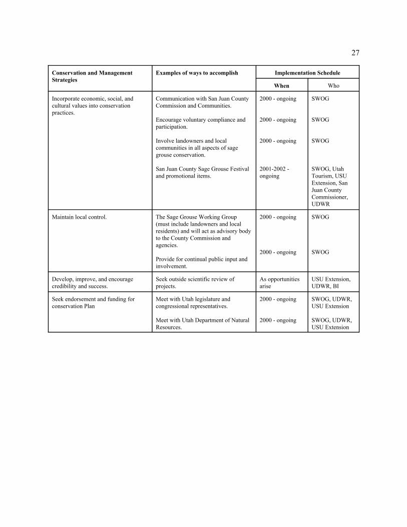
Conservation and ManagementStrategies
Examples of ways to accomplish Implementation Schedule
When Who
Incorporate economic, social, andcultural values into conservationpractices.
Communication with San Juan CountyCommission and Communities.
Encourage voluntary compliance andparticipation.
Involve landowners and localcommunities in all aspects of sagegrouse conservation.
San Juan County Sage Grouse Festivaland promotional items.
2000 - ongoing
2000 - ongoing
2000 - ongoing
2001-2002 -ongoing
SWOG
SWOG
SWOG
SWOG, UtahTourism, USUExtension, SanJuan CountyCommissioner,UDWR
Maintain local control. The Sage Grouse Working Group(must include landowners and localresidents) and will act as advisory bodyto the County Commission andagencies.
Provide for continual public input andinvolvement.
2000 - ongoing
2000 - ongoing
SWOG
SWOG
Develop, improve, and encouragecredibility and success.
Seek outside scientific review ofprojects.
As opportunitiesarise
USU Extension,UDWR, BI
Seek endorsement and funding forconservation Plan
Meet with Utah legislature andcongressional representatives.
Meet with Utah Department of NaturalResources.
2000 - ongoing
2000 - ongoing
SWOG, UDWR,USU Extension
SWOG, UDWR,USU Extension

28
Conservation and ManagementStrategies
Examples of ways to accomplish Implementation Schedule
When Who
Monitoring/Evaluation SWOG
SWOG will meet every 6 months toreview Plan implementation andprogress
Identify important sage grouse habitat,limiting factors, and activities that havethe potential to impact sage grouse ortheir habitat. Identify and evaluatecritical sage grouse habitats.
Meetings will be held in San JuanCounty with the working group and thelandowners.
Habitat mapping and monitoring.
Meetings with interested landowners.
Joint-interagency/landownerevaluation, information sharing.
2000 - ongoing
2000 - ongoing
2000 - ongoing
2000 - ongoing
UDWR, USUExtension, BI
Continue to gather or initiate thecollection of basic resource data tobetter understand and documentconditions for sage grouse, includingresponse habitat.
Hire a graduate student to collectbaseline habitat and population data.
Habitat mapping and monitoring.
Meetings with interested landowners.
Joint-interagency/landownerevaluation, information sharing.
2000 - ongoing
2000 - ongoing
2000 - ongoing
2000 - ongoing
SWOG. UDWR,USU, BI, WS,USFWS, BLM
Species Protection and Population/Habitat Enhancement
Develop and encourage incentives forlandowners and others to avoid ormitigate loss of sage grouse habitat.
Land exchanges.
Conservation Easements/Leases.
Transferrable development rights.
Payment for non-use.
Application of specific land-usepractices that benefit grouse.
Reintroduce sage grouse to restoredhabitats.
2000 - ongoing
As opportunitiesarise
As opportunitiesarise2000 - ongoing
2000 - ongoing
As opportunitiesarise
UDWR, FWS.SWOG, BLM,FS, NatureConservancy,UDWR, NGOs
UDWR, NGOS
UDWR, NGOS
UDWR, FWS,SWOG, NGOSLandowners
UDWR, NRCS,SWOG, PrivateLandowner

29
Conservation and ManagementStrategies
Examples of ways to accomplish Implementation ScheduleImplementation ScheduleWhen Who
Enhance and restore historic andexisting sage grouse habitat to offsetloss of habitat elsewhere.
Reseeding or reclaiming areas, creatingor protecting wet meadow areas, andimplementing vegetation treatments(i.e., prescribed burning, Dixieharrowing, etc) to rejuvenate habitatsand maintain leks.
Reintroduce sage grouse into restoredhabitats.
Ongoing
As opportunitiesarise
SWOG, UDWR,NRCS, USFWSLandowners,BLM
UDWR
Prevent loss and fragmentation ofhabitat from construction of roads,utilities.
Identify changes to county land useregulations which would benefit sagegrouse.
Relocation or modification of newutility lines, roads, development, etc. inkey grouse habitat and providerecommendations to the county or leadagency.
Pipeline or power line modifications.
For example: seek a county resolutionthat supports and encourages the use of conservation easements, mitigation ofnon-critical habitat areas, andpreventing loss of critical habitat.
As opportunitiesarise
Ongoing
Ongoing
SWOG, San JuanCountyCommissioner
BLM, UDWR,San Juan CountyCommissionSWOG, San JuanCountyCommission
Restoring or Improving Habitat Quality
Enhance existing riparian areas bycreating or enhancing small wet areasto benefit sage grouse nesting andbrood rearing habitat.
Design and implement livestockgrazing management practices tobenefit riparian areas.
Modify or adapt pipelines/springs tocreate small wet areas.
2000 - ongoing
As opportunitiesarise
USU Extension,UDWR, FWS,NRCS
PipelineCompanies,UDWR, BLM,FWS, andlandowners
Reduce or modify situations that causepredation.
Modify power lines and wood fenceposts (to remove raptor perches) incritical sage grouse areas.
Cut pinyon-juniper trees near leks andelsewhere within potential sage grousehabitat to remove raptor perches.
As opportunitiesarise
2000 - ongoing
UDWR, BLM,SWOG, USDA,Wildlife Services,FWS
UDWR, BLM,SWOG, USDA,Wildlife Services,FWS
30
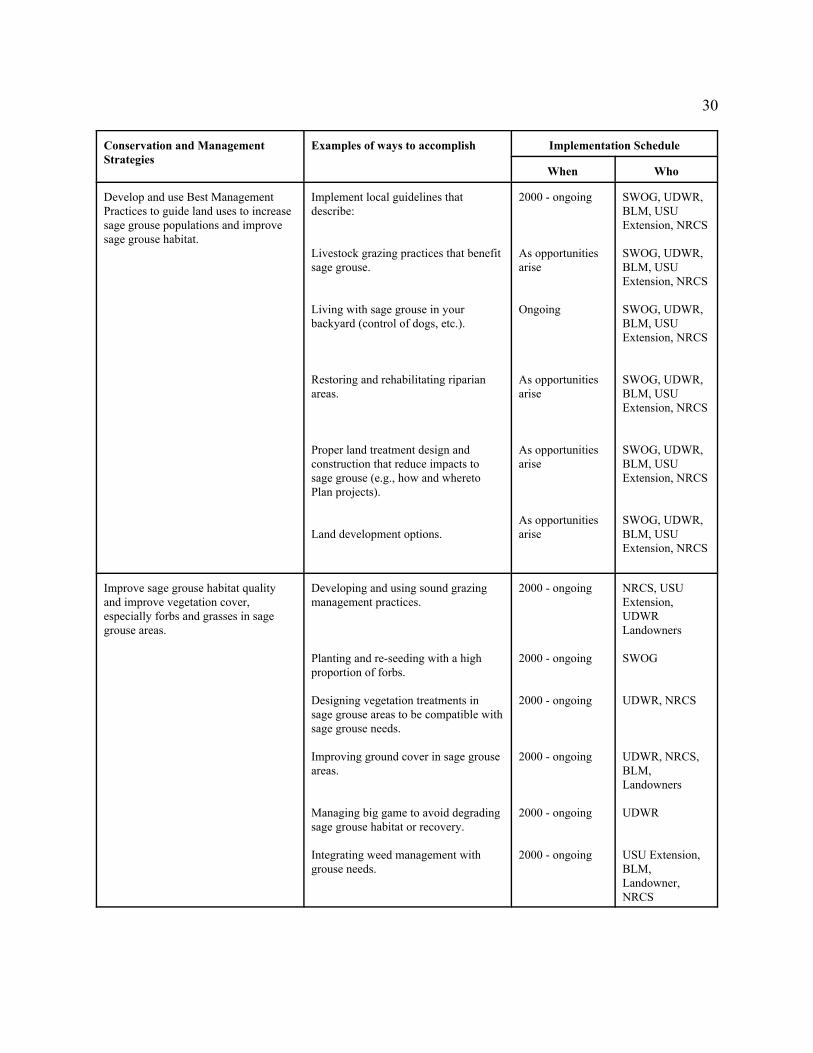
Conservation and ManagementStrategies
Examples of ways to accomplish Implementation Schedule
When Who
Develop and use Best ManagementPractices to guide land uses to increasesage grouse populations and improvesage grouse habitat.
Implement local guidelines thatdescribe:
Livestock grazing practices that benefitsage grouse.
Living with sage grouse in yourbackyard (control of dogs, etc.).
Restoring and rehabilitating riparianareas.
Proper land treatment design andconstruction that reduce impacts tosage grouse (e.g., how and wheretoPlan projects).
Land development options.
2000 - ongoing
As opportunitiesarise
Ongoing
As opportunitiesarise
As opportunitiesarise
As opportunitiesarise
SWOG, UDWR,BLM, USUExtension, NRCS
SWOG, UDWR,BLM, USUExtension, NRCS
SWOG, UDWR,BLM, USUExtension, NRCS
SWOG, UDWR,BLM, USUExtension, NRCS
SWOG, UDWR,BLM, USUExtension, NRCS
SWOG, UDWR,BLM, USUExtension, NRCS
Improve sage grouse habitat qualityand improve vegetation cover,especially forbs and grasses in sagegrouse areas.
Developing and using sound grazingmanagement practices.
Planting and re-seeding with a highproportion of forbs.
Designing vegetation treatments insage grouse areas to be compatible withsage grouse needs.
Improving ground cover in sage grouseareas.
Managing big game to avoid degradingsage grouse habitat or recovery.
Integrating weed management withgrouse needs.
2000 - ongoing
2000 - ongoing
2000 - ongoing
2000 - ongoing
2000 - ongoing
2000 - ongoing
NRCS, USUExtension,UDWRLandowners
SWOG
UDWR, NRCS
UDWR, NRCS,BLM,Landowners
UDWR
USU Extension,BLM,Landowner,NRCS
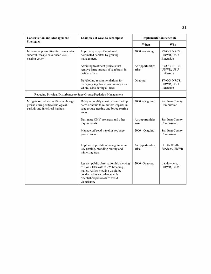
31
Conservation and ManagementStrategies
Examples of ways to accomplish Implementation Schedule
When Who
Increase opportunities for over-wintersurvival, escape cover near leks,nesting cover.
Improve quality of sagebrushdominated habitats by grazingmanagement.
Avoiding treatment projects thatremove large strands of sagebrush incritical areas.
Developing recommendations formanaging sagebrush community as awhole, considering all uses.
2000 - ongoing
As opportunitiesarise
Ongoing
SWOG, NRCS,UDWR, USUExtension
SWOG, NRCS,UDWR, USUExtension
SWOG, NRCS,UDWR, USUExtension
Reducing Physical Disturbance to Sage Grouse/Predation Management
Mitigate or reduce conflicts with sagegrouse during critical biologicalperiods and in critical habitats.
Delay or modify construction start updates or hours to minimize impacts insage grouse nesting and brood rearingareas.
Designate OHV use areas and otherrequirements.
Manage off-road travel in key sagegrouse areas.
Implement predation management inkey nesting, brooding rearing andwintering area.
Restrict public observation/lek viewingto 1 or 2 leks with 20-25 breedingmales. All lek viewing would beconducted in accordance withestablished protocols to avoiddisturbance
2000 - Ongoing
As opportunitiesarise
2000 - Ongoing
As opportunitiesarise
2000 -Ongoing
San Juan CountyCommission
San Juan CountyCommission
San Juan CountyCommission
USDA WildlifeServices, UDWR
Landowners,UDWR, BLM

32
V. SIGNATURES
By signing below, the following parties have agreed to voluntarily work toward implementationof the provisions contained in the San Juan County Gunnison Sage Grouse Conservation Plan.
_____________________________________________________________________________Landowner Date
_____________________________________________________________________________Landowner Date
_____________________________________________________________________________Landowner Date
_____________________________________________________________________________Landowner Date
_____________________________________________________________________________Landowner Date
_____________________________________________________________________________Landowner Date
_____________________________________________________________________________Landowner Date
_____________________________________________________________________________Landowner Date
_____________________________________________________________________________Landowner Date
_____________________________________________________________________________Landowner Date
_____________________________________________________________________________Landowner Date
_____________________________________________________________________________Landowner Date
_____________________________________________________________________________Landowner Date
_____________________________________________________________________________Landowner Date

33
_____________________________________________________________________________Landowner Date
_____________________________________________________________________________Landowner Date
_____________________________________________________________________________Landowner Date
_____________________________________________________________________________Landowner Date
______________________________________________________________________________San Juan County Commission Date
_____________________________________________________________________________U. S. Department of Interior DateU.S. Fish and Wildlife Service
_____________________________________________________________________________Utah Department of Natural Resources DateDivision of Wildlife Resources
______________________________________________________________________________Utah State University Extension Service Date
______________________________________________________________________________U.S. Department of Agriculture DateNatural Resources Conservation Service
______________________________________________________________________________U.S. Department of Interior DateBureau of Land Management
______________________________________________________________________________U.S. Department of Agriculture DateAnimal and Plant Health Inspection Services/Wildlife Services
______________________________________________________________________________U.S. Department of Agriculture DateFarm Services Agency
_____________________________________________________________________________Utah State University Extension Service Date
_____________________________________________________________________________

34
Utah State University, College of Natural Resources Date
_____________________________________________________________________________Jack H. Berryman Institute, Utah State University Date

35
VI. REFERENCES
Beck, J. L. and D. L. Mitchell. 1997. Brief guidelines for maintaining and enhancing sagegrouse habitat in private lands in Utah. Utah Division of Wildlife Resources Report. SaltLake City, Utah 9 pp.
Braun, C. E., T. Britt. And R. O. Wallestad. 1977. Guidelines for maintenance of sage grouse habitat. Wildlife Society Bulletin 5:99-106.
Commons, M. L. 1997. Movement and habitat use by Gunnision sage grouse (Centrocercus minimius) in southeastern Colorado. M.S. Thesis. University of Manitoba, Winnipeg. 108 pp.
Dunn, P.O. and C.E. Braun. 1986. Late summer-spring movements of juvenile sage grouse. Wilson Bulletin 98-83-92.
Klebrenow, D.A. 1969. Sage grouse nesting and brood habitat in Idaho. J. Wildl. Manage. 33:649-662.
Wallestad, R.O. 1971. Summer movements and habitat use by sage grouse broods in CentralMontana. J. Wildl. Manage. 35:129-136.
Young, J.R., J.W. Hupp, J.W. Bradbury, and C.E. Braun. 1994. Phenotypic divergence ofsecondary sexual traits among sage grouse, Centrocercus urophasianus, populations,Anim. Behav. 1994: 47:1353-1362.

36
VII. APPENDICES
A. San Juan County Gunnison Sage Grouse Working Group Members
Bureau of ReclamationFarm Services AgencyNatural Resource Conservation ServiceSan Juan County CommissionSan Juan County Extension OfficeSan Juan County LandownersUtah Division of Wildlife ResourcesUtah State University Extension ServiceUtah State University College of Natural Resources
Jack H. Berryman InstituteU.S.D.A. Wildlife Services U.S. Fish and Wildlife Service
B. San Juan County Gunnison Sage Grouse Conservation Area Vegetation Classifications
1. Surface Water--class includes areas of open water.
2. Wet meadows--class includes drainages, ephemeral steams, creeks, springs, and otherriparian areas. Commonly associated plant species include; Carex spp., Typha spp.,Scirpus spp., Salix spp., Artemisia tridentata, and other forbs and grasses.
3. Irrigated agriculture--class includes irrigated agriculture fields, mainly alfalfa,Medicago spp.
4. Non-irrigated agriculture--class includes those fields in some sort of dry land farming.
5. Urban--class includes urban areas.
6. Pinyon/Juniper--class includes those areas where pinyon (Pinus edulis) and/or UtahJuniper (Juniperous, osteosperma) comprise more than 15% of the total vegetation in agiven area. Commonly associated plant species include: Artemisia tridentata,Chrysothamnus spp., Quercus gambelii, Gutierrezia sarothrae, Purshia tridentata,Amelanchier alnifolia, Opuntia spp., Cordylanthus wrightii, Poa spp., Aristida spp.,Bromus tectorum, Stipa spp., Oryzopsis hymenoides, Aster spp., and Crypto-gramic crust.
7. Black Sage--class includes those areas where Artemisia nova is the dominate vegetation.Commonly associated plant species include: Artemisia tridentata, Chrysothamnus spp.,Gutierrezia sarothrae, Atriplex canescens, Opuntia spp., Cordylanthus wrightii, Poaspp., Bromus tectorum, Agropyron cristatum, Agropyron smithii, Ceritoides lanata, Asterspp., and Crypto-gramic crust.
37
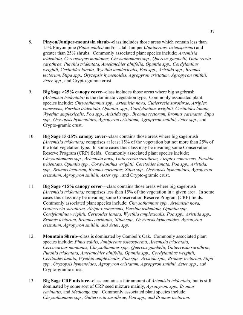
8. Pinyon/Juniper-mountain shrub--class includes those areas which contain less than15% Pinyon pine (Pinus edulis) and/or Utah Juniper (Juniperous, osteosperma) andgreater than 25% shrubs. Commonly associated plant species include; Artemisiatridentata, Cercocarpus montanus, Chrysothamnus spp., Quercus gambelii, Gutierreziasarothrae, Purshia tridentata, Amelanchier alnifolia, Opuntia spp., Cordylanthuswrightii, Ceritoides lanata, Wyethia amplexicalis, Poa spp., Aristida spp., Bromustectorum, Stipa spp., Oryzopsis hymenoides, Agropyron cristatum, Agropyron smithii,Aster spp., and Crypto-gramic crust.
9. Big Sage >25% canopy cover--class includes those areas where big sagebrush(Artemisia tridentata) is the dominate vegetation type. Commonly associated plantspecies include; Chrysothamnus spp., Artemisia nova, Gutierrezia sarothrae, Atriplexcanescens, Purshia tridentata, Opuntia, spp., Cordylanthus wrightii, Ceritoides lanata,Wyethia amplexicalis, Poa spp., Aristida spp., Bromus tectorum, Bromus carinatus, Stipaspp., Oryzopsis hymenoides, Agropyron cristatum, Agropyron smithii, Aster spp., andCrypto-gramic crust.
10. Big Sage 15-25% canopy cover--class contains those areas where big sagebrush(Artemisia tridentata) comprises at least 15% of the vegetation but not more than 25% ofthe total vegetation type. In some cases this class may be invading some ConservationReserve Program (CRP) fields. Commonly associated plant species include;Chrysothamnus spp., Artemisia nova, Gutierrezia sarothrae, Atriplex canescens, Purshiatridentata, Opuntia spp., Cordylanthus wrightii, Ceritoides lanata, Poa spp., Aristida,spp., Bromus tectorum, Bromus carinatus, Stipa spp., Oryzopsis hymenoides, Agropyroncristatum, Agropyron smithii, Aster spp., and Crypto-gramic crust.
11. Big Sage <15% canopy cover---class contains those areas where big sagebrush(Artemisia tridentata) comprises less than 15% of the vegetation in a given area. In somecases this class may be invading some Conservation Reserve Program (CRP) fields. Commonly associated plant species include: Chrysothamnus spp., Artemisia nova,Gutierrezia sarothrae, Atriplex canescens, Purshia tridentata, Opuntia spp.,Cordylanthus wrightii, Ceritoides lanata, Wyethia amplexicalis, Poa spp., Aristida spp.,Bromus tectorum, Bromus carinatus, Stipa spp., Oryzopsis hymenoides, Agropyroncristatum, Agropyron smithii, and Aster, spp.
12. Mountain Shrub--class is dominated by Gambel’s Oak. Commonly associated plantspecies include: Pinus edulis, Juniperous osteosperma, Artemisia tridentata,Cercocarpus montanus, Chrysothamnus spp., Quercus gambelii, Gutierrezia sarothrae,Purshia tridentata, Amelanchier alnifolia, Opuntia spp., Cordylanthus wrightii,Ceritoides lanata, Wyethia amplexicalis, Poa spp., Aristida spp., Bromus tectorum, Stipaspp., Oryzopsis hymenoides, Agropyron cristatum, Agropyron smithii, Aster spp., andCrypto-gramic crust.
13. Big Sage CRP mixture--class contains a fair amount of Artemisia tridentata, but is stilldominated by some sort of CRP seed mixture mainly, Agropyron, spp., Bromuscarinatus, and Medicago spp. Commonly associated plant species include:Chrysothamnus spp., Gutierrezia sarothrae, Poa spp., and Bromus tectorum.

38
14. CRP >70% canopy cover--class is dominated by CRP grasses and forbs, mainly Bromuscarinatus, and Medicago spp. Commonly associated plant species include: Agropyroncristatum, Agropyron smithii, Agropyron intermedium, Chrysothamnus spp., Gutierreziasarothrae, Poa spp., Aristida, spp., and Bromus tectorum.
15. CRP 40-70% canopy cover--class is dominated by CRP grasses and forbs, mainlyAgropyron spp. Commonly associated plant species include; Agropyron cristatum,Agropyron smithii, Agropyron intermedium, Bromus carinatus, Medicago spp.,Chrysothamnus spp., Gutierrezia sarothrae, Poa spp., Aristida spp., and Bromustectorum.
16. CRP 15-40% canopy cover--class is dominated by CRP grasses and forbs, mainlyAgropyron cristatum. Commonly associated plant species include: Agropyron smithii,Agropyron intermedium, Bromus carinatus, Medicago spp., Chrysothamnus spp.,Commonly associated plant Gutierrezia, sarothrae, Poa spp., Aristida, spp., and Bromustectorum.
17. Rangelands--class contains various vegetation types but was grazed too close to theground to allow vegetation to be placed into other classes. Commonly associated plantspecies include; Chrysothamnus spp., Gutierrezia sarothrae, Opuntia spp., Cordylanthuswrightii, Ceritoides lanata, Poa spp., Aristida spp., Bromus tectorum, Stipa spp.,Oryzopsis hymenoides, Agropyron cristatum, Agropyron smithii, and Aster spp.
18. Bare ground--class contains mainly bare ground and rock where vegetation is less than15% total canopy cover.
19. Unknown--class could not be placed into any of the above classes with the fewvegetation training sites collected in November 1997.

39
C. Habitat mixture seeded on CRP lands in the San Juan County Gunnision SageGrouse Conservation Plan Area.
Species PLS Lbs/acre
Grasses
Bluebunch wheatgrass 1.0
Thickspike wheatgrass 1.0
Western wheatgrass 1.5
Crested wheatgrass 0.5
Pubescent wheatgrass 1.0
Legumes/Forbs
Alfalfa (Rambler) 1.0
Alfalfa (Ladak, Normad) 1.5
Western yarrow 0.12
Lewis flax 0.25
Sainfoin 0.5
Small burnet 2.0
Shrubs
Wyoming big sagebrush 0.5
Forage kochia 0.5
Total 11.37

40
Appendix D
Accomplishments[_____]
year
Task Initiated/Completed Responsible Party(s) Comments
Note: The actual format of Appendix D might change slightly as implementation of the Sage Grouse Plan proceeds.