gwinnett village community improvement district · information & technology solutions – data...
TRANSCRIPT

A-38
great link to facilitate a collaborative economic development environment with neighboring communities.
Gwinnett Village Community Improvement District – The CID is an invaluable economic development partner for the city, representing than 550 commercial owners, accounting of $1 billion in commercial property owners. The team works to increase commercial values, promote economic development, and enhance quality of life for district workers/residents. The CID helps fund major transportation improvements and push forward important planning initiatives in Norcross, including the Jimmy Carter Boulevard/Buford Highway Redevelopment Plan, RAOD overlay district, and Diverging Diamond interchange implementation at Jimmy Carter and I‐85. The district includes the eastern portion of the city of Norcross along Buford Highway and eastward to I‐85, from Beaver Ruin Road and extending southward to Jimmy Carter Boulevard.
Figure 3-4. Gwinnett Village CID Boundaries
A-39
Comp
rehe
nsive
Plan
App
endix
Econ
omic
Deve
lopme
nt Te
chnic
al Ad
dend
umCi
ty of
Norcr
oss
Business Parks
The City of Norcross has several business parks that cater to a variety of business types, including light industrial and commercial. Below are the key parks in the city (also depicted in Figure 3‐1):
Pinnacle Business Center, 11 acres of office and warehouse space Beaver Ruin Business Center, 56 acres of office, industrial and service space Veridian Office Park Northbelt Business Park Indian Trail Center Crossings Center
(Source: City of Norcross Department of Economic Development)
Georgia Department of Economic Development – The Department offers a variety of resources to the City of Norcross from an economic support standpoint. One resource is the Department’s available buildings database, which as of August 2013 showed 57 buildings listed as available in Norcross (including spaces both in incorporated and unincorporated areas).
Electrical Cities of Georgia – ECG provides economic and strategic services to community‐owned utility systems that sell public power. Norcross, as one of these communities, has access to the organization’s resources. The City’s Public Works Director currently sits on the Board of Directors of this organization.
Opportunity Zone – The City of Norcross has an opportunity zone located along Jimmy Carter and Buford Highway. The zone provides tax credits to businesses within the district that create at least two full time jobs. At the time of this analysis, the city, in coordination with the Department of Community Affairs, was pursuing an additional opportunity zone for the southern portion of the city.
State Tax Credits and Incentives – The City leverages the State of Georgia’s various tax credit programs and small business incentives to attract and retain businesses.
City First Program – The City recently launched this program to help businesses and individuals connect with businesses within the city first before going to businesses located elsewhere for services, helping promote the local economy first and facilitating a “go local” climate in the city.
A-40
GeneralEconomicDevelopmentGoalsandObjectivesNorcross has a well‐rounded economy for a small to medium sized city. The Town Center is home to a mix of stable locally grown restaurants, shops, and businesses. The edges of the community support industrial and professional offices alike. The major arterials of Peachtree Industrial Boulevard, Jimmy Carter Boulevard, Buford Highway, and Beaver Ruin Road house a mix of commercial uses. Small and large businesses including those that are well‐established, new, or are growing, call Norcross home. As the City of Norcross looks to the next 20 years, there are opportunities to strengthen the local economy and supportive business environment.
TargetIndustriesThe 2030 Comprehensive Plan identified the need for a comprehensive business development strategy. Since then, the City’s Economic Development Manager has taken a comprehensive approach to address business retention and recruitment needs and market Norcross as a good place to do business and work. This is evidenced by the wealth of information on the City website and number of marking and programmatic initiatives the Department has underway. The City’s target industries, as identified by the City’s Economic Development Department, include corporate headquarters, engineering companies, and financial businesses.
Gwinnett County’s target industries, as identified by the economic development arm of the Gwinnett Chamber, are:
1. Information & Technology Solutions – data processing & security; software development; computer systems design
2. Health Sciences & Services – life sciences; healthcare services 3. Professional & Corporate Services – customer care services; headquarters operations;
business support services 4. Supply Chain management – wholesale trade; distribution & warehousing 5. Advanced Manufacturing – computer & electronics; energy technologies
The City of Norcross’s current industry mix parallel all of these targets, with the exception of health sciences and services – which are likely to be better accommodated in neighboring communities due to the concentration of such businesses outside of Norcross. The County’s economic development strategy “Partnership Gwinnett 2.0” is another tool for the city as it refines it unique economic development goals within the context of the broader economy. The strategy’s core goals include 1) Comprehensive Economic Development, 2) World Class Talent, and 3) Community and Leadership Development.
RegionalStrategyThe Atlanta Regional Commission completed a Regional Economic Competitiveness Strategy in 2012, which is an additional tool for Norcross to leverage as it moves forward key strategies for economic development. As part of a regional economy, it is essential that the city stay abreast of regional strategy, trends, and initiatives, particularly to the degree that they can help inform the city’s economic development efforts.
A-41
Comp
rehe
nsive
Plan
App
endix
Econ
omic
Deve
lopme
nt Te
chnic
al Ad
dend
umCi
ty of
Norcr
oss
PreliminaryGoalsandOpportunitiesThe following potential goals and opportunities for the city’s future economic development efforts can be extracted from this analysis:
Leverage catalysts of change (such as the OFS site redevelopment and potential transit/commuter rail extension) to attract related employers and businesses to the community and further redevelopment goals consistent with Future Development Map.
Continue to implement the Town Center plan to attract private investment and grow the town center/DDD area as a thriving center for the city.
Focus efforts on redevelopment along major corridors and furthering an environment that is attractive to small businesses and large corporations alike.
The City has a diverse economy and mix of land uses. To further its diversified economy, the City should work to ensure preservation commercial and industry centric land uses.
ARC’s Plan 2040 forecasts a decline in jobs in wholesale trade. Because a large share of Norcross’s employment is based in this industry, the City should continue to pursue alternative opportunities to diversify its economy.
The City has a high number of jobs compared to its population. This is a positive for tax purposes. It also poses an opportunity to increase housing options to retain more of the city’s workers as residents.
Build stronger partnerships and continue to identify collaboration opportunities with the Gwinnett Village CID, new Southwest Gwinnett Chamber, and Partnership Gwinnett to achieve the city’s business attraction and redevelopment goals.
Work with the Public Works Department to ensure appropriate infrastructure is in place to support the needs of the city’s target industries, including corporate headquarters, engineering companies, and financial businesses.
A-46
3
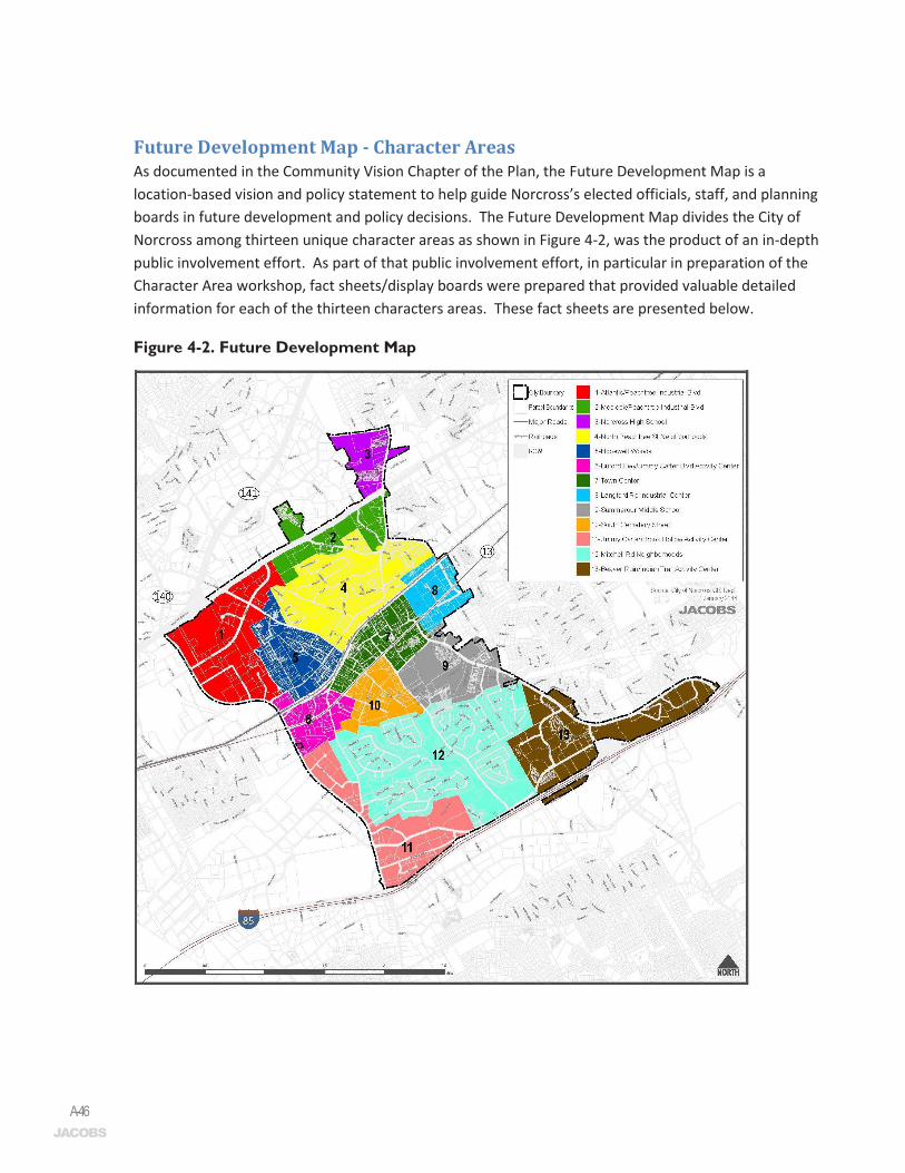
Future Development Map - Character Areas As documented in the Community Vision Chapter of the Plan, the Future Development Map is a location-based vision and policy statement to help guide Norcross’s elected officials, staff, and planning boards in future development and policy decisions. The Future Development Map divides the City of Norcross among thirteen unique character areas as shown in Figure 4-2, was the product of an in-depth public involvement effort. As part of that public involvement effort, in particular in preparation of the Character Area workshop, fact sheets/display boards were prepared that provided valuable detailed information for each of the thirteen characters areas. These fact sheets are presented below.
Figure 4-2. Future Development Map

A-59
Comp
rehe
nsive
Plan
App
endix
Land
Use
Tech
nical
Adde
ndum
City
of No
rcros
s
Futu
re D
evel
opm
ent A
rea:
Be
aver
Ruin
/Indi
an Tr
ail A
ctivi
ty Ce
nter
13
o
¹
!J
I85S
I85N
BEAVER RUIN
HILLCREST
BROO
K HOL
LOW
INDIAN TRAIL LILBURN
HILL
I85S O
N RP
-IT
SATELLITEOAK
BROOK
GOSH
EN SP
RINGS
WEXFORD
I85S
EX R
P-IT
WILLOW
TRAIL
CASTOR
I85S O
N RP
-BR
RED OAK
RAILS
PINNACLE
BAILEY
I85N ON RP-IT
I85N
EX R
P-IT
NEWBURY
GREE
NWAY
I85N EX
RP-BR
APPA
LOOS
A
AMB E
POND
BEAV
ER R
IDGE
MITCHELL
BOLT
ON
RANCHBEAVER SPRINGS
NORC
ROSS
GULF
SIER
RA
STAT
ION
VICTOR
ROC K
B ORO
UGH
SPUR
VALL
EY RI
DGE
TAHOE
JONCIE
COVE CREEK
FALC
ONW
OOD
RUNN
ING
FOX
PLYMOUTH
SOU R
WO O
D
I85S E
X RP-B
R
HOOT
OW
L
SHADOW
GOOD
WICK
VINE
YARD
PON
D
LANG
STON
WILLOW
I85N ON RP-BR
OLD MILL
BRIGHTON
BIG
HICKO
RY
LYME
BAY
HUDDERSFIELD
INDIAN BROOK
WESLEY
CHER
OKE
PINNACLE POINTE
FERENTZ
LIA HILL
S
COVE
NTRY
WEY
DEN
OLD HICKORY
RANC
H
I85S O
N RP-IT
NEW
BURY
HILL
WEY
DEN
1313
Pin
nacl
e P
arce
l
Bea
ver R
idge
Ele
men
tary
GA
Dep
t. D
river
Ser
vice
s &
Dep
t. of
Lab
or
•Majorcitygatew
ay•DirectaccesstoandgoodvisibilityfromI-85
•MajorlandusesincludetheMARTAIndianTrailParkandRideLot,bigboxcom
mercial
outletsandbusinesspark
•Currentplans(A
ctivityCenterLCI)anticipatethelocationofatransitstopintheareaand
trans
it or
ient
ed d
evel
opm
ent i
n th
e ar
ea
Existing
Visi
on•Agrow
ingregionalcenterduetoprominentandconvenientaccesstoI-85
•Theareaischaracterizedbymasterplanneddevelopmentsofm
id-risebuildings
•Thenewtransitstophashelpedgenerateahighlevelofactivityatalltim
es•ThemixofusesandintensityisseenassimilartothatofLindberghCenterinAtlanta,
whereaMARTAstation,offices,andnum
erousrestaurantsandhousingoptionsare
loca
ted.
•Well-designedbigboxretailstructuresinthisareaaddarchitecturalinteresttothe
streetscapeandaresafelyaccessibletopedestrians
Beav
er R
uin B
usine
ss C
enter
Pinn
acle
Busin
ess C
enter
Indian
Trail
Par
k and
Ride
lot
Ligh
t Ind
ustri
al
Com
mer
cial
/Ret
ail
Offi
ce/P
rofe
ssio
nal
Und
evel
oped
Par
ks/R
ec/C
onse
rvat
ion
(Priv
ate)
Inst
itutio
nal/P
ublic
Oth
er
Exis
ting
Land
Use
s
27%
11%
25%
19%
8%
5%7%
CBA
A
BC
A-61
Comp
rehe
nsive
Plan
App
endix
Land
Use
Tech
nical
Adde
ndum
City
of No
rcros
s
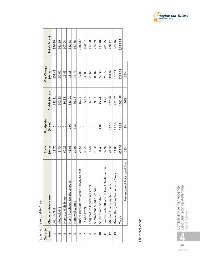
6 Ta
ble
4-2:
Dev
elop
able
Are
as
Char
acte
r Ar
ea
Char
acte
r Are
a N
ame
Stat
ic
(Acr
es)
Floo
dpla
in
(Acr
es)
Stab
le (A
cres
) M
ay C
hang
e (A
cres
) To
tal (
Acre
s)
1 At
lant
ic/P
IB
13.7
0 0
133.
31
209.
48
356.
50
2 M
edlo
ck/P
IB
8.70
0
102.
33
50.0
7 16
1.10
3
Nor
cros
s Hig
h Sc
hool
60
.25
0 30
.34
16.4
5 10
7.04
4
Nor
th P
each
tree
Nei
ghbo
rhoo
ds
41.6
3 0.
99
323.
98
15.8
8 38
2.48
5
Hope
wel
l Woo
ds
29.0
3 8.
32
86.7
2 73
.79
197.
86
6 Bu
ford
Hw
y/Jim
my
Cart
er A
ctiv
ity C
ente
r 28
.58
0 15
.21
77.0
9 12
0.88
9 7
Tow
n Ce
nter
36
.26
0 85
.41
39.0
1 16
0.67
8
Lang
ford
Rd
Indu
stria
l Cen
ter
6.68
0
86.6
7 23
.65
117.
00
9 Su
mm
erou
r Mid
dle
Scho
ol
79.3
1 0
59.0
1 86
.07
224.
39
10
Sout
h Ce
met
ery
Stre
et
31.4
9 4.
07
45.2
4 56
.38
137.
18
11
Jimm
y Ca
rter
/Bro
ok H
ollo
w A
ctiv
ity C
ente
r 32
.97
0 33
.28
215.
50
281.
75
12
Mitc
hell
Road
Nei
ghbo
rhoo
ds
44.3
8 52
.55
327.
36
304.
03
728.
32
13
Beav
er R
uin/
Indi
an T
rail
Activ
ity C
ente
r 11
.05
13.3
9 21
2.52
12
6.21
36
3.16
Tota
ls
424.
03
79.3
2 15
41.3
8 12
93.6
1 3,
338.
34
Pe
rcen
tage
of T
otal
Lan
d Ar
ea
13%
2%
46
%
39%
Char
acte
r Are
as
A-65
Comp
rehe
nsive
Plan
App
endix
Land
Use
Tech
nical
Adde
ndum
City
of No
rcros
s
10
Alignment of Land Use Regulations with the Community Vision One of the most valuable tools in implementing a Comprehensive Plan is its land use regulations which for Norcross is embodied in its Zoning Ordinance and Development Regulations. Besides making sure that these regulations reflect the community’s vision, they also need to be kept up-to-date with technological innovation and be effective and easy to administer and understand. Throughout the public involvement process various suggestions were offered by city staff and city officials as to improve the regulations and following is brief review of needed and desired changes.
a. Sign Ordinance. Amend sign ordinance to address improvements identified by GMA in its sign ordinance evaluation. There are some legal issues with the current ordinance that need to be addressed.
b. Repurposing of old buildings. Much of the city’s future growth will take the form of redevelopment of old buildings. Incentives for adaptive reuse of these structures need to be in place as well protections for historic structures to help maintain the city’s attractiveness to potential investors.
c. Industrial Zoning District. Revisit the M-1 zoning district to ensure appropriate users are allowed in the district. As the City’s only industrial zoning district, it is important that this district preserve the industrial base of the community.
d. Parking. Amend parking ordinance to provide to remove parking requirements in the historic downtown commercial area, and to allow for the banking of parking spaces in support the city’s efforts to build a parking deck.
e. Corridor design guidelines. Both the Activity Center LCI and the Jimmy Carter Boulevard Corridor Study called for the adoption of design guidelines and potential overlay districts for these areas as a means to incentivize the development of activity nodes in these areas, to protect the gateway aesthetics, and to promote multi-modal transportation.
Land Use Goals and Objectives Data analysis and review of existing conditions, detailed on the previous pages, indicate that the following goals may be desirable for Norcross’s land use policies and regulations. These ideas were developed for discussion purposes only. Land use goals and objectives were ultimately shaped by the priority needs and opportunities identified by the community in the public engagement process, both of which are highlighted in the main plan document.
1. Revisit Zoning and Development Regulations. Since the last update of the Comprehensive Plan, the City of Norcross has seen much progress, many changes, and annexation. As such, there is a need to revisit and consider edits to the zoning and development regulations of the city, as outlined above under “Alignment of Land Use Regulations with the Community Vision.”
2. Promote Development of Mixed Use Nodes at Key Gateway Intersections. Continue tradition of strong planning to support smart zoning, redevelopment, and development decisions. This should include updating the Norcross Activity Center LCI and the Jimmy Carter Boulevard/Buford Highway Redevelopment Plan in coordination with County and CID partners.
A-66
11
3. Promote Redevelopment along City’s Principal Roadways. Redevelopment along key roads like Buford Highway, Beaver Ruin, and Jimmy Carter Boulevard and reworking these roadways is essential to connecting the City’s different neighborhoods. Balancing land use and transportation improvements will be essential to achieving the area vision.
4. Improve gateways and wayfinding signage. Everyone should know when they have arrived in the City of Norcross through the aesthetic use of monuments and architectural treatments, and should easily be able to find community facilities and attractions. This need is already being pursued by the City and should continue to be a priority in the next five years as the City works to integrate newly annexed portions of the city. 5. Strengthen Historic District Regulations and consider the creation of a Historic Preservation Authority. In the past, the City has adopted and rescinded the creation of an Historic District, once again interest in utilizing this regulatory tool to preserve and protect the City’s historic resources has resurfaced.