gypsy and traveller site assessment addendum
TRANSCRIPT

Lewes District Council
and
South Downs National Park Authority
Gypsy and Traveller Site Assessment Addendum
December 2012
1

1. Introduction
1.1 Lewes District Council (LDC), in 2008, commissioned planning consultants, Parker Dann, to undertake a District wide assessment of sites fir potential Gypsy and Traveller use1. The initial Assessment shortlisted two sites, Land north of Offham Filling Station, Hamsey and Land at Denton Depot, Newhaven.
1.2 Subsequently, the two sites were outlined as potential Traveller site options in the joint Lewes District Council and South Downs National Park Authority (SDNPA) Emerging Core Strategy (ECS). Comments were sought on these options and other policy options in the 2011 Autumn consultation.
1.3 In light of the ECS consultation and recent National Planning Policy changes, National Planning Policy Framework (NPPF) and the supporting Planning Policy for Traveller sites, an update to the initial Site Assessment was considered appropriate. This addendum therefore considers additional potential sites put forward through ECS representations, sites identified from other sources and relevant changes to national planning policy.
1.4 In addition to the new sites assessed, the addendum amends and updates the Initial Site Assessment where fundamental changes have occurred, since its publication, which impact on a site’s assessment and/ or conclusion. These amendments are outlined in Section 4.
Summary of Initial Assessment
1.5 The initial Site Assessment used an agreed set of criteria2 to score a ‘long list’ of 14 sites drawn from vacant, underused and unused sites in public ownership, together with sites put forward through the previous Local Development Framework (LDF) site submission process. Sites were also subject to ‘initial exclusion filters’ including sites at high risk of flooding, contaminated land and sites designated as Sites of Special Scientific Interest (SSSI).
1.6 Of the initial 14 sites three sites were excluded due to land contamination and/or flooding and one due to its close proximity to a designated SSSI. Comments from statutory consultees, such as Environment Agency, Southern Water and East Sussex County Council (ESCC) Highway Authority, were sought on the principle of Traveller use on these sites. In addition to the four sites initially excluded, seven sites received ’in principle’ objections from the above consultees.
1 Lewes District Gypsy and Traveller Site Assessment (2010) www.lewes.gov.uk/planning/backgroundreps.asp2 Consultation with Traveller Working Group
2

1.7 Whilst these sites were excluded, in principle, as suitable for permanent sites the Assessment stated that sites may be considered suitable for temporary stopping places (TSP). In this instance particular assessment criterion, such as flood risk, can be removed or downgraded with the justification that a TSP will only be used on a short term and ad hoc basis.
1.8 During the initial Assessment three sites, sourced from the Register of Surplus Public Land, were sold and therefore no longer considered available for potential Gypsy and Traveller sites.
1.9 The following section outlines recent changes in Government policy and the implications of these on local policy and Traveller site provision.
3

2. Background
National Planning Policy Framework (NPPF)
2.1 On 27 March 2012 the Coalition Government published its National Planning Policy Framework (NPPF) to replace previous Planning Policy Statements (PPSs) and Planning Policy Guidance notes (PPGs). The NPPF also replaced various Official Letters and Circulars including Circular 01/2006: Planning for Gypsy and Traveller Caravan Sites and Sites and Circular 04/2007: Planning for Travelling Showpeople.
2.2 The supporting Planning Policy for Traveller sites3 was published alongside the NPPF. This Policy statement outlines Government policy and guidance on assessing accommodation needs, Plan-making and Decision-taking in relation to Gypsy and Traveller sites.
2.3 National Traveller Planning Policy states that at the plan making stage local planning authorities should set pitch and plot targets; identify a five year supply of specific deliverable4 sites, where possible developable sites for years six to 15; and develop a criteria based policy by which to determine planning applications and allocations where appropriate.
South East Plan – Pitch requirements
2.4 At the time of drafting the initial Site Assessment the South East England Partnership Board (SEEPB) were undertaking a Partial Review of the South East Plan (SEP) Gypsy and Traveller accommodation provision policy (H7). The initial Assessment outlined the draft permanent pitch requirement figures for Lewes District; 10 Gypsy and Traveller pitches and 1 Travelling Showpeople plot.
2.5 In July 2010 the Coalition Government announced the revocation of the SEP. At this point the Independent Panel had undertaken the Examination in Public (EiP) but took the decision not to complete the Partial Review, despite the reinstatement of the SEP in November 2010 following a High Court challenge against the revocation. However, in response to a Freedom of Information request (FoI) the unfinished Panel report was released for information purposes5.
2.6 To address the extant Gypsy and Traveller accommodation needs, the Gypsy and Traveller Planning Officers Group, consisting of East Sussex local authorities, ESCC and Brighton & Hove City Council (BHCC), formed a joint approach to locally derived pitch figures. The Officer group examined existing information from: the 2005 Gypsy and Traveller Accommodation Assessment (GTAA); subsequent bench
3 Planning policy for traveller sites (DCLG, 2012)4 Deliverable: Suitable, Available and Achievable5 Regional Strategies – (http://planning-inspectorate.gov.uk/pins/rss/index.htm)
4
marking and local authority advice; local knowledge of need; and recommendations emerging from the Unfinished Panel report, where there is sufficiently robust background evidence to support them.
2.7 The above approach outlines a need of 13 permanent pitches for Gypsies and Travellers but no need for Travelling Showpeople for the period to 2016.
LDC and SDNPA joint Core Strategy
2.8 LDC and the SDNPA are currently preparing a joint Core Strategy. The Emerging Core Strategy (ECS) document was consulted upon in Autumn 2011. The next stage of the Core Strategy is the Proposed Submission document which will be consulted on in early 2013. LDC and SDNPA anticipate adoption of the Strategy in late Summer 2013.
2.9 Core Policy 3: Gypsy and Traveller Accommodation of the ECS outlined a permanent pitch requirement figure to 2018 to ensure that the Core Strategy is planning for a five year supply from adoption. The agreed 3% compound growth rate, applied to the above identified need of 13 pitches resulted in a total five year requirement figure of 15 permanent pitches. Recognising that four pitches had received permanent planning permission, the residual permanent pitch requirement to 2018 is 11 permanent pitches.
2.10 To meet the short term pitch need a number of sites will need to be allocated in the Council’s Site Allocations Development Plan Document (DPD) and the SDNPA’s Local Plan, which are anticipated to be adopted in 2015 and 2016 respectively.
5

3. Methodology
3.1 This assessment implements the same methodology and agreed criteria as the initial Parker Dann Site Assessment. The full criteria matrix can be viewed as an appendix within the initial Site Assessment. As with the initial assessment, site(s) scoring the highest are considered to be the most suitable for the proposed use.
Sources of sites
3.2 For the Assessment Addendum a list of potential sites, from the below sources, was put together: � Emerging Core Strategy Public consultation representations � Strategic Housing Land Availability Assessment (SHLAA) � Lewes District Council owned land � Register of Surplus Public Surplus Land
3.3 Emerging Core Strategy (ECS) public consultation: As part of the consultation respondents were asked to comment on the preferred option and were given the opportunity to suggest alternative sites for consideration. A number of representations identified alternative sites or areas.
3.4 SHLAA: The SHLAA assesses sites submitted by landowners; developers; those aware of any potentially suitable land; and land from the register of surplus public sector land; potential available sites that Planning colleagues are aware of; and previous Local Plan allocations. In the early stages of the SHLAA three filters were applied to the long list of sites. Sites that failed these filters were excluded from further assessment. The three filters are: 1) Site threshold – sites below six units 2) Designations – sites within international or national designations,
excluding National Park 3) Planning boundary – sites that are located more than 500m from
an existing planning boundary. These filtered sites provided a long list of sites to consider for potential assessment.
3.5 Land owned by Lewes District Council: Land owned by Lewes District Council identified as potentially available for alternative use.
3.6 No suitable additional sites were available from the Register of Surplus Public Land.
6

Initial exclusion filters
3.7 When establishing a list of potential sites for assessment, and in consistency with national guidance, a number of initial filters were applied. The purpose of this was to remove sites which would be unsuitable for residential use from the outset. These initial filters included sites: at risk of flooding; within a Site of Special Scientific Interest (SSSI) designation; on or adjacent to incompatible uses for residential consideration (such as sewage works and land tips); and site size and/or shape.
3.8 The first three of the above filters are consistent with the approach taken in the initial Site Assessment. Government guidance considers mobile homes as a vulnerable use. This use should therefore be located outside of high flood risk areas and away from contaminated land. Environmental designations, such as SSSIs, are considered to be of high environmental and ecological value. As such, development within SSSIs should be avoided.
3.9 With regards to site size, sites that could accommodate less than four pitches were filtered from further assessment. A site of four pitches is considered to be an acceptable average sized site6. The initial Site Assessment allowed 500m2 per pitch, therefore sites of approximately 2000m2 (0.2ha) were discounted. In terms of site shape, a number of sites were of an irregular shape, for example grass verges and railway sidings, which provide a limited viable developable area. These sites were therefore removed from further consideration.
3.10 The below table contains the list of sites assessed as part of this update.
6 GTAA concluded that sites should ideally be fewer than 10. Consultation as part of the methodology development concluded from feed back that sites should not be larger than 6 pitches.
7

Site address Parish Size (m2) Source
A Land at Valley Road (Parcel 622)
Peacehaven 3190 LDC land
B Land south of Juggs Road, parcel ‘B’
Lewes 4321 LDC land
C Alfriston Road Seaford 8200 LDC land D Land east of Normansal
Park Avenue Seaford 19123 &
5030 LDC land
E Land near Cooksbridge, west of A275
Hamsey 7387 Suggested site
F Glendene, Station Road Chailey 23000 SHLAA G Land at the Paddock Chailey 3240 SHLAA H Layden Hall, A275 Chailey 3042 SHLAA I Land between The Plough
and the Old Brickworks, Station Road
Plumpton 44720 SHLAA
J Plumpton Depot, South Road
Plumpton 5300 SHLAA
K Land west of Slugwash Lane
Wivelsfield 3325 SHLAA
L Ditchling Nurseries, Beacon Road
Ditchling 7868 SHLAA
M Balcombe Pit, Station Road
Glynde 5000 SHLAA
N Tarring Neville Quarry, A26
Tarring Neville
13000 Suggested site
O Old Cement works, west of A26
Beddingham 9500 Suggested site
P Land east of Cuilfail Tunnel (south entrance)
Lewes 2750 Suggested site
Table 1: Additional assessed sites
8

4. Summary of findings
Initial Site Assessment
4.1 Site 3: North of Offham Filling Station, Hamsey previously scored 33. However, under criterion 7: Previously developed land (PDL) the site was incorrectly assessed as previously developed. The site should have scored ‘0’ against this criterion as it is predominantly greenfield. Following this amendment the site scores 30. This amendment does not alter the site’s overall conclusion and remains a preferred site to consider for permanent Traveller use.
4.2 Clarification on the availability of the above site for the proposed use was also sought from the landowner. Whilst the site’s availability for Traveller use has been confirmed the timeframe for delivery remains uncertain. As previous identified, the site is in private ownership. It is therefore assumed that the site would be delivered by the landowner. This may also impact on the site’s short term delivery and achievability. Consequently, the site can not be considered Deliverable at this stage.
4.3 In addition to the amendments to Site 3, further discussions relating to Site 8: Denton Depot, Newhaven have taken place. These discussions were to confirm the extent of site’s boundary and its availability. Since the publication of the Initial Site Assessment, the boundary identifying the land considered surplus differed to that initially assessed.
4.4 The amendment to the original site boundary reduced the size of the site. This impacted on the viability and achievability of considering the site for permanent use due to the associated costs of land-raising and landscaping required to mitigate the constraints identified in the initial assessment. Without implementing these mitigation measures the site could not be considered suitable for permanent use.
4.5 Consideration of Site 8 as an Emergency or Temporary Stopping Place has also been ruled out at this stage as this use does not marry with the landowner’s intentions of disposal. Consequently, the site is considered unavailable for permanent and temporary residential use.
Addendum assessment findings
4.6 As stated in paragraph 2.3 recent national policy outlines the need to identify Deliverable and Developable sites for Gypsies and Travellers. This will enable a sufficient supply of pitches to meet the identified need. The suitability of sites for the proposed use is considered through individual site assessments, appendix 1.
4.7 Table two below identifies the final score of each of the sites assessed, listed in descending order. Sites H, M and N all score 29 points out of a potential 37.
9

Site Ref
Site Score
H Land at Layden Hall, A275, North Chailey 29
M Land at Balcombe Pit, Glynde 29 N Tarring Neville chalk Pit, Tarring Neville 29
L Ditchling nurseries, Ditchling 27 J Land at Plumpton Depot, Plumpton 26 E Land north of B2116/ A275 junction,
Hamsey 25
I Land between The Plough and Old Brickworks, Plumpton
25
G The paddock at Chailey Green, Chailey 24 C Land at Alfriston Road, Seaford 23 F Land at Glendene, Station Road, North
Chailey 23
K Land west of Slugwash Lane, Wivelsfield 23 O Land south of Beddingham Chalk Pit 23 P Land west of southern entrance of Cuilfail
Tunnel, Lewes 22
A Valley Road, Peacehaven 20 B Juggs Road, Lewes 20 D Normansal Park Avenue, Seaford 18
Table 2: Sites in rank order
4.8 As part of the site assessments comments were sought from statutory bodies such as the Environment Agency, East Sussex County Council (ESCC) highway authority, local utility companies and the Highway Agency. Comments were also sought from LDC Environmental Health officers. The South Downs National Park Authority was also consulted on sites located within or immediately adjacent to the Park.
4.9 Table 3 below provides summary commentary and conclusions from stakeholders against each of the assessed sites.
Site Ref
Site Score Commentary
H Land at Layden Hall, A275, North Chailey
29 Site for further consideration. Future availability to be established.
M Land at Balcombe Pit, Glynde 29 Not Available for consideration as proposed use.
N Tarring Neville chalk Pit, Tarring Neville
29 Environment Agency and Environmental Health concerns, further
10
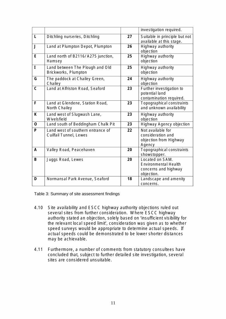
investigation required.
L Ditchling nurseries, Ditchling 27 Suitable in principle but not available at this stage.
J Land at Plumpton Depot, Plumpton 26 Highway authority objection
E Land north of B2116/ A275 junction, Hamsey
25 Highway authority objection
I Land between The Plough and Old Brickworks, Plumpton
25 Highway authority objection
G The paddock at Chailey Green, Chailey
24 Highway authority objection
C Land at Alfriston Road, Seaford 23 Further investigation to potential land contamination required.
F Land at Glendene, Station Road, North Chailey
23 Topographical constraints and unknown availability
K Land west of Slugwash Lane, Wivelsfield
23 Highway authority objection
O Land south of Beddingham Chalk Pit 23 Highway Agency objection
P Land west of southern entrance of Cuilfail Tunnel, Lewes
22 Not available for consideration and objection from Highway Agency
A Valley Road, Peacehaven 20 Topographical constraints showstopper.
B Juggs Road, Lewes 20 Located on SAM. Environmental Health concerns and highway objection.
D Normansal Park Avenue, Seaford 18 Landscape and amenity concerns.
Table 3: Summary of site assessment findings
4.10 Site availability and ESCC highway authority objections ruled out several sites from further consideration. Where ESCC highway authority stated an objection, solely based on ‘insufficient visibility for the relevant local speed limit’, consideration was given as to whether speed surveys would be appropriate to determine actual speeds. If actual speeds could be demonstrated to be lower shorter distances may be achievable.
4.11 Furthermore, a number of comments from statutory consultees have concluded that, subject to further detailed site investigation, several sites are considered unsuitable.
11

5. Conclusions
5.1 This addendum is an update to the 2010 Gypsy and Traveller Site Assessment. The aim of this update is to incorporate the additional sites that came forward since the initial Site Assessment. It also takes into consideration new Government planning policy, published in March 2012.
5.2 The update assessed 16 additional sites. To ensure consistency, each of the sites were assessed against the same criteria used within the initial Site Assessment. To this end, a number of ‘preferred’ sites were established.
5.3 The ‘preferred’ sites, within the Lewes District, form potential Gypsy and Traveller site allocations. Sites deemed to be Deliverable, will be allocated within the Lewes District Council Site Allocations Development Plan Document, anticipated to be adopted in 2015/16. Sites within the SDNP will need to be allocated within the SDNPA’s Local Plan, anticipated to be adopted in 2016.
5.3 In addition to assessment against the agreed criteria, statutory consultees such as the Environment Agency, East Sussex County Council (ESCC) highway authority and utility companies, were asked to comment on each of the sites.
5.4 ‘In principle’ objections from statutory consultees concluded seven out of the 16 sites assessed to be unsuitable for permanent Gypsy and Traveller use.
5.5 With regards to amendments to sites assessed within the initial Site Assessment, Site 3: North of Offham Filling Station, Hamsey remains a site considered as suitable for permanent Gypsy and Traveller use. However, it can not be considered a Deliverable site, at this stage, due to issues of availability and achievability. Site 8: Denton Depot, Newhaven is no longer considered Deliverable as a permanent or temporary site due to availability and achievability of delivery.
5.6 Three out of the additional 16 sites are known to be unavailable for the proposed use and should not be considered further.
5.7 One site, ‘Site H: Land at Layden Hall, North Chailey’, has been assessed as suitable, in principle, and identified for further consideration. The availability of the land will need to be established if considered for allocation.
5.8 Three sites: ‘Site N: Land at Tarring Neville Chalk Pit, Tarring Neville’; ‘Site C: Land at Alfriston Road, Seaford’; and ‘Site D: Normansal Park Avenue, Seaford’, require further detailed investigation into issues of
12

potential land contamination, before they can be considered suitable for residential use.
5.9 None of the potential sites assessed can, at this stage, be concluded to be Deliverable for Gypsy and Traveller use. Should the identified issues of availability and suitability be resolved, the above sites would form a potential pool of sites to consider for future allocation.
13

Appendix 1 - Site Assessments
14

Site A – Valley Road, Peacehaven
Commentary
This parcel of land within the Valley Road area is approximately 3190m2. It is currently within LDC ownership. It is a landlocked Greenfield site within an area of a semi-rural character which has been sporadically developed, following the area’s historic plotland form. The Valley Road area is commonly viewed as a transition area between the urban area of Peacehaven and the wider landscape and South Downs National Park.
The site is not within any national environmental or historical designations. However, it does lie within the Halcombe Farm Site of Nature Conservation importance (SNCI).
There is currently no vehicular access to the site. Any potential access point would need to be through adjacent privately owned land. ESCC highways state that the existing access road (Valley Road) requires substantial upgrading. The condition of the existing track is unsuitable for large vehicles and requires widening. The topography and steep gradient of the roads from Telscombe Road to the site could also be a significant constraint for larger vehicles accessing the site.
15
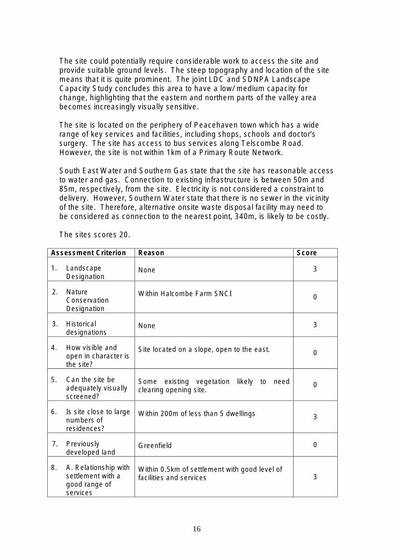
The site could potentially require considerable work to access the site and provide suitable ground levels. The steep topography and location of the site means that it is quite prominent. The joint LDC and SDNPA Landscape Capacity Study concludes this area to have a low/ medium capacity for change, highlighting that the eastern and northern parts of the valley area becomes increasingly visually sensitive.
The site is located on the periphery of Peacehaven town which has a wide range of key services and facilities, including shops, schools and doctor’s surgery. The site has access to bus services along Telscombe Road. However, the site is not within 1km of a Primary Route Network.
South East Water and Southern Gas state that the site has reasonable access to water and gas. Connection to existing infrastructure is between 50m and 85m, respectively, from the site. Electricity is not considered a constraint to delivery. However, Southern Water state that there is no sewer in the vicinity of the site. Therefore, alternative onsite waste disposal facility may need to be considered as connection to the nearest point, 340m, is likely to be costly.
The sites scores 20.
Assessment Criterion Reason Score
1. Landscape Designation
None 3
2. Nature Conservation Designation
Within Halcombe Farm SNCI 0
3. Historical designations
None 3
4. How visible and open in character is the site?
Site located on a slope, open to the east. 0
5. Can the site be adequately visually screened?
Some existing vegetation likely to need clearing opening site.
0
6. Is site close to large numbers of residences?
Within 200m of less than 5 dwellings 3
7. Previously developed land
Greenfield 0
8. A. Relationship with settlement with a good range of services
Within 0.5km of settlement with good level of facilities and services 3
16

B. Distance from primary route network
Not within 1km of primary route network. Approximately 2km from A259.
0
9. Suitable level access
Substantial work required along Valley Road, currently a track, to enable suitable access. Very steep access onto Valley Road.
0
10. Level site Slopes steeply north to south 0
11. Accessibility of Services and deliverability of site
Water – 50m from site Electricity – no constraint to delivery Sewerage – No sewer in immediate vicinity, 340m from connection point Gas - 85m from nearest main
2
12. Suitable for residential use by Gypsies and Travellers?
No noise or air pollution issues identified. No contamination issues. 3
13. Size of Site 3190m2 - Site can provide up to 6 pitches. 2
14. Total Score 20
Conclusion
The site scores well in terms of proximity to a settlement that contains a good range of services and facilities. However, it lacks good access to a Primary Route Network.
The site is partially screened by existing vegetation. However, development of this site is likely to be visible to outside views due to its elevated position.
The main constraints to this site are landscape impact and access due to the valley’s topography. The steep slopes are likely to create difficulties for long vehicles to manoeuvre. Also, the site does not have any existing vehicular access from Valley Road, which is in very poor condition and narrow.
17

Site B – Juggs Road Parcel ‘B’, Lewes
Commentary
The site is located on the south western edge of Lewes Town within a residential area and has good access to key services and facilities within the town, including shops, schools and healthcare. The site is approximately 4321m2 and in LDC ownership.
It is currently used as amenity land for the flatted development (Saxonbury) to the east of the site. Consequently, any development in this location is highly likely to impact on the amenity of existing residents.
The site is within the SDNP and is within a Scheduled Ancient Monument designation. It also lies within an Archaeological Notification Area.
A Tree Preservation Order (TPO) group designation is located along the southern boundary of the site. It provides important screening to the wider landscape and buffering of traffic noise from the A27 below. The TPO group would need to be a key consideration in considering any site layouts and capacity. The northern boundary of the site is marked by a flint wall which provides screening from the public footpath along Juggs Road. The most prominent views are from the C7 south east of the site.
The site has no existing vehicular access. The current residents’ car park is accessed via Juggs Road, which becomes a single track lane west of the junction of Juggs Close. Accessing the site from here is not considered
18

achievable. ESCC highway authority considered a potential new access point from the C7. Access in this location would require visibility splays of 2.4m x 120m in each direction. However, the highway authority does not consider that these distances (both vertically and horizontally) can be achieved.
The A27 and C7, located south and south east of the site respectively, were identified by LDC Environmental Health officers as potential sources of noise nuisance but concluded levels to be reasonable for residential use. However, EH Officers stated that the site is located in a very sensitive environmental location (primary source protection zone (SPZ1) of the Southover Public Water Abstraction).
Site has reasonable access to utilities to service the site. Costs of connection to existing infrastructure will need to be met by development.
Sites scores 20.
Assessment Criterion Reason Score
1. Landscape Designation
SDNP 0
2. Nature Conservation Designation
TPO Group to south. 2
3. Historical designations
Archaeological Notification Area and Scheduled Ancient Monument.
0
4. How visible and open in character is the site?
Site is contained to north by wall, west by trees. Slightly more open to south.
3
5. Can the site be adequately visually screened?
Yes, landscaping along southern boundary can reduce visual impacts and views from Kingston Road.
3
6. Is site close to large numbers of residences?
Site is within 200m of more than 10 properties. 0
7. Previously developed land
Greenfield - Garden land 0
8. A. Relationship with settlement with a good range of services
Within 0.5km of settlement with good level of facilities and services. 3
B. Distance from primary route network
A275 and A27 within 1km 1
9. Suitable level of access
Currently no vehicular access to site. Track is unmade and narrow. Visibility distances not considered at alternative access from C7.
0
19

10. Level site Slight slope to south 1
11. Accessibility of Services and deliverability of site
Water – Adequate supply Sewerage – 110m from site Electricity – Not considered a constraint to site Gas – approx 122m from nearest main
3
12. Suitable for residential use by Gypsies and Travellers?
Noise potential from A27 and C7 but levels considered reasonable. Site within primary Source Protection Zone (SPZ1) – Very sensitive environmental location.
2
13. Size of Site 4321m2 – Site can provide more than 6 pitches. 2
14. Total Score 20
Conclusion
The site is well situated in terms of access to a wide range of services and facilities within Lewes town. It also has reasonable access to a primary route network and utilities.
The site is located within the National Park and within a Scheduled Ancient Monument and Archaeological Notification Area designations. Impacts on identified environmental, ecological and historical designations are a significant constraint.
The lack of suitable vehicular access is the main constraint to the site being found suitable for residential use.
20

Site C – Alfriston Road, Seaford
Commentary
The site is located on the north eastern edge of Seaford on the Alfriston Road. It is currently within LDC ownership and used partly for recycling purposes. The remainder of the site is vacant. The site is approximately 0.82ha (8200m2) and is predominately flat.
The site is considered Greenfield and is located within the SDNP. There are no other known local or national designations. The majority of the site is wooded and therefore relatively well contained from the surrounding open landscape. Further landscape buffering may be required along the eastern boundary where the existing access point is.
The ‘part recycling’ use of the site appears to have been concentrated in a small clearing with the south east corner. LDC Environmental Health officer identify a requirement for further investigation into the historic waste disposal use. This will ultimately determine the site’s suitability for residential use.
The site currently has access from an unadopted road on to Alfriston Road. ESCC highway authority state that visibility splays of 2.4m x 215m are required as the site is within the national speed limit of 60mph. It is likely that
21

these can be provided and perhaps less required if further investigations were undertaken into actual speeds in the area.
Seaford town has a good range of services and facilities. The town centre is over a kilometre from the site. Bus services located within 500m of the site provide access to the town centre. The site scores poorly on distance from a primary route network (PRN). The nearest PRN is the A259, over a kilometre away.
The site is close to a number of existing residential properties, which may impact on the amenity of existing residents and potential future occupiers. LDC Environmental Health officers do not consider the adjacent Alfriston Road to be a source of significant potential noise nuisance or pollution for potential future occupiers of the site.
The site has reasonable access to key utilities to service the site. Water, gas and electricity are all available nearby. However, Southern Water state that there is currently no capacity within the existing sewer infrastructure. Improvements to service capacity will need to be met by the development or alternative provision made, potentially through onsite waste disposal system. South East Water estimate costs of water connection to the site, including infrastructure piping, to be £2,700. No offsite reinforcement anticipated.
The site scores 23.
Assessment Criterion Reason Score
1. Landscape Designation
SDNP 0
2. Nature Conservation Designation
None 2
3. Historical designations
None 3
4. How visible and open in character is the site?
Well contained site to south, west and north by mature trees.
3
5. Can the site be adequately visually screened?
Yes. 3
6. Is site close to large numbers of residences?
Within 200m of more than 10 dwellings 0
7. Previously developed land
Greenfield 0
8. A. Relationship with settlement with a good range of
Within 0.5km of settlement with good level of facilities and services.
3
22

services
B. Distance from primary route network
More than 1km from nearest primary route network, A259.
0
9. Suitable level access
Required visibility achievable. Access from track. 2
10. Level site Yes 1
11. Accessibility of Services and deliverability of site
Water – 10m from site Sewerage – Sewer located near by but currently no capacity. Gas – Nearest main is 25m from site Electricity – not considered a constraint
2
12. Suitable for residential use by Gypsies and Travellers?
Yes – residential use considered acceptable. No known contamination issues but potential historic waste disposal activities – will need investigating. No air quality or noise concerns.
2
13. Size of Site 8200m2 – site can provide more than 6 pitches but be satisfactorily subdivided. 2
14. Total Score 23
Conclusion
The site is located within the National Park. It is not located within other historical or environmental constraints. The site is well contained from the surrounding landscape by existing trees.
As a large site is it considered appropriate to consider bringing forward part of the site. The south east corner has existing access but requires further investigation into potential land contamination.
The site scores poorly on access to Primary route network, which is over 1km from the site, and its proximity to other existing residential properties.
Subject to the required investigations into land contamination the site is considered suitable for further consideration as a permanent traveller site.
23

Site D – Normansal Park Avenue, Seaford
© Crown copyright and database rights 2012 Ordnance Survey 100019275.
Commentary
The land is formed of two conjoined parcels of LDC owned land. The site at Normansal Park Avenue is located adjacent to the northern boundary of Seaford town. It is a large area of land 24153m2 (2.4ha) currently used as open informal recreation space.
The site is predominately within the South Downs National Park. The site does not have any other national landscape or historical designations. However, a Tree Preservation Order Group runs north/south along the western boundary, and includes a small parcel of woodland to the north west. This may impact on the site’s final capacity if considered further for development.
The existing trees contain and screen the site from the surrounding open landscape to the west and north. However, the joint LDC and SDNPA Landscape Capacity Study concludes this adjacent landscape area to have no capacity for change. Consequently, any development adjacent to it will need to be carefully considered in terms of its impact on the surrounding landscape. The northern part of the site is relatively flat compared to the southern part which slopes north/ south towards the town. Consequently, the site opens out to longer, but interrupted, views. Landscape buffering could be strengthened along the north and west boundaries to reduce visual impacts.
24

This would also potentially improve the amenity of both existing adjacent residents and potential future occupiers of the site.
Seaford town is classified as a District Centre within the Settlement Hierarchy. It has a good range of key services and facilities, including schools, shops and doctors. The site is within walking distance of a bus stop to access the town centre.
Normansal Park Avenue and Maple Drive provide two potential access points requiring visibility splays of 2.4m x 43m, which are considered achievable. ESCC highway authority note that access to the site would result in increased traffic movements through substantial residential areas. The suitability of these roads, in terms of the type and frequency of traffic requiring access, should be carefully considered so as to minimise the amenity of existing residents.
The site is unconstrained in terms of distance to existing sewerage and gas services. However, Southern Water state that there is currently no capacity within the infrastructure at the nearest point of connection. Costs of improving capacity will need to be met by development or alternatively onsite waste treatment considered. South East Water state that the nearest point of connection is 10m. Approximate costs of water connection to the site, including infrastructure piping £2,700. No offsite reinforcement anticipated.
Site scores 18 points.
Assessment Criterion Reason Score
1. Landscape Designation
SDNP 0
2. Nature Conservation Designation
TPO Groups run along the western and north western boundaries.
0
3. Historical designations
None 3
4. How visible and open in character is the site?
Site is quite visible and open to east. Low hedges and trees reduce views to north. Well screened to east by mature trees.
0
5. Can the site be adequately visually screened?
Landscaping along eastern boundary could be improved. Greatest potential for acceptable screening in north western part of site.
3
6. Is site close to large numbers of residences?
Within 200m of more than 10 dwellings 0
7. Previously developed land
Greenfield 0
8. A. Relationship with Within 0.5km of settlement with good level of 3
25

settlement with a good range of services
facilities and services.
B. Distance from primary route network
Not within 1km of nearest Primary Route Network (A259)
0
9. Suitable level of access
Access achievable from Normansal Park Avenue or Maple Drive. Would be through substantial residential areas.
1
10. Level site Majority of site slopes southwards with southern part of site particularly uneven. North part of slope levels out, particularly western parcel.
1
11. Accessibility of Services and deliverability of site
Water – 10m from site Sewerage - Sewer indicated to be nearby although stated not to have to capacity. Gas – 15m from nearest connection point Electricity – Not a constraint to development
2
12. Suitable for residential use by Gypsies and Travellers?
Yes, considered suitable for residential amenity. No onsite land contamination or noise or air pollution concerns.
3
13. Size of Site 19123m2 and 5030 m2 – two conjoined sites. Site could provide more than 6 pitches. Part of site could be used.
2
14. Total Score 18
Conclusion
The site scores a low total of 18. In terms of access to local services and facilities, and has reasonable access to bus services the site scores well. However, the site is over a kilometre from a Primary Route Network (A259).
Access to the site is considered achievable, although the amenity of existing residents will need to be a key consideration given the potential increase in traffic movements through residential streets. The site is considered suitable in terms of amenity of potential occupiers.
The site scores poorly in relation to current visual impacts on the landscape to the east and potential impacts on existing residents adjacent to the site. The topography of the southern part of the site may limit the site’s capacity.
26

Site E – Land South of Cooksbridge, west of A275
Commentary
This site was identified through the public consultation stage of the Emerging Core Strategy. It is currently within private ownership. It is a vacant parcel of Greenfield land located south of the village of Cooksbridge, west of the A275. The site is approximately 7387m2 (0.74ha). The triangular shape of the site limits the amount of developable land, as well as the site’s capacity.
The site lies just within the boundary of the South Downs National Park but does not have any other known local or national designations. The site has limited views out of the site and is fairly well contained by existing hedges and mature trees.
LDC Environmental Health Officers identified the A275 as a potential source of noise but did not consider it a significant constraint to residential development. Strengthening of the existing landscape buffering may benefit in reducing traffic noise from the A275 and B2116.
The site is reasonably well related to the village of Cooksbridge, a local service centre. Whilst the village lacks a wide range of services it has access to bus and train services larger settlements such as Lewes and Haywards Heath. It is adjacent to a primary route network (PRN), A275, a key route through and beyond the District.
27
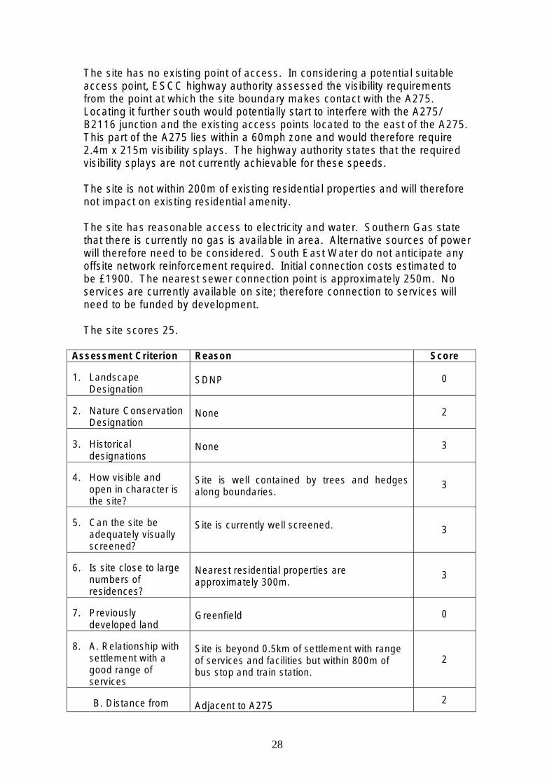
The site has no existing point of access. In considering a potential suitable access point, ESCC highway authority assessed the visibility requirements from the point at which the site boundary makes contact with the A275. Locating it further south would potentially start to interfere with the A275/ B2116 junction and the existing access points located to the east of the A275. This part of the A275 lies within a 60mph zone and would therefore require 2.4m x 215m visibility splays. The highway authority states that the required visibility splays are not currently achievable for these speeds.
The site is not within 200m of existing residential properties and will therefore not impact on existing residential amenity.
The site has reasonable access to electricity and water. Southern Gas state that there is currently no gas is available in area. Alternative sources of power will therefore need to be considered. South East Water do not anticipate any offsite network reinforcement required. Initial connection costs estimated to be £1900. The nearest sewer connection point is approximately 250m. No services are currently available on site; therefore connection to services will need to be funded by development.
The site scores 25.
Assessment Criterion Reason Score
1. Landscape Designation
SDNP 0
2. Nature Conservation Designation
None 2
3. Historical designations
None 3
4. How visible and open in character is the site?
Site is well contained by trees and hedges along boundaries.
3
5. Can the site be adequately visually screened?
Site is currently well screened. 3
6. Is site close to large numbers of residences?
Nearest residential properties are approximately 300m.
3
7. Previously developed land
Greenfield 0
8. A. Relationship with settlement with a good range of services
Site is beyond 0.5km of settlement with range of services and facilities but within 800m of bus stop and train station.
2
B. Distance from Adjacent to A275 2
28

primary route network
9. Suitable level of access
Does not meet visibility requirements for local speed limits.
0
10. Level site Yes 1
11. Accessibility of Services and deliverability of site
Gas – No gas in area, approx 2km. Electricity – Available, not a constraint Water – Connection available 5m from site Sewer – Nearest connection point 250m. Currently has capacity.
2
12. Suitable for residential use by Gypsies and Travellers?
Yes. No known land contamination issues. Noise from A275 not considered to have an overall significant impact on site.
2
13. Size of Site 7387m2 – site can provide more than 6 pitches. Realistically shape of site dictates that the southern part would be where pitches are located.
2
14. Total Score 25
Conclusion
The site scores well in respect of size and proximity to some key services. Access to public transport (bus and train) enables facilities and services to be accessed in other larger nearby settlements.
The site also scores well in relation to its topography. It is also relatively self contained within the landscape.
The residential amenity of both potential future occupants and existing nearby properties is considered good.
The lack of a suitable access raises doubts over the site’s suitability and achievability.
29

Site F – Glendene, North Chailey
Commentary
The above Greenfield site is located along a residential stretch of development north of the A272 (Station Road) between the settlements of North Chailey and Newick. The site was originally identified for potential development within the Strategic Housing Land Availability Assessment (SHLAA). However, it was filtered from assessment due to the lack of known details against which to assess it. It is considered to be in private ownership.
It is a large site, approximately 23000m2 (2.3ha), located outside of the South Downs National Park. The southern part of the site was previously used as a fruit nursery. A small northern section of the site is designated ancient woodland. This area would not be considered for development. Excluding this area would reduce the site’s capacity but would not impact on the other aspects of the assessment or achievability.
The site is currently screened from the road with board fencing. Due to topography of land, and existing trees to the south, only limited views of the site from the north can be achieved. The site is contained by the existing adjacent development. Developing the site would therefore have minimal impacts on the surrounding landscape.
The site is beyond 0.5km of a settlement with key services and facilities but is within 400m of a bus stop connecting the site with Newick to the east. Newick, a Rural Service Centre, is the closest settlement with a good range of
30

key services. The smaller settlement of North Chailey, west of the site, offers a convenience store within walking distance.
LDC Environmental Health Officers state that due to the site’s historic use as a fruit farm, which included greenhouses, and its proximity to a historic landfill site (250m), further investigation into potential land contamination issues is required.
There is currently no vehicular access to the site. ESCC highway authority state that a new access point would be needed on to A272. The site lies within the 50mph speed limit requiring visibility splays of 2.4m x road 160m. ESCC highways consider these distances to be achievable, along this stretch of road, within the available highway land.
Southern Water state that a foul sewer running across the north eastern corner of the site which requires a 6m buffer. This is not considered to impact on the suitability of the site but requires consideration in any site layout and capacity. Southern Water also state that there is currently no capacity at the sewer’s nearest point of connection. Costs of improving capacity will need to be met by development or alternative onsite foul waste treatment considered. Gas and electricity infrastructure services are not considered a constraint in this location. South East Water state that off-site reinforcement to the water supply is required to maintain current service standards. This additional cost will need to be at least partially met by the developer.
The site scores 23.
Assessment Criterion Reason Score
1. Landscape Designation
None 3
2. Nature Conservation Designation
Ancient Woodland within northern part of site. Could be excluded without impacting on achievability.
0
3. Historical designations
None 3
4. How visible and open in character is the site?
Site has limited views out to north but currently screened by hedges to south.
3
5. Can the site be adequately visually screened?
Landscaping to screen site from adjacent properties could be improved.
3
6. Is site close to large numbers of residences?
Site is within 200m of 10 or more properties 0
7. Previously Greenfield 0
31

developed land
8. A. Relationship with settlement with a good range of services
Beyond 0.5km of settlement but within 800m of bus stop. 2
B. Distance from primary route network
Adjacent to A272 2
9. Suitable level access
Yes. Required visibility splays achievable. 1
10. Level site No – steep north facing slope 0
11. Accessibility of Services and deliverability of site
Water – Available 5m from site Foul sewer within site, crosses north eastern corner, requires 6m buffer. Currently has no capacity. Electricity – Available, not a constraint Gas – Approx. 5m from connection
2
12. Suitable for residential use by Gypsies and Travellers?
Established residential use along Station Road. Known historic use of greenhouses on site. Potential for land contamination from chemicals. Within 250m of historic landfill. No noise or air quality concerns.
2
13. Size of Site 23000m2 – Site suitable to be subdivided 2
14. Total Score 23
Conclusion
Site lies outside of the SDNP and has access to key services, via public transport. ESCC highways are confident that the required visibility splays can be achieved.
Site is also adjacent to a Primary Route Network (PRN), A272, allowing easy east-west travel and is also within close proximity to the A275, providing north-south access.
The main concerns in terms of suitability for residential use are identified potential land contamination and topography of the land.
The site also scores poorly in relation to proximity to existing residential properties, potentially impacting on amenity.
32

Site G – Paddock at Chailey Green
Commentary
Chailey Green is a small hamlet located along the A275. The site, which lies west of the church, is approximately 3240m2 and is a relatively regular shape. Church Lane runs along the southern boundary from The Green to Chailey Moat. A small car park, which serves St Peter’s Church, is adjacent to the site’s eastern boundary.
The site was originally submitted as part of the Strategic Housing Land Availability Assessment (SHLAA) but was filtered at the initial stages due to its proximity to an existing planning boundary. It is currently within private ownership.
This Greenfield site is located outside the South Downs National Park area and has no environmental designations. However, the site is located within Chailey Green Conservation Area, the Appraisal of which highlights the trees and tree groups along the site’s boundary as a contributor to the rural character and sense of enclosure of the area.
In terms of any impact of potential development on the surrounding landscape the site is bounded by hedges and mature trees limiting views into and out of the site.
Chailey Green is a very small settlement, classified as a Hamlet within the Rural Settlement Study, with very few key services. Newick village is the
33

closest settlement with a good range of services. The site is located within 800m of a bus stop, enabling access to Lewes and Uckfield, via Newick.
ESCC highway authority considered two potential access points to the site from Church Lane. The existing access point in the south east corner is stated to be substandard in both directions due to the limited visibility from existing trees and shrubs. A potential new access point through the car park is suggested as an alternative. However, the highway authority does not consider Church Lane to be currently suitable for increased traffic movement due to its restricted width. Furthermore, the junction of Church Lane and A275 is located on a bend where the required visibility splays of 2.4m x 120 cannot be achieved.
LDC Environmental Health Officers did not identify any issues which would impact on the site’s suitability for residential use.
Due to the distance between the site and existing sewer and gas infrastructure the costs of connection are likely to be high, which will impact on the viability of development. South East Water also state that offsite reinforcement to the water supply will also be required to maintain current service standards. There is also an approximate connection cost of £1900. In terms of foul water disposal alternative onsite waste treatment could be considered. The site is unconstrained in terms of electricity.
Site scores 24.
Assessment Criterion Reason Score
1. Landscape Designation
None 3
2. Nature Conservation Designation
None 2
3. Historical designations
Chailey Green Conservation Area 1
4. How visible and open in character is the site?
Site is self contained with very limited views out of the site.
3
5. Can the site be adequately visually screened?
Site has existing screening by trees and hedges.
3
6. Is site close to large numbers of residences?
Within 200m of approximately 15 properties 0
7. Previously developed land
Greenfield 0
8. A. Relationship with settlement with a
Not within 0.5km of settlement with services 2
34

good range of services
but within 800m of bus stop
B. Distance from primary route network
Within 0.5km of A275 2
9. Suitable level access
40mph stretch of road. Visibility cannot be achieved at these speeds. Unsuitable road to site.
0
10. Level site Yes 1
11. Accessibility of Services and deliverability of site
Water – 5m, off-site reinforcement required. Sewer – 925m. Has capacity but likely to be costly to connect. Electricity – Not a constraint to delivery Gas – 550m from nearest main
2
12. Suitable for residential use by Gypsies and Travellers?
Yes. No identified noise, air quality or contamination issues. 3
13. Size of Site 3240m2 – Site can accommodate more than 6 pitches 2
14. Total Score 24
Conclusion
The site scores well in terms of its suitability for residential use. The site is level and is well contained by existing trees and hedges. However, it is within a Conservation Area. Therefore, any development in this area is likely to impact on the local character.
The site is considered available for consideration for assessment as it had previously been submitted to assess for potential housing.
The site does not have reasonable access to a settlement with a good range of key services, but does have access to a bus service which runs between Lewes and Uckfield.
However, due to Highway concerns over access to the site and the fact that the required visibility splays at Church Lane/ A275 junction are not considered achievable, the site is not considered suitable for use as a permanent site.
35
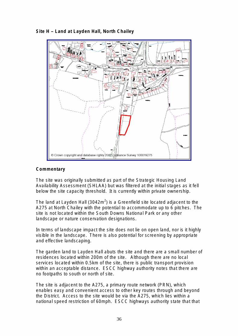
Site H – Land at Layden Hall, North Chailey
Commentary
The site was originally submitted as part of the Strategic Housing Land Availability Assessment (SHLAA) but was filtered at the initial stages as it fell below the site capacity threshold. It is currently within private ownership.
The land at Layden Hall (3042m2) is a Greenfield site located adjacent to the A275 at North Chailey with the potential to accommodate up to 6 pitches. The site is not located within the South Downs National Park or any other landscape or nature conservation designations.
In terms of landscape impact the site does not lie on open land, nor is it highly visible in the landscape. There is also potential for screening by appropriate and effective landscaping.
The garden land to Layden Hall abuts the site and there are a small number of residences located within 200m of the site. Although there are no local services located within 0.5km of the site, there is public transport provision within an acceptable distance. ESCC highway authority notes that there are no footpaths to south or north of site.
The site is adjacent to the A275, a primary route network (PRN), which enables easy and convenient access to other key routes through and beyond the District. Access to the site would be via the A275, which lies within a national speed restriction of 60mph. ESCC highways authority state that that
36

the visibility requirements (2.4m x 215m) are required for these speeds. Following a speed survey at this location vehicular average speeds were shown to be 52 and 54 miles per hour, travelling north and south respectively. Consequently, the required distances at these speeds can be reduced. These distances are considered achievable within the available land.
No significant concerns were raised by the Environmental Health Officers regarding noise pollution from the A275. The site is boarded to the north by Layden Hall. If the site is a transit site then early morning and late night arrivals and departures may adversely impact this property.
In terms of utilities, the site is approximately 300m from the nearest gas main. There is no sewer system in the immediate vicinity, therefore alternative onsite waste disposal treatment will need to be considered. Southern Water also indicate that there is no capacity in the current infrastructure. Costs of connecting the site to the infrastructure will need to be covered by the development. South East Water state that offsite network reinforcement will be required and there will be an initial connection cost of approximately £4300. The site is unconstrained in terms of electricity.
The site scores 26.
Assessment Criterion Reason Score
1. Landscape Designation
None 3
2. Nature Conservation Designation
None 2
3. Historical designations
None 3
4. How visible and open in character is the site?
Site is well contained. 3
5. Can the site be adequately visually screened?
Yes – appropriate and effective landscaping can be provided.
3
6. Is site close to large numbers of residences?
Site is within 200m of less than 10 properties 2
7. Previously developed land
Greenfield 0
8. A. Relationship with settlement with a good range of services
Not within 0.5km of settlement with services but within 800m of bus stop. 2
B. Distance from Adjacent to A275 and within 0.5km of A272 2
37

primary route network
9. Suitable level of access
Speed survey undertaken to confirm actual speeds. Distances required are considered achievable.
1
10. Level site Majority of site level 1
11. Accessibility of Services and deliverability of site
Gas – Approx 300m from nearest main. Sewer - No sewer in vicinity and no capacity. Electricity – Not a constraint Water – 20m, offsite reinforcement required.
2
12. Suitable for residential use by Gypsies and Travellers?
Yes. No identified noise, air quality or contamination issues identified. 3
13. Size of Site 3042 m2 – site can accommodate up to 6 pitches 2
14. Total Score 29
Conclusion
The site scores well in terms of its proximity to a Primary Route Network (PRN) and bus stop to access key services and facilities which are not available in the nearest settlement, North Chailey.
The site is also considered appropriate in landscape terms, having adequate existing vegetation that will provide some screening to the surrounding landscape.
This site could be considered suitable for use as a permanent residential Gypsy and Traveller site for approximately 4 pitches.
38

Site I – Land between The Plough and Old Brickworks
Commentary
Land between The Plough and the Old Brickworks is a large (44720m2) Greenfield site north of the village of Plumpton Green. The site is currently within private ownership and was originally submitted as part of the Strategic Housing Land Availability Assessment (SHLAA) but was filtered at the initial stages due to its proximity to an existing planning boundary.
The site is not within the South Downs National Park or any other local or national historical or nature conservation designations. The site is relatively open in character and has long but interrupted views to the south. Mature trees and hedges along the boundaries offer some screening to the wider landscape and adjacent properties. The gentle south sloping topography of the land means that the northern part of the site is more exposed. Subdivision and landscaping of the site will be required so as to mitigate any unacceptable impacts on the surrounding landscape. .
The amenity of future occupants would be good. LDC Environmental Health Officers do not identify any land contamination issues, although state that the industrial uses associated with the Old Brickworks to the south of the site may need to be a consideration.
ESCC Highway Authority assessed two potential access points, the first fronting St Helena Lane, west of the site, and a second from Station Road in the east, at an existing field entrance in the south east corner of the site.
39

Current speed limit of St Helena Lane is 60mph. Visibility of the access on to St Helena Lane is currently obstructed by an existing hedge with insufficient grass verge in front of hedge to gain adequate visibility. Moving the access south would reduce horizontal visibility due to the site’s position on the brow of a hill. The achievability of required visibility splays on Station Road is also a highway concern due to the current lack of knowledge of currently available highway land and obstructions from bus shelter, slight curve and uphill gradient of road to the north of the considered access point.
Due to the site’s rural and isolated location it is over a kilometre from a Primary Route Network. The closest is the A275.
The village of Plumpton Green, as a local village, to the south of the site has some key services including primary school, convenience store and post office. Further services can be accessed from other settlements via bus from within 800m of site, or bus and train from Plumpton Green.
In terms of availability of utility services, the site is unconstrained in water and electricity supplies. However, Southern Water state that there is currently no capacity in the existing sewerage infrastructure and Southern Gas Networks indicate that there is currently no gas supply to the surrounding area. Alternative onsite waste treatment and power would need to be considered. South East Water state the closest connection point is 5m from the site and has an initial cost of £1900. No offsite reinforcement anticipated.
The site scores 25.
Assessment Criterion Reason Score
1. Landscape Designation
None 3
2. Nature Conservation Designation
None 2
3. Historical designations
None 3
4. How visible and open in character is the site?
Within site it appears quite open due to its size. Limited views out due to mature tree boundaries and topography of land.
3
5. Can the site be adequately visually screened?
Southern part of site would naturally be easier to screen due to topography. Landscaping is considered appropriate and effective.
3
6. Is site close to large numbers of residences?
Site is within 200m of less than 10 properties 2
7. Previously developed land
Greenfield 0
40

8. A. Relationship with settlement with a good range of services
More than 0.5km from nearest settlement with services but within 800m of bus stop. 2
B. Distance from primary route network
More than 1km from primary route network. 0
9. Suitable level access
No suitable access identified. 0
10. Level site Gentle slopes to south but levels considered achievable. 1
11. Accessibility of Services and deliverability of site
Water – Approx 5m from connection point. No sewer indicated to be nearby. Electricity – Not a constraint to delivery Gas – No gas in area, approximately 4km to nearest main.
2
12. Suitable for residential use by Gypsies and Travellers?
Yes. No identified air quality or land contamination issues. Noise from adjacent industrial uses should be considered.
2
13. Size of Site 44720 m2 – site can be subdivided 2
14. Total Score 25
Conclusion
Overall the site scores comparatively well. Whilst this is a large site, it is considered achievable to subdivide the site without impacting on the landscape.
The site scores well in terms of access to basic services, although an onsite waste treatment will be required due to lack of existing sewer infrastructure.
The main constraint to development of this site is the lack of a suitable access as the required visibility splays are not considered achievable. The site is also considered isolated in terms of access to facilities.
41

Site J – Land at Plumpton Depot, South Road
Commentary
This site is currently is private ownership. The site was previously included asa site to be assessed as part of the Strategic Housing Land AvailabilityAssessment (SHLAA) and therefore considered available for assessment.The site is of a regular, square shape and measures 5082m2.
This previously developed site is located outside the South Downs NationalPark and has no other local or national historical or nature conservationdesignations.
The site is located between the villages of Wivelsfield Green and PlumptonGreen. Both of these settlements have access to key services such asprimary schools, convenience stores and post office. However, the site doesnot have access to a bus stop or train station so is considered a cardependant, isolated site.
It is currently used as an open storage site. As such, LDC EnvironmentalHealth Officer comments have identified the possibility for land contamination.This would need to be further investigated. Possible noise nuisance fromadjacent agricultural uses has also been identified.
The site is currently well contained by existing bunding and trees whichreduce any visual impacts of the site from the wider landscape.
42

The majority of the site is flat and has existing hardstanding, although some areas are more informal ‘tip’ areas.
ESCC highway authority, in considering a potential point of access, assessed the existing vehicular access which is onto South Road and lies within the 60mph national speed limit, which requires visibility splays of 2.4m x 215m. The highway authority noted that the current access is substandard and does not consider the required visibility splays to be achievable, given the lack of land control.
The site has reasonable access to power and water. However, Southern Water state that the nearest sewer is approximately 680m. Connection to infrastructure will need to be borne by development. Southern Gas state that there is no gas in the immediate vicinity. South East Water indicate an approximate connection cost of £3500 as the site is approximately 15m from network. No offsite network reinforcement anticipated.
The site scores 26.
Assessment Criterion Reason Score
1. Landscape Designation
None 3
2. Nature Conservation Designation
None 2
3. Historical designations
None 3
4. How visible and open in character is the site?
Well contained by existing boundary trees. 3
5. Can the site be adequately visually screened?
Yes, appropriate and effective landscaping can be achieved.
3
6. Is site close to large numbers of residences?
200m from less than 10 properties 2
7. Previously developed land
Brownfield - Storage 3
8. A. Relationship with settlement with a good range of services
Isolated site 0
B. Distance from primary route network
Over 1km from primary route network 0
43

9. Suitable level of access
Required visibility levels not likely to be achievable. 0
10. Level site Yes 1
11. Accessibility of Services and deliverability of site
Water – Approx 15m from connection Sewer – 680m to nearest connection. Currently has capacity. Electricity – Not a constraint to delivery Gas – No gas in area, approx 3km to nearest main
2
12. Suitable for residential use by Gypsies and Travellers?
Yes. Possibility of land contamination would need to be investigated. No identified air quality issues. Noise potential from adjacent agricultural uses.
2
13. Size of Site 5082 m2 – Site can accommodate more than 6 pitches but could satisfactorily bring part of site forward.
2
14. Total Score 26
Conclusion
Due to the lack of national or local landscape or environmental designations the above site scores well with regards to suitability within the surrounding landscape. It is also currently well contained by existing vegetation and bunding along the site boundary.
The site scores poorly due to its isolated and car dependant location. The nearest settlement which offers some key services is Wivelsfield Green.
The site is considered unsuitable due to highway concerns regarding the achievability of visibility splays required for the speeds of this road.
44

Site K – Land west of Slugwash Lane, Wivelsfield
Commentary
The above site, which is approximately 3325m2, was previously submitted for assessment for potential housing within the Strategic Housing Land Availability Assessment (SHLAA). However, it failed the SHLAA initial threshold filter. The site is located north of the development boundary of Wivelsfield Green.
This greenfield site is currently undeveloped land located outside of the South Downs National Park (SDNP) area. There are no environmental or historical designations onsite either.
Currently, the site contains trees and shrubs of various sizes across the majority of the site resulting in a well contained site. In order to deliver development on site a number of trees will need to be removed. Existing trees and hedges should be retained around the boundary providing screening to the existing residential properties to the south and the open countryside to the north.
ESCC highway authority states that the only existing access to the site is via a field access gate which is currently substandard. The site is located within the national speed limit section of Slugwash Lane. Consequently, the required visibility splays are 2.4m x 215m. Highways do not consider that these distances can be achieved due to the alignment of the road and lack of land control.
45

With regards to access to onsite utilities, water and electricity supplies are unconstrained to the site. South East Water state that no offsite network reinforcement is anticipated. Costs of initial connection to the site are approximately £1900. Southern Water indicate that the nearest point of connection to the sewerage infrastructure is 130m. Whilst it is stated that there is currently capacity at this point, the cost of connection will need to be met by the development. Alternatively, onsite waste water disposal system might be considered.
The site scores 23.
Assessment Criterion Reason Score
1. Landscape Designation
None 3
2. Nature Conservation Designation
None 2
3. Historical designations
None 3
4. How visible and open in character is the site?
Site is well contained. Site is reasonably wooded with limited views out of the site.
3
5. Can the site be adequately visually screened?
Appropriate and effective landscaping can be provided by existing trees.
3
6. Is site close to large numbers of residences?
Within 200m of more than 10 properties 0
7. Previously developed land
Greenfield. 0
8. A. Relationship with settlement with a good range of services
Nearest settlement of Wivelsfield Green has a primary school and convenience store. Other services and facilities require access to public transport. Within 800m of bus stop.
2
B. Distance from primary route network
More than 1km from primary route network 0
9. Suitable level access
Access currently substandard. Visibility splays not considered achievable.
0
10. Level site Yes 1
11. Accessibility of Services and deliverability of site
Water – Approx. 5m from connection point. Sewer – 130m, currently has capacity Electricity – Not a constraint Gas – No gas in area, approx 1km to nearest main
2
46

12. Suitable for residential use by Gypsies and Travellers?
Yes – considered appropriate for residential amenity. No known air or noise issues. No known contamination issues but investigation into previous use recommended.
2
13. Size of Site 3325m2 – site can accommodate up to 6 pitches. 2
14. Total Score 23
Conclusion
This site scores well with regards to its location outside of the SDNP and other environmental and landscape designation. The site itself is also well screened by existing vegetation.
The site has reasonable access to a primary school and store in Wivelsfield Green.
The main constraint to development at this site is access as it is currently substandard and the required visibility splays are not considered achievable.
47

Site L – Ditchling Nurseries, Beacon Road
Commentary
The Ditchling Nursery site (7868m2) is a privately owned Greenfield site located on Beacon Road. The site was previously assessed as part of the SHLAA. The site is reasonably sized and has the potential to deliver six pitches. It is located in the National Park. However, there are no other nature conservation or historic designations.
In terms of potential landscape impacts, the site has short and obscured views out and across the site. Existing trees and hedges also limit longer views into the site. Additional landscaping will help mitigate views from nearby vantage points, such as Ditchling Beacon, particularly in winter when visibility is increased due to reduced vegetation cover. The site lies within an area identified, in the joint LDC and SDNPA Landscape Capacity Study, as having a medium capacity for change.
The site is well located in terms of local services. It is 0.5km away from the nearest settlement and is also within 800m of the nearest bus route. There are less than 10 local residences within the 200m threshold. Impacts of additional traffic movements on nearby residents will need to be considered. The site is approximately 1km from the primary route network. ESCC highways state that visibility distances required for this stretch of road are considered achievable from the existing access point to the north.
48

Environmental Health Officers state that due to the site’s previous use as commercial nurseries there is the potential for localised contamination. Therefore, a detailed site investigation is likely to be required to determine the suitability of the site for future residential use and identify any appropriate remediation works.
Site has reasonable access to utilities. Southern Gas state that the site is 400m from the nearest gas main. South East Water do not anticipate any offsite network reinforcement being required. Nearest connection point to water supply is approximately 10m with an initial connection cost of £4,300. Southern Water state that there is no sewer in the immediate vicinity. However, there is adequate water capacity and the site is located 365m from the nearest connection point. Depending on final costs of connection, alternative power and foul water disposal may need to be considered.
The site scores 27.
Assessment Criterion Reason Score
1. Landscape Designation
SDNP 0
2. Nature Conservation Designation
None 2
3. Historical designations
None 3
4. How visible and open in character is the site?
Site has short views across the site. Views in and out of the site are obscured by existing trees and hedges.
3
5. Can the site be adequately visually screened?
Landscaping within the site should help screen site.
3
6. Is site close to large numbers of residences?
Site is 200m from less than 10 properties 2
7. Previously developed land
Greenfield. However, there are two large old greenhouse structures beneath the overgrown shrubbery.
0
8. A. Relationship with settlement with a good range of services
Within 0.5km of settlement with primary school, post office and doctors. Also within 800m of bus stop for access to other services and facilities.
3
B. Distance from primary route network
More than 1km from primary route network 0
49

9. Suitable level of access
Preferred access point to north of site were required visibility distances are achievable.
3
10. Level site Yes 1
11. Accessibility of Services and deliverability of site
Water – 20m from connection point. Sewer – 365m from nearest connection point. Currently has capacity. Electricity – Not a constraint to delivery Gas – Approx 400m from main
2
12. Suitable for residential use by Gypsies and Travellers?
Yes. No noise or air quality issues identified. Potential for and contamination issues due to previous commercial nursery use.
2
13. Size of Site 7868m2 – site can accommodate more than 6 pitches but could be subdivided. 2
14. Total Score 27
Conclusion
The site generally scores well against the above criteria. The site has existing access to Beacon Road to the north of the site. The site also scores well due to its proximity to a village with a range of facilities.
The site is within the SDNP but impacts on the surrounding landscape are limited due to existing vegetation.
As the site has previously been used as commercial nurseries a number of existing structures will need to be cleared and the land assessed for potential contamination.
The site scores poorly against distance from a primary route network and due to its location within the SDNP, although the site is well contained and screen by existing hedgerows along the boundaries.
50

Site M – Land at Balcombe Pit, Glynde
Commentary
The land at Balcombe Pit (5000m2) is a Brownfield site located on Station Road at Glynde with the potential to accommodate approximately 6 pitches. The site is privately owned. It formed part of the Economic and Employment Land Assessment (EELA) and has been assessed for an alternative use due to its low score in the EELA as an employment site. However, the assessment concluded that the site is not available for Traveller use.
Although the site borders the SDNP boundary, it is not located on any nature conservation or historic designations. The site is fairly well contained by the quarry cliff immediately to the west and trees to the east. There is also potential for further visibility screening which should protect the views from the SDNP. The site is within a wider area, identified within the joint LDC and SDNPA Landscape Capacity Study, concluded to have a medium to high capacity for change within.
The site is located within 200m of more than 10 properties and if the site is a transit site then early morning and late night arrivals and departures may adversely impact these properties. However, there is potential to strengthen the tree line which is currently screening the site. In terms of noise pollution within the site, despite the Eastbourne to Lewes railway line to the north, the potential for impact on future site users is somewhat mitigated and should not be an issue.
51

The site is within 800m of a bus stop which provides access to the nearest settlement with an appropriate level of services and facilities. The site is accessed via Station Road, which is within a 30mph speed restriction, and the site is within 1km of the primary route network. Although improvements to the access point are likely to be required, no significant access issues have been identified and visibility requirements are considered achievable.
The site is currently occupied by commercial/industrial units (including a motor garage) which have temporary planning consent and formerly occupied by a number of other industrial uses. With this in mind, a site investigation would be required to determine the suitability of the proposed use and if remedial works are required.
The site is not located in an area served by gas. Southern Gas Network state that the nearest main is 4.5km away. Southern Water state that whilst there is a foul sewer nearby, there is currently inadequate capacity to accommodate the site. Alternative onsite waste disposal will need to be considered. South East Water state that the nearest connection point is approximately 70m and an estimated initial connection cost of £12,300. Access to electricity is stated not to be a constraint to development.
Site scores 29.
Assessment Criterion Reason Score
1. Landscape Designation
None - Adjacent to SDNP boundary. 3
2. Nature Conservation Designation
None 2
3. Historical designations
None 3
4. How visible and open in character is the site?
Site is contained against quarry cliff to west and trees to east.
3
5. Can the site be adequately visually screened?
Site can be effectively and appropriately screened.
3
6. Is site close to large numbers of residences?
Site is within 200m of more than 10 properties 0
7. Previously developed land
Brownfield land. Currently has a number of empty buildings and works associated with B2 uses.
3
8. A. Relationship with settlement with a good range of services
Within 800m of bus stop to access settlement with an appropriate level of services and facilities.
2
52

B. Distance from primary route network
Within 1km of primary route network (A27) 1
9. Suitable level of access
Visibility achievable but layout currently substandard. 2
10. Level site Yes 1
11. Accessibility of Services and deliverability of site
Water – approx 70m Sewer – No sewer near to site. No capacity indicated. Electricity – Not a constraint Gas – No gas in area, approx 4.5km to nearest main.
2
12. Suitable for residential use by Gypsies and Travellers?
No identified air quality issues. Noise from railway considered to be mitigated by existing cutting. Potential land contamination issues due to known previous use but require further investigation.
2
13. Size of Site 5000m2 – Site can accommodate more than 6 properties. Due to site shape pitches would be anticipated to be located in southern part of site. Approx 6 pitches could be accommodated in area.
2
14. Total Score 29
Conclusion
This sites scores comparatively high. It receives positive scores against its location outside, although adjacent, of the SDNP and other environmental and landscape designations. The site is well screened and contained.
The site has an existing access point, which is considered achievable in terms of the required upgrading and visibility splays.
Whilst the scores well in terms of being brownfield there are some current light industrial uses. If the site was taken forward further land contamination investigations will be required.
The site scores poorly against its proximity to other residential properties with regards to potential impacts on amenity.
53

Site N – Tarring Neville Chalk Pit – Tarring Neville
Commentary
Tarring Neville Chalk Pit is a large (13000m2 / 1.3ha) disused greenfield site. It has been included in the Assessment as a known vacant site.
The sites lies outside, but adjacent to, the South Downs National Park. It is not subject to any other landscape or environmental designation. An Archaeological Notification Area lies also adjacent to the site.
Impacts on the landscape and views out of the site are limited due to the natural chalk walls of the quarry and topography of the site. Subdivision of the site has the potential to look at odds within the site but is not likely to impact on the wider landscape and therefore considered a feasible option.
The site itself lies outside of any areas of flood risk. However, the access is within Flood zone 3. Consequently, an alternative access point may need to be considered.
Comments provided by Environmental Health Officers state that in relation to the site’s previous use there is the potential for land contamination which will be required to be investigated. The potential for chalk rock fall should also be considered. Due to its proximity to the A26 there are likely to be noise impacts on future occupants, although the existing chalk wall may provide some mitigation.
54

The site has existing access to the A26, a Primary Route Network. ESCC highway authority and the Highway Agency consider the access to be substandard. The access lies within the 40mph speed limit but actual speeds will need to be further investigated to ascertain the appropriate visibility splays as it also lies close to the 60mph speed zone.
The site lies beyond 0.5km of the large urban area of Newhaven. Newhaven has a wide range of services and facilities. A bus stop within 800m of the site providing access the town.
The site has reasonable access to key services with a good prospect of delivery. Southern Water state that there is no sewer in the vicinity. Alternative onsite waste disposal will need to be considered.
The site scores 29.
Assessment Criterion Reason Score
1. Landscape Designation
None – Adjacent to SDNP 3
2. Nature Conservation Designation
None 2
3. Historical designations
None – Adjacent to Archaeological interest. 3
4. How visible and open in character is the site?
Site itself is open due to size and nature of its previous use but views out of site are very limited due to topography.
3
5. Can the site be adequately visually screened?
Effective and appropriate landscaping are considered to achievable to reduce impacts of views into quarry
3
6. Is site close to large numbers of residences?
Site within 200m of less than 5 properties 3
7. Previously developed land
Greenfield 0
8. A. Relationship with settlement with a good range of services
Beyond 0.5km of settlement but within 800m of bus stop for access to settlement 2
B. Distance from primary route network
Adjacent to A26 2
9. Suitable level of access
Access needing upgrading 1
55

10. Level site Yes 1
11. Accessibility of Services and deliverability of site
Water – 5m to connection cost Sewer - No sewer indicated nearby. Electricity – Not a constraint to development Gas – Approx 700m to nearest main
2
12. Suitable for residential use by Gypsies and Travellers?
Yes, quarry sides and additional landscaping and layout would help alleviate noise nuisance from A26. Potential for land contamination from previous quarry use. Flood zone 3 up to A26 – suitable means of evacuation plans required.
2
13. Size of Site 13,000m2 – Site can accommodate more than 6 pitches but could be satisfactorily subdivided.
2
14. Total Score 29
Conclusion
The site has good access to local services. The site lies adjacent to a Primary Route Network. The site is reasonably well screened and is not highly visible within the wider landscape.
Further investigation is required into land contamination and safety, in relation to chalk wall stability given its previous use, if taken forward.
The main constraints to development are access and residential amenity. If the site is taken forward for consideration as a permanent site the achievability of an alternative access point, due to the issue of flooding is currently unknown.
56

Site O – South of Beddingham old cement works, Beddingham
Commentary
This site has been included as a suggested site for assessment. It lies off the A26 within the Parish of Beddingham, south of the old cement works. The site is approximately 9500m (0.95ha).
The site lies within the South Downs National Park, but is not constrained by other environmental or landscape designations. The site is currently wooded, providing screening, with a track running along the west boundary which leads to agricultural fields to the south.
The site is located approximately 7km and 4.5km between the two settlements of Lewes and Newhaven respectively. Due to the site’s distance from any settlement it is considered to be an isolated site.
Comments provided by Environmental Health Officers state that due the site’s location adjacent to the Beddingham Landfill, further investigation will be required to determine whether ground gas protection would be required. No air quality impacts were identified. The A26 is identified as a potential for noise on potential future occupants.
57

The site lies adjacent to a track which joins an existing access point to the A26. Comments from the Highway Agency indicate that the access is considered substandard and has the potential to give rise to traffic conflicts due to the current 3 lane carriageway in place. Due to the topography and current speed limit of this stretch of the A26, the required visibility splays are not considered achievable.
Southern Gas Network and Southern Water both state that services are not available in the immediate area. The nearest gas main is approximately 5km from the site. Connections to these services are therefore likely to be unviable and alternative sources of power and onsite waste disposal will need to be considered.
Site scores 23.
Assessment Criterion Reason Score
1. Landscape Designation
SDNP 0
2. Nature Conservation Designation
None 2
3. Historical designations
None 3
4. How visible and open in character is the site?
Site is wooded and screened from outside views. Views from east will be most sensitive.
3
5. Can the site be adequately visually screened?
Yes, existing tree cover considered appropriate to provide screening.
3
6. Is site close to large numbers of residences?
Site is more than 200m from residential properties.
3
7. Previously developed land
Greenfield 0
8. A. Relationship with settlement with a good range of services
Site is isolated. 0
B. Distance from primary route network
Adjacent to A26 2
9. Suitable level access
Poorly aligned stretch of road with restricted visibility (horizontal and vertical). Junction improvements highly likely to be required.
0
10. Level site Yes 1
58

11. Accessibility of Services and deliverability of site
Sewer – No sewer in vicinity. Electricity – Not a restriction Gas – Approx 5km to nearest main. Water – 30m to connection cost.
2
12. Suitable for residential use by Gypsies and Travellers?
Yes. Potential for noise impacts from A26 but may be scope to alleviate with appropriate landscaping. Investigation into impacts of adjacent landfill.
2
13. Size of Site 9500m2 – site could accommodate more than 6 pitches but could be subdivided 2
14. Total Score 23
Conclusion
In landscape terms the site scores well. Retaining existing vegetation will help mitigate potential impacts of development on surrounding landscape. The level to which vegetation can be cleared without impacting on the landscape will dictate the capacity of the site. The site size can currently accommodate more than 6 pitches.
This site generally scores poorly due to its distance to any facilities and services. It is considered an isolated site.
Its proximity to the A26 and Beddingham Landfill are such that further investigation is required to ascertain its suitability for permanent residential use and impacts on future occupants.
Access to the site is the main constraint as there is likely to be traffic conflicts and difficulty in achieving the required horizontal and vertical visibility splays.
59

Site P – Land west of southern entrance to Cuilfail Tunnel, Lewes
Commentary
This site was put forward as a suggested site to be included within the Assessment. However, in undertaking the Assessment the current landowners, Highways Agency, stated that the site is not available.
The site is indicated to have once been a factory and builder’s yard but has since been left vacant and therefore now considered greenfield. Further land contamination investigations will however, be required.
The site is located north of the A26 approximately 150m from the southern entrance of the Cuilfail Tunnel east of Lewes Town. It is approximately 2750m (0.28ha) and formed of semi wooded/scrubland and occupies the land between the chalk cliff and A26.
There are currently limited views into the site however, views become increasingly open to the south west of the site. Its location within the South Downs National Park dictates that careful consideration of any development in this location, is given. The existing vegetation, which provides some screening should be retained and strengthened. This may potentially impact on the site’s capacity.
60

LDC Environmental Health Officer comments state that the site lies on the edge of source protection zone 3 for the Southover groundwater abstraction and therefore is considered a sensitive environmental location. The site lies outside of the Lewes Air Quality Management Area (AQMA) but may need reviewing should the site be used for permanent rather than transitory use.
Due to its proximity to the A26 the residential amenity of potential future occupants is likely to be unacceptably impacted upon. Residential development along South Street would be the site’s closest neighbour; however it is unlikely that this would pose an unacceptable impact on amenity.
There is currently no access to the site. The most likely point of access would be taken from the existing layby on the A26. However, the Highway Agency states that due to the cliff erosion they consider the site to be unsuitable for any type of development and recommend its removal from further assessment.
All services are available in the vicinity with good prospect of delivery.
The site scores 22.
Assessment Criterion Reason Score
1. Landscape Designation
SDNP 0
2. Nature Conservation Designation
None – Adjacent to SNCI 2
3. Historical designations
None 3
4. How visible and open in character is the site?
Fairly well contained site by existing trees but site can potentially be viewed from medium distances (Railway Land). However, site large enough to be set back.
3
5. Can the site be adequately visually screened?
Existing boundary trees should be retained to help screen site and mitigate noise from A26. Effective and appropriate landscaping considered achievable without impacting on surrounding character.
3
6. Is site close to large numbers of residences?
Within 200m of more than 10 properties 0
7. Previously developed land
Greenfield 0
8. A. Relationship with settlement with a good range of
Within 0.5km of settlement with good range of services and facilities
3
61

services
B. Distance from primary route network
Adjacent to A26 2
9. Suitable level of access
Access would likely have to be off existing parking bay.
0
10. Level site Yes. Works will be required to avoid rock fall into the site. Highways state that site is unsuitable for any development due to erosion, landslips and falling rocks.
1
11. Accessibility of Services and deliverability of site
Sewer – 50m Electricity – Not a constraint Water – Adequate capacity Gas – Approx 40m to nearest main.
3
12. Suitable for residential use by Gypsies and Travellers?
Site likely to be impacted by noise from A26. Potential for land contamination from former factory and builders yard. Assessment of air quality required for permanent use.
0
13. Size of Site 2750m2 – Site can accommodate up to 6 pitches 2
14. Total Score 22
Conclusion
The site is considered unsuitable due to concerns over the stability of the cliff. The site is also stated to be unavailable for development.
The site scores well in relation to nearby facilities and services and the availability of utilities.
Despite its location within the SDNP it is considered that any potential landscape impacts can be satisfactorily mitigated against.
Residential amenity of future occupants would be poor due to road noise and potential air quality concerns.
Overall the sites scores poorly and is not considered a suitable site to take forward for this proposed use.
62

Site Location Criterion 1 2 3 4 5 6 7 8a 8b 9 10 11 12 13 Total
A Valley Road, Peacehaven 3 0 3 0 0 3 0 3 0 0 0 2 3 2 19 B Juggs Road, Lewes 0 2 0 3 3 0 0 3 1 0 1 3 2 2 20 C Alfriston Road, Seaford 0 2 3 3 3 0 0 3 0 2 1 2 2 2 23 D Normansal Park Avenue, Seaford 0 0 3 0 3 0 0 3 0 1 1 2 3 2 18 E Land north of B2116/ A275 junction,
Hamsey 0 2 3 3 3 3 0 2 2 0 1 2 2 2 25
F Land at Glendene, Station Road, North Chailey
3 0 3 3 3 0 0 2 2 1 0 2 2 2 23
G The paddock at Chailey Green 3 2 1 3 3 0 0 2 2 0 1 2 3 2 24 H Land at Layden Hall, A275, North
Chailey 3 2 3 3 3 2 0 2 2 1 1 2 3 2 29
I Land between The Plough and Old Brickworks
3 2 3 3 3 2 0 2 0 0 1 2 2 2 25
J Land at Plumpton Depot, South Road 3 2 3 3 3 2 3 0 0 0 1 2 2 2 26 K Land west of Slugwash Lane,
Wivelsfield 3 2 3 3 3 0 0 2 0 0 1 2 2 2 23
L Ditchling nurseries, Beacon Road 0 2 3 3 3 2 0 3 0 3 1 3 2 2 27 M Land at Balcombe Pit, Glynde 3 2 3 3 3 0 3 2 1 2 1 2 2 2 29 N Tarring Neville chalk Pit, Tarring
Neville 3 2 3 3 3 3 0 2 2 1 1 2 2 29
O Land south of Beddingham Chalk Pit 0 2 3 3 3 3 0 0 2 0 1 2 2 2 23 P Land west of southern entrance of
Cuilfail Tunnel, Lewes 0 2 3 3 3 0 0 3 2 0 1 3 0 2 22
63