habitat management plan for high tor wildlife management area … · 2016-12-14 · ruffed grouse x...
TRANSCRIPT

0 | P a g e
HabitatManagementPlanfor
HighTorWildlifeManagementArea
2016‐2025
DivisionofFishandWildlifeBureauofWildlife
6274EastAvon‐LimaRoad,Avon,NewYork14414
June16,2016
Photo: Mike Palermo


2 | P a g e
TABLEOFCONTENTS SUMMARY ......................................................................................................................................... 3
I. BACKGROUND AND INTRODUCTION ................................................................................................ 3
PURPOSE OF HABITAT MANAGEMENT PLANS .................................................................................. 3
WMA OVERVIEW ............................................................................................................................ 5
LANDSCAPE CONTEXT ..................................................................................................................... 9
II. MANAGEMENT STRATEGIES BY HABITAT TYPE ............................................................................. 10
FOREST .......................................................................................................................................... 11
SHRUBLAND ................................................................................................................................... 23
GRASSLAND ................................................................................................................................... 25
AGRICULTURAL LANDS ................................................................................................................. 28
WETLANDS (NATURAL AND IMPOUNDED) ..................................................................................... 30
OPEN WATER (WATERBODIES AND WATERCOURSES) ................................................................... 32
HABITAT MANAGEMENT SUMMARY .............................................................................................. 35
III. FIGURES .................................................................................................................................. 37
IV. APPENDICES ............................................................................................................................. 47
APPENDIX A: DEFINITIONS ............................................................................................................ 47
APPENDIX B. STATEMENT OF CONFORMITY WITH SEQRA ............................................................ 50
APPENDIX C: FOREST MANAGEMENT PRESCRIPTIONS ................................................................... 52
APPENDIX D: AMENDMENTS .......................................................................................................... 55
LISTOFFIGURES
FIGURE 1. Location and access features at High Tor WMA. ........................................................ 37
FIGURE 2. High Tor WMA divided into section maps to provide closer detail. ........................... 38
FIGURE 3. Significant ecological communities on High Tor WMA (Map 1). .............................. 39
FIGURE 4. Significant ecological communities on High Tor WMA (Map 2). .............................. 40
FIGURE 5. Wetlands, open water, and streams of High Tor WMA (Map 1). ................................ 41
FIGURE 6. Wetlands, open water, and streams of High Tor WMA (Map 2). ................................ 42
FIGURE 7. Land cover and conservation lands in the landscape surrounding High Tor WMA. ... 43
FIGURE 8. Percent cover of land cover types within three miles of High Tor WMA. .................. 44
FIGURE 9. Habitat types and locations of proposed management on High Tor WMA (Map 1).. . 45
FIGURE 10. Habitat types and locations of proposed management on High Tor WMA (Map 2).. 46

3 | P a g e
SUMMARY High Tor Wildlife Management Area (WMA) is located at the south end of Canandaigua Lake and consists of three major sections: Hatch Hill, South Hill, and West River. Both Hatch and South hills are heavily forested while West River primarily consists of lowland marsh, shrub, and forested wetlands. Several threatened or special concern species and Species of Greatest Conservation Need (SGCN) use the various habitats on the WMA for breeding and/or wintering, and it is a New York State Bird Conservation Area.1 It is primarily managed to maintain a diverse assemblage of habitats consisting of upland forest, grasslands, marshes, ponds, and forested wetlands. This plan elaborates upon habitat objectives described in the Canandaigua Highlands Unit Management Plan2 (UMP) and provides guidance for the revision of that document. Key habitat management goals for High Tor WMA include:
Managing approximately 8% as young forest (at least 10% of forested landscape) to promote American woodcock and ruffed grouse;
Managing approximately 58% as intermediate and mature forest; Maintaining approximately 5% as grasslands to provide nesting habitat for grassland
birds and diverse food and cover for forest wildlife. Managing approximately 3% as early-successional shrublands; Managing approximately 1% as agricultural lands; and Maintaining approximately 21% as wetlands and open water to provide prime breeding
and migratory stopover habitat for marsh birds and waterfowl.
I.BACKGROUNDANDINTRODUCTION
PURPOSEOFHABITATMANAGEMENTPLANS
BACKGROUND
Active management of habitats to benefit wildlife populations is a fundamental concept of wildlife biology, and has been an important component of wildlife management in New York for decades. Beginning in 2015, NYS Department of Environmental Conservation (DEC) Division of Fish and Wildlife (DFW) initiated a holistic planning process for wildlife habitat management projects. Habitat Management Plans (HMPs) are being developed for WMAs and other properties administered by DFW Bureau of Wildlife, including select Multiple Use and Unique Areas. The goal of HMPs is to guide habitat management decision-making on those areas to benefit wildlife and facilitate wildlife-dependent recreation. HMPs guide management for a ten
1 Bird Conservation Area information is available online at http://www.dec.ny.gov/animals/25341.html. 2 NYSDEC Unit Management Plans are available online at http://www.dec.ny.gov/lands/4979.html
4 | P a g e
year time period, after which the plans and progress on implementation will be assessed and HMPs will be modified as needed. HMPs serve as the overarching guidance for habitat management on WMAs. These plans incorporate management recommendations from UMPs, existing WMA habitat management guidelines, NY Natural Heritage Program’s WMA Biodiversity Inventory Reports, Bird Conservation Area guidelines, and other documents available for individual WMAs.
SCOPE AND INTENT
Primary purposes of this document: Provide the overall context of the habitat on the WMA and identify the target species
for management; Identify habitat goals for WMA-specific target species, contemplating juxtaposition of
all habitat types to guide the conservation and management of sensitive or unique species or ecological communities;
Identify acreage-specific habitat goals for the WMA to guide management actions; Provide specific habitat management prescriptions that incorporate accepted best
management practices; Establish a forest management plan to meet and maintain acreage goals for various
forest successional stages; Address management limitations such as access challenges (e.g., topography); and Provide the foundation for evaluating the effectiveness of habitat management.
The Canandaigua Highlands UMP is scheduled for revision in 2018. At that time, this HMP will be integrated into a comprehensive WMA Management Plan that will include management provisions for facilitating compatible wildlife-dependent recreation, access, and facility development and maintenance. Definitions are provided in Appendix A. The effects of climate change and the need to facilitate wildlife adaptation under expected future conditions will be incorporated into the habitat management planning process and will be included in any actions that are recommended in the HMPs. For example, these may include concerns about invasive species, anticipated changes in stream hydrology, and the desirability for maintaining connectedness on and permeability of the landscape for species range adjustments. This plan and the habitat management it recommends will be in compliance with the State Environmental Quality Review Act (SEQRA), 6NYCRR Part 617. See Appendix B. The recommended habitat management also requires review and authorization under the Endangered Species Act (ESA), National Environmental Policy Act (NEPA), and National Historic Preservation Act (NHPA), prior to implementation.
5 | P a g e
WMAOVERVIEW
LOCATION
High Tor WMA is located in DEC Region 8, Town of Naples in Ontario County, and Towns of Middlesex and Italy in Yates County (Figure 1).
TOTAL AREA
6,832 acres
HABITAT INVENTORY
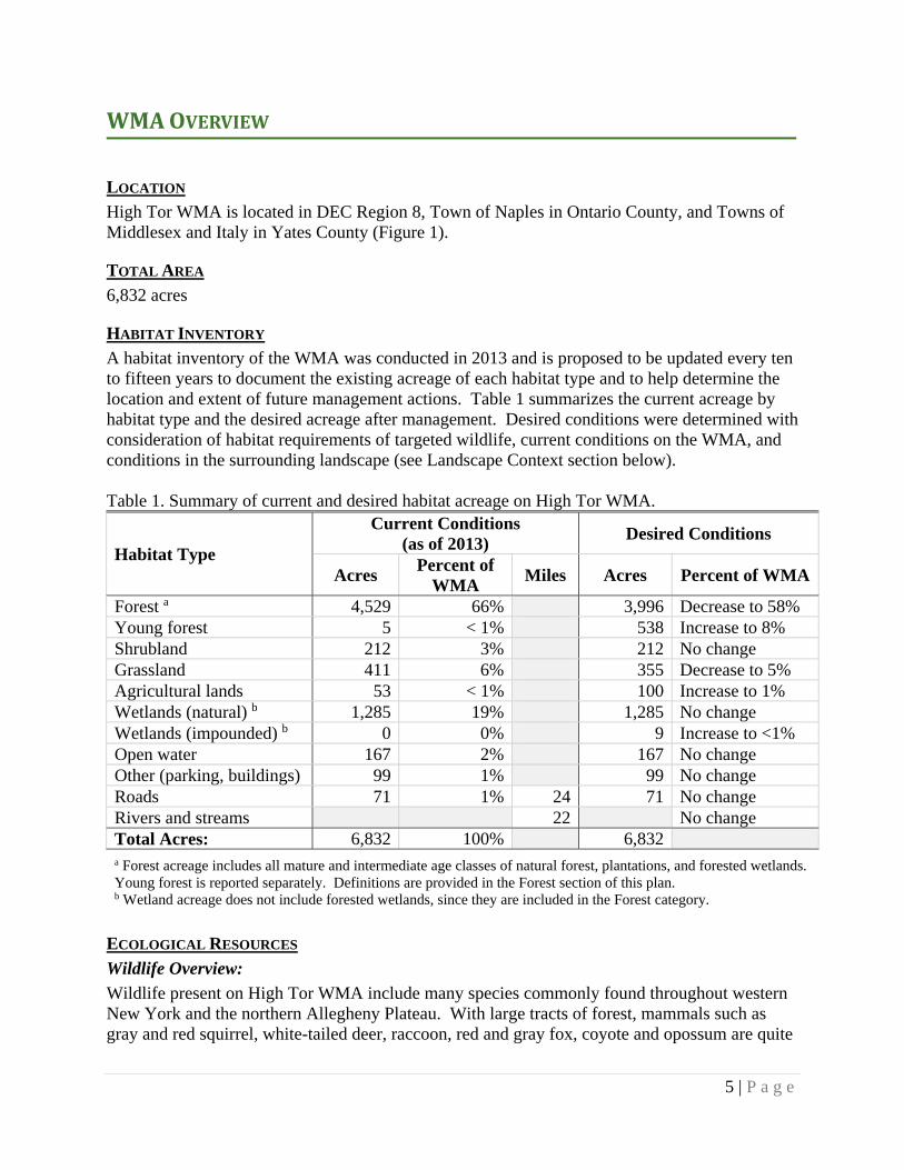
A habitat inventory of the WMA was conducted in 2013 and is proposed to be updated every ten to fifteen years to document the existing acreage of each habitat type and to help determine the location and extent of future management actions. Table 1 summarizes the current acreage by habitat type and the desired acreage after management. Desired conditions were determined with consideration of habitat requirements of targeted wildlife, current conditions on the WMA, and conditions in the surrounding landscape (see Landscape Context section below). Table 1. Summary of current and desired habitat acreage on High Tor WMA.
Habitat Type
Current Conditions (as of 2013)
Desired Conditions
Acres Percent of
WMA Miles Acres Percent of WMA
Forest a 4,529 66% 3,996 Decrease to 58% Young forest 5 < 1% 538 Increase to 8% Shrubland 212 3% 212 No change Grassland 411 6% 355 Decrease to 5%Agricultural lands 53 < 1% 100 Increase to 1%Wetlands (natural) b 1,285 19% 1,285 No change Wetlands (impounded) b 0 0% 9 Increase to <1% Open water 167 2% 167 No change Other (parking, buildings) 99 1% 99 No change Roads 71 1% 24 71 No change Rivers and streams 22 No change Total Acres: 6,832 100% 6,832 a Forest acreage includes all mature and intermediate age classes of natural forest, plantations, and forested wetlands. Young forest is reported separately. Definitions are provided in the Forest section of this plan. b Wetland acreage does not include forested wetlands, since they are included in the Forest category.
ECOLOGICAL RESOURCES
Wildlife Overview:
Wildlife present on High Tor WMA include many species commonly found throughout western New York and the northern Allegheny Plateau. With large tracts of forest, mammals such as gray and red squirrel, white-tailed deer, raccoon, red and gray fox, coyote and opossum are quite
6 | P a g e
common. A number of species not commonly found in western New York have reestablished themselves after long absences, including the black bear, bobcat, raven and fisher. Over 90 species of birds are known to nest in or near the area and in 2002, the WMA was designated a New York State Bird Conservation Area.
Many fish species annually visit the wetlands of West River to reproduce and Naples Creek supports a noted run of rainbow trout in the spring – a product of good water quality afforded by the forested slopes. These abundant wetlands are also home to many species of vertebrates besides fish. Several frog and turtle species are easily observed. Salamanders are found making annual spring treks to vernal pools in forested areas and include such species as Jefferson and spotted salamanders. Beaver, mink, and muskrat are commonly found, and river otter was reintroduced in the fall of 2000 as part of an otter restoration program to central and western NY. These extensive wetlands, adjacent to the large open waters of Canandaigua Lake, provide an important migratory concentration site for waterfowl.
Wildlife and Plant Species of Conservation Concern:
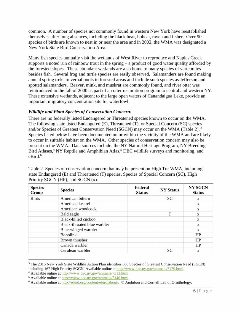
There are no federally listed Endangered or Threatened species known to occur on the WMA. The following state listed Endangered (E), Threatened (T), or Special Concern (SC) species and/or Species of Greatest Conservation Need (SGCN) may occur on the WMA (Table 2). 3 Species listed below have been documented on or within the vicinity of the WMA and are likely to occur in suitable habitat on the WMA. Other species of conservation concern may also be present on the WMA. Data sources include: the NY Natural Heritage Program, NY Breeding Bird Atlases,4 NY Reptile and Amphibian Atlas,5 DEC wildlife surveys and monitoring, and eBird.6
Table 2. Species of conservation concern that may be present on High Tor WMA, including state Endangered (E) and Threatened (T) species, Species of Special Concern (SC), High Priority SGCN (HP), and SGCN (x).
Species Group
Species Federal Status
NY Status NY SGCN
Status Birds American bittern SC x American kestrel x American woodcock x Bald eagle T x Black-billed cuckoo x Black-throated blue warbler x Blue-winged warbler x Bobolink HP Brown thrasher HP Canada warbler HP Cerulean warbler SC x
3 The 2015 New York State Wildlife Action Plan identifies 366 Species of Greatest Conservation Need (SGCN) including 167 High Priority SGCN. Available online at http://www.dec.ny.gov/animals/7179.html. 4 Available online at http://www.dec.ny.gov/animals/7312.html. 5 Available online at http://www.dec.ny.gov/animals/7140.html. 6 Available online at http://ebird.org/content/ebird/about/. © Audubon and Cornell Lab of Ornithology.

7 | P a g e
Table 2. Continued
Species Group
Species Federal Status
NY Status NY SGCN
Common nighthawk SC HP Cooper’s hawk SC Eastern meadowlark HP Golden-winged warbler SC HP Grasshopper sparrow SC HP Henslow’s sparrow T HP Horned lark SC HP Least bittern T x Louisiana waterthrush x Northern goshawk SC x Northern harrier T x Osprey SC Pied-billed grebe T x Prothonotary warbler HP Red-headed woodpecker SC HP Ruffed grouse x Rusty blackbird HP Scarlet tanager x Sharp-shinned hawk SC Vesper sparrow SC HP Wood thrush x Yellow-breasted chat SC HP Mammals None known to occur Amphibians and reptiles
Black ratsnake x Blue-spotted salamander SC HP
Eastern ribbonsnake x Jefferson salamander SC Northern black racer x Northern coal skink x Smooth greensnake x Snapping turtle x Western chorus frog x Fish Brook trout x Invertebrates None known to occur Plants Troublesome sedge T

8 | P a g e
Significant Ecological Communities:
There are two rare and significant natural communities located on High Tor WMA as identified by the NY Natural Heritage Program. The state rank reflects the rarity within NY, ranging from S1, considered the rarest, to S5, considered stable; definitions are provided in Appendix A. The following significant ecological communities occur on the WMA; community descriptions are from Ecological Communities of New York State, Second Edition 7 (Figures 3 and 4):
Floodplain forest (S2S3) - typically a hardwood forest that occurs on mineral soils on low terraces of river floodplains and river deltas. These sites are characterized by their flood regime; low areas are annually flooded in spring and high areas are flooded irregularly. Some sites may be quite dry by late summer whereas other sites may be flooded again in late summer or early autumn (these floods are caused by heavy precipitation associated with tropical storms). This is a broadly defined community; floodplain forests are quite variable and may be very diverse.
Perched swamp white oak swamp (S1S2) - a hardwood to mixed swamp that occurs in shallow depressions located either on flat hillside steps or flat hilltops where the water table is locally perched above the surrounding groundwater level. The water level fluctuates seasonally; the swamp may be flooded in spring and nearly dry by late summer. The substrate ranges from poorly drained mineral soil to muck over bedrock.
Additional information about significant ecological communities is available in the High Tor WMA Biodiversity Inventory Final Report (1997) prepared by the New York Natural Heritage Program. Soils:
Soils on High Tor WMA are largely shallow and infertile except in bottom lands adjacent to Naples Creek and West River. Most of the soils in the upland areas are the Lords-Town Series8 which are strongly acid, well-drained, and were developed in loose glacial till deposited over sandstone and shale bedrock. In some areas these soils create poor growing conditions resulting in slow tree growth. Proposed habitat management actions consider these growing conditions. Special Management Zones:
Special Management Zones (SMZs) are areas adjacent to wetlands, perennial and intermittent streams, vernal pool depressions, spring seeps, ponds and lakes, recreational trails, and other land features requiring special consideration. SMZs on High Tor WMA include:
Two wetlands (MS-1 and MS-2) regulated by Article 24 of the Environmental Conservation Law and several additional wetlands shown on the National Wetlands Inventory (NWI; Figures 5 and 6). Each state-regulated wetland is protected by a buffer zone of 100 feet from the delineated wetland boundary, known as the adjacent area. There may be forestry prescriptions associated with forested wetlands and adjacent areas, and each management prescription will be reviewed individually for determination of impacts.
7 Edinger, G. J., D. J. Evans, S. Gebauer, T. G. Howard, D. M. Hunt, and A. M. Olivero. 2014. Ecological Communities of New York State, Second Edition. New York Natural Heritage Program, NYS Department of Environmental Conservation, Albany, NY. Available online at http://www.dec.ny.gov/animals/97703.html. 8 Soil classification information available from: US Department of Agriculture, Natural Resources Conservation Service. Available online at http://www.nrcs.usda.gov/wps/portal/nrcs/surveylist/soils/survey/state/?stateId=NY.

9 | P a g e
Approximately 22 miles of streams, comprising sections of West River, Naples Creek, Tannery Creek, and their tributaries (Figures 5 and 6). Of these streams, 2.6 miles are classified as trout waters and are regulated by Article 15 of the Environmental Conservation Law. Water quality standards will be adhered to on all streams. 9
Guidelines for habitat management projects within these areas are outlined in the Division of Lands and Forests Rules for Establishment of Special Management Zones on State Forests and Wildlife Management Areas.10 Some habitat management activities may either be prohibited or restricted in order to protect these features. Any deviations from these guidelines will be addressed in the individual stand prescriptions.
State Nature and Historical Preserve:
There are two areas on High Tor WMA that are dedicated to the State Nature and Historical Preserve (SNHP). The SNHP consists of select state lands to be preserved and administered for the use and enjoyment of the people because of their natural beauty, wilderness character, or geological, ecological or historical significance. SNHP on High Tor WMA includes:
Clark Gully, approximately 150 acres, is located on the South Hill section, and was included in the SNHP because of its scenic gorge and “hanging falls.”
Parrish Gully (more commonly known as Conklin Gully), approximately 290 acres, is located on the Hatch Hill section, and was included in the SNHP due to its unique rock outcroppings and its interest to geologists.
Currently, there are no habitat management actions proposed within these areas. Future management actions would be to promote stewardship of the dedicated area. Additional information about the SNHP is available in Article XIV of the New York State Constitution11 and in Article 45 of the New York State Environmental Conservation Law. 12
LANDSCAPECONTEXT The goals of this HMP have been developed with consideration of surrounding landscape features and the availability of habitats and other conservation lands adjacent to High Tor WMA (Figures 7 and 8). The landscape within a three mile radius of the WMA is primarily privately-owned land including:
Forest (60% combining deciduous, evergreen and mixed) Pasture/hay and grassland (16%) Early-successional shrubland (9%) Cultivated crops (5%) Open water (4%) Developed (4%) Wetland (2% combining emergent and woody wetlands)
9 Information about stream classification is available online at http://www.dec.ny.gov/permits/6042.html. 10 Available online at http://www.dec.ny.gov/outdoor/104218.html. 11 Article XIV of the New York State Constitution is available online at http://www.dec.ny.gov/lands/55849.html. 12 Laws of New York are available online at http://public.leginfo.state.ny.us/lawssrch.cgi?NVLWO:.
10 | P a g e
Although the surrounding landscape is heavily forested, these forests are generally not managed in an even-aged fashion and therefore do not produce large patches of young forest habitat. The lack of young forests in the surrounding landscape makes their creation on High Tor WMA even more important. High Tor WMA is within the linkage zone that connects the Bristol Hills forest matrix block with the Schuyler County State Lands block. Forest matrix blocks are large, unfragmented examples of the dominant forest communities throughout the state. Linkage zones describe corridors between a pair of forest blocks that maintain connectivity for the populations of plants and animals of these forests. More information regarding forest matrix blocks can be found within the Strategic Plan for State Forest Management. 13 Several other conservation lands are near High Tor WMA, however they comprise less than 5% of the surrounding landscape (Figure 7). This includes:
Italy Hill State Forest (1,898 acres) - multiple-use forest, mixed age-classes. Boy Scouts of America property (1,194 acres) - Cleveland Hill, mostly mature forest. The Nature Conservancy’s West Hill Preserve (450 acres) - mostly mature forest. Yates County Forest (233 acres) - mature forest. Three Finger Lakes Land Trust properties:
o Great Hill Nature Preserve (255 acres) - west slope of South Hill, mature forest. o West River Preserve (64 acres) - grassland. o Carolabob Park (38 acres) - half grassland and half mature forest.
Naples Community Park (94 acres) - outdoor athletics, stream and mature forest. Grimes Glen County Park (32 acres) - protects Grimes Creek and its forested gully. Finger Lakes Community College East Hill Campus (30 acres) - mature forest.
II.MANAGEMENTSTRATEGIESBYHABITATTYPE DEC will continue active management of wildlife habitats on High Tor WMA to provide the following benefits:
Maintain habitat characteristics that will benefit wildlife abundance and diversity within the New York landscape.
Promote Best Management Practices for targeted wildlife and habitats. Provide opportunities for wildlife-dependent recreation such as trapping, hunting, and
bird watching compatible with the ongoing habitat management practices and species management considerations.
Improve habitat quality by reducing invasive species, if present and identified for treatment.
13 The Strategic Plan for State Forest Management is available online at http://www.dec.ny.gov/lands/64567.html.

11 | P a g e
FOREST Forested acreage includes the following forest types: Natural forest: naturally forested acres, including hardwoods and softwoods. Includes any upland forested acreage that is not young forest, i.e., pole stands, other intermediate forest age classes, mature forest, and old growth forest. Plantation: planted forested acres, generally planted in rows dominated by one or two species. Forested wetland: wetland acres where forest or shrub vegetation accounts for greater than 50% of hydrophytic vegetative cover and the soil or substrate is periodically saturated or covered with water. Young forest: young or regenerating forested acres, which are typically aged 0-10 years since a disturbance or regeneration cut, depending upon the site conditions (Photo 1). May include both natural forest and plantations. Young forest (forested wetland): young, regenerating forested wetland acres. Forest management on High Tor WMA incorporates an approach to create and/or maintain the diversity of forest age classes that are required to support a diversity of wildlife. In 2015, DEC launched the Young Forest Initiative (YFI) to increase the amount of young forest on WMAs to benefit wildlife that require this transitional, disturbance-dependent habitat. 14
MANAGEMENT OBJECTIVES
1. Create and maintain at least 10% of forested acreage as young forest. Currently, about 0.1% (5 acres) of High Tor WMA is young forest. Planned management actions intend to establish approximately 8% (538 acres) as young forest (12% of forested acreage).
2. Retain a mature forest component for associated species. Although mature forest is abundant on the WMA, forest management plans to increase young forest consider the need to retain large blocks of mature forest for associated wildlife species.
3. Where possible, regenerate stands to retain oak/hickory as a dominant species. Oak and hickory mast is a valuable food for many wildlife species. Without proper silvicultural techniques, oak/hickory stands can transition into other forest types.
4. Convert conifer plantation stands to natural forests. Conifer plantations cover 6% (382 acres) of the WMA. Proposed actions will prepare 111 acres of plantation stands to naturally regenerate, reducing plantation stands by nearly 30%.
14 Additional information about DEC’s Young Forest Initiative and the YFI Strategic Plan is available online at http://www.dec.ny.gov/outdoor/104218.html.
Photo1:Followingatimberharvest,stumpsproutsandseedlingsgrowvigorously,creatingayoungforest.
Photo:MikePalermo,NYSDEC

12 | P a g e
5. Promote the continued presence and success of wild apple trees. Apple trees exist on the WMA from historic planting and natural regeneration. These produce a valuable food resource and require active management to prevent decline from competing vegetation.
6. Address emerald ash borer (EAB) threat. Forested wetlands, which contain a high component of ash, encompass 3% (171 acres) of the WMA. To minimize EAB impacts, experimentation with sanitation harvests in up to 50% (86 acres) of these stands will occur, creating approximately 40 acres of young forest (forested wetland).
7. Identify and protect vernal pools and adjacent upland forest. As a valuable water resource for upland wildlife and a critical breeding site for many upland amphibians, these pools are a vital component of a forest ecosystem.
DESCRIPTION OF EXISTING FOREST HABITAT AND TARGET SPECIES
There are 4,534 acres of forest on High Tor WMA. The majority of the forested area is on Hatch and South Hills, and the forested wetlands are along West River (Figures 9 and 10). Table 3 provides a summary of the forested areas, including the common tree species present in each.
A large portion of the forested area is reverted farm lands from the 1930s. These 80+ year old forested areas join other stands of trees that were never completely cleared. Existing forest habitat is dominated by intermediate and mature natural hardwoods and contains a conifer component comprised of plantations and natural stands. A very small percentage of the area is young forest regenerating from previous forest management.
Many of the forest stands at High Tor WMA have reached maturity and are declining in productivity. The oak/hickory dominated forest has reached the end of its natural cycle. These trees no longer have the vigor of their youth, produce less mast for wildlife, and are susceptible to insects, disease and drought. If left to continue aging naturally, declining trees will die and fall, providing openings for shade-tolerant species such as maples and beech to become dominant.
Forested wetlands within the floodplains of West River and Naples Creek are dominated by silver maple and green ash. The ash component of these stands are at risk of mortality due to the imminent infestation by EAB, a non-native invasive insect.
Table 3. Summary of the acreage and dominant overstory species for each forest type present on High Tor WMA.
Forest Type Acres (as of 2013)
Desired Acres
Overstory species
Natural forest (mature/intermediate)
3,976 3,594Oak, hickory, maple, ash, aspen,
hemlockPlantation 382 271 Norway spruce, white spruce, red
pine, scotch pine, white pineForested wetland 171 131 Ash, cottonwood, silver maple,
sycamore, willowYoung forest 5 498 Ash, aspen, birch, red mapleYoung forest (forested wetland) 0 40 Currently not present on WMA
Total Forested Acres: 4,534 4,534

13 | P a g e
Young Forest Target Species: Due to the predominance of intermediate and mature forest, and low proportion of young forest, there has been a decline of wildlife species dependent upon young forests. Target species for young forest habitat management at High Tor WMA are American woodcock and ruffed grouse. Both of these are Species of Greatest Conservation Need, have declining populations and are popular game species.
These species rely on areas of young forest adjacent to mature forest for nesting, foraging, and cover and will benefit from management that creates the following habitat conditions:
American woodcock: o Singing/peenting ground – Open areas from 1 to >100 acres, usually in an
abandoned field. o Foraging areas – Moist, rich soils with dense overhead cover of young trees. o Nesting – Young, open, second growth woodlands. o Brood rearing – Similar to nesting except also including bare ground and dense
ground cover. o Roosting – Open fields (minimum of 5 acres) or reverting farm fields.15
Ruffed grouse: o Drumming areas – Downed trees surrounded by small diameter woody cover with
high stem density (Photo 2). o Foraging areas – Open areas with dense overhead cover of young forest with good
mast production and catkins. o Nesting – Young, open forest stands or second growth woodlands. o Brood rearing – Herbaceous ground cover with a high midstory stem density.16, 17
Management actions to create young forest will also benefit SGCN listed as species of interest for the Bird Conservation Area, including: black-billed cuckoo, blue-winged warbler, brown thrasher, and Canada warbler. Bobcat, white-tailed deer, wild turkey, and a variety of pollinator species are expected to benefit as well. Pollination is critical to the reproduction of wild and cultivated plants and providing habitat to sustain these pollinator populations is important both ecologically and economically.
15 US Department of Agriculture, Natural Resources Conservation Service. 2010. American Woodcock: Habitat Best Management Practices for the Northeast by Scot J. Williamson. Wildlife Insight. Washington, DC. 16 Dessecker, D. R., G. W. Norman, and S. J. Williamson. 2006. Ruffed Grouse Conservation Plan. Association of Fish & Wildlife Agencies: Resident Game Bird Working Group. 94 pp. 17 Jones, B. C. et al. Habitat Management for Pennsylvania Ruffed Grouse, Pennsylvania Game Commission. 10 pp.
Photo2:Ruffedgrouserequirethedensecoverofyoungforestfordrummingandcourtship.
Photo:ArtKirsch,NYSDEC
14 | P a g e
It is important to note that young forest habitat is important to many species typically associated with mature forest. The abundant and diverse food (e.g., berries, catkins, insects) present in young forests attract juvenile interior nesting bird species during critical growth periods as well as juveniles and adults during energy intensive migrations.
Mature Forest Target Species: As the forests at High Tor WMA have aged, several stands of high-quality mature forest habitat have developed. Although there is currently an abundance of mature forest on the WMA, important habitat areas should be retained.
The target species for mature forest habitat is the northern goshawk. The goshawk, a woodland raptor, is known to breed here and acts as an indicator of important mature forest habitat. Habitat managed for goshawks will also benefit other SGCN associated with mature forests likely to occur here, including cerulean warbler, scarlet tanager, and wood thrush. Other forest raptors and the American fisher are expected to benefit from this mature forest habitat as well.
Forested Wetland Target Species: The forested wetlands along West River provide excellent habitat for a variety of associated species. The target species for forested wetland habitat are hooded merganser and wood duck, which nest in the abundant cavities naturally occurring in trees here. Both of these are game species, with the wood duck being very popular due to its attractive coloration.
Western chorus frog, a SGCN, is also expected to benefit from the continued presence and quality of these forested wetlands, which provide fishless waters for reproduction. Breeding prothonotary warblers and migrating rusty blackbirds, both high priority SGCN, may be present and are expected to benefit as well.
Vernal Pool Target Species: Vernal pools are a valuable resource providing breeding sites for several upland amphibians and invertebrates, and water sources for wildlife during dry seasons. These are scattered across the WMA within upland forest stands and are typically isolated from surrounding wetlands. Target species for vernal pool habitat are Jefferson and spotted salamanders.
These species are known to inhabit the WMA, breeding in these pools and then spending the majority of their adult lives in the surrounding upland forest. These species are indicators of high-quality habitat and their continued presence illustrates the health of the larger ecosystem.
MANAGEMENT HISTORY
The upland portion of High Tor WMA was almost completely forested when the Parrish family, first European settlers of the area, arrived in 1789. By the 1860s, the top of South Hill was cleared for agriculture. Hatch Hill was similar to South Hill, but dating of present vegetation and hummock and hollow soil relief suggests some of the area was cleared and pastured, but never plowed. Woodland areas were heavily exploited for lumber, charcoal and wood alcohol.
In the early 1930s, the federal government purchased land from several owners, through the Federal Resettlement Act, which included portions of Hatch Hill and the West River wetlands. The area was leased to the State of New York in 1941. The State administered the land as a

15 | P a g e
game management area, and in 1962 accepted it as a gift from the federal government, consisting of 3,925 acres.
The original 855 acres of South Hill were purchased in 1965. Additional acquisition has taken place on all three sections ever since, including 473 acres of upland and 474 acres of wetland in the late 1960s, and approximately 830 acres along West River in the early 1980s.
During federal ownership, very little forest management occurred aside from pear tree planting, small clearcuts, and reforestation with conifer plantations. As soon as the State took ownership of the area in the early 1960s, efforts began to improve its value as a diverse habitat for wildlife and for human users, both consumptive and non-consumptive. Areas were cleared and seeded to herbaceous cover, stands were thinned, ponds and potholes were built, fire lanes were created, and release cuttings occurred to promote the development of apple, nut, and berry trees.
The largest forestry actions at High Tor WMA occurred in the late 1980s and early 1990s in response to the gypsy moth outbreak of 1985-86. Large operations were enacted to salvage nearly 500 acres of damaged and dead oaks. In stands with moderate mortality, treatment resembled a commercial thinning; in stands with heavy mortality, the results resembled a shelterwood or seed-tree cut. During these actions, opportunities for habitat enhancement were taken advantage of with several ponds and potholes being constructed and areas of 1-3 acres being clearcut for ruffed grouse.
Following these large salvage operations, timber harvests in the 1990s and early 2000s were much reduced, typically including small timber sales for firewood or plantation thinning. Partnerships with the Ruffed Grouse Society and National Wild Turkey Federation during these years helped to create several small clearcuts (<10 acres) and to release an apple orchard.
Very little harvesting has occurred here since the early 2000s. Although timber harvests have been an important management tool employed on High Tor WMA, a distribution that favors mature forests has become dominant.
Recent forest management actions begun in 2015 include two harvests that treated approximately 110 acres. The first harvest was an initial preparatory cut for a shelterwood treatment of 66 acres to stimulate desirable regeneration (e.g., oak, hickory, maple) by removing mature, over-mature, and poor-quality trees. The second harvest included the partial cutting of 42 acres over 12 stands to remove plantation forest of red and white pine and allow natural regeneration of native hardwood and softwood species. The habitat resulting from these harvests is not considered young forest because a large percentage of overstory was retained.
IMPLEMENTATION PLAN AND ANTICIPATED SCHEDULE
The following forest management is proposed during the timeframe of this plan: Management planned for 2016-2020 (Table 4, Figures 9 and 10):
o Clearcut harvest of Stand A19.1 (49 acres) o Seed tree harvest of Stands E25, E28, F18, F19, and G01 (229 acres) o Sanitation harvest of Stands D50 and D54 (86 acres, 50% of stands) o Thinning harvest of Stand F15 (14 acres)

16 | P a g e
Management planned for 2021-2025 (Table 5, Figures 9 and 10): o Clearcut harvest of Stand D20 (7 acres) o Seed tree harvest of Stands C08, E09, and E16 (213 acres) o Shelterwood harvest of Stands C06, F12, F14, G10, G14, and I01 (111 acres)
Table 4. Forest management schedule for the first five-year period of this HMP (2016-2020).
Stand Acres Size Class Forest Type Management
Direction Treatment
Type Current Future
A19.1 49 Small Saw Timber 12”-17” DBH
Transition Hardwood (NH-Oak)
Young Forest Wildlife Clearcut
D50 47 Pole Timber 6”-11” DBH
Swamp Hardwood
Swamp Hardwood / Young Forest (forested wetland)
Experimental Sanitation
D54 124 Small Saw Timber 12”-17” DBH
Swamp Hardwood
Swamp Hardwood / Young Forest (forested wetland)
Experimental Sanitation
E25 29 Medium Saw Timber 18”-23” DBH
Oak Young Forest Wildlife Seed Tree
E28 64 Medium Saw Timber 18”-23” DBH
Oak Young Forest Wildlife Seed Tree
F15 14 Pole Timber 6”-11” DBH
Oak Oak Wildlife Thinning
F18 82 Small Saw Timber 12”-17” DBH
Oak Young Forest Wildlife Seed Tree
F19 35 Medium Saw Timber 18”-23” DBH
Oak Young Forest Wildlife Seed Tree
G01 19 Small Saw Timber 12”-17” DBH
Oak Young Forest Wildlife Seed Tree
Table 5. Forest management schedule for the second five-year period of this HMP (2021-2025).
Stand Acres Size Class Forest Type Management
Direction Treatment
Type Current Future
C06 20 Pole Timber 6”-11” DBH
Plantation - Norway Spruce
Plantation - Norway Spruce
Wildlife Shelterwood
C08 20 Medium Saw Timber 18”-23” DBH
Oak Young Forest Wildlife Seed Tree
D20 7 Pole Timber 6”-11” DBH
Other - Ash-Maple
Young Forest Wildlife Clearcut

17 | P a g e
Table 5. Continued
Stand Acres Size Class
Forest Type Management
Direction Treatment
Type Current Future
E09 140 Small Saw Timber 12”-17” DBH
Oak-Hickory
Young Forest Wildlife Seed Tree
E16 53 Small Saw Timber 12”-17” DBH
Transition Hardwood (NH-Oak)
Young Forest Wildlife Seed Tree
F12 7 Small Saw Timber 12”-17” DBH
Plantation - Norway Spruce
Plantation - Norway Spruce
Wildlife Shelterwood
F14 11 Small Saw Timber 12”-17” DBH
Plantation - Norway Spruce
Plantation - Norway Spruce
Wildlife Shelterwood
G10 5 Small Saw Timber 12”-17” DBH
Plantation - Norway Spruce
Plantation - Norway Spruce
Wildlife Shelterwood
G14 38 Small Saw Timber 12”-17” DBH
Plantation - Norway Spruce
Plantation - Norway Spruce
Wildlife Shelterwood
I01 30 Small Saw Timber 12”-17” DBH
Plantation - Norway Spruce
Plantation - Norway Spruce
Wildlife Shelterwood
Stand locations and planned management actions are also summarized in Figures 9 and 10. Specific forest stand descriptions and detailed management prescriptions will be prepared for each proposed forest management area prior to implementation (see template, Appendix C). Briefly, habitat management for each of these stands will include the following:
Stand A19.1 and D20: Clearcut harvest of 56 acres to regenerate stands and create young forest habitat. Control of tree-of-heaven during harvest in Stand D20 with herbicide application.
Stand D50 and D54: Sanitation harvest of up to 86 acres will incorporate a combination of clearcut, seed tree and selection harvests and is expected to create approximately 40 acres of young forest (forested wetland). More information regarding this sanitation harvest is found below under Objective Six.
Stands C08, E09, E16, E25, E28, F18, F19 and G01: Seed tree harvest of 442 acres to regenerate stands and create young forest habitat. Seed trees may be retained in some stands to diversify habitat value of young forests.
Stands C06, F12, F14, G10, G14, and I01: Initial shelterwood harvest of 111 acres of conifer plantation to stimulate regeneration of naturally occurring hardwood and conifer species in preparation for future young forest habitat. A shelterwood harvest occurs in stages, with at least an establishment harvest and an overstory removal. The timeframe between initial harvest and overstory removal (creation of young forest) will vary by

18 | P a g e
stand and is determined as understory regeneration progresses. More information regarding these plantations is found under Objective Four.
Stand F15: Thinning harvest of 14 acres to release select oak trees from competition. Future even-aged management is anticipated for this stand.
Objective One - Create and maintain at least 10% of forested acreage as young forest:
The forest management objective should be met within the ten year span of this plan by creation of approximately 538 acres of young forest (12% of WMA forested area) through the use of clearcut (56 acres), seed tree (442 acres) and sanitation harvests (40 acres). The current 5 acres of young forest on the WMA is expected to become an intermediate-aged forest in the next few years. Maintaining at least 10% young forest will be accomplished through the application of even-aged management throughout WMA forested stands in perpetuity. The proposed shelterwood harvests provide necessary advanced regeneration so these stands can become future young forests, likely during the ten years following the time frame of this plan. The aging of young forests to intermediate then mature will ensure a diversity of forest age-classes in perpetuity.
Habitat values within a post-harvest stand are enhanced by retaining an abundance of coarse-woody debris, large downed logs, snags and legacy trees. This structure has many habitat functions such as: refugia for salamanders and snakes, drumming logs for ruffed grouse, and denning sites for bobcat. Trees bearing cavity sites will also be left throughout the stands to provide nesting and resting sites for various species. Feathering of forest edges around harvest areas will be utilized where practicable to promote diverse habitats and reduce negative effects associated with hard edges.
Objective Two - Retain a mature forest component for associated species:
Mature forest is abundant on High Tor WMA and provides valuable habitat for associated species. Management planning to create young forests will consider the arrangement of high-quality mature forest stands on the WMA.
The Canandaigua Highlands UMP designated Stands A18, C01, C05, C10, C17, and J70 (440 acres) as protection management (Figures 9 and 10), therefore requiring special consideration before implementing management activities. These stands are typically steep slopes and waterways and therefore little to no management is intended. By adhering to the protection management of these stands, it ensures a continued area of mature forested habitat on the WMA.
Species associated with mature forests are desirable to retain on the WMA. The northern goshawk is an indicator of productive mature forest habitat and its protection acts as an umbrella, benefiting several species that share similar habitat. A method to specifically promote the persistence of northern goshawk is to identify and protect nesting territories. Special consideration will be given to management actions in areas where goshawks are nesting to avoid or minimize impacts.
It is also important to consider that some mature forest species, such as cerulean warbler, require large tracts of unbroken habitat to succeed. Planning for the management of diverse age-classes will consider that although forest fragmentation by the creation of young forest is temporary, much more time is required to develop core areas of late-stage mature forest.

19 | P a g e
However, due to the large forested area of High Tor WMA (4,534 acres), the application of even-aged regeneration harvests throughout the WMA, maintaining at least 10% as young forest, is expected to provide an abundance of diverse forest age-classes in perpetuity, including areas of mature forest. Given the surrounding landscape characteristics and the unlikeliness that even-aged management will occur to any extent on adjacent forests, it is believed that the surrounding private forests will provide a stable to increasing availability of mature forests for these species.
Objective Three - Regenerate stands to retain oak/hickory as a dominant species: The oak/hickory forest type is dominant in many stands at High Tor WMA. The mast produced by these trees is a valuable food resource for wildlife and it is desired to promote the continued dominance of these species.
Silvicultural techniques will be used to promote the continuation of oak and hickory as significant components of forest stands. As is shown in Tables 4 and 5, clearcut and seed tree methods are proposed to regenerate oak/hickory type stands where there is sufficient advanced regeneration in the understory. Shelterwood treatment is proposed for stands lacking advanced regeneration, as it will provide enough sunlight and protection to allow oak/hickory seedlings to establish prior to the final removal of all or most of the canopy.
Objective Four - Convert conifer plantations to naturally regenerated mixed forest stands:
In order to promote the reforestation of High Tor WMA during early management, conifer plantations were established. The species most commonly planted were red pine and Norway spruce, for their rapid growth and relative freedom from disease and pests.
Now, several decades later, these plantations have matured and many are becoming overcrowded, with reduced live crown and an associated decline in habitat value. Harvesting mature conifers from these stands (selectively or entirely) to promote natural regeneration of conifers and hardwoods, will produce a stand of improved habitat value.
Shelterwood harvest is proposed for approximately 111 acres of conifer plantations (Stands C06, F12, F14, G10, G14 and I01), between 2021 and 2025 (Table 5 and Figures 9 and 10). Implementing a shelterwood in these stands is favorable due to the lack of advanced regeneration and should promote desired seedling establishment with the resulting canopy reduction. The final stage of the shelterwood removes the overstory, creating a young forest. This will reduce conifer plantations on the WMA by approximately 30% and will likely occur in these stands during the ten-year period following the timeframe of this plan. Even though it is desired to reduce the overall acreage of conifer plantations on High Tor WMA, it is desired to retain the benefits of conifer species. White pine and eastern hemlock are native to the WMA, are currently present, and the regeneration of forest stands will promote their persistence. Plantation species, although generally not native, provide valuable coniferous habitat and will be retained when naturally regenerating.
Objective Five - Promote the continued presence and success of wild apple trees:
Wild apple trees exist on High Tor WMA. In areas where old fields have reverted to forest, these apple trees are being dominated and shaded. In order to retain the high-quality wildlife food source that these apple trees produce, they will be rejuvenated and released from this

20 | P a g e
competition by removing tree and shrub growth surrounding the apple tree to provide increased sun exposure. Apple tree release and pruning to stimulate growth and vigor will occur opportunistically as trees are identified and personnel time becomes available.
Objective Six - Address emerald ash borer (EAB) threat to forested wetlands:
Ash are a significant component of forested wetland communities at High Tor WMA and EAB infestation will have severe impacts.
Sanitation cutting is the removal of trees to improve stand health by stopping or reducing actual or anticipated spread of insects and disease. Proactively harvesting from these stands will promote the regeneration of non-ash tree species.
Sanitation harvest is proposed for up to 50% (86 acres) of forested wetland Stands D50 (47 acres) and D54 (124 acres) during the first five-year period of this plan (Figures 9 and 10). This includes clearcut, seed tree, and selection harvests to experiment with various methods to regenerate forested wetlands and improve stand health with regards to imminent EAB infestation (confirmed within three miles of the WMA). The associated clearcut and seed tree harvests are expected to create approximately 40 acres of young forest (forested wetland). These experimental harvests will target areas with established access and dense ash abundance.
In order to retain and enhance hooded merganser and wood duck nesting habitat, trees with suitable cavities will be left standing. Timber management within these wetlands will take place in winter when ground is frozen to avoid impacts. All required permits will be obtained and best management practices will be followed. Approximately 55 acres of Floodplain Forest ecological community are contained within these forested wetland stands and management actions intend to promote long-term ecological function.
Objective Seven - Identify and protect vernal pools and adjacent upland forest:
To ensure this critical habitat persists on High Tor WMA, vernal pools will be protected and adjacent upland forest will be maintained. Vernal pools will be mapped as observed to ensure continued protection. The maintenance of existing potholes that function similarly as vernal pools and the creation of additional shallow ponds will be considered as funding and suitable areas are identified.
BEST MANAGEMENT PRACTICES
Forest management on all WMAs follows Best Management Practices to protect soil and water resources, promote quality wildlife habitat, and establish healthy forests (Table 6). Table 6. Best Management Practices for forest management on WMAs.
Resource Guidance Document 18
Soils Rutting Guidance for Timber Harvesting on Wildlife Management Areas Water quality NYS Forestry Best Management Practices for Water Quality Wildlife Retention Guidance on Wildlife Management Areas Plantations Plantation Management Guidance on Wildlife Management Areas
18 All guidance documents referenced here are available online at http://www.dec.ny.gov/outdoor/104218.html.
21 | P a g e
Wildlife Considerations:
Sensitive species known to be present on or near High Tor WMA that warrant special consideration include:
Bald eagle. Eagles are known to nest near High Tor WMA, and the southern end of Canandaigua Lake, including adjacent forest and marsh, is an important wintering location. Forest management here will avoid disturbing any nesting should it occur within or adjacent to a stand with proposed timber harvest actions. This may include delaying nearby harvest actions until after the breeding season and/or the establishment of a forested buffer around the nest.
Cerulean warbler. A point-count survey to detect presence may be utilized in suitable habitat prior to a timber harvest. If detected, the harvest may be conducted outside the breeding season or may avoid the occupied habitat. It is important to note that studies have shown initial shelterwood harvests to increase cerulean warbler presence.
Great blue heron. Although not an imperiled species, great blue heron rookeries are of importance and sensitivity. Historic records of a rookery exist on High Tor WMA along West River south of Caward Cross Road. Any nests observed will be protected.
Indiana, northern long-eared, and tri-colored bats. There are no known occurrences of these species on or near the WMA. However, surveys will occur in suitable habitat prior to timber harvest activities to detect presence or probable absence. If presence is detected, harvests will take place in winter to avoid potential impacts.
Northern goshawk. Goshawks are known to occur on the WMA. Pre-harvest surveys will be conducted and if nesting is documented, harvest activities nearby may be adjusted to occur outside the breeding season and nest buffers may be established. Attempts will be made to identify goshawk territories on the WMA to better understand habitat use. Impacts to territories should be avoided.
Due to the sensitivity of endangered, threatened and special concern species, and SGCN, cutting of trees may be conducted outside the breeding season if additional species become known to occur in or within close proximity to the forest stand to be harvested.
Forest Health Considerations:
Forest pests and invasive vegetation are an ongoing problem for habitat management. When pests attack forest stands in high numbers and cause decline and mortality, habitat values can shift to the detriment of many resident wildlife species. Likewise, as invasive plants overtake an area, outcompeting and dominating native vegetation, a lower diversity plant community is created. This decrease in habitat values means less wildlife may be able to utilize the area. All efforts to manage wildlife habitats on High Tor WMA must consider these forest pests and invasive species and ensure that measures are taken to control their presence or prevent their establishment.
Infestations of introduced insects such as EAB, gypsy moth, hemlock wooly adelgid (HWA), and pear thrips are of present concern and warrant persistent monitoring. Gypsy moth and pear thrips densities fluctuate and occasionally can reach outbreak levels where complete defoliation of host trees can occur. Gypsy moth most commonly attacks oak and aspen species while pear thrips favors sugar maple. Hemlock wooly adelgid has been detected within Conklin gully and the expected mortality of eastern hemlock trees may lead to less shade and increased water

22 | P a g e
temperatures. Clark, Conklin and one other smaller gully are the primary locations where hemlock is found in abundance and high quality on the WMA. Management actions to prevent or control HWA infestation are limited and no actions are proposed within this plan. Should effective methods be developed to control HWA, they may be implemented here.
The EAB is currently spreading throughout the eastern United States and although not yet detected on High Tor WMA, it is nearby. When EAB reaches the WMA, significant impacts to the forested wetlands along West River are expected, where ash trees are abundant. Actions proposed within forest management objective six are to experiment with regeneration harvests to promote forested wetland health. Harvest of timber in stands with a significant ash component will be evaluated based on current EAB regulations and quarantines.
Native insect species such as fall cankerworms are cyclic in population and may impact vegetation through defoliation at some time in the future as they have in the past. Cankerworms feed on a wide-range of species including ash, basswood, beech, black cherry, maples, and oaks.
Invasive plants that are known to be on or near the forested areas of the WMA include: autumn olive, buckthorn, honeysuckle, Japanese knotweed, multiflora rose, and tree-of-heaven. High levels of these species exist in some forest stands and are expected to provide management challenges to successful regeneration. Past invasive vegetation management actions, including the use of herbicide, have occurred on High Tor WMA and have effectively controlled their presence in treated stands. Pre- and Post-treatment Considerations:
Regeneration of a forest stand requires suitable conditions to ensure that desired species will succeed. Non-native invasive vegetation and undesirable native trees (American beech, ironwood and striped maple) are present in the understory of many stands. Beech, once favored for mast production, is now of diminished value due to the beech bark disease. If released by an open canopy, these species can quickly outcompete desired tree seedling species. Where invasives and other undesirable species are significantly abundant, pre-treatment herbicide application may be necessary.
Deer herbivory has the potential to be an issue at High Tor WMA. The large size of planned timber harvests may overwhelm deer and reduce overall impacts of browsing. If it is determined that herbivory is intense enough to prevent regeneration of desired tree species, fencing in of treatment areas may be necessary. Efforts to promote deer hunting on the WMA to maintain the local deer herd at desired levels will continue.
If it is concluded post-treatment that desired tree species are not regenerating in a high enough frequency, or that undesirable species are dominating the area and suppressing regeneration, then the stand may be re-treated. This may include mechanical and/or herbicidal control of undesirable species, removal of additional trees to increase available sunlight, scarification of forest floor to stimulate seedling establishment, and/or the direct seeding of desired tree species.
Pre- and post-treatment actions to promote the desired forest regeneration will be addressed in detail in the silvicultural prescriptions.

23 | P a g e
MANAGEMENT EVALUATION
In order to determine whether the desired forest regeneration and wildlife response(s) have been achieved by the management outlined above, pre- and post-management assessments will be conducted in accord with guidelines established in the Young Forest Initiative Monitoring Plan.19 The Monitoring Plan provides statewide standards for evaluating vegetation and target wildlife responses to forest management to determine if the outcome is as prescribed. Regeneration assessments will be conducted within one year of harvest completion, three, and five years after the harvest or until the forester determines adequate natural or artificial (i.e., planting) regeneration has been securely established. YFI wildlife target species selected for High Tor WMA, which may be assessed to determine response to management, include:
American woodcock Ruffed grouse
Monitoring of these species will include woodcock singing-ground surveys and ruffed grouse drumming surveys to determine habitat use and abundance in response to forest management. The establishment of periodic bird point counts and amphibian and reptile surveys in all forest types would be beneficial to better understand species diversity and use.
SHRUBLAND Shrublands are early successional habitats dominated by woody plants typically less than ten feet tall with scattered open patches of grasses and forbs that provide floristic diversity. Typically characterized by >50% cover of shrubs and < 25% canopy cover of trees.
MANAGEMENT OBJECTIVES
Maintain current acreage of shrubland habitat (212 acres). Promote dominance of native shrub species to enhance habitat quality.
DESCRIPTION OF EXISTING SHRUBLAND HABITAT AND TARGET SPECIES
There are 212 acres of shrubland on High Tor WMA (Figures 9 and 10). Many of these shrublands originated from grasslands and old agricultural fields not being maintained and naturally succeeding to a shrub-dominated community. These stands vary from sparse shrubs and grasses to extensive and dense shrub thickets with clumps of trees.
These shrublands were not planted, but colonized naturally by nearby woody vegetation. This unfortunately included an abundance of non-native species, including: autumn olive, buckthorn, honeysuckle, and multiflora rose. Due to the invasive biology of these species, they quickly can establish in an unmaintained field and become dominant.
19 Available online at http://www.dec.ny.gov/outdoor/104218.html.
24 | P a g e
Although these invasive species are dominant in most of these shrublands, native shrubs are present. Species of hawthorn, dogwood, and viburnum can be found and provide a valuable soft-mast resource for wildlife.
Shrublands contain unique food and cover options that differ from young forest and can often persist longer as a habitat type due to shrub thicket exclusion of tree growth. Shrublands provide habitat for many wildlife species, including several that also use young forests. Although young forest and shrubland provide habitats for similar species, both are needed to provide for the full range of disturbance-dependent wildlife species.
Target species for shrubland management on High Tor WMA are: American woodcock Ruffed grouse
Maintaining shrubland habitat is also expected to benefit SGCN listed as species of interest for the Bird Conservation Area, including: black-billed cuckoo, blue-winged warbler, and brown thrasher.
MANAGEMENT HISTORY
Past DEC management of High Tor WMA included the planting of wildlife food and cover shrubs. These were planted along woodland edges to enhance the transition zone between habitat types. Once considered benign and beneficial, non-native species were sometimes included in these plantings and this was likely a significant source of invasive shrub species that have become established on the area.
Very little management has occurred within shrublands on High Tor WMA. Many of these became established from a lack of management to maintain grassy openings and old agricultural fields. In some stands, an interspersion of mowing around shrub clumps has occurred.
IMPLEMENTATION PLAN AND ANTICIPATED SCHEDULE
Management planned for 2016-2025 (Figures 9 and 10): o Throughout all shrubland stands, perform maintenance actions as needed.
Selective cutting to remove young trees that would eventually dominate. Small stands of trees may be left as islands of second growth. Stumps should be removed or cut low to facilitate future maintenance. Brush cutting using a rotary mower or forestry cutter will be utilized to
create and maintain an interspersion of openings and travel corridors. Brush cutting and selective tree removal should occur every 4-5 years. When and where practicable, prescribed fire may be utilized.
o Throughout all shrubland stands, promote the dominance of native shrub species. Control of invasive vegetation will be accomplished through mechanical
removal, prescribed fire and/or herbicide application. Habitat type conversion to grassland may be necessary to effectively
control invasives. Either the converted stand or another area of grassland would then be planted or allowed to revert to a native shrubland to maintain acreage of each habitat type.

25 | P a g e
BEST MANAGEMENT PRACTICES
In order to minimize disturbance to shrubland wildlife species during management activities, brush-cutting and tree removal, if possible, should be done outside the bird nesting and brood rearing part of the year (April 15 to August 15). However, management may occur within this timeframe if the intent is to provide long-term benefits to the habitat/wildlife (such as invasive species management).
MANAGEMENT EVALUATION
Current monitoring of shrubland habitat use at High Tor WMA is informal and data are often derived opportunistically. This will be continued, however, the establishment of periodic bird point counts would be beneficial to better understand species diversity and habitat use.
GRASSLAND Grasslands are open, grassy areas with a minimal amount of shrub and tree cover (<35%) that are maintained, or could be maintained, without significant brush cutting. Grasslands may include areas where hay is harvested by late season mowing once per year.
MANAGEMENT OBJECTIVES
Maintain approximately 364 acres as grassland habitat. It is desired to retain abundant grasslands on the WMA to provide diverse food and cover habitats for wildlife.
Temporarily convert grasslands to agricultural lands (approximately 47 acres). Conversion to crops assists with invasive vegetation management in grasslands.
Enhance quality of large grassland patches to promote nesting of grassland bird species. Some grasslands on the area could provide suitable habitat if woody plant growth is controlled.
DESCRIPTION OF EXISTING GRASSLAND HABITAT AND TARGET SPECIES
There are 411 acres of grassland habitat on High Tor WMA (Figures 9 and 10). This is composed of numerous small patches of grassy openings throughout the forested areas and a few larger patches within the lowlands of West River and Naples valleys. Several of the grasslands here are heavily invaded by woody vegetation, are of degraded habitat value, and require intense management to improve quality.
Grassy openings range in size from less than one acre up to ten acres, often with irregular shapes and high edge-to-area ratios. Only a few large patches exist on the WMA that could provide breeding habitat for grassland bird species, due to these species’ need for large areas of grassland. This includes 40 and 60 acre patches along Parrish Cross Road, a 20 acre patch on West Avenue, and a 12 acre patch on State Route 245. Although many grassland breeding birds require large, contiguous grasslands, these fields may provide enough area for less sensitive species, such as bobolink, eastern meadowlark, and horned lark, as well as overwintering habitat for northern harrier.
Small grassland openings in a forested landscape serve a different but just as important function. Whereas grassland birds require large patches often in an open landscape, these smaller openings

26 | P a g e
in a wooded landscape provide abundant food sources and escape cover to many forest wildlife species. For example, deer find high-quality forage in these openings and turkey strut to attract mates. Pollinators and various other insects also thrive in grasslands and this provides an important high-protein food for grouse chicks, turkey poults, and songbirds.
In an effort to promote hunting opportunities, the ring-necked pheasant has been stocked in West River grasslands annually since 1980, often into both the large and small grassland patches.
Target species for grassland management at High Tor WMA include: Grassland birds White-tailed deer Wild turkey
MANAGEMENT HISTORY
Historically, management activities included the maintenance of old farm fields as grassland and the creation of additional grassy openings through periodic mowing and by clearing and seeding after timber harvests. Since the mid-1980s, an average of 150 acres have been mowed annually.
Field rehabilitation has occurred and included the spreading of soil amendments such as lime and ammonia sulfate in an attempt to promote more favorable grass growth. Reseeding activities have also taken place, with objectives to improve habitat value and to experiment with herbaceous species that would require less frequent mowing to prevent woody plant invasion. Agricultural activities have produced greater success in efforts to control invasive woody vegetation growth than tilling and reseeding alone. Intensive tilling and crop planting for multiple years is often necessary to deplete the seed source and rootstock of undesirable species. Recent activities include invasive shrub control in grassy openings on South Hill and the West River valley, control of knotweed near Flint Hill Road, and reseeding 10 acres of grassland on Basset Road near Brink Hill Road.
IMPLEMENTATION PLAN AND ANTICIPATED SCHEDULE
Management planned for 2016-2025 (Figures 9 and 10): o Throughout all grassland stands, routinely perform maintenance actions.
Mow fields every 1-3 years to prevent establishment of woody vegetation. Mowing of fields heavily invaded by woody plants may be most
effective if conducted in early spring and again before senescence. When resources are available, utilize prescribed fire where appropriate. Control invasive vegetation mechanically and/or with herbicide (e.g.
Rodeo). Control of common reed (Phragmites) in Stand B943 is a priority. Consider opportunities to incorporate rotational livestock grazing as a
means to control invasive vegetation and maintain grasslands. As needed: lime, fertilize, disk, and reseed grasslands. Promote native
herbaceous species where practical. o Temporarily convert approximately 47 acres of grassland to agricultural lands.
Consider opportunities to enter into additional cooperative agreements to utilize haying and crop planting as a mechanism to control invasive woody

27 | P a g e
vegetation and reseed grasslands with desired species. Fields used as agricultural lands may rotate throughout grassland stands
across the WMA as needed to promote long-term quality of grasslands. o Enhance grassland bird habitat in Stands B943, D940, D943, and D946.
Removal of invading brush and trees in Stands B943 and D946 could increase contiguous patch size to 100 and 20 acres, respectfully.
Mowing in sections or irregular patterns from year to year, to provide a variety of grass heights and thatch depth, will increase habitat diversity.
A floodplain restoration project is proposed in Stand B943 and is further discussed below in the Wetlands section. If implemented, grassland habitat would remain large enough in area to benefit grassland birds.
BEST MANAGEMENT PRACTICES
The following sub-sections provide guidelines for grassland habitat management on all WMAs in NY. For more detailed information and recommendations see A Plan for Conserving Grassland Birds in New York.20 In particular, refer to the plan for species-specific habitat requirements and detailed recommendations regarding grassland management and restoration techniques. General Management Recommendations
Target management for grassland bird species known to be in the vicinity, and consider the needs of both breeding and wintering grassland bird species.
Consider the surrounding landscape when making management decisions. Conduct baseline grassland bird surveys on newly acquired fields or fields targeted for
management changes to determine species present. Increase field size by hedgerow removal, removing trees, etc. to benefit species that
require large fields. Conduct invasive species control (glossy buckthorn, pale and black swallowwort, Canada
thistle, Phragmites, etc.) to improve habitat quality. Consider a variety of factors, such as the targeted grassland bird species, pollinators, seed
mix (warm versus cool season grasses, forbs, wildflower mixes, grass height and density), timing of planting, existing conditions, and vegetation removal techniques (including herbicide and intensive disking) in developing grassland planting or restoration projects.
Utilize mowing, haying, burning, and grazing for maintaining grassland habitat, after evaluating the appropriateness of these methods relative to site conditions and management objectives. In particular, burning cool season grasses is not advisable in most situations in New York.
Timing of Management
Fields over 25 acres (including all contiguous fields) or fields with a history of listed (federally listed and/or state E/T or SC) grassland bird species within the last 10 years,
20 Morgan, M. and M. Burger. 2008. A Plan for Conserving Grassland Birds in New York: Final Report to the New York State Department of Environmental Conservation under Contract #C005137. Audubon New York, Ithaca, NY.

28 | P a g e
including fields of any size AND contiguous fields. Can also include nearby fields if deemed necessary:
o Mowing or other management should be avoided between April 23 and August 15 unless at least one of the following criteria are met and the fields are assessed or surveyed to confirm there is no active nesting by E/T/SC grassland birds:
‐ Management is to be done for long term benefits to the habitat/wildlife (such as invasive species management).
‐ The fields are assessed or surveyed and there is no active nesting by E/T/SC grassland birds.
‐ Nesting locations can be avoided, such as using spot treatment for invasive species, reducing any negative impact to the species of concern.
Fields under 25 acres (including all contiguous fields) with no history of listed species: o Field can be managed/mowed within the period April 23 and August 15 if
necessary to: ‐ Control the growth of invasive vegetation in fields where grassland
habitat value is degraded. ‐ Ensure that suitable grass cover will be present to provide important
winter habitat for grassland birds and ring-necked pheasants. o If early management is proposed, then the habitat requirements and nesting
periods of other species should be considered (e.g., nesting waterfowl, American bittern, reptiles and amphibians).
Additional Mowing Guidelines
Frequency of mowing, size of area mowed, and mowing techniques should be based on species present and current and desired habitat conditions.
Block or spot mowing is preferred and strip mowing should be limited (especially in fields over 25 acres).
Unmowed blocks should be in the shape of a square as opposed to long rectangles. When mowing, consider mowing from one side of the field to the other side or start in the
center and mow outwards to avoid concentrating animals in the area yet to be mowed. In general, mow grass to a residual height of 6-12 inches.
MANAGEMENT EVALUATION
Current monitoring of grassland habitat use at High Tor WMA is informal and data are often derived opportunistically. This will be continued, however, the establishment of periodic bird point counts and wintering raptor surveys would be beneficial to better understand species diversity and habitat use.
AGRICULTURAL LANDS Agricultural lands on WMAs include any acreage on which crops are grown, primarily areas that are under cooperative agreements or farming contracts, but also including wildlife food plots.

29 | P a g e
MANAGEMENT OBJECTIVES
Temporarily increase total acreage managed as agricultural lands to approximately 100 acres to control succession of grasslands and restore grassland habitat quality.
DESCRIPTION OF EXISTING AGRICULTURAL LANDS AND TARGET SPECIES
Currently, 53 acres of High Tor WMA are under “Cooperative Agreement for the Use of State Land” (Figure 9). These agreements provide for individuals to grow crops on the WMA in exchange for services and are an important tool to manage and reseed grasslands.
The current cooperative agreement activities are located within Stands D941, D942, and D943 along State Route 245, and Stand D946 on Caward Cross Road. Crops planted are generally rotated and include hay (alfalfa, grass), row crops (corn), and grains (wheat, oats). Hay serves both as a crop and as potential nesting habitat for grassland birds. Active hay fields here are generally only a few acres in size, however two fields are each approximately 17 acres. Since agreement guidelines require hay collection be outside the grassland bird breeding season, successful reproduction is possible.
The temporary presence of row crops and grains also have habitat value, including high-quality forage for deer, geese, pheasants, and turkey, as well as for grassland bird species that prefer a higher amount of bare soil, such as horned lark. The landscape surrounding the WMA contains minimal cultivated crop habitat (5%) and therefore crops present on the WMA provide important diversity to the landscape (Figures 7 and 8).
Target species for agricultural lands on High Tor WMA are: White-tailed deer Wild turkey Grassland birds
Deer and turkey benefit from the rich food present before and after crop harvest, and grassland birds benefit from the nesting habitat provided by hay. Hunters also value being able to hunt agricultural land habitat types on public land. This is particularly true regarding field hunting for geese, as nearly all public land waterfowl hunting is limited to marshes or open water.
MANAGEMENT HISTORY
Two cooperative agreements currently exist on High Tor WMA: one of which began in 2008 and was renewed in 2013, the other began in 2013.
Cooperative agreements involving agricultural activities have been used as a management tool on High Tor WMA consistently since the late 1970s. This occurred within several fields along State Route 245 and the fields on Bassett Road just west of Brink Hill Road. These agreements generally contained a planting schedule that rotated among corn, hay, and oats.
IMPLEMENTATION PLAN AND ANTICIPATED SCHEDULE
Management planned for 2016-2025 (Figures 9 and 10): o Rebid or renew existing agreements with currently participating farmers as they

30 | P a g e
are scheduled to expire at the end of 2017. o Consider additional acreage under agricultural agreements, temporarily bringing
total acreage to approximately 100 acres (increase of approximately 47 acres). Agriculture should be used to restore grassland habitat value by
controlling woody plant growth through repeated tilling and crop planting, with the reseeding of desired grasses at the expiration of the contract.
Fields used as agricultural lands may rotate throughout grassland stands across the WMA as needed to promote long-term quality of grasslands.
As grassland quality is restored through this temporary increase in agriculture, the acreage of agricultural lands will be reduced to a level necessary to sustain grassland quality over time.
BEST MANAGEMENT PRACTICES
Agricultural activities involve mowing and tilling, which have potential to impact wildlife and the environment, therefore guidelines are provided within the agreement to minimize impacts. For High Tor WMA this includes: soil conservation practices; no fall plowing without a winter cover crop; and no harvest of hay, alfalfa, or other grasses prior to July 1 along West River (June 15 on all other fields). If renewed or added contracts include fields of 25 acres or larger, harvest of hay, alfalfa, or other grasses should not occur until after August 1. If future activities include livestock grazing, special consideration will be given to protect water resources and prevent erosion.
MANAGEMENT EVALUATION
Annual agricultural activities, such as timing of mowing and crops planted, will be tracked. Periodic bird point counts in hay fields would be beneficial to better understand species diversity and habitat use. Fields should be monitored for control of invasives to prevent spread to adjacent areas, or in preparation for rotating agricultural fields to grassland.
WETLANDS (NATURAL AND IMPOUNDED) Natural wetlands are areas where the soil or substrate is periodically saturated or covered with water, including emergent (perennial herbaceous vegetation accounts for >50% of hydrophytic vegetative cover) and scrub-shrub wetlands (woody vegetation under 20 feet tall accounts for >50% of hydrophytic vegetative cover). Impounded wetlands are areas similar to natural wetlands, but where water is held back by a berm, road, or other structure. Forested wetlands are addressed in the Forest section above.
MANAGEMENT OBJECTIVES
Maintain acreage and quality of wetlands. The prevention and control of invasive vegetation is a priority on the WMA.
Enhance wetland habitat value. Manipulations to a wetland, such as level-ditching, can be beneficial to increase value as habitat for target species.
Restore floodplain near Parrish Cross Road. Restoring hydrology to this floodplain could improve habitat quality of wetlands along Naples Creek and West River.

31 | P a g e
DESCRIPTION OF EXISTING WETLAND HABITAT AND TARGET SPECIES
Currently, 1,285 acres are managed as natural wetlands on High Tor WMA. There are two New York State regulated wetlands that overlap with the WMA (MS-1 and MS-2) as well as 152 wetlands mapped by the National Wetlands Inventory (NWI) (Figures 5 and 6). NWI wetlands typically overlap with New York State regulated wetlands, and on High Tor WMA, NWI wetland types are described as: 50% forested/shrub, 42% emergent, 5% riverine, 2% freshwater pond, and <1% lacustrine. Wetlands classified as freshwater ponds, lacustrine, and riverine are considered open water habitat types in this plan and are further discussed in that section. Approximately 171 acres classified as forested/shrub are considered forested wetlands in this plan and are previously discussed in the forest management section.
The majority of wetlands at High Tor WMA are in the lowlands along West River and Naples Creek, with a few small wetlands occurring on the hilltop of the Hatch Hill section. West River is one of western New York’s largest and most diverse natural wetlands. The hydrology of the wetland has and will be greatly affected by human use in the watershed. Annual drawdown of Canandaigua Lake water level in the winter negatively affects marsh habitat on the WMA. Wetland enhancement, such as over five miles of level-ditching within West River marshes, has temporarily ensured there will be water year-round throughout portions of the marsh.
Target species for wetland management on High Tor WMA are: Waterfowl (hooded merganser, mallard, and wood duck) Furbearers (beaver, mink, muskrat, and river otter)
Resident waterfowl include hooded merganser, mallard, and wood duck, with mallard and wood duck breeding in abundance. River otters were reintroduced to High Tor WMA in 2000 and a population is now successfully established. Beaver, mink, and muskrat are common on the WMA and are integral members of the ecosystem that provide a valuable furbearer resource. Wetland management here is also expected to benefit rare species, such as least bittern and pied-billed grebe, both Threatened, and American bittern, a Special Concern species. Each of these species have records of breeding on the WMA.
MANAGEMENT HISTORY
As soon as High Tor was purchased by the Federal government, an enhancement of the West River wetlands was desired. In 1936 and 1937, approximately 5,500 feet of ditching and fifteen potholes were dug by Resettlement crews. In the late 1940s, ditching and potholes were experimentally created with dynamite in the hardwood swamps. Limited success was observed, with holes varying in depth, and cattails invading within a year. Dynamite was once again used in the 1950s in an attempt to break up the monotypic cattails, however this was discontinued because it did not create water deep enough to prevent cattails from returning. In 1987, with funds obtained through the sale of timber products, a trial program of level-ditching was initiated. Meandering ditches and potholes were established to provide an interspersion of open water and raised islands throughout the dense cattail marshlands to enhance foraging and breeding habitat for marsh birds, muskrats and waterfowl. After investigating the results of this initial work, it was determined that continuing the program would be beneficial.
32 | P a g e
Through a partnership with Ducks Unlimited and the Canandaigua Lake Duck Hunters, with additional funding from timber sales and federal Wildlife Restoration funds, extensive additional level-ditching was developed. Level-ditching actions were completed in 1998 and totaled approximately five miles.
IMPLEMENTATION PLAN AND ANTICIPATED SCHEDULE
Management planned for 2016-2025 (Figures 9 and 10): o As needed, invasive vegetation such as common reed, Japanese knotweed, purple
loosestrife, and Asian water chestnut will be controlled mechanically and/or with herbicide. A priority is to continue efforts to prevent knotweed from entering wetlands near Flint Hill Road.
o Staff will work with Canandaigua Lake watershed authorities to determine the best time of year for water level adjustments that will reduce impacts to wildlife.
o As needed, level-ditching and marsh potholes will be maintained to prevent sedimentation and invasion of emergent vegetation.
o A floodplain restoration project in grassland Stand B943 will be considered (Figure 5). This project is proposed by the Canandaigua Lake Watershed Council and intends to restore historic floodplain flow onto these fields. Project design is incomplete but desired effects include reduced sedimentation and improved water quality in Naples Creek and West River wetlands to benefit fish and wildlife. Involved grassland is expected to persist with occasional floodplain inundation.
o Other special projects to enhance or create wetlands will be considered as opportunities arise.
BEST MANAGEMENT PRACTICES
Management activities within wetlands will take into consideration the timing of fish and wildlife breeding seasons and when practicable these periods of time will be avoided.
MANAGEMENT EVALUATION
Current monitoring of wetland habitat use at High Tor WMA is informal and data are often derived opportunistically and from hunter and trapper take. This will be continued, however, the establishment of periodic surveys for marsh bird and waterfowl presence during the breeding season would be beneficial to better understand species diversity and habitat use. Continued monitoring of invasive vegetation control efforts will be necessary to ensure success and prevent future spread.
OPENWATER(WATERBODIESANDWATERCOURSES) Open water is defined as any area of open water, generally with less than 25% cover of vegetation or soil and typically named (e.g., Perch Lake, South Colwell Pond).
MANAGEMENT OBJECTIVES
Maintain existing impounded open water habitat. Constructed ponds on the WMA require routine maintenance to ensure the integrity of impounding features.

33 | P a g e
Maintain the high-quality of waters found on the WMA. Water quality can easily be degraded and it is important to protect the high quality found here.
DESCRIPTION OF EXISTING OPEN WATER HABITAT AND TARGET SPECIES
There are 167 acres of open water on High Tor WMA, consisting of West River, Naples Creek and 37 small ponds (Figures 9 and 10). The WMA is situated at the south end of Canandaigua Lake which provides a large area of open water for wildlife to utilize and is an important waterfowl winter concentration area.
There are 22.4 miles of streams on High Tor WMA, composed of West River, Naples Creek, Tannery Creek and their tributaries. Among these streams, 2.6 miles are classified as trout waters, of which 2 miles are suitable for trout spawning.
This WMA is located within the southwestern portion of the Finger Lakes drainage basin. Naples Creek and West River are two large streams flowing through High Tor WMA that drain the Naples and Middlesex Valleys. Naples Creek is renowned for its run of rainbow trout. Tannery Creek, a tributary of Naples Creek, supports brook trout. West River and the surrounding marshes serve as a nursery for many warm water species. Together the streams account for a large volume of the water flow into Canandaigua Lake. Numerous perennial as well as intermittent drainages serve to drain the steep hills seasonally and during significant precipitation events.
Creation and maintenance of small ponds and dugouts in appropriate upland sites has met with great success in the past. There are 37 constructed ponds on the WMA, ranging in size from one-tenth of an acre up to 9 acres, with over 6,000 feet of maintained dike. In an effort to promote fishing opportunities, rainbow and brown trout were stocked in the larger ponds until the late 1980s and populations may remain.
Target species for open water management on High Tor WMA are: Breeding and migratory waterfowl Fish (trout and warm water species)
Common breeding waterfowl on the WMA are hooded merganser, mallard and wood duck. Migratory waterfowl species often include: American wigeon, Canada goose, green-winged teal, northern pintail, ruddy duck, bufflehead, greater and lesser scaup, canvasback, and redhead.
MANAGEMENT HISTORY
Beginning in the 1960s, numerous small ponds to create waterfowl and amphibian breeding habitat and provide water sources for wildlife during dry seasons were constructed through services associated with timber sale contracts, with the majority developed by the early 1980s. The most recent ponds created here occurred during the gypsy moth salvage harvests in the early 1990s. Management of constructed ponds has included the mowing and maintenance of dikes, and repair and replacement of water control structures. A canal near the mouth of West River was excavated by a power dredge in the winter of 1964-65 and runs from the east side of the mouth south to where the river bends east.

34 | P a g e
IMPLEMENTATION PLAN AND ANTICIPATED SCHEDULE
Management planned for 2016-2015 (Figures 9 and 10): o Maintain existing impounded open water habitat.
Inspect dikes annually and repair as needed, including the filling and compacting of animal burrows.
Mow dikes annually to suppress establishment of woody vegetation. If sedimentation is a problem, excavate pond bottoms.
o Maintain the high-quality of waters found on the WMA. All habitat management activities on High Tor WMA will adhere to the
Environmental Conservation Law and follow best management practices.
BEST MANAGEMENT PRACTICES
All activities will comply with the New York State Freshwater Wetlands Act (ECL Article 24) and Water Resources Law (ECL Article 15, Title 5).
MANAGEMENT EVALUATION
Current monitoring of wildlife use of open water habitat at High Tor WMA is informal and data are often derived opportunistically and from hunter take. This will be continued, however, the establishment of periodic surveys for waterfowl presence during the breeding and migratory seasons would be beneficial to better understand species diversity and habitat use.
Current monitoring of fish use of open water habitat at High Tor WMA is composed of annual electroshocking and periodic creel survey of Naples Creek. This will be continued, however, the establishment of periodic surveys of fish diversity and abundance in additional streams and within ponds would be beneficial.

35 | P a g e
HABITATMANAGEMENTSUMMARY In summary, Table 7 lists the habitat management actions planned for High Tor WMA over the next ten years. Any substantive changes will be appended to this HMP annually or as needed (Appendix D).
Table 7. Summary of habitat management actions recommended for High Tor WMA, 2016-2025. (Also see Figures 3 and 6.)
Habitat Management Action Acres Timeframe
Forest Clearcut harvest of Stand A19.1 49 2016-2020
Forest Seed tree harvest of Stands E25, E28, F15, F18, F19 and G01
229 2016-2020
Forest Sanitation harvest of Stands D50 and D54 86 2016-2020
Forest Thinning harvest of Stand F15 14 2016-2020
Forest Clearcut harvest of Stand D20 7 2021-2025
Forest Seed tree harvest of Stands C08, E09 and E16 213 2021-2025
Forest Shelterwood harvest of Stands C06, F12, F14, G10, G14 and I01
113 2021-2025
Forest Control invasive species 2016-2025, as needed
Forest Release apple trees as identified 2016-2025, ongoing
Forest Identify and protect vernal pools in planned timber harvest areas
2016-2025, ongoing
Shrubland Maintain shrubland acreage by cutting trees, brush cutting, and potentially prescribed fire
≤212 2016-2025, as needed
Shrubland Promote dominance of native shrubs by controlling invasive shrub species
≤212 2016-2025, ongoing
Grassland Maintain grassland acreage by mowing and potentially prescribed fire
≤411 Annual, biennial, or triennial

36 | P a g e
Table 7. Continued
Habitat Management Action Acres Timeframe
Grassland Improve grassland quality (lime, fertilizer, disk, reseed) ≤411 2016-2025, as needed
Grassland Control invasive species ≤411 2016-2025, as needed
Grassland Enhance grassland bird habitat patches in Stands B943, D940, D943 and D946
220 2016-2025
Agricultural Lands
Rebid or renew existing cooperative agreements ±53 2016-2020
Agricultural Lands
Consider temporary expansion of agricultural lands to restore quality of grasslands
~ 47 2016-2020
Wetlands Maintain level-ditching and marsh potholes 2016-2025, as needed
Wetlands Work with Canandaigua Lake watershed authorities regarding water level adjustments
2016-2025, ongoing
Wetlands Control invasive species ≤1,285 2016-2025, as needed
Wetlands Restore floodplain in grassland Stand B943 2016-2025
Open Water Inspect and mow dikes 6,000ft Annually
Open Water Repair dikes and excavate pond bottoms 2016-2025, as needed

37 | P a g e
III.FIGURES
FIGURE 1. Location and access features at High Tor WMA.
0 50 10025
Miles
³

38 | P a g e
FIGURE 2. High Tor WMA divided into section maps to provide closer detail.

39 | P a g e
FIGURE 3. Significant ecological communities on High Tor WMA (Map 1). Data are from the NY Natural Heritage Program.

40 | P a g e
FIGURE 4. Significant ecological communities on High Tor WMA (Map 2). Data are from the NY Natural Heritage Program.

41 | P a g e
FIGURE 5. Wetlands, open water, and streams of High Tor WMA (Map 1). Note: Wetland boundaries are not exact and may not be used for regulatory purposes without a current delineation.

42 | P a g e
FIGURE 6. Wetlands, open water, and streams of High Tor WMA (Map 2). Note: Wetland boundaries are not exact and may not be used for regulatory purposes without a current delineation.
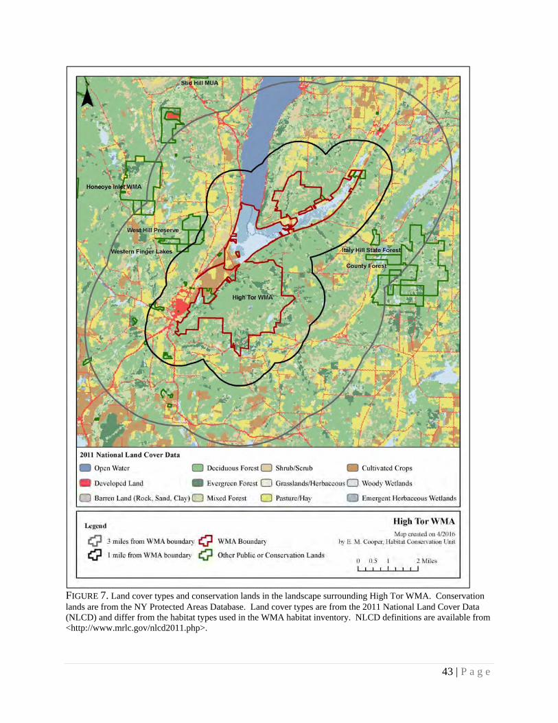
43 | P a g e
FIGURE 7. Land cover types and conservation lands in the landscape surrounding High Tor WMA. Conservation lands are from the NY Protected Areas Database. Land cover types are from the 2011 National Land Cover Data (NLCD) and differ from the habitat types used in the WMA habitat inventory. NLCD definitions are available from <http://www.mrlc.gov/nlcd2011.php>.

44 | P a g e
FIGURE 8. Percent cover of land cover types within 3 miles of High Tor WMA. Land cover types are from the 2011 National Land Cover Data (NLCD) and differ from the habitat types used in the WMA habitat inventory. NLCD definitions are available from <http://www.mrlc.gov/nlcd2011.php>.
Open Water 4%
Developed4%
Deciduous Forest 46%
Evergreen Forest 4%
Mixed Forest 10%
Shrub/Scrub 9%
Pasture/Hay 16%
Cultivated Crops 5%
Woody Wetlands 2%

45 | P a g e
FIGURE 9. Habitat types and location(s) of proposed management on High Tor WMA (Map 1). Numbers indicate the stand number from habitat inventory.

46 | P a g e
FIGURE 10. Habitat types and location(s) of proposed management on High Tor WMA (Map 2). Numbers indicate the stand number from habitat inventory

47 | P a g e
IV.APPENDICES
APPENDIXA:DEFINITIONS The following key words were used in the development of this Habitat Management Plan. Definitions are from The Dictionary of Forestry, Society of American Foresters, J. A. Helms, Editor, unless otherwise noted. Best Management Practices: (BMP) A practice or combination of practices that are determined to be the most effective and practicable means of avoiding negative impacts of habitat management.
Biodiversity: The variety and abundance of life forms, processes, functions, and structures of plants, animals, and other living organisms, including the relative complexity of species, communities, gene pools, and ecosystems at multiple spatial scales.
Clearcut: A forest regeneration or harvest method that entails the cutting of essentially all trees, producing a fully exposed microclimate for the development of a new age class. Depending on management objectives, a clearcut may or may not have reserve trees left to attain goals other than regeneration.
Community: An assemblage of plants and animals interacting with one another, occupying a habitat, and often modifying the habitat; a variable assemblage of plant and animal populations sharing a common environment and occurring repeatedly in the landscape. (NY Natural Heritage Program) Endangered Species: Any species listed on the current state or federal endangered species list as being in danger of extinction throughout all or a significant portion of its range. Forb: Any broad-leafed, herbaceous plant other than those in the Poaceae (Gramineae), Cyperaceae, and Juncaceae families (i.e., not grass-like). Forest: An ecosystem characterized by a dense and extensive tree cover, often consisting of stands varying in characteristics such as species composition, structure, age class, and associated processes, and commonly including meadows, streams, fish, and wildlife. Forest Health: The condition of a forest derived from concerns about such factors as its age, structure, composition, function, vigor, presence of unusual levels of insects or disease, and resilience to disturbance. Grassland Focus Area: Regions of NY that support key, residual populations of grassland birds. There are currently eight focus areas, within which there is a concentrated conservation effort for these species. (A Plan for Conserving Grassland Birds in New York, Audubon NY.) Habitat: A place that provides seasonal or year round food, water, shelter, or other environmental conditions for an organism, community, or population of plants or animals.
Hardwood: A broad leaved, flowering tree belonging to the botanical group Angiospermae, such as red maple, yellow birch, American beech, black cherry, etc. Impoundment: A pond caused by a dam across a stream and used for purposes such as water supply, water power, or wildlife habitat. (Edinger et al. 2002. Ecological Communities of New York State, Appendix B) Landscape: A spatial mosaic of several ecosystems, landforms, and plant communities across a defined area irrespective of ownership or other artificial boundaries and repeated in similar form throughout.

48 | P a g e
Mast: The fruit of trees considered as food for wildlife. Hard mast is the fruits or nuts of trees such as oak, beech, walnut, and hickories. Soft mast is the fruits and berries from plants such as dogwood, viburnum, elderberry, huckleberry, hawthorn, grape, raspberry, and blackberry. Multiple Use Area: Lands that were acquired by DEC to provide outdoor recreation and wherever possible the conservation and development of natural resources. As their name suggests, they are to be managed for a broader range of public use. (Public Use of Lands Managed by the Bureau of Wildlife) Native: A plant or animal indigenous to a particular locality. Old Growth Forest: Forest with an abundance of late successional tree species, at least 180 ‐ 200 years of age in a contiguous forested landscape that has evolved and reproduced itself naturally, with the capacity for self-perpetuation, arranged in a stratified forest structure consisting of multiple growth layers throughout the canopy and forest floor, featuring canopy gaps formed by natural disturbances creating an uneven canopy, and a conspicuous absence of multiple stemmed trees. (Adapted from the NYS Strategic Plan for State Forest Management) Pole: A tree of a size between a sapling (1” to 5” diameter at breast height) and a mature tree. Regeneration Cut: A cutting procedure by which a new forest age class is created; the major methods are clearcutting, seed tree, shelterwood, selection, and coppice. The Young Forest Initiative includes these silvicultural treatments: clearcuts, seed tree cuts, and shelterwood cuts. Salvage (following a natural disturbance) will be considered based on the size and scope of the disturbance.
Seed Tree Method: A forest regeneration or harvest method that entails cutting of all trees except for a small number of widely dispersed trees retained for seed production and to produce a new age class in fully exposed microenvironment.
Shelterwood Method: A forest regeneration or harvest method that entails the cutting of most trees, leaving those needed to produce sufficient shade to produce a new age class in a moderated microenvironment.
Shrubland: A community dominated by woody plants typically less than ten feet tall with scattered open patches of grasses and forbs that provide floristic diversity. Typically characterized by >50% cover of shrubs and <25% canopy cover of trees. (Adapted from Edinger et al. 2002. Ecological Communities of New York State, Appendix B) Softwood: A coniferous tree belonging to the botanical group Gymnospermae, such as white pine, Eastern hemlock, balsam fir, red spruce, etc. Special Management Zone: A vegetation strip or management zone extending from wetland boundaries, high-water marks on perennial and intermittent streams, vernal pool depression, spring seeps, ponds and lakes, and other land features requiring special consideration. (Adapted from DEC Division of Lands and Forests Management Rules for Establishment of Special Management Zones on State Forests)
State Rank of Significant Ecological Communities:
S1 = Typically 5 or fewer occurrences, very few remaining individuals, acres, or miles of stream, or some factor of its biology making it especially vulnerable in New York State. S2 = Typically 6 to 20 occurrences, few remaining individuals, acres, or miles of stream, or factors demonstrably making it very vulnerable in New York State. S3 = Typically 21 to 100 occurrences, limited acreage, or miles of stream in New York State. S4 = Apparently secure in New York State. S5 = Demonstrably secure in New York State. SH = Historically known from New York State, but not seen in the past 15 years. SX = Apparently extirpated from New York State. SE = Exotic, not native to New York State. SR = State report only, no verified specimens known from New York State. SU = Status unknown.

49 | P a g e
(Edinger et al. 2002. Ecological Communities of New York State, Appendix A)
Stand: In forestry, a contiguous group of trees sufficiently uniform in age-class distribution, composition, and structure, and growing on a site of sufficiently uniform quality, to be a distinguishable and manageable unit. In this HMP, the term “stand” is also applied to other habitat types (e.g., grassland, shrubland) to describe an area composed of similar vegetation composition and structure, as delineated during the habitat inventory.
Stand Prescription: A planned series of treatments designed to change current stand structure to one that meets management goals. Note: the prescription normally considers ecological, economic, and societal constraints.
Target Species: A suite of high priority wildlife species of conservation interest that are being targeted to benefit from management of a particular habitat type.
Unique Area: Lands that were acquired by DEC for their special natural beauty, wilderness character, geological, ecological, or historical significance for inclusion in the state nature and historical preserve. The primary purpose of these lands is to protect the feature of significance that led to the land being acquired by the state. (Public Use of Lands Managed by the Bureau of Wildlife) Upland: Sites with well-drained soils that are dry to mesic (never hydric). (Edinger et al. 2002. Ecological Communities of New York State, Appendix B)
Wetland: “Freshwater wetlands means lands and waters of the state as shown on the freshwater wetlands map which contain any or all of the following:
(a) lands and submerged lands commonly called marshes, swamps, sloughs, bogs, and flats supporting aquatic or semi-aquatic vegetation of the following types: wetland trees, wetland shrubs, emergent vegetation, rooted, floating-leaved vegetation, free-floating vegetation, wet meadow vegetation, bog mat vegetation, and submergent vegetation;
(b) lands and submerged lands containing remnants of any vegetation that is not aquatic or semi-aquatic that has died because of wet conditions over a sufficiently long period, provided that such wet conditions do not exceed a maximum seasonal water depth of six feet and provided further that such conditions can be expected to persist indefinitely, barring human intervention;
(c) lands and waters substantially enclosed by aquatic or semi-aquatic vegetation as set forth in paragraph (a) or by dead vegetation as set forth in paragraph (b) the regulation of which is necessary to protect and preserve the aquatic and semi-aquatic vegetation as set forth in paragraph (a) or by dead vegetation as set forth in paragraph (b) the regulation of which is necessary to protect and preserve the aquatic and semi-aquatic vegetation; and
(d) the waters overlying the areas set forth in (a) and (b) and the lands underlying.” (Refer to NYS Environmental Conservation Law, Article 24 § 24-0107 for full definition.) Wildlife Management Area: Lands that were acquired by DEC primarily for the production and use of wildlife, including hunting and trapping. These areas provide and protect wildlife habitats that are particularly significant in their capacity to harbor rare, threatened or endangered species, host unusual concentrations of one or more wildlife species, provide an important resting and feeding area for migratory birds, provide important nesting or breeding area for one or more species of wildlife, or provide significant value for wildlife or human enjoyment of wildlife. (Public Use of Lands Managed by the Bureau of Wildlife) Young Forest: Forests that result from a regeneration cut, typically having a dense understory where tree seedlings, saplings, woody vines, shrubs, and herbaceous vegetation grow together. Young forests are typically 0-10 years old. (Adapted from www.youngforest.org). It is acknowledged that “young forests” will differ in their character in different ecological areas of the state and that 0-10 years is a continuum into more mature forest types. (Refer to: A DEC Strategic Plan for Implementing the Young Forest Initiative on Wildlife Management Areas 2015-2020)
50 | P a g e
APPENDIXB.STATEMENTOFCONFORMITYWITHSEQRA Habitat Management Plans will be in compliance with the 1979 Programmatic Environmental Impact Statement on Habitat Management Activities of the Department of Environmental Conservation; Division of Fish and Wildlife by following the criteria for site specific assessments included in this Programmatic Environmental Impact Statement and by discussing further in Appendix B, Statement of Conformity with the State Environmental Quality Review Act. Appendix B will be included in each plan, thereby satisfying overall compliance with 6 NYCRR Part 617, the State Environmental Quality Review. If any of these criteria are exceeded an additional site specific environmental review will be required. The overarching goal of the Young Forest Initiative (YFI) is to restore and maintain young forest habitat on DEC’s Wildlife Management Areas (WMAs) in order to address the declining amount of young forest habitat in the state and provide habitat for key species of conservation interest, including both at-risk and important game species. The habitat management activities to be carried out under the YFI are in compliance with the above referenced document and these management activities:
Will not adversely affect threatened or endangered plants or animals or their habitat. o Careful review of the NY Natural Heritage Program’s “Natural Heritage Element Occurrence”
database in conjunction with a field survey when necessary prior to management activities taking place allows field staff to assess the presence or absence of threatened and endangered species. Appropriate actions will be taken if a threatened or endangered plant or animal is encountered in the project area including, but not limited to: establishing adequate buffer zones around known occurrences, moving the project area, or aborting the project altogether.
Will not induce or accelerate significant change in land use. o The forestland affected by the YFI will be regenerated and remain forested land, therefore no land
use change will take place. Will not induce significant change in ambient air, soil, or water quality.
o All projects carried out under the YFI will protect air, soil and water quality through careful project planning, use of appropriate NYS Best Management Practices for Water Quality, and establishment of Special Management Zones around sensitive land and water features requiring special consideration.
Will not conflict with established plans or policies of other state or federal agencies. o YFI projects will follow established plans or policies of other state and federal agencies.
Additionally, all YFI projects will be in compliance with all relevant US Fish and Wildlife Service rules and regulations.
Will not induce significant change in public attraction or use. o The WMA program is part of a long term effort to establish permanent access to lands in New
York State for the protection and promotion of its fish and wildlife resources. Projects carried out under the YFI will continue to protect, promote and maintain public access to WMAs and their wildlife resources.
Will not significantly deviate from effects of natural processes which formed or maintain area. o Habitat management projects under the YFI will be carried out primarily through even-aged forest
management. Even-aged silvicultural systems are designed to mimic natural disturbances, such as flooding, wildfire, insect and disease outbreaks and storm damage often found in nature.
Will not result in areas of significantly different character or ecological processes. o The even-aged silvicultural techniques that will be employed for habitat management projects
under the YFI intentionally result in areas of different character and ecological processes. However, they are not considered significant as they are ephemeral or transitional and will not permanently alter the landscape.
Will not affect important known historical or archeological sites. o Each YFI project will be reviewed by DEC’s State Historic Preservation Officer (SHPO) as well
as the Office of Parks, Recreation and Historic Preservation (OPRHP) to determine whether project sites may potentially affect any historical or archeological sites. In addition, thorough field review prior to management activities taking place allows field staff to assess the presence or

51 | P a g e
absence of any apparent historical or archeological sites that may not be found during the review process. Should known important historical or archeological sites present themselves necessary actions will be taken to protect these resources under the direction of DEC’s SHPO and the OPRHP Archaeology Unit staff.
Will not involve the application of herbicides, pesticides or other such chemicals. o YFI projects may involve the judicious use of pesticides which may be necessary to control
invasive species, to protect rare and endangered plants from competition, or to control vegetation interfering with forest regeneration. If projects do require the use of herbicides or pesticides an additional site-specific environmental review will be required.
Will not stimulate significant public controversy. o It is not anticipated that YFI projects will stimulate significant public controversy. A significant
amount of public outreach and notification will be conducted on an on-going basis as well as prior to projects being implemented on the ground including, but not limited to: public information sessions regarding the Habitat Management Plans for each WMA, signage installation at project sites informing the public of the scope and purpose of the project, establishment of one demonstration area in each region to showcase YFI management techniques to the public, periodic informational articles published in local media outlets and the development of a public YFI website. The YFI has one full time position dedicated to facilitating the program’s public outreach and communication efforts.

52 | P a g e
APPENDIXC:FORESTMANAGEMENTPRESCRIPTIONS
PRESCRIPTION FOR WILDLIFE MANAGEMENT AREA TIMBER HARVEST
Region: Wildlife Management Area: Stand number: Stand acreage:
Species composition:
Basal area: Trees per acre: Mean stand diameter:
Stand inventory or analysis date:
Regeneration data:
Natural Heritage Element Occurrence layer review:
SMZ layer review:
Retention data:
Soil types and drainage:
Interfering vegetation:
Acres to be treated: Target basal area:
Technical guidance/stocking guide:
Treatment purpose:
Management Objective: Even aged or Uneven Aged
-If even aged, specify treatment (i.e. shelterwood, seed tree, clearcut)
Clearcut acreage and configuration: (if applicable)
Natural Heritage /MHDB considerations and mitigation: (if applicable)
Retention considerations and adjustments:
Treatment descriptions:
Name and Title of Preparer:
Central Office Lands and Forests Staff Date
Regional Wildlife Manager Date

53 | P a g e
PRESCRIPTION NOTES Species Composition: At a minimum, the three most common species found in the overstory should be included, assuming at least three species comprise the stand. Species that individually constitute less than 5% of the stand may be lumped together as “Other” or “Miscellaneous.” For instance, if beech, hemlock and yellow birch each make up 3% of the stand, they may be lumped together as “Other – 9%.” Natural Heritage Element Occurrence layer review: List those species that the Natural Heritage Element Occurrence (EO) data layer indicates are or were known to be present in the stand, or could be affected by treatments to the stand. For instance, if a rare fish was indicated in a water body that is a short distance downstream of a creek that flows through the stand, it should be listed in the prescription. SMZ layer review: The SMZ data layer includes Special Management Zones around all streams and wetlands, as well as vernal pools, spring seeps and recreation areas that staff have mapped and digitized. If any of these features are mapped incorrectly or are missing from current data layers, staff can correct their locations by editing their office layers. Retention data: Include numbers of existing snags, cavity trees, Coarse Woody Material, Fine Woody Material, and legacy trees. Ocular estimates are acceptable. Soil types and drainage: Specifically named soil types are useful, but not necessarily required. “Flat, sandy, well-drained hilltop” or “Steep, gravelly, moderately well-drained mid-slope” may be just as useful as “Hershiser-Koufax Sandy Silt Loam” in describing the soil conditions as they relate to management decisions. The important point is to note those characteristics that may limit equipment operation or establishment of regeneration. Soil type data is available for some counties on the Data Selector. Interfering vegetation: Indicate the existing amount of interfering vegetation such as beech, striped maple, fern, etc. This may be quantified using mil-acre plots or by ocular estimate. Technical guidance used: This may include stocking guides, articles found in technical journals, textbooks or other silviculture-related publications. Other sources of guidance may be acceptable as well. Treatment purpose: As used here, “treatment purpose” and “management objective” (see below) are two different things. Also, “treatment purpose” is not what is to be done (i.e., “reduce basal area by 25%” or “remove every third row”), but rather is an explanation of why it is being done (i.e., “stimulate regeneration and increase growth of residual stand” or “regenerate current stand and convert to young forest”). Management objective: As used here, the term “management objective” is somewhat general. At a minimum, the prescription should indicate the desired future age structure and stand type. An entry as general as “Even aged hardwood” is acceptable, but regional staff may be more specific if they so choose. The management objective for a stand may be specified in the Habitat Management Plan (HMP) for the Wildlife Management Area in question. If the existing HMP does not specify the management objective regional staff should choose the management objective when the prescription is written. Clearcut acreage and configuration: If the harvest involves one single clearcut, indicate the total contiguous area, in acres. If the harvest comprises more than one clearcut, indicate the total combined area of clearcuts, as well as the area of the largest clearcut. Natural Heritage/MHDB considerations: Indicate what measures will be taken to protect those elements or features that were found in the review of the Natural Heritage Element Occurrence and Special Management Zone (not applicable yet) layers. Retention considerations: Indicate whether or not existing levels meet the standards set forth in the Division’s policy on Retention on State Forests, or whether they are expected to do so as a result of the proposed treatment. Also indicate if or how the treatment was adjusted in order to improve compliance with the policy standards.

54 | P a g e
Treatment description: The intended treatment should be clearly described. The amount of information necessary to accomplish this will vary greatly. For instance, in a row thinning of a pole timber sized plantation that had no SMZs or other special features, it may be sufficient to simply indicate “Remove two out of every six rows, taking two adjacent rows and leaving four rows between successive pairs being removed.” An intermediate thinning in a sawtimber sized hardwood stand with a recreational trail, two streams and a known occurrence of an endangered plant community would require significantly more detail. One rule of thumb that could be used is to describe the treatment so that a qualified forestry professional could use it to assist in marking the harvest. Additionally, since we are focused on creating young forests you should also address the presence/absence of advanced regeneration. If you are planning on clearcutting without advanced regeneration, address how you are going to mitigate that. For example, “This aspen stand will be clearcut and it is anticipated that future regeneration will be established through aspen root sprouting”. Or, “This stand will be clearcut and replanted with Norway spruce to establish conifer cover.” Furthermore, if you are planning on conducting a shelterwood or seed tree cut, please indicate when you are planning on returning to the stand to conduct the final harvest (overstory removal).

55 | P a g e
APPENDIXD:AMENDMENTS Any substantive changes to the habitat management described in this plan will be amended to the plan annually or as needed. Such changes may include: land acquisition, unforeseen natural disturbance, or any other change that alters the need for or the scope, method, or timing of management.
FY 16-17 (4/1/16 - 3/31/17)