halcrow group limited - telford and wrekin council …...halcrow has carried out this project in...
TRANSCRIPT
Telford and Wrekin Council Strategic Flood Risk Assessment for Local Development Framework Level 1 Volume 1 September 2007
Halcrow Group Limited

Strategic Flood Risk Assessment
Telford and Wrekin Borough Council
Strategic Flood Risk Assessment
Telford and Wrekin Borough Council
Telford and Wrekin Council Strategic Flood Risk Assessment for Local Development Framework Level 1 Volume 1
Contents Amendment Record This report has been issued and amended as follows:
Issue Revision Description Date Signed
1 Draft Report June 07 RD
2 Final Report Sept 07 RD

Strategic Flood Risk Assessment
Telford and Wrekin Borough Council
Strategic Flood Risk Assessment
Telford and Wrekin Borough Council
1
Contents
Contents.................................................................................................................................................1
Executive Summary..............................................................................................................................3
1 Introduction...................................................................................................................................5
1.1 Terms of Reference ...................................................................................................................5
1.2 Project Objectives ......................................................................................................................5
1.3 Methodology...............................................................................................................................5
1.4 Project Deliverables ...................................................................................................................5
1.5 SFRA Context ............................................................................................................................6
1.6 The Borough of Telford and Wrekin...........................................................................................7
2 Planning Context ..........................................................................................................................9
2.1 Introduction ................................................................................................................................9
2.2 National Planning Policy ............................................................................................................9
2.3 Regional Planning Policy ...........................................................................................................9
2.4 Local Planning Policy ...............................................................................................................10
3 Flood Zone Maps........................................................................................................................13
3.1 Introduction ..............................................................................................................................13
3.2 PPS 25 Flood Zones................................................................................................................13
3.3 Environment Agency Flood Zones...........................................................................................14
3.4 SFRA Flood Maps....................................................................................................................14
3.5 SFRA Climate Change Maps...................................................................................................14
4 Overview of PPS 25....................................................................................................................17
4.1 Key Aims ..................................................................................................................................17
4.2 Outcomes of the SFRA Process ..............................................................................................18
4.3 The Sequential Test .................................................................................................................18
4.4 The Exception Test ..................................................................................................................18
5 Study Methodology ....................................................................................................................21
5.1 The Practice Guide Companion to PPS 25..............................................................................21
5.2 Level 1 SFRA ...........................................................................................................................21
5.3 Approach to Data Gathering ....................................................................................................22
5.4 Production of Flood Maps ........................................................................................................23
5.5 Forms of Flooding and Data Limitations ..................................................................................24
Strategic Flood Risk Assessment
Telford and Wrekin Borough Council
2
6 Flood Risk in the Study Area ....................................................................................................27
6.1 Hydrology .................................................................................................................................27
6.2 Geology....................................................................................................................................27
6.3 Historical Flooding....................................................................................................................28
6.4 Areas Where Flood Risk May be Increased Flood Risk Elsewhere ........................................33
7 Flood Warning Systems and Flood Management Measures .................................................35
7.1 Flood Management ..................................................................................................................35
7.2 Flood Defences ........................................................................................................................35
7.3 Flood Warning..........................................................................................................................36
7.4 Flood Response Plan...............................................................................................................37
8 Flood Risk Management Policies .............................................................................................39
8.1 Catchment Flood Management Plans......................................................................................39
8.2 Policy Considerations...............................................................................................................40
9 Guidance on the Application of the Sequential Test ..............................................................43
9.1 Step One: Strategic Overview of flood risk across all potential development areas ...............43
9.2 Step Two: Flood Risk Issues in Zone 1 ...................................................................................43
9.3 Step Three: Sequential Test in Zones 2 and 3 ........................................................................44
10 Guidance for Preparation of Flood Risk Assessments..........................................................45
10.1 Proposed Developments Within Flood Zone 3a..................................................................48
10.2 Proposed Developments Within Medium Probability Flood Zone 2 ....................................48
10.3 Proposed Developments Within Flood Zones 1 and 2 ........................................................49
10.4 Raised Floor Levels and Basements (Freeboard)...............................................................49
11 Guidance for the Application of Sustainable Urban Drainage Systems...............................51
11.1 Introduction ..........................................................................................................................51
11.2 Types of SUDS Systems .....................................................................................................51
11.3 Application of SUDS for Telford and Wrekin Council ..........................................................52
12 Gap Analysis...............................................................................................................................55
12.1 Missing or Incomplete Data .................................................................................................55
12.2 Level 2 SFRA.......................................................................................................................55
13 References/Glossary..................................................................................................................57
APPENDIX A ........................................................................................................................................61
APPENDIX B ........................................................................................................................................63
APPENDIX C ........................................................................................................................................65
Strategic Flood Risk Assessment
Telford and Wrekin Borough Council
3
Executive Summary
In April 2007 the Districts and Boroughs of Shropshire as well as Shropshire County Council and the Unitary Authority Telford and Wrekin Council, commissioned Halcrow to produce a Level 1 Strategic Flood Risk Assessment (SFRA) in accordance with Planning Policy Statement 25 (PPS 25). This report presents the findings of the SFRA for Telford and Wrekin Borough Council.
The objective of this assessment is to inform the plan-making process of the Telford and Wrekin Local Development Framework (LDF). It should be used as a tool by the Local Planning Authority (LPA) to assess flood risk for spatial planning, producing development briefs, setting constraints, informing sustainability appraisals, identifying locations of emergency planning measures and requirements for flood risk assessments.
Telford and Wrekin Council covers an area of118 km2 with a population of 161,013. At the heart of the Borough is the "New Town" of Telford (designated in 1963), which is a regional focus for population and economic growth. In the south of the area situated on the northern bank of the River Severn is Ironbridge, the birth place of the Industrial Revolution and a UNESCO World Heritage Site. The Wrekin, a hill to the south west of Telford, is a prominent and well-known landmark on the border between the boroughs of Shrewsbury and Atcham and Telford and Wrekin. The Borough has a significant rural area which is located to the north and west of Telford and covers approximately 72% of the Borough's total area.
In accordance with the recently published document: Development and Flood Risk, a Practice Guide Companion to PPS 25 (February 2007), a Level 1 SFRA has been carried out and is contained herein. The study takes full account of the effect of climate change predictions as set out in PPS 25. The assessment also complies with the content of the Shropshire Districts project proposal dated March 2007.
This report provides general guidance and an overview of assumptions, uncertainties, approach, tasks undertaken and understanding of flood risk within the Borough. It provides the information required for the application of the Sequential Test of PPS 25. The LPA should apply the Sequential Test to demonstrate that there are no reasonably available sites in areas with less risk of flooding that would be appropriate to the type of development or land use proposed.
Policy ideas are provided together with comprehensive guidance for the preparation of flood risk assessments. Flood risk assessments will be required in most cases and the level of detail will depend on the proposed development footprint, its spatial distribution and the type and magnitude of existing and future flood risk.
The Environment Agency agrees fully with the content of this SFRA and a letter of acceptance of the assessment can be found in Appendix C.

Strategic Flood Risk Assessment
Telford and Wrekin Borough Council
4
This page is left intentionally blank

Strategic Flood Risk Assessment
Telford and Wrekin Borough Council
5
1 Introduction
1.1 Terms of Reference
In April 2007 the Districts and Boroughs of Shropshire as well as Shropshire County Council and the Unitary Authority Telford and Wrekin Council, commissioned Halcrow to produce a Level 1 Strategic Flood Risk Assessment (SFRA) in accordance with Planning Policy Statement 25 (PPS 25). This report, Volume 1, presents the findings of the SFRA for Telford and Wrekin, while Volume 2 contains the accompanying maps.
1.2 Project Objectives
The objective of the SFRA is to inform the plan-making process of the Telford and Wrekin LDF. This SFRA has been undertaken to provide a detailed and robust assessment of the nature and extent of all types of flooding in the Borough and the implications that this may have for land use planning.
The SFRA will allow the LPA to:
• Prepare appropriate policies for the management of flood risk within the Local Development Documents (LDDs)
• Meet the needs of the LDF
• Identify the level of detail required for site specific Flood Risk Assessments (FRAs) in key locations
• Determine the acceptability of flood risk in relation to emergency planning capability
• Allocate appropriate sites for development
• Identify opportunities for reducing flood risk
• Ensure that Telford and Wrekin Council meets its obligations under the latest planning guidance PPS 25
Data has been collected for use in this study based on the best viable data within the study timescales. Outputs from the study will require updating as additional data becomes available.
1.3 Methodology
Halcrow has carried out this project in accordance with the methodology outlined in the Shropshire Districts Strategic Flood Risk Assessment Project Proposal, dated March 2007. The assessment also follows the guidance contained in “Development and Flood Risk: A Practice Guide Companion to PPS25 ‘Living Draft’” for a Level 1 SFRA. The SFRA has also followed advice from the Environment Agency, and a letter detailing the Environment Agency’s acceptance of this assessment can be found in Appendix C.
1.4 Project Deliverables
The deliverables of this assessment are as follows:
• A technical report including analysis of missing/incomplete data required for a Level 2 SFRA
• A non-technical summary
• Strategic Flood Risk Maps, showing:
Strategic Flood Risk Assessment
Telford and Wrekin Borough Council
6
Flooding from all sources
Climate Change Scenarios
• GIS maps of collated data, including:
Main Rivers
Ordinary Watercourses
Existing Flood Zone Maps
Hydrometric data coverage
NFCDD data
Flood event data (historic flood outlines)
Flood Warning Areas
Geological maps
Artificial drainage information
1.5 SFRA Context
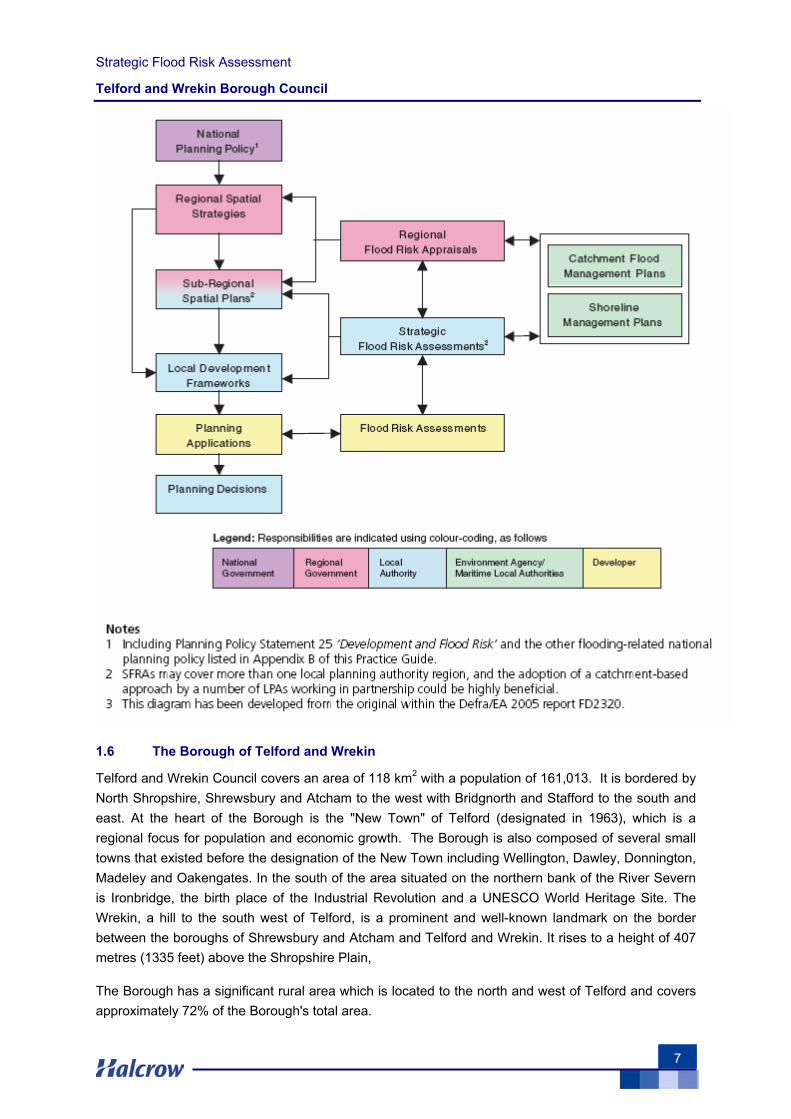
An SFRA is a strategic document which refines information on the probability of flooding, taking other sources of flooding and the impacts of climate change into account. An SFRA provides the basis for applying the Sequential Test, a process which seeks to locate new development in appropriate flood zones, based on the development’s vulnerability classification. An SFRA is also a living document and should be updated as new data becomes available, such as quarterly updates from the Environment Agency, who continuously refine and improve their Flood Zone Maps.
The figure overleaf, taken from the PPS 25 Practice Guide, illustrates the responsibilities for the production of key documents required to effectively manage flood risk through each stage of the spatial planning process, and, importantly, shows the link between other strategic documents.
Strategic Flood Risk Assessment
Telford and Wrekin Borough Council
7
1.6 The Borough of Telford and Wrekin
Telford and Wrekin Council covers an area of 118 km2 with a population of 161,013. It is bordered by North Shropshire, Shrewsbury and Atcham to the west with Bridgnorth and Stafford to the south and east. At the heart of the Borough is the "New Town" of Telford (designated in 1963), which is a regional focus for population and economic growth. The Borough is also composed of several small towns that existed before the designation of the New Town including Wellington, Dawley, Donnington, Madeley and Oakengates. In the south of the area situated on the northern bank of the River Severn is Ironbridge, the birth place of the Industrial Revolution and a UNESCO World Heritage Site. The Wrekin, a hill to the south west of Telford, is a prominent and well-known landmark on the border between the boroughs of Shrewsbury and Atcham and Telford and Wrekin. It rises to a height of 407 metres (1335 feet) above the Shropshire Plain,
The Borough has a significant rural area which is located to the north and west of Telford and covers approximately 72% of the Borough's total area.

Strategic Flood Risk Assessment
Telford and Wrekin Borough Council
8
The M54 motorway runs right through the town linking Telford with the M6 and the rest of the UK's motorway network. From Telford Central there are frequent trains to Birmingham with regular connections to London.
A number of minor watercourses, non-main rivers, exist and have been analysed where data exists. A watercourse map, giving an overview of fluvial features in the study area, can be found in Volume 2, Tile A1.
The Borough is partially covered by Strine Internal Drainage Board. This organisation is responsible for the local drainage networks. Severn Trent Water is responsible for the operation and maintenance of the artificial drainage systems across the Borough.

Strategic Flood Risk Assessment
Telford and Wrekin Borough Council
9
2 Planning Context
2.1 Introduction
This report conforms with National and Regional Planning Policy. It is a living document that provides the necessary information and guidance to allow the Council to make informed decisions relating to the use and allocation of land within the LDDs, to provide robust evidence to support the LDF at examination and to help formulate appropriate flood risk policies. An SFRA should be used as a tool by the LPA to assess flood risk for spatial planning, produce development briefs, set constraints, inform sustainability appraisals, and identify locations of emergency planning measures and requirements for flood risk assessments.
The success of the SFRA is heavily dependent upon the Council’s ability to implement the recommendations put forward for future sustainable flood risk management. It is ultimately the responsibility of the Council to establish robust policies that will ensure future sustainability with respect to flood risk.
2.2 National Planning Policy
The Government has updated its planning advice contained within Planning Policy Guidance Notes (PPGs) with the publication of new Planning Policy Statements (PPSs).
In December 2006 the Government published PPS 25: Development and Flood Risk (a restatement of PPG 25). It reflected the general direction set out in ‘Making Space for Water’ (Defra, 2004), the evolving new strategy to shape flood and coastal erosion risk over the next 10 to 20 years.
2.3 Regional Planning Policy
Regional planning policies provide the overarching framework for the preparation of the LDF. Regional Planning Guidance for the West Midlands (RPG11) was published in June 2004 but under the Planning and Compulsory Purchase Act 2004, RPG11 was automatically replaced by a new Regional Spatial Strategy for the West Midlands. The purpose of the West Midlands Regional Spatial Strategy (WMRSS) is to provide a long term land-use and transport planning framework for the West Midlands region. The WMRSS framework guides the preparation of local authority development plans and local transport plans. It determines (amongst other things) the scale and distribution of housing and economic development for each District or borough within the region, investment priorities for transport and sets out policies for enhancing the environment. The WMRSS has been prepared by the West Midlands Regional Assembly and has been guided by the national policy framework provided by Planning Policy Guidance, particularly PPG11, and other key policy documents and plans including the National Sustainable Development Strategy.
The WMRSS was published in June 2004. In approving the WMRSS the Secretary of State identified a number of issues where further work was required. The revision is being carried out in three stages. Phases One and Two of the Spatial Strategy Revision are underway, and Phase Three is due to launch in 2007.
Strategic Flood Risk Assessment
Telford and Wrekin Borough Council
10
The identification of Telford as a New Growth Point by the Department of Communities and Local Government (DCLG) is aimed at accelerating growth in a sustainable and viable way to build another 13,000 new houses by 2016, and up to 25,000 by 2026. As a New Growth Point, the Council have volunteered to promote house building at a minimum of at least 20% above the current RSS11 figures.
The “Development and Flood Risk” section of the WMRSS identifies the following policies in relation to Flood Risk Management:
“8.42 The implications of climate change for the severity of floods is uncertain but the most realistic approach is to accept that flooding is an inevitable process. PPG25 [now PPS25] Development and Flood Risk sets out detailed guidance on how flood risk should be considered at all stages of the planning and development process, including a sequential approach to locating development. Local authorities should also consider local Environment Agency plans, Catchment Flood Management Plans and indicative floodplains (Quality of the Environment – Assets Diagram).
8.43 For the review of this RSS the RPB with the Environment Agency and other partners should identify where flooding issues are likely to be of Regional significance, assess their implications for the distribution of development and where appropriate, set out appropriate policies and measures to address them. This could include defining areas where sustainable drainage systems would best contribute to reducing flood risk, and improving water quality where the need to improve the performance of the floodplain, attenuate flows and provide local treatment of polluted run-off is greatest. However it should be borne in mind that sustainable drainage systems are unlikely to provide the complete answer to problems associated with large-scale river flooding episodes; in the longer term they can help attenuate flows and reduce the risk of flooding in urban areas downstream.
8.44 When considering the possible risks, implications and steps needed to prevent general flooding affecting new development, the potential for sewer flooding should also be considered by developers and planning authorities. Large new developments may require some new or updated infrastructure in the existing sewer network and treatment works in order to cope with the additional load. Sustainable drainage systems can, in the correct conditions, help alleviate sewer flooding problems by preventing surface water from entering the sewerage system.”
2.4 Local Planning Policy
2.4.1 Local Development Framework
The Telford and Wrekin Local Plan has an end date of 2006, however, the Plan will be saved at least until September 2007 and as such will still form part of the Development Plan for the borough, together with the West Midlands Regional Spatial Strategy (RSS).
The adopted Joint Shropshire & Telford & Wrekin Structure Plan was adopted in 2002 with an end date of 2011. However under the new Act the Structure Plan is superseded by the Regional Spatial Strategy and Local Development Frameworks.
The Planning and Compulsory Purchase Act 2004 came into force in September 2004, requiring the Local Planning Authority to produce a Local Development Framework rather than a Local Plan. The
Strategic Flood Risk Assessment
Telford and Wrekin Borough Council
11
regulations relating to the new Act were published in September 2004 and in accordance with these, the Authority has produced a Local Development Scheme setting out the Local Development Documents which are to be produced and the timetable for their production. Officers are also currently working on the ‘saving’ of Local Plan Policies to beyond 27th September 2007.
The Telford & Wrekin Local Development Scheme will provide a long term development vision for the borough through to 2021.
This scheme clearly identifies the key milestones in plan preparation and opportunities for community engagement. The current scheme for the Borough covers the three year period up to April 2009 and will be reviewed annually. It was approved fit for purpose on 5th April 2006 and has an effective date of 10th April 2006. This revised scheme replaces the Borough's previous Local Development Scheme which had an effective date of 1st July 2005.
Since the adoption of the LDS in April 2006 it has become necessary to amend the timetable for the Core Strategy and Waste Development Plan Documents. Minor changes have also been made to the proposed Supplementary Planning Documents. These changes have been approved following consultation with the Government Office for the West Midlands and by the Head of Planning & Environmental Services under delegated powers agreed by Cabinet. This updated Local Development Scheme takes effect from the 1st August 2006.
Telford is one of several national growth points. Funding has been granted to carry out several feasibility studies to achieve growth beyond current Regional Spatial Strategy levels. The level of growth now being proposed in the revised RSS (preferred options Report to be submitted to the Secretary Of State in December 2007) is likely to accommodate the level of growth set out in Telford’s NGP. It is believed that Government will place increasing emphasis on Growth Points in meeting the objectives of its Sustainable Communities Plan.
2.4.2 Core Strategy Development Plan Document
The draft Core Strategy Development Plan Document was submitted for consultation from June/July 06 to Oct/ Nov 06. The Submission Core Strategy was subject to an independent examination which ended on 20th June 2007. It is expected that the Inspector’s Report will be published in November 2007. Adoption of the Core Strategy is expected in early 2008.

Strategic Flood Risk Assessment
Telford and Wrekin Borough Council
12
This page is left intentionally blank
Strategic Flood Risk Assessment
Telford and Wrekin Borough Council
13
3 Flood Zone Maps
3.1 Introduction
A good understanding of the PPS 25 Flood Zones, the Environment Agency Flood Zones and SFRA Flood Maps is of fundamental importance for SFRAs.
3.2 PPS 25 Flood Zones
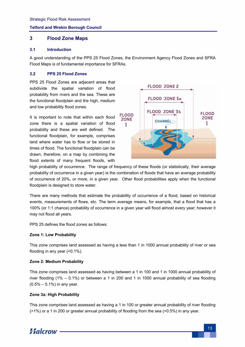
PPS 25 Flood Zones are adjacent areas that subdivide the spatial variation of flood probability from rivers and the sea. These are the functional floodplain and the high, medium and low probability flood zones.
It is important to note that within each flood zone there is a spatial variation of flood probability and these are well defined. The functional floodplain, for example, comprises land where water has to flow or be stored in times of flood. The functional floodplain can be drawn, therefore, on a map by combining the flood extents of many frequent floods, with high probability of occurrence. The range of frequency of these floods (or statistically, their average probability of occurrence in a given year) is the combination of floods that have an average probability of occurrence of 20%, or more, in a given year. Other flood probabilities apply when the functional floodplain is designed to store water.
There are many methods that estimate the probability of occurrence of a flood, based on historical events, measurements of flows, etc. The term average means, for example, that a flood that has a 100% (or 1:1 chance) probability of occurrence in a given year will flood almost every year; however it may not flood all years.
PPS 25 defines the flood zones as follows:
Zone 1: Low Probability
This zone comprises land assessed as having a less than 1 in 1000 annual probability of river or sea flooding in any year (<0.1%).
Zone 2: Medium Probability
This zone comprises land assessed as having between a 1 in 100 and 1 in 1000 annual probability of river flooding (1% – 0.1%) or between a 1 in 200 and 1 in 1000 annual probability of sea flooding (0.5% – 0.1%) in any year.
Zone 3a: High Probability
This zone comprises land assessed as having a 1 in 100 or greater annual probability of river flooding (>1%) or a 1 in 200 or greater annual probability of flooding from the sea (>0.5%) in any year.
Strategic Flood Risk Assessment
Telford and Wrekin Borough Council
14
Zone 3b: The Functional Floodplain
This zone comprises land where water has to flow or be stored in times of flood. SFRAs should identify this Flood Zone (land which would flood with an annual probability of 1 in 20 (5%) or greater in any year or is designed to flood in an extreme (0.1%) flood, or at another probability to be agreed between the LPA and the Environment Agency, including water conveyance routes).
3.3 Environment Agency Flood Zones
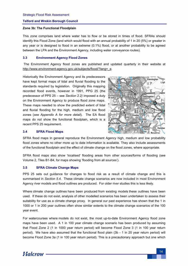
The Environment Agency flood zones are published and updated quarterly in their website at http://www.environment-agency.gov.uk/subjects/flood/?lang=_e.
Historically the Environment Agency and its predecessors have kept formal maps of tidal and fluvial flooding to the standards required by legislation. Originally this mapping recorded flood events, however in 1991, PPG 25 (the predecessor of PPS 25 – see Section 2.2) imposed a duty on the Environment Agency to produce flood zone maps. These maps needed to show the predicted extent of tidal and fluvial flooding for the high, medium and low flood zones (see Appendix A for more detail). The EA flood maps do not show the functional floodplain, which is a recent PPS 25 requirement.
3.4 SFRA Flood Maps
SFRA flood maps in general reproduce the Environment Agency high, medium and low probability flood zones where no other more up to date information is available. They also include assessments of the functional floodplain and the effect of climate change on the flood zones, where appropriate.
SFRA flood maps also show ‘localised’ flooding areas from other sources/forms of flooding (see Volume 2, Tiles B1-B4, for maps showing ‘flooding from all sources’).
3.5 SFRA Climate Change Maps
PPS 25 sets out guidance for changes to flood risk as a result of climate change and this is summarised in Section 5.4. These climate change scenarios are now included in most Environment Agency river models and flood outlines are produced. For older river studies this is less likely.
Where climate change outlines have been produced from existing models these outlines have been used. If these do not exist, analysis of other modelled scenarios has been undertaken to assess their suitability for use as a climate change proxy. In general our past experience has shown that the 1 in 1000 or 1 in 200 year outlines often show similar extents to the climate change scenarios of the 100 year event.
For watercourses where models do not exist, the most up-to-date Environment Agency flood zone maps have been used. A 1 in 100 year climate change scenario has been produced by assuming that Flood Zone 2 (1 in 1000 year return period) will become Flood Zone 3 (1 in 100 year return period). We have also assumed that the functional flood plain (3b - 1 in 20 year return period) will become Flood Zone 3a (1 in 100 year return period). This is a precautionary approach but one which

Strategic Flood Risk Assessment
Telford and Wrekin Borough Council
15
is consistent with our past modelling experience, which has shown that the 1 in 1000 year flood outline is often similar to the climate change scenario for the 100 year event.
This is the level of detail which PPS25 requires for a Level 1 SFRA. The climate change scenarios are provided in a series of maps covering the study area, found in Volume 2, Tile C1.

Strategic Flood Risk Assessment
Telford and Wrekin Borough Council
16
Strategic Flood Risk Assessment
Telford and Wrekin Borough Council
17
4 Overview of PPS 25
4.1 Key Aims
The key aims of PPS 25 are reproduced below:
“The aims of planning policy on development and flood risk are to ensure that flood risk is taken into account at all stages in the planning process to avoid inappropriate development in areas at risk of flooding, and to direct development away from areas at highest risk. Where new development is, exceptionally, necessary in such areas, policy aims to make it safe without increasing flood risk elsewhere and where possible, reducing flood risk overall.
Regional planning bodies and LPAs should prepare and implement planning strategies that help to deliver sustainable development by:
Appraising risk:
• Identifying land at risk and the degree of risk of flooding from rivers, the sea and other sources in their areas
• Preparing Regional Flood Risk Appraisals (RFRAs) or SFRAs as appropriate, as freestanding assessments that contribute to the Sustainability Appraisal of their plans
Managing risk:
• Framing policies for the location of development which avoid flood risk to people and property where possible, and manage any residual risk, taking account of the impacts of climate change
• Only permitting development in areas of flood risk when there are no reasonably available sites in areas of lower flood risk and benefits of the development outweigh the risks from flooding
Reducing risk:
• Safeguarding land from development that is required for current and future flood management e.g. conveyance and storage of flood water, and flood defences
• Reducing flood risk to and from new development through location, layout and design, incorporating sustainable drainage systems (SUDS)
• Using opportunities offered by new development to reduce the causes and impacts of flooding e.g. surface water management plans; making the most of the benefits of green infrastructure for flood storage, conveyance and SUDS; re-creating functional floodplain; and setting back defences
A partnership approach:
• Working effectively with the Environment Agency, other operating authorities and other stakeholders to ensure that best use is made of their expertise and information so that plans are effective and decisions on planning applications can be delivered expeditiously
• Ensuring spatial planning supports flood risk management policies and plans, River Basin Management Plans and emergency planning”
Strategic Flood Risk Assessment
Telford and Wrekin Borough Council
18
These broad planning objectives effectively set the scope for the specific outcomes of the SFRA process. The SFRA in turn then informs planning and development control decisions that ensure the objectives set out above can be achieved.
4.2 Outcomes of the SFRA Process
An SFRA provides sufficient data and information to enable a planning authority to apply the Sequential Test to land use allocations and, where necessary, the Exception Test (see Sections 4.3 and 4.4).
PPS 25 also indicates that Sustainability Appraisals should be informed by the SFRA for their area. Under the Town and Country Planning (Local Development - England) Regulations 2004, a Sustainability Appraisal (SA) is required for all LDFs. The purpose is to promote sustainable development through better integration of sustainability considerations in the preparation and adoption of plans. The Regulations stipulate that SAs for LDFs should meet the requirements of the Strategic Environmental Assessment (SEA) Directive. An SFRA is also used as a tool by an LPA for the production of development briefs, setting constraints, identifying locations of emergency planning measures and requirements for FRAs.
It is important to reiterate that PPS 25 is not applied in isolation as part of the planning process. The formulation of Council policy and the allocation of land for future development must also meet the requirements of other planning policy. Clearly a careful balance must be sought in these instances, and the SFRA aims to assist in this process through the provision of a clear and robust evidence base upon which informed decisions can be made.
4.3 The Sequential Test
A planning authority applies the Sequential Test to demonstrate that there are no reasonably available sites in areas with less risk of flooding that would be appropriate to the type of development or land use proposed.
Preference should be given to locating new development in Flood Zone 1 (see Section 3.2). If there is no reasonably available site in Flood Zone 1, the flood vulnerability (or level of resilience to damages from flooding) of the proposed development can be taken into account in locating development in Flood Zone 2 and then Flood Zone 3 (see Appendix B).
Within each Flood Zone new development should be directed towards lower flood risk areas (i.e. towards the adjacent zone of lower probability of flooding).
4.4 The Exception Test
If, following application of the Sequential Test, it is not possible or consistent with wider sustainability objectives for the development to be located in zones of lower probability of flooding, the Exception Test can be applied. This test provides a method of managing flood risk while still allowing necessary development to occur.
The Exception Test is only appropriate for use when there are large areas in Flood Zones 2 and 3, where the Sequential Test alone cannot deliver acceptable sites, but where some continuing development is necessary for wider sustainable development reasons, taking into account the need to avoid social or economic blight and the need for essential civil infrastructure to remain operational

Strategic Flood Risk Assessment
Telford and Wrekin Borough Council
19
during floods. It may also be appropriate to use it where restrictive national designations such as landscape, heritage and nature conservation designations, e.g. Areas of Outstanding Natural Beauty (AONBs), Sites of Special Scientific Interest (SSSIs) and World Heritage Sites (WHS), prevent the availability of unconstrained sites in lower risk areas.
For the Exception Test to be passed:
a) It must be demonstrated that the development provides wider sustainability benefits to the community that outweigh flood risk, informed by a SFRA. If the Development Plan Document has reached the ‘submission’ stage (see Figure 4 of PPS 12: Local Development Frameworks) the benefits of the development should contribute to the Core Strategy’s Sustainability Appraisal
b) The development should be on developable previously-developed land or, if it is not on previously developed land, that there are no reasonable alternative sites on developable previously-developed land
c) A flood risk assessment must demonstrate that the development will be safe, without increasing flood risk elsewhere, and, where possible, will reduce flood risk overall
The Exception Test will be possible following completion of the Level 2 SFRA.

Strategic Flood Risk Assessment
Telford and Wrekin Borough Council
20
This page is left intentionally blank
Strategic Flood Risk Assessment
Telford and Wrekin Borough Council
21
5 Study Methodology
5.1 The Practice Guide Companion to PPS 25
The study methodology follows the guidance from the February 2007 “Development and Flood Risk: A Practice Guide Companion to PPS 25”. It is a ‘living draft’ web-based consultation paper (see http://www.communities.gov.uk/index.asp?id=1504639); and is a comprehensive document incorporating many recommendations from previous guidance documents.
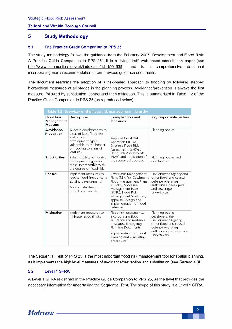
The document reaffirms the adoption of a risk-based approach to flooding by following stepped hierarchical measures at all stages in the planning process. Avoidance/prevention is always the first measure, followed by substitution, control and then mitigation. This is summarised in Table 1.2 of the Practice Guide Companion to PPS 25 (as reproduced below).
The Sequential Test of PPS 25 is the most important flood risk management tool for spatial planning, as it implements the high level measures of avoidance/prevention and substitution (see Section 4.3).
5.2 Level 1 SFRA
A Level 1 SFRA is defined in the Practice Guide Companion to PPS 25, as the level that provides the necessary information for undertaking the Sequential Test. The scope of this study is a Level 1 SFRA.

Strategic Flood Risk Assessment
Telford and Wrekin Borough Council
22
Where the need to apply the Exception Test is identified, due to there being an insufficient number of suitably available sites for development within zones of lower flood risk, the scope of the SFRA is widened to a more detailed Level 2 study.
5.2.1 Project Outputs for a Level 1 SFRA
The project outputs for Level 1 SFRA have been adopted for this study.
Following the advice from Section 2.34 of the Practice Guide Companion to PPS 25, the key project outputs are as follows:
1) Plans showing the administrative boundaries of the study area, main rivers, ordinary watercourses and defences (Volume 2, Tile A1)
2) Strategic flood risk maps showing flooding from all sources, including fluvial flood zones (including the functional floodplain where possible), and areas at risk of flooding from sources other than rivers (Volume 2, Tiles B1-B4)
3) An assessment of the implications of climate change for flood risk in the study area over an appropriate time period (Volume 2, Tile C1)
4) Historical flood outlines (Volume 2, Tiles E1-E2)
5) The location of any flood risk management measures, including both infrastructure (Volume 2, Tile A1) and the coverage of flood warning systems (Volume 2, Tile F1)
6) Locations where additional development may significantly increase flood risk elsewhere (see Section 6)
7) Guidance on the application of the Sequential Test (see Chapter 9)
8) Guidance on the preparation of Flood Risk Assessments for development sites (see Chapter 10).
9) Guidance on the likely applicability of different SUDS techniques for managing surface water run-off at key development sites (see Chapter 11)
5.3 Approach to Data Gathering
The main source of data for this study has been the Environment Agency, IDBs, web-based knowledge, Telford and Wrekin Council and Severn Trent Water.
Priority has been given to the collection of geo-referenced information in electronic format, to ensure the effective management of the data within a GIS environment. All incoming data has been recorded on a project data register by a specialist document controller/GIS data manager, specifically designated for this project.
The quality review of the information has been carried out by an experienced core team. The team has been able to review the collected data, assess its significance and quality, and advise on which part of the collected data needed to be used for the SFRA. The main approach to the SFRA has been to build on previous studies and gathered information.
Strategic Flood Risk Assessment
Telford and Wrekin Borough Council
23
5.4 Production of Flood Maps
The Environment Agency Flood Zone Maps and river models have been collected and used for the production of the SFRA flood maps (Volume 2, Tiles B1-B4).
5.4.1 Hydraulic (River) Models
Within Telford & Wrekin there are two known Environment Agency hydraulic models. These are of the River Tern, from the Great Bolas in the north to Walcot in the west of the authority area, and the River Severn as it passes through the Ironbridge, Jackfield and Coalport area in the south.
For both of these models the 100 year return period event has been modelled and a flood outline produced; meaning that it has been possible to use this outline in preference to the existing Environment Agency Flood Zone 3a.
A 25 year return period model and outline was also available for both models, and although this represents a conservative approach to estimating Flood Zone 3b, these have been used for this purpose.
The River Tern has a mapped outlines for the 200 year return period event. A comparison was made between the inflows to this model and the 100 year return period increased by 20% (the current recommended means of representing the climate change within hydraulic models). This indicated that the 200 year return period outline would represent a good approximation of the 100 year climate change scenario and so was used in preference to the Environment Agency’s existing Flood Zone 2 outline for this watercourse.
None of the available models were supplied with a 1000 year flood outline meaning that no new information was available to improve the present day Flood Zone 2 outlines.
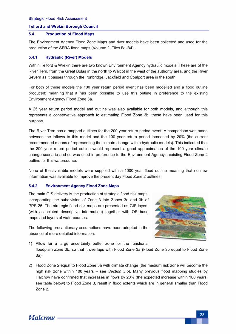
5.4.2 Environment Agency Flood Zone Maps
The main GIS delivery is the production of strategic flood risk maps, incorporating the subdivision of Zone 3 into Zones 3a and 3b of PPS 25. The strategic flood risk maps are presented as GIS layers (with associated descriptive information) together with OS base maps and layers of watercourses.
The following precautionary assumptions have been adopted in the absence of more detailed information:
1) Allow for a large uncertainty buffer zone for the functional floodplain Zone 3b, so that it overlaps with Flood Zone 3a (Flood Zone 3b equal to Flood Zone 3a).
2) Flood Zone 2 equal to Flood Zone 3a with climate change (the medium risk zone will become the high risk zone within 100 years – see Section 3.5). Many previous flood mapping studies by Halcrow have confirmed that increases in flows by 20% (the expected increase within 100 years, see table below) to Flood Zone 3, result in flood extents which are in general smaller than Flood Zone 2.

Strategic Flood Risk Assessment
Telford and Wrekin Borough Council
24
In its November 2006 publication of the predicted effects of climate change on the United Kingdom, DEFRA described how short duration rainfall could increase by 30% and flows by 20%, and suggests winters will become generally wetter. These effects will tend to increase both the size of flood zones associated with the sea and rivers, and the amount of flooding experienced from “other sources”.
The main Climate Change table from PPS 25 is shown below:
Parameter 1990 to
2025
2025 to
2055
2055 to
2085
2085 to
2115 Peak rainfall intensity +5% +10% +20% +30%
Peak river flow +10% +20%
Offshore wind speed +5% +10%
Extreme wave height +5% +10%
5.5 Forms of Flooding and Data Limitations
For the purpose of this assessment, forms of flooding (also defined as sources of flooding) are divided into four categories, the first covering fluvial flooding, the second flooding from artificial drainage systems and surface water runoff, the third covering flooding from impounded water bodies and the fourth from groundwater flooding. The reason for adopting this classification is to provide an understanding of data limitations and assumptions as there are different standards for the collection of each of these types of data.
5.5.1 Fluvial Flooding
This form of flooding (flood zones) is described in Chapter 3. See also Appendix A for further details, including assumptions and limitations.
5.5.2 Records of Flooding Artificial Drainage Systems and Surface Water Runoff
Methodologies for recording flooding from sources other than fluvial or tidal were not standardised until 2006. Therefore records held of such flooding can be incomplete, and not to a uniform standard. All Water Companies have a statutory obligation to maintain a register of properties/areas which are at risk of flooding from the public sewerage system, and this is shown on the DG5 Flood Register. This includes records of flooding from foul sewers, combined sewers and surface water sewers which are deemed to be public and therefore maintained by the Water Company. The DG5 register tends to show, to a greater or lesser extent, the following: the date of the most recent incident, the post town, locality, street, post code (four or six figures), a sewer problem description, sewer type description, if internal flooding occurred, details of curtilage flooding, and the eastings and northings of the flood incident. The recording of flood events by the authorities has often led to improvements intended to prevent reoccurrence, so historical flooding is not necessarily evidence of propensity for future flooding.
Information on flooding caused by surface water runoff can also be obtained from local government, highway authorities, the Environment Agency and libraries.
Strategic Flood Risk Assessment
Telford and Wrekin Borough Council
25
5.5.3 Records of Flooding from Impounded Water Bodies
Records of flooding from reservoirs and canals are erratic as there is no requirement for the Environment Agency to show historic flooding from canals and raised reservoirs on plans. In particular, PPS 25 does not require flood risk from canals and raised reservoirs to be shown on the flood map. This is surprising, as overflows from canals are common due to flows from land drainage and their frequent lack of overflows. Occasionally major bank breaches also occur, leading to rapid and deep flooding of adjacent land.
Reservoirs with an impounded volume in excess of 25,000 cubic metres (measured above natural ground level) are governed by the Reservoirs Act and are listed on a register held by the Environment Agency. Due to high standards of inspection and maintenance required by legislation, normally flood risk from registered reservoirs is moderately low.
5.5.4 Records of Groundwater Flooding
Both the Environment Agency and planning authorities can keep records of individual groundwater flooding events.

Strategic Flood Risk Assessment
Telford and Wrekin Borough Council
26
This page is left intentionally blank
Strategic Flood Risk Assessment
Telford and Wrekin Borough Council
27
6 Flood Risk in the Study Area
6.1 Hydrology
The Borough contains a number of designated main rivers:
• River Roden: The river cuts across the north-west corner of the District through the rural landscape before meeting the River Tern to the west of Telford
• River Meese: The River flows across the northern part of the District from the east near Newport to the west. The River is affected by groundwater abstractions and suffers from low flows during summer months; however, it is home to nationally important species of wildlife
• River Tern: From it’s headwaters around Market Drayton (North Shropshire) the River Tern flows south through the rural landscape into the District of Telford and Wrekin fed by the River Meese the River Strine, the Red Strine and the River Roden before joining the River Severn
• River Severn: The River Severn flows through the southern tip of the District, passing through Ironbridge, Jackfield and Coalport
A watercourse map, giving an overview of fluvial features in the study area, can be found in Volume 2, Tile A1.
6.2 Geology
Shropshire has a diverse geology with a wide range of mineral resources and rocks representing most of the major divisions of geological time.
Upper Carboniferous rocks occur in a discontinuous belt from north-west to south-east across Shropshire. They contain coal bearing strata giving rise to a number of small coalfields. The most well known of these are the Coalbrookdale Coalfield (Telford & Wrekin) and the adjacent Broseley Coalfield, both of which have a recent history of opencast coal and clay mining. Underground mining occurred in all of the county's coalfields during the 20th century.
The Wrekin is a prominent hill near the town of Telford. The Wrekin is home to some of the oldest rocks in the county of Shropshire (677 million years old).
The sedimentary rock types are varied around the area, but lava from various volcanic eruptions formed this landmark, however, The Wrekin itself is not a volcano, and never was. Intrusions of igneous rock have been quarried in the past at nearby Ercall Quarry.
Not far from The Wrekin is the famous Ironbridge Gorge, named after the bridge that stands over the River Severn near Madeley. The River Severn runs across the county from west to east. Around Ironbridge and Bridgnorth it runs through a deep gorge which has been cut through the rock
The geological events that took place here thousands of years ago were what made the events that took place here in the Industrial Revolution possible, as the Gorge itself was carved out by an ice sheet, together with its melt water, towards the end of the last ice age, some 15,000 years ago. , and cut down into layers of coal, limestone and iron ore (see Volume 2, Tile D1 for solid geology and Tile D2 for drift geology).
Strategic Flood Risk Assessment
Telford and Wrekin Borough Council
28
6.3 Historical Flooding
6.3.1 The Severn Catchment
The Severn catchment has a long and well-documented history of flooding, with records dating as early as 1258 detailing flooding in Shrewsbury. Recent high profile flood events on the Severn, in October 1998, Autumn 2000, February 2002, New Year 2003 and February 2004 have caused widespread flooding. Following submission of the draft SFRA in June 2007, a series of high-intensity rainfall events occurred in both June and July 2007, causing widespread flooding from all sources. In some places the magnitude of the flood events surpassed those witnessed during the great floods of 1947. The Environment Agency anticipates that historic flood outlines for these events will be available by the end of 2007, and it is recommended that these outlines are incorporated into the historic flood maps as part of the Level 2 SFRA. The LPA might also wish to incorporate these flood outlines into the Level 1 SFRA once available.
Generally flooding on the Severn is caused by rainfall in the upper reaches of the catchment causing a ‘plug’ of water to flow down the river to the sea. The Avon, Vyrnwy and Teme are the most significant tributaries of the Severn, though the flows from these rivers in isolation do not generally cause significant flooding on the Severn itself.
The River Severn is a regulated river with a five day mean flow of 850Ml/d to be maintained at Bewdley in the summer months. The river needs to support domestic, agricultural and industrial water uses without an adverse affect on the environment. Flows are augmented with water stored in reservoirs over the winter months or abstracted from the ground. Lake Vyrnwy and Llyn Clywedog, in the headwaters of the Vyrnwy and Clywedog, provide limited flood mitigation to the upper reaches of the Severn. Lake Vyrnwy, at the headwaters of the Vyrnwy, serves a dual purpose as a water storage and river regulation reservoir. The reservoir was not designed for a flood storage role but it does have a limited effect in managing flood risk in the vicinity of the dam.
Llyn Clywedog, which is located on the Afon Clywedog, was designed as a river regulation reservoir, generally to boost low flows during the summer months. It also provides a modicum of flood attenuation local to the dam. At the time of the Autumn 2000 event the reservoir was emptier than usual and no floodwater was discharged but extensive flooding still occurred. However the continued rainfall caused the reservoir to spill for subsequent events, as there was insufficient time for the reservoir level to be reduced to allow flood storage (River Severn Fluvial Strategy 2006).
For historical flood maps see Volume 2, Tiles E1-E2.
6.3.2 Notable events
Autumn 2000
This was the wettest Autumn on record over England and Wales for 270 years. In certain parts of Wales rainfall was exceptional, with 331mm being recorded for the 11 day period between 28th October and 8th November 2000 at Dolydd in the Welsh Mountains. This equated to a 1% chance rainfall event. The event impacted on the whole of the Severn valley and in places was worse than the floods of 1947. Prolonged rainfall was not limited to the upper reaches of the Severn and Vyrnwy, with other tributaries, such as the Camlad and Rhiw, contributing significant additional volumes to the
Strategic Flood Risk Assessment
Telford and Wrekin Borough Council
29
flows coming down from the upper reaches. Ludlow was also hit by floods when the River Teme bursts its banks (Haw Bridge, November 2000, Environment Agency).
The Environment Agency noted that “recent development in the floodplain was not as major an issue in Midlands Region as it may have been in other parts of the country. A relatively small proportion of the properties which flooded were less than 10 years old. Prior to the Autumn 2000 flooding the most significant event in the catchment in living memory had been in 1947, which caused widespread damage and disruption. This flooding was triggered by the melting of heavy winter snow (Dale End, Ironbridge 1947, Environment Agency).
Indicative Autumn 2000 event probabilities
Pentre 1.11%
Shrewsbury 1.54 - 1.82%
Ironbridge 2%
Bridgnorth 4 - 5%
February 2002
This event occurred during the beginning of February 2002 when flooding occurred at a number of locations along the Severn including Shrewsbury, Ironbridge, Bridgnorth, Bewdley. At Pontrobert and Llanymynech on the River Vyrnwy, the peaks on the 11th February were the highest on record. Return periods at the top of the catchment were estimated to be greater than those at gauging stations further downstream. At Welsh Bridge in Shrewsbury, and at Bewdley, the event was less exceptional with return periods of 5-10 years (Llanymynech Bridge February 2002, Environment Agency).
New Year 2003
New Year 2003 was a relatively minor event caused by prolonged rainfall across the catchment. The demountable defences to protect properties in Severnside North, Bewdley, were erected for the first time during an event, as a precautionary measure, although the water levels did not actually reach the level of the defences (Flood Report 28th October – 20th November 2000, Midlands Region)
6.3.3 Frequency of Flooding
The frequency of flooding varies across the study area, with some communities regularly affected. Examples of the return periods at which flooding begins for a number of communities is shown below.
Average % chance of event at onset of flooding
Pentre 20%
Shrewsbury 20 - 33%
Ironbridge 50%
Bridgnorth 20 - 33%

Strategic Flood Risk Assessment
Telford and Wrekin Borough Council
30
6.3.4 Flooding from Fluvial Sources
In the north eastern and central parts of Telford & Wrekin the River Strine and its tributaries affect significant areas of land, much of this being rural areas where the primary land use is agriculture. A prime example is the 20km2 area that is currently maintained by the Strine IDB. This stretches from Newport to Longdon on Tern, surrounding the Weald Moors. The Strine IDB have suggested that the existing Environment Agency Flood Zones may have underestimated the possible extent of flooding of some rural areas. They have also expressed concern that possible withdrawal of Environment Agency funding combined with decreased maintenance of Main River watercourses will caused increased instances of flooding, particularly to the large areas of farmland that are currently shown within the Environment Agency’s Flood Zones.
Away from the rural areas the River Strine Flood Zones tend to be somewhat narrower though they do affect some properties in the more urbanised areas that they pass though. These include the River Strine at Newport and five brooks (the Beanhill, Hurley, Crow, Humber and Wellington Road Brooks) that drain into the River Strine from the north of Telford, affecting areas such as Admaston, Leegomery, Hortonwood and The Humbers. A large number of fluvial-related problems were reported by Telford and Wrekin council and a number of these are located outside of the area covered by the Environment Agency’s Flood Zones. These include Appledore Gardens in western Telford, the Old Hall School Watercourse, Hutchinson Way in Ketley and the Furnace Lane Brook in Donnington/Oakengates.
The River Strine is a left bank tributary of the River Tern, the Flood Zones of which do not encompass a large number of properties some villages, such as Crudgington and Longdon on Tern are partially affected. The River Tern also has a comparatively narrow floodplain in most of the agricultural areas that it passes through with Flood Zone 2 typically less than 300m wide. There are a number of exceptions to this, notably at the confluence of the Rivers Tern and Roden, where a large area of land is included in Flood Zone 2.
To the south of Telford & Wrekin the River Severn runs through the narrow Ironbridge Gorge. As a result, this is one of the few areas on the River Severn where the Flood Zones are very narrow and include relatively few properties. The majority of those affected are to be found in Ironbridge and Coalbrookdale, where the Loamhole Brook is situated.
In the east of Telford the Mad Brook and the Nedge Hill Brook (a tributary of the Wesley Brook) affect a number of properties in the Holmswood, Stirchley and Halesfield areas.
6.3.5 Flooding from Artificial Drainage Systems and Surface Water Runoff
Information on flooding from surface water and artificial drainage sources has been provided by Severn Trent Water (STW) in the form of four digit postcode locations as recorded within their DG5 Flood Register. This information has been digitised and represented as postcode areas within Volume 2, Tiles B1-B4.
The aim of the DG5 levels of service indicators is to measure the frequency of actual flooding of properties and external areas from the public sewerage system by foul water, surface water or combined sewage. It should be noted that flooding from land drainage, highway drainage, rivers/watercourses and private sewers is not recorded within the register.
Strategic Flood Risk Assessment
Telford and Wrekin Borough Council
31
When a flood incident is reported to STW, a decision chart is used to asses whether the properties / areas are ‘at risk’ and then the record is added to the appropriate register. The following registers are currently maintained:
• Properties / areas at risk of flooding twice in ten years or more are added to the 2 in 10 year (2:10) register (FLOODS2 acronyms I05 / E05– Internal / External)
• Properties / areas at risk of flooding once in ten years but less than twice in ten years are added to the 1 in 10 year (1:10) register (FLOODS2 acronyms I10 / E10 – Internal/ External)
• Properties / areas at risk of flooding more once in twenty years but less than once in ten years are added to the 1 in 20 year (1:20) register (FLOODS2 acronyms I20 / E20 Internal / External)
• Properties / areas at risk of flooding on a greater than 20 year return period are added to the 1:>20yr register (FLOODS2 acronyms IXX / EXX Internal / External)
Within Telford & Wrekin there are twenty-four postcode areas identified with properties at risk of flooding from artificial drainage systems and surface water runoff. Due to the implications of the Data Protection Act on the data held on the DG5 flood register, this report cannot pin-point the exact locations of properties at risk; however, the number of properties affected within each post code area, type of register and date of flooding (where available) has been identified and detailed in the table overleaf. The Environment Agency has asked that, should development take place in these areas, further work should be carried out to investigate the nature and scale of the risk posed, so that mitigation can be put in place and the areas can be targeted through appropriate policies for reducing flood risk.
Flooding from artificial drainage systems and surface water runoff is clearly an issue in some parts of the study area. Postcode areas TF1 2 & TF1 5 (Arleston and Ketley) and TF10 7 & TF10 9 (Newport) contain the majority of the flooding incidents that have been recorded. Although more incidents might be expected in urban areas it is notable that within the Telford area, postcode areas to the north of the M54 appear to have a greater number of properties on the register than those to the south.
A number of surface water and drainage system problems were reported by the Telford & Wrekin council. These are all contained within the Telford urban area and include, amongst others, sewer capacity issues, problems with septic tanks and runoff from playing fields. The location of these problems is shown the Flood Zone Maps, Flooding from all Sources and further information can be accessed via GIS layers.
In Bridgnorth, Shifnal could be affected by flooding from the Telford and Wrekin area through any increased surface water discharges into Welsey Brook (a particularly flashy catchment). The Environment Agency advises that Surface Water drainage policies need to be in place to prevent this happening, and liaison with Bridgnorth District Council on this issue is advised. A reservoir exists upstream of Shifnal, acting as a balancing pond (Priors Lee) for Telford. The behaviour of this balancing pond, in terms of its current discharges and the effects of future increased inflows to the pond from increased surface water from new development, needs to be considered as part of a Level 2 SFRA.

Strategic Flood Risk Assessment
Telford and Wrekin Borough Council
32
Flooding From Artificial Sources as Recorded in Severn Trent DG5 Register
Postcode Area
No. Properties Affected
Date(s) of Reported Incident Current DG5
Register Classifications
SY4 4 1 03/07/1992, 18/09/1992, 21/08/1995, 10/08/1997
E05 -Garden
TF1 1 2 16/08/2001, 19/06/2005 E20 - Garden I20 - Domestic
TF1 2 16 23/07/1996, 28/07/2000, 15/08/2001, 05/08/2004, 19/06/2005, 05/09/2005, 22/07/2006, 01/08/2006, 05/08/2006
E05 -Garden E20 - Garden
I05 - Domestic TF1 3 4 10/07/1995, 10/07/1996, 05/09/2005 E5- Garden
E20- Garden TF1 5 11 02/06/1992, 10/07/1995, 31/08/1997,
06/06/1999, 04/07/1999, 02/08/1999, 17/08/1999, 19/09/1999, 04/10/1999, 23/05/2003, 22/09/2003, 01/12/2003, 20/12/2003, 15/07/2004, 23/08/2004, 12/09/2004, 14/09/2004, 21/05/2005, 19/06/2005, 24/07/2005, 08/11/2005, 21/05/2006, 23/08/2006, 14/09/2006, 24/09/2006, 05/10/2006, 30/12/2006, 03/06/2007, 18/06/2007, 19/06/2007,
20/06/2007, 22/06/2007
E05 - Garden E10 - Garden
E10 - Highway E10 - Garden
IXX - Domestic I05 - Domestic
TF1 6 1 15/08/2001 E20 - Highway TF2 0 2 10/07/1995, 16/08/2001 E20- Garden TF2 6 8 10/07/1995, 31/07/2000, 16/08/2001,
03/08/2004, 18/08/2004, 24/08/2004, 11/09/2004, 19/06/2005, 30/06/2005,
15/09/2006, 24/09/2006
E05 - Garden E05 - non Domestic
E20 - Garden I05 - Domestic I20 - Domestic
TF2 7 2 10/07/1995, 15/08/2001 E20- Garden TF2 8 2 27/07/2000, 20/08/2001 E20- Garden
E20 - Highway TF3 1 3 10/07/1995, 13/08/1997, 06/08/2004 E10 - Garden
E20 - Garden TF3 2 1 10/07/1995 E20- Garden TF3 5 4 10/07/1995, 23/07/1996, 06/08/1996,
11/06/1997, 18/08/1999, 17/08/2000, 16/08/2001
E20- Garden I05 - Domestic
TF4 2 1 03/08/2004 E20- Garden TF4 3 6 10/07/1995, 10/07/1996, 23/07/1996,
01/07/2000, 24/07/2000, 05/08/2006, 24/09/2006
E05 - Garden E20- Garden
I05 - Domestic TF5 0 6 10/07/1995, 05/08/2004, 12/08/2004,
04/09/2005 E05 - Garden E20- Garden
I05 - Domestic I20 - Domestic
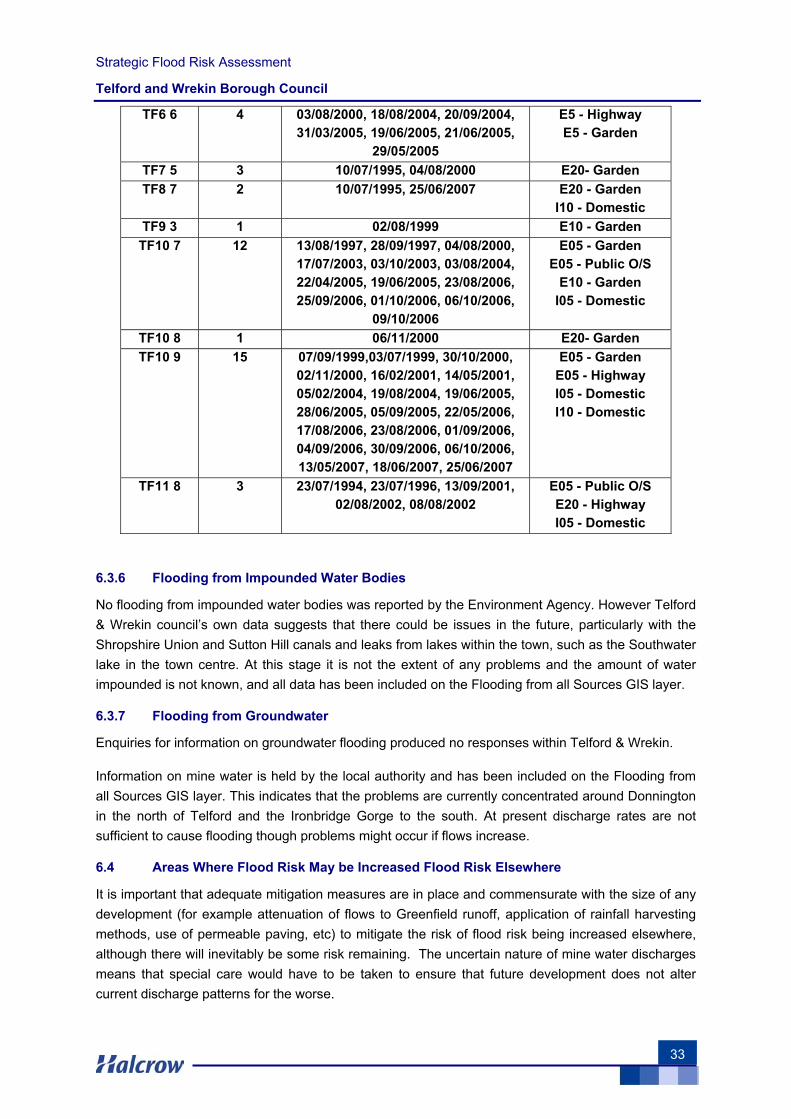
Strategic Flood Risk Assessment
Telford and Wrekin Borough Council
33
TF6 6 4 03/08/2000, 18/08/2004, 20/09/2004, 31/03/2005, 19/06/2005, 21/06/2005,
29/05/2005
E5 - Highway E5 - Garden
TF7 5 3 10/07/1995, 04/08/2000 E20- Garden TF8 7 2 10/07/1995, 25/06/2007 E20 - Garden
I10 - Domestic TF9 3 1 02/08/1999 E10 - Garden TF10 7 12 13/08/1997, 28/09/1997, 04/08/2000,
17/07/2003, 03/10/2003, 03/08/2004, 22/04/2005, 19/06/2005, 23/08/2006, 25/09/2006, 01/10/2006, 06/10/2006,
09/10/2006
E05 - Garden E05 - Public O/S
E10 - Garden I05 - Domestic
TF10 8 1 06/11/2000 E20- Garden TF10 9 15 07/09/1999,03/07/1999, 30/10/2000,
02/11/2000, 16/02/2001, 14/05/2001, 05/02/2004, 19/08/2004, 19/06/2005, 28/06/2005, 05/09/2005, 22/05/2006, 17/08/2006, 23/08/2006, 01/09/2006, 04/09/2006, 30/09/2006, 06/10/2006, 13/05/2007, 18/06/2007, 25/06/2007
E05 - Garden E05 - Highway I05 - Domestic I10 - Domestic
TF11 8 3 23/07/1994, 23/07/1996, 13/09/2001, 02/08/2002, 08/08/2002
E05 - Public O/S E20 - Highway I05 - Domestic
6.3.6 Flooding from Impounded Water Bodies
No flooding from impounded water bodies was reported by the Environment Agency. However Telford & Wrekin council’s own data suggests that there could be issues in the future, particularly with the Shropshire Union and Sutton Hill canals and leaks from lakes within the town, such as the Southwater lake in the town centre. At this stage it is not the extent of any problems and the amount of water impounded is not known, and all data has been included on the Flooding from all Sources GIS layer.
6.3.7 Flooding from Groundwater
Enquiries for information on groundwater flooding produced no responses within Telford & Wrekin.
Information on mine water is held by the local authority and has been included on the Flooding from all Sources GIS layer. This indicates that the problems are currently concentrated around Donnington in the north of Telford and the Ironbridge Gorge to the south. At present discharge rates are not sufficient to cause flooding though problems might occur if flows increase.
6.4 Areas Where Flood Risk May be Increased Flood Risk Elsewhere
It is important that adequate mitigation measures are in place and commensurate with the size of any development (for example attenuation of flows to Greenfield runoff, application of rainfall harvesting methods, use of permeable paving, etc) to mitigate the risk of flood risk being increased elsewhere, although there will inevitably be some risk remaining. The uncertain nature of mine water discharges means that special care would have to be taken to ensure that future development does not alter current discharge patterns for the worse.

Strategic Flood Risk Assessment
Telford and Wrekin Borough Council
34
This page is left intentionally blank
Strategic Flood Risk Assessment
Telford and Wrekin Borough Council
35
7 Flood Warning Systems and Flood Management Measures
7.1 Flood Management
Flood risk management can reduce the probability of occurrence through the management of land, river systems and flood defences, and reduce the impact though influencing development in flood risk areas, flood warning and emergency response.
A Catchment Flood Management Plan (CFMP) is a high-level strategic plan through which the Environment Agency seeks to work with other key-decision makers within a river catchment to identify and agree long-term policies for sustainable flood risk management. A CFMP for the Fluvial Severn was issued during 2005. The document assesses the size, nature and distribution of the current flood risk whilst providing an indication of future flood risk in the catchments. It then provides a complementary set of long-term flood risk management policies and an indication of the types of response that could be implemented to meet them.
The key policies relating to the study area are outlined in the next chapter.
The River Severn Fluvial Strategy follows on from the CFMP study and identifies preferred flood risk management measures that would deliver the CFMP policies in a specific area or river reach. Flood risk areas were defined to cover communities at risk options for flood management were then considered and technical, environmental and economic appraisals were carried out. The results of the three appraisals were used to identify a preferred option for each of the flood risk areas.
7.2 Flood Defences
Only a few of the communities at risk of flooding from the Severn are currently protected by permanent defences, such as Newtown on the Upper Severn. Demountable defences, with permanent civil engineering works, have recently been used to protect areas in Bewdley, Shrewsbury and Ironbridge. The level protection offered by the defences at Ironbridge is deemed to be between the 1 in 25 and 1 in 50 year events. Both temporary and demountable defences are not considered permanent and PPS 25 differentiates between temporary and demountable defences as the latter is associated with a particularly high risk of failure (as they may not be deployed rapidly enough). Low lying agricultural land at the confluence of the Severn and the Vyrnwy is frequently flooded and a series of low earth embankments, known locally as argaes, have been constructed to provide some protection. These banks prevent flooding at low return periods, typically protecting properties and agricultural land up to the events with between 10 and 20% chance of occurrence. A series of outfall structures release water back to the Severn and the Vyrnwy once river water levels have decreased but the argaes can prolong localised flooding by retaining floodwater trapped behind them after an event has passed. Previous studies have shown that the argae system provides significant protection to downstream communities, such as Shrewsbury, by storing substantial volumes of floodwater and releasing it back to the Severn after the event.
Within Telford & Wrekin there are no permanent formal Environment Agency flood defences. However the Environment Agency has used demountable temporary defences to protect properties on the Wharfage in Ironbridge.
A study of informal defences has not been made as part of this assessment.
Strategic Flood Risk Assessment
Telford and Wrekin Borough Council
36
7.3 Flood Warning
The Environment Agency is the lead organisation on flood warning and its key responsibilities include direct remedial action to prevent and mitigate the effects of an incident, to provide specialist advice, to give warnings to those likely to be affected, to monitor the effects of an incident and to investigate its causes. This requires the Environment Agency, local authorities and the emergency services to work together to protect people and properties.
When conditions suggest that floods are likely, it is the responsibility of the Environment Agency to issue flood warnings to the Police, Fire and Rescue Service, relevant local authorities, public and the flood wardens. It is the responsibility of individuals in the community to receive flood warnings via Flood Warnings Direct (FWD) which passes messages over the telephone network.
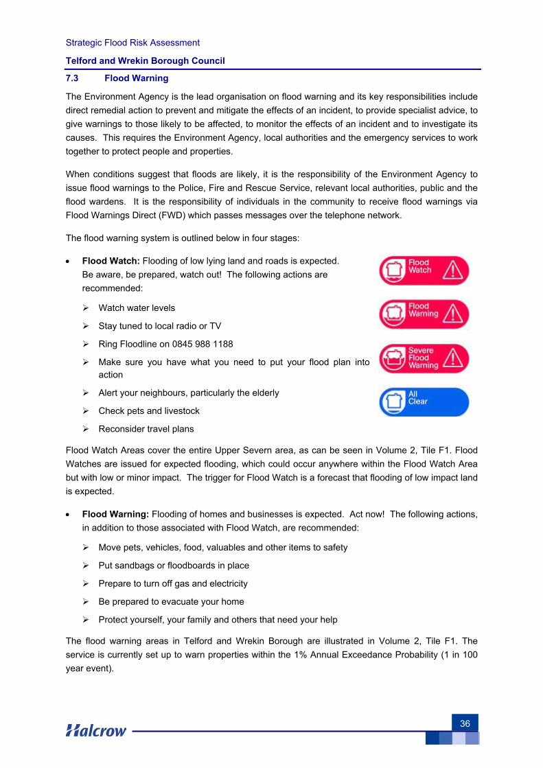
The flood warning system is outlined below in four stages:
• Flood Watch: Flooding of low lying land and roads is expected. Be aware, be prepared, watch out! The following actions are recommended:
Watch water levels
Stay tuned to local radio or TV
Ring Floodline on 0845 988 1188
Make sure you have what you need to put your flood plan into action
Alert your neighbours, particularly the elderly
Check pets and livestock
Reconsider travel plans
Flood Watch Areas cover the entire Upper Severn area, as can be seen in Volume 2, Tile F1. Flood Watches are issued for expected flooding, which could occur anywhere within the Flood Watch Area but with low or minor impact. The trigger for Flood Watch is a forecast that flooding of low impact land is expected.
• Flood Warning: Flooding of homes and businesses is expected. Act now! The following actions, in addition to those associated with Flood Watch, are recommended:
Move pets, vehicles, food, valuables and other items to safety
Put sandbags or floodboards in place
Prepare to turn off gas and electricity
Be prepared to evacuate your home
Protect yourself, your family and others that need your help
The flood warning areas in Telford and Wrekin Borough are illustrated in Volume 2, Tile F1. The service is currently set up to warn properties within the 1% Annual Exceedance Probability (1 in 100 year event).
Strategic Flood Risk Assessment
Telford and Wrekin Borough Council
37
• Severe Flood Warning: Severe flooding is expected. There is extreme danger to life and property. Act now! The following actions, in addition to those associated with Flood Warning, are recommended:
Be prepared to lose power supplies - gas, electricity, water, telephone
Try to keep calm, and to reassure others, especially children
Co-operate with emergency services and local authorities
You may be evacuated
• All Clear: Flood Watches or Warnings are no longer in force. The following is recommended:
Flood water levels receding
Check all is safe to return
Seek advice
7.4 Flood Response Plan
The Shropshire Flooding Response Plan aims to describe the response to serious flooding in Shropshire and to detail the measures to be taken by the various agencies involved. The plan is supplemented by the following:
• ‘Flooding in Shrewsbury Joint Action Plan’ produced by Shropshire County, Shrewsbury and Atcham Borough Council, the Environment Agency and Severn Trent Water.
• ‘Operation Tangent’ Plan produced by Telford and Wrekin Council, West Mercia Police, Shropshire Fire and Rescue Service, Shropshire Ambulance Service, Shropshire County Council, Bridgnorth District Council, Shrewsbury and Atcham Borough Council and the Environment Agency.
• ‘Flood Response Action Plan’ produced by Telford and Wrekin Council and the Environment Agency.
No two flood events are ever likely to be identical but the process can be broken down into four phases. The plan covers the following phases and outlines the actions required during each phase:
• Phase 1 - Flood Warning Phase
• Phase 2 - Preparatory Phase
• Phase 3 - The Flood Occurs
• Phase 4 - Recovery
Below is a summary of Telford and Wrekin Councils actions in the event of flooding taken from the Shropshire Flooding Response Plan (February 2007). For more detailed information reference should be made to authorities own emergency plans and procedures.
The potential for flooding will be monitored by the Emergency Planning Unit and will source information from the EA, the local radio and Telford and Wrekin Council Engineers. Telford and Wrekin Council act as Flood Wardens and are therefore alerted by the EA of Flood Warnings. In

Strategic Flood Risk Assessment
Telford and Wrekin Borough Council
38
addition the Emergency Planning Duty Officer receives ‘Flood Warning Update’ and ‘Sever Flood Warning’ warnings through Shropshire Fire and Rescue Service Control Room. In the event of a flooding incident the Council will act to notify owners of properties which are in danger of flooding and issue sandbags where necessary. Continue to monitor water levels throughout the event and liaise with the Emergency Services, and neighbouring authorities if required. If the decision is made to erect the temporary barriers, a deployment notice will be issued and the public will be informed that the barriers will be erected within 24 hours.
Strategic Flood Risk Assessment
Telford and Wrekin Borough Council
39
8 Flood Risk Management Policies
8.1 Catchment Flood Management Plans
The Severn Catchment Flood Management Plan (CFMP) is a document which aims to identify flood risk management policies for the catchment. Being a high-level document, it does not stipulate how the policy should be achieved, but does indicate the types of response that could be implemented to deliver a policy. The generic flood risk management policies which have been considered for the Severn are:
• Do nothing – no active intervention, including flood warning and maintenance
• Do minimum – continue with maintenance of river channel and existing flood defences, including asset surveys and inspections, and continue with the existing flood warning service; it is accepted that flood risk may change over time. Activities such as promotion of local self help types of response and individual property protection would also continue
• Maintain the current level of flood risk in the face of future changes. This is likely to require intervention during the life of the Plan, such as improving existing flood defence infrastructure or introducing upstream storage
• Intervene to reduce the current level of flood risk and to maintain this level in the face of future changes
• Intervene to increase the level of flood risk in specified areas in order to gain benefits locally or elsewhere, for example flooding farmland upstream of a community to provide storage for floodwater.
For the purposes of the CFMP, the Severn catchment has been considered as 20 sub-catchments. The sub-catchment(s) relevant to Telford and Wrekin Council’s area are those of the River Tern and the Middle Severn. Given the 50-year timescale of the Plan, and the potential effects of future change scenarios, policies for short and long term for each sub-catchment have been identified. Short term policies cover the first 10 years of the Plan period, while long term policies take into account future change scenarios and cover the remaining 40 years of the Plan.
The policies identified for these catchments are as follows:
River Tern
• Short Term Policy ( 0-10 years )
Maintain current level of flood risk
• Long Term Policy ( 11 - 50 years )
Maintain current level of flood risk
Middle Severn - Ironbridge
• Short Term Policy ( 0-10 years )
Reduce flood risk for The Wharfage
Strategic Flood Risk Assessment
Telford and Wrekin Borough Council
40
Do minimum for the remainder of the town
• Long Term Policy ( 11 - 50 years )
Maintain reduced level of flood risk for The Wharfage
Reduce flood risk for the remainder of the town
Middle Severn - remainder of catchment
• Short Term Policy ( 0-10 years )
Reduce level of flood risk for larger settlements
Do minimum for the remainder of the catchment
• Long Term Policy ( 11 - 50 years )
Maintain level of flood risk for larger settlements
Maintain current level of flood risk for smaller communities
Recognise that the level of flood risk will increase for agricultural land and undeveloped land and isolated properties.
8.2 Policy Considerations
Given the broad nature of these policies, more specific policy considerations are put forward below to drive the Council’s flood risk management policies.
To Seek Risk Reduction through Spatial Planning and Site Design:
• Use the Sequential Test to locate new development in least risky areas, giving highest priority to Flood Zone 1
• If a Sequential Test is undertaken and a site in a floodplain is identified as the only site for development, after application of Exception Test, use the sequential approach to inform the site design and seek opportunities to reduce risk
• Ensure that any redevelopment within the floodplain that is justified on wider sustainability grounds is resilient to flooding
• Identify long-term opportunities to remove development from the floodplain through land swapping
• Ensure development is ‘safe’. For residential developments to be classed as ‘safe’, dry pedestrian egress out of the floodplain and emergency vehicular access should be possible
• Raise floor levels above the 1 in 100 year plus climate change water level
To Reduce Surface Water Runoff from New Developments and Agricultural Land:
• SUDS required on all new development
• All sites greater than 1 Ha in size require the following:
- SUDS

Strategic Flood Risk Assessment
Telford and Wrekin Borough Council
41
- Greenfield discharge rates
- 1 in 100 year on-site attenuation taking into account climate change
• Set-aside space for SUDS on all allocated sites
• Promote environmental stewardship schemes to reduce water and soil runoff from agricultural land
To Enhance and Restore the River Corridor:
• Assess condition of existing assets and renew if required to ensure their lifetime is commensurate with lifetime of the development
• Seek opportunities to undertake river restoration/enhancement as part of a development to make space for water
• Avoid further culverting and building over of culverts. All new developments with culverts running through their site should seek to de-culvert rivers for flood risk management and conservation benefit
• Set development back from rivers, seeking an 8 metre wide undeveloped buffer strip. Making space for water and additional capacity to accommodate climate change
To Protect and Promote Areas for Future Flood Alleviation Schemes
• Protect Greenfield functional floodplain from future development (our greatest flood risk management asset)
• Develop appropriate flood risk management policies for the Brownfield functional floodplain, focusing on risk reduction
• Identify sites where developer contributions could be used to fund future flood risk management schemes or can reduce risk for surrounding areas
• Seek opportunities to make space for water to accommodate climate change
To Improve Flood Awareness and Emergency Planning
• Seek to improve the emergency planning process following future updates to the SFRA
• Encourage all those within Flood Zone 3a and 3b (residential and commercial occupiers) to sign-up to Flood Warnings Direct service operated by the Environment Agency
• Ensure robust emergency (evacuation) plans are implemented for new developments greater than 1 Ha in size (the Environment Agency has noted that criteria will need to be produced to ensure validation of robustness and the consequent production of effective, enforceable operational plans)
Strategic Flood Risk Assessment
Telford and Wrekin Borough Council
42
This page is left intentionally blank

Strategic Flood Risk Assessment
Telford and Wrekin Borough Council
43
9 Guidance on the Application of the Sequential Test
This section provides guidance on how to apply the Sequential Test.
9.1 Step One: Strategic Overview of flood risk across all potential development areas
The recommended initial step is to determine the extents of potential land allocations on large scale maps showing the most up-to-date flood zones, in accordance with PPS 25. Summary tables of flood risk issues should then be prepared for each location, indicating if the potential areas overlap Zones 2, 3, localised flooding areas or if there are records of previous flood incidents shown in the maps. It is then recommended that the summary tables and proposed locations are sent to the Environment Agency for verification. Particular care should be taken by identifying allocations that could increase flood risk elsewhere (flood incident points, localised flooding areas, flood zones) and lack of dry access.
9.2 Step Two: Flood Risk Issues in Zone 1
The next step should be to analyse all potential sites within Zone 1 by identifying those that have any flood risk issues (for example those affected by other sources of flooding or those that do not have dry access routes during flood events).
For the sites with flood risk issues, an assessment of likely significance of flood risk should then be carried out in terms of likely probability of flooding and potential consequences/flood damages (advice from a drainage specialist may be required, such as the SFRA consultant, the Environment Agency, a highways drainage engineer and/or the planning authority drainage specialist). The purpose is to identify sites with significant flood risk - high probability of flooding and significant flood damages with deep flooding and high velocities which could result in loss of property and potentially loss of life.
If a site with significant flood risk is identified within Zone 1, this would be considered as if it was in the High Probability Zone 3a, for further application of the Sequential Test in Zone 3a (see Section 9.3), bearing in mind that if a more vulnerable land use is required for the site, it will have to pass the Exception Test.
For those sites within localised flooding areas or with flood incident records where flood risk issues are not significant (for example shallow flooding and non-frequent blockages, etc), development should still be acceptable provided that adequate policies are in place for mitigating the risk (for example contributions may be required from the developer for the upgrade of the surface water system in the area).
It is important to note that most potential sites that pass the Sequential Test in Zone 1 will still require site-specific flood risk assessments. For development proposals on sites comprising one hectare or greater, the vulnerability to flooding from other sources (as well as from river flooding) and the potential to increase flood risk elsewhere through the addition of hard surfaces and the effect of the new development on surface water runoff, should be incorporated in an FRA. This need only be brief unless the factors above or other local considerations require particular attention. It is recommended that FRAs are still produced for Zone 1 sites of less than one hectare, at locations where there are records of previous flood incidents.
Strategic Flood Risk Assessment
Telford and Wrekin Borough Council
44
9.3 Step Three: Sequential Test in Zones 2 and 3
The third step is to sequentially allocate sites as described in Section 4.3 and as part of a Sustainability Appraisal (SA). It is recommended that prior to incorporating the Sequential Test within the SA, the following actions take place:
a) Apply the measure of avoidance/prevention (see Section 5.1) by moving the boundaries of the potential sites away from Zones 2, 3a and 3b, for those cases where the loss of site area is acceptable. This is generally the case at locations where the loss in area is of the order of 10%.
b) Provisionally adopting land uses that are fully compatible with the vulnerability classification of PPS 25, to try to avoid the need to apply the Exception Test where possible.
Strategic Flood Risk Assessment
Telford and Wrekin Borough Council
45
10 Guidance for Preparation of Flood Risk Assessments
The SFRA should be used as a starting point for flood risk assessments, to understand the level of risk posed to a particular site. General details about FRA requirements can be found in Table D.1: Flood Zones, in PPS 25. For quick reference, this table has been provided on the strategic flood risk maps in Volume 2.
It is imperative that site-based FRAs are discussed early in the planning process and submitted as an integral part of the planning application. It is a government directive that planning applications seeking approval for development within flood affected areas can be regarded as invalid if not supported by a detailed FRA. FRAs should also be incorporated into Environmental Statements, where one is required.
FRAs will be required for most proposed developments, but the level of detail will be dependant upon the existing level of flood risk posed to the site. FRAs should always be proportionate to the degree of flood risk and the scale, nature and location of the proposed development. The scope of FRAs should be agreed with the LPA, in consultation with the Environment Agency and other relevant bodies. The table matrix overleaf has been taken from the Environment Agency’s standard advice on Development and Flood Risk (http://www.pipernetworking.com/floodrisk/). The consultation matrix sets out when the Environment Agency needs to be consulted by Local Planning Authorities, together with guidance on what that consultation should contain.
Should new developments be permitted in Flood Zones 2 and 3, it is important to consider Flood Resilient Construction. It is also important that vulnerable uses of development have safe dry access, and less vulnerable developments have safe refuges and evacuation plans.

Strategic Flood Risk Assessment
Telford and Wrekin Borough Council
46
Strategic Flood Risk Assessment
Telford and Wrekin Borough Council
47
There are three levels of FRA which can be undertaken by a developer:
• Level 1: Screening Study: To identify whether there are any flooding or surface water management issues related to a development site that may warrant further consideration. This should be based on readily available existing information. The SFRA document, as well as the strategic flood risk maps (which reproduce the Environment Agency’s Flood Maps and also show flooding from other sources) will allow the LPA to ascertain whether an FRA is required.
The Level 1 FRA should refer to Table D1 of PPS 25, which is provided on the strategic flood risk maps, when cross-referencing proposed development sites with flood risk areas.
• Level 2 – Scoping Study: To be undertaken if the Level 1 FRA indicates that the site may lie within an area that is at risk of flooding or that the site may increase flood risk due to increased runoff. This study should confirm the sources of flooding which may affect the site. The study should also include the following:
o An appraisal of the availability and adequacy of existing information
o A qualitative appraisal of the flood risk posed to the site, and potential impact of the development on flood risk elsewhere
o An appraisal of the scope of possible measures to reduce the flood risk to acceptable levels
The scoping study may identify that sufficient quantitative information is already available to complete an FRA appropriate to the scale and nature of the development.
Typical sources of information for this level of study include: Regional/Local policy statements, Regional Flood Risk Appraisals, the SFRA, CFMPs (summarised in this document), Surface Water Management Plans, consultation with the Environment Agency, Historic maps, local information and a walkover survey of the proposed site (to assess potential sources of flooding, likely routes for flood water, site’s key features). A site survey to determine ground levels across the site and levels of formal and informal flood defences should also be ascertained.
• Level 3 – Detailed Study: To be undertaken if the Level 2 FRA concludes that further quantitative analysis is required to assess flood risk issues related to the development site. The study should include:
o Quantitative appraisal of the potential flood risk to the development
o Quantitative appraisal of the potential impact of the development site on flood risk elsewhere
o Quantitative demonstration of the effectiveness of any proposed mitigation measures
Typical sources of information for this level of study are as for the Level 2 FRA, as well as a detailed topographical survey, detailed hydrologic survey, site-specific hydrological and hydraulic modelling study, model calibration/verification (where data exists to do so) and continued consultation with the LPA, the Environment Agency and other flood risk consultees.
The following reflects best practice on what should be addressed within a detailed FRA.
Strategic Flood Risk Assessment
Telford and Wrekin Borough Council
48
10.1 Proposed Developments Within Flood Zone 3a
All FRAs supporting proposed development within High Probability Zone 3a should assess the proposed development against all elements of the Council’s flood policy, and include an assessment of the following:
• The vulnerability of the development to flooding from other sources (e.g. surface water drainage, groundwater) as well as from river flooding. This will involve discussion with the Council and the Environment Agency to confirm whether a localised risk of flooding exists at the proposed site.
• The vulnerability of the development to flooding over the lifetime of the development (including the potential impacts of climate change), i.e. maximum water levels, flow paths and flood extents within the property and surrounding area. The Environment Agency may have carried out detailed flood risk mapping within localised areas that could be used to underpin this assessment. Where available, this will be provided at a cost to the developer. Where detailed modelling is not available, hydraulic modelling by suitably qualified engineers will be required to determine the risk of flooding to the site.
• Whether the development contributes towards reducing flood risk. This is an important test of any new development in the context of PPS 25. The potential of the development to increase flood risk elsewhere through the addition of hard surfaces, the effect of the new development on surface water runoff, and the effect of the new development on depth and speed of flooding to adjacent and surrounding property should also be assessed. The latter point refers to the impact that the development will have on flood flow routes and flood storage. This will require a detailed assessment to be carried out by a suitably qualified engineer.
• It is highlighted that all forms of flooding need to be considered as localised flooding may also occur, typically associated with local catchment runoff following intense rainfall passing directly over the borough. This localised risk of flooding must also be considered as an integral part of the detailed Flood Risk Assessment.
• A demonstration that residual risks of flooding (after existing and proposed flood management and mitigation measures are taken into account) are acceptable. Measures may include flood defences, flood resistant and resilient design, escape/evacuation, effective flood warning and emergency planning.
• Details of existing site levels, proposed site levels and proposed ground floor levels. All levels should be stated relevant to Ordnance Datum.
It is essential that developers thoroughly review the existing and future structural integrity of informal defences, if present, upon which the development will rely (i.e. over the lifetime of the development), and ensure that emergency planning measures are in place to minimise risk to life in the unlikely event of a defence failure.
10.2 Proposed Developments Within Medium Probability Flood Zone 2
For all sites within Medium Probability Zone 2, a high level FRA should be prepared based upon readily available existing flooding information, sourced from the Environment Agency. It will be necessary to demonstrate that the residual risk of flooding to the property is effectively managed

Strategic Flood Risk Assessment
Telford and Wrekin Borough Council
49
through, for example, the provision of raised floor levels and the provision of planned evacuation routes.
10.3 Proposed Developments Within Flood Zones 1 and 2
Within all areas of the District, the risk of alternative sources of flooding (e.g. surface water, sewage, and/or groundwater) must be considered, and sustainable urban drainage techniques must be employed to ensure no worsening of existing flooding problems elsewhere within the area.
The SFRA provides specific recommendations with respect to the provision of sustainable flood risk mitigation opportunities that will address both the risk to life and the residual risk of flooding to development within particular ‘zones’ of the area. These recommendations should form the basis for the site-based FRA.
10.4 Raised Floor Levels and Basements (Freeboard)
The raising of floor levels above the 1% probability peak flood level will ensure that the damage to property is minimised. Given the anticipated increase in flood levels due to climate change, the adopted floor level should be raised above the 1% probability flood level assuming a 20% increase in flow over the next 20 to 100 years (see PPS 25 climate change tables at the end of Section 5.4).
It is highlighted that many of those areas currently situated within Medium Probability Zone 2 could become part of the High Probability Zone 3. This is important as it means that properties that are today at relatively low risk will, in 20 to 100 years, be within High Probability Zone 3a. It is imperative therefore that planning and development control decisions take due consideration of the potential risk of flooding in future years.
Wherever possible, floor levels should be situated a minimum of 600mm above the 1% probability peak flood level plus climate change flood level (+20% flows), determined as an outcome of the site-based FRA. Additional freeboard may be required because of the risk of blockages to the channel, culvert or bridge. The height that the floor level is raised above flood level is referred to as the ‘freeboard’, and is determined as a measure of the residual risks.
The use of basements within flood affected areas should be discouraged. Where basements are permitted however, it is necessary to ensure that the basement access points are situated 300 mm above the 1% probability flood level plus climate change. The basement must have unimpeded access and waterproof construction to avoid seepage during flooding conditions. Habitable uses of basements within Flood Zone 3 should not be permitted, while basement dwellings can be allowed in Flood Zone 2 provided they pass the Exception Test.

Strategic Flood Risk Assessment
Telford and Wrekin Borough Council
50
This page is left intentionally blank
Strategic Flood Risk Assessment
Telford and Wrekin Borough Council
51
11 Guidance for the Application of Sustainable Urban Drainage Systems
11.1 Introduction
Planning Policy Statement 1: Delivering sustainable development and PPS25 requires that Local Planning Authorities (LPAs) should promote Sustainable Urban Drainage Systems (SUDS). LPAs should ensure policies encourage sustainable drainage practices in their LDDs. SUDS is a term used to describe the various approaches that can be used to manage surface water drainage in a way that mimics the natural environment. The management of rainfall (surface water) is considered an essential element of reducing future flood risk to both the site and its surroundings. Indeed, reducing the rate of discharge from urban sites to Greenfield runoff rates is one of the most effective ways of reducing and managing flood risk within the borough.
11.2 Types of SUDS Systems
SUDS may improve the sustainable management of water for a site by:
• Reducing peak flows to watercourses or sewers and potentially reducing the risk of flooding downstream
• Reducing volumes of water flowing directly to watercourses or sewers from developed sites
• Improving water quality compared with conventional surface water sewers by removing pollutants from diffuse pollutant sources
• Reducing potable water demand through rainwater harvesting
• Improving amenity through the provision of public open space and wildlife habitat
• Replicating natural drainage patterns, including the recharge of groundwater so that base flows are maintained
Any reduction in the amount of water that originates from any given site is likely to be small however if applied across the catchment, the cumulative affect from a number sites could be significant.
There are numerous different ways that SUDS can be incorporated into a development. The appropriate application of a SUDS scheme to a specific development is heavily dependent upon the topography and geology of the site and the surrounding areas. Careful consideration of the site characteristics is necessary to ensure the future sustainability of the adopted drainage system. The most commonly found components of a SUDS system are described below:
• Pervious surfaces: Surfaces that allow inflow of rainwater into the underlying construction or soil
• Green roofs: Vegetated roofs that reduce the volume and rate of runoff and remove pollution
• Filter drains: Linear drains consisting of trenches filled with a permeable material, often with a perforated pipe in the base of the trench to assist drainage, to store and conduct water; they may also permit infiltration
• Filter strips: Vegetated areas of gently sloping ground designed to drain water evenly off impermeable areas and to filter out silt and other particulates
• Swales: Shallow vegetated channels that conduct and retain water, and may also permit infiltration; the vegetation filters particulate matter
• Basins: Ponds and wetlands areas that may be utilised for surface runoff storage
Strategic Flood Risk Assessment
Telford and Wrekin Borough Council
52
• Infiltration Devices: Sub-surface structures to promote the infiltration of surface water to ground. They can be trenches, basins or soakaways
• Bioretention areas: Vegetated areas designed to collect and treat water before discharge via a piped system or infiltration to the ground
• Pipes and accessories: A series of conduits and their accessories normally laid underground, that convey surface water to a suitable location for treatment and/or disposal (although sustainable, these techniques should be considered where other SUDS techniques are not practicable)
For more guidance on SUDS, the following documents and websites are recommended as a starting point:
• Planning Policy Statement 25 ‘Development & Flood Risk’ – Communities & Local Government (Dec 2006)
• Development & Flood Risk: ‘Practice Guide Companion to PPS 25’ – Communities & Local Government (Feb 2007)
• The SUDS Manual – CIRIA C697 (2007) provides the best practice guidance on the planning, design, construction, operation and maintenance of Sustainable Drainage Systems and facilitates their effective implementation within developments
• Interim Code of Practice for Sustainable Drainage Systems, National SUDS Working Group, 2004
• www.ciria.org.uk/suds/
11.3 Application of SUDS for Telford and Wrekin Council
This Borough is predominantly made up of low permeability, slightly acidic, loamy and clayey soils (see Section 6.2). The more permeable sites should have priority given to infiltration drainage techniques, as opposed to discharging surface water to watercourses. Where less permeability is found and infiltration techniques that rely on discharge into the existing soils are not viable (also due to a high water table, source protection zones, contamination etc), discharging site runoff to watercourses is preferable to the use of sewers. Integrated urban drainage should also be used throughout the design process.
The majority of the Borough has been highlighted by DEFRA as a Nitrate Vulnerable Zone (NVZ) and a significant area in the northern half of the borough is classified as a Groundwater Source Protection Zone (GSPZ) by the EA. The Borough includes Phases 1, 4 and 8 of the Shropshire Groundwater Scheme, which shows the location of pipelines and pumping stations. Any water wells should also be identified and taken into account in the design process.
NVZs are generally indicative of the agricultural nature of the surrounding land and the use of fertilisers. Nitrate levels in many English waters are increasing principally due to surface water runoff from agricultural land entering receiving water bodies. The level of nitrate contamination will have an impact on the choice of SUDS and will have to be assessed for specific sites.
The GSPZ is situated over the Permo-Triassic Sandstone Aquifer and is designated as inner, outer and total catchment areas. The Inner Zones of the GSPZ are the most sensitive areas and vary in diameter from 0.1 to 0.5 Kilometres. The Outer Zones are also sensitive to contamination and vary in diameter from 0.5 to 2.3 Kilometres in this borough. The GSPZ requires attenuated storage of runoff to prevent infiltration and contamination.

Strategic Flood Risk Assessment
Telford and Wrekin Borough Council
53
Eight GSPZ Inner Zones have been identified by the EA in this borough and they are situated in the following areas:
• Near Newport: Puleston, Chetwynd Aston, Longford, Preston upon the Weald Moors, Waters Upton, Crudgington and Longdon on Tern.
• East of Telford: Wrockwardine.
Runoff which is likely to be heavily contaminated must be treated by a proprietary device, which should be carefully considered to ensure the correct system is selected to remove pollutants. PPS 3 (2006) states that source control SUDS must be considered and incorporated where suitable. For example; surface water drained from a car park should implement a filter bed wherever possible before considering an interceptor device to remove contaminants.
If the local soil is contaminated then a lined system is generally required. This may include a drainage design which allows infiltration in the upper layer, but should incorporate an impermeable layer at its base to prevent contamination. In such cases lined underground attenuation storage is used to store a 1 in 100 year +20% (for climate change) storm event and discharges into a nearby watercourse.

Strategic Flood Risk Assessment
Telford and Wrekin Borough Council
54
This page is left intentionally blank
Strategic Flood Risk Assessment
Telford and Wrekin Borough Council
55
12 Gap Analysis
Data gaps have been assessed throughout the Level 1 SFRA data collection and review exercise. This has flagged the missing or incomplete data. It should be noted that an SFRA is a living document which should be updated as new and more detailed data becomes available.
12.1 Missing or Incomplete Data
The following data has not yet been received in phase 1 of the SFRA.
Data Description Source
Flood outlines 20year return period (or similar) flood outlines for all rivers except the River Severn and River Tern, allowing production of Flood Zone 3b outlines
Environment Agency (this data does not yet exist)
Flooding Data Flooding information for trunk roads within District
Highways Agency (pending)
Anecdotal Info Accounts of flooding from all sources Various
LiDAR data Topographical data required for breach scenarios
Environment Agency (pending)
FRA Developers Flood Risk Assessments Telford and Wrekin (pending)
Receipt of this data will further refine the SFRA. In particular, the DG5 Register is deemed to be the most urgent data requirement. This is because PPS25 requires that flooding from all sources is mapped as part of an SFRA, and at present flooding from foul and combined sewers is not represented on the strategic flood risk maps.
12.2 Level 2 SFRA
This Level 1 SFRA will allow South Shropshire DC to assess their current proposed site allocations using the sequential test. This will act as a ‘sieving’ process, allocating as many sites as possible to Flood Zone 1. Where it is found that some sites can only be placed in Flood Zones 2 and 3, further work will need to be undertaken as part of a Level 2 SFRA to determine the variations in flood risk in these zones. This will ensure that preference is given to the lowest risk areas within Flood Zones 2 and 3. Once this work has been carried out, the exception test will need to be applied in line with table D3 in Annex D of PPS 25. Three criteria need to be satisfied for the exception test to be passed:
• It must be demonstrated that the development provides wider sustainability benefits to the community that outweigh flood risk, informed by a SFRA where one has been prepared. If the DPD has reached the ‘submission’ stage – see Figure 4 of PPS12: Local Development Frameworks – the benefits of the development should contribute to the Core Strategy’s Sustainability Appraisal
• The development should be on developable, previously-developed land or, if it is not on previously developed land, that there are no reasonable alternative sites on developable previously-developed land
Strategic Flood Risk Assessment
Telford and Wrekin Borough Council
56
• A FRA must demonstrate that the development will be safe, without increasing flood risk elsewhere, and, where possible, will reduce flood risk overall
A Level 2 SFRA should be viewed as rather more site specific than a Level 1 SFRA, addressing flood risk to potential development sites which have gone through the sequential test and have been located in flood zones 2 or 3. The scope of works for a Level 2 SFRA needs to be agreed in consultation with the Environment Agency.
The data required for a Level 2 SFRA within Telford & Wrekin will therefore depend upon which, if any, of the Council’s final list of preferred sites remain in Flood Zones 2 & 3 following application of the Sequential Test and hence where the Exception test needs to be applied.
In instances where Flood Zone 3b does not exist (and therefore for the purposes of the sequential test Flood Zone 3b is deemed to be equal to 3a), and a ‘more vulnerable’ development has been allocated in Flood Zone 3a, it may be necessary to define Flood Zone 3b using flood mapping techniques. Halcrow is able to advise on further work required if this situation arises.
It is important that a Level 2 SFRA considers the variation of flood risk in a Flood Zone due to flood risk management measures i.e. flood defences. This increased scope involves a more detailed review of flood hazard (flood probability, flood depth, flood velocity, rate of onset of flooding). If development is to be located behind defences, it would be necessary to model constructional failure of the defence (breach) and water levels rising to exceed the level of the defence (overtopping). It is not necessary to carry out such scenarios behind all existing defences, if no new development is to be located behind these structures. In some instances improvements to existing flood defences may be required to manage residual flood risks. Here, the SFRA should include and appraisal of the extent of works to provide or raise the flood defence to appropriate standard. Should sites become allocated behind defences, Halcrow can advise on the cost of such work, and whether existing data is suitable for this purpose.
Level 2 SFRA outputs would include:
• An appraisal of the condition of flood defence infrastructure and likely future policy
• An appraisal of the probability and consequence of breach or overtopping of flood defence infrastructure
• Maps showing distribution of flood risk across zones
• Guidance on appropriate policies for making sites which satisfy parts a) and b) of the Exception Test safe, and the requirements for satisfying part c) of the Exception Test
• Guidance on the preparation of FRAs for sites with varying flood risk across the flood zone
A specific recommendation from the Environment Agency is that in Bridgnorth, Shifnal could be affected by flooding from the Telford and Wrekin area through any increased surface water discharges into Welsey Brook (a particularly flashy catchment). A reservoir exists upstream of Shifnal, acting as a balancing pond (Priors Lee) for Telford. The behaviour of this balancing pond, in terms of its current discharges and the effects of future increased inflows to the pond from increased surface water from new development, needs to be considered as part of a Level 2 SFRA.
Strategic Flood Risk Assessment
Telford and Wrekin Borough Council
57
13 References/Glossary
1) AEP - Annual Exceedance Probability, for example 1% AEP is equivalent to 1% probability of occurring in any one year (or, on average, once in every 100 years).
2) Core Strategy - The Development Plan Document which sets the long-term vision and objectives for the area. It contains a set of strategic policies that are required to deliver the vision including the broad approach to development.
3) DEFRA - Department of Environment, Food and Rural Affairs Development.
4) Development Plan Document (DPD) - A spatial planning document within the Council’s Local Development Framework which set out policies for development and the use of land. Together with the Regional Spatial Strategy they form the development plan for the area. They are subject to independent examination.
5) Dry pedestrian egress - Routes to and from buildings that will remain dry and allow pedestrian/wheelchair evacuation to dry land in times of flood.
6) Environment Agency - The leading public body for protecting and improving the environment in England and Wales.
7) Environment Agency Flood Map - Nationally consistent delineation of ‘high’ and ‘medium’ flood risk, published on a quarterly basis by the Environment Agency.
8) Environmental Stewardship - Environmental Stewardship is a new agri-environment scheme which provides funding to farmers and other land managers in England who deliver effective environmental management on their land. The scheme is intended to build on the recognised success of the Environmental Sensitive Areas scheme and the countryside Stewardship Scheme. Flood risk management is among its secondary objectives.
9) Exception Test - If, following application of the Sequential Test, it is not possible (consistent with wider sustainability objectives) to demonstrate that there are no reasonably available sites in areas with less risk of flooding that would be appropriate to the type of development or land use proposed, the Exception Test may apply. PPS 25 sets out strict requirements for the application of the Test.
10) Floodplain Mapping – River Stour and Smestow Brook (July 1993) – Floodplain mapping report detailing the hydrological analysis and hydraulic modelling undertaken as part of the study.
11) Flood Estimation Handbook - The latest hydrological approach for the estimate of flood flows in UK.
12) Flood Risk Management Hierarchy - PPS 25 reaffirms the adoption of a risk-based approach to flooding by following stepped hierarchical measures at all stages in the planning process. Avoidance/prevention is the first measure, followed by substitution, control and then mitigation.
13) Flood Risk Vulnerability - PPS 25 provides a vulnerability classification to assess which uses of land maybe appropriate in each flood risk zone.
Strategic Flood Risk Assessment
Telford and Wrekin Borough Council
58
14) Formal Flood Defence - A structure built and maintained specifically for flood defence purposes.
15) Functional Floodplain Zone 3b - Defined as areas at risk of flooding in the 5% AEP (20 year) design event.
16) Habitable Room - A room used as living accommodation within a dwelling but excludes bathrooms, toilets, halls, landings or rooms that are only capable of being used for storage. All other rooms, such as kitchens, living rooms, bedrooms, utility rooms and studies are counted.
17) High probability Zone 3a - Defined as areas at risk of flooding in the 1% AEP (100 year) design event.
18) IDB – Internal Drainage Board, responsible for non-main rivers and drainage within their boundary area.
19) Informal Flood Defence - A structure that provides a flood defence function however has not been built and/or maintained for this purpose (e.g. boundary wall).
20) JFLOW - A computer river model based on routeing a flood calculated by Flood Estimation Handbook methodology along a river corridor the levels of which are derived from a Side Aperture Radar (SAR) remote sensed Digital Terrain Model.
21) Land Swapping - looking for long term opportunities to remove development from areas that flood at present and relocate in lower risk locations which is essentially restoration of the floodplain.
22) LiDAR - Light Detection and Ranging (LiDAR) is an airborne terrain mapping technique which uses a laser to measure the distance between the aircraft and the ground.
23) Local Development Framework - The Local Development Framework (LDF) consists of a number of documents which together form the spatial strategy for development and the use of land.
24) Low Probability Zone 1 - Defined as areas outside Zone 2.
25) Main River – A section of watercourse (including the structures and devices on it used to regulate flow) which is maintained by the Environment Agency.
26) ‘Making Space for Water’ (Defra 2004) - The Government’s new evolving strategy to manage the risks from flooding and coastal erosion by employing an integrated portfolio of approaches, so as: a) to reduce the threat to people and their property; b) to deliver the greatest environmental, social and economic benefit, consistent with the Government's sustainable development principles, c) to secure efficient and reliable funding mechanisms that deliver the levels of investment required.
27) Medium probability Zone 2 - Defined as areas at risk of flooding in events that are greater than the 1% AEP (100 year), and less than the 0.1% AEP (1000 year) design event.

Strategic Flood Risk Assessment
Telford and Wrekin Borough Council
59
28) NFCDD – National Flood and Coastal Defence Database, owned by the Environment Agency, containing details of the location, standard and condition of all Environment Agency maintained defences
29) Ordinary Watercourse (non-main river) – Any section of watercourse not designated as a main river.
30) Planning Policy Statements - The Government has updated its planning advice contained within Planning Policy Guidance Notes (PPGs) with the publication of new style Planning Policy Statements (PPSs).
31) Planning Policy Statement 25 (PPS 25): Development and Flood Risk - PPS 25 reflects the general direction set out in ‘Making Space for Water’.
32) Previously Developed (Brownfield) Land - Land which is or was occupied by a building (excluding those used for agriculture and forestry). It also includes land within the curtilage of the building, for example a house and its garden would be considered to be previously developed land.
33) Residual Risk - The risk which remains after all risk avoidance, reduction and mitigation measures have been implemented.
34) Return Period – The probability of a flood of a given magnitude occurring within any one year e.g. a 1 in 100 year event has a probability of occurring once over 100 years. However, a 1 in 100 year event could occur twice or more within 100 years, or not at all.
35) Sequential Test - Informed by a SFRA, a planning authority applies the Sequential Test to demonstrate that there are no reasonably available sites in areas with less risk of flooding that would be appropriate to the type of development or land use proposed.
36) Strategic Flood Risk Assessment (SFRA) - A Strategic Flood Risk Assessment is used as a tool by a planning authority to assess flood risk for spatial planning, producing development briefs, setting constraints, informing sustainability appraisals and identifying locations of emergency planning measures and requirements for flood risk assessments.
37) Supplementary Planning Document (SPD) - Provides supplementary guidance to policies and proposals contained within Development Plan Documents. They do not form part of the development plan, nor are they subject to independent examination.
38) Sustainability Appraisal (SA) - Appraisal of plans, strategies and proposals to test them against broad sustainability objectives.
39) Sustainable Development - Development that meets the needs of the present without compromising the ability of future generations to meet their own needs” (The World Commission on Environment and Development, 1987).
40) West Midlands Regional Spatial Strategy - This is a new Regional Spatial Strategy which identifies the vision for the region. It will set a new housing requirement for each District or borough.

Strategic Flood Risk Assessment
Telford and Wrekin Borough Council
60

Strategic Flood Risk Assessment
Telford and Wrekin Borough Council
61
APPENDIX A

Strategic Flood Risk Assessment
Telford and Wrekin Borough Council
62

Strategic Flood Risk Assessment
Telford and Wrekin Borough Council
63
APPENDIX B

Strategic Flood Risk Assessment
Telford and Wrekin Borough Council
64
Strategic Flood Risk Assessment
Telford and Wrekin Borough Council
65
APPENDIX C
Appendix A Details of the Environment Agency Flood Zones
Introduction
A more detailed understanding of the Environment Agency Flood Zones and their limitations is important, as these are often used (unless more accurate flood outlines are available) for the production of SFRA flood maps.
Environment Agency Fluvial Maps
Data for fluvial Flood Zones 3 and 2 is derived from a number of sources. Most fluvial flood outlines are derived from the “JFlow” generalised computer modelling, which is a ‘coarse’ modelling approach. Some observations of flooding by the Environment Agency’s predecessors are included, for instance the extent of the severe 1947 floods, and this usually applies to Flood Zone 2. If a flood event extends further than Flood Zone 2 then the outline would be changed to reflect the wider flood risk area. In Shropshire, Flood Zone 3 has not been changed to match actual flood events.
Caution must be exercised in interpreting JFlow derived flood outlines due to the large number of assumptions incorporated into the JFlow model. For instance, at some locations the river centreline incorporated into the model was found to be erroneous with the result that the associated flood plains deviate from the natural valleys.
All Environment Agency Flood Zone Maps show the flood extent without the influences of defences.
Updates of the Environment Agency Flood Maps from Modelling
In many places the results of flood mapping studies have superseded the JFlow model. Generally these studies included high quality hydrological research, surveyed river cross sections, and more precise digital modelling such as ISIS, TuFlow and HecRas.
Although fluvial flooding is dependent on the standard of maintenance of watercourses and structures, the degree of maintenance allowed for tends to vary from model to model, with the result that flood maps based on modelling do not offer a uniform approach in this respect. As a consequence, serious blockages occurring during a flood might produce much more flooding than shown on previous modelling for a similar hydrological event.
Updates of the Environment Agency Flood Maps from Recent Events
Records of recent flood events have been used to modify the flood map. In these cases the Environment Agency has determined the return frequency of the observed event and modified the appropriate flood zone accordingly.
Output from a 2D TuFlow model
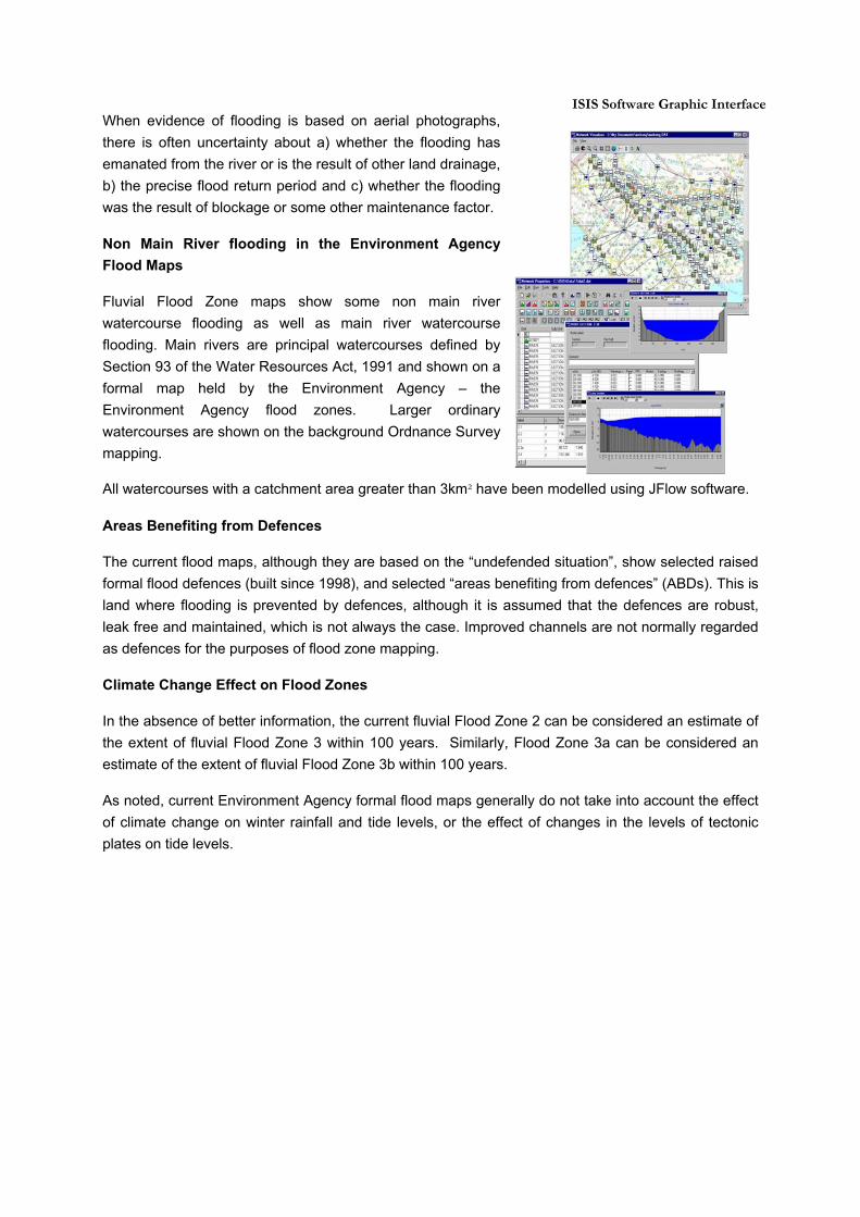
When evidence of flooding is based on aerial photographs, there is often uncertainty about a) whether the flooding has emanated from the river or is the result of other land drainage, b) the precise flood return period and c) whether the flooding was the result of blockage or some other maintenance factor.
Non Main River flooding in the Environment Agency Flood Maps
Fluvial Flood Zone maps show some non main river watercourse flooding as well as main river watercourse flooding. Main rivers are principal watercourses defined by Section 93 of the Water Resources Act, 1991 and shown on a formal map held by the Environment Agency – the Environment Agency flood zones. Larger ordinary watercourses are shown on the background Ordnance Survey mapping.
All watercourses with a catchment area greater than 3km² have been modelled using JFlow software.
Areas Benefiting from Defences
The current flood maps, although they are based on the “undefended situation”, show selected raised formal flood defences (built since 1998), and selected “areas benefiting from defences” (ABDs). This is land where flooding is prevented by defences, although it is assumed that the defences are robust, leak free and maintained, which is not always the case. Improved channels are not normally regarded as defences for the purposes of flood zone mapping.
Climate Change Effect on Flood Zones
In the absence of better information, the current fluvial Flood Zone 2 can be considered an estimate of the extent of fluvial Flood Zone 3 within 100 years. Similarly, Flood Zone 3a can be considered an estimate of the extent of fluvial Flood Zone 3b within 100 years.
As noted, current Environment Agency formal flood maps generally do not take into account the effect of climate change on winter rainfall and tide levels, or the effect of changes in the levels of tectonic plates on tide levels.
ISIS Software Graphic Interface
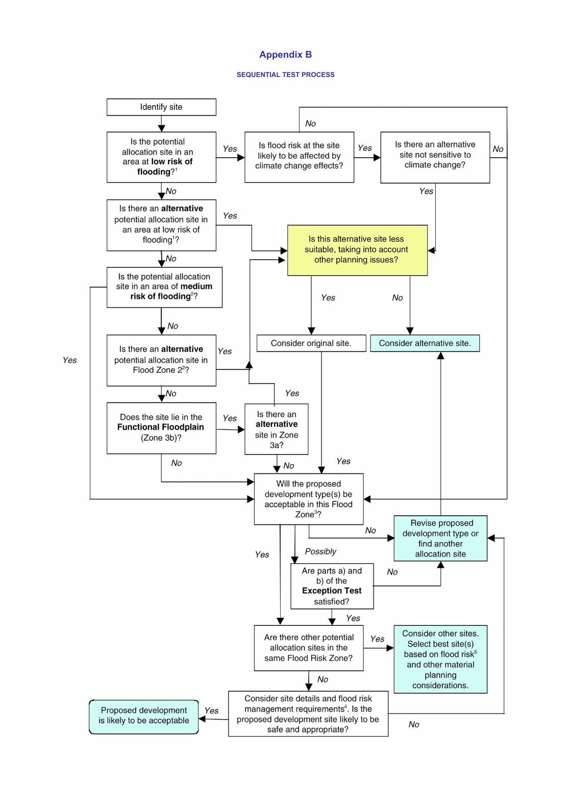
Appendix B
SEQUENTIAL TEST PROCESS

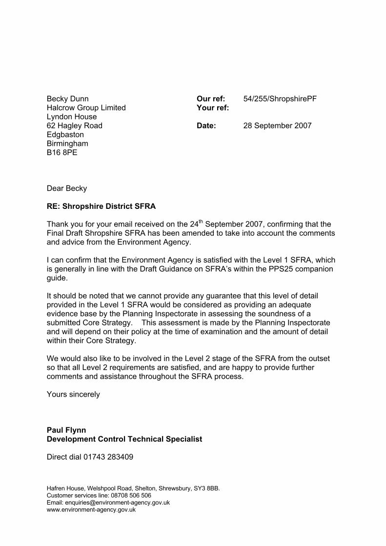
Hafren House, Welshpool Road, Shelton, Shrewsbury, SY3 8BB. Customer services line: 08708 506 506 Email: [email protected] www.environment-agency.gov.uk
Becky Dunn Halcrow Group Limited Lyndon House 62 Hagley Road Edgbaston Birmingham B16 8PE
Our ref: 54/255/ShropshirePF Your ref: Date: 28 September 2007
Dear Becky RE: Shropshire District SFRA Thank you for your email received on the 24th September 2007, confirming that the Final Draft Shropshire SFRA has been amended to take into account the comments and advice from the Environment Agency. I can confirm that the Environment Agency is satisfied with the Level 1 SFRA, which is generally in line with the Draft Guidance on SFRA’s within the PPS25 companion guide. It should be noted that we cannot provide any guarantee that this level of detail provided in the Level 1 SFRA would be considered as providing an adequate evidence base by the Planning Inspectorate in assessing the soundness of a submitted Core Strategy. This assessment is made by the Planning Inspectorate and will depend on their policy at the time of examination and the amount of detail within their Core Strategy. We would also like to be involved in the Level 2 stage of the SFRA from the outset so that all Level 2 requirements are satisfied, and are happy to provide further comments and assistance throughout the SFRA process. Yours sincerely Paul Flynn Development Control Technical Specialist Direct dial 01743 283409