half dome trail stewardship plan - national park service · half dome trail stewardship plan ......
TRANSCRIPT

Half Dome Trail Stewardship Plan Environmental Assessment
January 2012
National Park Service U.S. Department of the Interior Yosemite National Park Yosemite, California


Half Dome Trail Stewardship Plan Environmental Assessment
Yosemite National Park
Lead Agency: National Park Service
U.S. Department of the Interior
ABSTRACT
In 1964 Congress passed the Wilderness Act, creating the National Wilderness Preservation System, “to secure for the American people an enduring resource of Wilderness.”
1 In 1984, Congress
designated 95% of Yosemite National Park, including Half Dome and the Half Dome Trail, as a part of the National Wilderness Preservation System. Many Yosemite visitors travel into the wilderness to seek the beauty, solitude, and challenge that Congress sought to protect with wilderness designation. The California Wilderness Act of 1984 (Public Law [PL] 98–425) directs the National Park Service (NPS) to manage areas designated as wilderness according to provisions of the Wilderness Act of 1964. Half Dome is an iconic, granite peak visible from many spots in Yosemite National Park, and rising 5,000 feet above the Yosemite Valley floor in one dramatic sweep of sheer rock. Its summit is a goal for a broad cross section of the public; beginning and experienced hikers, first-time and lifelong park visitors, an array of ethnicities and cultures, children to grandparents, and people from all around the world. For many, this may be their first hike in designated wilderness. The combination of the long hike, an exhilarating, exposed ascent of the cables, and a spectacular view from the summit can combine to be a highlight of a person’s summer or even a life-changing event. The popularity of the Half Dome Trail has resulted in crowding along the Trail and the summit and adversely impacts wilderness character of the area by compromising visitors’ opportunities for solitude. High use levels also adversely impact wilderness character due to adverse impacts to natural resources. Crowding has raised concerns about the safety of both the public and that of rescue personnel on the cables. Crowding subjects hikers to long travel times and delays in ascending and descending the Half Dome Cables and may prevent them from getting down from the exposed portion of the Trail in a timely manner so as to avoid rain and lightning storms. These conditions on the Trail, as they existed at the start of this EA process, are counter to the Wilderness Act and National Park Service policy. The EA determines how to best manage the Half Dome Trail in accordance with the above law and policy. This document presents and analyzes five alternatives for public review and comment regarding wilderness character and risk management on the Half Dome Trail, in accordance with the National Environmental Policy Act and the National Historic Preservation Act. The No Action Alternative represents retaining the cable system and continuing to manage the Half Dome Trail as it was through 2009, without day-use limits. The No Action Alternative would result in impacts to both visitor safety and wilderness character, thereby violating NPS policy and is being carried forward as an alternative solely to demonstrate baseline conditions and allow direct comparison with the action alternatives. Therefore, the following four action alternatives represent a reasonable range of options to satisfy the purpose of and need for the project, while also meeting all relevant legal requirements:
Alternative B: 400 People per Day (Minimum Management Action)
Alternative C: 300 People per Day (Preferred)
Alternative D: 140 People per Day
Alternative E: Remove the Cables
1 Public Law 88-577 (16 U.S. C. 1131-1136)


Table of Contents
January 2012 Half Dome Trail Stewardship Plan EA
Table of Contents
EXECUTIVE SUMMARY ........................................................................................................................................................ iv
INTRODUCTION ......................................................................................................................................................................................... iv
PURPOSE AND NEED FOR ACTION ................................................................................................................................................... iv
OVERVIEW OF THE ALTERNATIVES ................................................................................................................................................ v
ACTIONS COMMON TO ALL ALTERNATIVES ............................................................................................................................... ix
ORGANIZATION OF THIS ENVIRONMENTAL ASSESSMENT ................................................................................................. x
CHAPTER 1 PURPOSE AND NEED .................................................................................................... 1-1
INTRODUCTION ...................................................................................................................................................................................... 1-1
PURPOSE OF THIS PROJECT ............................................................................................................................................................. 1-2
NEED FOR THIS PROJECT................................................................................................................................................................... 1-2
PROJECT SCOPE ...................................................................................................................................................................................... 1-2
BACKGROUND ......................................................................................................................................................................................... 1-2
POLICY AND PLANNING CONTEXT................................................................................................................................................ 1-6
PUBLIC INVOLVEMENT .................................................................................................................................................................... 1-10
CHAPTER 2 ALTERNATIVES.............................................................................................................. 2-1
DEVELOPMENT OF ALTERNATIVES ............................................................................................................................................. 2-2
ALTERNATIVES CONSIDERED AND DISMISSED .................................................................................................................. 2-13
IDENTIFICATION OF THE MINIMUM MANAGEMENT ALTERNATIVE ...................................................................... 2-16
IDENTIFICATION OF THE PREFERRED ALTERNATIVE ................................................................................................... 2-16
ENVIRONMENTALLY PREFERRED ALTERNATIVE ............................................................................................................. 2-16
SUMMARY OF ENVIRONMENTAL CONSEQUENCES ........................................................................................................... 2-17
CHAPTER 3 AFFECTED ENVIRONMENT AND ENVIRONMENTAL CONSEQUENCES ........ 3-1
INTRODUCTION ...................................................................................................................................................................................... 3-1
IMPACT TOPICS CONSIDERED IN THIS ENVIRONMENTAL ASSESSMENT ................................................................. 3-1
IMPACT TOPICS NOT INCLUDED IN THIS ENVIRONMENTAL ASSESSMENT ............................................................ 3-1
IMPACT SIGNIFICANCE DETERMINATION ................................................................................................................................ 3-2
WILDERNESS............................................................................................................................................................................................ 3-3
VISITOR EXPERIENCE ....................................................................................................................................................................... 3-11
VISITOR EXPERIENCE – ALTERNATIVE A – NO ACTION ................................................................................................. 3-12
PUBLIC SAFETY– MANAGING PERSONAL RISK .................................................................................................................... 3-15
NATURAL RESOURCES ..................................................................................................................................................................... 3-19
NATURAL RESOURCES – ALTERNATIVE A – NO ACTION ................................................................................................ 3-23
CULTURAL RESOURCES AND HISTORIC PROPERTIES ..................................................................................................... 3-26
CULTURAL RESOURCES AND HISTORIC PROPERTIES – ALTERNATIVES A, B, C and D ................................... 3-28
PARK OPERATIONS ............................................................................................................................................................................ 3-28
PARK OPERATIONS – ALTERNATIVE A – NO ACTION ...................................................................................................... 3-29
PARK OPERATIONS – ALTERNATIVES B, C, and D .............................................................................................................. 3-30
SOCIOECONOMICS .............................................................................................................................................................................. 3-31

Table of Contents
SOCIOECONOMICS – ALTERNATIVE A – NO ACTION ........................................................................................................ 3-34
UNAVOIDABLE ADVERSE IMPACTS ........................................................................................................................................... 3-38
IRREVERSIBLE AND IRRETRIEVABLE COMMITMENT OF RESOURCES ................................................................... 3-38
RELATIONSHIP OF SHORT-TERM USES OF MAN'S ENVIRONMENT AND LONG-TERM PRODUCTIVITY . 3-39
CHAPTER 4 CONSULTATION AND COORDINATION.................................................................. 4-1
INTERNAL AND PUBLIC SCOPING ................................................................................................................................................. 4-1
AGENCY CONSULTATION ................................................................................................................................................................... 4-2
ENVIRONMENTAL ASSESSMENT REVIEW ................................................................................................................................ 4-2
CHAPTER 5 LIST OF PREPARERS AND REVIEWERS ................................................................. 5-1
CHAPTER 6 GLOSSARY OF TERMS AND ACRONYMS ................................................................ 6-1
GLOSSARY OF TERMS .......................................................................................................................................................................... 6-1
ACRONYMS ................................................................................................................................................................................................ 6-4
CHAPTER 7 BIBLIOGRAPHY ............................................................................................................. 7-1
APPENDIX A CUMULATIVE IMPACTS PROJECT LIST ................................................................................. A-1
APPENDIX B COMMERCIAL USE .......................................................................................................................... B-1
APPENDIX C DETERMINATION OF EXTENT NECESSARY ON THE HALF DOME TRAIL ............ C-1
APPENDIX D MINIMUM REQUIREMENT ANALYSIS FOR THE HALF DOME TRAIL .................... D-1
LIST OF TABLES AND FIGURES
TABLE ES-1 COMPARISON OF EXPECTED NUMBERS OF USERS BY ALTERNATIVE......................... VII
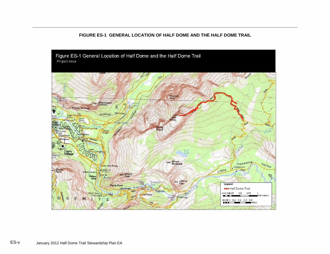
FIGURE ES-1 GENERAL LOCATION OF HALF DOME AND THE HALF DOME TRAIL ............................... 8
TABLE 1-1 ACCIDENTS ON THE HALF DOME (1967-PRESENT) ............................................................ 1-5
TABLE 1-2 DISTRIBUTION OF CONCERN STATEMENTS IDENTIFIED DURING SCOPING ....... 1-12
TABLE 2-1 COMPARISON OF EXPECTED NUMBERS OF USERS BY ALTERNATIVE........................ 2-2
TABLE 2-2 COMMERCIALUSE ALTERNATIVES .............................................................................................. 2-4
TABLE 2-3 SUMMARY OF EFFECTS BY ALTERNATIVE ............................................................................ 2-18
TABLE 3-1 OBSERVED AND PREDICTED GROUP ENCOUNTER RATES ............................................... 3-4
TABLE 3-2 MASS DESCENT TIMES ON THE CABLES ................................................................................. 3-16
TABLE 3-3 SPECIAL-STATUS SPECIES THAT OCCUR OR POTENTIALLY OCCUR IN HABITATS ALONG THE HALF DOME TRAIL AND ON THE HALF DOME SUMMIT ...................... 3-20
TABLE 3-4 DAY-USE FEES FOR CLIMBING/HIKING PERMITS ON OTHER FEDERAL LANDS . 3-32
TABLE 3-5 HALF DOME TRAIL COMMERCIAL USE BY YEAR ................................................................ 3-32
TABLE 3-6 HALF DOME GUIDED TRIPS AS A PERCENTAGE OF TOTAL GUIDED TRIPS ........... 3-33
TABLE 3-7 COMMERCIALUSE ALTERNATIVES ........................................................................................... 3-33
TABLE B-1 ORGANIZATIONS OFFERING GUIDED HIKES TO HALF DOME IN 2008 & 2010 ......... B-1

Table of Contents
January 2012 Half Dome Trail Stewardship Plan EA
This page intentionally left blank.

January 2012 Half Dome Trail Stewardship Plan EA ES-i
EXECUTIVE SUMMARY
INTRODUCTION
Half Dome, including its trail and cable system, is designated wilderness. It is also an iconic, internationally known mountain with a high demand from the public to reach its summit. Its trail and cable system have been in place since 1919, allowing generations of hikers to ascend the smooth, steep granite of the dome and reach the exposed summit. The beauty and challenge of the hike has attracted a diverse range of hikers, with unregulated day-use allowing for greater use each year. As use increased, crowding began to occur more regularly and eventually turned into long lines of hikers waiting to both ascend and descend the cables during busy days. To appropriately manage this important resource of the National Park System, the NPS has prepared an environmental assessment (EA) identifying and evaluating five alternatives for the Half Dome Trail Stewardship Plan in Yosemite National Park. This EA is pursuant to Section 102(2)(C) of the National Environmental Policy Act of 1969 (NEPA) (Public Law [PL] 91–190, as amended), and the Council on Environmental Quality (CEQ) Regulations (40 Code of Federal Regulations [CFR] Part 1500–1508), the Department of the Interior, National Park Service (NPS). This document is intended to also meet the requirements of Section 106 of the National Historic Preservation Act (NHPA) and fulfills public review requirements under the California Environmental Quality Act (CEQA). PURPOSE AND NEED FOR ACTION
The purpose of this project is to:
Protect the wilderness character of the project area while providing the public the appropriate opportunity to reach the summit of Half Dome.
Improve the visitor experience on the Half Dome Trail by reducing crowding and limiting encounters among hikers.
Protect the area’s natural and cultural resources.
Improve public safety by reducing crowding on the Half Dome Trail. The need for this project is evident through the following conditions which existed at the start of this EA process:
Crowding along the Trail and the summit adversely impacts wilderness character of the area by compromising visitors’ opportunities for solitude.
High use levels on the Trail adversely impact wilderness character due to adverse impacts to natural resources.
Crowding has raised concerns about the safety of both the public and that of rescue personnel on the cables. Crowding subjects hikers to long travel times and delays in ascending and descending the Half Dome cables and may prevent them from getting down from the exposed portion of the Trail in a timely manner so as to avoid rain and lightning storms.
RECENT EVENTS AND INTERIM MANAGEMENT ACTIONS The following recent actions have been implemented:
2006-2009: After a long record of very few accidents, four fatal falls occurred between 2006 and 2009 on the Half Dome cable system. These accidents, along with the increased crowding, have caused the NPS to reexamine the safety of the cable system.
2008: The NPS commissioned a study to better understand use levels, their relation to safety, and the visitor experience of those hiking Half Dome.
2009: After an additional fatality and multiple victim rescues, the NPS determined a need for

Executive Summary
January 2012 Half Dome Trail Stewardship Plan EA
an emergency interim use limit and permit system2.
2010: The NPS implemented an interim permit system only on the busiest days, generally weekends and holidays. Using data from the 2008 study as guidance, the NPS set limits on daily use to allow free-flow traveling for hikers up and down the cables. Fewer people on the cables greatly reduced the potential delays for hikers trying to descend the cables to avoid dangerous storm conditions. To avoid the weekend permit system, hikers moved their use to weekdays and the potentially unsafe use levels immediately shifted to the non-permit days. Concurrent with the start of the interim permit program in June 2010, the NPS began this EA to develop a long term management strategy for the Half Dome Trail .
2011: The interim permit system was extended to seven days a week. SCOPE OF THE PROJECT The geographic scope of the project is defined as the two miles of trail that leads from the junction with the John Muir Trail to the Half Dome summit (Figure ES-1). The management scope for this plan is limited to actions that would protect and enhance wilderness character. OVERVIEW OF THE ALTERNATIVES
This EA presents environmental analysis of five alternatives. Under Alternative A (No Action) the park would retain the cable system and continue managing the Half Dome Trail as it was up through 2009. There would be no day-use limits. Wilderness camping in the area would continue to be regulated through the Wilderness Permit System. The cables would continue to be put up in May and taken down in October, weather permitting. Maintenance and structural improvements to the Trail and cables would be done as needed. The No Action Alternative would result in impacts to both visitor safety and wilderness character that would be contrary to NPS policy and is being carried forward as an alternative solely to demonstrate baseline conditions and allow direct comparison with the action alternatives. Under Alternative B (Minimum Management Action) the park would retain the cable system and implement day-use limits through a permit system allowing 400 hikers per day. This use limit is the same as the current, interim permit program which was implemented as a temporary measure to address visitor safety and is considered the minimum management action. Under this alternative travel times on the cables, crowding, and wilderness trail encounters are greatly reduced from the busiest days during unregulated use (No Action Alternative). Use is not expected to exceed the visitor-informed threshold for crowding, which was determined to be 70 people at one time (PAOT) on the cables (Lawson et al. 2009). The 400 people per day would be a combination of overnight users with wilderness permits, hikers with day-use permits, and commercially guided clients and their guides. Day-use permits would be allocated through a combination of advanced reservation and day before allocation. Five permits per day would be set aside for commercial use for up to two commercial trips per day. Under Alternative C (Preferred Alternative) the park would retain the cable system and implement day-use limits through a permit system allowing 300 hikers per day. This alternative would result in the increased visitor safety realized under Alternative B as well as improve the visitor experience and wilderness character of the Trail. Average day-use levels are expected to remain below the statistical model threshold for crowding of 30 PAOT on the cables (Lawson et al. 2009) as well as provide encounter rates on the Trail that are commensurate with other high use wilderness trails both in and out of Yosemite. The 300 people per day would be a combination of overnight users with wilderness permits and hikers with day-use permits. Day-use
2 Under the authority of Title 36, Chapter 1.5; Closures and Public Use Limits. ES-ii

Executive Summary
January 2012 Half Dome Trail Stewardship Plan EA ES-iii
permits would be allocated through a combination of advanced reservation and day before allocation. Hikers wishing to use a commercial guiding service would have to compete for their own permits, as there would be no permits set aside for commercial use. Two commercial trips per day will be allowed. Under Alternative D the park would retain the cable system and implement day-use limits through a permit system allowing 140 hikers per day. At 140 people per day, maximum day-use levels are expected to always remain below the statistical model threshold for crowding of 30 PAOT on the cables (Lawson et al. 2009) and there would be no delays while traveling on the cables even at maximum periods of use. The 140 people per day would be a combination of overnight users with wilderness permits and hikers with day-use permits. Day-use permits would be allocated through a combination of advanced reservation and day before allocation. No commercial use would be allowed. Under Alternative E the park would physically remove the cable system from Half Dome. Access to the summit would only be possible via technical climbing routes. One commercial trip per day would be allowed. Commercial Use Considerations in Developing Alternatives The NPS is required to determine the proper level and type, if any, of commercial services that are necessary on the Half Dome Trail to realize the public purposes listed in the Wilderness Act. This was done through a Determination of Extent Necessary (DEN). The DEN can be found in Appendix C. This DEN sets an upper limit on commercial use in the project area that the NPS may
3 allow. The NPS sought to provide a range of alternatives, both in numbers of commercial
users per day and in allocation methods for that use. Each of the four action alternatives provides a different level of commercial use.
3 Wilderness Act, 16 U.S.C. 1131-1136, Section 4.d.6, Commercial services may be performed within the wilderness areas
designated by this Act to the extent necessary for activities which are proper for realizing the recreational or other wilderness purposes of the areas.

Executive Summary
January 2012 Half Dome Trail Stewardship Plan EA
Expected Use by Alternative Table ES-1 summarizes and compares user numbers expected under each of the five alternatives.
TABLE ES-1 COMPARISON OF EXPECTED NUMBERS OF USERS BY ALTERNATIVE
4
Alternative Max No.
People/day
Average Encounter Rate
(groups/hr)
PAOT on Cables PAOT on Summit
Average Maximum Average Maximum
A 1200 25
Sun-Fri
116 Sat
27 Sun-Fri 69 Sat
56 Sun-Fri
131 Sat 28 Sun-Fri 63 Sat
55 Sun-Fri 109 Sat
B 400 24 24 51 26 52
C 300 16 15 36 19 41
D 140 8 <6 <20 <11 <30
E 100+ Unk Unk Unk Unk Unk Notes: PAOT=People At One Time, Unk=unknown.
4 Pettebone et al 2010. ES-iv
January 2012 Half Dome Trail Stewardship Plan EA ES-v
FIGURE ES-1 GENERAL LOCATION OF HALF DOME AND THE HALF DOME TRAIL

January 2012 Half Dome Trail Stewardship Plan EA ES-vi
ACTIONS COMMON TO ALL ALTERNATIVES
All action alternatives would include the following common elements: Provide Visitor Education The NPS would continue to provide and update wilderness stewardship and safety information to the public to assist them in having a safe, successful, low impact wilderness experience on the Half Dome Trail. The Yosemite National Park web site http://www.nps.gov/yose/planyourvisit/halfdome.htm provides video and text information about safety and resource stewardship. Conduct Ranger Patrols NPS Rangers would continue to patrol the Half Dome Trail regularly to provide assistance to hikers, ensure protection of the wilderness resource, and check for compliance with regulations. Conduct Trail Maintenance The NPS would continue to maintain the Half Dome Trail. Wilderness trail maintenance would continue to primarily be done with hand tools but use of mechanized or motorized equipment may occasionally be the minimum tool for their work, as described in the Yosemite Wilderness Management Plan. Under Alternative E the upper part of the trail (the cables system) would be removed and therefore not maintained. Accommodate Wilderness Camping Camping would continue to be allowed in the Half Dome Trail area subject to the Yosemite Wilderness Permit System. The NPS would continue to regulate numbers of wilderness campers in the Half Dome Trail area through trailhead quotas. Camping is prohibited on the Half Dome summit. Conduct Visitor Use Monitoring The Half Dome Trail would continue to be monitored by the NPS to determine visitor use levels and associated resource impacts.
ACTIONS COMMON TO ALTERNATIVES THAT RETAIN THE CABLES (ALTERNATIVES B, C, AND D)
Action alternatives that retain the cables would include the following common elements: Maintain the Half Dome Cables The cable system would be put up each May and taken down each October – weather permitting. The steel cables would be left attached to the rock face all year, but when they are put up and readied for use, metal stanchions are placed to lift the cables off the rock and wooden steps (attached to the stanchions) are placed to aid footing. Sections of cables, connecting hardware, and anchor bolts would be inspected twice annually and replaced as necessary. If anchor bolts require replacement a Minimum Tool Analysis would be done. When the cables are taken down in the fall, the stanchions and steps would be removed and stored in the immediate area. Regulate Day-use Via a Permit System All the alternatives that retain the cables include a permit system to regulate use and would have similar system attributes, with the only difference being in numbers of permits issued. The permit system for the preferred alternative is described in the following paragraphs.
A percentage of the total 300 permits would be allocated to wilderness permit holders who start their trips from specified trailheads in the Half Dome area. Because those permit holders would already have gone through either a reservation or first-come first-served process, the NPS would not subject them to additional permit competition to use the Half Dome Trail (Pacific Crest Trail
Executive Summary
January 2012 Half Dome Trail Stewardship Plan EA ES-vii
permit holders would not be eligible for this privilege but could compete through the normal day-use permit allocation system). After the Wilderness Permit holders, the remaining use would be considered day-use and allocated through a combination of advance reservations and allocation the day before use. Specifics and timing of this advance permit allocation would be refined year to year and managed to best provide:
an equitable distribution system;
the ability to cancel unused reservations for a partial refund
technological and/or operational safeguards to protect against illegal resale of permits
actual use that meets the designated quota target Permits would be non-transferrable, validation of personal identification information may be necessary to ensure compliance. Advance reservation permits would be allocated through a first-come first-served reservation system, a lottery, or a combination of these options. Additionally, the NPS would reserve and distribute a portion of the day-use permits the day before the permit date to allow for more spontaneous use of the Trail. Finally, if through the ongoing monitoring of visitor use on the Half Dome Trail the NPS determines that this allocation system is not achieving the management target number of 300 people per day, the NPS would take action to adapt the permit allocation system to achieve this daily management target. One of these actions could be to sell additional permits, above the use limit number, to make up for an expected number of unused permits. The NPS could periodically adjust the permit allocation system to take advantage of new technologies as they become available. These adjustments would be made to improve equitability and efficiency of the system and achieve prescribed use targets. Public notice would be given for any such changes to the program. The NPS would charge a fee for Half Dome permits. Under the authority of 16 USC 3a
5 and using
NPS Reference Manual 536 for guidance, permit fees would be designed to recover costs
required to maintain the cable system and trail, monitor use, educate hikers, ensure compliance with use limits, and protect the wilderness resource. This permit program would be developed to recover those costs needed to directly manage the Half Dome Trail, to make the program self-sustaining. Total permit cost to a visitor would consist of two fees: 1) the cost of allocating the permit by a contractor, and 2) the cost per person for the NPS to manage the Trail. This total cost, under Alternative C, would likely range from approximately $9 to $13 per person, depending on the size of the group. Operational costs may increase in response to cost of living adjustments. This may require permit fees to proportionally increase to recover operating cost. ORGANIZATION OF THIS ENVIRONMENTAL ASSESSMENT
The contents of this document are as follows: Chapter 1: Purpose and Need – This chapter includes a discussion of the project’s purpose of and need for the action, planning context, and issues and concerns that are and are not
5 Title 16 U.S. Code Section 3(a) Notwithstanding any other provision of law, the National Park Service may on and after
November 11, 1993, recover all costs of providing necessary services associated with special use permits, such
reimbursements to be credited to the appropriation current at that time. 6 NPS Reference Manual #53 Section 10-3.

Executive Summary
January 2012 Half Dome Trail Stewardship Plan EA ES- viii
addressed. Chapter 2: Alternatives – This chapter describes the No Action Alternative and four action alternatives, including the preferred alternative. It also discusses alternatives considered and dismissed. Chapter 3: Affected Environment and Environmental Consequences – This chapter provides a description of the affected environment for each alternative and presents methods and analysis of potential impacts for each alternative.
Chapter 4: Consultation and Coordination – This chapter summarizes consultations undertaken in preparation and review of this EA. Chapter 5: List of Preparers and Reviewers – This chapter lists the names and qualifications of the individuals who contributed to this EA. Chapter 6: Glossary and Acronyms – This chapter defines the technical terms and acronyms used in this EA. Chapter 7: Bibliography – This chapter lists all references cited. In addition, appendices to this document augment and provide supplemental information to that presented in the above sections.


January 2012 Half Dome Trail Stewardship Plan EA 1-1
CHAPTER 1 PURPOSE AND NEED
INTRODUCTION
In 1964 Congress passed the Wilderness Act, creating the National Wilderness Preservation System, “to secure for the American people an enduring resource of Wilderness.”
7 In 1984
Congress designated 95% of Yosemite National Park, including Half Dome and the Half Dome Trail, as part of that National Wilderness Preservation System. Many Yosemite visitors travel into the wilderness to seek the beauty, solitude, and challenge that Congress sought to protect with wilderness designation. The California Wilderness Act of 1984 (Public Law [PL] 98–425) directs the National Park Service (NPS) to manage areas designated as wilderness according to provisions of the Wilderness Act of 1964. Although many intangible aspects of wilderness character are important, the National Park Service (Landres et al. 2008) has identified four qualities that are practical and measurable and rooted in the Wilderness Act. They are:
Untrammeled – Wilderness is essentially unhindered and free from modern human control or manipulation. This quality is degraded by modern human activities or actions that control or manipulate the components or processes of ecological systems inside the wilderness.
Natural – Wilderness ecosystems are substantially free from the effects of modern civilization. This quality is degraded by intended or unintended effects of modern people on the ecological systems inside the wilderness since the area was designated.
Undeveloped – The Wilderness Act states that wilderness is “an area of undeveloped Federal land retaining its primeval character and influence, without permanent improvements or human habitation,” “where man himself is a visitor who does not remain” and “with the imprint of man’s work substantially unnoticeable.” This quality is degraded by the presence of structures, installations, habitations, and by the use of motor vehicles, motorized equipment, or mechanical transport that increases people’s ability to occupy or modify the environment.
Solitude or Primitive and Unconfined Recreation – The Wilderness Act states that wilderness has “outstanding opportunities for solitude or a primitive and unconfined type of recreation.” This quality is about the opportunity for people to experience wilderness; it is not directly about visitor experiences per se. This quality is degraded by settings that reduce these opportunities, such as visitor encounters, signs of modern civilization, recreation facilities, and management restrictions on visitor behavior.
Use of the Half Dome Trail System, which includes the cables, (the “Trail”) has dramatically increased since the time of designation. This increase in visitation has caused crowding. Crowding threatens wilderness character, by diminishing the outstanding opportunities for solitude, which is one of the wilderness character elements the NPS is legally required to provide. In addition, increased use has affected wilderness character by impacting the condition of natural resources along the Trail. Crowding on the cables section of the Trail impedes the ability of visitors to descend quickly when storms are in the area. This means that hikers are more likely to be on the summit or cables when the rock is wet and slippery, and when they are at risk for a lightning strike. This significantly reduces the safety of both visitors and NPS employees engaged in search and rescue operations. As described below, the Half Dome Stewardship Plan and Draft Environmental Assessment (the
7 Public Law 88-577 (16 U.S. C. 1131-1136)

Chapter 1: Purpose and Need
January 2012 Half Dome Trail Stewardship Plan EA 1-2
“Plan”) is intended to address these and other concerns. PURPOSE OF THIS PROJECT
The purpose of this project is to:
Protect the wilderness character of the project area while providing the public with approporiate opportunities to reach the summit of Half Dome.
Improve the visitor experience on the Half Dome Trail by reducing crowding and limiting encounters among hikers.
Protect the area’s natural and cultural resources.
Improve public safety by reducing crowding on the Half Dome Trail. NEED FOR THIS PROJECT
The need for this project is evident through the following conditions which existed at the start of this EA process:
Crowding along the Trail and the summit adversely impacts wilderness character of the area by compromising visitors’ opportunities for solitude.
High use levels on the Trail adversely impact wilderness character due to adverse impacts to natural resources.
Crowding has raised concerns about the safety of both the public and that of rescue personnel on the cables. Crowding subjects hikers to long travel times and delays in ascending and descending the Half Dome cables and may prevent them from getting down from the exposed portion of the Trail in a timely manner so as to avoid rain and lightning storms.
PROJECT SCOPE The geographic scope of the project is defined as the two miles of the Trail that leads from the junction with the John Muir Trail to the Half Dome summit (Figure ES-1). The management scope for this plan is limited to actions that would protect and enhance wilderness character and improve public and rescuer safety. BACKGROUND
Half Dome rises 5,000 feet above the floor of Yosemite Valley in one dramatic sweep of sheer rock. It has become a “must do” peak for many California hikers and its summit is a goal for a broad cross section of the public; beginning and experienced hikers, first-time and lifelong park visitors, an array of ethnicities and cultures, children to grandparents, and people from all around the world. For many, this may be their first hike in designated wilderness. The combination of the long hike, an exhilarating, exposed ascent of the cables, and a spectacular view from the summit can combine to be a highlight of a person’s summer or even a life-changing event. For most people, gaining the summit of Half Dome is only possible via the Half Dome Trail. Hikers are able to use the steel cables and wooden steps on the Trail’s final 400 feet, to ascend the steep, smooth rock leading to the summit. The Half Dome Trail provides general public recreational access to the summit. Without the Trail, only technical rock climbers would be able to reach the summit of Half Dome.
Yosemite’s Trail System
The majority of Yosemite’s trails evolved from natural travel routes, created and used by Native Americans, cattle and sheep men, the United States Cavalry, and the National Park Service. As the number of people traveling the trails increased, the park service responded with increased trail maintenance. In contrast, a small number of trails in Yosemite were created specifically for

January 2012 Half Dome Trail Stewardship Plan EA 1-3
tourism. These include many of the trails that lead out of Yosemite Valley, including the Half Dome Trail, as well as the Trails that lead up the rocky canyons of both the Merced and Tuolumne Rivers. These routes are in steep, rugged terrain, and required prodigious efforts to construct. They contain an immense amount of rockwork, and some involved significant blasting of bedrock. These trails provide access to areas that would otherwise be very difficult for most hikers to reach without technical rock climbing or canyoneering skills.
History of the Half Dome Trail
The first recorded person to reach the summit of Half Dome was Sierra climbing pioneer George Anderson (Harrison 1977). In October of 1875, he ascended six-inch iron eyebolts threaded with a rope to reach the top. These bolts were left in place so others could repeat the ascent including Galen Clark and John Muir later that year. The climbing aids left on Half Dome during Anderson’s first ascent deteriorated over the ensuing years. In 1919, the Sierra Club installed approximately 800 feet of steel cables on Half Dome so hikers could reach the summit without relying on the remnants of Anderson’s bolt route. These cables were replaced by the Civilian Conservation Corp in 1934 (Kennedy/Jenks 2009). In 1984, just prior to wilderness designation, the cables, posts and wooden two-by-four footholds were replaced by NPS. The National Park Service made its first wilderness proposal in 1969, and the proposal changed many times before wilderness designation in 1984. All of these proposals included Half Dome. During congressional hearings on the various bills there was no discussion of the Half Dome Trail, although the NPS Director stated that “The adoption of our wilderness recommendation for the park will not change the existing management, operation, or programs…” (Testimony of Russel Dickenson, Hearings before the Subcommittee on Interior and Insular Affairs, House of Representatives, June 18, 1981, page 292).
Current Half Dome Cable System
The NPS generally “puts up” the Half Dome cables by Memorial Day weekend and “takes down” the cables after Columbus Day in October depending on snowpack and weather conditions. Putting up the cables involves raising them on stanchions (posts) and installing wooden steps. Taking down the cables is the reverse process where the NPS removes the stanchions and steps. The cables are not removed from their anchors during the off season, but are left lying on the rock face. Removal of the stanchions and steps prevents damage to the cable system from snow slides and loading during the winter. The rock surface of the cables portion of the Trail is much smoother, and consequently has less traction, than the rock outside of the cables. This increased smoothness is likely due from the years of foot traffic concentrated in this section of the rock face and can result in slippery footing when wet. In 2009, Kennedy/Jenks Consultants completed a preliminary assessment and structural evaluation of the cables. Although they did not identify any immediate hazards from its current configuration, available data were insufficient to estimate the capacity of the cables accurately. This assessment recommended that in order to create a cable system with the structural capacity to handle the high 2008 use levels on the cables, the NPS would have to rebuild some of the existing anchors. Additionally, they recommended that one of the current lengths of cable should be split into two shorter lengths and additional anchors to support the new configuration should be installed if 2008 use levels were to continue. (Kennedy/Jenks 2009). The assessment did not consider whether lower use levels, such as those that occurred during the interim permit program in 2010 and 2011, could allow the NPS to maintain a sufficient margin of safety with the current cable configuration, without the addition of new anchors. The NPS has started another engineering review to determine whether additional anchors would be recommended under the

Chapter 1: Purpose and Need
January 2012 Half Dome Trail Stewardship Plan EA 1-4
use levels contemplated by Alternatives B, C and D. This EA assumes, for purposes of analysis, that two additional anchors would be added under each of these alternatives. The results of the study are anticipated in summer of 2012.
Visitor Use Levels on the Half Dome Trail
Visitor use on the Trail has varied substantially over time. During the early to mid-1970s, anecdotal evidence suggests use of the Trail reached high levels with as many as 600 to 800 people per day. Backpackers accounted for most of the users (Snyder 2010). Subsequently, the park restricted overnight visitation and trail use declined dramatically by the late 1970s. No counts were made at the time of wilderness designation (1984), but a ranger who worked there at the time reported that:
I went up to the top of Half Dome probably 10 times that summer and would say that the cables were always busy with about 5 to 10 people going up or down at all times between 10-11am to 5-6 pm. Never a wait though; just steady traffic. My experience was that there were never any crowding issues. The trail up from LYV
8 was not busy and very much a wilderness experience in that one did not see
that many people. (Carmel 2010). This suggests a daily visitation of 100 to 200 people per day. Visitor counts on the Trail during the 1990s and 2000s show a trend of increasing use. Counts conducted in 1992 and 1994 show that the average number of people arriving at the base of the cable system on Saturdays was 575 (NPS 1994). By 2006, visitor counts on Saturdays reached an average of 760 (NPS 2006). By 2008, the highest use was on Saturdays and holidays (averaging 925 people per day). Sunday through Friday-use was lower, averaging 439 people per day (Lawson et al. 2009). More than 1,200 users were counted on the busiest survey day. During 2010 (the first season of the Interim Permit System), peak use levels switched from weekends to non-permit weekdays, with weekdays averaging 635 people per day. Effects of High Use Levels on Wilderness Character and Visitor Experience Increased use of the Half Dome Trail has led to conditions that adversely impact both the wilderness character of the project area and the experience of those visitors using the Trail, including but not limited to:
Crowding and long lines on the Sub Dome, summit, and cables result in an undesirable visitor experience. Visitors reported a preference for 10-30 PAOT on the cables portion of the Trail and that 70 or more PAOT on the cables represented conditions that were unacceptable. During peak periods of unregulated use there were up to 131 people on the cables at one time- greatly exceeding both visitor-informed standards (Lawson et al. 2009).
During periods of peak unregulated use, queues form at both the top and bottom of the cables and travel times are significantly higher (Lawson el al. 2009) than during periods of desired use (10-30 people at time)
High encounter rates on the Trail, including on the cables and on the summit, diminish opportunities for solitude. Encounter rates on the Half Dome Trail during the 2008 study reached 118 groups per hour. This is six times greater than the highest previously documented encounter rate reported in any federally designated wilderness area, which was at Snow Lake in Washington at 18 groups per hour (Cole et al. 1999).
8 Little Yosemite Valley

January 2012 Half Dome Trail Stewardship Plan EA 1-5
High use levels may impact natural conditions such as: o Vegetation damage and soil loss on and near the Trail corridor, with many sections
widened and deeply eroded; o Wildlife habituation along the Trail corridor, at the summit and Sub Dome from improper
food storage and feeding; o Potential impacts to a population of Mount Lyell Salamander, a California Species of
Special Concern, found on the Half Dome summit; and o Increased amounts of unburied human waste along the Trail corridor, along with litter and
evidence of human presence in the form of rock wind shelters and cairns on the Half Dome summit.
Effects of High Use Levels on Safety
The accident data in Table 1-1 provides information about weather conditions during past accidents on Half Dome. Even during days that start out as dry, rapidly moving summer storms can bring rain, hail, or snow to Half Dome and quickly change conditions. High use levels result in delays in accessing the cables and longer ascent and descent times on the cables. This increased time to ascend and descend the cables:
Makes it more likely that people will be caught in late morning or afternoon storms.
Causes people to spend more time on the cables, exposing them to increased fatigue as they hold themselves in place while waiting out the delays. On days with inclement weather the danger of longer times spent on the cables increases exposure to the elements (rain, lightning, hail, wind, cold etc.,) as well as the slippery rock surface and cold, wet cables.
Makes it more difficult for hikers to manage their own risk when they see approaching storms and try to descend to avoid the storm but are unable to do so in a timely manner because of crowding.
Makes a scenario more likely where many people, unable to descend because of delays could be stranded on the summit and/or cables causing prolonged exposure to dangerous weather conditions. Results of modeling scenarios in a recent study (Lawson and Kiser, 2011) showed that descent from the summit during periods of peak unregulated use could cause 45 minute delays for people on the summit attempting to access the cables, resulting in a total descent time of 83 minutes.
In 2009, during a rainstorm on a busy Saturday, one person was killed and 41 other hikers were rescued from the cables by NPS search and rescue personnel. Rescues in this type of environment, requiring rapid access via helicopter in inclement weather present a risk to park rescue personnel. Table 1-1 lists the Search and Rescue record for accidents on the cable portion of the Half Dome Trail from 1967 to the present.
TABLE 1-1 ACCIDENTS ON THE HALF DOME (1967-PRESENT)
Date Conditions Result 1 6/1/1969 Unknown Contusions, lacerations
2 9/6/1971 Possibly lightning/ wet rock Survived with major injuries
3 9/1/1984 Wet rock Broken pelvis
4 6/20/1990 Dry rock Minor injuries
5 9/8/1994 Dry rock Minor injuries
6 7/24/2003 Wet rock Multiple fractures, back injury
7 10/1/2006 Wet rock Fell off cables, stopped with no injuries
8 11/8/2006 Wet rock; Cables down Fatal
9 4/19/2007 Wet rock; Cables down Fatal
10 6/17/2007 Dry rock Fatal

Chapter 1: Purpose and Need
January 2012 Half Dome Trail Stewardship Plan EA 1-6
Date Conditions Result 11 6/6/2009 Wet rock Multiple fractures, jaw and back
12 6/13/2009 Wet rock Fatal
13 6/23/2010 Dry rock Internal injuries
14 1/28/2011 Icy rock; Cables down Fractured ankle
15 7/31/2011 Wet rock and lightning Fatal
Yosemite Search and Rescue Data, NPS.
Recent Management – Interim Permit and Monitoring System
In 2009, to address potential hazards caused by high use levels on the Half Dome Trail, the Yosemite National Park Superintendent implemented an Interim Permit System for the 2010 season. This was done as an emergency measure for maintenance of public health and safety under 36 C.F.R. Section 1.5. The NPS implemented this emergency measure in tandem with development of the Half Dome Trail Stewardship Plan and EA. The management prescription determined by this planning process will replace the interim permit system. The 2010 interim permit system limited visitor use of the Half Dome Trail on Fridays, Saturdays, Sundays, and federal holidays through a day-use permit system. Three hundred day-use permits were made available for each permit day, with an additional 100 hikers (approximately) entering the project area with their overnight Yosemite Wilderness Permit. This allowed for a total of 400 hikers each permit day and was intended to provide about the same level of use on weekends as was found on weekdays during the 2008 study. During the 2010 interim permit system period, park staff monitored cable usage with a focus on crowding, wait times, PAOT on the cables and summit, and trail encounter rates. While monitoring revealed dramatically reduced crowding on permit days, it indicated that peak usage and potentially unsafe use levels had shifted to Mondays and Thursdays. Therefore, to address the displacement of crowding on the Half Dome Trail, the NPS implemented seven day a week use limits for 2011. In response to high numbers in unused permits each day, the NPS made an additional 50 permits available starting July 15. These permits were available for online purchase the day before. The NPS continued to monitor use levels on the Half Dome Trail through the summer of 2011 and that data will be analyzed and published after the 2011 field season concludes. Additionally, the NPS will conduct a survey of Half Dome Trail users in 2012 to gather data on hikers’ experience and how their hike fits into the broader context of their trip to the Yosemite National Park. POLICY AND PLANNING CONTEXT
The following laws, policies, and management plans govern the management of Yosemite National Park.
Related Legislative and Executive Mandates
National Park Service Organic Act of 1916. In 1916, the Organic Act established the National Park Service in order to “promote and regulate the use of parks…” The stated purpose of national parks is “to conserve the scenery and natural and historic objects and the wild life therein and to provide for the enjoyment of the same in such manner and by such means as will leave them unimpaired for the enjoyment of future generations.” The Organic Act establishes the management responsibilities of the NPS. While Congress has given the NPS the management discretion to allow certain impacts within parks, that discretion is limited by the statutory requirement that park resources and values be left unimpaired. NPS Management Policies provide additional guidance on impairment of park resources and values (NPS 2006).
January 2012 Half Dome Trail Stewardship Plan EA 1-7
In addition to determining the environmental consequences of the alternatives, The NPS Organic Act, NPS Management Policies 2006 (NPS 2006) and Director’s Order 12 require analysis of impacts to determine if actions would impair park resources and values. The evaluation of impairment of the selected alternative will be included in the final decision document. Wilderness Act of 1964. The Wilderness Act, specifically 16 USC 1133(b), directs that “each agency administering any area designated as wilderness shall be responsible for preserving [its] wilderness character.” Accordingly, each agency will establish a baseline for wilderness character. The four qualities of interest in defining wilderness character are discussed at the beginning of this chapter. 1970 National Park Service General Authorities Act (As Amended in 1978 — Redwood Amendment). The Redwood Amendment (National Park Expansion Act of 1978) mandates that the NPS conduct its actions in a manner that will ensure no “derogation of the values and purposes for which these various areas have been established, except as may have been or shall be directly and specifically provided by Congress.” This act prohibits the NPS from allowing any activities that would cause derogation of the values and purposes for which the parks have been established (except as directly and specifically provided by Congress in the enabling legislation for the parks). Therefore, all units are to be managed as national parks, based on their enabling legislation and without regard for their individual titles. Parks also adhere to other applicable federal laws and regulations, such as the Endangered Species Act (ESA), the National Historic Preservation Act (NHPA), the Wilderness Act, and the Wild and Scenic Rivers Act. To articulate its responsibilities under these laws and regulations, the NPS has established management policies for all units under its stewardship. California Wilderness Act of 1984. This legislation (National Park Wilderness, Sec. 106) designated the following lands as wilderness in accordance with section 3(c) of the (federal) Wilderness Act (78 Stat. 890; 16 U.S.C. 1132(c)) and these lands shall be administered by the Secretary of the Interior in accordance with the applicable provisions of the Wilderness Act. In addition, to further clarify that use restrictions are allowable to preserve wilderness character, Congress specifically mentions restricting use in the report that accompanied the Yosemite Wilderness enabling legislation, House Report 98-40: “The National Park Service has implemented various mechanisms and restrictions to guide and control visitor use and protect back country and wilderness type resources, and is admonished to continue to institute such actions in a timely manner as may be necessary to assure the perpetual retention of wilderness resource character and the opportunity for visitors to experience the solitude of wilderness in this type of area system-wide.” National Environmental Policy Act, (42 USC 4341 et seq.). NEPA requires the identification and documentation of the environmental consequences of federal actions. Regulations implementing NEPA are set by the President’s Council on Environmental Quality (CEQ) (40 CFR Parts 1500-1508). CEQ regulations establish the requirements and process for agencies to fulfill their obligations under the Act. National Historic Preservation Act of 1966, Section 106 (16 USC § 470 et seq.). Section 106 of the National Historic Preservation Act of 1966 (NHPA) directs federal agencies to consider the effects of their actions on properties that are eligible for, or included on, the National Register of Historic Places (NRHP). Historical sites, objects, districts, historic structures, and cultural landscapes; archeological resources; and traditional cultural properties (TCPs) that are eligible for listing on the NRHP are known as historic properties. Yosemite National Park’s Section 106 review process is governed by the 1999 Programmatic Agreement Among the NPS at Yosemite, the California State Historic Preservation Officer, and the Advisory Council for Historic Preservation regarding the Planning, Design, Construction, Operations and Maintenance,
Chapter 1: Purpose and Need
January 2012 Half Dome Trail Stewardship Plan EA 1-8
Yosemite National Park (1999 PA) (NPS 1999) developed in consultation with associated American Indian Tribes and the National Trust for Historic Preservation. Endangered Species Act, (16 USC § 1531 et seq.). The Endangered Species Act (ESA) of 1973, as amended, requires all federal agencies to consult with the U.S. Fish and Wildlife Service (USFWS) to ensure that any action authorized, funded, or carried out by the agency does not jeopardize the continued existence of listed species or adversely modify critical habitat.
National Park Service Policy Context
The NPS Management Policies (2006) is the basic Service-wide policy document of the NPS. Key policies with specific application to the proposed project are set forth below:
Policy 1.4.3 The NPS Obligation to Conserve and Provide for Enjoyment of Park Resources and Values
Policy 6.3.4.3 Environmental Compliance
Policy 6.3.5 Minimum Requirement
Policy 6.3.10 Management Facilities Policy 6.3.10.2 Trails in Wilderness
Policy 6.4 Wilderness Use Management
Policy 6.4.1 General Policy
Policy 6.4.4 Commercial Services
Policy 6.4.3 Recreational Use Management in Wilderness
Policy 8.2 Visitor Use (particularly as it relates to the atmosphere of peace and tranquility)
Policy 8.2.5.1 Visitor Safety
Policy 10.3 Commercial Use Authorizations National Park Service Director’s Orders. Various NPS Director’s Orders are applicable to the Half Dome Trail Stewardship Plan including:
Director’s Order 2: Park Planning
Director’s Order 12: Conservation Planning, Environmental Impact Analysis, and Decision-making
Director’s Order 22: Recreation Fees
Director’s Order 28: Cultural Resources Management
Director’s Order 41 (Draft): Wilderness Management
Director’s Order 50: Public Risk Management Program
Director’s Order 83: Public Health
Yosemite National Park Planning Context
General Management Plan for Yosemite National Park (1980). The Yosemite National Park Service General Management Plan (1980) (GMP) provides the highest level of management guidance produced at the park level for Yosemite National Park. The GMP sets forth five broad goals for management of the park as a whole:
Reclaim priceless natural beauty;
Allow natural processes to prevail;
Promote visitor understanding and enjoyment;
Markedly reduce traffic congestion; and
Reduce crowding. In addition, the GMP specifically states that “wilderness classification prevents any further development of facilities or services; should existing developments be removed, there will be no reconstruction of facilities.” Yosemite Wilderness Management Plan (1989). Yosemite Wilderness was established by the California Wilderness Act of 1984. The Committee Report accompanying the 1984 Act contains

January 2012 Half Dome Trail Stewardship Plan EA 1-9
recommendations for managing Yosemite Wilderness regarding operational and environmental impacts. The Yosemite Wilderness Management Plan responded to those recommendations in addition to a number of objectives identified through condition reports and other research. The objectives of the Yosemite Wilderness Management Plan that pertain to the Half Dome Trail Stewardship Plan are: Human-Induced Change – NPS will impose limits on human-induced change and will establish maximum use levels and quotas to accomplish this objective
Wilderness Experience – Visitors can find a variety of wilderness experiences in keeping with traditional use patterns and select the degree of crowding, solitude, and human impact they wish to experience
Wilderness Values – NPS will provide educational and interpretive media and programs to facilitate greater understanding and appreciation of wilderness values and to help visitors minimize resource impacts
Wilderness Facilities – Facilities (including safety railings) in Yosemite wilderness will be limited to those currently present or specifically proposed in this plan. Further facilities would compromise the National Park Service’s responsibilities in wilderness management. Appendix D of the Wilderness Management Plan identifies the Half Dome cables as a form of railing.
Half Dome is discussed specifically in the Plan as a no wood fire zone “because of the heavy use and lack of fuel wood there. “Furthermore, the plan guides that “Day-use will be limited on a policy rather than permit basis, recognizing that eventually impact and use monitoring may make day-use permits necessary […] The Service will implement area limits or closures as necessary based on existing or potential impacts.” The National Park Service has obtained funding to revise the Yosemite Wilderness Management Plan. This revision is expected to result in a Yosemite Wilderness Stewardship Plan Environmental Impact Statement (EIS). Data gathering and evaluation is forecasted to begin in 2012 with public scoping starting in early 2013. Decisions made in this EA regarding use limits and cable management may (or would) be revisited in the forthcoming Wilderness Management Plan as part of the park’s overall wilderness planning effort. This EA does not constrain the range of alternatives that would be considered in the future wilderness plan. Decisions made in the Wilderness Plan may supersede those made in this EA. Wilderness stewardship strategies developed for the revised wilderness plan may also affect day and overnight use of other trails that lead to Half Dome. Such changes could, in turn, affect use levels at Half Dome. Any such changes would be evaluated comprehensively in the new wilderness plan. Tuolumne Wild and Scenic River Comprehensive Management Plan/Environmental Impact Statement and Merced Wild and Scenic River Comprehensive Management Plan/Environmental Impact Statement. Yosemite National Park contains two federally-designated wild and scenic rivers: the Tuolumne (designated by Congress in 1984) and the Merced (designated in 1987). To adhere to the requirements of the Wild and Scenic Rivers Act, the NPS is developing comprehensive management plans for both rivers. When completed, these documents will guide future managers in how best to ensure the protection and enhancement of the values for which the river was designated. The plans will also determine specific programs and activities (including management of user capacities, land uses, restoration, and levels of facilities) needed to meet river protection goals. The user capacity management for wilderness areas in the Tuolumne and Merced River corridors may affect day and overnight use of the trails that access Half Dome. The Half Dome Trail Stewardship Plan would be amended if the river plans determine that protection and enhancement of river values requires adjustments to use of the Half Dome Trail. See Appendix A. 1999 Programmatic Agreement among the National Park Service at Yosemite, the California State Historic Preservation Officer, and the Advisory Council on Historic

Chapter 1: Purpose and Need
January 2012 Half Dome Trail Stewardship Plan EA 1-10
Preservation. Under this programmatic agreement, the park has the responsibility to review most undertakings without further review by the state historic preservation officer (SHPO) or the Advisory Council on Historic Preservation (ACHP), provided the stipulations of the agreement have been fulfilled. The agreement requires consultation with SHPO, ACHP, Indian tribes, and interested persons when an undertaking may:
Affect a National Historic Landmark, or properties of national significance listed on or eligible for listing on the National Register of Historic Places,
Affect a human burial,
Adversely affect a traditional cultural property,
Generate significant public controversy, or
Involve a disagreement among the park, the SHPO, any American Indian Tribe, or any interested person regarding proposed use of standard mitigation measures.
PUBLIC INVOLVEMENT
Public scoping was initiated for the proposed Half Dome Trail Stewardship Plan on May 26, 2010. The 30-day public comment period was to end on June 25, 2010. This period was extended until July 9, 2010 to include the Fourth of July holiday weekend, which is typically a high use period. The NPS provided information about this Plan and the public scoping period through the following means:
An initial press release distributed on May 13, 2010, announced the public scoping period, the date of the first public meeting, and requested public input.
An electronic newsletter was emailed on May 19, 2010, to 5,161 individuals, agencies, organizations, and 7 tribes or tribal representatives and included project information and a request for public input. At least 1,143 of the electronic newsletters were opened.
The May 13, 2010, press release was also added to Yosemite National Park’s Daily Report, an email sent to all Yosemite National Park employees, and to approximately 550 individuals or organizations that requested to receive it.
An article was published in the Mariposa Gazette, the newspaper of record, on May 20, 2010, with public scoping details. A press release on May 27, 2010, announced the dates for the additional two public meetings (June 5 and June 16), and a press release on June 30, 2010, announced the extended public scoping period.
Three public scoping meetings were held on May 26, June 5, and June 16, 2010, in Yosemite Valley, Fresno, and Berkeley, respectively.
Scoping information was emailed on June 4, 2010 to the Commercial Use Authorization list, consisting of 577 agencies, organizations, businesses, and individuals. At least 133 of the emails were opened.
Public scoping information was posted on the National Parks Traveler and the Wilderness Watch websites.
Public scoping information was posted on the NPS Yosemite and Half Dome websites at http://www.nps.gov/yose/parkmgmt/hdp.htm, and links to the NPS Planning, Environment, and Public Comment (PEPC) website were provided.
The public scoping analysis report was posted to the NPS Half Dome website in December, 2010 http://www.nps.gov/yose/parkmgmt/hdp_information.htm
Approximately 100 letters and emails were received in 2010 and 2011 outside of the official public scoping and public comment periods. The park Superintendent sent responses to each individual letter. These letters will be incorporated into the administrative record of this project.
Public review of the environmental assessment will be conducted in early 2012.
An interactive demonstration of each of the alternatives will be available during the public comment period at http://www.nps.gov/yose/parkmgmt/hdp.htm
A public comment and response report will be completed and posted for the public at http://www.nps.gov/yose/parkmgmt/hdp_information.htm

January 2012 Half Dome Trail Stewardship Plan EA 1-11
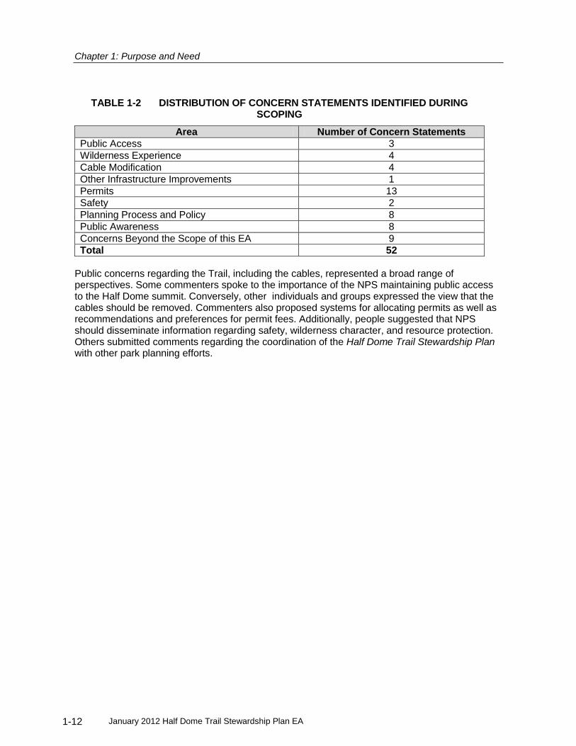
During the public scoping period, 96 correspondence items (including letters, faxes and emails, and meeting notes) were received. Of the 96 items, 90 were from individuals; 3 were from businesses, 2 were from conservation/preservation groups including Wilderness Watch and Friends of Yosemite Valley, and 1 was from a non-governmental organization. Other comments were received through public meeting participation and public scoping form submittals. Each comment letter was carefully reviewed, and 52 concern statements were identified. The Draft Public Scoping Analysis Report is posted on the linked website above, and Table 1-2 summarizes the distribution of concern statements.
Chapter 1: Purpose and Need
January 2012 Half Dome Trail Stewardship Plan EA 1-12
TABLE 1-2 DISTRIBUTION OF CONCERN STATEMENTS IDENTIFIED DURING SCOPING
Area Number of Concern Statements
Public Access 3
Wilderness Experience 4
Cable Modification 4
Other Infrastructure Improvements 1
Permits 13
Safety 2
Planning Process and Policy 8
Public Awareness 8
Concerns Beyond the Scope of this EA 9
Total 52
Public concerns regarding the Trail, including the cables, represented a broad range of perspectives. Some commenters spoke to the importance of the NPS maintaining public access to the Half Dome summit. Conversely, other individuals and groups expressed the view that the cables should be removed. Commenters also proposed systems for allocating permits as well as recommendations and preferences for permit fees. Additionally, people suggested that NPS should disseminate information regarding safety, wilderness character, and resource protection. Others submitted comments regarding the coordination of the Half Dome Trail Stewardship Plan with other park planning efforts.

January 2012 Half Dome Trail Stewardship Plan EA 1-13
This page intentionally left blank.


January 2012 Half Dome Trail Stewardship Plan EA 2-1
CHAPTER 2 ALTERNATIVES
This chapter describes five alternatives for managing the Half Dome Trail in Yosemite National Park, one no action alternative and four action alternatives. Under Alternative A (No Action) the park would retain the cable system and continue managing the Half Dome Trail as it was through 2009. There would be no day-use limits. Wilderness camping in the area would continue to be regulated through the Wilderness Permit System. The cables would continue to be put up in May and taken down in October, weather permitting. Maintenance and structural improvements to the Trail and cables would be done as needed. The No Action Alternative would result in unacceptable impacts to both visitor safety and wilderness character. The No Action alternative is included in the range of alternatives considered in this document solely to provide a baseline against which the effects of the action alternatives can be compared. NEPA’s implementing regulations require agencies to include the alternative of No Action in all EAs and EISs. See 40 C.F.R. Section 1502.14(d). Under Alternative B (Minimum Management Action) the park would retain the cable system and implement day-use limits through a permit system allowing 400 hikers per day. This use level would satisfy the purpose and need of this plan and is therefore considered the minimum management action. Under this alternative, travel times on the cables, crowding, and wilderness trail encounters are greatly reduced from the busiest days during unregulated use (No Action Alternative). Use levels under this alternative are is not expected to exceed the visitor-informed threshold for crowding, which was determined to be 70 PAOT on the cables (Lawson et al. 2009). 400 people per day would be a combination of overnight users with wilderness permits, hikers with day-use permits, and commercially guided clients with their guides. Day-use permits would be allocated through a combination of advanced reservation and day before allocation. A total of five permits per day would be set aside for commercial use for up to two commercial trips per day. This alternative may include the installation of up to two new bolts depending on the results of further engineering work (Kennedy/Jenks 2009.) Under Alternative C (Preferred Alternative) the park would retain the cable system and implement day-use limits through a permit system allowing 300 hikers per day. This alternative would result in the increased visitor safety realized under Alternative B as well as improve the visitor experience and wilderness character of the Trail. Average day-use levels are expected to remain below the statistical model threshold for crowding of 30 PAOT on the cables (Lawson et al. 2009) as well as provide encounter rates on the Trail that are commensurate with other high use wilderness trails both within and outside of Yosemite. The 300 people per day limit would be a combination of overnight users with wilderness permits and hikers with day-use permits. Day-use permits would be allocated through a combination of advanced reservation and day before allocation. Hikers wishing to use a commercial guiding service would have to compete for their own permits, as there would be no permits set aside for commercial use. A limit of two commercial trips per day would be allowed. This alternative may include the installation of up to two new bolts depending on the results of further engineering work (Kennedy/Jenks 2009.) Under Alternative D the park would retain the cable system and implement day-use limits through a permit system allowing 140 hikers per day. At 140 people per day, maximum day-use levels are expected to always remain below the statistical model threshold for crowding of 30 PAOT on the cables (Lawson et al. 2009) and there would be no delays while traveling on the cables even at maximum periods of use. 140 people per day would be a combination of overnight users with wilderness permits and hikers with day-use permits. Day-use permits would be allocated through a combination of advanced reservation and day before allocation. No commercial use would be allowed. This alternative may include the installation of up to two new bolts depending on the results of further engineering work (Kennedy/Jenks 2009.)

Chapter 2: Alternatives
January 2012 Half Dome Trail Stewardship Plan EA 2-2
Under Alternative E the park would physically remove the cable system from Half Dome. Access to the summit would only be possible via technical climbing routes. One commercial trip per day would be allowed. Table 2-1 summarizes and compares user numbers expected under each of the five alternatives.
TABLE 2-1 COMPARISON OF EXPECTED NUMBERS OF USERS BY ALTERNATIVE
Alternative Max No. People/day
Average Encounter Rate (groups/hr)
PAOT on Cables PAOT on Summit
Average Maximum Average Maximum
A 1200 25
Sun-Fri
116 Sat
27 Sun-Fri 69 Sat
56 Sun-Fri
131 Sat 28 Sun-Fri 63 Sat
55 Sun-Fri 109 Sat
B 400 24 24 51 26 52
C 300 16 15 36 19 41
D 140 8 <6 <20 <11 <30
E 100+ Unk Unk Unk Unk Unk Notes: PAOT=People At One Time, Unk=unknown.
DEVELOPMENT OF ALTERNATIVES
The alternatives considered in this analysis represent a range of reasonable and feasible approaches to provide for a variety of conditions for visitor experiences in designated wilderness. These alternatives were developed through an interdisciplinary process based in scientific visitor use studies, as well as public, NPS staff, tribal, and agency input. When developing reasonable alternatives for this EA, the NPS sought those that would:
Provide a range of wilderness experiences for people seeking to reach the summit of Half Dome;
Protect and enhance the wilderness character of the area; and
Provide generally consistent free-flow travel conditions on the Half Dome cable portion of the trail to improve both visitor experience and public safety.
Wilderness Character Considerations in Developing Alternatives
Some qualities of wilderness character are tangible and measureable. Setting standards for a particular area, however, requires the use of professional judgments that consider perceptions and preferences of the visiting public, the history, culture of use, and physical location in wilderness, and applicable law and policy.
The Wilderness Act and NPS policy clearly state that qualities of wilderness character must be preserved. They do not include specifically defined standards, and this provides opportunities for local park managers to set standards for the wilderness areas they manage. For example, The Yosemite Wilderness Management Plan describes goals and objectives for preserving wilderness character in Yosemite, but does not set specific standards to measure those goals. The following WMP objectives informed the development of alternatives in this plan:
Visitors can find a variety of wilderness experiences in keeping with traditional use patterns and can select the degree of crowding, solitude or human impact they wish to experience
The NPS may impose use limits to preserve wilderness values, but regulatory restrictions will be minimized to allow as much freedom as possible consistent with wilderness resource objectives
New facilities will not be constructed in wilderness but existing facilities may remain. The Half Dome cables are identified as form of safety railing that can remain.
The following discussion clarifies how the wilderness qualities of undeveloped and opportunity for solitude or primitive and unconfined recreation have been applied to the development of

Chapter 2: Alternatives
January 2012 Half Dome Trail Stewardship Plan EA 2-3
alternatives for this EA: Undeveloped. The range of alternatives includes three action alternatives that leave the cables in place and one that removes the cables. Trail structures such as the cables and Sub Dome steps are permitted by policy “where they are essential for resource preservation or where significant safety hazards exist during normal use periods.”
9 Guidance from the Yosemite
Wilderness Management Plan, supported by NPS Management Policies, directs that replacing or maintaining facilities such as railings or bridges in wilderness should only be considered in areas “where long tradition and high hazard to wilderness visitor safety requires them” (NPS 2006, YNP 1989). The Yosemite Wilderness Management Plan identifies the Half Dome cables as a form of safety railing. Both options are therefore viable alternatives and both could meet the purpose and need. The Wilderness Act states that wilderness areas “shall be administered for the use and enjoyment of the American people in such manner as will leave them unimpaired for the future use and enjoyment as wilderness” (16 U.S.C. 1131,1964). Removing the cables would limit use to only technical climbers who represent a minority of Yosemite National Park’s wilderness users. Maintaining the cable system would provide access to non-technical climbers. The action alternatives present a range of options for maintaining the undeveloped quality of wilderness. Opportunities for Solitude. Solitude can range from zero encounters with other people and groups to a number of encounters determined appropriate for a given area. In the context of this popular, easily-accessible wilderness area, the upper range for solitude was determined to be conditions that were free from crowding. The 2008 Half Dome Study provided a measure of Half Dome users’ perception of crowding through a visitor survey of hikers on the Half Dome Trail. Lawson, et al. (2009) found that 80% of respondents would prefer to see no more than 10 to 30 PAOT on the Half Dome cables, and 70 PAOT represented the level above which conditions became unacceptable for the mean of the respondents. It is important to note that another threshold to ensure free-flowing conditions has been developed through statistical modeling as a result of the 2008 study (Lawson et al. 2009). This threshold, though separate from the above visitor preference threshold, also has an upper limit of 30 PAOT. Solitude can also be measured by the encounter rate on a trail. This is the number of other groups met during a portion of one’s hike – usually stated as groups per hour. To give context to these numbers, the NPS compared encounter rates for other wilderness trails in Yosemite and other popular wilderness areas around the country (Pettebone et al. 2010). The highest published use on a wilderness trail was Snow Lake in Snoqualmie National Forest in Washington with an encounter rate of 18 groups per hour. In Yosemite, Cathedral Lakes Trail and Dog Lake Trail had encounter rates of 11 to12 groups per hour, and Lyell Canyon had approximately eight groups per hour. Hourly group encounter rates were estimated based on data collected in the project area in 2010 (Pettebone et al. 2010). Primitive or Unconfined Recreation. The opportunity for primitive recreation and the quality of primitiveness were considered as having the “dimensions of simplicity, lack of technology, and self-reliance” (Johnson, Hall and Cole 2005). Ascending the relatively simple system of steel cables and wooden steps is primitive.
9 National Park Service Management Policies 2006 6.3.10.2

Chapter 2: Alternatives
January 2012 Half Dome Trail Stewardship Plan EA 2-4
Wilderness values of self-reliance, adventure, and challenge are achieved both with and without the cables. On one hand, the cable system reduces the sense of self-reliance experienced by technical rock climbers who ascend Half Dome without the assistance of NPS-maintained facilities. Alternatively, pulling oneself hand-over-hand up a sheer rock face provides a rare level of challenge and adventure to the typical visitor. To respect this range of self-reliant experiences in wilderness, the NPS chose to consider a range of alternatives that includes both maintaining and removing the cables. NPS considers unconfined recreation as meaning to be free of the confinement of regulations, with the ability to access and travel about the wilderness freely. Regulating access into and within wilderness affects the unconfined quality of wilderness by reducing spontaneous choices about travel and trip itinerary. However, this is a necessary trade-off to protect wilderness resources and solitude in numerous wilderness areas around the country. Levels of regulation to manage access into and within wilderness areas vary and range from free, no-use-limits to permits where specific sites and dates are assigned. Yosemite’s current Wilderness Permit System requires that wilderness users enter a specific trailhead. Travel routes and camp locations within the Yosemite wilderness are relatively unrestricted. In addition, wilderness permits are distributed in a variety of ways ranging from online systems where reservations can be made months in advance to on-site systems where permits can be acquired in person the day of a trip. There are also a number of methods to allocate wilderness permits ranging from first-come first-served to lottery systems. NPS staff sought alternatives that were commensurate with this established range of wilderness regulation.
Visitor Safety and Risk Management Considerations in Developing Alternatives
NPS Policy states, “Park visitors must assume a substantial degree of risk and responsibility for their own safety when visiting areas that are managed and maintained as natural, cultural, or recreational environments”.
10 Crowding can prevent hikers from using the cable system at their
own chosen speed, particularly when trying to avoid approaching storms. To provide the best opportunity for hikers to manage their own risk on the cables, the NPS would attempt to achieve consistent free-flowing conditions; defined by a lack of queuing or congestion. The number of PAOT on the cables is the best indicator of free-flowing conditions under normal circumstances, and both PAOT on the cables and the summit are used to predict evacuation times in storm events. There is a strong correlation between PAOT on the cables and summit and total daily use. Only those alternatives that provided reasonable free-flowing conditions were considered. Commercial Use Considerations in Developing Alternatives The NPS is required to determine the proper level and type, if any, of commercial services that are necessary on the Half Dome Trail to realize the public purposes listed in the Wilderness Act.
11
This analysis is included in the Determination of Extent Necessary (DEN) found in Appendix C.12
Each of the four action alternatives provide a different level of commercial use.
TABLE 2-2 COMMERCIALUSE ALTERNATIVES
Alternative Alternative A
Alternative B
Alternative C
Alternative D
Alternative E
Total Use No limits 400 300 (302)* 140 No limits
10
National Park Service Policy, Section 8.2.5.1 Visitor Safety 11
Wilderness Act, 16 U.S.C. 1131-1136, Section 4.d.6, Commercial services may be performed within the wilderness areas designated by this Act to the extent necessary for activities which are proper for realizing the recreational or other wilderness purposes of the areas. 12
The Wilderness Act, 16 U.S.C. 1131-1136, Section 4.d.6, states that Commercial services may be performed within the wilderness areas designated by this Act to the extent necessary for activities which are proper for realizing the recreational or other wilderness purposes of the areas.

Chapter 2: Alternatives
January 2012 Half Dome Trail Stewardship Plan EA 2-5
Total Allowable Commercial Use
No restriction
30 educational 15 scenic,
30 educational 15 scenic
None 8 educational
2 groups max 2 groups max 1 group max
Day-Use Permits set aside for non-competitive distribution to commercial operators
N/A 5 (total for guides and clients)
2** 0 0
Commercial groups allowed to compete for Wilderness Permits which include Half Dome permits
Yes Yes No No Yes
* Two permits per day will be available for commercial guides if they have clients who have successfully competed for their own permits and who desire the use of a commercial trip.
**These two permits will only be issued in these circumstances, so there will be days when no guide permits are issued.
ACTIONS COMMON TO ALL ALTERNATIVES
Provide Visitor Education
The NPS would continue to provide and update wilderness stewardship and safety information to the public to assist them in having a safe, successful, low impact wilderness experience on the Half Dome Trail. The Yosemite National Park web site provides video and text information about safety and resource stewardship: http://www.nps.gov/yose/planyourvisit/halfdome.htm
Conduct Ranger Patrols
NPS Rangers would continue to patrol the Half Dome Trail regularly to ensure protection of the wilderness resource and check for compliance with regulations.
Conduct Trail Maintenance of Trail Bed and Stone Steps
The NPS would continue to maintain the trail bed and stone step portions of the Half Dome Trail. Wilderness trail maintenance would continue to primarily be done with hand tools but use of mechanized or motorized equipment may occasionally be the minimum tool for their work, as described in the Yosemite Wilderness Management Plan. Trail Maintenance under Alts B, C and D is different from maintenance under Alt E. Under Alt E, NPS would not be putting up the cables and the wooden steps would be removed.
Accommodate Wilderness Camping
Camping would continue to be allowed in the Half Dome Trail area subject to the Yosemite Wilderness Permit System. The NPS would continue to regulate numbers of wilderness campers in the Half Dome Trail area through trailhead quotas. Camping would continue to be prohibited on the Half Dome summit.
Conduct Visitor Use Monitoring
The Half Dome Trail would continue to be monitored by the NPS to determine visitor use levels and associated resource impacts.
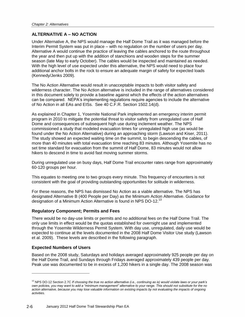
Chapter 2: Alternatives
January 2012 Half Dome Trail Stewardship Plan EA 2-6
ALTERNATIVE A – NO ACTION
Under Alternative A, the NPS would manage the Half Dome Trail as it was managed before the Interim Permit System was put in place – with no regulation on the number of users per day. Alternative A would continue the practice of leaving the cables anchored to the route throughout the year and then put up with the addition of stanchions and wooden steps for the summer season (late May to early October). The cables would be inspected and maintained as needed. With the high level of use expected under this alternative, the NPS would need to place four additional anchor bolts in the rock to ensure an adequate margin of safety for expected loads (Kennedy/Jenks 2009). The No Action Alternative would result in unacceptable impacts to both visitor safety and wilderness character. The No Action alternative is included in the range of alternatives considered in this document solely to provide a baseline against which the effects of the action alternatives can be compared. NEPA’s implementing regulations require agencies to include the alternative of No Action in all EAs and EISs. See 40 C.F.R. Section 1502.14(d). As explained in Chapter 1, Yosemite National Park implemented an emergency interim permit program in 2010 to mitigate the potential threat to visitor safety from unregulated use of Half Dome and consequences of subsequent high use during inclement weather. The NPS commissioned a study that modeled evacuation times for unregulated high use (as would be found under the No Action Alternative) during an approaching storm (Lawson and Kiser, 2011). The study showed an expected waiting time on the summit, to begin descending the cables, of more than 40 minutes with total evacuation time reaching 83 minutes. Although Yosemite has no set time standard for evacuation from the summit of Half Dome, 83 minutes would not allow hikers to descend in time to avoid fast moving summer storms. During unregulated use on busy days, Half Dome Trail encounter rates range from approximately 60-120 groups per hour. This equates to meeting one to two groups every minute. This frequency of encounters is not consistent with the goal of providing outstanding opportunities for solitude in wilderness. For these reasons, the NPS has dismissed No Action as a viable alternative. The NPS has designated Alternative B (400 People per Day) as the Minimum Action Alternative. Guidance for designation of a Minimum Action Alternative is found in NPS DO-12.
13
Regulatory Component; Permits and Fees
There would be no day-use limits or permits and no additional fees on the Half Dome Trail. The only use limits in effect would be the quotas established for overnight use and implemented through the Yosemite Wilderness Permit System. With day use, unregulated, daily use would be expected to continue at the levels documented in the 2008 Half Dome Visitor Use study (Lawson et al. 2009). These levels are described in the following paragraph.
Expected Numbers of Users
Based on the 2008 study, Saturdays and holidays averaged approximately 925 people per day on the Half Dome Trail, and Sundays through Fridays averaged approximately 439 people per day. Peak use was documented to be in excess of 1,200 hikers in a single day. The 2008 season was
13
NPS DO-12 Section 2.7C If choosing the true no action alternative (i.e., continuing as is) would violate laws or your park’s own policies, you may want to add a “minimum management” alternative to your range. This should not substitute for the no action alternative, because you may lose valuable information on existing impacts by not evaluating the impacts of ongoing activities.

Chapter 2: Alternatives
January 2012 Half Dome Trail Stewardship Plan EA 2-7
the last season without a permit requirement for accessing Half Dome. This alternative assumes that 2008 use levels would continue into the future. For purposes of comparing alternatives, the NPS is assuming use would most closely follow the last season studied without a permit system in place (2008), while recognizing that actual use could be substantially higher.
Commercial Use for the Half Dome Trail
Under Alternative A, commercial trips would continue to be managed at 2009 levels. Guides would be required to obtain a Commercial Use Authorization, acquire a Special Use Permit, or be an authorized park concessioner. No limits would be set or enforced for the number of guided trips per day. The size of each group would be limited to no more than 35 people, consistent with wilderness day-use restrictions outlined in the Yosemite Wilderness Management Plan.
ALTERNATIVE B – 400 PEOPLE PER DAY
Under Alternative B the park would retain the cable system and implement, using the appropriate administrative process, day-use limits through a permit system allowing 400 hikers per day. At 400 people per day, crowding is not expected to exceed the visitor-informed threshold for crowding, which was determined to be 70 PAOT on the cables (Lawson et al. 2009). Weather permitting, the cable system would be put up in May and taken down in October. The steel cables would be left attached to the rock face all year, but when they are put up and readied for use, metal stanchions are placed to lift the cables off the rock and wooden steps (attached to the stanchions) are placed to aid footing. Sections of cables, connecting hardware, and anchor bolts would be inspected twice annually and replaced as necessary. A Minimum Tool Analysis will be done to determine how maintenance to the trail and cable system will be accomplished. When the cables are taken down in the fall, the stanchions and steps would be removed and stored in the immediate area. This alternative may include the installation of up to two new bolts depending on the results of further engineering work (Kennedy/Jenks 2009.)
Regulatory Component; Permits and Fees
A permit system would be used to regulate use of the Trail. NPS analysis and best professional judgment has determined that an agency-imposed, regulated use permit system would be the minimum required action to protect wilderness character and safety on the Half Dome Trail. Specifics and timing of this advance permit allocation would be refined and managed to best provide:
An equitable distribution system;
The ability to cancel unused reservations for a partial refund;
Technological and/or operational safeguards to protect against illegal resale of permits; and
Actual use that meets the designated quota target. Permits would be non-transferrable, validation of personal identification information may be necessary to ensure compliance. Advance reservation permits would be allocated either through a first-come first-served reservation system, a lottery, or a combination of these options. Additionally, the NPS would reserve and distribute a portion of the day-use permits the day before the permit date to allow for more spontaneous use of the Trail. Finally, if through the ongoing monitoring of visitor use on the Half Dome Trail the NPS determines that this allocation system is not achieving the management target number of 400 people per day, the NPS would take action to adapt the permit allocation system to achieve this daily management target. One of these actions could be to sell additional permits, above the use limit number, to make up for an expected number of unused permits. The NPS could periodically adjust the permit allocation system to take advantage of new

Chapter 2: Alternatives
January 2012 Half Dome Trail Stewardship Plan EA 2-8
technologies as they become available. These adjustments would be made to improve equitability and efficiency of the system and achieve prescribed use targets. Public notice would be given for any such changes to the program. The NPS would charge a fee for Half Dome permits. Under the authority of 16 USC 3a
14 and
using NPS Reference Manual 5315
for guidance, permit fees would be designed to recover costs required to maintain the cable system and trail, monitor use, educate hikers, ensure compliance with use limits, and protect wilderness character. To ensure the program is self-sustaining, the permit program would be developed to recover those costs needed to directly manage the Half Dome Trail. The permit fee would be comprised of two components: 1) the cost of allocating the permit by a contractor, and 2) the cost per person for the NPS to manage the Trail. This total cost, under Alternative B, would likely range from approximately $7 to $11 per person, depending on the size of the group. Operational costs may increase in response to cost of living adjustments. This may require permit fees to proportionally increase to recover operating cost.
Expected Numbers of Users
The Half Dome cables would remain in place and use would be managed to a target of 400 people per day. Average encounter rates would be 24 groups per hour. There would be an average of 24 PAOT on the cables with a maximum of 51. Table 2-1 outlines a comparison of expected numbers of users, encounter rates, and PAOT on the cables and summit.
Commercial Use for the Half Dome Trail Half Dome Permit Distribution for Commercial Users. Under Alternative B, five permits per day (total for guides and clients) would be set aside, non-competitively, for commercial trips which realize either the educational purpose
16 or scenic purpose
17 of wilderness. The five daily permits
would be allocated equitably among the approved commercial guiding operations. Commercial trips which only realize the recreational purpose of wilderness would not be allowed on the Half Dome Trail. Commercial guiding services or their agents would not be allowed to compete for additional day-use permits through the general public allocation process. Commercial guiding services could continue to reserve wilderness permits for the Half Dome area, up to the limits set in Table 2-2. See Appendix C. The “set-aside” permits help guiding companies plan trips. The very small amount of permits reflects scoping comments from the non-commercial public that the permitting process be as equitable as possible. While only a small amount of commercial use would help realize the educational and scenic purposes on the Half Dome Trail, the rest of the Yosemite Wilderness would still be available for such services.
ALTERNATIVE C – 300 PEOPLE PER DAY (PREFERRED)
Under Alternative C the park would retain the cable system and implement, using the appropriate administrative process, day-use limits through a permit system allowing 300 hikers per day. Average day-use levels are expected to remain below the statistical model threshold for crowding
14
Title 16 U.S. Code Section 3(a) Notwithstanding any other provision of law, the National Park Service may on and after
November 11, 1993, recover all costs of providing necessary services associated with special use permits, such
reimbursements to be credited to the appropriation current at that time. 15
NPS Reference Manual #53 Section 10-3. 16
Educational Purpose: The educational purpose is considered realized when there are opportunities for both informal and formal education taking place in the wilderness. Informal education is self-directed learning available to all wilderness visitors. 17
Scenic Purpose: All visitors are engaging in informal appreciation of wilderness scenery, as are individuals located outside of wilderness who are looking in from a road or other developed area.

Chapter 2: Alternatives
January 2012 Half Dome Trail Stewardship Plan EA 2-9
of 30 PAOT on the cables (Lawson et al. 2009) as well as provide encounter rates on the Trail that are commensurate with other high use wilderness trails both within and outside of Yosemite. The cables would be put-up and taken down as suggested in Alternative B. This alternative may include the installation of up to two new bolts depending on the results of further engineering work (Kennedy/Jenks 2009.)
Regulatory Component; Permits and Fees
A permit system would be used to regulate use of the Trail. Specifics and timing of this advance permit allocation would be refined and managed to best provide:
An equitable distribution system;
The ability to cancel unused reservations for a partial refund;
Technological and/or operational safeguards to protect against illegal resale of permits; and
Actual use that approximates the designated daily use limit. Permits would be non-transferrable, validation of personal identification information may be necessary to ensure compliance. Advance reservation permits would be allocated through a first-come first-served reservation system, a lottery, or a combination of these options. Additionally, the NPS would reserve and distribute a portion of the day-use permits the day before the permit date to allow for more spontaneous use of the Trail. Finally, if through the ongoing monitoring of visitor use on the Half Dome Trail the NPS determines that this allocation system resulting in a use level far below 300 people per day as a result of no-shows, the NPS would consider taking action to adapt the permit allocation system so that actual use more closely approximates the daily use limit. One such action could be to sell additional permits, above the use limit number, to make up for an expected number of unused permits. The NPS could periodically adjust the permit allocation system to take advantage of new technologies as they become available. These adjustments would be made to improve equitability and efficiency of the system and achieve prescribed use targets. Public notice would be given for any such changes to the program. The NPS would charge a fee for Half Dome permits. Under the authority of 16 USC 3a
18 and
using NPS Reference Manual 5319
for guidance, permit fees would be designed to recover costs required to maintain the cable system and trail, monitor use, educate hikers, ensure compliance with use limits, and protect wilderness character. To ensure the program is self-sustaining, the permit program would be developed to recover those costs needed to directly manage the Half Dome Trail. The permit fee would be comprised of two components: 1) the cost of allocating the permit by a contractor, and 2) the cost per person for the NPS to manage the Trail. This total cost, under Alternative C, would likely range from approximately $9 to $13 per person, depending on the size of the group. Operational costs may increase in response to cost of living adjustments. This may require permit fees to proportionally increase to recover operating cost.
18
Title 16 U.S. Code Section 3(a) Notwithstanding any other provision of law, the National Park Service may on and after
November 11, 1993, recover all costs of providing necessary services associated with special use permits, such
reimbursements to be credited to the appropriation current at that time. 19
NPS Reference Manual #53 Section 10-3.
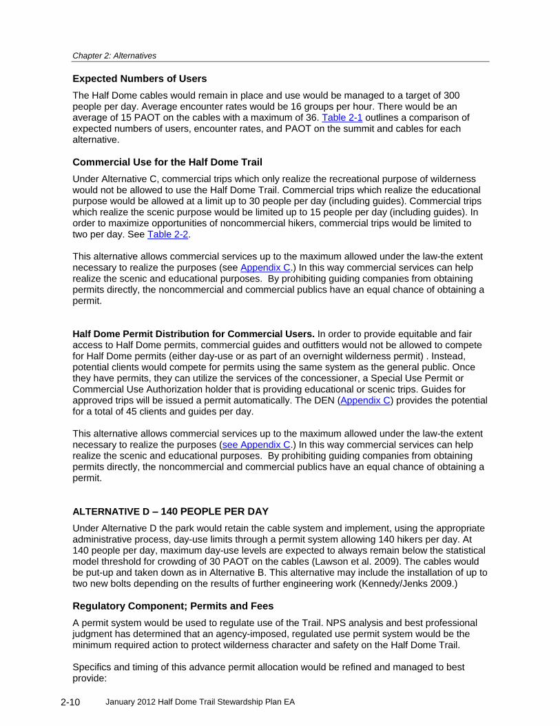
Chapter 2: Alternatives
January 2012 Half Dome Trail Stewardship Plan EA 2-10
Expected Numbers of Users
The Half Dome cables would remain in place and use would be managed to a target of 300 people per day. Average encounter rates would be 16 groups per hour. There would be an average of 15 PAOT on the cables with a maximum of 36. Table 2-1 outlines a comparison of expected numbers of users, encounter rates, and PAOT on the summit and cables for each alternative.
Commercial Use for the Half Dome Trail
Under Alternative C, commercial trips which only realize the recreational purpose of wilderness would not be allowed to use the Half Dome Trail. Commercial trips which realize the educational purpose would be allowed at a limit up to 30 people per day (including guides). Commercial trips which realize the scenic purpose would be limited up to 15 people per day (including guides). In order to maximize opportunities of noncommercial hikers, commercial trips would be limited to two per day. See Table 2-2. This alternative allows commercial services up to the maximum allowed under the law-the extent necessary to realize the purposes (see Appendix C.) In this way commercial services can help realize the scenic and educational purposes. By prohibiting guiding companies from obtaining permits directly, the noncommercial and commercial publics have an equal chance of obtaining a permit. Half Dome Permit Distribution for Commercial Users. In order to provide equitable and fair access to Half Dome permits, commercial guides and outfitters would not be allowed to compete for Half Dome permits (either day-use or as part of an overnight wilderness permit) . Instead, potential clients would compete for permits using the same system as the general public. Once they have permits, they can utilize the services of the concessioner, a Special Use Permit or Commercial Use Authorization holder that is providing educational or scenic trips. Guides for approved trips will be issued a permit automatically. The DEN (Appendix C) provides the potential for a total of 45 clients and guides per day. This alternative allows commercial services up to the maximum allowed under the law-the extent necessary to realize the purposes (see Appendix C.) In this way commercial services can help realize the scenic and educational purposes. By prohibiting guiding companies from obtaining permits directly, the noncommercial and commercial publics have an equal chance of obtaining a permit.
ALTERNATIVE D – 140 PEOPLE PER DAY
Under Alternative D the park would retain the cable system and implement, using the appropriate administrative process, day-use limits through a permit system allowing 140 hikers per day. At 140 people per day, maximum day-use levels are expected to always remain below the statistical model threshold for crowding of 30 PAOT on the cables (Lawson et al. 2009). The cables would be put-up and taken down as in Alternative B. This alternative may include the installation of up to two new bolts depending on the results of further engineering work (Kennedy/Jenks 2009.)
Regulatory Component; Permits and Fees
A permit system would be used to regulate use of the Trail. NPS analysis and best professional judgment has determined that an agency-imposed, regulated use permit system would be the minimum required action to protect wilderness character and safety on the Half Dome Trail. Specifics and timing of this advance permit allocation would be refined and managed to best provide:

Chapter 2: Alternatives
January 2012 Half Dome Trail Stewardship Plan EA 2-11
An equitable distribution system;
The ability to cancel unused reservations for a partial refund;
Technological and/or operational safeguards to protect against illegal resale of permits; and
Actual use that meets the designated quota target. Permits would be non-transferrable, validation of personal identification information may be necessary to ensure compliance. Advance reservation permits would be allocated either through a first-come first-served reservation system, a lottery, or a combination of these options. Additionally, the NPS would reserve and distribute a portion of the day-use permits the day before the permit date to allow for more spontaneous use of the Trail. Finally, if through the ongoing monitoring of visitor use on the Half Dome Trail the NPS determines that this allocation system is not achieving the management target number of 140 people per day, the NPS would take action to adapt the permit allocation system to achieve this daily management target. One of these actions could be to sell additional permits, above the use limit number, to make up for an expected number of unused permits. The NPS could periodically adjust the permit allocation system to take advantage of new technologies as they become available. These adjustments would be made to improve equitability and efficiency of the system and achieve prescribed use targets. Public notice would be given for any such changes to the program. The NPS would charge a fee for Half Dome permits. Under the authority of 16 USC 3a
20 and
using NPS Reference Manual 5321
for guidance, permit fees would be designed to recover costs required to maintain the cable system and trail, monitor use, educate hikers, ensure compliance with use limits, and protect wilderness character. To ensure the program is self-sustaining, the permit program would be developed to recover those costs needed to directly manage the Half Dome Trail. The permit fee would be comprised of two components: 1) the cost of allocating the permit by a contractor, and 2) the cost per person for the NPS to manage the Trail. This total cost, under Alternative D, would likely range from approximately $13 to $19 per person, depending on the size of the group. Operational costs may increase in response to cost of living adjustments. This may require permit fees to proportionally increase to recover operating cost.
Expected Numbers of Users
The Half Dome cables would remain in place and use would be managed to a target of 140 people per day. Average encounter rates would be 8 groups per hour. There would be an average of 6 PAOT on the cables with a maximum of 20. Table 2-1 outlines a comparison of expected numbers of users, encounter rates, and PAOT on the summit and cables for each alternative.
Commercial Use for the Half Dome Trail
Under Alternative D, no commercial use would be allowed on the Half Dome Trail, due to the high demand and lower number of permits available to the general public. While commercial use would not contribute to the realization of the educational and scenic purposes on the Half Dome trail, opportunities for guided educational and scenic trips would be plentiful in the rest of the Yosemite Wilderness. While Half Dome is a unique landform, it presents few if any unique opportunities for education-one can learn about wilderness travel, or the natural and human
20
Title 16 U.S. Code Section 3(a) Notwithstanding any other provision of law, the National Park Service may on and after
November 11, 1993, recover all costs of providing necessary services associated with special use permits, such
reimbursements to be credited to the appropriation current at that time. 21
NPS Reference Manual #53 Section 10-3.

Chapter 2: Alternatives
January 2012 Half Dome Trail Stewardship Plan EA 2-12
history of the Sierra anywhere in the surrounding landscape. Displacement of non-commercial visitors by commercial visitors would therefore be unnecessary under this alternative. See Appendix C. ALTERNATIVE E – REMOVE THE CABLE SYSTEM
The NPS would remove the existing Half Dome cable system, including the steel cables, metal stanchions, wooden steps, and all non-historic anchor bolts and hardware. Reaching the Half Dome Summit would require ascending a steep, smooth rock face that would require technical equipment and skills. Removing the cable system would leave Half Dome with a minor amount of human development, commensurate with other wilderness peaks and rock faces that attract technical climbing. The Trail and climbing routes would be managed similarly to other areas in Yosemite’s wilderness. Overnight use would be regulated through the Yosemite Wilderness Permit System, and day-use and climbing would require no additional permits. The NPS would expect multiple climbing routes, and one or more rappel routes, to be established by the climbing public on the northeastern face of Half Dome in place of the existing cable system. Current regulations prohibiting placement of permanent hardware or leaving ropes in place in Yosemite would apply. The NPS expects this would be a popular, high use climbing area because of the relatively easy access to the base, the iconic nature of Half Dome, and the fact that this would be the easiest and shortest technical climb to the summit.
Regulatory Component; Permits and Fees
There would be no additional use limits, permits, or fees for hiking the Half Dome Trail or accessing the summit.
Expected Numbers of Users
It is likely under this alternative that the Half Dome Trail could receive at least 100 hikers and climbers per day during weekends and holidays and fewer on weekdays. The metrics for crowding are different on a technical climbing route than on a hiking trail or the cable route. Monitoring and visitor use studies on the Half Dome Trail will be necessary under this alternative to determine whether use restrictions are needed to manage appropriate group size and encounter rates on a popular technical climbing route. In Yosemite, the southeast face of Cathedral Peak may be used as a comparison to predict potential use of technical climbing routes on Half Dome’s northeastern aspect. Cathedral Peak requires a relatively easy approach hike and moderate technical climbing to reach an iconic summit. In addition, similar to Half Dome, there are numerous starting points for technical climbs that are confined to a relatively small area with topography that makes it possible to vary routes along the way. A 2009 study documented use on Cathedral Peak’s southeast face averages 14 parties per day (30-40 people per day) on weekends, 6 on weekdays, and a maximum of 19 parties observed on a single day (Pettebone 2011). The Grand Teton, in Grand Teton National Park, is an iconic summit comparable to Half Dome in that it is also the physical symbol of that park. It has a seven to eight mile approach and an easy technical climbing route to the summit. Grand Teton National Park does not have accurate day-use studies for the Grand Teton, but management staff indicated that during peak season and good weather periods, the Grand Teton could have 100 climbers per day on its easiest routes on the south and west faces (Scott Guenther, personal communication, March 14, 2011). In addition to being a popular approach for technical climbing routes, it is also reasonable to believe that the Half Dome Trail leading to the summit of Sub Dome (six to seven miles one way) could become a popular destination for hikers interested in the spectacular view of the upper

Chapter 2: Alternatives
January 2012 Half Dome Trail Stewardship Plan EA 2-13
portion of Half Dome as well as the wide ranging views over the Tenaya and Merced drainages.
Commercial Use for the Half Dome Trail
Under Alternative E, commercial trips which only realize the recreational or scenic purposes of wilderness would not be allowed on the Half Dome Trail (see Appendix C). Commercial trips which realize the educational purpose would be limited to up to eight people per day (including guides).Commercial trips would be limited to one per day. Given the need for technical climbing, Half Dome would not be a suitable location for photography or other workshops which realize the scenic purpose. Given the potential for crowding on the final climb to the summit, the recreational purpose would most likely be realized without commercial use. A small amount of commercial use would help to realize the educational purpose while still allowing non-commercial access without undue crowding. The summit of Half Dome would be considered “off-trail”, with a legal group size limit of eight. ALTERNATIVES CONSIDERED AND DISMISSED
The NPS evaluated several alternatives that were considered and dismissed from detailed analysis.
Install a Third Cable to the Cable System
With this alternative, the NPS would install a third cable, additional stanchions, steps, anchor bolts, and hardware next to the existing cable system, resulting in a total of three cables and two lanes of travel, one up and one down the cable system. In the absence of use limits, this additional cable could increase the cable system’s capacity to handle the same level of use with less congestion, existing levels of use with less congestion. Moreover, a three cable system would likely not resolve safety issues associated with unregulated use levels. At 1200 people per day, PAOT on the cables can reach 130 which could overwhelm even the additional lane of travel, causing delays and congestion. The NPS dismissed this alternative because it is not consistent with the purpose and need for the project. A third cable that would potentially accommodate existing use levels does not meet the goal of reducing crowding and encounter rates on the Half Dome trail in order to protect wilderness character and increase safety. A third cable would allow the continued, extremely high use of the Trail resulting in crowding on the Trail and summit with encounter rates
22 that are
unacceptable. This alternative would also result in new human development in wilderness, which is inconsistent with approved plans. The Yosemite Wilderness Management Plan specifically limits facilities in Yosemite wilderness to those present in 1989 when the plan was written, and to those that were specifically proposed in the plan. The plan states, “Further facilities would compromise the National Park Service’s responsibilities in wilderness management.” A third cable would be inconsistent with the park’s approved Wilderness Management Plan.
Remove Half Dome Trail from Designated Wilderness
Under this alternative, the NPS would recommend to Congress that the Yosemite Wilderness boundaries, as designated in the 1984 California Wilderness Act, be redrawn to remove the Half Dome Trail from designated wilderness. Section 3 (e) of the 1964 Wilderness Act describes the option for boundary adjustment. Doing this would allow the NPS to manage the Half Dome Trail
22
116 groups encountered per hour, approximately one group every 30 seconds, during peak use periods. (Lawson et al, 2009)

Chapter 2: Alternatives
January 2012 Half Dome Trail Stewardship Plan EA 2-14
as non-wilderness and would not require the NPS to consider the concept of solitude or the minimum requirement for installation of structures. This alternative is not consistent with the purpose and need of this plan to protect wilderness character. Under this alternative, rather than being a guiding purpose, wilderness character would become irrelevant because Half Dome and the trail leading to Half Dome would be removed from wilderness. This alternative would also not meet the goal of increasing safety because existing use levels, which have been shown to impede free flow on the cable route, would continue. The safety considerations that form part of the purpose and need for this plan exist regardless of the area’s status as wilderness. This alternative is also beyond the scope of this plan. The scope of this plan is to identify alternative options for better managing the Half Dome Trail as part of Yosemite’s designated wilderness, in keeping with the park’s Wilderness Management Plan. Finally, removal of Half Dome from wilderness would require Congressional action. The NPS has no authority to remove designated wilderness from the wilderness preservation system.
Station Rangers at the Half Dome Cables in Lieu of Use Limits
Under this alternative, a ranger would be stationed at the base of the cables to regulate traffic during periods of congestion and/or to close the route during inclement weather. This could eliminate the need for use limits. This alternative was considered and dismissed because it would not decrease crowding and provide for solitude opportunities. Encounter rates would continue to be high, and crowding would be transferred to the summit and Sub Dome. Similarly, positioning a ranger to “close” the cable system when a storm is approaching contradicts established policy for risk management in wilderness. NPS Management Policies 2006 6.4.1 states, “Park visitors need to accept wilderness on its own unique terms”, and the NPS should only provide visitors with “general information” concerning possible risks. This would establish an unmanageable precedent for other Wilderness areas. In addition, there are hundreds of people at risk from thunderstorms in other locations in Yosemite such as Sentinel Dome, the top of Yosemite Falls, Mt. Hoffmann, and Mt. Dana. If Half Dome is routinely closed when weather threatens, there would be an expectation that other areas would be held to the same standard. Management Policies 8.2.5.1 states that, “Park visitors must assume a substantial degree of risk and responsibility for their own safety…” This option takes responsibility away from the hiker and places it with a NPS ranger. The ranger would have to make decisions based on a complex set of ever-changing variables, including the potential for bad weather, individual hikers’ abilities and confidence to handle wet rock, and estimated crowding on the cables during any period of potentially bad weather. If a ranger is contacting hikers at the base of Sub Dome, that ranger would have to determine what the weather will be for the next two to three hours, the average time that it takes hikers to ascend and descend the cables. If there is storm activity or even cloud formation over the Sierra Crest, there is potential for a storm to move over the Half Dome area in that two to three hour period. This can be a daily occurrence from June to August and would result in numerous unnecessary closures.
Control Timing of Use
Under this alternative, the NPS would spread use out over the day by assigning hikers to specific time slots. Controlling the timing of use would eliminate midday crowding and maintain free-flowing conditions. A ranger would be stationed at the base of the cables and would serve as a gatekeeper allowing hikers to use the cable system only during their assigned time slot.
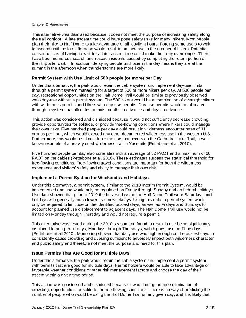
Chapter 2: Alternatives
January 2012 Half Dome Trail Stewardship Plan EA 2-15
This alternative was dismissed because it does not meet the purpose of increasing safety along the trail corridor. A late ascent time could have pose safety risks for many hikers. Most people plan their hike to Half Dome to take advantage of all daylight hours. Forcing some users to wait to ascend until the late afternoon would result in an increase in the number of hikers. Potential consequences of having to wait for a later ascent time could make their day even longer. There have been numerous search and rescue incidents caused by completing the return portion of their trip after dark. In addition, delaying people until later in the day means they are at the summit in the afternoon when thunderstorms are more likely.
Permit System with Use Limit of 500 people (or more) per Day
Under this alternative, the park would retain the cable system and implement day-use limits through a permit system managing for a target of 500 or more hikers per day. At 500 people per day, recreational opportunities on the Half Dome Trail would be similar to previously observed weekday-use without a permit system. The 500 hikers would be a combination of overnight hikers with wilderness permits and hikers with day-use permits. Day-use permits would be allocated through a system that allocates permits months in advance and days in advance. This action was considered and dismissed because it would not sufficiently decrease crowding, provide opportunities for solitude, or provide free-flowing conditions where hikers could manage their own risks. Five hundred people per day would result in wilderness encounter rates of 31 groups per hour, which would exceed any other documented wilderness use in the western U.S.. Furthermore, this would be almost triple the use that occurs on the Cathedral Lake Trail, a well-known example of a heavily used wilderness trail in Yosemite (Pettebone et al. 2010). Five hundred people per day also correlates with an average of 32 PAOT and a maximum of 66 PAOT on the cables (Pettebone et al. 2010). These estimates surpass the statistical threshold for free-flowing conditions. Free-flowing travel conditions are important for both the wilderness experience and visitors’ safety and ability to manage their own risk.
Implement a Permit System for Weekends and Holidays
Under this alternative, a permit system, similar to the 2010 Interim Permit System, would be implemented and use would only be regulated on Friday through Sunday and on federal holidays. Use data showed that prior to 2010 the busiest days on the Half Dome Trail were Saturdays and holidays with generally much lower use on weekdays. Using this data, a permit system would only be required to limit use on the identified busiest days, as well as Fridays and Sundays to account for planned use displacement to adjacent days. The Half Dome Trail use would not be limited on Monday through Thursday and would not require a permit. This alternative was tested during the 2010 season and found to result in use being significantly displaced to non-permit days, Mondays through Thursdays, with highest use on Thursdays (Pettebone et all 2010). Monitoring showed that daily use was high enough on the busiest days to consistently cause crowding and queuing sufficient to adversely impact both wilderness character and public safety and therefore not meet the purpose and need for this plan.
Issue Permits That Are Good for Multiple Days
Under this alternative, the park would retain the cable system and implement a permit system with permits that are good for multiple days. Permit holders would be able to take advantage of favorable weather conditions or other risk management factors and choose the day of their ascent within a given time period. This action was considered and dismissed because it would not guarantee elimination of crowding, opportunities for solitude, or free-flowing conditions. There is no way of predicting the number of people who would be using the Half Dome Trail on any given day, and it is likely that

Chapter 2: Alternatives
January 2012 Half Dome Trail Stewardship Plan EA 2-16
encounter rates would exceed 16 groups per hour on weekends and on the first day of favorable weather after a period of inclement weather. IDENTIFICATION OF THE MINIMUM MANAGEMENT ALTERNATIVE
As stated in NPS Director’s Order 12, if choosing the true no action alternative (i.e., continuing as is) would violate laws or your park’s own policies, you may want to add a “minimum management” alternative to your range. This should not substitute for the no action alternative, because you may lose valuable information on existing impacts by not evaluating the impacts of ongoing activities. Alternative A (No Action) would result in impacts to both wilderness character and public safety that would violate the Wilderness Act and NPS policy, therefore Alternative A could not be considered a viable alternative. Alternative B was determined to be the Minimum Management Alternative as it provides beneficial effects to wilderness character and safety that would meet the purpose and need for this plan as described in Chapter 1. Some of the key components of Alternative B were used as an interim management strategy in 2011, while this EA was being developed. IDENTIFICATION OF THE PREFERRED ALTERNATIVE
The National Park Service developed five alternatives in September 2010 based on the results of public scoping and documentation developed in support of this planning effort (e.g., visitor use studies, structural analysis, and National Register nomination of historic property). A value analysis workshop was held on March 2, 2011, to evaluate the relative advantages of each alternative. Participants identified seven evaluation factors against which the alternatives were measured. The seven factors were as follows (in no particular order):
Undeveloped wilderness character
Opportunities for solitude
Primitive and unconfined recreation
Wilderness-based visitor experience and access
Natural and cultural resources
Operational needs and cost Alternatives were evaluated and ranked by assigning a relative advantage to each factor. Participants shared their professional expertise regarding the potential beneficial or adverse effects of each aspect of the alternatives. With seven factors considered equally, Alternative E (Remove the Cables) scored the highest. However, when each of the factors was given a weight assigned by participants, Alternative C rose to the top. On May 12, 2011, the results of the value analysis workshop were presented to the park leadership team for identification of the preferred alternative. Upon review of the information gathered in support of this project and the results of the value analysis workshop, the leadership team identified Alternative C: 300 people per day as the preferred alternative, primarily because it maximizes use while maintaining free-flowing conditions meeting risk management needs and maintaining wilderness character. The leadership team revisited this decision on July 28, 2011, and reaffirmed the identification of Alternative C as the preferred alternative, based on risk management concerns and wilderness-based visitor experience and access. ENVIRONMENTALLY PREFERRED ALTERNATIVE
CEQ Regulations, implementing the National Environmental Policy Act (NEPA) and the National Park Service NEPA guidelines, require that “the alternative or alternatives which were considered to be environmentally preferable” be identified (CEQ Regulations, Section 1505.2).

Chapter 2: Alternatives
January 2012 Half Dome Trail Stewardship Plan EA 2-17
Environmentally preferable is defined as “the alternative that will promote the national environmental policy as expressed in the NEPA Section 101. This means the alternative that causes the least damage to the biological and physical environment; it also means the alternative that best protects, preserves, and enhances historic, cultural, and natural resources” (CEQ 1981). Section 101 of NEPA states that it is the continuing responsibility of the Federal Government to: (1) fulfill the responsibilities of each generation as trustee of the environment for succeeding generations; (2) assure for all Americans safe, healthful, productive, and aesthetically and culturally pleasing surroundings; (3) attain the widest range of beneficial uses of the environment without degradation, risk to health or safety, or other undesirable and unintended consequences; (4) preserve important historic, cultural, and natural aspects of our national heritage, and maintain, wherever possible, an environment which supports diversity, and variety of individual choice; (5) achieve a balance between population and resource use which will permit high standards of living and a wide sharing of life’s amenities; and (6) enhance the quality of renewable resources and approach the maximum attainable recycling of depletable resources.
Conformance
Alternative C would best fulfill the responsibilities of the National Park Service to identify the alternative that will promote national environmental policy as expressed in NEPA section 101. The No Action Alternative and Alternatives B, C, and D would retain the cables and allow hikers without technical rock climbing skills to access the summit. Alternative E would remove the cables which would improve the undeveloped character of wilderness on the Trail. As a matter of addressing the purpose and need of this plan, all action alternatives (B, C, D, and E) would assure surroundings where visitors can manage their own risks consistent with criterion (2). Alternative D would best meet criteria (4) and (6) as 140 people per day on the Half Dome Trail will likely result in the least amount of impacts to natural aspects of the environment while retaining national heritage in the form of historic use of the cables. The difference in physical impacts under Alternatives C and D is minimal, however. In addition, reducing use to the low levels prescribed by Alternative D would not attain the widest range of beneficial uses of the environment (criterion (3)). Alternative C best meets NEPA section 101 criteria (1), (2), and (3) by maximizing use while maintaining free-flowing conditions. This meets risk management needs, protects, and enhances wilderness character. Compared with other project alternatives, Alternative C would achieve a balance between visitor use and resource protection. SUMMARY OF ENVIRONMENTAL CONSEQUENCES
The matrix presented in Table 2-3 provides a comparison summary of the effects by impact topic that would occur by implementing each of the five alternatives for the Half Dome Stewardship Trail Plan. This space intentionally left blank.

Chapter 2: Alternatives
January 2012 Half Dome Trail Stewardship Plan EA 2-18
TABLE 2-3 SUMMARY OF EFFECTS BY ALTERNATIVE
Impact Topics
Alternative
A
No Action
B
400 people/day
C
300 people/day (preferred)
D
140 people/day
E
Remove cables
Wilderness Character
Undeveloped Moderate, Adverse
Represents human development and modification of the undeveloped natural environment.
Negligible, no change from existing conditions.
Negligible, no change from existing conditions.
Negligible, no change from existing conditions.
Beneficial
The Half Dome cables, anchors, and bolts would be removed. Expected addition of technical climbing bolts for climbing and rappel routes and fixed lines by general climbing public.
Natural Major, Adverse
Highest volume of use will cause greatest impacts to natural character.
Beneficial
Reduced use will likely reduce impacts to natural environment. Permit systems provide potential for educational opportunities to influence stewardship behavior
Beneficial
Reduced use will likely reduce impacts to natural environment. Permit systems provide potential for educational opportunities to influence stewardship behavior
Beneficial
Reduced use will likely reduce impacts to natural environment. Permit systems provide potential for educational opportunities to influence stewardship behavior.
Cable Area - Minor, Adverse Trail –Beneficial
Minor impacts from establishing new climbing routes on the rock face adjacent to the present cable route. Reduced use on the trail would reduce impacts.
Opportunities for Solitude Major, Adverse
Extremely high wilderness encounter rates will be the norm for most of daylight hours. Crowded conditions on the cables, with frequent queuing occurring to access cables.
Beneficial
At 400 people per day, crowding is not expected to exceed the visitor-informed threshold for crowding which was determined to be 70 PAOT on the cables.
Beneficial
Same benefits as Alt B, plus average day use levels are expected to remain below the statistical model threshold for crowding of 30 PAOT on the cables. Trail encounter rates are commensurate with other wilderness trails in U.S. and Yosemite.
Beneficial
Same benefits as Alt B & C, plus even maximum day use levels are expected to remain below the statistical model threshold for crowding of 30 PAOT on the cables.
Beneficial
At approximately 100 people per day, trail encounter rates are expected to be lowest of all alternatives
Primitive Recreation Minor, Adverse The cables
are made of manufactured materials.
No Change From Existing Conditions
No Change From Existing Conditions
No Change From Existing Conditions
Beneficial

Chapter 2: Alternatives
January 2012 Half Dome Trail Stewardship Plan EA 2-19
TABLE 2-3 SUMMARY OF EFFECTS BY ALTERNATIVE
Impact Topics
Alternative
A
No Action
B
400 people/day
C
300 people/day (preferred)
D
140 people/day
E
Remove cables
Unconfined Recreation Beneficial
There would be no day use limits.
Moderate, Averse
Hikers would have to carry a day use permit and be checked by a ranger. May need to show personal identification.
Moderate, Averse
Hikers would have to carry a day use permit and be checked by a ranger. May need to show personal identification.
Moderate, Averse
Hikers would have to carry a day use permit and be checked by a ranger. May need to show personal identification.
Beneficial
There would be no day use limits.
Wilderness Character Cumulative Effects
Beneficial
Upcoming Merced River Plan and Wilderness Plan Revision, on-going wilderness protection program, and on-going wilderness stewardship education will improve protection and enhancement of wilderness values park-wide.
Beneficial
Upcoming Merced River Plan and Wilderness Plan Revision, on-going wilderness protection program, and on-going wilderness stewardship education will improve protection and enhancement of wilderness values park-wide.
Beneficial
Upcoming Merced River Plan and Wilderness Plan Revision, on-going wilderness protection program, and on-going wilderness stewardship education will improve protection and enhancement of wilderness values park-wide.
Beneficial
Upcoming Merced River Plan and Wilderness Plan Revision, on-going wilderness protection program, and on-going wilderness stewardship education will improve protection and enhancement of wilderness values park-wide.
Beneficial
Upcoming Merced River Plan and Wilderness Plan Revision, on-going wilderness protection program, and on-going wilderness stewardship education will improve protection and enhancement of wilderness values park-wide.
Visitor Experience Major, Adverse
Use would result in consistent crowding above visitor preferences.
Beneficial
Non climbing public could reach summit of Half Dome without encountering crowded conditions.
Beneficial
Non climbing public could reach summit of Half Dome without encountering crowded conditions.
Beneficial
Non climbing public could reach summit of Half Dome without encountering crowded conditions.
Moderate, Adverse
No opportunity for non-climbers to reach summit. Beneficial for technical climbers
Visitor Experience Cumulative Effects
Beneficial
Upcoming Merced River Plan and Wilderness Plan Revision, on-going wilderness protection program, and on-going wilderness stewardship education will improve visitor experience park- wide.
Beneficial
Upcoming Merced River Plan and Wilderness Plan Revision, on-going wilderness protection program, and on-going wilderness stewardship education will improve visitor experience park- wide.
Beneficial
Upcoming Merced River Plan and Wilderness Plan Revision, on-going wilderness protection program, and on-going wilderness stewardship education will improve visitor experience park- wide.
Beneficial
Upcoming Merced River Plan and Wilderness Plan Revision, on-going wilderness protection program, and on-going wilderness stewardship education will improve visitor experience park- wide.
Moderate, Adverse
If the cables were removed under this Half Dome Trail Stewardship EA, they would not likely be reinstalled under a future plan. No opportunity for non-climbers to reach summit

Chapter 2: Alternatives
January 2012 Half Dome Trail Stewardship Plan EA 2-20
TABLE 2-3 SUMMARY OF EFFECTS BY ALTERNATIVE
Impact Topics
Alternative
A
No Action
B
400 people/day
C
300 people/day (preferred)
D
140 people/day
E
Remove cables
Risk Management Major, Adverse
Travel times on the cables during periods of high use cause delayed travel times Mass evacuations during storm events is estimated to be 83 minutes . Both of these conditions make it more likely that hikers could be caught in afternoon storms.
Beneficial
A mass evacuation from the summit is estimated to be 47 minutes, much faster than Alt A. Travel times during periods of peak use significantly less than Alt A.
Beneficial
A mass evacuation from the summit is estimated to be 47 minutes, much faster than Alt A. Travel times during periods of peak use significantly less than Alt A.
Beneficial
A mass evacuation from the summit is estimated to be less than 47 minutes, much faster than Alt A. Travel times during periods of peak use significantly less than Alt A.
Beneficial No data to
evaluate impediments to free-flowing or mass evacuation times on the technical climbing routes expected to be established if the cables are removed. Risk would be similar to what visitors experience at other popular technical climbing areas in the park.

Chapter 2: Alternatives
January 2012 Half Dome Trail Stewardship Plan EA 2-21
TABLE 2-3 SUMMARY OF EFFECTS BY ALTERNATIVE
Impact Topics
Alternative
A
No Action
B
400 people/day
C
300 people/day (preferred)
D
140 people/day
E
Remove cables
Risk Management Cumulative Effects
Major, Adverse Beneficial
It is expected that the Wilderness Plan Revision would address public safety and risk management in the wilderness with an expected goal of providing the appropriate opportunity for wilderness users to manage their own risk and safety
Beneficial
It is expected that the Wilderness Plan Revision would address public safety and risk management in the wilderness with an expected goal of providing the appropriate opportunity for wilderness users to manage their own risk and safety
Beneficial
It is expected that the Wilderness Plan Revision would address public safety and risk management in the wilderness with an expected goal of providing the appropriate opportunity for wilderness users to manage their own risk and safety
Beneficial
It is expected that the Wilderness Plan Revision would address public safety and risk management in the wilderness with an expected goal of providing the appropriate opportunity for wilderness users to manage their own risk and safety
Natural Resources – Vegetation
Moderate, Adverse
Vegetation trampling and soil loss on and near the trail corridor.
Beneficial
Reduced use will likely reduce impacts of vegetation trampling and soil loss. Permit systems provide potential for educational opportunities to improve stewardship behavior.
Beneficial
Reduced use will likely reduce impacts of vegetation trampling and soil loss. Permit systems provide potential for educational opportunities to improve stewardship behavior.
Beneficial
Reduced use will likely reduce impacts of vegetation trampling and soil loss. Permit systems provide potential for educational opportunities to improve stewardship behavior.
Cable Area - Minor, Adverse Trail –Beneficial
(see Natural Character, above)
Natural Resources – Vegetation
Cumulative Effects
Beneficial
Implementing the Vegetation Management Plan would benefit vegetation by allowing only those types/levels of public, administrative, and consumptive uses that do not affect Yosemite National Park native plant communities or special-status l
Beneficial
Implementing the Vegetation Management Plan would benefit vegetation by allowing only those types/levels of public, administrative, and consumptive uses that do not affect Yosemite National Park native plant communities or special-status plant species
Beneficial
Implementing the Vegetation Management Plan would benefit vegetation by allowing only those types/levels of public, administrative, and consumptive uses that do not affect Yosemite National Park native plant communities or special-status
Beneficial
Implementing the Vegetation Management Plan would benefit vegetation by allowing only those types/levels of public, administrative, and consumptive uses that do not affect Yosemite National Park native plant communities or special-status
Beneficial
Implementing the Vegetation Management Plan would benefit vegetation by allowing only those types/levels of public, administrative, and consumptive uses that do not affect Yosemite National Park native plant communities or special-status

Chapter 2: Alternatives
January 2012 Half Dome Trail Stewardship Plan EA 2-22
TABLE 2-3 SUMMARY OF EFFECTS BY ALTERNATIVE
Impact Topics
Alternative
A
No Action
B
400 people/day
C
300 people/day (preferred)
D
140 people/day
E
Remove cables
Natural Resources – Wildlife Negligible to Moderate, Adverse
Noise and visual disturbance to wildlife species from hikers and availability of human food, trash, and improperly stored waste.
Beneficial
Reduced use will likely reduce adverse impacts to wildlife. Permit systems provide potential for educational opportunities to improve stewardship behavior.
Beneficial
Reduced use will likely reduce adverse impacts to wildlife. Permit systems provide potential for educational opportunities to improve stewardship behavior.
.Beneficial
Reduced use will likely reduce adverse impacts to wildlife. Permit systems provide potential for educational opportunities to improve stewardship behavior
Beneficial
Reduced use will likely reduce adverse impacts to wildlife
Natural Resources – Wildlife Cumulative Effects
Beneficial
A primary objective of the Wilderness Stewardship Plan is to protect and enhance wilderness character, which includes protecting the fauna in its natural state.
Beneficial
A primary objective of the Wilderness Stewardship Plan is to protect and enhance wilderness character, which includes protecting the fauna in its natural state.
Beneficial
A primary objective of the Wilderness Stewardship Plan is to protect and enhance wilderness character, which includes protecting the fauna in its natural state.
Beneficial
A primary objective of the Wilderness Stewardship Plan is to protect and enhance wilderness character, which includes protecting the fauna in its natural state.
Beneficial
A primary objective of the Wilderness Stewardship Plan is to protect and enhance wilderness character, which includes protecting the fauna in its natural state.
Natural Resources – Special Status Species
May Affect, Not Likely to Adversely Affect
Unlikely indirect, discountable impacts to special status species.
Negligible
Unlikely indirect, discountable impacts to special status species.
Negligible
Unlikely indirect, discountable impacts to special status species.
Negligible
Unlikely indirect, discountable impacts to special status species.
May Affect, Not Likely to Adversely Affect
Unlikely indirect, discountable impacts to special status species.
Natural Resources – Special Status Species
Cumulative Effects
May Affect, Not Likely to Adversely Affect The plan
allows only those types/ levels of public, administrative, and consumptive uses that do not adversely affect the park’s special status species.
Beneficial Beneficial Beneficial Beneficial
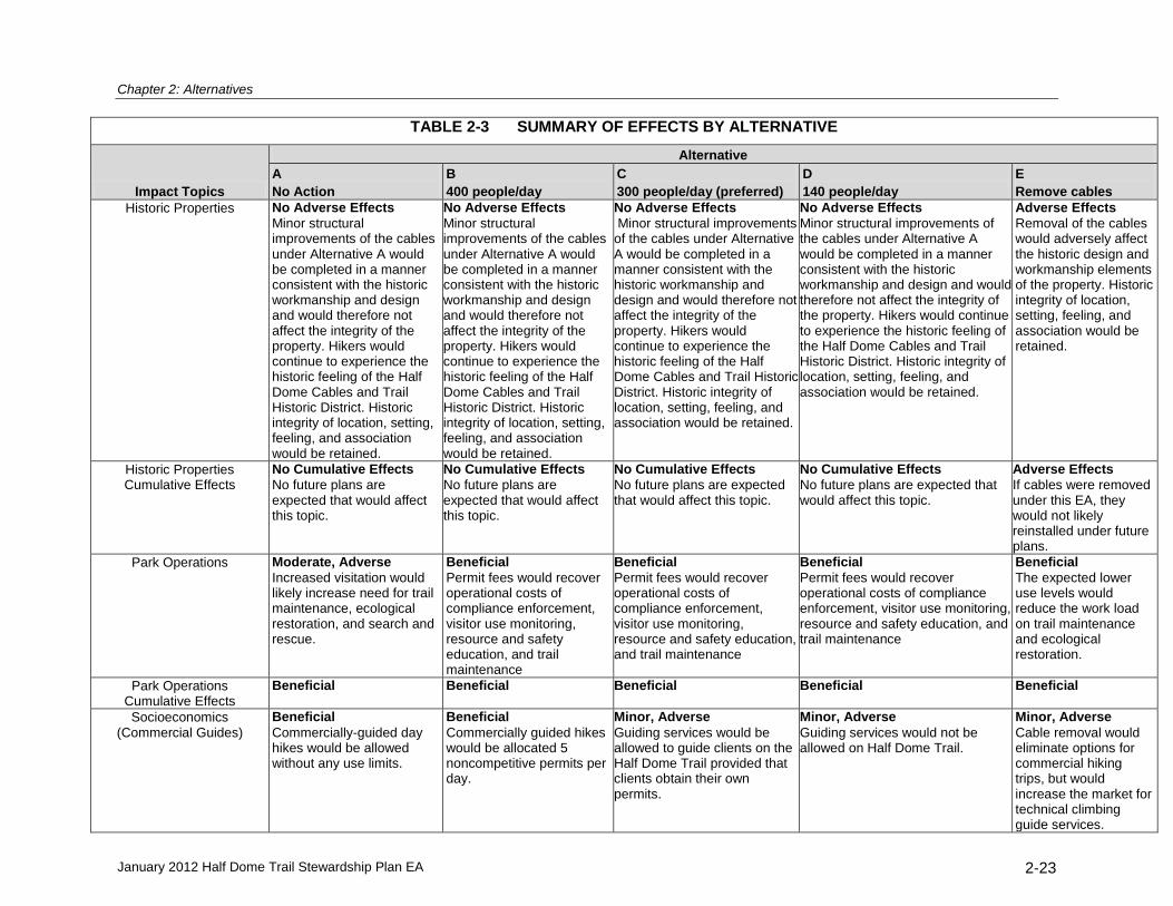
Chapter 2: Alternatives
January 2012 Half Dome Trail Stewardship Plan EA 2-23
TABLE 2-3 SUMMARY OF EFFECTS BY ALTERNATIVE
Impact Topics
Alternative
A
No Action
B
400 people/day
C
300 people/day (preferred)
D
140 people/day
E
Remove cables
Historic Properties No Adverse Effects
Minor structural improvements of the cables under Alternative A would be completed in a manner consistent with the historic workmanship and design and would therefore not affect the integrity of the property. Hikers would continue to experience the historic feeling of the Half Dome Cables and Trail Historic District. Historic integrity of location, setting, feeling, and association would be retained.
No Adverse Effects
Minor structural improvements of the cables under Alternative A would be completed in a manner consistent with the historic workmanship and design and would therefore not affect the integrity of the property. Hikers would continue to experience the historic feeling of the Half Dome Cables and Trail Historic District. Historic integrity of location, setting, feeling, and association would be retained.
Adverse Effects
Removal of the cables would adversely affect the historic design and workmanship elements of the property. Historic integrity of location, setting, feeling, and association would be retained.
Historic Properties Cumulative Effects
No Cumulative Effects
No future plans are expected that would affect this topic.
No Cumulative Effects
No future plans are expected that would affect this topic.
No Cumulative Effects
No future plans are expected that would affect this topic.
No Cumulative Effects
No future plans are expected that would affect this topic.
Adverse Effects
If cables were removed under this EA, they would not likely reinstalled under future plans.
Park Operations Moderate, Adverse
Increased visitation would likely increase need for trail maintenance, ecological restoration, and search and rescue.
Beneficial
Permit fees would recover operational costs of compliance enforcement, visitor use monitoring, resource and safety education, and trail maintenance
Beneficial
Permit fees would recover operational costs of compliance enforcement, visitor use monitoring, resource and safety education, and trail maintenance
Beneficial
Permit fees would recover operational costs of compliance enforcement, visitor use monitoring, resource and safety education, and trail maintenance
Beneficial
The expected lower use levels would reduce the work load on trail maintenance and ecological restoration.
Park Operations Cumulative Effects
Beneficial Beneficial Beneficial Beneficial Beneficial
Socioeconomics (Commercial Guides)
Beneficial
Commercially-guided day hikes would be allowed without any use limits.
Beneficial
Commercially guided hikes would be allocated 5 noncompetitive permits per day.
Minor, Adverse
Guiding services would be allowed to guide clients on the Half Dome Trail provided that clients obtain their own permits.
Minor, Adverse
Guiding services would not be allowed on Half Dome Trail.
Minor, Adverse
Cable removal would eliminate options for commercial hiking trips, but would increase the market for technical climbing guide services.

Chapter 2: Alternatives
January 2012 Half Dome Trail Stewardship Plan EA 2-24
TABLE 2-3 SUMMARY OF EFFECTS BY ALTERNATIVE
Impact Topics
Alternative
A
No Action
B
400 people/day
C
300 people/day (preferred)
D
140 people/day
E
Remove cables
Socioeconomics (Effect of permit fee on
public)
Beneficial
No day permit and no fee.
Minor, Adverse
Permit fee should not affect access for most Half Dome users.
Minor, Adverse
Permit fee should not affect access for most Half Dome users.
Moderate, Adverse
Higher permit fee more likely to affect access for Half Dome users.
Beneficial
No day permit and no fee.
Socioeconomics Cumulative Effects
Adverse (unknown level of impact) Determination
of Extent Necessary as part of Wilderness Plan for commercial use could result in additional limitations for guiding in high-demand wilderness areas in Yosemite.
Adverse (unknown level of impact) Determination of
Extent Necessary as part of Wilderness Plan for commercial use could result in additional limitations for guiding in high-demand wilderness areas in Yosemite.
Adverse (unknown level of impact) Determination of
Extent Necessary as part of Wilderness Plan for commercial use could result in additional limitations for guiding in high-demand wilderness areas in Yosemite.
Adverse (unknown level of impact) Determination of Extent
Necessary as part of Wilderness Plan for commercial use could result in additional limitations for guiding in high-demand wilderness areas in Yosemite.
Adverse (unknown level of impact) Determination of
Extent Necessary as part of Wilderness Plan for commercial use could result in additional limitations for guiding in high-demand wilderness areas in Yosemite.

Chapter 3: Affected Environment and Environmental Consequences
January 2012 Half Dome Trail Stewardship Plan EA 3-1
CHAPTER 3 AFFECTED ENVIRONMENT AND ENVIRONMENTAL
CONSEQUENCES
INTRODUCTION
This chapter of the Half Dome Trail Stewardship Plan describes the potential effect each of the action alternatives would have on existing conditions in the project area. These effects are compared against the potential effects that would result if no action was taken (as represented by Alternative A – No Action). Effects are evaluated using a range of impact topics. Topics were selected based on federal law, regulations, and executive orders; NPS management policies; and concerns expressed by the public, park staff or other agencies during scoping and comment periods. The topics analyzed in this EA include the natural, cultural, and social resources that would be directly, indirectly, or cumulatively impacted as a result of implementing any alternative proposed in this EA. This chapter also provides a discussion of topics that were dismissed from further analysis. Following the discussion on the topics selected and not selected, results of the environmental analysis are presented. A summary of environmental consequences is presented in Table 2-3. IMPACT TOPICS CONSIDERED IN THIS ENVIRONMENTAL ASSESSMENT
The impact topics identified during public scoping and by park staff as being potentially affected by the Half Dome Trail Stewardship Plan are listed below and analyzed in this chapter.
Wilderness Cultural Resources
Visitor Experience Socioeconomics
Public Safety, Managing Personal Risk Park Operations
Natural Resources
IMPACT TOPICS NOT INCLUDED IN THIS ENVIRONMENTAL ASSESSMENT
Given the scale and/or location of the project, these resources are not expected to be affected or may be negligibly affected by implementation of the various alternatives. Environmental Justice. No aspect of the action alternatives would result in disproportionately high and adverse human health or environmental effects on minority or low-income populations. Museum Collections. Park projects can indirectly affect the museum collections by generating additions to the collections from archeological data recovery performed as mitigation for direct site impacts. Archeological resources would be avoided to the maximum extent feasible. Based on the alternatives developed for analysis, data recovery is unlikely to be necessary. Prime and Unique Farmlands. There are no agricultural lands or uses in the area and alternatives would not affect farmlands outside the area. Geology, Geologic Hazards, and Soils. No aspect of the action alternatives would have an impact on geology, geologic hazards, or soils within the park. Night Sky. No aspect of the action alternatives would have an impact on night sky. Hydrology, Floodplains, and Water Quality. The alternatives would not alter or affect the hydrology or water quality of the drainage crossed by the Half Dome Trail, nor the area within a 100-year floodplain or 500-year floodplain.

Chapter 3: Affected Environment and Environmental Consequences
January 2012 Half Dome Trail Stewardship Plan EA 3-2
Air Quality. No aspect of the action alternatives would have an impact on air quality within or outside the park. Soundscape. No aspect of the action alternatives would have an impact on the natural soundscapes. Energy Consumption. Overall energy consumption within the park would not be influenced by the action alternatives. Land Use. Land uses within Yosemite National Park are classified as “Parklands” regardless of the individual types of land uses within the park. Implementation of the Half Dome Trail Stewardship Plan would not affect this classification, or any land uses within the park. IMPACT SIGNIFICANCE DETERMINATION
Potential impacts are described in terms of context, duration, type, and intensity (for adverse impacts only). General impact significance determination definitions are described below. Context. Context describes the area or location where the impact would occur – site-specific (within the project area), local (beyond the project area within Yosemite), regional (Sierra Nevada), or broader. Duration. Duration describes the length of time an effect would last, either short term or long term:
Short- term is generally used for impacts lasting only for the project duration, generally one year from the implementation date.
Long- term lasts generally beyond the date a project is considered fully implemented. Type. Type describes impacts as beneficial or adverse:
Beneficial: A positive change in the condition or appearance of the resource or a change that moves the resource toward a desired condition.
Adverse: A change that moves the resource away from a desired condition or detracts from its appearance or condition.
Intensity. Intensity describes the degree, level, or strength of an adverse impact. For this analysis, intensity is classified as negligible, minor, moderate, and major. Because intensity definitions vary by resource topic, they are provided separately in each resource topic discussion.
Cumulative Impacts
The Council on Environmental Quality (CEQ) describes a cumulative impact as follows (Regulation 1508.7):
A “cumulative impact” is the impact on the environment which results from the incremental impact of the action when added to other past, present, and reasonably foreseeable future actions regardless of what agency (federal or non-federal) or person undertakes such other actions. Cumulative impacts can result from individually minor but collectively significant actions taking place over a period of time.
The cumulative projects addressed in this analysis include past and present actions and planning/development activity being implemented or planned for implementation in the reasonably foreseeable future. Cumulative actions are evaluated in conjunction with other impacts to determine whether they have any additive effects on a resource. Most cumulative projects are in early planning stages, therefore, cumulative impacts were evaluated based on general project descriptions. A summary of cumulative projects is included in Appendix A.

Chapter 3: Affected Environment and Environmental Consequences
January 2012 Half Dome Trail Stewardship Plan EA 3-3
WILDERNESS
Affected Environment
The two-mile long Half Dome Trail was included as part of the recommendation for land appropriate for wilderness protection at the time of wilderness designation in 1984 and is managed according to the Wilderness Act of 1964. The California Wilderness Act of 1984 designated about 94% of Yosemite National Park as wilderness and 1.5% of the park as potential wilderness (YNP 2010a). Elements of wilderness character are defined by the Wilderness Act and described in Chapter 1 of this EA. These include untrammeled, natural, undeveloped, and opportunities for solitude or primitive and unconfined recreation. Chapter 2 includes a discussion of how project staff on this plan applied the qualities of undeveloped, solitude, and primitive and unconfined recreation to develop the alternatives in this EA. Active natural and cultural resource management occurs in wilderness, but such activities must be performed in a manner that utilizes the minimum requirements necessary to preserve the wilderness character. Access to wilderness areas for overnight use is controlled by trailhead quotas implemented through a wilderness permit system. Controlling overnight use at the trailhead allows for maximum visitor freedom – considered a cornerstone of the wilderness experience – while allowing the park to limit or disperse use as appropriate. Prior to the interim permit program instituted for the Half Dome Trail in 2010, no day-use restrictions had been implemented for wilderness areas in Yosemite.
Environmental Consequences
Methodology. Impact significance was determined for each of the wilderness qualities separately to address the purpose of this plan to identify specific opportunities to protect and enhance wilderness character along the Half Dome Trail. Untrammeled. The quality of wilderness character protects wilderness areas from modern human control or manipulation. This quality was considered and dismissed from further discussion in this EA because no alternatives, including the no action alternative, would result in manipulation of the biophysical environment or natural processes. Natural. This factor considers whether wilderness ecological systems are substantially free from the effects of modern civilization. The effects of an action are considered to be adverse when it increases the effects of modern humans on ecological systems. Effects are considered beneficial when they decrease such effects, either through natural recovery or intentional restoration. For the Half Dome study area, these are primarily the effects of Half Dome hikers on wildlife, vegetation, and soils. The plant and animal ecosystems will be discussed in the “Natural Resources” section of this chapter. Undeveloped. The Wilderness Act states that wilderness is “an area of undeveloped Federal land … without permanent improvements” and “with the imprint of man’s work substantially unnoticeable.” This factor considers the amount and type of permanent improvements, structures, installations, and administrative use of motorized tools and mechanized transportation. For the Half Dome Trail, the Trail itself is the major improvement and maintenance of the Trail the main administrative use. All of the alternatives propose to leave the Trail in place though Alternative E would remove the upper section of the Trail – the cable portion. Thus, the cable portion of the Trail, and its maintenance, will be the focus of analysis for the effects to the undeveloped character of wilderness. Improvements in wilderness are generally judged by a number of criteria. Developments in wilderness are generally judged by both number and type. Actions that increase the number of developments or the visual obtrusiveness, permanence, or technological

Chapter 3: Affected Environment and Environmental Consequences
January 2012 Half Dome Trail Stewardship Plan EA 3-4
sophistication of the development are considered to be adverse; actions that result in fewer developments or that are less obvious, more temporary, or more primitive are considered beneficial. Opportunities for Solitude. In wilderness areas, visitor experience is influenced by the number of other groups encountered during a given time period. Actions that increase crowding are considered adverse while those that reduce crowding are considered beneficial. In high use wilderness areas such as the Half Dome Trail, solitude is determined to be an area free from crowding. The quality of recreational experiences is typically measured through visitor use surveys. These surveys, which collect information about visitor values and attitudes on crowding and congestion, are commonly complemented with the collection of descriptive data of the kinds and amounts of visitor use, including encounter rates. The combination of these two methods allows a comparison of the temporal distribution of visitor use levels with evaluation of acceptability of various use levels. Changes in visitor evaluations of experience qualities can serve as early evidence of changes in recreational experience conditions. Visitor perceptions of crowding provide an important measurement of recreational experience (Vaske and Shelby 2008). The quality of a recreational experience is influenced by visitors’ previous experiences, expectations, and trip characteristics. In the context of the Half Dome cables, surveys administered on Sub Dome show that visitors prefer to only see 10-30 PAOT on the cables and at 70 PAOT felt crowded and unsafe(Lawson et al. 2009). Based on these visitor-informed surveys, 70 PAOT is used as a threshold past which the visitors’ experience, already far from preferred, becomes unacceptable. It is important to note that a much lower threshold to ensure free-flowing conditions has also been developed as a result of the visitor use research on the cables. Hourly group encounter rates were estimated based on data collected in the project area in 2010 (Pettebone et al. 2010). Table 3-1 compares encounter rates on popular wilderness trails in Yosemite with high use wilderness trails in Mt. Baker-Snoqualmie National Forest in Washington (located approximately 50 miles from downtown Seattle). Other than the Half Dome Trail, the Snow Lake Trail in Mt. Baker-Snoqualmie National Forest was the most heavily used wilderness trail in the country.
23
TABLE 3-1 OBSERVED AND PREDICTED GROUP ENCOUNTER RATES24
23
Though not all wilderness trails in the country have been studied, of those that have and have published results Snow Lake (Cole et al. 1997) had the highest reported encounter rates until the recent Yosemite study on the Half Dome Trail (Pettebone et al. 2010). 24
From Pettebone el al. 2010

Chapter 3: Affected Environment and Environmental Consequences
January 2012 Half Dome Trail Stewardship Plan EA 3-5
Primitive Recreation. The opportunity for primitive recreation and the quality of primitiveness were considered as having the dimensions of simplicity, lack of technology, and self-reliance (Johnson, Hall, and Cole 2005). Actions that decrease the opportunities for this type of recreation are considered adverse; those that increase such opportunities are considered beneficial. Ascending the relatively simple system of steel cables and wooden steps is “primitive” in that it involves substantial self-reliance to navigate the cables. Additionally, although modern rock climbing requires sophisticated equipment, the opportunities for self-reliance afforded by rock climbing are generally greater than relying on the cable system. Unconfined Recreation. This factor considers the difficulty for visitors to travel freely in the wilderness and the amount of regulatory requirements placed on them. Actions like permit systems and use limits, that increase the managerial control and oversight of wilderness visitors, are considered adverse, while those that reduce managerial control and oversight are considered beneficial. In the case of the proposed Half Dome use limits and permit system, Alternatives B, C, and D would impose a similar regulatory burden on the visitor: the required possession of a permit which must be presented to a ranger to gain access to the Half Dome Trail. Alternative E does not propose a permit system. Analysis of the effects to the unconfined aspect of wilderness character will focus on the impacts of the permit system.
Intensity Level Definitions. Negligible: There would be no effect or effects would not be measureable. Any affects to
wilderness would be slight, short term, and localized to the project area. Minor: Effects to wilderness character, including changes in encounter rates, agency
imposed restrictions, or natural character would be detectable and would be localized to the project area.
Moderate: Effects to wilderness character would be readily apparent and would affect the project

Chapter 3: Affected Environment and Environmental Consequences
January 2012 Half Dome Trail Stewardship Plan EA 3-6
area and possibly extend beyond. Mitigation would probably be necessary to offset adverse impacts.
Major: Effects would be readily apparent and would substantially change wilderness
character locally, as well as beyond the project area boundary. Extensive mitigation would likely be necessary to offset adverse impacts and its success could not be guaranteed. Major impacts could include adding or removing large permanent installations.
WILDERNESS – ALTERNATIVE A – NO ACTION
The NPS determined that the No Action Alternative, which represents conditions and management as existed pre 2010, would result in impacts (described below) to both wilderness character and public safety that would violate the Wilderness Act and NPS policy. Allowing these impacts to continue is not a viable action in this plan and Alternative A is being retained solely as a baseline condition upon which to evaluate the other alternatives. In comparing alternatives, the NPS is assuming the No Action Alternative would most closely resemble the last season studied without a permit system in place (2008), recognizing that actual use could be even higher. The highest use rates (Table 2-1) would occur under Alternative A, resulting in the highest adverse impacts to wilderness character. Undeveloped. The Half Dome cable system, as part of the Half Dome Trail, meets policy criteria to allow its presence in wilderness. Yet it still represents human development and modification of the undeveloped natural environment and thus results in a localized, long term, moderate adverse impact to the undeveloped character of wilderness. Natural. High use levels would impact natural conditions, and because most of the use of the Trail from Nevada Falls to the Half Dome Trails junction consists of Half Dome hikers (Pettebone et al. 2010) adverse impacts would reach beyond the project area and include:
vegetation damage;
soil loss and erosion on and near the Trail corridor;
wildlife habituation from improper food storage and feeding;
improperly buried human waste. Internet-based stewardship education and existing signs would continue to be used; however, targeted educational opportunities provided by the Interim Permit System would not occur. Impacts would extend outside of the project area, and would be major, long-term, and adverse.

Chapter 3: Affected Environment and Environmental Consequences
January 2012 Half Dome Trail Stewardship Plan EA 3-7
Opportunities for Solitude. Crowding on the Trail and cables, as indicated by the observed and projected PAOT on the cables and the encounter rates along the Trail (Table 2-1) would reduce opportunities for solitude. Under this alternative average encounter rates on the Trail during busy days (116 groups per hour, or almost 2 groups every minute) would be 5-6 times of that found on other high use trails in Yosemite’s wilderness and other wilderness areas around the country. The projected average PAOT on the cables for Saturdays and holidays (69) is indistinguishable from the visitor informed threshold of 70 PAOT, while the maximum observed PAOT on the cables (131) is nearly doubled
25. These effects would extend outside of the Half Dome Trail and
represent major, long-term adverse impacts to opportunities for solitude. These levels of crowding violate both the Wilderness Act mandate for “outstanding opportunities for solitude” and NPS policy, including Management Policy 6.4.3, which reinforces the mandate of opportunities for solitude, and Management Policy 8.2, which disallows impacts which “unreasonably interfere with…the atmosphere of peace and tranquility…in wilderness.” Primitive Recreation. While the Trail reduces the sense of “primitiveness” compared to an unmodified setting, for most visitors the experience is a self-reliant challenge. For rock climbers, the Trail, and especially the cables, reduces their sense of self-reliance. Yet rock climbing, with its sophisticated equipment, is in some ways less primitive than pulling oneself up the cables. Overall, the Trail has a localized, minor, long-term, adverse impact to primitive character.
Unconfined Recreation. Without day-use permits or limits, unrestricted access to the Half Dome Trail would allow the greatest spontaneity and the least amount of regulatory confinement. Consequently, the freedom of restrictions (no permits) would result in localized, long-term, beneficial impacts. Cumulative Impacts. Past actions of park staff to maintain the Trail, control erosion, rehabilitate impacted sites, and enforce food storage regulations along the Trail temporarily improve natural conditions contributing to wilderness character. The existing Yosemite Wilderness Management Plan restricts overnight wilderness use through a trailhead quota system for trails leading to Half Dome which affects both unconfined recreation and opportunity for solitude. The Yosemite Superintendent’s Compendium prohibits camping and campfires on the summit of Half Dome, which protects the natural quality of wilderness character while diminishing the unconfined quality. The Yosemite Wilderness Management Plan identifies the cables as an appropriate structure in wilderness but does not set day-use limits for this or other wilderness trails. The NPS is developing the Merced Wild and Scenic River Comprehensive Management Plan and the Yosemite National Park Wilderness Stewardship Plan Revision. An objective of each plan is to protect and enhance wilderness character including examining appropriate limits for visitor use. This could result in long-term and beneficial impacts that would extend beyond the project area.
WILDERNESS – ALTERNATIVE B – 400 PEOPLE PER DAY
The Half Dome cables would remain in place and use would be managed to a target of 400 people per day through a permit system. Undeveloped. The cables would remain in place with no substantial change to the existing structure. Natural. The potential for adverse impacts to the natural character of wilderness remains, but with substantially lower use numbers. In addition, increased educational opportunities with a permit system could result in noticeably lower impacts than under the no action alternative. This
25
These threshold numbers were derived from visitor surveys in the project area; they are not numbers assigned by the NPS or any other source.

Chapter 3: Affected Environment and Environmental Consequences
January 2012 Half Dome Trail Stewardship Plan EA 3-8
would likely affect the entire trail system, much of which is outside of the project area, between the wilderness boundary at the top of Nevada Falls to the John Muir Trail – Half Dome Trail junction. Impacts would extend outside of the project area, be long- term and beneficial. Opportunities for Solitude. With a daily limit of 400 users, use will be moderately less overall and substantially less on Saturdays and holidays compared to the no action alternative (Table 2-1). Encounter rates on the Trail would remain higher than other published levels for trails in Yosemite’s wilderness or other wilderness areas around the country. The maximum PAOT on the cables (51) is below the visitor-informed threshold for crowding of 70 and the average PAOT (24) is within the visitor-informed preferred range of 10-30. Because there would be less crowding than in Alternative A, the entire trail system between the wilderness boundary at the top of Nevada Falls to the John Muir Trail – Half Dome Trail junction, all of which is outside the project area, would be affected. Impacts would extend beyond the project area, and would be long-term and beneficial. Primitive Recreation. Since the cables would remain, impacts would be the same as Alternative A. This would result in localized, minor, long-term, adverse impacts to the primitive character. Unconfined Recreation. Wilderness users would be required to obtain and carry a permit. Users would also be required to carry personal identification and may be checked by a law enforcement ranger along the Trail. All of this would represent a loss of spontaneity and would affect the unconfined quality of wilderness character. Impacts would be localized, moderate, long-term, and adverse. Cumulative Impacts. Past actions of park staff to maintain the Trail, control erosion, rehabilitate impacted sites, and enforce food storage regulations along the Trail temporarily improve natural conditions contributing to wilderness character. The existing Yosemite Wilderness Management Plan restricts overnight wilderness use through a trailhead quota system for trails leading to Half Dome which affects both unconfined recreation and opportunity for solitude. Furthermore, the closure of the summit to overnight camping protects and enhances the natural character of this wilderness area. The Yosemite Wilderness Management Plan identifies the cables as an allowable structure in wilderness but does not set day-use limits for this or other wilderness trails. The NPS is developing the Merced Wild and Scenic River Comprehensive Management Plan and the Yosemite Wilderness Stewardship Plan Revision. An objective of each plan is to protect and enhance wilderness character including setting appropriate use limits. Overall, the cumulative actions in combination with Alternative B would result in impacts that would extend beyond the project area, and would be long-term, and beneficial.
WILDERNESS – ALTERNATIVE C – 300 PEOPLE PER DAY (PREFERRED ALTERNATIVE)
The Half Dome cables would remain in place and use would be managed to a target of 300 people per day through a permit system. This alternative was chosen as the preferred because it provides the highest daily use level while still allowing consistent free-flowing conditions on the cables as well as trail encounter rates that are commensurate with other wilderness trails in Yosemite and other wilderness areas around the country. Undeveloped. The cables would remain in place with no substantial change to the existing structure. Natural. The potential for adverse impacts to the natural character of wilderness remains, but with substantially lower use numbers. In addition, increased educational opportunities with a permit system could result in noticeably lower impacts than under the no action alternative. This would likely affect the entire trail system between the wilderness boundary at the top of Nevada

Chapter 3: Affected Environment and Environmental Consequences
January 2012 Half Dome Trail Stewardship Plan EA 3-9
Falls to the John Muir Trail – Half Dome Trail junction, all of which is outside the project area. Impacts would extend beyond the project area, and would be long-term and beneficial. Opportunities for Solitude. With a daily limit of 300 users, use will be significantly less overall and substantially less on Saturdays and holidays compared to the no action alternative (Table 2-1). Encounter rates on the Trail would be commensurate with other published levels for trails in Yosemite’s wilderness and other wilderness areas around the country. The maximum PAOT on the cables (36) is well below the visitor-informed threshold for crowding of 70 and the average PAOT (15) is within the visitor informed preferred range of 10-30. Because there would be less crowding than in Alternative A and B, the entire trail system between the wilderness boundary at the top of Nevada Falls to the John Muir Trail – Half Dome Trail junction, all of which is outside the project area, would be affected. Impacts would extend beyond the project area, and would be long-term and beneficial. Primitive Recreation. Because the cables would remain, impacts would be the same as Alternative A. This would result in localized, minor, long-term, adverse impacts to the primitive character. Unconfined Recreation. Wilderness users would be required to obtain and carry a permit. Users would also be required to carry personal identification and may be checked by a law enforcement ranger along the Trail. All of this would represent a loss of spontaneity and would affect the unconfined quality of wilderness character. Impacts would be localized, moderate, long-term, and adverse.
Cumulative Impacts. Past actions of park staff to maintain the Trail, control erosion, rehabilitate impacted sites, and enforce food storage regulations along the Trail temporarily improve natural conditions contributing to wilderness character. The existing Yosemite Wilderness Management Plan restricts overnight wilderness use through a trailhead quota system for trails leading to Half Dome which affects both unconfined recreation and opportunity for solitude. The Yosemite Wilderness Management Plan identifies the cables as an appropriate structure in wilderness but does not set day-use limits for this or other wilderness trails. The NPS is developing the Merced Wild and Scenic River Comprehensive Management Plan and the Yosemite Wilderness Stewardship Plan Revision. An objective of each plan is to protect and enhance wilderness character including setting appropriate limits for user capacity. Overall, the cumulative actions in combination with Alternative C would result in impacts that would extend beyond the project area, and would be long-term and beneficial.
WILDERNESS – ALTERNATIVE D – 140 PEOPLE PER DAY
The Half Dome cables would remain in place and use would be managed to a target of 140 people per day through a permit system. At 140 people per day, maximum day-use levels are expected to always remain below the statistical model threshold for crowding (30 PAOT) on the cables (Lawson et al. 2011). Undeveloped. The cables would remain in place with no substantial change to the existing structure. Natural. The potential for adverse impacts to the natural character of wilderness remains, but with substantially lower use numbers. In addition, increased educational opportunities with a permit system could result in noticeably lower impacts than under the no action alternative. This would likely affect the entire trail system between the wilderness boundary at the top of Nevada Falls to the John Muir Trail – Half Dome Trail junction, all of which is outside the project area. Impacts would extend beyond the project area, and could be long-term and beneficial. .

Chapter 3: Affected Environment and Environmental Consequences
January 2012 Half Dome Trail Stewardship Plan EA 3-10
Opportunities for Solitude. With a daily limit of 140 users (Table 2-1), encounter rates on the Trail, while difficult to predict at this low level, will be commensurate with other moderate use trails in Yosemite’s wilderness. Both the maximum PAOT on the cables (20) and the average PAOT (6) are well below the visitor informed threshold of 70 and within the visitor informed preferred range of 10-30. There would be less crowding than in Alternative A, therefore, the entire trail system between the wilderness boundary at the top of Nevada Falls to the John Muir Trail – Half Dome Trail junction, all of which is outside the project area, would be affected. Impacts would extend beyond the project area and be long-term and beneficial. Primitive Recreation. Because the cables would remain, impacts would be the same as Alternative A. This would result in localized, minor, long-term, adverse impacts to the primitive character. Unconfined Recreation. Wilderness users would be required to obtain and carry a permit. Users would also be required to carry personal identification and may be checked by a law enforcement ranger along the Trail. All of this would represent a loss of spontaneity and would affect the unconfined quality of wilderness character. Impacts would be localized, moderate, long-term, and adverse. Cumulative Impacts. Past actions of park staff to maintain the Trail, control erosion, rehabilitate impacted sites, and enforce food storage regulations along the Trail temporarily improve natural conditions contributing to wilderness character. The existing Yosemite Wilderness Management Plan restricts overnight wilderness use through a trailhead quota system for trails leading to Half Dome which affects both unconfined recreation and opportunity for solitude. The Yosemite Wilderness Management Plan identifies the cables as an appropriate structure in wilderness but does not set day-use limits for this or other wilderness trails. The NPS is developing the Merced Wild and Scenic River Comprehensive Management Plan and the Yosemite Wilderness Stewardship Plan Revision. An objective of each plan is to protect and enhance wilderness character including setting appropriate limits for user capacity. Overall, the cumulative actions in combination with Alternative D could result in impacts that would extend beyond the project area, and could be long-term and beneficial.
WILDERNESS – ALTERNATIVE E – REMOVE THE CABLE SYSTEM
Under Alternative E the cables, steps, stanchions and non-historic bolts would be removed and bolt holes would be filled. No day-use permit system would be implemented. Without the cable system, the estimated number of users per day would be substantially lower than under the No Action Alternative. In addition, Alternative E would have the lowest use of all the alternatives, estimated to be approximately 100 on weekends and holidays and fewer on weekdays. Under this alternative the easiest access to the Half Dome summit would be a technical climb following the former cable route. The same regulations for technical climbing elsewhere in the park would apply, allowing manual placement of bolts for technical climbing protection, as necessary. Additional routes could be established by the climbing public on either side of the former cable route.
Undeveloped. With the cable system removed, the visual impact and adverse impact to the undeveloped natural environment would be reduced. However, climbers may install new bolts to establish new ascent and descent routes. Additionally, illegal fixed ropes may be left to aid both ascent and descent, as indicated by climbing practices elsewhere in the park. These additional placements would be relatively insignificant compared to the removal of the cable system. Impacts would be localized, long term, and beneficial. Natural. Lower use levels on the Trail and at the summit would likely result in reduced trail erosion, reduced vegetation trampling, and reduced improper disposal of human waste. These

Chapter 3: Affected Environment and Environmental Consequences
January 2012 Half Dome Trail Stewardship Plan EA 3-11
benefits would likely extend to the entire trail system between the wilderness boundary at the top of Nevada Falls to the John Muir Trail – Half Dome Trail junction, all of which is outside the project area. Impacts to the Trail would extend outside of the project area and be long-term and beneficial. Opportunities for Solitude. The northeast face of Half Dome would expect to become a popular rock climbing destination under this alternative and there would likely be multiple climbing parties at the base of the climb and on various routes on the face simultaneously. Ascent times and potential queuing would depend on the number and difficulty of developed climbing routes and the skill of individual climbing parties. Longer ascent times could lead to a higher density of hikers at the base of the climb than along lower portions of the Half Dome Trail. Yet, compared with Alternative A, encounter rates would be expected to be much less. Impacts would extend beyond the project area resulting in long-term and beneficial impacts.
Primitive Recreation. The most self-reliance would be required under this alternative. Additional bolts may be installed for new climbing routes, but overall the climbing system would be less complicated, less visible and would result in more self-reliance requirements for users. Therefore, impacts would be localized, long-term, and beneficial. Unconfined Recreation (agency restrictions). As in Alternative A, there would be an unconfined ability to enter and use the wilderness with no day-use permits required. Therefore, Alternative E would have localized, long-term, beneficial impacts to unconfined recreation. Cumulative Impacts. Past actions of park staff to maintain the Trail, control erosion, rehabilitate impacted sites, and enforce food storage regulations along the Trail temporarily improve natural conditions contributing to wilderness character. The existing Yosemite Wilderness Management Plan restricts overnight wilderness use through a trailhead quota system for trails leading to Half Dome which affects both unconfined recreation and opportunity for solitude. The Yosemite Wilderness Management Plan identifies the cables as an appropriate structure in wilderness but does not set day-use limits for this or other wilderness trails. The NPS is developing the Merced Wild and Scenic River Comprehensive Management Plan and the Yosemite Wilderness Stewardship Plan Revision. An objective of each plan is to protect and enhance wilderness character including setting appropriate limits for user capacity. Overall, the cumulative actions in combination with Alternative E would result in impacts that would extend beyond the project area, and would be long-term and beneficial. VISITOR EXPERIENCE
Affected Environment
The top of Half Dome is a goal for a broad cross section of the public; beginning and experienced hikers, first-time and lifelong park visitors, an array of ethnicities and cultures, children to grandparents, and people from all around the world. For many, this may be their first hike in designated wilderness. The combination of the long hike, an exhilarating, exposed ascent of the cables, and a spectacular view from the summit can combine to be a highlight of a person’s summer or even a life-changing event. For almost all hikers, gaining the summit of Half Dome is only possible via the Half Dome Trail and cable system. Hikers are able to use the steel cables and wooden steps, installed and maintained by the NPS, as an aid on the final 400 vertical feet of the steep, smooth rock leading to the summit. This terrain would otherwise constitute a technical rock climb and this characteristic is part of the thrill, challenge, and attraction to the Half Dome Trail. This is a unique opportunity for the non-climber to ascend a sheer, dramatic face of such a spectacular mountain. For technical climbers there are numerous climbing routes to the summit on other sides of the

Chapter 3: Affected Environment and Environmental Consequences
January 2012 Half Dome Trail Stewardship Plan EA 3-12
peak, ranging in all levels of difficulty from easy to extreme.
Environmental Consequences
Methodology. This section analyzes how the different alternatives meet two of the purposes of this EA; 1) provide the public with the appropriate opportunity to reach the summit of Half Dome, while still ensuring the wilderness character of the area and 2) improve the visitor experience on the Half Dome Trail. The preceding section discussed how the alternatives impacted the wilderness character of the area and part of that discussion dealt with the ability of visitors to have a wilderness experience. The visitor experience in wilderness is connected with being able to experience the different qualities of wilderness. This section explores the impacts of the alternatives with the goal of providing the appropriate opportunity to reach the Half Dome summit. The appropriate opportunity to reach the summit refers to the ability of a diverse public to reach the summit, especially the opportunity for non-technical climbers. Analysis of visitor experience is based on whether there was a complete loss of a recreation opportunity, a change in access to or availability of a recreation opportunity or a change in the quality of visitor experience or recreational opportunities. The quality of visitor experience depends on maintaining its critical characteristics. Critical characteristics are those elements of a recreational activity that are most important to those who pursue it. In the case of the Half Dome Trail these characteristics were considered to be the ability of a diverse public to reach the summit and to do so in an uncrowded environment. Half Dome hikers reported that they preferred use levels of 10-30 PAOT on the cables and that they found 70 PAOT to be unacceptable (Lawson et al 2009). No survey was done to determine desired trail encounter rates, but it is assumed that by the same reasoning as for PAOT on the cables, Half Dome hikers do not desire high encounter rates on the Trail during their hike on the way to the cables. Impacts were evaluated in terms of whether they would be beneficial or adverse to visitor experience. Beneficial impacts would enhance visitor participation and quality of visitor experience. Adverse impacts would be effects that reduce visitor participation or quality of visitor experience. Intensity Level Definitions Negligible: There would be little noticeable change in visitor experience Minor: Minor impacts would result in changes in desired experiences but without
appreciably limiting or enhancing critical characteristics Moderate: Moderate impacts would change the desired experience appreciably (changes to
one or more critical characteristics or appreciable reduction/increase in the number of participants).
Major: Major impacts would eliminate or greatly enhance multiple critical characteristics
or greatly reduce/increase participation. VISITOR EXPERIENCE – ALTERNATIVE A – NO ACTION
Alternative A leaves the cable system in place, allowing non-technical climbing access to the summit of Half Dome by hikers. In comparing alternatives, the NPS is assuming use would most closely follow the last season studied without a permit system in place (2008), recognizing that actual use could be even higher in the future. The highest use rates (estimated at 3,559 people per week) would occur under Alternative A (Table 2-1), trail encounter rates are normally high during periods of highest use and are more than four times higher than reported wilderness trail use anywhere in the country. During the highest use periods under this alternative, conditions on the cables are normally in both the visitor informed unacceptable range and above the desired

Chapter 3: Affected Environment and Environmental Consequences
January 2012 Half Dome Trail Stewardship Plan EA 3-13
conditions range. Many hikers could reach the summit of Half Dome under this alternative, but many would do so in undesirable conditions. Also, the visitor experience of those who prefer that all access to the summit of Half Dome be by technical climb would continue to be adversely affected. Impacts to visitor experience under this alternative would be localized, long term, major, and adverse. Cumulative impacts. Past and current actions are the yearly installation and maintenance of the Half Dome cables, which provide access to the summit for non-technical climbers. The Yosemite Wilderness Management Plan allows the cables in designated wilderness. Foreseeable future actions could result from the Yosemite Wilderness Stewardship Plan Revision, which will seek to protect or improve wilderness character; Actions may include regulating high day-use areas to ensure an enjoyable wilderness experience. These potential actions along with the actions of this alternative could result in beneficial impacts to visitor experience as defined for this EA.
VISITOR EXPERIENCE – ALTERNATIVE B – 400 PEOPLE PER DAY
This alternative leaves the cable system in place, allowing non-technical climbing access to the summit of Half Dome by hikers. Use would be managed to a target of 400 people per day through a permit system. During periods of highest use, PAOT would never reach unacceptable levels (i.e. greater than 70 PAOT) but would be above visitor informed desirable levels, which range from 10-30 PAOT on the cables. Average trail encounter rates would be high, but less than Alternative A. Fewer hikers could reach the summit of Half Dome under this alternative as compared to the No Action alternative, but those that did would mainly do so under more desirable conditions than under Alternative A. This would result in beneficial impacts to visitor experience for those visitors who prefer to access Half Dome via the cables. Impacts to visitor experience for those who prefer the cable route would extend beyond the project area would be long-term and beneficial. Cumulative impacts. Past and current actions are the yearly installation and maintenance of the Half Dome cables, which provide access to the summit for non-technical climbers. The Yosemite Wilderness Management Plan allows the cables in designated wilderness. Foreseeable future actions could result from the Yosemite Wilderness Stewardship Plan Revision, which will seek to protect or improve wilderness character; Actions may include regulating high day-use areas to ensure an enjoyable wilderness experience. These potential actions along with the actions of this alternative could result in beneficial impacts to visitor experience as defined for this EA. Other park plans that guide wilderness management such as the Fire Management Plan and Invasive Plant Management Plan could also affect visitor experience.
VISITOR EXPERIENCE – ALTERNATIVE C – 300 PEOPLE PER DAY (PREFERRED ALTERNATIVE)
This alternative leaves the cable system in place, allowing non-technical climbing access to the summit of Half Dome by hikers. Use would be managed to a target of 300 people per day through a permit system. This alternative was chosen as the preferred because it provides the highest daily use level while still allowing consistent free flowing conditions on the cables as well as trail encounter rates that are commensurate with other wilderness trails in Yosemite and other wilderness areas around the country. 300 people per day also represents the actual average daily use on permit days in 2010 during the interim permit program. During periods of highest use, PAOT would never reach unacceptable levels and would be only slightly above visitor informed desirable levels. Fewer hikers could reach the summit of Half Dome under this alternative, but those that did would mainly do so under more desirable conditions than either Alternative A or B. Impacts to visitor experience under this alternative would extend beyond the project area and be

Chapter 3: Affected Environment and Environmental Consequences
January 2012 Half Dome Trail Stewardship Plan EA 3-14
long-term and beneficial. Cumulative impacts. Past and current actions are the yearly installation and maintenance of the Half Dome cables, which provide access to the summit for non-technical climbers. The Yosemite Wilderness Management Plan allows the cables in designated wilderness. Foreseeable future actions could result from the Yosemite Wilderness Stewardship Plan Revision, which will seek to protect or improve wilderness character; Actions may include regulating high day-use areas to ensure an enjoyable wilderness experience. These potential actions along with the actions of this alternative could result in localized, long-term, beneficial impacts to visitor experience as defined for this EA. Other park plans that guide wilderness management such as the Fire Management Plan and Invasive Plant Management Plan could also affect visitor experience.
VISITOR EXPERIENCE – ALTERNATIVE D – 140 PEOPLE PER DAY
This alternative leaves the cable system in place, allowing non-technical climbing access to the summit of Half Dome by hikers. Use would be managed to a target of 140 people per day through a permit system. At 140 people per day, maximum day-use levels are expected to always remain in the range of the visitor desired PAOT on the cables. Encounter rates on the Trail would be below that found on high use trails. Fewer hikers could reach the summit of Half Dome under this alternative, but those that did would do so under more desirable conditions than either Alternative A, B, or C. Impacts to visitor experience for those who prefer the cable route would extend beyond the project area would be long-term and beneficial. Cumulative impacts. Past and current actions are the yearly installation and maintenance of the Half Dome cables, which provide access to the summit for non-technical climbers. The Yosemite Wilderness Management Plan allows the cables in designated wilderness. Foreseeable future actions could result from the Yosemite Wilderness Stewardship Plan Revision, which will seek to protect or improve wilderness character; Actions may include regulating high day-use areas to ensure an enjoyable wilderness experience. These potential actions along with the actions of this alternative could result in localized, long-term, beneficial impacts to visitor experience as defined for this EA. Other park plans that guide wilderness management such as the Fire Management Plan and Invasive Plant Management Plan could also affect visitor experience.
VISITOR EXPERIENCE – ALTERNATIVE E – REMOVE THE CABLE SYSTEM
Under Alternative E the cables, steps, stanchions and non-historic bolts would be removed and there would be no permit system. Without the cable system, the estimated number of users per day would be substantially lower than under the No Action Alternative and would have the lowest use of all the alternatives. Under this alternative the easiest access to the Half Dome summit would be a technical climb following the former cable route. It is expected that the establishment of new popular climbing routes would draw significant numbers of novice and experienced climbers. Good rock, a beautiful setting, and moderate climbing would all add to its attractiveness. Queuing could develop and would depend on the number and difficulty of developed climbing routes. Popular climbing routes in Yosemite often have queues for ascending and descending the routes. This alternative eliminates the opportunity for non-technical hikers to reach the summit of Half Dome -unless those hikers acquire the knowledge, experience, and equipment needed for a technical climb. It is expected that this would significantly reduce the number of people reaching Half Dome’s summit. Though the removal of the cables would allow the establishment of new, easy to moderate enjoyable climbing routes, there are already existing routes to Half Dome’s summit that provide similar attractions.

Chapter 3: Affected Environment and Environmental Consequences
January 2012 Half Dome Trail Stewardship Plan EA 3-15
Impacts to the visitor experience of non-technical climbers under this alternative would be localized, long term, moderate, and adverse. Impacts to the experience of technical climbers would be beneficial. Cumulative impacts to visitor experience. Past and current actions are the yearly installation and maintenance of the Half Dome cables and the Yosemite Wilderness Management Plan which allows the cables in designated wilderness. The 2010-11 interim permit program regulated use at 400 persons per day for safety considerations. Foreseeable future actions could result from the Wilderness Stewardship Plan Revision which will seek to protect or improve wilderness character, including the ability of visitors to have an enjoyable wilderness experience. If the cables were removed under this Half Dome Trail Stewardship EA, they would not likely be reinstalled under a future plan. Thus, those past, present, and foreseeable future actions, along with the actions of this alternative could result in localized, long-term, moderate, adverse cumulative impacts to visitor experience as defined for this EA. PUBLIC SAFETY– MANAGING PERSONAL RISK
Affected Environment
Environmental conditions such as afternoon thunderstorms are a serious concern for safety on the Half Dome Trail. As discussed in Table 1-1, accident data suggest that the great majority of accidents have occurred during wet or icy conditions and very few accidents have occurred during dry conditions. The NPS has focused its safety message on the concept that hikers should avoid the exposed areas of the Sub Dome, cable route, and Half Dome summit whenever there is a chance for rain or lightning in the area. Because of the elevated and exposed nature of this upper section of the Trail it is likely more prone to lightning strikes. Additionally the smooth texture of the granite makes the entire area very slippery when it is wet, especially the steep section of the cable route. In the wilderness setting the ultimate responsibility for personal safety belongs to the individual. The freedom to make personal assessments about one’s own ability and experience in handling risks is a basic concept of wilderness travel. Likewise is the freedom to act on that assessment – to evaluate the risk and continue on or decide to turn back. The NPS Management Policies provide additional guidance about visitor safety. In the case of high adventure recreational activities, the Management Policies provide that “visitors must assume a substantial degree of risk and responsibility for their own safety.” During 2010 and 2011, the NPS provided education about the risks inherent in attempting to climb Half Dome and imposed restrictions that reduced use levels to allow visitors to move more freely up and down the cable system. . If a hiker is on the cables or summit and sees a storm approaching, that hiker should know that the storm greatly increases their personal risk and should know that they can descend the cables and Sub Dome steps in a timely manner to avoid being caught on exposed terrain during that storm. The NPS encourages safe behaviors in wilderness by providing safety information to the public through a variety of media and methods. Half Dome visitors can view web pages which provide wilderness safety tips and videos that can prepare hikers for the potential challenges and hazards associated with the hike. The 2010-11 interim permit system put this information in view of customers during the on line permit purchasing process. Preventive Search and Rescue staff (funded by the interim permit program) and NPS Rangers are available throughout the park and trail corridors to answer questions and provide general recommendations for safe decision-making in wilderness.

Chapter 3: Affected Environment and Environmental Consequences
January 2012 Half Dome Trail Stewardship Plan EA 3-16
This ability of hikers to manage their own risk on the Half Dome cables can be compromised when there are queuing and congestion delays on both ascent and descent (as discussed in Chapter 1). Queuing and congestion represent impediments to free-flowing conditions. When the cable route is crowded, hikers must often stand on the granite surface between the wooden steps. Waiting between the steps is more strenuous because hikers hold more of their body weight using the cables (Lawson et al. 2009). Crowding also makes it more difficult for hikers to descend to safer locations when storms are approaching. Table 3-2 compares the estimated times for a mass descent from the summit, during the highest use period of the day, in a fast approaching storm scenario.
TABLE 3-2 MASS DESCENT TIMES ON THE CABLES
Foundation Data Alt A-
Unregulated Alt B – 400
ppd Alt C- 300
ppd Alt D- 140
ppd Alt E-Remove
the Cables
Mass Descent Time 83 min 47 min 47 min Unknown N/A Note: ppd= persons per day
The figures in Table 3-2 were calculated based on the number of PAOT on the summit and cables for each of the alternatives. These numbers were generated through modeling scenarios (Lawson and Kiser 2011) based on visitor use studies conducted in 2008 and 2010 and show the time needed to evacuate all persons from the summit to the base of the cables. These numbers are for comparison only. In the case of an evacuation, 47 minutes is preferred over 83 minutes, but 47 minutes may still not ensure that a person is able to reach the bottom of the cables before being hit by a fast moving storm. Once off the cables, visitors can travel at their own speed and are unconstrained in finding safer ground. Additional study results suggest that during general, non-storm conditions when fewer than 30 PAOT are on the cables, hikers can ascend and descend more freely (Lawson et al. 2009). With 30 or more PAOT on the cables, hikers’ ability to ascend and descend becomes increasingly impeded by the presence of others. The number of PAOT on the summit and cables can be correlated with the number of people per day so that by regulating number of people per day a predictable PAOT, and corresponding free flow condition, can be maintained. In spite of low use on the cables and well-placed safety messages, visitor safety cannot be guaranteed, especially during wet rock conditions or during storm events. Even during dry conditions the Half Dome Trail and cables are a strenuous endeavor and not for everyone. A slip or fall on the exposed areas of the Trail can be fatal. None of the alternatives guarantee the safety of the public while using the Half Dome Trail. Each hiker must evaluate their ability to negotiate the Half Dome Trail and must make their own decision about whether or not to proceed.
Environmental Consequences
Methodology. Analysis was based on the degree to which each alternative addressed:
Free-flowing conditions, allowing unimpeded travel and ability to manage personal risk. Statistical models determined that with fewer than 30 PAOT on the cables, hikers are able to ascend and descend the cables without impediments from crowding.
The ability to provide safety education including videos, website and permit information, and required reading for purchasing a permit.
Descent times during mass evacuation scenario from Half Dome in response to an approaching storm. The longer the descent time, the less likely a hiker is to avoid a storm.
Intensity Level Definitions Negligible: There would be little noticeable change in management of public safety or
conditions affecting opportunities for hikers to manage personal risk.

Chapter 3: Affected Environment and Environmental Consequences
January 2012 Half Dome Trail Stewardship Plan EA 3-17
Minor: Noticeable changes to conditions affecting public safety or opportunities for hikers to manage personal risk would result.
Moderate: Noticeable changes to conditions affecting opportunities for hikers to manage
personal risk would result. Substantial changes in the ability to provide safety education would result.
Major: Major impacts would include substantial and highly noticeable changes in the
social, environmental, and behavioral factors affecting opportunities for hikers to manage personal risk. Major adverse impacts would result from unacceptable descent times during a mass evacuation of over an hour.
PUBLIC SAFETY– ALTERNATIVE A – NO ACTION
Unregulated use of the Half Dome Trail is expected to have use patterns much like those observed in 2008 and 2009. During high use periods there would be impeded travel conditions on the cables and queuing at the top and bottom. Mass evacuations during storm events could take as long as 83 minutes. Additionally during periods of highest use, PAOT on the cables would reach levels deemed unacceptable for safety by the public (Lawson el al 2009). Unregulated use would not allow opportunities for targeted safety information and education as would be possible with those alternatives that propose a permit system. Interim staffing of rangers and safety education staff in 2010 and 2011 would be discontinued due to budget constraints. The NPS would continue to use the park’s website, signage, and rangers to educate visitors about safety concerns on the cable route. However, there is no affirmative requirement for visitors to seek out this safety information. There will be localized, long-term, major, adverse impacts to public safety and visitors’ ability to manage their personal risk. Cumulative Impacts. Past and present actions that contributed to impacts on public safety and managing personal risk include cable installation, trail construction and ongoing maintenance to both. The interim permit program of 2010 and 2011 regulated daily use on the Trail to improve safety and is scheduled to end once this Half Dome Trail Stewardship Plan is implemented. The existing Wilderness Plan approved the cables as a structure in the wilderness and allows unregulated use. Reasonably foreseeable future projects that could affect public safety and managing personal risk are the Revised Wilderness Stewardship Plan and the Merced River Plan. Both of these plans are still under development but should either plan result in actions that reduce the numbers of hikers on the Half Dome Trail then there could be an impact on public safety. It is expected that the Wilderness Plan Revision would address public safety and risk management in the wilderness with an expected goal of providing the greatest opportunity for wilderness users to manage their own risk and safety. This foreseeable action, along with past and current actions and combined with the no action alternative would result in localized, long-term, beneficial impacts on public safety and managing personal risk for the Half Dome Trail. The intensity level of these benefits cannot be determined.
PUBLIC SAFETY– ALTERNATIVE B – 400 PEOPLE PER DAY
With a use limit of 400 people per day, use on the Half Dome Trail is expected to generally provide free-flowing conditions, with an average of 24 PAOT on the cables. However, maximum levels could reach 51 PAOT. Descent from the summit to Sub Dome during mass evacuations at maximum use levels is estimated to take 47 minutes. Alternative B would result in some impediments to free-flowing conditions on the cables during the highest use levels, but these would be greatly reduced compared to the no action alternative. Keeping use limits at 400 would better allow hikers’ to manage their own personal risk than under the no action alternative, Visitor

Chapter 3: Affected Environment and Environmental Consequences
January 2012 Half Dome Trail Stewardship Plan EA 3-18
perceptions of safe numbers on the cables would be met (below 70 PAOT). Additionally, targeted safety information during the permit process could increase hikers’ knowledge of the risks associated with the Trail as well as strategies to manages those risks Under Alternative B there will be a beneficial impact to public safety and managing personal risk for the Half Dome Trail. Cumulative Impacts. The list of past, current, or reasonably foreseeable actions that might have a cumulative impact on public safety and managing personal risk for the Half Dome Trail would be the same as described under Alternative A. These actions, combined with the actions in Alternative B would result in localized, long term beneficial impacts.
PUBLIC SAFETY– ALTERNATIVE C – 300 PEOPLE PER DAY (PREFERRED ALTERNATIVE)
With a use limit of 300 people per day, use on the Half Dome Trail is expected to generally provide free-flowing conditions, with an average of 15 PAOT on the cables. Maximum levels would only reach 36 PAOT, just slightly above the free flowing 30 PAOT. Descent from the summit to Sub Dome during mass evacuations at maximum use levels is estimated to take 47 minutes. Alternative C would rarely result in impediments to free-flowing conditions on the cables even during the highest use levels. These would be greatly reduced compared to the no action alternative. Keeping use limits at 300 would better allow hikers’ to manage their own personal risk than under the no action alternative. Visitor perceptions of safe numbers on the cables would be met (below 70 PAOT). Additionally, targeted safety information during the permit process could increase hikers’ knowledge of the risks associated with the Trail as well as strategies to manages those risks Under Alternative C there will beneficial impacts to public safety and managing personal risk for the Half Dome Trail. Cumulative Impacts. The list of past, current, or reasonably foreseeable actions that might have a cumulative impact on public safety and managing personal risk for the Half Dome Trail would be the same as described under Alternative A. These actions, combined with the actions in Alternative C would result in beneficial impacts to public safety and managing personal risk for the Half Dome Trail.
PUBLIC SAFETY– ALTERNATIVE D – 140 PEOPLE PER DAY
With a use limit of 140 people per day, travel up and down the cables is always expected to be free flowing with even maximum PAOT on the cables predicted at less than 20. Descent from the summit to Sub Dome during mass evacuations at maximum use levels was not able to be estimated in the modeling scenario but should be less than all other alternatives. Visitor perceptions of safe numbers on the cables would be met (below 70 PAOT). Additionally, targeted safety information during the permit process could increase hikers’ knowledge of the risks associated with the Trail as well as strategies to manages those risks Under Alternative D there will beneficial impacts to public safety and managing personal risk for the Half Dome Trail. Cumulative Impacts. The list of past, current, or reasonably foreseeable actions that might have a cumulative impact on public safety and managing personal risk for the Half Dome Trail would be the same as described under Alternative A. Under Alternative D There will be beneficial impacts to public safety and managing personal risk for the Half Dome Trail.

Chapter 3: Affected Environment and Environmental Consequences
January 2012 Half Dome Trail Stewardship Plan EA 3-19
PUBLIC SAFETY– ALTERNATIVE E – REMOVE THE CABLE SYSTEM
Without the cable system, the easiest access to the Half Dome summit would be a technical climb following the former cable route. The NPS estimates that on high use days approximately 100 climbers per day could ascend Half Dome by newly established routes. At this level of use, queuing at the base and summit would likely occur and crowding would not be eliminated. However, congestion on technical climbing routes is often self-regulated due to the limited number of belay and rappel stations where parties can anchor themselves during an ascent or descent. The NPS would continue to provide safety and risk management information on technical climbing through the Wilderness Climbing Ranger program. There is currently no data to evaluate impediments to free-flowing conditions or mass evacuation times on the technical climbing routes expected to be established if the cables are removed. Managing personal risk would be similar to what visitors experience at other popular technical climbing areas in the park. Cumulative Impacts. The list of past, current, or reasonably foreseeable actions that might have a cumulative impact on public safety and managing personal risk for the Half Dome Trail would be the same as described for Alternative A. These actions, combined with the actions in Alternative E would result in localized, long term moderate beneficial impacts to public safety and managing personal risk for the Half Dome Trail. NATURAL RESOURCES
Affected Environment
The Half Dome Trail begins at in a White Fir-Sugar Pine (Incense Cedar Jeffrey Pine) woodland mapping unit and continues up through California Red Fir-White Fir Forest Alliance, Western White Pine/Western Needlegrass Woodland Mapping Unit, and Jeffrey Pine/Huckleberry Oak Woodland Association. The final half mile of the Trail to the summit rises westward over nearly treeless granite domes. Vegetation and Biotic Communities. Most vegetation in the park is classified into five forest vegetation zones and associated meadow zones (NPS 2010a). Three of the five forest vegetation zones occur along the Half Dome Trail. Upper Montane Forests. Most of the Trail occurs within the Upper Montane Forests zone ranging from about 5,900 to 7,870 feet AMSL. This zone is characterized by montane chaparral and various coniferous forest communities. There are short, cool summers and cold winters there, and nearly all precipitation is in the form of snow (NPS 2010a, 2010b). Subalpine Forests. On the upper slopes approaching Half Dome, the Trail crosses through Subalpine Forests characterized by whitebark pine (Pinus albicaulis), mountain hemlock (Tsuga mertensiana), and lodgepole pine (Pinus contorta). This zone overlaps in elevation with the Upper Montane Forests zone, and it has short summers and long, cold, snowy winters with a lot of deep snow (NPS 2010a, 2010b). Alpine. The last half mile of trail up to the Half Dome summit goes through the Alpine zone. This area is mostly granite rock with some small pockets of vegetation found in depressions that collect water. Mosses, succulents and other low-growing plants are typically seen in these small pockets (NPS 2010a, 2010d). Wildlife. The park supports a variety of wildlife that can be seen in a wide range of habitats (YNP 2010a). Species vary with the types of vegetation that occur, and some vegetation zones are more diverse than others. Wildlife species in the Upper Montane Forest Zone include the great
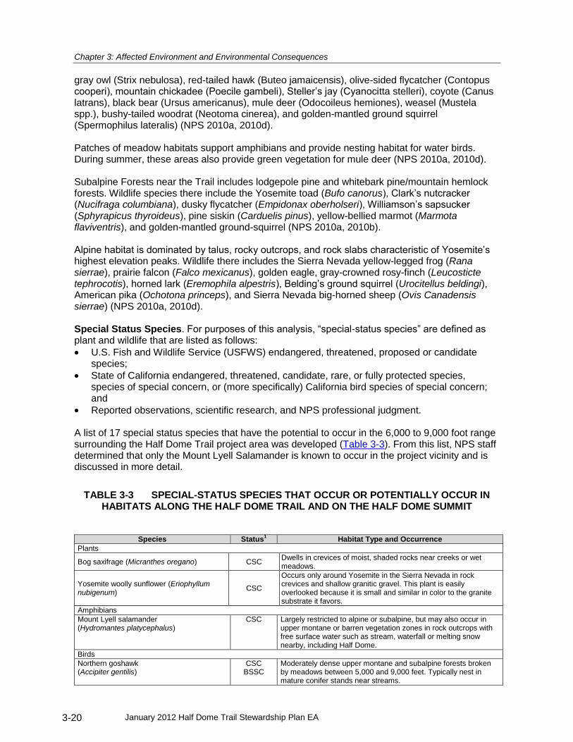
Chapter 3: Affected Environment and Environmental Consequences
January 2012 Half Dome Trail Stewardship Plan EA 3-20
gray owl (Strix nebulosa), red-tailed hawk (Buteo jamaicensis), olive-sided flycatcher (Contopus cooperi), mountain chickadee (Poecile gambeli), Steller’s jay (Cyanocitta stelleri), coyote (Canus latrans), black bear (Ursus americanus), mule deer (Odocoileus hemiones), weasel (Mustela spp.), bushy-tailed woodrat (Neotoma cinerea), and golden-mantled ground squirrel (Spermophilus lateralis) (NPS 2010a, 2010d). Patches of meadow habitats support amphibians and provide nesting habitat for water birds. During summer, these areas also provide green vegetation for mule deer (NPS 2010a, 2010d). Subalpine Forests near the Trail includes lodgepole pine and whitebark pine/mountain hemlock forests. Wildlife species there include the Yosemite toad (Bufo canorus), Clark’s nutcracker (Nucifraga columbiana), dusky flycatcher (Empidonax oberholseri), Williamson’s sapsucker (Sphyrapicus thyroideus), pine siskin (Carduelis pinus), yellow-bellied marmot (Marmota flaviventris), and golden-mantled ground-squirrel (NPS 2010a, 2010b). Alpine habitat is dominated by talus, rocky outcrops, and rock slabs characteristic of Yosemite’s highest elevation peaks. Wildlife there includes the Sierra Nevada yellow-legged frog (Rana sierrae), prairie falcon (Falco mexicanus), golden eagle, gray-crowned rosy-finch (Leucosticte tephrocotis), horned lark (Eremophila alpestris), Belding’s ground squirrel (Urocitellus beldingi), American pika (Ochotona princeps), and Sierra Nevada big-horned sheep (Ovis Canadensis sierrae) (NPS 2010a, 2010d). Special Status Species. For purposes of this analysis, “special-status species” are defined as plant and wildlife that are listed as follows:
U.S. Fish and Wildlife Service (USFWS) endangered, threatened, proposed or candidate species;
State of California endangered, threatened, candidate, rare, or fully protected species, species of special concern, or (more specifically) California bird species of special concern; and
Reported observations, scientific research, and NPS professional judgment. A list of 17 special status species that have the potential to occur in the 6,000 to 9,000 foot range surrounding the Half Dome Trail project area was developed (Table 3-3). From this list, NPS staff determined that only the Mount Lyell Salamander is known to occur in the project vicinity and is discussed in more detail.
TABLE 3-3 SPECIAL-STATUS SPECIES THAT OCCUR OR POTENTIALLY OCCUR IN HABITATS ALONG THE HALF DOME TRAIL AND ON THE HALF DOME SUMMIT
Species Status1 Habitat Type and Occurrence
Plants
Bog saxifrage (Micranthes oregano) CSC Dwells in crevices of moist, shaded rocks near creeks or wet meadows.
Yosemite woolly sunflower (Eriophyllum nubigenum)
CSC
Occurs only around Yosemite in the Sierra Nevada in rock crevices and shallow granitic gravel. This plant is easily overlooked because it is small and similar in color to the granite substrate it favors.
Amphibians
Mount Lyell salamander (Hydromantes platycephalus)
CSC Largely restricted to alpine or subalpine, but may also occur in upper montane or barren vegetation zones in rock outcrops with free surface water such as stream, waterfall or melting snow nearby, including Half Dome.
Birds
Northern goshawk (Accipiter gentilis)
CSC BSSC
Moderately dense upper montane and subalpine forests broken by meadows between 5,000 and 9,000 feet. Typically nest in mature conifer stands near streams.

Chapter 3: Affected Environment and Environmental Consequences
January 2012 Half Dome Trail Stewardship Plan EA 3-21
Species Status1 Habitat Type and Occurrence
Peregrine falcon (Falco peregrinus)
CFP Typically nests on high cliffs near water and searches for prey along cliffs and over surrounding habitats. Is known to nest on the south face of Half Dome.
California spotted owl (Strix occidentalis occidentalis)
CSC BSSC
Breeds in oak and ponderosa pine forests up to lower elevation red fir forests (foothill woodland to upper montane). Mixed conifer is the optimum type.
Great Gray Owl (Strix nebulosa)
CE Breeds in old-growth red fir, mixed conifer, or lodgepole pine habitats, always in the vicinity of wet meadows. Forages in wet meadows. However, there have been no great gray owl sightings and there are no known nesting sites near the Half Dome Trail.
Olive-sided flycatcher (Contopus cooperi)
CSC BSSC
Late successional montane conifer forests with open canopies, primarily mixed conifer and red fir.
Mammals
Pallid bat (Antrozous pallidus)
CSC Found primarily below 6,000 feet in a variety of habitats. Roosts in rock outcrops, caves and hollow trees.
Townsend’s big-eared bat (Corynorhinus townsendii townsendii)
CSC Low- to mid-elevation montane. Roosts in caves, mines, or buildings. Prefers mesic habitats.
Spotted bat (Euderma maculatum)
CSC Rare throughout range, but relatively abundant in Yosemite montane and subalpine zones. Roosts in crevices in rock faces and forages in a wide variety of habitats
Western red bat (Lasiurus blossevillii)
CSC Most common in low elevation riparian habitats, but have been documented up to 7,500 feet in montane zones. Roost in foliage.
Western mastiff bat (Eumops perotus californicus)
CSC Found in variety of montane habitats to over 9,800 feet. Roosts primarily in crevices in cliff faces.
Western white-tailed jackrabbit (Lepus townsendii townsendii)
CSC An uncommon year-round resident of sagebrush, subalpine conifer, juniper, alpine dwarf shrub and perennial grassland communities from upper montane to alpine zones.
Sierra Nevada red fox (Vulpes vulpes necator)
CT Primarily found in montane red fir, lodgepole pine, subalpine forests and alpine Sierra above 7,000 feet.
California wolverine (Gulo gulo)
FC CT
Never common, formerly ranged throughout the high Sierra above 8,000 feet. Now extremely rare.
American badger (Taxidea taxus)
CSC Uncommon, but found in most of California from the Central Valley, over the Sierra to the Great Basin. Prefers open areas such as dry grasslands and open forests.
Notes: 1. BSSC = California Bird Species of Special Concern, CFP = California Fully Protected, CSC = California Species of Special
Concern, CE = California Endangered, CT = California Threatened, FC = Federal Candidate. 2. List generated based on broad information from the USFWS and California Natural Diversity Database, as well as reported
observations, scientific research, and professional judgment of Yosemite National Park staff.
A special-status species of interest for this analysis is the Mount Lyell salamander (Hydromantes platycephalus), a California species of special concern. This salamander occurs in a wide range of elevations, mostly above 4,000 feet, in rock fissures, snowmelt seeps, and waterfall habitats. The species has a broad geographic range, but occurs in small local populations. Mount Lyell salamanders have historically been documented on Half Dome. In the 1930s, NPS ranger-naturalists collected more than 100 salamanders (Snyder 1993). A breeding population of Mount Lyell salamanders currently exists on Half Dome, south of the Trail (NPS 2010c). No salamanders have been documented in the immediate vicinity of the Trail since 1993 (NPS 2010c). Mount Lyell salamanders are nocturnal and live in areas not frequented by day hikers. They spend the day under flat rocks that cover small, water-carved cavities in gravel. They avoid bare, dry areas and, consequently, they are generally not disturbed hikers (Snyder 1993).
Environmental Consequences
Methodology. Impacts to vegetation, wildlife, and special-status species were evaluated through a qualitative assessment of changes in the diversity, continuity, and/or integrity of the resources. This impact analysis defines potential impacts as either adverse (negative) or beneficial (positive). For vegetation, actions that disrupt the diversity, continuity, and/or integrity of

Chapter 3: Affected Environment and Environmental Consequences
January 2012 Half Dome Trail Stewardship Plan EA 3-22
vegetation are considered adverse impacts. Actions that preserve or promote the viability of native vegetation are considered beneficial impacts. For wildlife, direct adverse impacts remove, relocate, affect, or cause an increased disturbance to wildlife. Indirect adverse impacts remove, relocate, affect, or cause increased disturbance to wildlife habitat. Beneficial impacts result from preservation and minimization of impacts to wildlife and their habitats. For special-status species, direct adverse impacts disturb individuals or a population of a special-status species. Indirect adverse impacts alter the habitat of a special-status species. Beneficial impacts improve the population viability or habitat of a special-status species. The duration of an impact considers whether the impact would occur in the short-term (temporary) or over the long-term (permanent).
Intensity level definitions.
Negligible: Impacts would not be measurable or detectable in their effects to vegetation, wildlife, or special-status species.
Minor: Impacts would be measurable or detectable, Impacts on the integrity of
populations would not be expected to have an overall effect on natural community structure.
Moderate: Impacts would be clearly detectable on habitat and populations and sufficient to
cause a change in the abundance, distribution, quantity, or integrity of species; community ecology (e.g. the number of different kinds of species present); or natural processes (e.g. hydrology).
Major: Impacts would be substantial and highly noticeable and could be permanent in
their effects to vegetation, wildlife, or special-status species. The National Park Service evaluated effects of the alternatives according to guidance outlined in the 1998 U.S. Fish and Wildlife Service and National Marine Fisheries Service Endangered Species Act Consultation Handbook: Procedures for Conducting Section 7 consultations and Conference Activities, and as described below: No Effect: The project (or action) is located outside suitable habitat and there would be no
disturbance or other direct, indirect, or cumulative impacts on the species. The action would not affect the listed species or its designated critical habitat (USFWS 1998).
May Affect, Not Likely to Adversely Affect: The project (or action) occurs in suitable habitat or results in indirect impacts on the species, but the effect on the species is likely to be entirely beneficial, discountable, or insignificant. The action might pose effects on listed species or designated critical habitat, but given circumstances or mitigation conditions, the effects might be discounted, insignificant, or completely beneficial. Insignificant effects would not result in take. Discountable effects are those extremely unlikely to occur. Based on best judgment, a person would not (1) be able to meaningfully measure, detect, or evaluate insignificant effects or (2) expect discountable effects to occur (USFWS 1998).
May Adversely Affect: The project (or action) would have an adverse effect on a listed species as a direct, indirect, or cumulative result of the proposed action or its interrelated or interdependent actions, and the effect is not discountable, insignificant, or beneficial (USFWS 1998).
The impact evaluation for special-status wildlife species was based on the following: (1) the known or likely occurrence of a species or its preferred habitat in the vicinity of the project area; (2) the direct physical loss or gain, or modification of habitat; and (3) the effective loss of habitat (through avoidance or abandonment) due to visitor activity or noise, or other species’ sensitivity to

Chapter 3: Affected Environment and Environmental Consequences
January 2012 Half Dome Trail Stewardship Plan EA 3-23
human disturbance. NATURAL RESOURCES – ALTERNATIVE A – NO ACTION
With unregulated use, the Half Dome Trail will likely continue to be a heavily-used wilderness trail and continue to receive associated impacts to its natural resources. The NPS would continue to use the park’s website, signage, and rangers to educate visitors about minimizing impacts to vegetation and wildlife. Unregulated use would not allow an opportunity for targeted education as would an alternative with a mandatory permit system. Vegetation. There would likely be moderate adverse impacts to Upper Montane Forest and Subalpine Forest vegetation. Past use has resulted in vegetation trampling and soil loss on and near the Trail corridor. Vegetation along the cable system and on Half Dome itself (which is associated with the Alpine zone) is limited; therefore, impacts to vegetation would be local, moderate, long-term, adverse, and restricted to the Trail segment between the John Muir Trail Junction and the Sub Dome area. Cumulative Impacts on Vegetation. Development of the Yosemite National Park Vegetation Management Plan is a present and future action that has a beneficial effect on vegetation along the Half Dome Trail. Implementing this plan would benefit vegetation by allowing only those types/levels of public, administrative, and consumptive uses that do not affect Yosemite National Park native plant communities or special-status plant species. Ecologically sensitive areas are protected under this plan by directing human use to environments that are the least vulnerable to degradation or where such use will not impact the viability of these areas and their scenic and biological values. Current general ecological restoration activities in the park also beneficially affect vegetation along the Half Dome Trail. On an ongoing basis, the NPS undertakes actions for ecological restoration as independent actions or as part of a larger plan. Restoration actions benefit vegetation along the Trail and would facilitate restoring disturbed/trampled vegetation to its more natural state, where possible. The NPS is developing the Yosemite National Park Wilderness Stewardship Plan Revision. A primary objective of this plan is to protect and enhance wilderness character, which includes protecting the flora, fauna and soils in their natural state. Overall, the past, present, and foreseeable future actions in combination with Alternative A would result in impacts that would extend beyond the project area, that would be, long-term, and beneficial. Wildlife. Impacts of the No Action alternative include increased availability of human food and trash to wildlife, and noise and visual disturbance resulting from unregulated numbers of from hikers on the Trail. Wildlife in the area, particularly squirrels and chipmunks, are well habituated already and could become more dependent over time. Increased wildlife along the Trail could become a safety concern, especially in cases when larger, sometimes unpredictable mammals, like bear, may be attracted to a high use area because of food and litter. Alternative A would result in localized, negligible to moderate, long-term, adverse impacts to wildlife and wildlife habitat. Cumulative Impacts on Wildlife. Past and currents actions that have contributed to impacts on wildlife along the Half Dome Trail include the implementation and enforcement of wilderness food storage regulations in Yosemite, including a food storage canister requirement for overnight use. For the foreseeable future, the NPS is developing the Yosemite National Park Wilderness Stewardship Plan Revision. A primary objective of this plan is to protect and enhance wilderness

Chapter 3: Affected Environment and Environmental Consequences
January 2012 Half Dome Trail Stewardship Plan EA 3-24
character, which includes protecting the flora, fauna and soils in their natural state. Overall, the cumulative actions in combination with Alternative A would result in cumulative impacts to the wildlife and wildlife habitat that would extend beyond the project area and would be long-term and beneficial. Special Status Species. Direct impacts to the Mount Lyell salamander would be negligible because this species is nocturnal and is not typically affected by day-use activities. Local indirect impacts from improper disposal of human waste or moving boulders could affect this species’ habitat, especially if hikers enter areas where this species and its habitat occur. Therefore, Alternative A may affect, but is not likely to adversely affect special-status species. Cumulative Impacts on Special Status Species. The Yosemite National Park Vegetation Management Plan is a past action that has had a beneficial effect on special-status species along the Half Dome Trail. The plan allows only those types/ levels of public, administrative, and consumptive uses that do not impede the park’s native plant communities. In addition, ecologically sensitive areas are protected by directing use to environments least vulnerable to degradation or where such use will not impact the area’s viability or scenic and biological values. The NPS undertakes ecological restoration on an ongoing basis, which benefits special-status species or their habitats. Past, present, and reasonably foreseeable future actions would result in beneficial impacts to special-status species. The Yosemite National Park Wilderness Stewardship Plan Revision would beneficially affect special-status species along the Trail by addressing visitor use, vegetation associations, and noise issues. These actions along with Alternative A would affect, but are not likely to adversely affect special-status species because they are likely to have beneficial impacts.
NATURAL RESOURCES – ALTERNATIVE B, C, AND D
The Half Dome cables would remain in place but the number of hikers would be greatly reduced from those in Alternative A. Use limits would be managed to a target of 140 to 400 people per day, depending on the alternative, through a mandatory permit program. Targeted education to Half Dome hikers on minimizing resource impacts would be done as part of the permit process. Vegetation. Types of impacts would be the same as those described for Alternative A, but the degree of impacts would be lower due to substantially lower numbers of hikers. With a permit system, adverse impacts could be noticeably lower with increased education and restoration opportunities, if so, this would result in a benefit when compared to Alternative A. Impacts would extend beyond the Half Dome Trail and be long term and beneficial. Cumulative Impacts on Vegetation. Past, present, and reasonably foreseeable future actions are the same as provided under Alternative A. These actions, when combined with either Alternative B, C, or D would result in long-term and beneficial cumulative impacts. Wildlife. Types of impacts would be the same as those described for Alternative A, but with substantially lower numbers of hikers and the increased educational and restoration opportunities with a permit system impacts could be noticeably lower and, if so, would result in a benefit when compared to Alternative A. Under either Alternative B, C, or D impacts to wildlife and wildlife habitat would extend beyond the Half Dome Trail, and be long-term and beneficial. Cumulative Impacts on Wildlife. Past, present, and reasonably foreseeable future actions

Chapter 3: Affected Environment and Environmental Consequences
January 2012 Half Dome Trail Stewardship Plan EA 3-25
would be the same as those described for Alternative A. When either Alternatives B, C, or D are considered with these other actions its contribution to cumulative effects would result in localized, long-term, and beneficial. Special-Status Species. Types of impacts would be the same as those described for Alternative A, but with substantially lower numbers of hikers and the increased educational and restoration opportunities with a permit system impacts could be noticeably lower and would result in a benefit when compared to Alternative A. Impacts would be indirect and discountable because they are extremely unlikely and would not result in take. Therefore, Alternatives B, C, and D may affect, but are not likely to adversely affect special-status species. Cumulative Impacts on Special Status Species The past, present, and reasonably foreseeable future cumulative actions that could affect Special Status Species would be the same as those described for Alternative A. These actions along with the action in Alternative B, C, or D would result in overall localized, long-term, beneficial cumulative impacts to special status species.
NATURAL RESOURCES – ALTERNATIVE E – REMOVE THE CABLE SYSTEM
Under Alternative E the cables, wooden steps, stanchions and non-historic bolts would be removed and there would be no permit system. Without the cable system, the estimated number of users per day would be substantially lower than under the No Action Alternative and would have the lowest use of all the alternatives. Additional climbing routes could be established by the climbing public on either side of the former cable route. Vegetation. Types of impacts would be the same as those described for Alternative A, but with substantially lower numbers of hikers not only on the Half Dome Trail, but also on surrounding connector trails; adverse impacts could be noticeably lower. Impacts on vegetation would reach beyond the Half Dome Trail and be long-term and beneficial. Cumulative Impacts on Vegetation Past, present, and reasonably foreseeable future actions would be the same as those described for Alternative A, Cumulative effects would extend beyond the Half Dome Trail and would result in overall long-term, , beneficial impacts. Wildlife. Types of impacts would be the same as those described for Alternative A, but with substantially lower numbers of hikers impacts could be noticeably lower and would result in a benefit when compared to Alternative A. Impacts to wildlife and wildlife habitat would reach beyond the Half Dome Trail and be long-term ,and beneficial. Cumulative Impacts on Wildlife. Past, present, and reasonably foreseeable future actions would be the same as those described for Alternative A, resulting in net localized, long-term beneficial impacts. Special-Status Species. The types of impacts, in all cases, would be the same as those described for Alternative A; although they would be less because of the drastically reduced visitation associated with Alternatives E. Cumulative Impacts on Special Status Species. Past, present, and reasonably foreseeable future actions would be the same as those described for Alternative A These actions along with the action in Alternative E would result in discountable, indirect effects that would be extremely

Chapter 3: Affected Environment and Environmental Consequences
January 2012 Half Dome Trail Stewardship Plan EA 3-26
unlikely due to the much lower level of visitation, resulting in beneficial impacts. CULTURAL RESOURCES AND HISTORIC PROPERTIES
The following Paiute Legend of T’siayak’a was submitted during public scoping, there are many other versions of this story retold by other American Indian groups:
Many, many generations ago, long before Creator had completed the fashioning of the magnificent cliffs in the Valley of Ahwahnee [now Yosemite Valley], they, there dwelt in the arid desert around Mono Lake an Indian couple. Learning from other Indians of the beautiful and fertile Valley of Ahwahnee, they decided to go there and make it their dwelling place. They began their journey into the Sierra Nevada towards Yosemite Valley, he carrying deer skins, and she holding a baby cradle in her arms and carrying a (wono) basket on her back. When the couple reached the site of present-day Mirror Lake, they began to quarrel. She wanted to go back to Mono Lake, but he refused, saying that no oaks or other trees grew there. He would not listen to her when she said she would plant seeds.
In despair, the girl began to cry and ran back toward the Paiute homeland of Mono Lake. Her husband grew angry and ran after her. To escape she threw the wono basket at him and it became Basket Dome. She continued running and threw the baby cradle at her husband. Today we experience it as the Royal Arches. Because they had brought anger into Yosemite, the Creator became upset at the couple. The Creator in his anger turned the two into stone. He became North Dome and she became what we know as Half Dome. The Mono Lake Paiute girl regretted the quarrel and the rock wall she became, Half Dome, began to cry, thus forming Mirror Lake…
Cultural resources include historic properties which are properties eligible or listed on the National Register of Historic Places. These can include sites, buildings, districts, structures, objects, landscapes, and traditional cultural properties. The quality of significance in American history, architecture, archeology, engineering, and culture is present in historic properties that possess integrity of location, design, setting, materials, workmanship, feeling, and association, and:
That are associated with events that have made a significant contribution to the broad patterns of our history;
That are associated with the lives of persons significant in our past; or
That embody the distinctive characteristics of a type, period, or method of construction or that represent the work of a master, or that possess high artistic values, or that represent a significant and distinguishable entity whose components may lack individual distinction; or
That have yielded, or may be likely to yield, information important in prehistory or history.
Affected Environment
Area of Potential Effect The area of potential effect for this project is a 100 meter buffer on either side of the two miles of the Half Dome Trail.
The Half Dome Cables and Trail Historic District The draft Half Dome Cables and Trail National Register nomination was prepared by Yosemite Cultural Resources staff to fulfill National Historic Preservation Act (NHPA) Section 110 requirements stating that federal agencies identify, evaluate, and nominate properties to the National Register of Historic Places (NRHP). This draft nomination was recently submitted for concurrence from the California State Historic Preservation Officer (SHPO) and the Keeper of the National Register. If concurrence is obtained, the property will be listed in NRHP.

Chapter 3: Affected Environment and Environmental Consequences
January 2012 Half Dome Trail Stewardship Plan EA 3-27
The draft nomination for the Half Dome Cables and Trail reached the following conclusions:
The Half Dome Cables and Trail is eligible for listing in the National Register as a Historic District with a period of significance extending from George Anderson’s ascent of Half Dome and concluding after the cable route and switchbacks were installed by the Sierra Club (1875-1919).
The Half Dome Cables and Trail Historic District has three contributing features (Half Dome Trail Alignment, Granite Stone Masonry Steps and Retaining Walls, and the Anderson Memorial Arch Ruins) and one non-contributing feature (Half Dome Cables and Stanchions). Although the Half Dome Cables and Stanchions are listed as non-contributing due to their replacement in 1934 and 1984, they are considered compatible within the historic property.
The Half Dome Cables and Trail is considered to have local historic significance under National Register Criterion A as one of the earliest trails to a Yosemite Valley high mountain summit and as one of the most difficult trail building projects in the park, local historic significance under National Register Criterion B for its association with George Anderson. It also has local historic significance under National Register Criterion C for its technological advances in the design and construction of modern technical rock climbing.
Integrity of the Half Dome Cables and Trail Historic District Today, the Half Dome cables and trail remains much as it did in 1919. It maintains a high degree of integrity in location, design, setting, workmanship, feeling, and association but has substantially diminished integrity of materials. The historic location of the stairway switchbacks leading to the cables and the cables themselves has not changed. The design of the route remains true to the 1919 installation by the Sierra Club as a granite switchback stairway leading to a pair of steel cables up Half Dome. The setting of the Half Dome cables and trail remains unchanged; it is situated in an otherwise undeveloped part of Yosemite’s wilderness, towering above the eastern portion of Yosemite Valley. Historic workmanship is evidenced through dry-laid stone masonry and through the many George Anderson and Sierra Club era drill holes that follow the alignment of the cables. The historic feelings of adventure, exploration, and triumph are still experienced by those who ascend the Half Dome cables. Finally, this route conveys a direct and tangible association to the site’s significance in recreation, transportation and invention and to its association with George Anderson. This popular hike has captured the imagination of Yosemite visitors since George Anderson first ascended the granite monolith in 1875 and it remains a definitive experience for park visitors today (Schaible 2010).
Archeological Resources No eligible or potentially eligible archeological resources have been identified along the Half Dome Trail corridor.
Environmental Consequences
Methodology. In accordance with ACHP implementing regulations, impacts on historic properties were identified and evaluated by:
determining the area of potential effect
identifying cultural resources present in the area of potential effect that were either listed in or eligible for listing in the National Register of Historic Places
applying the criteria of adverse effect to affected cultural resources listed in or eligible for listing in the National Register of Historic Places
considering ways to avoid, minimize, or mitigate adverse effects Intensity Level Definitions. Conventional terms used by the National Park Service to measure the context, duration, intensity, and type of impact analysis are not valid for assessing effects on historic properties under NHPA standards. Because the effect on a historic property is measured by the status of the historic property’s eligibility for listing in the National Register of Historic

Chapter 3: Affected Environment and Environmental Consequences
January 2012 Half Dome Trail Stewardship Plan EA 3-28
Places, the negligible, minor, moderate, and major degrees do not apply: either a historic property maintains the characteristics making it eligible for listing in the National Register of Historic Places, or it does not. This analysis of potential effects to cultural resources and historic properties satisfies both the NEPA and NHPA scope of analysis for cultural resources and historic properties. Criteria established in 36 CFR Part 800 guide how to determine effects to historic properties. Section 106 of the NHPA defines the following three types of effects to historic properties considered pursuant to 36 CFR Part 800.5:
No historic properties affected: This determination indicates that no historic properties are in the area of potential effect or that the undertaking would not alter the characteristics that make it eligible for listing on the NRHP in a manner that would affect the integrity of the historic property.
No adverse effect: This determination indicates that there would be an effect on the historic property by the undertaking, but it does not affect the integrity in a way that would make the property ineligible for listing on the NRHP.
Adverse effect: This determination indicates that the undertaking would alter, directly or indirectly, the integrity of location, design, setting, materials, association, workmanship, or feeling characteristics of the property, thereby changing its eligibility status for listing on the NRHP. An adverse effect may be resolved in accordance with Stipulation VIII (A) of the 1999 Programmatic Agreement with the SHPO and the Advisory Council on Historic Preservation.
CULTURAL RESOURCES AND HISTORIC PROPERTIES – ALTERNATIVES A, B, C and D
Under Alternatives A, B, C and D hikers would continue to experience the historic feeling of the Half Dome Cables and Trail Historic District. Minor structural improvements of the cables under alternative A would be completed in a manner consistent with the historic workmanship and design and would therefore not affect the integrity of the property. Cumulative Impacts. Past, present, and foreseeable future activities in the area of potential effect of the Half Dome Trail include maintenance activities including the replacement of the cables and changes in visitor use. None of these actions would result in any cumulative adverse effects to the area of potential effect of the Half Dome Trail.
CULTURAL RESOURCES AND HISTORIC PROPERTIES –ALTERNATIVE E – REMOVE THE CABLE SYSTEM
Under Alternative E, Yosemite National Park would remove the cables, wooden steps, stanchions and non-historic bolts. There would be no control or regulation of access different from climbing elsewhere in the park. These actions would restore the Half Dome Cables and Trail Historic Site to an approximation of its pre-cable condition, but would also remove the historic 1919 cable route. Historic integrity of location, setting, feeling, and association for the entire property would be retained. However, Alternative E would adversely affect the historic design and workmanship elements of dual cables leading to the Half Dome summit. Cumulative Impacts. Because it is unlikely that foreseeable future actions would reinstall the cables, the effect is adverse. PARK OPERATIONS
Affected Environment
The Yosemite General Management Plan management objective for Park Operations is to “Maintain a safe, functional, and orderly environment that provides compatible opportunities for resource preservation and enjoyment by visitors and employees” and to “Support an integrated

Chapter 3: Affected Environment and Environmental Consequences
January 2012 Half Dome Trail Stewardship Plan EA 3-29
system of compatible regional land uses providing opportunities for recreation, community development, preservation, and economic utilization of resources” (YNP 1980). The Superintendent is responsible for overall management, operation, and safety in the park. The Superintendent is supported by eight operational divisions of responsibility. NPS operations perform a range of activities to manage the Half Dome Trail and cables. Annually the cables are put up and taken down, as described in Chapter 1. Other regular park operations activities include ranger patrols, law enforcement, trail maintenance, use monitoring, search and rescue, visitor information and education and, in 2010-2011, permit system management.
Environmental Consequences
Methodology. Analysis was based on whether there would be a loss, gain, or change in the efficiency of operations or infrastructure or a change in safety.
Intensity Level Definitions Negligible: Impacts would not be detectable and would have no discernible effect on park
operations or infrastructure. Minor: Impacts on park operations or infrastructure would be slightly detectable, but not
expected to have and overall effect on those conditions. Moderate: There would be appreciable and clearly detectable effects on park operations or
infrastructure. Major: Impacts would be widespread and readily apparent to most visitors. Increases or
decreases in operating costs and/or staffing would require substantial changes in funding allocation and would alter the scope and quality of multiple programs or basic operational activities.
PARK OPERATIONS – ALTERNATIVE A – NO ACTION
Use on Half Dome would remain extremely high and likely continue to rise along with overall park visitation. Adverse impacts to natural resources would continue to occur which would result in an above normal work load per mile in trail maintenance, trailside vegetation restoration, and human waste mitigation. Unregulated use on the Half Dome cables makes a catastrophic rescue scenario, with resulting safety issue for rescuers, much more likely. Because these are generally the existing conditions absent a continued rise in Half Dome Trail use then there would be no impacts from the No Action Alternative. If use continues to grow then workloads on staff and funding will likely increase for trail maintenance, vegetation restoration, and search and rescue and result in moderate, long term, adverse impacts. Cumulative Impacts The existing Yosemite Wilderness Management Plan restricts overnight wilderness use through a trailhead quota system which affects all park trails including the Half Dome Trail. The quota system depends upon ranger staffing to ensure compliance. The Yosemite Wilderness Management Plan identifies the Half Dome Cables as appropriate infrastructure in wilderness but does not set day-use limits for this or other wilderness trails. The NPS is developing the Yosemite National Park Wilderness Stewardship Plan Revision. A primary objective of this plan is to protect and enhance wilderness character including examining appropriate limits for user capacity. Overall, the past, present, and foreseeable actions in combination with Alternative A would result in impacts that would extend beyond the project area, that would be localized, long-term, and beneficial to park operations.

Chapter 3: Affected Environment and Environmental Consequences
January 2012 Half Dome Trail Stewardship Plan EA 3-30
PARK OPERATIONS – ALTERNATIVES B, C, and D
Under Alternatives B, C, and D, the cables would remain in place and a permit system would limit day-use. Managing use under this alternative — including compliance enforcement, use monitoring, resource and safety education, and trail maintenance — would be done by dedicated Half Dome specific staff and would not take staffing away from other park operations. To eliminate the fiscal impact to the park’s other operations, managing a permit system would be done as a Cost Recovery process which would allow new permit fees to fund the above costs. Costs to the NPS for managing a permit system would be approximately the same, regardless of the number of permits issued. The same staffing would be required to implement any of the three proposed use limits; 140, 300, or 400. On the other hand, the cost of the permits to the visitors would vary depending on how the fixed costs were spread over the number of permits per day and to a lesser extent the length of the permit season. The range of the cost per permit would be approximately $7 to $20. Operational cost may increase in response to cost of living adjustments. This may require permit fees to proportionally increase to recover operating cost. The decreased number of hikers on the Trail, the increased targeted education available through the permit process, and the increased ranger presence should increase the efficiency of park operations and infrastructure. Under either of these alternatives the cable system, the Trail system, and the composting toilets at Little Yosemite Valley campground will all have lowered use levels that will improve the visitors’ ability to enjoy them. The increased opportunity for safety and resource protection education should reduce the frequency of rescue operations and resource restoration efforts. Increased ranger presence on the Trail should improve compliance with regulations as well as provide an additional timely safety message during inclement weather. Compliance enforcement and monitoring would add approximately 2 staff persons per night at the NPS camp at Little Yosemite Valley. This facility already supports 3-5 staff persons per night and the additional staff would not increase the footprint of the administrative use. Permit fees could be an adverse impact to visitors but would result in a commensurate noticeable minor beneficial impact in level of service and operational efficiency as noted above. The effects of these fees on visitors will be analyzed in the socioeconomic section of this chapter. Impacts to Park Operations under either Alternative B, C, or D would reach beyond the Half Dome Trail and be long term and beneficial. Cumulative Impacts Overall, the past, present, and foreseeable actions (as described under Alternative A) in combination with either Alternative B, C, or D would result in impacts that would extend beyond the project area, that would be long-term, and beneficial to park operations.
PARK OPERATIONS – ALTERNATIVE E – REMOVE THE CABLE SYSTEM
With the cable system removed, and the Half Dome summit reachable only by technical climbing, the number of users per day would be substantially lower than Alternative A and probably lower than any of the other alternatives. The lower use would likely lessen the maintenance workload on the composting toilets at Little Yosemite Valley. There would be no cable system to maintain each year and no permit system to administer. The removal of the cable system would change the type of potential rescue scenarios from those associated with use of the cable system to more standard technical climbing rescues. This could theoretically reduce the chance of a catastrophic multi casualty rescue and subsequent risk to rescuers that is possible with unregulated use of the cable system. Impact to Park Operations under Alternative E would extend beyond the Half Dome Trail and be long term and beneficial.

Chapter 3: Affected Environment and Environmental Consequences
January 2012 Half Dome Trail Stewardship Plan EA 3-31
Cumulative Impacts. Overall, the past, present, and foreseeable actions (as described under Alternative A) in combination with either Alternative B, C, or D would result in impacts that would extend beyond the project area, that would be long-term and beneficial to park operations. SOCIOECONOMICS
Affected Environment
The main potential socioeconomic concerns of this environmental assessment (EA) are in the following areas: economic effects to the local economy, economic effects to commercial guiding services, and the economic effect of potential permit fees on individual Half Dome Trail visitors. Local Economy. Yosemite National Park is located in Mariposa County. The U.S. Census counted a total of 18,251 residents in Mariposa County in 2010 (U.S. Census Bureau 2010). Of that population, 1,035 live inside the park; the rest reside in small communities within the county. Mariposa County is a popular year-round vacation destination because of its range of recreational opportunities. Yosemite National Park is as a primary tourist attraction for the county. Nearly 4 million people visit the park annually (Economic Development Corporation of Mariposa County 2009). Retail trade and accommodation and food services, both essential to supporting tourism, are the two dominant employment sectors in the county. The interim permit program instituted in 2010 and 2011 appeared to have a negligible effect on overall visitation to Yosemite National Park during the hiking season. In fact, park visitation increased during these two years. During the middle of the 2011 Half Dome permit season, July 2011 had the most July visitors ever on record. With no decrease in the number of overall park visitors, it is assumed that the local economy was not affected by the reduction in number of Half Dome hikers during the 2011 interim permit program and would not be affected by any of the proposed actions in this EA. Consequently the impact to the local economy was not analyzed separately for the different alternatives.
Effects on Park Visitors
Current fees -there is a $20 per vehicle entrance fee for all park visitors 26
. Half Dome hikers who are camping overnight in the wilderness may also incur a wilderness permit reservation fee of $5 per group plus $5 per person. There is no fee for a wilderness camping permit and therefore, wilderness camping can be fee-free if no advance reservation is sought. During the 2011 season there was a $1.50 reservation fee charged for all Half Dome day hiking permits. Potential fees under Alternatives B, C, and D - The operational costs for managing proposed Half Dome Trail permits is estimated at approximately $330,000 for 2012. This cost includes visitor protection, resource management, maintenance, and administration. The cost per permit assumes 137 permit days between May 27 and October 10. For example, issuing 300 permits per day would result in 41,100 permits issued for that period and would require fees of approximately $8 per permit to recover operating costs . Operational costs may increase in response to cost of living adjustments. Additionally, the permit processing fees charged by the contractor which operates the web-based program are also subject to change based on the complexity of the allocation system (first-come/first-served versus lottery) and market dynamics. This may require permit fees to increase to recover operating costs. The NPS’s current contractor, Active Networks, charges a $4.50 fee for each online lottery application and $6.50 for call in applications (both of which may be for multiple persons).
26
$10 per person on foot, or in public transportation. Annual or life-time federal pass holders are exempt from entrance fees.

Chapter 3: Affected Environment and Environmental Consequences
January 2012 Half Dome Trail Stewardship Plan EA 3-32
TABLE 3-4 DAY-USE FEES FOR CLIMBING/HIKING PERMITS ON OTHER FEDERAL
LANDS
Day-use Fees for Climbing/Hiking Permits on other Federal Lands
Mt. St. Helens, US Forest Service, WA Fee $22
Mt. Whitney, US Forest Service, CA Fee $15
Mt. Adams, US Forest Service, WA Fee $ 15 weekend, $10 weekday
Mt Shasta, US Forest Service, CA Fee $20
Mt. Hood, US Forest Service, OR No Fee
Mt. Rainier, US National Park Service, WA Fee $43 – good for climbing all season
Grand Teton, US National Park Service, WY No Fee
For the purposes of a cost-recovery estimate, the use season is defined as 137 days between May 27 and October 10. Operating costs for Alternatives B, C, and D are assumed to remain the same Therefore, the cost of an individual permit varies with the use scenario; however, park revenue remains the same. The NPS estimates that the level of service would remain the same during all use scenarios. Cost for permits would range from $7 to $20. The permit fee analysis in this chapter is concerned with the effect any proposed permit fee would have on deterring or encouraging Half Dome hikers to access Half Dome. No survey data exists showing average income of Half Dome hikers, which would be beneficial to help determine the socioeconomic impacts of differing permit fees. However, a visitor survey on Half Dome in 2008, before the interim permit system was in place, found that 75% of the respondents had at least a post-secondary degree from a college, university, or trade school and 38% had a master’s degree or higher (Lawson et al 2009). This likely indicates that Half Dome hikers are generally at least middle-income earners. This assumption is taken into consideration when analyzing the impacts on the public from the different permit fee amounts. Effects on Commercial Guiding Services Commercial operators, through the Commercial Use Authorization (CUA) program as well as the park concessioner – Delaware North Corporation (DNC), provide guided hikes to the Half Dome summit via the cables. Appendix B contains information on these companies and their 2008 and 2010 trip numbers for Half Dome. These CUAs traditionally also lead guided trips to other destinations in Yosemite and do not guide Half Dome trips exclusively. Table 3-5 shows that Half Dome Trail commercial use increased from 2008 (with unregulated use) to 2010 (interim permit system).
TABLE 3-5 HALF DOME TRAIL COMMERCIAL USE BY YEAR
As a part of this EA, the NPS conducted a Determination of Extent Necessary (DEN) specifying the type and amount of commercial use that will be allowed on the Half Dome Trail (Appendix C.) This DEN is required for any commercial uses in designated wilderness
27. The DEN for the Half
27
2004 decision by the U.S. Court of the Appeals for the Ninth Circuit in the case High Sierra Hikers Association v. Blackwell.
Commercial Use by Year 2008 2010
Number of Persons 303 470
Number of Trips 31 66

Chapter 3: Affected Environment and Environmental Consequences
January 2012 Half Dome Trail Stewardship Plan EA 3-33
Dome Trail determined that due to the high demand from the non-commercial, general public, the only commercial trips that would be allowed are those that provide structured appreciation of the scenic value of wilderness (art and photography workshops) and those that provide formal instruction to fulfill the educational value of wilderness. Formal education presented by a qualified instructor can promote a deeper, more comprehensive understanding of wilderness related subjects. Determination of Extent Necessary for the Half Dome Trail (DEN) Under Alternatives (B, C, D, E) Commercial trips which only realize the recreational purpose of wilderness are not allowed on the Half Dome Trail. Commercial trips which realize the educational purpose will be limited to up to 30 people per day (including guides). Commercial trips which realize the scenic purpose will be limited to up to 15 people per day (including guides). In order to maximize opportunities of noncommercial hikers, commercial trips will be limited to two per day. TABLE 3-6 HALF DOME GUIDED TRIPS AS A PERCENTAGE OF TOTAL GUIDED TRIPS
Half Dome Guided Trips as a Percentage of Total Guided Trips 2008 2010
# of companies guiding Half Dome 18 18
Clients guided up Half Dome 303 470
Of companies guiding Half Dome, total # of client days on all their trips in Yosemite
6967 5016
% of the above clients’ total clients days that were Half Dome clients
4% 5%
All client days on all guided trips in Yosemite 14152 14290
% of total of all guided client days in Yosemite That went on guided Half Dome trips.
2% 3%
Environmental Consequences
Methodology. Analysis was based on the level to which each alternative addressed:
Impacts to individual hikers resulting from permit fees (Alternatives B, C, and D)
Impacts to the concessioner and commercial use authorization holders who lead guided trips on Half Dome
Intensity Level Definitions Negligible Socioeconomics would not be affected, or impacts would not depart measurably from existing conditions. Minor: Impacts to socioeconomics would be detectable, but would have a small increase
or decrease (less than 5% increase or decrease, if quantifiable). Moderate: Impacts would be readily apparent and cause a moderate increase or decrease in
Half Dome availability/accessibility to the public, concessioner, and commercial use authorizations (5-10 % increase or decrease, if quantifiable).
Major: Impacts would substantially alter the social and economic characteristics of the
park and surrounding gateway communities and local governments.
TABLE 3-7 COMMERCIALUSE ALTERNATIVES
Alternative Alternative A
Alternative B Alternative C Alternative D
Alternative E

Chapter 3: Affected Environment and Environmental Consequences
January 2012 Half Dome Trail Stewardship Plan EA 3-34
Total Use No limits 400 300 (302)* 140 No limits
Total Allowable Commercial Use
No restriction 30 educational 15 scenic,
30 educational 15 scenic
None 8 educational
2 groups max 2 groups max 1 group max
Permits set aside for non competitive distribution to commercial operators
N/A 5 (total for guides and clients)
2** 0 0
* Two permits per day will be available for commercial guides if they have clients who have successfully competed for their own permits and who desire the use of a commercial trip.
**These two permits will only be issued in these circumstances, so there will be days when no guide permits are issued.
SOCIOECONOMICS – ALTERNATIVE A – NO ACTION
Hikers would be able to use the Half Dome Trail with no restrictions and no additional fees. Organizations that offer guided day hikes, under a CUA or as a park concessioner, to Half Dome would also be able to provide trips, as desired, enabling them to maintain their income from guided hikes to Half Dome. See Table 3-5. Impacts to commercial guiding services would be regional, long-term and beneficial. Impacts to park visitors would be regional, long-term and beneficial. Cumulative Impacts. Commercial guiding services. The 1989 Yosemite Wilderness Management Plan allows unlimited day use and does not impose limits on commercial hiking groups. The forthcoming Yosemite Wilderness Stewardship Plan Revision has the potential to restrict day use levels. It would also impose limits on commercial use levels in wilderness through a DEN process. Specific limits will not be known until the new wilderness plan is completed. However, these limits would apply to commercial use of Half Dome because use levels on Half Dome would be among the actions considered in the new wilderness management plan. While it is not possible to definitively predict what additional restrictions the new wilderness plan will impose, it is likely that the new wilderness plan would limit commercial use more than it is limited under this No Action alternative. Therefore, cumulative effects to commercial guiding services as a result of the new wilderness management plan would be regional, long term, and adverse. Park visitors. It is not known whether the Wilderness Stewardship Plan Revision will address day-use permit fees. The cumulative impact of that plan and this alternative on permit fees cannot be predicted.
SOCIOECONOMICS – ALTERNATIVE B – 400 PEOPLE PER DAY
To recover costs of the program, individual hikers would be charged approximately $7-$11 per permit. This price is not expected to exclude the majority of potential Half Dome hikers. Under this alternative five permits per day would be set aside for commercial use (guides and clients) without competition from the general public. These permits would be allocated equitably among the Yosemite’s concessioner, CUAs and Special Use Permit holders. Yosemite’s concessioner, CUAs, Special Use Permit holders, or agents for any of these entities would not be allowed to compete with the public in the system either the advance reservation system or the

Chapter 3: Affected Environment and Environmental Consequences
January 2012 Half Dome Trail Stewardship Plan EA 3-35
day before allocation for the remaining day-use permits. Table B-1 lists organizations that have offered guided hikes along with the number of Half Dome trips offered by each in 2008 (during unregulated use) and in 2010 (when permits were required on Fridays, Saturdays and Sundays). Under Alternative B, a total of 5 noncompetitive permits set aside for commercial guiding services. This would result in 685 commercial client days per season. (Five permits per day x 137 day season = 685 noncompetitive permits per season.) Alternative B would result in a greater number of commercial use client days than either the 2008 or 2010 season, when there were 303 and 470 commercial use client days. Because Alternative B would allow for an increase in commercial guiding services, the impacts of this alternative on commercial service providers would be beneficial. Impacts to park visitors, who would have to pay permit fees ranging from $7 - $11 dollars per permit, would be regional, long-term, minor and adverse. Cumulative Impacts. Commercial guiding services. The Yosemite Wilderness Management Plan has allowed unlimited day-use. Foreseeable actions in the Yosemite Wilderness Stewardship Plan Revision, which is being developed, has the potential for cumulative effects on wilderness use levels. If this plan should limit commercial use, through its own DEN process for high demand wilderness areas in Yosemite National Park then cumulative effects to commercial guiding services could be regional, long term, and adverse. Park visitors. It is not known whether the Yosemite Wilderness Stewardship Plan Revision will address day-use permit fees. The cumulative impact of that plan and this alternative on permit fees cannot be predicted.
SOCIOECONOMICS – ALTERNATIVE C – 300 PEOPLE PER DAY (PREFERRED ALTERNATIVE)
To recover costs of the program, individual hikers would be charged approximately $9 -$13 per permit. This price is not expected to exclude the majority of potential Half Dome hikers. Half Dome Permit Distribution for Commercial Users Under the Preferred Alternative. In order to provide equitable and fair access to Half Dome permits, commercial guides and outfitters would not be allowed to compete for Half Dome permits under this alternative. Instead, potential clients would compete for permits using the same system as the rest of the general public. Only two commercial groups would be permitted per day. Once a client has obtained a permit, the client could engage the services of the concessioner or a SUP/CUA holder who is authorized to provide educational or scenic trips. Guides for approved trips would be issued a permit automatically, with a limit of one guide per group. As described in the DEN, this alternative provides the potential for a total of 45 commercial users per day (clients plus guides). The number of commercial use days per season allowed under Alternative C would be greater than actual commercial use levels that occurred in the 2008 and 2010 seasons, but lower than number of the commercial use days allowed under Alternative B. While it is unclear how many permits would actually be used, the maximum would be 6,165 permits. There are other trails and options available within the park for non-technical guided hikes to peaks, though other peaks do not have the name recognition or the “charisma” of Half Dome. Demand to climb these other peaks with a guide could be less. Table B-1 lists organizations that have offered guided hikes along with the number of Half Dome trips offered by each in 2008, when no permit system existed, and in 2010, when permits were

Chapter 3: Affected Environment and Environmental Consequences
January 2012 Half Dome Trail Stewardship Plan EA 3-36
required on Fridays, Saturdays and Sundays. Each commercial guiding service had varying percentages of their Yosemite trips that involved hiking the Half Dome Trail as part of that trip, with Half Dome trips ranging from 2% to 100%
28 of their total use. Overall, in 2008 guided
commercial hiking use of Half Dome represented only 2% (Table 3-6) of the total of all guided commercial hiking use in Yosemite. Impacts for general commercial use would be long term, minor, regional, and adverse. Impacts to park visitors who would have to pay permit fees ranging from $9 - $13 would be regional, long-term, minor and adverse. Cumulative Impacts. Commercial guiding services. The Yosemite Wilderness Management Plan allows unlimited day-use. Foreseeable actions in the Yosemite National Park Wilderness Stewardship Plan Revision, which is being developed, has the potential for cumulative effects on wilderness use levels. If this plan should limit commercial use, through its own DEN process for high demand wilderness areas in Yosemite National Park then cumulative effects to commercial guiding services could be regional, long term, and adverse. Park visitors. It is not known whether the Yosemite Wilderness Stewardship Plan Revision will address day-use permit fees. The cumulative impact of that plan and this alternative on permit fees cannot be predicted.
SOCIOECONOMICS – ALTERNATIVE D – 140 PEOPLE PER DAY
To recover costs of the permit program, individual hikers would be charged approximately $15-$20 per permit. This price is not expected to exclude the majority of Yosemite visitors, but would be a substantial increase in cost from the permit price under Alternatives B or C. Under Alternative D, no commercial use would be allowed on the Half Dome Trail. There are other trails and options available within the park for non-technical guided hikes to peaks, though other peaks do not have the name recognition or the “charisma” of Half Dome. Demand to climb these other peaks with a guide could be less. Table B-1 lists organizations that have offered guided hikes along with the number of Half Dome trips offered by each in 2008, when no permit system existed, and in 2010, when permits were required on Fridays, Saturdays and Sundays. Each commercial guiding service had varying percentages of their Yosemite trips that involved hiking the Half Dome Trail as part of that trip, with Half Dome trips ranging from 2% to 100%
29 of their total use. Because of this wide variation
in percentage of total business that Half Dome represents to the various commercial operations it is not possible to accurately quantify the impact to each commercial operation with one blanket impact level. Overall, in 2008 guided commercial hiking use of Half Dome represented only 2% (Table 3-6) of the total of all guided commercial hiking use in Yosemite, so on a regional level this effect is considered minor. Impacts to commercial guiding services from agency restrictions would be regional, long-term, minor, and adverse. Impacts to park visitors from permit fees would be regional, long-term, moderate and adverse. Cumulative Impacts.
28
Appendix B Commercial Use Statistics 29
Appendix B Commercial Use Statistics

Chapter 3: Affected Environment and Environmental Consequences
January 2012 Half Dome Trail Stewardship Plan EA 3-37
Commercial guiding services. The Yosemite Wilderness Management Plan allows unlimited day-use. Foreseeable actions in the Yosemite National Park Wilderness Stewardship Plan Revision, which is being developed, has the potential for cumulative effects on wilderness use levels. If this plan should limit commercial use, through its own DEN process for high demand wilderness areas in Yosemite National Park then cumulative effects to commercial guiding services could be regional, long term, and adverse. Park visitors. It is not known whether the Yosemite Wilderness Stewardship Plan Revision will address day-use permit fees. The cumulative impact of that plan and this alternative on permit fees cannot be predicted.
SOCIOECONOMICS – ALTERNATIVE E – REMOVE THE CABLE SYSTEM
Cable removal would eliminate options for CUAs to offer guided hikes to summit of Half Dome. The park concessioner, DNC, operates the Yosemite Mountain Guides service which does provide guided technical climbs in the park and would be able to guide novice climbers up Half Dome even without the cable system. Table B-1 lists organizations that have offered guided hikes along with the number of Half Dome trips offered by each in 2008, when no permit system existed, and in 2010, when permits were required on Fridays, Saturdays and Sundays. Each commercial guiding service had varying percentages of their Yosemite trips that involved hiking the Half Dome Trail as part of that trip, with Half Dome trips ranging from 2% to 100%
30 of their total use. Because of this wide variation
in percentage of total business that Half Dome represents to the various commercial operations, it is not possible to accurately quantify the impact to each commercial operation with one blanket impact level. Overall, in 2008 guided commercial hiking use of Half Dome represented only 2% (Table 3-6) of the total of all guided commercial hiking use in Yosemite, so on a regional level this effect is considered minor. There are other trails and options available within the park for non-technical guided hikes to peaks, though other peaks do not have the name recognition or the “charisma” of Half Dome. Demand to climb these other peaks with a guide could be less. Under this alternative there would be no day-use permit system with its associated fees for private recreational climbers. Therefore, there would be no financial impact to these individual users under this alternative. Impacts to commercial guiding services from agency restrictions would be regional, long-term, minor and adverse. Impacts to park visitors from permit fees would be regional, long-term, minor and beneficial as there would be no additional permit fees. Cumulative Impacts. Commercial guiding services. The Yosemite Wilderness Management Plan allows unlimited day-use. Foreseeable actions in the Yosemite Wilderness Stewardship Plan Revision, which is being developed, has the potential for cumulative effects on wilderness use levels. If this plan should limit commercial use, through its own DEN process for high demand wilderness areas in Yosemite National Park then cumulative effects to commercial guiding services could be regional, long term, and adverse. Park visitors. It is not known whether the Yosemite Wilderness Stewardship Plan Revision will
30
Appendix B Commercial Use Statistics

Chapter 3: Affected Environment and Environmental Consequences
January 2012 Half Dome Trail Stewardship Plan EA 3-38
address day-use permit fees. The cumulative impact of that plan and this alternative on permit fees cannot be predicted. UNAVOIDABLE ADVERSE IMPACTS
The NPS is required to consider whether the alternative actions would result in impacts that could not be fully mitigated or avoided (NEPA Section 101(c)(ii)).
ALTERNATIVE A – NO ACTION
There would be long-term, unavoidable adverse impacts to vegetation, wildlife habitats, and cultural resources because of the high volume of hikers on the Half Dome Trail. Hikers would continue to trample vegetation, and the high volume of hikers would also result in unavoidable degradation of the natural and historic setting of the cables requiring improvements to the cable system. The cable system is a structural intrusion that would be an adverse visual effect on the site. Unavoidable adverse impacts on managing personal risk would continue because of crowding and the demand on park staff related to SAR and resource management activities.
ALTERNATIVE B – 400 PEOPLE PER DAY
Most of the unavoidable adverse impacts described for Alternative A would apply, but at a lower level for Alternative B. Hikers would still trample vegetation along the Trail, causing long-term unavoidable adverse impacts to vegetation and wildlife habitats. The cable system would continue to adversely affect visuals of Half Dome, and the park would continue to experience unavoidable adverse impacts on park management and operations because of demand on park staff related to continued SAR and resource management activities.
ALTERNATIVE C – 300 PEOPLE PER DAY (PREFERRED ALTERNATIVE)
Unavoidable adverse impacts would be the same as described for Alternative B, but they would occur at a lower level. Hikers would cause long-term unavoidable adverse impacts to vegetation and wildlife habitats by trampling vegetation. The cable system would continue to adversely affect visuals of Half Dome, and the park would experience unavoidable adverse impacts on park management and operations resulting from continued SAR and resource management activities associated with the Half Dome Trail.
ALTERNATIVE D – 140 PEOPLE PER DAY
Unavoidable adverse impacts under Alternative D would occur at an even lower level because of use limits. The relatively limited number of hikers would cause long-term unavoidable adverse impacts to vegetation and wildlife habitats along the Trail by trampling vegetation. The cable system would continue to adversely affect visuals of Half Dome. Finally, park management and operations would continue to experience unavoidable adverse impacts resulting from continued SAR and resource management activities.
ALTERNATIVE E – REMOVE THE CABLE SYSTEM
Under Alternative E, unavoidable adverse impacts would be the lowest of all action alternatives. Fewer hikers would still trample vegetation along the Half Dome Trail, causing long-term unavoidable adverse impacts to vegetation and wildlife habitats. The likely development of new climbing routes on the east face of Half Dome would unavoidably affect visuals of Half Dome. Park management and operations would experience more limited, but unavoidable, adverse impacts resulting from continued SAR and resource management activities. IRREVERSIBLE AND IRRETRIEVABLE COMMITMENT OF RESOURCES
Irreversible resource commitments are those that cannot be reversed (loss of future options),

Chapter 3: Affected Environment and Environmental Consequences
January 2012 Half Dome Trail Stewardship Plan EA 3-39
except perhaps in the extreme long term. The term relates primarily to nonrenewable resources, such as minerals or cultural resources, or those resources that are renewable only over long periods, such as old-growth forest. Irretrievable resource commitments are those that are lost for a period of time. None of the five alternatives would result in more than minor irreversible commitment of resources or irretrievable commitments of resources. No consumption of non-renewable energy or materials, such as petroleum products or sand and gravel materials would occur. Soil eroded from the Trail; however, would be transported off the Trail by snowmelt and storm water runoff would constitute an irretrievable loss. No populations of special-status species are expected to be irreversibly or irretrievably affected by the alternatives. RELATIONSHIP OF SHORT-TERM USES OF MAN'S ENVIRONMENT AND LONG-TERM
PRODUCTIVITY
Short-term uses are those that generally occur on a year-to-year basis. Examples are wildlife use of forage, timber management, recreation, and use of water resources. Long-term productivity is the capability of the land to provide resources for future generations. Maintaining and using the Half Dome Trail would adversely affect long-term productivity by reducing the productivity of soil and vegetation and their ability to provide quality habitats that support wildlife. However, the amount of soil, vegetation, and wildlife habitats affected by the presence of the Trail is very limited relative to what is available in the park. The park also has ongoing programs to maintain and restore habitats to slow the loss of soil and plant productivity. Throughout Yosemite, the NPS has taken numerous resource management actions which benefit special-concern species. For instance, the elimination of overnight camping on the summit of Half Dome helped limit the adverse effects to the Mount Lyell salamander. Also, special-concern species of wildlife have adjusted to the existence of the Half Dome Trail, and all action alternatives would limit the number of day hikers on the Trail on any given day, which would ensure the maximum long-term productivity possible while still providing for use of the Trail.


Chapter 4: Consultation and Coordination
January 2012 Half Dome Trail Stewardship Plan EA 4-1
CHAPTER 4 CONSULTATION AND COORDINATION
The park conducted both internal and external scoping with NPS staff, agencies, American Indian tribes, and the public to determine the range of issues to be analyzed in the EA. Internal scoping included analysis from specialists such as historical landscape architects, archeologists, hydrologists, biologists, social scientists, maintenance and facilities staff, park rangers, and other NPS staff from Yosemite National Park, the Denver Service Center (DSC), the Pacific West Region, and the NPS Washington Office. NPS staff, outside consultants, and specialists also participated in alternative development workshops and field trips to Half Dome. The scoping process was used to define the project purpose and need, identify issues and impact topics, outline reasonable and feasible alternative actions, and describe and evaluate the relationship of the preferred alternative to other planning efforts in the park. INTERNAL AND PUBLIC SCOPING
The formal public scoping period for the Half Dome Trail Stewardship EA began on May 26, 2010. The 30-day public comment period was set to end on June 25, 2010; however, it was extended until July 9, 2010, to take advantage of opportunities to incorporate feedback from the July 4 federal holiday. The NPS provided information about the plan and the public scoping period through the following means:
Press release distributed May 13, 2010 through an electronic newsletter to area media outlets;
May 13, 2010 press release was also added to Yosemite National Park’s Daily Report, an email sent to all Yosemite National Park employees and approximately 550 individuals or organizations that requested the Daily Report;
News article with public scoping details published May 20, 2010 in the Mariposa Gazette, the newspaper of record;
Three public scoping meetings held on May 26, June 5, and June 16, 2010 in Yosemite Valley, Fresno, and Berkeley, respectively;
Scoping information was emailed June 4, 2010 to the Commercial Use Authorization list, consisting of 577 agencies, organizations, businesses, and individuals;
Public scoping information was posted on the National Parks Traveler and the Wilderness Watch websites; and
Public scoping information was posted on the NPS’s Yosemite and Half Dome websites at http://www.nps.gov/yose/planyourvisit/halfdome.htm, and links to the NPS Planning, Environment, and Public Comment (PEPC) website were provided.
Furthermore, when the interim permit plan was introduced to a variety of agencies, media contacts, and interested parties in December 2009, the anticipated EA timeline was shared.
During the planning process comments on this project have been accepted at public meetings and by mail, fax, email, and through the PEPC electronic commenting system. During the public scoping period, a total of 96 correspondence items (including letters, faxes and emails, and meeting notes) were received. Of the 96 items, 90 were from individuals; 3 were from businesses, 3 were from conservation/preservation groups including Wilderness Watch, Sierra Club, and Friends of Yosemite Valley, and 1 from a non-governmental organization. Other comments were received through public meeting participation and public scoping form submittals. Based on internal and public scoping, comments received, and federal laws, regulations, and executive orders, the NPS determined that an EA was the appropriate level of NEPA compliance for this project.

Chapter 4: Consultation and Coordination
January 2012 Half Dome Trail Stewardship Plan EA 4-2
AGENCY CONSULTATION
Culturally Associated American Indian Tribes and Groups Yosemite National Park is consulting with American Indian tribes and groups with cultural associations with the area. These tribes and groups include the American Indian Council of Mariposa County, Inc. (aka Southern Sierra Miwuk Nation), Tuolumne Band of Me-Wuk Indians, North Fork Mono Rancheria, Picayune Rancheria of Chukchansi Indians, Bridgeport Paiute Indian Colony, Mono Lake Kutzadika’a Tribe, and Bishop Paiute Tribe. Consultation and partnering will continue with the American Indian tribes throughout the planning and implementation of the Half Dome Trail Stewardship Plan project to ensure that any potential concerns are addressed accordingly. California State Historic Preservation Officer The 1999 Park Programmatic Agreement Among the National Park Service at Yosemite, the California State Historic Preservation Officer and the Advisory Council on Historic Preservation Regarding Planning, Design, Construction, Operations and Maintenance, Yosemite National Park, California (1999 PA) was developed to coordinate consultation and methods for the Park to carry out its responsibilities under Section 106 of the National Historic Preservation Act (NHPA). In accordance with the 1999 PA, public involvement was coordinated with the public involvement and scoping discussed above. The NHPA Section 106 review process is documented in this EA, and will be submitted to the State Historic Preservation Officer (SHPO) and the Advisory Council on Historic Preservation (ACHP) with the Finding of No Significant Impact (FONSI). In accordance with Stipulation VIII B of the 1999 Programmatic Agreement, the National Park Service provided the State Historic Preservation Officer with a consultation letter requesting concurrence on the finding of no effects to historic properties. A response concurring with the finding of no effects was received by email November 1, 2011. U.S. Fish and Wildlife Service The Endangered Species Act (ESA) of 1973, as amended (16 United States Code [USC] 1531 et sq.), requires all federal agencies to consult with the U.S. Fish and Wildlife Service (USFWS) to ensure that any action authorized, funded, or carried out by the agency does not jeopardize the continued existence of listed species or adversely modify critical habitat. The NPS requested a list of federally-listed endangered and threatened species for the project analysis area. The list received from USFWS on was used as a basis for the special-status analysis in this EA. Based on this list, park data, and park staff’s professional knowledge and judgment, this EA has determined that the alternatives will not adversely affect species that are federally listed as threatened or endangered or their critical habitat. The NPS has notified the USFWS of this finding and has requested the agency review these findings and respond. ENVIRONMENTAL ASSESSMENT REVIEW
Copies of this EA will be distributed to those who requested it, including the public, state, and local governments and representatives, federal agencies, tribes, organizations, local businesses, public libraries, and the news media. This document and project information is available on the park’s website at http://www.nps.gov/yose/parkmgmt/hdp.htm. There will be a 45-day public comment period on this EA. Readers are encouraged to submit comments electronically through the PEPC system. A link to PEPC can be found on the project website, above, or directly at http://www.parkplanning.gov/yose (click on the ‘Open for Comment’ link and select ‘Half Dome Trail Stewardship Plan Environmental Assessment’). Approximately 100 letters were received from the public between the official scoping period and the comment period for this document between July 2010 and August 2011. The park

Chapter 4: Consultation and Coordination
January 2012 Half Dome Trail Stewardship Plan EA 4-3
superintendent responded to each of these letters, and they will be included in the administrative record for this document. Comments can be submitted in writing or by fax to: Superintendent, Yosemite National Park ATTN: Half Dome Trail Stewardship Plan P.O. Box 577 Yosemite, California 95389 Fax: 209-379-1294 To request a printed copy or CD of this EA (available in limited quantity), please email: [email protected] A public meeting will be scheduled during the public review period. Updated information about the project will be periodically distributed via newsletters, mailings, the park’s website (http://www.nps.gov/yose/parkmgmt/hdp.htm) and regional and local news media. Before including your address, phone number, e-mail address, or other personal identifying information in your comment, be aware that your entire comment, including your personal identifying information, may be made publicly available at any time. Comments will be documented and analyzed at the close of the public review period. If no significant impacts from the proposed action are identified, the EA will then be used to prepare a FONSI, which will be sent to the NPS Pacific West Regional Director for signature. During the public review period, additional consultation will occur to confirm determinations of effect (if needed) with the California SHPO, the USFWS, and the USACE. Notice of concurrence with the determinations of effect will be documented in the FONSI, if prepared, for this EA. For more information concerning this EA, please contact the park office of Environmental Planning and Compliance at (209) 379-1002.


January 2012 Half Dome Trail Stewardship Plan EA 5-1
CHAPTER 5 LIST OF PREPARERS AND REVIEWERS
Name Title Education Service
National Park Service, Yosemite National Park
Don Neubacher Superintendent M.S. Natural Resource Management B.S. Planning and Management
28 NPS
Dave Uberuaga Acting Superintendent (January 2009-February 2010)
M.B.A. B.S. Biology
26 NPS 10 Other
Jim Hammett Acting Deputy Superintendent (May2009 – September 2009)
M.S. Vegetation Ecology B.S. Forestry
39 NPS
Niki Stephanie Nicholas
Division Chief, Resources Management and Science (2004 - 2010)
Ph.D. Forestry M.S. Ecology B.A. Biology
6 NPS 18 Other
Mark Butler Division Chief Project Management (2004-2011)
M.P.A. Public Administration B.S. Soils and Water Science
28 NPS 2 Other
Kathleen S. Morse
Division Chief, Planning B.S. Natural Resource Economics 1 NPS 20 USFS
Charles Cuvelier Chief Ranger B.S. Biology and Outdoor Recreation 17 NPS
Elexis Mayer Environmental Planning and Compliance Program Manager
B.S. Natural Resources Planning 7 NPS 2 Other
Project Managers
Mark Marschall Wilderness Program Manager (2008-2010)
B.S. Natural Resource Management 31 NPS
Mark Fincher Wilderness Specialist B.A. Geography and Environmental Studies
22 NPS
Project Staff
Erin Davenport Compliance Specialist M.A. Cultural Resource Management B.S. Conservation and Resource Studies
8 NPS
Dave Pettebone Social Scientist, Visitor Use and Social Science
Ph.D. Human Dimensions of Natural Resources M.S. Human Dimensions of Natural Resources B.A. Jazz Studies
13 NPS
Ed Dunlavey Wilderness Program Manager (2011 - present)
B.S. Forestry 24 NPS
Jana Friesen McCabe
Visual Information Specialist, Office of Public Outreach and Engagement, Division of Interpretation
B.A. Latin American Studies M.A. Luso-Brazilian Literature
10 NPS
Ruth Middlecamp
Permit Program Manager B.S. Physical Education CA Teaching Credential Fed. Law Enforcement Academy
21 NPS 5 Other
Roger Farmer Safety Officer
Jack Hoeflich Supervisory Park Ranger M.S. Computer Engineering B.S. Computer Engineering
10 NPS 13 other
Dave Kari Parkwide Trail Supervisor B.S. Forest Management 28 NPS 1 Other

Chapter 5: List of Preparers and Reviewers
January 2012 Half Dome Trail Stewardship Plan EA 5-2
Name Title Education Service
Yosemite National Park Authors and Technical Experts
Donna Sisson Branch Chief, Public Outreach and Engagement
MBA; Organizational Change and Renewal B.S. Marketing and Management Strategy
10 NPS 8 Other
Colter Chisum Branch Chief, Design and Engineering
B.S Civil Engineering 6 NPS 6 Other
Haley Bercot Wilderness Assistant B.A. Liberal Arts Honors 6 NPS
Jessica Zeek Administrative Support Assistant
B.A. Philosophy 9 NPS
Danny Schaible Historical Landscape Architect B.S. Landscape Architecture 5 NPS
Allison Colwell Botanist Ph.D. Population Biology and Evolution B.A. Botany
3 NPS 6 Other
Heather McKenny
Aquatic Ecologist M.S. Forestry B.S. Biology
4 NPS 2 Other
Laisa Leao Visual Information Specialist B.A. Publicity and Advertising 1 NPS 5 Private
Jim Bacon User Capacity Program Manager
M.S. Outdoor Recreation Planning B.A. English
4 NPS 8 Other
Kassandra Hardy
Interpretive Specialist B.A. Environmental Studies and Government
8 NPS
ARCADIS Environmental Consultants
Deb Vreeland Project Manager B.A. Communications and English 21 Private
Dave Cameron Senior Technical Editor/Writer M.S. Animal Ecology B.S. Biology
32 Private
Susan Riggs Senior Environmental Scientist M.S. Environmental Science B.S. Biology
19 Private
Jason Adams Geologist M.S. Geological Sciences B.S. Earth Sciences
5 Private
Barbara Mohrman
Principle Scientist M.U.A. Urban Affairs B.S. Earth Sciences
32 Private
Barb Neary Senior Project Manager/ Engineer
B.S. Civil Engineering 25 Private
Kelly Portue Biologist B.S. Fish, Wildlife and Conservation Biology
4 Private
Carl Spath Environmental Scientist PhD. Anthropology M.A. Anthropology B.A. Anthropology
33 Private
Tara Corbett Senior Planner M.S. Geography B.A. Anthropology and Sociology
13 Private
Robert Kallin Environmental Scientist B.A. Physics 6 Private
Jocelyn Finch Scientist M.S. Forestry B.A. Biology and Anthropology
7 Private
Clayre Brown Project Administrator Associate of Arts 17 Private
Carrie Womack Senior Project Assistant Associate of Applied Science 26 Private
Chris Rutledge Senior Scientist M.S. Rangeland Ecosystem Science B.A. Environmental, Population and Organismic Biology
15 Private
Chris Merrifield Principal Health and Safety Professional
B.S. Safety Engineering 22 Private
This page intentionally left blank.

January 2012 Half Dome Trail Stewardship Plan EA 6-1
CHAPTER 6 GLOSSARY OF TERMS AND ACRONYMS
GLOSSARY OF TERMS
Archeological resources: Historic and prehistoric deposits, sites, features, structure ruins, and anything of a cultural nature found within, or removed from, an archeological site. Biodiversity: Biodiversity, or biological diversity, is generally accepted to include genetic diversity within species, species diversity, and a full range of biological community types. The concept is that a landscape is healthy when it includes stable populations of native species that are well distributed across the landscape. Critical habitat: The area of land and water with physical and biological features essential to the conservation of federally listed threatened and endangered species and which may require special management considerations or protection. Cultural resources: The broad category of socio-cultural resources and historic properties that reflect the relationship of people with their environment. Day visitor: Visitors that do not stay overnight in the park; includes both local overnighters and day excursion visitors. Ecosystem: An ecosystem can be defined as a geographically identifiable area that encompasses unique physical and biological characteristics. It is the sum of the plant community, animal community, and environment in a particular region or habitat. Emergent wetland: A wetland characterized by frequent or continual inundation dominated by herbaceous plant species typically rooted underwater and emerging into air (e.g., cattails, rushes). The emergent wetland class is characterized by erect, rooted, herbaceous hydrophytes (e.g., cattails, rushes), excluding mosses and lichens. This vegetation is present for most of the growing season in most years. Perennial plants usually dominate these wetlands. All water regimes are included, except sub-tidal and irregularly exposed. Educational Purpose of Commercial Activities: The educational purpose is considered realized when there are opportunities for both informal and formal education taking place in the wilderness. Informal education is self-directed learning available to all wilderness visitors. The realization of the “informal” component of the educational purpose can be considered as numerically congruent with the realization of the recreational purpose: All those who are recreating are in some way engaged in informal education. Directed, formal education is also a proper activity in wilderness and also realizes the educational purpose. Formal education presented by a qualified instructor can promote a deeper, more comprehensive understanding of wilderness related subjects. An allocation of 10% of capacity (30 people per day) is necessary to ensure that there is sufficient opportunity for formal education and classes, including the making of educational films. Environmental Assessment (EA): A public document required under the National Environmental Policy Act that identifies and analyzes activities that might affect the human and natural environment. An EA is considered a concise public document which provides sufficient evidence and analysis for determining whether to prepare an Environmental Impact Statement (EIS), aids an agency’s compliance with NEPA when no EIS is necessary, and it facilitates preparation of an EIS when one is necessary. Daily Lottery: A proposed lottery that accepts applications two days before the desired permit

Chapter 6: Glossary of Terms and Acronyms
January 2012 Half Dome Trail Stewardship Plan EA 6-2
date and successful applicants are notified the day before there desired permit date. Facilities: Buildings, communications support structures, and the associated supporting infrastructure such as roads, trails, and utilities. Finding of No Significant Impact (FONSI): The public document describing the decision made on selecting the “Preferred Alternative” in an EA. See “EA.” Free-Flowing Conditions: Visitors are able to ascend and descend the cables without being impeded by the presence of others. Ascent and descent times are consistent with what they would be without other people on the cables. Granitic rocks: Igneous rocks (intrusive magma) that have cooled slowly below the Earth’s surface typically consisting of quartz, feldspar, and mica. In contrast to granitic rocks, if magma erupts at the Earth’s surface, it is referred to as lava. Lava, when cooled, forms volcanic rocks. Historic and Cultural Resources: Under NEPA, culturally valued pieces of real property (not historic properties) and non-tangible values such as cultural use of the biophysical and built environments, and sociocultural attributes such as social cohesion, lifeways, religious practice and other social institutions (40 CFR 1508.27(b)(3)). Historic properties: Under NHPA and NEPA, a prehistoric or historic district, site, building, structure, object, landscape, or traditional cultural resource to which American Indians attach cultural and religious significance that is listed in, or eligible for listing in, the NRHP (36 CFR 800.16(l)(1) 40 CFR 1508.27(b)(8)). National Environmental Policy Act (NEPA): The federal act that sets national environmental policies and requires preparation of an EIS for major federal actions that may significantly affect the quality of the human environment. National Park Service Management Policies: A policy is a guiding principle or procedure that sets the framework and provides direction for management decisions. NPS policies are guided by and consistent with the Constitution, public laws, Executive proclamations and orders, and regulations and directives from higher authorities. Policies translate these sources of guidance into cohesive directions. Policy direction may be general or specific. It may prescribe the process by which decisions are made, how an action is to be accomplished, or the results are to be achieved. The primary source of NPS policy is the publication Management Policies 2001. The policies contained therein are applicable Service-wide. They reflect NPS management philosophy. Director's Orders supplement and may amend Management Policies. Unwritten or informal “policy” and people’s various understandings of NPS traditional practices are never relied on as official policy. National Park Service Organic Act: In 1916, the NPS Organic Act established the NPS in order to “promote and regulate use of parks...” and defined the purpose of the national parks as “to conserve the scenery and natural and historic objects and wild life therein and to provide for the enjoyment of the same in a manner and by such means as will leave them unimpaired for the enjoyment of future generations.” This law provides overall guidance for the management of Yosemite National Park. Natural processes: All processes (such as hydrologic, geologic, ecosystemic) that are not the result of human manipulation. No Action Alternative: The alternative in an EIS that proposes to continue current management direction. “No action” means the proposed activity would not take place, and the resulting environmental effects from taking no action would be compared with the effects of permitting the

Chapter 6: Glossary of Terms and Acronyms
January 2012 Half Dome Trail Stewardship Plan EA 6-3
proposed activity or an alternative activity to go forward. Non-native species: Species of plants or wildlife that are not native to a particular area and often interfere with natural biological systems. Riparian areas: The land area and associated vegetation bordering a stream or river. Sediment: A particle of soil or rock that was dislodged, entrained, and deposited by surface runoff or a stream. The particle can range in size from microscopic to cobble stones. Scenic Purpose: All visitors are engaging in informal appreciation of wilderness scenery, as are individuals located outside of wilderness who are looking in from a road or other developed area. Formal appreciation of wilderness scenery, such as art and photography workshops, can foster a more structured understanding of scenery and is also necessary to realize a purpose of the Wilderness Act. An allocation of 5 % of capacity (15 people per day) is necessary to ensure that there is sufficient opportunity for formal appreciation of wilderness scenery, including the making of films that focus on wilderness scenery. Socio-Cultural Resources: Under NEPA, culturally valued pieces of real property (not historic properties) and non-tangible values such as social use of the biophysical and built environments and socio-cultural attributes such as social cohesion, lifeways, religious practice and other social institutions (40 CFR 1508.27(b)(3)), including those that may have acquired an historical relevance by virtue of their continued use over time but do not meet the NRHP standards to qualify as historic properties (see Historic and Cultural Resources above). Succession: The process by which vegetation recovers following a disturbance or initially develops on an unvegetated site. Threatened and endangered species: Species of plants that receive special protection under state and/or federal laws; also referred to as “listed species,” “endangered species,” or “special-status species.” Traditional cultural resource: Any site, structure, object, landscape, or natural resource feature assigned traditional, legendary, religious, subsistence, or other significance in the cultural system of a group traditionally associated with it. Unconfined: User capacity: As it applies to parks, user capacity is the type and level of visitor use that can be accommodated while sustaining the desired resource and social conditions based on the purpose and objectives of a park unit. Visitor experience: The perceptions, feelings, and reactions a park visitor has in relationship with the surrounding environment. Wilderness: Those areas protected by the provisions of the 1964 Wilderness Act, characterized by a lack of human interference in natural processes, and which have outstanding opportunities for solitude or a primitive and unconfined type of recreation. Wilderness Act Of 1964: The wilderness act created the legal definition of wilderness and directed federal land management agencies to identify and protect suitable lands for official wilderness designation.

Chapter 6: Glossary of Terms and Acronyms
January 2012 Half Dome Trail Stewardship Plan EA 6-4
ACRONYMS
ACHP Advisory Council on Historic Preservation BLM Bureau of Land Management CalEPA California Environmental Protection Agency CDFG California Department of Fish and Game CDWR California Department of Water Resources CEQ Council on Environmental Quality CEQA California Environmental Quality Act CFR Code of Federal Regulations CISN California Integrated Seismic Network CNDDB California Natural Diversity Database CNPS California Native Plant Society DEN Determination of Extent Necessary DOE Determination of Eligibility DSC Denver Service Center EA environmental assessment EPA U.S. Environmental Protection Agency ESA Endangered Species Act FEMA Federal Emergency Management Agency FONSI Finding of No Significant Impact GMP General Management Plan GPS Global Positioning System LOS level of service NEPA National Environmental Policy Act NFPA National Fire Protection Act NHPA National Historic Preservation Act NPS National Park Service NRCS Natural Resources Conservation Service PA Programmatic Agreement PAOT people at one time PEPC Planning, Environment, and Public Comment PL Public Law ROD Record of Decision SIP State Implementation Plan TCP Traditional Cultural Properties UC University of California USC United States Code USDA U.S. Department of Agriculture USFS U.S. Forest Service USFWS U.S. Fish and Wildlife Service USGS U.S. Geological Survey

January 2012 Half Dome Trail Stewardship Plan EA 7-1
CHAPTER 7 BIBLIOGRAPHY
California Department of Fish and Game (CDFG) 2011 “State and Federally Listed Endangered, Threatened, and Rare Plants of California”
Biogeographic Data Branch, California Natural Diversity Database. Available at: http://www.dfg.ca.gov/biogeodata/cnddb/pdfs/TEAnimals.pdf Accessed May 7, 2011.
Carmel, Olof 2010 Email message from Olof Carmel (former NPS Ranger) to Mark Fincher Yosemite (NPS
Wilderness Specialist). October 14, 2010. Historic use of Half Dome cables. Cole, David N and Hall, Troy E. 2008 Wilderness Visitors, Experiences and Management Preferences; How They Vary with
Use Level and Length of Stay. Research Paper (RMRS-RP-71). USDA, Forest Service, Rocky Mountain Research Station. Fort Collins, CO. Available at: http://www.fs.fed.us/rm/pubs/rmrs_rp071.pdf Accessed: May 7, 2011.
Cole, D.N., Watson, A.E, Hall T.E., and Spildie, D.R. 1997 High-use destinations in wilderness: social and biophysical impacts, visitor responses,
and management options. Research Paper (INT-RP-496). USDA. Forest Service, Rocky Mountain Research Station. Missoula, MT.
Council on Environmental Quality (CEQ) 1981 Forty Most Asked Questions Concerning CEQ's National Environmental Policy Act
Regulations. Memorandum to Agencies. 46 Fed. Reg. 18026 (March 23, 1981). Guenther, Scot 2011 Grand Teton National Park Personal Communications with M. Marschall, February 16. Hammit, W.E., and M.A. Madden 1989 “Cognitive dimensions of wilderness privacy” Leisure Sciences, 11:293-301 Harrison, Steve 1977 George Anderson, First Up the Dome. Yosemite Nature Notes 46(2). Johnson, B., Hall, T., and Cole, D. 2005 Naturalness, Primitiveness, Remoteness, and Wilderness Visitors' Understanding and
Experience of Wilderness Qualities, University of Idaho. Kennedy/Jenks Consultants. 2009 Half Dome Cables Condition Assessment and Structural Evaluation. Kennedy/Jenks
Consultants, San Francisco, California. Landres, Peter; Barns, Chris; Dennis, John G.; Devine, Tim; Geissler, Paul;McCasland, Curtis S.; Merigliano, Linda; Seastrand, Justin; Swain, Ralph. 2008 Keeping it wild: an interagency strategy to monitor trends in wilderness character across
the National Wilderness Preservation System. Gen. Tech.Rep. RMRS-GTR-212. Fort Collins, CO: U.S. Department of Agriculture, Forest Service, Rocky Mountain Research Station. 77 p.

January 2012 Half Dome Trail Stewardship Plan EA 7-2
Lawson, S., J. Choi, N. Reigner, P. Newman, and A. Gibson. 2009 Half Dome Cables Modeling and Visitor Use Estimation Final Report. Yosemite National
Park. Updated January 2010. Resource Systems Group, Inc., White River Junction, Vermont. 57 pages + appendices.
Lawson, Steve and Kiser, Brett 2010 Memorandum. Half Dome Visitor Use Model Simulation Results – Scenarios 1 & 2.
November 29. 2011 Half Dome Cables Visitor Use Model Scenario Analysis, Final Report. April 2011 Manning 2011 Studies in outdoor recreation: Search and research for satisfaction, 3rd edition. Oregon
State University Press. Corvallis, OR. National Park Service (NPS) 1994 1994 Half Dome Day-Use Study, unpublished report, Yosemite National Park ,
Wilderness Branch. 1997 Yosemite National Park Vegetation Management. El Portal, CA: Yosemite National Park. 1999 Programmatic Agreement Among the National Park Service at Yosemite, the California
State Preservation Officer, and the Advisory Council on Historic Preservation Regarding the Planning, Design, Construction, Operations and Maintenance, Yosemite National Park. El Portal, CA: Yosemite National Park.
2001 Director’s Order # 12, Conservation Planning, Environmental Impact Analysis, and Decision Making (DO-12).
2006a National Park Service Management Policies 2006. Government Printing Office, Washington, DC. 168 pages
2006b 2006 Half Dome Day-use Study. Mark Fincher. Internal document on file at Yosemite National Park.
2007 Zion National Park Backcountry Management Plan. 2010a Information extracted from “Tenaya Lake Trail Map” Available on the internet at:
http://www.yosemitehikes.com/tioga- road/tenayalake/trail- map.htm 2010b Scenic Vista Management Plan, Environmental Assessment. Yosemite National Park.
Available on the internet at: http://www.nps.gov/yose/parkmgmt/sv-info.htm 2010c Information extracted from “special-status species maps” for the Little Yosemite Valley,
created by Vegetation and Ecological Restoration Staff at Yosemite National Park. 2011 Commercial Use Applications. Ruth Middlecamp, NPS Commercial Tours Permit
Manager, Yosemite National Park. Revised by Haley Bercot of NPS Wilderness Office, Yosemite National Park, Feb. 2011.
Pettebone, D., B. Meldrum, C. Leslie, K. King, and J. Meath. 2010 Half Dome Trail Visitor Use Monitoring Report. Visitor Use and Social Sciences Branch,
Division of Resources Management and Science, Yosemite National Park, El Portal, California. 42 pages.
2011 “Climbing Cathedral Peak” Yosemite Science, Winter. Schaible, D. 2010 Half Dome Cables and Trail. Draft National Register of Historic Places Registration Form.
El Portal, California. 20 pages. Snyder, J. 1993 Personal communication between Jim Snyder (NPS Historian) and Michael Finley (NPS
Superintendent). “Mt Lyell Salamanders and Half Dome.” 2010 Phone conversation between Jim Snyder (NPS Historian) and Mark Fincher (NPS
Wilderness specialist. Historic use of Half Dome Cables.

Chapter 7: Bibliography
January 2012 Half Dome Trail Stewardship Plan EA 7-3
U.S. Census Bureau. 2010 American Fact Finder. 2005-2009 American Community Survey 5-Year Estimates Fact
Sheet for Mariposa County, California [Web Page]. Located at: http://factfinder.census.gov/servlet/ACSSAFFFacts?_event=&geo+id=05000US06043&_geoContext=01000US%7 Accessed: April 25, 2011.
United States Code (USC) 1964 The Wilderness Act. 1131 (a) Vaske, J.J. and L.B. Shelby. 2008 Crowding as a Descriptive Indicator and an Evaluative Standard: Results from 30 Years
of Research. Leisure Science: Vol. 30. pp 111-126. Whitney, Josiah D. 1869 The Yosemite Book: A Description of the Yosemite Valley and the Adjacent Region of the
Sierra Nevada, and of the Big Trees of California, illustrated by maps and photographs. Prepared for the Geological Survey of California. New York: Julius Bien.
Yosemite National Park (YNP) 1989 Yosemite Wilderness Management Plan. 2010a Scenic Vista Management Plan for Yosemite National Park Environmental Assessment.
El Portal, California. 2010b Half Dome Trail Visitor Use Monitoring Report. Visitor Use and Social Science Branch,
Natural Resources and Science Division. 2010c Information extracted from “special-status species maps” for the Little Yosemite Valley,
created by Vegetation and Ecological Restoration Staff at Yosemite National Park.

January 2012 Half Dome Trail Stewardship Plan EA 7-4
This page intentionally left blank.

January 2012 Half Dome Trail Stewardship Plan EA A-1
APPENDIX A CUMULATIVE IMPACTS PROJECT LIST
CUMULATIVE IMPACTS Council on Environmental Quality (CEQ) regulations (42 USC 4321 et seq.) require an assessment of the cumulative impacts of proposed federal actions in NEPA documents. Cumulative impacts are defined as “the impact on the environment which results from the incremental impact of the action when added to other past, present, and reasonably foreseeable future actions regardless of what agency (federal or non- federal) or person undertakes such other actions” (40 CFR 1508.7). In this EA, cumulative impacts are assessed for each alternative. Cumulative impacts were assessed by combining the impacts of each alternative with the impacts of other past, present, and reasonably foreseeable future actions. The geographic scope for this analysis includes the Half Dome Trail area, and other applicable areas within Yosemite National Park. The following actions are considered reasonably foreseeable future, present, and past actions: Past Actions 1980 General Management Plan Cascades Diversion Dam Removal Cook’s Meadow Ecological Restoration Curry Village Employee Housing El Portal Road Improvements Project (Narrows to Pohono Bridge) Happy Isles Dam Removal Happy Isles Fen Habitat Restoration Project Happy Isles Gauging Station Bridge Removal Hetch Hetchy Communication System Upgrade Project Hodgdon Meadow Housing Area Trailer Replacement Project Lower Yosemite Fall Project Merced River Ecological Restoration at Eagle Creek Project Invasive Plant Management Plan Tunnel View Overlook Rehabilitation Yosemite National Park Fire Management Plan Yosemite National Park Vegetation Management Plan Yosemite Valley (hybrid electric- diesel) Shuttle Bus Procurement Present Actions Ahwahnee Comprehensive Rehabilitation Plan Commercial Use Authorizations for Commercial Activities Comprehensive Interpretive Plan Crane Flat Utilities Curry Village and East Yosemite Valley Campgrounds Improvements Curry Village Rockfall Hazard Zone Structures Project Curry Village Tent and Cabin Relocation Glacier Point Road Rehabilitation High Elevation Aquatic Ecological Recovery Plan Indian Cultural Center New Merced Wild and Scenic River Comprehensive Management Plan Parkwide Communication Data Network Rehabilitation of the Yosemite Valley Loop Road Scenic Vista Management Plan Special Use Permit Issuance for Events and Activities Tioga Road Rehabilitation Project Tioga Road Trailheads Project Tuolumne Meadows Water Treatment System Improvements

Appendix A: Cumulative Impacts Project List
January 2012 Half Dome Trail Stewardship Plan EA A-2
Tuolumne Wild and Scenic River Comprehensive Management Plan Utilities Master Plan/East Yosemite Valley Utilities Improvement Plan Yosemite Institute Environmental Education Campus Reasonably Foreseeable Future Actions El Capitan Meadow Restoration Project Visitor Use and Floodplain Restoration in East Yosemite Valley Wawona Road Maintenance Facility Wawona Road Rehabilitation Project Wilderness Management Plan Yosemite Museum Master Plan Yosemite Valley Loop Trail to West Yosemite Valley Yosemite Valley Shuttle Bus Stop Improvements Of these, the following were particularly relevant and formed the basis of the cumulative impact analysis. Merced Wild and Scenic River Comprehensive Management Plan The NPS has begun developing a new comprehensive management plan and associated environmental impact statement for the Merced Wild and Scenic River (Merced River Plan/EIS). In this plan, the agency will address resource protection and restoration; development (and/or removal) of lands and facilities; user capacities; and specific management measures that will be used to protect and enhance the river's outstandingly remarkable values. The Merced River Plan will address the quantity and mixture of recreation and other public uses that may be permitted without adverse impact on the river's outstandingly remarkable values, including a discussion of the maximum number of people that may be received in the river corridor. Scheduled/projected completion: 2013 Tuolumne Wild and Scenic River Comprehensive Management Plan The NPS is preparing a comprehensive management plan for the segments of the Tuolumne River corridor within Yosemite National Park. When completed, this document will guide the future management of the river to ensure the protection and enhancement of the river’s Outstandingly Remarkable Values and its free-flowing condition. The plan will also determine more specifically the programs and activities needed to meet river protection goals in Tuolumne Meadows and throughout the river corridor. The draft plan is to be completed by 2012. Commercial Use Authorizations for Commercial Activities The purpose for the issuance of these commercial use authorizations (CUA, previously titled Incidental Business Permit) is to regulate and oversee operations of permit holders involved in conducting commercially guided day hiking, overnight backpacking, fishing, photography workshops, stock use (pack animal trips and pack support trips for hikers), and Nordic skiing activities in Yosemite National Park. In addition to the base CUA, additional uses and activities may be allowed depending on the holder's request and compliance with all applicable laws, regulations, and guidelines. Conditions for these additional activities are stipulated in the body of the individual permit for each activity. The permitted activities are to be conducted only in those areas of Yosemite National Park open to the public and authorized by the permit. The permit holder is required to obtain any additional permits or licenses as required by law. Scheduled/projected completion: Permits are renewed annually. Yosemite National Park Wilderness Stewardship Plan Update The National Park Service is updating the 1989 Yosemite Wilderness Management Plan. The

Appendix A: Cumulative Impacts Project List
January 2012 Half Dome Trail Stewardship Plan EA A-3
objective associated with updating the plan is to assess current conditions and trends, in order to provide stewardship direction. This plan will guide park operations for the successful management of Yosemite’s designated Wilderness, which comprises almost 95 percent of the park. The plan will address land management issues within designated Wilderness, including visitor use, vegetation associations, air resources, noise issues, watersheds, soils, cultural landscapes, and other nature, cultural and social resource variables. The development of the EIS is anticipated to begin in 2012. Yosemite National Park General Ecological Restoration Yosemite National Park undertakes actions for ecological restoration as independent actions or as part of a larger plan on an ongoing basis. These actions involve a varying degree of compliance. Many of these projects are not major actions in themselves, but these actions collectively are considered in the analysis of this plan. Restoration work plans are developed and implemented annually. Yosemite National Park Vegetation Management Plan The Yosemite National Park Vegetation Management Plan (NPS 1997) establishes guidance for vegetation management issues. The purpose of the plan is to define objectives, techniques and strategies for managing vegetation while preserving scenic resources and providing resource and visitor protection. One objective of the Vegetation Management Plan is to provide for visitor recreation, access, enjoyment, safety, and understanding of park plant communities and ecosystems (NPS 1997). This can be accomplished by managing for and allowing only those types and levels of public, administrative, or consumptive uses that do not impede park native plant communities or threatened, endangered, candidate, or sensitive species. Ecologically sensitive areas are to be protected to prohibit impedement, with development and use directed to environments least vulnerable to degradation or where such use will not impact the viability of these areas and their scenic and scientific values (NPS 1997). Vegetation management work plans are developed and implemented annually.

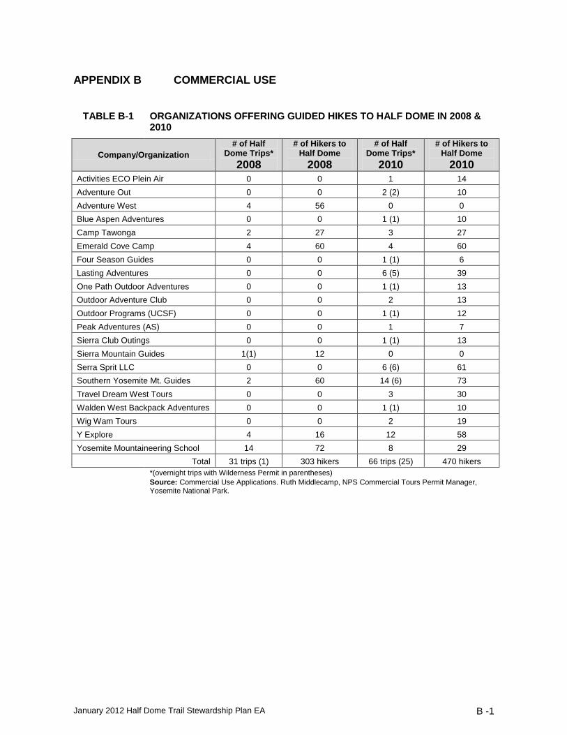
January 2012 Half Dome Trail Stewardship Plan EA B -1
APPENDIX B COMMERCIAL USE
TABLE B-1 ORGANIZATIONS OFFERING GUIDED HIKES TO HALF DOME IN 2008 &
2010
Company/Organization
# of Half Dome Trips*
2008
# of Hikers to Half Dome
2008
# of Half Dome Trips*
2010
# of Hikers to Half Dome
2010
Activities ECO Plein Air 0 0 1 14
Adventure Out 0 0 2 (2) 10
Adventure West 4 56 0 0
Blue Aspen Adventures 0 0 1 (1) 10
Camp Tawonga 2 27 3 27
Emerald Cove Camp 4 60 4 60
Four Season Guides 0 0 1 (1) 6
Lasting Adventures 0 0 6 (5) 39
One Path Outdoor Adventures 0 0 1 (1) 13
Outdoor Adventure Club 0 0 2 13
Outdoor Programs (UCSF) 0 0 1 (1) 12
Peak Adventures (AS) 0 0 1 7
Sierra Club Outings 0 0 1 (1) 13
Sierra Mountain Guides 1(1) 12 0 0
Serra Sprit LLC 0 0 6 (6) 61
Southern Yosemite Mt. Guides 2 60 14 (6) 73
Travel Dream West Tours 0 0 3 30
Walden West Backpack Adventures 0 0 1 (1) 10
Wig Wam Tours 0 0 2 19
Y Explore 4 16 12 58
Yosemite Mountaineering School 14 72 8 29
Total 31 trips (1) 303 hikers 66 trips (25) 470 hikers
*(overnight trips with Wilderness Permit in parentheses)
Source: Commercial Use Applications. Ruth Middlecamp, NPS Commercial Tours Permit Manager, Yosemite National Park.


January 2012 Half Dome Trail Stewardship Plan EA C-1
APPENDIX C DETERMINATION OF EXTENT NECESSARY ON THE HALF
DOME TRAIL
PART 1 INTRODUCTION The vast majority of Yosemite National Park (95%) was designated as federally protected wilderness by the California Wilderness Act of 1984
31. Congress delegated management
responsibility for Yosemite Wilderness to the National Park Service (NPS). In furtherance of its wilderness management responsibilities, the NPS has adopted a trailhead quota system to limit overnight visitation, implemented an extensive educational program to teach visitors how to minimize their impacts, promulgated a variety of specific regulations that mandate low impact practices, and instituted numerous monitoring programs to assess wilderness character and track potential threats to that character. To date, the National Park Service has not completed a Determination of Extent Necessary for commercial services in Yosemite’s designated wilderness. The need for this type of specialized finding has only recently been articulated, stemming from a 2004 decision by the U.S. Court of the Appeals for the Ninth Circuit in the case High Sierra Hikers Association v. Blackwell. In the Blackwell decision, the Ninth Circuit ruled that wilderness managing agencies must complete a specialized finding of necessity prior to authorizing commercial services in wilderness. This finding must be made after considering the extent to which commercial services are necessary to achieve the purposes for which the affected wilderness area was set aside. Congress directed that Yosemite’s wilderness be set aside for recreational, scenic, scientific, educational, conservation, and historical use purposes. This document evaluates the necessity for commercial services for the Half Dome Trail in light of these purposes. The most appropriate framework for completing an assessment of a Determination of Extent Necessary for commercial services in wilderness is in the park’s wilderness management plan, where commercial services will be addressed comprehensively for Yosemite’s entire wilderness. Yosemite National Park has appropriated funding for updating its Wilderness Management Plan, and has begun the initial steps in the planning process. The plan, however, will not be ready for public review for several more years. Rather than await the development of a new Yosemite Wilderness Management Plan, the park has elected to analyze commercial services on the Half Dome Trail at this time and provide the public with an opportunity to comment. PART 2 PURPOSE OF THIS DETERMINATION OF EXTENT NECESSARY AND RELATIONSHIP TO OTHER PLANS The purpose of this document is to determine limits on commercial services on the Half Dome Trail in accordance with the requirements of the Wilderness Act and NPS wilderness management policies. The limits described in this document apply only to the Half Dome Trail above the John Muir Trail junction. It does not apply to technical rock climbing routes on Half Dome. As noted above, the NPS is in the early stages of updating the Yosemite Wilderness Management Plan. Limits adopted in this Determination of Extent Necessary will be revisited as part of the planning process for the Yosemite Wilderness Management Plan, which will determine the extent of commercial services necessary throughout all of Yosemite’s designated wilderness. There will be many opportunities for public involvement in the development of the Yosemite Wilderness Management Plan, including the ability to provide additional input on the amount of
31
California Wilderness Act, Public Law No. 98-425 (1984)

Appendix C: Determination of Extent Necessary
January 2012 Half Dome Trail Stewardship Plan EA C-2
commercial services that should be authorized. While most commercial trips access the Half Dome Trail through the Merced Wild and Scenic River corridor, this Determination of Extent Necessary will not directly limit commercial use in the wilderness sections of that corridor. The Merced River Plan is currently being written and will include a Determination of Extent Necessary for commercial use in the wilderness sections of the corridor. Capacities determined as part of that planning process may affect travel patterns to Half Dome but will not affect the commercial use limits established by this Commercial Services Extent Necessary Analysis. PART 3 LEGAL FRAMEWORK FOR EVALUATING COMMERCIAL SERVICES IN WILDERNESS The Wilderness Act The Wilderness Act was passed in 1964 to “secure for the American people of present and future generations the benefits of an enduring resource of wilderness.”
32 Section 4(c) of the Wilderness
Act explicitly bars “commercial enterprises within designated wilderness areas.”33
An exception to this ban, subject to limitations, is provided for commercial services such as guides and outfitters in section 4 (d) 6, which states that “commercial services may be performed within the wilderness areas designated by this Act to the extent necessary for activities which are proper for realizing the recreational or other wilderness purposes of the areas.”
34 “Wilderness purposes” are defined
in section 4 (b) of the Act as “recreational, scenic, scientific, educational, conservation, and historical use.”
35
The National Park Service has not issued regulations or formal policy guidance outlining the process for authorizing commercial services under Section 4(d) of the Act. However, the U.S. Court of Appeals for the Ninth Circuit has issued several decisions interpreting the restrictions on commercial activities found in Sections 4(c) and (d) of the Act. These decisions have informed the analysis in this Commercial Services Extent Necessary Analysis. In 2003, the Ninth Circuit, in The Wilderness Society v. U.S. Fish & Wildlife Service, examined the overall structure of the Act and found that the Act’s broad mandate to protect wilderness areas was furthered by the prohibition provision found in Section 4(c), which among other things, prohibits commercial enterprises in wilderness. That prohibition, however, is qualified by the introductory language of Section 4(c) which states, “Except as specifically provided for in this [Act] … there shall be no commercial enterprise” within any wilderness area. (Emphasis added.) The exceptions to Section 4(c)’s prohibitions are found in Section 4(d), which is entitled “Special provisions.” Of relevance here is the exception allowing for commercial services. The commercial services exception is limited in scope. Because of the Act’s structure, in which there is a broad prohibition on commercial enterprise in Section 4(c) followed by a list of “special provisions” in Section 4(d), the Court concluded that the exceptions found in Section 4(d) are most properly read as a series of limited and express exceptions to the general prohibition found in Section 4(c) on commercial enterprises in wilderness.
36
In 2004, the Ninth Circuit issued an opinion, High Sierra Hikers Assn. v. Blackwell, interpreting the commercial services exception found in Section 4(d)(6) of the Act. The Court examined the specific language of Section 4(d)(6), and in particular the language stating that commercial services may only be authorized “to the extent necessary,” as well as relationship between
32 Wilderness Act, 16 USC 1131 (a) 33
Wilderness Act, 16 USC 1133 (c) 34
Wilderness Act, 16 USC 1133 (d) (5) 35
Wilderness Act, 16 USC 1133 (b) 36 The Wilderness Society v. U.S. Fish & Wildlife Service, 252 F.3d 1051, 1062 (en banc) (2003)
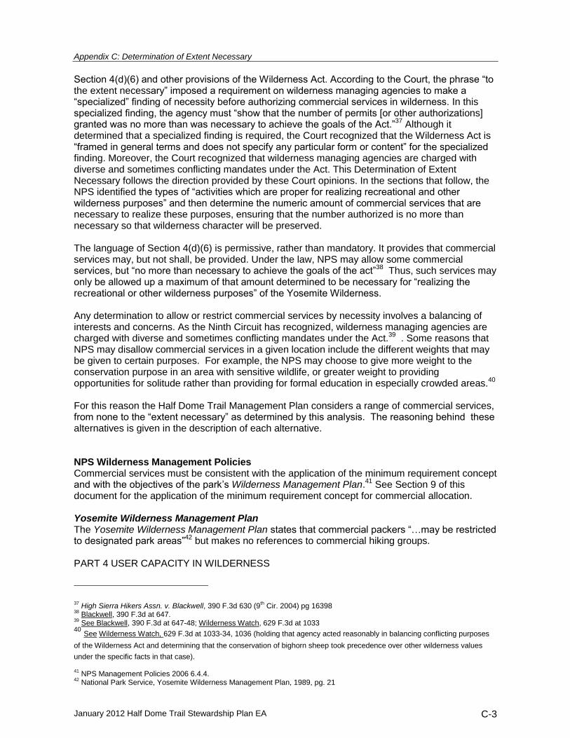
Appendix C: Determination of Extent Necessary
January 2012 Half Dome Trail Stewardship Plan EA C-3
Section 4(d)(6) and other provisions of the Wilderness Act. According to the Court, the phrase “to the extent necessary” imposed a requirement on wilderness managing agencies to make a “specialized” finding of necessity before authorizing commercial services in wilderness. In this specialized finding, the agency must “show that the number of permits [or other authorizations] granted was no more than was necessary to achieve the goals of the Act.”
37 Although it
determined that a specialized finding is required, the Court recognized that the Wilderness Act is “framed in general terms and does not specify any particular form or content” for the specialized finding. Moreover, the Court recognized that wilderness managing agencies are charged with diverse and sometimes conflicting mandates under the Act. This Determination of Extent Necessary follows the direction provided by these Court opinions. In the sections that follow, the NPS identified the types of “activities which are proper for realizing recreational and other wilderness purposes” and then determine the numeric amount of commercial services that are necessary to realize these purposes, ensuring that the number authorized is no more than necessary so that wilderness character will be preserved. The language of Section 4(d)(6) is permissive, rather than mandatory. It provides that commercial services may, but not shall, be provided. Under the law, NPS may allow some commercial services, but “no more than necessary to achieve the goals of the act”
38 Thus, such services may
only be allowed up a maximum of that amount determined to be necessary for “realizing the recreational or other wilderness purposes” of the Yosemite Wilderness. Any determination to allow or restrict commercial services by necessity involves a balancing of interests and concerns. As the Ninth Circuit has recognized, wilderness managing agencies are charged with diverse and sometimes conflicting mandates under the Act.
39 . Some reasons that
NPS may disallow commercial services in a given location include the different weights that may be given to certain purposes. For example, the NPS may choose to give more weight to the conservation purpose in an area with sensitive wildlife, or greater weight to providing opportunities for solitude rather than providing for formal education in especially crowded areas.
40
For this reason the Half Dome Trail Management Plan considers a range of commercial services, from none to the “extent necessary” as determined by this analysis. The reasoning behind these alternatives is given in the description of each alternative. NPS Wilderness Management Policies Commercial services must be consistent with the application of the minimum requirement concept and with the objectives of the park’s Wilderness Management Plan.
41 See Section 9 of this
document for the application of the minimum requirement concept for commercial allocation. Yosemite Wilderness Management Plan The Yosemite Wilderness Management Plan states that commercial packers “…may be restricted to designated park areas”
42 but makes no references to commercial hiking groups.
PART 4 USER CAPACITY IN WILDERNESS
37
High Sierra Hikers Assn. v. Blackwell, 390 F.3d 630 (9th Cir. 2004) pg 16398
38 Blackwell, 390 F.3d at 647.
39 See Blackwell, 390 F.3d at 647-48; Wilderness Watch, 629 F.3d at 1033
40 See Wilderness Watch, 629 F.3d at 1033-34, 1036 (holding that agency acted reasonably in balancing conflicting purposes
of the Wilderness Act and determining that the conservation of bighorn sheep took precedence over other wilderness values
under the specific facts in that case). 41
NPS Management Policies 2006 6.4.4. 42
National Park Service, Yosemite Wilderness Management Plan, 1989, pg. 21

Appendix C: Determination of Extent Necessary
January 2012 Half Dome Trail Stewardship Plan EA C-4
In the Yosemite Wilderness, wilderness character is preserved in part through the use of the trailhead quota system, which limits the amount overnight visitation through the use of a wilderness permit system. In order to preserve wilderness character, NPS must ensure that natural resources are protected from damage that can result from overuse, and that outstanding opportunities for solitude are preserved. The Yosemite trailhead quota system was developed in the 1970s, prior to wilderness designation.
43 The backcountry area of the park was divided into travel zones. For each zone a
capacity was set based on the number of acres and miles of trails and desired sociological densities for campsites and trails. The capacities were then adjusted to protect ecological resources. For example, capacities were adjusted in zones with ecosystems that were rare or vulnerable (such as those with subalpine meadows), or that exhibit fragility or limited resilience following impacts (such as those with alpine meadows). Zone capacities have been adjusted periodically to reflect new or changed scientific findings regarding ecosystem health and the effect of patterns of visitor use on resources. In concert with these zone capacities, the NPS has implemented a trailhead quota system. This type of system requires beginning a trip at a certain trailhead on a certain day, but otherwise does not restrict travel plans. Visitor travel patterns were studied to determine the relationship between the various trailheads and the travel zones.
44 By studying wilderness visitation travel patterns,
managers were able to determine the percentage of visitors to each zone that are attributable to each trailhead. By limiting the number of individuals who may enter the wilderness from a given trailhead on a given day, managers limit the number of visitors to each zone such that the wilderness character of the zone, including both the physical resources and the outstanding opportunities for solitude are maintained in accordance with law. User capacities for day-use have not been established for most of the Yosemite Wilderness. In the House Report that accompanied the Yosemite Wilderness enabling legislation, Congress made it clear that it was appropriate to do so. The National Park Service has implemented various mechanisms and restrictions to guide and control visitor use and protect back country and wilderness type resources, and is admonished to continue to institute such actions in a timely manner as may be necessary to assure the perpetual retention of wilderness resource character and the opportunity for visitors to experience the solitude of wilderness in this type of area system-wide.”
45
The Yosemite Wilderness Management Plan also recognized “…that eventually impact and use monitoring may make day-use permits necessary.”
46 The capacities established by the Half
Dome Trail Stewardship Plan are used to inform the limits on commercial use in this Determination of Extent Necessary Analysis. PART 5 DEFINITIONS Definition of Proper Activities Section 4 (d) (6) only allows commercial services which are “proper for realizing the recreational or other wilderness purposes of the areas.” Not all activities are proper or allowable in wilderness
43 van Wagtendonk, J. W. 1979. A conceptual backcountry carrying capacity model. Proc. 1st. Conf. Sci. Res. in the nat'l. Parks.
USDI, Nat'l. Park Serv. Trans. and Proc. Series 5:1033-1038. 44 van Wagtendonk, J.W., and J. M. Benedict. 1980.Wilderness permit compliance and validity. J. Forestry 78(1): 399-401; van Wagtendonk, J.W., and P. R. Coho. 1986. Trailhead quotas: rationing use to keep wilderness wild. J. Forestry 84(11): 22-24.
45 U.S. Congress, House Report 98-40, pg. 49
46 National Park Service, Yosemite Wilderness Management Plan, 1989, pg. 17

Appendix C: Determination of Extent Necessary
January 2012 Half Dome Trail Stewardship Plan EA C-5
areas. Section 4(c) of the Wilderness Act prohibits public use of motor vehicles, other forms of mechanical transport, motorized equipment, and landing of aircraft.
47 The 2006 Management
Policies provide additional guidance on the types of activities that are proper in park wilderness areas. NPS policy states that recreational uses in wilderness will be of a nature that:
Enables the areas to retain their primeval character and influence;
Protects and preserves natural conditions;
Leaves the imprint of man’s work substantially unnoticeable;
Provides outstanding opportunities for solitude or primitive and unconfined types of recreation; and
Preserves wilderness in an unimpaired condition48
. These restrictions apply equally to commercial and noncommercial public use. In the Yosemite Wilderness, proper activities are those traditionally associated with wilderness recreation, including hiking, backpacking, stock use, rock climbing, photography, nature study, and others. Improper (and illegal) activities include snowmobiling, mountain biking, skateboarding, and others. For a commercial service to be considered, it must first be related to an activity that is proper in wilderness. Therefore, the only commercial services considered in this document are those related to the types of activities found to be proper in Yosemite wilderness. The Wilderness Act directs that wilderness areas be administered “so as to provide…for the gathering and dissemination of information regarding their use and enjoyment as wilderness”
49
The making of films in wilderness is considered proper for realizing the educational and scenic purposes. Definition of Commercial Services Before the National Park Service can determine the types of commercial services that are necessary to further wilderness purposes, the NPS must first determine which services are commercial in nature and which are not. The Wilderness Act does not define the term “commercial service.” When Congress has failed to include definitions of important terms in a statute, agencies may rely on commonly accepted definitions. The word “commercial” is commonly defined as (1) “[o]f or relating to commerce,” i.e., “[t]he buying and selling of goods, esp. on a large scale: business,” (2) “[e]ngaged in commerce,” (3) “[i]nvolved in work designed or planned for the mass market,” or (4) [h]aving profit as a primary aim.”
50 The word “service” is
commonly defined as, “the organized system of apparatus, appliances, employees, etc., for supplying some accommodation required by the public” or “the performance of any duties or work for another; helpful or professional activity.”
51 Activities that are necessary and proper for realizing
wilderness purposes will be evaluated to determine whether they reflect consistent, commonly understood usage of the terms “commercial” and “services.” In addition, the NPS’s determination as to what constitutes a “commercial service” is guided by an analysis of the primary purpose and effect of each service. This further layer of analysis, focused on purpose and effect, is supported by judicial precedent.
52 While some services are conducted
for more than one purpose and may have more than one effect, the focus of the NPS’s analysis is on ascertaining the primary reason for the service. Incidental or subsidiary purposes and effects do not dictate that a service be categorized as commercial.
47
16 USC 1133 (c). 48
NPS Management Policies 2006, 6.4.3. 49
Wilderness Act, (16 USC 1131 (a)). 50
Webster’s II New College Dictionary 225 (1995); accord Merriam-Webster’s Collegiate Dictionary 230 (2000). See Wilderness Society v. U.S. Fish and Wildlife Service, 353 F.3d. 1051, 1061 (9th Cir. 2003) 51 www.dictionary.com. 52 Wilderness Society v. U.S. Fish and Wildlife Service, 353 F.3d. 1051, 1061 (9th Cir. 2003).

Appendix C: Determination of Extent Necessary
January 2012 Half Dome Trail Stewardship Plan EA C-6
For purposes of this document, a commercial service is one that relates to or is connected with commerce wherein work is performed for another person or entity, if the primary purpose is the experience of wilderness through support provided for a fee or charge and if the primary effect is that the wilderness experience is guided and shaped through the use of support services provided for a fee or charge. The form of the organization providing the service is also not dispositive of whether the organization is offering a commercial service, for example whether it is a non-profit or not-for-profit. Rather, the definitions above, including an analysis of the activity’s purpose and effect, will guide a determination of whether a service is commercial or not. Commercial services may be authorized under a number of different legal authorities, using a number of different instruments. Of relevance to designated wilderness areas within Yosemite National park are concession contracts, commercial use authorizations, and special use permits. Authorization Mechanisms for Commercial Services Concessions Contracts and Commercial Use Authorizations: Services authorized under concessions contracts and commercial use authorizations are considered commercial services because the entities holding these authorizations are businesses engaged in commerce, they provide a service to the public, members of the public who use these services experience Yosemite wilderness directly as a result of this commercial support, and employees of the concessioners and CUA holder direct and guide the wilderness experience of the trip participants. CUAs holders who lead either stock or hiking trips are considered providers of commercial services, as are certain park concessioners, which lead stock, hiking, and climbing trips in wilderness. Special Use Permits: Special Use Permits are used to authorize a wide range of activities, many of which are not commercial. Because Special Use Permits are issued on a case by case basis, it is not possible to evaluate all of the different activities that might be requested in a special use permit in advance; however, commercial filming permits (one type of Special Use Permit) are discussed below. When a request for another type of Special Use Permit in wilderness is received, it will be evaluated in accordance with the criteria above to determine whether the activity constitutes a commercial service. If it does, a permit will only be authorized in accordance with the procedures set out below in Section 8. Application of the Purpose and Effect Analysis For the majority of traditional wilderness outfitting and guide services the determination of commerciality is straightforward. The commerciality of some uses is not as clear, however, and those uses are analyzed here. Scientific Research: Scientific research performed by faculty, postdoctoral fellows, or students enrolled in degree-granting programs in accredited colleges and universities or holding appointments with governmental agencies or scientific research institutions, even when accompanied by pack stock support, will typically not be considered commercial. Research trips using pack stock support would normally not be classified as a commercial service trip because the primary purpose and effect of the trip is the enhancement of scientific understanding of park resources, not commercial interests. The NPS will review requests for scientific research permits that involve the support of

Appendix C: Determination of Extent Necessary
January 2012 Half Dome Trail Stewardship Plan EA C-7
commercial outfitters to determine whether the trip is commercial. In the event that a research trip is categorized as a commercial service, it will be allowed in accordance with the procedures set out below in Sections 8.
53
Commercial Filming and Photography: The NPS allows commercial filming and photography in national parks provided that there would not be a likelihood of resource damage, an unreasonable disruption of the public’s use and enjoyment of the site, or a health or safety risk to the public.
54 Filming involves movement or
motion of the subject whereas photography does not. The NPS Management Policies define “commercial filming” as “filming that involves the digital or film recording of a visual image or sound recording by a person, business, or other entity for a market audience.” All commercial filming is subject to permitting requirements, and is limited to projects that are necessary or proper for providing educational information about wilderness uses, resources or values, or necessary for other wilderness purposes. Commercial filming projects dealing mainly with individual athletic achievements in the wilderness are generally not considered necessary for providing educational information about wilderness uses. Still photography is only subject to permitting requirements if it takes place in areas not open to the public, involves the use of models or props that are not part of the location’s existing setting, or requires NPS oversight. Based on the NPS policy cited above, all commercial filming and photography will be treated as a commercial service. Trips by Educational Institutions: Each year, the park receives requests for wilderness trips by student groups from accredited educational institutions which are conducting classes for course credit. These institutions range from elementary, middle and high schools to colleges and universities. The goal of these trips is to provide environmental education to students and to foster self-reliance and other qualities. In some cases, employees of the educational institution guide the trip. In others, the school retains the services of an institution with expertise in environmental education. NatureBridge, a park partner whose mission is environmental education, leads many trips of this type. Trips by accredited academic institutions which give course credit for completion, even if accompanied by Yosemite Institute or a similar organization, are not considered commercial services for the purposes of this Commercial Services Extent Necessary Analysis. The primary purpose and effect of these trips is fulfilling academic goals for the students involved. The students’ experience is guided and shaped by the institution’s academic goals. Support services from environmental education organizations like Yosemite Institute do not change the essential character of the trip, which is academic not commercial. Definition of Wilderness Purposes Recreation All visitors to the Yosemite Wilderness help to realize the recreational purpose. The recreational purpose is realized when people are engaged in proper activities in wilderness. Those activities are described in Section 5.A above. Hiking, backpacking, horseback riding, fishing, climbing, nature study, and mountaineering are just a few examples of the many ways that visitors help to realize this purpose. Yosemite National Park does not allocate capacity to particular wilderness recreational activities.
55
53
Some scientific research could involve a commercial component if it contained an element of “bioprospecting.” Any such proposals will be reviewed for legality under the Wilderness Act and commerciality under the guidelines noted above. 54
U.S.C. §460l-6d.
55 This approach is reaffirmed by a recent district court ruling which stated: “…neither fishing nor any other particular activity is
endorsed by the Wilderness Act, nor is the enhancement of any particular recreational potential a necessary duty of wilderness area management.” High Sierra Hikers Assn. v. U.S. Forest Service, 436 F.Supp.2d 1117, 1144 (E.D. Cal. 2006).

Appendix C: Determination of Extent Necessary
January 2012 Half Dome Trail Stewardship Plan EA C-8
Education While many wilderness visitors are engaged in some type of informal, self-directed education, formal education is also necessary to realize the educational purpose. Examples of formal education that realize the educational purpose of wilderness include, but are not limited to the following: “How to” education on such topics as: Equipment selection Navigation Wilderness first aid Travel and camping skills More advanced “skills” training on such topics as: Rock climbing Mountaineering Backcountry skiing Coursework on wilderness values, ethics or philosophy including: Natural history Human or cultural history Wilderness values Environmental social or political history Environmental philosophy Coursework on scientific aspects of wilderness, such as: Biology Geology Zoology Fire ecology Programs specifically designed to teach people with little exposure to natural landscapes, particularly youth, wilderness skills, including: Self-reliance Survival Independence Physical fitness and agility Mental toughness Problem-solving Adaptability Making of educational films about wilderness, including but not limited to those about wilderness:
56
Wilderness values Natural history Human or cultural history Famous wilderness defenders such as John Muir Endangered species preservation Instructional films covering wilderness skills and techniques
56
Films focused on displaying scenic beauty rather than providing education on a topic may more properly be considered to fulfill the “scenic” purpose described below at Section 5.B.3.

Appendix C: Determination of Extent Necessary
January 2012 Half Dome Trail Stewardship Plan EA C-9
Exception: Leave No Trace training is considered a fundamental prerequisite for all wilderness visitors and as such will not be considered formal education. Scenic Wilderness possesses a particular type of scenery-natural and untrammeled. The scenic purpose is realized when visitors observe the natural landscape of wilderness. It is also realized when people take photographs of scenery and share them with others outside of the wilderness. As with the educational purpose, however, there is a more formal appreciation of scenery that is enjoyed by photographers and other artists. Commercial services provide necessary support for this purpose if they offer photography, painting, or even writing workshops that focus on appreciating and interpreting the scenery. Commercial filming, videography, audiography, and photography also realize the scenic purpose if they focus on wilderness scenery and soundscape. Conservation Conservation means actions that help to maintain the wilderness in a largely natural and untrammeled state, with native biodiversity intact and natural processes uninterrupted. Examples of activities in wilderness that help to realize the conservation purpose include, but are not limited to:
Ecological restoration projects
Trail building and maintenance
Species preservation activities
Eradication or removal of non-native invasive species Realizing the conservation purpose is primarily an agency responsibility. Occasionally a visitor group conducts a “service trip” that includes conservation work. In Yosemite, however, these groups are not able to work independently of NPS control and supervision. They are designated as volunteers. If the primary purpose of the service trip is that of learning through participation in the service activity rather than that of constructing, implementing or maintaining the conservation project, itself, then the purpose and effect is non-commercial. Historic “Historic uses” are defined as those uses which emphasize the wild, untrammeled, and natural character of the land in its historic state. Visitors help to realize the historic purpose when they encounter the land as did those of earlier historical periods. The historic purpose is realized by maintaining the wilderness character of the land, by primitive recreation in the wilderness, by the provision of opportunities for solitude, and by enjoying the scenic wonders of the natural and untrammeled landscape. The realization of this purpose is consistent with the realization of the conservation and recreational purposes. The courts have directly addressed the meaning of “historic uses” as used in the Wilderness Act, and have uniformly construed “historic use” to mean use of the primeval or ancient wilderness in its natural state. The U.S. Court of Appeals for the 11th Circuit found that “the only reasonable reading of “historical use” in the Wilderness Act refers to experiencing the natural, rather than manmade, features.”
57 This decision was followed by the district court in Olympic Park v.
Mainella, which held that: The National Park Service references the historic pattern of shelter construction and recreational
57
Wilderness Watch v. Mainella, 2004, Olympic Park Associates v. Mainella, 2005 WL 1871114 (D.Wash. 2005)

Appendix C: Determination of Extent Necessary
January 2012 Half Dome Trail Stewardship Plan EA C-10
use in concluding that the “setting, association, and feeling are significant aspects of historic use within the park” (AR 416-17), but while this may be true, this type of usage is in the past and a new value has been placed on the land by the creation of the Olympic Wilderness....a different “feeling” of wilderness is sought to be preserved for future generations to enjoy, a place “where the earth and its community of life are untrammeled by man” and which retains “its primitive character and influence.”
58
Thus, “historic use” refers to preserving the wilderness character of the land so that each visitor may encounter it in its historic state, as undeveloped as it was when the first humans experienced it. No commercial services are necessary for the realization of the historical purpose because its realization is congruent with the realization of the conservation purpose. Scientific The natural and untrammeled qualities of wilderness make an area valuable to science. Realizing the scientific purpose means allowing scientific research and monitoring to take place in wilderness. Unlike conservation activities, scientific activities fall on a spectrum from administrative to independent: Some are conducted by the agency, some are conducted by academics but sponsored or overseen by the agency, and some are conducted by independent academics or graduate students. Research conducted by or for the NPS is considered administrative, not commercial. On rare occasions an independent researcher might require commercial services to pack in supplies. However as discussed above in Section 5, the incidental use of pack services to support a research trip typically would not convert a research trip into a commercial service. In the Yosemite Wilderness, research is reviewed by an interdisciplinary permit committee and limited though a process articulated in An Interagency Framework to Evaluate Proposals for Scientific Activities in Wilderness.
59 This framework, including the application of the minimum
requirement concept, provides methods to quantify the impacts and benefits of research, compare costs and benefits, and prioritize research proposals. PART 6 COMMERCIAL SERVICES EXTENT NECESSARY ANALYSIS This section describes the methods used to determine limits on commercial services on the Half Dome Trail. As noted above, no commercial services are needed for the realization of the historic, scientific, or conservation purposes. All proposed commercial trips in wilderness will be assessed to see which purposes they fulfill (see section on the application process, below). The geographic scope of the Half Dome Trail Stewardship Plan constitutes only a small part of the Half Dome wilderness management zone, which has an established capacity of 25 people per night. The summit of Half Dome is closed to camping to protect the Mt. Lyell Salamander and other natural features. As a result, there is only one reasonable camping area within the scope of this plan, on the shoulder of Half Dome. Only a tiny percentage of Half Dome hikers use this camping area. For the purpose of this Commercial Services Extent Necessary Analysis, no separate commercial allocation will be made for overnight use of this area. Commercial use on the Half Dome Trail will be limited and regulated in the same manner for day hikers, those camping in other wilderness zones such as Little Yosemite Valley, or those camping on the shoulder of Half Dome. The preferred alternative for the Half Dome Stewardship Plan identifies 300 people per day as the capacity for the Half Dome Trail. This capacity is used in this Commercial Services Extent Necessary Analysis.
58
Olympic Park Associates v. Mainella, 2005 WL 1871114 (D.Wash. 2005) 59 See Landres, P., Fincher, M., Sharman, L., et al, An Interagency Framework to Evaluate Proposals for Scientific Activities in Wilderness, 2009 at wilderness.net/toolboxes.

Appendix C: Determination of Extent Necessary
January 2012 Half Dome Trail Stewardship Plan EA C-11
Recreational Purpose Under the Wilderness Act, the NPS may only authorize commercial services in wilderness if they are necessary to realize wilderness purposes. Webster’s Dictionary defines “realized” as “to bring into concrete existence.” In the case of Half Dome, commercial services are not necessary to realize the recreational purpose as non-commercial visitors consistently fill the area to capacity.
60
Educational Purpose The educational purpose is considered realized when there are opportunities for both informal and formal education taking place in the wilderness. Informal education is self-directed learning available to all wilderness visitors. The realization of the “informal” component of the educational purpose can be considered as numerically congruent with the realization of the recreational purpose: All those who are recreating are in some way engaged in informal education. Directed, formal education is also a proper activity in wilderness and also realizes the educational purpose. Formal education presented by a qualified instructor can promote a deeper, more comprehensive understanding of wilderness related subjects. An allocation of 10% of capacity (30 people per day) is necessary to ensure that there is sufficient opportunity for formal education and classes, including the making of educational films. The percent of capacity allocated to formal education is small for a number of reasons:
The educational purpose is largely being realized through informal education
NPS Management Policies directs that “. . . the service will, to the extent practicable, afford visitors ample opportunity for inspiration, appreciation, and enjoyment through their own personalized experiences-without the formality of program or structure.”
61
Commercial educational use will displace noncommercial use. Under the overall structure of the Wilderness Act, denial of access to noncommercial visitors in favor of commercial visitors should be minimized. In the case of Half Dome, the demand for access far exceeds the capacity, so noncommercial visitors are already being denied access in large numbers.
Classes offered by accredited schools for which students receive academic credit are not considered commercial and are not restricted by this allocation (see Part 5.) Trips featuring formal education on wilderness topics conducted by noncommercial entities such as the NPS, and accredited schools, colleges, and universities conducting classes for academic credit are also realizing the educational purpose, and will first be subtracted from that 10% of capacity. Currently, information about this type of use is incomplete, but such use appears to be negligible. Therefore the full 10% will be allocated for commercial groups that provide formal Education. Noncommercial educational use will be monitored and the percentage allocated to commercial groups adjusted accordingly when commercial use limits are recalculated (see Part 9.) Scenic Purpose All visitors are engaging in informal appreciation of wilderness scenery, as are individuals located outside of wilderness who are looking in from a road or other developed area. Formal appreciation of wilderness scenery, such as art and photography workshops, can foster a more structured understanding of scenery and is also necessary to realize a purpose of the Wilderness Act. An allocation of 5 % of capacity (15 people per day) is necessary to ensure that there is sufficient opportunity for formal appreciation of wilderness scenery, including the making of films that focus on wilderness scenery. The percent of capacity allocated to formal appreciation of scenery is small for a number of reasons:
60
2010 Half Dome Trail Visitor Use Monitoring Study 61
NPS Management Policies 2006 8.2

Appendix C: Determination of Extent Necessary
January 2012 Half Dome Trail Stewardship Plan EA C-12
The scenic purpose is largely being realized through informal appreciation, both inside and outside of wilderness
Policy guidance, noted above, that directs that non-formal opportunities be “ample.”
Commercial scenic use will displace noncommercial use. Under the overall structure of the Wilderness Act, denial of access to noncommercial visitors in favor of commercial visitors should be minimized.
Art and photography classes offered by accredited schools for course credit are not considered commercial and are not restricted by this allocation (see Part 5.) Trips featuring formal appreciation of scenery conducted by noncommercial entities such as the NPS, and accredited schools, colleges, and universities conducting classes for academic credit are also realizing the scenic purpose, and will first be subtracted from that 5% of capacity. Currently, this type of use is negligible, so the full 5% will be allocated for commercial groups that provide formal scenery appreciation. Noncommercial scenic use will be monitored and the percentage allocated to commercial groups adjusted accordingly when commercial use limits are recalculated (see Part 9.) PART 7 DETERMINATION OF EXTENT NECESSARYFOR THE HALF DOME TRAIL Commercial trips which only realize the recreational purpose of wilderness are not allowed on the Half Dome Trail. Commercial trips which realize the educational purpose will be limited to up to 30 people per day (including guides). Commercial trips which realize the scenic purpose will be limited to up to 15 people per day (including guides). In order to maximize opportunities of noncommercial hikers, commercial trips will be limited to two per day. PART 8 THE COMMERCIAL USE ALLOCATION PROCESS (For Preferred Alternative)
62
Half Dome Permit Distribution See descriptions in the alternatives for permit distribution methods. Application process for Commercial Services Implementation of this Determination of Extent Necessary will be integrated into Yosemite’s CUA and SUP application procedures and concession management operations. All entities, including concessioners, CUA holders, and SUP holders desiring to provide commercial services on the Half Dome Trail shall do the following: The concessioner, CUA, or Special Use Permit holder must submit a proposed trip itinerary to the Yosemite Wilderness Office once they have clients with valid Half Dome permits. The itinerary must be received prior to any trip entry into the park. The itinerary must provide a schedule of planned trips. For overnight trips, the itinerary must include the dates, point of entry and exit, each night’s camping location, and the group size (including employees). Day trips must include the date, group size, trailhead, and destination. In addition, the applicant must submit an explanation of the manner in which the proposed commercial trip meets the educational or scenic purposes, along with copies of, or internet links to, all advertising and other promotional materials related to that trip and submit an educational syllabus for the trip and documentation showing that employees are trained and qualified to provide such education. Only 30 people (clients plus guides) will be allowed per day for trips meeting the educational purpose; only 15 people per day (clients plus guides) will be allowed for trips meeting the scenic
62
Each of the action alternatives has a different allocation option for commercial use. Part 8 of this document is only for the preferred alternative.

Appendix C: Determination of Extent Necessary
January 2012 Half Dome Trail Stewardship Plan EA C-13
purpose. A maximum of two commercial trips per day will be allowed. The Minimum Requirement Concept By policy, the National Park Service must apply the minimum requirement concept to decisions about commercial use in wilderness.
63 The minimum requirement concept is a two part process
that determines “if administrative actions, projects, or programs undertaken by the Service or its agent and affecting wilderness character, resources, or the visitor experience are necessary, and, if so how to minimize impacts.”
64
Part of a minimum requirement decision is determining whether an activity is wilderness dependent. Wilderness dependence as used here means that if the activity can occur outside of wilderness with little loss of value, it should not take place in wilderness. The wilderness dependence criteria will be used during the application screening process. Commercial trips whose primary purpose is teaching a subject that is not wilderness dependent will be treated as recreational (and therefore not allowed on the Half Dome Trail) rather than educational. Compliance Wilderness Rangers routinely check on commercial trips in the field to assure compliance with park regulations. An assessment of the extent to which a commercial service provider has met its objective with respect to satisfaction of wilderness purposes will be added to the CUA contact form, for example to evaluate the claim that wilderness education is being provided by qualified personnel. Failing to provide promised educational or scenic opportunities may be grounds for limiting a commercial service provider’s ability to provide future commercial trips in the Yosemite Wilderness. PART 9 THE REASSESSMENT PROCESS The limits on commercial use imposed by this plan will be recalculated when significant changes in use patterns occur. The National Park Service has taken the initial steps of rewriting the Yosemite Wilderness Management Plan which will include a Determination of Extent Necessary for the entire wilderness. At that time both visitor use patterns and the Determination of Extent Necessary methodology will be reevaluated.
63
NPS Management Policies 2006 6.4.4 64
NPS Management Policies 2006 6.3.5


January 2012 Half Dome Trail Stewardship Plan EA D-1
APPENDIX D MINIMUM REQUIREMENT ANALYSIS FOR THE HALF DOME TRAIL
Law, Policy, and Plans The Wilderness Act directs that wilderness areas “be administered for the use and enjoyment of the American people in such manner as will leave them unimpaired for future use and enjoyment as wilderness….”
65 National Park Service Policy requires that “All management decisions affecting
wilderness must be consistent with the minimum requirement concept.”66
Management Policies also provides specific guidance on trails: Trails will be permitted within wilderness when they are determined to be necessary for resource protection and/or for providing for visitor use for the purposes of wilderness…Trail maintenance structures (such as water bars, gabions) may be provided, under minimum requirement protocols, where they are essential for resource preservation or where significant safety hazards exist during normal use periods.
67
The Half Dome Trail meets these criteria. The lower part of the trail prevents erosion by concentrating use into a single corridor that is maintained to minimize soil loss. The upper part of the trail provides access to the most popular location in the Yosemite Wilderness and thus helps realize the recreational purpose of wilderness listed in section 4 (b) of the Wilderness Act. The water bars, walls, and other maintenance structures on the lower part of the trail are essential for resource protection while the steps and cables on the upper part of the trail help mitigate the safety hazards on the upper part of the trail and provide for visitor use. The Yosemite Wilderness Management Plan (WMP) limits facilities to those “currently present or specifically proposed in this plan.”
68 It specifically includes both trails and safety railings as existing
facilities, and lists nine railings as well as the Half Dome cables, which it calls “a form of railing.”69
The plan also specifies that “Barring unusual weather or snowpack, the Half Dome cables will be in operation prior to the Friday of Memorial Day weekend each season and will not be taken down before the second week in October.”
70 Motorized tools used for routine trail maintenance are limited to those listed in
Appendix B of the WMP. The minimum requirement for trail maintenance and other administrative activities will be reconsidered when the WMP is rewritten. Scoping for a new WMP is scheduled for Fall of 2012. Minimum Requirement Analysis Management action is needed to address unacceptable impacts to wilderness character due to crowding on the Half Dome Trail. Three major decisions are analyzed: Whether or not to remove the Half Dome cables, whether or not to limit use with a permit system, and, if so, to what number of visitors. The Alternatives for the Environmental Assessment were developed using wilderness character as the primary consideration for feasibility and range. They will therefore be used as alternatives for the minimum requirement analysis as well. To determine the minimum requirement, these decisions are considered using wilderness character and access as criteria, following the guidance noted above. The impact analysis presented in chapter three will not be repeated here; only the rationale for the determination of the minimum requirement based on the chapter three analyses of those two topics. Alternative A (No Action) Alternative A does not preserve wilderness character because the impact to opportunities for solitude is at an unacceptable level for designated wilderness. This impact greatly outweighs the beneficial effects of unregulated day-use and recreational access for large numbers of people. Alternative E Under this alternative, the cables are removed and day-use access is unregulated at expected use levels. While there is a beneficial effect to the undeveloped and natural qualities, and better opportunities for solitude, these benefits are outweighed by the substantial reduction in access to the most popular location in the Yosemite Wilderness for the vast majority of visitors (those without technical climbing skills.) Alternatives B, C, and D These alternatives negatively affect the unconfined quality by regulating day-use through a permit system. They reduce access but protect opportunities for solitude (at different levels.) The undeveloped quality remains the same as at present, but the natural quality improves slightly as use levels decrease. Minimum Requirement Determination Alternative C, which allows 300 hikers a day to use the Half Dome Trail, is the minimum required
65
Wilderness Act, 16 USC 1131 (a) 66
National Park Service Management Policies 2006 6.3.5 67
National Park Service Management Policies 2006 6.3.10.2 68
Yosemite Wilderness Management Plan, 1989, page 14. 69 Yosemite Wilderness Management Plan, 1989, pages 14 and 87 70
Yosemite Wilderness Management Plan, 1989, page 34

Appendix D: Minimum Requirement Analysis
January 2012 Half Dome Trail Stewardship Plan EA D-2
management action to preserve wilderness character and preserve recreational access. The negative effect on the unconfined quality of wilderness character because of the additional regulation of a permit system is outweighed by the beneficial effect to opportunities for solitude. Access provided by the trail is maximized to the extent possible without unacceptable impacts to solitude. In addition, there are beneficial effects to the natural quality due to reduced visitation. Minimum Tool Determination As noted in “Actions common to all alternative” and “Actions Considered but Dismissed” in Chapter Two, the permit system would require both education and enforcement. Demand for Half Dome permits is so much higher than supply that Rangers on scene checking permits, as well as other educational efforts, are the minimum tool for implementing Alternative C.