hamilton (2014) - vacant infill and greenfield map.pdf
TRANSCRIPT
GIS - PLANNING & ANALYSISPLANNING AND ECONOMIC DEVELOPMENT DEPARTMENT
Source Date:
0 1 2
Kilometers
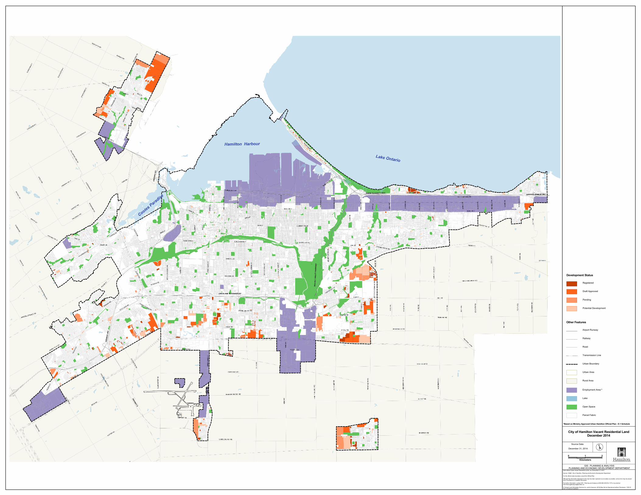
City of Hamilton Vacant Residential LandDecember 2014
Data reflects Urban Vacant Residential Lands, as of December 31, 2014.
Source: CHMC, City of Hamilton, Planning and Economic Development Department.
For the official urban boundary consult the Official Plan.
Although the information displayed in this map has been captured as accurately as possible, some errors may be presentdue to insufficient or outdated information.
For further information, contact GIS - Planning and Analysis at 905-546-2424 Ext 1272 or by email at:GIS-Planning&[email protected]
© Teranet Land Information Services Inc. and its licensors. [2014] May Not be Reproduced without Permission. THIS ISNOT A PLAN OF SURVEY
December 31, 2014
Development Status
Registered
Draft Approved
Pending
Potential Development
Other Features
Airport Runway
Railway
Road
Transmission Line
Urban Boundary
Urban Area
Rural Area
Employment Area *
Lake
Open Space
Parcel Fabric
*Based on Ministry Approved Urban Hamilton Official Plan - E-1 Schedule

Planning Single Detached Semi-Detached Townhouse Apartment City TotalStatus Units Area (ha) Units Area (ha) Units Area (ha) Units Area (ha) Units Area (ha)RegisteredAncaster 127 8.0 0 0.0 41 0.9 0 0.0 168 8.9Dundas 14 0.8 2 0.2 0 0.0 74 0.3 90 1.3Flamborough 15 0.7 4 0.1 5 0.1 0 0.0 24 0.9Glanbrook 442 16.4 0 0.0 314 7.0 140 0.8 896 24.2Hamilton 196 7.9 4 0.2 117 2.8 80 1.1 397 12.0Stoney Creek 211 9.1 0 0.0 465 8.6 260 2.3 936 20.0Total 1,005 42.9 10 0.5 942 19.4 554 4.5 2,511 67.3
Draft ApprovedAncaster 408 18.8 108 3.0 244 6.0 260 3.3 1,020 31.1Dundas 3 0.2 0 0.0 0 0.0 0 0.0 3 0.2Flamborough 891 33.5 434 10.6 738 10.6 1,396 8.1 3,459 62.8Glanbrook 714 31.5 0 0.0 325 8.3 0 0.0 1,039 39.8Hamilton 796 40.7 106 2.8 425 8.8 1,083 6.1 2,410 58.4Stoney Creek 197 8.6 114 3.2 818 19.0 474 4.9 1,603 35.7Total 3,009 133.3 762 19.6 2,550 52.7 3,213 22.4 9,534 228.0
PendingAncaster 218 15.9 0 0.0 89 3.1 0 0.0 307 19.0Dundas 0 0.0 0 0.0 12 0.3 0 0.0 12 0.3Flamborough 224 6.7 0 0.0 460 9.5 750 16.5 1,434 32.7Glanbrook 691 23.8 0 0.0 1,166 16.6 0 0.0 1,857 40.4Hamilton 232 9.3 0 0.0 349 8.4 105 0.2 686 17.9Stoney Creek 588 20.0 0 0.0 931 15.4 191 2.0 1,710 37.4Total 1,953 75.7 0 0.0 3,007 53.3 1,046 18.7 6,006 147.7
Potential DevelopmentAncaster 358 22.1 32 1.1 214 4.3 153 1.3 757 28.8Dundas 60 4.1 2 0.1 15 0.7 0 0.0 77 4.9Flamborough 214 8.1 0 0.0 0 0.0 287 2.4 501 10.5Glanbrook 782 31.4 135 4.5 336 8.4 26 0.4 1,279 44.7Hamilton 642 32.4 4 0.2 220 3.9 111 1.5 977 38.0Stoney Creek 932 34.2 2 0.1 598 11.7 73 0.9 1,605 46.9Total 2,988 132.3 175 6.0 1,383 29.0 650 6.5 5,196 173.8City Total 8,955 384.2 947 26.1 7,882 154.4 5,463 52.1 23,247 616.8
Source: CMHC, City of Hamilton, Planning and Economic Development DepartmentNote: Data derived from the City of Hamilton Land Use layer containing various assumptions. Although the data has been captured as accurately as possible, some errors may be present due to insufficient or outdated information.
Vacant Residential Land Area & Unit Potential, December 2014