harappa excavations · harappa excavations 1986-1990 . a multidisciplinary approach to third...
TRANSCRIPT

Harappa Excavations 1986-1990
A Multidisciplinary Approach to Third Millennium Urbanism
Edited by Richard H. Meadow
Monographs in World Archaeology No.3
•. PREH I STORY PRESS . Madison Wisconsin
b

4
Urban Process in the Indus Tradition: A Preliminary Model from Harappa
Jonathan Mark Kenoyer ';
University of Wisconsin-Madison ; i I
~i ! Excavations on two of the major mounds at Harappa have revealed traces of an early settlement, a transitional:1
phase ofdevelopment, and several phases of full urban and post-urban occupation. Although there is acontinuity ofoccupation, evidence for settlement growth and changes in organization reveal a dynamic process ofcity development. The segregation of specific crafts and occupations, the availibility of new and exotic raw materials, the
I construction of massive perimeter walls and entrances, and the maintenance of civic structures provide a new perspective on the nature ofan Indus city. A preliminary model is presented for the development ofHarappa as aI city in the wider context of the Indus Tradition.
I n studying the earliest urban settlements of South Asia, we do not have written documents that describe the structural and social organization of a
city. Consequently, our understanding of the urban process is often quite sketchy. The extensive archaeo
I1 logical excavations of the large urban centers of
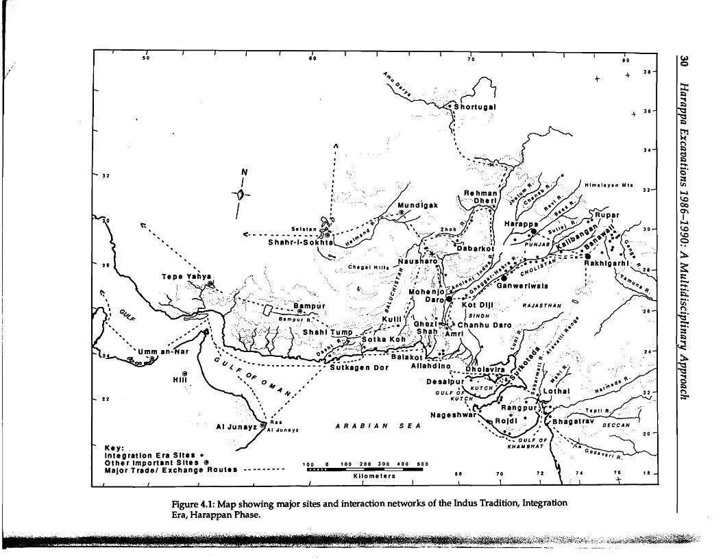
Harappa and Mohenjo-daro (Figure 4.1), carried out in the 19205 and 19305, provided a remarkable
t: glimpse of a previously unknown civilization, but
I I little was discovered about its origin, growth, and
internal organization. Subsequent excavations at these and other third millennium sites in the region have been undertaken to obtain additional details on the urban phenomenon of the Indus Tradition.
The observations and interpretations from these excavations, however" have been based on general impressions and, with a few exceptions, were not supported by the publication of detailed stratigraphic sections, plans, or artifact distribution analyses. As a result, it is difficull to critically assess many of the initial interpretations. Because of these problems, new excavations are needed at all of the previously excavated sites. Through the cooperative agreement between the Government of Pakistan, Deparbnent of Archaeology and Museums, and the University of California, Berkeley, it has been possible to open new
29
excavations at the important site of Harappa (District Sahiwal, Punjab, Pakistan: Figure 4.2).
Major objectives in these recent excavations at Harappa have been to collect data that were overlooked in previous large scale horizontal excavations, specifically those data relating to the growth and dynamics of this early urban center. By combining the new information with general observations from extensive horizontal exposures made in the past, it is possible to better understand the location of Harappa, why and how the settlement grew and expanded, and how the city was organized.
In this paper I present a brief summary of the findings from the first five years of the current excavations at Harappa and a preliminary model for conceptualizing the growth of Harappa as a city. The value of such a model is that it allows more specific comparisons within the Indus region and West Asia and helps to define and direct future research.
Harappa as Known from Previous Excavations
Prior to the current excavations at Harappa, major research at the site was conducted by M.S. Vats from 1926-1934 (1928-29, 1940), K.N. Shastri during the late
! /
1\
,••
N ••I •
I,•
-O- .".:.' .
f •
~ ~~ .. Sel, .. " ~_ .. <. - - - - - - - - - - - -)J@ 1- .\~" .. S hahr.I-Sokhta~ .. .. .. :,-~.......:;;.. ..
Chilli' HIIII
; \ .... . . ,,' 6\
...~:::.
@J' HIli ,,
, " ,,, RI' ARABIAN SEA
AI Junl yz
Key: , Integration Era Site. • Other Important Site. ~ 100 100 200 300 400 500 MajOr Trade' Exchange Route. -- -- -- --
~80 C>
384+ ~ ~
36 I~-\~
t'T'J
£ ~
34
~ ..... 6· ;:s (I)HlmlllYln Mil
32 Io-l (.0 00 0"'1 I
Io-l (.0 (.0 c
~ ~ ~
2 ~ ~
Figure 4.1: Map showing major sites and interaction networks of the Indus Tradition, Integration Era, Harappan Phase.
"'i,,, ~';:r J:',.'L_~_ :.:.·~~J.~. '-·:~T,.....~.~ _':'·,,-'::..·.·i,·,;.. ....~... ::.:
~~~;.i1;:f~~:~,::~9;f~{i:~vtJ~~~ ..~~~~:~,.::%;,~}~4~~~*.~;:.

/I"
/
N1800
N1SOO
N1400
N1200
N1000
N
t
® u.c. Berkeley Excavations: 1988-1990 Operation 1: cemetery ~
Operation 2: Mound AS ~ Operation 3: Mound E Previous Excavations r--;J
.. __ J
o 200 met.,.100
N1800
N1600
N1400
N1200
N1000
~ ~ ;:s
ti ~
~ ~ (I) (I)-.::::c
~ ~ -;:s""""'"~ ;: (I)
~
-.--.~o ::::c.. ~ ~
~-§.-.;:s ~ ""'t
~ Ioo-ol
Figure 4.2: Harappa 1990 site plan showing extent of excavations.

32 Harappa Excavations 1986-1990: A Multidisciplinary Approach
19305 (unpublished), R.E.M. Wheeler in 1946 (1947), and M.R. Mughal in 1966 (1968). In the context of this presentation, it is important to summarize the important contributions and clarify the interpretations presented by these earlier excavators. Other excavations have been made at Harappa, but they are still unpublished, and little is known about their results. (See Possehl, Chapter 2 in this volume.)
M.S. Vats
The first major excavations at Harappa were carried out by M.S. Vats. He (and his superior officers) proposed an internal chronology of the site based on his own work and the results of earlier small scale excavations conducted in 1921-1925 by D.R. Sahni. The classification of artifacts, internal chronology, and absolute dating of Harappa were' all based on general correlations with Mohenjo-daro, which was being excavated simultaneously. Although the proposed dates are no longer valid, the internal relative chronology that was proposed for Harappa is still important for comparative purposes (Table 4.1).
The overall chronology of the site was divided into Early, Intermediate, and Late periods, and the major levels or strata of discrete excavation units were correlated to these period designations. In this manner, stratum III from Mound F, Trench IV, was attributed to Late Period Ill, while stratum III from Area J was attributed to Intermediate I.
It is quite clear that Vats and his colleagues were not using a carefully structured systematic method for establishing the relative chronology. Nevertheless,
general correlations were made on the basis of an extensive knowledge of artifact types and careful observations of artifacts found in the major levels. In some contexts artifacts were carefully collected using small excavation knives and sieves (Vats 1940:58). Absolute levels of the strata were not considered as particularly relevant, and in several contexts Vats (1940:135) emphasizes that, although walls or artifacts were found at low levels, they are in fact derived from later periods. Vats also was concerned with the mixing of artifacts due to brick robber trenches and to the ancient Harappan practice of using older cultural material as filling in floors, foundations, and platforms. He paid careful attention to the mixing of larger seals in strata that contained the tiny seals and sealings (Vats 1940:120).
The overall relative chronology was based on general observations of specific artifact types that came to be identified as chronological markers. These artifacts included ceramics, figurines, and seal types. The most important in this discussion are the "tiny seals and sealings" and terracotta toy figurines of archaic type, which were invariably found in the lower levels of the excavations (Figure 4.3). In order to differentiate the "tiny seals and sealings" from actual intaglio seals and seal impressions, they here will be referred to as "steatite and faience tokens." The steatite tokens are incised in positive while the faience tokens are made in a mold or bear seal impressions.
Vats (1940:3) estimated that the site of Harappa spread over an area some 3.5 miles "in circuit." If calculated as a square, this would enclose approximately 198 hectares or as a circle, 252 hectares. Our
Table 4.1. General stratigraphy adapted from Vats (1940:9-10).·
Mohenjo-daro" Harappa MoundF MoundAB AreaJ AreaG CemeteryH
Period Strata Strata Strata Strata Strata Late (2750-3050 Be) (2750-3050 Be) (2850-3050 Be) (2700-2800 Be) (2000-2500 Be) I I I(slightly later) I I I II II II II II II III III III (N) N Intermediate (3QSO-3SOO Be) (before 3050 Be) (before 3OSO Be) (32SOBe) I N V III III II V VI N III VI (N) . VII
Early (1st 1/2 4th mil.) I VIII II III ·Dates are those quoted by Vats (1940:9-10). ·"'This periodization for Mohenjo-daro is based on Marshall (1931) but modifications were proposed by Mackay (1938:xiv).

Urban Process in the Indus Tradition: A Preliminary Model from Harappa 33
.. ' ........ • _ I'... .... · -'.. . .....:.": ,," "" : . ". ,. ",,' .. ~ ",J •
.".. .. .'.- .: ... I . . ... .. . ... :""' ,::-: '::": '\.'f· ! .... ~ ~f&. ;-.."I
A
O~ ··· &D. ~ •.'. I '0. 0'· •
-." ~.i\l AB Iv ffH] c
Figure 4.3: Harappa Figurines and Tokens: A. Examples of figurines with legs joined (from Vats 1940:Plate LXXIX, 61, 62, 63, 64); B. Examples of incised. steatite tokens, Harappa 1990, Period 3B; C. Examples of faience tokens, Harappa 1990, Period 3B. (See Figures 13.44 and 13.46 in this volume.)
current estimate is that the site was at least 150 hectares in area (Dales and Kenoyer 1989a).
Vats and his predecessors excavated in five major areas: Mound F in the northwest; Mound AB, Area J, and Area H (all to the south of Mound F); and Area G on the southeastern perimeter of the mounded areas (Figure 4.2). Mound E and modem Harappa town were examined, but no major excavations were conducted in those areas.
Natural soil and the water table were reached on Mound F in Trench I. There, the lowest"level of Harappan occupation consisted of a drain made of baked brick built on top of undisturbed soil (3 feet thick), "and then followed by a deposit of sand which has been cut through for another 7 ft. where the level of sub-soil water has been reached" at a depth of 35 feet below surface (Vats 1940:97). Two other deep diggings were ma~e, one in Trench IV of Mound F and the other in Area J to the south of Mound AB. Although Vats did not reach natural soil or the water table in these trenches, he did note that the cultural material was Harappan. The precise elevations of these deep diggings have not been calculated due to the absence of datum points and the fact that the present surface is totally modified.
In all three of these trenches, Vats notes the presence of steatite and faience tokens in the lower levels. In the lowest levels he notes the presence of archaic terracotta bull figurines (Vats 1940: PI. LXXXIX, 62) (Figure 4.3), which have the two front and two back legs joined together. In later figurines all four legs are separate.
On the basis of these artifacts and similarities in ceramics, Vats suggests that the occupations in both Area J and Mound F were contemporaneous and represent the earliest habitation of the city, while the massive height of Mound AB represents a later period of ety growth that was accompanied by construction of extensive mud-brick fillings or foundations. These mud-brick structures are visible around the entire circumference of Mound AB, and Vats (1940:7) suggested that they were constructed primarily to protect the city from floods.
In terms of city layout and organization, Vats was greatly hampered by the fact that most Harappan baked brick structures had been removed by brick robbing. This disturbance extended up to two meters below the surface in most areas, and some tunneling reached deep inside the mound. Consequently, few complete structures were identified, although Vats
,_,,,",'..' _ i

Urban Process in the Indus Tradition: A Preliminary Model from Harappa 35
and hoards of jewelry and copper-based implements were found in the vicinity of the kiln and working platfonn areas of Mound F. These hoards have been interpreted as stock piles maintained by artisans, rather than as the hidden wealth of private individuals. Unfortunately there is little detailed documentation of the location of specific artifacts and manufacturing areas, and it is impossible to detennine their precise association. For example, the widespread distribution of seals may well be the result of postdepositional disturbances such as erosion and founda tion filling rather than an accurate representation of where they were being used.
In sum, upon careful review of the published record, the excavations by Vats do not provide the kind or quality of evidence necessary to demonstrate whether or not craft activities were being carried out in segregated areas of the city, even though this has been assumed by many scholars (e.g., Wheeler 1947, 1968; Piggott 1950).
R.E.M. Wheeler
Wheeler (1947) opened the second major excavation of the inhabited areas of Harappa in 1946. In addition to his concern about the stratigraphic relationship between cemetery areas Hand R37, his goals were to ascertain the presence or absence of a city wall on Mound AB and its relationship to the general stratigraphy of the site .as proposed by Vats (1940:64).
Wheeler made ten trenches at isolated points around the southern, western, and northern edges of Mound AB. The largest of these trenches reached to natural soil and cut through a massive mud-brick structure that fonned the western edge of the mound. In all of the other isolated and unconnected test trenches, he encountered massive structures of mudbrick and remnants of baked brick facings that were invariably on the outside surface of the mud-brick structures. The baked brick facings were between one and two meters thick and were generally battered, slanting up towards the top of the mound.
In most of these trenches more than one phase of construction was identified (Wheeler 1947: 64-65). The initial building of the mud-brick rampart was followed by extensive erosion and weathering. Subsequently, the structure was rebuilt and reinforced with mud-brick and/or baked brick facings. Overall, three major periods of construction were identified. All of these apPear to fall within the Harappan occupation, although Wheeler does not specifically correlate his periods with the sequence established by Vats.
In one of the trenches along the western edge of the mound, Wheeler identified a large concave area with
terraces of mud-brick and scattered baked brick walls that he interpreted as a re-entrant with three gateways. He suggested that these gateways were part of an elaborate ceremonial or ritual entry to the city rather than for defensive purposes (Wheeler 1947:74). He also identified another re-entrant on the northern edge of Mound AB.
In compiling his final drawings, Wheeler had all of the mud-brick structures joined with straight dotted lines, and irregularities were squared off and made into towers. The end result of this interpretative drawing is a massive fortification with well-defined square towers or bastions and elaborate gateways on the west as well as a possible gateway on the north (Figure 4.4). (As an aside, it is interesting to note that most mud-brick fortifications of the historical period in northwestern South Asia have rounded rather than squared towers or bastions to avoid massive erosion during the monsoon.)
Careful examination of the eroding section of the massive mud-brick rampart on the west side of Mound AB, as it exists today, and comparison with the section drawing published by Wheeler (1947: Plate XXII) reveal that here, too, Wheeler provided a relatively generalized interpretation of the stratigraphy rather than accurate documentation. Without further excavations, such interpretation should be considered only as a working hypothesis. Although Wheeler established the presence of massive mud-brick structures along the edges of Mound AB, it is not clear if they functioned as revetments or if they were indeed free standing at the top. Most importantly, it is unclear if they represent a single phase of construction that encircled the entire mound or if they were the result of numerous different building episodes.
Although Wheeler's excavations did not provide any new information regarding the relative chronology of the different mounds, in his deep section he found Early Harappan pottery (as defined by Mughal 1970) in two levels that were inside and below the mud-brick structure and just above natural soil (Wheeler 1947: 66; here, Figure 4.5). During our recent surface surveys of the site we discovered numerous small Early Harappan sherds on top of Wheeler's excavation dumps. These sherds could indicate the presence of Early Harappan deposits all along the western edge of Mound AB or could derive from foundation fill that the Harappans themselves dug from Early Harappan deposits.
A careful reading of Wheeler's description of layers 26A to 30 is important since it our only record of these strata (Wheeler 1947:66, PI. XXII; here, Figure 4.5).
- Layers 27, 29 and 30 consist of "alluvial mud containing only a few sherds, mostly of pin head size and in some cases in root-holes".
34 Harappa Excavations 1986-1990: A Multidisciplinary Approach
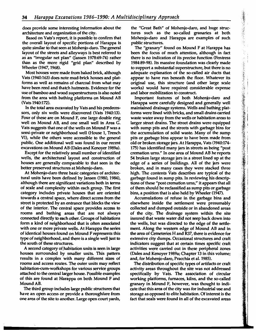
does provide some interesting information about the architecture and organization of the city.
Based on Vats's report, it is possible to confirm that the overall layout of sPeCific portions of HarapPa is quite similar to that seen at Mohenjo-daro. The general layout of the streets and alleyways is best referred to as an "irregular net plan" (Jansen 1978:69-74) rather than as the more rigid "grid plan" described by Wheeler (1947, 1968).
Most houses were made from baked brick, although Vats (1940:163) does note mud-brick houses and platforms as well as remains of charcoal from what may have been reed and thatch hutments. Evidence for the use of bamboo and wood superstructures is also noted from the area with bathing platforms on Mound AB (Vats 1940:172).
In the total area excavated by Vats and his predecessors, only six wells were discovered (Vats 1940:13). Four of these are on Mound F, one large double ring well on Mound AB, and· one small well in Area G. Vats suggests that one of the wells on Mound F was a semi-private or neighborhood well (House 1, Trench VI), while the others were accessible to the general public. One addi tional well was found in our recent excavations on Mound AB (Dales and Kenoyer 1989a).
Except for the relatively small number of identified wells, the architectural layout and construction of houses are generally comparable to that seen in the better preserved structures at Mohenjo-daro.
At Mohenjo-daro three basic categories of architectural units have been defined by Jansen (1980, 1984), although there are significant variations both in terms of scale and complexity within each group. The first category includes private houses that are oriented towards a central space, where direct access from the street is protected by an entrance that blocks the view of the interior. The central space provides access to rooms and bathing areas that are not always connected directly to each other. Groups of habitations form a kind of neighborhood that is often associated with one or more private wells. At Harappa the series of identical houses found on Mound F represents this type of neighborhood, and there is a single well just to the south of these structures.
A second category of.habitation units is seen in large houses surrounded by smaller units. This pattern results in a complex with many different sizes of rooms and access routes. The outer units may reflect habitation-eum-woi'kshops for various service groups attached to the central larger house. Possible examples of this are found at Harappa on both Mound F and MoundAB.
The third group includes large public structures that have an open access or provide a thoroughfare from one area of the site to another. Large open court yards,
the "Great Bath" of Mohenjo-daro, and huge structures such as the so-called granaries at both Mohenjo-daro and HarapPa are examples of such public structures.
The "granary" found on Mound Fat HarapPa has been the focus of much attention, although in fact there is no indication of its precise function (Fentress 1984:89-98). Its massive foundation was clearly made to support a substantial superstructure, but there is no adequate explanation of the so-called air ducts that appear to have run beneath the floor. Whatever its original use, this structure (and other large scale works) would have required considerable expense and labor mobilization to construct.
Important features of both Mohenjo-daro and HarapPa were carefully designed and generally well maintained drainage systems. Wells and bathing platforms were lined with bricks, and small drains carried waste water away from the wells or habitation areas to larger street drains. The street drains were equipped with sump pits and the streets with garbage bins for the accumulation of solid waste. Many of the sump pits or garbage bins appear to have been made from old or broken storage jars. At Harappa, Vats (1940:174175) has identified many jars in streets as being "POst cremation urns." In one area of Mound AB he reports 54 broken large storage jars in a street lined up at the edge of a series of buildings. All of the jars were broken, and in many cases they were stacked three high. The contents Vats describes are typical of the garbage found in sump pits. In reviewing his descriptions of these "post cremation urns," it appears that all of them should be reclassified as sump pits or garbage bins, a position that is also held by Wheeler (1947).
Accumulations of refuse in the garbage bins and elsewhere inside the settlement were presumably collected and dumped outside or in abandoned areas of the city. The drainage system within the site insured that waste water did not seep back down into the wells, but was directed to the edge of the settlement Along the western edge of Mound AB and in the area of Cemeteries Hand R37, there is evidence for extensive city dumps. Occasional structures and craft indicators suggest that at certain times SPeCific craft activities were carried out in these peripheral zones (Dales and Kenoyer 1989a; Chapter 13 in this volume; and, for Mohenjo-daro, Pracchia et al. 1985).
The distribution of SPeCific types of artifacts or craft activity areas throughout the site was not addressed SPeCifically by Vats. The association of circular working platforms, furnaces, kilns, and the so-called granary in Mound F, however, was thought to indicate that this area of the city was for industrial use and storage as opposed to elite habitation. Of interest is the fact that seals were found in all of the excavated areas
.~ .

36 Harappa Excavations 1986-1990: A Multidisciplinary Approach
10050
: -..... _
. . MOUND F: ; ~ ;
- ••••• - ••• I
: .... ; : _. . .
50 0--50 0 100 200 300
Figure 4.4: Plan of Mound AB; redrawn from Wheeler (1947:Plate XV).

, I
I
East
tl
4 o 4 8 12 16 20 24 feet
o 2 3 4 5 6 meter.
West
debris ,--:~ -.".~
c:: ""'t C3" $::I :::t "'tj
~ ~
~ tn
;;" ~
~ ~
.-...c :::t ~ ~ tn
~ t~ -" c" :::t.. ~ "'tj
~-§" ;;" $::I ""'t
". ".0 '0 .. "."....... '.' ..
...: •. 0.· :•.• o~lI~vlal deposlts.i.,: •• 0
........ -0... : "0" ...... .. .. ' ' ' •. , ...
natural soli
""'tI C ~
Figure 4.5: Detail of section through the mud-brick rampart, Mound AB; redrawn from Wheeler (1947:Plate XXII). ~ ""'t $::I
~ $::I
~ ~

38 Harappa Excavations 1986-1990: A Multidisciplinary Approach
- Layer 28 was also alluvial in nature but is a darker "earthy texture, suggesting that it may have been ploughed and sown; it was, however, similarly deficient in significant pottery."
- Layer 26 is described as an occupation layer comprised of dark earth with charcoal, but there is no report of mud-brick structures, hearths, or floors.
- Layer 26A is associated with the initial stages of rampart construction, and Wheeler suggests that the presence of five non:-Harappan sherds (Early Harappan tyPes) can be attributed to digging into Layer 26 during the construction of the rampart.
Wheeler also points out that numerous sherds found in the mortar of the core of the rampart derive from Layer 26. In contrast, most of the sherds incorporated in the outer face of the rampart are definitely associated with the Harappan culture. In conclusion, he suggests that "the building of the defences marked the first impact of the Harappa culture on this site, and that the builders were preceded here by a town- or viIlage-occupation representing a variant or even alien culture" (Wheeler 1947:93).
Mughal (1970:127-130 and Personal communication) does not agree with Wheeler's interpretation and proposes that layers 26 and 26A were in fact occupation deposits and that the earliest part of the massive mud-brick structure was constructed by the Early Harappan. settlers. Based on a reinterpretation of Wheeler's section he proposes that the portion of the mud-brick structure, the base of which is below the top of Layer 26A, is Early Harappan. Layer 26, which extends under the wall, would represent the earliest settlement prior to the construction of the wall, and Layer 26A would represent the build up of habitation debris inside the wall. Subsequent rebuilding by the Harappans would have eventually incorporated the Early Harappan structure.
It has not yet been possible to test Mughal's hypothesis; this would require the re-excavation and cleaning of Wheeler's section. However, as will be discussed below, most of t~ Early Harappan levels under Mound AB may have been eroded from the Early Harappan settlement discovered to the east, beneath MoundE.
u. C. Berkeley Expedition, 1986-1990
Current excavations at Harappa have included test trenches and horizontal exposures on Mound F, Mound AB, the Low Western Mound, the cemetery
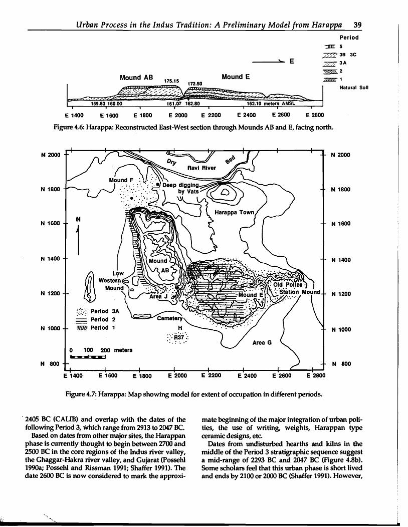
test pit on the Old Police Station Mound (Dales and Kenoyer 1989a, 1989b, 1990, 1992; Chapter 13 in this volume) (Figure 4.2). These various excavations have provided significant new information that requires a revised periodization and absolute chronology as well as a new model for understanding the growth of the city (Figures 4.6 and 4.7).
Periodization The earliest evidence for habitation is associated
with the Early Harappan culture (MughaI1970, 1990) and is found only on Mound E (Figures 4.6 and 4.7). These deposits can be sub-divided into two groups of strata; Period 1 refers to the deposits that were accumulated on natural soil prior to the construction of large mud-brick revetment walls, and Period 2 refers to the deposits that built up after the revetment walls
.-~ ,~",had been constructed. The transition between the two periods appears gradual, but since the analysis is not yet complete, such statements must be understood as being provisional.
In the upper levels of the Period 2 deposits there is ," ~' ....
again a gradual transition to Period 3 which is generally referred to as the "Harappan culture." Due to the fact that there is no distinct hiatus or break, Period 3 deposits are generally defined by the presence of ;:i~i
baked brick architecture and the entire range of artifacts associated with the Harappan phase. Period 3 can be divided into three sub-Periods on the basis of jlpreliminary correlations with the earlier excavation reports.
Period 4 is a transitional phase following the 'f,... \"
:}Harappan occupation, and Period 5 corresponds to ••.I·'.·I·.4'.:.~·:·:.'··"···.·'···. · .~- ~.the Late Harappan (Cemetery H culture) occupation .
of the site. Period 4 and 5 occupation levels are too fragmentary to discuss in any detail at this time. ~i
.~Subsequent occupations o~the site during the Early Historic, Medieval, and Historic Periods also have not been adequately explored, but will eventually fit into this periodization (Table 4.2).
j 1Chronology
.;~l ;At the present time, a total of 33 carbon samples ·1··
from the recent excavations at Harappa have been ;l~
·~.ii..' ?j~.'<dated (Figures 4.8a and 4.8b and Table 4.3), and addi ;ffi!, .tional samples are still being processed. The earliest '!.~.~'.• jdate comes from a hearth of Period 1 (Early HarapPan) situated just above natural soil. This sample date is cali ~'1
·s
i'brated to 3338, 3213, or 3203 BC (CAUB program, ····;·~J·'·.·····::.::.....Stuiver and Reimer 1986; Possehl 199Ob). ..: ."
~ i •Period 2 dates are from upPer stratigraphic levels, ·Ibetween one and two meters higher than the hearth of :lli
:.-:.'..•:1.•.:.... \areas (near Areas Hand R37), Mound E and a small Period 1. These calibrated dates range from 2470 to .:}.~. .'
Urban Process in the Indus Tradition: A Preliminary Model from Harappa 39 Period
:xm: 5
__---...;:1\=_ E /.~~' 38
..: ;.. 3A
3C
Mound AB 175.15 172.50 Mound E
~2
~1
Natural Soli
.~-
I 159.80 160.00
I 161.07 162.80
I I
162.10 meters AMSL I .
E 1400 E 1600 E 1800 E 2000 E 2200 E 2400 E 2600 E 2800
Figure 4.6: Harappa: Reconstructed East-West section through Mounds AB and E, facing north.
N 800
N 1000
N 1200
N 1400
N 1600
N 2000
N 1800
E 2800E 2600E 2400 E 2200E 2000E 1800E 1600
wi •• 1 100 200 meters
:.:.:/: Period 3A - Period 2
~ Period 1
E 1400
N 2000
N 1400
N 1800
N 1600
N 1000
N 1200
N 800
Figure 4.7: Harappa: Map showing model for extent of occupation in different Periods.
. 2405 BC (CALIB) and overlap with the dates of the mate beginning of the major integration of urban polifollowing Period 3, which range from 2913 to 2047 Be. ties, the use of writing, weights, Harappan type
Based on dates from other major sites, the Harappan ceramic designs, etc. phase is currently thought to begin between 2700 and Dates from undisturbed hearths and kilns in the 2500 Be in the core regions of the Indus river valley, middle of the Period 3 stratigraphic sequence suggest the Ghaggar-Hakra river valley, and Gujarat (Possehl a mid-range of 2293 BC and 2047 BC (Figure 4.8b). 1990a; Possehl and Rissman 1991; Shaffer 1991). The Some scholars feel that this urban phase is short lived date 2600 Be is now considered to mark the approxi- and ends by 2100 or 2000 BC (Shaffer 1991). However,

40 Harappa Excavations 1986-1990: A Multidisciplinary Approach
Table 4.2. Harappa 1991: Preliminary Periodization.
Period Area of Mound Description 1 MoundE
northwestern comer Early Harappan initial settlement on natural plain surface
2 MoundE western half
Early Harappan massive mud-brick revetment walls, gradual transition to Period 3
3A MoundE, Area}, MoundF
Harappan baked brick architecture, square intaglio seals terracotta bull figurines (legs joined), painted pottery (black on red slip)
3B All areas of site, including modem Harappa town
Harappan baked brick architecture, square intaglio seals steatite and faience tokens, terracotta bull figurines (legs separated)
3C All areas of site, including modem Harappa town
Harappan baked brick architecture, square intaglio seals fewer steatite and faience tokens, pointed-base goblets (final levels)
4 MoundE Transitional phase prior to Period 5 5 Mound E, Mound AB,
Area H, part of Mound F Late Harappan Cemetery H style ceramics and artifacts
Early Historic
MoundAB Gupta period sculpture, etc.
Medieval MoundE Islamic coins, not yet identified Saint's Tomb
Historical Mound AB, Harappa Town Old Police Station Mound
Mosque, Harappa Town Mughal Fort and Serai British Police Station, etc.
at Harappa there are between one and two meters of Period 3 occupation levels above the uppermost dated levels, which would suggest that Period 3 continues to 1900 DC, if not later.
Periods 4 and 5 are not dated at Harappa, but on the basis of dates from other sites, the Late Harappan phase continues until at least 1500 Be in most regions and possibly as late as 1000 DC in the Gangetic area (Kenoyer 1991b; SJ;\affer 1991; Possehl and Rissman 1991).
Natural Plain Surface in Antiquity
The local topography and vegetation was probably qUite similar to that seen along the river Ravi today and well documented since the time of Alexander the Great. This region was renowned for its thick marshy forests and flood plain covered with semi-arid shrubs and trees; farash (Tamarix orientalis), karil (Capparis
aphya), wan (Vitex negundo), jand (Prosopis spicigera), her (Zizyphus jujube) and wild grasses such as sa" (Saa:harum munja) (Vats 1940:4-5).
The natural surface on which the earliest inhabitants at the site settled appears to have been an elevated. area in what was undoubtedly a terraced river plain with ox-bow lakes and scattered dry river channels (Figure 4.2; also Amundson and Pendall, Chapter 3 in this volume). The presence of vegetation is suggested by numerous root casts visible in the natural soil. Some of these plants were undoubtedly present before the arrival of the earliest settlers, and they continued to grow in the midst of the settlement as is suggested by the presence of tiny pot sherds, ash, and red burned soil found in the root casts. In this context the term "natural soil" refers to a massive deposit of fine silty loam that in the upper portions has traces of root casts and tiny pieces of ash and red burnt soil and occasional sherds. In the lower levels it is totally sterile of

Urban Process in the Indus Tradition: A Preliminary Model from Harappa 41
YEARS B.C.
cultural remains and often overlies a massive clay deposit which has been identified by sedimentologists as the Qadirabad Fonnation. This is a late Pleistocene/ Holocene alluvial deposit, and calcite nodules from this deposit have been dated to 7080±120 BP (Pendall and Amundson 1990b, Amundson and Pendall, Chapter 3 in this volume).
The highest point of natural soil found to date is sealed beneath the earliest settlement at the northwestern corner of Mound E (N1313, E2083). This elevation ranges from 162.80 m AMSL to 162.60 m AMSL. Three meters to the west there is a rapid drop in elevation (to 162.08) and then a gradual slope
1'1 I I I I I I I I I I I , 1'1 I , I , , I I I , , , I , , , , I I I I , , I , , ,
.
, %. • • % %
I I. I... • ... • •• • • • • • • ... • I ...
I ~
~
~
•
.
T T, •. 3300
3100
2900
2700
2100
2300
1900
1700
1500
1300
1100
2500
Figure 4.8a: Calibrated Harappa radiocarbon determinations arranged stratigraphically.
reaching as low as 159.80 m AMSL some 349 m to the west. A similar slope with some slight disconformities has been traced approximately 325 m to the east below the southern edge of Mound E. In this area the natural soil ranges from 162.07 to 162.15, and 162.45 m AMSL.
The topography along the major north-south section is not as easy to define, because there appears to have been a major depression just to the south of Mound E. This depression may have been scoured out during or after the Early Harappan occupation, because there are no traces of Early Harappan cultural material in the interface between the natural soil and Harappan deposits or burials. The level of the natural soil in the

I I I I I I I 1 I I I I I I I I I I I I I I I I I
,• •
.. .. . % • % •
• • . • Z • • •,
T•
Figure 4.8b: Calibrated Harappa radiocarbon determinations on charcoal from inside hearths and kilns arranged stratigraphically.
3100
YEARS 2300 B.C.
2100
1900
1700
1500
1300
1100
2500
2700
2900
42 Harappa Excavations 1986-1990: A Multidisciplinary Approach
I
.
.
cemetery area ranges from 162.80 to 162.60, which is the same as in the highest areas beneath Mound E, some 300 m to the north (Table 4.4).
Evidence for Possible Neolithic Settlement
A single shred of evidence, in the form of a single tiny disc bead made from Spondylus shell, exists to suggest that there may be an early, possibly neolithic, settlement buried somewhere under the extensive mounds at Harappa. This tyPe of bead is well documented in the aceramic and ceramic Neolithic at Mehrgarh (6.500-4500 Be) Oarrige and Meadow 1980; Kenoyer 1986) but is not found in later periods at Mehrgarh or at any other known site. The bead was recovered through flotation of sediment from the lower levels of a Period 3 (Harappan phase) street at the southern edge of Mound E.
There are several possible explanations for presence of this bead. It could have been carried to the site by a traveler who found it eroding from a burial in the mountains. It may, however, have been recovered by some Harappan contractor who dug into a Neolithic burial or habitation area to obtain fill for construction or for patching potholes in the street. In any case, this minute bead provides a stimulus to keep looking for an earlier settlement at Harappa.
Period 1
Period 1 refers to the earliest occupation of the site by people of the Early Harappan, or Kot Dijian phase (Mughal 1970, 1990), and corresponds to the Regionalization Era as defined by Shaffer (Kenoyer 1991b; Shaffer 1991).
The cultural affiliation of the Period 1 occupation is based on preliminary observations of ceramics that

Urban Process in the Indus Tradition: A Preliminary Model from Harappa 43
Table 4.3: Harappa Dates Arranged Stratigraphically from latest to earliesf"
PROVENIENCE
MOUND AD, Period 3 WI5-2043
WI5-2144 WI5-2075 WI5-2140 MOUND E, Period 3 Northwestern Comer WI5-2139" WI5-2053 WI5-2074 ...... WI5-2143 ...... WI5-2145 WI5-2142
WI5-2141 QL-4378 QL-4374 BETA-33874 QL-4376'" Southern Slope WI5-2217 WI5-2219" QL-4484...... QL-4483...... WI5-222O" WI5-2221QL-4488, QL-4487
5568 BP
3770 +/-70
3720+/-100 3830+/-60 4290 +/-70
3820 +/- 60 3920 +/- 210 3700 +/- 60 3825 +/- 60 4020 +/- 60 4135 +/-65
3920 +/-70 3850+/-50 3800 +/-50 4540 +/-180 3810 +/-50
3860 +/- 60 3910 +/-65 3730 +/- 30 3784 +/- 30 3815 +/- 60 3940+/-120 3750 +/- 40 3816 +/-25,
MOUND E, PERIOD 2/3 Northwestern Comer QL-4377 3770 +/-100 Southem Slope QL-448S...... 3863 +/-45 WI5-2218" 3985 +/- 65 QL-4486...... 3785 +/-45 WI5-2216" 3930 +/-65 MOUND E, PERIOD 2 Northwestern Comer QL-4372...... 3890+/-40 QL-4375...... 3920 +/-40 QL-4373...... 3960 +/-30 QL-4380 ...... 3950+/-80 MOUND E, PERIOD 1 Northwestem Comer BETA-33873...... 4540 +/-85
5730 Be
1930+/-70
1880+/-105 1995+/-60 2470 +/-70
1985+/-60 2090+/-215 1861+/-60 1990+/-60 2190 +/-60 2410+/-65
2090+/-70 2015+/-50 1965+/-50 2725+/-185 1975+/-50
2026 +/- 60 2077 +/-65 1892 +/- 30 1947 +/- 30 1979 +/- 60 21~ +/-120 1912 +/-40 1980 +/-25
1935+/-105
2029+/-45 2154 +/-65 1948 +/-45 2098 +/-65
2055+/-40 2090+/-40 2130+/-30 2120+/-80
2725+/-90
CALIB Be
2268,2263,2203, 2147,2146 2138 2299 2913
2288 2469 2133,2067,2047 2293 2573,2535,2506 2863,2812,2742, 2726,2696,2677,2666 2462
':;1;2334 I'll2278,2234,2209 Ji 3338,3213,3203 2283 \1
~~li!i! ,~
:llli;2343 'II)2459 ,.1
2140 2270,2203 2286 2466 2191,2161,2145 2286
2198,2151,2149
2346 2556,2546,2493 2271,2260,2204 2464
2455,2416,2405 2462 2470 2468
3338,3213,3203
... The dates are arranged according to the specific stratigraphy in each area of the site. Mound AS d:ates can only be correlated with Mound E dates on the basis of general ceramic comparisons, but they are approximately equal to the Period 3 dates from Mound E. " These dates are from charcoal from inside hearths or kilns. (Acknowledgement: Radiocarbon dates from the Radiocarbon Lab of the Center for Climatic Research, University of Wisconsin-Madison, were supported by the Climate Dynamics Program, National Science Foundation under KJ'ant ##ATM86-0329S.)

44 Harappa Excavations 1986-1990: A Multidisciplinary Approach
Table 4.4. Elevations of "natural soil" found in excavation areas. Trench Coordinates Elevation AMSL
Slope to the west N1313, E2083 162.80 N1325, E2085. 162.60 N1320, E2079.50 162.~
N1320, E2078.50 161.96 Nl346, E2071 161.30 N 1310, E2055 161.07 Nl250, El860 160.00 Nl182, E1732 159.80
Slope to the East mn~E2083 ~~
NI020, E2360 162.15 NI015, E2355 162.07 N 985, E2360 162.45
Slope to South mn~E2083 162m NI013, El990 160.80 N 995, El995 162.60 N 980, El980.50 160.50 (just above natural soil)
appear identical to examples reported from the Early Harappan levels at Kot Diji (Khan 1965; MughaI1970), Jalilpur II (Mughal 1974), and Rehman Dheri II (Durrani 1988). In addition to ceramics, there are grey fired bangles, stone blades made from a dark greyishblack chert, a stone celt, various types of stone beads, and human figurines of a type that is not found in the following Harappan period (Period 3).
Primary occupation levels of the Early Harappan period have been found all along the northwestern edge of Mound E and include hearths, accumulations of domestic debris, and traces of mud-brick walls. None of the mud-brick walls from Period 1 have been exposed horizontally, but in section they appear to be oriented in the same direction as walls from the subsequent structures in Period 2 (Figure 4.9).
Period 1 occupations produced an accumulation of considerable domestic debris that resulted in a low mound (Figure 4.10). The northwestern edge of this mound was eventually defined by the construction of a massive mud-brick wall or revetment. The construction of this structure represents an important change in settlement organization, and the subsequent phase of the Early Harappan occupation has been designated Period 2.
Based on the gradual slope that extends from Mound E to the west, it is likely that most of the deposits with Early Harappan sherds discovered beneath Mound AB derive from Period 1 and the subsequent Period 2 occupations on Mound E. These eroded layers appear to have been confined to the
portion of the site between Area J and Area F, since Vats does not report any unique sherds from the deep trenches that he excavated in those areas (Figure 4.7).
The total extent of Period 1 deposits is not well defined, but it does not extend as far as the middle of Mound E, nor does it extend out to the west between Mound E and Mound AB (Figure 4.7). On the basis of this limited evidence it appears that the primary settlement was limited to the northwestern comer of Mound E possibly with other hamlets scattered over the plain.
The location and growth of the Period 1 settlement at Harappa can be attributed to the presence of high land in the midst of a rich alluvial plain. The location of the site probably corresponded to major trade and exchange networks that connected the plains to the highlands in the West and North. Continued research on the fauna, flora, and artifacts of Period 1 and comparative regional studies will provide the foundation for more specific interpretations in the future.
Period 2
Stratified deposits of Period 2 have been found along the northwestern comer of Mound E and as far as the middle of Mound E, where they lie directly on the natural soil (Figures 4.6 and 4.7). Of particular note is the construction of massive mud-brick revetments or retaining walls that have been identified at the northwestern periphery of Mound E (Figure 4.9).
These perimeter walls, as well as other structures toward the inside of the mound, were made from

----
Urban Process in the Indus Tradition: A Preliminary Model from Harappa 45
... N 1360+ I + BRICK WAll
BAKED BRICK WAll
PERIOD II MUD BRICK WAll (283)
+ + N 1355
WAll (33)
PERIOD II NMUD BRICK + N 1350+WAll (164)
meters
MUD BRICK WAll (284) , " \ + N 1345\ + \ \ \+ +
\ , , \,, , ~ \ \
BAKED BRICK WAll (33)
\ \ \ ' \ \
+ '+ \, + + ... N 1340,, \ , \
\ \
\ \ PLAIN lEVEL \,
\ , EDGE OF MOUND E\ \
BAKED BRICK WALL \
t (51) ,+ \
+ ~\I\, \ \ iet \
~-~\, /I
tfearth' ...............-....-
\'
j\\': , i , ,
PER I 0 D II MUD I RIC k W ALL (7 1 0]'-' "I' ,QL-4373 .In OL-437 .. . Q L:4'37 5 He arth\,. .
+ N 1325+ \ \ + \ 1880 ~~"""..",...,,,.--+"",\
EXCAVATION
+
MUD BRICK WALL (107) .... ~:\'ill,~ t'BilE.u~,~~,~ , .. ,., ~ Q L - 4380 He a r~t~h,:.:;::··-~~:t:=::=U~C':'::...Li[""-.J
\ ' ... PERIOD "'1+ \ \ \ +
BAKED IRICK WALL (33) \
~ , 1'""II"!~---r-"""4:M-::il B.I••338~ \,
of- + \, \ + +\ \ \ ~
E 2075 E 2080 \ \ E 2085 ' E 2090
Figure 4.9: Harappa 1990: Plan of northwestern comer of Mound E showing areas excavated and locations from which samples for radiocarbon detennination were obtained.
-

46 Harappa Excavations 1986-1990: A Multidisciplinary Approach
E2085 N1315
167.
Facing East 1 meter
E2085 N _'IL...-__ N1320 East
166·t 166.
Unexcavated
165.
~~~.,.;. IlfJJo;~"I'H.Relr Mudbrlck Platform
164. 164.
"Brick Rubble pI1ed against MudbrIck Platforms
163. 163.
Unexcavated
162. 162.
Unexcavated
Figure f.l0: Harappa 1988: Section facing East of trench cut through part of the northwestern slope of Mound E.

Urban Process in the Indus Tradition: A Preliminary Model from Harappa 47
bricks measuring 10 x 20 x 40 cm (1:2:4 ratio). The orientation of the longer walls is northwest to southeast at an angle of approximately 10° west of true north. Five and possibly six different building phases have been identified, and all are associated with strata containing ceramics similar to those of Period 1 (i.e., Kot Dijian or Early Harappan). Two of the walls are quite heavily eroded and are sealed by later Period 2 deposits, while the other three or four were built on the natural soil or by cutting foundation trenches into Period 1 deposits.
The most complete wall (Feature #[164]) extends north-south for over 15 m (Figure 4.9). It is two meters wide and is preserved to approximately two meters in height. A possible comer of this wall has been identified, but the eastern extension has been completely obliterated by later construction.
Wall ##[235] was built after wall #[164]. It is 2.5 m wide and has a well-defined corner and eastern extension that continues for about four meters. The north-south portion of this wall has been obliterated by later Harappan construction, and the exterior face of the corner has been repaired in Period 3 with a baked brick facing.
Both walls #[164] and #[235] were made from mudbricks of distinctly different colors. There does not seem to be any pattern to the use of these bricks, except that often three or four bricks of one color are laid together. This association probably reflects the manner in which bricks were brought from stockpiles to the workmen constructing the wall. The different colors probably represent different source areas for the clay and indicate that the bricks were being prepared in different areas around Harappa and brought to the site for construction of these massive walls.
The precise function of the walls is not clear, but since the exterior face is invariably eroded and the interior face is not eroded, it appears that they may have functioned as retaining or revetment walls or foundations. They could have served to protect the edge of the mound from floods or erosion as well as presenting a formidable elevation to discourage unwanted intruders.
These walls are quite massive, and it is unlikely that this scale of construction .would have been undertaken on an individual basis; rather it may reflect some form of Early Harappan social organization capable of mobilizing and controlling the production of large quantities of bricks as well as the labor involved in wall construction.
One particularly significant discovery in the Period 2 levels is a small circular kiln with a unique firing structure made by placing the upper half of a large pot in the center of a circular mud-brick structure. Objects being fired may have been placed inside the pot for
high temperature reduction that would have resulted in a dark grey or black color. This structure may have been used for firing the thin greyish black bangles that are common in all of the Early Harappan levels, although no bangles were found inside the kiln itself. This technology in the early phases at Harappa may represent the foundation for the highly advanced technique of stoneware bangle production that has been documented in Period 3 (Blackman and Vidale 1992; Halim and Vidale 1984; Dales, Chapter 5 in this volume).
The layers below, around, and above the Early Harappan kiln contain many vitrified sherds and kiln wasters that indicate the presence of long term ceramic production in this limited area of the settlement Such production continued into subsequent levels that are associated with Period 3 (see below).
In the later levels of Period 2 there are some stylistic and morphological changes in the ceramics. These reflect a continuity and gradual development or a synthesis of different cultural elements leading up to the ceramic styles of Period 3. Specific ceramic types, figurines, triangular terracotta cakes, terracotta toys, and red fired bangles all continue into Period 3.
An important feature of the later levels of Period 2 is the appearance of tan-brown chert from the Rohri Hills (near the site of Kot Diji) and shell bangles made from the marine shell, Turbinella pyrum. These artifacts indicate an expanded network of trade and exchange that extended to the south as far as Rohri and possibly even the coast. The discovery of graffiti on sherds is also an important feature that indicates the increased use of permanent abstract graphic symbols for communication.
Turning to the southern edge of Mound E, there is evidence in this area as well for Period 2 occupation in the form of house walls oriented in the cardinal directions and located along a major north-south street (Figure 4.11). The street is defined by what appear to be cart tracks cutting into natural soil (Figure 4.12) and embedded with late Period 2 type sherds (M.R. Mughal and Farid Khan, personal communications).
These indicators would suggest that the settlement was expanding in the later phases of Period 2 (Figures 4.6 and 4.7) and that habitation areas were constructed along a grid of streets aligned north-south and I,
presumably also east-west. Two phases of mud-brick "
construction were identified in this area with brick sizes being approximately 6 x 16 x 28 ems (1:2.7:4.7 ratio). Above these structures, ca. 1.5 m of laminated ash and silt deposits contained Early Harappan pottery (late Period 2). Several superimposed hearths contained datable carbon and important concentrations of charred grain. This pattern of superimposed hearths suggests that domestic structures were located

E 2365
166
UNEXCAVATED
root hole ·W.II (307J
EARLY HARAPPAN MUD BRICK STRUCTURES
NATURAL SOIL
LOOKING SOUTH
~ (I)
~ ""'t ~
~ t1'1 ~
~ ~ .....-.c ;:t V)
~
(,,() 00 0'\ I ~
(,,() (,,() c ~
s:: ;::.....s:-.V) ("')
~.--.;:t ~
~
~ ci ~ ("') ;:r
Figure 4.11: Harappa 1990: Section facing South of trench in Area C on the southern side of Mound E.

Urban Process in the Indus Tradition: A Preliminary Model from Harappa 49
N 1020 +
+
0'
. yellow brown sandy silt
natural soil
+ 162.13
+
+
N
+
+
c: 0-(U
> (U u >< W-0
CD C)
'C W
... CD-CD
E ,..
+
162.05 meters AMSL N 1015 + + + +
E 2355
Figure 4.12: Harappa 1990: Plan showing cart tracks in natural sediment in Area C on the southern side of Mound E.
adjacent to the north-South street and that this habita In view of the structural sequence on Mound E, it is tion pattern continued on into the full urban phase of possible that the earliest portions of mud-brick wall Period 3. Preliminary investigation of the ceramics seen in Wheeler's section (Figure 4.5) cut into Layer and the associated artifacts confirms that there was no 26A rather than predating it as suggested by Mughal. major hiatus or cultural break between the Early On the other hand, this structure and Layer 26A are Harappan and Harappan levels in this area, just as characterized by the presence of Early Harappan there was none in the northwestern part of Mound E. pottery and therefore may be correlated to the initial

50 Harappa Excavations 1986-1990: A Multidisciplinary Approach
building of massive mud-brick walls as seen on Mound E during Period 2. This may indicate that massive construction was being carried out on the western side of Mound AB at the same time as on Mound E and that there may be undiscovered Period 2 occupation deposits under the central portion of Mound AB as originally proposed by Mughal (personal communication).
Period 3
Occupations relating to Period 3, the Harappan phase of the Indus Tradition (Shaffer 1991), are found in all areas of Harappa and include the Early to Intermediate strata identified by Vats. The lowest levels of Vats's Late strata would also be included in Period 3, but it is not possible to make precise correlations because stratigraphic subdivisions were not published or well characterized.
It is only on Mound E that Period 3 occupation levels have been found directly overlying the Period 2 occupation, and there does not appear to have been any hiatus between the two periods. Nevertheless, there was change as well as continuity, and it is important to recognize the nature of these changes in order to understand the various processes of urban development at Harappa.
On the northwestern corner of Mound E, Period 3 is distinguished by the construction of massive retaining walls (Figure 4.9) of baked brick directly above the earlier mud-brick structures of Period 2. The brick bonding techniques of Period 3 and the orientations of the major north-south walls are identical to those seen in the earlier Period 2 walls. The peripheral walls were made of both mud-brick and baked brick and have several building phases. On the upper slope there is evidence for massive mud-brick platforms to consolidate the edge of the mound and to provide foundations for other structures. At the top of Mound E, and throughout the rest of the site, Period 3 is represented by large streets and drains along with mud-brick and baked brick structures oriented to the cardinal directions.
Some scholars have suggested that Harappan urban centers may have ~n planned as massive platforms on top of which the city and an extensive system of wells and segregated neighborhoods were laid out Oansen 1987, 1989). However, the evidence from Harappa can be correlated to recent geoarchaeological research at Mohenjo-daro (Balista 1988; Vidale and Balista 1988) to demonstrate that both of these major cities grew in several stages of platform building and reinforcement.
Along the southern edge of Mound E there is evidence for a massive free-standing mud-brick wall
that was built directly on the natural plain surface at the edge of the settlement (Figures 4.13 and 4.14). The mud-bricks measure 10 x 20 x 40 em, and Period 3 ceramics have been found beneath the wall and mixed in with the mortar. The pattern of brick bonding and the distribution of different colored mud-bricks is identical to that seen in the earlier Period 2 walls. This indicates a continuity in architectural technology and similar patterns of raw material acquisition from surrounding clay sources.
This wall was pierced with a gateway that was approximately 2.8 m wide and appears to have been faced with baked brick (Figure 4.15). The street running through the gateway was paved with crushed pottery and fired terracotta nodules and connected to a major street running east-west inside the wall. Possible street levels also were found along the outside of the wall as well.
Inside the wall, a major north-south street was identified directly above the Period 2 street. This street was five meters wide and could have accommodated twoway traffic of ox carts. Mud-brick and baked brick houses equipped with baked brick drains were constructed along the edges of the street (Figure 4.16).
The revebnent walls in the northwestern corner of Mound E, the free standing wall and gateway on the south, and the various habitation and kiln structures are associated with ceramics that are characteristic of the Harappan or full urban phase of the Indus Civilization. These ceramics have been documented from the sites of Mohenjo-daro and Harappa in earlier publications (Marshall 1931; Mackay 1938; Vats 1940) and in greater detail most recently by Dales and Kenoyer (1986).
In addition to baked brick architecture and distinctive ceramics, other new varieties of artifacts include intaglio steatite seals, inscribed steatite tokens, faience tokens, inscribed pottery, tan-brown chert tools, stone weights, terracotta cones, distinctive figurines, toys, and painted pottery. Detailed studies of these artifacts are beginning to provide new information for understanding the cultural dynamics within Period 3 and will help to further define the sub-periods discussed next.
In both Mound E and Mound AB, various categories of evidence from the recent excavations point to the existence of at least three sub-periods of the Period 3 urban settlement. These sub-periods do not relate simply to architectural building phases, but to larger episodes of urban growth and decay.
In the initial levels of Period 3 (Period 3A) along the southern edge of Mound E, distinctive artifacts include terracotta bull figurines with legs joined together, a chert weight, a copper arrow point, tanbrown chert tools, and a single fragment of an intaglio
Urban Process in the Indus Tradition: A Preliminary Model [rom Harappa 51
Area A
N 1080
N 1070
+
+
+ I I I I 1 I
ij 1
I ~
\
1 ~
Block
~ + +. N2360
__.' __..... S T R E E T E W 1 072
- ~~DRAIN [21]
S2360 + [46]
N 1060 + + + +
N
N 1050 t + + + + STREET
NS2355
N 1040 +1 : + + + 1 I
I ~ Are a B
Block W1030 ~BIOCk E1030
N1030 + ~ + t :EARLIESTi 10
I :CART TRACKS LATEST I I meters
m
N 1020 CART TRACK'li.T 2 + + I+ 1 ,. • Block E1015
ENCROACHMENT aI2J1 3 DRAIN t! • Block E1010
N 1010 + + + + I + + + + \ Are a C
Area 0 D N 1000 + + + + + + + / +
Area E DRAIN [244] ~990~~ ft_... '1 ,to
~:.- _... to to ;.-:; e.'1" ,.N 990 + + +~ + + +
F ~~ -WALL ~~~ ~9 _.---- CZt' ~9
... ~ N 980 + + + +J
EARLIER "-STREET
THRESHOLD [83] NS2338
N 970 GAT E W ~ Y [8 5 ] + + + + + + +
E 2320 E2340 E 2360 E2380 E 2400
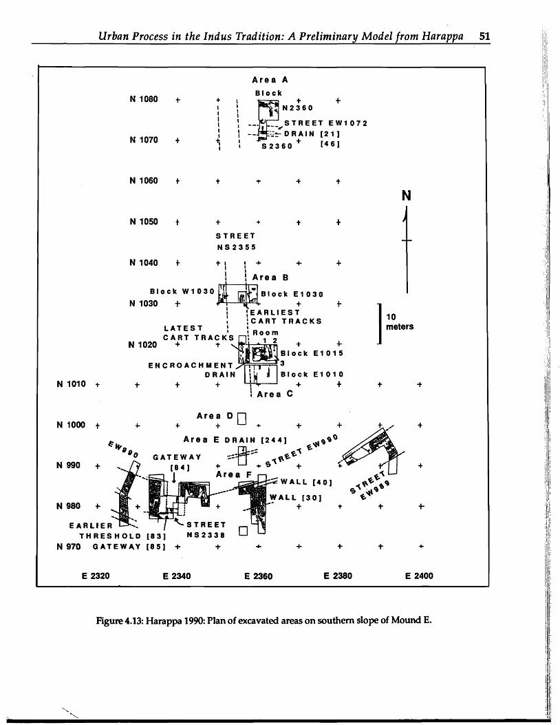
Figure 4.13: Harappa 1990: Plan of excavated areas on southern sloPe of Mound E.

)a.
I~ ""t
Figure 4.14: Harappa 1990: Sections on north side of mud-brick walls #[30] and #[40] in Area F on the ~ southern slope of Mound E. "North," "South," "East," and "West" denote directions being faced. ~
E 2360
N 985
WEST E 2360
N 988
NORTH
E 2362
N 988
EAST SOUTH
E 2360
N 985
164 + 164
163 + 163
162
...
NATURAL SOIL
NOT EXCAVATED .~l~ \' ~
~ bloturblton
, ,, , _\_.__. '••th.'.'
..
11 \II
10 VR 5/3 very fine Slndy lilt
1
j
~
1 meter ! !
- .... ·r· .. V '~'" ~ ..: 1'-. __ Cn~--_ "._ __V _ _ _., __ ,~ .._
,••,h.'"
J
-~-d" VB '1Il~- - - Jr - - - - ."
NATURAL SOIL , ~ 162
~
~ i1 ~ I~ ~
tT:l ~ (") ~
~-o· ;:t (I)
~
("Q 00 0'1 I ~
("Q ("Q
~ )a.
-~ ;:-s: fj). -.(")
./~~i:;I'i*,.r~'i:; '~.;~~i~fi~~~~~#~#r;r~~~~~..7f~J~h~~~";;"'';':1.';''i'~~i::).~;+i;;-'>~:~i;;i,&l.:;~:I./;'i;'~'" ·,.:!(:i:;;!~j'~~v~}:i~i~tfl>i~!fi~~i;):::.·

/I
./
OVERAL:L PLAN OF PERIPHERAL WALL [30] AND GATEWAY [84]
+ N 1000N 1000 + + + + + + +
AREA E \ '" \?AA
fiTjl O~"'\ " S'l"1I ~::-:.-.:: ~ "~~'l" ' -:'-':~[J~ ~ ~~O~~:::" ~E.E.1 E.
+
/.\~ ~..: 99 + + ,~,'" S1 flO\ + v- +'" 'l~~':::: + N 990N 990 + .....,~..::.<:/ 0 + ,..\.\. \~ .0.\ ~ .'
~~ ..::,:, f i-- ..
j • ,~.l:ji' •. .1
'.' .' J
.."...,..", GATEWAY
\'lO\
~ __.~-;;O\1\O'"
---' ftl\\C"- ~ ~....~~I (84) , .a\)O '" ~~'\l. ~ -'J I;'; ... ·J - - - - AO\ry4l. •..• rTl~"" c:,'\~;: ~/
I
laO} m:~~'l ..... " ,. o.~\C""~~\.\.\.' t -"''; ~ . r- • - - '" \A\)O '"
" ',' ~~ ~~~ Nt' + + + N 980N 980 + + '~!FJfi:,:~ GHOST WALL+ +.....
,:_.~
AREA F
I •EARLIEST THRESHOLD (83) STREET 10 meters 1EARLIER GATEWAY (85) NS 2338
+ N 970+ + +N 970 + + + + + E 2320 E 2340 E 2360 E 2380 E 2400
Figure 4.15: Harappa 1990: Overall plan of peripheral wall #[30] and gateway #[84] on southern slope of Mound E.
~ «:3" ~ ::= ~ """t Q ~
~ ~-.::= ;::-0 -~
;: ~
~ ;: (n
~
-~
-.~-.Q ;:.. ).
~ """t ~-§. ;;;. ~
~ ~ Q
-~ ~
"""t Q
;:!
g: """t ~
I~ ~
U1 ~

E 2355 ...
+
N 1020 +
+
N
+
+
+ I) ~ n (Itutlte token 1688 II ((
GHOST WALL lower ItrelL·I";::~II,......t1.of y,V/ V fa" I '/ . / C v l'<" a C/ I
. low..t Itrut Inel) VI/Vl'lk KI
N 1015 + ... + ... + ... ... + + + N 1015+ E 2355 E 2365
ENC\?iPAVING :
baked briCk~
~v 0ffim,~. ~ 1
1 motor
!
GHOST WALL
+ +
~ mud brick
0 baked brick
+ +
+ E 2365
+ N 1020
.,'''w.''
'" • lUi fragment 1594 I +
X .. Iteatlte token 1690
~brlckwalll urr-u 6~ 00 \)6 +ROOM 3 c!>:> w w a: •c I o
~I
,,.,--- .. I
UJ
~Jo + ........., ....
• 1591 , l:- Itea'tlte toke n 1712
1627 ,e~ ~ '0
•'a
!
~
~ ""t ~
~ ~
t'11 ~ (")
~
~ ""t
c· ::t V)
Io-l (,Q 00
cr Io-l (,Q (,Q
~ ).
~ ;::""t
~ Vi· (")-.
""t C ~ (");:r
Figure 4.16: Harappa 1990: Plan of house structure and upper street levels in Area C on the southern slope of Mound E.
~~'I;n~/'~"<:$1~{~l~~':~{~4.4:~'·~:.i!"~~+F~~~~r~!<~~~~-tt.\>~;".!i4.'<;t>t~,.",(.il.;i{~?: ..,.~jl/~';~~~ilit~'il" '.'

Urban Process in the Indus Tradition: A Preliminary Model from Harappa 55
steatite seal. No examples of tiny inscribed steatite tokens or faience sealings have been recovered to date. The ceramics in these earlier levels incorporate some stylistic continuities from Period 2, but the most noteworthy types are the elaborately painted ceramics (black paint on red slip) characteristic of Period 3. These distinctive ceramics are also found in the earliest burials of the Harappan cemetery, but do not continue in the later burials (Dales and Kenoyer 1989a) (Figure 4.17).
The initial Period 3A habitation deposits on the southem edge of Mound E are followed by a period. of civic decay and disrepair. The street drains became clogged and sewage flowed in the street, the wall and gateway became eroded and non-functional, and carcasses of animals were left lying in the street or dumped into abandoned rooms along the street (Dales and Kenoyer 1990; Chapter 13 in this volume; and Meadow, Chapter 7 in this volume).
The following Period. 3B is marked by a dramatic clean-up operation on the south side of Mound E, with new drains, a new southern wall and gateway, and new house structures. The rebuilt wall has been traced for over 73 m along the edge of the mound and ranges from 5.4 to as many as 11 m wide. The wider portions
appear to be repairs and additions, although they could also represent towers. At the gateway the wall was 85 m wide, and the gateway itself was faced with baked brick, 1.6 m thick. The wall was free-standing, and on the basis of one meter deep foundations, it probably stood several meters above the plain.
Most of the material culture characteristic of Period. 3A such as intaglio steatite seals, chert weights, tanbrown chert, and Painted ceramics continued to be used, but there is now evidence for the use of tiny steatite and faience tokens. Other varieties of objects with writing include inscribed or stamped pottery, inscribed stoneware bangles, inscribed terracotta cones, and impressed terracotta sealings that appear to have been broken from sealed vessels, bales, or doors. These various objects with writing have been found in primary and secondary contexts within the habitation areas and in the street leading towards the gateway.
During this sub-period, however, the joined leg terra-cotta bull figurines were no longer in use. Furthermore, the new forms of animal figurines with separated legs were made in many different styles and can be related to those found at Mohenjo-daro and other sites in the greater Indus Valley. In contrast to the earlier Period. 3A, much of the pottery is unPainted
Figure 4.17: Harappa 1988: Painted pottery motifs from vessels found in the Harappan phase cemetery (Period 3).

56 Harappa Excavations 1986-1990: A Multidisciplinary Approach
and unslipped and can be correlated to the later burials in the Harappan cemetery.
In the final levels of Period 3 (Period 3C), pointedbase goblets, a form of disposable drinking vessel, became quite common. These are particularly numerous in the levels that cover the Harappan phase cemetery, but also occur in the upper levels on the south side of Mound E where brick pavings and drains were built in what used to be the five-meterwide street, effectively encroaching on the thoroughfare and contributing to congestion. Unfortunately, most of the levels of this sub-period on the south side of Mound E have been disturbed by brick robbing.
In the northwestern comer of Mound E, terracotta bull figurines with joined legs are found in the initial levels of Period 3 but do not continue in the later levels. Inscribed steatite tokens and faience tokens have not been found in the lower levels nor in the later stratified deposits associated with the ceramic production area. However, they have been found in disturbed layers left by brick robbing and derive from habitation levels that are distinct from th~ ceramic production area.
Two kilns in the Period 3 levels above the Period 2 kiln attest to the continuity of ceramic production in the northwestern comer of the mound, and since there are no drains or streets in this area, it is not possible to distinguish ceramic debris accumulation from a lack of civic maintenance. If this portion of the mound did experience a period of decay and disrepair, it was completely eradicated by the construction of massive revetment walls of mud-brick with baked brick facings.
These patterns suggest that the northwestern portion of Mound E was going through a similar sequence of events as seen in the southern area. Unfortunately, it is difficult to correlate this same sequence to the earlier excavations of Vats and Wheeler. The earliest levels excavated by Vats in Area Jand Mound F appear to relate to Period 3A based on the presence of terracotta bull figurines with joined legs and distinctive painted pottery styles. While Vats does not discuss the state of the architecture in the lower levels, Wheeler mentions that the initial phase of rampart construction was followed by a period of decay and erosion. This may be correlated to the period of decay or erosion at the end Period 3B on Mound E, or relate to a different series of events occurring on Mound AB.
Vats notes that the lower levels of Mound Fand Area J have numerous examples of tiny inscribed steatite tokens and faience tokens. These levels probably correspond to the upper levels of Period 3B on Mound E. The upper levels of Mound F and the massive deposits
of Mound AB may represent Period 3C which is less massive on Mound E. Wheeler's designation of two additional periods of rampart repair and construction could relate to Period 3B and possibly 3C.
Period 4 The Period 4 designation is applied to stratified
deposits on Mound E and possibly on Mound AB that have ceramics which are not readily identified as either Mature Harappan or Late Harappan/Cemetery H. These ceramics appear to represent a transitional period prior to the development of Cemetery H culture. There is no distinct architectural division that differentiates levels of the Period 3 from Period 4, and definition of this period is based on preliminary observations of the ceramics and other artifact categories. On the basis of ceramic styles and morphology, some of the latest burials in the recent cemetery excavations as well as some of the early burials in the Cemetery H excavations by Vats (1940) may be associated with Period. 4.
Period 5
The final occupation of the protohistoric period is characterized by Cemetery H or Late Harappan ceramics. Most of the strata with these ceramics have been disturbed by brick robbing, but there are isolated areas at the northwestern comer of Mound E where undisturbed levels have been identified. Most of the Period. 5 occupation appears to have been on Mound AB and parts of Mound F. These strata contain Cemetery H ceramics and have drains and baked bricks of a smaller size than those of the earlier Period 3 occupation. Period 5 is well-represented in burials excavated by Vats from Cemetery H, and continued exploration of the site may reveal additional undisturbed levels.
Period. 5 may reflect only a change in the focus of settlement organization from that which was the pattern of the earlier Harappan phase and not cultural discontinuity, urban decay, invading aliens, or site abandonment, all of which have been suggested in the past
Conclusion Due to the limited space, it is not possible to present
a detailed comparison with other Indus sites or sites in West Asia. Instead, I conclude by comparing two different models for urban development. The most straightforward interpretation, commonly used for ancient cities in South and West Asia, uses a model of gradual or punctuated site expansion interrupted by periods of abandonment or contraction and finally collapse (e.g., Marshall 1931; Mackay 1938; Vats 1940; Wheeler 1947).

Urban Process in the Indus Tradition: A Preliminary Model from Harappa 57
Based on this model, one could suggest that the initial Period 1 settlement on Mound E gradually eXPaOded to the east during Period 2. Period 3A occupations developed on Mound E and eXPanded to the east and west covering the rest of the known site. Periods of abandonment due to floods or political disorders would explain the weathering of the ramParts and walls on both mounds. Reoccupation and urban renewal occurred over the entire site simultaneously, followed again by gradual decay, disorder, and. abandonment.
A different model can be derived from observations of historical dties and traditional settlements in South Asia. This model correlates the various settlement patterns to fluctuations in control and a shifting focus of urban development by different ruling elites. When new groups corne into power they often change the locus of power and build up ·their own neighborhoods or establish new areas of the city, while the old centers of power become delapidated. City growth and site formation processes are directly affected by such events.
The total area of the settlement during anyone period would represent the maximum extent of occupation but cannot be taken to represent population density. During specific seasons, urban centers become the focus of activity for traders, nomads, agriculturalists, and ritual specialists. Some people live with relatives in the city, others camp in the fields or on top of the city dumps. The population dynamics of a city in South Asia, and for that matter of all cities, is not a simple equation' to numbers of people who can exist in a given area.
Initial growth from a small to large settlement would have occurred in Periods 1 and 2 through the increased importance of the site for trade and probably also socioritual activities. Harappa is located on an important crossroads connecting the western highlands and northern plains to the Ghaggar-Hakra Valley and the southern plains. Evidence of expanded trade networks reaching to the south is evident in Period 2. The increase in settlement size can be explained through agglomeration of peripheral communities, as well as through gradual population growth.
Major sociopolitical integration is represented by the delimitation and protection of the site through the construction of massive mud-brick walls, revetments, and platfonns. Large north-south streets and segregated areas for habitation and craft activities were established dUring Period 2, commonly referred to as the Early Harappan or Kot Dijian phase.
The development of Period 3A on Mound E represents the initial establishment of the dominant elite groups associated with the HaraPPan phase. Settlement organization followed the basic layout
'- ......
defined in Period 2, with similar activities continuing in the same areas of the site. However, there appears to have been continued expansion over much of Mound E, Mound F, and Area J. It is also quite probable that the Period 3A occuPation will be found beneath Mound AB. Modem Harappa town, which covers approximately one quarter of the total area of the site, may cover areas of Period 3A eXPansion, but no traces are visible on the surface.
Period 3A expansion appears to have coincided with regional alliances and the integration of the Greater Indus Valley through trade and shared socio-ritual beliefs. The massive wall and narrow gateway on the southern edge of Mound E may indicate that there was some degree of conflict present, but armed conflict does not appear to have been a major activity of this culture, nor is there any indication that the integration of the Indus Valley was achieved through extensive military coercion. Any military conquest that would have been effective over such a large area should have left some clear evidence in the archaeological record. We do see evidence for what may be walled settlements, particularly in the piedmont and peripheral zones, but evidence for periods of sustained conflict and a coercive militaristic hegemony is not found.
During Period 3A we see the use of distinctive ceramic styles, figurine styles, intaglio seals, chert weights, and a large number of new ornament styles. These various objects reflect the many different communities and occupations that became established in the city (Kenoyer 1989, 1991a, 1991b, 1992).
After the Period 3A expansion, it is possible that the focus of development temporarily shifted to the west. The lack of civic maintenance and accumulation of garbage on Mound E may reflect a shift in socioeconomic control and political focus to Mound AB, where there was extensive construction and site build-up. This shift may correspond to the development of merchant classes or ruling elites and new socioeconomic or political organization. The use of tiny steatite tokens and faience tokens may have begun at this time.
The subsequent Period 3B renewal of Mound E may correspond to structural decay on Mound AB. Several phases of rePair and construction are noted by Wheeler and Vats for Mounds AB and F, but it is not clear how these are correlated to developments on MoundE.
Finally, during Period 3C there is evidence of extensive congestion in many areas of the site and a general lack of civic control. Whereas in the past this Pattern has been interpreted as a break down of political control, it also could reflect overpopulation of the mounds due to increased centripetal forces. Period 5 occupations, which appear to have been focused on

58 Harappa Excavations 1986-1990: A Multidisciplinary Approach
Mound AB and extended to parts of Mound E and F, G.F. Dales, F.A. Durrani, Javed Husain, M. Jansen, J.-F. may represent another phase of control that provided Jarrige, Farid Khan, R.H. Meadow, M.R. Mughal, J.G. order to specific areas of the site. Shaffer, Mohammad Siddique, R.P. Wright, M. Vidale,
The first model reflects an extremely simplistic and many other colleagues for the long discussions perception of urban dYnamics and does not take into and comments that have helped me to articulate account fluctuating political and socioeconomic factors concepts and ideas more clearly. I would also like to that undoubtedly were functioning in these early cities. acknowledge the important dialogue with graduate The second model is much more complicated, and students Carl Lipo, Seetha Reddy, Rose Drees, although it may reflect the dYnamics of early urban Heather Miller, Jay Knight, and Lisa Ferin that have development, it will require considerable refinement. helped me to SYnthesize many of the ideas presented Our excavations at Harappa have been designed to in this paper. Finally I would like to acknowledge the collect the types of data needed to test these models, financial support without which I would not have and I am confident that through our current analyses been able to conduct my research at Harappa. Major and future excavations we will be able to provide a support for field research has come from the more reliable perspective of urban dYnamics during the Smithsonian Institution, Foreign Currency Program Harappan phase of the Indus Tradition. branch, and other support has been provided by the
National Science Foundation, Presidential YoungAcknowledgements Investigator award, research fellowships from the
graduate school of the University of Wisconsin and This paper would not have been possible without from the University of California, Berkeley, and by
the encouragement and support of George F. Dales private donations of family and friends. Radiocarbon during my initial studies of the Indus Tradition and dates from the Radiocarbon Laboratory of the Center most recently during the excavations at Harappa. I for Climatic Research, University of Wisconsinwould like to thank him and all members of the Madison, were supported by the Climate Dynamics Harappa project for their cooperation and contribu Program, National Science Foundation, under grant tions that have resulted in the new sets of data that number ATM 86-03295. provide the basis for this paper. I would like to thank
References Cited Balista, C.
1988 Evaluation of Alluvial and Architectural Sequences at Moenjodaro through Core-Drilling. In Interim Reports Volume 3, edited by M. Jansen and M. Tosi, pp. 109-138. RWTH, Aachen, and IsMEO, Rome.
Blackman, M.J. and M. Vidale 1992 The Production and Distribution of Stoneware Bangles at Mohenjo-Daro and Harappa as
Monitored by Chemical Characterization Studies. In South Asian Archaeology 1989, edited by C. Jarrige. Prehistory Press, Madison, Wisconsin, in press.
Dales, G.F. and J.M. Kenoyer 1986 Excavations at Mohenjo Daro, Pakistan: The Pottery. University Museum Monograph 53. The
University Museum, Philadelphia. 1989a Excavations at Harappa-1988. Pakistan Archaeology 24:68-176. 1989b Preliminary Report on the Fourth Season (January IS-March 31, 1989) of Research at Harappa,
Pakistan. Ms. on file with the authors and with the Deparbnent of Archaeology, Govemmentof Pakistan.
1990 Preliminary Report on the Fifth Season at Harappa, Pakistan: January I-March 31, 1990. Ms. on file with the authors and with the Deparbnent of Archaeology, Govemment of Pakistan.
1992 Harappa 1989: Summary of the Fourth Season. In South Asian Archaeology 1989, edited by C. Jarrige. Prehistory Press, Madison, Wisconsin, in press.
Durrani, F.A. 1988 Excavations in the Gomal Valley: Rehman Dheri Excavations Report No.1. Ancient Pakistan 6:1
232. Fentress, M.A.
1984 The Indus "Granaries": Illusion, Imagination and Archaeological Reconstruction. In Studies in the Archaeology and Palaeoanthropology of South Asia, edited by K.A.R. Kennedy and G.L. Possehl, pp. 89-98. Oxford and IBH Publishing, New Delhi.

Urban Process in the Indus Tradition: A Preliminary Model from Harappa 59
Halim, M.A. and M. Vidale 1984 Kilns, Bangles and Coated Vessels: Ceramic Production in Oosed Containers at Moenjodaro.
Interim Reports Volume 1, edited by M. Jansen and G. Urban, pp. 63-97. RWfH, Aachen, and IsMEO, Rome.
Jansen, M. 1978 City Planning in the Harappa Culture. In Art and Archaeological Research Papers, no. 14, edited by
D. J()nes and G. Michell, pp. 69-74. London. 1980 Public SPaces in the Urban Settlements of the HarapPa Culture. In Art and Archaeological
Research Papers, no. 17, edited by D. Jones and G. Michell, pp. 11-19. London. 1984 Architectural Remains in Mohenjo-Daro. In Frontiers of the Indus Civilization, edited by B.B. Lal
and S.P. Gupta, pp. 75-88. Books and Books, Delhi. 1987 Preliminary Results on the Iforma Urbis' Research at Mohenjo-Daro. In Interim Reports Volume
2, edited by M. Jansen and G. Urban, pp. 9-22. RWI'H, Aachen, and IsMEO, Rome. 1989 Some Problems Regarding the Forma Urbis Mohenjo-Daro. In South Asian Archaeology 1985,
edited by K. Frifelt and P. Serensen, pp. 247-254. Curzon Press, London. Jarrige, J.-F. and R.H. Meadow
1980 The Antecedents of Civilization in the Indus Valley. Scientific American 243 (2):122-133. Kenoyer, I.M.
1986 Shell Trade and Shell Working during the Neolithic and Early Chalcolithic at Mehrgarh. Manuscript.
1989 Socio-Economic Structures of the Indus Civilization as Reflected in Specialized Crafts and the Question of Ritual Segregation. In Old Problems and New Perspectives in the Archaeology of South Asia, edited by J.M. Kenoyer, pp. 183-192. Wisconsin Archaeological Reports 2, Madison, Wisconsin.
1991a HarapPan Craft Specialization and the Question of Urban Segregation and Stratification. Eastern Anthropologist. Lucknow, in press.
1991b The Indus Tradition of Pakistan and Western India. Journal of World Prehistory 5(4):331-385. 1992 Ornament Styles of the Indus Tradition: Evidence from Recent Excavations in Pakistan and
India. Paleorient 17(2):in press. Khan, F.A.
1965 Excavations at Kot Diji. Pakistan Archaeology 2:13-85. Mackay, E.J.H.
1938 Further Excavations at Mohenjo-daro. 2 volumes. Government of India Press, New Delhi. Marshall, J.
1931 Mohenjo-daro and the Indus Civilization. A. Probsthain, London. Mughal, M.R.
1968 HaraPPa-1966 (Cemetery R37). Pakistan Archaeology 5: 63-68. 1970 The Early Harappan Period in the Greater Indus Valley and Northern Baluchistan. Unpublished Ph.D.
Dissertation, University of Pennsylvania, Philadelphia; University Microfilms, Ann Arbor, Michigan.
1974 New Evidence of the Early HarapPan Culture from Jalilpur, Pakistan. Archaeology 27(2):106-113. 1990 Further Evidence of the Early Harappan Culture in the Greater Indus Valley: 1971-90. South
Asian Studies 6:175-200. Piggott, S.
1950 Prehistoric India. Penguin Books, Harmondworth. Possehl, G.L.
1990a Revolution in the Urban Revolution: The Emergence of Indus Urbanism. Annual Review of Anthropology 19: 261-282.
1990b Radiocarbon Qates for South Asian Archaeology. University Museum, University of Pennsylvania, Philadelphia.
Possehl, G.L. and P.C. Rissman 1991 The Chronology of Prehistoric India: From Earliest Times to the Iron Age. In Chronologies in Old
World Archaeology, 3rd edition, edited by R. Ehrich, vol. 1. University of Chicago Press, Chicago, in press.

60 Harappa Excavations 1986-1990: A Multidisciplinary Approach
Pracchia, 5., M. Tosi and M. Vidale 1985 On the Type, Distribution and Extent of Craft Industries at Mohenjo-daro. In South Asian
Archaeology 1983, edited by J. Schotsmans and M. Taddei, pp. 207-247. Istituto Universitario Orientale, Naples.
Shaffer, J.G. 1991 The Indus Valley, Baluchistan and Helmand Traditions: Neolithic through Bronze Age. In
Chronologies in Old World Archaeology, 3rd edition, edited by R. Ehrich, vol. 1, pp. 441-464. University of Chicago Press, Chicago.
Stuiver, M. and P.J. Reimer 1986 A Computer Program for Radiocarbon Age Calibration. Radiocarbon 28:1022-1030.
Vats, M.S. 1928-29 Excavations at Harappa. Annual Report of the Archaeological Suroey of India, 1928-29:76-85,
Delhi. 1940 Excavations at Harappa. Government of India Press, Delhi.
Vidale, M. and C. Batista 1988 Towards a Ceo-Archaeology of Craft at Moenjodaro. In Interim Reports Volume 3, edited by M.
Jansen and M. Tosi, pp. 93-108. RWfH, Aachen, and IsMEO, Rome. Wheeler, R.E.M.
1947 Harappa 1946: The Defenses and Cemetery R-37. Ancient India 3:58-130. 1968 The Indus Civilimtion, 3rd edition. Cambridge University Press, Cambridge.