harris dam catchment area drinking water source …
TRANSCRIPT

Government of Western AustraliaDepartment of Water
��������������������������������
REPORT NO. 80June 2007
Harris Dam Catchment Area Drinking Water Source Protection Plan

Harris Dam Catchment Area Drinking Water Source Protection Plan
Great Southern Towns Water Supply Scheme Integrated Water Supply System
Department of Water
Water Resource Protection Series
Report No. 80
June 2007

Harris Dam Catchment Area Drinking Water Source Protection Plan Water Resource Protection, Report 80
ii Department of Water
Department of Water Level 4, 168 St Georges Terrace Perth Western Australia 6000
<www.water.wa.gov.au>
Telephone +61-8-6364 7600 Facsimile +61-8-6364 7601
For more information about this report, contact Program Manager Protection Planning, Water Source Protection Branch or email <[email protected]>
June 2007
ISSN 1326-7442
Subject of cover photograph Harris Dam Catchment Area, taken by Kathryn Buehrig

Water Resource Protection, Report 80 Harris Dam Catchment Area Drinking Water Source Protection Plan
Department of Water iii
Contents Contents......................................................................................................................iii
Preface........................................................................................................................ v
Summary.....................................................................................................................vi
1 Drinking water supply system ................................................................................. 1
1.1 Existing water supply system ............................................................................................ 1 1.2 Water treatment ................................................................................................................. 1 1.3 Catchment details .............................................................................................................. 4
1.3.1 Physiography..........................................................................................................................4 1.3.2 Climate ...................................................................................................................................4 1.3.3 Hydrology ...............................................................................................................................4
1.4 Future water supply requirements ..................................................................................... 5 1.5 Protection and allocation ................................................................................................... 5
1.5.1 Existing water source protection.............................................................................................5 1.5.2 Current allocation licence .......................................................................................................5
2 Water quality ........................................................................................................... 7
2.1 Microbiological contaminants ............................................................................................ 7 2.2 Health related chemicals ................................................................................................... 8 2.3 Aesthetic characteristics .................................................................................................... 8
3 Land use and contamination risk ............................................................................ 9
3.1 Potential water quality risks ............................................................................................... 9 3.2 Existing land uses and activities...................................................................................... 10
3.2.1 State Forest and Lane Poole Reserve..................................................................................10 3.2.2 Mining...................................................................................................................................12 3.2.3 Recreation ............................................................................................................................12 3.2.4 Western Power .....................................................................................................................14 3.2.5 Department of Water ............................................................................................................14
3.3 Proposed land uses ......................................................................................................... 14 3.3.1 National Park ........................................................................................................................14 3.3.2 Mining...................................................................................................................................15
4 Catchment protection strategy .............................................................................. 17
4.1 Protection objectives........................................................................................................ 17 4.2 Proclaimed area............................................................................................................... 17 4.3 Priority classifications ...................................................................................................... 17 4.4 Reservoir Protection Zone............................................................................................... 17 4.5 Land use planning ........................................................................................................... 20 4.6 Best management practices ............................................................................................ 20 4.7 Surveillance and By-law enforcement ............................................................................. 21 4.8 Emergency response....................................................................................................... 21 4.9 Recommended protection strategies............................................................................... 22
5 Recommendations ................................................................................................ 32
Appendices ............................................................................................................... 34
Glossary.................................................................................................................... 39

Harris Dam Catchment Area Drinking Water Source Protection Plan Water Resource Protection, Report 80
iv Department of Water
References................................................................................................................ 42
Contributors............................................................................................................... 45
Appendices
Appendix A - Water quality........................................................................................ 34
Appendix B - Photographs ........................................................................................ 37
Figures
Figure 1 Harris Dam Catchment Area locality map ......................................................2 Figure 2 Harris Dam Catchment Area ..........................................................................3 Figure 3 Land tenure and activities in the Harris Dam Catchment Area.....................16 Figure 4 Priority classification and Reservoir Protection Zone for Harris Dam
Catchment Area.....................................................................................................19
Tables
Table 1 Land use, potential water quality risks and recommended strategies ...........23

Water Resource Protection, Report 80 Harris Dam Catchment Area Drinking Water Source Protection Plan
Department of Water v
Preface
The Department of Water has prepared this Drinking Water Source Protection Plan to report on the activities and risks to water quality within the Harris Dam catchment and to recommend management strategies to minimise the identified risks.
A safe drinking water supply is critical to the well-being of the community and catchment protection is necessary to help avoid, minimise or manage risks to water quality. The Department is committed to protecting drinking water sources to ensure the continued supply of ‘safe, good quality drinking water’ to consumers.
The Australian Drinking Water Guidelines recommend a multiple barrier ‘catchment to consumer’ risk based approach to protect public drinking water. The protection and management of drinking water catchments is the ‘first barrier’, with subsequent barriers implemented at the water storage, treatment and distribution stages of a water supply system. Catchment protection includes understanding the catchment, the hazards and hazardous events that can compromise drinking water quality, and developing and implementing preventive strategies and operational controls to ensure the safest possible raw water supply.
This plan details the location and boundary of the drinking water catchment, which provides potable water to the Great Southern Towns Water Supply Scheme and the Integrated Water Supply Scheme. It discusses usage of the water source, describes the water supply system, identifies risks and outlines recommendations to maximise protection of the catchment.
This plan should be used to guide State and local government land use planning decisions. It should be recognised in the relevant Shires of Collie, Harvey and Williams Town Planning Schemes, consistent with the Western Australian Planning Commission’s Statement of Planning Policy No. 2.7 - Public Drinking Water Source Policy. Other stakeholders should use this document as a guide for protecting the quality of water within the Harris River Dam Catchment Area.
The stages involved in preparing a Drinking Water Source Protection Plan are: Stages in development of a Plan Comment
1 Prepare Drinking Water Source Protection Assessment
Assessment document prepared following catchment survey and preliminary information gathering from government agency stakeholders.
2 Conduct stakeholder consultation Advice sought from key stakeholders using the assessment as a tool for background information.
3 Prepare Draft Drinking Water Source Protection Plan
Draft Plan developed taking into account input from stakeholders and any additional advice received.
4 Release Draft Drinking Water Source Protection Plan for public comment
Draft Plan released for a six week public consultation period.
5 Publish Drinking Water Source Protection Plan
Final Plan published after considering advice received in submissions. Includes recommendations on how to protect the catchment.

Harris Dam Catchment Area Drinking Water Source Protection Plan Water Resource Protection, Report 80
vi Department of Water
Summary
Harris River Dam is located on the Harris River near the town of Collie. The associated reservoir has high quality water from an undeveloped catchment and supplies drinking water to the Great Southern Towns Water Supply Scheme. Harris Dam is the major source for towns in this scheme, however approximately half the localities also have local sources which can contribute to supply if required.
Water from Harris Dam can also be used to supplement the Integrated Water Supply Scheme which supplies Perth, Mandurah, the Goldfields, Harvey, Waroona and some other south west towns.
The Harris River Dam Catchment Area was originally proclaimed in 1990 under the Country Areas Water Supply (CAWS) Act 1947 following construction of the dam, to ensure protection of the water source. The boundary was slightly amended in 2000 and renamed the Harris Dam Catchment Area.
Most of the land in the catchment is vested with the Conservation Commission and managed by the Department of Environment and Conservation under the Conservation and Land Management Act 1984. This includes State Forest and the Lane Poole Reserve. The Reserve covers a large area to the east of the reservoir and is a proposed National Park. A State Agreement over the State Forest enables Alcoa to extract bauxite from within the catchment. The Western Power Muja Northern Terminal Line and the Worsley Alumina Bauxite conveyer also pass through the catchment.
Limited approved and managed recreation occurs in the catchment, namely the Bibbulmun Track and an overnight accommodation hut.
The reservoir and the shoreline are occasionally used for unauthorised activities such as marroning, camping, fishing and swimming. These activities involve people and their pets being in contact with the water body or in close proximity to the water. Such activities are not appropriate due to the risk of contamination to the drinking water source. These activities need to be directed to other areas in order to provide for a safe drinking water source now and in the future. Ongoing education and surveillance will be required to manage this issue.
The management objective for the Harris catchment is to preserve and protect the high quality of raw water for public drinking water supply by avoiding the risk of contamination from inappropriate land uses and activities.
This Plan proposes to establish a Priority 1 source protection classification for Harris Dam Catchment Area, and a Reservoir Protection Zone. In order to ensure the long term protection of the water quality of this source, it is also recommended that the Catchment Area, the Priority 1 classification and the Reservoir Protection Zone be

Water Resource Protection, Report 80 Harris Dam Catchment Area Drinking Water Source Protection Plan
Department of Water vii
recognised in the Shires of Collie, Harvey and Williams Town Planning Schemes and other relevant land planning strategies.
This Plan also identifies potential risks associated with land use practices in the catchment and recommends protection strategies to ensure these risks are effectively managed.
This Plan has been prepared in consultation with key stakeholders, including the Water Corporation, Department of Environment and Conservation, and the Shires of Harvey, Collie and Williams.


Water Resource Protection, Report 80 Harris Dam Catchment Area Drinking Water Source Protection Plan
Department of Water 1
1 Drinking water supply system
1.1 Existing water supply system
The Harris Dam is located on the Harris River approximately 10km north of Collie (see Figure 1). The main body of the catchment is within the Shire of Collie, the western portion is in the Shire of Harvey and a very small eastern section falls in the Shire of Williams (see Figure 2).
Harris Dam was constructed in 1990 to supply drinking water to the Great Southern Towns Water Supply Scheme (GSTWS).
Under the Stirling-Harvey Redevelopment Scheme, water was previously pumped from the Harris Reservoir to the Stirling Reservoir via a transfer main and existing stream to supplement the water supply to the Perth Integrated Water Supply System (IWSS), which includes Perth, Mandurah, Harvey, Waroona and the Goldfields. This has not occurred in recent years due to the lower water levels in Harris Dam. Once a new treatment plant is established at Harris Dam to maintain water quality during periods of low water level (as water levels become low, turbidity can increase), the Water Corporation plans to once again undertake transfers to Stirling.
The dam wall has a height of 30 metres and a full supply level of 223.5 metres AHD. The total reservoir storage capacity is 72 gigalitres.
1.2 Water treatment
Water from the Harris reservoir is treated before supply to the GSTWS. Disinfection is undertaken by adding chlorine, and the pH is stabilised by adding lime and carbon dioxide. Then fluoride is added.
Any water that is pumped to the Stirling reservoir is disinfected as part of the Stirling treatment process for the IWSS.
It should be recognised that although treatment and disinfection by chlorination are essential barriers used to ensure good quality drinking water, catchment management and water source protection are fundamental ‘first barriers’ for the protection of water quality. This approach is endorsed by the Australian Drinking Water Guidelines (ADWG) and reflects a multiple barrier ‘catchment to consumer’ risk based approach for the provision of safe drinking water to consumers.

Harris Dam Catchment Area Drinking Water Source Protection Plan Water Resource Protection, Report 80
2 Department of Water
Figure 1 Harris Dam Catchment Area locality map
PERTH
COLLIE
KWINANA
BUNBURY
MANDURAH
FREMANTLE
ROCKINGHAM
HARVEY
BYFORD
YARLOOP
WAROONA
PINJARRA
ARMADALE
ALLANSON
MUNDIJONG
BINNINGUP
BODDINGTON
BRUNSWICK JUNCTION
360100
360100
380100
380100
400100
400100
420100
420100
440100
440100
460100
460100
63
19
96
0
63
19
96
0
63
39
96
0
63
39
96
0
63
59
96
0
63
59
96
0
63
79
96
0
63
79
96
0
63
99
96
0
63
99
96
0
64
19
96
0
64
19
96
0
64
39
96
0
64
39
96
0
64
59
96
0
64
59
96
0
J:/pp/wp/59202/0017/Fig1_HarrisDam.mxd
FIGURE 1. HARRIS DAM CATCHMENT
AREA LOCALITY MAP
Drawn by: M. Webb Date 22/06/2006
Water Resource ManagementWater Source Protection Branch
INDEX TO ADJOINING1:100000
MAPS
LOCATION PLAN
WA
SOURCE DATA
DoW acknowledges the following datasets and their Custodians in the production of this map:Dataset Name - Custodian Acronym - Metadata datePDWSA - DOW - Feb 2006Rivers 25k - AUSLIG - 1998WA Coastline - WRC - 13.10.2000Cadastre Land Tenure - DLI - Sept 2005
2132 2232
2131 2231
2130 2230Harris River Dam
Perth
Coordinate System MGA94 Zone 50
2032
2031
2030
HARRIS DAM
South
We
ste
rn H
igh
wa
y
Albany H
ighway
Pinjarra Road
Williams C
ollie R
oad
Legend
Harris Dam Catchment Area
River
Main Road
0 6 12 18 24
Kilometers

Water Resource Protection, Report 80 Harris Dam Catchment Area Drinking Water Source Protection Plan
Department of Water 3
Figure 2 Harris Dam Catchment Area
DEE VEE RD
HA
RR
IS R
IVE
R
RD
NALYERIN LAKE RD
HURON RD
MYLES AV
SANDY R
D
WIL
LIAM
S-CO
LLIE R
DA
SQ
UIT
H R
DNORM RD
DEE VEE RD
TREES RD
BO
UN
DA
RY
RD
TREES RD
CO
LLIE
-TALLA
NA
L
LA RD
COLLIE
-TALLANALLA RD
AS
QU
ITH
RD
Harris R ive r
HarrisReservoir
StirlingReservoir
416000
416000
424000
424000
432000
432000
440000
440000
448000
448000
63
20
00
0
63
20
00
0
63
25
00
0
63
25
00
0
63
30
00
0
63
30
00
0
63
35
00
0
63
35
00
0
63
40
00
0
63
40
00
0
J:/pp/wp/59202/0017/Fig2_HarrisDam.mxd
FIGURE 2. HARRIS DAM
CATCHMENT AREA
Drawn by: M. Webb Date 23/06/2006
Water Resource ManagementWater Source Protection Branch
INDEX TO ADJOINING1:100000
MAPS
LOCATION PLAN
WA
SOURCE DATA
DoW acknowledges the following datasets and their Custodians in the production of this map:Dataset Name - Custodian Acronym - Metadata datePDWSA - DOW - Feb 2006Rivers - AUSLIG - 1998WA Coastline - WRC - 13.10.2000Cadastre Land Tenure - DLI - Sept 2005
2132 2232
2131 2231
2130 2230
Perth
LEGEND
Roads
Existing Catchment Boundary
Rivers
Local Government Authority
Coordinate System MGA94 Zone 50
0 1 2 3 4 5
Kilometers
2032
2031
2030Harris River Dam
SHIRE OF HARVEY
SHIRE OF COLLIE
SHIRE OF WILLIAMS
Wors
ly C
onveyo
r

Harris Dam Catchment Area Drinking Water Source Protection Plan Water Resource Protection, Report 80
4 Department of Water
1.3 Catchment details
1.3.1 Physiography
The Harris Dam Catchment Area is contained within the Darling Range. The land in the catchment varies in height from 160 metres to above 360 metres AHD. The plateau comprises an undulating laterised surface underlain by rock. These rocks are generally granitic or gneissic in composition and are variably foliated and intruded by dykes and sheets of dolerite (Dames and Moore, 1985). The land has been dissected by river systems that have eroded the scarp resulting in an undulating and hilly surface.
The plateau surface comprises massive and pisolitic laterite and some laterised sand, usually overlaying a weathered profile, which may exceed 20 metres in depth. Valley slopes are mantled by colluvial deposits and the valley floors comprise alluvial sands, silts and clays.
Several landform mapping units described by Churchward and McArthur (1980) exist in the catchment, including the Murray Unit and the Dwellingup Unit. The Murray Unit consists of minor hills and shallow depressions in sedimentary rock, and is generally located around streamlines. The soils are kaolinitic and subject to erosion. The Dwellingup Unit occurs over much of the catchment away from streams at a higher elevation. This unit usually overlies bauxite ores and is clayey and less prone to erosion.
The catchment is vegetated with relatively undisturbed native vegetation.
1.3.2 Climate
The area has a Mediterranean type climate, characterised by warm dry summers and cool wet winters. The average annual rainfall for the Harris catchment is 1000 millimetres, with most rainfall occurring between May and September. With the impact of climate change, the annual rainfall has not exceeded the long-term average for the last 20 years. It has reduced by 10 to 15 per cent throughout the south west of Western Australia (CSIRO, 2005; Pearcey & Terry, 2005).
1.3.3 Hydrology
The catchment for the Harris Dam has an area of 382 square kilometres. The dam is on the Harris River, which is a tributary of the Collie River.
Water inflow to the reservoir is mostly from surface runoff. Some subsurface flow exists due to the gravely nature of the geology in the Darling Plateau. There is perennial flow into the reservoir, although the average monthly flow in winter is significantly greater than in summer.

Water Resource Protection, Report 80 Harris Dam Catchment Area Drinking Water Source Protection Plan
Department of Water 5
The long term average stream flow into the Harris reservoir is 27.2 gigalitres, with an estimated annual yield from the dam of 17.5 giglitres (WRC, 1998). However, the south-west of WA has been impacted by climate change extensively. Declining rainfall has contributed to an approximate 50 per cent reduction of inflow into local dams (CSIRO, 2005; Pearcey & Terry, 2005). Comparisons of the median monthly flows for the Harris River from before and after 1976 show around a 60 per cent reduction between the two periods (Pearcey & Terry, 2005).
1.4 Future water supply requirements
The Water Corporation is proposing to construct a water treatment plant at Harris Dam for the GSTWS. Once this is commissioned, there will be greater confidence in the ability to maintain an acceptable level of water quality supplied to the GSTWS with lower water levels in Harris Dam. When water levels are low, colour becomes a problem due to the organic matter and tannins stored at the bottom of the reservoir. Organic matter reacts with chlorine, which is used to treat the raw water, and produces disinfection by-products.
Currently, water is only transferred to Stirling Dam for supply to the IWSS when there is a reasonable chance of Harris Dam overflowing. Once the water treatment plant is operational, the Water Corporation plans to undertake transfers to Stirling Dam on a more frequent basis.
1.5 Protection and allocation
1.5.1 Existing water source protection
The Harris River Dam Catchment Area was originally proclaimed in 1990 under the Country Areas Water Supply (CAWS) Act 1947, following construction of the dam. The boundary was amended and re-gazetted in 2000 as the Harris Dam Catchment Area. By-laws are available under the CAWS Act to ensure protection of the water source against contamination; however they require updating to maintain effective water quality controls.
These By-laws are being reviewed together with those in the Metropolitan Water Supply Sewerage and Drainage Act 1909 to create a uniform set of By-laws for the whole of the State.
1.5.2 Current allocation licence
Water resource use and conservation in Western Australia is administered by the Department of Water in accordance with the Rights in Water and Irrigation (RIWI) Act 1914. Under the Act, the right to use and control surface and groundwater is vested with the Crown. This Act requires licensing of surface water abstraction within proclaimed surface water areas.

Harris Dam Catchment Area Drinking Water Source Protection Plan Water Resource Protection, Report 80
6 Department of Water
The Harris Dam Catchment Area is within the Collie Basin Surface Water Area and is proclaimed under the RIWI Act. All surface water abstraction within this area requires licensing by the Department of Water.
The Water Corporation currently has a surface water licence to abstract water stored in the Harris reservoir. Surface Water Licence 104571 allows the Water Corporation to take 15 gigalitres of water from the Harris River per year to provide public drinking water supply. The Water Corporation have applied to renew and amend this licence to 17 gigalitres of water from the Harris River. This is currently being assessed by the Department of Water.

Water Resource Protection, Report 80 Harris Dam Catchment Area Drinking Water Source Protection Plan
Department of Water 7
2 Water quality
A wide range of chemical, physical and microbiological properties can impact on water quality and therefore affect the provision of safe, good quality, aesthetically acceptable drinking water to consumers.
The Water Corporation regularly monitors the raw water quality in the Harris reservoir in accordance with the ADWG, and corporate standards and procedures. Water samples are analysed for a comprehensive range of water quality parameters, including aesthetic characteristics (such as colour, turbidity and pH), health related chemicals (including barium, nitrite and sulphate) and microbiological contamination.
It should be noted that test results are from the raw (untreated) water. Further monitoring after treatment is undertaken to ensure that all ADWG health guideline limits are met prior to supply to consumers.
A summary of the water quality monitoring results from January 2001 to December 2006 is shown in Appendix A.
The Advisory Committee for the Purity of Water (chaired by the Department of Health) oversees the monitoring program for water supplied to consumers.
2.1 Microbiological contaminants
The most serious risk to human health is from pathogens. Pathogens are micro-organisms that are capable of causing diseases, and there are many types that are known to contaminate water supplies worldwide. These include bacteria (such as Escherichia coli, Salmonella and Cholera), protozoa (such as Cryptosporidium and Giardia) and viruses (such as Hepatitis). The diseases caused by these pathogens can range in severity from mild to severe gastroenteritis and can sometimes be fatal.
In water supplies, the pathogens of concern are mostly found in the faeces of humans and domestic animals. Even the smallest amount of faecal material could contain pathogens that may contaminate drinking water sources. Research has shown that pathogens within a reservoir can survive for long periods and be transported long distances, depending on conditions such as temperature, salinity, turbidity and turbulence (wind and waves).
Escherichia coli are an indicator for the possible presence of pathogens arising from faecal contamination.
Microbiological testing of raw water samples at Harris Dam is conducted on a weekly basis. Between January 2001 and December 2006, positive Escherichia coli counts were recorded in 30.5 per cent of samples. However, none of these samples had counts which exceeded the World Health Organisation contamination benchmark of less than 20 most probable number per 100 millilitres.

Harris Dam Catchment Area Drinking Water Source Protection Plan Water Resource Protection, Report 80
8 Department of Water
2.2 Health related chemicals
Raw water from Harris Dam is analysed for health related chemicals including inorganics, heavy metals, industrial hydrocarbons and pesticides. None of the parameters have exceeded ADWG guideline levels during the review period January 2001 to December 2006. No pesticides have been detected in Harris Dam.
2.3 Aesthetic characteristics
Aesthetic characteristics for Harris Dam are monitored regularly. Iron, manganese and turbidity levels have occasionally exceeded the ADWG criteria.
Iron has a taste threshold of 0.3 mg/L and becomes objectionable above 3 mg/L. The highest detection for Harris was 1.4 mg/L (in raw water). Manganese should not exceed 0.1 mg/L for aesthetic considerations but is not of a health concern unless the concentration exceeds 0.5 mg/L. The highest detection in Harris Dam’s raw water was 0.146 mg/L so it is not of health concern. High iron and manganese concentrations can give water an undesirable taste or appearance and can cause staining.
Turbidity is caused by the presence of fine suspended matter in water such as clay, silt, organic matter and microscopic organisms. A high level of turbidity causes a murky appearance, and can reduce the effectiveness of disinfection processes when in excess of 1 NTU. The median value for Harris Dam’s raw water was 0.9 NTU.

Water Resource Protection, Report 80 Harris Dam Catchment Area Drinking Water Source Protection Plan
Department of Water 9
3 Land use and contamination risk
3.1 Potential water quality risks
The risks to water quality associated with activities in catchments include pathogen contamination, turbidity, pesticide, hydrocarbon and nutrient contamination. Pathogens pose the most significant risk to public health.
Pathogens may enter a reservoir through activities involving the direct contact of human and domestic animals with the reservoir or tributaries (ie illegal fishing, swimming), primarily through the transfer of faecal material, or indirectly through the presence of humans near the reservoir and its tributaries (ie runoff transferring faecal material).
Pathogen contamination of a drinking water source is influenced by the existence of pathogen carriers (ie humans and domestic animals, such as dogs or cattle) and opportunity for their subsequent transfer to the water source, the ability of the pathogen to survive in the water source and the concentration required to cause illness.
There are a number of pathogens that are commonly known to contaminate water supplies worldwide. These include bacteria (eg Salmonella, Escherichia coli and Cholera), protozoa (eg Cryptosporidium, Giardia) and viruses. The percentage of humans in the world that carry various pathogens varies. For example, it is estimated that between 0.6 to 4.3 per cent of people are infected with Cryptosporidium worldwide, and 7.4 per cent with Giardia (Geldreich, 1996).
The ability of pathogens to survive in surface water differs between species. For example, Salmonella may be viable for two to three months, Giardia may still infect after one month in the natural environment (Geldreich, 1996) and Cryptosporidium oocysts (cells containing reproductive spores) may survive weeks to months in freshwater (NHMRC & ARMCANZ, 2004).
The effects of pathogen contamination in drinking water varies significantly, ranging from illness to death, as was the case in Walkerton, Canada in 2000 where seven people died due to a pathogenic contamination of Escherichia coli in the town water source and supply and inadequate disinfection prior to supply to consumers. Preventing the introduction of pathogens into the water source is the most effective barrier in avoiding this public health risk.
Land use activities within the catchment can directly influence the effectiveness of water treatment. For example, off-road driving and driving on unauthorised tracks contributes to erosion and the uprooting of vegetation. Erosion results in the mobilisation of soil particles, which are released into the air and tributaries and increase the turbidity within the reservoir. Pathogens adsorb onto these soil particles and may be shielded from the effects of disinfection. Increased turbidity also impacts

Harris Dam Catchment Area Drinking Water Source Protection Plan Water Resource Protection, Report 80
10 Department of Water
upon other environmental constituents, ie smothering riparian vegetation and reducing light transfer within the water column which affects plant growth.
Pesticides are toxic and some are potentially carcinogenic. Nutrients (such as nitrates) from fertiliser are toxic to humans at high levels, with infants less than 3 months old being most susceptible. Hydrocarbons (fuels, oils, solvents) and other chemicals are potentially toxic and carcinogenic, and harmful by-products may be formed when they are combined with chlorine.
3.2 Existing land uses and activities
Table 1 describes the proposed management strategies for the following land uses and activities which occur in the Harris Dam Catchment Area. Figure 3 shows the land tenure and locations of activities described.
3.2.1 State Forest and Lane Poole Reserve
State Forest and the Lane Poole Reserve cover the majority of the catchment, vested in the Conservation Commission and managed by the Department of Environment and Conservation (DEC) under the Conservation and Land Management Act 1984. DEC is obligated under The Act to promote conservation of water, prepare its management plans in consultation with the Department of Water and Water Corporation, and submit them to the Minister for Water Resources, and ensure leases and licences issued are consistent with the CAWS Act.
DEC manages indigenous State forests and timber reserves to achieve the purpose or combination of purposes provided for in the relevant Management Plan. These purposes may include recreation (where assessed as not compromising drinking water quality objectives), nature conservation, the protection of water catchments and the production of a sustainable harvest of timber. In addition, other commercial activities such as beekeeping and the harvesting of flora are generally permissible.
Reserves are managed for a variety of purposes including recreation and conservation and were created under the Land Act 1933 or the Land Administration Act 1997.
Current land uses and activities undertaken in the DEC managed land in the Harris Dam Catchment Area are outlined below.
Disease Risk Area
A large area of forest east of the reservoir is designated as a dieback quarantine area and managed as a Disease Risk Area (DRA) to minimise the artificial spread of Phytophthora (the organism that causes Dieback). DEC discourages any unauthorised entry of potential carriers (ie vehicles, machinery and horses) in these areas due to the threat of spreading the disease.

Water Resource Protection, Report 80 Harris Dam Catchment Area Drinking Water Source Protection Plan
Department of Water 11
Timber Harvesting
There are no pine plantations in the Harris catchment, although hardwood logging is conducted in the catchment.
One of the major risks to water quality associated with timber harvesting is turbidity. Turbidity is the presence of suspended solids such as soil and organic matter in water. These particles can aid the transport of some other contaminants and mask the presence of others. The main sources of suspended solids are soil erosion and disturbance of the streambed.
Management practices such as retaining vegetation buffers to watercourses can reduce the risk of soil erosion and therefore reduce turbidity levels in the water.
Fire management
Controlled burning is carried out by DEC for fuel reduction to reduce the risk of wildfire. Burning is mainly carried out during October to December. The Department aims for a 60 to 80 per cent burn leaving one to three tonnes of fuel per hectare, and expose no bare earth. Six months after burning, there is significant regeneration and the forest floor has a high degree of coverage.
One of the major risks of controlled burning is turbidity. Maintaining vegetation buffers to watercourses can reduce turbidity levels.
Roads and tracks
There are tracks around the reservoir allowing full access to the water body. These tracks are used by DEC for State Forest maintenance, but they are also used by the public, with evidence showing that vehicles have been driven below the waterline.
The Collie-Tallanalla / Trees Road is an unsealed gravel public road that passes through the catchment. It is used on a relatively regular basis.
Asquith, Dee Vee and Trees Roads are all strategic fire access roads located within the DRA with controlled access by DEC. Boundary Road is a strategic fire access road but isn’t in the DRA.
Feral animal control
The Harris Dam Catchment Area is baited with 1080 poison for fox and cat control by DEC. Feral pigs are managed through trapping.
Other activities
In the sections of State Forest that are not Disease Risk Areas, DEC allows certain activities that require a licence. These include apiarist activities (beekeeping), wildflower picking and seed collection. Apiarist activities are spread at a distance of two to three kilometres and are accessed mostly in spring. Beekeepers can be

Harris Dam Catchment Area Drinking Water Source Protection Plan Water Resource Protection, Report 80
12 Department of Water
provided with permits to access DRAs with conditions in order to reach their sites. Although firewood collection is an illegal use in the Harris catchment, this does occur on a widespread basis for private use.
3.2.2 Mining
A Special Mining Lease covers a section of the catchment. This State Agreement Tenement was granted to Alcoa of Australia in 1961. Under the Alumina Refinery Agreement Act 1961 No.3, Alcoa has rights to extract bauxite from areas of State Forest and Lane Poole Reserve with associated responsibilities to protect environmental values and rehabilitate mine sites.
No mining activity has occurred in the catchment to date.
The Worsley Alumina Conveyor passes through the catchment to the western side of the reservoir. The Conveyor carries bauxite to the nearby refinery. The maintenance track alongside the conveyor is closed to public access.
3.2.3 Recreation
The potential risks to water quality associated with recreation activities in the catchment are pathogen contamination, turbidity, excessive nutrients and inappropriate disposal of rubbish. Pathogens pose the most significant risk to public health of all contaminants. In water supplies, the pathogens of concern that can cause illness such as stomach upset and diarrhoea are mostly found in the faeces of humans and domestic animals. Human and domestic animal contact with water involves an immediate threat to drinking water quality, as treatment should not be relied upon as the sole barrier to prevent pathogen contamination.
Picnicking
There is a picnic, barbeque and artificial swimming pool area immediately downstream of the dam wall, outside the catchment. Therefore any potential contaminants directly from this site flow downstream of the reservoir and do not impact upon the drinking water supply. There are no designated picnic sites within the catchment.
Bibbulmun Track
The Bibbulmun Track passes through the catchment to the east and south east of the reservoir, approximately 280 metres away at the closest point. The Bibbulmun Track guide book advises walkers to stay out of the water as it is a major drinking water source, but tracks and gravel roads provide easy access to the water body.
There are two overnight stopping huts ‘Yourdamung’ (just inside the catchment boundary) and ‘Harris Dam’ (located just outside the catchment boundary) campsites. See Figure 3 for campsite locations. Bibbulmun Track campsites consist

Water Resource Protection, Report 80 Harris Dam Catchment Area Drinking Water Source Protection Plan
Department of Water 13
of a small wooden shelter for campers that can house about 12 hikers, and a pit toilet, which are sealed vault designed to ensure no leaching into surrounding soils. No fires are allowed to be lit at Yourdamung due to the conservation value of the surrounding forest.
Campsites and the track are managed by DEC. Friends of the Bibbulmun Track are a volunteer group, and undertake some maintenance activities to the track under the guidance of DEC.
Camping
Camping is allowed only at the designated Bibbulmun Track hut. All other camping is prohibited, although it does occur around the reservoir mostly associated with illegal marroning, particularly during summer months.
Fishing and marroning
Fishing and marroning are illegal activities in the Harris reservoir and the wider catchment. The Department of Fisheries does not operate any fishery in the catchment and there are no legal recreational fishing activities undertaken. Recreational fishers are aware that this area is closed to fishing. However, both fishing and marroning occur illegally in the catchment throughout the year. Fishing for marron and freshwater fish is heavily regulated under the Fish Resources Management (FRM) Act 1994, and the Department of Fisheries directs significant resources to compliance, but not so heavily in areas that are closed to public access such as Harris. The Water Corporation do however conduct regular patrols in the Harris Dam area, and have the same powers as fisheries officers. It is an offence under both the FRM Act and CAWS Act By-laws to fish or marron in the Harris Dam, and penalties apply.
Swimming
Swimming is prohibited in the Harris reservoir and surrounding catchment under the CAWS Act By-laws, due to the unacceptable risk it poses to drinking water quality. However, illegal swimming does occur in the reservoir near the off-take tower. Other swimming occurs incidental to camping. The Water Corporation conducts regular patrols of the area and rangers have the ability to prosecute people found swimming.
Off road driving
Off road driving, including trail bikes and motorbikes, is prevalent within the catchment, particularly around the high water line of the reservoir. Off road driving is an incompatible activity within the Harris catchment, due to the risk posed through turbidity, presence of people (pathogens) and potential accidents resulting in spills of fuels or oils.

Harris Dam Catchment Area Drinking Water Source Protection Plan Water Resource Protection, Report 80
14 Department of Water
Hunting
Illegal pig hunting and kangaroo shooting occurs upstream of the reservoir along the Harris River. Nalyerin Lake is a popular unauthorised destination. Hunting involves the presence of people, domestic animals (pets such as dogs) and animal carcasses in the catchment. This activity is illegal under the CAWS Act By-laws and considered an unacceptable risk to water quality, due to the potential for pathogen contamination from people, domestic animals and carcasses.
3.2.4 Western Power
The Western Power MUJA Northern Transmission Terminal Line (MU NT 91(330KV)) passes through the catchment to the west of the reservoir. This is a lattice tower (steel structure) line, which means no chemicals are used for pest treatment. Western Power undertakes maintenance activities as follows:
• helicopter washing every three years;
• line maintenance if required, annually in April;
• annual ground patrol in October;
• annual helicopter patrol in March;
• vegetation inspections annually in March;
• easement line maintenance (cutting and trimming as required) annually in April; and
• any emergency or fault repair work as required.
Maintenance activities require vehicle access and presence of Western Power staff in the catchment. Potential for contamination could occur from fuel and chemical spills from vehicles and from painted transmission line towers.
3.2.5 Department of Water
There are a number of lots within the Harris Dam Catchment Area which are owned by the Water and Rivers Commission (now Department of Water). They were purchased by the Crown to ensure protection of water quality. The Water Corporation assists in managing this land by undertaking surveillance, feral animal control and fire access track maintenance.
3.3 Proposed land uses
3.3.1 National Park
The Lane Poole Reserve covers the majority of the eastern half of the Harris Dam Catchment (see Figure 3). A management plan for the Lane Poole Reserve is currently being prepared by DEC, which will determine how it is managed over the next 10 years. The area of Lane Poole Reserve within the Harris Catchment is

Water Resource Protection, Report 80 Harris Dam Catchment Area Drinking Water Source Protection Plan
Department of Water 15
proposed to be reserved as National Park under the Lane Poole Reserve Issues Paper (see References) and the Government’s Protecting Old Growth Forests Policy (see References).
3.3.2 Mining
Alcoa has rights to extract bauxite from areas within the Harris Catchment under the State Agreement Act. If mining was to occur in the future, Alcoa have commitments under their Environmental Management Manual (see References) to ensure adequate measures are taken to protect water quality. Furthermore, the Mining and Management Liaison Planning Group guides matters such as the Environmental Management Manual, and has representation on it from this Department and the Water Corporation.

Harris River Dam Catchment Area Draft Drinking Water Source Protection Plan Water Resource Protection, Draft Report
16 Department of Water
Figure 3 Land tenure and activities in the Harris Dam Catchment Area
DEE VEE RD
HA
RR
IS R
IVE
R
RD
NALYERIN LAKE RD
HURON RD
MYLE
S A
V
SANDY R
D
WIL
LIAM
S-CO
LLIE
RD
AS
QU
ITH
RD
NORM RD
DEE VEE RD
TREES RD
BO
UN
DA
RY
RD
TREES RD
CO
LLIE
-TALL
AN
AL
LA RD
COLLIE
-TALLANALLA RD
AS
QU
ITH
RD
Harris River
HarrisReservoir
StirlingReservoir
410000
410000
415000
415000
420000
420000
425000
425000
430000
430000
435000
435000
440000
440000
445000
445000
450000
450000
63
20
00
0
63
20
00
0
63
30
00
0
63
30
00
0
63
40
00
0
63
40
00
0
J:/pp/wp/59202/0017/Fig3_HarrisDam.mxd
FIGURE 3.LAND TENURE AND ACTIVITIES IN THE
HARRIS DAM CATCHMENT AREA
Drawn by: M. Webb Date 23/06/2006
Water Resource ManagementWater Source Protection Branch
INDEX TO ADJOINING1:100000
MAPS
LOCATION PLAN
WA
SOURCE DATA
DoW acknowledges the following datasets and their Custodians in the production of this map:Dataset Name - Custodian Acronym - Metadata datePDWSA - DOW - Feb 2006Cadastre Land Tenure - DLI - Dec 2005Road Centrelines -DLI- 2004
2132 2232
2131 2231
2130 2230
Perth
Coordinate System MGA94 Zone 50
0 0.75 1.5 2.25 3 3.75
Kilometers
2032
2031
2030Harris River Dam
State Forest
Road
River
Harris Dam Catchment Area
Private Land
Bibbulmun Track
Harris DamCampsite
YourdamungCampsite
Wors
ley
Conve
yor
Department of Water’s Land
Harris Dam Wall
Mu
ja T
ran
sm
issio
n L
ine
Lease on State Forest
Apiary Sites
Lane Poole Reserve
Nalyerin Lake

Water Resource Protection, Report 80 Harris Dam Catchment Area Drinking Water Source Protection Plan
Department of Water 17
4 Catchment protection strategy
4.1 Protection objectives
The fundamental water quality objective for Harris Dam catchment is risk avoidance. The high water quality should be preserved by avoiding contamination risks to the water source from inappropriate land uses and activities.
The objective of this Plan is to manage activities in the Harris catchment to protect the primary value of raw water for public drinking water supply, while appropriately recognising other approved land uses. Where constraints limit further development of existing approved activities, investigation needs to be undertaken to seek locations that are more appropriate.
Table 1 outlines suggested risk management measures for potential impacts on drinking water quality at Harris Dam.
4.2 Proclaimed area
The Harris Dam Catchment Area was amended and gazetted under the CAWS Act in November 2000 to more accurately reflect the hydrological catchment boundary. This allows the application of By-laws to protect the catchment.
4.3 Priority classifications
It is proposed that the entire Harris Dam Catchment Area be managed for Priority 1 source protection. This classification is appropriate as:
• the Harris Dam reservoir is the primary source of drinking water for towns in the GSTWS, and should be afforded the highest feasible level of protection;
• the Harris Dam reservoir is an additional strategic supply for the IWSS and should be afforded the highest feasible level of protection;
• the existing water quality is of a high standard and therefore should be maintained by assigning a high level of protection;
• the land is predominantly under Crown ownership; and
• existing land uses are generally considered compatible with Priority 1 source protection objectives.
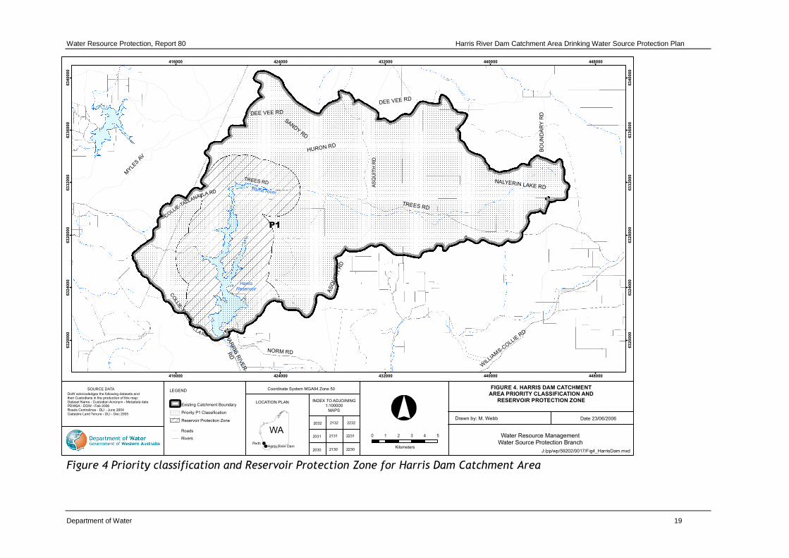
The Priority area is shown in Figure 4.
4.4 Reservoir Protection Zone
It is proposed to protect the reservoir from immediate risks to water quality including human contact, by amending the CAWS Act By-laws to apply a Reservoir Protection Zone in country areas. This Zone is a key barrier in the multiple barrier ‘catchment to

Harris Dam Catchment Area Drinking Water Source Protection Plan Water Resource Protection, Report 80
18 Department of Water
consumer’ risk based approach to drinking water source protection as outlined in the ADWG.
The Reservoir Protection Zone is an area extending two kilometres out from the top water level of the reservoir and includes the reservoir itself. It does not extend outside the catchment area. This area is shown for Harris Dam in Figure 4.
Unauthorised entry into the Reservoir Protection Zone would be prohibited under the proposed new By-laws.
Water Resource Protection, Report 80 Harris River Dam Catchment Area Drinking Water Source Protection Plan
Department of Water 19
Figure 4 Priority classification and Reservoir Protection Zone for Harris Dam Catchment Area
TREES RD
CO
LLIE
-TALL
AN
A
LLA RD
COLLIE
-TALLANALLA RD
AS
QU
I TH
RD
Harris River
HarrisReservoir
BO
UN
DA
RY
RD
TREES RD
DEE VEE RD
NORM RD
AS
QU
ITH
RD
WIL
LIAM
S-CO
LLIE R
D
SANDY RD
MYLE
S A
V
HURON RD
NALYERIN LAKE RD
HA
RR
IS R
IVE
R
RD
DEE VEE RD
416000
416000
424000
424000
432000
432000
440000
440000
448000
448000
63
20
00
0
63
20
00
0
63
24
00
0
63
24
00
0
63
28
00
0
63
28
00
0
63
32
00
0
63
32
00
0
63
36
00
0
63
36
00
0
63
40
00
0
63
40
00
0
J:/pp/wp/59202/0017/Fig4_HarrisDam.mxd
FIGURE 4. HARRIS DAM CATCHMENT
AREA PRIORITY CLASSIFICATION AND
RESERVOIR PROTECTION ZONE
Drawn by: M. Webb Date 23/06/2006
Water Resource ManagementWater Source Protection Branch
INDEX TO ADJOINING1:100000
MAPS
LOCATION PLAN
WA
SOURCE DATA
DoW acknowledges the following datasets and their Custodians in the production of this map:Dataset Name - Custodian Acronym - Metadata datePDWSA - DOW - Feb 2006Roads Centrelines - DLI - June 2004Cadastre Land Tenure - DLI - Dec 2005
2132 2232
2131 2231
2130 2230
Perth
LEGEND
Roads
Existing Catchment Boundary
Rivers
Priority P1 Classification
Coordinate System MGA94 Zone 50
0 1 2 3 4 5
Kilometers
2032
2031
2030Harris River Dam
P1
Reservoir Protection Zone

Harris Dam Catchment Area Drinking Water Source Protection Plan Water Resource Protection, Report 80
20 Department of Water
4.5 Land use planning
It is recognised under the Western Australian Planning Commission’s State Planning Strategy (see References) that the establishment of appropriate protection mechanisms in statutory land use planning processes is necessary to secure the long-term protection of drinking water sources. As outlined in Statement of Planning Policy No.2.7: Public Drinking Water Source Policy (see References) it is therefore appropriate that the Harris Dam Catchment Area, Reservoir Protection Zone and Priority 1 classification be recognised in the Shires of Collie, Harvey and Williams Town Planning Schemes.
Land use and activities in this P1 catchment should be guided by this Plan and the Department’s Water Quality Protection Note: Land Use Compatibility in Public Drinking Water Source Areas (see References). Any development proposals located within this area, or deemed likely to affect the protection objectives of the Harris Dam Catchment should be referred to the Department of Water for advice and recommendations.
The Department of Water’s protection strategy for PDWSAs provides for lawfully established and operated developments to continue within catchments despite their location or facilities posing a perceived level of risk to water quality which would not be accepted for new developments. The Department may negotiate with landowners/operators on measures to improve these facilities or processes to lessen the level of water contamination risk.
In critical areas close to water sources, the Department may make an offer to purchase land or development rights where the level of contamination risk is considered significant enough to potentially compromise the quality of water resources.
4.6 Best management practices
There are opportunities to significantly reduce risks to water quality by carefully considering design and management practices. The adoption of best management practices for land uses will continue to be encouraged to help protection water quality.
There are guidelines available for many land uses in the form of industry codes of practice, environmental guidelines or Water Quality Protection Notes. These have been developed in consultation with stakeholders such as industry groups, producers, State government agencies and technical advisers. Examples include Code of Practice for Timber Harvesting in Western Australia, Statewide Policy No.13 - Policy and Guidelines for Recreation within Public Drinking Water Source Areas on Crown Land and Statewide Policy No.2 - Pesticide use in Public Drinking Water Source Areas, which are listed in the References section. The guidelines help

Water Resource Protection, Report 80 Harris Dam Catchment Area Drinking Water Source Protection Plan
Department of Water 21
managers reduce the risk of their operations causing unacceptable environmental impacts. They are recommended as best practice for water quality protection.
Education and awareness (eg signage and information material) is a key mechanism for water quality protection, especially for those people visiting the area who are unfamiliar with the Harris Dam and its purpose. A brochure will be produced once this Plan is endorsed, describing the Harris Dam Catchment Area, its location and the main threats to water quality protection. This brochure will be available to the community and serve to inform people in simple terms about the drinking water source, its importance and the need to protect it.
4.7 Surveillance and By-law enforcement
The quality of public drinking water sources within country areas of the State is protected under the CAWS Act 1947. Declaration of these areas allows existing By-laws to be applied to protect water quality.
The Department of Water considers By-law enforcement, through on-ground surveillance of land use activities in Public Drinking Water Source Areas as an important water quality protection mechanism. Surveillance is also important in raising the general level of awareness of the need to protect water quality.
Signs are erected to educate the public and to advise of activities that are prohibited or regulated. This Plan recommends continuation of the delegation of surveillance and By-law enforcement to the Water Corporation.
4.8 Emergency response
Escape of chemicals during unforeseen incidents and use of chemicals during emergency responses can result in water contamination. The Shire of Harvey and Shire of Collie Local Emergency Management Committees (LEMC) through the South West Emergency Management District should be familiar with the location and purpose of the Harris Dam Catchment Area. This also applies to the Shire of Williams LEMC through the Great Southern Emergency Management District. A locality plan should be provided to the Fire and Rescue Services headquarters for the Hazardous Materials Emergency Advisory Team (HAZMAT). DEC is the lead agency for wildfire control management for the majority of the Harris Dam Catchment Area that is outside of the gazetted fire emergency response zone. The Water Corporation should have an advisory role to any HAZMAT incident in the Harris Dam Catchment Area.
Personnel who deal with WESTPLAN – HAZMAT (Western Australian Plan for Hazardous Materials) incidents within the area should have access to a map of the Harris Dam Catchment Area. These personnel should receive training to ensure an adequate understanding of the potential impacts of spills on the water resource.
Harris Dam Catchment Area Drinking Water Source Protection Plan Water Resource Protection, Report 80
22 Department of Water
4.9 Recommended protection strategies
Table 1 identifies the potential water quality risks associated with existing land uses in the Harris Dam Catchment Area and recommends protection strategies to minimise these risks.
Water Resource Protection, Report 80 Harris Dam Catchment Area Drinking Water Source Protection Plan
Department of Water 23
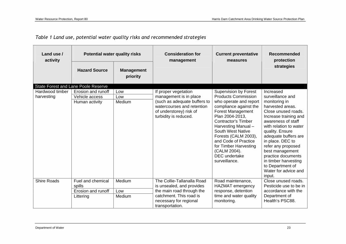
Table 1 Land use, potential water quality risks and recommended strategies
Potential water quality risks Land use / activity
Hazard Source Management priority
Consideration for management
Current preventative measures
Recommended protection strategies
State Forest and Lane Poole Reserve Erosion and runoff Low Vehicle access Low
Hardwood timber harvesting
Human activity Medium
If proper vegetation management is in place (such as adequate buffers to watercourses and retention of understorey) risk of turbidity is reduced.
Supervision by Forest Products Commission who operate and report compliance against the Forest Management Plan 2004-2013, Contractor’s Timber Harvesting Manual – South West Native Forests (CALM 2003), and Code of Practice for Timber Harvesting (CALM 2004). DEC undertake surveillance.
Increased surveillance and monitoring in harvested areas. Close unused roads. Increase training and awareness of staff with relation to water quality. Ensure adequate buffers are in place. DEC to refer any proposed best management practice documents in timber harvesting to Department of Water for advice and input.
Fuel and chemical spills
Medium
Erosion and runoff Low
Shire Roads
Littering Medium
The Collie-Tallanalla Road is unsealed, and provides the main road through the catchment. This road is necessary for regional transportation.
Road maintenance, HAZMAT emergency response, detention time and water quality monitoring.
Close unused roads. Pesticide use to be in accordance with the Department of Health’s PSC88.

Harris Dam Catchment Area Drinking Water Source Protection Plan Water Resource Protection, Report 80
24 Department of Water
Potential water quality risks Land use / activity
Hazard Source Management priority
Consideration for management
Current preventative measures
Recommended protection strategies
Fuel and chemical spills
Medium
Erosion and runoff Medium
Other roads and tracks Human activity High
Degree of maintenance depends on degree of usage for fire and forest management by DEC. Roads and tracks provide the public with easy access to the reservoir.
Water Corporation surveillance and water quality monitoring. Detention time in the reservoir.
Close unnecessary roads. Gate other roads that currently provide public access.
Turbidity from erosion from stripping of vegetation due to fire. Ash.
Low
Fire fighting foam Low Decomposition of vegetation, breakdown of soils/geological formation
Low
Decaying carcasses, human presence
Medium
Wildfire
Water point use and contamination of water body
Low
Campfires occasionally get out of control and turn into wildfires. DEC's fire fighting regime often results in feeder streams or dam water being pumped.
DEC carry out prescribed burns to reduce impact of wildfire. Water Corporation undertakes post fire catchment inspections and water quality monitoring. Turbidity mitigation strategies are implemented where required.
Continue current fire management regime.

Water Resource Protection, Report 80 Harris Dam Catchment Area Drinking Water Source Protection Plan
Department of Water 25
Potential water quality risks Land use / activity
Hazard Source Management priority
Consideration for management
Current preventative measures
Recommended protection strategies
Prescribed fire and fire control lines
Turbidity from erosion and stripping of vegetation due to fire, and ash.
Medium Fire management activities may cause turbidity but the degree is far less than if a wildfire occurred, therefore it is a necessary activity.
FESA standard operating procedures for prescribed burns.
FPC and DEC to have in place appropriate standards for construction of fire control lines. Water Corporation to monitor water quality at correct timing during and after prescribed burns.
Resource harvesting - apiarists, wildflower picking, seed collecting
Human activity Medium There are low numbers of people involved in these activities.
DEC permits required to undertake these activities with water quality protection measures as conditions.
DEC to ensure that permits contain adequate water quality protection measures.
Human and domestic animal presence
Medium Resource harvesting - firewood collection
Vehicle access Medium
Private firewood collection occurs on a widespread basis from Collie. DEC nominate designated firewood collection points to discourage collection from inappropriate locations.
Water Corporation surveillance, detention time.
Increased surveillance and signage. Prevent people collecting firewood from State Forest and Lane Poole Reserve, and promote legal collection in areas outside the catchment.

Harris Dam Catchment Area Drinking Water Source Protection Plan Water Resource Protection, Report 80
26 Department of Water
Potential water quality risks Land use / activity
Hazard Source Management priority
Consideration for management
Current preventative measures
Recommended protection strategies
Faecal contamination / carcasses
High
Erosion Low
There are a large number of feral pigs in the catchment. There is evidence of the deliberate introduction of pigs into the catchment to breed with the existing feral pig population to fuel hunting activities.
Water Corporation surveillance, DEC's 1080 baiting program for cats and foxes, DEC’s feral pig trapping program.
Feral animals
1080 Baiting Low 1080 is a naturally occurring poison in native plants.
Best practice guidelines for using 1080 poison
DEC to maintain 1080 baiting for cats and foxes and trapping for feral pigs.
Vegetation clearing for maintenance
Medium
Weed control Medium Machinery and vehicles
Medium
Muja power line
Western Power staff presence
Medium
Roundup is the only chemical used for weed control, in a spot-sprayed manner. This is a steel lattice tower structure, so no wood boring treatment is used. Easement maintenance is necessary for terminal line operations.
Undertaken during summer to reduce turbidity and dieback spread, detention time. PSC88.
Western Power to install access controls and adequate drainage on maintenance tracks, and comply with PSC88. Report any spills to WC.
Bauxite transport Low Vegetation clearing for maintenance
Low
Weed control Low
Conveyor belt Alcoa staff
presence Medium
The EPA has approved an Environmental Management Plan for the Worsley conveyor. Glyphosate is the only herbicide used.
Conveyor is enclosed/covered. Detention time, some drainage. PSC88.
Worsley to install access controls and maintain adequate drainage on access tracks. Comply with PSC88 and report

Water Resource Protection, Report 80 Harris Dam Catchment Area Drinking Water Source Protection Plan
Department of Water 27
Potential water quality risks Land use / activity
Hazard Source Management priority
Consideration for management
Current preventative measures
Recommended protection strategies
Machinery and vehicles
Medium
any spills to WC. Continue to operate in accordance with the EMP.
Erosion Low Public Environmental Review (PER) commitments.
Harris transfer main
Machinery and vehicles
Low
Transfers are not currently being undertaken until the new Treatment Plant is in operation.
Pipe is buried with a life greater than 100 years, with no regular maintenance required.
Adhere to the commitments in the PER.
Test drilling for future mining
Low
Spills Low Vehicle access Low
Mineral leases
Human presence Medium
The Department of Water and Water Corporation both have membership on the MMPLG. Mining activity has not occurred to date in the catchment.
MMPLG (Mining and Management Planning Liaison Group) oversees implementation of the State Agreement Act, which includes Alcoa's five year mine plan and environmental conditions.
Department of Water to reassess risk to water quality if mining is likely to occur, and continue to attend MMPLG meetings. Alcoa to comply with MMPLG requirements, and report any drilling or spills to WC.
Recreation - State Forest Bibbulmun track
Human and domestic animal presence
Medium Frequent and uncontrolled access to the water body.
Bibbulmun Track guide book and maps outline protection measures,
Increase signage informing walkers not to access the water

Harris Dam Catchment Area Drinking Water Source Protection Plan Water Resource Protection, Report 80
28 Department of Water
Potential water quality risks Land use / activity
Hazard Source Management priority
Consideration for management
Current preventative measures
Recommended protection strategies
Erosion Low toilets are provided at campsites. Stream crossings are bridged.
body. DEC to inform walkers not to contact water body.
Human and domestic animal presence
Medium
Rubbish/littering Medium Toilets Medium
Yourdamung Campsite (for Bibbulmun track users)
Campfires Low
Fires are not permitted at Yourdamung due to the high conservation values of the surrounding forest.
Bibbulmun Track guide book and maps outline protection measures, signage at camp sites, toilets and designated camp fire area provided, appropriate buffers to waterways from campsites.
Increase signage informing walkers not to access the water body. DEC to inform walkers not to contact water body.
Recreation - Illegal Rubbish/littering Medium Nutrients Low Erosion Low
Bushwalking / picnicking
Human presence High
Water Corporation surveillance, signage, water quality monitoring.
Increase signage informing tourists/picnickers not to access the water body, increased surveillance. Negotiate with landholders to close all unnecessary roads.
Hunting/shooting
Human and domestic animal activity
High There are a large number of feral pigs in the catchment. There is evidence of the
Water Corporation surveillance, limited signage.
Increased surveillance and By-law enforcement.

Water Resource Protection, Report 80 Harris Dam Catchment Area Drinking Water Source Protection Plan
Department of Water 29
Potential water quality risks Land use / activity
Hazard Source Management priority
Consideration for management
Current preventative measures
Recommended protection strategies
Carcasses and bait High introduction of pigs into the catchment to breed with the existing feral pig population to fuel hunting activities. Dogs are generally involved in pig hunting.
DEC’s feral pig trapping program, and 1080 baiting for cats and foxes.
Continue feral animal eradication programs.
Faecal contamination
High Dogs
Erosion of dam/stream banks
Low
People take their dogs into the catchment to hunt and shoot pigs. Dogs are known carriers of pathogens such as Cryptosporidium and Giardia. Dogs have been historically accepted into the catchment on a lead, and it is difficult to ensure they are always kept on a lead and owners clean up after their dogs.
Water Corporation surveillance.
Increased surveillance, and education and awareness in conjunction with land managers.
Human and animal activity, contact with water
High Marroning and fishing Erosion of
dam/stream banks Medium
Illegal under CAWS Act and FRM Act to undertake fishing and marroning. Penalties apply.
WC surveillance with occasional Fisheries surveillance. WC rangers have powers under the FRM Act.
Increased surveillance by WC and Fisheries. WC reporting to Fisheries to seek heavier

Harris Dam Catchment Area Drinking Water Source Protection Plan Water Resource Protection, Report 80
30 Department of Water
Potential water quality risks Land use / activity
Hazard Source Management priority
Consideration for management
Current preventative measures
Recommended protection strategies
Baits - including kangaroo carcasses
High
penalties for offenders. Closure of some roads and tracks to prevent unauthorised access in conjunction with land managers. Engage recreational user groups.
Human activity High Rubbish/littering High
Camping
Uncontrolled campfires
Medium
Uncontrolled campfires have the potential to cause wildfire. Camping in undesignated areas is prohibited and penalties apply.
Water Corporation surveillance, limited signage.
Increased surveillance and improved signage. DEC to promote use of designated campsites and discourage illegal camping. Closure of some roads and tracks to prevent unauthorised access.
Human contact with water
High Swimming
Erosion of dam/stream banks
Low
People and children have been seen jumping into the reservoir from the off-take tower. Direct body contact, especially near the off-take point, presents a high risk of pathogen contamination.
Water Corporation surveillance, limited signage, detention time, water quality monitoring.
Increased surveillance and By-laws enforcement, and signage. Closure of some roads and tracks to prevent unauthorised access.
Off-road driving Human activity High Evidence of off-road driving Water Corporation Increased

Water Resource Protection, Report 80 Harris Dam Catchment Area Drinking Water Source Protection Plan
Department of Water 31
Potential water quality risks Land use / activity
Hazard Source Management priority
Consideration for management
Current preventative measures
Recommended protection strategies
Erosion from vehicles
High
Fuel spills from refuelling/accidents
Medium
such as deliberately driving to spin wheels and disturb soil is visible around the banks of the catchment.
surveillance. Detention time in reservoir.
surveillance and signage. Gate access tracks to the water body. Close non-essential roads. Engage recreational user groups.
Human activity High Erosion from launching boats
Medium Boating
Fuel spills from refuelling/accidents
Medium
Evidence of boat launching on the banks of the Reservoir has been seen.
Water Corporation surveillance.
Increased surveillance and signage. Gate access tracks to the water body. Close non-essential roads. Engage recreational user groups.
Fuel Medium Chemicals Medium Pathogens High
Rubbish dumping Nutrients Low
Water Corporation surveillance. Illegal dumping legislation.
Increased surveillance and signage.
Fertiliser Low Weed control Medium Clearing native vegetation
Medium
Presence of people High
Illegal drug crops
Vehicle access Medium
DEC has reported finding illegal drug crops in low-lying areas of the catchment.
Water Corporation surveillance, Police intervention.
Increased surveillance and improved communication between WC, DEC and Police.

Harris Dam Catchment Area Drinking Water Source Protection Plan Water Resource Protection, Report 80
32 Department of Water
5 Recommendations 1 Implement the recommended protection strategies as detailed in Table 1: Land
use, potential water quality risks and recommended strategies of this Plan (Applicable stakeholders).
2 Prepare an implementation strategy in consultation with stakeholders for this Plan describing responsible parties, timeframes and funding sources for the recommended protection strategies (Department of Water).
3 The Shires of Collie, Harvey and Williams Town Planning Schemes should incorporate this Plan and reflect the identified Harris Dam Catchment Area boundary, the Reservoir Protection Zone and the Priority 1 classification (Shires of Collie, Harvey and Williams).
4 Any management plans produced by the Department of Environment and Conservation which incorporate the area of the Harris Dam Catchment should be referred to the Department of Water for advice and recommendations (Department of Environment and Conservation).
5 All development proposals within the Harris Dam Catchment Area that are likely to impact on water quality and/or quantity, or are inconsistent with Water Quality Protection Note – Land use compatibility in Public Drinking Water Source Areas or Statement of Planning Policy No.2.7 – Public Drinking Water Source Policy, should be referred to the Department of Water for advice and recommendations (Department for Planning and Infrastructure, Shires of Collie, Harvey and Williams and Department of Environment and Conservation).
6 Incidents covered by WESTPLAN – HAZMAT in the Harris Dam Catchment Area should be addressed through the following:
• the Shires of Collie, Harvey and Williams LEMCs are familiar with the location and purpose of the Harris River Dam Catchment Area;
• the locality plan for the Harris Dam Catchment Area is provided to the Fire and Rescue headquarters for the HAZMAT Emergency Advisory Team;
• the Water Corporation provides an advisory role during incidents in the Harris Dam Catchment Area; and
• personnel dealing with WESTPLAN – HAZMAT incidents in the area have ready access to a locality map of the Harris Dam Catchment Area and training to understand the potential impacts of spills on drinking water quality.
(Water Corporation, Shires of Collie, Harvey and Williams and Department of Environment and Conservation)
7 The surveillance program should be continued to identify any potential threats within the Harris Dam Catchment Area. Pursuant to Section 13(1) of the Water and Rivers Commission Act 1995, the Department of Water delegates responsibility for the surveillance and enforcement to the Water Corporation (Water Corporation).

Water Resource Protection, Report 80 Harris Dam Catchment Area Drinking Water Source Protection Plan
Department of Water 33
8 Investigate the closure of unnecessary roads and tracks, and gating of access to other roads to prevent public access to the Harris reservoir (Water Corporation, Department of Environment and Conservation, Shire of Harvey, Shire of Collie).
9 A review of this Plan should be undertaken after five years (Department of Water).

Harris Dam Catchment Area Drinking Water Source Protection Plan Water Resource Protection, Report 80
34 Department of Water
Appendices
Appendix A - Water quality
The Water Corporation has monitored the raw (source) water quality from Harris Dam in accordance with the Australian Drinking Water Guidelines (ADWG) and interpretations agreed to with the Department of Health. The raw water is regularly monitored for:
• aesthetic related characteristics (non-health related); and
• health related characteristics including:
− health related chemicals; and
− microbiological contaminants.
Following is data representative of the quality of raw water in Harris Dam. In the absence of specific guidelines for raw water quality, the results have been compared with the ADWG values set for drinking water, which defines the quality requirements at the customers tap. Results that exceed the ADWG have been shaded to give an indication of potential raw water quality issues associated with this source.
It is important to appreciate that the raw water data presented does not represent the quality of drinking water distributed to the public. Barriers such as storage and water treatment, to name a few, exist downstream of the raw water to ensure it meets the requirements of the ADWG. For more information on the quality of drinking water supplied to the Collie region and the GWTWS scheme refer to the most recent Water Corporation Drinking Water Quality Annual Report at <www.watercorporation.com.au> > Publications > Annual Reports > Drinking Water Quality Annual Report.
Aesthetic related characteristics
Aesthetic water quality analyses for raw water from Harris Dam are summarised in the table below.
The values are taken from ongoing monitoring for the period January 2001 to December 2006. Any water quality parameters that have been detected are reported, those that have on occasion exceeded the ADWG are shaded.

Water Resource Protection, Report 80 Harris Dam Catchment Area Drinking Water Source Protection Plan
Department of Water 35
Aesthetic related detections for Harris Dam
Harris Dam Parameter Units ADWG Aesthetic Guideline Value*
Range Median
Aluminium acid soluble mg/L 0.2 <0.008 - 0.016 0.016
Chloride mg/L 250 79 - 97 88
Colour - True TCU 15 2 - 10 4
Conductivity mS/m - 32 - 43 38
Hardness as CaCO3 mg/L 200 33 - 45 37.5
Iron unfiltered mg/L 0.3 <0.003 - 1.4 0.07
Manganese unfiltered mg/L 0.1 <0.002 - 0.146 0.012
Sodium mg/L 180 45 - 54 50.5
Sulphate mg/L 250 7.5 - 10 8.75
Total filterable solids by summation mg/L 500 173 - 207 189.5
Turbidity NTU 5 0.4 - 9.2 0.9
pH measured in laboratory NO UNIT 6.5 - 8.5 6.89 - 7.83 7.43 * An aesthetic guideline value is the concentration or measure of a water quality characteristic that is associated
with good quality water.
Health related characteristics
Health parameters
Raw water from Harris Dam is analysed for health related chemicals including inorganics, heavy metals, industrial hydrocarbons and pesticides. Health related water quality parameters that have been measured at detectable levels in the source between January 2001 and December 2006 are summarised in the table below.
Health related detections for Harris Dam
Harris Dam Parameter Units ADWG Health Guideline Value*
Range Median
Barium mg/L 0 - 0.7 0.0035 - 0.01 0.0075
Boron mg/L 0 - 4 0.026 - 0.03 0.03
Manganese unfiltered mg/L 0 - 0.5 <0.002 - 0.146 0.012
Nitrite as nitrogen mg/L 0 - 0.91 <0.002 - 0.006 <0.002
Nitrite plus nitrate as N mg/L 0 - 11.29 <0.05 - 0.17 <0.05
Sulphate mg/L 0 - 500 7.5 - 10 8.75

Harris Dam Catchment Area Drinking Water Source Protection Plan Water Resource Protection, Report 80
36 Department of Water
* A health guideline value is the concentration or measure of a water quality characteristic that, based on present knowledge, does not result in any significant risk to the health of the consumer over a lifetime of consumption (NHMRC & ARMCANZ, 1996).
Microbiological contaminants
Microbiological testing of raw water samples from Harris Dam is currently conducted on a weekly basis. Escherichia coli counts are used as an indicator of the degree of recent faecal contamination of the raw water from warm-blooded animals. A count less than 20 most probable number (MPN) per 100 millilitre (mL) sample is typically associated with low levels of faecal contamination and is used as a microbiological contamination benchmark of the raw water (WHO, 1996). As such, counts less than 20 MPN are seen as being an indication of raw water that has not been recently contaminated with faecal material.
During the reviewed period of January 2001 to December 2006, positive Escherichia coli counts were recorded in 30.5 per cent of samples. None of these samples had Escherichia coli counts greater than 20 MPN/100mL.

Water Resource Protection, Report 80 Harris Dam Catchment Area Drinking Water Source Protection Plan
Department of Water 37
Appendix B - Photographs
Photo 1 Harris Reservoir
Photo 2 Muja Transmission Line

Harris Dam Catchment Area Drinking Water Source Protection Plan Water Resource Protection, Report 80
38 Department of Water
Photo 3 Typical campsite along the Bibbulmun Track
Photo 4 Signage at the entry to Harris Dam

Water Resource Protection, Report 80 Harris Dam Catchment Area Drinking Water Source Protection Plan
Department of Water 39
Glossary
ADWG The Australian Drinking Water Guidelines, outlining guideline criteria for the quality of drinking water in Australia.
Aesthetic guideline
NHMRC guideline level ascribed to acceptable aesthetic qualities of drinking water such as taste, smell, colour and temperature.
AHD Australian Height Datum is the height of land in metres above mean sea level. For example this is +0.026 m at Fremantle.
Allocation The quantity of water permitted to be abstracted by a licence, usually specified in kilolitres per year (kL/a).
ANZECC Australian and New Zealand Environment Conservation Council.
ARMCANZ Agriculture and Resource Management Council of Australia and New Zealand.
Augment To increase the available water within a storage dam by pumping back water from a secondary storage/reservoir dam.
Catchment The area of land which intercepts rainfall and contributes the collected water to surface water (streams, rivers, wetlands) or groundwater.
CFU Coliform forming units is a measure of pathogen contamination in water.
DEC Department of Environment and Conservation (previously consisted of the Department of Environment and the Department of Conservation and Land Management).
Diffuse source Pollution originating from a widespread area eg urban stormwater runoff, agricultural infiltration.
Effluent The liquid, solid or gaseous wastes discharged by a process, treated or untreated.
FESA Fire and Emergency Services Authority of Western Australia
GL Gigalitres (1000 000 000 litres)
ha Hectares (a measure of area)
HAZMAT Hazardous Materials

Harris Dam Catchment Area Drinking Water Source Protection Plan Water Resource Protection, Report 80
40 Department of Water
Hydrogeology The study of groundwater, especially relating to the distribution of aquifers, groundwater flow and groundwater quality.
kL Kilolitres (1000 litres)
km Kilometres (1000 metres)
km2 Square kilometres (a measure of area)
KV Kilovolt (1000 volts)
Leaching / leachate
The process by which materials such as organic matter and mineral salts are washed out of a layer of soil or dumped material by being dissolved or suspended in percolating rainwater. The material washed out is known as leachate. Leachate can pollute groundwater and waterways.
LEMC Local Emergency Management Committee
m Metres
mg/L Milligrams per litre (0.001 grams per litre)
ML Megalitres (1 000 000 litres)
mm Millimetres
MMPLG Mining and Management Planning Liaison Group
MPN Most probable number (a measure of microbiological contamination)
NHMRC National Health and Medical Research Council.
NTU Nephelometric turbidity units are a measure of turbidity in water.
Nutrient load The amount of nutrient reaching the waterway over a given timeframe (usually per year) from its catchment area.
Nutrients
Minerals dissolved in water, particularly inorganic compounds of nitrogen (nitrate and ammonia) and phosphorous (phosphate) which provide nutrition (food) for plant growth. Total nutrient levels include the inorganic forms of an element plus any bound in organic molecules.
PER Public Environmental Review
Pesticides Collective name for a variety of insecticides, fungicides, herbicides, algicides, fumigants and rodenticides used to kill organisms.
Point source Pollution originating from a specific localised source, eg sewage or

Water Resource Protection, Report 80 Harris Dam Catchment Area Drinking Water Source Protection Plan
Department of Water 41
pollution effluent discharge, industrial waste discharge.
Pollution
Water pollution occurs when waste products or other substances, eg effluent, litter, refuse, sewage or contaminated runoff, change the physical, chemical biological or thermal properties of the water, adversely affecting water quality, living species and beneficial uses.
Public Drinking Water Source Area (PDWSA)
Includes all underground water pollution control areas, catchment areas and water reserves constituted under the Metropolitan Water Supply Sewerage and Drainage Act 1909 and the Country Areas Water Supply Act 1947.
Recharge Water infiltrating to replenish an aquifer.
Recharge area
An area through which water from a groundwater catchment percolates to replenish (recharge) an aquifer. An unconfined aquifer is recharged by rainfall throughout its distribution. Confined aquifers are recharged in specific areas where water leaks from overlying aquifers, or where the aquifer rises to meet the surface.
Reservoir A reservoir, dam, tank, pond or lake that forms part of any public water supply works
Run-off Water that flows over the surface from a catchment area, including streams.
Scheme supply Water diverted from a source or sources by a water authority of private company and supplied via a distribution network to customers for urban, industrial or irrigation use.
Storage reservoir
A major reservoir of water created in a river valley by building a dam.
Stormwater Rainwater which has run off the ground surface, roads, paved areas etc. and is usually carried away by drains.
TDS Total dissolved solids, a measurement of ions in solution, such as salts in water.
Treatment Application of techniques such as settlement, filtration and chlorination to render water suitable for specific purposes including drinking and discharge to the environment.
Water quality The physical, chemical and biological measures of water.

Harris Dam Catchment Area Drinking Water Source Protection Plan Water Resource Protection, Report 80
42 Department of Water
References
Australian and New Zealand Environment and Conservation Council (ANZECC) 1992, Australian Water Quality Guidelines for Fresh and Marine Waters – National Water Quality Management Strategy, ANZECC, Canberra.
Agriculture and Resource Management Council of Australia and New Zealand (ARMCANZ) & ANZECC 1996, Draft Rural Land Uses and Water Quality – A Community Resource Document, ARMCANZ & ANZECC, Canberra.
Australian Labor Party 2001, Protecting Our Old Growth Forests, adopted as the State Government’s Protecting Our Old Growth Forests Policy, Department of Environment and Conservation, available <www.naturebase.net/national_parks/management>
Churchwood, HM & McArthur, WM 1980, Landforms and soils of the Darling System, Western Australia, Atlas of Natural Resources – Darling System Western Australia, Department of Conservation and Land Management and Environment WA, Perth.
Collie Water Advisory Group 1999, Collie Basin Water Resource Management, prepared for the Western Australian Government, Department of Resources Development, Perth.
Conservation Commission of Western Australia 2004, Forest Management Plan 2004 – 2013, Government of Western Australia, Perth.
The Cooperative Research Centre (CRC) for Water Quality and Treatment, no date, Drinking Water Facts – All About Australia’s Drinking Water, CRC, Adelaide, available <www.waterquality.crc.org.au>.
CSIRO 2005, Water for a Healthy Country Update – September 2005, National Research Flagship, CSIRO, available <http://www.cmis.csiro.au/healthycountry/updates/sep05/story1.htm>.
Dames and Moore 1985, Harris Dam Project Environmental Review and Management Programme, Report No. WP2, Water Authority of Western Australia, Leederville.
Department of Conservation and Land Management 1999, Code of Practice for Timber Harvesting in Western Australia, Department of Conservation and Land Management, Perth.
Department of Conservation and Land Management 2002, Bibbulmun Track Map 3 Collie – Harvey – Quindanning Road to Mumballup, December 2002, Government of Western Australia, Perth.

Water Resource Protection, Report 80 Harris Dam Catchment Area Drinking Water Source Protection Plan
Department of Water 43
Department of Conservation and Land Management 2002, Guide to the Bibbulmun Track - Northern Half, 2nd edn, Department of Conservation and Land Management, Perth.
Department of Conservation and Land Management 2003, Contractor’s Timber Harvesting Manual for South West Native Forests, Department of Conservation and Land Management, Perth.
Department of Conservation and Land Management 2004, Lane Poole Reserve Issues Paper, Department of Conservation and Land Management, Perth, available <www.naturebase.net/national_parks/management/man_have_your_say.html>
Department of Health 2006, Use of Herbicides in Water Catchment Areas, Circular No: PSC 88, 29 August 2006, Department of Health, Perth.
Department of Water Various dates, Water Quality Protection Notes – Various titles, Department of Water, Perth, available <www.water.wa.gov.au>.
Geldreich, EE 1996, Pathogenic Agents in Freshwater Resources, Hydrological Processes, Volume 10, pp 315-333, 1996.
Government of Western Australia 1914, Rights in Water and Irrigation Act 1914, State Law Publisher, Perth, available <www.slp.wa.gov.au>.
Government of Western Australia 1947, Country Areas Water Supply Act 1947, State Law Publisher, Perth, available <www.slp.wa.gov.au>.
Government of Western Australia 1961, Alumina Refinery Agreement Act 1961, State Law Publisher, Perth, available <www.slp.wa.gov.au>.
Government of Western Australia 2001, State Water Quality Management Strategy No.1 – Framework for implementation, Report SWQ1, Government of Western Australia, Perth.
Grant, C 2005, Environmental Management Manual Bauxite Mining Operations 2005 – 2007, Version 9, Authorised by MIN Environmental Authorisers, Alcoa, Western Australia.
Grayson, RB, Haydon, SR, Jayasuriya, MDA & Finlayson, BL 1993, Water Quality in mountain ash forests, separating the impact of roads from logging operations, Journal of Hydrology, 150 pp 459-480.
Hrudey, SE & Hrudey, EJ 2004, Safe Drinking Water – Lessons from Recent Outbreaks in Affluent Nations, IWA Publishing, London.
National Health and Medical Research Council (NHMRC) & Natural Resource Management Ministerial Council (NRMMC) 2004, National Water Quality

Harris Dam Catchment Area Drinking Water Source Protection Plan Water Resource Protection, Report 80
44 Department of Water
Management Strategy: Australian Drinking Water Guidelines, Australian Government, Canberra, available <www.nhmrc.gov.au/publications/synopses/eh19syn.htm>.
Pearcey, M (Department of Environment) & Terry, C (Water Corporation) 2005, How our river flows have changed, Climate Note 7/05 (August), Indian Ocean Climate Initiative, Perth, available <www.ioci.org.au>.
State Emergency Management Committee 2005, Policy Statement No.7 Western Australian Emergency Management Arrangements, Government of Western Australia, Perth.
Water and Rivers Commission 1998, Proposed Harvey Basin Surface Water Allocation Plan, WRAP14, Water and Rivers Commission, Perth.
Water and Rivers Commission 2000, Statewide Policy No.2 – Pesticide Use in Public Drinking Water Source Areas, Water and Rivers Commission, Perth, available <www.water.wa.gov.au>.
Water and Rivers Commission 2003, Statewide Policy No.13 – Policy and Guidelines for Recreation within Public Drinking Water Source Areas on Crown Land, Water and Rivers Commission, Perth, available <www.water.wa.gov.au>.
Water Corporation 2006, SG097 Source Protection Operations Manual, WI1, Water Corporation, Perth.
Welker Environmental Consultancy 1999, Stirling-Harvey Redevelopment Scheme – Public Environmental Review, Water Corporation, Perth.
Western Australian Planning Commission 1997, State Planning Strategy, State Government of Western Australia, Perth, available <www.wapc.wa.gov.au/Publications/52.aspx>.
Western Australian Planning Commission 2003, Statement of Planning Policy No. 2.7 – Public Drinking Water Source Policy, Government Gazette WA, 10 June 2003, pp. 2077-82, Government of Western Australia, Perth, available <www.wapc.wa.gov.au/Publications/149.aspx>.
Western Australian Planning Commission 2004, Water resources statement of planning policy 2.9 – Draft policy for public comment, Western Australian Planning Commission, Perth, available <www.wapc.wa.gov.au/Publications/250.aspx>.
World Health Organisation 1996, Guidelines for Drinking-Water Quality – Volume 2 – Health Criteria and Other Supporting Information, 2nd edn, World Health Organisation, Geneva, available <www.who.int/water_sanitation_health/dwq/en/2edvol2p1.pdf>.

Water Resource Protection, Report 80 Harris Dam Catchment Area Drinking Water Source Protection Plan
Department of Water 45
Contributors
This report was prepared by:
Contribution Personnel Title Organisation
Tony Laws Branch Manager, Water Source Protection
Department of Water
Supervision
Stephen Watson Program Manager, Water Source Protection
Department of Water
Kathryn Buehrig Water Resource Planner, Water Source Protection
Department of Water
Report Preparation
Sarah MacNish Scientific Officer Water Corporation
Drafting Melanie Webb GIS Officer Department of Water
Photographs Kathryn Buehrig Water Resource Planner, Water Source Protection
Department of Water

Government of Western AustraliaDepartment of Water
��������������������������������
REPORT NO. 80June 2007
Harris Dam Catchment Area Drinking Water Source Protection Plan