harrison’s wood - neighbourhood plan | welcome to … · · 2016-10-01harrison’s plantation,...
TRANSCRIPT

Harrison’s Plantation, The Breck and The Boar Plantation;Management Plan, June 2015
Norfolk County Council on behalf of Broadland District Council and Sprowston Town Council
H A R R I S O N ’ S W O O D

Date: 29.06.2015 Final VersionAuthor: Z. Tebbutt (Norfolk County Council, Natural Environment Team)Checked by: D. White (Norfolk County Council, Natural Environment Team)
Commissioning Officer: R. Squires (Broadland District Council)
On behalf of
Contents
Harrison’s Plantation, The Breck and The Boar; Management Plan 2015
1.0 Introduction 2.0 The Site 3.0 Site Phasing 4.0 Beyond the Basics
1.0 Introduction
1.1 Appointment & Brief 1.2 Scope and Objectives 1.3 Methodology
2.0 The Site
2.1 Wider Context 2.2 Historical Context 2.3 Site Survey 2.4 Strengths, Weaknesses, Opportunities, Constraints (SWOC) 2.5 Zoning Plan Proposals 2.6 Consultation and Site Visit
3.0 Site Phasing
3.1 Variables and Risks
3.2 Phasing 3.2.1 Phase 1 3.2.2 Phase 2 3.2.3 Phase 3 3.2.4 Future Phases
4.0 Beyond the Basics
4.1 On-going Management 4.1.1 Ecology 4.1.2 Tree Health and Safety 4.1.3 Woodland Management 4.2 Designations 4.3 Future Funding
5.0 Appendices & References
5.1 Appendices Appendix 1. Broadland District Council Brief
Appendix 2. Key Dates/ Consultation Meetings
Appendix 3 Detailed Ecological Management Schedule
Appendix 4 Project Risk Register
Appendix 5 Schedule of Works
Appendix 6 National Tree Safety Group Guidance.
Appendix 7 Indicative Cost Estimates
5.2 References Image References Text References
Harrison’s Plantation, The Breck and The Boar; Management Plan 2015
1.0 Introduction Page 12.0 The Site 3.0 Site Phasing 4.0 Beyond the Basics
1.0 Introduction1.1 Appointment & Brief
Norfolk County Council Natural Environment Team has been appointed by Broadland District Council to produce a management plan for Harrison’s Plantation, The Breck and The Boar Plantation, Sprowston, to enable public access ahead of development.
The officers undertaking study and writing of the management plan comprise;
Zoe Tebbutt, Landscape and Green InfrastructureEdward Stocker, EcologyTom Russell-Grant, ArboricultureDavid White, Green Infrastructure
The original requirement for a management plan was secured through condition and s106 agreement for the development known as Land at Blue Boar Lane, Sprowston, (2008/0367) for the erection of up to 1233 Dwellings Including Link Road, Recreation Areas, Primary School, Open Space and other Associated Works.
These woodland areas have been enabled to be brought forward earlier than the development trigger ‘prior to occupation of 450th dwelling’ through prioritisation by the Greater Norwich Green Infrastructure Team, and agreed loan through the Greater Norwich Growth Board (GNGB). Funds are to be reimbursed to the GNGB once development reaches the s106 trigger point.
1.2 Scope and Objectives
This management plan looks at the necessary measures required to enable public access to the woodlands in the short term, while assessing the aspirations and opportunities for woodland management and further community involvement in the longer term. The plan takes into consideration potential risks and variables
associated with other projects and the permitted development.
Broadland District Council has produced a detailed brief for these works (Appendix 1), with the main objectives summarised below,
The Woodland Management Plan shall:
• Establish the woodland management objectives in consultation with Broadland District Council and Sprowston Town Council.
• Identify an initial programme of costed works to be undertaken in year 1 in order to make the woodlands safe and suitable for use.
• Set out the requirements for the future management and maintenance of Harrison Plantation, The Breck and Boar Plantation including costed works for years 2 to 5.
This document responds to requirements as set out by Broadland District Council in the attached brief (Appendix 1). However it should be noted that Condition 20 of planning permission 20080367 sets out further detail for the management plan. Although this report acknowledges and provides sufficient detail to achieve relative aims of the condition, the report principally responds to the brief as written by Broadland District Council.
Condition 20 summarised as follows;
The Woodland Management plan shall comprise a full and detailed plan for all woodland areas for a period of twenty-five years and include detailed proposals for the following matters;
• wildlife conservation and biodiversity considerations,
• a full, detailed and quantified risk assessment of all trees and woodland areas on site,
• the defined uses of all woodland areas including
nature conservation, quiet recreation, dog walking and other recreational activity such as nature / tree trails, orienteering, Forest Schools and other group activities including local volunteers,
• all forms of access including emergency and maintenance vehicles, disabled visitors, pedestrians and cyclists; paths; fences and structures to be erected anywhere around or within the woodland areas and,
• the long term provision for management and maintenance of these areas.
1.3 Methodology
Consultation with Broadland District Council, Sprowston Town Council and others was inherent throughout the management planning process with regular update meetings with representatives from each party, notwithstanding telephone calls and emails in between these times. These meetings were as regular as required, a schedule of meetings held can be found in Appendix 2.
Working methodology for the management plan was as follows;
• Desk Study; a desk study examined the historical values of the site in terms of ecology and heritage and drew a comparison to the woodland today. The study also brings together other project streams to assess other potential risks and timescales involved.
• Site Survey; All members of the team made a number of site visits to assess ecology, landscape, health and safety and met to discuss proposals/other project streams. Workshop style meetings were held within the Natural Environment Team to discuss the site and management proposals, inviting others when appropriate.
• Initial Concepts; once the initial survey and
concept plan had been drafted, more detailed discussion was undertaken with the entire Sprowston Town Council.
• Consultation; aside from consultation with councillor’s through the Chairman and Parish Clerk, a guided site visit took place for local councillors, allowing them to see the site, ask questions and put forward suggestions.
• Report Drafting; remaining information was gathered and a full draft created and circulated to Broadland District Council and Town Councillors ahead of a final meeting to discuss any amendments required and the next steps.
• Final Report; amendments to be made and appendices finalised after meeting on 2nd June. Final Report to be issued before the end of the calendar month.
Harrison’s Plantation, The Breck and The Boar; Management Plan 2015
1.0 Introduction 2.0 The SitePage 2 3.0 Site Phasing 4.0 Beyond the Basics
0 630 1,260 1,890 2,520315Meters
1:25,000
LegendStudy Site Boundaries
Future Development PhasesDeveloper
Hopkins Homes
Persimmon
Public Open Space
School
Taylor Wimpey
New Link Road
´
This
map
is b
ased
upo
n O
rdna
nce
Sur
vey
mat
eria
l with
the
perm
issi
on o
f Ord
nanc
e S
urve
y on
beh
alf o
fth
e C
ontro
ller o
f Her
Maj
esty
's S
tatio
nery
Offi
ce ©
Cro
wn
copy
right
. N
orfo
lk C
ount
y C
ounc
il. L
icen
ce N
o: 1
0001
9340
201
5
P1
P3
P2
P4
P3
P4
P1
P2P3
P2
P4
POS
POS
P4
P1School
0 125 250 375 50062.5Meters
1:5,000
LegendStudy Site Boundaries
Future Development PhasesDeveloper
Hopkins Homes
Persimmon
Public Open Space
School
Taylor Wimpey
New Link Road
´
This
map
is b
ased
upo
n O
rdna
nce
Sur
vey
mat
eria
l with
the
perm
issi
on o
f Ord
nanc
e S
urve
y on
beh
alf o
fth
e C
ontro
ller o
f Her
Maj
esty
's S
tatio
nery
Offi
ce ©
Cro
wn
copy
right
. N
orfo
lk C
ount
y C
ounc
il. L
icen
ce N
o: 1
0001
9340
201
5
The Boar Plantation
Harrison’s Plantation
The Breck
© N
orfo
lk C
ount
y C
ounc
il©
Cro
wn
Cop
yrig
ht a
nd d
atab
ase
right
s 20
15 O
rdna
nce
Sur
vey
1000
1934
0
2.0 The Site
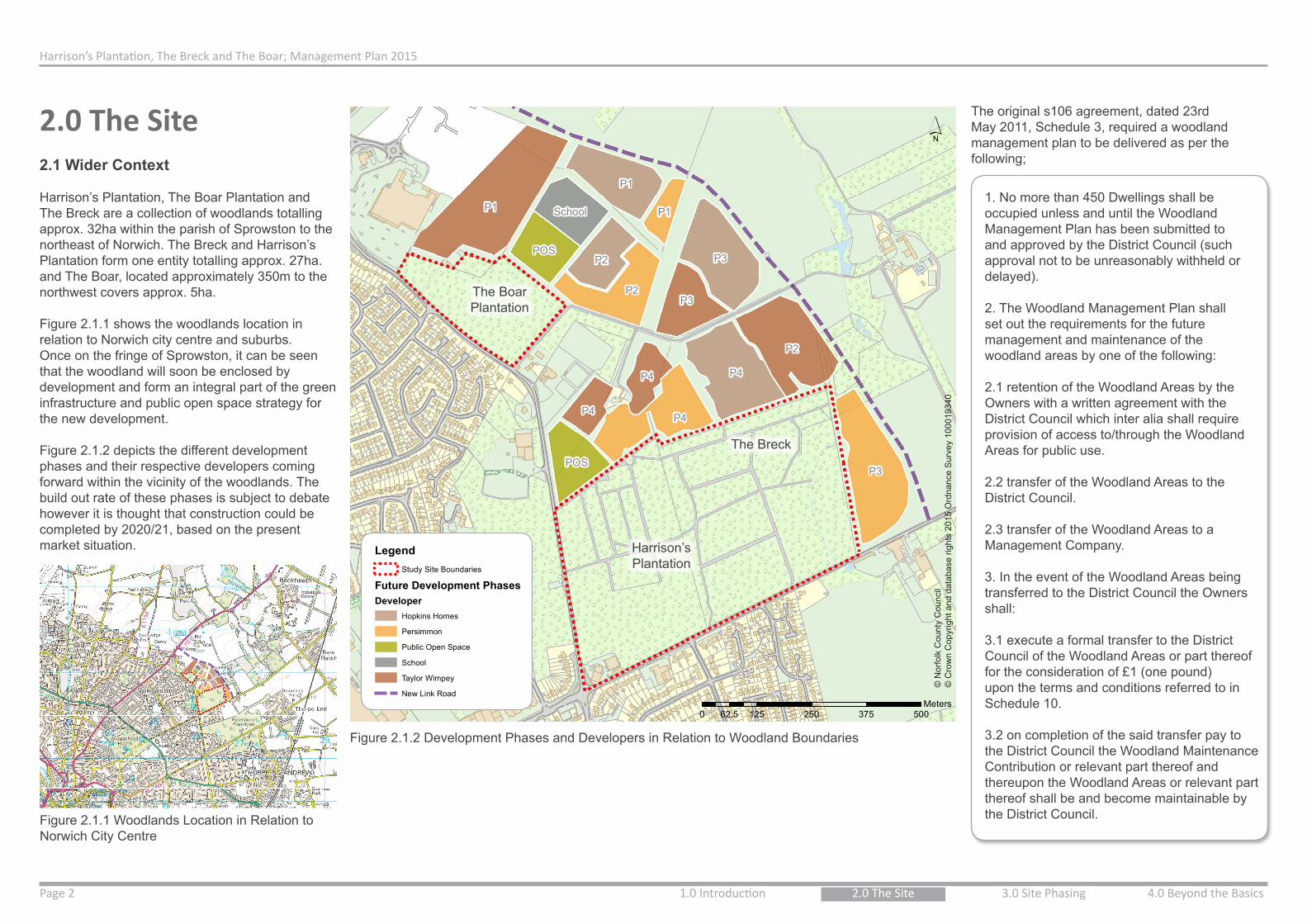
Figure 2.1.1 Woodlands Location in Relation to Norwich City Centre
Figure 2.1.2 Development Phases and Developers in Relation to Woodland Boundaries
2.1 Wider Context
Harrison’s Plantation, The Boar Plantation and The Breck are a collection of woodlands totalling approx. 32ha within the parish of Sprowston to the northeast of Norwich. The Breck and Harrison’s Plantation form one entity totalling approx. 27ha. and The Boar, located approximately 350m to the northwest covers approx. 5ha.
Figure 2.1.1 shows the woodlands location in relation to Norwich city centre and suburbs. Once on the fringe of Sprowston, it can be seen that the woodland will soon be enclosed by development and form an integral part of the green infrastructure and public open space strategy for the new development.
Figure 2.1.2 depicts the different development phases and their respective developers coming forward within the vicinity of the woodlands. The build out rate of these phases is subject to debate however it is thought that construction could be completed by 2020/21, based on the present market situation.
The original s106 agreement, dated 23rd May 2011, Schedule 3, required a woodland management plan to be delivered as per the following;
1. No more than 450 Dwellings shall be occupied unless and until the Woodland Management Plan has been submitted to and approved by the District Council (such approval not to be unreasonably withheld or delayed).
2. The Woodland Management Plan shall set out the requirements for the future management and maintenance of the woodland areas by one of the following:
2.1 retention of the Woodland Areas by the Owners with a written agreement with the District Council which inter alia shall require provision of access to/through the Woodland Areas for public use.
2.2 transfer of the Woodland Areas to the District Council.
2.3 transfer of the Woodland Areas to a Management Company.
3. In the event of the Woodland Areas being transferred to the District Council the Owners shall:
3.1 execute a formal transfer to the District Council of the Woodland Areas or part thereof for the consideration of £1 (one pound) upon the terms and conditions referred to in Schedule 10.
3.2 on completion of the said transfer pay to the District Council the Woodland Maintenance Contribution or relevant part thereof and thereupon the Woodland Areas or relevant part thereof shall be and become maintainable by the District Council.

Harrison’s Plantation, The Breck and The Boar; Management Plan 2015
1.0 Introduction Page 32.0 The Site 3.0 Site Phasing 4.0 Beyond the Basics
Present Day Woodlands Location
Map
Cou
rtesy
of A
ndre
w M
acna
ir, O
rigin
ally
Pub
lishe
d by
Lar
k’s
Pre
ss, 1
989
There are other requirements of the s106 which could have a degree of impact on the woodlands for which this management plan will try to mitigate through integrated planning and sharing of information with Norfolk County Council Developer Services.
Schedule 6 outlines Pedestrian and Cycle Routes to be provided by the development, of which the following are particularly relevant to the Woodlands:
• Provision of a cycleway adjacent to Blue Boar Lane to be provided prior to occupation of 550th dwelling, unless otherwise agreed with the County Council.
• Provision of cycleway adjacent to Salhouse Road to be provided by the occupation of the 1050th Dwelling or prior to the occupation of the 1st dwelling in the vicinity of the Salhouse Road/Link Road roundabout, whichever is the earlier, unless otherwise agreed with the County Council.
4. In the event of the Woodland Areas being transferred to the District Council the District Council shall apply the Woodland Maintenance Contribution towards the maintenance of the Woodland Areas or relevant part thereof and for no other purpose.
“Woodland Maintenance Contribution” means the sum not exceeding £100,000 (one hundred thousand pounds) as increased by the Inflation provision payable (in part or parts) by the Owners to the District Council towards the future costs of maintaining the Woodland Areas in accordance with the Woodland Management Plan by the District Council.
Development-led schemes are not the only instances of potential influence on the woodland management plan; Push The Pedalways is a scheme coordinated by Norwich City Council which has been enabled by Department for Transport Cycling Ambition grants.The proposed route of the Pink Pedalway is to join Salhouse Road via Hammond Close, crossing the road, and passing through the edge of Harrison’s Plantation heading northeast toward Rackheath. Some preparation works have already been undertaken with regard to this cycleway, and further works are to be implemented in September 2015. It will be necessary to coordinate proposals and working schedules with Norwich City Council for the Salhouse Road side of the plantation.
There are some local relevant policies for this scheme; Sprowston Neighbourhood Plan (2014) Policies 16 and 17 identify these woodlands as having the potential for a Woodland Park with a Puffin crossing facility at Blue Boar Lane between Cottage and Harrison’s Plantations. Discussion with Norfolk County Council Highways will take place to determine how access to the new site will be addressed.
2.2 Historical Context
2.2.1 Landscape History
The land where the woodlands stand was once part of a much larger Mousehold Heath that stretched from Norwich to Rackheath and Salhouse. Figure 2.2.1.1 is a copy of Faden’s Map of Norfolk (Lark’s Press, 1989), dating from 1797 and shows the site as grassland and or heath in the late 18th Century.
By the time of the first Edition Ordnance Survey Map (1879 -1886), much of the site had been cultivated or was being managed for timber production. However as can be seen on the first Edition Ordnance Survey Map (Fig 2.2.1.2), some uncultivated heathland/ grassland habitat
Fig 2.2.1.1 Faden’s Map of Norfolk, 1797
remained in the North East and South East areas of the site.
These areas were eventually also planted with commercial softwood species and by the 20th Century, were being managed for forestry with mature trees being harvested in blocks on rotation.Aerial photographs (Fig 2.2.1.3) from 1946 show forestry management in place, and roughly 40years later (which is an average age for coniferous trees to reach maturity), the 1988 aerial photographs (Fig 2.2.1.4) show that the entire plantation once again has a completely closed canopy with virtually no open land.
The site has a legacy of good forestry management; for a large number of years the plantation has received advice from the forestry agent Andrew Falcon, with Andrew’s father providing advice before him. The continuity of management advice from the Falcons’ since around the time of the First World War has resulted in the great diversity of tree species and management practices represented in the wood today.
Harrison’s Plantation remains largely wooded; however management of the woodland rides (tracks), commercial forestry, and fencing to allow for natural regeneration has created open areas

Harrison’s Plantation, The Breck and The Boar; Management Plan 2015
1.0 Introduction 2.0 The SitePage 4 3.0 Site Phasing 4.0 Beyond the Basics
© Norfolk County Council© Crown Copyright and database rights 2015 Ordnance Survey 100019340
© Norfolk County Council © Norfolk County Council
Figure 2.2.1.2 First Edition Ordnance Survey Map Figure 2.2.1.3 1946 Aerial Photograph Figure 2.2.1.4 1988 Aerial Photograph
2.2.2 The Origin of Harrison’s Plantation, The Breck and Boar Plantation.
In terms of the historical value of the names of these woodlands, The Breck and Boar are thought to primarily reside from their landscape character and location;
• The dictionary definition of ‘Breck’ is as a stretch of rough or sandy, often undulating ground with scattered trees or pine hedges. An enclosed portion of such land can also be referred to as a Breck (Merriam-Webster, 2015).Other sources suggest that the term dates back to medieval times to describe heathland which has been
‘broken up’ into temporary fields for cultivation before being allowed to revert back, and naturally regenerate, once soils are exhausted (The Breckland Society, 2014).
These definitions would coincide with historical mapping and site survey findings, as the most recent site forester trialled The Breck as an area of natural regeneration, and the species which have arisen are typical of the heathland type.
• It is suggested that The Boar Plantation is named after The Boar public house which is shown as early as Faden’s Map, 1797 (Fig. 2.2.1.1).
The origin of the name of Harrison’s plantation is thought to originate from the owner of the Sprowston Post Mill, William Albert Harrison, who inherited the mill from his uncle George Rockhill Robertson in the 1800’s. Alternatively, Albert’s son Horace G. Harrison did rent the Mill for a period of time.
The location of the Mill, destroyed by fire in 1933, was close to the Brickmaker’s public house some 2km away from the Plantation itself, so the woodland is not the original site of the Mill (J. Neville, 2004).
As there is some historic relevance of the plantation name to a local individual, however the link may have come about, this is of value, and it was recommended that this be considered in any renaming of the plantation. Sprowston Town Council were subsequently consulted and agreed that the site should be renamed Harrison’s Woodland.
2.3 Site Survey
This site survey was conducted through a number of visits during the spring of 2015 by an ecologist, arboriculturalist and landscape officer. It is recognised that this time is not optimal for some surveys, particularly regarding ecology, and further surveys/monitoring have been recommended where appropriate.
Early on in discussions with Sprowston Town Council it was decided that The Boar Plantation area be of limited/no public access to preserve for wildlife and potentially commercial forestry operations in the future. Therefore focus was given to Harrison’s Plantation and The Breck, as the largest single woodland area, in terms of the formation of a ‘Woodland Activity Park’. Hereafter ‘the site’ refers to the areas known as Harrison’s Plantation and The Breck unless otherwise stated.
Survey Overview
The site has been actively well managed in the past primarily for commercial purposes, however there has been little recent management. There is a mixture of management styles throughout the woodland that are clearly defined by compartments, which generally coincide with features on the first edition Ordnance Survey map (Fig.2.2.1.2). There are a mixture of both tree species and age classes within the site and a network of extraction rides, 2 ponds, and drainage ditches. Tree species within the woodland include
and sunlit woodland rides where a greater diversity of plants and wildlife (biodiversity) are found.
In these areas habitats of greater conservation value have established that should be safeguarded and managed as a priority of the long term vision for the woodland park.
Harrison’s Plantation, The Breck and The Boar; Management Plan 2015
1.0 Introduction Page 52.0 The Site 3.0 Site Phasing 4.0 Beyond the Basics
Beech Enclosure
Norway Spruce
Coppice
Rhododendron
Hydrology
Suspected Victorian Bottle Dump
1
2
3
4
56
7
© N
orfo
lk C
ount
y C
ounc
il©
Cro
wn
Cop
yrig
ht a
nd d
atab
ase
right
s 20
15 O
rdna
nce
Sur
vey
1000
1934
0
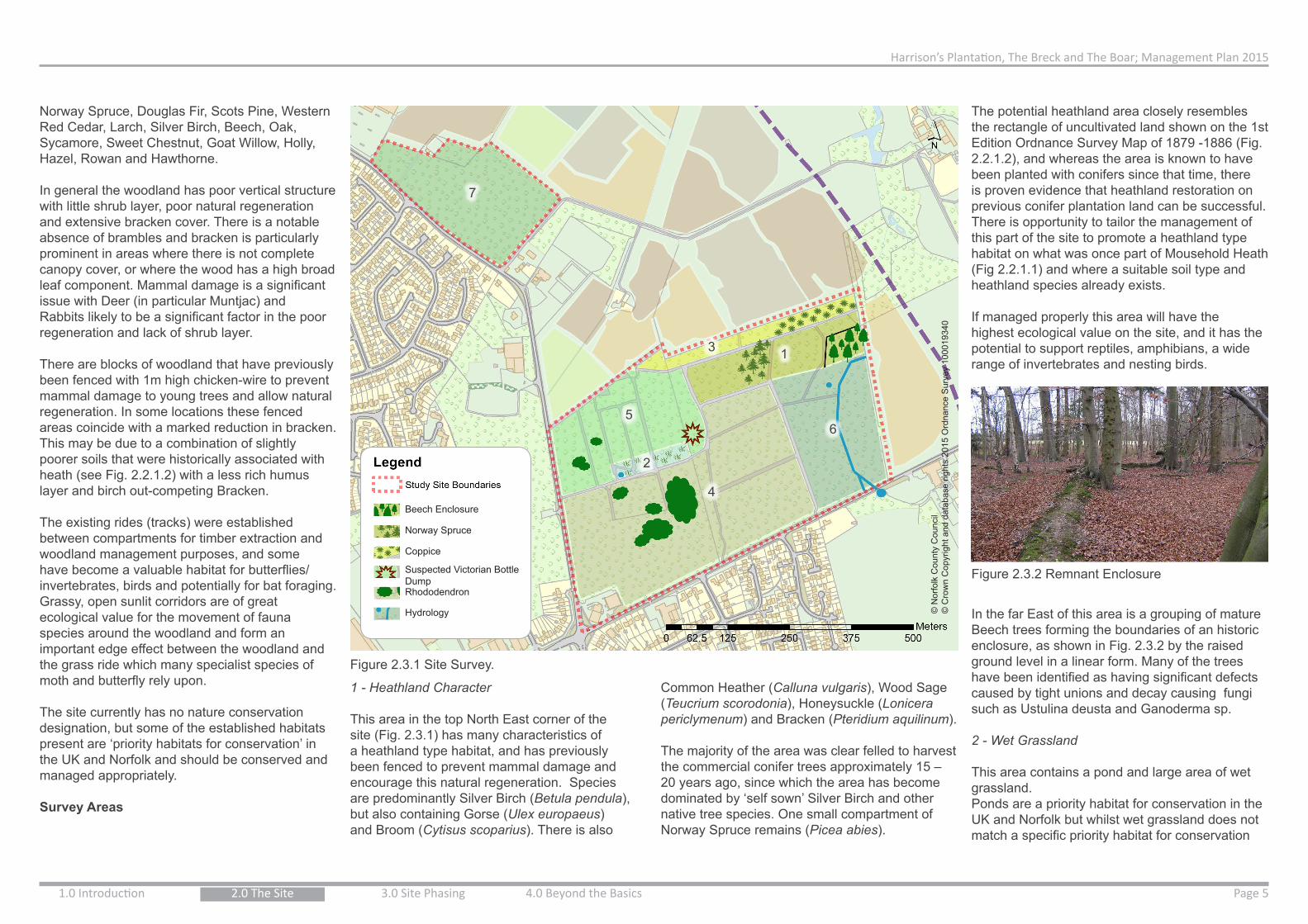
Norway Spruce, Douglas Fir, Scots Pine, Western Red Cedar, Larch, Silver Birch, Beech, Oak, Sycamore, Sweet Chestnut, Goat Willow, Holly, Hazel, Rowan and Hawthorne.
In general the woodland has poor vertical structure with little shrub layer, poor natural regeneration and extensive bracken cover. There is a notable absence of brambles and bracken is particularly prominent in areas where there is not complete canopy cover, or where the wood has a high broad leaf component. Mammal damage is a significant issue with Deer (in particular Muntjac) and Rabbits likely to be a significant factor in the poor regeneration and lack of shrub layer.
There are blocks of woodland that have previously been fenced with 1m high chicken-wire to prevent mammal damage to young trees and allow natural regeneration. In some locations these fenced areas coincide with a marked reduction in bracken. This may be due to a combination of slightly poorer soils that were historically associated with heath (see Fig. 2.2.1.2) with a less rich humus layer and birch out-competing Bracken.
The existing rides (tracks) were established between compartments for timber extraction and woodland management purposes, and some have become a valuable habitat for butterflies/ invertebrates, birds and potentially for bat foraging.Grassy, open sunlit corridors are of great ecological value for the movement of fauna species around the woodland and form an important edge effect between the woodland and the grass ride which many specialist species of moth and butterfly rely upon.
The site currently has no nature conservation designation, but some of the established habitats present are ‘priority habitats for conservation’ in the UK and Norfolk and should be conserved and managed appropriately.
Survey Areas
Figure 2.3.1 Site Survey.
1 - Heathland Character
This area in the top North East corner of the site (Fig. 2.3.1) has many characteristics of a heathland type habitat, and has previously been fenced to prevent mammal damage and encourage this natural regeneration. Species are predominantly Silver Birch (Betula pendula), but also containing Gorse (Ulex europaeus) and Broom (Cytisus scoparius). There is also
Common Heather (Calluna vulgaris), Wood Sage (Teucrium scorodonia), Honeysuckle (Lonicera periclymenum) and Bracken (Pteridium aquilinum).
The majority of the area was clear felled to harvest the commercial conifer trees approximately 15 – 20 years ago, since which the area has become dominated by ‘self sown’ Silver Birch and other native tree species. One small compartment of Norway Spruce remains (Picea abies).
The potential heathland area closely resembles the rectangle of uncultivated land shown on the 1st Edition Ordnance Survey Map of 1879 -1886 (Fig. 2.2.1.2), and whereas the area is known to have been planted with conifers since that time, there is proven evidence that heathland restoration on previous conifer plantation land can be successful. There is opportunity to tailor the management of this part of the site to promote a heathland type habitat on what was once part of Mousehold Heath (Fig 2.2.1.1) and where a suitable soil type and heathland species already exists.
If managed properly this area will have the highest ecological value on the site, and it has the potential to support reptiles, amphibians, a wide range of invertebrates and nesting birds.
Figure 2.3.2 Remnant Enclosure
In the far East of this area is a grouping of mature Beech trees forming the boundaries of an historic enclosure, as shown in Fig. 2.3.2 by the raised ground level in a linear form. Many of the trees have been identified as having significant defects caused by tight unions and decay causing fungi such as Ustulina deusta and Ganoderma sp.
2 - Wet Grassland
This area contains a pond and large area of wet grassland.Ponds are a priority habitat for conservation in the UK and Norfolk but whilst wet grassland does not match a specific priority habitat for conservation
Harrison’s Plantation, The Breck and The Boar; Management Plan 2015
1.0 Introduction 2.0 The SitePage 6 3.0 Site Phasing 4.0 Beyond the Basics
such as ‘Fen’, this low lying boggy area within the woodland should be seen as a priority area for conservation management.
Dominated by Soft Rush (Juncus effusus), this wet area also has large areas of Forget–me–not (Myosotis sylvatica), Creeping Cinquefoil (Potentilla reptans), Creeping Buttercup (Ranunculus repens), Common Sedge (Carex nigra) and Water Mint (Mentha aquatica), with several grass species and Bracken around the drier edges of the area.
This is an important open area within the woodland and provides habitat for invertebrates, amphibians, birds and potentially reptiles at the edge of the adjoining woodland.
(N.B, Due to the time of year that the Management Plan was commissioned, a complete list of grass/wetland flora was not completed. Further surveys of the flora and fauna of this wet grassland area and pond will be important to safeguard the habitat and direct the annual management. It is unknown if the pond is seasonal and will dry up in summer)
3 - Woodland Fringe
Generally the woodland fringe is comprised of a mixture of Coniferous and Broadleaf trees to the west, Broadleaf standards with Hazel coppice in centre/east location, and birch regeneration with dense Bracken to the east.
This area has been identified as a habitat in its own right and is recommended to be managed for nature conservation over amenity. This said, this area forms the woodland edge, and will have an important role and relationship with the proposed adjacent development. Consideration will need to be given to woodland access in this area.
4 - Forestry; Compartment Mix
This area of the woodland originates from the
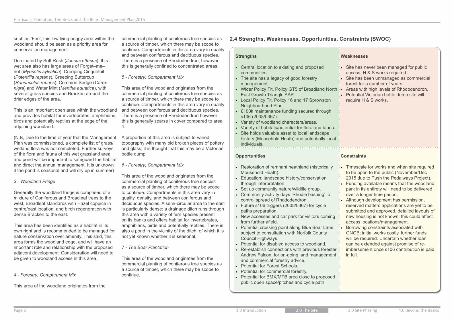
Strengths
• Central location to existing and proposed communities.
• The site has a legacy of good forestry management.
• Wider Policy Fit, Policy GT5 of Broadland North East Growth Triangle AAP.
• Local Policy Fit, Policy 16 and 17 Sprowston Neighbourhood Plan.
• £100k maintenance funding secured through s106 (2008/0367).
• Variety of woodland characters/areas.• Variety of habitats/potential for flora and fauna.• Site holds valuable asset to local landscape
history (Mousehold Heath) and potentially local individuals.
Weaknesses
• Site has never been managed for public access, H & S works required.
• Site has been unmanaged as commercial forest for a number of years.
• Areas with high levels of Rhododendron.• Potential Victorian bottle dump site will
require H & S works.
Opportunities
• Restoration of remnant heathland (historically Mousehold Heath).
• Education; landscape history/conservation through interpretation.
• Set up community nature/wildlife group.• Community activity days ‘Rhodie bashing’ to
control spread of Rhododendron.• Future s106 triggers (2008/0367) for cycle
paths preparation.• New accesses and car park for visitors coming
from further afield.• Potential crossing point along Blue Boar Lane,
subject to consultation with Norfolk County Council Highways.
• Potential for disabled access to woodland.• Re-establish connections with previous forester,
Andrew Falcon, for on-going land management and commercial forestry advice.
• Potential for Forest Schools.• Potential for commercial forestry.• Potential for BMX/MTB area close to proposed
public open space/pitches and cycle path.
Constraints
• Timescale for works and when site required to be open to the public (November/Dec 2015 due to Push the Pedalways Project).
• Funding available means that the woodland park in its entirety will need to be delivered over a longer time period.
• Although development has permission, reserved matters applications are yet to be submitted and approved, detailed layouts of new housing is not known, this could affect access locations/management.
• Borrowing constraints associated with GNGB; initial works costly, further funds will be required. Uncertain whether loan can be extended against promise of re-imbersement once s106 contribution is paid in full.
2.4 Strengths, Weaknesses, Opportunities, Constraints (SWOC)commercial planting of coniferous tree species as a source of timber, which there may be scope to continue. Compartments in this area vary in quality and between coniferous and deciduous species. There is a presence of Rhododendron, however this is generally confined to concentrated areas.
5 - Forestry; Compartment Mix
This area of the woodland originates from the commercial planting of coniferous tree species as a source of timber, which there may be scope to continue. Compartments in this area vary in quality and between coniferous and deciduous species. There is a presence of Rhododendron however this is generally sparse in cover compared to area 4.
A proportion of this area is subject to varied topography with many old broken pieces of pottery and glass; it is thought that this may be a Victorian bottle dump.
6 - Forestry; Compartment Mix
This area of the woodland originates from the commercial planting of coniferous tree species as a source of timber, which there may be scope to continue. Compartments in this area vary in quality, density, and between coniferous and deciduous species. A semi-circular area to the east is particularly dense; a drainage ditch runs through this area with a variety of fern species present on its banks and offers habitat for invertebrates, amphibians, birds and potentially reptiles. There is also a pond in the vicinity of the ditch, of which it is not yet known whether it is seasonal.
7 - The Boar Plantation
This area of the woodland originates from the commercial planting of coniferous tree species as a source of timber, which there may be scope to continue.
Harrison’s Plantation, The Breck and The Boar; Management Plan 2015
1.0 Introduction Page 72.0 The Site 3.0 Site Phasing 4.0 Beyond the Basics
0 125 250 375 50062.5Meters
1:5,000
LegendStudy Site Boundaries
Type1. Conservation; Limited Access
2. Publically Accessible
Future Development PhasesDeveloper
Hopkins Homes
Persimmon
Public Open Space
School
Taylor Wimpey
New Link Road
´
This
map
is b
ased
upo
n O
rdna
nce
Sur
vey
mat
eria
l with
the
perm
issi
on o
f Ord
nanc
e S
urve
y on
beh
alf o
fth
e C
ontro
ller o
f Her
Maj
esty
's S
tatio
nery
Offi
ce ©
Cro
wn
copy
right
. N
orfo
lk C
o unt
y C
ounc
il. L
icen
ce N
o: 1
0001
9340
201
5
0 125 250 375 50062.5Meters
1:5,000
LegendStudy Site Boundaries
ZoningConservation; Heathland Character
Conservation; No Formal Access
Conservation; Wet Grassland
Forestry/Limited Formal Access; Mixed Woodland
Forestry/Woodland Activities; Compartment Mix
Forestry/Woodland Activities; MTB, Dog Walking
Woodland Fringe
Future Development PhasesDeveloper
Hopkins Homes
Persimmon
Public Open Space
School
Taylor Wimpey
New Link Road
´
0 125 250 375 50062.5Meters
1:5,000
LegendStudy Site Boundaries
ZoningConservation; Heathland Character
Conservation; No Formal Access
Conservation; Wet Grassland
Forestry/Limited Formal Access; Mixed Woodland
Forestry/Woodland Activities; Compartment Mix
Forestry/Woodland Activities; MTB, Dog Walking
Woodland Fringe
Future Development PhasesDeveloper
Hopkins Homes
Persimmon
Public Open Space
School
Taylor Wimpey
New Link Road
´0 125 250 375 50062.5
Meters1:5,000
LegendStudy Site Boundaries
Type1. Conservation; Limited Access
2. Publically Accessible
Future Development PhasesDeveloper
Hopkins Homes
Persimmon
Public Open Space
School
Taylor Wimpey
New Link Road
´
This
map
is b
ased
upo
n O
rdna
nce
Sur
vey
mat
eria
l with
the
perm
issi
on o
f Ord
nanc
e S
urve
y on
beh
alf o
fth
e C
ontro
ller o
f Her
Maj
esty
's S
tatio
nery
Offi
ce ©
Cro
wn
copy
right
. N
orfo
lk C
ount
y C
ounc
il. L
icen
ce N
o: 1
0001
9340
201
5
0 125 250 375 50062.5Meters
1:5,000
LegendStudy Site Boundaries
Type1. Conservation; Limited Access
2. Publically Accessible
Future Development PhasesDeveloper
Hopkins Homes
Persimmon
Public Open Space
School
Taylor Wimpey
New Link Road
´
This
map
is b
ased
upo
n O
rdna
nce
Sur
vey
mat
eria
l with
the
perm
issi
on o
f Ord
nanc
e S
urve
y on
beh
alf o
fth
e C
ontro
ller o
f Her
Maj
esty
's S
tatio
nery
Offi
ce ©
Cro
wn
copy
right
. N
orfo
lk C
o unt
y C
ounc
il. L
icen
ce N
o: 1
0001
9340
201
5
0 125 250 375 50062.5Meters
1:5,000
LegendStudy Site Boundaries
Type1. Conservation; Limited Access
2. Publically Accessible
Future Development PhasesDeveloper
Hopkins Homes
Persimmon
Public Open Space
School
Taylor Wimpey
New Link Road
´
This
map
is b
ased
upo
n O
rdna
nce
Sur
vey
mat
eria
l with
the
perm
issi
on o
f Ord
nanc
e S
urve
y on
beh
alf o
fth
e C
ontro
ller o
f Her
Maj
esty
's S
tatio
nery
Offi
ce ©
Cro
wn
copy
right
. N
orfo
lk C
o unt
y C
ounc
il. L
icen
ce N
o: 1
0001
9340
201
5
1
2
3
4
5 6
7
© N
orfo
lk C
ount
y C
ounc
il©
Cro
wn
Cop
yrig
ht a
nd d
atab
ase
right
s 20
15 O
rdna
nce
Sur
vey
1000
1934
0
© N
orfo
lk C
ount
y C
ounc
il©
Cro
wn
Cop
yrig
ht a
nd d
atab
ase
right
s 20
15 O
rdna
nce
Sur
vey
1000
1934
0
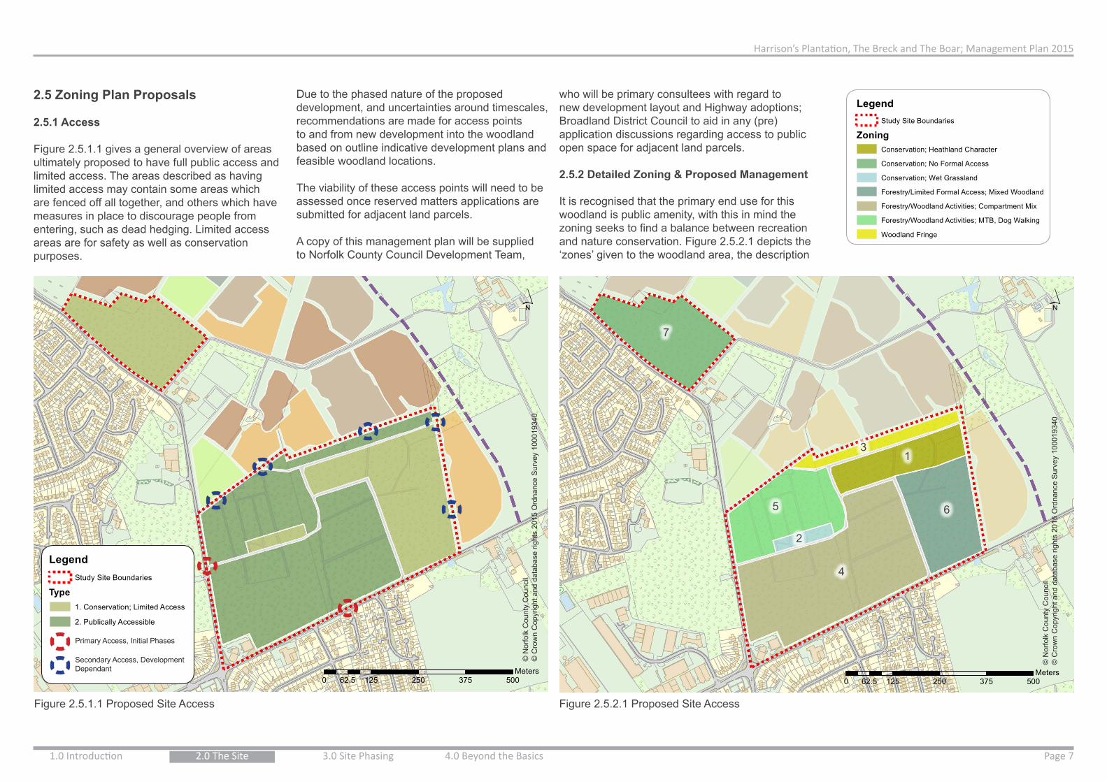
2.5 Zoning Plan Proposals
2.5.1 Access
Figure 2.5.1.1 gives a general overview of areas ultimately proposed to have full public access and limited access. The areas described as having limited access may contain some areas which are fenced off all together, and others which have measures in place to discourage people from entering, such as dead hedging. Limited access areas are for safety as well as conservation purposes.
Figure 2.5.1.1 Proposed Site Access Figure 2.5.2.1 Proposed Site Access
Primary Access, Initial Phases
Secondary Access, Development Dependant
Due to the phased nature of the proposed development, and uncertainties around timescales, recommendations are made for access points to and from new development into the woodland based on outline indicative development plans and feasible woodland locations.
The viability of these access points will need to be assessed once reserved matters applications are submitted for adjacent land parcels.
A copy of this management plan will be supplied to Norfolk County Council Development Team,
who will be primary consultees with regard to new development layout and Highway adoptions; Broadland District Council to aid in any (pre) application discussions regarding access to public open space for adjacent land parcels.
2.5.2 Detailed Zoning & Proposed Management
It is recognised that the primary end use for this woodland is public amenity, with this in mind the zoning seeks to find a balance between recreation and nature conservation. Figure 2.5.2.1 depicts the ‘zones’ given to the woodland area, the description

Harrison’s Plantation, The Breck and The Boar; Management Plan 2015
1.0 Introduction 2.0 The SitePage 8 3.0 Site Phasing 4.0 Beyond the Basics
030
6090
120
15
Meters
1:1,500
LegendStudy Site Boundaries
Management Plan PhaseP1
Indicative PathsFencingTYPE^ Interpretation^ Signalised Crossing
ZoningConservation; Heathland Character
Conservation; No Formal Access
Conservation; Wet Grassland
Forestry/Limited Formal Access; Mixed Woodland
Forestry/Woodland Activities; Compartment Mix
Forestry/Woodland Activities; MTB, Dog Walking
Woodland FringeFuture Development Phases
DeveloperHopkins HomesPersimmonPublic Open SpaceSchool
Taylor WimpeyNew Link Road
´
030
6090
120
15
Meters
1:1,500
LegendStudy Site Boundaries
Management Plan PhaseP1
Indicative PathsFencingTYPE^ Interpretation^ Signalised Crossing
ZoningConservation; Heathland Character
Conservation; No Formal Access
Conservation; Wet Grassland
Forestry/Limited Formal Access; Mixed Woodland
Forestry/Woodland Activities; Compartment Mix
Forestry/Woodland Activities; MTB, Dog Walking
Woodland FringeFuture Development Phases
DeveloperHopkins HomesPersimmonPublic Open SpaceSchool
Taylor WimpeyNew Link Road
´ 0 30 60 90 12015Meters
1:1,500
LegendStudy Site Boundaries
Management Plan PhaseP1
Indicative Paths
Fencing
TYPE
^ Interpretation
^ Signalised Crossing
ZoningConservation; Heathland Character
Conservation; No Formal Access
Conservation; Wet Grassland
Forestry/Limited Formal Access; Mixed Woodland
Forestry/Woodland Activities; Compartment Mix
Forestry/Woodland Activities; MTB, Dog Walking
Woodland Fringe
Future Development PhasesDeveloper
Hopkins Homes
Persimmon
Public Open Space
School
Taylor Wimpey
New Link Road
´
Heathland Restoration;Limited Public Access via Stile
Beech Enclosure & Wildlife Refuge;No Public Access for Safety
Interpretation
© Norfolk County Council© Crown Copyright and database rights 2015 Ordnance Survey 100019340
of each area below indicates suggested use and some management objectives;
1. Conservation; Heathland Character
Lowland heathland is a priority habitat for conservation in the UK and in Norfolk; the Greater Norwich Development Partnership Green Infrastructure Delivery Plan (2009) identifies this former area of Mousehold Heath NE of Norwich, as a priority area for heathland restoration. This reiterates the fact that in England, only a sixth of the heathland present in 1800 now remains and there is potential to create a valuable and diverse heathland type habitat (approximately 2.7ha) in this area. Aim to keep areas of heathland within Forestry Commission allowances (10%) for open space within the woodland.
It is recommended that this area be given over to nature conservation and fenced with stock proof fencing (See Fig. 2.5.2.2) to limit public access and dog walking (The stock netting will allow small mammals and reptiles to pass through at ground level);
• The eastern section to have no public access to reduce risk in relation to the Beech trees within the old enclosure. Monolith (remove branches and retain trunk only) some trees to prevent future failure and maintain standing deadwood for wildlife benefit.
• The western section will be managed to promote heathland restoration but will have two stiles to allow some public access but reduce likelihood of disturbance by dogs and excessive numbers of people.
• Both fenced areas will have a five-bar locked timber gate to enable maintenance access from the northern ride.
• A path will be provided between these two fenced areas to maintain permeability, and interpretation erected to explain the purpose of the fencing.
• The remaining area of Norway Spruce (Picea abies) within this area will be selectively Figure. 2.5.2.2 Proposed Conservation Area to be Stock Fenced
felled over time, with potential local value as Christmas Trees, and the cleared land managed as heathland.
• Silver Birch should be selectively thinned, retaining some trees to become mature standard birch trees. Removed wood could have local commercial viability as part of a ‘community wood-lot’ to sell smaller items of woodland produce.
• Felled trees and associated material should be retained to create log habitat piles and reptile hibernacula.
• Standing deadwood should be retained to benefit invertebrates, birds such as great spotted woodpecker, tree creeper and nut hatch, and bracket fungus.
• Selected trees could be ‘Ringbarked’ where safe to do so, to create standing dead wood.
• Bare ground could be created by scraping away the leaf litter, to provide a sandy base for burrowing insects and for reptiles to bask.
• Conservation areas could be monitored and managed by a community wildlife group who could carry out ecological surveys of the ground flora, survey for reptiles, invertebrates and nesting birds at the appropriate times of year.
2. Conservation; Wet Grassland
Ponds are a priority habitat for conservation in the UK but whilst wet grassland does not match
a specific priority habitat for conservation such as ‘Fen’, this low lying boggy area within the woodland should be seen as a priority area for conservation management;
• Ground flora to be surveyed through summer to identify and notable species.
• The area should be kept free of woody shrub species.
• The area should be mown once a year in late summer and ‘arisings’ removed to reduce the nutrients going back into the soil. This will help promote the growth of wildflowers.
• Cut material to be stacked along the wooded edge of the area to degrade and form hibernating habitat for amphibians.
• Once identified, mow around any desirable plants rather than uniformly mowing the whole area.
• Control bracken that is establishing near the woodland edge by ‘bracken bruising’ or repeated mowing.
• Take care not to make any changes to the drainage of the area.
• Management of the pond to keep free of woody bushes/ trees that will drain the water, management should also retain partial shade from mature trees nearby to reduce evaporation of water.
3. Woodland Fringe
The woodland fringe will act as a landscape buffer between housing, heathland, and central wooded area. Maintain as a minimum 35m wide tree belt with some areas much wider to create a wavy woodland edge; accesses to be created between woodland types.
‘Standard’ individual trees were left within this area to grow to maturity for their timber value (in this case Oak and Sweet Chestnut (Castanea sativa)); it is recommended that the areas of mature trees within the woodland fringe be managed as part of a site tree inspection and management regime.
Elsewhere within the fringe, coppicing, a traditional form of woodland management, is applicable. Tree species such as hazel, Hornbeam (Carpinus betulus), Sweet Chestnut and Willow (Salix sp.) can be cut back to the same level near to the ground every 5 – 20 years depending on the size of the wood that was required from the re-growth. General management techniques as follows;
• traditional management techniques and volunteers should be used to coppice the hazel stools on a 5 – 10 year rotation.
• Planting new trees for coppice management.• No more than 25% of the coppice stools to be
coppiced in any one year• Stools to be protected from rabbit and deer
grazing.• Bent over stems of the hazel pinned to the
ground can be used to form new plants.• Cut hazel poles can be used for woodland
management around the site, including dead hedging.
• Bird boxes can be erected on mature trees. • Old stumps and fallen trees can be left to
provide deadwood for invertebrates.
4. Forestry/Woodland Activities; Compartment Mix
This area will primarily be given over to public access for recreation. There will be way-marked routes and opportunities for natural play and sculpture. This area has potential for Forest School activities in the future. It is recommended

Harrison’s Plantation, The Breck and The Boar; Management Plan 2015
1.0 Introduction Page 92.0 The Site 3.0 Site Phasing 4.0 Beyond the Basics
0 125 250 375 50062.5Meters
1:5,000
LegendStudy Site Boundaries
ZoningConservation; Heathland Character
Conservation; No Formal Access
Conservation; Wet Grassland
Forestry/Limited Formal Access; Mixed Woodland
Forestry/Woodland Activities; Compartment Mix
Forestry/Woodland Activities; MTB, Dog Walking
Woodland Fringe
Future Development PhasesDeveloper
Hopkins Homes
Persimmon
Public Open Space
School
Taylor Wimpey
New Link Road
´© N
orfo
lk C
ount
y C
ounc
il©
Cro
wn
Cop
yrig
ht a
nd d
atab
ase
right
s 20
15 O
rdna
nce
Sur
vey
1000
1934
0
that mature trees be managed as part of a site tree inspection and management regime. General management recommendations for this area are as follows;
• There may be scope for commercial timber in this area, consultant advice should be sought.
• Retain standing deadwood where safe to do so (e.g. away from footpaths, well used areas)
• Leave fallen trees in-situ to degrade• Create log piles with felled trees and branches• Use ‘chipped’ tree material to maintain paths.• Erect bat boxes and bird boxes on mature trees,
where commercial felling is unlikely.• Phased removal of Rhododendron ponticum
from the site (this is not urgent and the plant does have a value for nesting birds, however it can become invasive and should be monitored).
• Create open sunny glades within the woodland to maximise biodiversity.
5. Forestry/Woodland Activities; MTB, Dog Walking
This area will primarily be for public access and recreation. This will be the most formal area of the woodland, with car park and way-marked routes.
A location has been identified within this area for MTB/BMX use, in line with Sprowston Town Council aspirations. This location has been deemed most suitable due to its proximity to Blue Boar Lane and the sports pitch facilities to be provided by the new development; this location was preferred for ease of construction, emergency and maintenance access. Moreover, the facility in this location will be en route of the proposed cycleway to also be delivered by development, and close to the car park, therefore reducing the need for people to cycle though the main body of woodland.
In the future this area could also host a visitor/forest schools centre, should the Town Council wish to pursue.It is recommended that mature trees be managed
as part of a site tree inspection and management regime. General recommendations for this area are as follows:
• Retain standing deadwood where safe to do so (e.g. away from footpaths, well used areas)
• Leave fallen trees in-situ to degrade• Create log piles with felled trees and branches• Use ‘chipped’ tree material to maintain paths.• Erect bat boxes and bird boxes on mature trees,
where commercial felling is unlikely.• Phased removal of Rhododendron ponticum
from the site (this is not urgent and the plant does have a value for nesting birds, however it can become invasive and should be monitored).
• Victorian bottle dump either subject to bottle dig and tidy or surface scraped and capped. Norfolk County Council Historic Environment Service discussions ongoing.
• Creating a car park must not over expose sections of the woodland and should also be capable of being used for forestry operations. It is highly likely that roadside trees will need to be removed to allow adequate visibility splays. It may be desirable to allow clear view into car park to reduce likelihood of antisocial behaviour.
• Car parking could be positioned either side of the main ride or designed around tree removals required for visibility splays. When in use for forestry operations car park can then be easily segregated. Car park could be associated with publicly visible picnic or natural play area.
6. Forestry/Limited Formal Access; Mixed Woodland
There is only one main ride through this area that traverses the ditch before it forks. It is proposed that this, and another entrance at an existing ride to the north-east corner of the site, be the only entrances into the woodland from development to the east for health and safety and conservation management reasons.
This area will primarily act as a landscape buffer between housing and the central, more
characterful wooded area.
It is recommended that mature trees be managed as part of a site tree inspection and management regime. General management recommendations for this area are as follows:
• An assessment will be required on the condition of the current land bridge over the ditch, and enhancements/bridge required.
• There may be scope for commercial timber in this area, consultant advice should be sought.
• Retain standing deadwood where safe to do so (eg. away from footpaths, well used areas)
• Leave fallen trees in-situ to degrade• Create log piles with felled trees and branches• Use ‘chipped’ tree material to maintain paths.• Erect bat boxes and bird boxes on mature trees,
where commercial felling is unlikely.
7. Conservation; No Formal Access
It is recommended that mature trees be managed as part of a site tree inspection and management regime. General management recommendations for this area are as follows;
• Advice should be sought on the commercial viability of this compartment and future forestry management.
• Retain standing deadwood where safe to do so (e.g. away from roadsides and footways)
• Leave fallen trees in-situ to degrade• Create log piles with felled trees and branches• Use ‘chipped’ tree material to maintain paths at
Harrison’s Plantation.• Erect bat boxes and bird boxes on mature trees,
where commercial felling is unlikely.
8. Woodland Rides Recommendations;
The tracks through the wood are a habitat feature in their own right and have become a valuable habitat for butterflies/ invertebrates, birds. They are also potentially important bat foraging corridors;
• Where they already exist, retain the grassy, open sunlit rides and mow the grass to enable good access rather than installing hard surfaces.
• Maintain shrubby edges between the trees and the path with a gradual transition in plant heights, from the low path, through longer grass, herbs, woody shrubs and into the trees.
• Create scalloped sunny bays at the edge of the tracks to provide sheltered sunny spots for butterflies and other invertebrates.
• Remember the importance of the edge effect between the woodland and the grass ride which many specialist species of moth and butterfly rely upon.
• Within darker areas of the woodland, selectively remove some conifers to allow light to reach the woodland rides.
• Carry out bat surveys and annual butterfly transects (surveys) along a specified route to record the importance of these corridors for wildlife.
• Ensure the woodland rides remain in a usable state and carry out tree inspections of the trees within falling distance of the path. Any trees that need to be felled for safety reasons should be left within the woodland or along the edge of the path to degrade naturally.
0 125 250 375 50062.5Meters
1:5,000
LegendStudy Site Boundaries
ZoningConservation; Heathland Character
Conservation; No Formal Access
Conservation; Wet Grassland
Forestry/Limited Formal Access; Mixed Woodland
Forestry/Woodland Activities; Compartment Mix
Forestry/Woodland Activities; MTB, Dog Walking
Woodland Fringe
Future Development PhasesDeveloper
Hopkins Homes
Persimmon
Public Open Space
School
Taylor Wimpey
New Link Road
´
0 125 250 375 50062.5Meters
1:5,000
LegendStudy Site Boundaries
Type1. Conservation; Limited Access
2. Publically Accessible
Future Development PhasesDeveloper
Hopkins Homes
Persimmon
Public Open Space
School
Taylor Wimpey
New Link Road
´
This
map
is b
ased
upo
n O
rdna
nce
Sur
vey
mat
eria
l with
the
perm
issi
on o
f Ord
nanc
e S
urve
y on
beh
alf o
fth
e C
ontro
ller o
f Her
Maj
esty
's S
tatio
nery
Offi
ce ©
Cro
wn
copy
right
. N
orfo
lk C
o unt
y C
ounc
il. L
icen
ce N
o: 1
0001
9340
201
5
1
2
3
4
5 6
7
Figure 2.5.2.1 Proposed Site Access

Harrison’s Plantation, The Breck and The Boar; Management Plan 2015
1.0 Introduction 2.0 The SitePage 10 3.0 Site Phasing 4.0 Beyond the Basics
2.6 Consultation and Site Visit
Consultation has been undertaken throughout the management plan drafting process, as described in 1.3 Methodology and documented in Appendix 2.
On 9th April 2015, Sprowston Town Councillors, and one County Councillor attended a guided walk around the site.
The walk and proposals were well received and the Councillors noted the size and diversity of the site which has been unknown to many for a number of years.
Figures 2.6.1 to 2.6.7 show photos from the morning’s tour and other site visits.
This event could be repeated on public opening of the woodland, to guide members of the public around and identify key locations, giving historical and conservational context. This would also provide the councils with further views and comments for input into the long term vision for the site.
Sprowston Town Councillors were consulted on the naming of the woodland, and what should appear on any publicity or signage. After discussion of a number of options, the Council settled on Harrison’s Woodland.
Figure 2.6.2 The Councillor’s Questions and Answers
Figure 2.6.5 Area of Deciduous Woodland
Figure 2.6.6 Bottle Found in Area of Victorian Bottle Dump
Figure 2.6.7 Councillor’s walking along Woodland Ride
Figure 2.6.3 The Councillor’s in the Central Area of Woodland
Figure 2.6.4 The Councillor’s Looking Across to Area of Rhododendron
Figure 2.6.1 Beech Tree with Notable Defect

Harrison’s Plantation, The Breck and The Boar; Management Plan 2015
1.0 Introduction Page 112.0 The Site 3.0 Site Phasing 4.0 Beyond the Basics
0 75 150 225 30037.5Meters
1:3,000
LegendStudy Site Boundaries
Management Plan PhaseP1
Indicative Paths
Fencing
^ Interpretation
^ Signalised Crossing
ZoningConservation; Heathland Character
Conservation; No Formal Access
Conservation; Wet Grassland
Forestry/Limited Formal Access; Mixed Woodland
Forestry/Woodland Activities; Compartment Mix
Forestry/Woodland Activities; MTB, Dog Walking
Woodland Fringe
Future Development PhasesDeveloper
Hopkins Homes
Persimmon
Public Open Space
School
Taylor Wimpey
New Link Road
´0 75 150 225 30037.5
Meters1:3,000
LegendStudy Site Boundaries
Management Plan PhaseP1
Indicative Paths
Fencing
^ Interpretation
^ Signalised Crossing
ZoningConservation; Heathland Character
Conservation; No Formal Access
Conservation; Wet Grassland
Forestry/Limited Formal Access; Mixed Woodland
Forestry/Woodland Activities; Compartment Mix
Forestry/Woodland Activities; MTB, Dog Walking
Woodland Fringe
Future Development PhasesDeveloper
Hopkins Homes
Persimmon
Public Open Space
School
Taylor Wimpey
New Link Road
´
0 75 150 225 30037.5Meters
1:3,000
LegendStudy Site Boundaries
Management Plan PhaseP1
Indicative Paths
Fencing
^ Interpretation
^ Signalised Crossing
ZoningConservation; Heathland Character
Conservation; No Formal Access
Conservation; Wet Grassland
Forestry/Limited Formal Access; Mixed Woodland
Forestry/Woodland Activities; Compartment Mix
Forestry/Woodland Activities; MTB, Dog Walking
Woodland Fringe
Future Development PhasesDeveloper
Hopkins Homes
Persimmon
Public Open Space
School
Taylor Wimpey
New Link Road
´
© N
orfo
lk C
ount
y C
ounc
il©
Cro
wn
Cop
yrig
ht a
nd d
atab
ase
right
s 20
15 O
rdna
nce
Sur
vey
1000
1934
0
3.0 Site Phasing3.1 Variables and Risks
This section highlights some of the potential risks associated with the project to bring the site into public use. Full details of risks can be found in Appendix 4, Project Risk Register. Please note that Appendix 4 is a living document.
Development Phasing and Build Out Rates
There is a level of uncertainty in the management plan due to the timescale of the new development.
Developers are yet to submit Reserved Matters applications which will confirm the layout of the new development, and where woodland accesses would be best placed. These planning applications are required by condition 2 of Outline permission 2008/0367 to be submitted by 23.05.2016.
Commencement of any P2 development parcel must then commence within 1 year of reserved matters approval of the said parcel.
Due to these uncertainties as to when these applications are coming forward, and other timescales, this management plan outlines where accesses should go based on the formation of the woodland and assumed format of the development from the illustrative masterplan.
Push the Pedalways
The Pedalways project is reaching the end stages, and the final element to be completed on the pink route is the temporary terminus at Harrison’s Plantation. This will consist of a signalised crossing point on Salhouse Road opposite the footpath exiting Hammond Close, signage, interpretation, and some cycle stands.
The timescale in which the Department for Transport (DfT) grant monies must be spent is
short, and the crossing point is scheduled to start construction in September/October 2015. It is therefore important that health and safety works, way-marking and interpretation around the woodland is implemented prior to, or as soon after this date as possible to enable public access and prevent any potential negative press associated with a new crossing which offers no destination and remains out of use.
General Works
Please refer to Appendix 5, Schedule of Works, a living document which gives an indicative time scale for works required at different stages.
Felling Licenses (Forestry Commission)
A felling licence from the Forestry Commission is required to fell trees. It is an offence to fell trees without a licence if an exemption does not apply. It has been noted that the areas of felling required to create the proposed car park and MTB/BMX area meet the criteria and a felling license is required.
Tree Preservation Orders (TPO)
You must inform the Forestry Commission if the trees to be felled are covered by a Tree Preservation Order or are located in a Conservation Area.
European Protected Species (EPS)
A European Protected Species (EPS) mitigation licence may be required from Natural England under the Habitats and Species Regulations (2010) if felling operations could adversely affect any EPS. (The majority of felling operations will however be able to proceed without a mitigation licence even in the presence of EPS, providing that good practice guidance is followed.)
3.2 Phasing
3.2.1 Phase 1
Phase 1 works aim to facilitate the partial opening of the woodland for public access. The
optimum date for these works to be completed is September/October 2015, alongside the installation of the new signalised crossing and interpretation on Salhouse Road as part of the Push the Pedalways Project. Exact start and completion dates for the crossing are yet to be confirmed however, in discussions with Norwich
Figure 3.2.1.1 Phase 1

Harrison’s Plantation, The Breck and The Boar; Management Plan 2015
1.0 Introduction 2.0 The SitePage 12 3.0 Site Phasing 4.0 Beyond the Basics
0 75 150 225 30037.5Meters
1:3,000
LegendStudy Site Boundaries
Management Plan PhaseP2
Indicative Paths
Fencing
^ Car Park
^ MTB/BMX Park
ZoningConservation; Heathland Character
Conservation; No Formal Access
Conservation; Wet Grassland
Forestry/Limited Formal Access; Mixed Woodland
Forestry/Woodland Activities; Compartment Mix
Forestry/Woodland Activities; MTB, Dog Walking
Woodland Fringe
Future Development PhasesDeveloper
Hopkins Homes
Persimmon
Public Open Space
School
Taylor Wimpey
New Link Road
´0 75 150 225 30037.5
Meters1:3,000
LegendStudy Site Boundaries
Management Plan PhaseP1
Indicative Paths
Fencing
^ Interpretation
^ Signalised Crossing
ZoningConservation; Heathland Character
Conservation; No Formal Access
Conservation; Wet Grassland
Forestry/Limited Formal Access; Mixed Woodland
Forestry/Woodland Activities; Compartment Mix
Forestry/Woodland Activities; MTB, Dog Walking
Woodland Fringe
Future Development PhasesDeveloper
Hopkins Homes
Persimmon
Public Open Space
School
Taylor Wimpey
New Link Road
´
0 75 150 225 30037.5Meters
1:3,000
LegendStudy Site Boundaries
Management Plan PhaseP1
Indicative Paths
Fencing
^ Interpretation
^ Signalised Crossing
ZoningConservation; Heathland Character
Conservation; No Formal Access
Conservation; Wet Grassland
Forestry/Limited Formal Access; Mixed Woodland
Forestry/Woodland Activities; Compartment Mix
Forestry/Woodland Activities; MTB, Dog Walking
Woodland Fringe
Future Development PhasesDeveloper
Hopkins Homes
Persimmon
Public Open Space
School
Taylor Wimpey
New Link Road
´
0 75 150 225 30037.5Meters
1:3,000
LegendStudy Site Boundaries
Management Plan PhaseP2
Indicative Paths
Fencing
^ Car Park
^ MTB/BMX Park
ZoningConservation; Heathland Character
Conservation; No Formal Access
Conservation; Wet Grassland
Forestry/Limited Formal Access; Mixed Woodland
Forestry/Woodland Activities; Compartment Mix
Forestry/Woodland Activities; MTB, Dog Walking
Woodland Fringe
Future Development PhasesDeveloper
Hopkins Homes
Persimmon
Public Open Space
School
Taylor Wimpey
New Link Road
´
030
6090
120
15
Meters
1:1,500
LegendStudy Site Boundaries
Management Plan PhaseP1
Indicative PathsFencingTYPE^ Interpretation^ Signalised Crossing
ZoningConservation; Heathland Character
Conservation; No Formal Access
Conservation; Wet Grassland
Forestry/Limited Formal Access; Mixed Woodland
Forestry/Woodland Activities; Compartment Mix
Forestry/Woodland Activities; MTB, Dog Walking
Woodland FringeFuture Development Phases
DeveloperHopkins HomesPersimmonPublic Open SpaceSchool
Taylor WimpeyNew Link Road
´ 0 30 60 90 12015Meters
1:1,500
LegendStudy Site Boundaries
Management Plan PhaseP1
Indicative Paths
Fencing
TYPE
^ Interpretation
^ Signalised Crossing
ZoningConservation; Heathland Character
Conservation; No Formal Access
Conservation; Wet Grassland
Forestry/Limited Formal Access; Mixed Woodland
Forestry/Woodland Activities; Compartment Mix
Forestry/Woodland Activities; MTB, Dog Walking
Woodland Fringe
Future Development PhasesDeveloper
Hopkins Homes
Persimmon
Public Open Space
School
Taylor Wimpey
New Link Road
´
Figure. 3.2.1.2 Proposed Conservation Area to be Stock Fenced
GateGate & Stile
Stile
© N
orfo
lk C
ount
y C
ounc
il©
Cro
wn
Cop
yrig
ht a
nd d
atab
ase
right
s 20
15 O
rdna
nce
Sur
vey
1000
1934
0
© Norfolk County Council© Crown Copyright and database rights 2015 Ordnance Survey 100019340
City Council, the maximum time agreed for the crossing to remain bagged and not in use is approximately 1 month post installation, there is therefore little room for slippage on the woodland works.
Due to the uncertain timescale for the proposed development to the north and east of the site, access points to the site will be kept to a minimum until development comes forward.
On phase 1 completion, there will be pedestrian access points via signalised crossing on Salhouse Road, and the existing gates on Blue Boar Lane. Maintenance access will be gained from the existing gates on Blue Boar Lane.
Phase 1 works required as follows;
• Norwich City Council to install signalised crossing, stretch of surfaced path into the woodland, cycle stands and interpretation board at Salhouse Road entrance point.
• Engage forestry consultant in development of detailed forestry management plan, taking into consideration potential for commercial activities for income generation.
• Development of phase 1 pedestrian routes, including safety measures on Blue Boar Lane to allow pedestrians to cross safely prior to car park construction.
• Health and safety tree inspection regime development.
• Prepare specification for health and safety tree works, arrange pre-quote site visit with contractors, request and receive quotes, evaluate and appoint.
• Health and safety tree works associated with phase 1 pedestrian routes and selective felling within conservation area.
• Vegetation management works.• Victorian bottle dump investigations and
mitigation works.• Production of overall illustrative site masterplan
for use on entrance interpretation boards, in publications and publicity.
• Signing of phase 1 routes and interpretation at all Figure 3.2.1.1 star locations giving information on the site, phased access and conservation. Interpretation boards to be of a nature that content can be updated over time e.g. water-proof notice board with lockable Perspex front.
• Identify locations and install infrastructure e.g. Fido bins.
• Additional signage requesting public to stay on way marked paths for safety until phase 2 works completed.
• Stock fencing and installation of 2 no. stiles and 2 no. five bar timber field gates as shown in Figure 3.2.1.2. In the short term, maintenance vehicles for the conservation area will access
along the main ride from Blue Boar Lane. In the medium to long term maintenance vehicles will access from the proposed playing fields and along the northern most ride.
Figure 3.2.2.1 Phase 2
3.2.2 Phase 2
Phase 2 aims to grant public access to the north-west section of woodland, as hatched in Figure 3.2.2.1. One of the primary aims of this phase is to gain a license from the Forestry Commission and
Harrison’s Plantation, The Breck and The Boar; Management Plan 2015
1.0 Introduction Page 132.0 The Site 3.0 Site Phasing 4.0 Beyond the Basics
0 75 150 225 30037.5Meters
1:3,000
LegendStudy Site Boundaries
Management Plan PhaseP3
Indicative Paths
Fencing
^ Bridge
ZoningConservation; Heathland Character
Conservation; No Formal Access
Conservation; Wet Grassland
Forestry/Limited Formal Access; Mixed Woodland
Forestry/Woodland Activities; Compartment Mix
Forestry/Woodland Activities; MTB, Dog Walking
Woodland Fringe
Future Development PhasesDeveloper
Hopkins Homes
Persimmon
Public Open Space
School
Taylor Wimpey
New Link Road
´0 75 150 225 30037.5
Meters1:3,000
LegendStudy Site Boundaries
Management Plan PhaseP1
Indicative Paths
Fencing
^ Interpretation
^ Signalised Crossing
ZoningConservation; Heathland Character
Conservation; No Formal Access
Conservation; Wet Grassland
Forestry/Limited Formal Access; Mixed Woodland
Forestry/Woodland Activities; Compartment Mix
Forestry/Woodland Activities; MTB, Dog Walking
Woodland Fringe
Future Development PhasesDeveloper
Hopkins Homes
Persimmon
Public Open Space
School
Taylor Wimpey
New Link Road
´
0 75 150 225 30037.5Meters
1:3,000
LegendStudy Site Boundaries
Management Plan PhaseP1
Indicative Paths
Fencing
^ Interpretation
^ Signalised Crossing
ZoningConservation; Heathland Character
Conservation; No Formal Access
Conservation; Wet Grassland
Forestry/Limited Formal Access; Mixed Woodland
Forestry/Woodland Activities; Compartment Mix
Forestry/Woodland Activities; MTB, Dog Walking
Woodland Fringe
Future Development PhasesDeveloper
Hopkins Homes
Persimmon
Public Open Space
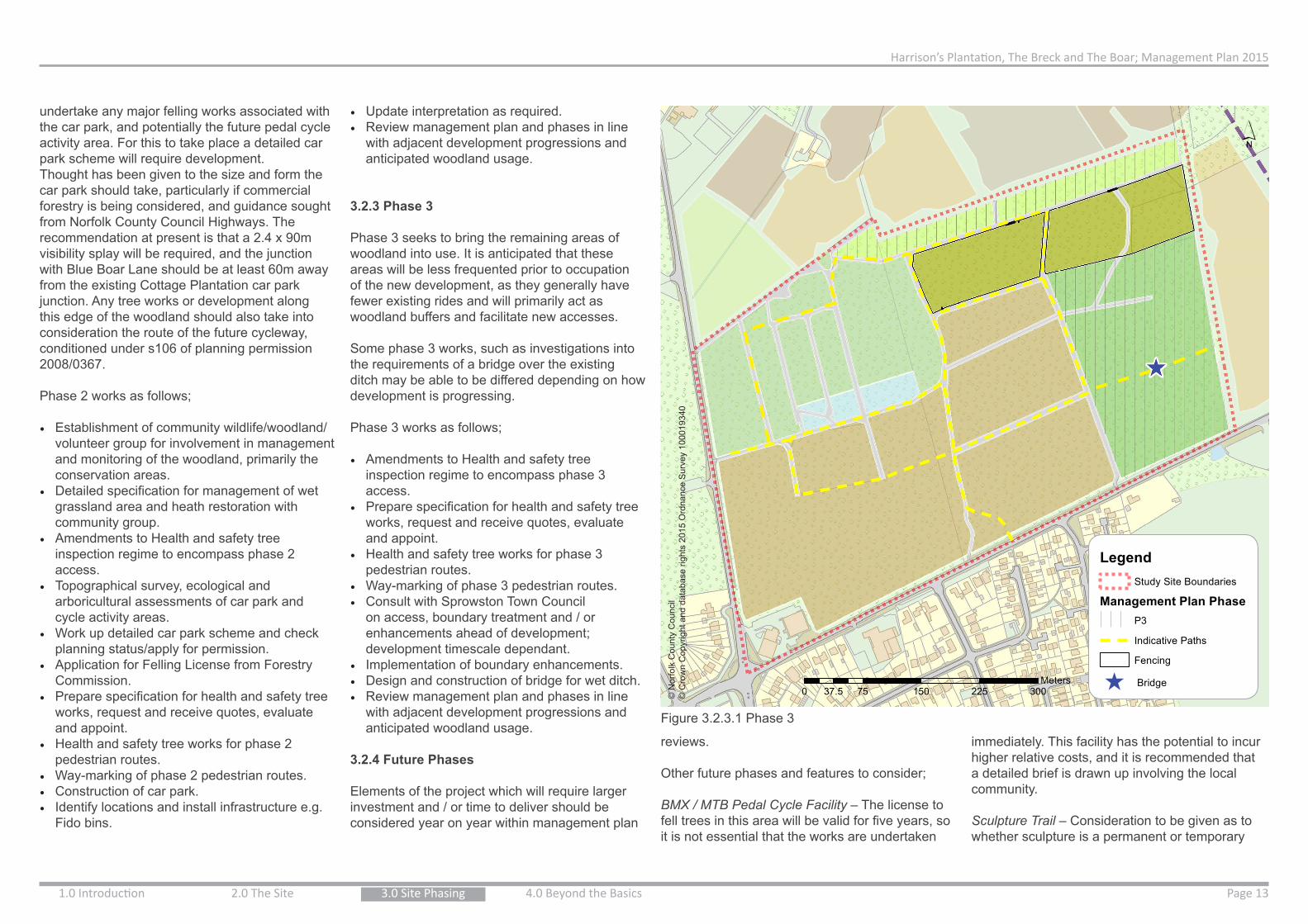
School
Taylor Wimpey
New Link Road
´
0 75 150 225 30037.5Meters
1:3,000
LegendStudy Site Boundaries
Management Plan PhaseP3
Indicative Paths
Fencing
^ Bridge
ZoningConservation; Heathland Character
Conservation; No Formal Access
Conservation; Wet Grassland
Forestry/Limited Formal Access; Mixed Woodland
Forestry/Woodland Activities; Compartment Mix
Forestry/Woodland Activities; MTB, Dog Walking
Woodland Fringe
Future Development PhasesDeveloper
Hopkins Homes
Persimmon
Public Open Space
School
Taylor Wimpey
New Link Road
´
© N
orfo
lk C
ount
y C
ounc
il©
Cro
wn
Cop
yrig
ht a
nd d
atab
ase
right
s 20
15 O
rdna
nce
Sur
vey
1000
1934
0
Figure 3.2.3.1 Phase 3
undertake any major felling works associated with the car park, and potentially the future pedal cycle activity area. For this to take place a detailed car park scheme will require development.Thought has been given to the size and form the car park should take, particularly if commercial forestry is being considered, and guidance sought from Norfolk County Council Highways. The recommendation at present is that a 2.4 x 90m visibility splay will be required, and the junction with Blue Boar Lane should be at least 60m away from the existing Cottage Plantation car park junction. Any tree works or development along this edge of the woodland should also take into consideration the route of the future cycleway, conditioned under s106 of planning permission 2008/0367.
Phase 2 works as follows;
• Establishment of community wildlife/woodland/volunteer group for involvement in management and monitoring of the woodland, primarily the conservation areas.
• Detailed specification for management of wet grassland area and heath restoration with community group.
• Amendments to Health and safety tree inspection regime to encompass phase 2 access.
• Topographical survey, ecological and arboricultural assessments of car park and cycle activity areas.
• Work up detailed car park scheme and check planning status/apply for permission.
• Application for Felling License from Forestry Commission.
• Prepare specification for health and safety tree works, request and receive quotes, evaluate and appoint.
• Health and safety tree works for phase 2 pedestrian routes.
• Way-marking of phase 2 pedestrian routes.• Construction of car park.• Identify locations and install infrastructure e.g.
Fido bins.
• Update interpretation as required.• Review management plan and phases in line
with adjacent development progressions and anticipated woodland usage.
3.2.3 Phase 3
Phase 3 seeks to bring the remaining areas of woodland into use. It is anticipated that these areas will be less frequented prior to occupation of the new development, as they generally have fewer existing rides and will primarily act as woodland buffers and facilitate new accesses.
Some phase 3 works, such as investigations into the requirements of a bridge over the existing ditch may be able to be differed depending on how development is progressing.
Phase 3 works as follows;
• Amendments to Health and safety tree inspection regime to encompass phase 3 access.
• Prepare specification for health and safety tree works, request and receive quotes, evaluate and appoint.
• Health and safety tree works for phase 3 pedestrian routes.
• Way-marking of phase 3 pedestrian routes.• Consult with Sprowston Town Council
on access, boundary treatment and / or enhancements ahead of development; development timescale dependant.
• Implementation of boundary enhancements.• Design and construction of bridge for wet ditch.• Review management plan and phases in line
with adjacent development progressions and anticipated woodland usage.
3.2.4 Future Phases
Elements of the project which will require larger investment and / or time to deliver should be considered year on year within management plan
reviews.
Other future phases and features to consider;
BMX / MTB Pedal Cycle Facility – The license to fell trees in this area will be valid for five years, so it is not essential that the works are undertaken
immediately. This facility has the potential to incur higher relative costs, and it is recommended that a detailed brief is drawn up involving the local community.
Sculpture Trail – Consideration to be given as to whether sculpture is a permanent or temporary

Harrison’s Plantation, The Breck and The Boar; Management Plan 2015
1.0 Introduction 2.0 The SitePage 14 3.0 Site Phasing 4.0 Beyond the Basics
4.0 Beyond The Basics4.1 On-going Management
4.1.1 Ecology
As there are UK and Norfolk priority habitats for conservation and potentially protected species within the site, it is essential to work to a plan that aims to conserve and enhance these features.
A methodology for managing the ecological
features based on a period of 5 years, after which time it is to be reviewed, has been drafted and is available in Appendix 3.
Some management operations will continue annually, other targets that have been met may be removed from future management plans, and new projects or techniques can be included.
Conservation Priorities;
• Protect the existing habitats and species; (carry out surveys and seek designation for the site.)
• Create new habitat features where possible including nesting, roosting and hibernating habitat.
• Increase the amount of open habitat available to wildlife through selective thinning of conifers.
• Create disturbance free areas as a refuge for wildlife e.g. Heathland restoration area.
• Form a Community Nature/ Conservation Group• Use traditional ‘low disturbance’ management
techniques to manage the habitats.• Record the success of the management through
species monitoring.
4.1.2 Tree Health and Safety
A system of inspection in line with the recommendations of the National Tree Safety Groups (NTSG, Appendix 6), like the Norfolk Tree Policy (2012), should be implemented.
Areas should be zoned in terms of frequency of use; for example, car parks, picnic areas, cycle areas and roadsides should undergo more frequent inspections. Access should be limited and / or discouraged around any trees of poor condition, such as the Beech in the north-east of the site. The usage of these areas should be monitored to ensure mitigation measures are sufficient enough to reduce any risk.
Main corridors of movement are to be encouraged along the forestry access routes, as these are easily to monitored. Some ‘informal’ sinuous
paths should be created from the main corridors to encourage users away from sensitive or under managed areas. The informal creation of such paths should be monitored and appropriate assessment made as to whether health and safety mitigation is required with regard to trees.
To mitigate risks, encouragement / planting of understory or creation of a dead hedge between path entrances can enable more effective temporary blocking of access routes into woodland compartments to enable woodland management operations.
4.1.3 Woodland Management
Engagement with Andrew Falcon, the former site forester is recommended to provide advice for the site in line with new objectives, to take advantage of grant schemes, maximise revenue and act as an educational resource / demonstration of woodland management working to the UK Forestry Standards.
Sale of produce could contribute to management costs of the site, particularly the additional tree safety inspection and work required. Systems need to be in place to advertise when woodland work is being carried out and ensure that the public do not enter areas during management.
Where suitable, community engagement could be sort to manage less complex areas of the wood for actions such as thinning, coppicing and rhododendron removal.
Woodland produce should be sought to be used locally. Consider the use of a mobile saw mill to convert material on site and the use of wood chippings as mulch for local planting schemes.
Deer control will be required, although it is possible that an increase in human presence and dog walking may make the woodland less favourable for Deer. Fenced trail areas could be established, to exclude mammal browsing, to compare and assess the impact of Deer across the site.
4.2 Designations
To safeguard the site, and the habitats and species within it, it is recommended that some level of designation should be sought such as Local nature Reserve (LNR) and or County Wildlife Site (CWS).Local Nature Reserve
A Local Nature Reserve is a statutory designation which is designated by the local planning authority that would allow bylaws to be adopted to protect the site from activities likely to disturb important features or cause problems for the legitimate management of the site.
County Wildlife Site
A County Wildlife Site is a non-statutory designation that follows standardised criteria based assessment to highlight the habitat as being of conservation / ecological value. The designation is granted by Norfolk Wildlife Trust in partnership with the landowner and would raise the profile of the site within the planning system.
4.3 Future Funding
Current cost estimates are available under Appendix 7, however It is recommended that advice from a forestry specialist such as Andrew Falcon, whom previously managed the site, or the Norwich Fringe Project is sought for the on-going maintenance of the site as they will be best placed to record and action any qualifying funding available, generate revenue, and facilitate community involvement. Contact details for the above persons can be provided to the Councils on request.
Some potential funding streams may include;
• Higher Level Stewardship/ NELMS• Woodland Trust Grants• Forestry Commission Grants
feature within the woodland. A general way of working could be evolved to incorporate sculpture from wood when available e.g. fallen or monolith trees. In terms of temporary function, the site could play part in the Norwich Festival Open Studios, to exhibit environmental art forms.
Visitor / Forest School Facilities – Toilets, outdoor classroom(s)/forest school areas, and refreshment facilities may be something to consider in the longer term subject to the Town Council’s end vision for the site.
Accessibility – Although in the short term routes will not be accessible to all, in the future it will be desirable to enhance some surfaces for wheelchair and other less mobile users. The routes for these enhancements will need to be made with any commercial or maintenance intentions on site in mind; the reasoning for surface improvements as a future phase is to allow time for a forestry management regime to be implemented alongside other management for public access and conservation. This critique of commercial viability and management techniques will help to identify the most suitable areas for surface improvements. Notwithstanding the current uncertainty regarding primary routes associated with new development.

Harrison’s Plantation, The Breck and The Boar; Management Plan 2015
Page 155.0 Appendices & References
Project Brief: Harrison’s Plantation, The Breck and Boar Plantation Woodland Park – Woodland
Management Plan
Sponsoring Group: Greater Norwich Infrastructure Board Sponsor: Phil Courtier, Head of Planning, Broadland District Council Project Manager: David White, Natural Environment Team, Norfolk County Council Project Description: A “Woodland Management Plan” for Harrison’s Plantation / The Breck, hereafter referred to as “the Woodland”. The Woodland Management Plan shall:
Establish the woodland management objectives in consultation with Broadland District Council and Sprowston Town Council
Identify an initial programme of costed works in order to make the Woodland suitable for use as a “Woodland Activity Park”, to be undertaken in year 1.
Sets out the requirements for the future management and maintenance of Harrison Plantation, The Breck and Boar Plantation as a “Woodland Activity Park” including costed works for years 2 to 5.
Background: The delivery of a publically accessible woodland park at Harrison’s Plantation and The Breck was required as part of the allocation of White House Farm for development within the Broadland Local Plan Replacement (2006). The delivery of publically accessible woodland at Harrison’s Plantation, The Breck and Boar Plantation was secured through the grant of planning permission at White House Farm for “the erection of 1233 dwellings, including link road, recreation areas, primary school, open space and other associated works” on 23 May 2011, district reference 20080367. The S106 agreement that accompanied planning permission 20080367 required the a woodland management plan, public access to the woodlands and, in the event of the transfer of the site to the district council, the payment of a woodland management contribution not exceeding £100,000 as increased by inflation in accordance with the Woodland Management Plan. This requirement must be fulfilled prior to the occupation of the 451st dwelling. The woodland is one of three large public parks to be delivered through development identified within the published Growth Triangle Area Action Plan. The woodland forms part of the Green Infrastructure Network for the Growth Triangle and plays a key role in mitigating potential recreational impact on internationally designated sites of ecological importance.
The woodland is identified within the adopted Sprowston Neighbourhood Plan as a “woodland activity park”. Proposal The project is the production of a woodland management plan and will be delivered by Norfolk County Council Natural Environment Team. The first stage of the project will be to establish woodland management objectives through consultation with Broadland District Council and Sprowston Town Council. Once objectives are established the draft woodland management plan will be produced. This will be followed by a period of consultation with Broadland District Council and Sprowston Town Council before the woodland management plan is finalised. The project is the necessary first stage of the GNGB project which seeks to secure early public access to Harrison’s Plantation and The Breck. Concurrently with the production of the woodland management plan, the acquisition of the woodland from the White House Farm development consortium will be finalised. Following the production of the management plan and acquisition of the woodland the initial programme of works will be undertaken and the woodlands opened to the public (Year 1). Arrangements will then be made for the ongoing maintenance of the woodlands (Years 2-5). Timescale The project will begin in XXXX 2014 and will be completed by XXXX (latest possible date is 31 March 2015) Key Dates Consultation on Draft Woodland Management Objectives
TBC
Draft Woodland Management Plan Produced
TBC
Stakeholder Comments Provided in Draft Woodland Management Plan
TBC
Final Woodland Management Plan Delivered
TBC
Benefits The project is a necessary first step in securing the early public access to Harrison’s Plantation, The Breck and Boar Plantation. This ensures the delivery of a key part of the Green Infrastructure Network, which plays a key role in mitigating potential recreational impact on internationally designated sites of ecological importance, will be delivered in advance of development and delivers a key policy objective of the Sprowston Neighbourhood Plan.
5.0 Appendices & References5.1 Appendices
Appendix 1, Project Brief, Broadland District Council
...Continued
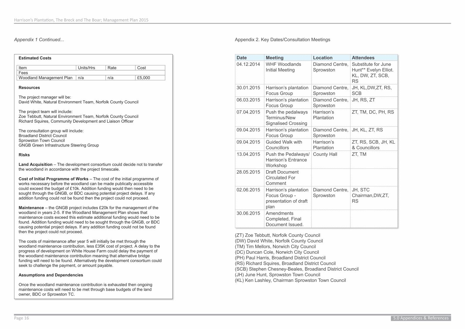
Harrison’s Plantation, The Breck and The Boar; Management Plan 2015
Page 16 5.0 Appendices & References
Estimated Costs Item Units/Hrs Rate Cost Fees Woodland Management Plan n/a n/a £5,000 Resources The project manager will be: David White, Natural Environment Team, Norfolk County Council The project team will include: Zoe Tebbutt, Natural Environment Team, Norfolk County Council Richard Squires, Community Development and Liaison Officer The consultation group will include: Broadland District Council Sprowston Town Council GNGB Green Infrastructure Steering Group Risks Land Acquisition – The development consortium could decide not to transfer the woodland in accordance with the project timescale. Cost of Initial Programme of Works – The cost of the initial programme of works necessary before the woodland can be made publically accessible could exceed the budget of £10k. Addition funding would then need to be sought through the GNGB, or BDC causing potential project delays. If any addition funding could not be found then the project could not proceed. Maintenance – the GNGB project includes £20k for the management of the woodland in years 2-5. If the Woodland Management Plan shows that maintenance costs exceed this estimate additional funding would need to be found. Addition funding would need to be sought through the GNGB, or BDC causing potential project delays. If any addition funding could not be found then the project could not proceed. The costs of maintenance after year 5 will initially be met through the woodland maintenance contribution, less £35K cost of project. A delay to the progress of development on White House Farm could delay the payment of the woodland maintenance contribution meaning that alternative bridge funding will need to be found. Alternatively the development consortium could seek to challenge the payment, or amount payable. Assumptions and Dependencies Once the woodland maintenance contribution is exhausted then ongoing maintenance costs will need to be met through base budgets of the land owner, BDC or Sprowston TC.
Date Meeting Location Attendees04.12.2014 WHF Woodlands
Initial MeetingDiamond Centre, Sprowston
Substitute for June Hunt** Evelyn Elliot. KL, DW, ZT, SCB, RS
30.01.2015 Harrison’s plantation Focus Group
Diamond Centre, Sprowston
JH, KL,DW,ZT, RS, SCB
06.03.2015 Harrison’s plantation Focus Group
Diamond Centre, Sprowston
JH, RS, ZT
07.04.2015 Push the pedalways Terminus/New Signalised Crossing
Harrison’s Plantation
ZT, TM, DC, PH, RS
09.04.2015 Harrison’s plantation Focus Group
Diamond Centre, Sprowston
JH, KL, ZT, RS
09.04.2015 Guided Walk with Councillors
Harrison’s Plantation
ZT, RS, SCB, JH, KL & Councillors
13.04.2015 Push the Pedalways/Harrison’s Entrance Workshop
County Hall ZT, TM
28.05.2015 Draft Document Circulated For Comment
02.06.2015 Harrison’s plantation Focus Group - presentation of draft plan
Diamond Centre, Sprowston
JH, STC Chairman,DW,ZT, RS
30.06.2015 Amendments Completed, Final Document Issued.
Appendix 1 Continued... Appendix 2. Key Dates/Consultation Meetings
(ZT) Zoe Tebbutt, Norfolk County Council(DW) David White, Norfolk County Council(TM) Tim Mellors, Norwich City Council(DC) Duncan Cole, Norwich City Council(PH) Paul Harris, Broadland District Council(RS) Richard Squires, Broadland District Council(SCB) Stephen Chesney-Beales, Broadland District Council(JH) June Hunt, Sprowston Town Council(KL) Ken Lashley, Chairman Sprowston Town Council

Harrison’s Plantation, The Breck and The Boar; Management Plan 2015
Page 175.0 Appendices & References
Man
agem
ent S
ched
ule
for C
onse
rvat
ion
Wor
k C
onse
rvat
ion
Prio
ritie
s P
resc
riptio
n Ye
ars
Tim
ing
Who
to d
eliv
er
Det
ails
Pro
tect
ion
of
exis
ting
wild
life
and
habi
tats
.
Dis
cuss
the
pote
ntia
l for
‘Loc
al
Nat
ure
Res
erve
’ (L
NR
) sta
tus
1 P
hase
1
Boa
dlan
d D
istri
ct
Cou
ncil,
in li
aiso
n w
ith S
prow
ston
To
wn
Cou
ncil
Th
is w
ould
pro
vide
th
e si
te w
ith a
leve
l of
prot
ectio
n in
pla
nnin
g an
d al
low
the
adop
tion
of b
ylaw
s to
pr
even
t dis
turb
ance
to
wild
life/
eco
logy
.
Con
sult
Nor
folk
W
ildlif
e Tr
ust
abou
t sur
veyi
ng
the
site
as
a po
tent
ial ‘
Cou
nty
Wild
life
Site
’
1 P
hase
1
Spr
owst
on T
own
Cou
ncil/
NC
C/
NW
T
C
ount
y W
ildlif
e S
ites
are
a no
n st
atut
ory
desi
gnat
ion
that
if
elig
ible
, wou
ld
iden
tify
the
site
as
of
cons
erva
tion
valu
e.
Hea
thla
nd
rest
orat
ion
Are
a Fe
nce
perim
eter
of
the
Hea
thla
nd
Are
a. T
o sa
fegu
ard
ecol
ogy
(she
ep n
ettin
g)
1 P
hase
1
(Sep
tem
ber-
Oct
ober
201
5)
Con
tract
or
U
se s
heep
net
ting
to
allo
w re
ptile
s an
d sm
all m
amm
als
to
pass
thro
ugh.
Fenc
ing
is to
pro
hibi
t do
gs
P
rovi
de a
fiel
d ga
te
into
eac
h co
mpa
rtmen
t for
ve
hicl
e ac
cess
, and
st
iles
for p
edes
trian
s.
S
elec
tive
thin
ning
of
bet
ula
pend
ula
and
crea
tion
of
habi
tat /
feat
ures
S
elec
tive
thin
ning
1
Som
e In
itial
th
inni
ng d
urin
g tre
e he
alth
&
safe
ty w
ork
in
Pha
se 1
by
Con
tract
or.
Con
tract
or
Vol
unte
ers
R
etai
n m
atur
e / w
ell
form
ed b
irch
trees
as
‘sta
ndar
ds’
R
etai
n &
crea
te
stan
ding
dea
dwoo
d w
here
saf
e to
do
so.
of b
etul
a pe
ndul
a an
d cr
eatio
n of
ha
bita
t / fe
atur
es
2 - 5
(O
ctob
er 2
015)
-S
ubse
quen
t gr
adua
l thi
nnin
g of
sm
all s
elf-
sow
n bi
rch
by
volu
ntee
rs
U
se b
rash
and
logs
to
form
rept
ile
‘hib
erna
cula
r’
S
urve
y of
the
heat
hlan
d ar
ea fo
r re
ptile
s an
d in
verte
brat
es
2- 5
P
hase
2. M
arch
- J
uly
Vol
unte
ers
with
gu
idan
ce fr
om
NB
IS
Sur
vey
heat
hlan
d ar
ea
for R
eptil
es,
inve
rtebr
ates
, gro
und
flora
.
Long
er te
rm
thin
ning
of P
icea
ab
ies
Nor
way
sp
ruce
and
cr
eatio
n of
he
athl
and
type
ha
bita
t
3 - 5
P
hase
3 +
. S
epte
mbe
r -
Janu
ary
Spr
owst
on T
own
Cou
ncil,
C
ontra
ctor
, V
olun
teer
s
The
desi
red
use
of th
e tim
ber.
Eg.
Chr
istm
as
trees
, fire
woo
d, h
abita
t pi
les.
Will
dict
ate
who
ca
rries
out
the
wor
k.
Wet
Gra
ssla
nd
Are
a E
colo
gica
l Sur
vey
2
Mar
ch -
Aug
ust
Com
mun
ity
volu
ntee
rs &
NBI
S
Car
ry o
ut e
colo
gica
l su
rvey
s fo
r in
verte
brat
es, r
eptil
es ,
amph
ibia
ns &
flor
a.
M
owin
g of
gra
ss
area
2
– 5
S
epte
mbe
r /
Oct
ober
S
prow
ston
Tow
n C
ounc
il/
Con
tract
or /
Com
mun
ity
volu
ntee
rs
All
aris
ing
to b
e he
aped
on
the
north
ern
edge
an
d le
ft to
dec
ay. T
his
will
als
o fo
rm re
ptile
/ am
phib
ian
hibe
rnac
ula.
Ret
ain
the
willo
w
tree
at th
e w
este
rn
edge
Per
man
ently
In
Apr
il 20
15 th
e tre
e w
as c
over
ed in
com
ma
and
peac
ock
butte
rflie
s an
d ot
her i
nver
tebr
ates
. N
orth
ern
woo
dlan
d fri
nge
(Haz
el
Cop
pice
Sto
ols)
Man
age
the
sect
ion
of th
e w
oodl
and
edge
co
ntai
ning
haz
el
as a
n ar
ea o
f “h
azel
cop
pice
with
st
anda
rds,
to
2 - 5
N
ovem
ber -
Ja
nuar
y C
omm
unity
vo
lunt
eers
with
gu
idan
ce
R
e-co
ppic
e tw
o st
ools
per
yea
r, ev
ery
othe
r yea
r. (c
oppi
ced
stoo
ls w
ill re
quire
pr
otec
tion
from
gr
azin
g an
imal
s).
R
etai
n m
atur
e tre
es
Appendix 3 Detailed Ecological ManagementSchedule
...Continued

Harrison’s Plantation, The Breck and The Boar; Management Plan 2015
Page 18 5.0 Appendices & References
Man
agem
ent S
ched
ule
for C
onse
rvat
ion
Wor
k C
onse
rvat
ion
Prio
ritie
s P
resc
riptio
n Ye
ars
Tim
ing
Who
to d
eliv
er
Det
ails
Pro
tect
ion
of
exis
ting
wild
life
and
habi
tats
.
Dis
cuss
the
pote
ntia
l for
‘Loc
al
Nat
ure
Res
erve
’ (L
NR
) sta
tus
1 P
hase
1
Boa
dlan
d D
istri
ct
Cou
ncil,
in li
aiso
n w
ith S
prow
ston
To
wn
Cou
ncil
Th
is w
ould
pro
vide
th
e si
te w
ith a
leve
l of
prot
ectio
n in
pla
nnin
g an
d al
low
the
adop
tion
of b
ylaw
s to
pr
even
t dis
turb
ance
to
wild
life/
eco
logy
.
Con
sult
Nor
folk
W
ildlif
e Tr
ust
abou
t sur
veyi
ng
the
site
as
a po
tent
ial ‘
Cou
nty
Wild
life
Site
’
1 P
hase
1
Spr
owst
on T
own
Cou
ncil/
NC
C/
NW
T
C
ount
y W
ildlif
e S
ites
are
a no
n st
atut
ory
desi
gnat
ion
that
if
elig
ible
, wou
ld
iden
tify
the
site
as
of
cons
erva
tion
valu
e.
Hea
thla
nd
rest
orat
ion
Are
a Fe
nce
perim
eter
of
the
Hea
thla
nd
Are
a. T
o sa
fegu
ard
ecol
ogy
(she
ep n
ettin
g)
1 P
hase
1
(Sep
tem
ber-
Oct
ober
201
5)
Con
tract
or
U
se s
heep
net
ting
to
allo
w re
ptile
s an
d sm
all m
amm
als
to
pass
thro
ugh.
Fenc
ing
is to
pro
hibi
t do
gs
P
rovi
de a
fiel
d ga
te
into
eac
h co
mpa
rtmen
t for
ve
hicl
e ac
cess
, and
st
iles
for p
edes
trian
s.
S
elec
tive
thin
ning
of
bet
ula
pend
ula
and
crea
tion
of
habi
tat /
feat
ures
S
elec
tive
thin
ning
1
Som
e In
itial
th
inni
ng d
urin
g tre
e he
alth
&
safe
ty w
ork
in
Pha
se 1
by
Con
tract
or.
Con
tract
or
Vol
unte
ers
R
etai
n m
atur
e / w
ell
form
ed b
irch
trees
as
‘sta
ndar
ds’
R
etai
n &
crea
te
stan
ding
dea
dwoo
d w
here
saf
e to
do
so.
max
imis
e bi
odiv
ersi
ty v
alue
. as
‘Sta
ndar
d’ tr
ees.
Incr
ease
the
num
ber
of h
azel
sto
ols
by
bend
ing
youn
g st
ems
and
pegg
ing
dow
n w
here
con
tact
is
mad
e w
ith th
e gr
ound
. Thi
s pr
omot
es r
ootin
g an
d fo
rms
new
pl
ants
.
W
oodl
and
Are
as
Exp
lore
co
mm
erci
al
viab
ility
& h
isto
ry
of tr
ee s
tock
. (C
onta
ct A
ndre
w
Falc
on)
1
June
201
5 .
If
certa
in a
reas
are
to
be m
anag
ed fo
r fo
rest
ry, i
t wou
ld n
ot
be re
com
men
ded
to
crea
te w
ildlif
e ha
bita
t eg
. log
pile
s, b
ird&
ba
t box
es, i
n th
ese
area
s.
S
urve
ys fo
r pro
tect
ed
spec
ies
,eg.
Bat
s,
nest
ing
bird
s, re
ptile
s w
ould
be
requ
ired
befo
re fe
lling
trees
.
Man
age
area
s cl
asse
d as
‘ope
n w
oodl
and’
in a
w
ildlif
e fri
endl
y w
ay
1 –
5
Oct
ober
201
5 S
epte
mbe
r 201
6 on
war
ds.
(if ti
mbe
r ex
tract
ion
is
desi
red)
Con
tract
or i
nitia
lly
thro
ugh
Hea
lth &
sa
fety
tree
wor
k.
Com
mun
ity
Vol
unte
ers
Fore
stry
C
ontra
ctor
R
etai
n fa
llen
dead
tre
es to
dec
ay, &
use
w
ood
prun
ed fr
om
trees
to c
reat
e lo
g/
habi
tat p
iles.
Ret
ain
stan
ding
dea
d w
ood
‘whe
re s
afe
to
do s
o’ e
g. S
mal
l tre
es
away
from
foot
path
s.
R
etai
n an
d in
crea
se
the
amou
nt o
f
‘und
erst
ory’
pla
nts
– ou
tsid
e of
fore
stry
ar
eas.
Pha
sed
rem
oval
of
Rho
dode
ndro
n 2
- 5
Sep
tem
ber -
Ja
nuar
y C
omm
unity
V
olun
teer
s &
Con
tract
or
R
hodo
dend
ron
shou
ld b
e re
mov
ed
grad
ually
dur
ing
win
ter m
onth
s.
(stu
mps
sho
uld
be tr
eate
d w
ith
glyp
hosa
te a
nd
cut m
ater
ial b
urnt
un
der
supe
rvis
ion.
W
oodl
and
Rid
es
/pat
hs
Man
age
woo
dlan
d rid
es to
max
imis
e bi
odiv
ersi
ty.
1 - 5
S
epte
mbe
r -
Janu
ary
Com
mun
ity
Vol
unte
ers
& C
ontra
ctor
R
etai
n / m
ow
gras
s tra
cks
&
crea
te s
callo
ped
edge
s in
to th
e w
oodl
and
edge
w
here
pos
sibl
e to
m
axim
ise
edge
ef
fect
and
she
lter
for b
utte
rflie
s.
E
stab
lish
a gr
adie
nt o
f ve
geta
tion
at th
e ed
ge o
f the
ride
. R
isin
g fro
m th
e gr
asse
s, th
roug
h to
her
bs, t
alle
r pl
ants
and
shr
ubs
into
the
unde
rsto
rey
and
trees
. P
onds
& s
tream
S
urve
y po
nds
for
amph
ibia
ns
2 Fe
brua
ry 2
016
– A
pril
2016
A
n ec
olog
ist
A
vis
ual c
heck
of
the
wat
er a
nd
Appendix 3 Continued...
...Continued

Harrison’s Plantation, The Breck and The Boar; Management Plan 2015
Page 195.0 Appendices & References
Man
agem
ent S
ched
ule
for C
onse
rvat
ion
Wor
k C
onse
rvat
ion
Prio
ritie
s P
resc
riptio
n Ye
ars
Tim
ing
Who
to d
eliv
er
Det
ails
Pro
tect
ion
of
exis
ting
wild
life
and
habi
tats
.
Dis
cuss
the
pote
ntia
l for
‘Loc
al
Nat
ure
Res
erve
’ (L
NR
) sta
tus
1 P
hase
1
Boa
dlan
d D
istri
ct
Cou
ncil,
in li
aiso
n w
ith S
prow
ston
To
wn
Cou
ncil
Th
is w
ould
pro
vide
th
e si
te w
ith a
leve
l of
prot
ectio
n in
pla
nnin
g an
d al
low
the
adop
tion
of b
ylaw
s to
pr
even
t dis
turb
ance
to
wild
life/
eco
logy
.
Con
sult
Nor
folk
W
ildlif
e Tr
ust
abou
t sur
veyi
ng
the
site
as
a po
tent
ial ‘
Cou
nty
Wild
life
Site
’
1 P
hase
1
Spr
owst
on T
own
Cou
ncil/
NC
C/
NW
T
C
ount
y W
ildlif
e S
ites
are
a no
n st
atut
ory
desi
gnat
ion
that
if
elig
ible
, wou
ld
iden
tify
the
site
as
of
cons
erva
tion
valu
e.
Hea
thla
nd
rest
orat
ion
Are
a Fe
nce
perim
eter
of
the
Hea
thla
nd
Are
a. T
o sa
fegu
ard
ecol
ogy
(she
ep n
ettin
g)
1 P
hase
1
(Sep
tem
ber-
Oct
ober
201
5)
Con
tract
or
U
se s
heep
net
ting
to
allo
w re
ptile
s an
d sm
all m
amm
als
to
pass
thro
ugh.
Fenc
ing
is to
pro
hibi
t do
gs
P
rovi
de a
fiel
d ga
te
into
eac
h co
mpa
rtmen
t for
ve
hicl
e ac
cess
, and
st
iles
for p
edes
trian
s.
S
elec
tive
thin
ning
of
bet
ula
pend
ula
and
crea
tion
of
habi
tat /
feat
ures
S
elec
tive
thin
ning
1
Som
e In
itial
th
inni
ng d
urin
g tre
e he
alth
&
safe
ty w
ork
in
Pha
se 1
by
Con
tract
or.
Con
tract
or
Vol
unte
ers
R
etai
n m
atur
e / w
ell
form
ed b
irch
trees
as
‘sta
ndar
ds’
R
etai
n &
crea
te
stan
ding
dea
dwoo
d w
here
saf
e to
do
so.
po
nd e
dges
for
frogs
, toa
ds,
com
mon
new
ts
and
thei
r egg
s.
S
urve
y po
nds
for
grea
t cre
sted
ne
wts
2 Fe
brua
ry 2
016
– A
pril
2016
A
n ec
olog
ist w
ith a
cu
rrent
Gre
at
cres
ted
new
t su
rvey
Lic
ense
It
is a
dvis
able
to
surv
ey th
e po
nds
for t
he li
kely
pr
esen
ce o
f gre
at
cres
ted
new
ts to
av
oid
unin
tent
iona
l co
nflic
ts w
ith th
e co
nser
vatio
n m
anag
emen
t
Rem
ove
self-
sow
n ‘w
oody
scr
ub’ e
g.
Willo
w, a
lder
, birc
h
that
mig
ht
esta
blis
h ar
ound
th
e po
nd s
.
2 - 5
Ju
ly –
Aug
ust
whe
n w
ater
leve
l is
at i
ts lo
wes
t.
Com
mun
ity
volu
ntee
rs
Em
ploy
a
cont
ract
or fo
r any
tre
atm
ent o
f st
umps
with
he
rbic
ide.
B
y pu
lling
whe
re
poss
ible
.
Sta
ck a
ny c
ut
mat
eria
l at t
he
edge
of t
he p
ond
as h
abita
t for
am
phib
ians
.
Trea
t cut
stu
mps
w
ith g
lyph
osat
e to
pr
even
t reg
row
th.
M
aint
ain
the
leve
l of
wat
er in
the
stre
am/ d
itch.
R
etai
n br
anch
es
over
the
ditc
h an
d re
sist
the
urge
to
dred
ge th
e se
dim
ent o
ut a
s th
is m
ay d
rain
the
wat
er a
way
.
The
wat
er fi
lled
ditc
h is
a h
abita
t in
its
own
right
, w
ith s
hady
wet
ar
eas
cont
aini
ng
fern
s an
d m
osse
s, a
nd
rotte
n fa
llen
trees
.
Res
istin
g th
e ur
ge
to o
verti
dy th
e w
oodl
and
and
ditc
h w
ill re
tain
th
e di
vers
ity th
at
this
und
istu
rbed
ar
ea p
rovi
des.
Acc
ess
wou
ld
idea
lly n
ot b
e en
cour
aged
. R
evie
w a
nd a
men
d M
anag
emen
t Pla
n
Mon
itor t
he
succ
ess
of th
e ha
bita
ts b
y co
mpa
ring
the
resu
lts o
f the
an
nual
sur
veys
3 - 5
M
arch
201
7 S
prow
ston
Tow
n C
ounc
il/
Com
mun
ity
volu
ntee
rs
Th
is w
ill su
gges
t w
heth
er c
urre
nt
man
agem
ent
shou
ld b
e ch
ange
d, a
nd c
an
be im
plem
ente
d un
der t
he n
ext
man
agem
ent
plan
. C
reat
e ne
w
Man
agem
ent P
lan
Bui
ld o
n th
e ex
istin
g m
anag
emen
t pla
n to
pro
duce
a n
ew
plan
that
con
tinue
s to
invo
lve
loca
l pe
ople
in th
e m
anag
emen
t and
de
velo
ps t
he
grou
ps s
kills
to
focu
s on
mor
e de
taile
d m
anag
emen
t of
the
habi
tats
for
spec
ific
spec
ies.
5
Spr
owst
on T
own
Cou
ncil
&co
mm
unity
vo
lunt
eers
M
onito
ring,
su
rvey
ing
and
feed
ing
back
the
resu
lts in
to th
e m
ain
cons
erva
tion
effo
rt in
Nor
folk
, sh
ould
be
inte
gral
to
the
man
agem
ent o
f H
arris
ons
plan
tatio
n.
Lo
cal p
eopl
e an
d gr
oups
sho
uld
be
heav
ily in
volv
ed in
th
e pr
actic
al
cons
erva
tion
wor
k to
ens
ure
the
impo
rtant
hab
itats
do
not
bec
ome
negl
ecte
d an
d lo
st.
Appendix 3 Continued...

Harrison’s Plantation, The Breck and The Boar; Management Plan 2015
Page 20 5.0 Appendices & References
No. Phase Action Risk(s) Liklihood Impact Risk Rating Mitigation Mitigated RR
1 P1
Land transfer from developer consortium to Broadland District Council does not occur as scheduled, before December 2015.
Public access not able to be granted. New signalised crossing unable to be commissioned and motorists continue to speed. New signalised crossing commissioned and the public trespass into the woodland, H&S liability.
2 3 5
Ongoing discussions with Consortium in order to address any issues directly and efficiently
3
2 P1Reserved Matters application required by 23.05.16 to accord with condition 2 of PP 20080367
Application not received within condition time frame. Would cause implecations for PP and potential issues for BDC reimbersement of contributions for Harrison's Plantation management plan and maintenance.
1 3 4
N/A. Ongoing discussions with Consortium. Management Plan phase implementation could be haulted, and priorities reconsidered. Consider these priorities to be considered in management plan.
3
3 P2
Commencement of any P2 development parcel must commence within 1 year of reserved matters approval of said parcel.
Construction not started. 1 3 4
Management Plan phase implementation could be haulted/adapted, and priorities reconsidered. Consider these priorities to be considered in management plan.
4 All
Uncertainty in build out rates for development; Estimated build out 9 years for PP 20080367. Developer Consortium estimates 7 year build out rate for PP 20080367
Disjointed approach to Harrison's Plantation phasing. 2 3 5
Management plan to be forwarded to BDC planners and must be considered in reserved matters application. Alternatively management plan phase implementation could be haulted/adapted, and priorities reconsidered. Consider these priorities to be considered in management plan.
2
5 All
Reserved Matters applications do not adequately take into account identified woodland access from management plan and site survey.
Disjointed approach to Management of Plantation. On site implementation and management plan potentially flawed
3 3 5
Broadland District Council and Norfolk County Council Developer Services to ensure that reserved matters applications respond to management plan and woodland layout. Copies of management plan to be provided to BDC and NCC
2
3 4 5 62 3 4 5
Liklihood 1 2 3 41 2 3
Impact
Appendix 4 Project Risk Register (Living Document)
Risk Rating Matrix
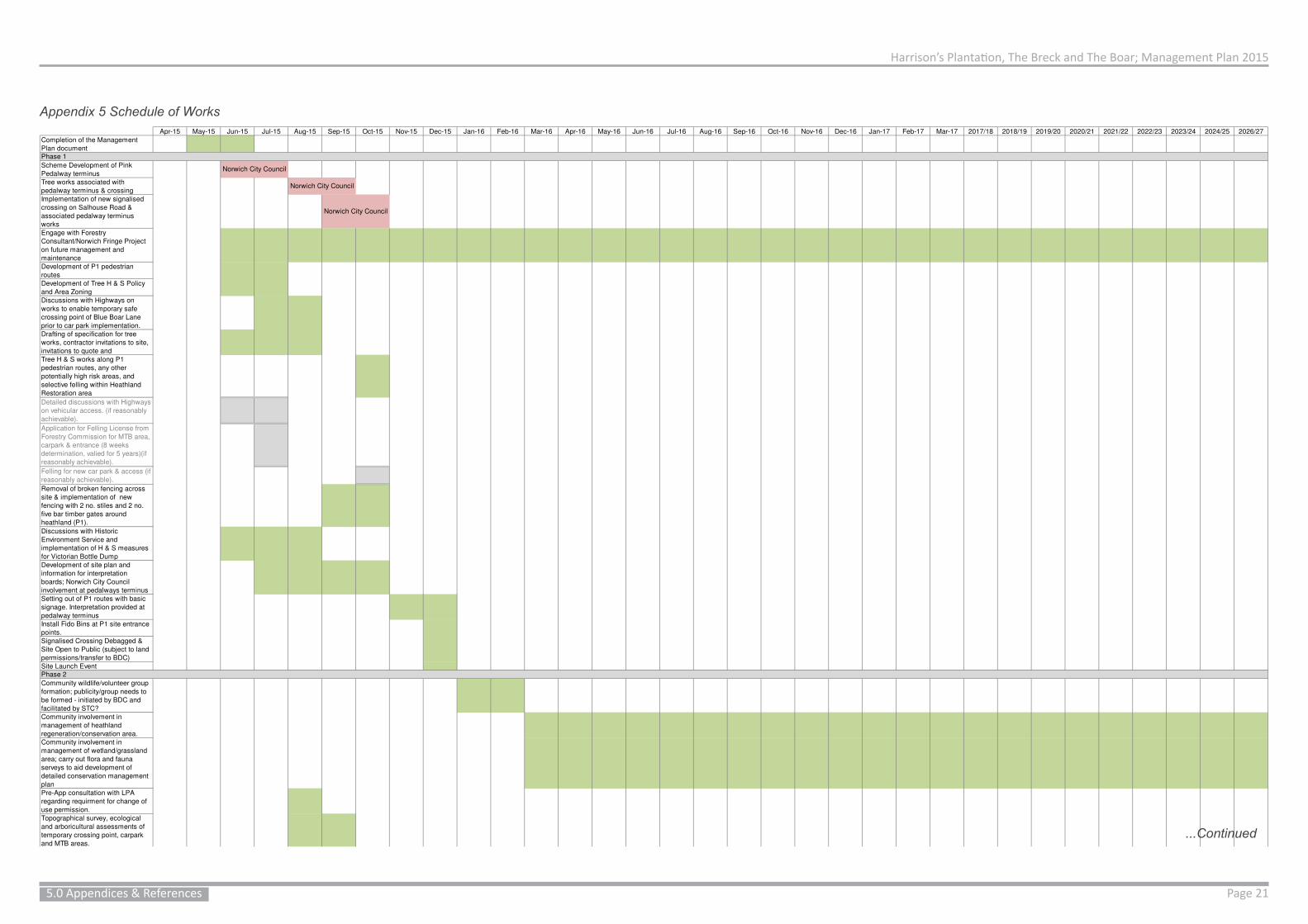
Harrison’s Plantation, The Breck and The Boar; Management Plan 2015
Page 215.0 Appendices & References
Apr-15 May-15 Jun-15 Jul-15 Aug-15 Sep-15 Oct-15 Nov-15 Dec-15 Jan-16 Feb-16 Mar-16 Apr-16 May-16 Jun-16 Jul-16 Aug-16 Sep-16 Oct-16 Nov-16 Dec-16 Jan-17 Feb-17 Mar-17 2017/18 2018/19 2019/20 2020/21 2021/22 2022/23 2023/24 2024/25 2026/27
Completion of the Management
Plan document
Scheme Development of Pink
Pedalway terminus
Tree works associated with
pedalway terminus & crossing
Implementation of new signalised
crossing on Salhouse Road &
associated pedalway terminus
works
Engage with Forestry
Consultant/Norwich Fringe Project
on future management and
maintenance
Development of P1 pedestrian
routes
Development of Tree H & S Policy
and Area Zoning
Discussions with Highways on
works to enable temporary safe
crossing point of Blue Boar Lane
prior to car park implementation.
Drafting of specification for tree
works, contractor invitations to site,
invitations to quote and
Tree H & S works along P1
pedestrian routes, any other
potentially high risk areas, and
selective felling within Heathland
Restoration area
Detailed discussions with Highways
on vehicular access. (if reasonably
achievable).
Application for Felling License from
Forestry Commission for MTB area,
carpark & entrance (8 weeks
determination, valied for 5 years)(if
reasonably achievable).
Felling for new car park & access (if
reasonably achievable).
Removal of broken fencing across
site & implementation of new
fencing with 2 no. stiles and 2 no.
five bar timber gates around
heathland (P1).
Discussions with Historic
Environment Service and
implementation of H & S measures
for Victorian Bottle Dump
Development of site plan and
information for interpretation
boards; Norwich City Council
involvement at pedalways terminus
Setting out of P1 routes with basic
signage. Interpretation provided at
pedalway terminus
Install Fido Bins at P1 site entrance
points.
Signalised Crossing Debagged &
Site Open to Public (subject to land
permissions/transfer to BDC)
Site Launch Event
Community wildlife/volunteer group
formation; publicity/group needs to
be formed - initiated by BDC and
facilitated by STC?
Community involvement in
management of heathland
regeneration/conservation area.
Community involvement in
management of wetland/grassland
area; carry out flora and fauna
serveys to aid development of
detailed conservation management
plan
Pre-App consultation with LPA
regarding requirment for change of
use permission.
Topographical survey, ecological
and arboricultural assessments of
temporary crossing point, carpark
and MTB areas.
Detailed discussions with Highways
on vehicular access.
Detailed car park scheme
development
Apply for planning permission with
detailed scheme. (6-8 week
determination period)
Application for Felling License from
Forestry Commission for MTB area,
carpark & entrance (8 weeks
determination, valied for 5 years)
Felling for new car park & access
Norwich City Council
Norwich City Council
Norwich City Council
Phase 1
Phase 2
Appendix 5 Schedule of Works
...Continued

Harrison’s Plantation, The Breck and The Boar; Management Plan 2015
Page 22 5.0 Appendices & References
Apr-15 May-15 Jun-15 Jul-15 Aug-15 Sep-15 Oct-15 Nov-15 Dec-15 Jan-16 Feb-16 Mar-16 Apr-16 May-16 Jun-16 Jul-16 Aug-16 Sep-16 Oct-16 Nov-16 Dec-16 Jan-17 Feb-17 Mar-17 2017/18 2018/19 2019/20 2020/21 2021/22 2022/23 2023/24 2024/25 2026/27
Construction of appropriate access,
car park and associated works as
agreed with LPA and Highways.
Revision of tree policy/zoning as
required. Tree H & S works along
P2 pedestrian routes. Waymarking
P2.
Site H & S;any further works
associated with 'bottle dump' -
Norfolk County Council Historic
Environment Service as required
Review and amend management
plan in light of development and
public use as required
Review and amend interpretation as
required.
Phase 2 open to public; car park
and woodland. NOTE MTB not yet
constructed, area felled.
Revision of tree policy/zoning as
required.
Tree H & S works along P3
pedestrian routes. Waymarking P3.
Review and amend management
plan in light of development and
public use as required
Review and amend interpretation as
required.
Identification/consultation with town
council on boundary enhancements
ahead of development
Implementation of boundary
enhancements.
Design and construction of bridge
for wet ditch ahead of development
(Subject to progression of
Residential Development &
Funding)
Once development accesses are
known, alongside longer term
management (e.g. forestry/visitor
centre) assess appropriate
locations for routes accessible to
all, cost and implement.
Development of Community Project
for MTB/BMX area; Case Study
research/advice sought for
BMX/MTB area. Exemplar
community projects can used to
form outline for community project.
Risk assessments. (Subject to
resources and funding - this could
be BDC/STC led)
BMX/MTB consultation/community
project initiation. (Subject to
Funding)
Construction of MTB/BMX area
(Subject to Funding)
Sculpture Trails/Events
Visitor/Forest Schools Opportunities
Reserved Matters application
required by 23.05.16 to accord with
condition 2 of PP 20080367
Identification of accesses to and
from woodland to development as
detailed applications come forward.Commencement of any P2
development parcel must
commence within 1 year of
reserved matters approval of said
parcel.Estimated build out 9 years for PP
20080367
Developer Consortium estimates 7
year build out rate for PP 20080367
s106 trigger for Harrison's
Plantation, The Breck and the Boar
(450th Dwelling)
s106 Trigger for Cycleway Blue
Boar Lane to Salhouse Road
Junction (occupation of 550th
dwelling)
Cycleway Link along Salhouse
Road from Link Road Junction to
Blue Boar Lane (Occupation of
1050th dwelling)
Other Factors
**These works could happen ahead of the anticipated cycle path development trigger
(2019/20), however may cause some conflict should the path take in some of the
BMX/MTB area which could informally increase in size. The cycle path scheme will
need to be a consideration in the development of the MTB/BMX area; Conversations
with Highways will be required, and possibly some early conceptual scheme design.
Phase 3 & Onwards
Apr-15 May-15 Jun-15 Jul-15 Aug-15 Sep-15 Oct-15 Nov-15 Dec-15 Jan-16 Feb-16 Mar-16 Apr-16 May-16 Jun-16 Jul-16 Aug-16 Sep-16 Oct-16 Nov-16 Dec-16 Jan-17 Feb-17 Mar-17 2017/18 2018/19 2019/20 2020/21 2021/22 2022/23 2023/24 2024/25 2026/27
Completion of the Management
Plan document
Scheme Development of Pink
Pedalway terminus
Tree works associated with
pedalway terminus & crossing
Implementation of new signalised
crossing on Salhouse Road &
associated pedalway terminus
works
Engage with Forestry
Consultant/Norwich Fringe Project
on future management and
maintenance
Development of P1 pedestrian
routes
Development of Tree H & S Policy
and Area Zoning
Discussions with Highways on
works to enable temporary safe
crossing point of Blue Boar Lane
prior to car park implementation.
Drafting of specification for tree
works, contractor invitations to site,
invitations to quote and
Tree H & S works along P1
pedestrian routes, any other
potentially high risk areas, and
selective felling within Heathland
Restoration area
Detailed discussions with Highways
on vehicular access. (if reasonably
achievable).
Application for Felling License from
Forestry Commission for MTB area,
carpark & entrance (8 weeks
determination, valied for 5 years)(if
reasonably achievable).
Felling for new car park & access (if
reasonably achievable).
Removal of broken fencing across
site & implementation of new
fencing with 2 no. stiles and 2 no.
five bar timber gates around
heathland (P1).
Discussions with Historic
Environment Service and
implementation of H & S measures
for Victorian Bottle Dump
Development of site plan and
information for interpretation
boards; Norwich City Council
involvement at pedalways terminus
Setting out of P1 routes with basic
signage. Interpretation provided at
pedalway terminus
Install Fido Bins at P1 site entrance
points.
Signalised Crossing Debagged &
Site Open to Public (subject to land
permissions/transfer to BDC)
Site Launch Event
Community wildlife/volunteer group
formation; publicity/group needs to
be formed - initiated by BDC and
facilitated by STC?
Community involvement in
management of heathland
regeneration/conservation area.
Community involvement in
management of wetland/grassland
area; carry out flora and fauna
serveys to aid development of
detailed conservation management
plan
Pre-App consultation with LPA
regarding requirment for change of
use permission.
Topographical survey, ecological
and arboricultural assessments of
temporary crossing point, carpark
and MTB areas.
Detailed discussions with Highways
on vehicular access.
Detailed car park scheme
development
Apply for planning permission with
detailed scheme. (6-8 week
determination period)
Application for Felling License from
Forestry Commission for MTB area,
carpark & entrance (8 weeks
determination, valied for 5 years)
Felling for new car park & access
Norwich City Council
Norwich City Council
Norwich City Council
Phase 1
Phase 2
Appendix 5 Continued...
...Continued

Harrison’s Plantation, The Breck and The Boar; Management Plan 2015
Page 235.0 Appendices & References
Apr-15 May-15 Jun-15 Jul-15 Aug-15 Sep-15 Oct-15 Nov-15 Dec-15 Jan-16 Feb-16 Mar-16 Apr-16 May-16 Jun-16 Jul-16 Aug-16 Sep-16 Oct-16 Nov-16 Dec-16 Jan-17 Feb-17 Mar-17 2017/18 2018/19 2019/20 2020/21 2021/22 2022/23 2023/24 2024/25 2026/27
Construction of appropriate access,
car park and associated works as
agreed with LPA and Highways.
Revision of tree policy/zoning as
required. Tree H & S works along
P2 pedestrian routes. Waymarking
P2.
Site H & S;any further works
associated with 'bottle dump' -
Norfolk County Council Historic
Environment Service as required
Review and amend management
plan in light of development and
public use as required
Review and amend interpretation as
required.
Phase 2 open to public; car park
and woodland. NOTE MTB not yet
constructed, area felled.
Revision of tree policy/zoning as
required.
Tree H & S works along P3
pedestrian routes. Waymarking P3.
Review and amend management
plan in light of development and
public use as required
Review and amend interpretation as
required.
Identification/consultation with town
council on boundary enhancements
ahead of development
Implementation of boundary
enhancements.
Design and construction of bridge
for wet ditch ahead of development
(Subject to progression of
Residential Development &
Funding)
Once development accesses are
known, alongside longer term
management (e.g. forestry/visitor
centre) assess appropriate
locations for routes accessible to
all, cost and implement.
Development of Community Project
for MTB/BMX area; Case Study
research/advice sought for
BMX/MTB area. Exemplar
community projects can used to
form outline for community project.
Risk assessments. (Subject to
resources and funding - this could
be BDC/STC led)
BMX/MTB consultation/community
project initiation. (Subject to
Funding)
Construction of MTB/BMX area
(Subject to Funding)
Sculpture Trails/Events
Visitor/Forest Schools Opportunities
Reserved Matters application
required by 23.05.16 to accord with
condition 2 of PP 20080367
Identification of accesses to and
from woodland to development as
detailed applications come forward.Commencement of any P2
development parcel must
commence within 1 year of
reserved matters approval of said
parcel.Estimated build out 9 years for PP
20080367
Developer Consortium estimates 7
year build out rate for PP 20080367
s106 trigger for Harrison's
Plantation, The Breck and the Boar
(450th Dwelling)
s106 Trigger for Cycleway Blue
Boar Lane to Salhouse Road
Junction (occupation of 550th
dwelling)
Cycleway Link along Salhouse
Road from Link Road Junction to
Blue Boar Lane (Occupation of
1050th dwelling)
Other Factors
**These works could happen ahead of the anticipated cycle path development trigger
(2019/20), however may cause some conflict should the path take in some of the
BMX/MTB area which could informally increase in size. The cycle path scheme will
need to be a consideration in the development of the MTB/BMX area; Conversations
with Highways will be required, and possibly some early conceptual scheme design.
Phase 3 & Onwards
Apr-15 May-15 Jun-15 Jul-15 Aug-15 Sep-15 Oct-15 Nov-15 Dec-15 Jan-16 Feb-16 Mar-16 Apr-16 May-16 Jun-16 Jul-16 Aug-16 Sep-16 Oct-16 Nov-16 Dec-16 Jan-17 Feb-17 Mar-17 2017/18 2018/19 2019/20 2020/21 2021/22 2022/23 2023/24 2024/25 2026/27
Construction of appropriate access,
car park and associated works as
agreed with LPA and Highways.
Revision of tree policy/zoning as
required. Tree H & S works along
P2 pedestrian routes. Waymarking
P2.
Site H & S;any further works
associated with 'bottle dump' -
Norfolk County Council Historic
Environment Service as required
Review and amend management
plan in light of development and
public use as required
Review and amend interpretation as
required.
Phase 2 open to public; car park
and woodland. NOTE MTB not yet
constructed, area felled.
Revision of tree policy/zoning as
required.
Tree H & S works along P3
pedestrian routes. Waymarking P3.
Review and amend management
plan in light of development and
public use as required
Review and amend interpretation as
required.
Identification/consultation with town
council on boundary enhancements
ahead of development
Implementation of boundary
enhancements.
Design and construction of bridge
for wet ditch ahead of development
(Subject to progression of
Residential Development &
Funding)
Once development accesses are
known, alongside longer term
management (e.g. forestry/visitor
centre) assess appropriate
locations for routes accessible to
all, cost and implement.
Development of Community Project
for MTB/BMX area; Case Study
research/advice sought for
BMX/MTB area. Exemplar
community projects can used to
form outline for community project.
Risk assessments. (Subject to
resources and funding - this could
be BDC/STC led)
BMX/MTB consultation/community
project initiation. (Subject to
Funding)
Construction of MTB/BMX area
(Subject to Funding)
Sculpture Trails/Events
Visitor/Forest Schools Opportunities
Reserved Matters application
required by 23.05.16 to accord with
condition 2 of PP 20080367
Identification of accesses to and
from woodland to development as
detailed applications come forward.Commencement of any P2
development parcel must
commence within 1 year of
reserved matters approval of said
parcel.Estimated build out 9 years for PP
20080367
Developer Consortium estimates 7
year build out rate for PP 20080367
s106 trigger for Harrison's
Plantation, The Breck and the Boar
(450th Dwelling)
s106 Trigger for Cycleway Blue
Boar Lane to Salhouse Road
Junction (occupation of 550th
dwelling)
Cycleway Link along Salhouse
Road from Link Road Junction to
Blue Boar Lane (Occupation of
1050th dwelling)
Other Factors
**These works could happen ahead of the anticipated cycle path development trigger
(2019/20), however may cause some conflict should the path take in some of the
BMX/MTB area which could informally increase in size. The cycle path scheme will
need to be a consideration in the development of the MTB/BMX area; Conversations
with Highways will be required, and possibly some early conceptual scheme design.
Phase 3 & Onwards
Appendix 5 Continued...
Appendix 6 National Tree Safety Group Guidance
Management of the Risk from Falling Trees or Branches Available Online at: http://www.hse.gov.uk/foi/internalops/sims/ag_food/010705.htm#Appendix-1
Common Sense Risk Management of Trees; Guidance on trees and public safety in the UKfor owners, managers and advisers (2011)Available Online at: http://www.forestry.gov.uk/PDF/FCMS024.pdf/$FILE/FCMS024.pdf
Common Sense Risk Management of Trees; Landowner summary of guidance on trees and public safety in the UK for estates and smallholdings. Available Online at: http://www.forestry.gov.uk/PDF/FCMS025.pdf/$FILE/FCMS025.pdf

Harrison’s Plantation, The Breck and The Boar; Management Plan 2015
Page 24 5.0 Appendices & References
Typ
eW
ho
Qu
an
tity
Un
itR
ate
(£
)O
the
r In
cu
rre
d C
osts
Co
st
(£)
To
tal (£
)T
ota
l fo
r P
ha
se
(£
)
Co
mp
letio
n o
f th
e M
an
ag
em
en
t
Pla
n d
ocu
me
nt
De
sk S
tud
y/S
ite
Vis
its/C
on
su
lta
tio
nN
CC
NE
T1
Pro
ject
50
00
50
00
50
00
Sch
em
e D
eve
lop
me
nt
of
Pin
k
Pe
da
lwa
y t
erm
inu
s0
Tre
e w
ork
s a
sso
cia
ted
with
pe
da
lwa
y t
erm
inu
s &
cro
ssin
g
Tre
e
Su
rga
ry/P
run
ing
No
rwic
h C
ity C
ou
ncil;
Co
ntr
acto
rD
ay
0
Imp
lem
en
tatio
n o
f n
ew
sig
na
lise
d
cro
ssin
g o
n S
alh
ou
se
Ro
ad
&
asso
cia
ted
pe
da
lwa
y t
erm
inu
s
wo
rks
La
farg
e (
TB
C)
No
rwic
h C
ity C
ou
ncil;
Co
ntr
acto
rC
on
tra
ct
0
En
ga
ge
with
Fo
restr
y
Co
nsu
lta
nt/
No
rwic
h F
rin
ge
Pro
ject
on
fu
ture
ma
na
ge
me
nt
an
d
ma
inte
na
nce
(In
dic
ati
ve
in
itia
l
co
st;
Fo
res
try C
on
su
lta
nt
Fe
e
ap
pro
x £
20
00
pe
r a
nn
um
)
De
sk/V
olu
nte
er
Gro
up
/Me
etin
gs/S
it
e M
ain
ten
an
ce
No
rwic
h F
rin
ge
Pro
ject
5D
ay
37
51
87
5
En
ga
ge
with
Fo
restr
y
Co
nsu
lta
nt/
No
rwic
h F
rin
ge
Pro
ject
on
fu
ture
ma
na
ge
me
nt
an
d
ma
inte
na
nce
De
sk/M
ee
tin
gs/S
it
e M
ain
ten
an
ce
An
dre
w F
alc
on
Da
y0
De
ve
lop
me
nt
of
P1
pe
de
str
ian
rou
tes
De
sk/S
ite
Vis
itN
CC
NE
T/O
the
r
ap
po
inte
d1
5H
ou
r4
0P
rin
tin
g1
.56
01
.5
De
ve
lop
me
nt
of
Tre
e H
& S
Po
licy
an
d A
rea
Zo
nin
gD
esk/S
ite
Vis
itN
CC
NE
T/O
the
r
ap
po
inte
d2
1H
ou
r4
0P
rin
tin
g3
84
3
Dis
cu
ssio
ns w
ith
Hig
hw
ays o
n w
ork
s
to e
na
ble
te
mp
ora
ry s
afe
cro
ssin
g
po
int
of
Blu
e B
oa
r L
an
e p
rio
r to
ca
r
pa
rk im
ple
me
nta
tio
n.
AN
D d
raw
ing
up
of
pla
ns/s
pe
c f
or
wo
rks
Me
etin
g/S
ite
Vis
itN
CC
NE
T/O
the
r
ap
po
inte
d9
Ho
ur
40
Pri
ntin
g8
36
8
Dra
ftin
g o
f sp
ecific
atio
n f
or
tre
e
wo
rks,
co
ntr
acto
r in
vita
tio
ns t
o s
ite
,
invita
tio
ns t
o q
uo
te a
nd
De
sk
NC
C N
ET
/Oth
er
ap
po
inte
d7
.5H
ou
r4
0P
rin
tin
g5
30
5
Tre
e H
& S
wo
rks a
lon
g P
1
pe
de
str
ian
ro
ute
s,
an
y o
the
r
po
ten
tia
lly h
igh
ris
k a
rea
s,
an
d
se
lective
fe
llin
g w
ith
in H
ea
thla
nd
Re
sto
ratio
n a
rea
On
Site
; T
ree
Clim
bin
g/G
rou
nd
Wo
rks
Ap
po
inte
d Q
ua
lifie
d
Co
ntr
acto
r8
Da
y5
00
40
00
De
taile
d d
iscu
ssio
ns w
ith
Hig
hw
ays
on
ve
hic
ula
r a
cce
ss.
(if
rea
so
na
bly
ach
ieva
ble
).
Me
etin
g/S
ite
Vis
itN
CC
NE
T/O
the
r
ap
po
inte
d5
Ho
ur
40
20
0
Ap
plic
atio
n f
or
Fe
llin
g L
ice
nse
fro
m
Fo
restr
y C
om
mis
sio
n f
or
MT
B a
rea
,
ca
rpa
rk &
en
tra
nce
(8
we
eks
de
term
ina
tio
n,
va
lied
fo
r 5
ye
ars
)(if
rea
so
na
bly
ach
ieva
ble
).
De
sk
NC
C N
ET
/Oth
er
ap
po
inte
d3
Ho
ur
40
Pri
ntin
g &
Po
sta
ge
31
23
Fe
llin
g f
or
ne
w c
ar
pa
rk &
acce
ss (
if
rea
so
na
bly
ach
ieva
ble
).
On
Site
; T
ree
Clim
bin
g/G
rou
nd
Wo
rks
Ap
po
inte
d Q
ua
lifie
d
Co
ntr
acto
r2
Da
y5
00
Pri
ntin
g2
10
02
Re
mo
va
l o
f b
roke
n f
en
cin
g a
cro
ss
site
& im
ple
me
nta
tio
n o
f n
ew
fen
cin
g w
ith
2 n
o.
stile
s a
nd
2 n
o.
five
ba
r tim
be
r g
ate
s a
rou
nd
he
ath
lan
d (
P1
).
On
Site
La
bo
ur/
Ma
teri
als
Ap
po
inte
d C
on
tra
cto
r7
Da
y3
50
Infr
astr
uctu
re;
Ga
tes
£2
00
ea
, S
tile
£5
0
ea
. P
ost
an
d S
tock
Wir
e F
en
ce
£8
pe
r/m
@ a
pp
rox.
10
30
m
87
40
11
19
0
Dis
cu
ssio
ns w
ith
His
tori
c
En
vir
on
me
nt
Se
rvic
e a
nd
imp
lem
en
tatio
n o
f H
& S
me
asu
res
for
Vic
tori
an
Bo
ttle
Du
mp
Me
etin
g/E
ma
il/P
ho
ne
NC
C N
ET
/Oth
er
ap
po
inte
d3
Ho
ur
40
12
0
Bo
ttle
Du
mp
in
itia
l H
& S
me
asu
res
(De
pe
nd
an
t o
n o
utc
om
e f
rom
NC
C H
ES
Dis
cu
ss
ion
s)
On
Site
Wo
rks/M
ate
ria
ls
Ap
po
inte
d
Co
ntr
acto
r/N
CC
HE
S2
Da
y4
00
Po
ten
tia
l ca
pp
ing
ma
teri
al
80
0
De
ve
lop
me
nt
of
site
pla
n a
nd
info
rma
tio
n f
or
inte
rpre
tatio
n b
oa
rds;
No
rwic
h C
ity C
ou
ncil
invo
lve
me
nt
at
pe
da
lwa
ys t
erm
inu
s
De
sk/P
rin
tin
gN
CC
NE
T/O
the
r
ap
po
inte
d7
.5H
ou
r4
0P
rin
tin
g o
f
Inte
rpre
tatio
n S
he
ets
10
31
0
Se
ttin
g o
ut
of
P1
ro
ute
s w
ith
ba
sic
sig
na
ge
. In
terp
reta
tio
n p
rovid
ed
at
pe
da
lwa
y t
erm
inu
s
Site
Wo
rks/M
ate
ria
ls
NC
C N
ET
/Oth
er
ap
po
inte
d1
Da
y3
50
Infr
astr
uctu
re;
Po
sts
an
d D
isks
35
0
Insta
ll F
ido
Bin
s a
t P
1 s
ite
en
tra
nce
po
ints
.
Site
Wo
rks/M
ate
ria
lsA
pp
oin
ted
Co
ntr
acto
r2
Ho
ur
50
Infr
astr
uctu
re;
Fid
o
Bin
s @
£1
20
ea
. +
min
£4
pe
r vis
it t
o
em
pty
24
03
40
Site
La
un
ch
Eve
nt
De
sk/S
ite
Vis
itB
DC
/ST
C2
Da
y3
50
Ma
teri
als
/Pri
ntin
g/
Re
fre
sh
me
nts
10
08
00
£2
1,9
02
.50
Co
mm
un
ity w
ildlif
e/v
olu
nte
er
gro
up
form
atio
n;
pu
blic
ity/g
rou
p n
ee
ds t
o
be
fo
rme
d -
in
itia
ted
by B
DC
an
d
facili
tate
d b
y S
TC
?
De
sk/S
ite
Vis
it/M
ee
tin
gB
DC
/ST
C3
Da
y3
50
Pu
blic
ity/P
rin
tin
g2
00
12
50
Co
mm
un
ity in
vo
lve
me
nt
in
ma
na
ge
me
nt
of
he
ath
lan
d
reg
en
era
tio
n/c
on
se
rva
tio
n a
rea
. (O
n-
go
ing
Co
st;
co
ste
d o
n a
ba
sis
of
1 d
ay p
er
mo
nth
sp
lit
be
twe
en
we
tla
nd
an
d h
ea
th)
De
sk/V
olu
nte
er
Gro
up
/Me
etin
gs/S
it
e M
ain
ten
an
ce
No
rwic
h F
rin
ge
Pro
ject
6D
ay
35
0E
qu
ipm
en
t H
ire
21
00
Co
mm
un
ity in
vo
lve
me
nt
in
ma
na
ge
me
nt
of
we
tla
nd
/gra
ssla
nd
are
a;
ca
rry o
ut
flo
ra a
nd
fa
un
a
se
rve
ys t
o a
id d
eve
lop
me
nt
of
de
taile
d c
on
se
rva
tio
n m
an
ag
em
en
t
pla
n.
(On
-go
ing
Co
st;
co
ste
d o
n a
ba
sis
of
1 d
ay p
er
mo
nth
sp
lit
be
twe
en
we
tla
nd
an
d h
ea
th)
De
sk/V
olu
nte
er
Gro
up
/Me
etin
gs/S
it
e M
ain
ten
an
ce
No
rwic
h F
rin
ge
Pro
ject
6D
ay
35
0E
qu
ipm
en
t H
ire
21
00
Pre
-Ap
p c
on
su
lta
tio
n w
ith
LP
A
reg
ard
ing
re
qu
irm
en
t fo
r ch
an
ge
of
use
pe
rmis
sio
n.
Me
etin
g/E
ma
il/P
ho
ne
ST
C/N
CC
NE
T/O
the
r
ap
po
inte
d2
Ho
ur
40
80
To
po
gra
ph
ica
l su
rve
y f
or
ca
r p
ark
an
d a
cce
ss.
Es
tim
ate
; a
wa
itin
g
qu
ote
De
sk/S
ite
Vis
itN
CC
/Oth
er
Ap
po
inte
d1
Su
rve
y1
20
01
20
0
eco
log
ica
l a
nd
arb
ori
cu
ltu
ral
asse
ssm
en
ts o
f te
mp
ora
ry c
rossin
g
po
int,
ca
rpa
rk a
nd
MT
B a
rea
s.
De
sk/S
ite
Vis
itN
CC
/Oth
er
Ap
po
inte
d1
5H
ou
r4
06
00
Imp
lem
en
tatio
n o
f sa
fe c
rossin
g
po
int
(Su
bje
ct
to S
pe
c)
Site
Wo
rks/M
ate
ria
lsA
pp
oin
ted
Co
ntr
acto
r1
Da
y3
50
Ma
teri
als
/Eq
uip
me
nt
11
50
15
00
De
taile
d d
iscu
ssio
ns w
ith
Hig
hw
ays
on
ve
hic
ula
r a
cce
ss.
Me
etin
g/S
ite
Vis
itN
CC
NE
T/O
the
r
ap
po
inte
d5
Ho
ur
40
20
0
Ph
ase
1
Ph
ase
2
No
t in
clu
de
d in
P1
To
tal
Typ
eW
ho
Qu
an
tity
Un
itR
ate
(£
)O
the
r In
cu
rre
d C
osts
Co
st
(£)
To
tal (£
)T
ota
l fo
r P
ha
se
(£
)
De
taile
d c
ar
pa
rk s
ch
em
e
de
ve
lop
me
nt
De
sk
NC
C N
ET
/Oth
er
ap
po
inte
d7
.5H
ou
r4
03
00
Ap
ply
fo
r p
lan
nin
g p
erm
issio
n w
ith
de
taile
d s
ch
em
e.
(6-8
we
ek
de
term
ina
tio
n p
eri
od
)
De
sk
NC
C N
ET
/Oth
er
ap
po
inte
d1
Ho
ur
40
Pri
ntin
g/P
osta
ge
/
Pla
nn
ing
Fe
es
38
54
25
Ap
plic
atio
n f
or
Fe
llin
g L
ice
nse
fro
m
Fo
restr
y C
om
mis
sio
n f
or
MT
B a
rea
,
ca
rpa
rk &
en
tra
nce
(8
we
eks
de
term
ina
tio
n,
va
lied
fo
r 5
ye
ars
)(if
rea
so
na
bly
ach
ieva
ble
).
De
sk
NC
C N
ET
/Oth
er
ap
po
inte
d3
Ho
ur
40
Pri
ntin
g &
Po
sta
ge
31
23
Fe
llin
g f
or
ne
w c
ar
pa
rk &
acce
ss (
if
rea
so
na
bly
ach
ieva
ble
).
On
Site
; T
ree
Clim
bin
g/G
rou
nd
Wo
rks
Ap
po
inte
d Q
ua
lifie
d
Co
ntr
acto
r2
Da
y5
00
Pri
ntin
g2
10
02
Co
nstr
uctio
n o
f a
pp
rop
ria
te a
cce
ss,
ca
r p
ark
an
d a
sso
cia
ted
wo
rks a
s
ag
ree
d w
ith
LP
A a
nd
Hig
hw
ays.
(Co
st
de
pe
nd
an
t o
n s
urf
ace
sp
ec)
Site
Wo
rks/M
ate
ria
ls
Ap
po
inte
d Q
ua
lifie
d
Co
ntr
acto
r -
La
farg
e?
5D
ay
10
00
Ma
teri
als
in
cl. h
eig
ht
restr
ictio
n b
ar
30
00
80
00
Tre
e H
& S
wo
rks a
lon
g P
2
pe
de
str
ian
ro
ute
s.
Wa
ym
ark
ing
P2
.
Oth
er
an
nu
al tr
ee
H &
S W
ork
s
On
Site
; T
ree
Clim
bin
g/G
rou
nd
Wo
rks
Ap
po
inte
d Q
ua
lifie
d
Co
ntr
acto
r4
Da
y5
00
Infr
astr
uctu
re;
Po
sts
an
d D
isks
20
00
Re
vis
ion
of
tre
e p
olic
y/z
on
ing
as
req
uir
ed
.D
esk
NC
C N
ET
/Oth
er
ap
po
inte
d7
.5H
ou
r4
03
00
Site
H &
S;a
ny f
urt
he
r w
ork
s
asso
cia
ted
with
'bo
ttle
du
mp
' -
No
rfo
lk C
ou
nty
Co
un
cil
His
tori
c
En
vir
on
me
nt
Se
rvic
e a
s r
eq
uir
ed
Site
Wo
rks
Co
nta
cto
r/N
CC
HE
S1
Da
y4
00
40
0
Re
vie
w a
nd
am
en
d m
an
ag
em
en
t
pla
n in
lig
ht
of
de
ve
lop
me
nt
an
d
pu
blic
use
as r
eq
uir
ed
Site
Vis
it/D
esk
NC
C N
ET
/Oth
er
ap
po
inte
d7
.5H
ou
r4
03
00
Re
vie
w a
nd
am
en
d in
terp
reta
tio
n a
s
req
uir
ed
.S
ite
Vis
it/D
esk
NC
C N
ET
/Oth
er
ap
po
inte
d5
Ho
ur
40
Inte
rpre
tatio
n
Pri
ntin
g/R
ep
lace
me
nt
20
22
0£
22
,10
0.0
0
Re
vis
ion
of
tre
e p
olic
y/z
on
ing
as
req
uir
ed
.S
ite
Vis
it/D
esk
NC
C N
ET
/Oth
er
ap
po
inte
d1
5H
ou
r4
06
00
Tre
e H
& S
wo
rks a
lon
g P
3
pe
de
str
ian
ro
ute
s.
Wa
ym
ark
ing
P3
.
Oth
er
an
nu
al tr
ee
H &
S
Wo
rks/t
hin
nin
g
On
Site
; T
ree
Clim
bin
g/G
rou
nd
Wo
rks
Ap
po
inte
d Q
ua
lifie
d
Co
ntr
acto
r5
Da
y5
00
Infr
astr
uctu
re;
Po
sts
an
d D
isks
25
00
Re
vie
w a
nd
am
en
d m
an
ag
em
en
t
pla
n in
lig
ht
of
de
ve
lop
me
nt
an
d
pu
blic
use
as r
eq
uir
ed
Site
Vis
it/D
esk
NC
C N
ET
/Oth
er
ap
po
inte
d7
.5H
ou
r4
03
00
Re
vie
w a
nd
am
en
d in
terp
reta
tio
n a
s
req
uir
ed
.S
ite
Vis
it/D
esk
NC
C N
ET
/Oth
er
ap
po
inte
d5
Ho
ur
40
Inte
rpre
tatio
n
Pri
ntin
g/R
ep
lace
me
nt
20
22
0
Ide
ntifica
tio
n/c
on
su
lta
tio
n w
ith
to
wn
co
un
cil
on
bo
un
da
ry e
nh
an
ce
me
nts
ah
ea
d o
f d
eve
lop
me
nt
Site
Vis
it/M
ee
tin
g/D
esk
NC
C N
ET
/Oth
er
ap
po
inte
d4
Ho
ur
40
16
0
Imp
lem
en
tatio
n o
f b
ou
nd
ary
en
ha
nce
me
nts
.S
ite
Wo
rks
Ap
po
inte
d C
on
tra
cto
r1
0D
ay
35
03
50
0
De
sig
n a
nd
co
nstr
uctio
n o
f b
rid
ge
for
we
t d
itch
ah
ea
d o
f d
eve
lop
me
nt
(Su
bje
ct
to p
rog
res
sio
n o
f
Re
sid
en
tia
l D
eve
lop
me
nt)
Site
Wo
rks
Ap
po
inte
d C
on
tra
cto
r2
Da
y3
50
Ma
teri
als
10
08
00
On
ce
de
ve
lop
me
nt
acce
sse
s a
re
kn
ow
n,
alo
ng
sid
e lo
ng
er
term
ma
na
ge
me
nt
(e.g
. fo
restr
y/v
isito
r
ce
ntr
e)
asse
ss a
pp
rop
ria
te lo
ca
tio
ns
for
rou
tes a
cce
ssib
le t
o a
ll. (
Te
nd
er
an
d i
mp
lem
en
tati
on
co
st
no
t
inc
lud
ed
)
Site
Vis
it/D
esk
NC
C N
ET
/Oth
er
ap
po
inte
d3
0H
ou
r4
0P
rin
tin
g5
12
05
De
ve
lop
me
nt
of
Co
mm
un
ity P
roje
ct
for
MT
B/B
MX
are
a;
Ca
se
Stu
dy
rese
arc
h/a
dvic
e s
ou
gh
t fo
r
BM
X/M
TB
are
a.
Exe
mp
lar
co
mm
un
ity p
roje
cts
ca
n u
se
d t
o
form
ou
tlin
e f
or
co
mm
un
ity p
roje
ct.
Ris
k a
sse
ssm
en
ts.
(Su
bje
ct
to
reso
urc
es a
nd
fu
nd
ing
- t
his
co
uld
be
BD
C/S
TC
le
d)
Site
Vis
it/D
esk/E
ma
il/P
ho
ne
BD
C/S
TC
/Oth
er
Ap
po
inte
d4
Da
y3
50
14
00
BM
X/M
TB
co
nsu
lta
tio
n/c
om
mu
nity
pro
ject
initia
tio
n.
(Su
bje
ct
to
Fu
nd
ing
)
Site
Vis
it/P
ub
lic
Co
nsu
lta
tio
n
BD
C/S
TC
/Oth
er
Ap
po
inte
d5
Da
y3
50
Ma
teri
als
/Pu
blic
ity/
Ro
om
Hir
e1
00
02
75
0
Co
nstr
uctio
n o
f M
TB
/BM
X a
rea
(Su
bje
ct
to F
un
din
g)
Site
Wo
rks
Ap
po
inte
d C
on
tra
cto
r2
Da
y8
00
16
00
Co
mm
un
ity in
vo
lve
me
nt
in
ma
na
ge
me
nt
of
co
nse
rva
tio
n a
rea
s
an
d o
the
r ve
ge
tatio
n.
1 m
ee
tin
g p
er
mo
nth
.
De
sk/V
olu
nte
er
Gro
up
/Me
etin
gs/S
it
e M
ain
ten
an
ce
No
rwic
h F
rin
ge
Pro
ject
12
Da
y3
50
Eq
uip
me
nt
Hir
e4
20
01
92
35
Ge
ne
rali
se
d A
nn
ua
l C
os
t
Co
mm
un
ity in
vo
lve
me
nt
in
ma
na
ge
me
nt
of
co
nse
rva
tio
n a
rea
s
an
d o
the
r ve
ge
tatio
n.
1 m
ee
tin
g p
er
mo
nth
.
De
sk/V
olu
nte
er
Gro
up
/Me
etin
gs/S
it
e M
ain
ten
an
ce
No
rwic
h F
rin
ge
Pro
ject
12
Da
y3
50
Eq
uip
me
nt
Hir
e4
20
0
Re
vis
ion
of
tre
e p
olic
y/z
on
ing
as
req
uir
ed
.S
ite
Vis
it/D
esk
NC
C N
ET
/Oth
er
ap
po
inte
d7
.5H
ou
r4
03
00
Site
Su
rve
y a
nd
Re
co
mm
en
da
tio
ns
(ba
se
d o
n 1
an
nu
al
as
se
ss
me
nt
bu
t w
ill
be
as
Tre
e P
oli
cy
Re
qu
ire
s)
Site
Vis
it/D
esk
NC
C N
ET
/Oth
er
ap
po
inte
d2
2.5
Ho
ur
40
90
0
An
nu
al tr
ee
H &
S W
ork
s/t
hin
nin
g
On
Site
; T
ree
Clim
bin
g/G
rou
nd
Wo
rks
Ap
po
inte
d Q
ua
lifie
d
Co
ntr
acto
r5
Da
y5
00
25
00
Re
vie
w a
nd
am
en
d m
an
ag
em
en
t
pla
n in
lig
ht
of
de
ve
lop
me
nt
an
d
pu
blic
use
as r
eq
uir
ed
Site
Vis
it/D
esk
NC
C N
ET
/Oth
er
ap
po
inte
d7
.5H
ou
r4
03
00
Re
vie
w a
nd
am
en
d in
terp
reta
tio
n a
s
req
uir
ed
.S
ite
Vis
it/D
esk
NC
C N
ET
/Oth
er
ap
po
inte
d5
Ho
ur
40
Inte
rpre
tatio
n
Pri
ntin
g/R
ep
lace
me
nt
20
22
0
2 F
ido
Bin
s E
mp
tie
d a
t ra
te o
f 1
x
pe
r w
ee
k.
Ap
po
inte
d C
on
tra
cto
r1
04
Vis
it4
41
6£
8,8
36
.00
Co
ntin
ge
ncy o
f 2
0%
fo
r u
nfo
rse
en
tre
e/s
urf
acin
g w
ork
s+
17
67
.2
Ap
pro
xim
ate
An
nu
al C
ost;
£1
0,6
03
.20
Ph
ase
3 &
Fu
ture
Wo
rks
Appendix 7 Indicative Cost Estimates

Harrison’s Plantation, The Breck and The Boar; Management Plan 2015
Page 255.0 Appendices & References
Typ
eW
ho
Qu
an
tity
Un
itR
ate
(£
)O
the
r In
cu
rre
d C
osts
Co
st
(£)
To
tal (£
)T
ota
l fo
r P
ha
se
(£
)
Co
mp
letio
n o
f th
e M
an
ag
em
en
t
Pla
n d
ocu
me
nt
De
sk S
tud
y/S
ite
Vis
its/C
on
su
lta
tio
nN
CC
NE
T1
Pro
ject
50
00
50
00
50
00
Sch
em
e D
eve
lop
me
nt
of
Pin
k
Pe
da
lwa
y t
erm
inu
s0
Tre
e w
ork
s a
sso
cia
ted
with
pe
da
lwa
y t
erm
inu
s &
cro
ssin
g
Tre
e
Su
rga
ry/P
run
ing
No
rwic
h C
ity C
ou
ncil;
Co
ntr
acto
rD
ay
0
Imp
lem
en
tatio
n o
f n
ew
sig
na
lise
d
cro
ssin
g o
n S
alh
ou
se
Ro
ad
&
asso
cia
ted
pe
da
lwa
y t
erm
inu
s
wo
rks
La
farg
e (
TB
C)
No
rwic
h C
ity C
ou
ncil;
Co
ntr
acto
rC
on
tra
ct
0
En
ga
ge
with
Fo
restr
y
Co
nsu
lta
nt/
No
rwic
h F
rin
ge
Pro
ject
on
fu
ture
ma
na
ge
me
nt
an
d
ma
inte
na
nce
(In
dic
ati
ve
in
itia
l
co
st;
Fo
res
try C
on
su
lta
nt
Fe
e
ap
pro
x £
20
00
pe
r a
nn
um
)
De
sk/V
olu
nte
er
Gro
up
/Me
etin
gs/S
it
e M
ain
ten
an
ce
No
rwic
h F
rin
ge
Pro
ject
5D
ay
37
51
87
5
En
ga
ge
with
Fo
restr
y
Co
nsu
lta
nt/
No
rwic
h F
rin
ge
Pro
ject
on
fu
ture
ma
na
ge
me
nt
an
d
ma
inte
na
nce
De
sk/M
ee
tin
gs/S
it
e M
ain
ten
an
ce
An
dre
w F
alc
on
Da
y0
De
ve
lop
me
nt
of
P1
pe
de
str
ian
rou
tes
De
sk/S
ite
Vis
itN
CC
NE
T/O
the
r
ap
po
inte
d1
5H
ou
r4
0P
rin
tin
g1
.56
01
.5
De
ve
lop
me
nt
of
Tre
e H
& S
Po
licy
an
d A
rea
Zo
nin
gD
esk/S
ite
Vis
itN
CC
NE
T/O
the
r
ap
po
inte
d2
1H
ou
r4
0P
rin
tin
g3
84
3
Dis
cu
ssio
ns w
ith
Hig
hw
ays o
n w
ork
s
to e
na
ble
te
mp
ora
ry s
afe
cro
ssin
g
po
int
of
Blu
e B
oa
r L
an
e p
rio
r to
ca
r
pa
rk im
ple
me
nta
tio
n.
AN
D d
raw
ing
up
of
pla
ns/s
pe
c f
or
wo
rks
Me
etin
g/S
ite
Vis
itN
CC
NE
T/O
the
r
ap
po
inte
d9
Ho
ur
40
Pri
ntin
g8
36
8
Dra
ftin
g o
f sp
ecific
atio
n f
or
tre
e
wo
rks,
co
ntr
acto
r in
vita
tio
ns t
o s
ite
,
invita
tio
ns t
o q
uo
te a
nd
De
sk
NC
C N
ET
/Oth
er
ap
po
inte
d7
.5H
ou
r4
0P
rin
tin
g5
30
5
Tre
e H
& S
wo
rks a
lon
g P
1
pe
de
str
ian
ro
ute
s,
an
y o
the
r
po
ten
tia
lly h
igh
ris
k a
rea
s,
an
d
se
lective
fe
llin
g w
ith
in H
ea
thla
nd
Re
sto
ratio
n a
rea
On
Site
; T
ree
Clim
bin
g/G
rou
nd
Wo
rks
Ap
po
inte
d Q
ua
lifie
d
Co
ntr
acto
r8
Da
y5
00
40
00
De
taile
d d
iscu
ssio
ns w
ith
Hig
hw
ays
on
ve
hic
ula
r a
cce
ss.
(if
rea
so
na
bly
ach
ieva
ble
).
Me
etin
g/S
ite
Vis
itN
CC
NE
T/O
the
r
ap
po
inte
d5
Ho
ur
40
20
0
Ap
plic
atio
n f
or
Fe
llin
g L
ice
nse
fro
m
Fo
restr
y C
om
mis
sio
n f
or
MT
B a
rea
,
ca
rpa
rk &
en
tra
nce
(8
we
eks
de
term
ina
tio
n,
va
lied
fo
r 5
ye
ars
)(if
rea
so
na
bly
ach
ieva
ble
).
De
sk
NC
C N
ET
/Oth
er
ap
po
inte
d3
Ho
ur
40
Pri
ntin
g &
Po
sta
ge
31
23
Fe
llin
g f
or
ne
w c
ar
pa
rk &
acce
ss (
if
rea
so
na
bly
ach
ieva
ble
).
On
Site
; T
ree
Clim
bin
g/G
rou
nd
Wo
rks
Ap
po
inte
d Q
ua
lifie
d
Co
ntr
acto
r2
Da
y5
00
Pri
ntin
g2
10
02
Re
mo
va
l o
f b
roke
n f
en
cin
g a
cro
ss
site
& im
ple
me
nta
tio
n o
f n
ew
fen
cin
g w
ith
2 n
o.
stile
s a
nd
2 n
o.
five
ba
r tim
be
r g
ate
s a
rou
nd
he
ath
lan
d (
P1
).
On
Site
La
bo
ur/
Ma
teri
als
Ap
po
inte
d C
on
tra
cto
r7
Da
y3
50
Infr
astr
uctu
re;
Ga
tes
£2
00
ea
, S
tile
£5
0
ea
. P
ost
an
d S
tock
Wir
e F
en
ce
£8
pe
r/m
@ a
pp
rox.
10
30
m
87
40
11
19
0
Dis
cu
ssio
ns w
ith
His
tori
c
En
vir
on
me
nt
Se
rvic
e a
nd
imp
lem
en
tatio
n o
f H
& S
me
asu
res
for
Vic
tori
an
Bo
ttle
Du
mp
Me
etin
g/E
ma
il/P
ho
ne
NC
C N
ET
/Oth
er
ap
po
inte
d3
Ho
ur
40
12
0
Bo
ttle
Du
mp
in
itia
l H
& S
me
asu
res
(De
pe
nd
an
t o
n o
utc
om
e f
rom
NC
C H
ES
Dis
cu
ss
ion
s)
On
Site
Wo
rks/M
ate
ria
ls
Ap
po
inte
d
Co
ntr
acto
r/N
CC
HE
S2
Da
y4
00
Po
ten
tia
l ca
pp
ing
ma
teri
al
80
0
De
ve
lop
me
nt
of
site
pla
n a
nd
info
rma
tio
n f
or
inte
rpre
tatio
n b
oa
rds;
No
rwic
h C
ity C
ou
ncil
invo
lve
me
nt
at
pe
da
lwa
ys t
erm
inu
s
De
sk/P
rin
tin
gN
CC
NE
T/O
the
r
ap
po
inte
d7
.5H
ou
r4
0P
rin
tin
g o
f
Inte
rpre
tatio
n S
he
ets
10
31
0
Se
ttin
g o
ut
of
P1
ro
ute
s w
ith
ba
sic
sig
na
ge
. In
terp
reta
tio
n p
rovid
ed
at
pe
da
lwa
y t
erm
inu
s
Site
Wo
rks/M
ate
ria
ls
NC
C N
ET
/Oth
er
ap
po
inte
d1
Da
y3
50
Infr
astr
uctu
re;
Po
sts
an
d D
isks
35
0
Insta
ll F
ido
Bin
s a
t P
1 s
ite
en
tra
nce
po
ints
.
Site
Wo
rks/M
ate
ria
lsA
pp
oin
ted
Co
ntr
acto
r2
Ho
ur
50
Infr
astr
uctu
re;
Fid
o
Bin
s @
£1
20
ea
. +
min
£4
pe
r vis
it t
o
em
pty
24
03
40
Site
La
un
ch
Eve
nt
De
sk/S
ite
Vis
itB
DC
/ST
C2
Da
y3
50
Ma
teri
als
/Pri
ntin
g/
Re
fre
sh
me
nts
10
08
00
£2
1,9
02
.50
Co
mm
un
ity w
ildlif
e/v
olu
nte
er
gro
up
form
atio
n;
pu
blic
ity/g
rou
p n
ee
ds t
o
be
fo
rme
d -
in
itia
ted
by B
DC
an
d
facili
tate
d b
y S
TC
?
De
sk/S
ite
Vis
it/M
ee
tin
gB
DC
/ST
C3
Da
y3
50
Pu
blic
ity/P
rin
tin
g2
00
12
50
Co
mm
un
ity in
vo
lve
me
nt
in
ma
na
ge
me
nt
of
he
ath
lan
d
reg
en
era
tio
n/c
on
se
rva
tio
n a
rea
. (O
n-
go
ing
Co
st;
co
ste
d o
n a
ba
sis
of
1 d
ay p
er
mo
nth
sp
lit
be
twe
en
we
tla
nd
an
d h
ea
th)
De
sk/V
olu
nte
er
Gro
up
/Me
etin
gs/S
it
e M
ain
ten
an
ce
No
rwic
h F
rin
ge
Pro
ject
6D
ay
35
0E
qu
ipm
en
t H
ire
21
00
Co
mm
un
ity in
vo
lve
me
nt
in
ma
na
ge
me
nt
of
we
tla
nd
/gra
ssla
nd
are
a;
ca
rry o
ut
flo
ra a
nd
fa
un
a
se
rve
ys t
o a
id d
eve
lop
me
nt
of
de
taile
d c
on
se
rva
tio
n m
an
ag
em
en
t
pla
n.
(On
-go
ing
Co
st;
co
ste
d o
n a
ba
sis
of
1 d
ay p
er
mo
nth
sp
lit
be
twe
en
we
tla
nd
an
d h
ea
th)
De
sk/V
olu
nte
er
Gro
up
/Me
etin
gs/S
it
e M
ain
ten
an
ce
No
rwic
h F
rin
ge
Pro
ject
6D
ay
35
0E
qu
ipm
en
t H
ire
21
00
Pre
-Ap
p c
on
su
lta
tio
n w
ith
LP
A
reg
ard
ing
re
qu
irm
en
t fo
r ch
an
ge
of
use
pe
rmis
sio
n.
Me
etin
g/E
ma
il/P
ho
ne
ST
C/N
CC
NE
T/O
the
r
ap
po
inte
d2
Ho
ur
40
80
To
po
gra
ph
ica
l su
rve
y f
or
ca
r p
ark
an
d a
cce
ss.
Es
tim
ate
; a
wa
itin
g
qu
ote
De
sk/S
ite
Vis
itN
CC
/Oth
er
Ap
po
inte
d1
Su
rve
y1
20
01
20
0
eco
log
ica
l a
nd
arb
ori
cu
ltu
ral
asse
ssm
en
ts o
f te
mp
ora
ry c
rossin
g
po
int,
ca
rpa
rk a
nd
MT
B a
rea
s.
De
sk/S
ite
Vis
itN
CC
/Oth
er
Ap
po
inte
d1
5H
ou
r4
06
00
Imp
lem
en
tatio
n o
f sa
fe c
rossin
g
po
int
(Su
bje
ct
to S
pe
c)
Site
Wo
rks/M
ate
ria
lsA
pp
oin
ted
Co
ntr
acto
r1
Da
y3
50
Ma
teri
als
/Eq
uip
me
nt
11
50
15
00
De
taile
d d
iscu
ssio
ns w
ith
Hig
hw
ays
on
ve
hic
ula
r a
cce
ss.
Me
etin
g/S
ite
Vis
itN
CC
NE
T/O
the
r
ap
po
inte
d5
Ho
ur
40
20
0
Ph
ase
1
Ph
ase
2
No
t in
clu
de
d in
P1
To
tal
Typ
eW
ho
Qu
an
tity
Un
itR
ate
(£
)O
the
r In
cu
rre
d C
osts
Co
st
(£)
To
tal (£
)T
ota
l fo
r P
ha
se
(£
)
De
taile
d c
ar
pa
rk s
ch
em
e
de
ve
lop
me
nt
De
sk
NC
C N
ET
/Oth
er
ap
po
inte
d7
.5H
ou
r4
03
00
Ap
ply
fo
r p
lan
nin
g p
erm
issio
n w
ith
de
taile
d s
ch
em
e.
(6-8
we
ek
de
term
ina
tio
n p
eri
od
)
De
sk
NC
C N
ET
/Oth
er
ap
po
inte
d1
Ho
ur
40
Pri
ntin
g/P
osta
ge
/
Pla
nn
ing
Fe
es
38
54
25
Ap
plic
atio
n f
or
Fe
llin
g L
ice
nse
fro
m
Fo
restr
y C
om
mis
sio
n f
or
MT
B a
rea
,
ca
rpa
rk &
en
tra
nce
(8
we
eks
de
term
ina
tio
n,
va
lied
fo
r 5
ye
ars
)(if
rea
so
na
bly
ach
ieva
ble
).
De
sk
NC
C N
ET
/Oth
er
ap
po
inte
d3
Ho
ur
40
Pri
ntin
g &
Po
sta
ge
31
23
Fe
llin
g f
or
ne
w c
ar
pa
rk &
acce
ss (
if
rea
so
na
bly
ach
ieva
ble
).
On
Site
; T
ree
Clim
bin
g/G
rou
nd
Wo
rks
Ap
po
inte
d Q
ua
lifie
d
Co
ntr
acto
r2
Da
y5
00
Pri
ntin
g2
10
02
Co
nstr
uctio
n o
f a
pp
rop
ria
te a
cce
ss,
ca
r p
ark
an
d a
sso
cia
ted
wo
rks a
s
ag
ree
d w
ith
LP
A a
nd
Hig
hw
ays.
(Co
st
de
pe
nd
an
t o
n s
urf
ace
sp
ec)
Site
Wo
rks/M
ate
ria
ls
Ap
po
inte
d Q
ua
lifie
d
Co
ntr
acto
r -
La
farg
e?
5D
ay
10
00
Ma
teri
als
in
cl. h
eig
ht
restr
ictio
n b
ar
30
00
80
00
Tre
e H
& S
wo
rks a
lon
g P
2
pe
de
str
ian
ro
ute
s.
Wa
ym
ark
ing
P2
.
Oth
er
an
nu
al tr
ee
H &
S W
ork
s
On
Site
; T
ree
Clim
bin
g/G
rou
nd
Wo
rks
Ap
po
inte
d Q
ua
lifie
d
Co
ntr
acto
r4
Da
y5
00
Infr
astr
uctu
re;
Po
sts
an
d D
isks
20
00
Re
vis
ion
of
tre
e p
olic
y/z
on
ing
as
req
uir
ed
.D
esk
NC
C N
ET
/Oth
er
ap
po
inte
d7
.5H
ou
r4
03
00
Site
H &
S;a
ny f
urt
he
r w
ork
s
asso
cia
ted
with
'bo
ttle
du
mp
' -
No
rfo
lk C
ou
nty
Co
un
cil
His
tori
c
En
vir
on
me
nt
Se
rvic
e a
s r
eq
uir
ed
Site
Wo
rks
Co
nta
cto
r/N
CC
HE
S1
Da
y4
00
40
0
Re
vie
w a
nd
am
en
d m
an
ag
em
en
t
pla
n in
lig
ht
of
de
ve
lop
me
nt
an
d
pu
blic
use
as r
eq
uir
ed
Site
Vis
it/D
esk
NC
C N
ET
/Oth
er
ap
po
inte
d7
.5H
ou
r4
03
00
Re
vie
w a
nd
am
en
d in
terp
reta
tio
n a
s
req
uir
ed
.S
ite
Vis
it/D
esk
NC
C N
ET
/Oth
er
ap
po
inte
d5
Ho
ur
40
Inte
rpre
tatio
n
Pri
ntin
g/R
ep
lace
me
nt
20
22
0£
22
,10
0.0
0
Re
vis
ion
of
tre
e p
olic
y/z
on
ing
as
req
uir
ed
.S
ite
Vis
it/D
esk
NC
C N
ET
/Oth
er
ap
po
inte
d1
5H
ou
r4
06
00
Tre
e H
& S
wo
rks a
lon
g P
3
pe
de
str
ian
ro
ute
s.
Wa
ym
ark
ing
P3
.
Oth
er
an
nu
al tr
ee
H &
S
Wo
rks/t
hin
nin
g
On
Site
; T
ree
Clim
bin
g/G
rou
nd
Wo
rks
Ap
po
inte
d Q
ua
lifie
d
Co
ntr
acto
r5
Da
y5
00
Infr
astr
uctu
re;
Po
sts
an
d D
isks
25
00
Re
vie
w a
nd
am
en
d m
an
ag
em
en
t
pla
n in
lig
ht
of
de
ve
lop
me
nt
an
d
pu
blic
use
as r
eq
uir
ed
Site
Vis
it/D
esk
NC
C N
ET
/Oth
er
ap
po
inte
d7
.5H
ou
r4
03
00
Re
vie
w a
nd
am
en
d in
terp
reta
tio
n a
s
req
uir
ed
.S
ite
Vis
it/D
esk
NC
C N
ET
/Oth
er
ap
po
inte
d5
Ho
ur
40
Inte
rpre
tatio
n
Pri
ntin
g/R
ep
lace
me
nt
20
22
0
Ide
ntifica
tio
n/c
on
su
lta
tio
n w
ith
to
wn
co
un
cil
on
bo
un
da
ry e
nh
an
ce
me
nts
ah
ea
d o
f d
eve
lop
me
nt
Site
Vis
it/M
ee
tin
g/D
esk
NC
C N
ET
/Oth
er
ap
po
inte
d4
Ho
ur
40
16
0
Imp
lem
en
tatio
n o
f b
ou
nd
ary
en
ha
nce
me
nts
.S
ite
Wo
rks
Ap
po
inte
d C
on
tra
cto
r1
0D
ay
35
03
50
0
De
sig
n a
nd
co
nstr
uctio
n o
f b
rid
ge
for
we
t d
itch
ah
ea
d o
f d
eve
lop
me
nt
(Su
bje
ct
to p
rog
res
sio
n o
f
Re
sid
en
tia
l D
eve
lop
me
nt)
Site
Wo
rks
Ap
po
inte
d C
on
tra
cto
r2
Da
y3
50
Ma
teri
als
10
08
00
On
ce
de
ve
lop
me
nt
acce
sse
s a
re
kn
ow
n,
alo
ng
sid
e lo
ng
er
term
ma
na
ge
me
nt
(e.g
. fo
restr
y/v
isito
r
ce
ntr
e)
asse
ss a
pp
rop
ria
te lo
ca
tio
ns
for
rou
tes a
cce
ssib
le t
o a
ll. (
Te
nd
er
an
d i
mp
lem
en
tati
on
co
st
no
t
inc
lud
ed
)
Site
Vis
it/D
esk
NC
C N
ET
/Oth
er
ap
po
inte
d3
0H
ou
r4
0P
rin
tin
g5
12
05
De
ve
lop
me
nt
of
Co
mm
un
ity P
roje
ct
for
MT
B/B
MX
are
a;
Ca
se
Stu
dy
rese
arc
h/a
dvic
e s
ou
gh
t fo
r
BM
X/M
TB
are
a.
Exe
mp
lar
co
mm
un
ity p
roje
cts
ca
n u
se
d t
o
form
ou
tlin
e f
or
co
mm
un
ity p
roje
ct.
Ris
k a
sse
ssm
en
ts.
(Su
bje
ct
to
reso
urc
es a
nd
fu
nd
ing
- t
his
co
uld
be
BD
C/S
TC
le
d)
Site
Vis
it/D
esk/E
ma
il/P
ho
ne
BD
C/S
TC
/Oth
er
Ap
po
inte
d4
Da
y3
50
14
00
BM
X/M
TB
co
nsu
lta
tio
n/c
om
mu
nity
pro
ject
initia
tio
n.
(Su
bje
ct
to
Fu
nd
ing
)
Site
Vis
it/P
ub
lic
Co
nsu
lta
tio
n
BD
C/S
TC
/Oth
er
Ap
po
inte
d5
Da
y3
50
Ma
teri
als
/Pu
blic
ity/
Ro
om
Hir
e1
00
02
75
0
Co
nstr
uctio
n o
f M
TB
/BM
X a
rea
(Su
bje
ct
to F
un
din
g)
Site
Wo
rks
Ap
po
inte
d C
on
tra
cto
r2
Da
y8
00
16
00
Co
mm
un
ity in
vo
lve
me
nt
in
ma
na
ge
me
nt
of
co
nse
rva
tio
n a
rea
s
an
d o
the
r ve
ge
tatio
n.
1 m
ee
tin
g p
er
mo
nth
.
De
sk/V
olu
nte
er
Gro
up
/Me
etin
gs/S
it
e M
ain
ten
an
ce
No
rwic
h F
rin
ge
Pro
ject
12
Da
y3
50
Eq
uip
me
nt
Hir
e4
20
01
92
35
Ge
ne
rali
se
d A
nn
ua
l C
os
t
Co
mm
un
ity in
vo
lve
me
nt
in
ma
na
ge
me
nt
of
co
nse
rva
tio
n a
rea
s
an
d o
the
r ve
ge
tatio
n.
1 m
ee
tin
g p
er
mo
nth
.
De
sk/V
olu
nte
er
Gro
up
/Me
etin
gs/S
it
e M
ain
ten
an
ce
No
rwic
h F
rin
ge
Pro
ject
12
Da
y3
50
Eq
uip
me
nt
Hir
e4
20
0
Re
vis
ion
of
tre
e p
olic
y/z
on
ing
as
req
uir
ed
.S
ite
Vis
it/D
esk
NC
C N
ET
/Oth
er
ap
po
inte
d7
.5H
ou
r4
03
00
Site
Su
rve
y a
nd
Re
co
mm
en
da
tio
ns
(ba
se
d o
n 1
an
nu
al
as
se
ss
me
nt
bu
t w
ill
be
as
Tre
e P
oli
cy
Re
qu
ire
s)
Site
Vis
it/D
esk
NC
C N
ET
/Oth
er
ap
po
inte
d2
2.5
Ho
ur
40
90
0
An
nu
al tr
ee
H &
S W
ork
s/t
hin
nin
g
On
Site
; T
ree
Clim
bin
g/G
rou
nd
Wo
rks
Ap
po
inte
d Q
ua
lifie
d
Co
ntr
acto
r5
Da
y5
00
25
00
Re
vie
w a
nd
am
en
d m
an
ag
em
en
t
pla
n in
lig
ht
of
de
ve
lop
me
nt
an
d
pu
blic
use
as r
eq
uir
ed
Site
Vis
it/D
esk
NC
C N
ET
/Oth
er
ap
po
inte
d7
.5H
ou
r4
03
00
Re
vie
w a
nd
am
en
d in
terp
reta
tio
n a
s
req
uir
ed
.S
ite
Vis
it/D
esk
NC
C N
ET
/Oth
er
ap
po
inte
d5
Ho
ur
40
Inte
rpre
tatio
n
Pri
ntin
g/R
ep
lace
me
nt
20
22
0
2 F
ido
Bin
s E
mp
tie
d a
t ra
te o
f 1
x
pe
r w
ee
k.
Ap
po
inte
d C
on
tra
cto
r1
04
Vis
it4
41
6£
8,8
36
.00
Co
ntin
ge
ncy o
f 2
0%
fo
r u
nfo
rse
en
tre
e/s
urf
acin
g w
ork
s+
17
67
.2
Ap
pro
xim
ate
An
nu
al C
ost;
£1
0,6
03
.20
Ph
ase
3 &
Fu
ture
Wo
rks
Appendix 7 Continued...
Harrison’s Plantation, The Breck and The Boar; Management Plan 2015
Page 26 5.0 Appendices & References
5.2 References
Image References
Cover Photo, Stocker, E. (2015)
Logos courtesy of Norfolk county Council, Broadland District Council and Sprowston Town Council
Content Page Inset, Tebbutt, Z. (2015)
Figure 2.1.1 This map is based upon Ordnance Survey material with the permission of Ordnance Survey on behalf of the Controller of Her Majesty’s Stationery Office © Crown copyright. Unauthorised reproduction infringes Crown copyright and may lead to prosecution or civil proceedings. Norfolk County Council. Licence No: 100019340 2015
Figure 2.1.2 This map is based upon Ordnance Survey material with the permission of Ordnance Survey on behalf of the Controller of Her Majesty’s Stationery Office © Crown copyright. Unauthorised reproduction infringes Crown copyright and may lead to prosecution or civil proceedings. Norfolk County Council. Licence No: 100019340 2015
Figure 2.2.1.1, Lark’s Press (1989) Faden’s Map of Norfolk, First Published 1797 [Online] Available at: http://www.fadensmapofnorfolk.co.uk/index.asp (Accessed 25.05.2015)
Figure 2.2.1.2 Ordnance Survey first edition. This map is based upon Ordnance Survey material with the permission of Ordnance Survey on behalf of the Controller of Her Majesty’s Stationery Office © Crown copyright. Unauthorised reproduction infringes Crown copyright and may lead to prosecution or civil proceedings. Norfolk County Council. Licence No: 100019340 2015
Figure 2.2.1.3 Ariel Photographs, Norfolk County Council, 1946
Figure 2.2.1.4 Ariel Photographs, Norfolk County Council, 1988
Figure 2.3.1 This map is based upon Ordnance Survey material with the permission of Ordnance Survey on behalf of the Controller of Her Majesty’s Stationery Office © Crown copyright. Unauthorised reproduction infringes Crown copyright and may lead to prosecution or civil proceedings. Norfolk County Council. Licence No: 100019340 2015
Figure 2.3.2 Photograph, Tebbutt, Z. (2015)
Figure 2.5.1.1 This map is based upon Ordnance Survey material with the permission of Ordnance Survey on behalf of the Controller of Her Majesty’s Stationery Office © Crown copyright. Unauthorised reproduction infringes Crown copyright and may lead to prosecution or civil proceedings. Norfolk County Council. Licence No: 100019340 2015
Figure 2.5.2.1 This map is based upon Ordnance Survey material with the permission of Ordnance Survey on behalf of the Controller of Her Majesty’s Stationery Office © Crown copyright. Unauthorised reproduction infringes Crown copyright and may lead to prosecution or civil proceedings. Norfolk County Council. Licence No: 100019340 2015
Figure 2.5.2.2 This map is based upon Ordnance Survey material with the permission of Ordnance Survey on behalf of the Controller of Her Majesty’s Stationery Office © Crown copyright. Unauthorised reproduction infringes Crown copyright and may lead to prosecution or civil proceedings. Norfolk County Council. Licence No: 100019340 2015
Figure 2.6.1 Photograph, Tebbutt, Z. (2015)
Figure 2.6.2 Photograph, Squires, R. (2015)
Figure 2.6.3 Photograph, Squires, R. (2015)
Figure 2.6.4 Photograph, Squires, R. (2015)
Figure 2.6.5 Photograph, Tebbutt, Z. (2015)
Figure 2.6.6 Photograph, Russell-Grant, T. (2015)
Figure 2.6.7 Photograph, Squires, R. (2015)
Figure 3.2.1.1 This map is based upon Ordnance Survey material with the permission of Ordnance Survey on behalf of the Controller of Her Majesty’s Stationery Office © Crown copyright. Unauthorised reproduction infringes Crown copyright and may lead to prosecution or civil proceedings. Norfolk County Council. Licence No: 100019340 2015
Figure 3.2.1.2 This map is based upon Ordnance Survey material with the permission of Ordnance Survey on behalf of the Controller of Her Majesty’s Stationery Office © Crown copyright. Unauthorised reproduction infringes Crown copyright and may lead to prosecution or civil proceedings. Norfolk County Council. Licence No: 100019340 2015
Figure 3.2.2.1 This map is based upon Ordnance Survey material with the permission of Ordnance Survey on behalf of the Controller of Her Majesty’s Stationery Office © Crown copyright. Unauthorised reproduction infringes Crown copyright and may lead to prosecution or civil proceedings. Norfolk County Council. Licence No: 100019340 2015
Figure 3.2.3.1 This map is based upon Ordnance Survey material with the permission of Ordnance Survey on behalf of the Controller of Her Majesty’s Stationery Office © Crown copyright. Unauthorised reproduction infringes Crown copyright and may lead to prosecution or civil proceedings. Norfolk County Council. Licence No: 100019340 2015
Text References
Sprowston Town Council (2014) Sprowston Neighbourhood Plan [Online] Available at: http://www.sprowston-tc.gov.uk/wp-content/uploads/2013/05/Neighbourhood-Plan-Final-Version-for-website.pdf (Accessed 25.05.2015)
Merriam-Webster (2015) Dictionary. An Encyclopaedia Britannica Company [Online] Available at: http://www.merriam-webster.com/dictionary/breck (Accessed 25.05.2015)
The Breckland Society (2014) Welcome [Online] Available at: http://www.brecsoc.org.uk/ (Accessed 25.05.2015)
J. Neville & M. Roots (2004) Sprowston Post Mill [Online] Available at: http://www.norfolkmills.co.uk/WindmillsN/sprowston-postmill.html (Accessed 25.05.2015)