hawke's bay regional coastal environment plan - hbrc.govt.nz · hawke's bay regional...
TRANSCRIPT

Hawke's Bay Regional Coastal Environment Plan
Operative
8 November 2014

Hawke's Bay Regional Coastal Environment Plan i
Contents Notes ............................................................................................................................................................................... iv
PART A - INTRODUCTION ................................................................................................................................................... 1
1.1 Title and purpose of Plan ................................................................................................................................... 1
1.2 Statutory context ............................................................................................................................................... 4
1.3 Management direction ...................................................................................................................................... 8
1.4 Plan structure .................................................................................................................................................... 8
PART B – MATTERS OF NATIONAL IMPORTANCE .............................................................................................................. 11
2 Natural character ................................................................................................................................................. 11
3 Outstanding natural features and landscapes ...................................................................................................... 13
4 Indigenous species and habitats........................................................................................................................... 15
5 Public access to and along the coast..................................................................................................................... 17
6 Relationship of Maori and the coast..................................................................................................................... 19
7 Historic heritage .................................................................................................................................................. 21
PART C – USE AND DEVELOPMENT: COASTAL MARGIN .................................................................................................... 22
8 Land Resources .................................................................................................................................................... 22
9 Surface Water Quality .......................................................................................................................................... 24
10 Surface Water Quantity ....................................................................................................................................... 28
11 Groundwater Quality ........................................................................................................................................... 30
12 Groundwater Quantity ......................................................................................................................................... 33
13 Beds of Rivers and Lakes ...................................................................................................................................... 35
14 Air Quality ........................................................................................................................................................... 38
15 Coastal Hazards ................................................................................................................................................... 42
PART D – USE AND DEVELOPMENT: COASTAL MARINE AREA ........................................................................................... 48
16 Discharge of contaminants into CMA ................................................................................................................... 48
17 Disturbances, depositions and extractions in CMA ............................................................................................... 52
18 Structures and occupation of space in CMA ......................................................................................................... 56
19 Reclamations and drainage in CMA ...................................................................................................................... 59
20 Taking, using, damming and diverting water in CMA ............................................................................................ 62
21 Introduction of exotic plants and animals in CMA ................................................................................................ 64
22 Surface water activities in CMA............................................................................................................................ 66
23 Aquaculture ......................................................................................................................................................... 68
24 Hazardous substances in CMA.............................................................................................................................. 72
25 Noise in CMA ....................................................................................................................................................... 74
26 PART E – Introduction to Coastal Environment Rules ........................................................................................... 76
26.1 Rule interpretation .......................................................................................................................................... 76
26.2 Rule classifications ........................................................................................................................................... 76
26.3 Guide to rule tables ......................................................................................................................................... 79
26.4 Regional Coastal Environment Rules ............................................................................................................... 79
27 Rules – Coastal Environment ................................................................................................................................ 86
27.1 Use and Development of Land in Coastal Margin ............................................................................................ 86
27.2 Discharges to air / land / water in Coastal Margin .......................................................................................... 91
27.3 Take, diversion and transfer of water in Coastal Margin ............................................................................... 112
27.4 River and lake beds in Coastal Margin ........................................................................................................... 116
27.5 Discharges to air ............................................................................................................................................ 127
27.6 Land use activities in Coastal Hazard Zones................................................................................................... 144
27.7 Reclamations and drainage in Coastal Marine Area ...................................................................................... 158
27.8 Structures in Coastal Marine Area ................................................................................................................. 160

Hawke's Bay Regional Coastal Environment Plan
27.9 Disturbances, depositions and extractions in Coastal Marine Area .............................................................. 167
27.10 Introduction of plants in Coastal Marine Area............................................................................................... 176
27.11 Taking, use, damming and diversion of coastal water ................................................................................... 177
27.12 Coastal discharges ......................................................................................................................................... 180
27.13 Surface water activities in Coastal Marine Area ............................................................................................ 185
27.14 Hazardous substances in Coastal Marine Area .............................................................................................. 186
27.15 Noise in Coastal Marine Area ........................................................................................................................ 188
27.16 Occupation of space in Coastal Marine Area ................................................................................................. 191
PART F – NON REGULATORY METHODS ......................................................................................................................... 193
28 Non-regulatory methods .................................................................................................................................... 193
28.1 Introduction ................................................................................................................................................... 193
28.2 Environmental Education and Co-ordination ................................................................................................ 193
28.3 Liaison with Territorial Authorities ................................................................................................................ 194
28.4 Economic Instruments ................................................................................................................................... 195
28.5 Provision of Works and Services .................................................................................................................... 195
28.6 Research and Investigation ............................................................................................................................ 196
28.7 Monitoring ..................................................................................................................................................... 196
PART G – ADMINISTRATIVE MATTERS ............................................................................................................................ 198
29 Administrative Matters ...................................................................................................................................... 198
29.1 Introduction ................................................................................................................................................... 198
29.2 Guidelines for Resource Consent Applicants ................................................................................................. 198
29.3 Financial Contributions .................................................................................................................................. 201
29.4 Coastal Occupation and Coastal Occupation Charges ................................................................................... 201
29.5 Cross Boundary Issues ................................................................................................................................... 202
29.6 Plan Monitoring and Review .......................................................................................................................... 203
PART H – SCHEDULES ..................................................................................................................................................... 205
Schedule A – Sustainable Land Use Capability ............................................................................................................. A1
Schedule B - Statutory Acknowledgements ................................................................................................................. B1
Schedule C – Interpretation of terminology for air discharges .................................................................................... C1
Schedule D – Surface water quality.............................................................................................................................. D1
Schedule E – Coastal water quality .............................................................................................................................. E1
Schedule F – Resource Management (Marine Pollution) Regulations 1998 .................................................................F1
Schedule G – Performance requirements for qualifications to apply agrichemicals .................................................... G1
Schedule H – National or regionally threatened plant and animal species found in Hawke’s Bay .............................. H1
Schedule I – Chimney design guide and combustion of fuels ....................................................................................... I1
Schedule J – Air quality guidelines 2002 ....................................................................................................................... J1
Schedule K – Emission requirements: small-scale solid fuel burners ........................................................................... K1
Schedule L – Airshed boundaries and Airzone boundaries ........................................................................................... L1
Schedule M – Historic heritage features within Hawke’s Bay coastal environment ................................................... M1
Schedule N – Design specifications for wastewater systems ....................................................................................... N1
Schedule O – Known productive aquifer systems in Hawke’s Bay coastal environment ............................................. O1
Schedule P – Groundwater management zones in Hawke’s Bay coastal environment ............................................... P1
Schedule Q – Sensitive catchments in Hawke’s Bay coastal environment ................................................................... Q1
Schedule R – Stock Management Areas in Hawke’s Bay coastal environment ............................................................ R1
Schedule S – Lawfully established structures within coastal marine area ....................................................................S1
PART I – GLOSSARY ........................................................................................................................................................... I1
1.1 Introduction ...................................................................................................................................................... I1
1.2 General rules of interpretation ......................................................................................................................... I1
1.3 Definitions ........................................................................................................................................................ I1

Hawke's Bay Regional Coastal Environment Plan iii
Tables
Table 8-1: Environmental Guidelines - Land. 22
Table 9-1: Environmental Guidelines – Surface Water Quality (Guidelines that apply across entire Coastal Margin)24
Table 9-2: Environmental Guidelines – Surface Water Quality (Guidelines that apply to specific catchments). 24
Table 10-1: Minimum flow and allocatable volumes for specified rivers. 28
Table 11-1: Environmental Guidelines – Groundwater Quality. 30
Table 12-1: Environmental Guidelines – Groundwater Quantity. 33
Table 13-1: Environmental Guidelines – Beds of Rivers and Lakes. 35
Table 14-1: Environmental Guidelines and Standards – Air Quality. 38
Table 15-1: Environmental Guidelines – Coastal Hazards. 42
Table 16-1: Environmental Guidelines – Discharge of contaminants in CMA. 48
Table 17-1: Environmental Guidelines – Disturbances, depositions and extractions in CMA. 52
Table 18-1: Environmental Guidelines – Structures and occupation of space in CMA. 56
Table 19-1: Environmental Guidelines – Reclamation and drainage in CMA. 59
Table 20-1: Environmental Guidelines – Taking, using, damming and diverting water in CMA. 62
Table 21-1: Environmental Guidelines – Introduction of exotic plants and animals in CMA. 64
Table 22-1: Environmental Guidelines – Surface water activities in CMA. 66
Table 23-1: Environmental Guidelines – Aquaculture activities in CMA. 68
Table 24-1: Environmental Guidelines – Hazardous substances in CMA. 72
Table 25-1: Environmental Guidelines – Noise emissions in CMA. 74
Table 26-1: Summary of regional coastal environment rules. 81
Figures
Figure 1-1: Hawke's Bay Region Coastal Marine Area. 2
Figure 1-2: Schematic representation of relationship between the HB Regional Coastal Environment Plan and the Hawke’s Bay Regional Resource Management Plan 3
Figure 1-3: Representation of the spatial relationship between the 'Coastal Margin', the 'Coastal Marine Area' and the Hawke's Bay Regional Resource Management Plan 3
Figure 26-1: Overview of how the activity classifications work. 78

Hawke's Bay Regional Coastal Environment Plan iv
Notes
NOTES
Republished as at 8 November 2014
Important dates:
Operative Date 8 November 2014
Date of Minister of Conservation’s approval 14 June 2014
Date of adoption by Hawke’s Bay Regional Council 31 October 2012
Date of decisions on submissions 19 July 2008
Public notification of proposed plan 30 August 2006
Other revisions
Amendment Date amendment in effect
Variation 1 (Rivermouth Hazard Areas) 8 November 2014
Variation 2 (Air quality) 8 November 2014
Variation 3 (onsite wastewater) 8 November 2014
s55 RMA amendments to remove conflict and avoid duplication with revised
Resource Management (National Environmental Standards for Air Quality)
Regulations 2004
8 November 2014
s55 RMA amendments to remove conflict and avoid duplication with Resource
Management (National Environmental Standards for Electricity Transmission
Activities) Regulations 2009.
8 November 2014
Amendments as directed by New Zealand Coastal Policy Statement 2010 Policy 29(2) 8 November 2014
Insertion of policies as directed by National Policy Statement for Freshwater Management 2014
8 November 2014
Statutory Acknowledgement – Ngati Pahauwera 8 November 2014
Statutory Acknowledgement – Maungaharuru-Tangitu 8 November 2014


Hawke's Bay Regional Coastal Environment Plan 1
PART A - INTRODUCTION
1.1 Title and purpose of Plan
1.1.1 Citation 1.1.1.1 This Plan is to be known as the Hawke's Bay Regional Coastal Environment Plan. It has been prepared by the Hawke’s Bay
Regional Council (HBRC) in accordance with the Council’s functions under the Resource Management Act 1991 (RMA).
1.1.1.2 This Plan incorporates the regional coastal plan (as required to be prepared by regional councils) as well as issues regarding the landward component of the coastal environment. Chapter 1.11.1.3.2 defines the coastal environment for the purposes of this Plan. The landward margin of the coastal environment is identified on the planning maps of this Plan.
1.1.2 Purpose 1.1.2.1 The purpose of this Plan is to enable the HBRC to promote the sustainable management of the natural and physical
resources of Hawke's Bay’s coastal environment. Section 5 of the RMA contains a definition of ‘sustainable management.’ The Plan sets out a framework for managing resource use activities in an integrated manner throughout Hawke's Bay’s coastal environment. The Hawke's Bay Regional Resource Management Plan (RRMP) largely addresses management of resource use activities in other parts of the region.
1.1.3 Geographic coverage 1.1.3.1 The Hawke’s Bay coastline stretches 353km from Mahia Peninsula and Mahanga in the north, to slightly south of
Porangahau beach. Along these 353km, the coastline supports a diverse range of habitats underpinned by the unique geological history of the area. Coastline features largely reflect the geomorphology of the region, with large undulating coastal cliffs, sandy beaches, extensive dune systems and rock platforms characterising the coastline between Cape Kidnappers and Cape Turnagain. To the north, gravel beaches and herbfields typify coastal habitats between Tangoio bluff and Te Awanga, with steep cliffs; low-lying dunes, sandy and gravel beaches and rock platforms present north of Tangoio to Mahanga (Stevens and Robertson, 2005). The region is dominated by Hawke Bay itself, which is 94km across its widest point.
1.1.3.2 The Plan extends to include all of the coastal environment1. The coastal environment includes the coastal marine area (as defined in s2 of the RMA) and the landward edge to this. The term ‘coastal environment’ is not specifically defined in the RMA, nor in the New Zealand Coastal Policy Statement, but has been defined in resource management case law. For the purposes of this Regional Coastal Environment Plan, the HBRC has defined the Hawke's Bay coastal environment as including:
(a) the coastal marine area (b) any areas identified as being affected by, or potentially affected by, coastal flooding or coastal erosion and (c) any of the following:
i) tidal waters and the foreshore above mean high water springs ii) dunes iii) beaches iv) areas of coastal vegetation and coastal associated fauna v) coastal cliffs vi) salt marshes vii) coastal wetlands, including estuaries and viii) areas where activities occur or may occur which have a direct physical connection with, or impact on, the
coast.
1.1.3.3 For the purposes of this Plan, the coastal environment comprises all of the coastal marine area of Hawke's Bay and the coastal margin. The inland boundary of the coastal margin and the coastal environment is as shown on the planning maps.
1.1.3.4 It should be noted that the term ‘coastal environment’ is not defined in the RMA, but is used in s6 of the RMA and in the NZCPS. It was defined under the now repealed Town and Country Planning Act 1977 as an environment in which the coast is usually a significant part or element. The Environment Court has held that the coastal environment is usually accepted as extending to the crest of the nearest skyline. In some cases, the coastal environment for the purposes of s6 and/or the
1 The ‘Hawke's Bay Regional Resources Management Plan’ is applicable to those areas of the Hawke's Bay region that are not
within the coastal environment.
2 Hawke's Bay Regional Coastal Environment Plan
NZCPS may extend inland of the coastal environment as shown on the planning maps. However the provisions of this Plan only apply seaward of the ‘inland coastal environment boundary’ shown on the planning maps.
1.1.3.5 The criteria in Chapter 1.1.3.2 above form the basis for spatially defining the landward margin of the region’s coastal environment, as opposed to undertaking an exhaustive site-by-site assessment of the entire region’s coastline. The inland boundary of the coastal environment is identified on the planning maps. The outer seaward boundary of the coastal environment is the 12 nautical mile limit (or approximately 22.2 kilometres from shore). The coastal environment’s inland boundary recognises the varying natural and physical characteristics of Hawke's Bay’s coast and does not represent a ‘one size fits all’ approach. The margin largely follows property boundaries, coastal ridgelines and clifftops and other natural or physical features (eg: roads, rail) where appropriate.
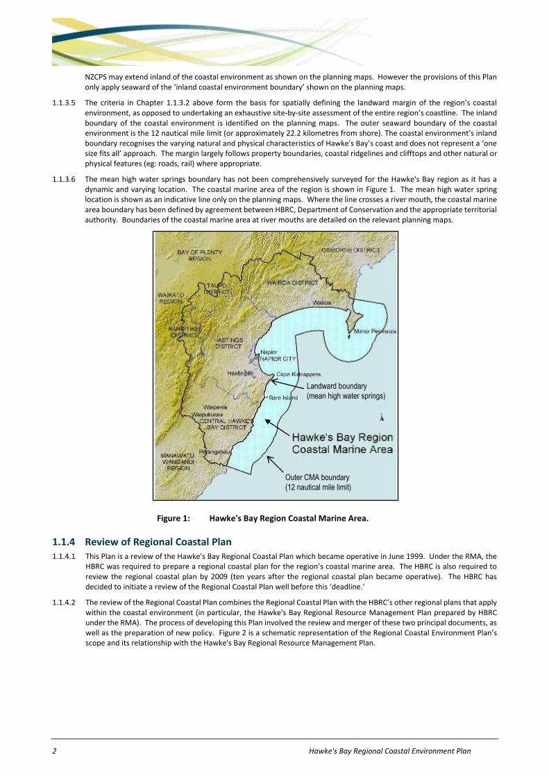
1.1.3.6 The mean high water springs boundary has not been comprehensively surveyed for the Hawke's Bay region as it has a dynamic and varying location. The coastal marine area of the region is shown in Figure 1. The mean high water spring location is shown as an indicative line only on the planning maps. Where the line crosses a river mouth, the coastal marine area boundary has been defined by agreement between HBRC, Department of Conservation and the appropriate territorial authority. Boundaries of the coastal marine area at river mouths are detailed on the relevant planning maps.
Figure 1: Hawke's Bay Region Coastal Marine Area.
1.1.4 Review of Regional Coastal Plan 1.1.4.1 This Plan is a review of the Hawke's Bay Regional Coastal Plan which became operative in June 1999. Under the RMA, the
HBRC was required to prepare a regional coastal plan for the region’s coastal marine area. The HBRC is also required to review the regional coastal plan by 2009 (ten years after the regional coastal plan became operative). The HBRC has decided to initiate a review of the Regional Coastal Plan well before this ‘deadline.’
1.1.4.2 The review of the Regional Coastal Plan combines the Regional Coastal Plan with the HBRC’s other regional plans that apply within the coastal environment (in particular, the Hawke's Bay Regional Resource Management Plan prepared by HBRC under the RMA). The process of developing this Plan involved the review and merger of these two principal documents, as well as the preparation of new policy. Figure 2 is a schematic representation of the Regional Coastal Environment Plan’s scope and its relationship with the Hawke's Bay Regional Resource Management Plan.
Outer CMA boundary
(12 nautical mile limit)
Landward boundary
(mean high water springs)

Hawke's Bay Regional Coastal Environment Plan 3
Figure 2: Schematic representation of relationship between the HB Regional Coastal Environment
Plan and the HB Regional Resources Management Plan
Figure 3: Representation of the spatial relationship between the 'Coastal Margin', the 'Coastal Marine Area' and the Hawke's Bay Regional Resources Management Plan
1.1.4.3 The HBRC recognised that restricting its attention to issues solely within the coastal marine area would fail to recognise the integrated nature of the coastal environment. Elements and qualities which comprise the coastal environment are inextricably linked, regardless of where they lie in relation to mean high water springs. Under the current regional coastal plan/regional plan structure, it is difficult in some cases to effectively manage these elements and qualities which exist within the coastal marine area in isolation from those existing above mean high water springs.
1.1.4.4 For this reason, resource management issues within the coastal environment (for example: natural character, natural features and landscapes, public access, natural coastal hazards, and significant areas of flora and fauna) need to be managed in an integrated way. This means managing (i.e. identifying, prioritising and acting on) the use, development and protection of natural and physical resources as a whole – albeit within the relevant roles of responsibilities of agencies involved. Also non-point (sedimentation, and nutrient and faecal contamination) and point source discharges (such as sewage and stormwater) are activities that occur beyond the coastal marine area which directly affect the CMA and need to be managed in an integrated way. The HBRC has adopted a ‘coastal environment’ approach in this Plan to achieve better integrated management of the coast’s natural and physical resources. In this way, it is possible to review the Regional Coastal Plan and the HBRC’s other regional plans to ensure the objectives, policies and methods developed in this Plan are consistent in relation to land and sea areas of the region’s coast.
1.1.5 Effect of this Plan 1.1.5.1 As a ‘plan’, this Regional Coastal Environment Plan has legal force under the RMA. The regional rules contained within it
have the force and effect of a regulation under the RMA. The HBRC must have regard to the provisions of the plan when considering applications for resource consents. In addition, territorial local authorities (TLAs) within Hawke's Bay must
Coastal Margin
Coastal Marine Area
RRMP applies
Regional Policy Statement
CMA Land
Regional Resources
Management Plan Regional Coastal
Environment Plan
MHWS Coastal Environment landward boundary

4 Hawke's Bay Regional Coastal Environment Plan
ensure that their district plans are not inconsistent with the provisions of the plan. TLAs must also have regard to this Plan’s provisions when considering resource consent applications for land use activities and subdivision.
1.1.5.2 Nothing in this Plan removes the need for all people to comply with requirements of all other statutes, regulations, plans, bylaws or any other controls relevant to any activities undertaken, or to be undertaken, within the coastal environment.
1.2 Statutory context This chapter sets out the statutory context for this Plan. It has been included to help explain the context in which this Plan has been developed.
1.2.1 The Resource Management Act 1991 1.2.1.1 The RMA is the principal statute for managing the use of natural and physical resources. The RMA establishes an integrated
framework for the management of activities affecting land, air, water and ecosystems, including the coast. Its overarching purpose (stated in s5) is to promote the sustainable management of natural and physical resources.
1.2.1.2 Part II of the RMA sets out the purpose and principles of the Act, which govern decision making and the policy formation functions of regional councils in respect of resource management.
1.2.1.3 A hierarchy of principles of the RMA is also contained within Part 2. The principles define matters that the HBRC must address in relation to managing the use, development and protection of natural and physical resources. These are: matters of national importance, which the HBRC must recognise and provide for (s6); other matters such as kaitiakitanga, the efficient use and development of natural and physical resources and maintenance and enhancement of the quality of the environment, which the HBRC must have particular regard to (s7); and the principles of the Treaty of Waitangi, which the HBRC must take into account (s8).
1.2.1.4 The HBRC has given effect to the purpose of the RMA by establishing policies and methods in this Plan which focus on managing environmental effects and enabling activities to take place. The HBRC believes that, while establishing a policy framework for sustaining natural and physical resources is clearly fundamental, it is also important to provide certainty and minimise costs for the people of the region. Hence, the HBRC has sought to regulate activities only to the degree necessary to meet the purpose of the RMA. A key approach of this Plan is to permit minor activities which have little environmental effect that would otherwise be restricted under the RMA.
1.2.1.5 Part 3 of the RMA sets out duties and restrictions on people carrying out activities which may affect the environment. Most activities affecting ‘public’ resources – coasts, air, water, rivers and lakes – are restricted under the RMA, (eg: discharges of contaminants, water abstractions, and structures in the coastal marine area). This means that a resource consent must be obtained before these types of activities can be undertaken, unless there are rules in a plan stating otherwise. By contrast, land use activities are not restricted under the RMA, unless a council writes rules regulating land use activities, as most land is a ‘private’ resource. Land use activities remain largely unregulated by the HBRC. Reference should be made to the relevant district plan for further requirements in respect of land use.
1.2.2 Policy statements and plans 1.2.2.1 Under the RMA, national policy statements can be prepared. The New Zealand Coastal Policy Statement (NZCPS) prepared
by the Minister of Conservation is the only national policy statement prepared to date. Regional plans must give effect2 to the NZCPS. The NZCPS provides a policy framework for resource management issues within the coastal environment. Policies within the NZCPS address:
(a) national priorities for the preservation of the natural character of the coastal environment including protection from inappropriate subdivision, use and development.
(b) the protection of the characteristics of the coastal environment of special value to the tangata whenua including wahi tapu, tauranga waka, mahinga maataitai, and taonga raranga.
(c) activities involving the subdivision, use or development of areas of the coastal environment.
(d) The Crown’s interests in land of the Crown in the coastal marine area.
(e) The matters to be included in any or all regional coastal plans in regard to the preservation of the natural character of the coastal environment, including specific circumstances in which the Minister of Conservation will decide resource consents.
(f) The implementation of New Zealand’s international obligations affecting the coastal environment.
(g) The procedures and methods to be used to review the policies and to monitor their effectiveness.
2 ’Give effect’ in this context refers to the implementation or actioning of the higher-levelled policy.

Hawke's Bay Regional Coastal Environment Plan 5
1.2.2.2 The Hawke's Bay Regional Policy Statement (RPS) is embodied within the Hawke's Bay Regional Resource Management Plan. The RPS sets out a policy framework for promoting the sustainable management of the region’s natural and physical resources. The RPS must give effect to the NZCPS while this Plan must give effect to the NZCPS and the RPS.
1.2.3 HBRC functions 1.2.3.1 The Hawke's Bay Regional Coastal Environment Plan has been prepared in accordance with the functions vested in the
HBRC under the RMA. The functions relevant to this Plan are summarised below:
(a) The establishment, implementation and review of objectives, policies and methods to achieve integrated management of the natural and physical resources of the region.
(aa) The preparation of objectives and policies in relation to effects of the use, development or protection of land which are of regional significance.
(b) In relation to the coastal marine area, the control (in conjunction with the Minister of Conservation) of: land and associated natural and physical resources; the occupation and allocation of space on land of the Crown or HBRC and the extraction of sand, shell, gravel or other natural material from that land; the taking, use, damming and diversion of water; discharges of contaminants into or onto land, air or water and discharges of water into water; the dumping and incineration of waste or other matter from ships, aircraft and offshore installations; any effects of the use, development or protection of land for avoiding or mitigating natural hazards, or for preventing or mitigating any adverse effects of the storage, use, disposal or transportation of hazardous substance; the emission of noise; and activities in relation to the surface of water.
(c) The control of the use of land (including the beds of water bodies) for the purpose of: soil conservation; the maintenance or enhancement of water quality; the maintenance of water quantity; the avoidance or mitigation of natural hazards; or the prevention or mitigation of any adverse effects of the storage, use, disposal, or transportation of hazardous substances.
(d) The control of the taking, use, damming, and diversion of water, and the control of the quantity, level, and flow of water in any water body.
(e) The control of discharges of contaminants into or onto land, air, or water and discharges of water into water.
(f) In relation to the bed of a water body, the control of the introduction or planting of any plant, for the purpose of: soil conservation; the maintenance or enhancement of water quality; the maintenance of water quantity; or the avoidance or mitigation of natural hazards.
(g) The establishment, implementation and review of objectives, policies and methods to maintain indigenous biological diversity.
1.2.3.2 In addition to its functions under the RMA, the HBRC has related functions and programmes under other statutes. Flood protection works and soil conservation activities are undertaken pursuant to the Soil Conservation and Rivers Control Act 1941; the management of plant and animal pests is carried out under the Biosecurity Act 1993 (including ‘environmental’ pest control programmes); navigation and marine safety issues are addressed through the HBRC’s Navigation and Safety Bylaws and under Maritime Rule Part 91; and land drainage activities are undertaken pursuant to the Land Drainage Act 1908. The HBRC owns significant assets and areas of land in relation to its flood protection and drainage activities. In this respect, the Council has property owner rights equivalent to those of other property owners.
1.2.3.3 Under the Building Act 2004, territorial authorities are responsible for the issuing of building consents for structures and building work located in the coastal marine area adjacent to their district. The HBRC is responsible for consent processing and monitoring compliance in relation to dams. Dams are artificial barriers to water and include flood control dams, significantly modified natural features and canals, but not stopbanks.
1.2.4 The role of other agencies 1.2.4.1 The HBRC views itself as just one of many agencies involved in resource management. It seeks to develop partnerships
with other stakeholders, in order to work together to achieve environmental outcomes. The coastal environment is managed (as a statutory requirement under the RMA) by the Minister of Conservation, regional councils and territorial local authorities. There are other agencies which have responsibilities under the RMA and other legislation, within the coastal environment. The responsibilities of some of the key agencies are described below. The following sections are not intended as an exhaustive list of all agencies or comprehensive coverage of the roles of identified agencies.
THE MINISTER AND DEPARTMENT OF CONSERVATION 1.2.4.2 The Minister of Conservation is required to prepare a New Zealand Coastal Policy Statement (NZCPS). The Minister also
has the role of approving regional coastal plans for the coastal marine area. Certain activities have been specified as restricted coastal activities in the NZCPS where those activities have or are likely to have significant or irreversible adverse effects on the coastal marine area. These activities are incorporated in the rules section of this Plan (Part E) where

6 Hawke's Bay Regional Coastal Environment Plan
applicable. The Minister also has the role of monitoring the effect and implementation of the NZCPS and coastal permits granted by the Minister of Conservation.
1.2.4.3 Most of Hawke's Bay region is within the East Coast Hawke's Bay Conservancy Area. The East Coast Hawke's Bay Conservation Board has the responsibility for shaping conservation management in its Conservancy. This is achieved through the development of a Conservation Management Strategy and Conservation Management Plans for public conservation lands administered by the Department of Conservation and by the Board acting as an advocate for conservation on lands not administered by the Department of Conservation. The East Coast Hawke's Bay Conservation Board has functions and powers provided by the Conservation Act 1987, the National Parks Act 1980 and the New Zealand Walkways Act 1990.
1.2.4.4 The Minister of Conservation also leads central government’s work relating to the New Zealand Biodiversity Strategy. This Strategy sets out a 20 year plan to halt the decline of New Zealand’s indigenous biodiversity (New Zealand’s native species and the ecosystems that support them). The Strategy contains information and detailed action plans for land, freshwater and marine biodiversity, as well as for biosecurity, and for Maori and community participation.
1.2.4.5 The Department of Conservation (DoC) has identified a number of areas along Hawke's Bay’s coastline as having significant conservation values, commonly known as Areas of Significant Conservation Value (ASCVs). These areas have been adopted as ‘Significant Conservation Areas’ which are identified on the planning maps. DOC also has a management role in the coastal environment under a range of statutes including the Marine Reserves Act 1971, the Marine Mammals Protection Act 1978, the Conservation Act 1987, and the Wildlife Act 1953. DOC is also able to advocate for the conservation of natural and historic resources generally.
THE MINISTER AND MINISTRY FOR THE ENVIRONMENT 1.2.4.6 Monitoring of the effect and implementation of the RMA is the responsibility of the Minister for the Environment. The
Minister also has the ability to ‘call-in’ projects of national significance and may promulgate the making of Regulations in relation to environmental standards for a range of matters (eg: contaminants and water quality).
THE MINISTER AND MINISTRY OF FISHERIES 1.2.4.7 The major statutory responsibility of the Ministry of Fisheries in the coastal environment is to manage fisheries and fishery
resources. The Ministry of Fisheries was responsible, under the Biosecurity Act 1993, for controlling the deliberate or accidental importation of foreign organisms into New Zealand, including via the ballast water of ocean-going vessels. Since November 2004, this responsibility now lies with Biosecurity New Zealand under the Ministry of Agriculture and Forestry. When undertaking their roles under the Fisheries Act 1996, the Minister and Ministry, shall take into account the following environmental principles:
(a) Associated or dependent species should be maintained above a level that ensures their long-term viability:
(b) Biological diversity of the aquatic environment should be maintained:
(c) Habitat of particular significance for fisheries management should be protected.
THE MINISTER OF TRANSPORT AND MARITIME NEW ZEALAND 1.2.4.8 Under the Maritime Transport Act 1994, Maritime New Zealand (previously known as the Maritime Safety Authority) is
responsible for promoting a safe maritime environment and for providing effective marine pollution prevention and an effective marine pollution response system. This involves responsibilities for navigation, safety and the standards of vessels operating commercially. Maritime New Zealand is also responsible for administering the Maritime Rules on all water other than those covered by harbour bylaws for which the HBRC is responsible).
1.2.4.9 The dumping of waste in New Zealand’s marine waters requires a permit under the Maritime Transport Act. Maritime New Zealand is responsible for issuing these permits and enforcing discharge requirements beyond the Territorial Sea (12 nautical mile limit) and within the Exclusive Economic Zone (200 nautical miles).
1.2.4.10 Under s395 of the RMA, the HBRC must forward to the Minister of Transport, a copy of any coastal permit application it receives in respect of any reclamation, the construction of any structure or the undertaking of any harbour works or the removal of any stone, gravel, sand, boulders, silt, mud, shell or other material within the meaning of the Harbours Act 1950 within the coastal marine area. In such cases, the Minister of Transport must report back to the HBRC on any navigation related matters that the Minister considers relevant to the application. The HBRC must then take into account the Minister’s report when considering the application.
1.2.4.11 Regional councils are required to prepare Oil Spill Contingency Plans. Maritime New Zealand is required to co-ordinate the preparation and approval of these plans. Maritime New Zealand is also responsible for oil spill cleanups beyond the coastal marine area and for oil spill cleanups within the coastal marine area that exceed the HBRC’s capability to respond.
1.2.4.12 Transit New Zealand is a Crown entity with responsibilities under the Land Transport Management Act 2003, to operate the state highway system in a way that contributes to an integrated, safe, responsive and sustainable land transport system.

Hawke's Bay Regional Coastal Environment Plan 7
In doing that, Transit New Zealand must exhibit a sense of social and environmental responsibility. In Hawke's Bay, there are a number of state highways that are within, or pass through, the coastal environment.
NEW ZEALAND HISTORIC PLACES TRUST 1.2.4.13 The New Zealand Historic Places Trust (NZHPT) was established in 1954 as a charitable trust and is now continued by the
Historic Places Act 1993. It is currently governed by a Board of Trustees and a Maori Heritage Council. NZHPT’s mission is to promote the identification, protection, preservation and conservation of the historical and cultural values of New Zealand. This has significant connections with local authorities. In terms of the coastal environment, the main aspects of this role include:
(a) issuing of archaeological authorities under the Historic Places Act 1993 for activities that may destroy, damage or modify archaeological sites
(b) registration of historic places, historic areas, wahi tapu and wahi tapu areas
(c) provision of advice and information for protection and preservation of historic heritage and
(d) advocating for the protection of historic and cultural heritage under the RMA and Building Act.
TERRITORIAL AUTHORITIES 1.2.4.14 There are four territorial authorities (or TLAs) in the Hawke’s Bay region whose districts are partly within Hawke's Bay’s
coastal environment. These four TLAs are Wairoa District Council, Napier City Council, Hastings District Council and Central Hawke’s Bay District Council. The Taupo and Rangitikei District Councils each have a small area in the Hawke’s Bay region but their districts do not extend to the coastal environment.
1.2.4.15 TLAs have limited responsibilities within the coastal marine area. They do have some responsibilities associated with the administration of the Local Government Act bylaws that deal with day-to-day management of some foreshore areas such as for animal control, nude bathing, use of vehicles on beaches and litter control. TLAs also have responsibilities for reserve land in their control.
1.2.4.16 The major responsibility of TLAs within the coastal environment is the area landward of mean high water springs. TLAs are responsible for managing the use of this land, controlling the emission of noise, and controlling the effects of activities on the surface of water not within the coastal marine area. TLAs are required to prepare a district plan to assist them in carrying out these functions. District plans cannot be inconsistent with the New Zealand Coastal Policy Statement, the Hawke's Bay Regional Policy Statement or any regional plans, including this Plan.
1.2.4.17 The functions of territorial authorities and regional councils overlap in relation to land use, and can cause cross-boundary effects in other respects (e.g. land use activities regulated by the territorial authority can affect water quality, which is managed by the HBRC). It is therefore critical that the HBRC and the territorial authorities in the region establish a sound working relationship and compatible environmental policy.
RESOURCE USERS 1.2.4.18 The environmental behaviour of a resource user is influenced by a number of factors. These include: the market demand
for clean, safe products; the environmental ethic of the business; the availability of information about sound environmental practices; the degree of public exposure; the need to comply with rules and regulations; and the sanctions for non-compliance. Because regional councils are just one source of influence, it is important to work with resource users to ascertain how the HBRC can be most effective. In particular, recognising the efforts made by resource users to improve their own environmental performance is important.
TANGATA WHENUA 1.2.4.19 Tangata whenua are involved in a range of management frameworks relating to coastal resources. Under the RMA, tangata
whenua are to be recognised as kaitiaki of the coast’s natural and physical resources. Iwi authorities are to be involved in the preparation of policy statements and plans under the RMA, and may be involved where appropriate in resource consent decision-making processes. Tangata whenua may also exercise Customary Rights Orders for customary activities along the coast. They may be an agent for the transfer of powers and making of joint agreements under the RMA. Tangata whenua have other roles and functions under other legislation including:
(a) territorial customary rights, customary rights orders, and governance of Foreshore and Seabed Reserves under the Foreshore and Seabed Act 2004 [repealed]
(b) taiapure and customary fisheries management under the Fisheries Act 1996
(c) formation of conservation strategies and plans under the Conservation Act 1987
(d) rights and roles under the Maori Commercial Aquaculture Claims Settlement Act 2004

8 Hawke's Bay Regional Coastal Environment Plan
(e) functions and roles under the Marine Reserves Act 1977.
1.3 Management direction This chapter introduces some of the key policy issues and principles which have guided preparation of the Plan. Direction on these matters has come from the Resource Management Act 1991, the New Zealand Coastal Policy Statement and the Hawke's Bay Regional Policy Statement.
1.3.1 Sustainable management 1.3.1.1 In promoting sustainable management, HBRC recognises the intrinsic values of the coastal marine area, Coastal Margin and
the importance of the coast to many people. HBRC will provide guidance on adverse effects on the environment to be avoided, remedied or mitigated. In recognition of the national importance of the coast, the NZCPS also requires that regard shall be had to a number of general principles. Those general principles are set out in the NZCPS.
1.3.2 Precautionary approach 1.3.2.1 HBRC will take a precautionary approach when making decisions about the use, development and protection of coastal
resources where effects are uncertain or where potential risks to the environment are considered to be unacceptable. The precautionary approach will ensure that any decision made will err on the side of the environment and that any adverse effects will be avoided, remedied or mitigated. This is not to be interpreted in a way that seeks to avoid, remedy or mitigate all risks. This approach recognises that there is limited information available on the region's coast and possibly incomplete knowledge of effects that activities may have on it now or in the future.
1.3.3 Treaty of Waitangi 1.3.3.1 HBRC recognises that the tangata whenua of the region have an important relationship with the coast and its resources. In
undertaking its management role within the Coastal Environment, HBRC must also take into account the principles of the Treaty of Waitangi (s8, RMA). Matters of special value to tangata whenua need to be protected through provisions in this Plan. HBRC recognises the need for on-going consultation and negotiation with tangata whenua over management of the coast's resources, and will continue to seek their involvement in any further changes to this Plan and its implementation. The RMA provides strong signals that iwi authorities have a special status (under Clause 3A of Schedule 1 of the) in preparation of plans for management of natural and physical resources - they are not to be considered simply another interested party.
1.3.4 Integrated management 1.3.4.1 HBRC recognises that mean high water springs is an arbitrary line in terms of coastal management, but it is the line which
demarcates the extent of certain roles, responsibilities, powers and control under the RMA. Because of this, there is a need to ensure that resource management above and below mean high water springs is consistent. Combining regional coastal plan provisions with other regional plan provisions into this Plan is one way of achieving that consistency. Other plans (eg: district plans) which address matters on the landward side of mean high water springs must also consider effects on the coastal marine area.
1.4 Plan structure
1.4.1 Overview 1.4.1.1 As noted in Chapter 1.1, this Plan is a combined regional coastal plan and regional plan. The Regional Coastal Environment
Plan consists of Parts A to I and Schedules, plus planning maps. The following list outlines the various Parts of this Plan and their content:
Part A: Introduction - This Chapter introduces the purpose and structure of the Plan and provides an overview of its statutory context.
Part B: Matters of National Importance – Chapters 2-7 set out significant resource management issues in relation to matters of national importance stated in s6 of the RMA. These chapters also set out the specific objectives, policies and anticipated environmental results for addressing these matters of national importance in Hawke's Bay’s coastal environment context.
Part C: Use and Development: Coastal Margin - Chapters 8-15 set out the key objectives sought to be achieved by the Plan by establishing an overall framework for the management of activities and effects in Hawke's Bay’s coastal environment that is not within the CMA. This includes coastal hazards as required by s67 of the RMA. These chapters also set out the specific policies for addressing these key objectives.
Part D: Use and Development: Coastal Marine Area - Chapters 16-25 set out the key objectives sought to be achieved by the Plan by establishing an overall framework for the management of activities and effects in Hawke’s

Hawke's Bay Regional Coastal Environment Plan 9
Bay’s coastal marine area. Specific policies for addressing these key objectives are also set out in these chapters.
Part E: Regional Rules: Coastal Margin, Coastal Environment and Coastal Marine Area - Chapters 26 and 27 are the regulatory parts of the Plan. It contains regional rules that allow, regulate or prohibit resource use activities. Chapter 26 assists with interpretation of the rules, and provides a summary of all the rules contained within the Plan. Chapter 27 sets out rules applicable within the Coastal Margin, the coastal marine area or both.
Part F: Non-Regulatory Methods – Chapter 28 sets out the non-regulatory methods to be used by the HBRC in addition to regional rules. Non-regulatory methods include education, co-ordination, liaison with territorial authorities, economic instruments, works and services, monitoring, and research. For some of these methods much of the detail is contained within other documents, (for example, the HBRC Environmental Education Strategy and Coastal Monitoring Strategy).
Part G: Administrative Matters – In this Part, Chapter 29 includes guidelines for the HBRC’s preferred approach for the use of regional rules, resource consent processes, and enforcement procedures. It describes the circumstances under which the HBRC will seek financial contributions from resource users, the circumstances of imposing coastal occupation charges, the procedures for dealing with cross-boundary issues, and the approaches for monitoring and reviewing this Plan.
Part H: The Schedules contain area-specific provisions, or other specific details relating to implementation of the policies or rules. The Schedules are cross-referenced within the main body of the Plan.
Part I: The Glossary located at the rear of Volume 1 for convenience and easy reference, provides the meanings of some terms used in this document. An asterisk (*) indicates that a meaning is the same as that set out in s2 of the RMA.
1.4.1.2 The planning maps feature the inland margin of the coastal environment, coastal hazard zones, historic heritage features, coastal water quality classifications, the location and extent of ‘Management Areas’ (Significant Conservation Areas; Port Management Area; Harbour Management Area; Aquaculture Management Areas; and the General Management Area); and other mapped features.
1.4.2 Plan mechanisms 1.4.1.1 This Plan utilises a variety of planning mechanisms to implement provisions of the RMA and NZCPS. These mechanisms
include those specifically provided for by the RMA (eg: the use of standards and terms) and also some traditional methods (such as zoning or ‘management areas’). The principal mechanisms used in this Plan are described below.
1.4.3 Management Areas 1.4.3.1 Management areas are a means of recognising and providing for areas with different qualities, values and specific needs
within Hawke's Bay’s coastal environment. These management areas have specific provisions which apply only within their boundaries. Six management areas have been defined within Hawke's Bay’s coastal environment and are marked on the planning maps. These management areas are:
the Coastal Margin the Aquaculture Management Area the Significant Conservation Area the Port Management Area the Harbour Management Area and the General Management Area (this area relates to all parts of the coastal marine area not otherwise covered by
any other management area).
1.4.3.2 The SCAs identified in the RCEP are similar to the 'Significant Areas' that were identified in Schedule II of the operative RCP. The SCAs and Significant Areas are derived from work undertaken by Department of Conservation in the early 1990s for input into the first generation regional coastal plans. The DOC report applied criteria to identify 'Areas of Significant Conservation Value.' The criteria used included:
Maori cultural values of local, regional or national significance presence of protected areas wetlands, estuaries and coastal lagoons of national or international significance habitats, breeding sites, roost sites or feeding sites of marine mammals and birds ecosystems, flora and fauna habitats with regionally, nationally or internationally significant or threatened
ecosystems or species scenic sites of regional, national or international importance historic places of outstanding significance representative examples of nationally significant or outstanding coastal landforms and associated processes.

10 Hawke's Bay Regional Coastal Environment Plan
1.4.4 Overlays 1.4.4.1 In addition to the management areas described above, the Plan identifies a number of other elements or features that
‘overlay’ the management areas. These overlays include:
coastal hazard zones historic heritage features Class CR(HB) coastal water Class AE(HB) coastal water dredge disposal sites maintenance dredging areas vegetation clearance management areas and Parade gravel extraction area, etc.
1.4.4.2 Specific provisions in the Plan apply within these overlay areas. These provisions are typically in addition to relevant management areas’ provisions. These overlays are a planning method which assists the HBRC to address specific resource management issues or needs that may apply across one or more management areas, and therefore overlay the management area boundaries and plan provisions.
1.4.5 Restricted Coastal Activities (RCAs) 1.4.5.1 The NZCPS may list a series of activities that are deemed to be restricted coastal activities requiring resource consent from
the Minister of Conservation. The 2010NZCPS does not specify any activities in the coastal marine area as RCAs.
Hawke’s Bay Regional Coastal Environment Plan 11
PART B – MATTERS OF NATIONAL IMPORTANCE
2 Natural character
Issue 2.1
The coastal environment’s natural character is being modified and adversely affected through inappropriate subdivision, use and development.
Objective 2.1
Preservation of the natural character of the coastal environment, and the protection of the coastal environment from inappropriate subdivision, use and development.
Policies
Policy 2.1 To ensure any adverse effects on the natural character of the coastal environment arising from inappropriate use and development within the coastal marine area are avoided.
Policy 2.2 To recognise that protecting outstanding natural features and landscapes, areas of significant indigenous vegetation, significant habitats of indigenous fauna and historic heritage features assists in preserving natural character of the coastal environment.
Policy 2.3 To promote the location of future use and development in areas of the coastal environment which are already significantly modified by similar activities, provided the adverse effects of the new use and development are avoided, remedied or mitigated.
Policy 2.4 To recognise and provide for appropriate use and development provided any adverse effects on the coastal environment’s natural character arising from such use and development are avoided, remedied or mitigated.
Policy 2.5 To enable the use and development of port facilities as part of the coastal environment’s physical resources in order to meet the needs of the regional community and future generations while avoiding, remedying or mitigating adverse effects of port activities on natural character and processes where practicable.
Policy 2.6 To recognise that local authorities have statutory functions on behalf of their communities including provision of services for wastewater, stormwater, water supply, parks and recreation, roads, solid waste disposal.
Policy 2.7 To have particular regard to the avoidance of adverse effects of the following dynamic coastal processes on the physical environment: (a) wave action (b) tidal flow (c) currents and sediment transport (d) natural water quality and (e) natural substrate composition.
Policy 2.8 To have particular regard to the mitigation of adverse effects of dynamic coastal processes on the physical environment and provision made for remedying those effects where complete avoidance cannot be achieved.
Policy 2.9 To have particular regard to the maintenance or enhancement of the coastal environment’s existing amenity values and cultural values.
Policy 2.10 To promote the restoration and rehabilitation of the coastal environment’s natural character in the following areas, where appropriate and in particular: - dune systems; estuaries, wetlands, habitats important to the continued survival of any indigenous species, waahi tapu, historic heritage, intertidal reef systems, and coastal cliffs and hill faces.
Policy 2.11 To promote where practicable, the protection and enhancement of natural values and features (including migration of natural features as a result of coastal processes) that provide a natural buffer against coastal erosion and inundation. These features include dunes, gravel barriers, active off-shore sediment reservoirs, inter-tidal rock platforms, reefs and indigenous coastal vegetation.
Policy 2.12 When assessing applications for land use consents, coastal permits, discharge permits or water permits, HBRC will take into account the values and management objectives identified for the relevant SCA as described in HBRC Plan Number 4203.
Policy 2.13 To implement the policies set out above predominantly in the following manner:
(a) resource consents – the policies will primarily be used in the process of making decisions on resource consents in accordance with the RMA;
(b) regional rules – the policies have been incorporated into rules (including conditions, standards and terms) set out in Part E of this Plan and provide a basis for the level of regulation used;
12 Hawke’s Bay Regional Coastal Environment Plan
(c) non-regulatory methods – the policies may also be implemented through non-regulatory methods where appropriate, including the provision of information, environmental monitoring and reporting, and liaison/consultation with resource users and territorial authorities.
Explanation and reasons
All of Hawke's Bay’s coastal environment possesses natural character to some degree. This exists along a continuum from areas which remain in a largely natural state to areas where few natural attributes exist. The approach under the RMA is to seek to protect the attributes which give an area its natural character from inappropriate use and development. These attributes may include outstanding natural features and landscapes, areas of significant indigenous vegetation and significant habitats of indigenous fauna, and ecological and hydrological systems. The RMA itself does not define what ‘natural character’ is or is not, but a reasonable number of Environment Court decisions exist that assist in interpreting this term. The coastal environment’s natural character is being modified and adversely affected through inappropriate subdivision, use and development.
The natural character of the region’s coastal environment is a fragile and finite resource that is vulnerable to irreversible alteration and damage. Protection of the coastal environment from inappropriate subdivision, use and development includes restoration and/or enhancement of any natural character values which may have been adversely affected, to avoid adverse cumulative effects or incremental loss of natural character. Policies in this Chapter or anywhere else in the Plan are not intended as ‘de facto’ prohibitions on activities and future development. The policies are statements that Plan users will use to guide future resource use decisions, in particular in assessment of resource consent applications.
Further modification of the coast’s natural character may be appropriate in some locations (for example, in areas where natural character is already highly modified such as urban areas and harbours or in circumstances for provision of essential infrastructural services). Other parts of the coastal environment having high natural character may include significant conservation areas and natural areas. These tend to be sensitive areas where any development could cause serious or irreversible adverse effects.
Use of the coastal marine area and wider coastal environment has tended to involve cumulative changes which have gradually and eventually adversely changed vegetation, habitats and landforms within the coastal environment. Furthermore, the coastal environment is dynamic and natural processes such as dune formation, longshore drift of sediments, and wind and wave erosion influence the shape as well as the appearance of the coast. These processes also affect the natural movement of flora and fauna. Any proposal for use or development in the coastal environment should therefore take account of the effects of coastal processes and the dynamic nature of the coast.
The importance of protecting all of these elements and features is recognised in the policies of the New Zealand Coastal Policy Statement. The above objective and policies recognise the national directives contained within the NZCPS. Policies elsewhere in this Plan will also relate to specific features that contribute to the natural character of the region’s coastal environment. Careful management of these features is required to ensure natural character of the coasta l environment is preserved.
A precautionary approach to the management of high natural character areas is proposed to ensure these sensitive areas are protected from inappropriate use and development. Similarly, it may be appropriate that in areas with a lesser natural character (ie: those already developed to a significant degree), further use and development can be permitted. Principles 1 and 2 of the [1994] New Zealand Coastal Policy Statement (NZCPS) recognise that functionally, certain activities can only be located on the coast or in the coastal marine area, and that protection of the coastal environment need not preclude appropriate use and development in appropriate places.
Policy 1.1.5 of the [1994] NZCPS states it is a national priority to restore and rehabilitate the natural character of the coastal environment where appropriate. Policy 2.11 identifies areas where such rehabilitation and restoration is most likely to be appropriate.
Anticipated environmental results
AER 2.1 Preservation of the natural character of Hawke's Bay’s coastal environment and protection of it from inappropriate subdivision, use and development.
AER 2.2 Dynamic natural and physical coastal processes are maintained and not altered by inappropriate subdivision, use and development in a way to prevent those processes from occurring.
AER 2.3 Appropriate use and development within the coastal marine area occurring in areas already developed or in use by activities with similar environmental effects.
AER 2.4 Restoration and rehabilitation of identified areas where the natural character of the coastal environment has been degraded by past activities or may be degraded by proposed activities.
AER 2.5 Greater public awareness of the need to preserve the coastal environment’s natural character and what comprises that natural character in different parts of the region’s coastal environment.
AER 2.6 Maintenance or enhancement of the existing amenity values of the coastal marine area.
AER 2.7 Protection of the integrity, function and resilience of the coastal environment in terms of dynamic coastal processes such as wave action, tidal flow, currents and sediment transport, natural water and air quality and natural substrate composition.

Hawke’s Bay Regional Coastal Environment Plan 13
3 Outstanding natural features and landscapes
Issue 3.1
Inappropriate subdivision, use and development may degrade the physical integrity and aesthetic values of outstanding natural features and landscapes within the coastal environment.
Objective 3.1
Protection of outstanding natural features and landscapes within the coastal environment from inappropriate subdivision, use and development.
Policies
Policy 3.1 To recognise and provide for the protection of the visual coherence of the existing landscape, seascape and outstanding natural features in the coastal environment.
Policy 3.2 To recognise and provide for the avoidance, remediation or mitigation of adverse effects on significant landforms and significant geological features.
Policy 3.3 To ensure the visual quality and the physical and ecological integrity of outstanding natural features and landscapes within the coastal environment are maintained and that such areas be restored and rehabilitated where appropriate.
Policy 3.4 To protect physical and ecological values of existing wetlands, dune systems, lagoons, estuaries and river mouths in the coastal environment.
Policy 3.5 To ensure estuarine habitats and physical estuarine processes are used or developed in a way that avoids, remedies or mitigates adverse effects on the biological integrity of the estuarine system.
Policy 3.6 To promote the restoration and rehabilitation of identified areas where outstanding natural features and landscapes within the Coastal Environment have been degraded by past activities or may be degraded by proposed activities.
Policy 3.7 To implement the policies set out above predominantly in the following manner:
(a) resource consents – the policies will primarily be used in the process of making decisions on resource consents in accordance with the RMA;
(b) regional rules – the policies have been incorporated into rules (including conditions, standards and terms) set out in Part E of this Plan and provide a basis for the level of regulation used;
(c) non-regulatory methods – the policies may also be implemented through non-regulatory methods where appropriate, including the provision of information, environmental monitoring and reporting, and liaison/consultation with resource users and territorial authorities.
Explanation and reasons
Natural features and landscapes can be damaged or destroyed by a range of activities. Natural features are also constantly subject to change from natural erosion or depositional processes along the coast. Inappropriate subdivision, use and development which occurs above mean high water springs can have adverse effects on natural features and seascapes present in the coastal marine area. Protection of the values of outstanding natural features and landscapes in the coastal environment is a shared responsibility among HBRC and city and district councils. District Plans can manage activities which may have adverse effects on those landscapes and natural features above mean high water springs. Some district plans already identify outstanding natural features and landscapes above MHWS. The Regional Coastal Environment Plan (and other regional planning documents) establish objectives and policies which guide preparation and review of district plans. Inappropriate subdivision, use and development can degrade the physical integrity and aesthetic values of outstanding natural features and landscapes within the coastal environment.
Certain types of activities on landscape or seascape features will have far greater adverse visual and ecological effects than others. Some activities may destroy the natural elements that make up visual and/or ecological character and other activities may obscure or interrupt features with high visual or ecological qualities. There is a need for such activities to be carefully managed according to their likely potential effects.
Wetlands, coastal lagoons, estuaries and river mouths often feature intricate ecosystems which in turn possess high ecological value. The physical and ecological values of these waterways in the coastal environment need to be carefully managed. It should also be recognised that in some cases, development (such as to provide essential infrastructural services) may need to pass through areas with high values as outstanding landscapes or natural features.
Case law has evolved and developed a set of robust criteria that can be used to define outstanding natural features and landscapes for district and regional planning purposes. The 'Pigeon Bay' criteria have been refined and include:
Natural science factors – the geological, topographical, ecological and dynamic components of the landscape; Its aesthetic values (including memorability and naturalness); Its expressiveness (legibility); how obviously the landscape demonstrates the formative process leading to it; Transient values; occasional presence of wildlife; or its values at certain times of the day or year; Whether the values are shared and recognised; Its value to tangata whenua; Its historic associations.
Anticipated environmental results
AER 3.1 Protection of outstanding natural features and landscapes from inappropriate subdivision, use and development within Hawke's Bay’s coastal environment.
14 Hawke’s Bay Regional Coastal Environment Plan
AER 3.2 Restoration and rehabilitation of identified areas where outstanding natural features and landscapes within the coastal environment have been degraded by past activities.
AER 3.3 Greater public awareness of the need to protect outstanding natural features and landscapes within the region’s coastal environment.
AER 3.4 Protection of the visual harmony of the existing landscape, seascape and outstanding natural features in the coastal marine area.
AER 3.5 Avoidance, remediation or mitigation of adverse effects on significant landforms and significant geological features in the coastal marine area.
Hawke’s Bay Regional Coastal Environment Plan 15
4 Indigenous species and habitats
Issue 4.1
Significant areas of indigenous vegetation and significant habitats of indigenous fauna can be adversely affected and incrementally lost through inappropriate subdivision, use and development in the coastal environment.
Objective 4.1
Protection of the following in the Coastal Environment from inappropriate subdivision, use and development:
(a) regionally and nationally important ecosystems (b) areas of regionally or nationally significant indigenous vegetation; (c) areas of regionally or nationally significant habitats of indigenous fauna.
Policies
Policy 4.1 To ensure adverse effects on ecological systems (including natural movement of biota, natural biodiversity, productivity and biotic patterns) are avoided, including adverse effects on:
(a) fishing grounds (b) shell fish areas (c) fish spawning and nursery areas (d) bird breeding and nursery areas (e) fish and bird migration (f) feeding patterns (g) habitats’ importance to the continued survival of any indigenous species (h) wildlife and indigenous marine biota (i) dune systems (j) the intrinsic values of ecosystems.
Policy 4.2 To ensure adverse effects on ecological systems (including Significant Conservation Areas) are remedied or mitigated where complete avoidance is not practicable, except to always ensure:
(a) Adverse effects on areas containing nationally vulnerable species or nationally outstanding examples of indigenous community types are avoided; and
(b) The avoidance or remediation of adverse effects on:
(i) outstanding or rare indigenous community types within an ecological region or ecological district; (ii) habitat important to regionally endangered or nationally rare species and ecological corridors connecting
such areas; and (iii) areas important to migratory species, and to vulnerable stages of common indigenous species, in
particular wetlands and estuaries.
Policy 4.3 To protect ecological values of existing wetlands, dune systems, lagoons, estuaries and river mouths in the coastal environment.
Policy 4.4 To ensure adverse effects on cultural, ecological, historic, geological, and scenic values of Significant Conservation Areas are avoided, remedied or mitigated.
Policy 4.5 To promote the restoration and rehabilitation of areas of significant indigenous flora and fauna where appropriate in the coastal environment and in particular wetlands, estuaries, dune systems, lagoons, rivermouths and coastal hill faces.
Policy 4.6 To implement the policies set out above predominantly in the following manner:
(a) resource consents – the policies will primarily be used in the process of making decisions on resource consents in accordance with the RMA;
(b) regional rules – the policies have been incorporated into rules (including conditions, standards and terms) set out in Part E of this Plan and provide a basis for the level of regulation used;
(c) non-regulatory methods – the policies may also be implemented through non-regulatory methods where appropriate, including the provision of information, environmental monitoring and reporting, and liaison/consultation with resource users and territorial authorities.
Explanation and reasons
The RMA requires that areas of significant indigenous vegetation and significant habitats of indigenous fauna should be protected where appropriate. The Regional Coastal Environment Plan would not be consistent with the RMA and the New Zealand Coastal Policy Statement if it failed to do so. New Zealand’s marine environment contains a significant portion of the country’s biodiversity, much of which is poorly understood. Fishing practices, the effects of activities on land, and biosecurity threats constitute the greatest risks to marine biodiversity and ecosystems. The Department of Conservation has identified through its Protected Natural Areas Programme, recommended areas for protection in terms of their indigenous vegetation and habitat. Some district plans in the region have used these recommended areas for protection in identifying areas of significance Significant areas of indigenous vegetation and significant habitats of indigenous fauna can be adversely affected and incrementally lost through inappropriate subdivision, use and development in the coastal environment.

16 Hawke’s Bay Regional Coastal Environment Plan
The objective and policies give effect to the New Zealand Coastal Policy Statement’s provisions in Chapters 1 and 3. In particular, NZCPS Policy 1.1.2 which states that it is a national priority to protect areas of significant indigenous vegetation and significant habitats of indigenous fauna in the coastal environment. NZCPS Policy 1.1.2 also emphasises the need to protect ecosystems which are unique to the coastal environment and those that are vulnerable to modification (eg: estuaries, coastal wetlands, mangroves, dunes and their margins).
Protecting the primary areas of vegetation or habitat is not sufficient to ensure their continuation. In order to protect such areas, it is necessary to ensure that the ecosystems which support them are viable. Food sources, breeding grounds and corridors to other populations are essential components of providing protection for these areas. If activities to be undertaken adversely affect any or all of these factors, then the viability of these areas may be threatened and the activity may be considered inappropriate. It should also be recognised that in some cases, development (such as to provide essential infrastructural services) may need to pass through areas with high values for their habitats or indigenous vegetation.
The policies are necessary to protect areas of significant indigenous vegetation and significant habitats of indigenous fauna from inappropriate subdivision, use and development within the coastal environment. This includes protecting the viability of these areas by ensuring surrounding ecological systems continue to support the integrity of the species present.
Anticipated environmental results
AER 4.1 Protection of areas of significant indigenous vegetation and significant habitats of indigenous fauna within the coastal environment from inappropriate subdivision, use and development.
AER 4.2 Identification of areas of significant indigenous vegetation and significant habitats of indigenous fauna in the region’s coastal environment.
AER 4.3 Protection of ecological systems that contribute to the viability and integrity of significant habitats of indigenous fauna and areas of significant indigenous vegetation.
AER 4.4 Restoration and rehabilitation of identified areas where significant indigenous vegetation and significant habitats of indigenous fauna of the coastal environment which have been degraded by past activities.
AER 4.5 Greater public awareness of the need to protect areas of significant indigenous vegetation and significant habitats of indigenous fauna in the region’s coastal environment.
AER 4.6 Avoidance, remediation or mitigation of adverse effects on ecological systems, including natural movement of biota, natural biodiversity, productivity and biotic patterns.
AER 4.7 The enhancement of degraded habitats of significant indigenous flora and fauna. AER 4.8 The protection of ecosystems within the coastal environment which contribute to the cultural relationships of tangata
whenua and which contain taonga species of flora and fauna.

Hawke’s Bay Regional Coastal Environment Plan 17
5 Public access to and along the coast Issue 5.1
Appropriate subdivision, use and development within the coastal environment may enhance public access to the coastal marine area. In other cases, restricting public access to the coast may be necessary to protect ecological or cultural values, or for health, safety and security reasons
Objective 5.1
Maintenance and enhancement of public access to and along the coastal marine area while recognising the need to protect certain areas for ecological, cultural, historic heritage, health, safety, or security (including biosecurity) reasons.
Policies
Policy 5.1 To promote appropriate public access to and along the coastal marine area so that public access is restricted only where necessary.
Policy 5.2 To identify, where practicable and in the public interest to do so, the location and extent of places where it is desirable that physical access to and along the coastal marine area should be formed or enhanced.
Policy 5.3 To encourage and support moves by territorial authorities to restrict access to sensitive dune areas and highly sensitive habitats of indigenous species throughout the region.
Policy 5.4 To encourage and support moves by territorial authorities to restrict vehicular access in coastal areas where the safety of other beach users is threatened by inappropriate use of vehicles on beaches.
Policy 5.5 To promote the maintenance and protection of sensitive dune areas where this is necessary to protect or enhance sensitive habitats of indigenous flora and fauna or mitigate natural coastal hazards.
Policy 5.6 To enable appropriate tangata whenua access to their traditional fishing grounds and other sites of cultural significance within the coastal marine area in accordance with tikanga Maori.
Policy 5.7 To ensure rights to occupy space within the coastal marine area are not granted for a duration longer than is necessary to enable the use or activity to be carried out.
Policy 5.8 To ensure rights to occupy space within the coastal marine area are not granted for areas greater than is necessary to enable the use or activity to be carried out.
Policy 5.9 To ensure activities and structures occupying space within the coastal marine area are established and operated in a manner that maximises public use and access, except in the Port Management Area or where ecological values, cultural values, health, safety, security (including biosecurity) or other exceptional circumstances require.
Policy 5.10 To ensure activities occupying space within the coastal marine area do not unreasonably restrict or prevent other uses of space within the coastal marine area.
Policy 5.11 To implement the policies set out above predominantly in the following manner:
(a) resource consents – the policies will primarily be used in the process of making decisions on resource consents in accordance with the RMA;
(b) regional rules – the policies have been incorporated into rules (including conditions, standards and terms) set out in Part E of this Plan and provide a basis for the level of regulation used;
(c) non-regulatory methods – the policies may also be implemented through non-regulatory methods where appropriate, including the provision of information, environmental monitoring and reporting, and liaison/consultation with resource users and territorial authorities.
Explanation and reasons
Appropriate subdivision, use and development within the coastal environment may enhance public access to the coastal marine area. In other cases, restricting public access to the coast may be necessary to protect ecological or cultural values, or for health, safety and security (including biosecurity) reasons. This objective and associated policies recognise the Council’s responsibilities under s.6 of the RMA and the priority to be afforded to unrestricted public access to and along the coastal marine area. However, it does not preclude the restriction of access in certain circumstances. Those circumstances when restrictions on access are considered to be appropriate include:
(a) protection of areas of significant indigenous vegetation and/or significant habitats of indigenous fauna (b) protection of Maori cultural values (including the need to enable access to coastal resources for tangata whenua as kaitiaki except where this conflicts
with other uses/values) (c) protection of public health and/or safety (d) protection of historic heritage (e) maintaining a level of security (including biosecurity) for lawfully established activities and uses within or adjacent to the coastal marine area or (f) other exceptional circumstances sufficient to justify the restriction notwithstanding the national importance of maintaining that access. [NZCPS Policy
3.5.1]
There is a long held expectation and inferred right of New Zealanders that all members of the public have free use and enjoyment of, and access to and along, the coastline and sea. The Foreshore and Seabed Act 2004 [repealed] provides for Crown ownership of the public foreshore and seabed on behalf of all New Zealanders. Public access - whether by vehicle, boat or on foot - is an issue that spans the coastal marine area and its landward edge. Addressing the issue of public access to the coast therefore needs a broad approach by all governmental authorities.

18 Hawke’s Bay Regional Coastal Environment Plan
NZCPS Policy 3.5.2 urges provision to be made for identifying as far as practicable, places in the coastal environment where it may be possible and desirable to provide or enhance physical access opportunities. These desirable places may be identified on planning maps, structure plans, concept plans etc. and incorporated into conditions of resource consents, works programmes for government and non-government organisations etc. However, in some ecologically or culturally sensitive locations, access may need to be carefully managed (or at least not positively encouraged) as uncontrolled public access in some locations causes irreversible damage to sensitive ecosystems and destabilises dune systems.
Increasing visitor and residential pressures in the coastal environment may lead to conflict over demand for public access to and along the CMA. For reasons of public safety, territorial authorities may, for example, need to restrict vehicular access in the main bathing areas of surf club patrolled beaches. There is also a need to protect areas of the coast by restricting access for safety and security (including biosecurity) purposes (eg: for maintenance and protection of infrastructural services). The Port of Napier is a ‘receiving port’ under the Biosecurity Act and the Maritime Security Act, and as such, it is an example where pub lic access is restricted for safety, security and also biosecurity reasons. Public access to structures, land and parts of the coastal marine area immediately adjacent to land at the Port of Napier is therefore limited.
It is recognised that some parts of the region’s coastal marine area are in private ownership. As such, the owners of these areas have the right to deny public access. This Plan does not restrict the rights of land owners to deny public access to privately owned land, nor does it restrict or impinge on obligations under other legislation.
Activities occupying space within the coastal marine area should not be undertaken in such a way so as to adversely affect public access opportunities, (including access by tangata whenua to traditional fishing grounds, sites of cultural significance and other coastal taonga). This applies to both the duration of any such occupation and the spatial extent of the occupation. Similarly, where activities do occupy space within the coastal marine area, the activity and any associated structures should be established and operated in a manner that maximises public use and access, and private use.
Anticipated environmental results
AER 5.1 Public access to and along the coastal marine area is maintained and, where it is practicable and in the public interest to do so, enhanced.
AER 5.2 Public health and safety is protected from inappropriate means of public access to and along the coastal marine area, at the Port of Napier in particular.
AER 5.3 Areas of significant indigenous vegetation and significant habitats of indigenous fauna are protected from inappropriate public access to and along the coastal marine area and dune areas.
AER 5.4 Maori cultural values are protected from inappropriate public access to and along the coastal marine area. AER 5.5 Adverse effects on private property from inappropriate public access to and along the coastal marine area are minimised. AER 5.6 Adverse effects on public access, use and enjoyment of the coastal environment arising from activities occupying space
within the coastal marine area, are avoided, remedied or mitigated. AER 5.7 Access to the coast is maintained where appropriate for tangata whenua to preserve matauranga Maori and enable
kaitiakitanga and its practical benefits to people, communities, and the management of coastal resources.

Hawke’s Bay Regional Coastal Environment Plan 19
6 Relationship of Maori and the coast
Issue 6.1
The potential for degradation of tangata whenua’s relationship with the coast and potential degradation of mauri, the life sustaining force of natural and physical resources in the coastal environment, including waterways, waterbodies and waahi tapu which are of spiritual, heritage, historical and cultural significance to Maori.
Objective 6.1
The protection of the characteristics of the coastal environment of special spiritual, heritage, historical and cultural significance to tangata whenua.
Policies
Policy 6.1 To recognise and support the role of tangata whenua of Hawke’s Bay as kaitiaki of the region’s coastal resources.
Policy 6.2 To recognise and provide for the protection of sites within the coastal environment of spiritual, heritage, historical or cultural significance to Maori identified in accordance with tikanga Maori, including waahi tapu, nga toka, tauranga waka, mahinga mataitai, taiapure and taonga raranga.
Policy 6.3 To promote the protection of sites within the Coastal Margin of spiritual, heritage, historical or cultural significance to Maori identified in accordance with tikanga Maori.
Policy 6.4 To ensure adverse effects of activities on sites and areas of significant cultural value to tangata whenua are avoided, remedied or mitigated.
Policy 6.5 To actively involve tangata whenua in management of the coastal environment and in protecting natural and physical resources of the coastal marine area that are of spiritual, heritage, historical and cultural significance.
Policy 6.6 To assist in identifying any taonga that may be affected by an application for a coastal permit.
Policy 6.7 To enable customary uses and management practices relating to natural and physical resources of the coastal marine area, including mahinga mataitai, waahi tapu, and taonga raranga, in accordance with tikanga Maori.
Policy 6.8 To have particular regard to the adequacy of consultation undertaken with tangata whenua where coastal taonga may be affected by an application for a coastal permit, and may require additional information regarding the consultation undertaken and the outcomes of that consultation.
Policy 6.9 When assessing applications for land use consents, coastal permits, discharge permits or water permits, HBRC will take into account the findings of any cultural impact assessment prepared by a suitably qualified person.
Policy 6.10 To implement the policies set out above predominantly in the following manner:
(a) resource consents – the policies will primarily be used in the process of making decisions on resource consents in accordance with the RMA;
(b) regional rules – the policies have been incorporated into rules (including conditions, standards and terms) set out in Part E of this Plan and provide a basis for the level of regulation used;
(c) non-regulatory methods – the policies may also be implemented through non-regulatory methods where appropriate, including the provision of information, environmental monitoring and reporting, and liaison/consultation with resource users and territorial authorities.
Explanation and reasons
Tangata whenua of Hawke's Bay have strong traditional and cultural relationships with the sea. They are the kaitiaki (or guardians) of their coastal resources. As such, they have assumed the responsibility to ensure that the mauri (the indefinable essence described as the life-force) of these resources is safeguarded. This has been recognised in the Foreshore and Seabed Act 2004. That Act now provides for Crown ownership of the public foreshore and seabed on behalf of all New Zealanders as well as recognition and protection of customary rights. The degradation of mauri, the life sustaining force of natural and physical resources in the coastal environment, including waterways, waterbodies and waahi tapu which are of spiritual, heritage, historical and cultural significance to Maori. HBRC has information, available upon request, about which hapu have mana moana over particular parts of the CMA.
The identification and protection of coastal characteristics of special significance to iwi recognises the special relationships that iwi have with coastal resources. The whole of the CMA is of significance to Ngati Kahungunu. The Coastal Margin is also of importance to Ngati Kahungunu. Water in particular has high spiritual, social and cultural values to Maori and the predominant view of Maori in Hawke's Bay is that water is an essential ingredient of life, therefore water and associated resources can form a basis for identification, belonging and mana. As kaitiaki for coastal waters, tangata whenua have concern for protecting its mauri and are particularly disturbed by practices which result in polluted water.
The objective and policies give effect to the New Zealand Coastal Policy Statement’s provisions. In particular, NZCPS Policy 1.1.3 which states that it is a national prior ity to protect characteristics of special spiritual, historical or cultural significance to Maori identified in accordance with tikanga Maori and also to protect significant places or areas of historic or cultural significance.
The policies are necessary to ensure the relationship of Maori and coastal resources is recognised and provided for. This may include supporting tangata whenua (for example through provision of information, advice, or other similar resources) in their role as kaitiaki of the region’s coastal resources and ensuring opportunities exist for effective participation in decision-making processes associated with the protection, use and development of coastal resources.
Some territorial authorities have already identified areas of significance to Maori in their districts (above MHWS) and included those in their district plans.

20 Hawke’s Bay Regional Coastal Environment Plan
The policies are necessary to ensure the relationship of Maori, including spiritual relationships with coastal resources is recognised and provided for. This may include support and exchange of information between HBRC and tangata whenua (for example through provision of information, advice or resources to assist tangata whenua in their role as kaitiaki of the region’s coastal resources and ensuring opportunities exist for effective participation in decision-making processes associated with the protection, use and development of coastal resources.
Only Maori can identify their taonga (and other cultural and traditional values). There is a statutory requirement for HBRC to have particular regard to kaitiakitanga. Tangata whenua hold the knowledge of their cultural and spiritual values, and may articulate these values through resource management decision-making processes. Local authorities must take into account the principles of the Treaty of Waitangi when exercising their functions and powers. There is, therefore, a need for HBRC and tangata whenua to develop a mutual understanding as to how the principles of the Treaty should apply to the management of natural and physical resources in the Coastal Environment.
In terms of Policy 6.9, cultural impact assessments will not be required in every case, but where there is potential for taonga to be affected, such an assessment will help HBRC to ascertain the nature and extent of any effects on taonga. Assessments should at least deal with the following:
(a) a description of the methodology used, (including consultative processes used) in preparing the report (eg: site visits, hui, tangata whenua presentations, reviews of draft and sign-off);
(b) a brief description of the proposed activity being assessed; (c) recognition if the mana whenua within vicinity of the proposed activity and a description of who the report is being prepared on behalf of; (d) a brief overview of the relevant planning framework; (e) identification and description of Maori cultural values associated with the site or the resource that is subject to the application; (f) identification of impacts and evaluation of effects of a proposed activity on the identified cultural values; (g) recommendations to avoid, remedy or mitigate any adverse effects on Maori cultural values; (h) recommended conditions of consent should the application be granted; (i) Iwi/hapu expectations for ‘where to from here’ (ie: the process following completion and submittal of the impact assessment); and (j) where relevant, the assessment may also include an archaeological assessment or survey (perhaps even as a subcontracted separate report that
provides tangata whenua with information needed to assess impacts on archaeological values from a cultural perspective).
Anticipated environmental results
AER 6.1 Protection of mauri, the life sustaining force of natural and physical resources of the coastal environment. AER 6.2 Protection of areas of significant value to Maori including waahi tapu, nga toka, tauranga waka, mahinga mataitai,
taiapure and taonga raranga. AER 6.3 Protection of ancestral lands, water, sites, waahi tapu and other taonga. AER 6.4 Ongoing partnership between the Council and tangata whenua in the management of coastal resources. AER 6.5 Spiritual, heritage, historical and cultural values of the coastal environment are recognised and provided for. AER 6.6 Access to the coast is maintained where appropriate for tangata whenua to preserve matauranga Maori and enable
kaitiakitanga and its practical benefits to people, communities, and the management of coastal resources.

Hawke’s Bay Regional Coastal Environment Plan 21
7 Historic heritage Issue 7.1
Both identified and unidentified historic heritage resources within the coastal environment can be adversely affected by inappropriate subdivision, use and development.
Objective 7.1
Protection of historic heritage within the coastal environment from inappropriate subdivision, use and development.
Policies
Policy 7.1 To have particular regard to the avoidance, remediation, or mitigation of adverse effects on historic heritage resources within the coastal marine area.
Policy 7.2 To identify historic heritage resources within the coastal marine area that require active conservation intervention to ensure those resources are protected for future generations.
Policy 7.3 To ensure any adverse effects on historic heritage resources within the coastal marine area are avoided, remedied or mitigated.
Policy 7.4 To ensure that historic heritage of significance to coastal hapu are protected from inappropriate subdivision, use and development.
Policy 7.5 To implement the policies set out above predominantly in the following manner:
(a) resource consents – the policies will primarily be used in the process of making decisions on resource consents in accordance with the RMA;
(b) regional rules – the policies have been incorporated into rules (including conditions, standards and terms) set out in Part E of this Plan and provide a basis for the level of regulation used;
(c) non-regulatory methods – the policies may also be implemented through non-regulatory methods where appropriate, including the provision of information, environmental monitoring and reporting, and liaison/consultation with resource users and territorial authorities.
Explanation and reasons
The RMA requires that historic heritage resources should be protected from inappropriate subdivision, use and development. The Regional Coastal Plan would not be consistent with the RMA and the New Zealand Coastal Policy Statement if it failed to do so. In Hawke's Bay, coastal resources have historically attracted settlement near the coast. Those settlements have since contributed to Hawke's Bay’s historic heritage which includes archaeological sites, historic places, historic areas, shipwrecks, buildings and structures, as well as natural features and objects of historic and cultural significance. Both identified and unidentified historic heritage resources within the coastal environment can be adversely affected by inappropriate use and development.
Some of the region’s historic heritage features are located in the coastal marine area or straddle the mean high water springs mark. Such sites can become under threat of being compromised or lost through increasing pressure for use and development in the coastal marine area. Effects of activities on historic heritage resources above mean high water springs are controlled by city and district councils through district plans, and also the New Zealand Historic Places Trust under the Historic Places Act 1993.
Some territorial authorities have already identified historic heritage features located within their respective districts and included those features in their district plans. District plans are the appropriate planning documents for ensuring the sustainable management of historic heritage resources located above mean high water springs. It is important to note that historic places within the coastal marine area cannot be protected through the RMA’s heritage order process as the RMA defines heritage orders as provisions within district plans. Regulatory protection of these resources is reliant upon appropriate rules in the regional coastal plan.
Accordingly, the objective and its associated policies recognise the importance of retaining diverse and representative examples of significant historic heritage resources located within the coastal marine area. The Council will also consider the means necessary to ensure adverse effects on such historic heritage resources are appropriately avoided, remedied or mitigated.
Under the Historic Places Act 1993, all recorded and unrecorded pre-1900 archaeological sites are protected. That degree of protection is in addition to any restrictions imposed by regional and district plans.
All of the coastal environment is of significance to Ngati Kahungunu iwi and constituent hapu. Within the coastal environment are areas and sites of 'special significance' due to the context, depth, nature and extent of coastal hapu relationships with specific characteristics. Historic heritage is a major component of hapu relationships with these sites having helped to define their identity over time. To safeguard these relationships and continued customary access and use requires identification of a number of these sites, notwithstanding the importance of the coastal marine area and coastal environment as a whole. Within the Significant Conservation Areas are other historic heritage sites which coastal hapu have used, and continue to use for their spiritual and physical sustenance.
Anticipated environmental results
AER 7.1 Preservation and protection of historic heritage resources in the coastal marine area which have heritage values. AER 7.2 Retention of a diverse and representative range of historic heritage resources in the coastal marine area. AER 7.3 Avoidance, remediation or mitigation of adverse effects on historic heritage resources within the coastal marine area.
22 Hawke’s Bay Regional Coastal Environment Plan
PART C – USE AND DEVELOPMENT: COASTAL MARGIN
8 Land Resources NOTE: The provisions in this chapter apply only within the Coastal Margin between mean high water springs and the Coastal
Environment Inland Boundary identified on the Planning Maps.
Objective 8.1
The sustainable management of the land resource so as to avoid compromising future use and water quality.
Policies
Policy 8.1 To encourage landowners and occupiers to manage the effects of activities affecting soil (including both land use activities and discharges of contaminants onto or into land) in accordance with the environmental guidelines set out in Table 8-1 below.
Table 8-1: Environmental Guidelines - Land.
Issue Guideline
1. Appropriate land use Land use activities should not exceed the land use capability of the subject land, as described in Schedule A to this Plan and assessed on-site.
2. Soils prone to wind erosion Areas prone to wind erosion from land use activities should have preventative or remedial measures applied. The depth of soil (including sand) should not be reduced at a rate that exceeds the natural rate of replenishment.
3. Soils prone to other types of erosion
Where vegetation is removed from areas prone to erosion, best management practices should be followed. These should include replanting the area within 18 months with vegetation that will provide equivalent or better land stabilisation, or other recognised methods that will stabilise land or prevent erosion.
4. Soil health There should be no long-term degradation of the physical properties (including soil structure) or biological properties (including organic matter content) of soil.
5. Soil contamination The discharge of contaminants into the soil, including hazardous substances, pathogens and diseases, should be at a level that will not cause acute or chronic toxic effects on humans or other non-target species, or have the potential to reduce long-term land use potential.
6. Earthworks, roading, tracking In order to meet the surface water quality guidelines set out in Chapter 9 where land is subject to earthworks, best practice should be adopted to mitigate or avoid the effects of runoff into water bodies (as necessary according to the erodibility of the soil).
Policy 8.2 To implement the environmental guidelines for land set out in Policy 8.1 in the following manner:
(a) Non-regulatory methods - The environmental guidelines for land will be implemented predominantly through non-regulatory methods, including the provision of financial incentives, the preparation of farm plans, and the provision of information, field days and other educational services.
(b) Unregulated activities - If necessary, the environmental guidelines will be used as a guide to ascertain whether the provisions of s17 of the RMA have been breached (the duty of every person to avoid, remedy or mitigate any adverse effect on the environment).
(c) Regulatory methods - In association with the above non-regulatory methods to regulate vegetation clearance in accordance with the rules set out in Part E of this Plan where significant adverse effects occur as a result of the vegetation clearance activities.
Explanation and Reasons
Objective 8.1 establishes the overall objective for land management in Hawke’s Bay. It is based on the principle that land outside that used for urban, commercial or industrial activities should be used in a sustainable manner such that future use options and water quality are not compromised. The policies, which support the objective, establish how the land resource may be sustainably managed and how Council’s land management functions will be implemented. For example, highly fertile flat to rolling land is likely to be suitable for a wide range of uses, including intensive cropping, horticulture, pastoral farming and forestry. By comparison, much of the land in Hawke’s Bay is suitable for significantly fewer land use activities. Some areas may not be suitable for pastoral farming and others like very steep, erodible areas, for forestry. Land

Hawke’s Bay Regional Coastal Environment Plan 23
use capability throughout the Region has been mapped as part of the New Zealand Land Resource Inventory. This information is presented in Schedule A to this Plan. However, the land use capability of specific sites requires individual on-site assessments.
Policy 8.1 establishes environmental guidelines for land. Guideline 1 continues the approach taken in the objective, that land should be used within its suite of sustainable land use activities. As noted above, Schedule A provides more detail on what this means in practice. Guidelines 2 to 6 address both physical parameters (soil erosion, vegetation removal, and earthworks), and chemical and biological parameters (soil health and soil contamination).
The Visual Soils Assessment technique has been developed to provide soil health indicators for use by land users. A state of the environment monitoring framework is being developed for hill and flat land. Until this study is completed, a comparison of existing land use against land use capability will be the primary method of assessing the state of the soil resource in Hawke’s Bay. This is shown in the maps in Schedule A of this Plan, which are at a scale suitab le for regional assessments. However, the Sustainable Land Use index of specific sites requires individual on-site assessments. Those areas identified as being used outside their capability can be assumed to be at most risk of soil loss or degradation.
The environmental guidelines for land will largely be used in association with non-regulatory methods, based on HBRC’s overall stance to continue its approach of imposing very few rules regulating land use activities.
Rules in this Plan are intended to allow most vegetation clearance as permitted activities providing water quality is reasonably protected and the activities do not impact adversely off-site.
Anticipated environmental results
Anticipated Environmental Result Indicator Data Source
8.1 Land use activities not exceeding land use capability of subject land
% region being sustainably managed against land use capability
Land cover mapping (5 yearly)
8.2 Areas prone to wind erosion have remedial measures applied
% vulnerable land protected by shelterbelts or vegetative cover
Survey ( 5 yearly)
8.3 Areas prone to erosion are replanted within 18 months
Number of incidents reported/ complaints received
Council records
8.4 No long term degradation of physical or biological properties
Flat land ‘500 Soils’ assessments
Hill country –’:Visual Soil Assessment’ technique
State of Environment monitoring
8.5 Reduction in number of sites with significant levels of contaminants in soils
Level of contamination below that which causes acute or toxic effects on humans, other non-target species, or reduces long term land use potential
Compliance monitoring
8.6 Surface water quality guidelines are complied with
1. Temperature not changed by more than 3 degrees Celsius, nor raised above 25 degrees Celsius
2. Dissolved oxygen not exceeding guideline values
3. Ammoniacal nitrogen levels not exceeding guideline values
4. Soluble reactive phosphorous values not exceeding guideline values
5. No loss of fish species or indigenous invertebrates
6. Clarity in areas used for contact recreation not exceeding guideline values
7. Faecal coliform concentrations not exceeding levels in Schedule D
8. Suspended solid concentrations not exceeding levels in Schedule D
9. Shellfish and other taonga species are safe for human consumption
Council surface water quality monitoring programme
Annual SOE Reporting
Cultural Health Index Monitoring

24 Hawke’s Bay Regional Coastal Environment Plan
9 Surface Water Quality NOTE: The provisions in this chapter apply only within the Coastal Margin between mean high water springs and the Coastal
Environment Inland Boundary identified on the Planning Maps.
Objective 9.1
The maintenance and enhancement of the water quality of rivers and lakes in order that the existing species and natural character are sustained, while providing for resource availability for a variety of purposes, including groundwater recharge, maintenance or enhancement of mauri, and the protection of aquatic ecosystems.
Policies
Policy 9.1 To manage the effects of activities affecting the quality of water in rivers, lakes and wetlands in accordance with the environmental guidelines set out in Table 9-1 and Table 9-2.
Table 9-1: Environmental Guidelines – Surface Water Quality (Guidelines that apply across the entire Coastal Margin).
These guidelines apply after reasonable mixing and disregarding the effect of any natural perturbations that may affect the water body, as set out in Policy 9.2.
Issue Guideline
1. Temperature The temperature of the water should be suitable for sustaining the aquatic habitat.
2. Dissolved oxygen The concentration of dissolved oxygen should exceed 80% of saturation concentration.
3. Ammoniacal nitrogen The concentration of ammoniacal nitrogen (N-NH4+) should not exceed 0.1 mg/l.
4. Soluble reactive phosphorus
The concentration of soluble reactive phosphorus should not exceed 0.015 mg/l.
5. Clarity In areas used for contact recreation, the horizontal sighting range of a 200mm black disk should exceed 1.6 m.
6. Heavy metals The concentration of heavy metals should not exceed the relevant limits contained in:
(a) The contact recreation guidelines contained in ‘Microbial Guidelines for Marine and Freshwater Recreational Areas’ (Ministry of Health and Ministry for the Environment, June 2003); and
(b) The guidelines for the protection of aquatic ecosystems contained in the ‘Guidelines for Fresh and Marine Water Quality 2000’ (ANZECC, 2000).
Table 9-2: Environmental Guidelines – Surface Water Quality (Guidelines that apply to specific catchments).
These guidelines apply after reasonable mixing and disregarding the effect of any natural perturbations that may affect the water body, as set out in Policy 9.2.
Catchment Area Faecal Coliforms
(cfu/100ml) Suspended Solids
(mg/l)
Aropaoanui River
Clive River and tributaries
Esk River
Ikanui Stream
Kopuawhara Stream
Mangakuri Stream
Maraetotara River
200
200
200
200
200
200
200
50
10
50
50
50
50
50

Hawke’s Bay Regional Coastal Environment Plan 25
Catchment Area Faecal Coliforms
(cfu/100ml) Suspended Solids
(mg/l)
Mohaka River
Ngaruroro River downstream of the Expressway Bridge
Opoutama Stream
Porangahau River
Puhokio Stream
Tukituki River downstream of Tamumu bridge
Tutaekuri River downstream of the Expressway Bridge
Waingonoro Stream
Waipatiki Stream
Waipuka Stream
Wairoa River at and downstream of Frasertown
50
150
200
200
200
100
150
200
200
200
200
10
25
50
50
50
10
25
50
50
50
25
* The figures in Table 9-2 represent concentrations of contaminants in the water body that should not be exceeded after reasonable mixing.
Policy 9.2 To implement the environmental guidelines set out in Policy 9.1 predominantly in the process of making decisions on resource consents in accordance with the RMA, and in accordance with the following approach:
(a) After reasonable mixing - The environmental guidelines apply to surface water bodies after reasonable mixing of contaminants, and disregarding the effect of any natural perturbations that may affect the water body. The exception is where water diverted or discharged into water from a hydro-electric power scheme entrains sediment between the point of discharge and the point of reasonable mixing, causing a breach of the suspended sediments guidelines c(i) and c(ii) below. In this case, the guidelines may apply at the point of discharge, disregarding the effect of any natural perturbations that may affect the water body;
(b) Point of discharge – Notwithstanding (a) above, where individual circumstances are appropriate, conditions may be imposed on resource consents that require surface water quality parameters to comply with limits measured at the point of discharge;
(c) At or below median flows or levels for all guidelines except suspended solids - All environmental guidelines, except those for suspended solids, apply to flowing surface water bodies when the flow of water is at or less than the median flow, or for non-flowing water bodies, the level of water is at or less than the median level;
(d) At all flows for suspended solids - The guidelines for suspended solids apply as follows:
(i) At times when the suspended solids concentration is less than the specified guideline for a particular water body and location, an activity should not cause, or contribute to, a breach of the specified guideline. In no case should an activity cause more than a doubling of the suspended solids concentration or turbidity of the receiving water body;
(ii) At times when the suspended solids concentration is equal to or greater than the specified guideline, an individual activity should not cause the concentration of suspended solids or the turbidity in any river or lake to increase by more than 10%, as determined on a case by case basis;
[Note: HBRC recognises that some resource users prefer to measure clarity, rather than concentrations of suspended solids or turbidity. While there is not a direct relationship between suspended solids and clarity that can be applied across the Region, the HBRC is happy to work with any such resource users to establish allowable changes in clarity corresponding to the suspended solids limits where this is required.]
(e) Existing good water quality - Where existing water quality is better than the guidelines, no more than minor degradation of water quality will be allowed;
(f) Improvement of poor water quality - Where existing water quality is poorer than the guidelines, the following approach will be adopted:
(i) Regulated activities - Where activities that are regulated by way of resource consents (e.g. discharges of contaminants into water) are the predominant cause of poor water quality, improvements will be sought at the time of granting, review or renewal of the consent while having regard to the following:
the degree to which the activity adversely affects aquatic ecosystems and contact recreation the extent to which the activity causes the poor water quality relative to other activities

26 Hawke’s Bay Regional Coastal Environment Plan
for existing activities, the need to allow time to achieve the required improvements.
Where activities that are regulated by way of resource consents are not the predominant cause of degraded water quality, conditions will be imposed on such consents to avoid further degradation of water quality unless the HBRC is satisfied that:
the activity will not cause any significant adverse effects on aquatic ecosystems and contact recreation exceptional circumstances justify allowing further degradation or in the case of discharges, the discharge is of a temporary nature, or is associated with necessary
maintenance work.
(ii) Unregulated activities - Where activities that are unregulated are the predominant cause of poor water quality, non-regulatory methods (as set out in Part F) will be used as the primary means for achieving an improvement in water quality, in particular -
the provision of financial incentives to facilitate improved land management practices, including the retirement of riparian margins, or to enhance wetlands
the provision of education and co-ordination.
Where no improvement or where further degradation is evident over time as a result of unregulated activities, the HBRC will consider the need for regulation of these activities.
(g) Recognition of variables - Consideration of the environmental guidelines will take into account the measurement uncertainties associated with variables such as location, flows, seasonal variation and climatic events.
(h) Temporary / maintenance activities (including those required for the management of a commercial forest) -Consideration of the environmental guidelines in relation to discharges will take into account the degree to which a discharge is of a temporary nature, or is associated with maintenance work.
Explanation and reasons
Prior to this Plan being prepared, the HBRC had already established an approach of managing rivers, lakes and wetlands for the purposes of aquatic ecosystems in its former Regional Policy Statement and Regional Water Resources Plan. These documents had also signalled the need to manage water quality for the purpose of contact recreation where this was practicable and desirable. Objective 9.1 above continues this overall approach – it establishes that rivers, lakes and wetlands are to be managed for both aquatic ecosystems and contact recreation purposes, where appropriate. During the life of this Plan the Council will continue to work towards surface water management on a catchment by catchment basis. The goal of managing for contact recreation purposes does not pre-suppose that contact recreation will occur, but rather sets a guideline which is another stage in the overall attainment of better water quality. Those stretches of river near the coast which are influenced by the sea will have guidelines which reflect the water quality expectations of the coastal marine area. These are set out elsewhere in this Plan.
Policy 9.1 sets out the surface water quality guidelines. In most cases, existing water quality reaches the levels set. However in some cases, such as faecal coliforms, there is a need for improvement. Overall, the water quality of Hawke's Bay’s rivers and lakes compares quite favourably with the rest of New Zealand. Indeed, some water quality parameters are at a level throughout the Region that limits the onset of problems, e.g. soluble reactive phosphorus is at a sufficiently low level that it restricts the undesirable growth of green algal slimes. The presence of heavy metal concentrations within sediments can adversely impact upon the benthic community and on organisms which feed upon them. Suspended sediments containing metals and other contaminants affect water quality and can disperse over a wide area. Further research on background (ambient) heavy metal levels is required before guidelines are included in the policies.
The water quality guidelines set out in Policy 9.1 are likely to be refined in future. The Ministry for the Environment is undertaking a substantial amount of work that is likely to influence the resource management approaches of regional councils in future. In particular, the Ministry is developing a suite of environmental indicators, and a methodology classifying specific reaches of catchments for different management purposes. After this information becomes available, the HBRC is likely to build upon, and refine, its present overall direction for water quality management (rather than start afresh). This is likely to mean that, in future, more detailed water management objectives and standards will be developed on a reach-by-reach basis for surface water resources in the Region.
The relevance of the specific water quality parameters chosen in Policy 9.1 is as follows (note that further Explanation and Reasons of the parameters used is provided in Schedule D while the State of the Environment Report and Annual Updates provide information on existing water quality for comparative purposes):
(a) Temperature – Temperature changes have a significant effect on the functioning of aquatic ecosystems; particular increases in temperature have adverse effects.
(b) Dissolved oxygen – An adequate concentration of dissolved oxygen is critical for sustaining aquatic life. An inadequate level is akin to ‘suffocating’ the aquatic ecosystem.
(c) Ammoniacal nitrogen – Ammoniacal nitrogen is toxic to aquatic fauna and, in sufficient concentrations, can also be linked to adverse instream pH and hardness. High concentrations are generally as a result of animal faecal material and decomposing organic matter being carried into waterways.
(d) Soluble reactive phosphorus – The presence of high concentrations of soluble reactive phosphorus can result in undesirable biological growths. It can also indicate that land use practices may not be appropriate, e.g. fertiliser application, grazing or cultivation of river margins. Soluble reactive phosphorus is naturally low in waterways in Hawke’s Bay – maintaining these low levels will assist in the maintenance of instream habitat.
(e) Faecal coliforms – Faecal coliform bacteria are a general indicator of mammalian contamination, including human sewage. In sufficient numbers, faecal coliform bacteria denote a significant health risk. Achieving low levels is thus critical for contact recreation purposes. High numbers can also restrict macroinvertebrate fauna, and increase the abundance of benthic slimes and macro flora.
(f) Suspended solids and clarity – The presence of high levels of suspended solids or turbidity can inhibit the abundance of fish species, and reduce the diversity and abundance of instream life in general and restrict other uses. Poor clarity is likely to restrict contact recreation use.
Policy 9.2 sets out how the surface water quality guidelines are to be implemented. It specifies that the guidelines are to be implemented largely through resource consent processes and then sets out the manner in which the guidelines will be used. This policy makes it clear that, where existing water quality is better than the guidelines, the present water quality should be maintained. By contrast, where existing water quality is worse than the guidelines, the Council will seek improvements by way of resource consents or non-regulatory methods as appropriate.

Hawke’s Bay Regional Coastal Environment Plan 27
Policy 9.2A
1. When considering any application for a discharge the consent authority must have regard to the following matters:
(a) the extent to which the discharge would avoid contamination that will have an adverse effect on the life-supporting capacity of fresh water including on any ecosystem associated with fresh water, and
(b) the extent to which it is feasible and dependable that any more than minor adverse effect on fresh water, and on any ecosystem associated with fresh water, resulting from the discharge would be avoided.
2. When considering any application for a discharge the consent authority must have regard to the following matters:
(a) the extent to which the discharge would avoid contamination that will have an adverse effect on the health of people and communities as affected by their secondary contact with fresh water; and
(b) the extent to which it is feasible and dependable that any more than minor adverse effect on the health of people and communities as affected by their secondary contact with fresh water resulting from the discharge would be avoided.
3. This policy applies to the following discharges (including diffuse discharge by person or animal):
(a) a new discharge, or
(b) a change or increase in any discharge –
of any contaminant into fresh water, or onto or into land in circumstances that may result in that contaminant (or, as a result of any natural process from the discharge of that contaminant, any other contaminant) entering fresh water.
4. Paragraph 1 of this policy does not apply to any application for consent first lodged before the National Policy Statement for Freshwater Management 2011 took effect on 1 July 2011.
5. Paragraph 2 of this policy does not apply to any application for consent first lodged before the National Policy Statement for Freshwater Management 2014 takes effect [i.e. on 1 August 2014].
Explanation and Reasons
Policy 9.2A was inserted in accordance with the direction stated in Policy A4 of the National Policy Statement for Freshwater Management 2014.
Anticipated environmental results
Anticipated Environmental Result Indicator Data Source
9.1 Surface water bodies suitable for sustaining aquatic ecosystems
1. Temperature not changed by more than 3 degrees Celsius, nor raised above 25 degrees Celsius
2. Dissolved oxygen not exceeding guideline values
3. Ammoniacal nitrogen levels not exceeding guideline values
4. Soluble reactive phosphorus values not exceeding guideline values
5. No loss of fish species or indigenous invertebrates
6. Clarity in areas used for contact recreation not exceeding guideline values
7. Faecal coliform concentrations not exceeding guideline values
8. Suspended solid concentrations not exceeding guideline values
9. Enhancement of degraded aquatic habitats
10. Fewer occurrences of algal growth to prevent effects on amenity, cultural values, macroinvertebrates and fish species
Council water quality monitoring programme
Annual SOE monitoring and reporting

28 Hawke’s Bay Regional Coastal Environment Plan
10 Surface Water Quantity NOTE: The provisions in this chapter apply only within the Coastal Margin between mean high water springs and the Coastal
Environment Inland Boundary identified on the Planning Maps.
Objective 10.1
The maintenance of the water quantity of specific rivers in order that the existing aquatic ecosystems are sustained.
Policies
Policy 10.1 To sustain aquatic ecosystems by establishing a minimum flow in a river as that level which will maintain the existing ecosystem.
Policy 10.2 On rivers (or water management zones) where minimum flows have been established, all takes for which a resource consent is required will be required to cease when the river is flowing at or below the minimum flow. Except that where the taking has, as a primary purpose, the provision of drinking water to people or animals taking could be restricted to the level necessary to maintain human or animal welfare.
Policy 10.3 To provide a known level of risk to resource users by ensuring that, for rivers with an established minimum flow, the total allocation authorised through the resource consent process does not result in authorised takes being restricted for more than 5% of the time on average during the period November – April.
Policy 10.4 To define the allocatable volume as being the difference between the summer 7-day Q95 and the minimum flow.
Policy 10.5 To sustain the natural character of the surface water body when determining the minimum flows and allocatable volumes for surface water bodies in Table 4.
Policy 10.6 To allocate surface water for irrigation purposes on the basis of actual crop requirements up to a maximum equal to that required during a one in five year drought. The allocation assessment will take into account information on crop type, rainfall, potential evapotranspiration rates, and best irrigation management practices. The allocation assessment may also have regard to soil type and moisture holding capacity.
Policy 10.7 To implement Policy 10.1, Policy 10.2 and Policy 10.3 predominantly in the process of making decisions on resource consents in accordance with the RMA, through Table 10-1:
Table 10-1: Minimum flow and allocatable volumes for specified rivers.
River name Minimum Flow
Site Name Minimum Flow (l/s)
Allocatable Volume (m3/week)
Map Reference
Esk River Shingle Works 1400 355 018 V20:432945
Esk River At SH2 1000 - V20:438939
Maraetotara River At Te Awanga Bridge 220 30 971 W21:520661
Ngaruroro River At Fernhill Bridge 2400 956 189 V21:330729
Nuhaka River At Valley Road 80 41 731 X19:225329
Pouhokio Stream At Allens Bridge 80 - V22:498441
Tukituki River At Red Bridge 3500 1 407 751 V22:466581
Tutaekuri River At Puketapu 2000 928 972 V21:357812
Waimaunu Stream At Duncans 10 15 304 X19:229300
Explanation and Reasons
Policy 10.1, Policy 10.2, and Policy 10.3 recognise that Hawke's Bay is prone to extended dry periods when river flows can decrease dramatically. During these periods it is important to ensure, as far as possible, that aquatic ecosystems are not placed under additional stress over and above that which occurs naturally. In addition, the uses of water provided for as of right by the RMA (domestic use, stock water and fire fighting) need to be safeguarded. The taking of water should also not detract from aquatic or marine ecosystem integrity and function, or adversely affect the use of aquatic resources by tangata whenua in accordance with tikanga Maori.
Policy 10.6 sets out the technical procedure that HBRC will use for the allocation of surface water for irrigation purposes. In essence, HBRC will allocate surface water based on crop water requirements during a 1 in 5 year drought, adjusted according to local data for rainfall and evapotranspi ration rates. For planning purposes it is necessary to establish a level of risk. A 20% risk that actual water needs will exceed the authorised volume in any one year (ie: a 1 in 5 year return period) recognises the need to balance crop water needs against the ability of the surface water body to maintain flow above the minimum flow and its ability to recover from a low flow situation. Policy 10.6 also notes that the water will also be allocated on the basis of best irrigation management practices rather than, for example, the amount of water required for an inefficient irrigation system.

Hawke’s Bay Regional Coastal Environment Plan 29
Policy 10.4 and Policy 10.7 incorporate the results of investigations undertaken by the HBRC into identifying sustainable management levels for rivers. The general approach to developing minimum flows has been to seek to balance the risks of environmental effects against the needs of stream users for security of supply.
The criteria for setting minimum flows are based on the following:
(a) identified or estimated habitat requirements for a range of species which currently exist in the river (b) the need to maintain water quality at low flows (c) the need to meet recreational requirements (d) Maori cultural and spiritual values (e) the application of consistent methodology when setting and reviewing minimum flows.
In order to determine the maximum amount of water that could be sustainably allocated from a river the HBRC has selected the 7-day average flow that is exceeded 95% of the time over the summer period November-April as the key statistic. This statistic (the 7-day Q95) was selected because:
(a) it takes account of the natural availability of water within rivers (b) the November–April period is both the period of lowest flows and the time of greatest water demand in Hawke's Bay (c) the seven day averaged flow smoothes out short-term variations that can skew low flow estimates (d) when a river is fully allocated and fully used the river should not drop below its minimum flow for more than 5% of the summer low flow period.
Policy 10.7A
1. When considering any application the consent authority must have regard to the following matters:
(a) the extent to which the change would adversely affect safeguarding the life-supporting capacity of fresh water and of any associated ecosystem and
(b) the extent to which it is feasible and dependable that any adverse effect on the life-supporting capacity of fresh water and of any associated ecosystem resulting from the change would be avoided.
2. This policy applies to:
(a) any new activity; and
(b) any change in the character, intensity or scale of any established activity –
that involves any taking, use damming or diverting of fresh water or draining of any wetland which is likely to result in any more than minor adverse change in the natural variability of flows or level of any fresh water, compared to that which immediately preceded the commencement of the new activity or the change in the established activity (or in the case of a change in an intermittent or seasonal activity, compared to that on the last occasion on which the activity was carried out).
3. This policy does not apply to any application for consent first lodged before the National Policy Statement for Freshwater Management 2011 took effect on 1 July 2011.
Explanation and Reasons
Policy 10.7A was inserted in accordance with the direction stated in Policy B7 of the National Policy Statement for Freshwater Management 2014.
Anticipated environmental results
Anticipated Environmental Result Indicator Data Source
10.1 The Minimum Flow is established and maintained at levels that provide for the sustaining of aquatic ecosystems and natural character in Hawke’s Bay rivers
Measurement of river flow at minimum flow sites
Minimum flow monitoring and analysis
10.2 The maintenance of surface water quantity (other than by natural events) at a level which sustains the aquatic ecosystems in the relevant surface water bodies
Physical and biological parameters Council SOE monitoring
10.3 Restoration and enhancement of mauri
Physical, biological and cultural parameters
Cultural Impact assessments where available
Cultural Health Index monitoring

30 Hawke’s Bay Regional Coastal Environment Plan
11 Groundwater Quality NOTE: The provisions in this chapter apply only within the Coastal Margin between mean high water springs and the Coastal
Environment Inland Boundary identified on the Planning Maps.
Objectives
11.1 No degradation of existing groundwater quality in aquifers in the Heretaunga Plains aquifer system.
11.2 The maintenance or enhancement of groundwater quality in unconfined or semi-confined productive aquifers in order that it is suitable for human consumption and irrigation without treatment, or after treatment where this is necessary because of the natural water quality.
Policies
Policy 11.1 To manage the effects of activities affecting the quality of groundwater in accordance with the environmental guidelines set out in Table 11-1.
Table 11-1: Environmental Guidelines – Groundwater Quality.
Issue Guideline
CONFINED, PRODUCTIVE AQUIFERS IN THE HERETAUNGA PLAINS AQUIFER SYSTEMS
1. No degradation There should be no degradation of existing groundwater quality.
OTHER PRODUCTIVE AQUIFERS
2. Human consumption The quality of groundwater should meet the ‘Drinking Water Quality Standards for New Zealand’ (Ministry of Health, 2005) without treatment, or after treatment where this is necessary because of the natural water quality.
3. Irrigation The quality of groundwater should meet the guidelines for irrigation water contained in the ‘Guidelines for Fresh and Marine Water Quality 2000’ (ANZECC, 2000) without treatment, or after filtration where this is necessary because of the natural water quality.
Policy 11.2 To implement the environmental guidelines for groundwater quality set out in Policy 11.1 predominantly in the following manner:
(a) Resource consents - The environmental guidelines will primarily be used in the process of making decisions on resource consents, in accordance with the RMA;
(b) Regional rules - The environmental guidelines have also been incorporated in conditions, standards and terms in the rules set out in Part E of this Plan as appropriate -
and in accordance with the following approach:
(c) After reasonable mixing - The environmental guidelines will apply after reasonable mixing of contaminants, and disregarding the effect of any natural perturbations that may affect the water body;
(d) Heretaunga and Ruataniwha Plains confined aquifers - To not permit any activity that is likely to cause any degradation of groundwater quality in confined productive aquifers in the Heretaunga Plains and Ruataniwha Plains aquifer systems. This means that activities involving the discharge of contaminants over the recharge areas will be regulated;
(e) Other productive aquifers with good water quality - For other productive aquifers where the existing groundwater quality is suitable for human consumption and irrigation (without treatment, or after filtration where this is necessary because of the natural water quality), to ensure that the groundwater quality remains within these guidelines;
(f) Other productive aquifers with poor water quality - Where existing water quality is poorer than the guidelines for ‘other productive aquifers’, the following approach will be adopted:
(i) Regulated activities - Where activities that are regulated by way of resource consents (e.g. discharges of contaminants onto land) are the predominant cause of poor water quality, improvements will be sought at the time of granting, review or renewal of consent while having regard to the following:

Hawke’s Bay Regional Coastal Environment Plan 31
the extent to which the activity causes the poor water quality relative to other activities for existing activities, the need to allow time to achieve the required improvements.
Where activities that are regulated by way of resource consents are not the predominant cause of degraded water quality, conditions will be imposed on such consents to avoid further degradation of water quality unless the HBRC is satisfied that:
exceptional circumstances justify allowing further degradation or in the case of discharges, the discharge is of a temporary nature, or is associated with necessary
maintenance work.
(ii) Unregulated activities - Where activities that are unregulated are the predominant cause of poor water quality, non-regulatory methods (as set out in Part F of this Plan) will be used as the primary means for achieving an improvement in water quality, in particular the provision of education and co-ordination.
Where no improvement or where further degradation is evident over time as a result of unregulated activities, the HBRC will consider the need for regulation of these activities.
(g) Interconnections between aquifers and other water bodies - Aquifers (including unconfined, unproductive aquifers) that have hydraulic connections with other aquifers or surface water bodies will be managed in a manner which avoids any degradation of groundwater quality or a breach of the environmental guidelines for those other water bodies that are hydraulically connected.
Explanation and Reasons
Policy 11.1 recognises the very high quality of groundwater in confined, productive aquifers in the Heretaunga Plains aquifer system (being a significant system partly within the coastal environment), and the strategic importance of this groundwater resources to the Region. It therefore establishes a regime of not allowing any degradation of the quality of this aquifer system.
For other productive aquifers, the objectives and policies continue the approach established in the former Proposed Regional Water Resources Plan of managing the water within these aquifers for the purposes of human consumption and irrigation. This may allow for some limited degradation of groundwater quality, provided the guidelines for human consumption and irrigation are met.
Policy 11.2 sets out how the guidelines for groundwater quality will be implemented. It specifies that the guidelines have been applied through regional rules, and will be used in resource consent processes. It then sets out the manner in which the guidelines will be applied.
Policy 11.2A
1. When considering any application for a discharge the consent authority must have regard to the following matters:
(a) the extent to which the discharge would avoid contamination that will have an adverse effect on the life-supporting capacity of fresh water including on any ecosystem associated with fresh water, and
(b) the extent to which it is feasible and dependable that any more than minor adverse effect on fresh water, and on any ecosystem associated with fresh water, resulting from the discharge would be avoided.
2. When considering any application for a discharge the consent authority must have regard to the following matters:
(a) the extent to which the discharge would avoid contamination that will have an adverse effect on the health of people and communities as affected by their secondary contact with fresh water; and
(b) the extent to which it is feasible and dependable that any more than minor adverse effect on the health of people and communities as affected by their secondary contact with fresh water resulting from the discharge would be avoided.
3. This policy applies to the following discharges (including diffuse discharge by person or animal):
(a) a new discharge, or
(b) a change or increase in any discharge –
of any contaminant into fresh water, or onto or into land in circumstances that may result in that contaminant (or, as a result of any natural process from the discharge of that contaminant, any other contaminant) entering fresh water.
4. Paragraph 1 of this policy does not apply to any application for consent first lodged before the National Policy Statement for Freshwater Management 2011 took effect on 1 July 2011.
5. Paragraph 2 of this policy does not apply to any application for consent first lodged before the National Policy Statement for Freshwater Management 2014 takes effect [i.e. on 1 August 2014].
Explanation and Reasons
Policy 11.2A was inserted in accordance with the direction stated in Policy A4 of the National Policy Statement for Freshwater Management 2014.

32 Hawke’s Bay Regional Coastal Environment Plan
Anticipated environmental results
Anticipated Environmental Result Indicator Data Source
11.1 No degradation of existing groundwater quality in confined productive aquifers
Nitrate levels
Pesticides and herbicides
Faecal coliform concentrations not exceeding values in Schedule D
Ministry of Health
Council SOE monitoring
11.2 Groundwater quality in productive aquifers which meets the ‘Drinking Water Quality Standards for New Zealand’ (MoH, 2005)
Nitrate levels
Pesticides and herbicides
Faecal coliform concentrations not exceeding values in Schedule D
Ministry of Health
Council SOE monitoring
11.3 Groundwater quality in productive aquifers which meets irrigation guidelines contained in the ‘Guidelines for Fresh and Marine Water Quality 2000’ (ANZECC, 2000)
Nitrate levels
Pesticides and herbicides
Faecal coliform concentrations not exceeding values in Schedule D
Ministry of Health
Council SOE monitoring
Hawke’s Bay Regional Coastal Environment Plan 33
12 Groundwater Quantity NOTE: The provisions in this chapter apply only within the Coastal Margin between mean high water springs and the Coastal
Environment Inland Boundary identified on the Planning Maps.
Objective 12.1
The maintenance of a sustainable groundwater resource.
Policies
Policy 12.1 To manage takes of groundwater to ensure abstraction does not exceed the rate of recharge.
Policy 12.2 To manage the available groundwater resource to ensure supplies of good quality groundwater.
Policy 12.3 To manage the groundwater resource in such a manner that existing efficient groundwater takes are not disadvantaged by new takes.
Policy 12.4 To manage takes of groundwater to ensure abstraction does not have an adverse effect on rivers, lakes, springs, or wetlands.
Policy 12.5 To allocate groundwater for irrigation purposes on the basis of actual crop water requirements up to a maximum equal to that required during a one in ten year drought. The allocation assessment will take into account information on crop type, rainfall, potential evapotranspiration rates, and best irrigation management practices. The allocation assessment may also have regard to soil type and moisture holding capacity.
Policy 12.6 To manage the effects of activities affecting quantity of groundwater in accordance with the environmental guidelines set out in Table 12-1.
Table 12-1: Environmental Guidelines – Groundwater Quantity.
Issue Guideline
1. Demand The safe yield identified for an aquifer should not be exceeded by a single activity or the cumulative effect of more than one activity.
2. Effects of takes and uses on water quality
Takes should not contribute to the intrusion of salt water into fresh water aquifers.
3. Effects of takes on levels of rivers, lakes, springs and wetlands
Takes should not cause a reduction in the flow of rivers, levels of springs or lakes or ecologically significant wetlands.
4. Effects of new takes on existing authorised users
The take should not adversely impact on existing efficient groundwater or surface water takes unless written approval from affected persons is obtained.
Policy 12.7 To implement the environmental guidelines for groundwater quantity set out in Policy 12.6 predominantly in the following manner:
(a) Regional rules - The environmental guidelines have been incorporated in conditions, standards and terms in the rules set out in Part E of this Plan, and to provide a basis for the level of regulation, as appropriate. In particular, minor takes and uses of groundwater have been permitted provided adverse effects are managed in accordance with the environmental guidelines.
(b) Resource consents - The environmental guidelines will also be used in the process of making decisions on resource consents, in accordance with the RMA.
Explanation and Reasons
Policy 12.1 to Policy 12.6 recognise that groundwater is a critical resource in Hawke’s Bay, and in many areas is the main source of water. It is therefore necessary to ensure that the resource is managed in a sustainable manner to accommodate a variety of needs. It is also important to recognise that demand for the resource is high across a variety of sectors, in particular horticulture and agriculture. It is critical that there is a degree of protection for existing resource consent holders and permitted users whose takes are efficient, from adverse effects of new or proposed takes.
Policy 12.5 sets out the technical procedure that HBRC will use for the allocation of groundwater for irrigation purposes. For planning purposes, it is necessary to establish a level of risk. A 10% risk that actual water needs will exceed the authorised volume in any year (ie: a 1 in 10 year return period) is reasonable. This level of risk means that the groundwater allocated will meet crop requirements for a 1 in 10 year drought and will exceed crop requirements in the other 9 years on average. Policy 12.5 also notes that the water will also be allocated on the basis of best irrigation management practices rather than, for example, the amount of water required for an inefficient irrigation system.
Policy 12.7 establishes how the environmental guidelines for groundwater quantity will be implemented. They will be used in rules, and in the resource consent process.
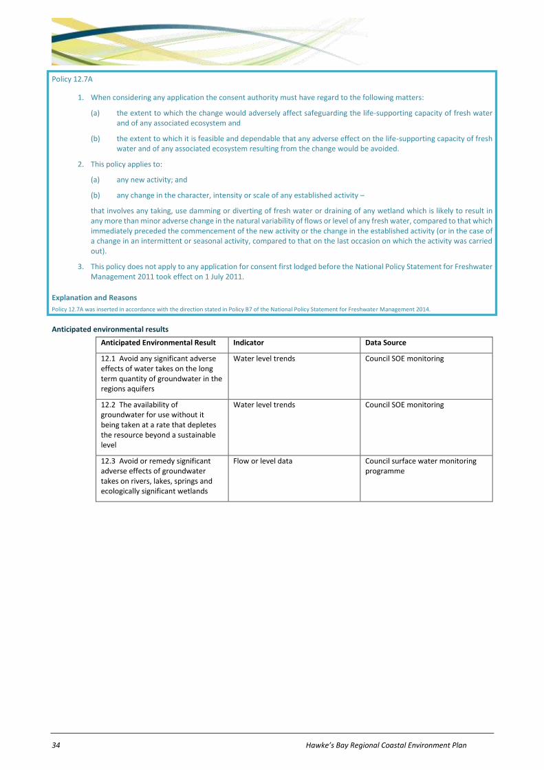
34 Hawke’s Bay Regional Coastal Environment Plan
Policy 12.7A
1. When considering any application the consent authority must have regard to the following matters:
(a) the extent to which the change would adversely affect safeguarding the life-supporting capacity of fresh water and of any associated ecosystem and
(b) the extent to which it is feasible and dependable that any adverse effect on the life-supporting capacity of fresh water and of any associated ecosystem resulting from the change would be avoided.
2. This policy applies to:
(a) any new activity; and
(b) any change in the character, intensity or scale of any established activity –
that involves any taking, use damming or diverting of fresh water or draining of any wetland which is likely to result in any more than minor adverse change in the natural variability of flows or level of any fresh water, compared to that which immediately preceded the commencement of the new activity or the change in the established activity (or in the case of a change in an intermittent or seasonal activity, compared to that on the last occasion on which the activity was carried out).
3. This policy does not apply to any application for consent first lodged before the National Policy Statement for Freshwater Management 2011 took effect on 1 July 2011.
Explanation and Reasons
Policy 12.7A was inserted in accordance with the direction stated in Policy B7 of the National Policy Statement for Freshwater Management 2014.
Anticipated environmental results
Anticipated Environmental Result Indicator Data Source
12.1 Avoid any significant adverse effects of water takes on the long term quantity of groundwater in the regions aquifers
Water level trends Council SOE monitoring
12.2 The availability of groundwater for use without it being taken at a rate that depletes the resource beyond a sustainable level
Water level trends Council SOE monitoring
12.3 Avoid or remedy significant adverse effects of groundwater takes on rivers, lakes, springs and ecologically significant wetlands
Flow or level data Council surface water monitoring programme

Hawke’s Bay Regional Coastal Environment Plan 35
13 Beds of Rivers and Lakes NOTE: The provisions in this chapter apply only within the Coastal Margin between mean high water springs and the Coastal
Environment Inland Boundary identified on the Planning Maps.
Objective 13.1
The maintenance or enhancement of the natural and physical resources, and use and values, of the beds of rivers and lakes within the Region as a whole.
Policies
Policy 13.1 To manage the effects of activities affecting river beds and lake beds in accordance with the environmental guidelines set out in Table 13-1.
Table 13-1: Environmental Guidelines – Beds of Rivers and Lakes.
Issue Guideline
1. Fish passage The activity should be undertaken in a manner that continues to provide for the existing passage of fish past the structure.
2. Fish spawning In areas of fish spawning, the activity should be undertaken in a manner that minimises adverse effects on overall fish spawning patterns.
3. Bed stability No long term or ongoing acceleration of the rate of erosion or accretion of the bed of a river or lake as a result of any activity in a river bed or lake bed.
4. Habitat Adverse effects on the habitat of aquatic and terrestrial flora and fauna within the bed of a river or lake should be avoided, remedied or mitigated.
5. Flow regimes Adverse effects on natural flow regimes should be avoided where this is possible, or remedied or mitigated where avoidance is not possible.
6. Other structures and activities
There should be no significant adverse effects, including by way of destabilisation, on lawful existing structures or activities within the bed of a river or lake.
7. Flood risk There should be no reduction in the channel’s capacity that results in adverse flooding effects.
8. Debris risk There should be no significant impedance to the passage of floating debris.
9. Damage to property There should be no damage caused, and no increase in the risk of damage, to any property, including river control works, unless written approval is obtained from any affected parties.
10. Temporary activities Upon completion of any temporary activity affecting the bed of a river or lake, the bed should as far as practicable be restored to no less than the state it was in prior to the activity taking place.
11. Outstanding natural features
Adverse effects on any outstanding natural features within river and lake beds should be avoided, remedied or mitigated.
12. Historic heritage and significant cultural values
Adverse effects on historic heritage features and areas of significant cultural heritage within river and lake beds should be avoided, remedied or mitigated.
Policy 13.2 To implement the environmental guidelines for river beds and lake beds set out in Policy 13.1 predominantly in the following manner:
(a) Regional rules - The environmental guidelines have been incorporated in conditions, standards and terms in the rules set out in Part E of this Plan, and to provide a basis for the level of regulation, as appropriate. In particular, the use, maintenance and removal of structures have been allowed provided adverse effects are managed in accordance with the environmental guidelines.
(b) Resource consents - The environmental guidelines will also be used in the process of making decisions on resource consents, in accordance with the RMA.

36 Hawke’s Bay Regional Coastal Environment Plan
Explanation and reasons
Policy 13.1 sets out environmental guidelines for the management of activities affecting river beds and lake beds, including structures in, on, under or over river or lake beds, and bed disturbances. The environmental guidelines address the management of both natural and physical resources within river beds and lake beds.
Policy 13.2 establishes that the environmental guidelines for river and lake beds will be used to guide regulation. They have been used in rules, and will be used in resource consent processes.
Policy 13.7A
1. When considering any application the consent authority must have regard to the following matters:
(a) the extent to which the change would adversely affect safeguarding the life-supporting capacity of fresh water and of any associated ecosystem and
(b) the extent to which it is feasible and dependable that any adverse effect on the life-supporting capacity of fresh water and of any associated ecosystem resulting from the change would be avoided.
2. This policy applies to:
(a) any new activity; and
(b) any change in the character, intensity or scale of any established activity –
that involves any taking, use damming or diverting of fresh water or draining of any wetland which is likely to result in any more than minor adverse change in the natural variability of flows or level of any fresh water, compared to that which immediately preceded the commencement of the new activity or the change in the established activity (or in the case of a change in an intermittent or seasonal activity, compared to that on the last occasion on which the activity was carried out).
3. This policy does not apply to any application for consent first lodged before the National Policy Statement for Freshwater Management 2011 took effect on 1 July 2011.
Explanation and Reasons
Policy 13.7A was inserted in accordance with the direction stated in Policy B7 of the National Policy Statement for Freshwater Management 2014.
Anticipated environmental results
Anticipated Environmental Result Indicator Data Source
13.1 Fish passage and spawning are able to continue despite the erection or use of a structure or bed disturbance
Abundance of fish in selected locations Department of Conservation, Fish and Game, HBRC, tangata whenua
13.2 Avoidance, remedy or mitigation of adverse effects on natural flow regimes
Natural flow regimes Flow monitoring programme
13.3 No significant adverse effects on existing structures or activities within the bed of a river or lake
Destabilisation of existing structures or activities
Compliance monitoring
13.4 No reduction in ability of channels to convey flood flows
River bed cross section profiles Asset Management Plans and flow monitoring
13.5 No damage to property by works in river beds, without owners’ consent
Reports of damage from river control works
Occasional event reports
13.6 Restoration of river or lake bed following temporary activity
As far as practicable the bed is restored to at least its state prior to activity occurring
Compliance monitoring
13.7 Aquatic habitat is maintained at a sustainable level
1. Temperature not changed by more than 3 degrees Celsius nor raised above 25 degrees Celsius
2. Dissolved oxygen not exceeding guideline values
3. Ammoniacal nitrogen levels not exceeding guideline values
4. Soluble reactive phosphorous values not exceeding guideline values
Council water quality monitoring programme, and tangata whenua monitoring programmes where available
Hawke’s Bay Regional Coastal Environment Plan 37
5. No loss of fish species or indigenous invertebrate diversity and abundance
6. Clarity in areas used for contact recreation not exceeding guideline values
7. Faecal coliform concentrations not exceeding with guideline values
8. Suspended solid concentrations not exceeding guideline values
9. Sediments and contaminants not having adverse effects on sedimentary fauna or aquatic ecosystems

38 Hawke’s Bay Regional Coastal Environment Plan
14 Air Quality NOTE: The provisions in this chapter apply only within the Coastal Margin between mean high water springs and the Coastal
Environment Inland Boundary identified on the Planning Maps.
Objectives
Obj 14.1 A standard of ambient air quality is maintained at, or enhanced to, a level that is not detrimental to human health, amenity values or the life supporting capacity of air, and meets National Environmental Standards.
Obj 14.2 A standard of local air quality is maintained that is not detrimental to human health, amenity values or the life supporting capacity of air.
Obj 14.3 In the Napier, Hastings, Awatoto and Whirinaki Airsheds, improve ambient air quality so that by 1 September 2020 the concentration of PM10 does not exceed 50µg/m3 (24 hour average), more than once in any 12 month period.
Obj 14.4 In the balance of the region outside the Napier, Hastings, Awatoto and Whirinaki Airsheds, the ambient air quality shall be managed in a manner that ensures the concentration of PM10 does not exceed 50µg/m3 (24 hour average), more than once in any 12 month period.
Policies
Policy 14.1 To manage the effects of activities affecting air quality in accordance with the environmental guidelines and standards set out in Table 14-1.
Table 14-1: Environmental Guidelines and Standards – Air Quality.
Issue Guideline
1. Odour There should be no offensive or objectionable odour beyond the boundary of the subject property3.
2. Gases, airborne liquid and other noxious or dangerous contaminants
There should be no noxious or dangerous levels of gases or airborne liquid or other airborne contaminants beyond the boundary of the subject property, in concentrations and at locations that are likely to cause adverse effects on human health, terrestrial ecosystems, aquatic ecosystems or property.
3. Smoke and water vapour The discharge should not result in any smoke, water vapour or other contaminant that adversely affects navigation, traffic safety, or reduces horizontal visibility within 5m of ground level beyond the boundary of the subject property.
4. Dust Any dust deposition should not raise the ambient dust deposition rate by more than 4 g/m2 per 30 days at any point beyond the boundary of the subject property.
5. Particulate matter There should be no objectionable deposition of particulate matter on any land or structure beyond the boundary of the subject property.
6. Ambient air quality (a) The ambient air quality must remain within the Resource Management (National Environmental Standards for Air Quality) Regulations 20044.
(b) Where no national environmental standards exist, the ambient air quality should remain within the New Zealand Ambient Air Quality Guidelines MfE 20025.
(c) Where the existing ambient air quality is better than the concentrations specified in relevant national environmental standards and guidelines in (a) and (b) above, there should be no significant degradation of ambient air quality.
3 ‘Subject property’ means the legally defined property, whether private land or public land, within which the subject activity occurs and
includes all land that is under common ownership. 4 Ministry for the Environment (2011) Resource Management (National Environmental Standards Relating to Air Quality) Regulations 2004. 5 Ministry for the Environment (2002) Ambient Air Quality Guidelines.
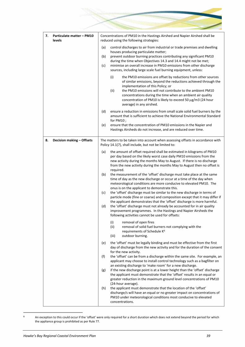
Hawke’s Bay Regional Coastal Environment Plan 39
7. Particulate matter – PM10 levels
Concentrations of PM10 in the Hastings Airshed and Napier Airshed shall be reduced using the following strategies:
(a) control discharges to air from industrial or trade premises and dwelling houses producing particulate matter;
(b) prevent outdoor burning practices contributing any significant PM10 during the time when Objectives 14.3 and 14.4 might not be met;
(c) minimise an overall increase in PM10 emissions from other discharge sources, including large scale fuel burning equipment, unless:
(i) the PM10 emissions are offset by reductions from other sources of similar emissions, beyond the reductions achieved through the implementation of this Policy; or
(ii) the PM10 emissions will not contribute to the ambient PM10 concentrations during the time when an ambient air quality
concentration of PM10 is likely to exceed 50 g/m3 (24 hour average) in any airshed.
(d) ensure a reduction in emissions from small scale solid fuel burners by the amount that is sufficient to achieve the National Environmental Standard for PM10 ;
(e) ensure that the concentration of PM10 emissions in the Napier and Hastings Airsheds do not increase, and are reduced over time.
8. Decision making – Offsets The matters to be taken into account when assessing offsets in accordance with Policy 14.1(7), shall include, but not be limited to:
(a) the amount of offset required shall be estimated in kilograms of PM10 per day based on the likely worst case daily PM10 emissions from the new activity during the months May to August. If there is no discharge from the new activity during the months May to August then no offset is required.
(b) the measurement of the ‘offset’ discharge must take place at the same time of day as the new discharge or occur at a time of the day when meteorological conditions are more conducive to elevated PM10. The onus is on the applicant to demonstrate this.
(c) the ‘offset’ discharge must be similar to the new discharge in terms of particle mode (fine or coarse) and composition except that it may differ if the applicant demonstrates that the ‘offset’ discharge is more harmful.
(d) the ‘offset’ discharge must not already be accounted for in air quality improvement programmes. In the Hastings and Napier Airsheds the following activities cannot be used for offsets:
(i) removal of open fires (ii) removal of solid fuel burners not complying with the
requirements of Schedule K6 (iii) outdoor burning.
(e) the ‘offset’ must be legally binding and must be effective from the first day of discharge from the new activity and for the duration of the consent for the new activity.
(f) the ‘offset’ can be from a discharge within the same site. For example, an applicant may choose to install control technology such as a bagfilter on an existing discharge to ‘make room’ for a new discharge.
(g) if the new discharge point is at a lower height than the ‘offset’ discharge the applicant must demonstrate that the ‘offset’ results in an equal or greater reduction in the maximum ground level concentrations of PM10 (24-hour average).
(h) the applicant must demonstrate that the location of the ‘offset’ discharge/s will have an equal or no greater impact on concentrations of PM10 under meteorological conditions most conducive to elevated concentrations.
6 An exception to this could occur if the ‘offset’ were only required for a short duration which does not extend beyond the period for which
the appliance group is prohibited as per Rule 77.
40 Hawke’s Bay Regional Coastal Environment Plan
(i) The National Environmental Standards for Air Quality must be considered in relation to all ‘offsets” as in some situations the National Environmental Standards for Air Quality may restrict their use.
Note: For clarification, the ‘offset’ discharge is the one that is being removed and the “new” discharge is the one that is new. The offset discharge must be therefore equal or “worse than the new discharge so there is an environmental improvement.
Policy 14.2 To implement the environmental guidelines for air quality set out in Policy 14.1 predominantly in the following manner:
(a) Regional rules -The environmental guidelines and standards for air quality have been incorporated primarily in conditions, standards and terms in the rules set out in Part E of this Plan as appropriate. The environmental guidelines for air quality that refer to ‘noxious’, ‘dangerous’, ‘offensive’ or ‘objectionable’ effects will be interpreted in the manner described in Schedule C of this Plan, and in accordance with any relevant case law.
(b) Resource consents - The environmental guidelines and standards for air quality will also be used in the process of making decisions on resource consents, in accordance with the RMA.
(c) Enforcement – Enforcement action will be used, where necessary, to aid in implementing the standards and terms of the rules set out in Part E of this Plan. Any enforcement action will be undertaken in accordance with the enforcement provisions of the RMA.
(d) Non-regulatory methods - Non-regulatory methods will also be used, where appropriate, in achieving the objectives and implementing policies in Chapter 14, including:
i) liaising with territorial authorities to seek the inclusion of appropriate land use policies, rules and methods within district plans, and building codes, as necessary to meet the objectives and policies within Chapter 14.
ii) the Hawke’s Bay Regional Council will influence and inform the community through the development of an appropriate communications and marketing strategy. Information will be provided to assist the community (including industrial and horticultural operators) understand the types of effects that can occur as a result of discharges of contaminants into air and the overall effects of such discharges on ambient air quality. Information will be provided advising appropriate methods to avoid, remedy or mitigate any adverse effects of discharging contaminants into air.
iii) the Hawke’s Bay Regional Council will encourage the use of dry wood through education.
iv) the Hawke’s Bay Regional Council will develop a best practice guide for the sale of wood by accredited dry wood merchants.
v) provision of financial incentives. The Hawke’s Bay Regional Council may choose to provide incentives and financial assistance to assist achievement of Objective 14.3, thereby complying with National Environmental Standard for PM10.
vi) development of a best practice guide for outdoor burning to ensure that those undertaking the activity are aware of what steps need to be taken to minimise the effects from outdoor burning.
vii) encouraging people currently using open fires and small scale solid fuel burners that are not NESAQ compliant burners to install cleaner forms of heating.
(e) Resource Management Regulations - National Environmental Standards apply across New Zealand. These national standards may prohibit or restrict certain types of activities affecting air quality. The Hawke’s Bay Regional Council will enforce these standards in accordance with (c) above.
Explanation and reasons
Prior to this Plan being prepared, the Hawke’s Bay Regional Council had already established an approach for air management in its former Regional Air Plan. Objective 14.1 continues the direction set by the objectives of this former Plan. In particular, it recognises the need to focus on both ambient air quality and local air quality. Similarly, the environmental guidelines set out in Policy 14.1 follow the direction set in the former Regional Air Plan for regulating discharges of contaminants into air. This policy seeks to manage the range of effects that can be caused by discharges of contaminants into air, drawing on common conditions contained in rules in the former Regional Air Plan and in resource consents granted by the Hawke’s Bay Regional Council.
Guidelines 1 to 5 largely address localised effects, recognising that these are the most common air quality problems. By comparison, Guideline 6 addresses ambient air quality. Ministry for the Environment has produced Ambient Air Quality Guidelines for a range of key air contaminants which detail the minimum requirements that outdoor air quality should meet in order to protect human health and the environment. Five of these guidelines have been implemented as mandatory standards in the form of National Environmental Standards which are Regulations under the Act. The guideline and standard values are applied as a ‘bottom line’, and where existing air quality is better than the Guidelines and Standards (which is the case for most areas in Hawke’s Bay), the present air quality should be maintained. In other words, the existing ambient air quality should not be allowed to degrade to a level of contamination beyond that specified in the NZ Ambient Air Quality Guidelines and National Environmental Standards for Air Quality (NESAQ).

Hawke’s Bay Regional Coastal Environment Plan 41
PM10 ambient air quality in Hastings and Napier can be poor in winter and in 2008 did not meet the National Environmental Standards for PM10 with the main contribution coming from domestic heating sources; air quality within the Whirinaki and Awatoto Airsheds is also poor. However, the main contributor within these relatively small and focussed airsheds is industry. Excessive concentrations of PM10 are associated with numerous health problems ranging from minor irritation of the eyes and nose to exacerbating existing respiratory problems among small children and the elderly in particular.
Objective 14.3 defines the ambient air quality PM10 concentration to be achieved in the Napier, Hastings, Awatoto and Whirinaki Airsheds. Objective 14.4 covers the rest of the region and ensures the existing ambient air quality PM10 concentration remains less than 50µg/m3 (24 hour average), with no more than one annual exceedence. Guideline 7 specifies strategies to reduce PM10 concentrations in the Hastings and Napier Airsheds to a level which complies with the NESAQ for PM10.
Objectives 14.3 and 14.4 and Guideline 7 have been adopted in response to the National Environmental Standards for Air Quality set by Ministry of the Environment in 2004. Objective 14.3 predates the 2011 amendments to the National Environmental Standards for Air Quality, which revised the timeframes for compliance with the ambient PM10 standard from 2013 to either 2016 or 2020, depending on the number of times the ambient PM10 standard was exceeded in an Airshed at 1 September 2011. The amended regulations require the National Environmental Standard for PM10 to be met in the Napier Airshed by 1 September 2016, and in the Hastings, Awatoto and Whirinaki Airsheds by 1 September 2020.
The Hawke’s Bay Regional Council will monitor changes in PM10 concentrations in these airsheds. If monitoring indicates that the Objective 14.3 will not be met, or that Objective 14.4 is at risk of being compromised, the Council will initiate further measures, in addition to those outlined in the Plan. These measures may be regulatory, non-regulatory, or a combination of both.
Policy 14.2 establishes that, unlike the environmental guidelines for land (which will largely be used in a non-regulatory manner), the environmental guidelines for air quality have been used to guide regulation as the principal means of meeting the air quality objectives. The guidelines have been used in rules, and will be used in resource consent processes. Policy 14.2(a) cross-references Schedule C of this Plan, which provides some guidance on interpretation of the terms ‘noxious’, ‘dangerous’, ‘offensive’ or ‘objectionable’. These terms are commonly used in the regulation of discharges of contaminants into air.
Regulatory and non regulatory methods will play a significant part in meeting Objective 14.3. Policy14.2(d)(i) will help integrate decision making under the Resource Management Act and Building Act and ensure that regional council and territorial authority requirements are considered at the same time. Policy 14.2(d)(ii),(iii),(iv) recognises that awareness about effects can lead to people adopting practices which can bring about changes in the quality of the air resource, and that information transfer can be an effective alternative to enforcement as a means of changing people’s behaviour. In particular , Policy 14.2(d)(ii),(iii),(iv) can focus on educating people about the adverse effects associated with the discharges from domestic fuel burners, open fires and outdoor rubbish burning. Many of the problems associated with domestic heating are caused or exacerbated by ongoing use of open fires and small scale solid fuel burners that do not meet the NESAQ emission standards, incorrect use of appliances, and the use of poor quality fuels. While the use of NESAQ compliant burners will improve environmental outcomes and assist the Council in meeting Objective 14.3, it is acknowledged that the use of heating appliances which reduce or minimise incorrect operation and can only use clean energy sources or dry fuels, will further improve air quality within Napier and Hastings. Similarly, problems associated with vegetation burning often relate to when and how burning is undertaken. Both these issues can be addressed through education of the public about their burning and heating practices. Policy 14.2(d)(v) states that the Hawke’s Bay Regional Council may choose to provide financial packages to encourage the maximum uptake by households of NESAQ compliant burners and/or clean heating systems.
Anticipated environmental results
Anticipated Environmental Result Indicator Data Source
14.1 No offensive or objectionable odour beyond the boundary of any subject property
Number, nature and type of resource consent, and reported incidents of odour
Compliance monitoring
Incident monitoring
14.2 No noxious or dangerous gases or airborne liquid or other airborne contaminants beyond the boundary of any subject property
Number, nature, type and location of resource consent, and reported incidents of spray drift and other contaminants
Compliance monitoring
Incident monitoring
14.3 Reduction in number of incidents where smoke, water vapour or other contaminants reduce visibility or affect traffic safety
Visibility monitoring 5 yearly monitoring for input into State of the Environment Report
Incident monitoring
14.4 Reduction in occurrences of dust deposition which do not comply with guidelines beyond subject property boundary
Dust deposition should comply with the guidelines value of 4g/m2 per 30 days
Annual State of the Environment update reporting
Incident monitoring
14.5 Reduction in occurrences of objectionable deposition of particulate matter beyond subject property boundary
The accumulation of particulate matter
Annual State of the Environment update reporting
Incident monitoring
14.6 Ambient Air Quality NO2, SO2, and CO Four yearly monitoring
14.7 By 1 September 2020 the concentration of PM10 in any airshed is not exceeding 50µg/m3 (24 hour average), more than once in any year
PM10 Compliance monitoring in accordance with Resource Management (National Environmental Standards for Air Quality) Regulations 2004

42 Hawke’s Bay Regional Coastal Environment Plan
15 Coastal Hazards
Objectives
Obj 15.1 Risks posed by coastal hazards to people and property are avoided or mitigated.
Obj 15.2 The avoidance of new and further inappropriate development in areas identified as being currently at risk of coastal erosion or inundation (ie: those areas within Coastal Hazard Zone 1).
Obj 15.3 The avoidance of new and further inappropriate development in areas identified as being at risk of coastal erosion or inundation during the next 100 years (ie: those areas within Coastal Hazard Zone 2 or Coastal Hazard Zone 3), taking into account the risk associated with global sea level rise and the level of protection afforded by natural coastal features and lawfully established coastal protection structures.
Policies
Policy 15.1 To manage coastal erosion and inundation risks in accordance with the environmental guidelines set out in Table 15-1.
Table 15-1: Environmental Guidelines – Coastal Hazards.
Issue Guideline
1. Management approach Coastal hazards will be proactively managed in the following prioritised ways:
(a) avoidance of new development in areas that are, or have potential to be, subject to coastal erosion or inundation
(b) maintaining and enhancing natural values and features that provide a buffer against coastal erosion and inundation
(c) relocation and removal of existing uses and development from areas at risk of coastal hazards will be evaluated, and implemented if appropriate;
(d) evaluating, then implementing if appropriate, activities which mitigate coastal hazards (for example, beach renourishment); and then
(e) evaluating, then implementing if appropriate subject to Guideline 12, permanent structures (for example, sea walls, groynes, artificial reefs) to mitigate coastal hazards.
2. Identification of coastal hazard areas
With the availability of new or updated information, areas subject to, or likely to be subject to, short and long-term coastal erosion, sea-water inundation, and cliff shoreline instability should be reviewed, identified and managed in an integrated manner. The most recent mid-range IPCC sea level rise scenario should be taken into account in these reviews.
3. Precautionary approach (a) A precautionary approach will be adopted in the assessment of:
(i) areas at risk from short, medium and long-term coastal erosion and inundation hazards and
(ii) potential adverse effects of subdivision, use and development in the coastal environment.
(b) Where a district plan gives effect to a more precautionary approach to the assessment and management of coastal hazard areas and controls on subdivision, use and development of land within those hazard areas than this Plan, then coastal hazard zones will not be identified in this Plan for those areas.
4. Information The most up to date information on coastal processes and coastal hazards within the region will be made available to local authorities, statutory agencies and the public to inform people of the relevant risk of coastal hazards in the area, and to encourage people to avoid developing in areas at risk of coastal hazards.
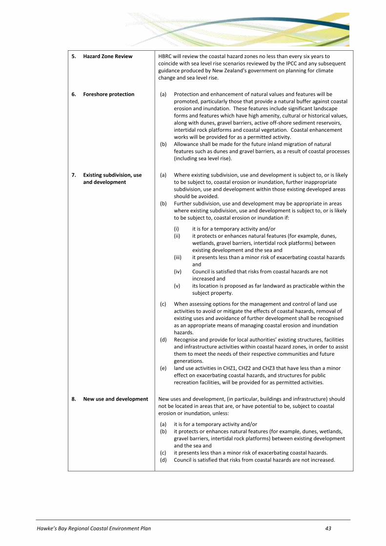
Hawke’s Bay Regional Coastal Environment Plan 43
5. Hazard Zone Review HBRC will review the coastal hazard zones no less than every six years to coincide with sea level rise scenarios reviewed by the IPCC and any subsequent guidance produced by New Zealand's government on planning for climate change and sea level rise.
6. Foreshore protection (a) Protection and enhancement of natural values and features will be promoted, particularly those that provide a natural buffer against coastal erosion and inundation. These features include significant landscape forms and features which have high amenity, cultural or historical values, along with dunes, gravel barriers, active off-shore sediment reservoirs, intertidal rock platforms and coastal vegetation. Coastal enhancement works will be provided for as a permitted activity.
(b) Allowance shall be made for the future inland migration of natural features such as dunes and gravel barriers, as a result of coastal processes (including sea level rise).
7. Existing subdivision, use and development
(a) Where existing subdivision, use and development is subject to, or is likely to be subject to, coastal erosion or inundation, further inappropriate subdivision, use and development within those existing developed areas should be avoided.
(b) Further subdivision, use and development may be appropriate in areas where existing subdivision, use and development is subject to, or is likely to be subject to, coastal erosion or inundation if:
(i) it is for a temporary activity and/or (ii) it protects or enhances natural features (for example, dunes,
wetlands, gravel barriers, intertidal rock platforms) between existing development and the sea and
(iii) it presents less than a minor risk of exacerbating coastal hazards and
(iv) Council is satisfied that risks from coastal hazards are not increased and
(v) its location is proposed as far landward as practicable within the subject property.
(c) When assessing options for the management and control of land use activities to avoid or mitigate the effects of coastal hazards, removal of existing uses and avoidance of further development shall be recognised as an appropriate means of managing coastal erosion and inundation hazards.
(d) Recognise and provide for local authorities’ existing structures, facilities and infrastructure activities within coastal hazard zones, in order to assist them to meet the needs of their respective communities and future generations.
(e) land use activities in CHZ1, CHZ2 and CHZ3 that have less than a minor effect on exacerbating coastal hazards, and structures for public recreation facilities, will be provided for as permitted activities.
8. New use and development New uses and development, (in particular, buildings and infrastructure) should not be located in areas that are, or have potential to be, subject to coastal erosion or inundation, unless:
(a) it is for a temporary activity and/or (b) it protects or enhances natural features (for example, dunes, wetlands,
gravel barriers, intertidal rock platforms) between existing development and the sea and
(c) it presents less than a minor risk of exacerbating coastal hazards. (d) Council is satisfied that risks from coastal hazards are not increased.

44 Hawke’s Bay Regional Coastal Environment Plan
9. New subdivision and district plan rezoning
(a) New and further subdivision shall be strongly discouraged within areas subject to, or likely to be subject to, coastal erosion or inundation hazards.
(b) District plans should restrict new and further subdivision of land and rezoning of land within coastal hazard zones so subdivision and zoning of land presents less than a minor risk of exacerbating coastal hazards.
10. Deposition and removal of sediment (and other earthworks)
Subject to Guideline 11, deposition and removal of gravel and other earthworks should not occur in, or adjacent to, areas that are, or have potential to be, subject to coastal erosion, unless:
(a) it is for a temporary activity; and/or (b) it protects or enhances natural features (for example, dunes, wetlands,
gravel barriers, intertidal rock platforms) between existing development and the sea; and
(c) it presents less than a minor risk of exacerbating coastal hazards; and (d) Council is satisfied that risks from coastal hazards are not increased.
11. Hazard mitigation works (a) The ability for local authorities to carry out hazard mitigation works shall be provided for. Such works undertaken to mitigate coastal hazards shall, to the greatest extent practicable, avoid adversely affecting public access, natural character, dynamic coastal processes, historic heritage, landscape and ecological values in the coastal environment.
(b) Recognise and provide for the ongoing renourishment of Westshore Beach as an appropriate means of mitigating the effects of coastal hazards on the shoreline.
12. Coastal protection structures
(a) Coastal protection structures should only be used to mitigate coastal hazards when:
(i) it is the best practicable option and (ii) no other non-structural alternative is effective or feasible to
reduce coastal hazard risk and (iii) the structure is to be located and designed so as to avoid adverse
environmental effects to the greatest extent practicable, particularly effects on coastal processes, landscape values and the existing natural character of the coastline and
(iv) the structure is to:
serve a use with a functional need to locate in the coastal marine area or
protect areas of existing development and network utility operations from coastal erosion or inundation risks.
(b) Maintenance and repair of existing lawfully established coastal protection structures will be provided for in this Plan as a restricted discretionary activity. In considering whether or not to grant consent, Council will have particular regard to the duration of consent to enable the undertaking of maintenance and repair works over an extended period of time.
13. Network utility operations (a) The continued use and protection of essential infrastructure and services in coastal hazard areas shall be provided for as a permitted activity where the infrastructure and service is located in a road reserve.
(b) New and upgraded infrastructure and services should not be located in areas that are, or have potential to be, subject to coastal erosion or inundation risk unless:
(i) it is for a temporary activity and/or (ii) it protects or enhances natural features (for example, dunes,
wetlands, gravel barriers, intertidal rock platforms) between existing development and the sea and
(iii) it presents less than a minor risk of exacerbating hazards and (iv) Council is satisfied that risks from coastal hazards are not
increased and

Hawke’s Bay Regional Coastal Environment Plan 45
(v) no other reasonable alternative location or service delivery option exists beyond a CHZ.
14. Temporary activities (a) The use of land subject to, or likely to be subject to, coastal erosion or inundation for the purposes of temporary activities (and any associated structures) shall be provided for as a permitted activity.
(b) Upon completion of any temporary activity that altered the profile of the fore dune, the fore dune should as far as practicable, be restored to no lesser state than it was in prior to the activity taking place.
15. Decision Making When assessing resource consent applications the following matters shall be taken into account for activities in CHZ1, and in relation to CHZ2 and CHZ3, the following matters should be taken into account (where relevant):-
(a) site elevation relative to mean sea level (b) the presence and long-term effectiveness of any lawfully established
coastal protection structures (c) sea level rise predictions (d) geological characteristics of the site and surrounding environment (e) the expected life of the proposed activity (f) the purpose and intended use of the proposed activity (eg: habitation,
storage of goods and materials, commercial activity, essential infrastructure, or some other purpose).
(g) the reasons for the proposed siting or location of the activity on the property relative to the location of coastal hazard zone(s)
(h) the findings and recommendations of a site-specific coastal hazard assessment prepared by a suitably qualified person. Site-specific coastal hazard assessments shall address:
(i) Impacts of sea level rise using the Intergovernmental Panel on Climate Change’s most recent assessment, and figures recommended in the most recent version of guidance manuals published by Ministry for the Environment and/or NZ Climate Change Office.
(ii) Shoreline response to storm erosion and flooding: Scientifically appropriate models should be used, such as those based on, but not restricted to, the Bruun Rule or Komar Rule.
(iii) Planning horizon: A 100-year planning horizon should be used. (iv) Long term trend: This should be derived from cadastral, aerial
photography, surveys, or other reliable historic data. The reference shore adopted should be the toe of the foredune where these land forms occur, or elsewhere should be the seaward limit of vegetation or RL 11.0m datum as appropriate.
(v) Short term fluctuation: This should be derived from the most reliable records available at the time for particular stretches of the coast, and should err on the side of caution.
(vi) Land stability factor: This should be based on the angle of repose (AOR) of the land geology as defined locally.
(vii) Factor of safety: The coastal hazard area assessment should include an appropriate factor of safety, either built into the above criteria and standards, or added on in the final stage in the calculation.
(viii) Any profiles (cross sections) should be carried out to accepted surveyors standards and practice. All levels must be in terms of mean sea level to Hawke's Bay datum.
(ix) For inundation hazards, sea level rise; minimum annual exceedance probability of 2%; tide level; wave set up; wave runup; factor of safety; and the potential for contaminants to mix with flood waters.

46 Hawke’s Bay Regional Coastal Environment Plan
Policy 15.2 To implement the environmental guidelines for coastal hazards set out in Policy 15.1 predominantly in the following manner:
(a) Resource consents - The environmental guidelines will be used in the process of making decisions on resource consents, in accordance with the RMA.
(b) Regional rules - The environmental guidelines have been incorporated into rules, (including conditions, standards and terms) set out in Part E of this Plan and provide a basis for the level of regulation used.
(c) Non-regulatory methods - The environmental guidelines for coastal hazards may also be implemented through non-regulatory methods where appropriate, including the provision of information, advocacy on district plans and resource consent applications (including joint-hearing proceedings), environmental monitoring and reporting, financial incentives, and liaison/consultation with territorial authorities.
Explanation and reasons
Natural disasters or the potential for disasters arise where these dynamic coastal processes interact with human use, property and infrastructure. Primary hazards arising from these interactions include erosion, inundation of low lying areas, and land instability including major slumping, slips and earthflows. There is a significant history of natural disasters and lesser adverse events affecting property at numerous locations along Hawke's Bay’s coastline. The entire region’s shoreline is prone to storm damage and the influence of cyclical erosion and accretion trends. There is also a risk of erosion due to ongoing and accelerated global sea level rise. Coastal erosion and inundation can and have damaged property and threatened people’s safety and wellbeing. Limitations on the supply of sediment to coastal areas and impediments to sediment transport can affect the risks posed by coastal hazards. Also, in many instances, risks of damage to property, people’s safety and the environment have increased due to the inappropriate location of assets and activities within hazard-prone areas.
While most natural processes which generate the coastal hazard originate in the coastal marine area, the adverse effects are usually expressed on the land above mean high water springs, where the regional council and territorial authorities have joint responsibilities to ensure such impacts are avoided or mitigated. Sustainable management of the coastal environment with respect to hazards involves consideration of the particular hazard in the wider context (both above and below mean high water springs), and over long-term timeframes. This is necessary to ensure appropriate methods are used to effectively avoid or mitigate natural coastal hazards.
Avoiding permanent development in areas prone to coastal erosion or inundation and taking into account the risk associated with global sea level rise is necessary to promote the sustainable management of the coastal environment’s natural and physical resources. This approach enables the community to provide for efficient and effective use of resources and the safety of people and property and recognises the reasonably foreseeable needs of future generations. It also gives a clear indication to resource users that most development in these areas is inappropriate. Some limited forms of development may be appropriate if it does not interfere with coastal processes or the risks of coastal hazards are not worsened. Where existing development is within areas subject to coastal hazards, the risk needs to be minimised. This may be achieved through strategies involving planned retreat of existing development or perhaps strategies to implement physical solutions to mitigate coastal erosion or inundation processes. It is up to a consent applicant to satisfy HBRC about the effectiveness of any proposed measure for mitigating the risks of inundation associated with the proposed activity. For example, an applicant could supply survey data showing that ground levels are or will be raised to a suitable level, or details of building platforms that have been specifically designed in a way that will mitigate against inundation risk.
Any strategic decision for the co-ordinated removal, relocation or even abandonment of public and private assets at risk of being impacted by coastal hazards is often referred to as ‘managed retreat.’ The extent, scale and timeframes over which retreat could occur will vary depending on a variety of factors. Various scales of retreat include:
(a) micro-retreat, where the elevation of building floors is raised; (b) relocation within a property’s boundaries; (c) relocation to another site; (d) large-scale relocation of settlements and associated infrastructure.
Guideline 1(iii) expects an evaluation of ‘managed retreat’ options as part of a landowners’ response or community-wide response to avoiding and mitigating risks associated with coastal hazards. The extent, scale, timeframes, feasibility and practicality of each response will differ. The most likely, but not necessarily only, methods for implementing a managed retreat strategy would be a mix of some or all of the following:
(e) regional and district rules that relate to managing existing uses, restricting new uses, and restricting construction of coastal protection structures; (f) property title covenants; (g) education and improved awareness of hazard and consequences; (h) financial instruments (for example: property purchases, subsidies for relocation, taxation of risk, pre-paid community relocation funds, transferable
development rights, etc); (i) removal, relocation and construction of infrastructure out of at risk areas; (j) insurance incentives and disincentives.
Responses to coastal hazards should be prioritised. Guideline 1 outlines a prioritised approach (from avoidance of the hazard in the first instance; followed by maintenance and enhancement of natural features and buffers; then in cases where existing development is threatened, consideration of relocating or removing such development; then evaluating the use of beach nourishment solutions to mitigate the coastal hazard. The use of structural works is considered only after these other priorities have been evaluated and deemed inappropriate or not feasible. Even then, the use of structural protection works needs to be proven as the best practicable option. These priorities are outlined further in Guidelines 6-11 that give effect to policies in Chapter 3 of the NZCPS, particularly Policy 3.4.6.
Guidelines 2-4 are consistent with Policies 3.4.1 and 3.4.2 of the NZCPS which suggest local authorities should identify areas where coastal hazards exist and also take into account the possibility of sea level rise and its effects. A consistent regional approach should give a clear indication of which areas, on extrapolated trends, will be at risk from coastal erosion and inundation within defined time periods. Guideline 5 indicates that coastal hazard zones will be regularly reassessed to coincide with IPCC assessments and guidance from central government. The CHZ review process may or may not reveal a need to amend the CHZs identified in the Plan. If amendments are necessary, then the RMA's plan change process will be used to introduce any such amendments.
Given the importance of network utility operations to the wellbeing of people and communities, it is appropriate that some new infrastructure may be established in coastal hazard areas where there are no other reasonable locations or no other service delivery options. The Plan provides for establishment of network utility operations in coastal hazard zones, but in order to ensure the effects are appropriately managed, a resource consent will be required where they are not located within road reserves.
Guideline 3 gives effect to NZCPS Policy 3.3.1. Adopting a precautionary approach recognises that with further monitoring and research about the region’s coastal processes and the effects of activities on those processes, adjustments to the policy and regulatory structure may need to be made at the next review of this Plan. Guideline 3(b) states that regional rules for coastal hazards will not be applied in areas where district plans identify coastal hazard zones and rules apply to subdivision, use and development within such zones. At the time of adopting this Plan, these circumstances were only relevant along the Westshore and Bay View coastline in Napier City.
Guideline 15 is intended to assist decision-makers and resource users by clearly outlining some of the key matters that shall be taken into account when assessing resource consent applications for non-complying activities in CHZ1. Where relevant, these matters should also be applied to assessment of other resource consent applications for

Hawke’s Bay Regional Coastal Environment Plan 47
activities in the CHZs. Specific details are provided on the desired type of information to be applied in preparation and review of any site-specific hazard assessments submitted in support of a resource consent application. These ‘criteria’ will assist in ensuring a consistently high level of quality is presented in such assessments.
Since 1987, gravel has been deposited at Westshore Beach to renourish that beach and mitigate the effects of coastal erosion at Westshore and to a lesser extent, Bay View. Guideline 11(b) recognises that depositing gravel at Westshore Beach is an appropriate and effective way of mitigating coastal erosion in that location. Renourishment material has historically been sourced from an area just south of the Port of Napier on Marine Parade. A resource consent currently allows up to 30,000m3 of sediment per annum to be extracted from the Parade Gravel Extraction Area for Westshore Beach renourishment purposes until 2017.
Anticipated environmental results
Anticipated Environmental Result Indicator Data Source
15.1 Avoidance and mitigation of the risk to property and other values from the effects of natural coastal hazards, in particular storm erosion and storm surge inundation.
Position of shoreline and upper beach crest
Volumetric change in beach profile
HBRC Coastal Profile Monitoring
Compliance monitoring
Incident reports
15.2 Coastal protection structures are only constructed where such structures will not exacerbate the coastal hazard and where potential adverse effects on public and private land, amenity values, ecosystems and natural coastal processes can be avoided, remedied or mitigated.
Position of shoreline and upper beach crest
Volumetric change in beach profile
Number of incident reports / complaints received
Physical and biological parameters
HBRC Coastal Profile Monitoring
Compliance monitoring
Incident reports

48 Hawke’s Bay Regional Coastal Environment Plan
PART D – USE AND DEVELOPMENT: COASTAL MARINE AREA
16 Discharge of contaminants into CMA
Issue 16.1
The coastal marine area, dune systems, estuaries wetlands and rivermouths, their ecosystems, their mauri and their potential recreational use are being affected by the dumping and discharging of contaminants directly or indirectly into coastal waters.
Objectives
Obj 16.1 Maintenance or enhancement of water quality of the coastal marine area in order that it is suitable for sustaining or improving aquatic ecosystems, and for contact recreation purposes where appropriate.
Obj 16.2 Promote the avoidance, remediation or mitigation of the adverse effects of activities on mauri in the coastal marine area.
Obj 16.3 Adverse effects on the environment associated with discharge and dumping of contaminants to the coastal marine area are avoided, remedied or mitigated.
Obj 16.4 The life supporting capacity of water in the coastal marine area is safeguarded.
Policies
Policy 16.1 To manage discharges of contaminants in the coastal marine area in accordance with the environmental guidelines set out in Table 16-1.
Table 16-1: Environmental Guidelines – Discharge of contaminants in CMA.
Issue Guideline
1. Control of discharges
(a) Discharges of contaminants and the effects of such discharges on water in the coastal marine area shall be managed for aquatic ecosystem purposes (Class AE(HB) Water) and contact recreation purposes (Class CR(HB) Water) where appropriate.
(b) Discharges of contaminants from boat maintenance operations shall be restricted, and the installation of bunding around boat maintenance facilities shall be required.
2. Reasonable mixing
Discharges of contaminants into classified waters should comply with receiving water quality standards in Schedule E after reasonable mixing.
3. Sewage discharges
(a) The discharge of sewage from land which does not pass through soil or wetland, directly into water in the coastal marine area is inappropriate, unless:
(i) the disposal of sewage directly into the coastal marine area is the best practicable option and
(ii) significant adverse effects on ecosystems, natural character of the coastal environment and on water quality classified for contact recreation purposes are avoided, or remedied or mitigated where avoidance is not practicable.
(iii) there has been consultation with:
tangata whenua in accordance with tikanga Maori and due weight has been given to s6, s7 and s8 of the RMA and
the affected community in determining the suitability of the treatment and disposal system.
(b) The location and extent of any mixing zone for discharge of sewage shall ensure that there are no significant adverse effects on:
(i) any Significant Conservation Area or (ii) the use of receiving waters for recreation or (iii) the use of receiving waters for collection of seafood for human consumption.
(c) the adverse effects of sewage discharges on the present and reasonably foreseeable use of the receiving waters have been avoided where practicable, remedied or mitigated, particularly in:

Hawke’s Bay Regional Coastal Environment Plan 49
Issue Guideline
(i) areas where there is high recreational use or (ii) areas of maintenance dredging or (iii) areas adjacent to commercial or residential development.
4. Stormwater (a) Adverse effects on water quality from the discharge of stormwater shall be avoided, remedied or mitigated.
(b) Adoption of stormwater management systems, structures or facilities shall be promoted for the purposes of:
(i) separating drainage of areas which are at little risk of being contaminated from those which may be contaminated
(ii) preventing contaminants from reaching stormwater and (iii) treating contaminated stormwater at source or before it enters the coastal
marine area or surface water body.
5. Water quality (a) Subject to (b), applications to discharge any contaminant that either on its own or in combination with other lawful discharges will result in the water quality standards set out in Schedule E not being maintained, shall be declined.
(b) Discharges of any contaminant that either on its own or in combination with other lawful discharges will result in the water quality standards set out in Schedule E not being maintained, may be provided for where:
(i) exceptional circumstances justify the granting of a permit or (ii) the discharge is of a temporary nature or (iii) the discharge is associated with necessary maintenance work.
(c) The use of antifouling paints that are less harmful to the environment than those antifouling paints that contain organotin compounds will be supported and encouraged.
6. Review of consents
(a) HBRC will retain discretion to impose conditions requiring consent holders, who rely on the exceptions in Guideline 5(b), to undertake such works in such stages throughout the term of the consent to ensure that upon expiry of the consent (or such earlier date as specified in the conditions) the holder can achieve and maintain the water quality standards set out in Schedule E.
(b) HBRC will consider whether or not it is appropriate to review the conditions of existing resource consents in order to enable the water quality standards set out in Schedule E to be maintained. Where a discharge needs to be upgraded, consideration will be given to the likely costs that will be imposed on the consent holder by upgrading the discharge and establish reasonable timeframes within which the existing discharge will be upgraded.
7. Shellfish gathering
Commonly used areas will be identified during the life of this Plan where coastal waters should be managed for shellfish gathering purposes. The criteria to be used in assessing the appropriateness of coastal waters being managed for shellfish gathering purposes are:
(i) the extent and location of existing shellfish gathering areas and their utilisation as a food resource for human consumption
(ii) the extent to which known shellfish are able to be safely eaten (iii) the existing water quality (iv) existing lawful discharges and financial implications for dischargers (v) current state of technical knowledge and treatment and disposal options for
dischargers (vi) the nature and extent of tangata whenua relationships with customary shellfish
gathering areas.

50 Hawke’s Bay Regional Coastal Environment Plan
Issue Guideline
8. Dredging Activities
Areas will be identified where the disposal of dredge material from specified sources is appropriate. Identification of these areas generally facilitates activities disturbing the foreshore and seabed and does not imply the discharge of contaminants is allowed.
Policy 16.2 To implement the environmental guidelines for the discharge of contaminants set out in Policy 16.1 predominantly in the following manner:
(a) Resource consents – The environmental guidelines will be used in the process of making decisions on resource consents, in accordance with the RMA.
(b) Point of discharge – Notwithstanding any reference to guidelines applying after reasonable mixing, where individual circumstances are appropriate, conditions may be imposed on resource consents that require coastal water quality parameters to comply with limits measured at the point of discharge.
(c) Regional rules – The environmental guidelines have been incorporated into rules, (including conditions, standards and terms) set out in Part E of this Plan and provide a basis for the level of regulation used.
(d) Non-regulatory methods – The environmental guidelines for discharge of contaminants in the CMA may also be implemented through non-regulatory methods where appropriate, including the provision of information, environmental monitoring and reporting, and liaison/ consultation with resource users and territorial authorities.
Policy 16.3 When considering new applications or applications to renew discharge permits, to take into account:
(a) The existing state of the receiving environment, its resources and its assimilative capacity, including seasonal fluctuations
(b) Tangata whenua relationships with, and use of, resources within the receiving environment
(c) Cumulative effects of all discharge activities within the area on ecosystems and indigenous flora and fauna.
Explanation and reasons
The objectives seek to maintain and where appropriate enhance the quality of the water in the coastal environment and avoid, remedy or mitigate the adverse effects of activities on mauri within the coastal environment. The achievement of these objectives would resolve the issues associated with the discharge of contaminants and help to promote the sustainable management of the coastal environment.
The policies and guidelines are necessary to achieve the purpose of the RMA because they provide the appropriate framework to support the objectives and allow people and communities to provide for their social and economic wellbeing whilst sustaining the potential of natural and physical resources to meet the needs of future generations, safeguarding the life supporting capacity of coastal waters and avoiding adverse effects on the environment.
Section 60(3) of the RMA does not allow the HBRC to establish standards in a Plan which result or may result in a reduction in water quality at the time of public notification of the proposed Regional Coastal Plan unless it is consistent with the purpose of the RMA to do so. The HBRC considered that any lowering of the water quality standards in the Transitional Coastal Plan is not consistent with the purpose of the RMA. Those same standards were incorporated into the 1999 Operative Regional Coastal Plan.
The introduction of exotic marine organisms into New Zealand’s coastal waters is a nationwide problem and is considered to be a biosecurity issue that is managed by the Ministry of Agriculture and Fisheries (MAF). The Resource Management (Marine Pollution) Regulations 1998 contain rules relating to the discharge and dumping of waste from ships and off-shore installations. In addition to the Regulations, the RMA enables rules in this Plan to be stricter that the Regulations where appropriate. The policies and guidelines assist in implementing these Regulations.
Guidelines 1 and 2 outline the approach that the HBRC will take to managing coastal waters in Hawke’s Bay. Guideline 1 also recognises that boat maintenance operations may be a potential source of contamination in the coastal marine area. It also recognises that bunding around boat maintenance areas, particularly slipways, would help to overcome this problem.
Guideline 3 is included as a requirement of the NZCPS and provides resource consent assessment criteria for the discharge of sewage into the coastal marine area. A discharge of sewage that does not meet all of the criteria specified or which does not pass through land will not be allowed by the HBRC. This is consistent with NZCPS Policy 5.1.2.
Guideline 4 provides a management approach to avoid, remedy or mitigate the adverse effects of discharging stormwater. By separating contaminated areas from non-contaminated areas, efficient and effective treatment options are able to be adopted. This system avoids costs that would be incurred from applying treatment unnecessarily to uncontaminated stormwater discharges. This is consistent with NZCPS Policy 5.1.6.
Guideline 5 allows for the consideration of cumulative impacts of more than one discharge in a particular area and indicates that the water quality classes set may only be exceeded by a discharge in the special circumstances outlined. This is consistent with NZCPS Policy 3.2.4. Guideline 5 also indicates that the HBRC supports and encourages the use of antifouling paints that are less harmful to the environment than those which contain organotins. The sale and use of antifouling paints that contain organotins has been banned in New Zealand. However, the use of old stocks of the paint is still a potential water quality problem.
Guideline 6 outlines the process to be followed to review the conditions on existing resource consents in order to enable the water quality classes set to be met. This is consistent with NZCPS Policy 5.1.4 and s128 of the RMA.
Guideline 7 outlines the approach that the HBRC will take to introduce shellfish gathering water quality classes for Hawke’s Bay. This is consistent with NZCPS Policy 5.1.1 and complements Guideline 1. The shellfish areas are not classified in this Plan at present because this may falsely lead the public to believe that it is safe to eat shellfish from these areas, when in fact it may not be safe.
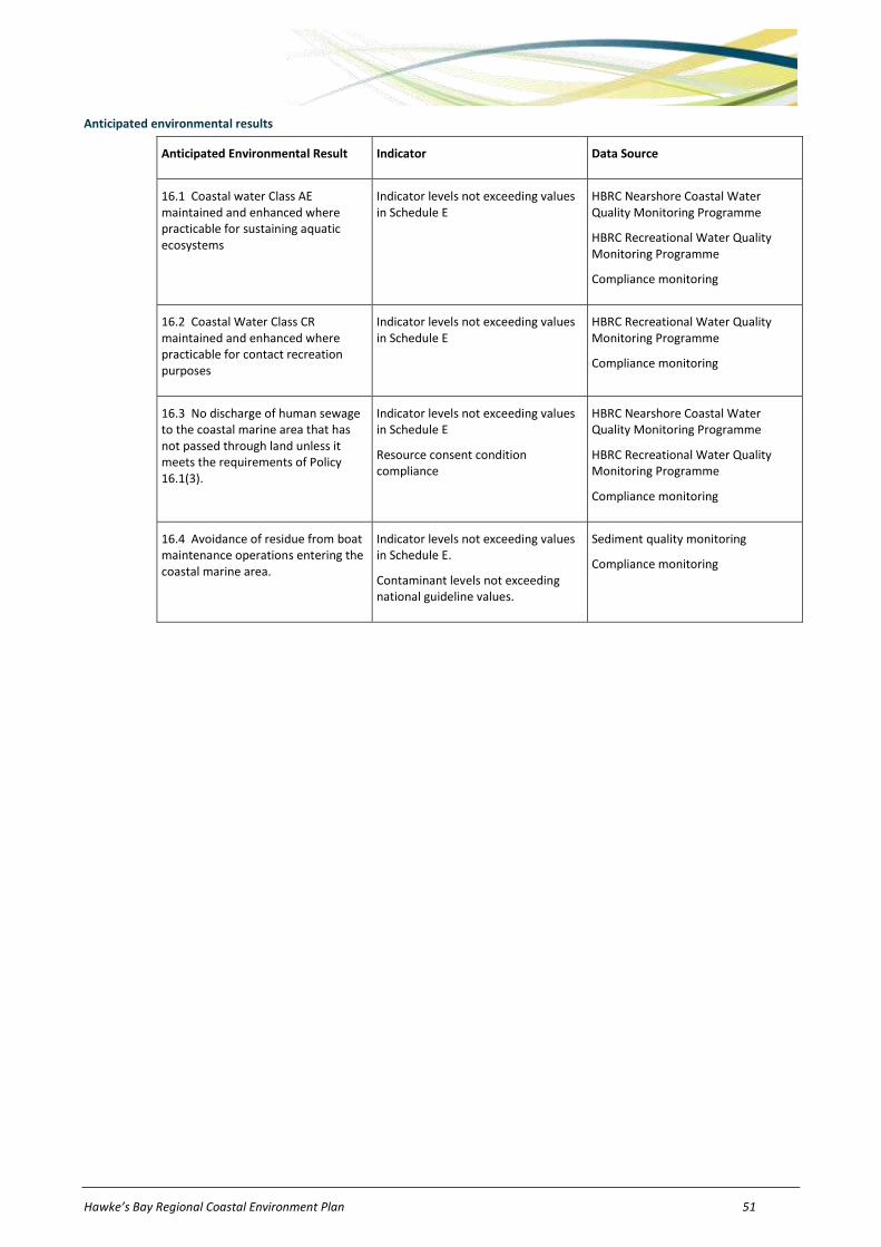
Hawke’s Bay Regional Coastal Environment Plan 51
Anticipated environmental results
Anticipated Environmental Result Indicator Data Source
16.1 Coastal water Class AE maintained and enhanced where practicable for sustaining aquatic ecosystems
Indicator levels not exceeding values in Schedule E
HBRC Nearshore Coastal Water Quality Monitoring Programme
HBRC Recreational Water Quality Monitoring Programme
Compliance monitoring
16.2 Coastal Water Class CR maintained and enhanced where practicable for contact recreation purposes
Indicator levels not exceeding values in Schedule E
HBRC Recreational Water Quality Monitoring Programme
Compliance monitoring
16.3 No discharge of human sewage to the coastal marine area that has not passed through land unless it meets the requirements of Policy 16.1(3).
Indicator levels not exceeding values in Schedule E
Resource consent condition compliance
HBRC Nearshore Coastal Water Quality Monitoring Programme
HBRC Recreational Water Quality Monitoring Programme
Compliance monitoring
16.4 Avoidance of residue from boat maintenance operations entering the coastal marine area.
Indicator levels not exceeding values in Schedule E.
Contaminant levels not exceeding national guideline values.
Sediment quality monitoring
Compliance monitoring

52 Hawke’s Bay Regional Coastal Environment Plan
17 Disturbances, depositions and extractions in CMA
Issue 17.1
The coastal marine area, particularly its habitats, ecosystems, natural coastal processes, amenity values, historic heritage and natural character can be adversely affected by foreshore and seabed disturbance, deposition and extraction. However, in some instances, dredging and spoil disposal is necessary for mitigation of coastal hazards, the maintenance of existing waterway channels, and to enhance ecosystems, natural character and recreational opportunities of some coastal lagoons and estuaries.
Objectives
Obj 17.1 Adverse effects of livestock and the use of motor vehicles on sensitive habitats of flora and fauna and ecological systems within the coastal marine area are avoided, remedied or mitigated.
Obj 17.2 Adverse effects on the environment associated with dredging, drilling, tunnelling, use of explosives, excavation and/or removal of sand, gravel, shell or other natural material in the coastal marine area are avoided, remedied or mitigated.
Obj 17.3 Adverse effects on the environment associated with the deposition of substances within the coastal marine area are avoided, remedied or mitigated.
Policies
Policy 17.1 To manage deposition and extraction of material within the coastal marine area and disturbance of the foreshore and seabed in accordance with the environmental guidelines set out in Table 17-1.
Table 17-1: Environmental Guidelines – Disturbances, depositions and extractions in CMA.
Issue Guideline
1. Deposition of material
(a) Deposition of substances on the foreshore or seabed within a Significant Conservation Area or adversely affecting known historic heritage is inappropriate and should be avoided.
(b) Deposition of substances on the foreshore or seabed not within a Significant Conservation Area may be appropriate where adverse effects on indigenous flora, fauna, benthic organisms and their habitats, are minimised.
(c) Deposition of sediment in the coastal marine area should only occur:
(i) where the sediment to be deposited is of the same or similar particle size to the sediment at the proposed deposition site
(ii) at times, durations or rates to minimise adverse effects on:
threatened bird species migratory patterns of marine life spawning of marine life coastal water quality recreational and commercial activities in the immediate area benthic communities adjacent to the area to be deposited on and cultural and social values.
(iii) where the sediment to be deposited is not spoil from land-based activities.
(d) Deposition of materials containing hazardous substances in quantities which will adversely affect the life supporting capacity of the coastal marine area, shall be avoided.
(e) Disturbance and deposition arising from the disposal of spoil from land-based activities should be avoided.

Hawke’s Bay Regional Coastal Environment Plan 53
Issue Guideline
2. Removal of material
(a) Removal of sand, shell, gravel or other natural material from the coastal marine area should ensure adverse effects on indigenous flora, fauna, benthic organisms and their habitats within a Significant Conservation Area, and adverse effects on known historic heritage, are avoided.
(b) Subject to (a) removal of sand, shell, gravel or other natural material from the coastal marine area should ensure adverse effects on the following, are minimised:
(i) threatened bird species (ii) migratory patterns of marine life (iii) spawning of marine life (iv) coastal water quality (v) recreational and commercial activities in the immediate area (vi) benthic communities adjacent to the area to be deposited on and (vii) cultural and social values (viii) beaches and dune systems (ix) historic heritage.
(c) When assessing a coastal permit application or application to change conditions on existing coastal permits to remove sand, gravel, shell or other material for commercial purposes from within the coastal marine area, regard shall be had to:
(i) alternative extraction sites and reasons for the proposed location; (ii) the concept of adaptive management, and the ability of natural processes to
restore or replenish the material.
3. Coastal hazards (a) Disturbance of the foreshore or seabed (in particular removal of sand, shell, gravel, or other natural material from the coastal marine area) should not occur in, or adjacent to areas that are, or are likely to be, subject to coastal erosion, unless:
(i) it is for a temporary activity and/or (ii) it protects or enhances natural buffers between existing development and the
sea and (iii) it presents less than a minor risk of exacerbating coastal erosion or inundation.
(b) Initiatives to deposit dredged or excavated sediment in designated disposal areas within the coastal marine area shall be provided for where the deposit will help to renourish beaches adjacent to existing developed areas that are at risk from coastal erosion or inundation.
4. Motor vehicles Motor vehicles and livestock shall be prohibited from sensitive areas, particularly inter-tidal rock platforms and the beds and margins of estuaries and wetlands, unless the vehicle is used for emergency or biosecurity purposes.
5. Seismic surveys Regard shall be had to adverse effects on marine mammals and other marine life and ecosystems when assessing an application for a resource consent for seismic surveys and activities involving explosives in the coastal marine area.
6. River and harbour works and utility maintenance
(a) Disturbance of the foreshore and seabed (including river mouths and harbours) shall be provided for where it is necessary for river control, flood management, drainage scheme works or maintenance of safe access for marine vessels.
(b) Disturbance of the foreshore and seabed shall be provided for where it is necessary for the maintenance of network utility operations.
7. Small-scale and incidental disturbances
Disturbance of the foreshore and seabed associated with small-scale structures that are otherwise permitted in the coastal marine area and the movement of ships and other vessels, shall be provided for.
8. Riparian margins
Retirement of riparian margins shall be promoted in areas adjacent to or within estuaries, wetlands and lagoons where this is necessary to protect or enhance water quality or sensitive habitats of indigenous flora and fauna.

54 Hawke’s Bay Regional Coastal Environment Plan
Issue Guideline
9. Disturbance in SCAs
Disturbance of Significant Conservation Areas will not be provided for, unless the disturbance is for scientific, research, environmental enhancement or similar purposes.
10. Aquaculture wastes
Adverse effects arising from dumping and discharge of harvesting residues and wastes from aquaculture activities are avoided, remedied or mitigated.
11. Historic heritage
Adverse effects on historic heritage from foreshore and seabed disturbances, and depositions or extractions in the coastal marine area will be avoided, remedied or mitigated.
Policy 17.2 To implement the environmental guidelines for disturbances, extractions and depositions set out in Policy 17.1 predominantly in the following manner:
(a) Resource consents – The environmental guidelines will be used in the process of making decisions on resource consents, in accordance with the RMA.
(b) Regional rules – The environmental guidelines have been incorporated into rules, (including conditions, standards and terms) set out in Part E of this Plan and provide a basis for the level of regulation used.
(c) Non-regulatory methods – The environmental guidelines for disturbances, extractions and depositions in the CMA may also be implemented through non-regulatory methods where appropriate, including the provision of information, environmental monitoring and reporting, and liaison/consultation with resource users and territorial authorities.
Explanation and reasons
The objectives seek to avoid, remedy or mitigate the adverse environmental effects of use of motor vehicles on intertidal rock platforms and beaches; excavation, dredging, drilling, tunnelling; use of explosives; deposition of substances; seismic surveys; and the removal of sand, gravel, shell or other natural material. The presence of livestock in sensitive habitats and ecosystems, particularly in the beds and margins of estuaries and wetlands, is also an issue of concern. The achievement of these objectives would resolve the issues associated with the deposition or extraction of material, destruction, damage or disturbance of the foreshore or seabed and help to promote the sustainable management of the coastal marine area.
The policies and guidelines are necessary to achieve the purpose of the RMA because they provide the appropriate framework to support the objectives and allow people and communities to provide for their social, and economic wellbeing, whilst sustaining the potential of natural and physical resources to meet the needs of future generations, safeguarding the life supporting capacity of the foreshore and seabed and avoiding adverse effects on the environment.
Guideline 1 provides HBRC with an assessment criterion. This criterion recognises that the deposition of sediment onto sediment of similar particle size will avoid, remedy or mitigate adverse effects on coastal processes, natural substrate composition, water quality and benthic flora and fauna. This is consistent with NZCPS Policy 1.1.4. Guideline 1(d) recognises that it is not always possible to completely eliminate hazardous substances from deposited substances but that it is possible to avoid depositing toxic compounds in quantities which will adversely affect the life supporting capacity of the coastal marine area.
Guidelines 2 and 3 recognise that the removal of sand, shell, gravel and other natural material may increase coastal erosion or affect indigenous animals and plants and their habitats. The guidelines seek to ensure that this activity does not contribute to or exacerbate coastal erosion and adverse effects on indigenous flora, fauna and their habitats are minimised. These guidelines give effect to NZCPS Policies 1.1.1(c), 1.1.2(c), 3.2.2 and 3.4.3. Guideline 3(b) complements policies that seek to prevent coastal erosion and avoid, remedy and mitigate the effects of erosion on development. The deposition of excavated or dredged sediment in areas adjacent (updrift or downdrift) to areas that are at risk from coastal erosion may help to decrease the rate of erosion by increasing sediment supply to the beach. This is consistent with NZCPS Policies 3.4.2, 3.4.5 and 3.4.6.
Gravel extraction is currently (as at December 2010) authorised by a coastal permit (CL020082) in the Awatoto Gravel Extraction Area. Rules 107 and 108 relate specifically to gravel extraction within this area.
Guideline 2(c) is included as a requirement of NZCPS Policy 4.1.6 and requires the consent authority to have regard to any alternatives to and reasons for seeking to remove sand, gravel, shell or other material for commercial purposes.
Guideline 4 outlines HBRC’s intention to ban motor vehicles and livestock from sensitive areas where they are adversely affecting the environment. It also recognises that the beds and margins of estuaries and wetlands are particularly susceptible to damage from these activities. The cumulative effects of vehicles on intertidal rock platforms significantly affect the communities that live on the rock platforms and are of concern to the tangata whenua particularly with regard to protecting Paringo or Karingo and other kai moana.
Guideline 5 recognises that seismic surveys and the use of explosives may adversely affect marine mammals in the region’s coastal waters.
There is a need to ensure some of the region’s rivers are maintained for proper management of river systems within the coastal environment. Similarly, while the launching and retrieval of ships in the coastal marine area is not restricted by the RMA or this Plan, disturbance of the seabed arising from the passage of vessels of all sizes, particularly where powered by propellers, will inevitably occur within the Port Management Area and other frequently used shipping corridors. Harbours and some of these corridors require regular dredging to maintain safe depths. Guideline 6 recognises the need to provide for such disturbances and river maintenance activities. Likewise, Guideline 7 recognises that disturbance of the foreshore and seabed will be associated with the construction, repair, maintenance or removal of small-scale structures that are otherwise permitted activities within the coastal marine area.
Guideline 8 recognises that the retirement of riparian margins adjacent to or within estuaries, wetlands and lagoons is one method to protect or enhance water quality or sensitive habitats of indigenous flora and fauna. However, the HBRC is limited to promoting this method of management in most circumstances as the area to be retired is usually outside the HBRC’s area of jurisdiction and is a territorial authority responsibility.
Guideline 11 recognises the importance of historic heritage sites and features within the coastal marine area and the need to protect those from inappropriate activities.

Hawke’s Bay Regional Coastal Environment Plan 55
Anticipated environmental results
Anticipated Environmental Result Indicator Data Source
17.1 Avoidance, remediation or mitigation of adverse effects on the environment associated with disturbances, depositions or extractions within the coastal marine area.
Physical and biological parameters Coastal habitat mapping
Compliance monitoring
17.2 No vehicles in sensitive dune areas or to be driven onto intertidal rock platforms from Auroa Point to Taiporutu river mouth and from Kairakau Beach to Blackhead Point or through the Maungawhio Lagoon.
Number of incidents reported/complaints received
Council records
17.3 No exacerbation of erosion from the removal of sand, shell, shingle and other natural material.
Coastal cross-section profiles Asset Management Plans
Shoreline monitoring programme
17.4 Coastal water quality standards are complied with
Indicator levels not exceeding values in Schedule E
HBRC nearshore coastal water quality monitoring programme
HBRC Recreational water quality monitoring programme
Compliance monitoring
17.5 No deposition of substances which contain hazardous substances onto the foreshore or seabed in quantities which will adversely affect the life supporting capacity of the coastal marine area.
Indicator levels not exceeding values in Schedule E.
Contaminant levels below that which causes acute or toxic effects on humans and other organisms.
Sediment quality monitoring
Compliance monitoring
Incident reports

56 Hawke’s Bay Regional Coastal Environment Plan
18 Structures and occupation of space in CMA
Issue 18.1
Structures in the coastal marine area can affect natural character, public access and amenity values, impact on habitats, marine fauna, historic heritage and natural coastal processes, and conflict with other uses of the coastal marine area. At the same time, structures also assist in providing for the community’s social and economic wellbeing by enabling a number of productive activities to operate efficiently.
Objectives
Obj 18.1 Adverse effects on the environment arising from the use and development of structures in the coastal marine area are avoided, remedied or mitigated.
Obj 18.2 Adverse effects on the environment arising from the occupation of space in the coastal marine area are avoided, remedied or mitigated.
Policies
Policy 18.1 To manage structures and any associated occupation of space in the coastal marine area in accordance with the environmental guidelines set out in Table 18-1.
Table 18-1: Environmental Guidelines – Structures and occupation of space in CMA.
Issue Guideline
1. Removal and demolition of redundant or abandoned structures
The following requirements shall be met in relation to any redundant or abandoned structure, shipwreck or vessel that is fixed in, on, under, or over the foreshore or seabed:
(i) where removal is practicable, such structures should be removed at the expense of the owner or consent holder to enhance public access, navigational safety, people’s health and safety and natural character of the coastal marine area.
(ii) where removal of such structures is not practicable and there are adverse effects caused by the structure remaining in the coastal marine area, those adverse effects should be avoided, remedied or mitigated.
2. Functional need (a) Existing and lawfully established structures and new small-scale structures directly associated with activities that have a functional need to locate in, or adjacent to, the coastal marine area (including aquaculture activities and network utility operations), shall be provided for.
(b) Structures that have a functional need to locate in the coastal marine area may be appropriate where:
(i) they do not adversely affect navigation and mooring within navigation channels (ii) they do not adversely affect coastal hydrological and geomorphic processes (iii) they do not contribute to a proliferation of structures in the coastal marine area
or do not promote the inefficient use of existing structures, facilities and network utility corridors
(iv) adverse effects on historic heritage, sites of cultural significance, indigenous flora, fauna, benthic organisms and their habitats, are avoided, or mitigated where avoidance is not practicable.
(c) Erection, placement, use of, and occupation of space by structures that do not have a functional need to locate in the coastal marine area is inappropriate and shall not be provided for.
3. Construction materials
Use of constructions materials containing hazardous substances in quantities which will adversely affect the life supporting capacity of the coastal marine area shall be avoided.
4. Public access and other uses
(a) Structures and activities occupying space in the coastal marine area shall be established and operated in a manner that maximises public use and access, except where public access is inappropriate.

Hawke’s Bay Regional Coastal Environment Plan 57
Issue Guideline
(b) Structures and activities occupying space in the coastal marine area should not unnecessarily restrict or prevent other uses of space within the coastal marine area.
5. Aquaculture activities
A precautionary approach shall be adopted to development of aquaculture activities within Aquaculture Management Areas to ensure that the erection, placement, use of, and occupation of space by structures associated with aquaculture activities in the coastal marine area avoid, as far as practicable, any adverse effects (including cumulative effects) on the coastal environment. Where complete avoidance is not practicable, adverse effects should be remedied or mitigated.
6. Coastal hazards (a) Structures in the coastal marine area should not be located in, or adjacent to areas that are, or are likely to be, subject to coastal erosion, unless:
(i) it is for a temporary activity and/or (ii) it protects or enhances natural buffers between existing development and the
sea and (iii) it presents a less than minor risk of exacerbating coastal erosion or inundation.
(b) Structures should only be used to mitigate coastal hazards when:
(i) it is the best practicable option and (ii) no other non-structural alternative is effective or feasible to reduce coastal
hazard risk and (iii) the structure is to serve a use with a functional need in the coastal marine area
or is to protect existing development and network utility operations from current erosion or inundation risks and
(iv) the structure is to be located and designed so as to avoid adverse environmental effects to the greatest extent practicable, particularly effects on coastal processes and natural character.
Policy 18.2 To implement the environmental guidelines for structures and occupation of space in the CMA set out in Policy 18.1 predominantly in the following manner:
(a) Resource consents – The environmental guidelines will be used in the process of making decisions on resource consents, in accordance with the RMA.
(b) Regional rules – The environmental guidelines have been incorporated into rules, (including conditions, standards and terms) set out in Part E of this Plan and provide a basis for the level of regulation used.
(c) Non-regulatory methods – The environmental guidelines for structures and occupation of space in the CMA may also be implemented through non-regulatory methods where appropriate, including the provision of information, environmental monitoring and reporting, and liaison/consultation with territorial and tangata whenua authorities.
Explanation and reasons
The objectives seek to avoid, remedy or mitigate the adverse effects of structures on the environment and occupation of space within the coastal marine area. The achievement of these objectives would resolve the issues associated with occupation of space in the CMA and structures, and help to promote the sustainable management of the coastal marine area and wider coastal environment.
The policies and guidelines provide an appropriate framework to support the objectives and allow people and communities to provide for their social, and economic wellbeing whilst sustaining the potential of natural and physical resources to meet the needs of future generations, safeguarding the life supporting capacity of the foreshore and seabed and avoiding adverse effects on the environment.
Guideline 1 is a procedural-type policy outlining some of the requirements that will generally be placed as conditions on a coastal permit to erect, reconstruct, place, alter, extend, remove or demolish a structure. These general conditions are designed to ensure that unused structures are not left in the coastal marine area and that any unforeseen damage to a site or accidents that happen on the site will not cause adverse effects on the environment. This is consistent with Policy 4.1.3 of the NZCPS.
Guideline 2 recognises the importance of providing for new and existing structures and works associated with activities which have an operational necessity to locate in the coastal marine area, including network utility operators, navigational safety aids and associated activities and which comply with the objectives, policies and methods outlined in this Plan. Careful management is necessary to avoid proliferation of structures in the coastal marine area that do not rely on a functional or operational need to locate within the coastal marine area.
Guideline 4 recognises structures and activities occupying space within the CMA should not be undertaken in such a way so as to adversely affect public access opportunities. This applies to both the duration of any such occupation and the spatial extent of the occupation. Similarly where activities or structures do occupy space within the CMA, these should be established and operated in a manner that maximises public use and access, and private use.

58 Hawke’s Bay Regional Coastal Environment Plan
A precautionary approach is necessary in Guideline 5 to apply to development of aquaculture where information is limited and where there is a potential threat of significant adverse effect on the coastal environment. This approach could enable an ‘adaptive management technique’ to be used for staged development of new aquaculture activities in areas where aquaculture does not currently exist and potential effects are not fully understood.
Guideline 6 gives effect to Policies 3.3.1 and 3.4.6 of the NZCPS in that structures (including structural coastal protection works) should only be implemented where they are the best practicable option for the future for dealing with coastal hazard threats to existing subdivisions, use and development. Other options may be available to avoid or mitigate the effects of coastal hazards which may enable a more sustainable use of natural and physical resources (for example, beach renourishment or dune stabilisation).
Anticipated environmental results
Anticipated Environmental Result Indicator Data Source
18.1 Avoidance, remediation or mitigation of adverse effects on the environment associated with structures located in the coastal marine area.
Physical and biological parameters Coastal habitat mapping
Compliance monitoring
Incident reports
18.2 No whitebait stands or maimai in the Porangahau Estuary, Waitangi Estuary, Ahuriri Estuary and Maungawhio Lagoon.
Structure inventories and physical parameters
Compliance monitoring
Incident reports
18.3 No structures that would impound or effectively contain the coastal marine area to be erected, placed, altered or extended in the Porangahau Estuary, Tukituki River Mouth, Waitangi Estuary, Ahuriri Estuary or the Maungawhio Lagoon.
Structure inventories and physical parameters
Compliance monitoring
Incident reports

Hawke’s Bay Regional Coastal Environment Plan 59
19 Reclamations and drainage in CMA
Issue 19.1
Reclamation and drainage of coastal wetlands, foreshore and/or seabed can have adverse and irreversible effects on habitats, ecosystems, natural coastal processes, amenity values, public access, historic heritage and natural character. Reclamation and drainage may also provide for the community’s economic and social wellbeing by enhancing access to and along the coast, or increasing areas of useable land.
Objective 19.1
Adverse effects on the environment arising from reclamation and drainage of estuaries, foreshore or seabed are avoided, remedied or mitigated.
Policies
Policy 19.1 To manage reclamation and drainage of the coastal marine area in accordance with the environmental guidelines set out in Table 19-1.
Table 19-1: Environmental Guidelines – Reclamation and drainage in CMA.
Issue Guideline
1. Reclamation of CMA
Reclamation of the coastal marine area, particularly in Significant Conservation Areas, is inappropriate in Hawke's Bay, unless:
(i) the reclamation is essential to serve a use having a functional need to locate in the coastal marine area and
(ii) the activity carried out on the reclaimed land is consistent with existing activities located upon land adjacent to the reclamation and
(iii) any adverse effects on marine habitats and biota are avoided, remedied or mitigated and
(iv) adverse effects on historic heritage are avoided.
2. Esplanade reserves and esplanade strips
(a) Subject to (b) below, an esplanade reserve or esplanade strip will be required on all reclamations in the CMA for the purpose of maintaining or enhancing public access along the coast; or maintaining or enhancing water quality. Consideration will be given to rules in district plans of adjacent territorial authorities regarding taking of esplanade reserves or strips.
(b) In order to provide for the operational needs of network utility operations and Port of Napier; and to ensure safety and security of mooring facilities, vessels and other infrastructure within the Harbour Management Area and Port Management Area, HBRC will consider:
(i) in the Harbour Management Area, exercising its discretion to waive requirements for esplanade reserves and esplanade strips and
(ii) in the Port Management Area, waiving requirements for esplanade reserves and esplanade strips
(iii) in the coastal marine area, exercising its discretion to waive requirements for esplanade reserves and esplanade strips on reclamations for purposes of network utility operations.

60 Hawke’s Bay Regional Coastal Environment Plan
Issue Guideline
3. Reclamation works
The following requirements shall be met when reclaiming the foreshore or seabed:
(i) consent holders shall remove any abandoned or redundant structure that the consent holder erected or took responsibility for during the construction of the reclamation
(ii) should any unforeseen damage occur to, or accidents happen on, a site during the construction of the reclamation all care shall be taken to ensure the activity will not cause significant adverse effects on the environment
(iii) during construction, materials on the site shall be held, managed and contained to ensure they are secure and confined
(iv) materials used as fill in any reclamation shall not include septic tank sludge, hazardous substances, organic materials, domestic waste or industrial refuse
(v) adverse effects on marine habitats and biota shall be avoided, remedied or mitigated
(vi) adverse effects on historic heritage shall be avoided.
4. Water quality Reclamation shall be designed and constructed so as to avoid, remedy or mitigate adverse effects on water quality arising from any erosion of the reclaimed land’s seaward face and runoff of stormwater from the reclamation into the CMA.
5. Drainage of CMA
Drainage of the coastal marine area, particularly in estuaries, lagoons and river mouths, is inappropriate in Hawke's Bay unless:
(i) the drainage is essential to serve a use having a functional need to locate in the coastal marine area and
(ii) there is no practicable alternative location for which the drainage activity is required, beyond the coastal marine area and
(iii) any adverse effects on marine habitats and biota are avoided, remedied or mitigated
(iv) adverse effects on historic heritage are avoided.
Policy 19.2 To implement the environmental guidelines for reclamation and drainage of the CMA hazards set out in Policy 19.1 predominantly in the following manner:
(a) Resource consents - The environmental guidelines will be used in the process of making decisions on resource consents, in accordance with the RMA.
(b) Regional rules - The environmental guidelines have been incorporated into rules, (including conditions, standards and terms) set out in Part E of this Plan and provide a basis for the level of regulation used.
(c) Non-regulatory methods - The environmental guidelines for reclamations and drainage in the CMA may also be implemented through non-regulatory methods where appropriate, including the provision of information, environmental monitoring and reporting, and liaison/consultation with territorial authorities.
Explanation and reasons
The objective seeks that adverse effects of reclamations and drainage within the coastal marine area are avoided, remedied or mitigated. The achievement of this objective would resolve the issues associated with reclamations and drainage and assist in promoting the sustainable management of the coastal marine area and wider coastal environment.
The policies and guidelines are necessary to achieve the purpose of the RMA because they provide the appropriate framework to support the objective and allow people and communities to provide for their social, and economic wellbeing whilst safeguarding the life supporting capacity of the foreshore and seabed and avoiding adverse effects on the environment.
The policies indicate that reclamation of the foreshore or seabed is generally inappropriate, except where it is able to be undertaken in managed circumstances. If there is a functional need for the reclamation (eg: the reclamation can only be undertaken within the coastal marine area), then the reclamation may be appropriate. These policies are consistent with Policies 3.1.1, 3.2.1 and 4.1.6 of the NZCPS. Similarly, Guideline 5 recognises the need to carefully manage drainage in the coastal marine area.
Guideline 2 outlines the HBRC requirements with respect to esplanade reserves or strips on all reclamations where it will enable public access along the coast or to maintain or enhance water quality. This recognises that the maintenance and enhancement of public access to and along the coastal marine area is an issue of national importance. Sometimes an esplanade reserve or strip may be used to provide a buffer between activities carried out on the reclamation and the coastal marine area in order to prevent any contaminants discharged (accidental or otherwise) onto the reclamation from reaching coastal waters. This Policy is consistent with NZCPS Policy 3.5.3.
Guideline 2 also specifies that HBRC will waive this requirement on reclamations undertaken in the Port of Napier and may waive this requirement on reclamations in the Iron Pot and Inner Harbour. This recognises the operational needs of these areas and also recognises that restrictions to access may need to be imposed for biosecurity reasons or to ensure security and safety with regard to mooring facilities, other infrastructure or ships. It is also consistent with Objective 9 in the RRMP which refers to appropriate provision being made for economic development within the coastal environment, including the maintenance and enhancement of industry and commerce.

Hawke’s Bay Regional Coastal Environment Plan 61
Guideline 3 outlines some of the requirements that will generally apply as conditions on a coastal permit to reclaim the foreshore or seabed. They ensure that unused structures are not left in the coastal marine area and that any unforeseen damage to a site or accidents that happen on the site will not cause adverse effects on the environment.
Guideline 4 recognises that surface runoff from reclamations may be a source of marine pollution and erosion of reclaimed land may result in contamination of coastal waters. Reclamations should be designed to take this into account. This is consistent with NZCPS Policy 5.1.6.
Anticipated environmental results
Anticipated Environmental Result Indicator Data Source
19.1 Avoidance, remediation or mitigation of adverse effects on wetlands, the foreshore or seabed arising from reclamation and drainage.
Physical and biological parameters
Number of incidents reported / complaints received
Contaminants not exceeding national guideline values or levels in Schedule E
Coastal habitat mapping
Wetlands database
Incident reports
Department of Conservation, HBRC records
19.2 Esplanade reserves or strips set aside on all reclamations (except reclamations in the Port Management Area and Harbour Management Area) where this will enhance public access to and along the coastal marine area or enhance water quality.
Number of esplanade reserves or strips required
HBRC records
19.3 No reclamations using septage, hazardous substances, organic materials or domestic or industrial sludge as fill. Also, no clay or clay soils used as fill below sea level.
Physical and biological parameters
Number of incidents reported / complaints received
Contaminants not exceeding national guideline values or levels in Schedule E
Compliance monitoring
Incident reports
Sediment quality monitoring
HBRC nearshore coastal water quality monitoring programme
19.4 No reclamations occurring in Significant Conservation Areas, unless within the Ahuriri Estuary and the Waitangi Estuary for the purposes of a network utility operation.
Physical and biological parameters
Number of incidents reported / complaints received
Compliance monitoring
Incident reports
19.5 The Maungawhio Lagoon, Wairoa Estuary and Coastal Lagoons, Ahuriri Estuary, Waitangi Estuary, Tukituki River Mouth and the Porangahau Estuary are not drained in order to reclaim land.
Physical and biological parameters
Number of incidents reported / complaints received
Compliance monitoring
Incident reports
Wetlands database
Coastal habitat mapping

62 Hawke’s Bay Regional Coastal Environment Plan
20 Taking, using, damming and diverting water in CMA
Issue 20.1
Taking and using open coastal waters will generally have minor effects on the environment but taking, using, damming and diverting of water in enclosed coastal waters (such as embayments, estuaries, lagoons and river mouths), can have adverse and irreversible effects on the environment, including habitats and ecosystems, natural coastal processes, water quality, and natural character.
Objective 20.1
Adverse effects on the environment arising from taking, using, damming and diverting water in the coastal marine area are avoided, remedied or mitigated.
Policies
Policy 20.1 To manage the taking, use, damming and diversion of water in the coastal marine area in accordance with the environmental guidelines set out in Table 20-1.
Table 20-1: Environmental Guidelines – Taking, using, damming and diverting water in CMA.
Issue Guideline
1. Inlets and estuaries
Existing dilution factors should be maintained and larval supplies to inlets and estuaries should be protected, particularly in relation to the Porangahau Estuary (SCA 1), the Waitangi Estuary (SCA 11), the Ahuriri Estuary (SCA 12), the Wairoa River and Coastal Lagoons (SCA 15), and the Maungawhio Lagoon (SCA 20).
2. Marine ecosystems & water quality
Coastal water should not be taken or used in quantities or rates that would adversely affect marine flora and fauna, ecosystems, biodiversity or water quality.
3. Dams and diversions
(a) Diversion of natural watercourses should only occur to protect human safety or to enhance biodiversity and natural character of the coastal environment.
(b) Damming or diversion of coastal water should not adversely affect:
(i) natural ecosystems or dynamic coastal processes (ii) natural character of the coastal environment (iii) fish passage and spawning areas or (iv) increase the risk of inundation (v) historic heritage and sites of cultural significance to tangata whenua.
4. Short-term damming and diversions
Short-term damming and diversion of coastal water for temporary activities including maintenance, repair, removal or demolition of structures; and network utility lines, pipelines and cables in the coastal marine area, shall be provided for.
Policy 20.2 To implement the environmental guidelines for taking, using, damming and diverting coastal water set out in Policy 20.1 predominantly in the following manner:
(a) Resource consents - The environmental guidelines will be used in the process of making decisions on resource consents, in accordance with the RMA.
(b) Regional rules - The environmental guidelines have been incorporated into rules, (including conditions, standards and terms) set out in Part E of this Plan and provide a basis for the level of regulation used.
(c) Non-regulatory methods - The environmental guidelines for taking, using, damming and diverting water in the CMA may also be implemented through non-regulatory methods where appropriate, including the provision of information, environmental monitoring and reporting, and liaison/ consultation with territorial and tangata whenua authorities and resource users.
Explanation and reasons The objective seeks to avoid, remedy or mitigate adverse effects on the environment arising from taking, using, damming and diverting water in the coastal marine area. The achievement of this objective would resolve the issues associated with these activities and help to promote the sustainable management of the coastal environment.

Hawke’s Bay Regional Coastal Environment Plan 63
The policies and guidelines are necessary to achieve the purpose of the RMA because they provide the appropriate framework to support the objective and allow people and communities to provide for their social and economic wellbeing while sustaining the potential of natural and physical resources to meet the needs of future generations, safeguarding the life supporting capacity of estuaries, lagoons, the foreshore and seabed and avoiding adverse effects on the environment.
Generally, HBRC considers that any activity involving the taking and using of water in the coastal marine area that does not involve the erection or placement of a structure in the coastal marine area or disturbance of the foreshore or seabed will have minor adverse effects on the environment. However, taking and using of water from estuaries does have the potential to cause adverse effects on larval supply to those estuaries and on dilution factors within the estuaries if the take is prolonged or is large in relation to the size of the inlet. This is recognised in Guidelines 1 and 2 where specified Significant Conservation Areas may be sensitive to water extraction, particularly if the extraction is large scale or prolonged. Particular emphasis will be placed on maintaining dilution factors within and protecting larval supply to the inlets. These are important aspects of the estuarine environment that should be protected.
Guideline 3 highlights that the damming and diverting of water does have the potential to cause adverse effects on the environment. These may include adverse effects on historic heritage, cultural values, marine habitat, benthic communities, shellfish areas, vegetation, fish and fisheries, wildlife and the movement of marine life. Water quality may also be affected due to loss in dilution factors. Damming and diversion may also affect coastal processes through changes in sediment supply to the coast or by altering tidal flushing or currents. There may also be adverse effects on local residents from the noise associated with the activity and loss of public access along the coastal marine area. Damming and diversion of coastal water has the potential to adversely affect the relationship of coastal hapu with coastal taonga if measures are not taken to appropriately avoid, remedy or mitigate those adverse effects.
Guideline 4 recognises that there are circumstances where damming and diversion of water is necessary, but any such activities should only be temporary to ensure adverse effects on marine habitats, benthic communities, shellfish areas, vegetation, fish and fisheries, wildlife and the movement of marine life are minimised.
These policies and guidelines are consistent with NZCPS Policies 1.1.2(b), 1.1.4(a), (b) and (e), and 3.2.8.
Anticipated environmental results
Anticipated Environmental Result Indicator Data Source
20.1 Avoidance, remediation or mitigation of adverse effects on the environment arising from taking, using, damming and diverting water in the coastal environment.
Natural flow regimes
Indicator levels not exceeding values in Schedule E
Physical and biological parameters
Surface water flow monitoring programme
HBRC Nearshore coastal water quality monitoring programme
HBRC Surface water quality monitoring programme
Compliance monitoring
20.2 Protection of larval supply to inlets in the Porangahau Estuary, Waitangi Estuary, the Ahuriri Estuary, the Wairoa River and Coastal Lagoons, and the Maungawhio Lagoon.
Physical and biological parameters Coastal habitat mapping
Rivermouth opening records
20.3 Maintenance of coastal water in quantities and locations which sustains aquatic ecosystems (including fish passage and spawning areas) in the relevant coastal water bodies.
Physical and biological parameters
Abundance of fish in selected locations
Implementation of fish passage design guides
Department of Conservation, Fish and Game, HBRC records

64 Hawke’s Bay Regional Coastal Environment Plan
21 Introduction of exotic plants and animals in CMA
Issue 21.1
The inappropriate introduction of exotic plants or animals in the coastal marine area can adversely affect the environment, including indigenous flora and fauna, natural coastal processes, loss of habitat and foreshore area, degrading natural character and amenity values.
Objectives
Obj 21.1 Adverse effects on the environment of introducing exotic plant and animal species in the coastal marine area are avoided, remedied or mitigated.
Obj 21.2 Prevention of the spread within the coastal marine area of pest plants within the meaning of the Biosecurity Act 1993.
Policies
Policy 21.1 To manage the introduction of exotic plants or animals into the coastal marine area in accordance with the environmental guidelines set out in Table 21-1.
Table 21-1: Environmental Guidelines – Introduction of exotic plants and animals in CMA.
Issue Guideline
1. Exotic plants (a) The introduction and planting of exotic plant species in the coastal marine area shall be restricted, particularly where the introduction of those plants could have significant adverse effects on:
(i) natural character of the coastal environment (ii) the functioning of natural ecosystems, particularly indigenous flora and fauna (iii) the functioning of geophysical processes which form and maintain estuaries,
lagoons, rivermouths and dune systems.
(b) A precautionary approach will be adopted towards the assessment and decision-making in relation to the introduction of exotic plant species not already present in the region’s coastal marine area.
2. Exotic animals A precautionary approach will be adopted towards the assessment and decision-making in relation to the introduction of animals not already present in the region’s coastal marine area.
3. Plant pests The spread of plant pests within the meaning of the Biosecurity Act 1993 shall be controlled in accordance with the Regional Plant Pest and Animal Pest Management Strategy.
4. Restoration planting
Indigenous plant species preferably from local genetic stock, should be used where practicable whenever restoration plantings are carried out in, or adjacent to, the coastal marine area for the purposes of:
(i) preventing bank instability (ii) avoiding, remedying or mitigating the adverse effects of erosion and/or
inundation from storms or sea level rise (iii) preserving, restoring and rehabilitating the natural character of the coastal
environment where appropriate (iv) maintaining and enhancing habitats of indigenous fauna.
Policy 21.2 To implement the environmental guidelines for the introduction of exotic plants and animals set out in Policy 21.1 predominantly in the following manner:
(a) Resource consents - The environmental guidelines will be used in the process of making decisions on resource consents, in accordance with the RMA.
(b) Regional rules - The environmental guidelines have been incorporated into rules, (including conditions, standards and terms) set out in Part E of this Plan and provide a basis for the level of regulation used.

Hawke’s Bay Regional Coastal Environment Plan 65
(c) Non-regulatory methods - The environmental guidelines for the introduction of exotic plants and animals in the CMA may also be implemented through non-regulatory methods where appropriate, including the provision of information, environmental monitoring and reporting, and liaison/ consultation with resource users and territorial authorities.
Explanation and reasons
The objectives seek to avoid, remedy or mitigate the adverse effects of introducing exotic plants and animals in the coastal marine area. There are a number of potential adverse effects associated with any such introduction. These may include reduction in water quality during planting activities and as a result of organic matter contributions to the water, loss of foreshore or seabed space, loss of habitat of indigenous fauna particularly the nesting and roosting sites of birdlife and conflict with indigenous flora. The introduction or planting of exotic plants may also have adverse effects on public access, natural character, visual aesthetics, natural features and landscapes and cultural, spiritual, historic and amenity values.
The policies and guidelines are necessary to achieve the purpose of the RMA because they provide the appropriate framework to support the objective and allow people and communities to provide for their social and economic wellbeing while sustaining the potential of natural and physical resources to meet the needs of future generations, safeguarding the life supporting capacity of the foreshore and seabed and avoiding adverse effects on the environment.
The introduction or planting of exotic plants may adversely affect sediment movement, currents and tidal areas. Some plants may lead to loss of habitat through direct colonisation of tidal flats and the avoidance of tidal areas by wading birds close to stands of the plants because they become possible predator habitats. However, the benefits of planting in terms of stabilising foreshores and sand dunes is recognised. This is recognised in Guideline 1 so rules will restrict planting of exotic plants in the CMA to ensure adverse effects of that planting are avoided, remedied or mitigated.
The RMA does not specifically regulate the introduction of animal species into the coastal marine area. However, this Plan does regulate the erection of structures and other activities that could be associated with the introduction of new animal species (eg: aquaculture activities). Guideline 2 recognises this position while acknowledging that there are potential risks that the introduction of new species (say for aquaculture) will cause adverse effects on other fisheries and the marine environment, if the new species reproduces out of control. S30 of the RMA limits the extent to which HBRC can regulate fisheries (eg: HBRC cannot exercise control to prevent a species being introduced for aquaculture on the grounds that it may have adverse effects on other fisheries).
Guideline 3 states that provisions within the Regional Plant Pest and Animal Pest Management Strategy will be primarily used to control the spread of plant pests in the coastal environment.
Guideline 4 provides HBRC with assessment criteria for applications to introduce plants into the coastal environment. This recognises that the use of indigenous species, preferably from local genetic stock, for restoration planting in the coastal environment will enhance the quality of the environment, particularly in terms of natural character, and will maintain and enhance the habitat of indigenous fauna. This policy is consistent with NZCPS Policy 1.1.5 and 3.2.10.
Anticipated environmental results
Anticipated Environmental Result Indicator Data Source
21.1 Prevention of the spread of plant and animal pests.
Number of incidents reported / complaints received
Plant and animal pest control
Department of Conservation, Biosecurity New Zealand, HBRC records
HBRC Plant and Animal Pest Strategy
21.2 The use of indigenous species preferably from local genetic stock whenever restoration planting is carried out.
% species planted in restoration planting work
Department of Conservation, territorial authorities, HBRC records

66 Hawke’s Bay Regional Coastal Environment Plan
22 Surface water activities in CMA
Issue 22.2
Some activities on the surface of coastal waters may affect habitats of coastal flora and fauna while others may create conflicts with other users of the coastal marine area and affect people’s amenity values.
Objectives
Obj 22.1 Adverse effects on the environment resulting from surface water activities in the coastal marine area are avoided, remedied or mitigated.
Obj 22.2 Safe and efficient navigation and the maintenance of navigation channels for shipping activities is recognised.
Policies
Policy 22.1 To manage surface water activities in the coastal marine area in accordance with the environmental guidelines set out in Table 22-1.
Table 22-1: Environmental Guidelines – Surface water activities in CMA.
Issue Guideline
1. Navigation and safety in Pilotage Limits
HBRC will manage navigation safety issues associated with surface water activities in the Pilotage Limits in accordance with its responsibilities under the Local Government Act 1974 and any subsequent amendments.
2. Sensitive ecosystems and habitats
Vessels and ships in areas where the use is likely to have an adverse effect on sensitive ecosystems and habitats will be prohibited.
Policy 22.2 To implement the environmental guidelines for surface water activities in the CMA set out in Policy 22.1 predominantly in the following manner:
a) Regional rules - The environmental guidelines have been incorporated into rules, (including conditions, standards and terms) set out in Part E of this Plan and provide a basis for the level of regulation used.
b) Non-regulatory methods - The environmental guidelines for surface water activities in the CMA may also be implemented through non-regulatory methods where appropriate, including the provision of information, navigational and safety bylaws, and liaison/ consultation with resource users and territorial authorities.
Explanation and reasons
Under the RMA the HBRC is responsible for controlling activities in relation to the surface of the water in the coastal marine area. However, these controls do not extend to the activities of ships in respect of their navigational safety needs. The adverse effects of surface water activities which are of concern to the HBRC and to the public include the adverse effects of excessive noise on local residents, on wildlife, and on navigation and safety.
The HBRC, as a Harbour Authority under the Local Government Act 1974, is responsible for navigation safety inside the Pilotage Limits. This area is shown on the planning maps in Volume 2 of this Plan. These functions are carried out by the Harbour Master under the HBRC Navigation and Safety Bylaws. This is recognised in Guideline 1. Outside the pilotage limits, surface water activities are controlled by Maritime Rule Part 91 Navigation Safety. Those regulations refer to the speed of small craft, water skiing, access lanes, surfboards, mooring areas and reserved areas for other activities. The provisions of those regulations can be enforced by:
(a) maritime safety inspectors; (b) honorary safe boating advisors appointed by Maritime New Zealand.
At present the Navigation Safety Bylaws and Maritime Rule Part 91 are sufficient to control the navigation and safety issues associated with surface water activities in the coastal marine area and other waters within the region. This is necessary as recreational activities such as swimming and windsurfing can conflict with each other. Therefore, some separation of these uses is required.
The RMA enables the HBRC to control the adverse effects of ships on the environment, including the adverse effects of noise on local residents and wildlife. Most surface water activities in Hawke’s Bay do not have any adverse effects on the environment. However, there are a few sites in the coastal marine area where the use of motorised ships may have adverse effects on wildlife. Consequently, these activities need to be carefully managed by this Plan. This is indicated in Guideline 2.

Hawke’s Bay Regional Coastal Environment Plan 67
Anticipated environmental results
Anticipated Environmental Result Indicator Data Source
22.1 Avoidance, remediation or mitigation of adverse effects on the environment from activities on the surface of water within the coastal marine area.
Physical and biological parameters
Number of incidents reported / complaints received
Incident reports
Council records

68 Hawke’s Bay Regional Coastal Environment Plan
23 Aquaculture
Issue 23.1
Aquaculture activities are a productive use of coastal resources that may result in many social and economic benefits. However, these activities typically require large areas of space in the coastal marine area. There is a consequent need to ensure aquaculture activities are located, constructed, and managed to minimise potential conflicts between marine farming and other activities in, or values of, the coastal marine area.
Objective 23.1
Any adverse effects on the environment associated with aquaculture activities in the coastal marine area should be avoided as far as practicable. Where complete avoidance is not practicable, adverse effects should be remedied or mitigated.
Policies
Policy 23.1 To manage aquaculture activities in the coastal marine area in accordance with the environmental guidelines set out in Table 23-1.
Table 23-1: Environmental Guidelines – Aquaculture activities in CMA.
Issue Guideline
1. Location (a) Establishment or expansion of aquaculture activities though coastal permit applications shall be prohibited in locations that are:
(i) outside Aquaculture Management Areas identified in the Plan or (ii) unsuitable for aquaculture because of potential conflicts with cultural values or
the use, development or protection of adjacent areas and activities.
(b) The layout and location of aquaculture activities within Aquaculture Management Areas shall be controlled to ensure they are constructed and maintained in a manner so safe and efficient navigation, recreation activities and navigation channels for shipping activities, habitats of indigenous marine flora and fauna, and cultural values, are maintained. HBRC will identify “Aquaculture Excluded Areas” for the purposes of s165W of the RMA where Invited Private Plan Change Requests for new Aquaculture Management Areas will not be allowed.
2. Space within AMAs
(a) The efficient use and development of space within Aquaculture Management Areas shall be promoted by:
(i) HBRC not initiating or adopting any new Aquaculture Management Areas in the region, other than for aquaculture activities that hold a current resource consent for that activity and
(ii) assessing potential for new Aquaculture Management Area by way of the private plan change request process under Schedule 1 of the RMA and Invited Private Plan Change process under s165Z of the RMA and
(iii) using a ‘priority in time’ method to allocate space within any newly defined Aquaculture Management Areas.
(b) Aquaculture activities operating within Aquaculture Management Areas shall be provided for by:
(i) restricting other activities proposing to locate within Aquaculture Management Areas unless the activities are able to co-exist with, and not impede, aquaculture activities and
(ii) having regard to the need to maintain water quality in the coastal marine area for aquaculture in Aquaculture Management Areas.
(c) Any privately initiated plan change applications requesting the inclusion of new Aquaculture Management Areas in this Plan may be required to provide information in relation to any or all of the following:
(i) the location of the proposed Aquaculture Management Area (ii) an assessment of the present nature of the site, both physical and biological
including the nature of the sea floor and species found in the area (iii) the type of aquaculture activity likely to be undertaken within the AMA
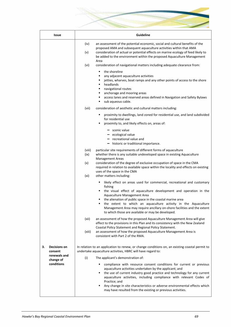
Hawke’s Bay Regional Coastal Environment Plan 69
Issue Guideline
(iv) an assessment of the potential economic, social and cultural benefits of the proposed AMA and subsequent aquaculture activities within that AMA
(v) consideration of actual or potential effects on marine ecology of feed likely to be added to the environment within the proposed Aquaculture Management Area
(vi) consideration of navigational matters including adequate clearance from:
the shoreline any adjacent aquaculture activities jetties, wharves, boat ramps and any other points of access to the shore headlands navigational routes anchorage and mooring areas access lanes and reserved areas defined in Navigation and Safety Bylaws sub aqueous cable.
(vii) consideration of aesthetic and cultural matters including:
proximity to dwellings, land zoned for residential use, and land subdivided for residential use
proximity to, and likely effects on, areas of:
− scenic value
− ecological value
− recreational value and
− historic or traditional importance.
(viii) particular site requirements of different forms of aquaculture (ix) whether there is any suitable undeveloped space in existing Aquaculture
Management Areas (x) consideration of the degree of exclusive occupation of space in the CMA
required in relation to available space within the locality and effects on existing uses of the space in the CMA
(xi) other matters including:
likely effect on areas used for commercial, recreational and customary fishing
the visual effect of aquaculture development and operation in the Aquaculture Management Area
the alienation of public space in the coastal marine area the extent to which an aquaculture activity in the Aquaculture
Management Area may require ancillary on-shore facilities and the extent to which those are available or may be developed.
(xii) an assessment of how the proposed Aquaculture Management Area will give effect to the provisions in this Plan and its consistency with the New Zealand Coastal Policy Statement and Regional Policy Statement.
(xiii) an assessment of how the proposed Aquaculture Management Area is consistent with Part 2 of the RMA.
3. Decisions on consent renewals and change of conditions
In relation to an application to renew, or change conditions on, an existing coastal permit to undertake aquaculture activities, HBRC will have regard to:
(i) The applicant's demonstration of:
compliance with resource consent conditions for current or previous aquaculture activities undertaken by the applicant; and
the use of current industry good practice and technology for any current aquaculture activities, including compliance with relevant Codes of Practice; and
Any change in site characteristics or adverse environmental effects which may have resulted from the existing or previous activities.

70 Hawke’s Bay Regional Coastal Environment Plan
Issue Guideline
(ii) any disturbance of the foreshore and seabed, and deposition or discharge in the coastal marine area (including feed) required to undertake the aquaculture activity
(iii) Effects on water quality, including nutrient enrichment, and the effects of any discharges to the coastal marine area;
(iv) Sustainability of the aquaculture activity effects on other existing aquaculture activities
(v) Changes to habitats within and inshore of the application area, including the introduction of exotic biota
(vi) Effects on other uses and values of the coastal marine area including navigational safety and anchorage, public access to and along the coast, recreational and commercial uses and utilities
(vii) Economic benefits to the national economy and the Hawke's Bay region and its communities
(viii) Environmental, social and cultural benefits to the Hawke's Bay region and its communities.
Policy 23.2 To implement the environmental guidelines for aquaculture activities set out in Policy 23.1 predominantly in the following manner:
(a) Resource consents - The environmental guidelines will be used in the process of making decisions on resource consents, in accordance with the RMA.
(b) Plan changes - the environmental guidelines will be used in the process of making decisions on new AMA proposals through the invited private plan change process under s165Z of the RMA and private plan change process under Schedule 1 of the RMA.
(c) Regional rules - The environmental guidelines have been incorporated into rules, (including conditions, standards and terms) set out in Part E of this Plan and provide a basis for the level of regulation used.
(d) Non-regulatory methods - The environmental guidelines for aquaculture activities in the CMA may also be implemented through non-regulatory methods where appropriate, including the provision of information, environmental monitoring and reporting, and liaison/ consultation with resource users, territorial authorities and other agencies.
Explanation and reasons
Aquaculture is a valid use of the coastal marine resource as it enables people and the Hawke's Bay community to utilise that resource to help provide for their wellbeing and economic benefit. It requires the occupation of space within the coastal marine area. The coastal marine area is a finite resource. There are many other uses of space in the CMA (such as recreational boating and commercial shipping) that may be affected by aquaculture activities. Space needs to be identified where aquaculture is appropriate and would not compromise safe recreation and navigation in the coastal marine area. The RMA empowers regional councils to create Aquaculture Management Areas (“AMAs”) which are zones where aquaculture can be undertaken with a coastal permit. Outside AMAs, aquaculture activities are prohibited.
Guideline 1 suggests that sporadic development of aquaculture should be avoided and space within AMAs should be used efficiently. Further development of the Hawke's Bay coastal marine area for aquaculture will be provided through a variation or change to the Plan (Guideline 2(c)). This ensures that any future aquaculture development is the subject of wide public consultation. This procedure will also ensure that costs of establishing a new AMA are shifted to those who stand to benefit, ie: the resource user.
The main known or potential effects of aquaculture in Hawke's Bay include:
(a) physical exclusion of other uses from the marine farm area (b) restriction of public access (c) interference with navigation (d) interference with dynamic coastal processes and natural character (e) visual impacts of structures (f) potential displacement or entanglement of some marine mammal species (g) nutrient depletion (h) potential siltation and build-up of organic matter and (i) the build-up of shell debris on the seafloor under shellfish farms.
Aquaculture can be a sustainable use of the coastal marine area if it is managed appropriately. There are many competing uses and values, such as recreational boating, shipping routes areas of high ecological value and fishing activities in the coastal marine area that need to be considered when providing for aquaculture. The coastal marine area is a finite resource, so it is importance that competing interests be managed effectively. Guideline 2 recognises that space for, and within, AMAs needs to be appropriately allocated to ensure that efficient use is made of these areas and that the balance of the coastal marine area can be sustainably managed for other uses, developments or protection purposes. The Maori Commercial Aquaculture Claims Settlement Act 2004 requires 20% of all new AMA space identified in the coastal marine area to be transferred to iwi, via the Maori Commercial Aquaculture Settlement Trust. The 20% allocated space should be representative of each farming type covered by the rules in the AMA, and the overall productive capacity of the new space.
In Hawke's Bay, demand for aquaculture space is not great at present and environmental conditions are not thought to be highly suitable for aquaculture activities. The HBRC is responsible for allocating space within AMAs – regardless of whether the AMA was initiated by the Council or by private interests. Coastal tendering is the ‘default’ method under the RMA of allocating space within AMAs. The RMA allows regional councils to adopt an alternative means of allocating space within AMAs. Tendering can

Hawke’s Bay Regional Coastal Environment Plan 71
be extremely effective when there is high demand for a resource. However, where there is little demand, as is the case for space for aquaculture in Hawke's Bay, then tendering is not considered the best option. The HBRC has considered other options for allocation, including balloting (a random allocation), fitness/suitability of applicant, priority in time (first in, first served) and apportionment by share (which involves dividing space equally).
The process to establish a new AMA is likely to be expensive and without some certainty to actually occupy the AMA once created. This may be too great a disincentive for private parties to proceed with aquaculture development. This, in addition to the small demand for aquaculture space in the region, has led the HBRC to adopt a “priority in time” process based on a first in first served formula to allocate any new AMA space in the region. This is stated in Guideline 2(a). This may be an interim measure until a more robust and effective alternative allocation method can be developed nationally, perhaps by an individual local authority or a group of councils in the future.
As aquaculture can only occur within AMAs, it is important that these areas can function appropriately for the primary purpose of carrying out aquaculture activities. Guideline 2(b) recognises this as it suggests structures and activities that compromise the use of AMAs for carrying out aquaculture activities are considered inappropriate and generally, consents will not be granted. Land use activities and use of the coastal marine area may affect the quality of coastal water and consequently have an impact on aquaculture activities by degraded water quality. Maintenance of coastal water quality is addressed in more detail elsewhere in this Plan.
Guideline 2(c) identifies a range of information that may be required in support of a plan change request that seeks to include a new AMA in this Plan. By stating these, the Plan provides clear instructions to applicants on what information should support efforts to identify new AMAs in Hawke's Bay.
Anticipated environmental results
Anticipated Environmental Result Indicator Data Source
23.1 Development of aquaculture activities within Aquaculture Management Areas.
Physical parameters Compliance monitoring
23.2 Avoidance of sprawling and sporadic development of aquaculture activities and associated structures.
Physical parameters Compliance monitoring
23.3 Protection of natural character, outstanding natural landscapes, amenity, coastal processes, water quality, ecological and cultural values from inappropriate aquaculture activities.
Physical and biological parameters HBRC Nearshore coastal water quality monitoring programme
Compliance monitoring
HBRC records

72 Hawke’s Bay Regional Coastal Environment Plan
24 Hazardous substances in CMA
Issue 24.1
There is a risk of adverse effects on the coastal marine area arising from the use, storage, disposal and transportation of hazardous substances within the coastal environment.
Objectives
Obj 24.1 Risks to human health and the environment associated with the use, storage and transportation of hazardous substances within the coastal environment, are avoided, remedied or mitigated.
Obj 24.2 Adverse effects on the environment associated with the disposal of hazardous substances to the coastal environment are avoided.
Policies
Policy 24.1 To manage hazardous substances in the coastal marine area in accordance with the environmental guidelines set out in Table 24-1.
Table 24-1: Environmental Guidelines – Hazardous substances in CMA.
Issue Guideline
1. Management approach
(a) The safe use, storage and transportation of hazardous substances within the coastal environment will be promoted.
(b) Disposal of hazardous substances in the coastal marine area shall be prohibited.
(c) Storage of hazardous substances within a Significant Conservation Area shall be prohibited.
2. Precautionary approach
A precautionary approach will be adopted in the assessment of assessing actual and potential effects arising from the use, storage and transportation of hazardous substances in the coastal marine area.
Policy 24.2 To implement the environmental guidelines for hazardous substances set out in Policy 24.1 predominantly in the following manner:
(a) Resource consents - The environmental guidelines will be used in the process of making decisions on resource consents, in accordance with the RMA.
(b) Regional rules - The environmental guidelines have been incorporated into rules, (including conditions, standards and terms) set out in Part E of this Plan and provide a basis for the level of regulation used.
(c) Non-regulatory methods - The environmental guidelines for hazardous substances in the CMA may also be implemented through non-regulatory methods where appropriate, including the provision of information, environmental monitoring and reporting, and liaison/ consultation with resource users, territorial authorities and other agencies.
Explanation and reasons
The objectives seek to avoid, remedy or mitigate adverse effects on the environment, particularly on human health arising from the use, storage, disposal and transportation of hazardous substances in the coastal environment. The achievement of these objectives would resolve issues associated with these activities and help promote the sustainable management of the coastal environment.
The policies and guidelines are necessary to achieve the purpose of the RMA because they provide the appropriate framework to support the objective and allow people and communities to provide for their social and economic wellbeing while sustaining the potential of natural and physical resources to meet the needs of future generations, safeguarding the life supporting capacity of the foreshore and seabed and avoiding adverse effects on the environment.
Under the RMA, HBRC in conjunction with territorial authorities, is responsible for preventing or mitigating any adverse effects of the storage, use, disposal or transportation of hazardous substances in the region (including the coastal marine area). The respective responsibilities of the HBRC and territorial authorities are stated in the Hawke's Bay Regional Resource Management Plan. Specific responsibility for controlling any adverse effects of the storage, use, disposal or transportation of hazardous substances within the coastal marine area remains with the HBRC under s30(d)(v) of the RMA.
Guideline 1 recognises that risks associated with the use, storage and transportation of hazardous substances can be minimised by adoption of safe handling, storage, and transport methods. Guideline 1 also relates to HBRC’s function under s30(1)(d)(v) of the RMA. Risks to water quality, ecosystems, coastal processes and people’s health can be avoided by disposing hazardous substances at purpose-built disposal facilities rather than by dumping in the coastal marine area.
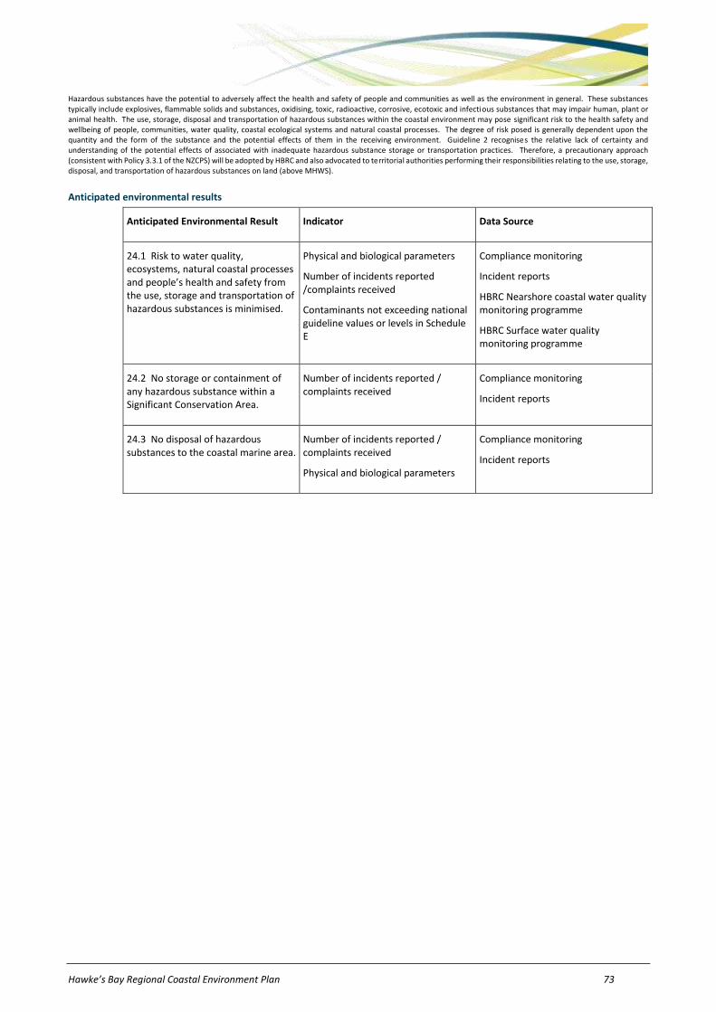
Hawke’s Bay Regional Coastal Environment Plan 73
Hazardous substances have the potential to adversely affect the health and safety of people and communities as well as the environment in general. These substances typically include explosives, flammable solids and substances, oxidising, toxic, radioactive, corrosive, ecotoxic and infectious substances that may impair human, plant or animal health. The use, storage, disposal and transportation of hazardous substances within the coastal environment may pose significant risk to the health safety and wellbeing of people, communities, water quality, coastal ecological systems and natural coastal processes. The degree of risk posed is generally dependent upon the quantity and the form of the substance and the potential effects of them in the receiving environment. Guideline 2 recognises the relative lack of certainty and understanding of the potential effects of associated with inadequate hazardous substance storage or transportation practices. Therefore, a precautionary approach (consistent with Policy 3.3.1 of the NZCPS) will be adopted by HBRC and also advocated to territorial authorities performing their responsibilities relating to the use, storage, disposal, and transportation of hazardous substances on land (above MHWS).
Anticipated environmental results
Anticipated Environmental Result Indicator Data Source
24.1 Risk to water quality, ecosystems, natural coastal processes and people’s health and safety from the use, storage and transportation of hazardous substances is minimised.
Physical and biological parameters
Number of incidents reported /complaints received
Contaminants not exceeding national guideline values or levels in Schedule E
Compliance monitoring
Incident reports
HBRC Nearshore coastal water quality monitoring programme
HBRC Surface water quality monitoring programme
24.2 No storage or containment of any hazardous substance within a Significant Conservation Area.
Number of incidents reported / complaints received
Compliance monitoring
Incident reports
24.3 No disposal of hazardous substances to the coastal marine area.
Number of incidents reported / complaints received
Physical and biological parameters
Compliance monitoring
Incident reports
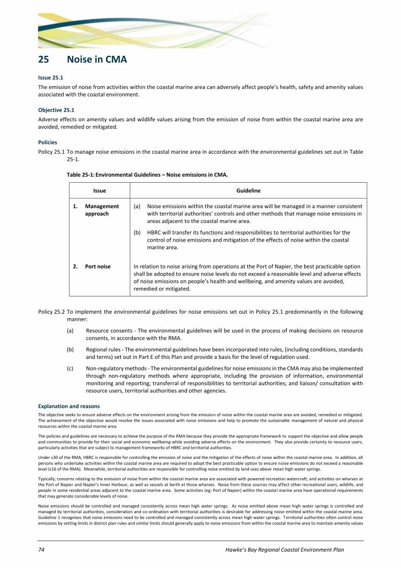
74 Hawke’s Bay Regional Coastal Environment Plan
25 Noise in CMA
Issue 25.1
The emission of noise from activities within the coastal marine area can adversely affect people’s health, safety and amenity values associated with the coastal environment.
Objective 25.1
Adverse effects on amenity values and wildlife values arising from the emission of noise from within the coastal marine area are avoided, remedied or mitigated.
Policies
Policy 25.1 To manage noise emissions in the coastal marine area in accordance with the environmental guidelines set out in Table 25-1.
Table 25-1: Environmental Guidelines – Noise emissions in CMA.
Issue Guideline
1. Management approach
(a) Noise emissions within the coastal marine area will be managed in a manner consistent with territorial authorities’ controls and other methods that manage noise emissions in areas adjacent to the coastal marine area.
(b) HBRC will transfer its functions and responsibilities to territorial authorities for the control of noise emissions and mitigation of the effects of noise within the coastal marine area.
2. Port noise In relation to noise arising from operations at the Port of Napier, the best practicable option shall be adopted to ensure noise levels do not exceed a reasonable level and adverse effects of noise emissions on people’s health and wellbeing, and amenity values are avoided, remedied or mitigated.
Policy 25.2 To implement the environmental guidelines for noise emissions set out in Policy 25.1 predominantly in the following manner:
(a) Resource consents - The environmental guidelines will be used in the process of making decisions on resource consents, in accordance with the RMA.
(b) Regional rules - The environmental guidelines have been incorporated into rules, (including conditions, standards and terms) set out in Part E of this Plan and provide a basis for the level of regulation used.
(c) Non-regulatory methods - The environmental guidelines for noise emissions in the CMA may also be implemented through non-regulatory methods where appropriate, including the provision of information, environmental monitoring and reporting; transferral of responsibilities to territorial authorities; and liaison/ consultation with resource users, territorial authorities and other agencies.
Explanation and reasons
The objective seeks to ensure adverse effects on the environment arising from the emission of noise within the coastal marine area are avoided, remedied or mitigated. The achievement of the objective would resolve the issues associated with noise emissions and help to promote the sustainable management of natural and physical resources within the coastal marine area.
The policies and guidelines are necessary to achieve the purpose of the RMA because they provide the appropriate framework to support the objective and allow people and communities to provide for their social and economic wellbeing while avoiding adverse effects on the environment. They also provide certainty to resource users, particularly activities that are subject to management frameworks of HBRC and territorial authorities.
Under s30 of the RMA, HBRC is responsible for controlling the emission of noise and the mitigation of the effects of noise within the coastal marine area. In addition, all persons who undertake activities within the coastal marine area are required to adopt the best practicable option to ensure noise emissions do not exceed a reasonable level (s16 of the RMA). Meanwhile, territorial authorities are responsible for controlling noise emitted by land uses above mean high water springs.
Typically, concerns relating to the emission of noise from within the coastal marine area are associated with powered recreation watercraft, and activities on wharves at the Port of Napier and Napier’s Inner Harbour, as well as vessels at berth at those wharves. Noise from these sources may affect other recreational users, wildlife, and people in some residential areas adjacent to the coastal marine area. Some activities (eg: Port of Napier) within the coastal marine area have operational requirements that may generate considerable levels of noise.
Noise emissions should be controlled and managed consistently across mean high water springs. As noise emitted above mean high water springs is controlled and managed by territorial authorities, consideration and co-ordination with territorial authorities is desirable for addressing noise emitted within the coastal marine area. Guideline 1 recognises that noise emissions need to be controlled and managed consistently across mean high water springs. Territorial authorities often control noise emissions by setting limits in district plan rules and similar limits should generally apply to noise emissions from within the coastal marine area to maintain amenity values

Hawke’s Bay Regional Coastal Environment Plan 75
of the area. Limits on reasonable noise levels in different areas of the coast will depend on the sensitivity of those areas. Guideline 1 also refers to the ability of, and action already taken by, HBRC transferring to TLAs its functions and responsibilities relating to the control of noise emissions and mitigation of the effects of noise within the coastal marine area.
Guideline 2 recognises that a sustainable approach to managing noise emissions arising from port operations is required for many of New Zealand’s ports, including Port of Napier. New Zealand Standard NZS6809:1999 ‘Acoustics – Port Noise Management and Land Use Planning’ adopts an approach which integrates management of noise effects from the coastal marine area with those from adjacent port operations on land. The Standard provides a basis for control and management of noise from all port operations, taking into account port operational issues and providing certainty to both resource user and nearby land uses. A similar management framework based on this Standard is incorporated into Napier City’s District Plan for the port and surrounding areas not within the coastal marine area.
Anticipated environmental results
Anticipated Environmental Result Indicator Data Source
25.1 People’s health and amenity values not adversely affected by emissions of noise from within the coastal marine area.
Number of incident reports / complaints received
Territorial authorities, HBRC records
Incident reports
25.2 Consistent management and control across mean high water springs of noise emissions and mitigation of the effects of noise.
Number of incident reports / complaints received
Transfer of HBRC functions to TLAs
Territorial authorities, HBRC records
Incident reports
76 Hawke’s Bay Regional Coastal Environment Plan
26 PART E – Introduction to Coastal Environment Rules
26.1 Rule interpretation
Introduction
This chapter provides some information on how to interpret regional rules under the RMA. However, the HBRC can provide more detailed information on interpreting regional rules and consent application processes. HBRC staff should be contacted by anyone who is in doubt about understanding the rules in this Plan or the resource consent process.
Chapter 27 of this Plan contains rules which allow, regulate, or prohibit resource use activities. This Users' Guide (Chapter 26) has been prepared to assist readers to locate and understand rules of interest. It provides the following:
(a) an explanation of the classification of activities under the RMA and
(b) a guide to understanding how the rules are set out in the tables.
In addition, Schedule C provides a guide to interpreting the terms ‘noxious’, ‘dangerous’, ‘offensive’ and ‘objectionable’, which are used in several rules, especially those regulating the discharge of contaminants into air.
26.2 Rule classifications
If an activity is classified in a rule as:
(a) Permitted, it can be carried out without a resource consent provided the conditions in the rule are met and continue to be met.
(b) Controlled, a resource consent is required, but HBRC must grant the consent (unless it has insufficient information to determine whether or not the activity is a controlled activity). HBRC may impose conditions on the consent relating to matters specified in the rule over which control is reserved and the activity must comply with the standards and terms in the rule. HBRC reserves its control over the following matters in addition to any matters specified in the rule tables:
(i) financial contributions in the form of money or land or a combination of these (ii) bonds or covenants or both, to ensure performance of, or compliance with, any conditions imposed (iii) works or services to ensure the protection, restoration, or enhancement of any natural or physical resource,
including (but not limited to) planting or replanting, earthworks, or any other works or services necessary to ensure the avoidance, remediation or mitigation of adverse environmental effects
(iv) administrative charges to be paid to HBRC in respect of processing applications, administration, monitoring and supervision of resource consents, and for the carrying out of the HBRC’s functions under s35 of the RMA
(v) requirements for a consent holder to supply HBRC with information relating to the exercise of the consent (vi) requirements for a consent holder to record measurements, take samples, carry out analyses, surveys,
investigations, inspections or other specified tests (vii) requirements for a consent holder to adopt the best practicable option to prevent or minimise any actual or
likely adverse effect on the environment of a discharge of contaminants (viii) the duration of a resource consent, under s123 of the RMA (ix) the lapsing of a resource consent, under s125 of the RMA (x) provision for the review of some or all of the conditions at some time in the future, under s128 of the RMA.
NOTE: When considering resource consent applications and setting consent conditions, HBRC will have regard to relevant objectives and policies in the Regional Policy Statement parts of the Hawke's Bay Regional Resource Management Plan (particularly Chapter 3.2 and Schedule I); and the relevant objectives and policies elsewhere in this Plan.
(c) Restricted discretionary, a resource consent is required, and HBRC will decide whether or not to grant the consent. However, HBRC’s powers to decline consent and to impose conditions are restricted to exercising its discretion over the list of matters specified in the rule and the following matters:
(i) financial contributions in the form of money or land or a combination of these (ii) bonds or covenants or both, to ensure performance of, or compliance with, any conditions imposed (iii) works or services to ensure the protection, restoration, or enhancement of any natural or physical resource,
including (but not limited to) planting or replanting, earthworks, or any other works or services necessary to ensure the avoidance, remediation or mitigation of adverse environmental effects
(iv) administrative charges to be paid to HBRC in respect of processing applications, administration, monitoring and supervision of resource consents, and for the carrying out of the HBRC’s functions under s35 of the RMA
(v) requirements for a consent holder to supply HBRC with information relating to the exercise of the consent (vi) requirements for a consent holder to record measurements, take samples, carry out analyses, surveys,
investigations, inspections or other specified tests

Hawke’s Bay Regional Coastal Environment Plan 77
(vii) requirements for a consent holder to adopt the best practicable option to prevent or minimise any actual or likely adverse effect on the environment of a discharge of contaminants
(viii) the duration of a resource consent, under s123 of the RMA (ix) the lapsing of a resource consent, under s125 of the RMA (x) provision for the review of some or all of the conditions at some time in the future, under s128 of the RMA.
NOTE: When considering resource consent applications and setting consent conditions, HBRC will have regard to relevant objectives and policies in the Regional Policy Statement parts of the Hawke's Bay Regional Resource Management Plan (particularly Chapter 3.2 and Schedule I); and the relevant objectives and policies elsewhere in this Plan.
(d) Discretionary, a resource consent is required, and the HBRC will decide whether or not to grant the consent. Whether or not the Council grants consent will depend upon the effects of the activity and how consistent the proposed activity is with provisions of the RMA and the objectives and policies set in this Plan.
NOTE: When considering resource consent applications and setting consent conditions, HBRC will have regard to relevant objectives and policies in the Regional Policy Statement parts of the Hawke's Bay Regional Resource Management Plan (particularly Chapter 3.2 and Schedule I); and the relevant objectives and policies elsewhere in this Plan.
(e) Non-complying, a resource consent is required, and can only be granted if the adverse effects on the environment will be minor, or the activity is not contrary to the objectives and policies of this Plan;
NOTE: When considering resource consent applications and setting consent conditions, HBRC will have regard to relevant objectives and policies in the Regional Policy Statement parts of the Hawke's Bay Regional Resource Management Plan (particularly Chapter 3.2 and Schedule I); and the relevant objectives and policies elsewhere in this Plan.
(f) Prohibited, the activity is not allowed under any circumstances, subject to s77C of the RMA.
(g) Restricted coastal activity, a resource consent is required. Applications will be publicly notified. The Minister of Conservation is the consent authority who will decide whether or not to grant the consent. However, HBRC holds a hearing and makes a recommendation to the Minister. That recommendation is appealable to the Environment Court which then makes its own (non binding) recommendation to the Minister.
Figure 26-1 provides an overview of how the activity classifications work.
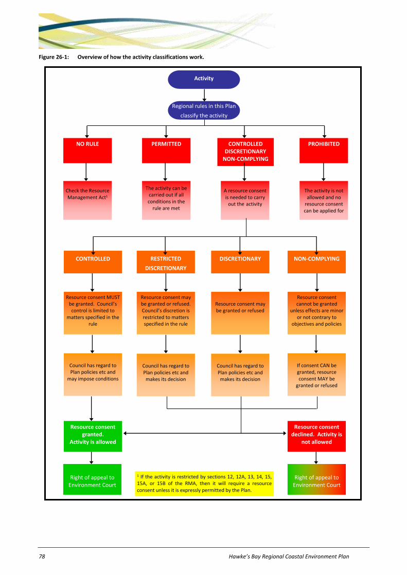
78 Hawke’s Bay Regional Coastal Environment Plan
Figure 26-1: Overview of how the activity classifications work.
Regional rules in this Plan
classify the activity
CONTROLLED DISCRETIONARY
NON-COMPLYING
PROHIBITED PERMITTED NO RULE
Check the Resource Management Act1
The activity can be carried out if all conditions in the
rule are met
A resource consent is needed to carry
out the activity
The activity is not allowed and no
resource consent can be applied for
DISCRETIONARY NON-COMPLYING CONTROLLED
Resource consent MUST be granted. Council’s control is limited to
matters specified in the rule
Resource consent may be granted or refused
Resource consent cannot be granted
unless effects are minor or not contrary to
objectives and policies
Council has regard to Plan policies etc and
may impose conditions
Council has regard to Plan policies etc and makes its decision
If consent CAN be granted, resource consent MAY be
granted or refused
Resource consent granted.
Activity is allowed
Resource consent declined. Activity is
not allowed
Right of appeal to
Environment Court
Right of appeal to
Environment Court
1 If the activity is restricted by sections 12, 12A, 13, 14, 15, 15A, or 15B of the RMA, then it will require a resource consent unless it is expressly permitted by the Plan.
Activity
RESTRICTED
DISCRETIONARY
Resource consent may be granted or refused. Council’s discretion is restricted to matters specified in the rule
Council has regard to Plan policies etc and makes its decision

Hawke’s Bay Regional Coastal Environment Plan 79
26.3 Guide to rule tables
The rules in this Plan are arranged in tables. Within each of the rule tables there are six columns headed as follows:
Rule
This column contains the rule number together with a brief title for the rule.
Activity
The activity column describes the activity to be undertaken. For the activity to be considered under this rule it must be consistent with the description contained in this column, and meet any criteria contained in the conditions/standards/terms column.
Classification
This column contains the classification of the activity, i.e. permitted, controlled, restricted discretionary, discretionary, non-complying or prohibited. Activity classifications are explained in earlier in this Chapter.
Conditions / Standards / Terms
This column contains conditions for permitted activities, and standards and terms for controlled and restricted discretionary activities. (Note that standards and terms must be stated for controlled activities, but may or may not be stated for restricted discretionary activities.) The conditions, standards and terms are requirements that must be met for the activity to be in the activity class concerned. If the conditions are not met, the rule will not apply and another rule will apply in its place. If consent is granted, the standards or terms will be incorporated into conditions of consent. Failure to comply with conditions on a permitted activity will mean that the activity is no longer permitted, and would thus require a resource consent. This would also amount to a breach of the rule and may be subject to enforcement action.
Matters for Control / Discretion
This column is relevant only for controlled activities and restricted discretionary activities. For controlled activities, this column contains the matters over which HBRC has reserved its control. For restricted discretionary activities, it contains the matters to which HBRC has restricted the exercise of its discretion (also refer to earlier parts of this Chapter). When this column is blank, it means that the activity is classified as a permitted, discretionary, non-complying or prohibited activity.
Notification Requirements
This column is also only relevant for controlled or restricted discretionary activities. For these activity classifications, the HBRC may state whether a consent application for the activity could be considered without notification, and/or without the need to obtain the written approval of affected persons and/or whether notice of the application needs to be served on people affected by the application.
It is important to note that a consent application for a discretionary or non-complying activity may also be considered without public notification if the consent authority is satisfied that the adverse effects of the activity on the environment will be minor, and written approval has been obtained from every affected person. An affected person is a person who is affected in a manner different from the public generally (an interested party or interest group is not necessarily an affected person).
Footnotes
Footnotes are used in the rule tables to express important information on the implementation of rules and/or conditions, and also to provide advisory notes to Plan users.
26.4 Regional Coastal Environment Rules
Table 26-1 provides a summary of the rules for easy reference.
It is important to note that a ‘permitted activity’ as described in the summary in Table 26-1 may be undertaken without a resource consent only if the activity fits the description and complies with all the relevant conditions/standards/ terms. The policies referred to in Table 26-1 is only a selection of the more relevant policies in this Plan – it is not a comprehensive list of all policies that relate to a particular rule or activity.
The rules are to be read subject to the following:
(a) Rules in Chapters 27.1 – 27.4 only apply within the Coastal Margin (ie: not within the coastal marine area). Chapters 27.5 and 27.6 contain rules that apply throughout the region’s coastal environment (ie: both within and outside the coastal marine area). The rules in Chapters 27.7 – 27.16 apply to activities and effects in the coastal marine area. The coastal environment is described in Chapter 1 and the landward boundary of the coastal environment is identified on the planning maps. The coastal marine area is also described in Chapter 1 of this Plan.
(b) Some rules only apply within parts of the coastal environment or parts of the coastal marine area. This is generally indicated in the heading with reference made to the management area(s) to which that rule applies.
(c) Where an activity is classified as a prohibited activity in the rules of this Plan, it shall be read as an activity for which no resource consent shall be granted (subject to s77B and s77C of the RMA).

80 Hawke’s Bay Regional Coastal Environment Plan
(d) Where a resource consent is required from the HBRC for an activity and there is no relevant rule in this Plan or this Plan does not classify the activity as controlled, restricted discretionary, discretionary or non-complying, the activity will be treated as a discretionary activity in accordance with s77C of the RMA).
(e) Where a rule refers to occupation of space in the coastal marine area, the rule only applies in relation to land of the Crown in the coastal marine area or land in the coastal marine area vested in the HBRC, (NOTE, ‘land’ under the RMA also includes the water column and air space above the land).
(f) Where an activity may fit within two or more rules, HBRC will generally apply the rule which in its opinion best fits the activity. Where a proposal requires multiple resource consents from HBRC, the proposal will generally be considered as a whole and usually the most restrictive activity classification applying to any component activity will apply to the overall activity.

Hawke’s Bay Regional Coastal Environment Plan 81
Table 26-1: Summary of regional coastal environment rules.
Chapter Rule #
RULE TITLE CLASSIFICATION RELATED POLICIES7
Pg
27.1 USE AND DEVELOPMENT OF LAND IN COASTAL MARGIN 86 Rule 1 Decommissioning of bores Permitted 11.1 86 Rule 2 Bore drilling and use Controlled 11.1 86 Rule 3 Bore drilling that does not comply with Rule 2 Rest. Discretionary 11.1 87 Rule 4 Unwanted or leaking bores Non-Complying 11.1 87 Rule 5 Feedlots and feedpads Controlled 9.1 87 Rule 6 Feedlots and feedpads that do not comply with Rule 5 Rest. Discretionary 9.1 88 Rule 7 Vegetation clearance and soil disturbance Permitted 8.1; 9.1 89 Rule 8 Vegetation clearance and soil disturbance that do not comply with
Rule 7 Rest. Discretionary 8.1; 9.1 90
27.2 DISCHARGES TO AIR / LAND / WATER IN COASTAL MARGIN 91 Rule 9 Discharges of contaminants not regulated by, or not complying
with, other rules Discretionary 8.1; 9.1; 11.1;
16.1 91
Rule 10 Burial of dead fish, marine mammals and other dead animals Permitted 17.1 91 Rule 11 Small-scale application of agrichemicals Permitted 14.1 91 Rule 12 Widespread application of agrichemicals Permitted 14.1 92 Rule 13 Stock feed on production land Permitted 9.1; 11.1; 14.1 95 Rule 14 Use of fertiliser, compost, biosolids, and other soil conditioners Permitted 9.1; 11.1; 14.1 95 Rule 15 Storage of fertiliser, compost and biosolids Permitted 9.1; 11.1; 14.1 96 Rule 16 Management of solid waste on production land Permitted 8.1; 9.1; 11.1 97 Rule 17 Discharge of contaminants to surface water Permitted 9.1 98 Rule 18 Discharge of solid contaminants (incl cleanfill) to land that will not
enter water Permitted 8.1 100
Rule 19 Discharge of contaminants to land that may enter water Permitted 9.1; 11.1 101 Rule 20 Discharge of animal effluent Controlled 8.1; 9.1; 11.1;
13.1 102
Rule 21 Discharge of animal effluent in sensitive catchments and SMAs Discretionary 8.1; 9.1; 11.1 103
Water and Drainage Water
Rule 22 Discharge of water to water Permitted 9.1; 10.1; 13.1 103 Rule 23 Discharge of drainage water to water (gravity flow systems) Permitted 9.1; 10.1; 13.1 103 Rule 24 Discharge of drainage water to water (pumped systems) Controlled 9.1; 10.1; 13.1 104
Stormwater
Rule 25 Small-scale diversion and discharge of stormwater Permitted 9.1; 10.1; 13.1; 16.1
105
Rule 26 Large-scale diversion and discharge of stormwater Controlled 9.1; 10.1; 13.1; 16.1
105
Wastewater
Rule 27 Existing wastewater systems Permitted 9.1; 11.1; 16.1 106 Rule 28 New wastewater systems Permitted 9.1; 11.1; 16.1 107 Rule 29 Existing high discharge volume wastewater systems Rest. Discretionary 9.1; 11.1; 16.1 109 Rule 30 Discharge of septage Discretionary 8.1; 9.1; 11.1;
16.1 110
Landfills, Transfer Stations Waste Oil and Bore Drilling Fluids
Rule 31 Discharge of bore drilling fluids to land or water Permitted 9.1; 11.1; 16.1 110 Rule 32 Discharges from closed landfills Controlled 9.1; 11.1; 16.1 110 Rule 33 Discharges from operating landfills and transfer stations Discretionary 9.1; 11.1; 16.1 111 Rule 34 Discharge of waste oil Non-Complying 9.1; 11.1; 16.1 111
27.3 TAKE, DIVERSION, AND TRANSFER OF WATER IN COASTAL MARGIN 112 Take and Use of Water Rule 35 Taking and use of surface water and groundwater not regulated by,
or not complying with, other rules Discretionary 9.1; 10.1; 11.1;
12.1 112
Rule 36 Minor takes and uses of groundwater Permitted 11.1; 12.1 112 Rule 37 Aquifer testing Permitted 11.1; 12.1 112 Rule 38 Minor takes and uses of surface water Permitted 9.1; 10.1 112
7 This is not intended as an exhaustive listing of all policies relating to any particular rule.
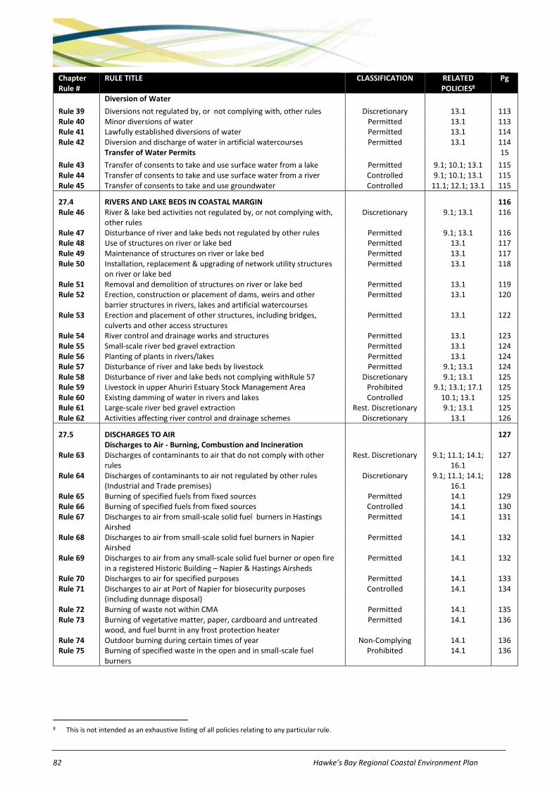
82 Hawke’s Bay Regional Coastal Environment Plan
Chapter Rule #
RULE TITLE CLASSIFICATION RELATED POLICIES8
Pg
Diversion of Water
Rule 39 Diversions not regulated by, or not complying with, other rules Discretionary 13.1 113 Rule 40 Minor diversions of water Permitted 13.1 113 Rule 41 Lawfully established diversions of water Permitted 13.1 114 Rule 42 Diversion and discharge of water in artificial watercourses Permitted 13.1 114
Transfer of Water Permits 15
Rule 43 Transfer of consents to take and use surface water from a lake Permitted 9.1; 10.1; 13.1 115 Rule 44 Transfer of consents to take and use surface water from a river Controlled 9.1; 10.1; 13.1 115 Rule 45 Transfer of consents to take and use groundwater Controlled 11.1; 12.1; 13.1 115
27.4 RIVERS AND LAKE BEDS IN COASTAL MARGIN 116 Rule 46 River & lake bed activities not regulated by, or not complying with,
other rules Discretionary 9.1; 13.1 116
Rule 47 Disturbance of river and lake beds not regulated by other rules Permitted 9.1; 13.1 116 Rule 48 Use of structures on river or lake bed Permitted 13.1 117 Rule 49 Maintenance of structures on river or lake bed Permitted 13.1 117 Rule 50 Installation, replacement & upgrading of network utility structures
on river or lake bed Permitted 13.1 118
Rule 51 Removal and demolition of structures on river or lake bed Permitted 13.1 119 Rule 52 Erection, construction or placement of dams, weirs and other
barrier structures in rivers, lakes and artificial watercourses Permitted 13.1 120
Rule 53 Erection and placement of other structures, including bridges, culverts and other access structures
Permitted 13.1 122
Rule 54 River control and drainage works and structures Permitted 13.1 123 Rule 55 Small-scale river bed gravel extraction Permitted 13.1 124 Rule 56 Planting of plants in rivers/lakes Permitted 13.1 124 Rule 57 Disturbance of river and lake beds by livestock Permitted 9.1; 13.1 124 Rule 58 Disturbance of river and lake beds not complying withRule 57 Discretionary 9.1; 13.1 125 Rule 59 Livestock in upper Ahuriri Estuary Stock Management Area Prohibited 9.1; 13.1; 17.1 125 Rule 60 Existing damming of water in rivers and lakes Controlled 10.1; 13.1 125 Rule 61 Large-scale river bed gravel extraction Rest. Discretionary 9.1; 13.1 125 Rule 62 Activities affecting river control and drainage schemes Discretionary 13.1 126
27.5 DISCHARGES TO AIR 127 Discharges to Air - Burning, Combustion and Incineration Rule 63 Discharges of contaminants to air that do not comply with other
rules Rest. Discretionary 9.1; 11.1; 14.1;
16.1 127
Rule 64 Discharges of contaminants to air not regulated by other rules (Industrial and Trade premises)
Discretionary 9.1; 11.1; 14.1; 16.1
128
Rule 65 Burning of specified fuels from fixed sources Permitted 14.1 129 Rule 66 Burning of specified fuels from fixed sources Controlled 14.1 130 Rule 67 Discharges to air from small-scale solid fuel burners in Hastings
Airshed Permitted 14.1 131
Rule 68 Discharges to air from small-scale solid fuel burners in Napier Airshed
Permitted 14.1 132
Rule 69 Discharges to air from any small-scale solid fuel burner or open fire in a registered Historic Building – Napier & Hastings Airsheds
Permitted 14.1 132
Rule 70 Discharges to air for specified purposes Permitted 14.1 133 Rule 71 Discharges to air at Port of Napier for biosecurity purposes
(including dunnage disposal) Controlled 14.1 134
Rule 72 Burning of waste not within CMA Permitted 14.1 135 Rule 73 Burning of vegetative matter, paper, cardboard and untreated
wood, and fuel burnt in any frost protection heater Permitted 14.1 136
Rule 74 Outdoor burning during certain times of year Non-Complying 14.1 136 Rule 75 Burning of specified waste in the open and in small-scale fuel
burners Prohibited 14.1 136
8 This is not intended as an exhaustive listing of all policies relating to any particular rule.

Hawke’s Bay Regional Coastal Environment Plan 83
Chapter Rule #
RULE TITLE CLASSIFICATION RELATED POLICIES9
Pg
Rule 76 Discharges to air from open fires in Napier/Hastings Airshed Prohibited 14.1 137 Rule 77 Discharges to air from small-scale solid fuel burners in Napier
Airshed Prohibited 14.1 137
Rule 78 Discharges to air from small-scale solid fuel burners at property ownership transfer in Napier Airshed
Prohibited 14.1 138
Discharges to Air – Other Activities
Rule 79 Flaring of hydrocarbons from petroleum exploration or mining in CMA
Controlled 14.1 138
Rule 80 Moveable aggregate crushing and screening plants Permitted 14.1 138 Rule 81 Minor discharges to air from industrial and trade premises Permitted 14.1 139 Rule 82 Management of waste and other matter, excluding industrial and
trade premises Permitted 14.1 140
Rule 83 Wet abrasive blasting Permitted 14.1 140 Rule 84 Dry abrasive blasting – fixed source Permitted 14.1 141 Rule 85 Dry abrasive blasting – moveable source Discretionary 14.1 141 Rule 86 Miscellaneous discharges to air from industrial and trade premises Discretionary 14.1 141 Rule 87 Moveable asphalt plants Discretionary 14.1 143 Rule 88 Moveable road burners Non-Complying 14.1 143
27.6 COASTAL HAZARDS 144 Land Use Activities in Coastal Hazard Zones Rule 89 Minor land uses in CHZ1, CHZ2 and CHZ3 Permitted 15.1 144 Rule 90 Land use activities in CHZ1, CHZ2, and CHZ3 not complying with
conditions Rest. Discretionary 15.1 145
Rule 91 Non-reticulated wastewater systems in CHZ3 Permitted 15.1 145 Rule 92 Temporary activities in any CHZ Permitted 15.1 146 Rule 93 Coastal enhancement projects in CHZ1 or CHZ2 Permitted 15.1 146 Rule 94 Network utility structures in CHZ3 Permitted 15.1 146 Rule 95 Building work in CHZ2 Rest. Discretionary 15.1 146 Rule 96 Small-scale additions and alterations projecting seaward of existing
building in CHZ1 Rest. Discretionary 15.1 147
Rule 97 New network utility operation structures in CHZ1 or CHZ2 not within a road reserve
Rest. Discretionary 15.1 148
Rule 98 Maintenance and repair of coastal protection structures Rest. Discretionary 15.1 149 Rule 99 Upgrading of lawfully established local authority stormwater and
coastal water structures in CHZ1 or CHZ2 Controlled 15.1 149
Rule 100 Coastal protection structures Non-Complying 15.1 150 Rule 101 Replacement of structures in CHZ1 or CHZ2 damaged by action of
sea Non-Complying 15.1 150
Rule 102 Building work in CHZ1 Non-Complying 15.1 151 Deposition and Removal of Material Rule 103 Deposition of sediment for Westshore Beach Renourishment
Scheme Controlled 15.1 151
Rule 104 Deposition of sediment in CHZ1 Rest. Discretionary 15.1 152 Rule 105 Removal of gravel and other earthworks within the Parade Gravel
Extraction Area Controlled 15.1 153
Rule 106 Removal of gravel and other earthworks within the Parade Gravel Extraction Area not complying with Rule 90
Rest. Discretionary 15.1 154
Rule 107 Removal of gravel and other earthworks within the Awatoto Gravel Extraction Area (on or before 31 May 2017)
Controlled 15.1 155
Rule 108 Removal of gravel and other earthworks within the Awatoto Gravel Extraction Area (after 31 May 2017)
Rest. Discretionary 15.1 156
Rule 109 Removal of gravel and other earthworks in CHZ1 Non-Complying 15.1 157 Rule 110 Landfills and dumping of hazardous substances in any CHZ Prohibited 9.1; 11.1; 15.1;
16.1 157
9 This is not intended as an exhaustive listing of all policies relating to any particular rule.

84 Hawke’s Bay Regional Coastal Environment Plan
Chapter Rule #
RULE TITLE CLASSIFICATION RELATED POLICIES10
Pg
27.7 RECLAMATIONS AND DRAINAGE IN COASTAL MARINE AREA 158 Rule 111 Reclamations not regulated by, or not complying with, other rules Discretionary 19.1 158 Rule 112 Reclamations by network utility operators within specified
Significant Conservation Areas Non-Complying 19.1 158
Rule 113 Reclamations using septage, hazardous wastes, clay, organic materials or other waste
Prohibited 19.1 158
Rule 114 Reclamations in Significant Conservation Areas Prohibited 19.1 158 Rule 115 Drainage activities not regulated by other rules Discretionary 19.1 159 Rule 116 Drainage in specified Significant Conservation Areas Prohibited 19.1 159
27.8 STRUCTURES IN COASTAL MARINE AREA 160 Rule 117 Structures not regulated by, or not complying with, other rules Discretionary 15.1; 16.1; 18.1 160 Rule 118 Lawfully established structures Permitted 18.1 160 Rule 119 Whitebait structures and maimai Permitted 18.1 161 Rule 120 Network utility lines, pipelines and cables suspended above coastal
water and the foreshore or seabed Permitted 18.1 161
Rule 121 Removal and demolition of structures Permitted 18.1 162 Rule 122 Small-scale structures Permitted 18.1 162 Rule 123 Navigation aids Permitted 18.1 163 Rule 124 Structures in Aquaculture Management Area required for an
aquaculture activity Controlled 18.1; 23.1 164
Rule 125 Large-scale coastal protection structures parallel to shore Non-Complying 15.1; 16.1; 18.1 165 Rule 126 Large-scale coastal protection structures not parallel to shore Non-Complying 15.1; 16.1; 18.1 165 Rule 127 Whitebait structures and maimai in specified Significant
Conservation Areas Prohibited 18.1 166
Rule 128 Structures containing or impounding specified Significant Conservation Areas
Prohibited 18.1 166
Rule 129 Structures for storage of petroleum products or other contaminants in Significant Conservation Areas
Prohibited 18.1; 24.1 166
27.9 DISTURBANCES, DEPOSITIONS AND EXTRACTIONS IN CMA 167 Rule 130 Disturbances of the foreshore or seabed not regulated by, or not
complying with, other rules Discretionary 15.1; 16.1; 17.1 167
Rule 131 Motor vehicles in specific areas Prohibited 17.1 167 Rule 132 Motor vehicles in specific areas used for specified purposes Permitted 17.1 167 Rule 133 River control and drainage works Permitted 15.1; 17.1 168 Rule 134 Removal of sediment from outfall structures, bridges, sea water
intakes and culverts Permitted 17.1 168
Rule 135 Disturbances from manoeuvring of ships Permitted 17.1 168 Rule 136 Non-mechanical enhancement of shellfish beds Permitted 17.1 169 Rule 137 Disturbances to bury dead marine mammals, fish and other dead
animals Permitted 17.1 169
Rule 138 Drilling and seabed explorations Permitted 16.1; 17.1 169 Rule 139 Maintenance dredging in specified port and harbour areas Permitted 16.1; 17.1 170 Rule 140 Maintenance dredging in the Port Management Area Controlled 16.1; 17.1 170 Rule 141 Disturbance of foreshore or seabed affecting historic heritage Rest. Discretionary 7.1 to 7.3; 17.1 171 Rule 142 Livestock within specified Significant Conservation Areas Prohibited 17.1 172 Rule 143 Disturbances within specified Significant Conservation Areas Prohibited 17.1 172
Removal of Sand, Shell, Gravel and other Natural Material
Rule 144 Removal of sand, shell, gravel or other natural material not regulated by, or not complying with, other rules
Discretionary 15.1; 16.1; 17.1 172
Rule 145 Small-scale removal of sand or gravel Permitted 17.1 173 Rule 146 Removal of shell, driftwood or dead seaweed for non-commercial
purposes Permitted 17.1 173
Rule 147 Depositions of 50,000m3 or less per year not regulated by, or not complying with, other rules
Rest. Discretionary 15.1; 16.1; 17.1 173
Rule 148 Deposition of substances from river control and drainage works Permitted 15.1; 16.1; 17.1 174 Rule 149 Deposition of substances from outfall structures, bridges, sea water
intakes and culverts Permitted 15.1; 16.1; 17.1 174
Rule 150 Deposition of substances arising from maintenance dredging of specified areas
Controlled 16.1; 17.1 175
Rule 151 Depositions of more than 50,000m3 per year Discretionary 15.1; 16.1; 17.1 175

Hawke’s Bay Regional Coastal Environment Plan 85
Chapter Rule #
RULE TITLE CLASSIFICATION RELATED POLICIES11
Pg
27.10 INTRODUCTION OF PLANTS IN COASTAL MARINE AREA 176 Rule 152 Introduction or planting of an already present exotic plant species Discretionary 21.1 176 Rule 153 Introduction or planting of any plant pest Prohibited 21.1 176
27.11 COASTAL WATER TAKES, USE, DAMMING AND DIVERSION 177 Rule 154 Taking and use of coastal water not complying with other rules Discretionary 20.1 177 Rule 155 Damming and diversion of water not regulated by other rules Discretionary 20.1 177 Rule 156 Taking and use of coastal water Permitted 20.1 177 Rule 157 Damming and diversion of water for river control & drainage works Permitted 20.1 178 Rule 158 Temporary damming and diversion of water Permitted 20.1 178 Rule 159 Lawfully established diversions of water Permitted 20.1 178
27.12 COASTAL DISCHARGES (also refer to Resource Management (Marine Pollution)
Regulations – Schedule F of this Plan) 180
Rule 160 Discharges not regulated by, or not complying with, other rules Discretionary 16.1 180 Rule 161 Discharge of drilling muds, cuttings and fluids Permitted 16.1 180 Rule 162 Small-scale discharges of agrichemicals Permitted 16.1 181 Rule 163 Small-scale diversion and discharge of stormwater Permitted 16.1 181 Rule 164 Large-scale diversion and discharge of stormwater to the CMA Rest. Discretionary 16.1 182 Rule 165 Discharge of sewage from ships or off-shore installations into
specified areas Prohibited 6.1 to 6.7; 16.1 183
Rule 166 Discharge of litter Prohibited 16.1 184 Rule 167 Discharge of sewage from land which has not passed through soil or
wetland into a Significant Conservation Area or a Historic Heritage Area
Prohibited 6.1 to 6.7; 7.1 to 7.3; 16.1
184
27.13 SURFACE WATER ACTIVITIES IN COASTAL MARINE AREA 185 Rule 168 Use of hovercraft in specified areas Prohibited 22.1; 25.1 185 Rule 169 Use of powered ships in the Ahuriri Estuary and Maungawhio
Lagoon for emergency operations or instructional purposes Permitted 22.1; 25.1 185
Rule 170 Use of powered ships in the Ahuriri Estuary and Maungawhio Lagoon
Prohibited 22.1; 25.1 185
27.14 HAZARDOUS SUBSTANCES IN COASTAL MARINE AREA 186 Rule 171 Storage of any hazardous substance not regulated by, or not
complying with, other rules Rest. Discretionary 16.1; 18.1; 24.1 186
Rule 172 Storage of any hazardous substance except within a Significant Conservation Area
Permitted 16.1; 18.1; 24.1 186
Rule 173 Dumping of hazardous substances Prohibited 16.1; 24.1 187 Rule 174 Storage of any hazardous substance within a Significant
Conservation Area Prohibited 16.1; 18.1; 24.1 187
27.15 NOISE IN COASTAL MARINE AREA 188 Rule 175 Noise emissions in CMA not complying with rules Rest. Discretionary 25.1 188 Rule 176 Noise emissions from coastal marine area Permitted 25.1 188 Rule 177 Noise emissions within Port Management Area Permitted 25.1 189
27.16 OCCUPATION OF SPACE IN COASTAL MARINE AREA 191 Rule 178 Occupation of CMA not regulated by, or not complying with, other
rules Discretionary 18.1 191
Rule 179 Temporary occupation of CMA Permitted 18.1 191 Rule 180 Occupation of CMA associated with authorised activities and
structures Permitted 18.1 191
Rule 181 Occupation of CMA for aquaculture activities within an Aquaculture Management Area
Controlled 18.1; 23.1 192
Rule 182 Occupation of space in an AMA by non-aquaculture activity Discretionary 18.1; 23.1 192 Rule 183 Occupation of space not within an AMA by an aquaculture activity Prohibited 18.1; 23.1 192
10 This is not intended as an exhaustive listing of all policies relating to any particular rule. 11 This is not intended as an exhaustive listing of all policies relating to any particular rule.

86 Hawke’s Bay Regional Coastal Environment Plan
27 Rules – Coastal Environment
27.1 Use and Development of Land in Coastal Margin
Rule Activity Classification Conditions / Standards / Terms Matters for control / discretion
Notification requirements
1
Decommission-ing of bores
The decommissioning or sealing of bores in the Coastal Margin.
Permitted a) Decommissioned bores shall be backfilled and sealed at the surface to prevent contamination of groundwater.
b) Decommissioned holes and bores intersecting groundwater shall be sealed to prevent the vertical movement of groundwater, and to permanently confine the groundwater to the specific zone (or zones) in which it originally occurred.
c) Backfill materials, where used between permanent seals, shall consist of clay or drill cuttings. The material shall be non-hazardous.
d) Decommissioning shall be undertaken by a suitably qualified person.
e) The Council shall be advised of any bores that are decommissioned, stating the following in particular:
i) HBRC bore number reference; and/or ii) Bore location (easting and northing reference).
2
Bore drilling and use
The use of land for drilling, construction, alteration, and ongoing maintenance of a bore in the Coastal Margin.
Controlled a) The bore shall be cased and sealed to prevent aquifer cross-connection, and leakage from the ground surface into ground water.
a) Bore identification, location (easting and northing reference), diameter, depth
b) Bore screen slot size, length, depth & diameter
c) Bore head completion
d) Backflow prevention
e) Information requirements, including bore logs, water levels and aquifer tests
f) Matters in Chapter 26.2
Except where an applicant requests or where special circumstances exist, an application will not be served on any person or publicly notified.
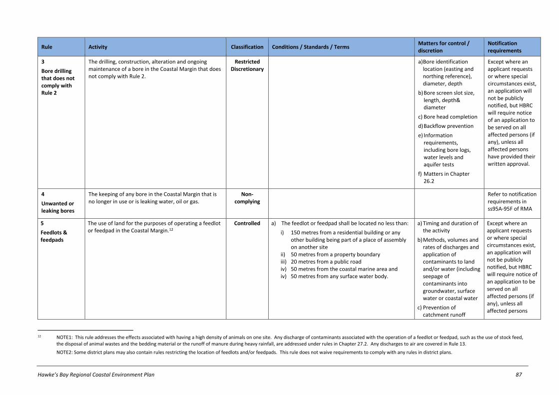
Hawke’s Bay Regional Coastal Environment Plan 87
Rule Activity Classification Conditions / Standards / Terms Matters for control / discretion
Notification requirements
3
Bore drilling that does not comply with Rule 2
The drilling, construction, alteration and ongoing maintenance of a bore in the Coastal Margin that does not comply with Rule 2.
Restricted Discretionary
a) Bore identification location (easting and northing reference), diameter, depth
b) Bore screen slot size, length, depth& diameter
c) Bore head completion
d) Backflow prevention
e) Information requirements, including bore logs, water levels and aquifer tests
f) Matters in Chapter 26.2
Except where an applicant requests or where special circumstances exist, an application will not be publicly notified, but HBRC will require notice of an application to be served on all affected persons (if any), unless all affected persons have provided their written approval.
4
Unwanted or leaking bores
The keeping of any bore in the Coastal Margin that is no longer in use or is leaking water, oil or gas.
Non-complying
Refer to notification requirements in ss95A-95F of RMA
5
Feedlots & feedpads
The use of land for the purposes of operating a feedlot or feedpad in the Coastal Margin.12
Controlled a) The feedlot or feedpad shall be located no less than:
i) 150 metres from a residential building or any other building being part of a place of assembly on another site
ii) 50 metres from a property boundary iii) 20 metres from a public road iv) 50 metres from the coastal marine area and iv) 50 metres from any surface water body.
a) Timing and duration of the activity
b) Methods, volumes and rates of discharges and application of contaminants to land and/or water (including seepage of contaminants into groundwater, surface water or coastal water
c) Prevention of catchment runoff
Except where an applicant requests or where special circumstances exist, an application will not be publicly notified, but HBRC will require notice of an application to be served on all affected persons (if any), unless all affected persons
12 NOTE1: This rule addresses the effects associated with having a high density of animals on one site. Any discharge of contaminants associated with the operation of a feedlot or feedpad, such as the use of stock feed,
the disposal of animal wastes and the bedding material or the runoff of manure during heavy rainfall, are addressed under rules in Chapter 27.2. Any discharges to air are covered in Rule 13.
NOTE2: Some district plans may also contain rules restricting the location of feedlots and/or feedpads. This rule does not waive requirements to comply with any rules in district plans.

88 Hawke’s Bay Regional Coastal Environment Plan
Rule Activity Classification Conditions / Standards / Terms Matters for control / discretion
Notification requirements
entering feedlot or feedpad
d) Proximity to, and sensitivity of, the surrounding environment
e) Scale and extent of feedlot or feedpad (including number of animals)
f) Matters in Chapter 26.2
have provided their written approval.
6
Feedlots & feedpads that do not comply with Rule 5
The use of land for the purposes of operating a feedlot or feedpad in the Coastal Margin, in a manner which does not comply with Rule 5.13
Restricted discretionary
a)Matters addressed by any conditions in Rule 5 which the activity cannot comply with and the related environmental effects of such non-compliance
b) Matters in Chapter 26.2
Except where an applicant requests or where special circumstances exist, an application will not be publicly notified, but HBRC will require notice of an application to be served on all affected persons (if any), unless all affected persons have provided their written approval.
c)
13 NOTE: This rule only addresses the use of land for a feedlot or feedpad (and thus, the effects associated with having a high density of animals on one site). Any discharge of contaminants associated with the operation
of a feedlot or feedpad, such as the use of stock feed, the disposal of animal wastes and the bedding material or the runoff of manure during heavy rainfall, are addressed under rules in Chapters 27.2. Any discharges to air are covered in Rule 13.

Hawke’s Bay Regional Coastal Environment Plan 89
Rule Activity Classification Conditions / Standards / Terms Matters for control / discretion
Notification requirements
7
Vegetation clearance and soil disturbance14
Vegetation clearance or soil disturbance in the Coastal Margin.15
Permitted a) All cleared vegetation, disturbed soil or debris shall be deposited or contained to reasonably prevent the transportation or deposition of disturbed matter into the coastal marine area or any water body16.
b) Vegetation clearance or soil disturbance shall not give rise to any significant change in the colour or clarity of any coastal water or any adjacent water body, after reasonable mixing.
c) any vegetation clearance within a Vegetation Clearance Management Area identified in this Plan’s maps shall not occur within:
i) 5m of any permanently flowing river or: ii) any other river with a bed width in excess of 2m
or iii) any other lake or wetland.
Except that this condition shall not apply to:
1) the clearance of plantation forestry established prior to the date of this Plan becoming operative
d) Vegetation clearance shall not occur within 20m of the coastal marine area.
e) Deposition of soil or soil particles across a property boundary shall not be objectionable or offensive, cause property damage or exceed 10kg/m2.17
f) Where the clearance of vegetation or the disturbance of soil increases the risk of soil loss the land shall be:
i) re-vegetated as soon as practicable after completion of the activity, but in any event no later than 18 months after completion with
14 Rule 7 does not apply to the trimming, felling, or removing of any tree or vegetation or earthworks, in relation to an existing high voltage electricity transmission lines. Refer to the Resource Management (National
Environmental Standards for Electricity Transmission Activities) Regulations 2009.
15 NOTE1: Some district plans may also contain rules restricting the clearance of vegetation and / or earthworks. This rule does not waive requirements to comply with any rules in district plans.
NOTE2: 'Vegetation Clearance Management Areas' on the planning maps relate to land that is not "flat to gently undulating" slopes (ie: 00 to 30 slope) and not urbanised areas.
16 In considering whether Condition (a) has been met, HBRC shall have regard to recognised industry codes of practice, best practice guidelines & environmental management plans relevant to, and adopted in, carrying out the activity.
17 NOTE: 10kg/m2 of dry soil is equivalent to 5mm depth assuming a specific gravity of 2kg/litre.

90 Hawke’s Bay Regional Coastal Environment Plan
Rule Activity Classification Conditions / Standards / Terms Matters for control / discretion
Notification requirements
species providing equivalent or better land stabilisation or
ii) retained in a manner which inhibits soil loss.
8
Vegetation clearance and soil disturbance that does not comply with Rule 718
Vegetation clearance or soil disturbance in the Coastal Margin which does not comply with Rule 7.
Restricted discretionary
a)Matters addressed by any conditions in Rule 7 which the activity cannot comply with and the related environmental effects of such non-compliance
b) Matters in Chapter 26.2
Except where an applicant requests or where special circumstances exist, an application will not be publicly notified, but HBRC will require notice of an application to be served on all affected persons (if any) unless all affected persons have provided their written approval.
18 Rule 8 does not apply to the trimming, felling, or removing of any tree or vegetation or earthworks, in relation to an existing high voltage electricity transmission lines. Refer to the Resource Management (National
Environmental Standards for Electricity Transmission Activities) Regulations 2009.
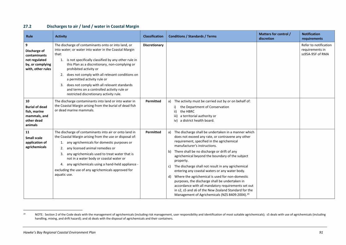
Hawke’s Bay Regional Coastal Environment Plan 91
27.2 Discharges to air / land / water in Coastal Margin
Rule Activity Classification Conditions / Standards / Terms Matters for control / discretion
Notification requirements
9
Discharge of contaminants not regulated by, or complying with, other rules
The discharge of contaminants onto or into land, or into water; or water into water in the Coastal Margin that:
1. is not specifically classified by any other rule in this Plan as a discretionary, non-complying or prohibited activity or
2. does not comply with all relevant conditions on a permitted activity rule or
3. does not comply with all relevant standards and terms on a controlled activity rule or restricted discretionary activity rule.
Discretionary Refer to notification requirements in ss95A-95F of RMA
10
Burial of dead fish, marine mammals, and other dead animals
The discharge contaminants into land or into water in the Coastal Margin arising from the burial of dead fish or dead marine mammals.
Permitted a) The activity must be carried out by or on behalf of:
i) the Department of Conservation ii) the HBRC iii) a territorial authority or iv) a district health board.
11
Small scale application of agrichemicals
The discharge of contaminants into air or onto land in the Coastal Margin arising from the use or disposal of:
1. any agrichemicals for domestic purposes or
2. any licensed animal remedies or
3. any agrichemicals used to treat water that is not in a water body or coastal water or
4. any agrichemicals using a hand-held appliance -
excluding the use of any agrichemicals approved for aquatic use.
Permitted a) The discharge shall be undertaken in a manner which does not exceed any rate, or contravene any other requirement, specified in the agrichemical manufacturer's instructions.
b) There shall be no discharge or drift of any agrichemical beyond the boundary of the subject property.
c) The discharge shall not result in any agrichemical entering any coastal waters or any water body.
d) Where the agrichemical is used for non-domestic purposes, the discharge shall be undertaken in accordance with all mandatory requirements set out in s2, s5 and s6 of the New Zealand Standard for the Management of Agrichemicals (NZS 8409:2004).19
19 NOTE: Section 2 of the Code deals with the management of agrichemicals (including risk management, user responsibility and identification of most suitable agrichemicals); s5 deals with use of agrichemicals (including
handling, mixing, and drift hazard); and s6 deals with the disposal of agrichemicals and their containers.

92 Hawke’s Bay Regional Coastal Environment Plan
Rule Activity Classification Conditions / Standards / Terms Matters for control / discretion
Notification requirements
12
Widespread application of agrichemicals
Except as provided for in Rule 11, the discharge of contaminants into air or onto land, or into water, in the Coastal Margin arising from the use or disposal20 of any agrichemical.21
Permitted a) The discharge shall be undertaken in a manner which does not exceed any rate, or contravene any other requirement, specified in the agrichemical manufacturer's instructions.
b) For the ground based application of agrichemicals the following qualifications shall be held at all times:
i) every commercial user shall hold a qualification that meets the requirements of Schedule G for commercial user or be under direct supervision of a person holding the qualification
ii) every contractor shall be a GROWSAFE® Registered Chemical Applicator
iii) every employee of a contractor shall hold or be under training for a valid qualification that meets the requirements of Schedule G for contractor employees.
c) Every pilot undertaking the aerial application of agrichemicals shall hold a GROWSAFE® Pilot Agrichemical Rating Certificate.
d) The discharge shall not result in any agrichemical being deposited on any roof or other structure used as a catchment for water supply other than in compliance with condition (e).
e) Where the discharge is for the purpose of eradicating, modifying or controlling unwanted aquatic plants, or other biosecurity purposes:
i) only agrichemicals approved for aquatic use by the Environmental Risk Management Authority may be used
ii) the applications shall not exceed the quantity and concentration required for that purpose
iii) the discharge shall not include disposal to water of any agrichemical and
20 This rule does not apply to the disposal of agrichemical containers. Vertebrate toxic agents are covered under the Hazardous Substances and New Organisms Act 1996 and under the Agricultural Compounds and
Veterinary Medicines Act 1997.
21 NOTE: Restrictions may also apply to agrichemicals under the Hazardous Substances and New Organisms Act 1996. Under these regulations, approval is required from the Medical Officer of Health/Health Protection Officer for the use of a vertebrate toxic agent. Refer to HSNO Act for further details.

Hawke’s Bay Regional Coastal Environment Plan 93
Rule Activity Classification Conditions / Standards / Terms Matters for control / discretion
Notification requirements
iv) the discharger shall notify: 1) every person taking water for domestic
supply within 1 km downstream of the proposed discharge; and
2) every holder of a resource consent for the taking of water for public water supply purposes downstream of the proposed discharge -
at least 1 week before commencing the discharge.
f) Where condition (e) does not apply, then any discharge of agrichemicals not approved for aquatic use shall not enter any water body or coastal water.
g) Aerial and ground based discharges shall be notified by the property owner , manager or contractor in accordance with the following requirements22:
i) where the application is on private land, occurs on any land within 50m of an adjacent property twice in any 12 month period, and occurs in circumstances where spray drift beyond the property boundary cannot be avoided, a property spray plan shall be prepared at the beginning of each year or spray season, in accordance with Appendix M of the New Zealand Standard for the Management of Agrichemicals (NZS 8409:2004). The plan shall be given upon request to the owner or occupier of any adjacent property, or to a Council officer.
ii) where the application is on private land, signs shall be used to clearly indicate the use of any agrichemicals: 1) within 10m of public land where there is a
shelter belt giving effective protection between the application and the public land or
22 NOTE: For the avoidance of doubt, the notification requirements set out in Condition (i) do not apply to discharges of agrichemicals where there is never any spray drift beyond the property boundary.

94 Hawke’s Bay Regional Coastal Environment Plan
Rule Activity Classification Conditions / Standards / Terms Matters for control / discretion
Notification requirements
2) within 30m of public land where there is no shelter belt giving effective protection between the application and the public land
iii) Where the application is on public land: 1) notification shall be given in local
newspapers or by door-to-door advice to land occupiers adjacent to the intended application at the beginning of the spray season, not more than six months prior to the application, and in any case, not less than one month prior to application and
2) signs shall be used to clearly indicate the agrichemical use.
iv) where the application may affect bee keeping, prior notification shall be given to the affected parties.
h) The discharge shall be undertaken in accordance with all mandatory requirements set out in s2, s5 and s6 of the New Zealand Standard for the Management of Agrichemicals (NZS 8409:2004)23.
23 Agrichemical Spray Drift Hazard – Table G1 from the New Zealand Standard for the Management of Agrichemicals (NZS8409:2004) includes the following guidance chart for assessing agrichemical spray drift hazard.
Dischargers should note that adequate notification of those who may be at risk, so that they can take precautionary action, effectively reduces drift hazard.
FACTOR POTENTIAL DRIFT HAZARD SCALE
HIGH LOW
Wind speed Wind direction Humidity Atmospheric stability Maximum height of release Particle (droplet) size Volatility Sensitive area Buffer zone Shelter belts Toxicity
Zero/very low (<1 m/s) or >6 m/s Unpredictable Low (delta T>8oC) Inversion layer present >1.5 m above the target <50 microns diameter High (vapour pressure >10 mPa) Close (<100 m away) None No shelter Class 6.1A, B, C, D
Steady (1-3 m/s) Predictable, and away from sensitive areas High (delta T<4oC) No inversion layer <0.5 m above the target >250 microns diameter Low (vapour pressure <0.1 mPa) None, or more than 1 km distant Yes (>100 m) Live shelter, >3m high and 1 m thick Class 6.1E
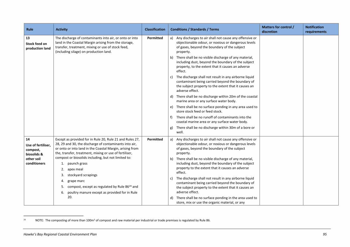
Hawke’s Bay Regional Coastal Environment Plan 95
Rule Activity Classification Conditions / Standards / Terms Matters for control / discretion
Notification requirements
13
Stock feed on production land
The discharge of contaminants into air, or onto or into land in the Coastal Margin arising from the storage, transfer, treatment, mixing or use of stock feed, (including silage) on production land.
Permitted a) Any discharges to air shall not cause any offensive or objectionable odour, or noxious or dangerous levels of gases, beyond the boundary of the subject property.
b) There shall be no visible discharge of any material, including dust, beyond the boundary of the subject property, to the extent that it causes an adverse effect.
c) The discharge shall not result in any airborne liquid contaminant being carried beyond the boundary of the subject property to the extent that it causes an adverse effect.
d) There shall be no discharge within 20m of the coastal marine area or any surface water body.
e) There shall be no surface ponding in any area used to store stock feed or feed stock.
f) There shall be no runoff of contaminants into the coastal marine area or any surface water body.
g) There shall be no discharge within 30m of a bore or well.
14
Use of fertiliser, compost, biosolids & other soil conditioners
Except as provided for in Rule 20, Rule 21 and Rules 27, 28, 29 and 30, the discharge of contaminants into air, or onto or into land in the Coastal Margin, arising from the, transfer, treatment, mixing or use of fertiliser, compost or biosolids including, but not limited to:
1. paunch grass
2. apex meal
3. stockyard scrapings
4. grape marc
5. compost, except as regulated by Rule 8624 and
6. poultry manure except as provided for in Rule 20.
Permitted a) Any discharges to air shall not cause any offensive or objectionable odour, or noxious or dangerous levels of gases, beyond the boundary of the subject property.
b) There shall be no visible discharge of any material, including dust, beyond the boundary of the subject property to the extent that it causes an adverse effect.
c) The discharge shall not result in any airborne liquid contaminant being carried beyond the boundary of the subject property to the extent that it causes an adverse effect.
d) There shall be no surface ponding in the area used to store, mix or use the organic material, or any
24 NOTE: The composting of more than 100m3 of compost and raw material per industrial or trade premises is regulated by Rule 86.

96 Hawke’s Bay Regional Coastal Environment Plan
Rule Activity Classification Conditions / Standards / Terms Matters for control / discretion
Notification requirements
discharge of contaminants into the coastal marine area or any surface water body.
e) The discharge shall not cause any contamination of groundwater.
f) The discharge shall be able to infiltrate through at least 600mm of unsaturated soil.
g) Where material is discharged onto grazed pasture, the application rate shall not exceed:
i) 100 kg/ha of nitrogen in any 12 month period and
ii) 8kg/ha in any 28 day period, except that where material is discharged onto land used for a crop, the application rate shall not exceed the rate of nitrogen uptake by the crop.
h) Upon request by the HBRC, information shall be provided by the resource user setting out how the conditions above will be met.
15
Storage of fertiliser, compost, and biosolids
Except as provided for in Rule 20, Rule 21 and Rules 27, 28, 29 and 30, the discharge of contaminants into air, or onto or into land in the Coastal Margin, arising from the storage of fertiliser, compost or biosolids including, but not limited to:
1. paunch grass
2. apex meal
3. stockyard scrapings
4. grape marc
5. compost, except as regulated by Rule 8625 and
6. poultry manure except as provided for in Rule 20.
Permitted a) Any discharges to air shall not cause any offensive or objectionable odour, or noxious or dangerous levels of gases, beyond the boundary of the subject property.
b) There shall be no visible discharge of any material, including dust, beyond the boundary of the subject property to the extent that it causes an adverse effect.
c) The discharge shall not result in any airborne liquid contaminant being carried beyond the boundary of the subject property to the extent that it causes an adverse effect.
d) There shall be no surface ponding in the area used to store, organic material, and no discharge of contaminants into the coastal marine area or any surface water body.
25 NOTE: The composting of more than 100m3 of compost and raw material per industrial or trade premises is regulated by Rule 86.

Hawke’s Bay Regional Coastal Environment Plan 97
Rule Activity Classification Conditions / Standards / Terms Matters for control / discretion
Notification requirements
e) The discharge shall not cause any contaminant to enter groundwater, surface water body or coastal water.
f) There shall be no discharge within 20 metres of the coastal marine area or any surface water body.
g) In the case of aboveground storage, storage areas shall be imperviously sealed, bunded, or otherwise contained so that discharge of contaminants shall be totally confined within the site on which the discharge occurs.
h) Any discharge shall be able to infiltrate through at least 600mm of unsaturated soil.26
i) Any storage of fertiliser, compost and/or biosolids exceeding a volume of 100m3 in an area where there is potential for contamination of groundwater by seepage of contaminants, shall be managed in a manner that prevents any such contamination.
j) Upon request by the HBRC, information shall be provided by the resource user setting out how the conditions above will be met.
16
Management of solid waste on production land27
The discharge of contaminants into air, or onto or into production land in the Coastal Margin, arising from the storage, transfer, treatment or disposal of solid waste, including, but not limited to:
1. the use of farm tips
2. offal holes.
Permitted a) The waste shall have been generated on the subject property, or on another property under the same ownership as that used for disposal.
b) There shall be no disposal of waste oil or any other hazardous substance.
c) Any discharges to air shall not cause any offensive or objectionable odour, or noxious or dangerous levels of gases, beyond the boundary of the subject property.
d) There shall be no visible discharge of any material, including dust, beyond the boundary of the subject property to the extent that it causes an adverse effect.
26 NOTE: Rule 86 applies to discharges to air arising from the storage of compost on industrial and trade premises in volumes greater than 100m3.
27 This rule does not apply to burning of waste. Burning of waste is addressed by rules in Chapter 27.5 of this Plan.

98 Hawke’s Bay Regional Coastal Environment Plan
Rule Activity Classification Conditions / Standards / Terms Matters for control / discretion
Notification requirements
e) There shall be no discharge of contaminant into, or within 20m of, the coastal marine area or any surface water body.
f) There shall be no surface ponding in the area used to store, mix or use solid waste, and no discharge of contaminants into the coastal marine area or any surface water body.
g) There shall be no ponding in the area used for waste management.
h) There shall be no discharge within 30m of any bore or well.
i) The discharge shall not cause any contaminant to enter groundwater.
j) Any waste disposal shall be able to infiltrate through at least 600mm of unsaturated soil.
k) Any offal holes used shall be securely covered, and shall be constructed in soil with an infiltration rate not exceeding 150 mm/hour.28
17
Discharge of contaminants to surface water29
Except as provided for in any other rules in this Plan, the discharge of contaminants into surface water in the Coastal Margin.
Permitted a) The rate of discharge at any particular point shall be no greater than 50m3/d.
b) There shall not be any adverse flooding effects on any property owned or occupied by another person as a result of the discharge activity.
c) The discharge shall not cause any scouring or erosion of any land or any water course beyond the point of discharge.
d) The discharge shall not cause the natural temperature of any receiving water to be changed by more than 3 degrees Celsius from normal seasonal water temperature fluctuations, after reasonable mixing.
28 For the purposes of Condition (k), the soil type should not comprise gravels, coarse/medium sands, scoria, fissured rock, or other such materials likely to permit free travel of excreta residues away from the offal hole.
29 1. Where there is doubt about compliance with the conditions (a) to (m) in this rule, it is the responsibility of the person undertaking the activity to demonstrate to HBRC that the conditions are being complied with or a resource consent shall be required.
2. Rule 17 does not apply to the discharge of contaminants into water in relation to an existing high voltage electricity transmission activity. Refer to the Resource Management (National Environmental Standards for Electricity Transmission Activities) Regulations 2009.
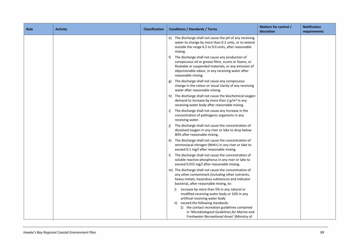
Hawke’s Bay Regional Coastal Environment Plan 99
Rule Activity Classification Conditions / Standards / Terms Matters for control / discretion
Notification requirements
e) The discharge shall not cause the pH of any receiving water to change by more than 0.2 units, or to extend outside the range 6.5 to 9.0 units, after reasonable mixing.
f) The discharge shall not cause any production of conspicuous oil or grease films, scums or foams, or floatable or suspended materials, or any emission of objectionable odour, in any receiving water after reasonable mixing.
g) The discharge shall not cause any conspicuous change in the colour or visual clarity of any receiving water after reasonable mixing.
h) The discharge shall not cause the biochemical oxygen demand to increase by more than 2 g/m3 in any receiving water body after reasonable mixing.
i) The discharge shall not cause any increase in the concentration of pathogenic organisms in any receiving water.
j) The discharge shall not cause the concentration of dissolved oxygen in any river or lake to drop below 80% after reasonable mixing.
k) The discharge shall not cause the concentration of ammoniacal nitrogen (NH4+) in any river or lake to exceed 0.1 mg/l after reasonable mixing.
l) The discharge shall not cause the concentration of soluble reactive phosphorus in any river or lake to exceed 0.015 mg/l after reasonable mixing.
m) The discharge shall not cause the concentration of any other contaminant (including other nutrients, heavy metals, hazardous substances and indicator bacteria), after reasonable mixing, to:
i) increase by more than 5% in any natural or modified receiving water body or 10% in any artificial receiving water body
ii) exceed the following standards: 1) the contact recreation guidelines contained
in ‘Microbiological Guidelines for Marine and Freshwater Recreational Areas’ (Ministry of
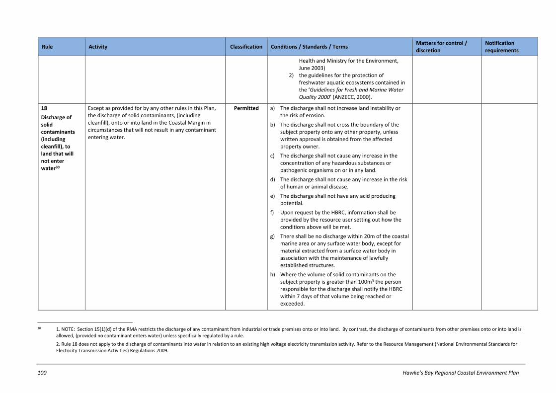
100 Hawke’s Bay Regional Coastal Environment Plan
Rule Activity Classification Conditions / Standards / Terms Matters for control / discretion
Notification requirements
Health and Ministry for the Environment, June 2003)
2) the guidelines for the protection of freshwater aquatic ecosystems contained in the ‘Guidelines for Fresh and Marine Water Quality 2000’ (ANZECC, 2000).
18
Discharge of solid contaminants (including cleanfill), to land that will not enter water30
Except as provided for by any other rules in this Plan, the discharge of solid contaminants, (including cleanfill), onto or into land in the Coastal Margin in circumstances that will not result in any contaminant entering water.
Permitted a) The discharge shall not increase land instability or the risk of erosion.
b) The discharge shall not cross the boundary of the subject property onto any other property, unless written approval is obtained from the affected property owner.
c) The discharge shall not cause any increase in the concentration of any hazardous substances or pathogenic organisms on or in any land.
d) The discharge shall not cause any increase in the risk of human or animal disease.
e) The discharge shall not have any acid producing potential.
f) Upon request by the HBRC, information shall be provided by the resource user setting out how the conditions above will be met.
g) There shall be no discharge within 20m of the coastal marine area or any surface water body, except for material extracted from a surface water body in association with the maintenance of lawfully established structures.
h) Where the volume of solid contaminants on the subject property is greater than 100m3 the person responsible for the discharge shall notify the HBRC within 7 days of that volume being reached or exceeded.
30 1. NOTE: Section 15(1)(d) of the RMA restricts the discharge of any contaminant from industrial or trade premises onto or into land. By contrast, the discharge of contaminants from other premises onto or into land is
allowed, (provided no contaminant enters water) unless specifically regulated by a rule.
2. Rule 18 does not apply to the discharge of contaminants into water in relation to an existing high voltage electricity transmission activity. Refer to the Resource Management (National Environmental Standards for Electricity Transmission Activities) Regulations 2009.
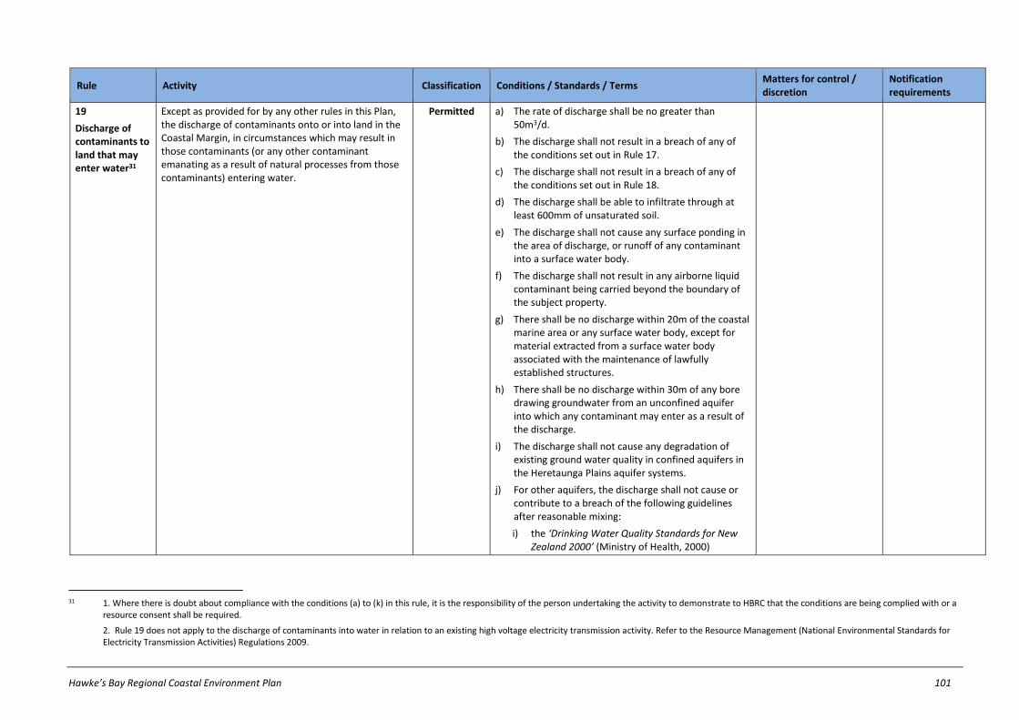
Hawke’s Bay Regional Coastal Environment Plan 101
Rule Activity Classification Conditions / Standards / Terms Matters for control / discretion
Notification requirements
19
Discharge of contaminants to land that may enter water31
Except as provided for by any other rules in this Plan, the discharge of contaminants onto or into land in the Coastal Margin, in circumstances which may result in those contaminants (or any other contaminant emanating as a result of natural processes from those contaminants) entering water.
Permitted a) The rate of discharge shall be no greater than 50m3/d.
b) The discharge shall not result in a breach of any of the conditions set out in Rule 17.
c) The discharge shall not result in a breach of any of the conditions set out in Rule 18.
d) The discharge shall be able to infiltrate through at least 600mm of unsaturated soil.
e) The discharge shall not cause any surface ponding in the area of discharge, or runoff of any contaminant into a surface water body.
f) The discharge shall not result in any airborne liquid contaminant being carried beyond the boundary of the subject property.
g) There shall be no discharge within 20m of the coastal marine area or any surface water body, except for material extracted from a surface water body associated with the maintenance of lawfully established structures.
h) There shall be no discharge within 30m of any bore drawing groundwater from an unconfined aquifer into which any contaminant may enter as a result of the discharge.
i) The discharge shall not cause any degradation of existing ground water quality in confined aquifers in the Heretaunga Plains aquifer systems.
j) For other aquifers, the discharge shall not cause or contribute to a breach of the following guidelines after reasonable mixing:
i) the ‘Drinking Water Quality Standards for New Zealand 2000’ (Ministry of Health, 2000)
31 1. Where there is doubt about compliance with the conditions (a) to (k) in this rule, it is the responsibility of the person undertaking the activity to demonstrate to HBRC that the conditions are being complied with or a
resource consent shall be required.
2. Rule 19 does not apply to the discharge of contaminants into water in relation to an existing high voltage electricity transmission activity. Refer to the Resource Management (National Environmental Standards for Electricity Transmission Activities) Regulations 2009.

102 Hawke’s Bay Regional Coastal Environment Plan
Rule Activity Classification Conditions / Standards / Terms Matters for control / discretion
Notification requirements
ii) the guideline for irrigation contained in the ‘Guidelines for Fresh and Marine Water Quality 2000’ (ANZECC, 2000).
k) Where the quality of ground water in any aquifer encompassed by condition (j) breaches the standards specified in that condition prior to the discharge occurring, the discharge shall not cause any further degradation of the quality of ground water in any such aquifer after reasonable mixing.
20
Animal effluent
Except as provided for in Rule 21, the discharge of contaminants into air, or onto or into production land in the Coastal Margin, arising from the management, storage, transfer, treatment, mixing, spreading, or use of liquid animal effluent, including, but not limited to:
1. dairy shed effluent
2. piggery effluent
3. poultry farm effluent and
4. associated sludges.32
Controlled a) There shall be no seepage of contaminants into groundwater from any area used for storing animal effluent.
b) The discharge shall not cause any contaminant to enter groundwater.
c) Either:
i) there shall not be offensive or objectionable odour, or noxious or dangerous levels of gases or airborne or airborne liquid contaminants, beyond the boundary of the subject property or
ii) for discharges of effluent from piggeries, every point of discharge shall be sited so as to meet the requirements of the ‘Code of Practice - Pig Farming’ (New Zealand Pork Industry Board, 1997), in respect of buffer zone distances.
d) There shall be no visible discharge of any material, including dust, beyond the boundary of the subject property, unless written approval is obtained from the affected property owner.
e) There shall be no discharge of any contaminant into the coastal marine area or any surface water body.
f) There shall be no discharge within 30m of any bore or well.
g) Where effluent is discharged onto grazed pasture, the nitrogen loading rate from the effluent application shall not exceed 100 kg/ha/y of nitrogen.
a) Amount of effluent per discharge
b) Frequency of discharge;
c) Maintenance of vegetative cover
d) Buffer zone requirements
e) Measures to avoid a breach of the environmental guidelines for surface and groundwater quality set out in Chapters 9 and 11
f) Management of cumulative adverse effects
g) For discharges of effluent from piggeries, use of the best practicable option for minimising discharges of odour beyond the boundary of the subject property
h) Matters in Chapter 26.2
In relation to a new application, (except where an applicant requests or where special circumstances exist), an application will not be publicly notified, but HBRC will require notice of an application to be served on all affected persons (if any), unless all affected persons have provided their written approval.
In relation to an application to renew consent, (except where an applicant requests or where special circumstances exist), an application will not be served on
32 This rule covers the discharge of poultry effluent from poultry farms on land associated with the poultry farm, where the discharge is for the purpose of disposal.

Hawke’s Bay Regional Coastal Environment Plan 103
Rule Activity Classification Conditions / Standards / Terms Matters for control / discretion
Notification requirements
h) Where effluent is discharged onto land covered by a crop, or to be used for cropping purposes, the application rate shall not exceed the rate of nitrogen uptake by the crop.
any person or publicly notified.
21
Discharge of animal effluent in sensitive catchments
The discharge of contaminants into air, or onto or into production land, arising from the management, storage, transfer, treatment, mixing, spreading, or use of liquid animal effluent, including but not limited to, dairy shed effluent, piggery effluent, and poultry farm effluent in:
1. a Sensitive Catchment within the Coastal Margin as identified in Schedule Q of this Plan; or
2. a Stock Management Area as identified in Schedule R of this Plan.
Discretionary Refer to notification requirements in ss95A-95F of RMA
22
Discharge of water to water33
Except as provided for in Rule 23, Rule 24, Rule 25 and Rule 26, the discharge of water into water in the Coastal Margin, excluding coastal water.34
Permitted a) There shall not be any adverse flooding effects on any property owned or occupied by another person as a result of the discharge activity.
b) The discharge shall not cause any scouring or erosion of any land or any water course beyond the point of discharge.35
c) The discharge shall not cause the natural temperature of any receiving water to be changed by more than 3 degrees Celsius from normal seasonal water temperature fluctuations, after reasonable mixing.
23
Discharge of drainage water
(gravity flow systems)
Except as provided for in Rule 25 and Rule 26, the diversion and discharge of water into water or onto or into land in the Coastal Margin, from a gravity flow drainage system (without pumping).
Permitted a) There shall not be any adverse flooding effects on any property owned or occupied by another person as a result of the discharge activity.
b) The discharge shall not cause any scouring or erosion of any land or any water course beyond the point of discharge.
33 Rule 22 does not apply to the discharge of water into water in relation to an existing high voltage electricity transmission activity. Refer to the Resource Management (National Environmental Standards for Electricity
Transmission Activities) Regulations 2009.
34 NOTE: The discharge of water onto or into land is not restricted by the RMA.
35 The discharge of sediment to surface water bodies as a result of scouring is covered by Rule 19.
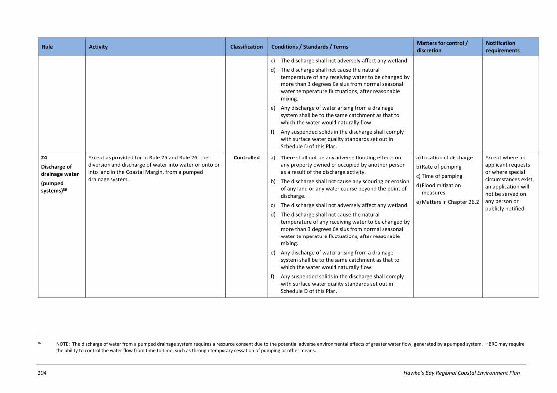
104 Hawke’s Bay Regional Coastal Environment Plan
Rule Activity Classification Conditions / Standards / Terms Matters for control / discretion
Notification requirements
c) The discharge shall not adversely affect any wetland.
d) The discharge shall not cause the natural temperature of any receiving water to be changed by more than 3 degrees Celsius from normal seasonal water temperature fluctuations, after reasonable mixing.
e) Any discharge of water arising from a drainage system shall be to the same catchment as that to which the water would naturally flow.
f) Any suspended solids in the discharge shall comply with surface water quality standards set out in Schedule D of this Plan.
24
Discharge of drainage water
(pumped systems)36
Except as provided for in Rule 25 and Rule 26, the diversion and discharge of water into water or onto or into land in the Coastal Margin, from a pumped drainage system.
Controlled a) There shall not be any adverse flooding effects on any property owned or occupied by another person as a result of the discharge activity.
b) The discharge shall not cause any scouring or erosion of any land or any water course beyond the point of discharge.
c) The discharge shall not adversely affect any wetland.
d) The discharge shall not cause the natural temperature of any receiving water to be changed by more than 3 degrees Celsius from normal seasonal water temperature fluctuations, after reasonable mixing.
e) Any discharge of water arising from a drainage system shall be to the same catchment as that to which the water would naturally flow.
f) Any suspended solids in the discharge shall comply with surface water quality standards set out in Schedule D of this Plan.
a) Location of discharge
b) Rate of pumping
c) Time of pumping
d) Flood mitigation measures
e) Matters in Chapter 26.2
Except where an applicant requests or where special circumstances exist, an application will not be served on any person or publicly notified.
36 NOTE: The discharge of water from a pumped drainage system requires a resource consent due to the potential adverse environmental effects of greater water flow, generated by a pumped system. HBRC may require
the ability to control the water flow from time to time, such as through temporary cessation of pumping or other means.

Hawke’s Bay Regional Coastal Environment Plan 105
Rule Activity Classification Conditions / Standards / Terms Matters for control / discretion
Notification requirements
25
Diversion and discharge of stormwater
The diversion and discharge of stormwater from any constructed open drainage system or piped stormwater drainage system in the Coastal Margin that:
1. Does not convey stormwater from any industrial or trade premises; or
2. Conveys stormwater from any industrial or trade premises (excluding premises used for the storage of any hazardous substance) covering an area of less than 2ha.
Permitted a) The activity shall not cause any permanent:
i) reduction of the ability of the receiving channel to convey flood flows or
ii) bed scouring or bank erosion of the receiving channel.
b) The discharge shall not cause the production of conspicuous oil or grease films, scums or foams, or floatable or suspended materials in any receiving water after reasonable mixing.
26
Diversion and discharge of stormwater
Except as provided for in Rule 25, the diversion and discharge of stormwater in the Coastal Margin.
Controlled a) All reasonable measures shall be taken to ensure that the activity is unlikely to give rise to all or any of the following effects in any receiving water after reasonable mixing:
i) the production of any conspicuous oil or grease films, scums or foams, or floatable or suspended materials
ii) any conspicuous change in the colour or visual clarity
iii) any emission of objectionable odour iv) the rendering of fresh water unsuitable for
consumption by farm animals or v) any significant adverse effects on aquatic life.
a)Location of the point of diversion and discharge including its catchment area
b) Volume, rate, timing and duration of the discharge, in relation to a specified design rainfall event
c) Effects of the activity on downstream flooding
d) Contingency measures in the event of pipe capacity exceedence
e) Actual or likely adverse effects on fisheries, wildlife, habitat or amenity values of the coastal marine area or any surface water body
f) Actual or likely adverse effects on the potability of any ground water
g) Matters in Chapter 26.2
Except where an applicant requests or where special circumstances exist, an application will not be publicly notified, but HBRC will require notice of an application to be served on all affected persons (if any), unless all affected persons have provided their written approval.

106 Hawke’s Bay Regional Coastal Environment Plan
Rule Activity Classification Conditions / Standards / Terms Matters for control / discretion
Notification requirements
27
Existing wastewater systems37,38
The discharge of contaminants onto or into land, and any ancillary discharge of contaminants into air, in the Coastal Margin, from any existing wastewater system.
Permitted a) The rate of discharge shall not exceed 2m3/d, averaged over any 7 day period.
b) There shall be no surface ponding as a result of the discharge, or direct discharge into the coastal marine area or any water body.
c) There shall be no increase in the concentration of pathogenic organisms or faecal indicator bacteria in the coastal marine area or any surface water body as a result of the discharge.
d) Either:
i) the point of discharge shall be no less than 600mm above the highest seasonal groundwater table or
ii) the discharge shall not result in, or contribute to, a breach of the ‘Drinking Water Quality Standards for New Zealand’ (Ministry of Health, 2005 (Revised 2008)) in any groundwater body after reasonable mixing.
e) The discharge shall not cause any emission of offensive or objectionable odour, or release of noxious or dangerous gases (including aerosols) beyond the boundary of the subject property.
f) Either:
i) discharges from pit privies shall be from privy’s constructed in soil with a soil texture category of 2 to 6 as per AS/NZS 1547 that has an infiltration rate not exceeding 150 mm/h; or
ii) all other discharges shall be into a land treatment field that complies with the requirements specified in Schedule N.
g) Compliance with any conditions of a resource consent held for the activity.
37 Any existing wastewater system modified or replaced after 1 January 2012 is considered to be a ‘new’ system and must be assessed in accordance with Rule 28.
38 NOTE: Rule 27 means that once the system has been lawfully established, the system’s continued operation is permitted under this rule. No ongoing consent is required for the operation of lawfully established discharges provided the conditions of this rule are met.

Hawke’s Bay Regional Coastal Environment Plan 107
Rule Activity Classification Conditions / Standards / Terms Matters for control / discretion
Notification requirements
h) The wastewater treatment and land application system shall be maintained in accordance with the manufacturers’ instructions, or if no manufacturer’s instructions exist, in accordance with the best management practice as described in AS/NZS 1547, or TP58: On-site Wastewater Systems: Design and Management Manual (Auckland Regional Council Technical Publication No. 58), or other alternative recognised on-site wastewater design manuals. A schedule of maintenance shall be kept, and this schedule shall be available for inspection by the Regional Council upon request.
i) The discharge shall not be disposed of by way of spray irrigation.
28
New wastewater systems
Except as provided for in Rule 27 or Rule 29, the discharge of contaminants (including greywater) onto or into land, and any ancillary discharge of contaminants into air, in the Coastal Margin from any new39 wastewater system (including greywater).
Permitted a) The rate of discharge of domestic sewage (including greywater) shall not exceed 2 m3/d, averaged over any 7 day period.
b) Where the wastewater receives no more than advanced primary treatment, the discharge shall not be onto or into a property with a land area less than 2500 m2.
c) Where the wastewater receives more than advanced primary treatment, then:
i) the discharge shall be onto or into a property with a land area of no less than 1000 m2; and
ii) the net site area to discharge volume ratio shall not be less than 1.5 m2 per litre per day 40.
d) The discharge and land treatment field shall not be within:
i) 20m of any surface water body (including any stormwater open drain or roadside drain) or
ii) 20m of any tile drain or iii) 20m of the coastal marine area or iv) 1.5m of any property boundary.
39 ‘New’ wastewater systems include those systems installed after this rule becomes operative, as well as those lawfully established wastewater systems that have been modified or replaced since 1 January 2012.
40 The net site area to discharge volume ratio can be calculated by dividing the net site area by the expected daily wastewater volume. If the answer is less than 1.5, the discharge does not comply with this condition. E.g. A 1000m2 property with a three bedroom home on it with maximum daily discharge volume of 1200 L (6 people at 200 L/p/d) has a ratio of 0.83 (1000/1200). This discharge would not comply with this condition.
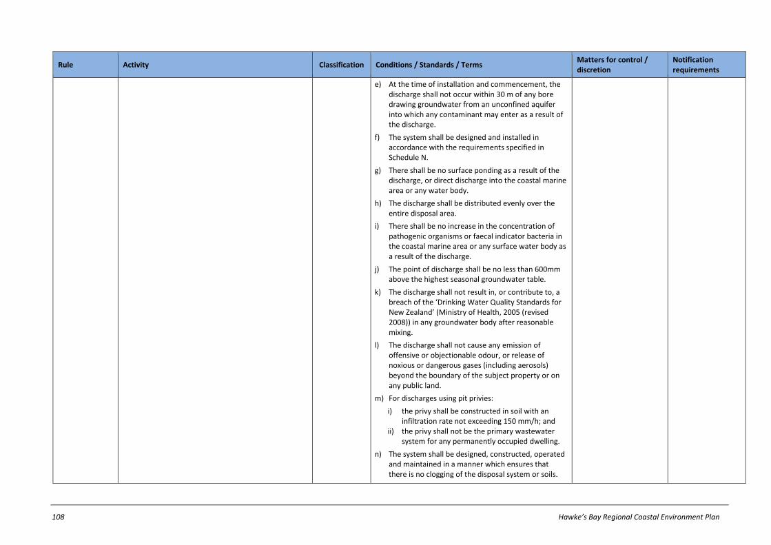
108 Hawke’s Bay Regional Coastal Environment Plan
Rule Activity Classification Conditions / Standards / Terms Matters for control / discretion
Notification requirements
e) At the time of installation and commencement, the discharge shall not occur within 30 m of any bore drawing groundwater from an unconfined aquifer into which any contaminant may enter as a result of the discharge.
f) The system shall be designed and installed in accordance with the requirements specified in Schedule N.
g) There shall be no surface ponding as a result of the discharge, or direct discharge into the coastal marine area or any water body.
h) The discharge shall be distributed evenly over the entire disposal area.
i) There shall be no increase in the concentration of pathogenic organisms or faecal indicator bacteria in the coastal marine area or any surface water body as a result of the discharge.
j) The point of discharge shall be no less than 600mm above the highest seasonal groundwater table.
k) The discharge shall not result in, or contribute to, a breach of the ‘Drinking Water Quality Standards for New Zealand’ (Ministry of Health, 2005 (revised 2008)) in any groundwater body after reasonable mixing.
l) The discharge shall not cause any emission of offensive or objectionable odour, or release of noxious or dangerous gases (including aerosols) beyond the boundary of the subject property or on any public land.
m) For discharges using pit privies:
i) the privy shall be constructed in soil with an infiltration rate not exceeding 150 mm/h; and
ii) the privy shall not be the primary wastewater system for any permanently occupied dwelling.
n) The system shall be designed, constructed, operated and maintained in a manner which ensures that there is no clogging of the disposal system or soils.

Hawke’s Bay Regional Coastal Environment Plan 109
Rule Activity Classification Conditions / Standards / Terms Matters for control / discretion
Notification requirements
o) The discharge shall not be into a trench or bed disposal system constructed in category 5 or 641 soil except where wastewater receives at least secondary treatment.
p) Where the wastewater receives secondary treatment or better, the discharge shall not exceed 20 g/m3 of BOD, and 30 g/m3 of suspended solids.
q) The wastewater treatment and land application system shall be maintained in accordance with the manufacturers’ instructions, or if no manufacturer’s instructions exist, in accordance with the best management practice as described in AS/NZS 1547, or TP58: On-site Wastewater Systems: Design and Management Manual (Auckland Regional Council Technical Publication No. 58), or other alternative recognised on-site wastewater design manuals. A schedule of maintenance shall be kept, and this schedule shall be available for inspection by the Regional Council upon request.
r) The discharge shall not be disposed of by way of spray irrigation.
s) The discharge shall not be into a raised bed.
29
Existing high discharge volume wastewater systems
The discharge of contaminants onto or into land, and any ancillary discharge of contaminants into air, in the Coastal Margin from any existing wastewater system with a rate of discharge exceeding 2m3/day averaged over any 7 day period.
Restricted discretionary
a) There shall be no surface ponding as a result of the discharge, or direct discharge into the coastal marine area or any water body.
b) There shall be no increase in the concentration of pathogenic organisms or faecal indicator bacteria in the coastal marine area, any groundwater system or any surface water body as a result of the discharge.
c) Either:
i) the point of discharge shall be no less that 600mm above the highest seasonable groundwater table or
ii) the discharge shall not result in, or contribute to, a breach of the ‘Drinking Water Quality
a) Method of treatment b) Method of disposal c) Effluent application
rate d) Need for reserve area e) Buffer zone
requirements f) Maintenance of system g) Proximity to registered
drinking water supplies h) Matters in Chapter 26.2
Except where an applicant requests or where special circumstances exist, an application will not be publicly notified, but HBRC will require notice of an application to be served on all affected persons (if any), unless all affected persons
41 A category 5 soil is a light clay, permeability (Ksat) can range generally between 0.5 m/d (strongly structured) and <0.06 m/d (weakly structured or massive) and the soil is poorly drained. Clay content of approximately
35-40%. Category 6 soils are medium to heavy clays that are very poorly drained. The permeability of category 6 soils is generally less than 0.06 m/d. Clay content of over 40%.

110 Hawke’s Bay Regional Coastal Environment Plan
Rule Activity Classification Conditions / Standards / Terms Matters for control / discretion
Notification requirements
Standards for New Zealand’ (Ministry of Health, 2005 (revised 2008)) in any groundwater body after reasonable mixing.
d) The discharge shall not cause any emission of offensive or objectionable odour, or release of noxious or dangerous gases (including aerosols) beyond the boundary of the subject property.
have provided their written approval.
30
Discharge of septage
The discharge of septage onto or into land in the Coastal Margin.
Discretionary Refer to notification requirements in ss95A-95F of RMA
31
Discharge of bore drilling fluids to land or water
The discharge of bore drilling fluids onto or into land, or into surface water42 in the Coastal Margin, for the purpose of bore construction, maintenance or alteration.
Permitted a) There shall be no discharge of contaminants into the coastal marine area or any surface water body.
b) There shall be no discharge of contaminants onto any property other than the subject property, without the consent of the property owner.
c) The discharge shall not contain more than 15 g/m3 of oil and grease.
d) Any discharge to groundwater shall contain no more than 100 g/m3 suspended solids.
32
Discharges from closed landfills
Except as provided for in Rule 16, the use of land (including any discharge of contaminants onto or into land, or into water) for a closed landfill in the Coastal Margin.
Controlled a) Management of the closed landfill shall be undertaken in accordance with a Landfill Management Plan approved by HBRC.
a) Adequacy of protection of the landfill from saltwater and fresh water intrusion
b) The design of the compacted capping layer
c) The ability of landfill surfaces to prevent ponding
d) The adequacy of the grass cover
e) Mitigation measures to meet required water quality standards
Except where an applicant requests or where special circumstances exist, an application will not be served on any person or publicly notified.
42 For the purpose of this Rule, ‘into water’ refers to the groundwater into which the bore is being drilled, therefore only relates to groundwater-bearing aquifers.
Hawke’s Bay Regional Coastal Environment Plan 111
Rule Activity Classification Conditions / Standards / Terms Matters for control / discretion
Notification requirements
f) Frequency, location and method of sampling, and the determinants to be measured and method of measurement
g) Contents of Management Plan
h) Matters in Chapter 26.2
33
Discharges from operating landfills & transfer stations
Except as provided for in Rule 16 and Rule 32, the discharge of contaminants onto or into land, or into water, in the Coastal Margin arising from a landfill or transfer station.
Discretionary Refer to notification requirements in ss95A-95F of RMA
34
Discharge of waste oil
The discharge of waste oil onto or into land (excluding by way of disposal at a landfill) in the Coastal Margin.
Non-Complying
Refer to notification requirements in ss95A-95F of RMA

112 Hawke’s Bay Regional Coastal Environment Plan
27.3 Take, diversion and transfer of water in Coastal Margin
Rule Activity Classification Conditions / Standards / Terms Matters for control / discretion
Notification requirements
35
Taking and use of surface water and groundwater not regulated by, or not complying with, other rules
Except as provided for in Rule 36, Rule 37 or Rule 38, the take and use of surface water or ground water in the Coastal Margin.
Discretionary Refer to notification requirements in ss95A-95F of RMA
36
Minor takes and uses of ground
water
Except as provided for in Rule 37, the take and use of groundwater in the Coastal Margin, excluding the take and use of groundwater from the Groundwater Management Zones identified in Schedule P of this Plan. 43
Permitted a) The total volume of water taken from any property shall not exceed 20 m3/d.44
b) The rate of take shall not exceed 10 l/s.
c) The take shall not adversely affect any lawfully established efficient ground water take, or any lawfully established surface water take, which existed prior to commencement of the take unless written approval is obtained from the affected persons.
d) The take shall not adversely affect any wetland, lake or surface water body.
e) In circumstances where there is the risk of contaminants flowing into a bore used for taking ground water, a backflow prevention device shall be installed.
37
Aquifer testing
The take and use of groundwater in the Coastal Margin for purposes of aquifer testing.
Permitted
38
Minor takes and uses of surface water
Except as provided for in Rule 37, the take and use of surface water in the Coastal Margin.45
Permitted a) Except for takes occurring for a period of less than 4 weeks, the total volume taken shall not exceed 20 m3/d per property;(or per work site where the activity relates to the take and use of water for the maintenance of road reserves) nor shall the total
43 NOTE: The take and use of water for reasonable domestic needs, stock drinking purposes and fire fighting, (including from locations within the Groundwater Management Zones identified in Schedule P of this Plan) is
not required to be included in this measurement.
44 NOTE: When the permitted activity limit of 20m3 per day is exceeded, a resource consent is required for the total take.
45 NOTE: The take and use of water for an individual’s reasonable domestic needs and stock drinking purposes is not restricted by this rule.
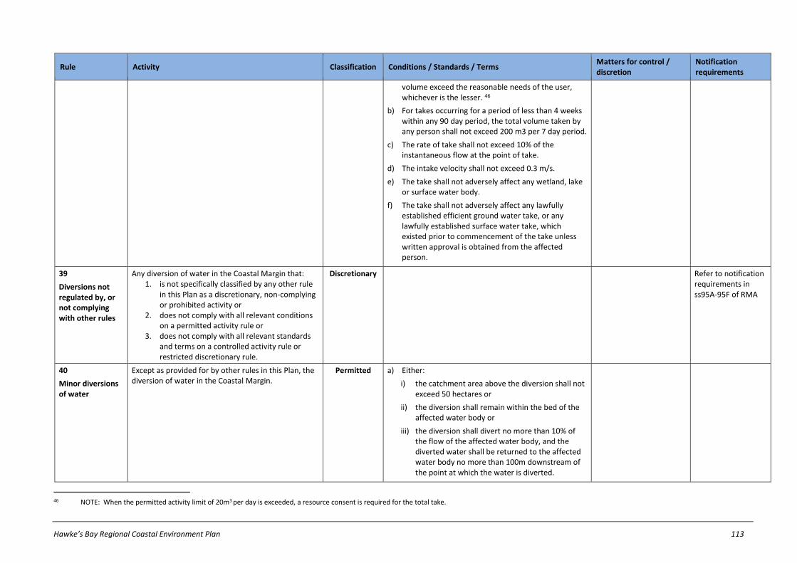
Hawke’s Bay Regional Coastal Environment Plan 113
Rule Activity Classification Conditions / Standards / Terms Matters for control / discretion
Notification requirements
volume exceed the reasonable needs of the user, whichever is the lesser. 46
b) For takes occurring for a period of less than 4 weeks within any 90 day period, the total volume taken by any person shall not exceed 200 m3 per 7 day period.
c) The rate of take shall not exceed 10% of the instantaneous flow at the point of take.
d) The intake velocity shall not exceed 0.3 m/s.
e) The take shall not adversely affect any wetland, lake or surface water body.
f) The take shall not adversely affect any lawfully established efficient ground water take, or any lawfully established surface water take, which existed prior to commencement of the take unless written approval is obtained from the affected person.
39
Diversions not regulated by, or not complying with other rules
Any diversion of water in the Coastal Margin that: 1. is not specifically classified by any other rule
in this Plan as a discretionary, non-complying or prohibited activity or
2. does not comply with all relevant conditions on a permitted activity rule or
3. does not comply with all relevant standards and terms on a controlled activity rule or restricted discretionary rule.
Discretionary Refer to notification requirements in ss95A-95F of RMA
40
Minor diversions of water
Except as provided for by other rules in this Plan, the diversion of water in the Coastal Margin.
Permitted a) Either:
i) the catchment area above the diversion shall not exceed 50 hectares or
ii) the diversion shall remain within the bed of the affected water body or
iii) the diversion shall divert no more than 10% of the flow of the affected water body, and the diverted water shall be returned to the affected water body no more than 100m downstream of the point at which the water is diverted.
46 NOTE: When the permitted activity limit of 20m3 per day is exceeded, a resource consent is required for the total take.

114 Hawke’s Bay Regional Coastal Environment Plan
Rule Activity Classification Conditions / Standards / Terms Matters for control / discretion
Notification requirements
b) The diversion shall have not adversely affect any wetland.
c) The diversion shall not be from one catchment to another.
d) The diversion shall not cause any scouring or erosion of any land or any water course beyond the point of discharge.
e) The diversion shall not adversely affect any lawfully established take, which existed at the time that the diversion commenced.
f) The diversion shall not prevent the passage of fish within the water body.
g) There shall be no adverse flooding effects on any property owned or occupied by another person, as a result of the diversion activity.
41
Lawfully established diversions of water
Any lawfully established diversion of water47 in the Coastal Margin.
Permitted a) The diversion shall not cause any scouring or erosion of any land or any water course beyond the point of discharge.
b) The diversion shall not adversely affect any lawfully established take, which existed at the time that the diversion commenced.
c) The diversion shall not prevent the passage of fish within the water body unless this was authorised at the time that the diversion was established.
d) There shall be no adverse flooding effects on any property owned or occupied by another person, as a result of the diversion activity.
42
Diversion and discharge of water in an artificial watercourse
The diversion and discharge of water in the Coastal Margin associated with the maintenance and removal or demolition of structures in any artificial water course and associated discharge of sediment.
Permitted a) There shall be no adverse flooding effects on any property owned or occupied by another person, as a result of the diversion or discharge activity.
b) There shall be no discharge of contaminants, other than sediment, into the river or lake.
47 NOTE: This rule provides for diversions established in accordance with either s14 of the RMA, or s20A of the RMA which provides for certain existing lawful activities to be allowed.

Hawke’s Bay Regional Coastal Environment Plan 115
Rule Activity Classification Conditions / Standards / Terms Matters for control / discretion
Notification requirements
c) Any release of sediment shall not cause any conspicuous change in the colour or visual clarity of the water after reasonable mixing.
43
Transfer of consents to take and use surface water from a lake
The transfer of a resource consent to take and use surface water from a lake in the Coastal Margin to another site.
Permitted a) The transfer must be to another site within the same lake in the Coastal Margin.
44
Transfer of consents to take and use surface water from a river
The transfer of a resource consent to take and use surface water from a river in the Coastal Margin to another site.
Controlled a) The transfer must be to another site within the same stream management zone in the Coastal Margin, where the flow is not significantly less than at the original site of abstraction.
b) The transfer shall not result in any reduction in the rate of surface water recharge into ground water.
c) The transfer shall not adversely affect any lawfully established surface water abstraction, which existed prior to transfer of the take.
d) The transfer shall not result in any increase in adverse effects on aquatic ecosystems or fish passage.
a) Timing of take b) Design of intake c) Volume of water
required by, or reasonable needs of, transferee
d) Matters in Chapter 26.2
Except where an applicant requests or where special circumstances exist, an application will not be served on any person or publicly notified.
45
Transfer of consents to take and use ground water
The transfer of a resource consent to take and use groundwater in the Coastal Margin to another site.
Controlled a) The transfer must be to another site within the same aquifer in the Coastal Margin.
b) The transfer must be to a location at which the aquifer has the same or greater aquifer transmission and storage characteristics.
c) The transfer shall not adversely affect any lawfully established efficient ground water abstraction, which existed prior to transfer of the take.
d) The transfer shall not cause any reduction in the flow of any river or spring.
a) Aquifer testing b) Volume of water
required by, or reasonable needs of transferee
c) Matters in Chapter 26.2
Except where an applicant requests or where special circumstances exist, an application will not be served on any person or publicly notified.

116 Hawke’s Bay Regional Coastal Environment Plan
27.4 River and lake beds in Coastal Margin
Rule Activity Classification Conditions / Standards / Terms Matters for control / discretion
Notification requirements
46
River & lake bed activities not regulated by, or not complying with, other rules
Any activity in, on, or under the bed of any river or lake in the Coastal Margin that:
1. Is not specifically classified by any other rule in this Plan as a discretionary, non-complying or prohibited activity; or
2. Does not comply with all relevant conditions on a permitted activity rule; or
3. Does not comply with all relevant standards and terms on a controlled activity rule or restricted discretionary rule.
Discretionary Refer to notification requirements in ss95A-95F of RMA
47
Disturbance of river and lake beds not regulated by other rules
Except as provided for by any other rules in this Plan, the disturbance of the bed of a river or lake in the Coastal Margin including, but not limited to any disturbance caused by:
1. tunnelling or 2. drilling or 3. excavation.
Permitted a) The area of disturbance shall be no greater than 5m2.
b) The disturbance shall not change the natural course of any river or lake.
c) Any release of sediment shall not cause any conspicuous change in the colour or visual clarity of water after reasonable mixing.
d) There shall be no discharge of contaminants, other than sediment, into the river or lake.
e) The activity shall be undertaken in a manner that continues to provide for the existing passage of fish past the structure.
f) The disturbance shall not cause any increase in the risk of flooding or damage to any property during flood events, including the risk resulting from trapped debris.
g) Any diversion of water for the purposes of carrying out the activity shall be for a period of no more than five consecutive days.
h) The activity or structure shall not cause any erosion, scour or deposition beyond the area of disturbance or adversely affect any other lawfully established structure.
i) All excess materials shall be removed from the bed by completion of the activity.

Hawke’s Bay Regional Coastal Environment Plan 117
Rule Activity Classification Conditions / Standards / Terms Matters for control / discretion
Notification requirements
j) In areas of fish spawning there shall be no disturbance by the use of mobile machinery of any part of the bed covered by water from 1 May to 30 September (fish spawning season).
48
Use of
structures48
The use49 of any lawfully established structure in, on, under or over the bed of a river, lake or artificial watercourse in the Coastal Margin.
Permitted
49
Maintenance of
structures50
Except as provided for in Rule 54, the maintenance of any lawfully established structure in, on, under or over the bed of a river or lake in the Coastal Margin and
1. any associated disturbance of the river or lake bed and
2. any associated discharge of sediment and 3. any associated diversion of water.
Permitted a) The activity shall not result in any increase in the area of river or lake bed occupied by the structure.
b) There shall be no discharge of contaminants, other than sediment, into the river or lake.
c) The disturbance of any river or lake bed, and any associated removal, flushing or deposit of bed material, shall only be to the extent necessary to maintain the functional integrity and operational efficiency of the structure.
d) Any release of sediment shall not cause any conspicuous change in the colour or visual clarity of water after reasonable mixing.
e) All materials removed from the structure and excess construction materials shall be removed from the bed by completion of the activity.
f) Materials used shall not be toxic to aquatic ecosystems.
g) The activity shall be undertaken in a manner that continues to provide for the existing passage of fish past the structure.
h) There shall be no reduction in the ability of the channel to convey flood flows, or impedance to the passage of floating debris.
48 Rule 48 does not apply to the use, maintenance and upgrading of existing electricity transmission activity structures. Refer to the Resource Management (National Environmental Standards for Electricity Transmission
Activities) Regulations 2009.
49 For the purposes of this Rule, ‘use’ refers to the actual use of the structure and not to matters contained in s14 and s15 of the RMA.
50 Rule 49 does not apply to the use, maintenance and upgrading of existing electricity transmission activity structures. Refer to the Resource Management (National Environmental Standards for Electricity Transmission Activities) Regulations 2009.

118 Hawke’s Bay Regional Coastal Environment Plan
Rule Activity Classification Conditions / Standards / Terms Matters for control / discretion
Notification requirements
i) Any diversion of water for the purposes of carrying out the activity shall be for a period of no more than five consecutive days
j) Upon completion of any channel bank works within a river or lake bed, the banks shall be reinstated to a natural contour and revegetated.
k) Existing river protection works or any other existing structure must not be damaged.
l) In areas of fish spawning there shall be no disturbance by the use of mobile machinery of any part of the bed covered by water from 01 May to 30 September (fish spawning season) other than the necessary maintenance of culverts, drains or bridges and for the clearance of debris from structures.
50
Installation, replacement and upgrading of network utility
structures51
Any activity associated with the following: 1. the replacement and upgrading of any lawfully
established network utility operation structure in airspace over and above the bed of any river or lake in the Coastal Margin
2. the installation of lines or cables attached to an existing structure in the airspace over and above the bed of any river or lake in the Coastal Margin.52
Permitted a) There shall be no reduction in the ability of the channel to convey flood flows, or impedance to the passage of floating debris.
b) There shall be no discharge of contaminants, other than sediment, into the river or lake.
c) Any diversion of water for the purposes of carrying out the activity shall be for a period of no more than five consecutive days, and for no more than 12 hours on any one day during those five days.
d) Any release of sediment shall not cause any conspicuous change in the colour or visual clarity of water after reasonable mixing.
e) Any upgrading of a structure shall not result in an increase or more than 15% of the land area occupied by the structure.
f) No work shall be undertaken in the bed of the river or lake during fish spawning season (1 May to 30 September).
51 Rule 50 does not apply to the use, maintenance and upgrading of existing electricity transmission activity structures. Refer to the Resource Management (National Environmental Standards for Electricity Transmission
Activities) Regulations 2009.
52 HBRC owns or administers many of the beds of rivers and lakes in the region, and thus has landowner rights and responsibilities in relation to this land. No right to undertake works on land owned or administered by the HBRC is given or inferred even if works fully comply with this rule.

Hawke’s Bay Regional Coastal Environment Plan 119
Rule Activity Classification Conditions / Standards / Terms Matters for control / discretion
Notification requirements
51
Removal and demolition of structures
Except as provided for in Rule 54, the removal or demolition of a structure, or any part of a structure, in, on, under, or over the bed of a river or lake in the Coastal Margin and
1. any associated disturbance of the river or lake bed and
2. any associated discharge of sediment and 3. any associated diversion of water.53
Permitted a) There shall be no discharge of contaminants, other than sediment, into the river or lake.
b) Any release of sediment shall not cause any conspicuous change in the colour or visual clarity of water after reasonable mixing.
c) All removal and demolition material shall be removed from the bed by completion of the activity.
d) Materials used shall not be toxic to aquatic ecosystems.
e) The activity shall be undertaken in a manner that continues to provide for the existing passage of fish past the structure.
f) There shall be no reduction in the ability of the channel to convey flood flows, or impedance to the passage of floating debris.
g) Any diversion of water for the purposes of carrying out the activity shall be for a period of no more than five consecutive days.
h) Upon completion of any channel bank works within a river or lake bed, the banks shall be reinstated to a natural contour and revegetated.
i) Existing river protection works or any other existing structure must not be damaged.
j) Written notice shall be provided to HBRC advising of the removal or demolition of any of the following structures, at least 15 working days prior to the commencement of the activity:
i) access structures in or on the bed of a river or lake, including bridges, culverts, and fords, which are located within a catchment greater than 50 hectares
ii) structures which occupy more than 5m2 of the bed of the river or lake.
53 HBRC owns or administers many of the beds of rivers and lakes in the region, and thus has landowner rights and responsibilities in relation to this land. No right to undertake works on land owned or administered by
the HBRC is given or inferred even if works fully comply with this rule.

120 Hawke’s Bay Regional Coastal Environment Plan
Rule Activity Classification Conditions / Standards / Terms Matters for control / discretion
Notification requirements
k) In areas of fish spawning there shall be no disturbance by the use of mobile machinery of any part of the bed covered by water from 1 May to 30 September (fish spawning season).
52
Dams, weirs and other barrier structures in rivers, lakes and artificial watercourses
The erection, construction or placement of any dam, weir or other barrier structure in, on, under, or over the bed of a river, lake and artificial watercourse in the Coastal Margin and
1. any associated damming or diversion of water and
2. any associated discharge of sediment and 3. any associated disturbance of the river or lake
bed.54
Permitted a) The catchment area of the structure shall not exceed 50 hectares, except where the structure is located in a land drainage or flood control area that is managed by a local authority exercising its powers, functions and duties under the Soil Conservation and River Control Act 1941, the Land Drainage Act 1908 or the Local Government Act 1974.
b) The volume of water to be stored or retained by the structure to spill level shall not exceed 20,000m3.
c) The height of the structure (as measured vertically from the downstream bed to the crest) shall be no greater than 4m.
d) A spillway shall be constructed to prevent the structure being overtopped during storm events, unless the structure is designed to allow overtopping.
e) Conditions (a) to (d) do not apply to structures which are located in a land drainage or flood control area that is managed by a local authority exercising its powers, functions and duties under the Soil Conservation and Rivers Control Act 1941, the Land Drainage Act 1908 or the Local Government Act 1974.
f) The impounded water shall not encroach onto any property, nor impede any drainage system beyond the subject property unless agreed to in writing by any affected property owners.
g) Erection or placement of the structure shall not cause any erosion, scour or deposition beyond the area of erection or placement.
h) The impounded water shall not cause any erosion or instability of bordering land.
54 NOTE: Rule 35, Rule 36, Rules 37 and Rule 38 apply to any associated taking and use of surface water.
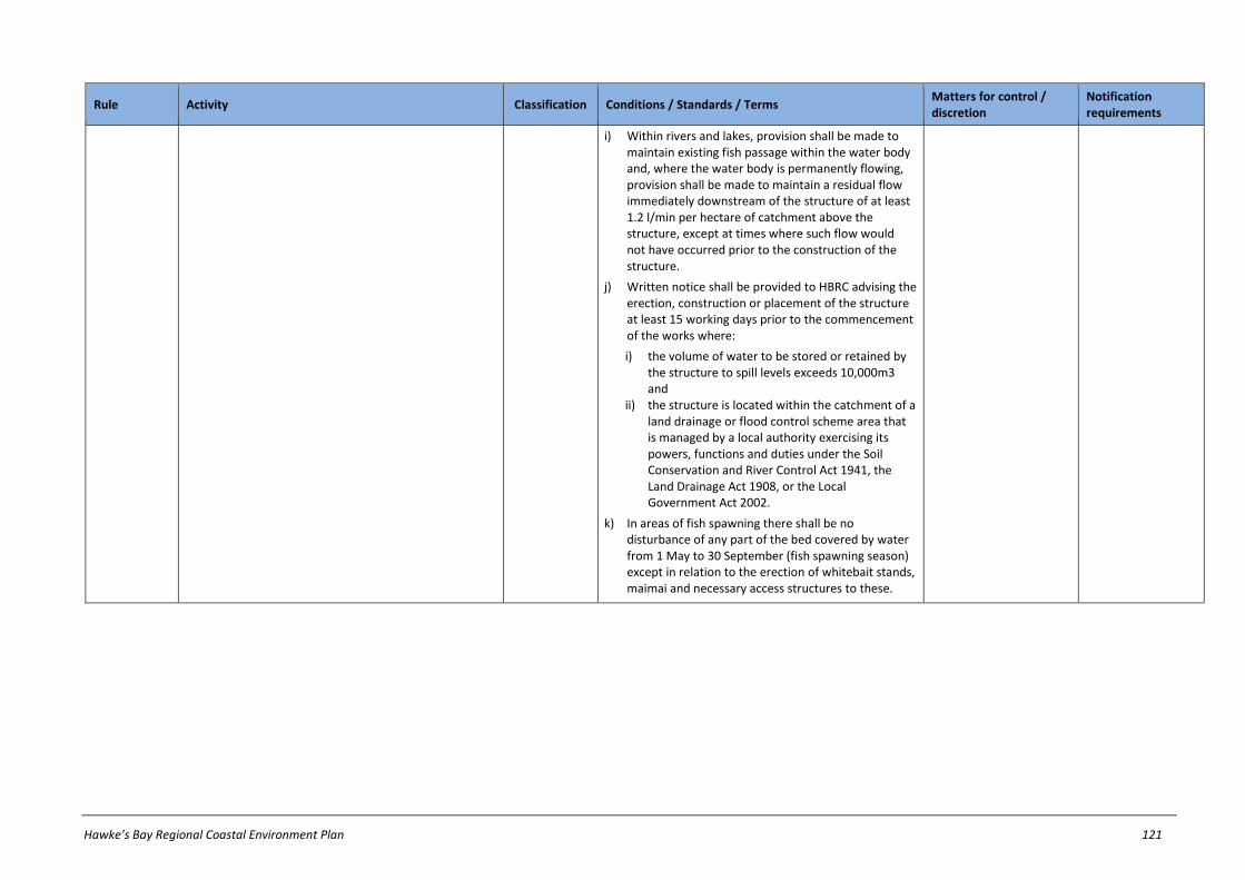
Hawke’s Bay Regional Coastal Environment Plan 121
Rule Activity Classification Conditions / Standards / Terms Matters for control / discretion
Notification requirements
i) Within rivers and lakes, provision shall be made to maintain existing fish passage within the water body and, where the water body is permanently flowing, provision shall be made to maintain a residual flow immediately downstream of the structure of at least 1.2 l/min per hectare of catchment above the structure, except at times where such flow would not have occurred prior to the construction of the structure.
j) Written notice shall be provided to HBRC advising the erection, construction or placement of the structure at least 15 working days prior to the commencement of the works where:
i) the volume of water to be stored or retained by the structure to spill levels exceeds 10,000m3 and
ii) the structure is located within the catchment of a land drainage or flood control scheme area that is managed by a local authority exercising its powers, functions and duties under the Soil Conservation and River Control Act 1941, the Land Drainage Act 1908, or the Local Government Act 2002.
k) In areas of fish spawning there shall be no disturbance of any part of the bed covered by water from 1 May to 30 September (fish spawning season) except in relation to the erection of whitebait stands, maimai and necessary access structures to these.
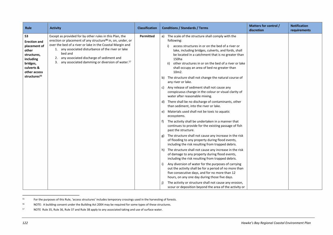
122 Hawke’s Bay Regional Coastal Environment Plan
Rule Activity Classification Conditions / Standards / Terms Matters for control / discretion
Notification requirements
53
Erection and placement of other structures, including bridges, culverts & other access structures55
Except as provided for by other rules in this Plan, the erection or placement of any structure56 in, on, under, or over the bed of a river or lake in the Coastal Margin and
1. any associated disturbance of the river or lake bed and
2. any associated discharge of sediment and 3. any associated damming or diversion of water.57
Permitted a) The scale of the structure shall comply with the following:
i) access structures in or on the bed of a river or lake, including bridges, culverts, and fords, shall be located in a catchment that is no greater than 150ha
ii) other structures in or on the bed of a river or lake shall occupy an area of bed no greater than 10m2.
b) The structure shall not change the natural course of any river or lake.
c) Any release of sediment shall not cause any conspicuous change in the colour or visual clarity of water after reasonable mixing.
d) There shall be no discharge of contaminants, other than sediment, into the river or lake.
e) Materials used shall not be toxic to aquatic ecosystems.
f) The activity shall be undertaken in a manner that continues to provide for the existing passage of fish past the structure.
g) The structure shall not cause any increase in the risk of flooding to any property during flood events, including the risk resulting from trapped debris.
h) The structure shall not cause any increase in the risk of damage to any property during flood events, including the risk resulting from trapped debris.
i) Any diversion of water for the purposes of carrying out the activity shall be for a period of no more than five consecutive days, and for no more than 12 hours, on any one day during those five days.
j) The activity or structure shall not cause any erosion, scour or deposition beyond the area of the activity or
55 For the purposes of this Rule, ‘access structures’ includes temporary crossings used in the harvesting of forests.
56 NOTE: A building consent under the Building Act 2004 may be required for some types of these structures.
57 NOTE Rule 35, Rule 36, Rule 37 and Rule 38 apply to any associated taking and use of surface water.

Hawke’s Bay Regional Coastal Environment Plan 123
Rule Activity Classification Conditions / Standards / Terms Matters for control / discretion
Notification requirements
structure or adversely affect any other lawfully established structure.
k) All excess materials shall be removed from the bed by completion of the activity.
l) In areas of fish spawning there shall be no disturbance of any part of the bed covered by water from 1 May to 30 September (fish spawning season) except in relation to emergency works, or the erection of whitebait stands, maimai, and necessary access structures to these.
m) Any whitebait structure shall be removed within 14 days of the end of any whitebait season.
54
River control and drainage works and structures
Any activity in the Coastal Margin, as described in the Hawke's Bay Regional Council Environmental Code of Practice for River Control and Drainage Works (2003), that is carried out by, or on behalf of, a local authority exercising its powers, functions and duties under the Soil Conservation and Rivers Control Act 1941, the Land Drainage Act 1908, or the Local Government Act 2002, in relation to flood control and drainage, including, but not limited to:
1. edge protection works 2. planting 3. river protection maintenance works 4. irrigation intake maintenance 5. weed and vegetation control (excluding spraying) 6. drain maintenance, and drainage outlet
maintenance 7. drain crossings 8. opening a river mouth, lagoon or estuary 9. closing a river mouth, lagoon or estuary 10. river management and drainage for the
maintenance of surface water quality 11. channel diversions within a river bed or drain,
ancillary to the above activities.
Permitted a) The activity or structure shall be undertaken in a manner that continues to provide for the existing passage of fish past the structure.
b) The appropriate Fish and Game Council, Iwi and Department of Conservation office, shall be notified at least 5 working days before any channel diversion is undertaken.
c) There shall be no discharge of contaminants, other than sediment, arising from the use of machinery in the bed of any river or lake.
d) The activity shall not adversely affect any wetland.
e) All activities shall be undertaken in accordance with the HBRC Environmental Code of Practice for River Control and Drainage Works, 2003.

124 Hawke’s Bay Regional Coastal Environment Plan
Rule Activity Classification Conditions / Standards / Terms Matters for control / discretion
Notification requirements
55
Small scale river bed gravel extraction
The extraction of sand, gravel or other material from the bed of a river using a hand-held, non-mechanical device (eg: a shovel), and any associated disturbance of the bed in the Coastal Margin.
Permitted a) The quantity of bed material extracted by any person on any single day shall not exceed 0.25m3.
b) The total quantity of bed material extracted by any person over any 12 month period shall not exceed 1m3.
c) The material shall be extracted from an area of river bed that is not covered by water at the time of extraction.
d) The area from which material is extracted shall be recontoured so that no mounds or depressions remain.
e) There shall be no discharge of any contaminant directly into water.
56
Planting of plants in rivers/lakes
Except as provided for in Rule 54 and Rule 62, the introduction or planting of any plant58 or any part of any plant in, on, or under the bed of a river or lake in the Coastal Margin.
Permitted a) The plant shall not be an exotic plant.
b) The planting shall not result in any reduction in the ability of the water body to convey flood flows or any impedance to the passage of debris.
c) The activity shall not cause any significant erosion, scour or deposition.
d) The activity shall be undertaken in a manner that continues to provide for the existing passage of fish.
e) In areas of fish spawning there shall be no disturbance of any part of the bed covered by water from 01 May to 30 September (fish spawning season).
57
Disturbance of river/lake beds by livestock
Except as provided for in Rule 59, the disturbance of the bed of any permanently flowing river or any lake arising from the presence of livestock.
Permitted a) The disturbance shall not cause any conspicuous change in the visual clarity of the water after reasonable mixing.
b) Supplementary feed shall not be deposited on the bed of the river or lake.
c) The disturbance shall not result in faecal coliforms exceeding 200cfu/100ml in any receiving water after reasonable mixing.
58 NOTE: Pursuant to the Biosecurity Act 1993, it is an offence for anyone to sell, propagate or distribute any plant classified as a plant pest in the Regional Plant Pest Management Strategy.

Hawke’s Bay Regional Coastal Environment Plan 125
Rule Activity Classification Conditions / Standards / Terms Matters for control / discretion
Notification requirements
58
Disturbance of river/lake beds by livestock not complying with Rule 57
Except as provided for in Rule 59, the disturbance of the bed of any permanently flowing river or any lake arising from the presence of livestock that does not comply with Rule 57.
Discretionary Refer to notification requirements in ss95A-95F of RMA
59
Livestock in upper Ahuriri Estuary Stock Management Area
Livestock entering or crossing the bed or land within the upper Ahuriri Stock Management Area identified in Schedule R of this Plan and including any disturbance of the bed of the waterbody arising from presence of livestock.59
Prohibited
60
Existing damming of water in rivers and lakes
Except as provided for in Rule 52, any existing damming of water associated with a lawfully established dam, weir, or other barrier structure in, on, under, or over the bed of a river, lake or artificial watercourse in the Coastal Margin.60
Controlled a) The impounded water shall not encroach onto any property beyond the subject property, unless agreed to in writing by any affected property owners.
a) Stability of the land bordering the dam
b) Residual downstream flow
c) Flood risk in the event of structure failure
d) Maintenance of structure
e) Matters in Chapter 26.2
Except where an applicant requests or where special circumstances exist, an application will not be served on any person or publicly notified.
61
Large scale river bed gravel extraction
Except as provided for in Rule 55, the extraction of sand, gravel or other material from the bed of any river or lake in the Coastal Margin and:
1. any associated disturbance of the bed and 2. any associated discharge of sediment and 3. any associated diversion of water.
Restricted discretionary
a) Location of extraction sites & stockpile areas
b) Volume of gravel extracted
c) Rate of removal of gravel
d) Period of extraction e) End use of the gravel f) Dust management g) Compliance with the
HBRC Code of Practice for River Control and Drainage Works
Except where an applicant requests or where special circumstances exist, an application will not be publicly notified, but HBRC will require notice of an application to be served on all affected persons (if any), unless all affected persons
59 This rule does not apply to any activity undertaken by, or on behalf of, a local authority or Department of Conservation for the purpose of restoring, protecting or enhancing the biodiversity of the coastal environment.
60 NOTE: This Rule only applies to existing damming of water associated with lawfully established structures – not the structure itself. Rule 49 relates to lawfully established structures in river and lake beds.

126 Hawke’s Bay Regional Coastal Environment Plan
Rule Activity Classification Conditions / Standards / Terms Matters for control / discretion
Notification requirements
h) Matters in Chapter 26.2 have provided their written approval.
62
Activities affecting river control & drainage schemes61
Any of the following activities in the Coastal Margin, where they are undertaken by persons other than the local authority or persons acting on the local authority’s behalf, within a land drainage or flood control scheme area that is managed by a local authority exercising its powers, functions and duties under the Soil Conservation and Rivers Control Act 1941, the Land Drainage Act 1908, the Local Government Act 1974 or the Local Government Act 2002:62
1. the introduction or planting of any plant including any tree in, on, or under the bed of any river, lake or artificial watercourse, or within 6 metres of the bed
2. the erection of any building, fence or other structure in, on, or under the bed of any river, lake or artificial watercourse, or within 6 metres of the bed
3. the deposition of any rock, gravel, earth, debris or other substance in, on, or under the bed of any river, lake or artificial watercourse, or within 6 metres of the bed
4. the reclamation or drainage of the bed of any river, lake or artificial watercourse
5. the undertaking of any other land disturbance activity which impedes access to the bed of any river, lake or artificial watercourse, or within 6 metres of the bed
6. the erection of any structure and the undertaking of any land disturbance activity which interferes with the integrity of any defence against water63.
Discretionary Refer to notification requirements in ss95A-95F of RMA
61 NOTE 1: HBRC owns much of the land within River Control and Drainage Schemes, and thus has landowner rights and responsibilities in relation to this land. No right to undertake works on land owned or administered
by the HBRC is given or inferred even if resource consent is granted under this rule.
NOTE 2: This rule does not apply to maintenance, replacement or upgrading of a structure that fully complies with Rule 49 or Rule 50 whichever is applicable.
62 NOTE: The ongoing maintenance and repair of any structure authorised by a resource consent under this rule is a permitted activity under Rule 49.
63 ‘Defence against water’ includes stopbanks and their foundations.

Hawke’s Bay Regional Coastal Environment Plan 127
27.5 Discharges to air
Rule Activity Classification Conditions / Standards / Terms Matters for control / discretion
Notification requirements
63
Discharges of contaminants to air not complying with rules
The discharge of contaminants into the air in the Coastal Environment that:
1. does not comply with all relevant conditions on a permitted activity rule or
2. does not comply with all relevant standards and terms on a controlled activity rule.
Restricted discretionary
a) Conditions, standards or terms which the activity cannot comply with, and the related environmental effects
b) Matters for control’ set out in the relevant rule for activities that would otherwise be controlled activities (if they complied with all standards & terms of the relevant rule)
c) Contaminant emission rate
d) Measures to ensure maintenance of fuel burning equipment; carrying out of measurements, samples, analysis, surveys, investigations or inspections including monitoring of: contaminant concentrations and emission rates, opacity of discharges; quantity of fuel used; cumulative effects of discharges in combination with discharges from other sources; provision of information to consent authority at specified times
e) New technologies available to minimise
Except where an applicant requests or where special circumstances exist, an application will not be publicly notified, but HBRC will require notice of an application to be served on all affected persons (if any), unless all affected persons have provided their written approval.

128 Hawke’s Bay Regional Coastal Environment Plan
Rule Activity Classification Conditions / Standards / Terms Matters for control / discretion
Notification requirements
discharges or effects of discharges
f) Effects on aircraft navigation and safety and highway safety
g) Methods used to disperse contaminants, including chimney height, design, and emission velocity; and direction of exhaust gases. Chimney height will generally be determined in accordance with Schedule I
h) Matters in Chapter 26.2
64
Discharges of contaminants to air not regulated by
other rules64
(Industrial and Trade premises)
The discharge of contaminants into the air in the Coastal Environment from any industrial and trade premises that is not specifically classified by any other rule in this Plan as a permitted, controlled, restricted discretionary, non-complying or prohibited activity.
Discretionary Refer to notification requirements in ss95A-95F of RMA
64 All other discharges to air (e.g. from residential properties) which are not specifically regulated by rules in this Plan are regulated by Section 15 of the RMA. NOTE: The Resource Management (National Environmental
Standards Relating to Air Quality) Regulations 2004 regulate the installation of woodburners on properties less than 2 hectares in size.

Hawke’s Bay Regional Coastal Environment Plan 129
Rule Activity Classification Conditions / Standards / Terms Matters for control / discretion
Notification requirements
65
Burning of specified fuels from fixed
sources65, 66, 67,
The discharge of any contaminant into air from any source in the Coastal Environment, (including any industrial or trade premises), but excluding any moveable source68, and any dwelling house arising from the burning of:
1. natural or liquefied petroleum gas and/or 2. coal, diesel, kerosene, light fuel oil, heavy fuel
oil wood pellet fuel or untreated wood.
Permitted a) maximum heat output shall not exceed:
i) 5 MW for natural or liquefied petroleum gas or ii) 100 kW for coal, light fuel oil, heavy fuel oil or
untreated wood or iii) 200 kW for wood pellet fuel iv) 2 MW for diesel or kerosene or (external
combustion) v) 100 kW for diesel or kerosene (internal
combustion) vi) where more than one fuel type is used on the
site, the combined heat output shall not exceed the lowest MW threshold of any of the fuel types used.
b) The fuel shall be burned using fuel burning equipment, and the discharge shall be from a chimney or exhaust structure designed so that the emission is effectively dispersed upwards.
c) At any point beyond the boundary of the subject property, or on any public land:
i) the discharge shall not result in any smoke that adversely affects traffic safety, or reduces visibility within 5m of ground level and
ii) the discharge shall not result in any objectionable deposition of particulate matter on any land or structure and
iii) the discharge shall not result in any offensive or objectionable odour, or any noxious or dangerous levels of gases.
d) The fuel shall not comprise any of the waste materials specified in Rule 75.
65 NOTE: Schedule I sets out estimated emission rates of contaminants under this rule.
66 NOTE: This rule does not apply to any activity otherwise regulated by the Resource Management (Marine Pollution) Regulations.
67 NOTE: For the avoidance of doubt, Rule 65 applies to the discharge of contaminants into air from any small-scale solid fuel burner or open fires on an industrial or trade premises where that burner or open fire is used exclusively for smoking or cooking of food for wholesale or retail sale.
68 Discharges of contaminants into air arising from the combustion of fuels in moveable sources (including ships, vessels, motor vehicles and aircraft), are not regulated by this Plan and therefore do not require resource consents (excluding moveable asphalt plants and road burners which are covered by rules elsewhere in Chapter 27.5).
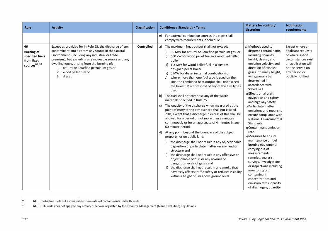
130 Hawke’s Bay Regional Coastal Environment Plan
Rule Activity Classification Conditions / Standards / Terms Matters for control / discretion
Notification requirements
e) For external combustion sources the stack shall comply with requirements in Schedule I.
66
Burning of specified fuels from fixed
sources69, 70
Except as provided for in Rule 65, the discharge of any contaminant into air from any source in the Coastal Environment, (including any industrial or trade premises), but excluding any moveable source and any dwellinghouse, arising from the burning of:
1. natural or liquefied petroleum gas or 2. wood pellet fuel or 3. diesel.
Controlled a) The maximum heat output shall not exceed:
i) 50 MW for natural or liquefied petroleum gas; or ii) 600 kW for wood pellet fuel in a modified pellet
boiler iii) 1.2 MW for wood pellet fuel in a custom
designed pellet boiler iv) 5 MW for diesel (external combustion) or v) where more than one fuel type is used on the
site, the combined heat output shall not exceed the lowest MW threshold of any of the fuel types used.
b) The fuel shall not comprise any of the waste materials specified in Rule 75.
c) The opacity of the discharge when measured at the point of entry to the atmosphere shall not exceed 20%, except that a discharge in excess of this shall be allowed for a period of not more than 2 minutes continuously or for an aggregate of 4 minutes in any 60 minute period.
d) At any point beyond the boundary of the subject property, or on public land:
i) the discharge shall not result in any objectionable deposition of particulate matter on any land or structure and
ii) the discharge shall not result in any offensive or objectionable odour, or any noxious or dangerous levels of gases and
iii) the discharge shall not result in any smoke that adversely affects traffic safety or reduces visibility within a height of 5m above ground level.
a) Methods used to disperse contaminants, including chimney height, design, and emission velocity; and direction of exhaust gases. Chimney height, will generally be determined in accordance with Schedule I
b) Effects on aircraft navigation and safety and highway safety
c) Particulate matter emissions and means to ensure compliance with National Environmental Standards
d) Contaminant emission rate
e) Measures to ensure maintenance of fuel burning equipment; carrying out of measurements, samples, analysis, surveys, investigations or inspections including monitoring of: contaminant concentrations and emission rates, opacity of discharges; quantity
Except where an applicant requests or where special circumstances exist, an application will not be served on any person or publicly notified.
69 NOTE: Schedule I sets out estimated emission rates of contaminants under this rule.
70 NOTE: This rule does not apply to any activity otherwise regulated by the Resource Management (Marine Pollution) Regulations.

Hawke’s Bay Regional Coastal Environment Plan 131
Rule Activity Classification Conditions / Standards / Terms Matters for control / discretion
Notification requirements
of fuel used; cumulative effects of discharges in combination with discharges from other sources; provision of information to consent authority at specified times
f) New technologies available to minimise discharges or effects of discharges
g) Matters in Chapter 26.2
67
Discharge to air from any small scale solid fuel burner -
Hastings Airshed
The discharge of contaminants into air from a small scale solid fuel burner in a building located within the Hastings Airshed.
Permitted a) Any solid fuel burner located in Airzone 2 of the Hastings Airshed must comply with the requirements in Part B Schedule K, except where the solid fuel burner was installed before 1 November 2014 (being the date this rule became operative).
b) At any point beyond the boundary of the subject property, or on any public land:
i) the discharge shall not result in any objectionable deposition of particulate matter on any land or structure and
ii) the discharge shall not result in any offensive or objectionable odour, or any noxious or dangerous levels of gases.
c) Contaminants discharged may only be derived from the combustion of fuel approved by the manufacturer for use in the solid fuel burner.

132 Hawke’s Bay Regional Coastal Environment Plan
Rule Activity Classification Conditions / Standards / Terms Matters for control / discretion
Notification requirements
68
Discharges to air from any small scale solid fuel burner in Napier Airshed
The discharge of contaminants to air from a small scale fuel burner in a building located within the Napier Airshed.71
Permitted a) Any small scale solid fuel burner located on a property less than 2 hectares in size in Airzone 1 of the Napier Airshed must comply with the requirements in Part B Schedule K or Part C Schedule K, or with the definition of ‘wood fired cooker’ in this Plan.
b) Any solid fuel burner located in Airzone 2 of the Napier Airshed or in Airzone 1 of the Napier Airshed on a property over 2 hectares in size must comply with the requirements in Part B Schedule K, except where the solid fuel burner was installed before 1 November 2014 (being the date this rule became operative).
c) At any point beyond the boundary of the subject property, or on any public land:
i) the discharge shall not result in any objectionable deposition of particulate matter on any land or structure and
ii) the discharge shall not result in any offensive or objectionable odour, or any noxious or dangerous levels of gases.
d) Contaminants discharged may only be derived from the combustion of fuel authorised or approved for use in the small scale solid fuel burner.
69
Discharges to air from any small scale solid fuel burner or open fire in a Registered Historic Building
The discharge of contaminants into air from the burning of fuel in any existing small scale solid fuel burner or an open fire that is located within a registered historic building72 located in the Napier or Hastings Airsheds.
Permitted a) The small scale solid fuel burner or open fire must contribute to the significance of the registered historic place.
b) Any wood burner installed after 1 September 2005, or any small scale solid fuel burner installed after 10 December 2008 in a building on a property with an allotment size of less than 2 hectares, must comply with the requirements in Schedule K.
c) At any point beyond the boundary of the subject property, or on any public land:
71 If condition (a) of Rule 68 cannot be complied with, then the activity is prohibited under Rule 77. If conditions (b), (c) and (d) of Rule 68 cannot be complied with then the activity is restricted discretionary under Rule 63.
72 For the purposes of Rule 69, a registered historic building is a building that is individually registered on the New Zealand Historic Places Register and/or in any relevant district plan or proposed district plan.

Hawke’s Bay Regional Coastal Environment Plan 133
Rule Activity Classification Conditions / Standards / Terms Matters for control / discretion
Notification requirements
Napier and Hastings Airsheds
i) the discharge shall not result in any objectionable deposition of particulate matter on any land or structure and
ii) the discharge shall not result in any offensive or objectionable odour, or any noxious or dangerous levels of gases.
70
Discharges to air for specified purposes
The discharge of contaminants into air arising from the burning of materials in the Coastal Environment for any of the following purposes:
1. training people to put out fires 2. creating special smoke and fire effects for the
purposes of producing films 3. fireworks display or other temporary event
involving the use of fireworks.
Permitted a) At any point beyond the boundary of the subject property, or on public land:
i) the discharge shall not result in any objectionable deposition of particulate matter on any land or structure and
ii) the discharge shall not result in any offensive or objectionable odour, or any noxious or dangerous levels of gases and
iii) the discharge shall not result in any smoke that adversely affects traffic safety or reduces visibility within a height of 5m above ground level.
b) Any discharges for purposes of training people to put out fires must take place under the control of the NZ Fire Service or any other nationally recognised agency authorised to undertake firefighting research or fire fighting activities.
c) Any discharge for the purposes of training people to put out fires, or for the creation of special smoke or fire effects for producing films:
i) Must not occur during the months of May, June, July or August If the property is located within
the Hastings or Napier Airsheds73, and
ii) Must be notified to the Hawke’s Bay Regional Council at least 2 working days prior to the activity commencing.
73 If condition (c)(i) of Rule 70 cannot be complied with then the activity is non-complying under Rule 74.
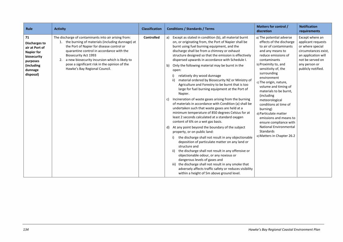
134 Hawke’s Bay Regional Coastal Environment Plan
Rule Activity Classification Conditions / Standards / Terms Matters for control / discretion
Notification requirements
71
Discharges to air at Port of Napier for biosecurity purposes (including dunnage disposal)
The discharge of contaminants into air arising from: 1. the burning of materials (including dunnage) at
the Port of Napier for disease control or quarantine control in accordance with the Biosecurity Act 1993
2. a new biosecurity incursion which is likely to pose a significant risk in the opinion of the Hawke’s Bay Regional Council.
Controlled a) Except as stated in condition (b), all material burnt on, or originating from, the Port of Napier shall be burnt using fuel burning equipment, and the discharge shall be from a chimney or exhaust structure designed so that the emission is effectively dispersed upwards in accordance with Schedule I.
b) Only the following material may be burnt in the open:
i) relatively dry wood dunnage ii) material ordered by Biosecurity NZ or Ministry of
Agriculture and Forestry to be burnt that is too large for fuel burning equipment at the Port of Napier.
c) Incineration of waste gases arising from the burning of materials in accordance with Condition (a) shall be undertaken such that waste gases are held at a minimum temperature of 850 degrees Celsius for at least 2 seconds calculated at a standard oxygen content of 6% on a wet gas basis.
d) At any point beyond the boundary of the subject property, or on public land:
i) the discharge shall not result in any objectionable deposition of particulate matter on any land or structure and
ii) the discharge shall not result in any offensive or objectionable odour, or any noxious or dangerous levels of gases and
iii) the discharge shall not result in any smoke that adversely affects traffic safety or reduces visibility within a height of 5m above ground level.
a) The potential adverse effects of the discharge to air of contaminants and any means to reduce emissions of contaminants
b) Proximity to, and sensitivity of, the surrounding environment
c) The origin, nature, volume and timing of materials to be burnt, (including meteorological conditions at time of burning)
d) Particulate matter emissions and means to ensure compliance with National Environmental Standards
e) Matters in Chapter 26.2
Except where an applicant requests or where special circumstances exist, an application will not be served on any person or publicly notified.

Hawke’s Bay Regional Coastal Environment Plan 135
Rule Activity Classification Conditions / Standards / Terms Matters for control / discretion
Notification requirements
72
Burning of waste not within CMA
Except as provided for in Rule 70 and Rule 71, the discharge of contaminants into air not within the coastal marine area74 arising from the burning of waste.75
Permitted a) The waste shall have been generated on the same property, or on another property under the same ownership, as that used for burning.
b) Any material burnt on, or originating from, industrial or trade premises shall be burnt using fuel burning equipment, and the discharge shall be from a chimney or exhaust structure designed so that the emission is effectively dispersed upwards in accordance with Schedule I.
c) The material to be burnt shall not contain any animal waste (except animal waste generated on production land), tyres or other rubber, waste oil, any waste products containing hydrocarbons, wood treated with chemicals, painted wood, chip board, plastic, asbestos, medical waste, chemical waste, or any combination of metals and combustible materials or any other waste materials specified in Rule 75.
d) At any point beyond the boundary of the subject property:
i) the discharge shall not result in any smoke that adversely affects traffic safety, or reduces visibility within a height of 5m above ground or reduces visibility within recognised flight paths in the vicinity of airports and
ii) the discharge shall not result in any objectionable deposition of particulate matter on any land or structure and
iii) the discharge shall not result in any offensive or objectionable odour, or any noxious or dangerous levels of gases.
74 NOTE: The burning of waste or other matter in any marine incineration facility in the coastal marine area is deemed to be a prohibited activity in any regional coastal plan or proposed regional coastal plan under Clause
6(10) of the Resource Management (Marine Pollution) Regulations 1998.
75 Conditions (a) to (d) shall apply where discharges of contaminants occur as a result of Local Authorities carrying out their functions by burning waste on public land.
Advisory Note:
Territorial Authority Bylaws – it is important to note that rules do not replace territorial authority bylaws controlling burning. Persons burning any waste or other materials should ensure that they comply with any relevant bylaws, including prohibited or restricted fire seasons.

136 Hawke’s Bay Regional Coastal Environment Plan
Rule Activity Classification Conditions / Standards / Terms Matters for control / discretion
Notification requirements
73
Burning of vegetative matter, paper, cardboard and untreated wood, and fuel burnt in any frost protection heater
Except as provided for by Rule 71 the discharge of contaminants into air arising from the burning in the open of vegetative matter, paper, cardboard and untreated wood, and fuel burnt in any frost protection heater.
Permitted a) Burning shall only consist of fuel for frost protection purposes or vegetative matter, paper, cardboard and untreated wood generated on the same property, or a property under the same ownership.
b) At any point beyond the boundary of the subject property, or on any public land:
i) the discharge shall not result in any objectionable deposition of particulate matter on any land or structure and
ii) the discharge shall not result in any offensive or objectionable odour, or any noxious or dangerous levels of gases.
c) Burning shall not consist of any of the specific fuels or waste specified in Rule 7576.
d) The burning of oil77 for frost protection purposes shall only take place in fuel burning equipment that operates with a stack or chimney.
74
Outdoor burning during certain times of year
Except as provided for in Rule 70, Rule 71, Rule 72, Rule 73 and Rule 75, the discharge of contaminants into air arising from outdoor burning during the months of May, June, July or August within the Napier Airshed or Hastings Airshed.78
Non-complying
Refer to notification requirements in ss95A-95F of RMA
75
Burning of specified
waste79 in the
open and in small scale fuel burners
Except as provided for in Rule 70 and Rule 71, the discharge of contaminants into air in the Coastal Environment arising from the burning in the open and/or in a small scale fuel burner of:
1. any combination of metals and combustible materials; or
2. animal waste (excluding animal waste generated on production land), rubber, wood
Prohibited
76 NOTE: Condition (c) effectively means that only burning of fuel in frost protection heaters, or the burning of paper, cardboard, wood, vegetation cuttings, untreated plant fibres and the like complies with this condition.
77 For the purposes of Rule 73(d) oil is defined as: petroleum in any form other than gas, including crude oil, and refined oil products (e.g. diesel fuel, kerosene, motor gasoline), but excludes waste oil which is prohibited from being burnt in the open under Rule 75.
78 NOTE: Rule 74 does not override Clause 10 of the Resource Management (National Environmental Standards Relating to Air Quality) Regulations 2004 which prohibits burning of oil in the open.
79 NOTE: The burning of waste or other matter in any marine incineration facility in the coastal marine area is deemed to be a prohibited activity in any regional coastal plan or proposed regional coastal plan under Clause 6(1) of the Resource Management (Marine Pollution) Regulations 1998.

Hawke’s Bay Regional Coastal Environment Plan 137
Rule Activity Classification Conditions / Standards / Terms Matters for control / discretion
Notification requirements
treated with chemicals except wood pellets which comply with the definition of ‘wood pellets’ in this Plan), oiled, painted or stained wood, chip board, asbestos, medical waste, pacemakers, biomechanical devices or chemical waste; or
3. synthetic material, including but not limited to, motor vehicle parts, foams, fibreglass, batteries, surface coating materials, tar or any type of plastic; or
4. peat; or 5. sludge from industrial processes80.
76
Discharges to air from open fires in Hastings or Napier Airsheds
Except as provided for by Rule 69, the discharge of contaminants to air from a building located within the Hastings Airshed or Napier Airshed resulting from the burning of any solid fuel in any open fire from 1 January 2012, unless:
1. the open fire was installed before 10 December 2008, and
2. is located on a property over 2 hectares in size or is located in Airzone 2 of the Hastings or Napier Airsheds.
Prohibited
77
Discharges to air from small scale solid fuel burners
Napier Airshed
Except as provided for in Rule 67, Rule 68 and Rule 69, the discharge of contaminants into air from any small scale solid fuel burner in a building located in Airzone 1 of the Napier Airshed as follows:
1. After 1 January 2014 the use of solid fuel burners installed prior to 31 December 1995
2. After 1 January 2016, the use of solid fuel burners installed between 1 January 1996 and 31 August 2005
3. After 1 January 2020, the use of solid fuel burners installed after 1 September 2005 that do not comply with the requirements in Schedule K.
Prohibited
80 NOTE: Burning of other materials in addition to those identified in this rule may be prohibited by National Environmental Standards.

138 Hawke’s Bay Regional Coastal Environment Plan
Rule Activity Classification Conditions / Standards / Terms Matters for control / discretion
Notification requirements
78
Discharges to air from a small scale solid fuel burner or open fire at property
ownership81
transfer in Napier Airshed
Except as provided for by Rule 67, Rule 68 and Rule 69, the discharge of contaminants into air from any existing small scale solid fuel burner or open fire, located within Airzone 1 of the Napier Airshed that:
1. is occurring at any time after the date from which there is a registered transfer of ownership of the property, after 1 November 2014 (being the date this rule became operative).
Prohibited
79
Flaring of hydrocarbons from petroleum exploration or mining in the CMA
The discharge of contaminants to air in the coastal marine area arising from the flaring of hydrocarbons from petroleum exploration or mining.
Controlled a) The discharge must not occur within 2,000m of a Significant Conservation Area.
b) Any non-petroleum products must not be combusted or discharged.
c) The discharge must not be located in aircraft flight paths identified in the City of Napier District Plan.
a) Effects on air quality and water quality
b) Effects on wildlife, including marine mammals and birds
c) Performance of combustion equipment
d) Separation of natural gas from liquid hydrocarbons and water
e) Noise & light emissions f) Duration of flaring g) Notification prior to
commencement h) Matters in Chapter 26.2
Except where an applicant requests or where special circumstances exist, an application will not be served on any person or publicly notified.
80
Moveable aggregate processing plants
The discharge of contaminants into air in the Coastal Environment from the operation of a moveable aggregate processing plant.
Permitted a) There shall be no visible discharge of water spray or dust beyond the boundary of the subject property, or in the case of public land, beyond 50m from the discharge or beyond the boundary of the public land, whichever is the lesser.
b) The dust deposition rate resulting from the discharge shall not raise the ambient dust deposition rate by more than 4g/m2 per 30 days at any point beyond the boundary of the subject property.
81 Rule 78 does not apply to a transfer in title in consequence of death of an owner when the title is transferred to the surviving partner, or where the surviving partner continues to occupy the dwelling.
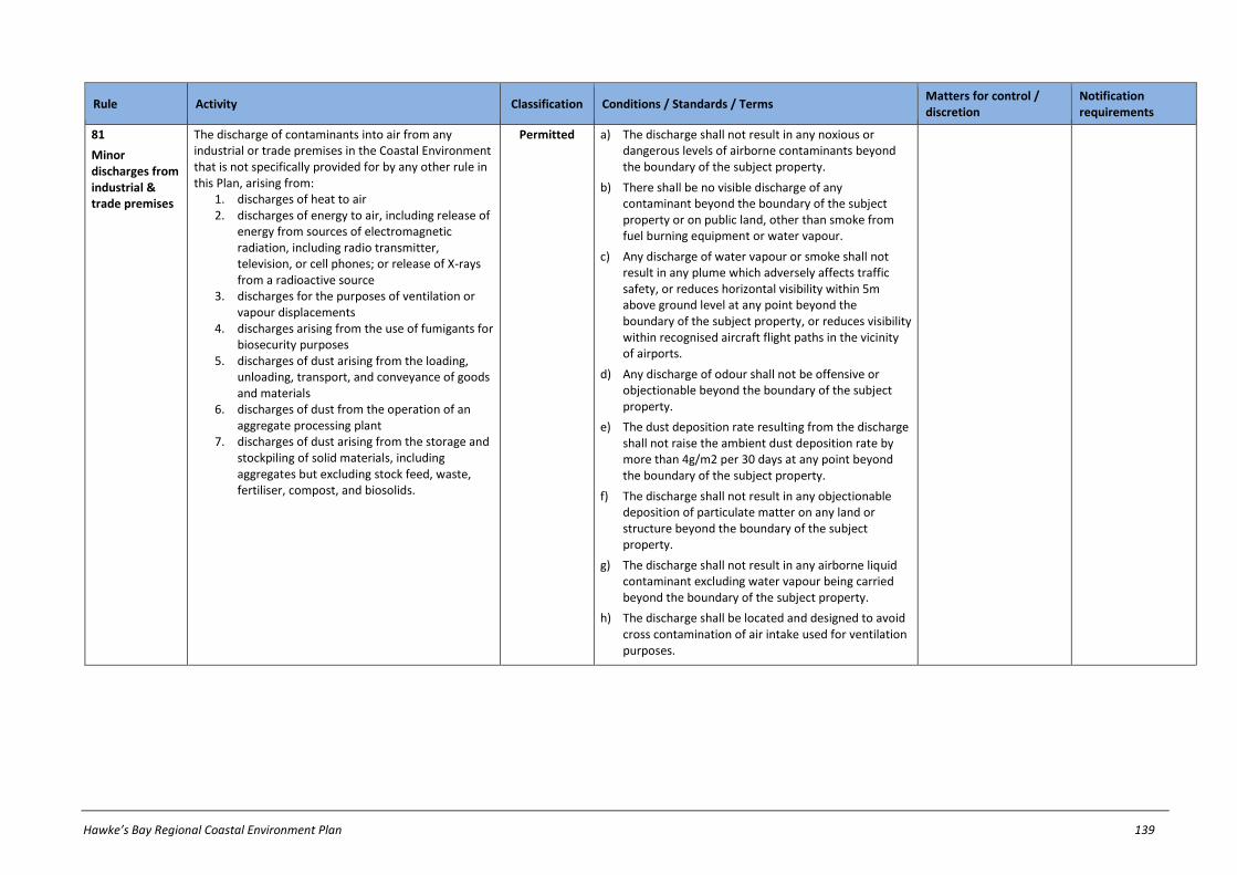
Hawke’s Bay Regional Coastal Environment Plan 139
Rule Activity Classification Conditions / Standards / Terms Matters for control / discretion
Notification requirements
81
Minor discharges from industrial & trade premises
The discharge of contaminants into air from any industrial or trade premises in the Coastal Environment that is not specifically provided for by any other rule in this Plan, arising from:
1. discharges of heat to air 2. discharges of energy to air, including release of
energy from sources of electromagnetic radiation, including radio transmitter, television, or cell phones; or release of X-rays from a radioactive source
3. discharges for the purposes of ventilation or vapour displacements
4. discharges arising from the use of fumigants for biosecurity purposes
5. discharges of dust arising from the loading, unloading, transport, and conveyance of goods and materials
6. discharges of dust from the operation of an aggregate processing plant
7. discharges of dust arising from the storage and stockpiling of solid materials, including aggregates but excluding stock feed, waste, fertiliser, compost, and biosolids.
Permitted a) The discharge shall not result in any noxious or dangerous levels of airborne contaminants beyond the boundary of the subject property.
b) There shall be no visible discharge of any contaminant beyond the boundary of the subject property or on public land, other than smoke from fuel burning equipment or water vapour.
c) Any discharge of water vapour or smoke shall not result in any plume which adversely affects traffic safety, or reduces horizontal visibility within 5m above ground level at any point beyond the boundary of the subject property, or reduces visibility within recognised aircraft flight paths in the vicinity of airports.
d) Any discharge of odour shall not be offensive or objectionable beyond the boundary of the subject property.
e) The dust deposition rate resulting from the discharge shall not raise the ambient dust deposition rate by more than 4g/m2 per 30 days at any point beyond the boundary of the subject property.
f) The discharge shall not result in any objectionable deposition of particulate matter on any land or structure beyond the boundary of the subject property.
g) The discharge shall not result in any airborne liquid contaminant excluding water vapour being carried beyond the boundary of the subject property.
h) The discharge shall be located and designed to avoid cross contamination of air intake used for ventilation purposes.

140 Hawke’s Bay Regional Coastal Environment Plan
Rule Activity Classification Conditions / Standards / Terms Matters for control / discretion
Notification requirements
82
Management of waste & other matter, excluding industrial & trade premises
The discharge of contaminants into air in the Coastal Environment arising from the storage, use, transfer, treatment or disposal of waste and other matter, excluding:
1. discharges into air from any industrial or trade premises82 and
2. discharges into air addressed by other rules in this Plan83 and
3. discharges into air from moveable sources.
Permitted a) Any waste which is disposed of shall have been generated on the subject property or on another property under the same ownership as that used for disposal.84
b) The discharge shall not result in any offensive or objectionable odour, or any noxious or dangerous levels of gases, beyond the boundary of the subject property.
c) The discharge shall not result in any visible discharge of any material, including dust, beyond the boundary of the subject property.
d) The discharge shall not result in any airborne liquid contaminant being carried beyond the boundary of the subject property.
e) For any discharge into air arising from material sourced from industrial and trade premises, a Management Plan shall be prepared which sets out how conditions (b), (c) and (d) above will be met. A copy of this Management Plan shall be provided to the Hawke’s Bay Regional Council upon request.
83
Wet abrasive
blasting85
The discharge of contaminants into air in the Coastal Environment from abrasive blasting, using wet abrasive blasting techniques.86
Permitted a) There shall be no discharge of water spray, dust or other contaminant beyond the boundary of the subject property or, in the case of public land, beyond 50 metres from the discharge or beyond the boundary of the public land, whichever is the lesser.
b) There shall be no discharge of water spray, dust or other contaminant into the coastal marine area.
82 The discharge of contaminants into air from industrial or trade premises, arising from the management of waste and other matter, is addressed under Rule 82 and Rule 86
83 The discharge of contaminants into air arising from the burning of waste and other matter, is addressed under Rule 72 and Rule 75.
84 NOTE: Condition (a) only restricts the source of waste to be disposed of. The source of waste or other matter that is stored, used, transferred or treated is not restricted.
85 Rule 84 does not apply to the wet or dry abrasive blasting of a transmission line support structures of existing high voltage electricity transmission lines or the preparation of the structure to receive a protective coating. Refer to the Resource Management (National Environmental Standards for Electricity Transmission Activities) Regulations 2009.
86 Where discharges may enter a water body, then the activity must also meet the requirements of Rule 19; or Rule 167 where the discharge enters coastal waters.

Hawke’s Bay Regional Coastal Environment Plan 141
Rule Activity Classification Conditions / Standards / Terms Matters for control / discretion
Notification requirements
84
Dry abrasive blasting – fixed
source87
The discharge of contaminants into air in the Coastal Environment from dry abrasive blasting, other than from the use of a moveable source.88
Permitted a) The discharge shall not result in any noxious or dangerous levels of airborne contaminants beyond the boundary of the subject property.89
b) All items shall be blasted within an abrasive blasting enclosure.90
c) There shall be no visible discharge of dust beyond the abrasive blasting enclosure.
d) There shall be no discharge of water spray or dust beyond the boundary of the subject property.
85
Abrasive blasting – moveable
source91
Except as provided for in Rule 83, the discharge of contaminants into air in the Coastal Environment arising from abrasive blasting, using a moveable source.
92,93
Discretionary Refer to notification requirements in ss95A-95F of RMA
86
Miscellaneous discharges to air from industrial & trade premises
The discharge of contaminants into air in the Coastal Environment from any industrial or trade premises caused by any of the following activities, that is not specifically regulated by any other rule within this Plan:
1. waste treatment and/or disposal 2. composting, where more than 100m3 (in total)
of raw material, composting material and compost is held per premise at any one time
Discretionary Refer to notification requirements in ss95A-95F of RMA
87 Rule 85 does not apply to the wet or dry abrasive blasting of a transmission line support structures of existing high voltage electricity transmission lines or the preparation of the structure to receive a protective coating.
Refer to the Resource Management (National Environmental Standards for Electricity Transmission Activities) Regulations 2009.
88 Where discharges may enter water, then the activity must also meet the requirements of Rule 19; or Rule 167 where the discharge enters coastal waters.
89 For the purposes of Condition (a), the surface to be blasted should not contain any significant levels of hazardous substances, including lead, zinc, arsenic, chromium, copper, mercury, asbestos, tributyl tin, thorium-based compounds, other heavy metals, and antifouling substances. The document ‘Guidelines for the Management of Lead-Based Paint’ (Occupational Safety and Health Service and Public Health Commission, 1995) provides comprehensive guidance for the removal of lead-based paints.
90 For the purposes of this rule, an ‘abrasive blasting enclosure’ means a temporary or permanent structure with sealed ground/floor coverings and no ability for contaminants to escape from the structure. A negative air pressure device can assist with containment of contaminants.
91 Rule 86 does not apply to the wet or dry abrasive blasting of a transmission line support structures of existing high voltage electricity transmission lines or the preparation of the structure to receive a protective coating. Refer to the Resource Management (National Environmental Standards for Electricity Transmission Activities) Regulations 2009.
92 Where discharges may enter a water body, then the activity must also meet the requirements of Rule 19; or Rule 167 where the discharge enters coastal waters.
93 Nothing in Rule 86 precludes a person from applying for a single resource consent to cover multiple locations in the Hawke's Bay region.

142 Hawke’s Bay Regional Coastal Environment Plan
Rule Activity Classification Conditions / Standards / Terms Matters for control / discretion
Notification requirements
3. combustion of natural or liquefied petroleum gas with a maximum heat output that exceeds 50 MW
4. combustion of coal, light fuel oil, heavy fuel oil or untreated wood with a maximum heat output that exceeds 100 kW
5. combustion of diesel with a maximum heat output that exceeds 5 MW (external combustion)
6. Combustion of diesel and kerosene with a maximum heat output that exceeds 100 kW (internal combustion)
7. Combustion of kerosene with a maximum heat output that exceeds 2 MW (external combustion)
8. Combustion of wood pellets with a maximum heat output that exceeds 600 kW (modified pellet boilers)
9. Combustion of wood pellets with a maximum heat output that exceeds 1.2 MW (custom designed pellet boilers)
10. materials burnt in fuel burning equipment comprising any of the waste materials specified in Rule 75
11. the manufacture of cement, fibre board, pulp, paper, soaps, detergents, fertiliser, milk powder, other dried milk derived products, aluminium, steel, fibreglass, glass or frit, organic or inorganic chemicals (including pharmaceuticals), or rubber goods
12. the mechanical drying of treated timber 13. rendering, tanning, fellmongering, skin or hide
processing, or pet food processing 14. fumigation processes, except for biosecurity
purposes 15. crematoria 16. asphalt plants 17. hot dip galvanising 18. manufacture or disposal of radioactive
substances

Hawke’s Bay Regional Coastal Environment Plan 143
Rule Activity Classification Conditions / Standards / Terms Matters for control / discretion
Notification requirements
19. use of di-isocyanates or organic plasticisers 20. sintering, calcining, or roasting of metal ores 21. smelting of any metal or metal alloy, including
scrap metal 22. carbonisation, gasification, refining,
purification, or reforming of natural gas, petroleum oil, shale, coal, wood, or other carbonaceous materials
23. smelting or burning of calcium or calcium-magnesium carbonates to produce calcium or magnesium oxides or hydroxides.
87
Moveable asphalt plants
The discharge of contaminants into air in the Coastal Environment arising from the operation of a moveable asphalt plant.94
Discretionary Refer to notification requirements in ss95A-95F of RMA
88
Moveable road burners
The discharge of contaminants into air in the Coastal Environment arising from the operation of moveable equipment used to treat road surfaces with heat.95
Non-Complying
Refer to notification requirements in ss95A-95F of RMA
94 Nothing in Rule 88 precludes a person from applying for a single resource consent to cover multiple locations in the Hawke's Bay region.
95 NOTE: Burning of bitumen on a road is prohibited under the Resource Management (National Environmental Standards Relating to Air Quality) Regulations 2004.

144 Hawke’s Bay Regional Coastal Environment Plan
27.6 Land use activities in Coastal Hazard Zones
Rule Activity Classification Conditions / Standards / Terms Matters for control / discretion
Notification requirements
89
Minor land uses in CHZ1, CHZ2 and CHZ3
Except as provided for in Rules 90 to 110, any of the following land uses in CHZ1, CHZ2, or CHZ3:
1. Internal building work; 2. The maintenance, repair, construction,
replacement, removal or demolition of a minor structure or works on private land;
3. The maintenance, repair, replacement, removal or demolition of an existing lawfully established building or structure, excluding any coastal protection structure;
4. The replacement of a lawfully established local authority owned or operated: a) reticulated system for stormwater; or b) structure for the taking or discharge of
coastal water; c) where that system or structure is damaged
or destroyed by coastal erosion or storm surge inundation.
5. The maintenance, repair, construction, upgrading, replacement, removal or demolition of a network utility operation structure within a road reserve;
6. Construction of decks and other uncovered outdoor entertaining structures no greater than 30m2 in floor area;
7. Additions or alterations to an existing lawfully established building or structure where the floor area of additions and alterations are no greater than 20m2 in floor area as measured from the floor area existing as at 30 August 2006;
8. The maintenance, repair, construction, upgrading, replacement, removal or demolition of cycleways, pathways, boardwalks, interpretive and directional signs, fencing, pedestrian stiles, gates, bollards, seating, picnic tables, barbeques, play equipment, public toilet and changing facilities, rubbish/recycling bins, and public car parks;
Permitted a) In relation to additions and alterations in CHZ1 to an existing lawfully established building or structure, the additions and alterations shall not project further seaward than the existing building or structure.

Hawke’s Bay Regional Coastal Environment Plan 145
Rule Activity Classification Conditions / Standards / Terms Matters for control / discretion
Notification requirements
9. Any other land use activity not regulated by another rule in Chapter 27.6 of this Plan;96
10. Any earthworks associated with land uses in (1) to (9) above.
90
Land use activities in CHZ1, CHZ2 and CHZ3 not complying with conditions
Any activity referred to in Rule 92, Rule 93 or Rule 95 that does not comply with all of the relevant conditions, but which is not expressly classified as a restricted discretionary, discretionary, non-complying or prohibited activity elsewhere in Chapter 27.6.
Restricted Discretionary
a) Intended purpose or use of any structure(s)
b) Effects on people’s health and safety
c) Effects of any structure(s) or use of land on natural coastal processes
d) Effects of natural coastal processes on any structure(s) & use of land
e) Probability and magnitude of erosion and inundation
f) Methods to avoid or mitigate effects of coastal hazard to land use and any structure(s)
g) Degree to which any protection works to the property or structure have been carried out
h) Matters in Chapter 26.2
Except where an applicant requests or where special circumstances exist, an application will not be publicly notified, but HBRC will require notice of an application to be served on all affected persons (if any), unless all affected persons have provided their written approval.
91
Non-reticulated wastewater systems in CHZ3
A non-reticulated wastewater system in Coastal Hazard Zone 3.
Permitted a) The system shall be designed and installed to:
i) operate in all ground conditions; and ii) ensure contents do not mix with flood waters in
an event of inundation by coastal water having a 2% probability of occurring annually.
96 This rule does not override other rules elsewhere in Chapter 27 of this Plan (ie: such rules may also control land use activities, discharges of contaminants, the taking and use of water, structures in river beds etc. within
the coastal environment).
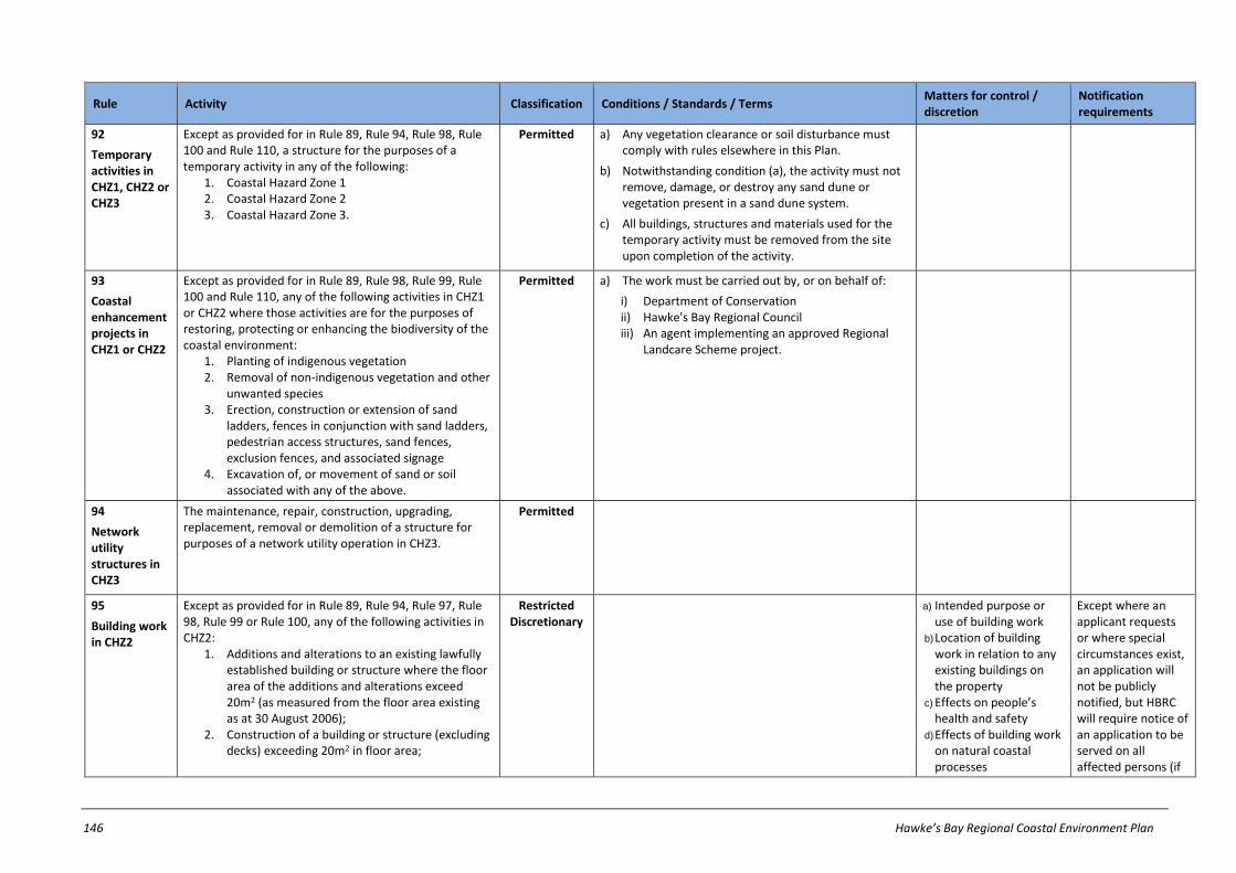
146 Hawke’s Bay Regional Coastal Environment Plan
Rule Activity Classification Conditions / Standards / Terms Matters for control / discretion
Notification requirements
92
Temporary activities in CHZ1, CHZ2 or CHZ3
Except as provided for in Rule 89, Rule 94, Rule 98, Rule 100 and Rule 110, a structure for the purposes of a temporary activity in any of the following:
1. Coastal Hazard Zone 1 2. Coastal Hazard Zone 2 3. Coastal Hazard Zone 3.
Permitted a) Any vegetation clearance or soil disturbance must comply with rules elsewhere in this Plan.
b) Notwithstanding condition (a), the activity must not remove, damage, or destroy any sand dune or vegetation present in a sand dune system.
c) All buildings, structures and materials used for the temporary activity must be removed from the site upon completion of the activity.
93
Coastal enhancement projects in CHZ1 or CHZ2
Except as provided for in Rule 89, Rule 98, Rule 99, Rule 100 and Rule 110, any of the following activities in CHZ1 or CHZ2 where those activities are for the purposes of restoring, protecting or enhancing the biodiversity of the coastal environment:
1. Planting of indigenous vegetation 2. Removal of non-indigenous vegetation and other
unwanted species 3. Erection, construction or extension of sand
ladders, fences in conjunction with sand ladders, pedestrian access structures, sand fences, exclusion fences, and associated signage
4. Excavation of, or movement of sand or soil associated with any of the above.
Permitted a) The work must be carried out by, or on behalf of:
i) Department of Conservation ii) Hawke's Bay Regional Council iii) An agent implementing an approved Regional
Landcare Scheme project.
94
Network utility structures in CHZ3
The maintenance, repair, construction, upgrading, replacement, removal or demolition of a structure for purposes of a network utility operation in CHZ3.
Permitted
95
Building work in CHZ2
Except as provided for in Rule 89, Rule 94, Rule 97, Rule 98, Rule 99 or Rule 100, any of the following activities in CHZ2:
1. Additions and alterations to an existing lawfully established building or structure where the floor area of the additions and alterations exceed 20m2 (as measured from the floor area existing as at 30 August 2006);
2. Construction of a building or structure (excluding decks) exceeding 20m2 in floor area;
Restricted Discretionary
a) Intended purpose or use of building work
b) Location of building work in relation to any existing buildings on the property
c) Effects on people’s health and safety
d) Effects of building work on natural coastal processes
Except where an applicant requests or where special circumstances exist, an application will not be publicly notified, but HBRC will require notice of an application to be served on all affected persons (if
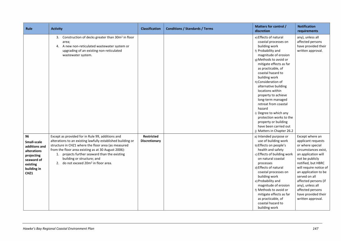
Hawke’s Bay Regional Coastal Environment Plan 147
Rule Activity Classification Conditions / Standards / Terms Matters for control / discretion
Notification requirements
3. Construction of decks greater than 30m2 in floor area;
4. A new non-reticulated wastewater system or upgrading of an existing non-reticulated wastewater system.
e) Effects of natural coastal processes on building work
f) Probability and magnitude of erosion
g) Methods to avoid or mitigate effects as far as practicable, of coastal hazard to building work
h) Consideration of alternative building locations within property to achieve long-term managed retreat from coastal hazard
i) Degree to which any protection works to the property or building have been carried out
j) Matters in Chapter 26.2
any), unless all affected persons have provided their written approval.
96
Small-scale additions and alterations projecting seaward of existing building in CHZ1
Except as provided for in Rule 99, additions and alterations to an existing lawfully established building or structure in CHZ1 where the floor area (as measured from the floor area existing as at 30 August 2006):
1. projects further seaward than the existing building or structure; and
2. do not exceed 20m2 in floor area.
Restricted Discretionary
a) Intended purpose or use of building work
b) Effects on people’s health and safety
c) Effects of building work on natural coastal processes
d) Effects of natural coastal processes on building work
e) Probability and magnitude of erosion
f) Methods to avoid or mitigate effects as far as practicable, of coastal hazard to building work
Except where an applicant requests or where special circumstances exist, an application will not be publicly notified, but HBRC will require notice of an application to be served on all affected persons (if any), unless all affected persons have provided their written approval.

148 Hawke’s Bay Regional Coastal Environment Plan
Rule Activity Classification Conditions / Standards / Terms Matters for control / discretion
Notification requirements
g) Consideration of alternative building locations within property to achieve long-term managed retreat from coastal hazard
h) Degree to which any protection works to the property or building have been carried out
i) Matters in Chapter 26.2
97
Network utility structures in CHZ1 and CHZ2 not within a road reserve
Except as provided for in Rule 89, Rule 98, Rule 99 and Rule 100, any of the following activities in CHZ1 or CHZ2 not within a road reserve:
1. construction of a new structure and any associated earthworks for purposes of a network utility operation;
2. upgrading of an existing lawfully established structure and any associated earthworks for purposes of a network utility operation.97
Restricted Discretionary
a) The need for the structure to be located in the Coastal Hazard Zone
b) Effects on people’s health and safety
c) Effects of structure on natural coastal processes
d) Effects of natural coastal processes on structure and network utility operation.
e) Probability and magnitude of erosion and inundation
f) Methods to avoid or mitigate effects of coastal hazard to structure and network utility operation
g) Degree to which any protection works to the property or structure have been carried out
h) Matters in Chapter 26.2
Except where an applicant requests or where special circumstances exist, an application will not be served on any person or publicly notified.
97 NOTE: For the avoidance of doubt, Rule 94 applies to structures for purposes of network utility operations in CHZ3.

Hawke’s Bay Regional Coastal Environment Plan 149
Rule Activity Classification Conditions / Standards / Terms Matters for control / discretion
Notification requirements
98
Maintenance and repair of coastal protection
structures98
Except as otherwise provided for in Rule 54, the maintenance or repair of an existing lawfully established coastal protection structure wholly or partly located in any of the following:
1. Coastal Hazard Zone 1 2. Coastal Hazard Zone 2.
Restricted Discretionary
a) There must not be any discharge of contaminants, other than sediment, into the coastal marine area.
b) Any release of sediment must not cause any conspicuous changes in the colour or visual clarity of water after reasonable mixing.
c) Materials used must not be toxic to aquatic ecosystems.
d) Any materials removed from the structure and any excess construction materials must be removed from the property and foreshore and seabed upon completion of the activity.
a) Effects on people’s health and safety.
b) Effects of the activity on natural coastal processes, including increasing the likelihood of erosion or inundation to other properties.
c) Effects of natural coastal processes on the activity
d) Probability and magnitude of erosion.
e) Design and construction of the activity, including size, length, materials, construction methods and likely design life.
f) Duration of consent for multiple maintenance or repair works over time.
g) Matters in Chapter 26.2
Except where an applicant requests or where special circumstances exist, an application will not be publicly notified, but HBRC will require notice of an application to be served on all affected persons (if any), unless all affected persons have provided their written approval.
99
Upgrading of lawfully established local authority stormwater and coastal water structures in CHZ1 or CHZ2
The upgrading (including extension) of the following local authority owned or operated structures in CHZ1 or CHZ2:
1. lawfully established reticulated systems for stormwater;
2. lawfully established structures for the taking or discharge of coastal water.
Controlled a) The need for the structure to be located in a CHZ.
b) Effects on people’s health and safety.
c) Effects of structure on natural coastal processes.
d) Effects of natural coastal processes on structure.
Except where an applicant requests or where special circumstances exist, an application will not be served on any person or publicly notified.
98 For the avoidance of doubt, this rule does apply to coastal protection structures that may span or cross mean high water springs, but does not apply to post wire fences, temporary fences, or fences for impounding
stock on production land.

150 Hawke’s Bay Regional Coastal Environment Plan
Rule Activity Classification Conditions / Standards / Terms Matters for control / discretion
Notification requirements
e) Probability and magnitude of erosion and inundation.
f) Methods to avoid or mitigate effects of coastal hazard to structure.
g) degree to which any protection works have been carried out.
h) Matters in Chapter 26.2
100
Coastal protection
structures99
Except as otherwise provided for in Rule 54, Rule 98, Rule 125 or Rule 126, any of the following activities wholly or partly in CHZ1 or CHZ2:
1. the replacement, erection, placement, construction (including extension) demolition or removal of any coastal protection structure;
2. the maintenance or repair of an existing lawfully established coastal protection structure that does not comply with all relevant conditions in Rule 98.
Non-Complying100
Refer to notification requirements in ss95A-95F of RMA
101
Replacement of structures in CHZ1 or CHZ2 damaged by action of the sea
Except as provided for in Rule 89, Rule 97, Rule 98, Rule 99 or Rule 100, any replacement of a structure damaged or destroyed by coastal erosion or storm surge inundation in any of the following:
1. Coastal Hazard Zone 1 2. Coastal Hazard Zone 2.101
Non-Complying
Refer to notification requirements in ss95A-95F of RMA
99 For the avoidance of doubt, this rule does apply to coastal protection structures that may span or cross mean high water springs, but does not apply to post wire fences, temporary fences, or fences for impounding
stock on production land.
100 NOTE: A coastal protection structure in the CMA which exceeds 300m in length approximately parallel to the line of mean high water springs, is a non-complying activity under Rule 125. A coastal protection structure in the CMA which exceeds 100m in length approximately perpendicular or oblique to the line of mean high water springs, is a non-complying activity under Rule 126.
101 NOTE: For the avoidance of doubt, Rule 89(d) applies to the replacement of a lawfully established local authority owned or operated reticulated system for stormwater or structure for the taking or discharge of coastal water where that system or structure is damaged or destroyed by coastal erosion or storm surge inundation

Hawke’s Bay Regional Coastal Environment Plan 151
Rule Activity Classification Conditions / Standards / Terms Matters for control / discretion
Notification requirements
102
Building work in CHZ1
Except as provided for in Rule 89, Rule 97, Rule 98, Rule 99 or Rule 100, any of the following activities in CHZ1:
1. Additions or alterations to an existing lawfully established building or structure where the floor area of additions and alterations exceeds 20m2 (as measured from the floor area existing as at 30 August 2006)
2. Construction of a building or structure (excluding decks) exceeding 20m2 in floor area;
3. Construction of decks greater than 30m2 in floor area;
4. A new non-reticulated wastewater system or upgrading of an existing non-reticulated wastewater system.
Non-Complying
Refer to notification requirements in ss95A-95F of RMA
103
Deposition of sediment for Westshore Beach Re-nourishment Scheme
Deposition of sediment for purposes of the Westshore Beach Renourishment Scheme.
Controlled a) The sediment shall be deposited within the Westshore Renourishment Area identified in this Plan’s maps.
b) Any material deposited must not include any of the following:
i) septic tank sludge ii) hazardous wastes iii) organic materials or iv) any other domestic or industrial waste, except
cleanfill such as concrete, sand or gravel.
c) The quantity of sediment deposited must not exceed 50,000m3 in any 12 month period.
a) Duration of the deposition and possible reinstatement of land contours
b) Effects on people’s health and safety
c) Potential for damage to existing lawfully established structures
d) Probability and magnitude of erosion
e) Effects of displacing of erosion processes onto nearby land, property, public works and network utilities
f) Degree to which any protection works to the land have been carried out
g) Sediment particle size h) Matters in Chapter 26.2
Except where an applicant requests or where special circumstances exist, an application will not be served on any person or publicly notified.
a)

152 Hawke’s Bay Regional Coastal Environment Plan
Rule Activity Classification Conditions / Standards / Terms Matters for control / discretion
Notification requirements
104
Deposition of sediment in CHZ1
Except as provided for in Rule 89 or Rule 103, deposition of sediment in volumes greater than 5m3 per property in any six consecutive month period within Coastal Hazard Zone 1.102
Restricted Discretionary
a) Any material deposited must not include any of the following:
i) septic tank sludge ii) hazardous wastes iii) organic materials or iv) any other domestic or industrial waste, except
cleanfill such as concrete, sand or gravel.
b) Intended purpose of the filling
c) Duration of the filling and possible reinstatement of land contours
d) Effects on people’s health and safety
e) Potential for damage to existing lawfully established structures
f) Probability and magnitude of erosion
g) Effects of displacing of erosion processes onto nearby land, property, public works and network utilities
h) Degree to which any protection works to the land have been carried out
i) Matters in Chapter 26.2
Except where an applicant requests or where special circumstances exist, an application will not be publicly notified, but HBRC will require notice of an application to be served on all affected persons (if any), unless all affected persons have provided their written approval.
102 This rule does not apply to:
a) non-mechanical domestic gardening and landscaping or b) gravel imported or stored on industrial or trade premises. c)) building work in CHZ1 under Rule 102 or d) removal of gravel and other earthworks clearing an outfall structure, bridge, water intake structure or culvert in order to maintain the flow through the structure.

Hawke’s Bay Regional Coastal Environment Plan 153
Rule Activity Classification Conditions / Standards / Terms Matters for control / discretion
Notification requirements
105
Removal of gravel and other earthworks within the Parade Gravel Extraction Area
Removal of in-situ gravel and other earthworks, provided it is:
1. within the Parade Gravel Extraction Area; and 2. up to 20,000m3 in any 12 month period; and 3. for Westshore Beach Renourishment Scheme
purposes; and 4. for a consent duration up to 10 years.103
Controlled a) Timing of the excavation and possible reinstatement of land contours
b) Effects on people’s health and safety
c) Potential for damage to existing lawfully established structures
d) Probability and magnitude of erosion and inundation, including long term projected trends
e) Effects of displacing of erosion processes onto nearby land, property, public works and network utilities
f) Monitoring and up to bi-monthly reporting, in particular regular beach profile monitoring (extending from HB10 up to Port of Napier) and reassessment of coastal processes and gravel supply implications, including long term trends
g) Matters in Policy 15.1(15) if relevant
h) Matters in Chapter 26.2 (excluding matter 26.2(b)(viii)).
Except where an applicant requests or where special circumstances exist, an application will not be served on any person or publicly notified.
103 This rule does not apply to:
a) removal of gravel and other earthworks for the purposes of opening river mouths; or clearing outfall structures, bridges, water intake structures, or culverts in order to maintain the flow through the structure or b) removal of gravel imported or stored on industrial or trade premises or c) building work in CHZ1 under Rule 102.

154 Hawke’s Bay Regional Coastal Environment Plan
Rule Activity Classification Conditions / Standards / Terms Matters for control / discretion
Notification requirements
106
Removal of gravel and other earthworks within the Parade Gravel Extraction Area not complying with Rule 105
Removal of in-situ gravel and other earthworks not complying with Rule 105, provided it is:
1. within the Parade Gravel Extraction Area; and 2. up to a total of 30,000m3 in any 12 month
period104; and 3. for Westshore Beach Renourishment Scheme
purposes; and 4. for a consent duration up to 10 years.105
Restricted discretionary
a) Volume of gravel removed
b) Timing of the excavation and possible reinstatement of land contours
c) Effects on people’s health and safety
d) Potential for damage to existing lawfully established structures
e) Probability and magnitude of erosion and inundation, including long term projected trends
f) Effects of displacing of erosion processes onto nearby land, property, public works and network utilities
g) Monitoring and up to bi-monthly reporting, in particular regular beach profile monitoring (extending from HB10 up to Port of Napier) and reassessment of coastal processes and gravel supply implications, including long term trends
h) Matters in Policy 15.1(15) if relevant
Refer to notification requirements in ss95A-95F of RMA
104 NOTE: This amount shall include the combined total of all volumes removed from the Parade Gravel Extraction Area.
105 This rule does not apply to: a) removal of gravel and other earthworks for the purposes of opening river mouths; or clearing outfall structures, bridges, water intake structures, or culverts in order to maintain the flow through the structure or b) removal of gravel imported or stored on industrial or trade premises or c) building work in CHZ1 under Rule 102.
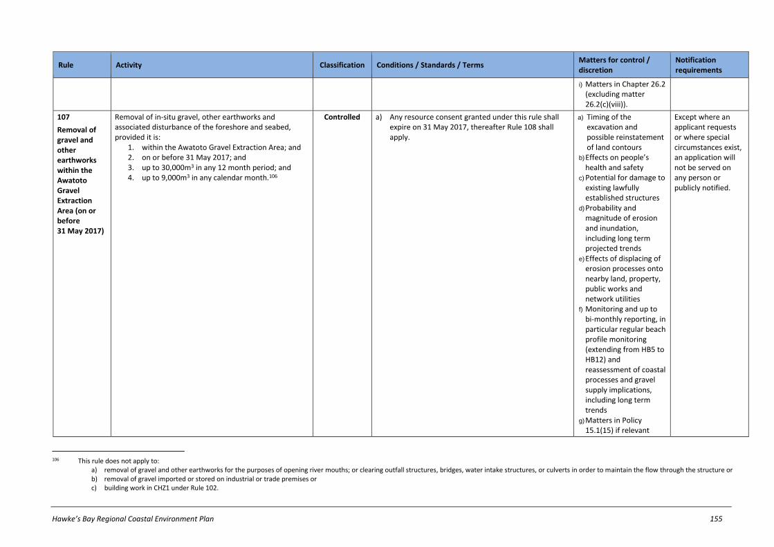
Hawke’s Bay Regional Coastal Environment Plan 155
Rule Activity Classification Conditions / Standards / Terms Matters for control / discretion
Notification requirements
i) Matters in Chapter 26.2 (excluding matter 26.2(c)(viii)).
107
Removal of gravel and other earthworks within the Awatoto Gravel Extraction Area (on or before 31 May 2017)
Removal of in-situ gravel, other earthworks and associated disturbance of the foreshore and seabed, provided it is:
1. within the Awatoto Gravel Extraction Area; and 2. on or before 31 May 2017; and 3. up to 30,000m3 in any 12 month period; and 4. up to 9,000m3 in any calendar month.106
Controlled a) Any resource consent granted under this rule shall expire on 31 May 2017, thereafter Rule 108 shall apply.
a) Timing of the excavation and possible reinstatement of land contours
b) Effects on people’s health and safety
c) Potential for damage to existing lawfully established structures
d) Probability and magnitude of erosion and inundation, including long term projected trends
e) Effects of displacing of erosion processes onto nearby land, property, public works and network utilities
f) Monitoring and up to bi-monthly reporting, in particular regular beach profile monitoring (extending from HB5 to HB12) and reassessment of coastal processes and gravel supply implications, including long term trends
g) Matters in Policy 15.1(15) if relevant
Except where an applicant requests or where special circumstances exist, an application will not be served on any person or publicly notified.
106 This rule does not apply to:
a) removal of gravel and other earthworks for the purposes of opening river mouths; or clearing outfall structures, bridges, water intake structures, or culverts in order to maintain the flow through the structure or b) removal of gravel imported or stored on industrial or trade premises or c) building work in CHZ1 under Rule 102.

156 Hawke’s Bay Regional Coastal Environment Plan
Rule Activity Classification Conditions / Standards / Terms Matters for control / discretion
Notification requirements
h) Matters in Chapter 26.2 (excluding matter 26.2(b)(viii)).
108
Removal of gravel and other earthworks within the Awatoto Gravel Extraction Area (after 31 May 2017)
Removal of in-situ gravel, other earthworks and associated disturbance of the foreshore and seabed, provided it is:
1. within the Awatoto Gravel Extraction Area; and 2. after 31 May 2017; and 3. up to 30,000m3 in any 12 month period; and 4. up to 9,000m3 in any calendar month; 5. for a consent duration up to 10 years.107
Restricted discretionary
a) Volume of gravel removed
b) Timing of the excavation and possible reinstatement of land contours
c) Effects on people’s health and safety
d) Potential for damage to existing lawfully established structures
e) Probability and magnitude of erosion and inundation, including long term projected trends
f) Effects of displacing of erosion processes onto nearby land, property, public works and network utilities
g) Monitoring and up to bi-monthly reporting, in particular regular beach profile monitoring (extending from HB5 to HB12) and reassessment of coastal processes and gravel supply implications, including long term trends
Refer to notification requirements in ss95A-95F of RMA
107 This rule does not apply to:
a) removal of gravel and other earthworks for the purposes of opening river mouths; or clearing outfall structures, bridges, water intake structures, or culverts in order to maintain the flow through the structure or removal of gravel imported or stored on industrial or trade premises or c) building work in CHZ1 under Rule 102.

Hawke’s Bay Regional Coastal Environment Plan 157
Rule Activity Classification Conditions / Standards / Terms Matters for control / discretion
Notification requirements
h) Matters in Policy 15.1(15) if relevant
i) Matters in Chapter 26.2 (excluding matter 26.2(c)(viii)).
109
Removal of sediment and other earthworks in CHZ1
Except as provided for in Rule 89, Rule 105, Rule 106, Rule 107 or Rule 108, removal of in-situ gravel and other earthworks within Coastal Hazard Zone 1 in volumes greater than 5m3 per property in any six consecutive month period.108
Non-Complying
Refer to notification requirements in ss95A-95F of RMA
110
Landfills and dumping of hazardous substances in CHZ1, CHZ2 or CHZ3
Landfills or dumping of hazardous substances in any of the following:
1. Coastal Hazard Zone 1 2. Coastal Hazard Zone 2 3. Coastal Hazard Zone 3.
Prohibited
108 This rule does not apply to:
a) removal of gravel and other earthworks for the purposes of opening river mouths; or clearing outfall structures, bridges, water intake structures, or culverts in order to maintain the flow through the structure or b) removal of sand, shell gravel or other natural material under Rule 144, Rule 145, or Rule 146 or c) removal of gravel imported or stored on industrial or trade premises or d) building work in CHZ1 under Rule 102.

158 Hawke’s Bay Regional Coastal Environment Plan
27.7 Reclamations and drainage in Coastal Marine Area
Rule Activity Classification Conditions / Standards / Terms Matters for control / discretion
Notification requirements
111
Reclamations not regulated by or not complying with other rules
Any reclamation of the foreshore or seabed that: 1. does not comply with all relevant conditions on a
discretionary activity rule or 2. is not specifically classified by any other rules in
this Plan as a discretionary, non-complying or prohibited activity.
Discretionary Refer to notification requirements in ss95A-95F of RMA
112
Reclamations within specified Significant Conservation Areas
Except as provided for in Rule 113, any reclamation of the foreshore or seabed within the Waitangi Estuary (SCA11) or Ahuriri Estuary (SCA12) or Nuhaka (SCA21) that is undertaken by or on behalf of:
1. a network utility operator or 2. a local authority exercising its statutory powers,
functions or duties.109
Non-Complying
Refer to notification requirements in ss95A-95F of RMA
113
Reclamations using septage, hazardous wastes, clay, organic material or other waste
Notwithstanding any other rule in this Plan, any reclamation of the foreshore or seabed that uses or includes any of the following as fill:
1. septage 2. hazardous substances 3. clay or clay soils110 4. organic materials or 5. any other domestic or industrial waste, excluding
cleanfill.
Prohibited
114
Reclamations in Significant Conservation Areas
Except as provided for in Rule 112, any reclamation of the foreshore or seabed in a Significant Conservation Area.
Prohibited
109 NOTE: This enables a resource consent application to be made for reclamations in these areas by network utility operators or local authorities undertaking their statutory duties.
110 NOTE: This rule does not apply to small percentages of clay or clay soils that are incidental to the type of fill chosen for the reclamation. The clay content should not exceed 5% of the total aggregate. The exclusion of clay or clay soils does not apply to landscaping activities on top of the reclamation.

Hawke’s Bay Regional Coastal Environment Plan 159
Rule Activity Classification Conditions / Standards / Terms Matters for control / discretion
Notification requirements
115
Drainage activities not regulated by other rules
Any drainage of the foreshore or seabed that is not specifically classified by any other rule in this Plan as a prohibited activity.
Discretionary Refer to notification requirements in ss95A-95F of RMA
116
Drainage in specified Significant Conservation Areas
Except as provided for in Rule 114, drainage of the foreshore or seabed in any of the following Significant Conservation Areas:
1. Porangahau Estuary (SCA1) 2. Tukituki River mouth (SCA10) 3. Waitangi Estuary (SCA11) 4. Ahuriri Estuary (SCA12) 5. Wairoa Estuary and Coastal Lagoons (SCA15) or 6. Maungawhio Lagoon (SCA20).
Prohibited

160 Hawke’s Bay Regional Coastal Environment Plan
27.8 Structures in Coastal Marine Area
Rule Activity Classification Conditions / Standards / Terms Matters for control / discretion
Notification requirements
117
Structures not regulated by, or not complying with, other rules
The erection, reconstruction, placement, alteration, extension, removal, or demolition of a structure in the coastal marine area that is fixed in, on, under or over the foreshore or seabed, that:
1. is not specifically classified by any other rule in this Plan as a discretionary, non-complying or prohibited activity 111; or
2. does not comply with all relevant conditions on a permitted activity rule; or
3. does not comply with all relevant standards and terms on a controlled activity rule.
Discretionary Refer to notification requirements in ss95A-95F of RMA
118
Lawfully established
structures112
Lawfully established structures113 and the maintenance or repair of a lawfully established structure in the coastal marine area (including any associated disturbance of the foreshore or seabed; and any associated deposition of substances on the seabed; but not any associated damming or diversion of water).
Permitted a) The activity must not increase the area of the foreshore or seabed occupied by the structure.
b) There must not be any discharge of contaminants, other than sediment, into water within the coastal marine area.
c) Any release of sediment must not cause any conspicuous change in the colour or visual clarity of water after reasonable mixing.
d) Materials used must not be toxic to aquatic ecosystems.
e) There must not be any reduction in the ability of any channel to convey flood flows or impedance to the passage of floating debris.
f) Any materials removed from the structure and any excess construction materials must be removed from the foreshore and seabed upon completion of the activity.
111 For the purposes of Rule 117.1 and avoidance of doubt, this includes structures in the Port Management Area. 112 Rule 158 applies to any temporary damming and diversion of water associated with this activity.
113 NOTE1: For the purposes of Rule 118 and avoidance of doubt, ‘lawfully established structures’ includes those structures listed in Schedule S.
NOTE2: Maintenance and repair of lawfully established coastal protection structures within CHZ1 or CHZ2 is subject to Rule 98.

Hawke’s Bay Regional Coastal Environment Plan 161
Rule Activity Classification Conditions / Standards / Terms Matters for control / discretion
Notification requirements
119
Whitebait structures and
maimai114
Except as provided for in Rule 127, the erection, placement, alteration, extension or removal of a whitebait structure or a maimai structure in the coastal marine area.
Permitted a) Existing river protection works or any other existing structure must not be damaged.
b) The free flow of water must be maintained at all times.
c) Any whitebait structure must be established in accordance with the Whitebait Fishing Regulations 1994.
d) Any structure must not exceed 5m2 in floor area.
e) Any maimai structure may only be erected or placed in the coastal marine area during the period commencing one month prior to commencement of the duck shooting season through until the end of the season.
f) Any maimai structure must be removed within one week following the end of the duck shooting season.
120
Network utility lines, pipelines and cables suspended above foreshore, seabed and coastal water
The erection, reconstruction, placement, alteration, extension, removal or demolition of any line, pipeline or cable owned or managed by a network utility operator suspended above coastal water and115 the foreshore or seabed.116
Permitted a) The activity must not cause any:
i) obstruction to aircraft flight paths; ii) obstruction to existing ship navigation channels.
b) Except within the Port Management Area and Harbour Management Area, the erection, placement or extension of a line, pipeline or cable:117
i) must be attached to an existing lawfully established support structure.
ii) must not be fixed to the foreshore or seabed. iii) must not extend below the underside of the
existing lawfully established support structure to which the line, pipeline or cable is to be attached.
114 NOTE: This rule does not give unauthorised structures or illegally established structures a permitted activity status. Also, this rule does not waive any requirements to obtain from the HBRC a ‘licence to occupy’ space
within a river or stream.
115 NOTE: As this activity relates to network utility structures suspended above coastal water and the foreshore or seabed, no additional resource consent is required by s12 of the RMA. ‘Over’ the foreshore or seabed in this context refers to the airspace above the foreshore, seabed and coastal water. It does not include structures under, in, or on the foreshore or seabed; or floating or submerged in coastal water.
116 Rule 158 applies to any temporary damming and diversion of water associated with this activity.
117 NOTE: For the avoidance of doubt, condition (b) does not apply to lines, pipelines and cables suspended over coastal water and the foreshore or seabed within the Port Management Area or Harbour Management Area.

162 Hawke’s Bay Regional Coastal Environment Plan
Rule Activity Classification Conditions / Standards / Terms Matters for control / discretion
Notification requirements
c) There must not be any reduction in the ability of any channel to convey flood flows or impedance to the passage of floating debris.
d) There must not be any discharge of contaminants, other than sediment, into water within the coastal marine area.
e) Any release of sediment must not cause any conspicuous change in the colour or visual clarity of water after reasonable mixing.
121
Removal and demolition of
structures118,
119
The removal or demolition of a structure or any part of a structure in the coastal marine area in, on, under or over the foreshore or seabed and
1. any associated disturbance of the foreshore and seabed and
2. any associated deposition of substances on the seabed.
Permitted a) The structure wholly or partly to be removed or demolished must not exceed 50m2.
b) There must not be any discharge of contaminants, other than sediment, into water within the coastal marine area.
c) Any release of sediment must not cause any conspicuous change in the colour or visual clarity of water after reasonable mixing.
d) All removal and demolition material must be removed from the foreshore and seabed upon completion of the activity.
e) There must not be any reduction in the ability of any channel to convey flood flows or impedance to the passage of floating debris.
f) Explosives must not be used.
122
Small scale structures
Except as provided for by a rule elsewhere in this Plan, the erection, reconstruction, placement, alteration, extension, removal or demolition of a structure (including an environmental monitoring device) in the coastal marine area, and any associated disturbance of the foreshore or seabed. 120
Permitted a) The structure must not exceed 5m2 in floor area.
b) The activity or structure must not occupy an area exceeding 5m2 of the coastal marine area.
c) The duration of the activity shall be less than 28 days (whether consecutive days or total number of days) in any 12 month period. This condition shall not
118 NOTE: Any destruction, damage, or modification of a structure pre-dating 1900 may require an archaeological authority under the Historic Places Act 1993.
119 Rule 158 applies to any temporary damming and diversion of water associated with this activity.
120 NOTE: Any destruction, damage, or modification of a structure or other historic heritage feature pre-dating 1900 may require an archaeological authority under the Historic Places Act 1993. This rule does not override any requirements of the Navigation and Safety Bylaws or any other navigational safety requirements.

Hawke’s Bay Regional Coastal Environment Plan 163
Rule Activity Classification Conditions / Standards / Terms Matters for control / discretion
Notification requirements
apply to environmental monitoring devices, for which there is no time limit.
d) The erection, reconstruction, placement, alteration, extension, removal or demolition activity shall not:
i) cause any obstruction to: 1) aircraft flight paths 2) existing ship navigation channels
ii) be located within a Significant Conservation Area iii) be used for use of mooring a vessel (except
within the Harbour Management Area of Port Management Area; or any temporary anchoring of a vessel in the CMA).
e) Any anchoring-type device must not exceed 50kg total clump weight.
f) There must not be any reduction in the ability of any channel to convey flood flows or impedance to the passage of floating debris.
g) There must not be any discharge of contaminants, other than sediment, into water within the coastal marine area.
h) Any release of sediment must not cause any conspicuous change in the colour or visual clarity of water after reasonable mixing.
123
Navigation aids
The erection, reconstruction, placement, alteration, extension, removal or demolition of a navigational aid structure in the coastal marine area, and any associated disturbance of the foreshore or seabed.121
Permitted a) The activity must be undertaken by, or on behalf of:
i) a local authority in respect of anywhere within the coastal marine area; or
ii) a local authority or port operator in respect of anywhere within the Pilotage Limit; or
iii) the Department of Conservation in respect of marine reserves.
b) The structure must not exceed 5m2 in floor area.
c) The activity or structure must not occupy an area exceeding 5m2 of the coastal marine area.
d) The activity or structure must not:
i) cause any obstruction to:
121 NOTE: Any destruction, damage, or modification of a structure or other historic heritage feature pre-dating 1900 may require an archaeological authority under the Historic Places Act 1993.

164 Hawke’s Bay Regional Coastal Environment Plan
Rule Activity Classification Conditions / Standards / Terms Matters for control / discretion
Notification requirements
1) aircraft flight paths 2) existing ship navigation channels
ii) be located within a Significant Conservation Area iii) be used for use of mooring a vessel (except any
temporary anchoring of a vessel).
e) Any anchoring-type device must not exceed 8000kg total clump weight.
f) There must not be any reduction in the ability of any channel to convey flood flows or impedance to the passage of floating debris.
g) There must not be any discharge of contaminants, other than sediment, into water within the coastal marine area.
h) Any release of sediment must not cause any conspicuous change in the colour or visual clarity of water after reasonable mixing.
124
Structures in an Aquaculture Management Area required for an aquaculture
activity122
The erection, reconstruction, placement, alteration, or extension of a structure required for an aquaculture activity in an Aquaculture Management Area; and any associated disturbance of the foreshore or seabed.
Controlled a) The aquaculture activity must not exceed the area of space within the coastal marine area for which it is authorised to occupy.
a) The condition and maintenance of any structure
b) Necessity of structure(s) for types of species authorised to be farmed
c) Effects arising from any disturbance of the foreshore or seabed
d) Effects arising from any deposition of material in the coastal marine area
e) Any discharge of contaminants
f) Effects on navigation and safety, including provision for warning devices, signs & lighting
Except where an applicant requests or where special circumstances exist, an application will not be publicly notified, but HBRC will require notice of an application to be served on all affected persons (if any), unless all affected persons have provided their written approval.
122 NOTE: This rule only addresses issues arising from the effects of structures in the CMA required for an aquaculture activity. Effects arising from occupation of space, discharges of, and deposition of, contaminants
arising from an aquaculture activity in an AMA are addressed by rules elsewhere in this Plan.

Hawke’s Bay Regional Coastal Environment Plan 165
Rule Activity Classification Conditions / Standards / Terms Matters for control / discretion
Notification requirements
g) Effects on the natural character of the coast
h) Effects on marine ecosystems present in the surrounding area
i) Removal of any structure at the expiration of the resource consent
j) Timing and/or staging of structures’ development
k) Matters in Chapter 26.2
125
Large-scale coastal protection structures parallel to
shore123
Except within the Port Management Area124, any activity involving the erection of a coastal protection structure in the coastal marine area which:
1. Is solid (or presents a significant barrier to water or sediment movement) and
2. When established on the foreshore or seabed would extend 300m or more in length more or less parallel to the line of mean high water springs (including separate structures which total 300m or more contiguous).
Non-Complying
Refer to notification requirements in ss95A-95F of RMA
126
Large-scale coastal protection structures not parallel to
shore125
Except within the Port Management Area126, any activity involving the erection of a coastal protection structure in the coastal marine area which:
1. Is solid (or presents a significant barrier to water or sediment movement) and
2. Sited obliquely or perpendicular in horizontal projection to the line of mean high water springs and
Non-Complying
Refer to notification requirements in ss95A-95F of RMA
123 For the avoidance of doubt, this rule does apply to coastal protection structures that may span or cross mean high water springs, but does not apply to post wire fences, temporary fences, or fences for impounding
stock on production land.
124 NOTE: Any such structures within the Port Management Area are subject to Rule 117.
125 For the avoidance of doubt, this rule does apply to coastal protection structures that may span or cross mean high water springs, but does not apply to post wire fences, temporary fences, or fences for impounding stock on production land.
126 NOTE: Any such structures within the Port Management Area are subject to Rule 117.
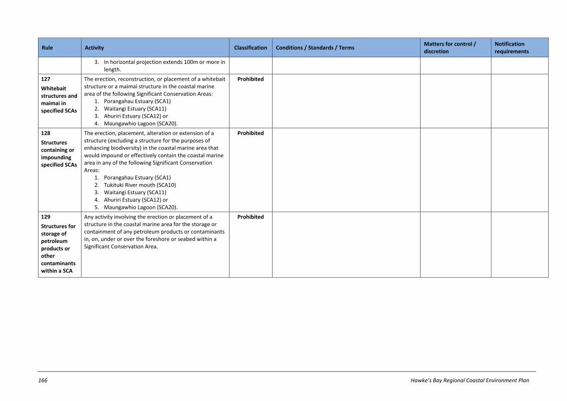
166 Hawke’s Bay Regional Coastal Environment Plan
Rule Activity Classification Conditions / Standards / Terms Matters for control / discretion
Notification requirements
3. In horizontal projection extends 100m or more in length.
127
Whitebait structures and maimai in specified SCAs
The erection, reconstruction, or placement of a whitebait structure or a maimai structure in the coastal marine area of the following Significant Conservation Areas:
1. Porangahau Estuary (SCA1) 2. Waitangi Estuary (SCA11) 3. Ahuriri Estuary (SCA12) or 4. Maungawhio Lagoon (SCA20).
Prohibited
128
Structures containing or impounding specified SCAs
The erection, placement, alteration or extension of a structure (excluding a structure for the purposes of enhancing biodiversity) in the coastal marine area that would impound or effectively contain the coastal marine area in any of the following Significant Conservation Areas:
1. Porangahau Estuary (SCA1) 2. Tukituki River mouth (SCA10) 3. Waitangi Estuary (SCA11) 4. Ahuriri Estuary (SCA12) or 5. Maungawhio Lagoon (SCA20).
Prohibited
129
Structures for storage of petroleum products or other contaminants within a SCA
Any activity involving the erection or placement of a structure in the coastal marine area for the storage or containment of any petroleum products or contaminants in, on, under or over the foreshore or seabed within a Significant Conservation Area.
Prohibited

Hawke’s Bay Regional Coastal Environment Plan 167
27.9 Disturbances, depositions and extractions in Coastal Marine Area
Rule Activity Classification Conditions / Standards / Terms Matters for control / discretion
Notification requirements
130
Disturbances of the foreshore or seabed not regulated by, or not complying with, other rules
The excavation, dredging, drilling or tunnelling, the use of explosives or any other disturbance in, on, or under the foreshore or seabed, that:
1. is not specifically classified by any other rule in this Plan as a non-complying or prohibited activity; or
2. does not comply with all relevant conditions on a permitted activity rule; or
3. does not comply with all relevant standards and terms on a controlled activity rule or restricted discretionary activity rule.
Discretionary Refer to notification requirements in ss95A-95F of RMA
131
Motor vehicles in specific areas
Except as provided for in Rule 132 and Rule 133, the disturbance of the foreshore or seabed by driving a motor vehicle:
1. onto or along the intertidal rock platforms between Auroa Point and Taiporutu River mouth
2. onto or along the intertidal rock platforms between Kairakau Beach and Blackhead Point
3. in or through the Maungawhio Lagoon (SCA20).
Prohibited
132
Motor vehicles in specific areas used for specified purposes
Disturbance of the foreshore or seabed by a motor vehicle:
1. on or along the intertidal rock platform from Auroa Point to Taiporutu River mouth
2. on or along the intertidal rock platform from Kairakau Beach to Blackhead Point
3. in or through the Maungawhio Lagoon (SCA20).
Permitted a) Use of the motor vehicle must be for one or more of the following purposes:
i) marine mammal rescue or disposal ii) burial of dead animals washed up on the
foreshore iii) emergency situations, including fire fighting, oil
spill response, and rescue operations iv) eradication, control, surveillance and monitoring
of unwanted organisms or pests under the Biosecurity Act 1993 or Fisheries Act 1996
v) monitoring, surveillance and enforcement of law.

168 Hawke’s Bay Regional Coastal Environment Plan
Rule Activity Classification Conditions / Standards / Terms Matters for control / discretion
Notification requirements
133
River control and drainage works
Disturbance of the foreshore or seabed for the purposes of an activity described in the Hawke's Bay Regional Council Environmental Code of Practice for River Control and Drainage Works (2003)127 including, but not limited to:
1. edge protection works 2. planting 3. river protection maintenance works 4. irrigation intake maintenance 5. weed and vegetation control (excluding spraying) 6. drain maintenance, and drainage outlet
maintenance 7. drain crossings 8. opening a river mouth, lagoon or estuary 9. closing a river mouth, lagoon or estuary to
implement spill containment management practices
10. river management and drainage for the maintenance of surface water quality
11. channel diversions within a river bed or drain, ancillary to the above activities.
Permitted a) The activity must be undertaken by or on behalf of a local authority exercising its statutory powers, functions or duties under any of the following:
i) the Soil Conservation and Rivers Control Act 1941 ii) the Land Drainage Act 1908 iii) the Local Government Act 1974 iv) the Local Government Act 2002.
b) The activity must not impede fish passage.
c) There must not be any discharge of contaminants, other than sediment, into water within the coastal marine area.
d) Any release of sediment must not cause any conspicuous change in the colour or visual clarity of water after reasonable mixing.
e) The activity must not cause deterioration of receiving water quality beyond the water quality standards set out in Schedule E.
134
Removal of sediment from outfall structures, bridges, sea water intakes and culverts
Disturbance of the foreshore or seabed for the purpose of removing sediment from an outfall structure, bridge, sea water intake structure or culvert in order to maintain the flow through the structure.128
Permitted a) The activity must not cause deterioration of receiving water quality beyond the water quality standards set out in Schedule E.
135
Disturbances arising from manoeuvring of ships
Disturbance of the foreshore and seabed arising from passage and manoeuvring of ships.
Permitted
127 NOTE: Refer to Rule 157 addressing the damming and diversion of water associated with river control and drainage works, and Rule 148 that addresses deposition of excavated or dredged sediment in the coastal
marine area.
128 NOTE: Refer to Rule 149 which addresses the deposition of the accumulated sediment in the coastal marine area.
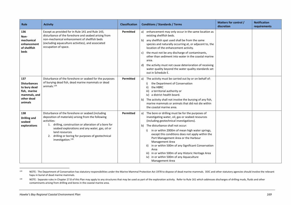
Hawke’s Bay Regional Coastal Environment Plan 169
Rule Activity Classification Conditions / Standards / Terms Matters for control / discretion
Notification requirements
136
Non-mechanical enhancement of shellfish beds
Except as provided for in Rule 141 and Rule 143, disturbance of the foreshore and seabed arising from non-mechanical enhancement of shellfish beds (excluding aquaculture activities), and associated occupation of space.
Permitted a) enhancement may only occur in the same location as existing shellfish beds.
b) any shellfish spat used shall be from the same species and naturally occurring at, or adjacent to, the location of the enhancement activity.
c) the must not be any discharge of contaminants, other than sediment into water in the coastal marine area.
d) the activity must not cause deterioration of receiving water quality beyond the water quality standards set out in Schedule E.
137
Disturbances to bury dead fish, marine mammals, and other dead animals
Disturbance of the foreshore or seabed for the purposes of burying dead fish, dead marine mammals or dead animals.129
Permitted a) The activity must be carried out by or on behalf of:
i) the Department of Conservation ii) the HBRC iii) a territorial authority or iv) a district health board.
b) The activity shall not involve the burying of any fish, marine mammals or animals that did not die within the coastal marine area.
138
Drilling and seabed explorations
Disturbance of the foreshore or seabed (including deposition of materials) arising from the following activities:
1. drilling, construction or alteration of a bore for seabed explorations and any water, gas, oil or land resources
2. drilling or boring for purposes of geotechnical investigation.130
Permitted a) The bore or drilling must be for the purposes of investigating water, oil, gas or seabed resources (including geotechnical investigations).
b) The disturbance shall not occur:
i) in or within 2000m of mean high water springs, except this conditions does not apply within the Port Management Area or the Harbour Management Area
ii) in or within 500m of any Significant Conservation Area
iii) in or within 500m of any Historic Heritage Area iv) in or within 500m of any Aquaculture
Management Area
129 NOTE: The Department of Conservation has statutory responsibilities under the Marine Mammal Protection Act 1978 to dispose of dead marine mammals. DOC and other statutory agencies should involve the relevant
hapu in burial of dead marine mammals.
130 NOTE: Separate rules in Chapter 27.8 of this Plan may apply to any structures that may be used as part of the exploration activity. Refer to Rule 161 which addresses discharges of drilling muds, fluids and other contaminants arising from drilling and bores in the coastal marine area.
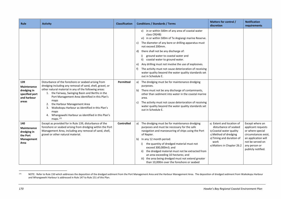
170 Hawke’s Bay Regional Coastal Environment Plan
Rule Activity Classification Conditions / Standards / Terms Matters for control / discretion
Notification requirements
v) in or within 500m of any area of coastal water class CR(HB)
vi) in or within 500m of Te Angiangi marine Reserve.
c) The diameter of any bore or drilling apparatus must not exceed 200mm.
d) there shall not be any discharge of:
i) ground water to coastal water and ii) coastal water to ground water.
e) Any drilling must not involve the use of explosives.
f) The activity must not cause deterioration of receiving water quality beyond the water quality standards set out in Schedule E.
139
Maintenance dredging in specified port and harbour areas
Disturbance of the foreshore or seabed arising from dredging including any removal of sand, shell, gravel, or other natural material in any of the following areas:
1. the Fairway, Swinging Basin and Berths in the Port Management Area identified in this Plan’s maps
2. the Harbour Management Area 3. Waikokopu Harbour as identified in this Plan’s
maps 4. Whangawehi Harbour as identified in this Plan’s
maps.131
Permitted a) The dredging must be for maintenance dredging purposes.
b) There must not be any discharge of contaminants, other than sediment into water in the coastal marine area.
c) The activity must not cause deterioration of receiving water quality beyond the water quality standards set out in Schedule E.
140
Maintenance dredging in the Port Management Area
Except as provided for in Rule 139, disturbance of the foreshore or seabed arising from dredging within the Port Management Area, including any removal of sand, shell, gravel or other natural material.
Controlled a) The dredging must be for maintenance dredging purposes and must be necessary for the safe navigation and manoeuvring of ships using the Port of Napier.
b) In any 12 month period:
i) the quantity of dredged material must not exceed 300,000m3; and
ii) the dredged material must not be extracted from an area exceeding 10 hectares; and
iii) the area being dredged must not extend greater than 10,000m over the foreshore or seabed
a) Extent and location of disturbance of seabed
b) Coastal water quality c) Method of dredging d) Timing and duration of
work e) Matters in Chapter 26.2
Except where an applicant requests or where special circumstances exist, an application will not be served on any person or publicly notified.
131 NOTE: Refer to Rule 150 which addresses the deposition of the dredged sediment from the Port Management Area and the Harbour Management Area. The deposition of dredged sediment from Waikokopu Harbour
and Whangawehi Harbour is addressed in Rule 147 to Rule 151 of this Plan.
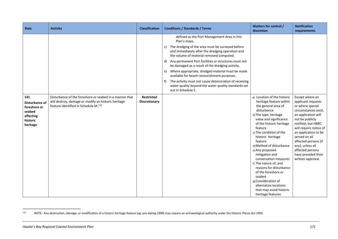
Hawke’s Bay Regional Coastal Environment Plan 171
Rule Activity Classification Conditions / Standards / Terms Matters for control / discretion
Notification requirements
defined as the Port Management Area in this Plan’s maps.
c) The dredging of the area must be surveyed before and immediately after the dredging operation and the volume of material removed computed.
d) Any permanent Port facilities or structures must not be damaged as a result of the dredging activity.
e) Where appropriate, dredged material must be made available for beach renourishment purposes.
f) The activity must not cause deterioration of receiving water quality beyond the water quality standards set out in Schedule E.
141
Disturbance of foreshore or seabed affecting historic heritage
Disturbance of the foreshore or seabed in a manner that will destroy, damage or modify an historic heritage feature identified in Schedule M.132
Restricted Discretionary
a) Location of the historic heritage feature within the general area of disturbance
b) The type, heritage value and significance of the historic heritage feature
c) The condition of the historic heritage feature
d) Method of disturbance e) Any proposed
mitigation and conservation measures
f) The nature of, and reasons for disturbance of the foreshore or seabed
g) Consideration of alternative locations that may avoid historic heritage features
Except where an applicant requests or where special circumstances exist, an application will not be publicly notified, but HBRC will require notice of an application to be served on all affected persons (if any), unless all affected persons have provided their written approval.
132 NOTE: Any destruction, damage, or modification of a historic heritage feature (eg: pre-dating 1900) may require an archaeological authority under the Historic Places Act 1993.

172 Hawke’s Bay Regional Coastal Environment Plan
Rule Activity Classification Conditions / Standards / Terms Matters for control / discretion
Notification requirements
h) Effects on historic heritage
i) Matters in Chapter 26.2
142
Livestock within specified Significant Conservation Areas
Disturbance of the foreshore or seabed arising from the presence of livestock within any of the following Significant Conservation Areas:
1. Porangahau Estuary (SCA1) 2. Aramoana-Blackhead Beach (SCA3) 3. Tukituki River mouth (SCA10) 4. Waitangi Estuary (SCA11) 5. Ahuriri Estuary (SCA12) 6. Wairoa Estuary and Coastal Wetlands (SCA15) or 7. Maungawhio Lagoon (SCA20).
Prohibited
143
Disturbances within specified Significant Conservation
Areas133
Except for scientific research purposes134, the disturbance or removal of:
1. the Pourerere Miocene Microfauna fossil horizon from Ouepoto-Paoanui Point (SCA4) or
2. spherical concretionary (Cray Bay) boulders from Waimarama (SCA8) or
3. sand, rock or gravel from Te Angiangi (SCA3), Hinemahanga Rocks (SCA7), or
4. within 700m of Red Island/Karamea, or Pania Reef (SCA13).
Prohibited
144
Removal of sand, shell, gravel or other natural material not regulated by other, or not complying with, rules
Except as provided for in Rule 105, Rule 106, Rule 107, Rule 108 and Rule 109, the removal of sand, shell, gravel or other natural material from the foreshore or seabed, that-
1. Is not specifically classified by any other rule in this Plan as a non-complying or prohibited activity; or
2. Does not comply with all relevant conditions on a permitted activity rule.
Discretionary Refer to notification requirements in ss95A-95F of RMA
133 NOTE: Removal of sand, shell, gravel or other material from a marine reserve (eg: Te Angi Angi Marine Reserve in SCA3), unless appropriately authorised for research purposes, is prohibited under the Marine Reserves
Act 1971.
134 Disturbance or removal of these materials for scientific research purposes is a discretionary activity in accordance with Rule 135 or Rule 149, whichever is appropriate.
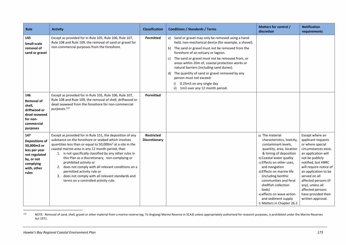
Hawke’s Bay Regional Coastal Environment Plan 173
Rule Activity Classification Conditions / Standards / Terms Matters for control / discretion
Notification requirements
145
Small-scale removal of sand or gravel
Except as provided for in Rule 105, Rule 106, Rule 107, Rule 108 and Rule 109, the removal of sand or gravel for non-commercial purposes from the foreshore.
Permitted a) Sand or gravel may only be removed using a hand-held, non-mechanical device (for example, a shovel).
b) The sand or gravel must not be removed from the foreshore of an estuary or lagoon.
c) The sand or gravel must not be removed from, or areas within 20m of, coastal protection works or natural barriers (including sand dunes).
d) The quantity of sand or gravel removed by any person must not exceed:
i) 0.25m3 on any single day ii) 1m3 over any 12 month period.
146
Removal of shell, driftwood or dead seaweed for non-commercial purposes
Except as provided for in Rule 105, Rule 106, Rule 107, Rule 108 and Rule 109, the removal of shell, driftwood or dead seaweed from the foreshore for non-commercial purposes.135
Permitted
147
Depositions of 50,000m3 or less per year not regulated by, or not complying with, other rules
Except as provided for in Rule 151, the deposition of any substance on the foreshore or seabed which involves quantities less than or equal to 50,000m3 at a site in the coastal marine area in any 12 month period, that:
1. is not specifically classified by any other rules in this Plan as a discretionary, non-complying or prohibited activity or
2. does not comply with all relevant conditions on a permitted activity rule or
3. does not comply with all relevant standards and terms on a controlled activity rule.
Restricted Discretionary
a) The material characteristics, toxicity, contaminant levels, quantity, area, location & timing of deposition
b) Coastal water quality c) Effects on other uses,
and navigation d) Effects on marine life
(including benthic communities and feral shellfish collection beds)
e) effects on wave action and sediment supply
f) Matters in Chapter 26.2
Except where an applicant requests or where special circumstances exist, an application will not be publicly notified, but HBRC will require notice of an application to be served on all affected persons (if any), unless all affected persons have provided their written approval.
135 NOTE: Removal of sand, shell, gravel or other material from a marine reserve (eg: Te Angiangi Marine Reserve in SCA3) unless appropriately authorised for research purposes, is prohibited under the Marine Reserves
Act 1971.

174 Hawke’s Bay Regional Coastal Environment Plan
Rule Activity Classification Conditions / Standards / Terms Matters for control / discretion
Notification requirements
148
Deposition of substances from river control and drainage works
The deposition of any substance onto the foreshore or seabed which was excavated or dredged from the foreshore or seabed for the purposes of an activity described in the Hawke's Bay Regional Council Environmental Code of Practice for River Control and Drainage Works (2003).136
Permitted a) The activity must be undertaken by or on behalf of a local authority exercising its statutory powers, functions or duties under any of the following:
i) the Soil Conservation and Rivers Control Act 1941 ii) the Land Drainage Act 1908 iii) the Local Government Act 1974 iv) the Local Government Act 2002.
b) The quantity of substance deposited must not exceed 50,000m3 in any 12 month period.
c) The substance must not be deposited on or within 50m of any of the following:
i) shell fish gathering areas or ii) bird nesting areas.
149
Deposition of substances from outfall structures, bridges, sea water intakes and culverts
The deposition of any substance onto the foreshore or seabed cleared from an outfall structure, bridge, sea water intake structure or culvert.
Permitted a) The substance must be deposited on sediment which is of the same or similar in size.
b) The substance must be deposited within a distance of 50m from where it was cleared.
c) The substance must not be deposited on any of the following:
i) shell fish gathering areas or ii) bird nesting areas.
d) The substance must not be deposited within 100m of the Harbour Management Area.
e) The substance must not be deposited at a rate exceeding 0.5m3 per square metre.
136 NOTE: Refer to Rule 133 which addresses disturbance of the foreshore or seabed for river control and drainage works.

Hawke’s Bay Regional Coastal Environment Plan 175
Rule Activity Classification Conditions / Standards / Terms Matters for control / discretion
Notification requirements
150
Deposition of substances arising from maintenance dredging of specified
areas137
The deposition of any substance onto the foreshore or seabed arising from maintenance dredging of:
1. the Fairway, Swinging Basin and Berths in the Port Management Area.
2. the Harbour Management Area.
Controlled138 a) The quantity of substance deposited must not exceed 50,000m3 in any 12 month period.
b) Any substance from maintenance dredging of the Fairway, or Swinging Basin and Berth areas in the Port Management Area must be deposited into:
i) Dredge Disposal Area 1 and/or ii) Dredge Disposal Area 2 identified in this Plan’s maps.
c) Any substance from maintenance dredging of the Harbour Management Area must be deposited into Dredge Disposal Area 2 identified in this Plan’s maps.
a) The material characteristics, toxicity, contaminant levels, quantity, location and timing of the deposition
b) Effects on water quality c) Effects on feral shellfish
beds d) Matters in Chapter 26.2
Except where an applicant requests or where special circumstances exist, an application will not be publicly notified, but HBRC will require notice of an application to be served on all affected persons (if any), unless all affected persons have provided their written approval.
151
Depositions of more than 50,000m3 per year
Any activity involving the deposition of any material on the foreshore or seabed in quantities greater than 50,000m3 in any 12 month period in the coastal marine area.
Discretionary Refer to notification requirements in ss95A-95F of RMA
137 NOTE: Refer also to Rule 139 which addresses the maintenance dredging of these areas.
138 NOTE: The Resource Management (Marine Pollution) Regulations 1998 have 'deemed' deposition of dredge material from any ship, aircraft, or offshore installation to be a discretionary activity in all regional coastal plans. Deposition of dredge material in the CMA for all other instances is subject to Rule 150.

176 Hawke’s Bay Regional Coastal Environment Plan
27.10 Introduction of plants in Coastal Marine Area
Rule Activity Classification Conditions / Standards / Terms Matters for control / discretion
Notification requirements
152
Introduction or planting of exotic plant species
The introduction or planting of an exotic plant species within the coastal marine area that:
1. is already present in an area; or 2. is not already present in an area.
Discretionary Refer to notification requirements in ss95A-95F of RMA
153
Introduction or planting of plant pests
Notwithstanding Rule 152, the introduction to, or planting within, the coastal marine area of any plant pest within the meaning of the Biosecurity Act 1993.
Prohibited
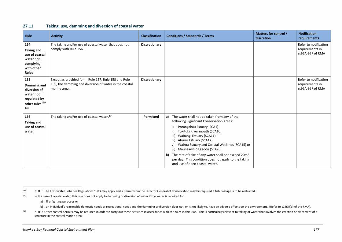
Hawke’s Bay Regional Coastal Environment Plan 177
27.11 Taking, use, damming and diversion of coastal water
Rule Activity Classification Conditions / Standards / Terms Matters for control / discretion
Notification requirements
154
Taking and use of coastal water not complying with other Rules
The taking and/or use of coastal water that does not comply with Rule 156.
Discretionary Refer to notification requirements in ss95A-95F of RMA
155
Damming and diversion of water not regulated by
other rules139,
140
Except as provided for in Rule 157, Rule 158 and Rule 159, the damming and diversion of water in the coastal marine area.
Discretionary Refer to notification requirements in ss95A-95F of RMA
156
Taking and use of coastal water
The taking and/or use of coastal water.141 Permitted a) The water shall not be taken from any of the following Significant Conservation Areas:
i) Porangahau Estuary (SCA1) ii) Tukituki River mouth (SCA10) iii) Waitangi Estuary (SCA11) iv) Ahuriri Estuary (SCA12) v) Wairoa Estuary and Coastal Wetlands (SCA15) or vi) Maungawhio Lagoon (SCA20).
b) The rate of take of any water shall not exceed 20m3 per day. This condition does not apply to the taking and use of open coastal water.
139 NOTE: The Freshwater Fisheries Regulations 1983 may apply and a permit from the Director General of Conservation may be required if fish passage is to be restricted.
140 In the case of coastal water, this rule does not apply to damming or diversion of water if the water is required for:
a) fire-fighting purposes or
b) an individual’s reasonable domestic needs or recreational needs and the damming or diversion does not, or is not likely to, have an adverse effects on the environment. (Refer to s14(3)(d) of the RMA).
141 NOTE: Other coastal permits may be required in order to carry out these activities in accordance with the rules in this Plan. This is particularly relevant to taking of water that involves the erection or placement of a structure in the coastal marine area.

178 Hawke’s Bay Regional Coastal Environment Plan
Rule Activity Classification Conditions / Standards / Terms Matters for control / discretion
Notification requirements
157
Damming and diversion of water for river control and drainage works
Damming and diversion of water in the coastal marine area for the purposes of any activity described in the Hawke's Bay Regional Council Environmental Code of Practice for River Control and Drainage Works (2003).
Permitted a) The activity must be undertaken by or on behalf of a local authority exercising its statutory powers, functions or duties under any of the following:
i) the Soil Conservation and Rivers Control Act 1941 ii) the Land Drainage Act 1908 iii) the Local Government Act 1974 iv) the Local Government Act 2002.
b) The activity must not impede fish passage.142
158
Temporary damming and diversion of water
Damming and diversion of water in the coastal marine area for any of the following purposes:
1. the maintenance or repair of a lawfully established structure in accordance with Rule 118 or
2. the erection, reconstruction, placement, alteration, extension, removal or demolition of any line, pipeline or cable owned or managed by a network utility operator in accordance with Rule 120 or
3. the removal or demolition of a structure or any part of a structure in accordance with Rule 121.
Permitted a) The damming and diversion of water must:
i) not divert more than 10% of the flow of coastal water (where coastal water flows);
ii) return any diverted water back to the affected water body within 100m downstream of the point at which the water is diverted.
b) The damming and diversion of water must not exceed a period of 5 consecutive days.
c) The damming and diversion of water must not exceed a period of 12 hours on any single day during the period in (b) above.
d) The activity must not impede fish passage. 143
159
Lawfully established diversions of
water144
Any lawfully established diversion of water in the coastal marine area.
Permitted a) The diversion must not cause any scouring or erosion of and land or water course beyond the point of the discharge.
b) The diversion must not adversely affect any lawfully established water take, which existed at the time the diversion commenced.
c) The diversion must not prevent the passage of fish within the water body, unless this was authorised at the time that diversion was established.
d) The diversion shall not cause or contribute to the flooding of any property, unless written approval was
142 NOTE: The Freshwater Fisheries Regulations 1983 may apply and a permit from the Director General of Conservation may be required if fish passage is to be restricted.
143 NOTE: The Freshwater Fisheries Regulations 1983 may apply and a permit from the Director General of Conservation may be required if fish passage is to be restricted.
144 NOTE: This rule provides for diversions established in accordance with either s14 of the RMA, or s20A of the RMA which provides for certain existing lawful activities to be allowed.

Hawke’s Bay Regional Coastal Environment Plan 179
Rule Activity Classification Conditions / Standards / Terms Matters for control / discretion
Notification requirements
obtained from the affected property owner at the time that the diversion was established.
e) For diversions lawfully established by way of resource consent, the diversion shall continue to comply with all conditions of the consent.145
145 NOTE: This rule means that once diversions have been lawfully established, their continued operation is permitted under this rule. No ongoing consent is required for the operation of existing diversions provided the
conditions of this rule are met.

180 Hawke’s Bay Regional Coastal Environment Plan
27.12 Coastal discharges
Rule Activity Classification Conditions / Standards / Terms Matters for control / discretion
Notification requirements
160
Discharges not regulated by, or not complying with, other
rules146
The discharge of a contaminant or water into water in the coastal marine area, or the discharge of a contaminant into or onto land in the coastal marine area in circumstances which may result in that contaminant (or any other contaminant emanating as a result of natural processes from that contaminant) entering water in the coastal marine area that:
1. is not specifically classified by any other rule in this Plan as a non-complying or prohibited activity 147 ; or
2. does not comply with all relevant conditions on a permitted activity rule or
3. does not comply with all relevant standards and terms on a controlled activity rule or a restricted discretionary rule.
Discretionary Refer to notification requirements in ss95A-95F of RMA
161
Discharge of drilling muds, cuttings & fluids
The discharge of drilling muds, cuttings or fluids into the coastal marine area.148
Permitted a) The drilling must be for the purposes of investigating water, oil, gas or seabed resources.
b) The discharge shall not occur:
i) within 2000m of mean high water springs, except this condition shall not apply within the Port Management Area.
ii) in or within 500m of any Significant Conservation Area
iii) in or within 500m of any Historic Heritage Area iv) in or within 500m of any Aquaculture
Management Area v) in or within 500m of any area of coastal water
class CR(HB) vi) in or within 500m of the Te Angiangi Marine
Reserve.
146 NOTE: This rule does not apply to discharges from ships or offshore installations or discharges of contaminants associated with maintenance dredging activities complying with Rule 139. Refer to Schedule F of this
Plan.
147 For the purposes of Rule 160.1 and the avoidance of doubt, this rule is applicable to: a) the discharge of human sewage (except as provided for in Rule 165 and Rule 167) which has not passed through soil or wetland ,to the coastal marine area; and b) the discharge of any contaminant to the coastal marine area in respect of which the applicant may desire to rely on section 107(2)(a) of the RMA.
148 Refer to Rule 138 which addresses disturbance of the foreshore and seabed arising from drilling and bores in the coastal marine area.

Hawke’s Bay Regional Coastal Environment Plan 181
Rule Activity Classification Conditions / Standards / Terms Matters for control / discretion
Notification requirements
c) There shall be no discharge to groundwater or surface water.
d) The discharge shall not contain more than 15 g/m3 of oil and grease.
162
Small-scale discharge of agrichemicals
The discharge of contaminants in the coastal marine area arising from the use of agrichemicals
Permitted a) The activity must be carried out by or on behalf of:
i) the Department of Conservation ii) the HBRC iii) a territorial authority iv) a district health board v) Biosecurity New Zealand.
b) The discharge must be for purposes of eradicating, modifying or controlling unwanted aquatic plants, or other biosecurity purposes.
c) Only hand held appliances may be used to discharge the agrichemicals.
d) The discharge must not include any agrichemicals not approved for aquatic use by the Environmental Risk Management Authority.
e) The discharge shall be undertaken in a manner which does not exceed any rate, or contravene any other requirement, specified in the agrichemical manufacturer's instructions.
f) The discharge shall be undertaken in accordance with all mandatory requirements set out in s2, s5 and s6 of the New Zealand Standard for the Management of Agrichemicals (NZS 8409:2004).
g) The discharge shall not include disposal to water of any agrichemical.
163
Diversion and discharge of stormwater
The diversion and discharge of stormwater from any constructed open drainage system or piped stormwater drainage system that:
1. does not drain any industrial or trade premises; or
2. drains any industrial or trade premises (excluding premises used for the storage of any hazardous substance).
Permitted a) The activity must not cause any permanent:
i) reduction in the ability of the receiving environment to convey flood flows;
ii) bed scouring or bank erosion of the receiving environment.
b) The discharge must not cause the production of conspicuous oil or grease films, scums or foams, or

182 Hawke’s Bay Regional Coastal Environment Plan
Rule Activity Classification Conditions / Standards / Terms Matters for control / discretion
Notification requirements
floatable or suspended materials in any receiving water after reasonable mixing.
c) The discharge must not cause deterioration of receiving water quality beyond the water quality standards set out in Schedule E.
d) The stormwater shall not be diverted or discharged from an area greater than 2 hectares.
164
Diversion and discharge of stormwater to
the CMA149
Except as provided for in Rule 169, the diversion and discharge of stormwater to the coastal marine area.
Controlled a) The discharge must not cause deterioration of receiving water quality beyond the water quality standards set out in Schedule E.
a) Location of the point of diversion and discharge including its catchment area
b) Volume, rate, timing and duration of the discharge, in relation to a specified rainfall event, including any measures to attenuate flood flow, rates and peaks for a range of rainfall durations and intensities.
c) Effects of the activity on any downstream flooding
d) Contingency measures in the event of pipe capacity exceedence or contaminants entering stormwater.
e) Actual or likely adverse effects on fisheries, wildlife, habitats, ecosystems, aquatic life or amenity values and the relationship of tangata whenua with
Except where an applicant requests or where special circumstances exist, an application will not be publicly notified, but HBRC will require notice of an application to be served on all affected persons (if any), unless all affected persons have provided their written approval.
149 NOTE: Authorised discharges into stormwater systems do not require a resource consent. However, in accordance with these rules, the owner of any particular stormwater system may be required to obtain a resource
consent to cover the situation where the stormwater discharges into coastal water.

Hawke’s Bay Regional Coastal Environment Plan 183
Rule Activity Classification Conditions / Standards / Terms Matters for control / discretion
Notification requirements
the receiving environment
f) Coastal water quality, including but not limited to matters in RMA s107, coastal water quality standards set out in Schedule E, and cumulative effects of contaminants accumulating in the receiving environment.
g) quality of stormwater discharged, including but not limited to, concentration of hazardous substances in the stormwater to be discharged, and methods to reduce contaminant and sediment loadings before discharge (such as stormwater treatment and low impact design).
h) Matters in Chapter 26.2
165
Discharge of sewage from ships or off-shore installations into specified areas
The discharge of sewage from a ship or off-shore installation150:
1. within the Porangahau Estuary (SCA1) or 2. inside, or within 500m of the seaward extent of
the banks of, the Wairoa River, Whangawehi Harbour, or Waikokopu Harbour or
3. in or within 500m of an Aquaculture Management Area.
4. in or within 500m of the Port Management Area or
Prohibited
150 The Resource Management (Marine Pollution) Regulations 1998 may apply. Refer to Schedule F of this Plan.

184 Hawke’s Bay Regional Coastal Environment Plan
Rule Activity Classification Conditions / Standards / Terms Matters for control / discretion
Notification requirements
5. in or within 500m of the Harbour Management Area or
6. in or within 500m of Pania Reef (SCA13) or 7. in or within 500m of Te Angiangi Marine Reserve.
166
Discharge of
litter151
The discharge or dumping of litter in the coastal marine area.
Prohibited
167
Discharge of sewage from land which has not passed through soil or wetland into a SCA or Historic Heritage Area
The discharge of sewage from land which has not passed through soil or wetland, into:
1. a Significant Conservation Area, excluding the Wairoa River (SCA15) or
2. a Historic Heritage Area identified in this Plan’s maps.
Prohibited
151 NOTE: This rule does not include garbage cast from ships or offshore installations. The Resource Management (Marine Pollution) Regulations 1998 may apply to the discharge and dumping of litter or garbage from
ships and offshore installations. Refer to Schedule F of this Plan.

Hawke’s Bay Regional Coastal Environment Plan 185
27.13 Surface water activities in Coastal Marine Area
Rule Activity Classification Conditions / Standards / Terms Matters for control / discretion
Notification requirements
168
Use of hovercraft in specified areas
The use of hovercraft: 1. within 600m of Black Reef as identified in this
Plan’s maps; or 2. within a 600m radius of an area immediately
south of Cape Kidnappers as identified in this Plan’s maps.
Prohibited
169
Use of powered ships in Ahuriri Estuary and Maungawhio Lagoon for emergency operations or instructional purposes
The use of powered ships in: 1. the Ahuriri Estuary and Pandora Pond (SCA12) 2. the Maungawhio Lagoon (SCA20).
Permitted a) Except as provided for in conditions (b) and (c), the use of powered ships shall only be for emergency purposes.
b) The use of powered ships may be for one or more of the following purposes:
i) environmental monitoring ii) scientific research, provided that it is undertaken
by or on behalf of: 1) Department of Conservation or 2) the HBRC or 3) a territorial authority or 4) a district health board or 5) NIWA or other Crown Research Institute.
c) Within SCA12, the use of powered ships in Pandora Pond shall only be for the purposes specified in condition (b) above or instructional purposes.
d) Any ship used for the purposes specified in conditions (b) or (c) must not be powered by a motor exceeding 10 horsepower.152
170
Use of powered ships in the Ahuriri Estuary and Maungawhio Lagoon
Except as provided for in Rule 169, the use of powered ships in:
1. the Ahuriri Estuary and Pandora Pond (SCA12) 2. the Maungawhio Lagoon (SCA20).
Prohibited
152 NOTE: Notwithstanding this engine power limitation, speed restrictions also apply within SCA12.

186 Hawke’s Bay Regional Coastal Environment Plan
27.14 Hazardous substances in Coastal Marine Area
Rule Activity Classification Conditions / Standards / Terms Matters for control / discretion
Notification requirements
171
Storage of hazardous substances not regulated by, or not complying with, other rules
Except as provided for in Rule 174, the storage153 of any hazardous substance in, on, under or over the foreshore or seabed that:-
1. Is not specifically classified by any other rule in this Plan as a discretionary, non-complying or prohibited activity; or
2. Does not comply with all of the relevant conditions on a permitted activity rule.
Restricted Discretionary
a) The potential adverse effects of a spillage or discharge of hazardous substances and any means to avoid or reduce potential for spillage or discharge
b) Proximity to, and sensitivity of, the surrounding environment
c) The nature and volume of stored substances
d) Matters in Chapter 26.2.
Except where an applicant requests or where special circumstances exist, an application will not be publicly notified, but HBRC will require notice of an application to be served on all affected persons (if any), unless all affected persons have provided their written approval.
172
Storage of hazardous substances
Except as provided for in Rule 174, the storage154 of any hazardous substance in, on, under or over the foreshore or seabed.
Permitted a) At least one of the following shall apply:
i) the storage is on a wharf within the Harbour Management Area or the Port Management Area or
ii) the hazardous substance is being carried as cargo in or on a vehicle, ship or aircraft or
iii) the storage is in or on a vehicle, ship or aircraft and is for the purposes of refuelling that vehicle, ship or aircraft or
iv) the storage is directly associated with the conveyance of a hazardous substance in or on a conveyor, or in a line, pipeline, hose or cable.
b) The quantity of hazardous substance stored (whether in a container, building or any other structure) must comply with the Hazardous Substances and New Organisms Act 1996 and any Regulations made under that Act.
153 Storage for the purposes of this Rule does not include the conveyance of hazardous substances in a line, pipeline, hose or cable.
154 Storage for the purposes of this Rule does not include the conveyance of hazardous substances in a line, pipeline, hose or cable.

Hawke’s Bay Regional Coastal Environment Plan 187
Rule Activity Classification Conditions / Standards / Terms Matters for control / discretion
Notification requirements
173
Dumping of hazardous substances
The dumping155 of any hazardous substance in the coastal marine area.
Prohibited
174
Storage of hazardous substances within a SCA
The storage156 or containment of any hazardous substance in, on, under or over the foreshore or seabed within a Significant Conservation Area.
Prohibited
155 NOTE: Any dumping or discharging from ships, aircraft or offshore installations in the CMA may be subject to the provisions of Sections 15A, 15B and 15C or the RMA and to any regulations made under those sections.
156 Storage for the purposes of this rule does not include the conveyance of hazardous substances in a line, pipeline, hose or cable.
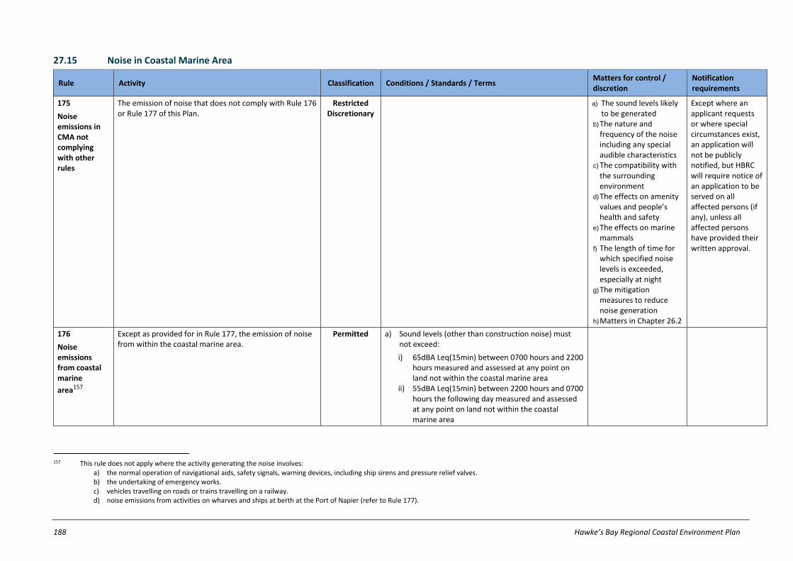
188 Hawke’s Bay Regional Coastal Environment Plan
27.15 Noise in Coastal Marine Area
Rule Activity Classification Conditions / Standards / Terms Matters for control / discretion
Notification requirements
175
Noise emissions in CMA not complying with other rules
The emission of noise that does not comply with Rule 176 or Rule 177 of this Plan.
Restricted Discretionary
a) The sound levels likely to be generated
b) The nature and frequency of the noise including any special audible characteristics
c) The compatibility with the surrounding environment
d) The effects on amenity values and people’s health and safety
e) The effects on marine mammals
f) The length of time for which specified noise levels is exceeded, especially at night
g) The mitigation measures to reduce noise generation
h) Matters in Chapter 26.2
Except where an applicant requests or where special circumstances exist, an application will not be publicly notified, but HBRC will require notice of an application to be served on all affected persons (if any), unless all affected persons have provided their written approval.
176
Noise emissions from coastal marine
area157
Except as provided for in Rule 177, the emission of noise from within the coastal marine area.
Permitted a) Sound levels (other than construction noise) must not exceed:
i) 65dBA Leq(15min) between 0700 hours and 2200 hours measured and assessed at any point on land not within the coastal marine area
ii) 55dBA Leq(15min) between 2200 hours and 0700 hours the following day measured and assessed at any point on land not within the coastal marine area
157 This rule does not apply where the activity generating the noise involves: a) the normal operation of navigational aids, safety signals, warning devices, including ship sirens and pressure relief valves. b) the undertaking of emergency works. c) vehicles travelling on roads or trains travelling on a railway. d) noise emissions from activities on wharves and ships at berth at the Port of Napier (refer to Rule 177).

Hawke’s Bay Regional Coastal Environment Plan 189
Rule Activity Classification Conditions / Standards / Terms Matters for control / discretion
Notification requirements
iii) 85dBA Lmax measured and assessed at any point on land not within the coastal marine area.
b) Noise (other than construction noise) must be measured in accordance with provisions of New Zealand Standard NZS6801:1999 ‘Acoustics: Measurement of Environmental Sound’.
c) Noise (other than construction noise) must be assessed in accordance with provisions of New Zealand Standard NZS6802:1999 ‘Acoustics: Assessment of Environmental Sound’.
d) Construction noise must not exceed the limits recommended in, and measured and assessed in accordance with, New Zealand Standard NZS6803:1999 ‘Acoustics: Construction Noise’.
177
Noise emissions in Port Management
Area158
Emission of noise in the Port Management Area. Permitted a) Sound levels (other than construction noise) must not exceed:
i) 65dBA Ldn over any consecutive five day period at any point beyond the Port Inner Noise Boundary as identified in the Napier District Plan.
ii) 68dBA Ldn on any day at any point beyond the Port Inner Noise Boundary as identified in the Napier District Plan.
iii) 60dBA Leq (9 hour) between 2200 hours and 0700 hours the following day at any point beyond the Port Inner Noise Boundary as identified in the Napier District Plan.
iv) 65dBA Leq (15min) between 2200 hours and 0700 hours the following day at any point beyond the Port Inner Noise Boundary as identified in the Napier District Plan.
v) 85dBA Lmax on any night between 2200 hours and 0700 hours the following day at any point
158 This rule does not apply where the activity generating the noise involves: a) the normal operation of navigational aids, safety signals, warning devices, including ship sirens and pressure relief valves. b) the undertaking of emergency works.
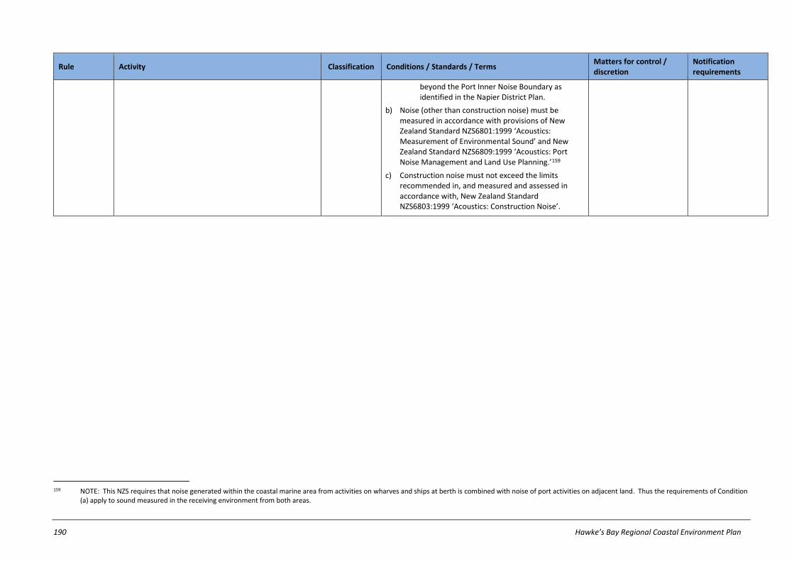
190 Hawke’s Bay Regional Coastal Environment Plan
Rule Activity Classification Conditions / Standards / Terms Matters for control / discretion
Notification requirements
beyond the Port Inner Noise Boundary as identified in the Napier District Plan.
b) Noise (other than construction noise) must be measured in accordance with provisions of New Zealand Standard NZS6801:1999 ‘Acoustics: Measurement of Environmental Sound’ and New Zealand Standard NZS6809:1999 ‘Acoustics: Port Noise Management and Land Use Planning.’159
c) Construction noise must not exceed the limits recommended in, and measured and assessed in accordance with, New Zealand Standard NZS6803:1999 ‘Acoustics: Construction Noise’.
159 NOTE: This NZS requires that noise generated within the coastal marine area from activities on wharves and ships at berth is combined with noise of port activities on adjacent land. Thus the requirements of Condition
(a) apply to sound measured in the receiving environment from both areas.

Hawke’s Bay Regional Coastal Environment Plan 191
27.16 Occupation of space in Coastal Marine Area
Rule Activity Classification Conditions / Standards / Terms Matters for control / discretion
Notification requirements
178
Occupation of CMA not regulated by, or not complying with, other rules
Occupation of the coastal marine area that – 1. is not specifically classified by any other rule in
this Plan as a discretionary, non-complying or prohibited activity 160 ; or
2. does not comply with all relevant conditions on a permitted activity rule or
3. does not comply with all relevant standards and terms on a controlled activity or a restricted discretionary rule.
Discretionary Refer to notification requirements in ss95A-95F of RMA
179
Temporary occupation of CMA
Temporary occupation of the coastal marine area for the purposes of a special event or other surface water activity.
Permitted NOTE: There are no conditions/standards/terms for this activity. Nothing in this Plan waives any requirements to comply with the HBRC Navigation and Safety Bylaws 2002.
180
Occupation of CMA associated with authorised activities and structures
Except as provided for by Rule 179, Rule 181, Rule 182, Rule 183 and Rule 184, the occupation of the coastal marine area by, and which occurs concurrently with, and is directly associated with:
1. a lawfully established structure or any erection, reconstruction, placement, alteration, extension, removal, maintenance, repair or demolition of a lawfully established structure161 or
2. any activity involving reclamation, drainage, or disturbance of the foreshore or seabed or
3. any activity involving deposition or removal of material from the foreshore or seabed or
4. any activity involving the take, use damming or diversion of water from within the coastal marine area or
5. any activity involving the discharge of a contaminant to the coastal marine area.
Permitted a) The structure or activity must be authorised either:
i) as a permitted activity in rules elsewhere in this Plan or
ii) by a controlled activity resource consent for the structure or activity.
b) Written notice must be provided to the HBRC of the nature and location of the activity or structure at least 10 working days prior to the commencement of any occupation of the coastal marine area.
160 For the purposes of Rule 178.1 and avoidance of doubt, this does apply to any activity involving exclusive occupation of the coastal marine area. 161 NOTE: For the purposes of Rule 180 and avoidance of doubt, ‘lawfully established structures’ includes those structures listed in Schedule S.

192 Hawke’s Bay Regional Coastal Environment Plan
Rule Activity Classification Conditions / Standards / Terms Matters for control / discretion
Notification requirements
181
Occupation of space in an AMA by aquaculture
activities162
Occupation of coastal marine area within an Aquaculture Management Area by an aquaculture activity.
Controlled a) The occupation must only be for the purpose of farming species authorised by a current resource consent.
b) The occupation must not occur in space that is already the subject of a current resource consent for the occupation of that space by another person.
a) Effects on navigation and safety, including provision for warning devices, signs and lights
b) Effects on marine ecological systems
c) Extent of occupation, including degree of exclusivity and spatial area
d) Timing and/or staging of occupation
e) Mooring requirements f) Matters in Chapter
26.2.
Except where an applicant requests or where special circumstances exist, an application will not be publicly notified, but HBRC will require notice of an application to be served on all affected persons (if any), unless all affected persons have provided their written approval.
182
Occupation of space in an AMA by non-aquaculture
activities163
Except as provided for in Rule 190, the occupation of coastal marine area within an Aquaculture Management Area by an activity, other than an aquaculture activity.164
Discretionary Refer to notification requirements in ss95A-95F of RMA
183
Occupation of space not within an AMA by an aquaculture activity
Except as provided for in Rule 181 and Rule 182, occupation of the coastal marine area by an aquaculture activity.
Prohibited
162 NOTE: This rule only addresses issues arising from the effects of occupation of space. Effects arising from structures, discharges of, and deposition of, contaminants arising from an aquaculture activity in an AMA are
addressed by rules elsewhere in this Plan.
163 NOTE: Section 12A(3) of the RMA provides that “an activity that is not an aquaculture activity may not be undertaken in an Aquaculture Management Area, except to the extent that the activity is compatible with aquaculture activities.”
164 NOTE: This rule only addresses issues arising from the effects of occupation of space. Effects arising from structures, discharges of, and deposition of, contaminants arising from non-aquaculture activities in an AMA are addressed by rules elsewhere in this Plan.
Hawke’s Bay Regional Coastal Environment Plan 193
PART F – NON REGULATORY METHODS
28 Non-regulatory methods
28.1 Introduction
This chapter contains the non-regulatory methods used by the HBRC to implement the policies set out in previous chapters of this Plan, and to achieve the purpose of the RMA. The non-regulatory methods are categorised under the following headings which are each in turn described in Chapters 28.2-28.7:
(a) environmental education and co-ordination (b) liaison with territorial authorities (c) economic instruments (d) works and services (e) research and investigation and (f) monitoring.
28.2 Environmental Education and Co-ordination
The HBRC is placing increasing emphasis on environmental education and co-ordination as a tool for achieving its functions under the RMA. As a result, the HBRC has developed an Environmental Education Strategy which sets the direction for the Council’s education activities, thereby ensuring the Council moves down the path of environmental education in a co-ordinated and cost-effective manner.
The Environmental Education Strategy focuses on four target sectors:
(a) resource user groups (b) the formal education sector (c) care groups and (d) the regional community.
The aims of the Environmental Education Strategy are as follows:
(a) Knowledge – To help people gain experience in, and a basic understanding of, the environment and human interaction within it.
(b) Skills – To help people acquire the skills to participate effectively in respect of environmental issues and to be involved in identifying and solving environmental problems.
(c) Awareness – To promote and help people acquire an awareness of, and sensitivity to, the whole environment and environmental issues.
(d) Participation – To promote public participation and provide people with the capacity to be actively involved in helping resolve environmental problems.
(e) Attitudes and values – To help people acquire values of concern and responsibility for the environment and be motivated to care for the environment.
In order to meet these aims the HBRC has encouraged the co-ordination of resource users and has developed a number of environmental education programmes all of which will continue to be implemented, including:
(a) Promotion of Landcare groups – These are community self-help groups formed to take action on local environmental issues, including coastal dune and wetland projects.
(b) Preparation of farm plans and erosion control plans – The HBRC works with land owners to prepare farm plans and erosion control plans to help improve land management practices.
(c) Production of ‘Environment Topics’ and ‘The Big Picture’ newsletter – The HBRC has prepared a series of pamphlets (‘Environment Topics’) regarding environmental management, and adds to this series on an ongoing basis. In addition, the HBRC produces ‘The Big Picture’, a newsletter for communicating information to Hawke's Bay households.
(d) Co-ordination and involvement in field days and seminars – The HBRC regularly organises field days and seminars, or participates in events organised by others, as an interactive means of providing information and advice.
(e) Waste minimisation – The HBRC, together with the Napier City Council and Hastings District Council, funds a Waste Minimisation Officer, whose work focuses on initiatives to reduce, reuse and recycle waste.

194 Hawke’s Bay Regional Coastal Environment Plan
(f) Self-regulation – The HBRC actively promotes and supports self-regulation by resource users, including the preparation of guidelines and codes of practice by resource user groups. HBRC promotion and support for self-regulation is undertaken by the following means:
(i) support (through the development of this Plan and through plan changes) for activities which comply with relevant codes of practice or environmental guidelines to be permitted or controlled activities
(ii) the establishment and maintenance of a register of codes of practices and guidelines that meet the relevant provisions of this Plan.
(g) Resource user group liaison – The HBRC has a programme of regular liaison with key stakeholder groups, as a means of sharing views and information regarding resource use and environmental management.
(h) Joint management initiatives – The HBRC is actively involved in jointly managing the restoration, enhancement and development of resources in the region. Joint management may occur from time to time as appropriate with other resource users, stakeholders and other statutory agencies.
28.3 Liaison with Territorial Authorities
The HBRC recognises that in order to promote the sustainable management of the environment it must integrate its responsibilities with those of other authorities who also have responsibilities under the RMA. For example, the six territorial authorities in the region (Napier City, and Wairoa, Taupo, Hastings, Rangitikei and Central Hawke's Bay districts) manage the effects of the use, development and protection of land; while the HBRC generally controls land use for the purposes of soil conservation, water quality and water quantity. Under this Plan the HBRC also controls land uses for the purposes of avoidance or mitigation of natural coastal hazards. Because of the inter-linkages between these authorities’ responsibilities and decisions it is important that the HBRC and territorial authorities adopt a consistent and co-ordinated approach to resource management issues.
There are several ways that the HBRC has been achieving this, all of which will continue to be implemented:
(a) Statutory advocacy – The HBRC will continue to advocate to the territorial authorities, where appropriate, that the provisions included in district plans should not be inconsistent with the objectives and policies set out in the Hawke's Bay Regional Policy Statement, this Plan and other regional plans.
In addition, the HBRC will continue to develop a process for ensuring that resource consent applications that are received by territorial authorities that require joint processing between the territorial authority and the HBRC have complete details of the proposal and full assessments of environmental effects pertaining to all district and regional council matters. This process will continue to be monitored and refined to ensure its appropriateness and effectiveness. In particular, statutory advocacy will be used in recognition of the collaborative approach required to prevent and resolve problems arising from the effects of conflicting land use activities.
(b) Joint hearings – The HBRC promotes and facilitates, where appropriate, joint and combined hearings of resource consent applications with cross-boundary issues with the view of encouraging consistency and integration within the decision-making process.
(c) Communication – The HBRC, in conjunction with other resource management agencies (eg: Department of Conservation, and territorial authorities) has established working groups to facilitate discussions on topics such as policy development, information requirements and monitoring programmes. The HBRC recognises the importance of continued communication between parties in developing effective policy development and policy implementation techniques.
(d) Transfer of powers – The HBRC recognises that for the sake of efficiency and effectiveness the responsibility for certain actions and decision-making may be more appropriately transferred to other organisations, usually the territorial authorities. The RMA provides for this through the transfer of powers or the delegation of functions.
(e) Protocols – The HBRC has sought to encourage the development and implementation of protocols and systems to aid all of Hawke’s Bay’s territorial authorities in the day-to-day administration of functions under the RMA. The objective is to set up protocols and systems for information gathering and sharing, joint hearing opportunities, natural hazard planning, contaminated sites issues, and possibly waste water treatment and stormwater control issues. Other issues where protocols would enhance relations will be dealt with as they arise.
The HBRC will also implement the following new initiatives:
(f) Contacts database – A database will be developed of contact persons, their positions and areas of specialty, covering staff from all territorial authorities in the Region. This database will be administered by the HBRC and will be updated frequently to ensure its continual accuracy and usefulness.
(g) Overlap issues – The HBRC believes that there are potential overlaps with territorial authorities in the regulation of earthworks, tracking, air discharges, the control of people on beaches, and navigation and safety on rivers which it would be beneficial to resolve. The HBRC will endeavour to set a clear demarcation of responsibility relating to these issues in consultation with the territorial authorities, with the aim of reaching agreement.

Hawke’s Bay Regional Coastal Environment Plan 195
(h) Liaison with Tangata whenua – HBRC will liaise with Ngati Kahungunu Iwi, Whanau-Hapu-Marae and task dedicated work groups (roopu) to ensure a comprehensive understanding of the underlying resource management principles and values of Ngati Kahungunu.
(i) Contaminated Sites Database – A contaminated sites database will be maintained by HBRC for use by territorial authorities in providing appropriate information on sites through the Project Information Memorandum (PIM) and Land Information Memorandum (LIM) processes. Such a database will distinguish between known contaminated sites and those that have an historical association with hazardous substances. Appropriate remediation for known contaminated sites will be determined by the territorial and regional councils on a case-by-case basis with the landowner.
28.4 Economic Instruments
The HBRC uses a number of economic instruments to promote sustainable management. To be effective, incentives should:
(a) be targeted to achieve specific resource management objectives (b) result in tangible benefits to the environment (c) not reward behaviour which would occur anyway in the absence of the incentive and (d) be monitored to assess their effectiveness.
Examples of economic instruments used by the HBRC, that will continue to be implemented include:
(a) Regional Land Care Scheme – The provision of funding for soil conservation, riparian protection, native bush protection and research projects.
(b) Biodiversity Protection and Enhancement (Coastal Dunes) – The provision of funding for the retirement, long-term biodiversity and environmental enhancement of coastal dune areas.
(c) Financial contributions – The RMA allows financial contributions to be applied as a condition of a resource consent. However, the HBRC will require (in accordance with Chapter 29.2) financial contributions only in relation to resource consents for river bed gravel extraction, and will use the contributions for the purposes specified in Chapter 29.2.3.
(d) Development contributions – The Local Government Act 2002 does not empower regional councils to require development contributions, however the Act does require HBRC to adopt a policy on development contributions. In the HBRC Long Term Council Community Plan 2004-2014, Council’s policy is stated as being “not to charge development contributions.”
(e) Bonds – The RMA also allows the HBRC to require a bond to be paid as a condition of a resource consent. Bonds are payable to ensure the satisfactory completion or compliance with the conditions of the resource consent granted.
28.5 Provision of Works and Services
The HBRC also undertakes works and provides services as methods of implementation. ‘Works’ are actual physical developments, such as sea exclusion banks, river and flood control works, whereas ‘services’ include such things as making staff available to provide planning or technical assistance.
The scope of works and services able to be provided is limited by the terms of the Local Government Act. Examples of works and services undertaken by the HBRC, that will continue to be implemented where appropriate, include:
(a) Wetlands enhancement scheme – An ongoing wetlands enhancement programme for identified priority wetlands of the Region. As a first priority, the HBRC will ensure that further degradation of a wetland does not occur; as a second priority the HBRC will seek to enhance the values of a wetland where there are significant biodiversity benefits in doing so and where it is economically feasible.
(b) Service delivery under other legislation – including:
(i) Animal pest control – The surveillance of pest populations, particularly possums and rabbits, on land in the Region. The HBRC has also undertaken animal pest control programmes where necessary.
(ii) Plant pest control – The HBRC provides information to the public on the identification and control of plant pests in the Region. The HBRC has also undertaken measures to control biological plant pests in the Region through the application of a management programme.
(iii) Flood protection schemes – The HBRC has undertaken flood protection schemes and works within areas of the Region’s major rivers. Examples of these schemes are the Heretaunga Plains and Upper Tukituki flood control schemes, for which Asset Management Plans have been developed.
(iv) Beach renourishment schemes and coastal protection structures – HBRC, in conjunction with the Napier City Council, contributes to the Westshore Beach Renourishment Scheme. HBRC also contributes to
196 Hawke’s Bay Regional Coastal Environment Plan
maintenance of a number of existing coastal protection structures (for example: the Kairakau Beach seawall and Haumoana groyne).
(c) Emergency management programme – The HBRC is a member of the Hawke's Bay Civil Defence Emergency Management Group – a joint committee established under the Civil Defence Emergency Management Act 2002. The objective of this committee is to provide the organisational arrangements and services to ensure that Hawke's Bay residents and visitors enjoy a safe and sustainable environment. The HBRC assumes a primary role in the management of flood events.
28.6 Research and Investigation
The HBRC gathers and provides information of a technical nature to assist resource users and decision-makers. There are a number of key areas where the HBRC collects information to expand its own knowledge of the resources it manages and/or to share its knowledge with other resource management agencies.
Research and investigations and projects undertaken by the HBRC include:
(a) Heretaunga Plains groundwater study – A study of the groundwater resources of the Heretaunga Plains aquifer system.
(b) Inventory of regionally significant wetlands – A study identifying regionally significant wetlands within the Region and prioritising them for enhancement.
(c) Priority riparian areas – A study identifying priority riparian areas which should be retired.
(d) Coastal Processes Scoping Study – A report that establishes criteria for further studies on coastal processes and coastal resources over the next 5-10 years.
(e) Hawke's Bay Regional Coastal Hazard Assessment – A study developing a consistent methodology for erosion and inundation mapping of sandy shores, gravel shores and cliff shores. This takes into account relevant physical processes, geology, morphology, historic trends, subsidence, sediment supply and climate change effects.
(f) Earthquake hazards in Hawke’s Bay – Four reports detailing the risk of earthquakes to the Hawke’s Bay Region, and the implications for hazard management and the Emergency Management Strategy.
(g) Tsunami hazard for Hawke's Bay – A study detailing the risk of tsunami to the Hawke’s Bay Region, and the implications for hazard management and the Emergency Management Strategy.
(h) Hawke's Bay Onsite Wastewater Treatment Risk Assessment Framework – A study to determine constraints and risks posed by the use of on-site wastewater treatment systems across the Hawke's Bay region.
(i) Agrichemical collection report – A report on how to safely use and handle agrichemicals, and an analysis of the unwanted agrichemicals collected by the HBRC in a collection scheme.
(j) Hawke's Bay catchments: minimum water yields – A study into the minimum flows in rivers and lakes of the Region, and the effects from adjacent land use practices and seasonal variations.
(k) HBRC contaminated site management strategy – A report detailing the extent of contaminated sites within the Region, the degree of contamination and the appropriate strategy to deal with the site investigation, the effects of contamination, clean-up procedures, and guidelines to avoid future contamination.
28.7 Monitoring
The HBRC’s role of managing Hawke’s Bay’s natural and physical resources necessitates an awareness of the state of the Region’s environment and of changes that occur over time. Regular monitoring of key resources using a range of environmental indicators enables trends in the environmental quality to be identified, and the effects of activities to be assessed. Trend monitoring also serves as a means to measure the performance of the HBRC’s environmental policy, and where changes are seen in the environment, amendments can be made to policy as necessary.
The HBRC undertakes a Regional Monitoring Strategy comprising three essential components. These are:
(a) State of the Environment monitoring – State of the Environment monitoring monitors key environmental indicators to enable the HBRC to understand the nature of the Region’s resources and trends in the quality and quantity of those resources. State of the Environment monitoring culminates in the production of Annual State of the Environment Updates and a comprehensive ‘State of the Environment’ report every five years.
(b) Compliance monitoring – Compliance monitoring monitors the extent to which resource users are complying with the provisions of the Regional Resource Management Plan and requirements of resource consents.
(c) Effects based monitoring – Effects based monitoring uses both the State of the Environment monitoring and Compliance monitoring to ascertain the effects of individual and groups of activities on Hawke’s Bay’s resources.
All three of these elements can contribute towards monitoring the effectiveness of this Plan.
Hawke’s Bay Regional Coastal Environment Plan 197
STATE OF THE ENVIRONMENT MONITORING
Through a variety of resource monitoring programmes, the HBRC investigates the state of the Hawke’s Bay region. These investigations are the result of the HBRC having researched the main environmental issues and resources of the region and discussed these with the community through the development of regional plans. This state of the environment monitoring and subsequent reports assists in the review of planning documents, resource investigations and research directions.
In relation to the coastal environment, state of the environment monitoring that the HBRC undertakes includes the following:
(a) Bathing Beach Compliance - each summer, the HBRC monitors water quality at a number of the region’s most popular beaches and reports problem areas to the public through the Public Health Officer. This monitoring and reporting indicates the most suitable sites for swimming ranging from very poor to very good. Most sites have good to very good water quality, although the 2004 State of the Environment Report comments that several estuarine sites frequently have poor water bacterial levels that exceed the national guidelines.
(b) Wetland Enhancement Programme - ecological monitoring of three estuaries (Whakaki Lagoon, Waitangi Estuary and Tukituki Estuary) is done biennially as part of the Wetland Enhancement Programme. The monitoring is used to categorise the estuaries according to their ecological condition. This is compared to previous surveys to determine whether the estuary is deteriorating, stable or improving.
COMPLIANCE MONITORING
Compliance monitoring is undertaken in accordance with the HBRC’s duty to monitor the exercise of resource consents. in order to effectively and efficiently undertake this duty, the HBRC employs a number of compliance monitoring methods. These are:
(a) Monitoring programme – The HBRC prepares an appropriate monitoring programme to be placed on a resource consent as a condition of consent. The monitoring programme identifies what the consent holder is required to monitor, when monitoring must take place and how often.
(b) Compliance officers – The HBRC dedicates staff to monitoring the compliance of resource use activities with the provisions of this Plan, other regional plans and consent conditions.
(c) Field inspections and sampling – The HBRC undertakes field inspections during the duration of the consent to measure, for example, contaminants discharged and water abstraction rates.
(d) Self monitoring – The HBRC encourages self monitoring by consent holders as a means of increasing the consent holders awareness of complying with conditions, the effects of their activities, and helping to reduce costs to consent holders.
OTHER MONITORING
The HBRC also uses other monitoring methods, including:
(a) Complaints register – The HBRC maintains a register that records complaints from the public regarding resource use activities.
(b) Other organisations – The HBRC encourages the sharing of both regional and territorial monitoring information between other organisations, particularly territorial authorities.
(c) Hazard management – The HBRC monitors changes in beach profiles at a number of strategic locations throughout the region. The HBRC also checks the accuracy of existing flood models against data from recent flood events, and maintains a telemetered flood warning and river level monitoring system.

198 Hawke’s Bay Regional Coastal Environment Plan
PART G – ADMINISTRATIVE MATTERS
29 Administrative Matters
29.1 Introduction
The chapter covers a number of administrative matters for which HBRC has responsibilities and functions under the RMA:
Chapter 29.2 provides guidelines for resource consent applicants by setting out the resource consent processes and procedures
Chapter 29.3 sets out the circumstances under which the HBRC will use financial contributions
Chapter 29.4 sets out a regime for coastal occupation and charging for the occupation of space in the CMA
Chapter 29.5 addresses cross-boundary issues, including the need for integrated management
Chapter 29.6 outlines the procedures to be used to assess the suitability and effectiveness of this Plan, through monitoring and review
29.2 Guidelines for Resource Consent Applicants
As part of assessing resource consents under the RMA there are administrative matters that are followed to ensure that resource consent applications are processed in a structured and effective manner. This chapter sets out detailed guidelines to assist the applicant in understanding the administrative steps involved in processing resource consents.
29.2.1 The Process
Any person may apply to the HBRC for resource consents where the activity would otherwise contravene sections of the RMA. In doing so it would be assumed that an activity that has not been permitted under this Plan has actual or potential effects on the environment. In many cases the HBRC must consider whether these effects are adverse and impact on other parties. If this is the case then the HBRC may require the consent to go through a public notification procedure.
Once an application is received by HBRC, the duration of the consent must be considered. Changes to the Plan that affect resource consent conditions apply to new consents and may apply to existing consents. Where there are new environmental standards in the Plan, the conditions of existing consents may be reviewed as set out in Chapter 29.2.4.
The following sections provide more detailed guidelines to assist the applicant in understanding the administrative matters which are considered during the processing of resource consents.
29.2.2 Notification and Non-notification of Resource Consent Applications
In order to assess whether a resource consent application needs to be notified, the HBRC uses the following activity classification:
29.2.2.1 Controlled activities
The HBRC will not publicly notify resource consent applications for controlled activities or require notice of the application to be served on all affected persons, except as expressly stated otherwise in specific rules in this Plan.
29.2.2.2 Restricted discretionary activities
The HBRC will generally not publicly notify resource consent applications for restricted discretionary activities or require notice of the application to be served on all affected persons (if any), in circumstances where the proposed activity is unlikely to affect any of the following persons:
(a) lawfully established resource users (b) other land owners within the vicinity (c) organisations with statutory responsibilities in relation to the resources that may be affected by the proposed
activity (d) tangata whenua who have a special relationship with the resources not shared by the rest of the community (e) land owners or occupiers of the affected site, who will not be involved in undertaking the proposed activity (f) or alternatively, the HBRC will consider resource consent applications for restricted discretionary activities
without notification where written approval has been obtained from all of the above persons who are affected by the proposed activity.
The above general circumstances apply unless expressly stated otherwise in specific rules in this Plan.

Hawke’s Bay Regional Coastal Environment Plan 199
29.2.2.3 Discretionary activities
The HBRC will generally publicly notify resource consent applications for discretionary activities or require notice of the application to be served on all affected persons on the basis that these activities are likely to have more than minor adverse effects on the environment. Notwithstanding this, HBRC may be satisfied that the adverse effects of some discretionary activities on the environment will be minor and the application need not be served on any person or publicly notified.
29.2.2.4 Non-complying activities
The HBRC will generally publicly notify resource consent applications for non-complying activities or require notice of the application to be served on all affected persons on the basis that these activities are likely to have more than minor adverse effects on the environment. Notwithstanding this, HBRC may be satisfied that the adverse effects of some non-complying activities on the environment will be minor and the application need not be served on any person or publicly notified.
29.2.2.5 Restricted coastal activities
Section 117(3) of the RMA requires HBRC to publicly notify any application for a restricted coastal activity. The Minister of Conservation is the decision-making authority, while the HBRC assists in an administrative capacity. However, HBRC holds a hearing and makes a recommendation to the Minister. That recommendation is appealable to the Environment Court, which then makes its own (non binding) recommendation to the Minister.
Notwithstanding the above, the RMA enables the HBRC to publicly notify resource consent applications if requested by the applicant or special circumstances exist in accordance with s94C of the RMA.
29.2.3 Consent Duration
The HBRC will typically grant:
(a) land use consents for land use activities pursuant to s9 of the RMA, and reclamations pursuant to s13 of the RMA, for an unlimited period and
(b) resource consents for other activities for a period of 20 to 35 years -
unless one or more of the following exceptions apply:
(c) the activity has a duration of less than 20 years, in which case a consent will be granted for the duration of the activity
(d) there is a need to align the consent expiry date with others, in order that the cumulative effects of activities can be considered through a common consent renewal process
(e) the consent is for the allocation of gravel or another resource whose availability changes over time in an unpredictable manner
(f) the type of activity has effects that are unknown or potentially significant for the locality in which it is undertaken (g) at the time of granting consent, the effects of the activity are/were unknown or little understood and a
precautionary approach is adopted.
29.2.4 Consent Review
For resource consents that are granted, the HBRC will establish at the time of considering the application and on a case by case basis the need to review consent conditions during the term of the consent. A review of consent conditions will be the preferred means (as opposed to a short term-consent) for:
(a) Dealing with any adverse effect on the environment which may arise from the exercise of the consent and which it is appropriate to deal with at a later stage. This type of review will be invoked only where a more than minor change in adverse effects, or any unanticipated significant effect, arises during the exercise of the consent.
(b) Requiring the holder of a discharge permit to adopt the best practicable option to remove or reduce any adverse effect on the environment. This type of review will be invoked when it is necessary in order to utilise technological developments or to meet new environmental standards.
(c) Giving effect to any operative regional rules relating to maximum or minimum levels of flows or rates of use of water, or minimum standards of water quality or air quality.
(d) Determining the degree of consistency between the volume of water authorised to be taken and actual water need as recorded through actual water use, including an assessment of efficiency of water use.
(e) Addressing staged improvements or changes planned by the consent holder, which are unlikely to increase the level of adverse effects on the environment.
(f) Reviewing the appropriateness of any condition requiring the holder of a resource consent to supply the consent authority information relating to the exercise of the resource consent.
Section 128 of the RMA sets out circumstances when conditions of a resource consent can be reviewed. Those circumstances only apply to review of conditions – not the entire granting of a resource consent.
200 Hawke’s Bay Regional Coastal Environment Plan
The timing and frequency of any such review will be determined on a case-by-case basis, but the frequency will generally be in the order of 5 to 10 years.
29.2.5 Consent lapsing
In addition to the requirements set out in s125 of the RMA in respect of an application made to HBRC to extend the period after which a consent lapses, HBRC will take into account the following where relevant:
(a) the existing level of resource allocation from the catchment from which consents have been granted (b) the level of demand for water from the catchment from which consents have been granted (c) the activity for which consent has been sought (d) Water, environmental, economic and market conditions and availability of essential inputs including matters that
would be classified as force majeure (unforeseen circumstances).
29.2.6 Enforcement Procedures
The HBRC will use enforcement measures as a means of achieving compliance with:
(a) resource consents (b) permitted activity rules and (c) the environmental guidelines set out in Part C and Part D of this Plan for unregulated activities (using the
enforcement provisions available under s17 of the RMA).
The HBRC will adopt the following approach for the use of enforcement measures:
(a) The HBRC will, in all its activities, place emphasis on holding discussions and providing information as the primary means of addressing non-compliance by resource users
(b) In the event that further action is necessary, the HBRC may adopt a range of methods to seek to address the problem, including one or more of the following:
(c) working in collaboration with an organisation representing the resource user, if such an organisation exists (d) promoting the use of community working groups which bring affected people together in order to discuss the
problem (e) Using an independent facilitator to mediate between disputing parties (f) Using the services of independent experts to carry out investigations. (g) However, in the event of a blatant breach of conditions of a rule in the plan where there is no serious or ongoing
environmental harm occurring, HBRC will use infringement notices as a punitive measure to encourage compliance with RMA requirements.
Notwithstanding the approach set out above, in the event of single instances of non-compliance that have serious adverse environmental effects, the HBRC may immediately use the enforcement provisions under the RMA to control adverse effects.
In considering the range of enforcement action proceedings available the HBRC will consider (but not limit itself to) the following factors:
(a) the significance and scale of environmental effects (b) mitigation and remedial measures undertaken since the event (c) the culpability of the alleged offender (d) the occurrence of previous incidents and any associated warnings (e) whether a deterrent is needed.
29.2.7 Existing Activities versus New Activities
Any environmental guidelines introduced in this Plan, or by way of later changes to this Plan, apply to both existing and new resource consent holders. However, in the event that existing consent holders do not comply with new environmental standards (introduced by way of rules), they will be given a period of time within which to achieve compliance. Any such period of time will be decided after discussion with the consent holder, but will generally be in the order of 5 to 10 years, or at the time of granting a new consent upon expiry of an existing consent.
The following factors will be taken into account when deciding an appropriate timeframe for any required improvement:
(a) the degree of non-compliance with the new standards (b) the degree of adverse effects on the environment caused by non-compliance with the new standards (c) the availability of technology which will allow the new standards to be met and (d) the financial implications of meeting the new standards.
It is important to note that the HBRC cannot review the conditions of existing resource consents to recognise new environmental standards, unless the standards are introduced by way of rules in a Plan in accordance with s128(1)(b) of the RMA or the resource consent expressly allows such a review. This means, for example, that the environmental guidelines set out in Chapters 8-25 of this Plan cannot be used to review the conditions of an existing consent, unless the consent expressly allows this. However, they can be used at the time of consent renewal.

Hawke’s Bay Regional Coastal Environment Plan 201
29.3 Financial Contributions
29.3.1 Overview
Where the HBRC grants a resource consent, it may impose a condition requiring that a financial contribution be made for the purposes specified in this Plan.
The term ‘financial contribution’ is defined in s108(9) of the RMA as:
“… a contribution of— (a) Money; or (b) Land, including an esplanade reserve or esplanade strip (other than in relation to a subdivision consent), but
excluding Maori land within the meaning of the Maori Land Act 1993 unless that Act provides otherwise; or A combination of money and land.”
Section 108(10) of the RMA states that:
“A consent authority must not include a condition in a resource consent requiring a financial contribution unless (a) The condition is imposed in accordance with the purposes specified in the plan or proposed plan (including
the purpose of ensuring positive effects on the environment to offset any adverse effect); and (b) The level of contribution is determined in the manner described in the plan or proposed plan.”
Financial contributions may, therefore, be required for a variety of purposes, including the purpose of offsetting any adverse effects. In accordance with s111 of the RMA, any financial contribution of money collected by the HBRC must be used in reasonable accordance with the purposes for which the money was received.
The following provisions reflect the requirements of the RMA and set out:
(a) the circumstances when a financial contribution may be imposed (b) the purposes for which the contribution may be used and (c) the manner in which the level of contribution will be determined.
29.3.2 Circumstances
The HBRC will use financial contributions as a resource management tool only in relation to resource consents granted for river bed gravel extraction.
29.3.3 Purposes
The purposes for which financial contributions will be sought from river bed gravel extractors are as follows:
(a) construction of, or maintenance of, roads, fences and gates that are used or will be used to access the gravel extraction site
(b) stop bank restoration or enhancement to offset the effects of gravel extraction on flooding (c) strengthening or restoration of affected flood control or river stabilisation works (d) replanting of vegetation removed, destroyed or damaged by gravel extractors accessing gravel extraction sites,
or by the gravel extraction process (e) downstream planting of riparian margins to offset erosion caused or exacerbated by gravel extraction.
29.3.4 Level of Contribution
The level of contribution will be determined in the following manner:
(a) The total annual cost of the works and services to be funded by the contributions (as determined in each year’s annual plan prepared in accordance with the Local Government Act) divided by the total annual estimated volume of river bed gravel extraction, thereby giving rise to a uniform financial contribution per cubic metre of gravel extracted.
(b) The final financial contributions sought will fairly and reasonably reflect the degree of adverse effects arising as a result of river bed gravel extraction.
29.4 Coastal Occupation and Coastal Occupation Charges
Most of Hawke's Bay region’s coastal marine area is public space, available for anyone in the community who wants to use and enjoy it. In some of these areas, private or commercial structures or activities may affect people’s use of or access to the region’s coastal marine area. Under the RMA, all regional councils must decide whether or not to charge for the private occupation of public space in the coastal marine area of their region.
An ‘occupation’ of space within the coastal marine area excludes other people or activities for a period of time that is more than transitory. This may include the actual physical space that is taken up by the activity or structure and also the area surrounding, over, under, or within any given activity or structure. Structures and activities that ‘occupy’ space in the CMA may therefore include wharves, jetties, boat ramps, boat sheds, moorings, marine farms, cables and pipelines.

202 Hawke’s Bay Regional Coastal Environment Plan
An ‘occupation charge’ is an annual fee, to be paid by any person or organisation who occupies public space in the coastal marine area to the exclusion of the public. Access, use and enjoyment of the coastal marine area can be restricted, prevented or enhanced by structures and/or activities occupying space in the CMA. Being able to charge for occupation, particularly where a private benefit has been obtained, is one way the public can be ‘recompensed’ for this loss of opportunity to the full use and enjoyment of the coastal marine area.
Occupation charges do not relate to the value or income generated by an activity occupying space in the coastal marine area. For example, a private boatshed versus a commercial boat storage facility is not a relevant consideration for imposing an occupation charge.
Under the RMA, ‘occupation’ and ‘occupation charges’ only apply to Crown land or land vested with the HBRC (which in the Hawke's Bay region, is the clear majority of the coastal marine area) and do not apply to privately owned land in the CMA.
In preparing this Plan, the HBRC has considered whether or not a coastal occupation charging regime applying to persons who occupy any part of the CMA should be included. The HBRC considers that a coastal occupation charging regime should not be included in this Plan at this time. This statement is for the purposes of s64A(2) of the RMA.
29.5 Cross Boundary Issues
The RMA requires that regional plans set out the processes to be used to deal with issues which cross local authority boundaries, and issues between territorial authorities or between regions. The Hawke's Bay Regional Resource Management Plan contains provisions establishing which local authority (i.e. the HBRC or territorial authority) has responsibility for developing objectives, policies, and rules relating to the control of the use of land for:
(a) the avoidance or mitigation of natural hazards and (b) the prevention or mitigation of any adverse effects of the storage, use, disposal, or transportation of hazardous
substances.
29.5.1 Procedures for Cross Boundary Issues
Activities conducted within one region may result in adverse effects that are felt within a neighbouring region. These activities may be related to the direct use of resources within the coastal marine area, or to land use activities which pollute waterways and ultimately coastal waters. For this reason, processes need to be developed to manage issues which cross regional boundaries.
In addition to these inter-regional cross-boundary issues, there are those that involve the HBRC and the region’s four territorial authorities that have coastal boundaries. These issues relate to activities conducted within one district which have adverse effects felt in others or in the coastal marine area.
Integrated management aims to minimise the effects of cross boundary issues and promote complementary, efficient and effective management of all natural and physical resources. Integrated management involves a consideration of:
(a) the effects (including cumulative effects) of the use of one natural and physical resource on other natural and physical resources or on other parts of the environment, recognising that such effects may occur across space and time
(b) the functions and roles of other agencies for managing natural and physical resources (c) the objectives and interests of the community, recognising that natural and physical resources cannot be
managed without having regard to social, economic and cultural factors.
The processes that will be used to deal with issues in the coastal environment which cross local authority boundaries, and issues between territorial authorities or between regions, are as follows:
(a) Having regard under s61 and s66 of the RMA to the policy statements and plans (including management plans and strategies prepared under other Acts) of territorial authorities and neighbouring regional councils, and the extent to which this Plan needs to be consistent with those documents.
(b) Liaising and sharing information with the Gisborne District Council and Manawatu-Wanganui Regional Council in respect of the management of land, air, water, and discharges, particularly in respect of the extent to which there should be cross boundary consistency.
(c) Liaising and sharing information with the Wairoa District, Napier City, Hastings District, and Central Hawke’s Bay District Councils on cross boundary issues affecting resource management, particular in respect of the management of incompatible land uses, hazardous substances and natural hazards and contaminated sites.
(d) Establishing procedures with the territorial authorities set out in (c) for ensuring efficient resource management processes in areas where there are overlaps in the functions of regional councils and territorial authorities under the RMA.
(e) Making submissions on district plans prepared by the territorial authorities set out in (c) aimed at ensuring that those plans are not inconsistent with this regional plan, and are not unnecessarily inconsistent with each other.
(f) Undertaking transfers of functions, powers or duties under s33 the RMA, where this would result in more efficient or effective resource management processes or outcomes.
Hawke’s Bay Regional Coastal Environment Plan 203
(g) Exercising the following functions and powers under the RMA in relation to resource consent applications:
(i) making submissions on resource consent applications made to other consent authorities, and advising affected territorial authorities and adjoining regional councils (where appropriate) of resource consent applications lodged with the HBRC
(ii) holding joint hearings with the territorial authorities set out in (c) for resource consent applications that have cross boundary issues
(iii) co-ordinating information to be submitted with applications for resource consents that have cross boundary issues
(iv) involving other management agencies in pre-hearing meetings under s99 of the RMA, in circumstances where their statutory or declared area of interest is affected
(v) co-ordinating and facilitating consultation between resource consent applicants, key resource user groups, tangata whenua, and statutory organisations (including territorial authorities, the Department of Conservation, the Fish and Game Council, network utility operators and representatives of the health sector)
(vi) adopting a proactive approach in achieving environmental solutions through co-operation with territorial authorities (including the formation of joint committees where appropriate), where resource management issues which cross territorial and regional boundaries arise.
29.6 PLAN MONITORING AND REVIEW
29.6.1 Statutory Requirements
Under s62 and s67 of the RMA, this Plan is required to state the procedures to be used to:
(a) review the contents of this Plan and (b) monitor the effectiveness of this Plan as a means of achieving its objectives and policies.
These obligations link directly to s35(2)(b) of the RMA, which requires the HBRC to monitor the suitability and effectiveness of any plan for the region.
Section 79 of the RMA sets out the procedures for reviewing plans:
“79. Review of policy statements and plans
(1) Every regional council shall commence a full review of its regional policy statement, and each of its regional plans, not later than 10 years after the statement or plan became operative.
(2) Every territorial authority shall commence a full review of its district plan not later than 10 years after the plan became operative.
(3) If, after reviewing a policy statement or plan under this section, a regional council or territorial authority considers-
(a) That the statement or plan requires change or replacement, it shall change or replace the statement or plan in the manner set out in Schedule 1 and this Part:
(b) That the statement or plan can remain without change or replacement, it shall publicly notify that statement or plan as if it were a proposed policy statement or plan in the manner set out in Schedule 1 and this Part.
(4) When a regional council or territorial authority is reviewing a policy statement or plan, it shall review all sections of, and all changes to, the policy statement or plan regardless of when those sections or changes became operative.
(5) A policy statement or plan shall not cease to be operative by virtue of being due for review or while it is being reviewed.
(6) The obligations of each regional council and territorial authority under this section are in addition to its duty to monitor under section 35.”
29.6.2 Plan Monitoring
The monitoring of the suitability and effectiveness of this Plan will be completed as part of the HBRC’s Regional Monitoring Strategy, as discussed in Part F of this Plan, including:
(a) state of the environment monitoring (b) compliance monitoring and (c) effects-based monitoring.
This will be supplemented with an audit of policies and methods, regional rules (especially permitted activity rules), certificates of compliance issued by the HBRC, and resource consent processes, to ascertain whether:
(a) the specified policies have been interpreted and applied consistently (b) non-regulatory methods have been implemented

204 Hawke’s Bay Regional Coastal Environment Plan
(c) rules have been interpreted and applied consistently (d) the HBRC’s discretion to grant consents has been applied consistently (e) the conditions attached to resource consents have applied consistently and (f) the procedures for addressing cross-boundary issues have resulted in efficient resource management processes.
The results of this monitoring will be evaluated, as part of the annual State of the Environment updates, culminating in a five-yearly State of the Environment report, to determine the effectiveness of the Plan as a means of achieving the HBRC’s objectives and policies.
29.6.3 Plan Review
In accordance with s79 of the RMA, the HBRC will undertake a complete review of this Plan within ten years of it becoming operative. At that time, the entire Plan will be reviewed, including any changes made to it over that period.
The overall thrust of this Plan is to deregulate the management of resource use activities while providing a framework of sustainable management. This Plan incorporates a review of the regional coastal plan. As this Plan is the first regional plan for the Hawke's Bay region that has merged with the regional coastal plan, there may be a need to review the Plan or change parts of it at an earlier stage. In particular, the HBRC will assess the need to initiate an early review, or make changes to the Plan where:
(a) administrative difficulties arise from implementation of the Plan (b) there is a need to make changes to introduce more catchment-specific policy frameworks (c) information obtained as part of the state of the environment monitoring program indicates the need for a review
or change (d) changes in national policy, including new or amended laws, regulations, national policy statements and national
environmental standards require a regional response (e) a request to change the Plan needs to be actioned.
The procedures to review this Plan will include:
(a) an assessment of the state of the environment, based on information derived from the regional state of the environment monitoring programme
(b) an assessment of the efficiency and effectiveness of policies and methods of implementation including rules, in achieving the objectives of the Plan
(c) an assessment of the resource consents process, including the types of consents, the information required to be submitted with applications, the benefits and costs of the process, the time taken to process applications, and other administrative matters and
(d) formal and informal liaison with public authorities and key interest groups regarding the effectiveness of the Plan.

Hawke’s Bay Regional Coastal Environment Plan I.1
PART I – GLOSSARY
1.1 Introduction In this Plan, the following terms have the meaning as described. Terms shown with an asterisk (*) have the meaning provided in the Interpretation section (s2) of the Resource Management Act 1991. In the case of any inconsistency with the meaning of words defined in the RMA, the statutory definition shall prevail.
1.2 General rules of interpretation Any word, term or phrase defined in singular form includes plural and vice versa.
All lists of items (eg: place names, conditions, standards and terms, etc) and subparagraphs within paragraphs are to be read conjunctively, unless expressed as alternatives.
Headings do not affect the interpretation of this Plan.
Cross references are for the assistance of the Plan user and are not necessarily exhaustive.
Any abbreviation has the same meaning as the word, term or phrase that it abbreviates.
1.3 Definitions Abrasive blasting means the cleaning, smoothing, roughening, cutting or removal of part of the surface of any article by the use, as an abrasive, of a jet of sand, metal, shot or grit or other material propelled by a blast of compressed air or steam or water or by a wheel. (Also refer to ‘Dry abrasive blasting’ and ‘Wet abrasive blasting’).
Accelerated erosion means intensification of the natural rate of erosion of the land surface (including soil, regolith and bedrock), induced by human activity.
Accretion means the gradual build-up of deposited material (sediment, gravel etc).
Acid producing potential is a laboratory measure of the ability of a rock or soil mass to generate acid drainage.
Act means the Resource Management Act 1991 including any amendments thereto.
Advanced primary treatment in relation to treatment of wastewater, means primary treatment with the addition of an effluent outlet solids control device (outlet filter).
Aerial discharge means the discharge of a substance from an aircraft.
Aerosol means a system of particles consisting of water containing contaminants which may be carried in the atmosphere by the movement of air, with the aerodynamic diameter of the particles ranging from 0.05 to 50 microns.
After reasonable mixing (a) in relation to flowing surface water bodies, means the mixing of contaminants in surface water at whichever of the
following is the least: (i) a distance 200 metres downstream of the point of discharge or (ii) a distance equal to seven times the bed width of the surface water body, but which shall not be less than 50
metres or (iii) the distance downstream at which mixing of contaminants has occurred across the full width of the surface
water body, but which shall not be less than 50 metres (b) in relation to lakes, means the mixing of contaminants in lake water at a distance 15 metres from the point of
discharge (c) in relation to groundwater bodies, means the mixing of contaminants in groundwater at whichever of the following
is the least: (i) a distance 100 metres from the point of discharge or (ii) the boundary of the subject property.
Alternatively, for activities that are subject to resource consent process, ‘reasonable mixing’ may be determined on a case-by-case basis for the purposes of that specific resource consent.

I.2 Hawke’s Bay Regional Coastal Environment Plan
Agrichemical means any substance, whether inorganic or organic, man-made or naturally occurring, modified or in its original state, that is used to eradicate, modify or control flora and fauna, excluding fertiliser and pheremones.
Agrichemical spray drift means the airborne movement of agrichemicals, as droplets, vapour or solid particles, onto a non-target area.
Airshed means:
(a) the region of a regional council excluding any area specified in a notice under (b) (b) a part of the region of a regional council specified by the Minister for the Environment by a notice in the Gazette to
be a separate airshed. Maps of airsheds gazetted under b) are incorporated by reference in Schedule L.
Allocatable volume means the volume of water flow available for out-of-stream use (eg. irrigation). It is the volume of the total river flow available over a set period (eg. the average daily flow or average seven day flow or Summer 7-day Q95) that may be abstracted from a river or stream without causing the minimum flow to occur so often as to cause a continuing change in the nature of the aquatic ecosystem.
Allotment * has the same meaning as set out in s218 of the RMA which is:
“(a) any parcel of land under the Land Transfer Act 1952 that is a continuous area and whose boundaries are shown separately on a survey plan, whether or not- (i) the subdivision shown on the survey plan has been allowed, or subdivision approval has been granted, under
another Act; or (ii) a subdivision consent for the subdivision shown on the survey plan has been granted under this Act; or
(b) any parcel of land or building or part of a building that is shown or identified separately- (i) on a survey plan; or (ii) on a licence within the meaning of Part 7A of the Land Transfer Act 1952; or
(c) any unit on a unit plan; or (d) any parcel of land not subject to the Land Transfer Act 1952.”
Ambient air quality means the air quality beyond the boundary of the subject property and beyond any area of local air quality.
Amenity values * means those natural or physical qualities and characteristics of an area that contribute to people’s appreciation of its pleasantness, aesthetic coherence, and cultural and recreational attributes.
Angle of repose (AOR) Means the maximum slope, measured in degrees from the horizontal, at which loose solid material will remain in place without sliding.
Animal effluent means animal excreta (excluding human waste) that is collected and managed by people, (including associated process water, contaminants, and sludges).
Animal remedy means any drug, medicine, remedy or therapeutic preparation, or any biochemical substances for:
(a) curing, diagnosing, treating, controlling or preventing any disease in animals; or (b) destroying or preventing parasites on or in animals; or (c) maintaining or improving the health, condition, productivity or appearance of any animals; or (d) capturing or immobilising any animal.
Aquaculture activities * means the breeding, hatching, cultivating, rearing, or ongrowing of fish, aquatic life, or seaweed for harvest if the breeding, hatching, cultivating, rearing or ongrowing involves the occupation of a coastal marine area; and:
(a) includes the taking of harvestable spat if the taking involves the occupation of a coastal marine area; but (b) does not include any activity specified above if the fish, aquatic life or seaweed-
(i) are not in the exclusive and continuous possession or control of the person undertaking the activity; or (ii) cannot be distinguished or kept separate from naturally occurring fish, aquatic life, or seaweed.
Aquaculture management area * means a coastal marine area described as an aquaculture management area and included in a regional coastal plan or proposed regional coastal plan in accordance with s165C; and includes:
(a) an interim aquaculture management area that becomes an aquaculture management area under s44 of the Aquaculture Reform (Repeals and Transitional Provisions) Act 2004; and

Hawke’s Bay Regional Coastal Environment Plan I.3
(b) part of an aquaculture management area.
Aquifer means a saturated permeable geologic unit that can transmit significant quantities of water at a rate which is useful for water supply under ordinary hydraulic gradients.
Related terms include:
‘Aquiclude’ means a saturated but poorly permeable formation that may transmit water to or from adjacent aquifers.
‘Aquitard’ means a geologic formation through which virtually no water moves.
‘Confined Aquifer’ means an aquifer which is confined between aquitards and therefore contains water under pressure.
‘Unconfined Aquifer’ means an aquifer which has its upper boundary at the Earth’s surface.
Note: This diagram is explanatory only, not representative of any particular aquifer.
Aquifer testing means taking and using groundwater at a constant rate not exceeding 3 consecutive days in any 28 day period to test attributes and characteristics of an aquifer and/or groundwater. Those characteristics may include transmisivity, storativity and chemical composition. It does not include any taking or use of groundwater to which a device is connected that may result in variability of water flow.
Archaeological site has the same meaning as in s2 of the Historic Places Act 1993, which is: “any place in New Zealand that:
(a) either: (i) was associated with human activity that occurred before 1900; or (ii) is the site of the wreck of any vessel where that wreck occurred before 1900; and
(b) is or may be able through investigation by archaeological methods to provide evidence relating to the history of New Zealand.”
Artificial watercourse includes an irrigation canal, water supply race, canal for the supply of water for electricity power generation, and farm drainage canal [also refer to definition of ‘River’ under the RMA].
AS/NZS 1547 means the Australian/New Zealand Standard for On-site domestic wastewater management, published 24 February 2012 and referred to as AS/NZS 1547:2012.
Asphalt plant means any process for the blending or coating of road chip with any material based on tar or bitumen or asphalt and intended for road surfacing application.
Awatoto Gravel Extraction Area means an area within the coastal marine area identified on the planning maps for the purposes of this Plan to manage the effects of extracting gravel and other sediment for commercial purposes by Winstone Aggregates.
Bathymetry means the contours of the seafloor.
I.4 Hawke’s Bay Regional Coastal Environment Plan
Beach nourishment means the placement of sediment by artificial means on the foreshore, seabed or active beach area for the purposes of mitigating a coastal hazard or for maintaining shoreline location. Usually the imported material is of similar physical characteristics to the material already present. Beach nourishment is most commonly carried out as a coastal protection work. It is not a reclamation because its primary purpose is not to create new land; and does not include the dumping of waste or other material.
Bed * means:
(a) in relation to any river- (i) for the purposes of esplanade reserves, esplanade strips, and subdivision, the space of land which the waters
of the river cover at its annual fullest flow without overtopping its banks: (ii) in all other cases, the space of land which the waters of the river cover at its fullest flow without overtopping
its banks; and (b) in relation to any lake, except a lake controlled by artificial means,-
(i) for the purposes of esplanade reserves, esplanade strips, and subdivision, the space of land which the waters of the lake cover at its annual highest level without exceeding its margin:
(ii) in all other cases, the space of land which the waters of the lake cover at its highest level without exceeding its margin; and
(c) in relation to the sea, the submarine areas covered by the internal waters and the territorial sea.
Bed form means the topography or shape of the bed of a lake or river.
Benefits and costs * includes benefits and costs of any kind, whether monetary or non-monetary.
Benthic means seafloor.
Benthos means organisms living on, or in the foreshore or seabed.
Berm means that area of land located adjacent to the river bed that is periodically covered by flood waters that overtop the banks of the river.
Best irrigation management practice means the optimum application of irrigation water to a crop in a manner that takes into account:
(a) appropriate scheduling (b) rate of application (c) crop type (d) soil and site characteristics and (e) application method (f) to avoid wastage of water.
Best practicable option * in relation to a discharge of a contaminant or an emission of noise, means the best method for preventing or minimising the adverse effects on the environment having regard, among other things, to:
(a) the nature of the discharge or emission and the sensitivity of the receiving environment to adverse effects; and (b) the financial implications, and the effects on the environment, of that option when compared with other options; and (c) the current state of technical knowledge and the likelihood that the option can be successfully applied.
in relation to natural hazards, means the best method for preventing or mitigating the natural hazard having regard, among other things, to:
(d) the nature of the natural process, or processes, contributing to the hazard and the sensitivity of the coastal environment to those processes; and
(e) the financial implications, and the effects on the environment, of that option when compared with other options; (f) the current state of technical knowledge and the likelihood that the option can be successfully applied.
Biochemical oxygen demand (BOD) is a measure of the amount of oxygen consumed during the decomposition of organic matter in water. BOD5 has a corresponding meaning as a measure of oxygen consumed over a five day period.
Biodiversity means the variability among indigenous living organisms from all sources including, inter alia, terrestrial, marine and other aquatic ecosystems and the ecological complexes of which they are a part; this includes diversity within species, between species and of ecosystems.

Hawke’s Bay Regional Coastal Environment Plan I.5
Biosolids means processed sludges from industrial activities (excluding human waste and agricultural effluents) that are suitable for reuse as soil conditioners or fertiliser substitutes.
Biota means all living components of the environment, excluding humans.
Blackwater means wastes discharged from the human body either direct to a vault toilet or through a water closet (flush toilet) and/or urinal.
Boat maintenance activity includes cleaning, scraping, sanding, painting, antifouling or repair of any surface on a boat, and cleaning, dismantling, removing, repairing or replacing of any engine, part of an engine, propeller, propeller shaft, or other device or fitting which is part of or attached to a boat when in use.
Boat maintenance facility means any boat grid, slipway, ramp or haul-out facility located within the coastal marine area, on adjoining land, or both, which is specifically designed for the purpose of carrying out boat maintenance activity.
Bore means any pipe, cylinder or hole inserted into the ground that either:
(a) is created for the purpose of accessing underground water, oil or gas; or (b) penetrates a confined aquifer; or (c) in any way causes the release of water from a confined aquifer; or (d) is created for the purpose of exploring water, oil or gas resources
but does not include a piezometer installed for monitoring purposes.
Buffer zone means the distance between the boundary of an activity and an identified sensitive area.
Building means any temporary or permanent moveable or immovable structure, including any structure used or intended to be used for:
(a) occupation by people, animals, machinery or chattels (b) a non-reticulated wastewater system for storage, treatment and/or disposal of wastewater (c) a bore.
Building work means work for, or in connection with, the alteration, construction, or placement of a building, and includes earthworks and other work on a site preparatory to or associated with the construction, alteration or placement of a building. For the avoidance of doubt and purposes of Rules in Chapter 27.6, it does not include internal or interior building work.
Bund in relation to stored contaminants, means a constructed embankment or low wall designed to contain accidental spillage of a stored liquid.
Catchment means the total area from which a single water body collects surface and subsurface runoff.
Chimney means any structure designed for venting the airborne products of combustion upwards and above the ceiling height of the topmost floor of the building to which it is associated.
CHZ refer to Coastal Hazard Zone.
Class AE(HB) in relation to coastal water quality means a classification applied to all coastal water in the Hawke's Bay Region to be managed for aquatic ecosystem purposes. It does not include coastal water classified as Class CR(HB). Class CR(HB) coastal waters are identified in Volume 2 of this Plan.
Class CR(HB) in relation to coastal water quality means a classification applied to coastal water in the Hawke's Bay Region to be managed for contact recreation and aquatic ecosystem purposes. It does not include any coastal water classified as Class AE(HB). Class CR(HB) coastal waters are identified in Volume 2 of this Plan.
Cleanfill means natural materials such as clay, soil, rock and such other materials as concrete, brick, old asphalt or demolition products that are free of:

I.6 Hawke’s Bay Regional Coastal Environment Plan
(a) combustible or putrescible components apart from up to 10% by volume untreated timber in each load (b) hazardous substances or materials (such as municipal waste) likely to create leachate by means of biological or
chemical breakdown and (c) any products or materials derived from hazardous waste treatment, stabilisation or disposal processes.
Closed landfill means any landfill that was no longer operating at the date of public notification of this Plan.
Coastal environment means an environment in which the coast is a significant element or part, and includes:
(a) the coastal marine area; (b) any areas identified as being affected by, or potentially affected by, coastal flooding or coastal erosion; (c) any of the following:
(i) tidal waters and the land above mean high water springs; (ii) dunes; (iii) beaches; (iv) areas of coastal vegetation and coastal associated fauna; (v) coastal cliffs (vi) salt marshes; (vii) coastal wetlands, including estuaries; and (viii) areas where activities occur or may occur which have a direct physical connection with, or impact on, the coast.
For the purposes of this Plan, the coastal environment comprises all of the coastal marine area of Hawke's Bay and the coastal margin. The inland boundary of the coastal margin and coastal environment is as shown on the planning maps in this Plan.177
Coastal Hazard Zone 1 (CHZ1) means an area identified on the planning maps which is land assessed as being subject to storm erosion, short-term fluctuations and dune instability and includes rivermouth and stream mouth areas susceptible to both erosion and inundation due to additional hydraulic forcing of river or estuary systems. For the purposes of this Plan, it extends a distance of 200m seaward from its inland boundary.
Coastal Hazard Zone 2 (CHZ2) means an area identified on the planning maps which is land assessed as being potentially at risk up to 2100 due to long term rates of coastal erosion and at some locations, may also include areas assessed as being potentially at risk of sea water inundation in a 1 in 50 year combined tide and storm surge event. It includes allowance for sea level rise, but does not include land within Coastal Hazard Zone 1 or Coastal Hazard Zone 3.
Coastal Hazard Zone 3 (CHZ3) means an area of land assessed as being potentially at risk of sea water inundation in a 1 in 50 year combined tide and storm surge event, and includes allowance for sea level rise, but does not include land within Coastal Hazard Zone 1 or Coastal Hazard Zone 2.
Coastal Margin means an area of the coastal environment identified for the purposes of this Plan to manage activities and the effects of activities occurring within the coastal environment. It does not include any part of the coastal marine area.
Coastal marine area * means the foreshore, seabed, and coastal water, and the air space above the water:
(a) of which the seaward boundary is the outer limits of the territorial sea (as defined by s3 of the Territorial Sea and Exclusive Economic Zone Act 1977):
(b) of which the landward boundary is the line of mean high water springs, except that where that line crosses a river, the landward boundary at that point shall be whichever is the lesser of: (i) one kilometre upstream from the mouth of the river; or (ii) the point upstream that is calculated by multiplying the width of the river mouth by 5.
Coastal protection structure means any structure(s) used to reduce risks posed by coastal erosion and/or inundation by the sea to human life, property or the environment and includes sea walls, groynes, rip-rap, bunds, breakwaters, revetments, gabions and reinforced fences.
177 NOTE: The term ‘Coastal Environment’ is not defined in the RMA but is used in s6 of the RMA and in the NZCPS. It was
defined under the Town and Country Planning Act 1977 as an environment in which the coast is a significant part or element. The Environment Court has held that the coastal environment is usually accepted as extending to the crest of the nearest skyline. In some cases, the coastal environment for the purposes of s6 and/or the NZCPS may extend inland of the coastal environment as shown on the planning maps. However, the provisions of this Plan only apply seaward of the line shown on the planning maps.
Hawke’s Bay Regional Coastal Environment Plan I.7
Coastal protection work means any works used to reduce risks posed by coastal erosion and/or inundation by the sea to human life, property, or the environment and includes coastal protection structures and beach nourishment.
Coastal water * means seawater within the outer limits of the territorial sea and includes:
(a) seawater with a substantial fresh water component; and (b) seawater in estuaries, fiords, inlets, harbours, or embayments.
Commercial user in relation to agrichemicals, means any person, group or organisation using agrichemicals in the course of their business activities. It includes any local authority managing the use of agrichemicals in public places and amenity areas, roadside, waterways and on noxious weeds.
Composting means the biological reduction of organic waste to a relatively stable product.
Concretionary boulder means a boulder formed of sedimentary material cemented around a central core, or nucleus (eg: Moeraki boulders).
Conglomerate means a heterogenous mixture of rock fragments cemented together.
Conditions * in relation to plans and resource consents, includes terms, standards, restrictions, and prohibitions.
Confined aquifer refer to ‘Aquifer’.
Consent authority * means the Minister of Conservation, a regional council, a territorial authority, or a local authority that is both a regional council and a territorial authority, whose permission is required to carry out an activity for which a resource consent is required under the RMA.
Conspicuous change refer to ‘Discernable change.’
Construction in relation to a building or structure, means fitting, assembly or erection of parts and includes relocation of a building or structure. Construct and constructing have corresponding meanings.
Constructed wetland means an artificial wetland.
Contaminant * includes any substance (including gases, odorous compounds, liquids, solids, and micro-organisms) or energy (excluding noise) or heat, that either by itself or in combination with the same, similar, or other substances, energy, or heat:
(a) when discharged into water, changes or is likely to change the physical, chemical, or biological condition of water; or (b) when discharged onto or into land or into air, changes or is likely to change the physical, chemical, or biological
condition of the land or air onto or into which it is discharged.178
Contaminated site means a site at which hazardous substances or organic waste occur at concentrations above background levels and where assessment indicates it poses, or is likely to pose, an immediate or long-term hazard to human health of the environment. Background levels refer to ambient levels of a contaminant in the local area of the site under consideration.
Contractor means any person or organisation who by agreement with the owner, occupier or manager of any land, undertakes activities for hire or reward. It does not include an employee, owner, occupier or manager.
Contravene * includes fail to comply with.
Controlled activity * means an activity which:
178 NOTE: In Re an application by Contact Energy Ltd (C116/2004), the Environment Court concluded in that ‘deposit any
substance’ is different from ‘discharge any contaminant’; ‘deposit’ is a limited subset of ‘discharge’; ‘substance’ does not include ‘contaminant’ so that substances must be benign, and usually natural; and deposit involves action by the depositor because passive non-interference with effects can be addressed by imposing conditions on the active cause.
I.8 Hawke’s Bay Regional Coastal Environment Plan
(a) is provided for, as a controlled activity, by a rule in a plan or proposed plan; and (b) complies with the standards and terms specified in a plan or proposed plan for such activities; and (c) is assessed according to matters over which the consent authority has reserved control over in the plan or proposed
plan; and (d) is allowed only if a resource consent is obtained in respect of that activity.
Crop means any vegetative crop (including a crop of trees) established by humans.
Crossing means any bridge, ford or conduit, including pipe or culvert, in, on or over the bed of any river or lake.
Cultivation means land tillage and other land disturbance activities for the purposes of establishing and growing a crop, or pasture establishment.
Custom designed pellet boiler means solid fuel burning equipment that is specifically designed and manufactured as a boiler fuelled by wood pellets and where the pellets and air are mechanically delivered to an enclosed combustion chamber at a controlled rate. This does not include solid fuel burning equipment that has been modified or customised after its manufacture.
Dam means any structure across the bed of a river or lake or artificial watercourse which impounds water.
Dangerous refer to Schedule C of this Plan.
Declamation means the removal of land adjacent to a water body or part of a water body which results in enlargement, in a horizontal dimension, of the water body (ie: antonym of reclamation).
Deposit in relation to any substance, means reasonably directly and actively to place or empty a substance (not being a contaminant).179
Deposition means the deposition of any substance, other than water or water-borne contaminants (discharge), or fill material (reclamation).
Defence against water includes stopbanks and their foundations.
Demolition in relation to a building or structure, means removal or dismantling. Demolish and demolishing have corresponding meanings.
Designated mooring area means a mooring area where a structure has been put in place for the purpose of mooring a ship and a fee is payable to the owner of the structure for the use of the structure.
Diesel means a refined petroleum distillate having a viscosity and distillation range intermediate between those of kerosene and light fuel oil, whether or not it contains additives, intended for use as fuel in internal combustion equipment and external combustion equipment, but excludes re-refined oil and used oil or waste oil. Diesel must have properties that conform to the limits specified in Schedule 3 of the Petroleum Products Specifications Regulations 1988, when tested by the methods specified in that Schedule.
Diffuse source discharge means a discharge that does not have a particular point of origin or is not introduced into receiving waters from a specific outlet, but arises from a wide or diffuse area.
Discernible change means a change in colour of more than five points on the Munsell scale or more than 20% change in clarity as measured by a 200mm black disc as per ‘Water Quality Guidelines Number 2’ published by the Ministry for the Environment. (For example, a change in water colour from blue to blue/green is 10 points on the Munsell Scale).
Discharge * includes emit, deposit, and allow to escape.180
179 NOTE: In Re an application by Contact Energy Ltd (C116/2004), the Environment Court concluded in that ‘deposit any
substance’ is different from ‘discharge any contaminant’; ‘deposit’ is a limited subset of ‘discharge’; ‘substance’ does not include ‘contaminant’ so that substances must be benign, and usually natural; and deposit involves action by the depositor because passive non-interference with effects can be addressed by imposing conditions on the active cause.
180 NOTE: In Re an application by Contact Energy Ltd (C116/2004), the Environment Court concluded in that ‘deposit any substance’ is different from ‘discharge any contaminant’; ‘deposit’ is a limited subset of ‘discharge’; ‘substance’ does not

Hawke’s Bay Regional Coastal Environment Plan I.9
Discretionary activity * means an activity:
(a) which is provided for, as a discretionary activity, by a rule in a plan or proposed plan; and (b) which is allowed only if a resource consent is obtained in respect of that activity; and (c) which may have standards and terms specified in a plan or proposed plan; and (d) in respect of which the consent authority may restrict the exercise of its discretion to those matters specified in a
plan or proposed plan for that activity.
District plan * means an operative plan approved by a territorial authority under Schedule 1 of the RMA; and includes all operative changes to such a plan (whether arising from a review or otherwise).
District rule * means a rule made as part of a district plan or proposed district plan in accordance with s76 and s77A of the RMA.
Disturbance includes excavation, dredging, drilling and tunnelling.
Diversion in relation to the diversion of water, means the process of redirecting the flow of water from its existing course to another by modification of its course.
Domestic needs refer to ‘Reasonable domestic needs.’
Domestic purposes in relation to agrichemicals, means the use of agrichemicals by a person, group or organisation in a private capacity, who do not use agrichemicals in the course of their business activities.
Domestic sewage refer to ‘Sewage.’
Domestic wastewater refer to ‘Wastewater.’
Drainage means the activity of lowering the water table to achieve productive land use to facilitate the stability of land or structures, or to achieve some other resource use activity, and ‘to drain’ and ‘drained’ have corresponding meanings. This generally involves the diversion of water. It does not include stormwater drainage.
Drainage system Is the means by which water is drained.
Drainage water means the water that drains from a drainage system as a result of drainage activity. It does not include stormwater.
Dry abrasive blasting means abrasive blasting using materials to which no water has been added.
Dumping * means:
(a) in relation to waste or other matter, its deliberate disposal; and (b) in relation to a ship, an aircraft, or an offshore installation, its deliberate disposal or abandonment:-
but does not include the disposal of waste or other matter incidental to, or derived from, the normal operations of a ship, aircraft, or offshore installation, if those operations are prescribed as the normal operations of a ship, aircraft , or offshore installation, or if the purpose of those operations does not include the disposal, or the treatment or transportation for disposal, of that waste or other matter; and ‘to dump’ and ‘dumped’ have corresponding meanings.
Dunnage means the temporary wooden props and matting used to secure a ship's cargo in position in a ship's hold.
Dust means all solid particulate matter that is suspended in the air, or has settled after being airborne. (By way of example, ‘dust’ may be derived from sand, cement, fertiliser, coal, soil, paint, ash, animal products, or wood).
include ‘contaminant’ so that substances must be benign, and usually natural; and deposit involves action by the depositor because passive non-interference with effects can be addressed by imposing conditions on the active cause.

I.10 Hawke’s Bay Regional Coastal Environment Plan
Dwellinghouse * means any building, whether permanent or temporary, that is occupied, in whole or in part, as a residence; and includes any structure or outdoor living area that is accessory to, and used wholly or principally for the purposes of, the residence; but does not include the land upon which the residence is sited.
Earthworks means the disturbance of land surfaces by blading, contouring, ripping, moving, removing, placing or replacing soil or earth, or by excavation, or by cutting and filling operations. In relation to CHZ1, it does not include:
(a) non-mechanical domestic landscaping or gardening (b) the clearance of grasses and forest thinning (c) cultivation, grazing and harvesting of agricultural, horticultural and viticultural crops.
Ecosystem means a dynamic complex of plant, animal and micro-organism communities and their non-living environment, interacting as a functional unit.
Edge protection works means works established to provide protection to a river bank.
Effect * includes:
(a) any positive or adverse effect; and (b) any temporary or permanent effect; and (c) any past, present, or future effect; and (d) any cumulative effect which arises over time or in combination with other effects-
regardless of the scale, intensity, duration, or frequency of the effect, and also includes: (e) any potential effect of high probability; and (f) any potential effect of low probability which has a high potential impact.
Efficient means the use of a resource in a manner that maximises net benefits to the region. Net benefits are determined by subtracting total costs (including negative effects on the environment) from total benefits (including positive effects on the environment).
Efficient abstraction refer to ‘efficient groundwater take.’
Efficient groundwater take means abstraction by a bore which penetrates the aquifer from which water is being drawn at a depth sufficient to enable water to be drawn all year (ie: the bore depth is below the range of seasonable fluctuations in groundwater level), with the bore being adequately maintained, of sufficient diameter and screened to minimise drawdown, with a pump capable of drawing water from the base of the bore to the land surface.
Efflux means the velocity of gases leaving a chimney, pipe or other exhaust.
Endemic means only occurring within New Zealand.
Embayment means a part of the coastal marine area bounded by headlands in which the body of coastal water is subject to tidal action.
Energy means the capacity of a body or a system to do work.
Environment * includes:
(a) ecosystems and their constituent parts, including people and communities; and (b) all natural and physical resources; and (c) amenity values; and (d) the social, economic, aesthetic, and cultural conditions which affect the matters stated in paragraphs (a) to (c) of this
definition or which are affected by those matters.
Erosion means the natural (geological) processes of the wearing away of the land surface (including soil, regolith or bedrock) by natural agents and the transport of the derived material. Erosion includes sheet, wind, creep, slump, flow, rill gully, tunnel gully, stream and coastal erosion.
Hawke’s Bay Regional Coastal Environment Plan I.11
Estuary refer to ‘marine wetland’.
Excavate means to extract substrate by digging.
Exclusive occupation in relation to the coastal marine area, means to occupy a defined parcel or area to the exclusion of all other class of persons who are not expressly allowed to occupy that same parcel or area of the coastal marine area.
Existing fish passage includes the passage of fish that occurs in a given water body over the course of a year.
Existing systems for the purpose of this Plan, existing systems do not include systems that have been modified or replaced after public notification of this Plan.
Exotic plant means a plant which is not native to New Zealand. These may include introduced plants which are species not native to New Zealand, but have been brought in by accident or design.
External combustion means a fuel combustion process that is not internal combustion, but utilises a heat furnace primarily to generate thermal energy. External combustion typically involves fully aspirated burning of the fuel to heat another fluid such as water (for steam), other exchange liquids or gases, air directly, or any component or part of a process that requires thermal energy. Unlike internal combustion, mechanical energy from external combustion can only be generated indirectly, by the furnace heating a fluid within a closed circuit – typically utilising phase change of the heated fluid between liquid and gas to generate physical motion, such as via a steam turbine driven by a boiler/cooler circuit.
Fauna means all the animal life of a given place.
Feedlot means an area of land upon which animals are kept and fed for more than 15 days in any 30 day period, where the activity precludes the maintenance of pasture or ground cover.
Feedpad means an area of land to which animals are brought for supplementary feeding on a regular basis, where the activity precludes the maintenance of pasture or ground cover.
Fence means any structure intended to be a permanent division, screen or barrier.
Fertiliser means any substance which is described as or held out to be for, or suitable for sustaining or increasing growth, productivity, or quality of plants or animals through the application of the following essential nutrients to plants or soils whether in solid or fluid form:
(a) nitrogen, phosphorous, potassium, sulphur, magnesium, calcium, chlorine, sodium, as major nutrients or (b) manganese, iron, copper, boron, cobalt, molybdenum, selenium, as minor nutrients or additives and
any other product which is considered to meet identified soil or plant nutrient deficiencies and is applied with this principal objective.
Financial contribution means a contribution as described in s108(9) of the RMA, and as set out in Part G of this Plan.
Flood carrying capacity means the capacity of any channel to convey flood waters.
Flora means all the plant life of a given place.
Foreshore * means any land covered and uncovered by the flow and ebb of the tide at mean spring tides and, in relation to any such land that forms part of the bed of a river, does not include any area that is not part of the coastal marine area.
Fresh water * means all water except coastal water and geothermal water.
Freestanding Burner means an appliance designed to be installed as a solid fuel burner in all areas of a residential dwelling except in a concrete or masonry fireplace or recessed into a building structure or fitting.

I.12 Hawke’s Bay Regional Coastal Environment Plan
Fuel burning equipment means any enclosed fireplace, stove, incinerator, boiler, furnace, turbine, or internal or external combustion engine, in which the combustion of fuel or waste is carried out in a manner whereby the oxygen content, temperature, turbulence and residence time can be controlled.
Functional need means the need for an activity to be located within the coastal marine area where it is not able to function above mean high water springs.
General Management Area means an area within the coastal marine area identified for the purposes of this Plan to manage activities and the effects of activities occurring within, or near, the coastal marine area. It includes all of the coastal marine area, but not any part of the coastal marine area identified as being within an Aquaculture Management Area, Harbour Management Area, Port Management Area or Significant Conservation Area.
Gravel means all rock and soil material which is derived from catchment erosion processes and includes all technical categories of such material including shingle, sediment, silts and clays, and includes other generally accepted terms such as aggregates.
Greywater means the domestic wastes from baths, showers, basins, laundries and kitchens specifically excluding water closet and urinal wastes. Greywater does not normally contain human wastes unless laundry tubs or basins are used to rinse soiled clothing or babies’ napkins.
Greater Region Airshed means an airshed covering those parts of the region which have not been specified by the Minister for the Environment in a notice In the Gazette to be a separate airshed.
Groundwater means water which is below the surface of the ground, or the bed of any lake or river, whether the water is flowing or not, and if it is flowing, whether it is in a defined channel or not.
Groundwater protection zone means an area of land in which land use and water use activities are to be managed to protect the underlying groundwater resource.
GROWSAFE Introductory Certificate means a certificate which is administered by the New Zealand Agrichemical Education Trust, and awarded for successful completion of the GROWSAFE Introductory Course.
Guideline means a numerical concentration or narrative statement recommended to support and maintain an identified environmental value or resource use.
Habitat means the place or type of site where an organism or population normally occurs.
Hand-held appliance in relation to agrichemicals, means a knapsack sprayer, a non-motorised handgun sprayer, a motorised knapsack sprayer, a hand-held sprayer, or a non-motorised applicator with a rate and volume of application no greater than these devices.
Harbour Management Area means an area within the coastal marine area identified for the purposes of this Plan to manage activities and the effects of activities occurring within or near Napier’s Inner Harbour. The area is identified on maps in Volume 2 of this Plan. The landward boundary of the Harbour Management Area is mean high water springs.
Hazard mitigation in relation to natural hazards, means lessening the risks posed by natural hazards to human welfare and physical infrastructure.
Hastings Airshed means an airshed specified by the Minister for the Environment by a notice in the Gazette over the Hastings urban area and surrounds for the purposes of managing local ambient air quality. The area covered by the Hastings Airshed is incorporated by reference in Schedule L, and comprises Airzone 1 and Airzone 2.
Hastings Airshed Airzone 1 means the area of the Hastings Airshed covered by Airzone 1 as shown in Schedule L.
Hastings Airshed Airzone 2 means the area of the Hastings Airshed covered by Airzone 2 as shown in Schedule L.
Hazardous facility means activities involving hazardous and environmentally damaging substances and sites, including vehicles for their transport, at which these substances are used, stored, handled or disposed of. It does not include:
Hawke’s Bay Regional Coastal Environment Plan I.13
(a) storage or use of hazardous consumer products for private domestic purposes (b) retail outlets for the domestic usage sale of hazardous substances (for example: supermarkets, hardware shops,
pharmacies and other similar outlets) (c) facilities using genetically modified or new organisms (d) land uses that are or may be hazardous but do not involve hazardous substances (for example: mineral extraction,
high voltage transmission lines, radio masts, electrical substations and other similar uses) (e) gas and oil pipelines (f) fuel in motor vehicles, boats, and small engines such as weedeaters, lawnmowers and chainsaws, and trailer mounted
refuelling equipment.
Hazardous substance * includes, but is not limited to, any substance defined in section 2 of the Hazardous Substance and New Organisms Act 1996 as a hazardous substance.
Hazardous waste means hazardous substances which are unwanted and/or economically unusable.
HBRC means the Hawke’s Bay Regional Council.
Heavy fuel oil means the residual fuel oil remaining after light fuel oil and the lighter fractions have been removed from crude oil during the refining process. Heavy fuel oil is more dense and viscous and has a higher sulphur content than light fuel oil.
Historic heritage * (a) means those natural and physical resources that contribute to an understanding and appreciation of New Zealand’s
history and cultures, deriving from any of the following qualities: (i) archaeological (ii) architectural (iii) cultural (iv) historic (v) scientific (vi) technological and
(b) includes: (i) historic sites, structures, places, and areas and (ii) archaeological sites (iii) sites of significance to Maori, including wahi tapu and (iv) surroundings associated with the natural and physical resources.
Historic place has the same meaning as in s2 of the Historic Places Act 1993, which is: “any land (including an archaeological site); or any building or structure (including part of a building or structure); or any combination of land and a building or structure that forms part of the historical and cultural heritage of New Zealand and lies within the territorial limits of New Zealand; and includes anything that is in or fixed to such land.”
Horticulture means the growing of vegetables, fruit, flowers, plants in nurseries, grapes, other orchard trees, ornamental trees, and forest tree nurseries for commercial purposes.
Hydraulic head means the sum of elevation head and pressure head at a given point (well) within an aquifer.
Impoundment means the impounding, whether permanent or temporary, of water within any part of the coastal marine area by means of the construction of a causeway, bund, seawall, other similar solid structure, or any combination thereof, but excluding the impounding of water within any area which is in the process of being reclaimed and within which the reclamation is authorised by a resource consent.
Incineration * in relation to waste or other matter, means its deliberate combustion or burning for the purpose of its thermal destruction; and ‘to incinerate’ and ‘incinerated’ have corresponding meanings.
Incinerator means a device that is capable of burning solid fuel and waste, but the combustion is not able to be controlled and is not totally enclosed.
Indigenous means occurring naturally in New Zealand or having arrived in New Zealand without human assistance.

I.14 Hawke’s Bay Regional Coastal Environment Plan
Insert burner – no wetback means a solid fuel burning appliance designed to be installed in a fireplace or a suitably flued masonry enclosure, but not connected to the hot water supply system within a residential dwelling.
Insert burner – wetback means a solid fuel burning appliance designed to be installed in a fireplace or a suitably flued masonry enclosure and is connected to the hot water supply system within a residential dwelling.
Individual premises means any building (or buildings) and any areas of adjoining land in common ownership.
Individual’s reasonable domestic needs refer to ‘Reasonable domestic needs.’
Industrial or trade premises * means:
(a) any premises used for any industrial or trade purposes; or (b) any premises used for the storage, transfer, treatment, or disposal of waste materials or for other waste-management
purposes, or used for composting organic materials; or (c) any other premises from which a contaminant is discharged in connection with any industrial or trade process–
but does not include any production land.
Industrial or trade process * includes every part of a process from the receipt of raw material to the dispatch or use in another process or disposal of any product or waste material, and any intervening storage of the raw material, partly processed matter, or product.
Industrial refuse does not include clean concrete rubble.
Instream values means those uses or values of rivers and streams that are derived from within the river system itself and include amenity values, cultural and spiritual values of tangata whenua, and values associated with freshwater ecology and recreational, scenic, aesthetic and educational uses.
Instantaneous flow refers to the rate of river flow at the time of measurement.
Intake structure means the device by which water is taken from a water body.
Intensive pig farming means pig farming carried out predominantly within buildings or fenced outdoor areas where the stocking density precludes the maintenance of pasture or ground cover, and involving the keeping, breeding or rearing of more than five pigs that have been weaned, or more than two sows.
Internal combustion means a fuel combustion process within an engine in which mechanical energy is produced by the explosion of a fuel-and-air mixture within the engine (either within cylinders in the case of engines powered by fuels like petrol or diesel, or within gas turbines in the case of jet engines). While the primary purpose of an internal combustion process is to convert the energy from combustion of the fuel directly into mechanical energy, note that a significant proportion of the energy is also converted to waste heat.
Intertidal area means an area covered by the rise and fall of the tide.
Intertidal platform means a gently sloping rocky outcrop with varying width and topography that makes up part of the foreshore.
Intrinsic values * in relation to ecosystems, means those aspects of ecosystems and their constituent parts which have value in their own right, including:
(a) their biological and genetic diversity and (b) the essential characteristics that determine an ecosystem’s integrity, form, functioning, and resilience.
Iwi authority * means the authority which represents an Iwi and which is recognised by that Iwi as having authority to do so.
Iwi management plan means a relevant planning document recognised by an Iwi authority affected by this Plan, to which local authorities shall have regard. An Iwi management plan may include a combination of management plans prepared by Hapu.

Hawke’s Bay Regional Coastal Environment Plan I.15
Kaitiaki means a person or entity responsible for the exercise of Kaitiakitanga; a kaitiaki may be spiritual or physical and may assume many different forms.
Kaitiakitanga means the exercise of guardianship; and, in relation to a resource, includes the ethic of stewardship based on the nature of the resource itself; it recognises the origins of Taonga Tuku Iho and the rights of future generations.
Kerosene means a highly refined fuel, also known as paraffin oil, used whenever a pure, low contamination liquid fuel is required, as in certain types of lamps, and domestic heating devices and industrial fuel burning equipment. Kerosene fuels are a clear, colourless hydrocarbon liquid and are characterised by low volatility and moderately high flash points which make them difficult to ignite and burn cleanly without preheating.
kW (kilowatt) means a measure of power (the rate at which work is being done) where 1 KW = 103 (1000) Joules per second.
Lake means a body of fresh water which is entirely or nearly surrounded by land.
Land * includes land covered by water and the air space above land.
Land based discharge means the discharge of a substance from a device or other structure in contact with land at the time of the discharge.
Land fill means a waste disposal site of any size used for the controlled deposit of predominantly solid wastes onto or into land.
Land holder includes land owner, lessee and occupier.
Land use capability refers to the assessed capability of an area of land to sustain a range of land use activities.
Lawfully established refers to a structure, use, or activity established lawfully either before or after this Plan was publicly notified, and:
(a) either: (i) was as a permitted activity or otherwise could have been lawfully carried on without a resource consent under
this Plan or an earlier regional plan and (ii) the effects are the same or similar in character, intensity, and scale to the effects that existed before this Plan
was publicly notified and (iii) the activity has not been discontinued for a continuous period of more than 6 months since the Plan was publicly
notified or (b) was granted a resource consent and that resource consent has not lapsed or expired.
Leachate means a liquid contaminant resulting from the liquid being exuded from or percolated through predominantly solid matter.
Litter means any refuse, rubbish, animal remains (excluding fresh fish and parts thereof), glass, metal, garbage, debris or other like thing, but does not include sewage or oil.
Light fuel oil means residual oil of grade No. 5 or less (as described in USEPA Chapter 1 of the Compilation of Air Pollutant Emission Factors, AP-42, (January 1995) Fifth Edition, Volume I: Stationary Point and Area Sources), and contains less than 2% sulphur by weight. This does not include distillate oils such as kerosene and diesel.
Liquefied petroleum gas (LPG) means butane, propane or a mixture of the two.
Local air quality means the air quality outside buildings or structures affected by a variety of sources causing a cumulative effect within a relatively small area. It does not mean indoor air or individual source discharges.
Local authority * means a regional council or territorial authority.
Maimai means a structure to be used for the purpose of game bird shooting.

I.16 Hawke’s Bay Regional Coastal Environment Plan
Maintenance in relation to a structure, means to keep in existing order, to prevent loss or deterioration, or to restore to working order. It does not include extending, replacing, removing or demolishing a structure, or any substantive change to the form, orientation or outline of the structure.
Maintenance dredging means any dredging of the seabed necessary to maintain water depths to dredging levels previously approved by a resource consent, for the safe and convenient navigation of ships in navigation channels and at berthing and mooring facilities.
Manufacture for the purposes of this Plan, manufacture excludes sites which deal solely with the handling, storage and mixing of goods.
Management agency means any body having functions, powers and duties under the RMA or having functions, powers or duties transferred to it under the RMA.
Management area means part of the coastal environment identified for the purposes of this Plan to manage activities and the effects of activities occurring within the coastal environment. Management areas are identified on maps in Volume 2 of this Plan and include:
(a) Aquaculture Management Area (b) Coastal Margin (c) General Management Area (d) Harbour Management Area (e) Port Management Area and (f) Significant Conservation Area.
Marine wetland means any wetland with indigenous plants and animals living under the influence of periodic or occasional salt intrusion.
Matauranga Maori means a body of knowledge, comprehension or understanding of everything visible or invisible that exists across the universe.
Mauri means the indefinable essence described as the ‘life-force’.
MCI – Macro invertebrate community index is an index of the proportion of sensitive to tolerant species (in relation to the quality of a water body), among the community of benthic invertebrates that can be seen with the naked eye.
Mean high water springs (MHWS) means the average line of spring high tide. MHWS can be calculated as the average of the levels of each pair of successive high waters during that period of about 24 hours in each semi-lunation (approximately every 14 days), when the range of the tide is greatest (NZ Nautical Almanac).
Mean sea level (MSL) Means the average level of the sea surface over a long period or the average level which would exist in the absence of tides (NZ Nautical Almanac).
Mineral has the same meaning as in s2 of the Crown Minerals Act 1991, which is: “a naturally occurring inorganic substance beneath or at the surface of the earth, whether or not under water; and includes all metallic minerals, non-metallic minerals, fuel minerals, precious stones, industrial rocks and building stones, and a prescribed substance within the meaning of the Atomic Energy Act 1945.”
Minimum flow means a critical flow set to ensure sufficient water is left in a river to maintain the life-supporting capacity of aquatic ecosystems and/or other identified values, during low flow conditions.
Mooring means any weight or article placed in or on the foreshore or seabed for the purpose of securing a vessel, ship, raft, aircraft or floating structure: and includes any wire, chain, rope, buoy or other device attached or connected to such weight or article, but does not include an anchor which is normally removed with a vessel, ship, raft, aircraft or floating structure when it leaves a site or anchorage. A mooring may be a swing mooring which is placed on the seabed and allows the vessel to swing freely around it with the movement of tides and currents, or a pole mooring which is embedded in the seabed and to which the vessel is fixed in place at both bow and stern of the vessel.
Minor structures or works on private land means fences, gardens, trees, garden structures, barbeques, outdoor entertaining areas (such as seating, steps, pergolas etc) clotheslines, letterboxes and paving areas, and other such small-scale structures and works. No such structures shall be designed, used or constructed as a coastal protection structure. It does not include:

Hawke’s Bay Regional Coastal Environment Plan I.17
(a) uncovered decks exceeding 30m2 in floor area (b) building work exceeding 20m2 in floor area.
For the avoidance of doubt, minor structures or works on private land include: (c) uncovered decks no greater than 30m2 in floor area (d) temporary storage stack of goods or materials (e) any mast, pole, pylon, sign or similar structure.
Modified NESAQ compliant burner: means a small scale solid fuel burner that meets the requirements of Part C Schedule K after modification, and is specifically included on an approved modified burner list181.
Modified pellet boiler means solid fuel burning equipment that has been modified after manufacture and/or installation to convert it to a boiler fuelled by wood pellets and where the pellets and air are mechanically delivered to an enclosed combustion chamber at a controlled rate.
Mouth * for the purpose of defining the landward boundary of the coastal marine area, means the mouth of the river either:
(a) as agreed and set between the Minister of Conservation, the regional council, and the appropriate territorial authority in the period between consultation on, and notification of, the proposed regional coastal plan or
(b) as declared by the Environment Court under s310 of the RMA upon application made by the Minister of Conservation, the regional council, or the territorial authority prior to the plan becoming operative.
National Policy Statement * means a statement issued under s52 of the RMA.
Multi-fuel burner means a small scale fuel burner designed to burn more than one type of solid fuel.
MW (megawatt) means a measure of power (the rate at which work is being done) where 1 MW = 106 (1 million) Joules per second, or 1000 KW.
Napier Airshed means an airshed specified by the Minister for the Environment by a notice in the Gazette over the Napier urban area and surrounds for the purposes of managing local ambient air quality. The area covered by the Napier Airshed is incorporated by reference in Schedule L, and comprises Airzone 1 and Airzone 2.
Napier Airshed Airzone 1 means the area of the Napier Airshed covered by Airzone 1 incorporated by reference in Schedule L.
Napier Airshed Airzone 2 means the area of the Napier Airshed covered by Airzone 2 incorporated by reference in Schedule L.
National Ambient Air Quality Standard means a standard specified under the Resource Management (National Environmental Standards for Air Quality) Regulations 2004.
Natural and physical resources * includes land, water, air, soil, minerals, and energy, all forms of plants and animals (whether native to New Zealand or introduced), and all structures.
Natural gas means a mixture of naturally occurring hydrocarbons that are gaseous under normal conditions of temperature and pressure, comprising methane and small amounts of ethane, propane and other gases.
Natural character means those qualities and features in the coastal environment which have been brought into being by nature.
Natural hazard * means any atmospheric or earth or water related occurrence (including earthquake, tsunami, erosion, volcanic and geothermal activity, landslip, subsidence, sedimentation, wind, drought, fire, or flooding) the action of which adversely affects or may adversely affect human life, property, or other aspects of the environment.
Natural temperature means the temperature which occurs naturally when the water is not influenced by known discharges or activities which may cause an increase or decrease in the temperature of the water.
181 A list of approved modified burners (i.e those burning appliances that have been modified to comply with the NESAQ) is
available from the Hawke’s Bay Regional Council on request.
I.18 Hawke’s Bay Regional Coastal Environment Plan
Navigation aid includes any buoy, beacon, light, marker, sign, fog signal apparatus or radio device erected, moored or placed in the CMA in aid of navigation.
Network utility operator * has the meaning set out in s166 of the RMA and ‘network utility operation’ has a corresponding meaning.
NESAQ refer to National Ambient Air Quality Standard.
NESAQ compliant burner means a small scale solid fuel burner that meets the requirements in Schedule K, and is specifically stated on an approved burner list.182
Net site area (NSA) means a single contiguous area of a property set aside for the exclusive use of its owners, leasees or tenants and shall exclude all common use areas, access lots or access strips and entrance strips.
New Zealand Coastal Policy Statement (NZCPS) * means a statement issued under s57 of the RMA.
Noise * includes vibration.
Non-complying activity means an activity:
(a) which is provided for as a non-complying activity, by a rule in a plan or proposed plan and (b) which is allowed only if a resource consent is obtained in respect of that activity and
for which the consent authority may grant a resource consent with or without conditions or decline the resource consent.
Non-hazardous by-products means by-products from industrial processes that are not hazardous substances and are not contaminated by hazardous substances.
Non-reticulated wastewater system refer to ‘on-site wastewater disposal system.’
Non-point source discharge refer to ‘diffuse source discharge.’
Non-point source stormwater means rainfall that runs off land, or structures, including roading networks, in a diffuse manner for which no specific drainage channels or pipes have been constructed.
Noxious refer to Schedule C of this Plan.
Objectionable refer to Schedule C of this Plan.
Occupy * in relation to the coastal marine area, means the activity of occupying any part of the coastal marine area:
(a) where the occupation is reasonably necessary for another activity and (b) where it is to the exclusion of all or any class of persons who are not expressly allowed to occupy that part of the
coastal marine area by a rule in a regional coastal plan and in any relevant proposed regional coastal plan or by a resource consent and
(c) for a period of time and in a way that, but for a rule in the regional coastal plan and in any relevant proposed regional coastal plan or the holding of a resource consent under the RMA, a lease or licence to occupy that part of the coastal marine area would be necessary to give effect to the exclusion of other persons, whether in a physical or legal sense.
It includes ‘exclusive occupation.’
Offensive refer to Schedule C of this Plan.
On-site wastewater disposal system means a system for the collection, treatment and land application of domestic wastewater within the boundary of the same property title that generates that wastewater. Treatment systems include basic septic tank units, alternative septic tank units, dry vault units (e.g. pit privies), wet vaults (e.g. septic closet) systems for blackwater with separate greywater disposal (e.g. sullage tanks), aerated
182 A list of approved burners (ie: those burning appliances that comply with the NESAQ) is available from the Hawke’s Bay
Regional Council on request.

Hawke’s Bay Regional Coastal Environment Plan I.19
wastewater treatment systems, sand media and alternative filters, wetland etc. Disposal systems include soakage trenches and beds, modified trench and bed systems relying in full or in part on evapo transpiration, subsurface and surface irrigation systems, absorption wells/infiltration pits, and above ground treatment/disposal (fill and mound) systems.
Open coastal water * means coastal water that is remote from estuaries, fiords, inlets, harbours, and embayments.
Operative * in relation to a policy statement or plan, or a provision of a policy statement or plan, means that the policy statement, plan, or provision has become operative in terms of clause 20 of Schedule 1 of the RMA and has not ceased to be operative.
Open fire means a fireplace or similar device installed in, or attached to, any building which is capable of burning solid fuel, but where the combustion is not totally enclosed.
Organic material means putrescible material of plant, animal or microbial origin but does not include cleanfill.
Outfall structure means a structure that is constructed and used solely for the discharge of water and/or contaminants into the coastal marine area, and includes a stormwater pipe, sewerage discharge pipe and any associated structures that protect the outfall structure from tides or currents or secure or anchor the structure to land.
Outdoor burning means the combustion of any material in the open air, other than in purpose-built fuel burning equipment designed to control the combustion process. Outdoor burning includes the use of any fire, or bonfire or burning in drums and backyard rubbish incinerators, but does not include the burning of fuels in hangi and barbeques for food cooking purposes.183
Parade Gravel Extraction Area means an area of land from which gravel is extracted for purposes of the Westshore Beach Renourishment Scheme.
Particulate matter means solid and aerosol matter that exists in the atmosphere. For the purposes of this Plan, it includes smoke, deposited particulates, suspended particulates, respirable particulates and visibility-reducing particulates. Particles range in size from 100 microns down to aggregation of molecules. Particulate matter that is less than 10 microns in aerodynamic diameter is referred to as PM10.
Passive recreational activity means any activity that is carried out for recreational purposes and which does not involve the use of motorised vehicles.
Permitted activity * means an activity that is allowed by a plan without a resource consent if it complies in all respects with any conditions (including any conditions in relation to any matter described in s108 or s220 of the RMA) specified in the plan.
Pellet burner means any small-scale solid fuel burning appliance that burns only wood pellets where the pellets and air are mechanically delivered to an enclosed combustion chamber at a controlled rate.
Piezometer means an observation well designed to measure the elevation of the water table or hydraulic head of groundwater at a particular level. The well is normally quite narrow and allows groundwater to enter only at a particular depth, rather than through its length.
Pilots chemical rating means a rating which is administered by the Civil Aviation Authority, and is awarded to pilots involved in the aerial application of agrichemicals.
Pipeline means a pipeline constructed or used to convey any matter or substance; and includes all necessary incidental equipment, including compressor stations. Pipe has a corresponding meaning.
Point of discharge in relation to a drainage system, means the location in a system that the drainage system operator ceases to control the discharge to the environment.; and
in relation to on-site wastewater disposal systems, means the depth below or above ground level that a distribution line is placed, or if a trench or bed is used, the base of that trench or bed (not the depth at which the distribution line is placed within the trench or bed).
183 NOTE: The NESAQ contains clauses prohibiting the burning of certain materials in the open and overrides rules contained
elsewhere in this Plan.
I.20 Hawke’s Bay Regional Coastal Environment Plan
PM10 means particulate matter that is less than 10 microns in aerodynamic diameter (ie: less than 0.01mm diameter).
Point source discharge means a discharge that has been collected and controlled in some manner, such as a discharge that has been pumped through a pipe.
Point source stormwater means rainfall that runs off land and is collected or diverted through specifically constructed drainage channels or pipes.
Port Management Area means an area within the coastal marine area identified for the purposes of this Plan to manage activities and the effects of activities occurring within and near the Port of Napier. The area is identified on maps in Volume 2 of this Plan. The landward boundary of the Port Management Area is mean high water springs.
Port noise has the same meaning as in New Zealand Standard NZS6809:1999 (Port Noise Management and Land Use Planning) which is “noise generated within a port, and includes noise from handling of cargo and passengers; operation of machinery and equipment; ships at berth; maintenance, repair, storage and administration activities; and vehicle/rail activity only when it relates to port activities and is inside the port. Noise from vessels not at berth is excluded, as is noise associated with construction of permanent port facilities.”
Port operator means Port of Napier Limited or its successor.
Precautionary approach means a cautious approach involving decision-making that recognises the relative lack of knowledge about the environment or part thereof, where:
(a) there is insufficient knowledge to predict the effects of an activity or natural process or (b) there is reason to believe that the activity or natural process will have significant adverse effects or (c) it is not practicable to require a consent applicant to gather sufficient information prior to granting a consent to be
able to predict the impact of the effects of the activity or natural process.
Preservation in relation to a resource, means the maintenance, so far as is practicable, of its existing values.
Primary production means the use and development of land for the production of primary products including agricultural, horticultural, pastoral and forestry products.
Primary treatment in relation to treatment of sewage, means the settlement or separation of sludge, scum and other settleable solids (eg: a single or double chamber septic tank).
Private land means land which is not public land.
Production cropping means planting, growing and harvesting crops on production land.
Production land * (a) means any land and auxiliary buildings used for the production (but not processing) of primary products (including
agricultural, pastoral, horticultural and forestry products) (b) does not include land or auxiliary buildings used or associated with prospecting, exploration, or mining for minerals-
and ‘production’ has a corresponding meaning.
Productive aquifer means an aquifer:
(a) that has a quantity and flow of water such that it can be used for water supply purposes and (b) where the benefits of utilisation outweigh the costs (especially where the aquifer has existing contamination).
also refer to ‘aquifer’.
Prohibited activity means any activity which a plan expressly prohibits and describes as an activity for which no resource consent shall be granted; and includes any activity prohibited by s105(2)(b) of the Historic Places Act 1993.
Property means land in one or more allotments as contained in a single certificate of title, and also includes all adjacent land that is in the same ownership.
Hawke’s Bay Regional Coastal Environment Plan I.21
Proposed plan * means a proposed plan, or variation to a proposed plan, or change to a plan that has been notified under clause 5 of Schedule 1 of the RMA but has not become operative in terms of clause 20 of Schedule 1; but does not include a proposed plan or change originally requested by a person other than a local authority or a Minister of the Crown, unless the proposed plan or change is adopted and notified by the local authority under clause 25(2)(a) of Schedule 1.
Protection in relation to a resource means its maintenance so far as is practicable, in its current state; but may include:
(a) its restoration to a former state (b) its augmentation, enhancement or expansion.
Public land means land to which the public has free access at the time an activity is undertaken in accordance with a rule in this Plan.
Raised bed means an area that wastewater is discharged into/onto that has been raised above surrounding ground level by the importation of additional soil/fill. For the purposes of this definition, raised beds include Wisconsin Mounds and ETA/ETS design where these are built up above the existing ground level.
RAP (Recommended Area for Protection) means place identified in a Department of Conservation ‘Ecological District Natural Area Survey’ as a priority for protection because it contains the best example(s) of its type or class of natural ecosystem and/or landscape in an ecological district.
Reasonable domestic needs refers to needs associated with occupation of a dwellinghouse. ‘Domestic uses’ and ‘Domestic purposes’ have corresponding meanings. Also refer to definition of ‘Dwellinghouse.’
In relation to the taking and use of water for an individual’s reasonable domestic needs, as a guideline this should involve the taking and use of up to 15m3 over any seven day period per dwellinghouse.
Reasonable mixing refer to ‘After reasonable mixing.’
Reclamation means the permanent infilling of a water body or part of a water body with sand, rock, quarry material, concrete, or other similar material, for any purpose, and includes any embankment or causeway, but does not include any structure above water where that structure is supported by piles, beach renourishment or any deposition of material or infilling that is not permanent.
Regional coastal plan * means an operative plan approved by the Minister of Conservation under Schedule 1 of the RMA and includes all operative changes to such a plan (whether arising from a review or otherwise).
Regional council * means a regional council within the meaning of the Local Government Act 2002.
Regional plan * means an operative plan (including a regional coastal plan) approved by a regional council or the Minister of Conservation under the Schedule 1 of the RMA; and includes all operative changes to such a plan (whether arising from a review or otherwise).
Regional policy statement * means an operative regional policy statement approved by a regional council under Schedule 1 of the RMA; and includes all operative changes to such a policy statement (whether arising from a review or otherwise).
Regional rule * means a rule made as part of a regional plan or proposed regional plan in accordance with s68 and s77A of the RMA.
Registered chemical applicator means any person who is, for the time being, recognised as a Registered Chemical Applicator in accordance with the scheme of registration conducted by the New Zealand Agrichemical Education Trust.
Registered historic place means any historic place registered under Part II of the Historic Places Act 1993.
Regulation means regulations made under the RMA.
Relocation in relation to a building or structure, means moving the building or structure to or from another property. For the purposes of this Plan, it does not include moving a building or structure within the same property where its new position is further inland from CHZ1 or CHZ2 than the existing position. Relocate and relocating have corresponding meanings.

I.22 Hawke’s Bay Regional Coastal Environment Plan
Removal in relation to a building or structure, means taking away the building or structure as a whole, or in parts after demolition or dismantling. Remove and removing have corresponding meanings.
Repair means to restore or mend to good condition after damage or wear and includes the reconstruction or alteration of any part of a structure, providing that:
(a) the repair does not result in any increase in the area of land occupied by the structure and (b) the repair does not change the character, scale, and intensity of any effects of the structure on the environment
(except to reduce any adverse effects or to increase positive effects) but does not include extending, replacing, removing, or demolishing the entire structure.
Replacement in relation to a building or structure, means putting back in place of, or taking the place of, or substitution. Replace and replacing have corresponding meanings.
Residential property means a property that contains at least one permanent dwellinghouse, and which is used primarily for domestic purposes. For the purposes of this Plan this refers to non-sewered properties.
Resource consent * has the meaning set out in s87 of the RMA; and includes all conditions to which the consent is subject.
Restricted coastal activity * means any discretionary activity or non-complying activity:
(a) which in accordance with s68 of the RMA, is stated by a regional coastal plan to be a restricted coastal activity and (b) for which the Minister of Conservation is the consent authority.
Restricted discretionary activity means an activity which:
(a) is provided for as a restricted discretionary activity by a rule in a plan or proposed plan; and (b) complies with the standards, terms and conditions (if any) specified in a plan or proposed plan for such activities; and (c) is assessed according to matters over which the consent authority has restricted discretion over in the plan or
proposed plan; and (d) is allowed only if a resource consent is obtained in respect of that activity.
Reticulated system, or reticulation is the means by which water, stormwater, sewage or any water-borne contaminant is collected and delivered prior to discharge.
Reticulated wastewater system means a system for the collection, conveyance, treatment and disposal of wastewater that is owned and operated by a network utility operator. It includes sewers; trunk mains; pumping stations; milliscreening facilities; and other facilities for the collection, treatment and disposal of wastewater, but does not include an on-site wastewater disposal system or a non-reticulated wastewater system.
Riparian management means the activities and practices that can be applied to the riparian margin in order to improve the natural characteristics and functioning of the whole riparian zone (which includes the waterway itself as well as the riparian margins).
Riparian margin means a strip of land of varying width adjacent to a waterway and which contributes or may contribute to the maintenance and enhancement of the natural function, quality and character of the waterway and its margins.
River * means a continually or intermittently flowing body of fresh water, and includes a stream and modified watercourse, but does not include any artificial watercourse (including an irrigation canal, water supply race, canal for the supply of water for electricity power generation, and farm drainage canal).
River bed refer to ‘bed.’
RMA means the Resource Management Act 1991 including any amendments thereto.
Road * has the same meaning as in s315 of the Local Government Act 1974; and includes a motorway as defined in s2(1) of the Transit New Zealand Act 1989.
Hawke’s Bay Regional Coastal Environment Plan I.23
Run off means water moving over the ground surface.
Seabed means any land in the coastal marine area, excluding the foreshore.
Secondary treatment in relation to treatment of sewage, means treatment of settled overflow from primary treatment, or advanced primary treatment by aerobic biological or physical biological processes.
Sediment includes particulate soils and organic matter.
Septage means the contents of a non-reticulated wastewater system, removed during desludging operations, including scum, sludge and tank liquid.
Sewage means
(a) Subject to (b) any wastewater, including faecal matter, urine, household and commercial wastewater, that contains human waste; and
(b) in relation to a ship or offshore installation, has the same meaning as in the Resource Management (Marine Pollution) Regulations 1998.
Sewage from land means sewage generated by activities on land. It does not include sewage generated from activities in the coastal marine area.
Sewerage means the pipes and infrastructure through which wastewater flows.
Shingle refer to 'Gravel.'
Ship has the same meaning as in s2 of the Maritime Transport Act 1994 which is: “every description of a boat or craft used in navigation, whether or not it has any means of propulsion, and includes:
(a) a barge, lighter or other like vessel (b) a hovercraft or other thin deriving full or partial support in the atmosphere from the reaction of air against the surface
of water over which it operates and (c) a submarine or other submersible.”
Significant Conservation Area means an area within the coastal marine area identified for the purposes of this Plan to manage activities and the effects of activities within areas having significant conservation values, particularly cultural, ecological, historic, or wildlife values. The areas are identified on the maps in Volume 2 of this Plan. Where a Significant Conservation Area adjoins the Coastal Margin, the landward boundary of those Significant Conservation Areas is mean high water springs.184
Smoke means any product of combustion, complete or incomplete, other than water vapour, which is, or could be, visible in daylight or artificial light.
Small scale fuel burner means any fuel burning equipment which burns solid fuel, diesel, oil or other liquid fuels for cooking, space or water heating or other purposes, where the net heat output from the combustion is not greater than 70 kilowatts (kW) for any gaseous or liquefied gaseous fuel, or not greater than 40 kW for any other fuel.
Small scale pellet burner refer to ‘Pellet Burner.’
Small scale solid fuel burner means fuel burning equipment with a heat generation of up to 40 kilowatts (kW), in which solid fuel is burnt for heating or cooking, and is primarily used in dwellinghouses. It includes (but is not limited to) appliances for interior space heating in buildings, such as wood burners, pellet burners, pot belly and domestic ranges and stoves, water heaters or central heating units, multi-fuel burners, and similar appliances, but excludes small-scale devices used for smoking food. For the purposes of this Plan, a small-scale solid fuel burner does not include an incinerator or an open fire.
184 Refer to HBRC Report Number [4203] for further description of, and values associated with, Significant Conservation Areas.
I.24 Hawke’s Bay Regional Coastal Environment Plan
SOE means State of the Environment monitoring and reporting.
Soil conditioning purposes means the application of organic material to improve the structure and quality of the soil.
Soil disturbance means the disturbance of soil by any means including blading, contouring, ripping, discing, root raking, moving, ploughing, removing, cutting and blasting. It does not include:
(a) the normal maintenance of legally established structures, roads, tracks, railway lines and river beds (b) the clearance of grasses and forest thinning (c) non-motorised soil disturbance activities (d) thrusting, boring, trenching, or mole ploughing associated with cable or pipe laying or a network utility operation (e) Soil disturbance undertaken by a mine or quarry operation which either had a valid mining license at 15 April 2000,
or is lawfully established (f) cultivation, grazing and harvesting of agricultural, horticultural and viticultural crops (g) foundations works for structures and (h) construction and maintenance of fences and drains.
Soil health means:
(a) physical parameters including soil structure and porosity (b) biological parameters including soil organic matter and earthworms and (c) chemical parameters including contaminants but excluding soil chemical properties generally accepted as
measurements of soil fertility.
Solid waste means primarily solid contaminants for which disposal by discharge into the environment is intended.
Solid fuel means a solid substance that releases useable energy when burnt (e.g. wood, manufactured fuel pellets, coal and its derivatives).
Solid waste management means all means for addressing issues relating to the creation, minimisation, reuse, recycling, treatment, disposal or containment of solid waste.
Space * in relation to the coastal marine area, means any part of the foreshore, seabed, and coastal water, and the air space above the water.
Spray in relation to agrichemicals, means the discharge into the air of agrichemicals whether in liquid, emulsified, mist, granular, powdered, pelletised or any other physical form or forms, and ‘spraying’ has a corresponding meaning.
Stock feed means organic material that can be consumed by farmed animals.
Stack refer to ‘Chimney.’
Stormwater means surface water runoff (and any contaminants contained therein) from land or the external surface of any structure which is discharged to a water body or land as a result of rainfall, excluding the discharge of any contaminant from any industrial or trade process.
Stream management zone means the reaches of a river and/or its tributaries governed by a single minimum flow site.
Structure * means any building, equipment, device, or other facility made by people and which is fixed to land; and includes any raft.
Subject property means the legally defined property, whether private land or public land, within which the subject activity occurs and includes all land that is under common ownership.
Substance in relation to depositing a substance, means a benign, usually natural substance, but does not include a contaminant.
Subtidal area means an area seaward of the area covered by the rise and fall of the tide.

Hawke’s Bay Regional Coastal Environment Plan I.25
Summer 7-day Q95 means the amount of water in a surface water body available for 95% of the time on average over the months November to April.
Surface water means water which is above the surface of the ground, whether flowing or not, including rivers, lakes, artificial watercourses and wetlands.
Suspended solids means particulate matter carried in suspension within water.
Sustainable management * means managing the use, development, and protection of natural and physical resources in a way, or at a rate, which enables people and communities to provide for their social, economic and cultural wellbeing and for their health and safety while:
(a) sustaining the potential of natural and physical resources (excluding minerals) to meet the reasonably foreseeable needs of future generations;
(b) safeguarding the life-supporting capacity of air, water, soil, and ecosystems; and (c) avoiding, remedying, or mitigating any adverse effects of activities on the environment.
Taking in relation to the taking of water, is the process of extracting the water for any purpose and for any period of time.
Tangata whenua * in relation to a particular area, means the Iwi, or Hapu, that holds mana whenua over that area.
Taonga means treasure, property; prized and protected as sacred possessions of the relevant hapu which exercises kaitiaki over it.
Target area in relation to the use of agrichemicals, means the physical target of the agrichemical application. ‘Non-target area’ has the opposite meaning.
Tauranga waka * means canoe (waka) landing sites.
Temporary activity in relation to the use of land within CHZ1, CHZ2 and/or CHZ3, means the use of land that lasts for a duration of no longer than 7 days and does not recur for at least another 28 days.
Territorial authority * means a territorial authority within the meaning of the Local Government Act 2002.
Total clump weight means the total mass of weights used to anchor or moor a structure to the seabed. It does not include mooring lines.
Transfer station means an industrial or trade premises which receives solid waste for the purpose of sorting and/or aggregating prior to being transported to a disposal facility.
Thermal efficiency means the ratio of useable heat energy output to energy input.
Treaty of Waitangi * has the same meaning as the word ‘Treaty’ as defined in s2 of the Treaty of Waitangi Act 1975.
Unconfined aquifer refer to ‘Aquifer.’
Upgrading in relation to a structure, means changing or altering a structure so that the effects resulting from the structure are of a different scale or nature from those existing before the changes or alterations were made. It does not include maintenance or repair.
Use in relation to water, means the use of water but not the processes of extraction, damming, diversion or discharge. Uses of water include human consumption, irrigation of a crop (excluding the taking of water for irrigation), and recreational uses of a water body.
in relation to land, has the same meaning as set out in s9(4) of the RMA, which is:
“(a) any use, erection, reconstruction, placement, alteration, extension, removal or demolition of any structure or part of any structure in, on, under, or over the land; or
(b) any excavation, drilling, tunnelling, or other disturbance of the land; or (c) any destruction of, damage to, or disturbance of, the habitats of plants or animals in, on, or under the land;
or

I.26 Hawke’s Bay Regional Coastal Environment Plan
(d) any deposit of any substance in, on, or under the land; or (da) Any entry on to, or passing across, the surface of water in any lake or river; (e) Any other use of land- and may use has a corresponding meaning.”
Vegetation means any vegetation, exotic or indigenous.
Vegetation clearance means the cutting, burning, clearing or destruction (including destruction by spraying) of trees, shrubs or plants. It does not include:
(a) the normal maintenance of legally established structures, roads, tracks, railway lines and river beds (b) the normal maintenance of parks and reserves and domestic gardening and landscaping activities (c) the clearance of grasses and forest thinning (d) the clearance of isolated or scattered regrowth on productive pasture (e) the clearance of any indigenous vegetation understorey beneath plantation forests (f) the clearance of noxious weeds covered by the Regional Plant Pest Management Strategy prepared under the
Biosecurity Act 1993 (g) cultivation, grazing and harvesting of agricultural, horticultural and viticultural crops.
Ventilation includes both natural ventilation and artificial ventilation (including air conditioning units, extraction vents, mechanical fans, hoods and ducts) for the purpose of controlling temperature or providing air movement within a workplace.
Vegetative matter means any tree branches, roots, leaves, grass cuttings, seed pods, stalks and stubble (stems), prunings, wood and similar organic plant material.
Vessel has the same meaning as set out in the Harbours Act 1950, which is: “a ship, boat, hovercraft, or any other description of a vessel used or designed to be used in navigation.”
Waste means any contaminant, discharged into the environment, which is unwanted or economically unusable at the time of discharge. (This definition excludes cleanfill).
Waste oil means oil that has been utilised for a process (typically lubrication, either in internal combustion engines or moving parts to minimise component wear) that results in contaminants building up in the oil. Contaminants may include heavy metal particles, combustion by-products, fuel and used additives. Note: while some ‘purification’ processes may result in the removal of a number of these contaminants, the oil even though described as ‘processed waste oil’ is still defined to be waste oil because the removal is often only partial.
Waste or other matter * means materials and substances of any kind, form, or description.
Wastewater means all water or other liquid including waste matter in solution or suspension from any source which is to be discharged into a wastewater system. Wastewater includes sewage, greywater and blackwater.
Wastewater system means a system for the collection, treatment and disposal of wastewater. It includes on-site wastewater disposal systems and reticulated wastewater systems.
Water * (a) means water in all its physical forms whether flowing or not and whether over or under the ground: (b) includes fresh water, coastal water, and geothermal water: (c) does not include water in any form while in any pipe, tank, or cistern.
Water body * means fresh water or geothermal water in a river, lake, stream, pond, wetland, or aquifer, or any part thereof, that is not located within the coastal marine area.
Water conservation order * has the meaning set out in s200 of the RMA, and refers to a status applied to a water body which has significant environmental, or recreational values.
Water harvesting * means the taking of water from rivers and streams during high flows and storing it to provide water for use in the dry season.
Hawke’s Bay Regional Coastal Environment Plan I.27
Water table means the layer of unconfined water. Also refer to ‘Aquifer.’
Westshore Beach Renourishment Scheme means beach renourishment works at Westshore undertaken by, or on behalf of, HBRC and Napier City Council.
Wet abrasive blasting means abrasive blasting to which water has been added.
Wetland * includes permanently or intermittently wet areas, shallow water, and land water margins that support a natural ecosystem of plants and animals that are adapted to wet conditions. It does not include wet pasture; artificial wetlands used for wastewater or stormwater treatment; farm dams and detention dams; land drainage canals and drains; reservoirs for firefighting, domestic or municipal water supply; temporary ponded rainfall; or artificial wetlands created for beautification purposes.
Wildlife means any animal that is living in a wild state, and includes any such animal or egg or offspring of any such animal held or hatched or born in captivity.
Wood includes logs, sawn timber, bark, shavings, sawdust and wood chips.
Wood burner means a small-scale solid fuel burner that burns wood, but does not include:
(a) an open fire; or (b) a multi-fuel burner, a pellet burner, or a coal burner; or (c) wood fired cooker.
Wood pellets means individual pellets of between 6 mm and 8 mm in diameter and a maximum length of 38 mm made from wood shavings or sawdust bonded together by the woods natural resins though the process of pelletisation. Wood pellets made using wood, wood shavings or sawdust that has been treated with preservatives or impregnated with chemicals are excluded from this definition, except for negligible amounts of antisapstain where, in the pellets185, the concentration of copper does not exceed 10 mg/kg dry, and the concentration of chlorine does not exceed 0.02 w-% dry186.
Wood fired cooker means a wood fuelled cooking appliance containing an oven of not less than 20 L capacity and a hot plate and is specifically included on an approved wood fired cooker list187. A ‘wood fired cooker’ does not include a pot belly, chip heater or a wood burner.
185 Concentrations of copper and chlorine in a pellet shall be sampled, tested and reported in accordance with DIN51731:1996
or a similar method. DIN51731:1996 is a standard accepted in the European Union, where a 120kg sample is taken in irregular amounts over 5 consecutive working days; then that sample is split into thirds, leaving 1x40kg sample; then that 40kg sample is further split in 2 leaving 1x20kg sample; then that 20kg sample is split in 2 leaving 1x10kg sample for copper and chlorine concentration testing.
186 ie: ≤ 200mg/kg of dry pellets. 187 A list of approved wood fired cookers (i.e. those appliances that comply with the definition of ‘wood fired cooker); is available
from the Hawke’s Bay Regional Council on request.