heading county geology site criteria for cornwall and the ... · county geology site criteria for...
TRANSCRIPT
Heading
County Geology Site Criteria for Cornwalland the Isles of Scilly
Environmental Records Centre for Cornwall and the Isles of Scilly

We are very grateful to all those who provided input and comments during the production of this document. Particular thanks go to Peter Ealey and the other members of the Cornwall RIGS Group who willingly shared their
knowledge and expertise and whose contribution has been invaluable.
ERCCIS and Cornwall Wildlife Trust (2010)County Geology Site Criteria for Cornwall and the Isles of Scilly
Written by Susan Hocking, with contributions from the Cornwall RIGS Group
Edited by Victoria Whitehouse, Cheryl Marriott and Fay Robinson
Designed by Sheila McCann-DownesDrawings by Sarah McCartney
Copies can be obtained from:ERCCIS
c/o Cornwall Wildlife TrustFive Acres
AlletTruro
COUNTY GEOLOGY SITE CRITERIA FOR CORNWALL AND THE ISLES OF SCILLY
CONTENTS
1 Introduction 1
2 Context and Background 22.1 The Geological Heritage of Cornwall and the Isles of Scilly 22.2 Sites of National Importance 32.3 Sites of Local Importance 32.4 Background to County Geology Sites/RIGS in Cornwall 3
3 County Geology Site Selection 43.1 The Role of the JNCC (1977) Guidelines 43.2 Nature Conservancy Council (NCC) (1990) Guidelines 43.3 Framework for Establishing the County Geology Site/RIGS System 53.4 Guiding Principles for County Geology Site/RIGS Selection 53.5 Procedures for County Geology Site/RIGS Selection 73.6 Site Boundaries 8
4 Criteria for County Geology Site/RIGS Selection in Cornwall & The Isles of Scilly 9
BIBLIOGRAPHY 12
APPENDICES
Appendix 1 – List of County Geology Sites/RIGS in Cornwall & The Isles of Scilly
Appendix 2 – The Geological Conservation Review (GCR) Background to Site Selection
Appendix 3 – Example of a County Geology Site/RIGS Summary Sheet
Appendix 4 – Protocol for amending County Geology Site/RIGS boundaries (DRAFT)

County Geology Site Criteria for Cornwall & The Isles of Scilly Page 1
1. INTRODUCTION
The aim of this document is to provide a systematic basis for the selection and designation of non-statutory or ‘Local’ Earth science sites in Cornwall and the Isles of Scilly. These sites, initially known as Regionally Important Geological/Geomorphological Sites or RIGS, are now called ‘County Geology Sites’ (CGSs) in Cornwall. On the Isles of Scilly, which is not a county but administered by its own Council, the name RIGS has been retained.
These CGSs/RIGS: provide a local/regional network of sites that complements the national network of Sites of Special
Scientific Interest (SSSIs) and plays an important role in implementing Planning Policy Statement 9: Biodiversity and Geological Conservation (PPS9) (2005), and delivering Local Geodiversity Action Plans (LGAPS);
form an integral part of the natural history of Cornwall and the Isles of Scilly; represent local character and distinctiveness; contribute to the quality of life and the well-being of the community, with many sites providing
opportunities for education, research and leisure.
CGSs/RIGS are an established feature of the statutory planning process in Cornwall and are at the forefront of the county’s geodiversity conservation. They are an important factor taken into account when planning decisions are made and are shown in the County Minerals, Waste, and Local Development Frameworks.
For this reason it is important that the rationale for site selection is recorded and published and the process of site selection is transparent. This document is therefore of importance for planners, landowners, developers and those working in geological conservation.
Geology determines the nature of the landscape and the location of habitats and therefore has a direct effect on species distribution and numbers and underpins many conservation goals. CGSs/RIGS are selected and maintained primarily for their Earth science importance but many also have wildlife interest. There are obvious links with ecology in some habitats e.g. coastal habitats, mines and mine waste tips, quarries, road and rail cuttings. Management of a site for purely geological reasons (i.e. maintaining the maximum amount of 'clean' rock) would often be contrary to management goals for biological interest, so there are obvious advantages to running the two site systems in parallel and producing holistic management plans for each site, in order to minimise conflict and to prevent features such as mine waste tips and quarries falling between the two disciplines.
An equivalent document (County Wildlife Sites Criteria for Cornwall) has been produced to provide a similar basis for the identification of County Wildlife Sites. These two documents provide criteria to ensure a comprehensive local sites system is in place for Cornwall.
The documents are produced in line with guidance given by the Government’s Department for the Environment, Food and Rural Affairs, in its publication 'Local Sites: Guidance on their identification, selection and management' (DEFRA 2006). This, in response to Government guidance issued in PPS9, aims to promote more transparent and consistent approaches to the development and operation of systems to identify sites of local importance for nature conservation in England.
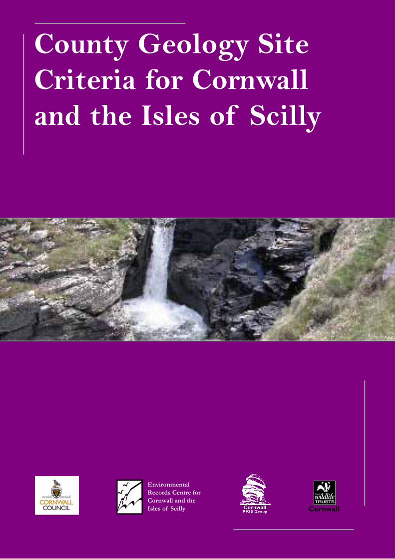
Kynance Cove.

County Geology Site Criteria for Cornwall & The Isles of Scilly Page 2
2. CONTEXT AND BACKGROUND
2.1 The Geological Heritage of Cornwall and the Isles of Scilly The geological history of Cornwall and the Isles of Scillyextends over a period of 500 million years and hasresulted in a great diversity of rocks, mineral deposits,and landscapes. Its geology is dominated by the events(400–200 million years ago (Ma)) associated with theVariscan Orogeny. This mountain building episode onlyaffected the area that was to become south-west Britain,extending into central Europe. It post-dated the earlierCaledonian/Acadian orogenic episodes (c. 400 Ma andearlier), affecting north-west Britain, Scandinavia andeastern North America.
Prior to the onset of the Variscan Orogeny, Devonian deposition in Cornwall was predominantly marine and associated with volcanic activity. It contrasts with the non-marine (‘Old Red Sandstone’) desert, depositional environments further north in the areas of Britain affected by the Caledonian/Acadian mountain building. The Devonian and younger Carboniferous rocks of North Cornwall were deposited in a series of geographically distinct sedimentary basins, each with its own geological history.
The initial compressive phase of the Variscan Orogeny, caused by the northward advance of the super-continent Gondwanaland, folded these deposits dramatically and sometimes completely detached units into separate thrust slices. The unique Lizard Complex with its record of a pre-Variscan ocean floor, is a particularly good example of this.
This Variscan folding and thrusting led to a great pile of sediments on Cornwall, resulting in gravitational collapse, which created its own geological structures and melting at depth, resulting in formation of the granite backbone of the county, now exposed in the line of topographically prominent moors, from Dartmoor through Bodmin Moor on to the Isles of Scilly. The granite intrusion was followed by circulation of metal-rich fluids associated with their crystallisation, and cooling with attendant hydrothermal circulation that led to the formation of Cornwall’s renowned china clay deposits.
Deep tropical weathering during the Tertiary (65-1.8 Ma) led to the formation of an extensive levelled erosion surface which was subsequently incised by falls in sea level associated with the subsequent cold glacial periods. The only area undoubtedly affected by glaciation itself was the northern Isles of Scilly. The other areas were affected by periglacial frozen conditions found at the outer edges of the glaciers, giving rise to extensive ‘head’ and wind-blown dust deposits. The intervening warm interglacial periods gave rise to raised beaches and the drowning of river valleys to form rias such as the Fal and the Tamar. The Isles of Scilly were essentially drowned, giving rise to an archipelago and coastal processes that give the islands their unique marine habitats.
The result of these geological processes is a landscape the qualities of which are conserved and enhanced by designations as an Area of Outstanding Natural Beauty (AONB) and Heritage Coast.
The physical geography of the area has an influence on the study and conservation of its geology and geomorphology. Cornwall is a long, narrow peninsula with over 300km of coastline and a wealth of coastal exposure. On the north coast the battering of the Atlantic has formed rugged cliffs that cut across most of the main rock groups that form the county, giving great opportunities for their study. The low-lying south coast has been flooded by the sea and the lower reaches of the river valleys form rias, which further extend the exposure available for study. Outcrops away from the coast are much less numerous, elevating the importance of inland exposures such as quarries and road/rail cuttings, and temporary exposures (building and major construction sites) in these areas.
Tor, Bodmin Moor. Millook Cliffs.
County Geology Site Criteria for Cornwall & The Isles of Scilly Page 3
2.2 Sites of National ImportanceNature Conservation, encompassing both wild flora and fauna and geological and physiographic features, has traditionally been the responsibility of English Nature (now part of Natural England) and its predecessor the Nature Conservancy Council. Its inception in 1949 began the identification of the most important biological and Earth science sites in Britain. This is carried out through the Site of Special Scientific Interest (SSSI) network of nationally and regionally important sites. There are currently 168 SSSIs in Cornwall and the Isles of Scilly, protected under the provision of the Wildlife and Countryside Act 1981 (as amended), 113 of which are notified wholly or partly for their biological importance and 88 (52%) wholly or partly for their geological and/or geomorphological importance (these figures are from the latest downloads available from the Natural England website, accessed October 2010). When compared to the national figure of 30% of English SSSIs being of Earth science interest, this illustrates the importance of Earth science in Cornwall. The Geological Conservation Review (GCR) in 1977-1990, saw a review of the coverage of Earth science SSSIs and a more systematic approach to site selection. The GCR sites form the basis of statutory Earth heritage conservation in Britain. The results of this major review are being published in 42 volumes.
2.3 Sites of Local ImportanceThe national system of statutory sites (SSSIs) is not meant to be comprehensive. It provides a representative suite of the nation’s most important wildlife and geological sites, not every site of interest is included. Therefore, to safeguard the biodiversity and geodiversity of Cornwall and the Isles of Scilly, a further level of recognition and protection is needed.
In the late 1980s the extent of local Earth heritage conservation was patchy across the UK and there was a need to provide a national focus and identity for regionally and locally important Earth science sites. The Nature Conservancy Council (NCC), a predecessor to Natural England, created the RIGS (Regionally Important Geological/Geomorphological Sites) initiative to meet this need, which stimulated local/regional geoconservation. The RIGS initiative aims to conserve a series of locally important sites; to involve people in Earth heritage conservation; to raise public awareness of Earth heritage and to draw planning authorities’ attention to features of local value, so that their consideration becomes an integral part of the planning process. RIGS, now called County Geology Sites in Cornwall, underpin and expand the SSSI network and should not be seen as ‘second-tier’ SSSIs. They are equivalent to County Wildlife Sites and are of regional or local importance in their own right.
Planning Policy Statement 9: Biodiversity and Geological Conservation (PPS9) (2005) which states current national planning policy for the natural
environment, recognised that Local Sites have a fundamental role to play in helping to meet overall national biodiversity/geodiversity targets, contributing to the quality of life and the well-being of the local community and supporting research and education.
In addition, Planning Policy Guidance Note 17: Planning for Open Space, Sport and Recreation (2002) recognises that open spaces may also have biodiversity or geodiversity interest and states that this should be taken into account and protected.
Local sites - CWSs and CGSs/RIGS, provide a comprehensive system of sites that represent local character and distinctiveness and complement other national, regional and local site networks.
2.4 Background to County Geology Sites/RIGS in Cornwall and the Isles of ScillyLocal geoconservation efforts in Cornwall date back to at least the 1860s, when the Cheesewring and other tors on Bodmin Moor were protected from quarrying. In 1991, the Cornwall RIGS Group, with the Cheesewring as its logo, was founded. The group is affiliated to Cornwall Wildlife Trust and is made up of geologists in industry; geologists with experience of education at all levels, from primary to postgraduate and representatives from other bodies involved in conservation such as Natural England, The National Trust, museums and geological societies.
On its inception, the Cornwall RIGS Group immediately started the process of identifying and designating sites but as the work is carried out entirely by unpaid volunteers, the process is nowhere near complete. A total of 113 (figure correct at 22nd November 2010) sites have been designated so far and are registered with Cornwall Council. These sites are of at least County importance for their Earth science interest, many are of regional or even greater significance. A full list of CGSs /RIGS in Cornwall and the Isles of Scilly is given in Appendix 1.

County Geology Site Criteria for Cornwall & The Isles of Scilly Page 4
3. COUNTY GEOLOGY SITE SELECTION
The legislation in PPS9 firmly establishes geology as part of nature conservation and puts it on an equal footing with biodiversity in the Government's planning objectives. Geodiversity is now in a similar situation to biodiversity following the 1992 Earth Summit in Rio de Janeiro, which raised public awareness of biodiversity and established it as a priority for policy and decision makers.
Although no formal equivalent to national Biodiversity Action Plans (BAPs) currently exists for geological sites, such a system is being developed and promoted and a UK Geodiversity Action Plan (UKGAP) is awaiting publication. The Geodiversity Action Plan for Cornwall and the Isles of Scilly (Wheeler, 2005) sets out Cornwall and Scilly’s objectives to deliver and promote geological conservation based on knowledge of the existing network of nationally important geological SSSIs; local geological sites; CGSs/RIGS and geology in the wider environment. Due to lack of funds it was beyond the scope of the Cornwall GAP to carry out a comprehensive audit such as that carried out by the Cornwall Biodiversity Action Plan (BAP). A synthesis of the conservation status of every individual rock type, mineral, fossil, stratigraphic unit etc, within Cornwall and the Isles of Scilly was therefore not undertaken. However, an initial framework was established which summarises and classifies the principal geological, geomorphological, soil and landscape features and natural resources comprising the geodiversity of Cornwall and the Isles of Scilly. This will allow the site selection process to go ahead until a full audit can be carried out.
The Cornwall and Isles of Scilly GAP is important in the process of site selection as it informs the decision making process, providing a strategic framework for geodiversity in the area against which sites can be assessed. This is important as the non-statutory CGSs/RIGS are protected through the planning system, and Local Authority plans and policies are expected to become increasingly GAP focussed in light of PPS9, and with the delivery of the UK GAP.
When assessing the Earth science interest of a site, either during the selection of CGSs/RIGS or when comparing sites of lower interest, nationally recognised criteria are applied.
3.1 The role of the JNCC (1977) GuidelinesThe JNCC document 'Guidelines for Selection of Earth Science SSSIs' (1977), summarises the rationale behind the selection of Earth science SSSIs, a process known as the Geological Conservation Review (GCR), the aim of which was to select a GB-wide series of sites of
national/international interest for their geology using the minimum number of sites needed to demonstrate the range and diversity of Earth science features in the UK. The sites are assessed against the criteria of:• representativeness• exceptionalfeatures• internationalimportance
The criteria are applied on a working subject ‘block’ basis, each ‘block’ consisting of a group of sites, addressing a particular period of geological time or subject area. Those of relevance to Cornwall and the Isles of Scilly are listed in Appendix 2. Representative sites are selected within each block and they fall within natural groupings, called networks, based on their geological features or scenarios.
The criteria and principles used in GCR and SSSI selection can provide a useful background to the application of more relevant and up-to-date criteria in the assessment of Local Sites.
3.2 Nature Conservancy Council (NCC) (1990) guidelines“For geological sites, guidelines for the selection of nationally important sites, originally published in the Geological Conservation Review (GCR), have already been supplemented by criteria for more local application in the selection of CGSs/RIGS. This has involved emphasis of the educational and research opportunities and aesthetic qualities of sites. CGSs/RIGS are selected on a local or regional basis using four nationally agreed criteria” (para. 52 of the Defra guidance 2006).
The four nationally agreed criteria for the selection of County Geology Sites/RIGS detailed in the NCC publication Earth Science Conservation in Great Britain – A Strategy (1990) are:1. the value of a site for educational fieldwork in
primary and secondary schools, at undergraduate level and in adult education courses;
2. the value of a site for study by both professional and amateur Earth scientists; such sites demonstrate, alone or as part of a network, the geology and geomorphology of the area;
3. the historical value of the site in terms of important advances in Earth science knowledge;
4. the aesthetic value of a site in the landscape, particularly in relation to promoting public awareness and appreciation of the Earth sciences.
These CGS criteria more closely reflect local use and interest. The method of application of the criteria is less clear and there is regional variation across the country.

County Geology Site Criteria for Cornwall & The Isles of Scilly Page 5
The four locally agreed themes upon which more detailed criteria for the selection of County Geology Sites in Cornwall and RIGS in the Isles of Scilly will be based are:1. Scientific importance2. Educational value3. Historical/Cultural significance4. Aesthetic value (value for public awareness and
appreciation)
In Cornwall and the Isles of Scilly these criteria have been strengthened by the RIGS Group to emphasise the intrinsic scientific value of CGSs/RIGS. The national criteria for local geological site selection tie in scientific importance with its value for study or education, but there are many features of regional scientific importance in Cornwall and Scilly that are not SSSI but which are not suitable for inclusion under educational or study criteria. This approach is supported by Defra: “…selection of Local Sites to maintain geological conservation should be based on national, regional and local assessment of features of geological interest and the provision of such sites for educational or research purposes. Therefore, this national guidance simply provides a standard framework against which to structure assessment of local nature conservation priorities, rather than a rigid set of rules” (para. 39, Defra 2006 guidance).
3.3 Framework for Establishing the County Geology Site/RIGS System“Many organisations have an interest in biodiversity and geological conservation…..The establishment and management of a Local Sites system, whilst needing a clear focus of responsibility, should be based on a partnership approach involving such organisations” (para. 14, Defra 2006 guidance). The suggested role of such a partnership is to agree the basis for site selection; co-ordinate the site selection procedures; promote and support site management, enhancement and educational use; co-ordinate funding; monitor sites and review the system. This role is described in more detail in Section 3.5 of this document.
3.4 Guiding Principles for County Geology Site / RIGS SelectionThe guiding principles used in the application of the criteria to select CGSs in Cornwall and RIGS in the Isles of Scilly, are stated below.
A The CGS/RIGS system, together with other site networks, should cover the full range of important geological and geomorphological features at a level necessary to maintain the Earth science resource of Cornwall and the Isles of Scilly. The CGS/RIGS system for Cornwall and Scilly is comprehensive and aims to protect as many sites of substantive interest as possible. The system complements national site networks, which select a suite of sites that are representative samples
of the range of diversity of Earth science features in England, whilst more closely reflecting local use and interest.
B When selecting sites it is important to keep in mind the reason the sites are being selected, i.e. to raise awareness and target resources. It is critical that the criteria are used to select appropriate sites. Omitting sites of high enough quality to be County Geology Sites/RIGS may increase the potential for damage or degradation to those sites. Conversely, selecting sites of inferior quality can waste resources and threaten the integrity of the whole system.
C The application of the criteria for CGS/RIGS selection at a local level will be a matter of expert judgment based on specialist knowledge, using the information available at the time. The framework against which sites are judged is inherently dynamic and will change with advances in the science. As theories are developed and new exposures are revealed, so sites will need to be added to, or removed from the system if it is to maintain its conservation relevance. The criteria therefore need to be applied by experts (1) with an understanding of geological principles and processes and an intimate knowledge of the Earth science interest of Cornwall and the Isles of Scilly.
Granite, St Mary's Isles of Scilly.

County Geology Site Criteria for Cornwall & The Isles of Scilly Page 6
D Geological site assessment will be carried out using the 4 locally defined themes, listed in section 3.2, assessing each site in the context of the appropriate locally defined Earth science subject area and the relevant, locally defined, geological 'block', within each Area of Search (AOS). (The themes, subject areas and blocks are detailed in Chapter 4, Section 1). The national criteria need to be applied against a framework of information which reflects the considerable range of variation in the geology and geomorphology of Cornwall and Scilly. The use of the appropriate locally defined subject areas combined with the geological blocks defined in the geodiversity audit presented in the Cornwall and Isles of Scilly GAP, as a framework for assessment, allows this variation to be taken into account, while there have been many specialist studies which give the required background that allows specific subject areas to be assessed. Decisions will be based on a good local knowledge of the geology of the area, in relation to the extent and quality of the Earth science resource within that particular geological subject 'block', the current situation and perceived trends in the science, and the availability of exposure.
The Area of Search (AOS) is the area over which the criteria are applied. For this purpose Cornwall is divided into areas which reflect local variations in wildlife and natural features. Following the principles specified in paragraph 40 of the DEFRA (2006) guidance the AOS is based on the ‘Natural Areas’ defined by the former English Nature, combined with the former Countryside Commission’s Character Areas. These Joint Character Areas divide Cornwall and Scilly into
The Culm; Bodmin Moor; Cornish Killas; Hensbarrow; Carnmenellis; The Lizard; West Penwith and the Isles of Scilly. Due to the large size of the ‘Cornish Killas’, and the different character of the north and south coasts, this area is further sub-divided into ‘North’ and ‘South’.
E There are 4 qualifying criteria, but a feature will be considered eligible for selection if it satisfies only one of them. The term ‘eligible for selection’ is used because it is always necessary for each case to be judged by an expert. This is particularly important where a site may be borderline, in which case, other aspects of the site including the quality of the exposure have to be considered.
F The guiding principle of SSSI selection, that for sites which do not clearly qualify on a single feature of interest, the combined value must be taken into account, will be followed. This principle refers to combinations of features within a single site and will be most applicable to educational sites.
G In certain cases it is permissible to designate CGSs/RIGS within Sites of Special Scientific Interest (SSSIs), providing the features of interest designated in each case are not the same. SSSIs may include features of 'substantive' conservation interest, important in the local context, quite apart from the internationally/nationally significant features for which they have been designated, for example, a SSSI designated for its Variscan structures may also contain locally significant mineralization. Liaison with Natural England is important to ensure a co-ordinated approach to the conservation and management of such sites. Natural England should be encouraged to incorporate management for the locally significant feature within the management advice they give the landowner for the whole SSSI. This will only be possible if there is no conflict with management for the feature(s) for which the statutory site has been designated.
H Active quarries are eligible for selection as a CGS/RIGS. Although active quarrying and Earth science conservation may not appear to be compatible, such activity has revealed more rock exposures, minerals and fossils than would have been known from natural exposures alone. Features such as these and road cuttings can be designated as local sites but co-operation between the extraction/construction industries and conservation interests will be needed, with systems for liaison and long term management and maintenance of features, to strike a mutually beneficial balance.
I Active processes are eligible for selection as CGSs/RIGS. An active geomorphological process, such as landslipping, can be selected as a CGS/RIGS to recognise and afford protection to the process. However, the aim must be to maintain the active process by non-interference.Mylor Slates folded in a zig-zag near Godrevy.
(1) An expert is defined as “someone having the knowledge and skills necessary to perform the task required through training, qualification, experience or a combination of these”
County Geology Site Criteria for Cornwall & The Isles of Scilly Page 7
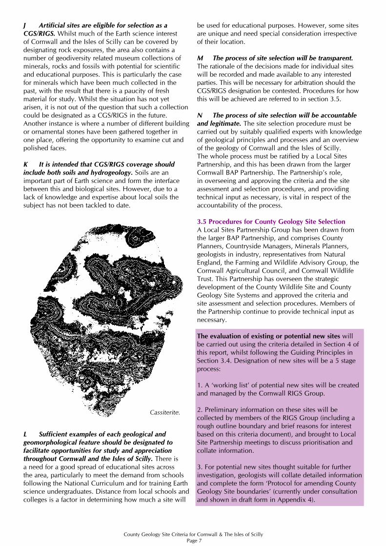
J Artificial sites are eligible for selection as a CGS/RIGS. Whilst much of the Earth science interest of Cornwall and the Isles of Scilly can be covered by designating rock exposures, the area also contains a number of geodiversity related museum collections of minerals, rocks and fossils with potential for scientific and educational purposes. This is particularly the case for minerals which have been much collected in the past, with the result that there is a paucity of fresh material for study. Whilst the situation has not yet arisen, it is not out of the question that such a collection could be designated as a CGS/RIGS in the future. Another instance is where a number of different building or ornamental stones have been gathered together in one place, offering the opportunity to examine cut and polished faces.
K It is intended that CGS/RIGS coverage should include both soils and hydrogeology. Soils are an important part of Earth science and form the interface between this and biological sites. However, due to a lack of knowledge and expertise about local soils the subject has not been tackled to date.
L Sufficient examples of each geological and geomorphological feature should be designated to facilitate opportunities for study and appreciation throughout Cornwall and the Isles of Scilly. There is a need for a good spread of educational sites across the area, particularly to meet the demand from schools following the National Curriculum and for training Earth science undergraduates. Distance from local schools and colleges is a factor in determining how much a site will
be used for educational purposes. However, some sites are unique and need special consideration irrespective of their location.
M The process of site selection will be transparent. The rationale of the decisions made for individual sites will be recorded and made available to any interested parties. This will be necessary for arbitration should the CGS/RIGS designation be contested. Procedures for how this will be achieved are referred to in section 3.5.
N The process of site selection will be accountableand legitimate. The site selection procedure must be carried out by suitably qualified experts with knowledge of geological principles and processes and an overview of the geology of Cornwall and the Isles of Scilly. The whole process must be ratified by a Local Sites Partnership, and this has been drawn from the larger Cornwall BAP Partnership. The Partnership’s role, in overseeing and approving the criteria and the site assessment and selection procedures, and providing technical input as necessary, is vital in respect of the accountability of the process. 3.5 Procedures for County Geology Site SelectionA Local Sites Partnership Group has been drawn fromthe larger BAP Partnership, and comprises CountyPlanners, Countryside Managers, Minerals Planners,geologists in industry, representatives from NaturalEngland, the Farming and Wildlife Advisory Group, theCornwall Agricultural Council, and Cornwall WildlifeTrust. This Partnership has overseen the strategicdevelopment of the County Wildlife Site and CountyGeology Site Systems and approved the criteria andsite assessment and selection procedures. Members ofthe Partnership continue to provide technical input asnecessary.
The evaluation of existing or potential new sites willbe carried out using the criteria detailed in Section 4 of this report, whilst following the Guiding Principles in Section 3.4. Designation of new sites will be a 5 stage process:
1. A ‘working list’ of potential new sites will be createdand managed by the Cornwall RIGS Group.
2. Preliminary information on these sites will be collected by members of the RIGS Group (including a rough outline boundary and brief reasons for interest based on this criteria document), and brought to Local Site Partnership meetings to discuss prioritisation and collate information.
3. For potential new sites thought suitable for furtherinvestigation, geologists will collate detailed information and complete the form ‘Protocol for amending County Geology Site boundaries’ (currently under consultation and shown in draft form in Appendix 4).
Cassiterite.
County Geology Site Criteria for Cornwall & The Isles of Scilly Page 8
4. The Local Sites Partnership will meet to evaluate sitesby referring to the completed protocol form and these criteria. Sites will be approved, rejected or put on hold pending more information.
5. If the site is approved, site documentation will be completed with a Site Summary Sheet and a Site Boundary Map being produced for each site.
The process for changes to site boundaries and/or deletion of sites will follow the steps below (data is likely to have been collected by geologists undertaking surveys in the field, so there is no need for steps 1 & 2 above):
1. Geologists will collate detailed information on the site and reasons for suggested boundary changes andcomplete the form ‘Protocol for amending County Geology Site boundaries’ (currently in draft form; Appendix 4).
2. The Local Sites Partnership will meet to evaluate theproposed amendment/deletion by referring to thecompleted protocol form and these criteria. Sites willbe approved, rejected or put on hold pending moreinformation.
3. If the amendment/deletion is approved, site documentation will be completed with a Site Summary Sheet and a Site Boundary Map being produced for each site.
The summary sheet will be distributed to the site ownerand other selected parties and will ultimately be made available on a password-protected web-based system. An example of the summary sheet is given in Appendix 3. The web-based CGS dataset will be re-issued annually. There will also be a rolling programme of site review and update, as funding allows.
3.6 Site BoundariesThere are many issues associated with delineating sites and drawing boundaries. Paragraphs A-D below outline the procedures associated with these.
A Site boundaries are drawn as close to the geological site interest as possible, whilst also being clearly identifiable on the ground. In practice, this usually means that the boundary of any site is coincident with parts of the local field boundary system or edges of clearly identifiable landscape features such as quarries. It is also important to document the site interest using photographs, so it can be easily identified. Occasionally, if it is important to accurately locate a site's interest, it may need professional surveying.
There are relatively few sites where the boundary which marks the land of interest from the wider landscape is clear-cut. While quarries are often features that can be clearly identified, the majority of exposures tend to be sporadic and interspersed with areas of semi-natural vegetation and farmland. In these cases the boundaries that are drawn to enclose and define a site of Earth science interest necessarily involve some element of subjectivity. It is usually the case that the areas of Earth science interest are first identified and then a boundary is defined that both includes all the area of interest and follows some clearly identifiable landscape feature.
B Extensive features that are fragmented may still be viewed as one site. For example a dyke with intermittent exposure. In circumstances such as these it is deemed sensible to treat the whole area as one site, even though some of the components are isolated and small. There is no easy answer to how fragmented any area must be before the fragments are treated as separate sites, rather each case must be assessed and described on an individual basis.
C As a general rule site boundaries do not include deliberately delineated buffer zones. Buffer land is defined as land that of itself is of no evident significant Earth science interest, but changes to it may have a knock-on effect to adjacent sites of Earth science importance. For example, an active processes geomorphological site.
D The problem of whether areas within a site that lack special interest should be excluded from the site, thereby leaving ‘holes’ within the site map, has to be decided for each case on its merits. There are two basic types of site where this problem arises: it may be the case that there is intermittent or fragmented exposure of a feature or a site may have several features of interest that have been incorporated into one site but exposure is not continuous. The size of the included area is of secondary importance but should ideally be a relatively small proportion of the total area of the site.

County Geology Site Criteria for Cornwall & The Isles of Scilly Page 9
4. CRITERIA FOR COUNTY GEOLOGY SITE/RIGS SELECTION IN CORNWALL AND THE ISLES OF SCILLYThis section provides details of the locally defined criteria for CGS/RIGS selection in Cornwall and the Isles of Scilly. Sites are selected according to the guiding principles in section 3.4.
1. Scientific importance
Criteria S1 to S10 deal with the intrinsic scientific interest of a site. Generally, if the site demonstrates a good example of a feature or features representative of one of the 22 subject blocks for Cornwall and the Isles of Scilly, as defined in the Cornwall and Isles of Scilly GAP (2005), it will be considered eligible for selection. The criteria consider the subject blocks grouped within 8 main subject areas corresponding to the established sub-disciplines of Earth science (S1-S8). S9 considers economic geology and S10 wider links between Earth science and ecology:
Criteria for assessing the scientific importance of sites.Sites will be considered eligible for selection if they satisfy any of the following criteria.S1 Mineralogy The site: • is important for a particular mineral or mineral assemblage; • demonstrates a particular style of mineralization.
S2 Igneous Rocks The site exposes igneous rocks representative of one of the subject blocks identified for Cornwall and the Isles of Scilly:• pre-Devonian Basement; • pre-Variscan volcanics;• Lizard Complex; • granites; • associated rocks i.e. elvans, pneumatolytic breccias, lamprophyres etc.
S3 Sedimentary Rocks The site exposes sedimentary rocks representative of one of the subject blocks identified for Cornwall and the Isles of Scilly: • Cornwall Sedimentary Basins: Looe Basin, Gramscatho Basin, Trevone-South Devon Basin, Tavy Basin, Culm Basin; • Tertiary or Quaternary Sediments.
S4 Metamorphic Rocks The site exposes metamporphic rocks representative of the Regional Metamorphism subject block identified for Cornwall and the Isles of Scilly.
S5 Palaeontology The site:• is important for a particular fossil species or assemblage;• is important palaeo-ecologically in the context of one of Cornwall and the Isles of Scilly’s Sedimentary Basins;• is important for Tertiary or Quaternary sediments.
S6 Stratigraphy The site shows stratigraphic features representative of, or the site is important for stratigraphic correlation of:• Cornwall and the Isles of Scilly’s Sedimentary Basins; • Tertiary or Quaternary sediments.
S7 Structures The site demonstrates any important structural features in relation to:• Cornwall and the Isles of Scilly’s Sedimentary Basins: Pre-Devonian Basement, Looe Basin, Gramscatho Basin, Trevone-South Devon Basin, Tavy Basin, Culm Basin; • Variscan Structures;• regional Metamorphism;• Lizard Complex;• granites;• associated rocks;• offshore Geology;• Tertiary;• Quaternary Sediments;• soils.
S8 Geomorphology The site:• is an important landscape feature;• demonstrates characteristic geomorphological features or processes.
S9 Economic The site contains:• important minerals (metallic or china clay);• aggregates and building stone;• other resources that are of use for education and/or research.
S10 Other geological interests The site has the potential for demonstrating links/relationships between wildlife and Earth science.
Quartz Vein.
Engine House.
County Geology Site Criteria for Cornwall & The Isles of Scilly Page 10
2. Educational value
The criteria for selecting Local Geological Sites place a major emphasis on education. This is not just education in the context of school-based learning but includes the development of knowledge and understanding by individuals, of the world around them. This is often called life-long learning and is as important for adult personal fulfilment as for the formal education of children. Public awareness of Earth science is increasing but is still a long way behind that of the biological sciences. A major part of the role of the Local Geological Sites network is therefore to increase public awareness and to encourage appreciation in order to ensure a long term sustainable future.
Earth Science is an investigative discipline, the basis of which is in fieldwork. There is a fundamental need for hands-on experience, and access to a wide range of appropriate sites is essential for students to understand the complexity of the natural environment. First hand experience is widely acknowledged as the most effective method of learning and many concepts can only be appreciated by studying field relationships.
Educational sites are a finite resource and sites showing local phenomena and local historic, economic or cultural resources are difficult to replace. An even coverage of suitable sites across the county will cut down on travel time and expense.
Local Geological Sites have the potential for Earth science education at all levels but this potential is limited by a lack of understanding of the attributes that make a site useful for teaching and learning. Detailed background information on the National Curriculum useful in assessing educational sites can be found on the internet at http://curriculum.qcda.gov.uk. In general the scientific features suitable for education include:
1. Sites suitable for different ages and abilities, where investigation and active learning are possible.2. Sites where worthwhile materials, resources, features and relationships are apparent.3. Sites where integrated studies are possible, both within and outside the sciences and which can be related to others to be visited in a coherent plan e.g. linking geology, geomorphology, biology, hydrology, agriculture, archaeology, economics, human geography and social history.4. Sites which permit the understanding of concepts and processes only properly appreciated in the field.
Primary criteria for assessing educational sites:E1 If the site is safe and physically accessible it will be considered eligible for selection.
E2 If access to the site is permitted for educational visits it will be considered eligible for selection.
E3 If the site is robust and capable of absorbing limited damage it will be considered eligible for selection.
Secondary criteria for assessing educational sites:E4 If the site is suitable for teaching the Earth science components of the National Curriculum it will be considered eligible for selection.
E5 If the site is suitable for teaching the Earth sciences at ‘A’ level it will be considered eligible for selection.
E6 If the site is suitable for teaching the Earth sciences at undergraduate level it will be considered eligible for selection.
E7 If the site is suitable for other educational users to learn about Earth science e.g. adult education classes, it will be considered eligible for selection.
Ideally educational sites will have the following additional features but this will obviously be largely dependent on the status of the site (privately owned or owned by the Wildlife Trust or another public body) and the level of funding available.
1. Have appropriate documentation such as explanatory booklets or worksheets to help inexperienced group leaders and students.2. Some form of management team that can regularly maintain the site and assess its safety on a regular basis.3. A programme of site improvement and management4. Some form of publicity or listing for educational users.5. A generic site risk assessment.6. A code of conduct for educational users.
Cligga Head.

County Geology Site Criteria for Cornwall & The Isles of Scilly Page 11
3. Historical significance
Historical value is an important aspect of Earth science site assessment. Britain played an important role in the history and development of geology and consequently many sites are of importance as the place where scientific concepts were first demonstrated. Recorded history is also important in making links between the natural environment and our cultural heritage and local distinctiveness, for example, the link between local geology, quarries and building stone.
Criteria for assessing sites of historical value.H1 If the site is historically important in terms of advances in geological/geomorphological knowledge, it will be considered eligible for selection.
H2 If the Earth science interest of the site has important historical links with the local environment, vernacular building stones etc, it will be considered eligible for selection.
H3 If the site has any important associations with culture, folklore or religion that can be directly linked to the Earth science interest, it will be considered eligible for selection.
H4 If the site has any archaeological significance that can be directly linked to the Earth science interest, it will be considered eligible for selection.
4. Aesthetic value (value for public awareness and appreciation)
Local sites give the opportunity to raise awareness of the wider significance of rocks, soils and physical processes in our daily lives and as a key part of our natural heritage, landscape and scenery. The aesthetic value of a site therefore plays an important part in stimulating interest and awareness in the Earth sciences and leading the way to unlocking the educational potential for people of all ages to learn about the natural world.
Criteria for assessing sites of aesthetic value (value for public awareness and appreciation).
A1 If the Earth science interest of the site is an essential component of an attractive or evocative local landscape it will be considered eligible for selection.
A2 If the site could be used to promote public awareness and appreciation of geology/ geomorphology, it will be considered eligible for selection.
St Erth Pits.
Castellated Cliffs.
County Geology Site Criteria for Cornwall & The Isles of Scilly Page 12
BIBLIOGRAPHY
Bristow, C.M. 1996. Cornwall’s Geology and Scenery: An introduction. Cornish Hillside Publications, St Austell.
Burek, C. and Potter, J. 2004a. Cheshire Region Local Geodiversity Action Plan. English Nature & University College Chester.
Burek, C. and Potter, J. 2004b. Local Geodiversity Action Plans: setting the context for geological conservation. English Nature Research Report, No 560.
Burek, C. and Potter, J. 2004c. Local Geodiversity Action Plans: sharing good practice workshop. English Nature Research Report, No 601.
Department for the Environment, Food and Rural Affairs. 2006. Local Sites. Guidance on their Identification, Selection and Management.Defra.
Ellis,N.V.,Bowen,D.Q.andCampbell,S.1996. An introduction to the Geological Conservation Review Geological Conservation Review Series No. 1. Peterborough: JNCC.
Joint Nature Conservation Committee. 1977. Guidelines for Selection of Earth Science SSSIs. JNCC.
Nature Conservancy Council. 1990. Earth Science Conservation in Great Britain – A Strategy.
ODPM. 2004. Consultation on PPS9: Biodiversity and Geological Conservation. ODPM.
Royal Society for Nature Conservation. 1999. RIGS Handbook. Newark: The Royal Society for Nature Conservation.Updated versions published on www.ukrigs.org.uk
Selwood, E.B., Durrance, E.M., and Bristow C.M. 1998. The Geology of Cornwall. University of Exeter Press.
Soil Survey of England and Wales. 1983. Soils of England and Wales: Sheet 5, South-west England.
Wheeler, P. D. 2005. Geodiversity Action Plan, Cornwall and the Isles of Scilly. 1st Edition. Cornwall Wildlife Trust, Truro, UK.

Appendix 1
List of County Geology Sites/RIGS in Cornwall & the Isles of Scilly
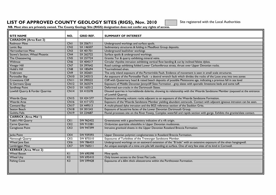
LIST OF APPROVED COUNTY GEOLOGY SITES (RIGS), Nov. 2010 Site registered with the Local Authorities
NB. Most sites are privately owned. The County Geology Site (RIGS) designation does not confer any rights of access.
SITE NAME NO. GRID REF. SUMMARY OF INTEREST CARADON (Area East 2) Redmoor Mine CN1 SX 356711 Underground workings and surface spoils. Lantic Bay CN2 SX 146507 Sedimentary structures & folding in Meadfoot Group deposits. Harrowbarrow Mine CN3 SX 401701 Underground lead/silver workings Stowe's Section, Wheal Phoenix CN4 SX 262722 Surface spoils & underground workings. The Cheesewring CN5 SX 257724 Granite Tor & quarry exhibiting mineral veins. Withnoe CN6 SX 404517 Circular rhyolite intrusion exhibiting vertical flow banding & cut by inclined felsite dykes. Vinegar Hill CN7 SX 397642 Road cuttings exhibiting folded Lower Carboniferous strata, thrust over Upper Devonian rocks. Hobb's Hill CN8 SX 185694 Tourmalinised elvan. Trebrown CN9 SX 302601 The only inland exposure of the Portwrinkle Fault. Evidence of movement is seen in small scale structures. Portnadler Bay CN10 SX 243515 An exposure of the Portnadler Fault - a dextral wrench fault which divides the rocks of the Looe area into two zones Crowstone Cliff CN11 SX 390522 Cliff with Quaternary head & raised beach deposits of possible Pleistocene age, indicating a previous fall in sea level St Germans Quay CN12 SX 363574 Exposure of Middle Devonian Jennycliff Slate Formation - grey slates with sporadic limestone beds and some tuff. Sandheap Point CN13 SX 163512 Deformed sun-cracks in the Dartmouth Slates. Lowhill Quarry & Forder Quarries CN14 SX 415578 Disused quarries in horneblende dolerite, showing its relationship with the Wearde Sandstone Member (exposed at the entrance
of Lowhill Quarry). Wearde Quay CN15 SX 424 577 Exposure showing volcanic rocks adjacent to an exposure of the Wearde Sandstone Formation. Wearde Area CN16 SX 417 572 Exposure of the Wearde Sandstone Member yielding abundant ostracods. Contact with adjacent igneous intrusion can be seen. Cawsand Bay CN17 SX 449513 A multi-phased dyke intrusion and the BGS reference section of the Staddon Grits. Seaton Beach CN18 SX 301543 Exposure of lacustrine facies of the Lower Devonian Dartmouth Group. Golitha Falls CN19 SX 224687 Fluvial processes site on the River Fowey. Complex waterfall and rapids section with gorge. Exhibits the granite/slate contact. CARRICK (Area Mid 1) Tubb's Mill Quarry CK1 SW 962432 Greenstones with a geochemistry indicative of a rift origin. Carne Quarries CK2 SW 913381 Ordovician quartzite olistoliths in Upper Devonian mudstones. Caragloose Point CK3 SW 947399 Intrusive granitoid sheets in the Upper Devonian Roseland Breccia Formation
Jacka Point CK4 SW 939393 Upper Devonian polymict conglomerates in Roseland Breccia Formation. Nansough Quarry CK5 SW 875510 Exposures of Turbidites of the Treworgan Sandstone Member. Wheal Jane East CK6 SW 786433 Underground workings on an eastward extension of the “B lode” with an extensive exposure of the elvan hangingwall. Lambriggan Mine CK7 SW 760511 An unique example of a mine ore pile left standing at surface. One of very few sites of its kind in Cornwall. KERRIER (Area West 2) Wheal Basset K1 SW 690398 Mine spoils. Wheal Uny K2 SW 695410 Only known access to the Great Flat Lode. Fishing Cove K3 SW 599428 Exposures of a 60m thick olistostrome within the Porthtowan Formation.

SITE NAME NO. GRID REF. SUMMARY OF INTEREST KERRIER (continued) Carn Brea K4 SW 684407 Exposures of megacrystic biotite-muscovite granite. Porthcadjack Cove K5 SW 641447 Exposures of contractional fault systems & The Great Cross-Course. Great Wheal Fortune K6 SW 626288 Mineralisation in the Mylor metasediments. The Hutches K7 SW 791286 Uplifted wave-cut platform & raised beach deposits. Parson's Beach K8 SW 788272 Several outcrops of a lamprophyre dyke. Crousa Common K9 SW 771198 A former rab pit within the Tertiary Crousa Gravels. Wheal Gorland K10 SW 731428 Sim's Shaft & Davey's Footway, accessing lodes. Wheal Johnny K11 SW 627412 Mine dumps. Good educational site. Praa Sands K12 SW573281 A composite raised beach and Head sequence overlain by Holocene peat and coastal dunes. Kerriack Cove K13 SW678470 Mineralisation in Devonian sandstones. Beacon Hill K14 SW782337 Cutting with varied granites, structural foliation, jointing, shear zones, variable weathering and kaolinisation. Unsuitable for visits. Countybridge Quarry K15 SW 722220 Serpentinite quarry. West Lizard Cliffs K17 SW 670160 10Km cliff section through serpentinite and hornblende schist, showing cliff topography, landslips, caves,stacks &islands. Wheal Rose K18 SW 634249 Lead ‘stringer’ vein running across beach and underground workings. Tye Rocks K19 SW 634249 Lead mineralisation exposed in cliff and on beach below. Lowland Point to Trevalsoe K20 SW 797195 Coastal gabbroic tors, head, dated loess, gabbro blocks & clitter, illustrating Late Devensian periglacial processes. Portreath K21 SW 655453 Cliffs, beach and harbour wall exhibiting a variety of rock types and geological processes. Submerged forest & past mining Enys Head K22 SW 728149 Veinstones within the serpentinite and altered basic dykes.. Downas Cove to Pedn Boar K23 SW 766165 Unique primary features preserved in peridotite of upper mantle derivation. Also examples of early copper mining. Trewavas Mine K24 SW 598265 Spoils with sulphide mineralisation. Maindale K25 SW 784199 Best remaining site to observe numerous gabbroic blocks (crusairs), of problemmatic origin, littering the landscape.. Halzephron Cliffs K26 SW 656216 Coastal erosion giving rise to cracking and displacement in the abandoned highway and on the cliff face. Goongillings K27 SW 733280 Former iron workings, trial pits and open cast works, following lodes up ‘head’ covered valley slope. Nelly’s Cove K28 SW 798235 Dip section of head overlying raised beach and shore platform, figured by De La Beche (1839) and Flett & Hill (1912). Kennack Sands K29 SW 735165 Extensive subcrop of Holocene clays beneath the beach. Durgan K30 SW 773273 Excellent example of salt weathering known to have developed since 1876. Poldark Mine K31 SW 682315 Old mine workings representing the roots of a lode system and the base of the tin zone. NORTH CORNWALL (Area East 1) Stepper Point NC1 SW 908780 Dolerite sill intruded into Upper Devonian slates, showing later deformation. Underwood NC2 SX 302872 Exposure of the Stourscombe Beds. Port Quin NC3 SW 970806 Devonian slates some fossils and vein mineralisation. Penfoot Quarry NC4 SX 301832 Exposure of the Yeolmbridge Beds. Oldwit Lane NC5 SX 318819 Road cutting exhibiting Upper Devonian fauna. Landlake Quarries NC6 SX 328823 Old limestone quarries. Kit Hill NC7 SX 376713 Mine spoils. South-West Constantine Bay NC8 SX 855745 Mid-Devonian shales with ammonoids.

SITE NAME NO. GRID REF. SUMMARY OF INTEREST NORTH CORNWALL continued Merope Islands NC9 SW 894769 –
SW 897774 Fossiliferous Upper Devonian slates with mineralization and structures. The site also exhibits a suite of coastal geomorphological features.
Port Arthur NC10 SW 922747 Faulted, fossiliferous Devonian slate/tuff succession. Gilson's Cove Mine NC11 SW 967804 Mine spoils. Cant Hill NC12 SW 951742 Middle Devonian slates with shallow marine fauna. Upton Coast NC13 SS 190040 Upper Carboniferous Bude Formation sediments and structures, Quaternary at Widemouth Tremore Quarry West NC14 SX 010649 Quarry in Tremore elvan. Lemail NC15 SX 022731 Lamprophyre dyke. Tregardock NC16 SX 041840 Late variscan structures, mineralisation and major slips. Lanterdan NC18 SX 051870 Disused quarry in Upper Devonian, Upper Delabole Slate. Quarrying methods of interest. Flat Marsh Cutting NC19 SX 163741 Artificial exposure of porphyritic granite with variable kaolinisation, overlain by a thin regolith. Shallow Water Hill Cutting NC20 SX 163741 Granite cutting showing abundant kaolinisation features & variable weathering. Exposure a mix of sub-vertical faces & regolith. South Petherwin NC21 SX 313823 Exposure of basal Lower Carboniferous, West Petherwin Conglomerate. Tremore Quarry East NC22 SX 011648 Former elvan quarry, primarily of interest for exposures of calc-flinta. Duckpool Valley NC23 SS 215118 Suite of fluvial geomorphological features, including meanders & ox-bow lakes, in the lower reaches of the Coombe Valley Trebarwith Stream NC24 SX 048 864 Site exhibiting erosion by a rejuvenated, downcutting river. The processes of corrasion (giving rise to potholes), corrosion,
attrition and hydraulic action can be observed. Valency Valley NC25 SX 110909 Active fluvial system with a suite of features and contemporary flood dynamics. Rocky Valley NC26 SX 073895 Deeply incised hanging river valley with associated fluvial features. Harlyn Beachrock NC27 SW 877754 –
SW872758 Stratified beachrock exposed in the upper intertidal zone on Harlyn beach. Active and relict tufa cascades in Onjohn Cove.
Bound’s Cliff to Barrett’s Zawn NC28 SX 019812 – SX 029823
Rare forms of mineralization and coastal geomorphology illustrating erosion processes.
PENWITH (Area West 1) Gryll's Bunny P1 SW 364335 Opencast & underground tin workings. Venton Cove P2 SW 527301 Pneumatolytic breccia intrusion. Wheal Cock P3 SW 364340 Mine spoil. Wheal Hazard P4 SW 363334 Mine workings exhibiting granite contact. Black Cliff P5 SW 553387 Sandstone dominated turbidites in the Porthtowan Formation. Great and Little Hogus P6 SW 512306 Volcaniclastic debris flows within the Mylor Slate Formation. Bog Inn P7 SW 393319 Large depression sculpted by glacial/periglacial action. Wheal Drea P8 SW 365322 Large mine spoil. Wheal Carpenter P9 SW 584353 Mine spoils. Wicca Pool P10 SW463398 Granite veining in slate, first described by Henry de la Beche in 1839 Geevor Mine Ore Stockpile P11 SW 373346 Recently constructed “finger-dump” of original Geevor ore. New Mexico Shaft, Geevor P12 SW 368344 18th Century mine workings exhibiting fissure veins, hand-worked stopes and an exposure of the granite/killas contact.

SITE NAME NO. GRID REF. SUMMARY OF INTEREST PENWITH continued Wheal Edward P13 SW361327 Killas and hornfels mining waste. Croft Gothal P14 SW 569309 Mine dumps. Pendeen Cliff to Kenidjack P15 SW 379356-SW
354323 A stretch of coastal cliffs characterised by frequent deep, narrow clefts, locally called zawns. These are eroded along fault planes and hydrothermal veins principally in hornfelsed Mylor Slates.
RESTORMEL (Area Mid 2) Duporth R1 SX 036512 An altered picrite intrusion . Black Head-Ropehaven R2 SX 039484 Fossiliferous slates and a quartz-diabase intrusion. Wheal Remfry R3 SW 924575 Sheeted vein system with tourmaline hydrothermal breccia, felsitic elvan & contact with the aureole rocks. Goonbarrow R4 SX 007583 Active china clay pit exhibiting intrusive relationships & hydrothermal features. Helman Tor R5 SX 062615 Megacrystic granite tor. Whipsiderry R6 SW 832635 Conformable transition between Dartmouth & Meadfoot Groups. The Gannel Quarry R7 SW 795612 A mica trap intrusion. Carlyon Bay East R8 SX 067522 Lower Devonian slates containing volcanoclastic material. Also a dolerite sill, a recumbent fold & a raised beach. Fistral Bay R9 SW 799625 Cemented raised beach exhibiting karstic pipes. Gamas Point R10 SX 023472 Sediments providing important stratigraphic information. Watergate Bay R11 SW 841651 Lower Devonian mudstones. Luxulyan Valley R12 SX 056571 Granite core-stones formed by deep Tertiary weathering. Fowey Estuary R13 SX 130540 An example of a drowned river valley, showing the characteristic features of a ria. Newgate Cutting R14 SX 032626 Exposure of granite contacts and quartz-mica rock, hornfels, spotted slates & haematisation in a road cutting. Tresayes R15 SW 996588 Old workings in the metamorphic aureole of the St Austell granite. Originally worked for glass manufacture and later for glaze for
pottery and parian ware. Carlyon Bay West R16 SX 055520 Fossiliferous L. Devonian slates with volcanoclastic material, cut by mineral veins. A raised beach caps Crinnis Island. Carclaze Old Tin Pit R17 SX 024549 Kaolinised and mineralised granite in a china clay pit that played a part in the early development of geological science South Fistral R18 SW SW795616 –
SW798618 Wave cut platform in Meadfoot Group Slates overlain by Godrevy Formation raised beach unit with erratics and sandrock unit containing palaeokarst piping and trace fossils.
Spit Point R19 SX 073524 Quaternary section with paleao-cliff, raised shore platforms, raised beaches, head and loess, with well developed periglacial structures and incipient beach dunes.
ISLES OF SCILLY The Gugh SC1 SV 887084 A spectacular tombolino, a coastal depositional feature, linking the islands of Gugh and St Agnes.
NB: The County Geology Site (RIGS) designation does not confer any rights of access.
Tel: 01872 240777 ext.246 Fax: 01872 225476 E-mail: [email protected] RIGS home page: http://www.cornwallgeology.org.uk or www.cornwallrigs.org.uk Company Registration Number – 732511. VAT Registration number – 557 3030 53
Registered Charity Name - Cornwall Trust for Nature Conservation Ltd. Registered Charity No. – 214929

APPENDIX 2
The Geological Conservation Review (GCR) background to Site Selection.
The GCR aims to protect:
Sites of importance to the international community of Earth scientists Sites that are scientifically important because they contain exceptional features Sites that are nationally important because they are representative of an Earth science feature, event or process which is fundamental to Britain’s Earth history
The GCR recognises five fields covering the discipline of Earth sciences:
Pre-Cambrian, metamorphic and structural geology Igneous petrology and mineralogy Stratigraphy Palaeontology Quaternary geology and geomorphology
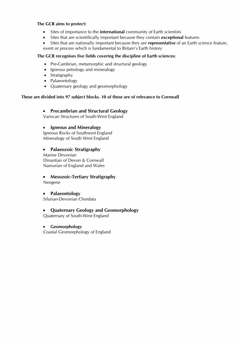
These are divided into 97 subject blocks. 10 of these are of relevance to Cornwall
Precambrian and Structural Geology Variscan Structures of South-West England
Igneous and Mineralogy Igneous Rocks of Southwest England Mineralogy of South West England Palaeozoic Stratigraphy Marine Devonian Dinantian of Devon & Cornwall Namurian of England and Wales
Mesozoic-Tertiary Stratigraphy Neogene Palaeontology Silurian-Devonian Chordata Quaternary Geology and Geomorphology Quaternary of South-West England
Geomorphology Coastal Geomorphology of England

APPENDIX 3
Example of a County Geology Site/RIGS summary sheet
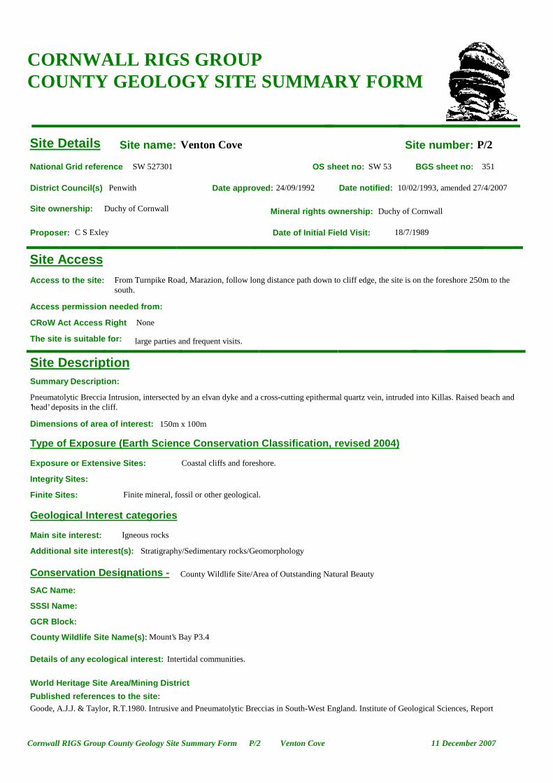
Site name: Venton Cove Site number: P/2
Date approved: 24/09/1992 Date notified: 10/02/1993, amended 27/4/2007
Date of Initial Field Visit: 18/7/1989Proposer: C S Exley
National Grid reference SW 527301 OS sheet no: SW 53 BGS sheet no: 351
District Council(s) Penwith
Site ownership: Duchy of Cornwall Mineral rights ownership: Duchy of Cornwall
Details of any ecological interest: Intertidal communities.
Summary Description:
Pneumatolytic Breccia Intrusion, intersected by an elvan dyke and a cross-cutting epithermal quartz vein, intruded into Killas. Raised beach and ’head’ deposits in the cliff.
Published references to the site:Goode, A.J.J. & Taylor, R.T.1980. Intrusive and Pneumatolytic Breccias in South-West England. Institute of Geological Sciences, Report
Site Details
Site Description
Type of Exposure (Earth Science Conservation Classification, revised 2004)
Exposure or Extensive Sites:
Finite Sites:
Geological Interest categories
Conservation Designations -
Access to the site: From Turnpike Road, Marazion, follow long distance path down to cliff edge, the site is on the foreshore 250m to the south.
Integrity Sites:
Access permission needed from:
Site Access
CORNWALL RIGS GROUP COUNTY GEOLOGY SITE SUMMARY FORM
SSSI Name:
GCR Block:
large parties and frequent visits.The site is suitable for:
Coastal cliffs and foreshore.
Finite mineral, fossil or other geological.
County Wildlife Site/Area of Outstanding Natural Beauty
Dimensions of area of interest: 150m x 100m
Main site interest: Igneous rocks
Additional site interest(s): Stratigraphy/Sedimentary rocks/Geomorphology
County Wildlife Site Name(s): Mount’s Bay P3.4
SAC Name:
NoneCRoW Act Access Right
World Heritage Site Area/Mining District
11 December 2007P/2 Venton CoveCornwall RIGS Group County Geology Site Summary Form

Details of any Economic Associations
Key issues/potentially damaging activities:
None identified
Management required:
None
Details of management carried out:
80/2. Bromley, A.V.1989. Field Guide to the Cornubian Orefield. Sixth International Symposium on Wayer-Rock Interaction, International Association of Geochemistry and Cosmochemistry, Malvern. Camborne School of Mines.
Site Significance
Site Management and Monitoring Summary
Full description of the site and its significance:
The focus of interest is a breccia dyke, about 3m wide, intruded into killas. It lies on the east (footwall) side of an elvan dyke which strikes NE/SW and widens from 3-4m, at its seaward end to 15-20m near the low cliff. The elvan intersects the breccia and has a 0.5m selvedge containing breccia fragments along its footwall. Fragments in the breccia are of Mylor Slate Formation metasediment, greenstone and a small amount of granite, set in a tourmaline matrix. There are many breccias of this type in Cornwall, some intrude granite eg. Wheal Remfrey, St Austell and most are associated with elvans and mineral veins. This suggests they are just post-granite in age, their constituent fragments include several rock types, the proportion of granite depending on the proximity to a granite intrusion, and vary both in size and angularity. The matrix consists of fine rock and mineral fragments in which quartz and tourmaline predominate and in which there has usually been extensive tourmalinisation and chloritisation. Their origin lies in the build-up of pressure from volatiles (chiefly water and boron) beneath a granite carapace at the end of magmatic crystallisation. The release of pressure from jointing or fracturing was followed by the implosion of surrounding rock into the cavities, creating the breccia. The exposure of the hydrothermal breccia is mainly below the high water mark and can be obscured by shingle. Also exposed is a cross-cutting NW – SE striking epithermal quartz vein, 2-3m in width, probably displacing the elvan dyke. At SW5280 3017, some 25m SE of the dyke, there is an excellent exposure of the same quartz vein exhibiting both a banded cockscomb appearance. In the cliff, a raised beach of pea gravels is exposed, overlain by periglacial ‘head’.
Scientific importance: The site is considered to be of regional scientific importance
Educational value: The site is of educational value
Date of last visit to the site: January 2007
Date site was last photographed : January 2007
Aesthetic Appeal: The site forms a key part of an attractive or evocative landscape.
Historical importance: The site is not known to have any important historical associations.
Educational Groups most likely to benefit are: Secondary, Adult & Continuing and Higher Ed.
Simon CammSurveyor:
Details of Educational Interest Rock types; cross-cutting relationships
11 December 2007P/2 Venton CoveCornwall RIGS Group County Geology Site Summary Form

Photographs Venton Cove P/2
View looking WSW from cliff top
01/07
Epithermal quartz veins cross-cutting dyke, looking SE
01/07
Detail of epithermal quartz vein
01/07
11 December 2007P/2 Venton CoveCornwall RIGS Group County Geology Site Summary Form
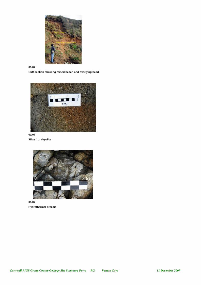
Cliff section showing raised beach and overlying head
01/07
’Elvan’ or rhyolite
01/07
Hydrothermal breccia
01/07
11 December 2007P/2 Venton CoveCornwall RIGS Group County Geology Site Summary Form
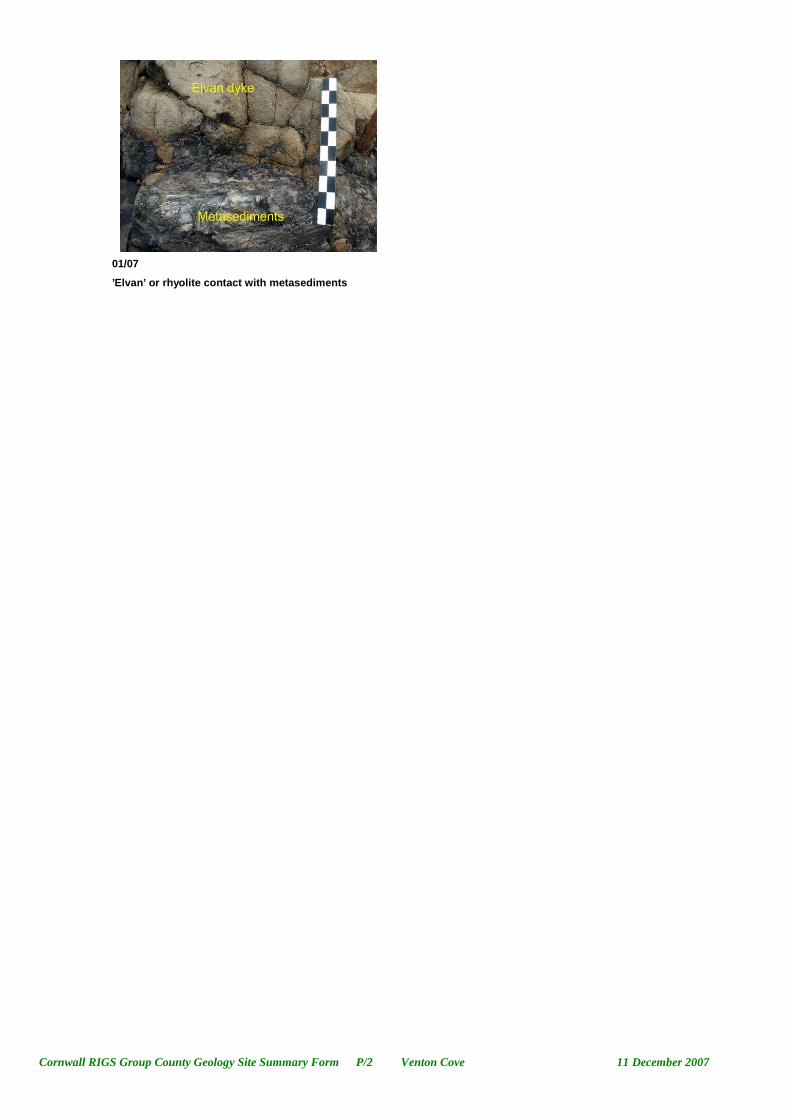
’Elvan’ or rhyolite contact with metasediments
01/07
11 December 2007P/2 Venton CoveCornwall RIGS Group County Geology Site Summary Form

11 December 2007P/2 Venton CoveCornwall RIGS Group County Geology Site Summary Form

APPENDIX 4
Protocol for amending County Geology Site/RIGS boundaries (Draft)

Draft protocol for amending Local Site boundaries - County Geology Sites. Page 1 of 4 19/10/2010
Tick when Process Complete
Protocol for Amending Local Site Boundaries - County Geology Sites.
Site name: Site code: Grid ref. (site centroid): Site area: Type of assessment. (tick as appropriate) Boundary update Extension (go to page 2) Contraction (go to page 3) New Site (Go to page 2) Site Deletion (Go to page 3) County Geology Site Technical Group. Name of assessors: Date of assessment: Assessment summary

Draft protocol for amending Local Site boundaries - County Geology Sites. Page 2 of 4 19/10/2010
Site Extension/New Site Details of any relevant survey information. (complete if relevant) Surveyor: Survey Date: Type of survey: Survey Report attached: Y/N Landowner: Site extension/new site rationale: Relevant Scientific Criteria:
Notes:
Relevant Educational Criteria:
Notes:
Relevant Historic Criteria:
Notes:
Relevant Aesthetic (value for public awareness & appreciation) Criteria:
Notes:
Additional significant interest:
Notes:
Details of how combined value of additional interest adds further justification for designation:
Site eligible for selection Y/N Summary of Justification for selection:
Landowner comments/observations:
Go to page 4
Draft protocol for amending Local Site boundaries - County Geology Sites. Page 3 of 4 19/10/2010
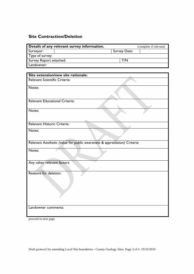
Site Contraction/Deletion Details of any relevant survey information. (complete if relevant) Surveyor: Survey Date: Type of survey: Survey Report attached: Y/N Landowner: Site extension/new site rationale: Relevant Scientific Criteria:
Notes:
Relevant Educational Criteria:
Notes:
Relevant Historic Criteria:
Notes:
Relevant Aesthetic (value for public awareness & appreciation) Criteria:
Notes:
Any other relevant factors
Reasons for deletion:
Landowner comments:
proceed to next page

Draft protocol for amending Local Site boundaries - County Geology Sites. Page 4 of 4 19/10/2010
Local Sites Partnership Approval of Boundary Amendment Date of meeting: Site amendment approved:
Y/N Date of approval:
If amendment not approved, details of any further work needed:
Date Summary sheet prepared/ updated: Date boundary drawn/updated on GIS: Date GIS layer updated: Date web database updated: Date of layer re-issue to partners: Landowner informed:
List of those present:
Landowner comments:


Heading