heaven a bright 2 - the dmsmediafiles.thedms.co.uk/publication/ys-brad/cms/pdf/p1965_ilkley... ·...
TRANSCRIPT
02
Bradford is an internationally important centre for fine art, attracting artists and exhibitions from all over the world.
You can take your pick from an impressive collection of galleries, such as the Impressions Gallery. One of the UK’s most celebrated photography venues; it champions the best of today’s emerging talent.You’ll also find the Bradford 1 Gallery showcasing contemporary and historic art and craft from national touring galleries.
Then there’s the Cartwright Hall Art Gallery with its major exhibitions of contemporary art and stunning works by Lowry, Reynolds and Warhol.
One of the world’s largest collections of David Hockney works is on display at Salts Mill. Get your timing right, and you can also enjoy the Saltaire Arts Trail, a vibrant festival of art packed full of unique art and textile shows.
And for an eclectic and compelling programme of International art exhibitions, make a bee-line for Bradford University’s Gallery II.
A bright canvas visitbradford.com
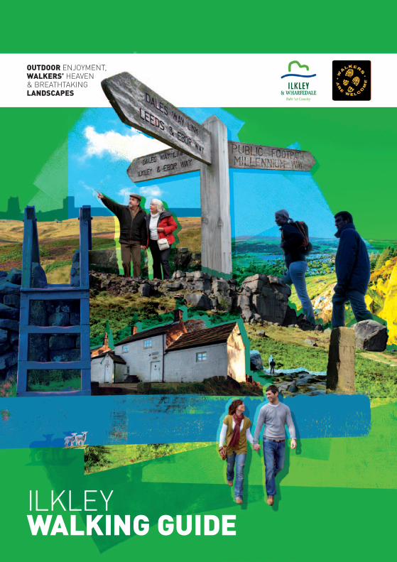
ilkley wAlking guide
outdoor enjoyment, wAlkers’ heaven & breathtaking lAndscApes
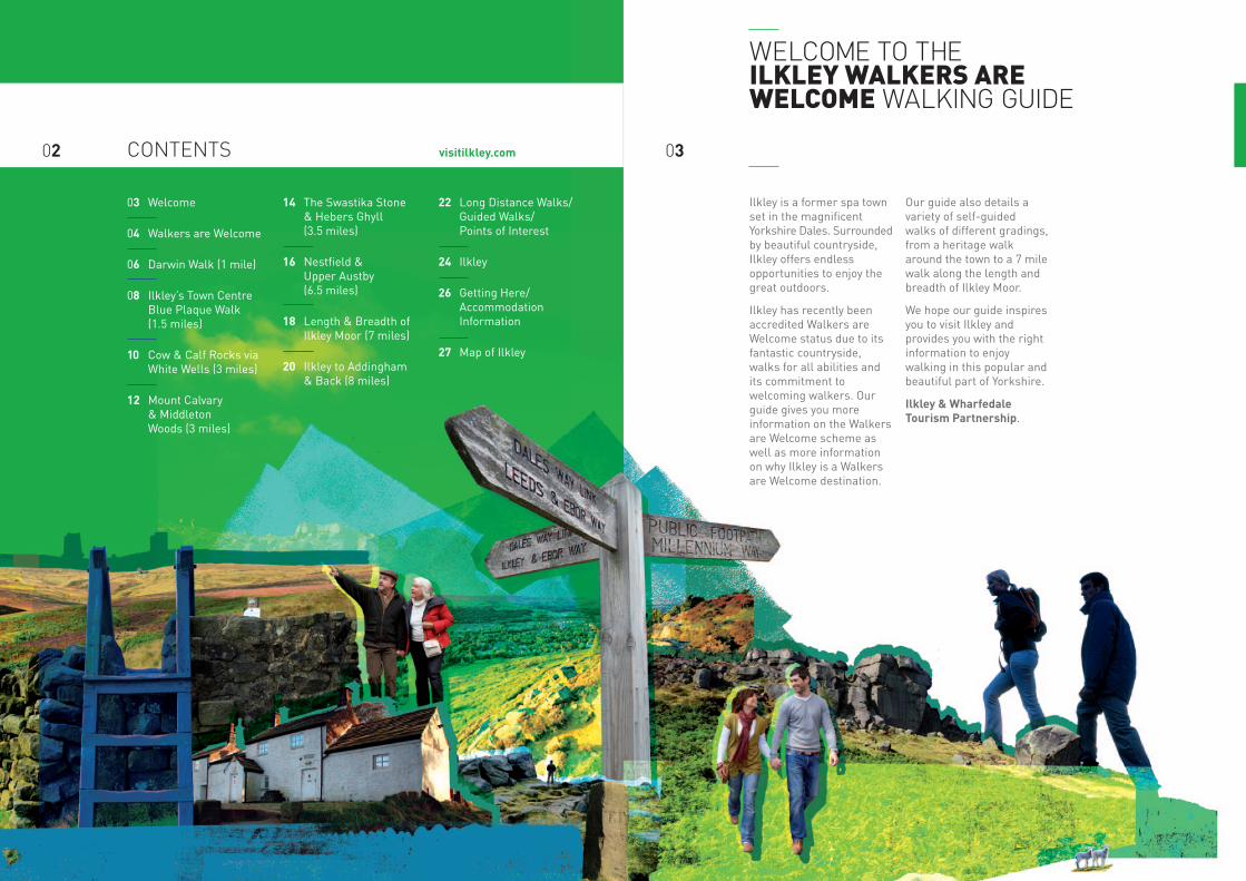
03 Welcome
04 Walkers are Welcome
06 Darwin Walk (1 mile)
08 Ilkley’s Town Centre Blue Plaque Walk (1.5 miles)
10 Cow & Calf Rocks via White Wells (3 miles)
12 Mount Calvary & MiddletonWoods (3 miles)
14 The Swastika Stone & Hebers Ghyll (3.5 miles)
16 Nestfi eld & Upper Austby(6.5 miles)
18 Length & Breadth of Ilkley Moor (7 miles)
20 Ilkley to Addingham & Back (8 miles)
22 Long Distance Walks/Guided Walks/Points of Interest
24 Ilkley
26 Getting Here/Accommodation Information
27 Map of Ilkley
visitilkley.com02
Ilkley is a former spa town set in the magnifi cent Yorkshire Dales. Surrounded by beautiful countryside, Ilkley offers endless opportunities to enjoy the great outdoors.
Ilkley has recently been accredited Walkers are Welcome status due to its fantastic countryside, walks for all abilities and its commitment to welcoming walkers. Our guide gives you more information on the Walkers are Welcome scheme as well as more information on why Ilkley is a Walkers are Welcome destination.
Our guide also details a variety of self-guided walks of different gradings, from a heritage walk around the town to a 7 mile walk along the length and breadth of Ilkley Moor.
We hope our guide inspires you to visit Ilkley and provides you with the right information to enjoy walking in this popular and beautiful part of Yorkshire.
Ilkley & Wharfedale Tourism Partnership.
contents 03
welcome to the ilkley wAlkers Are welcome walking guide
0504
walkers arewelcome
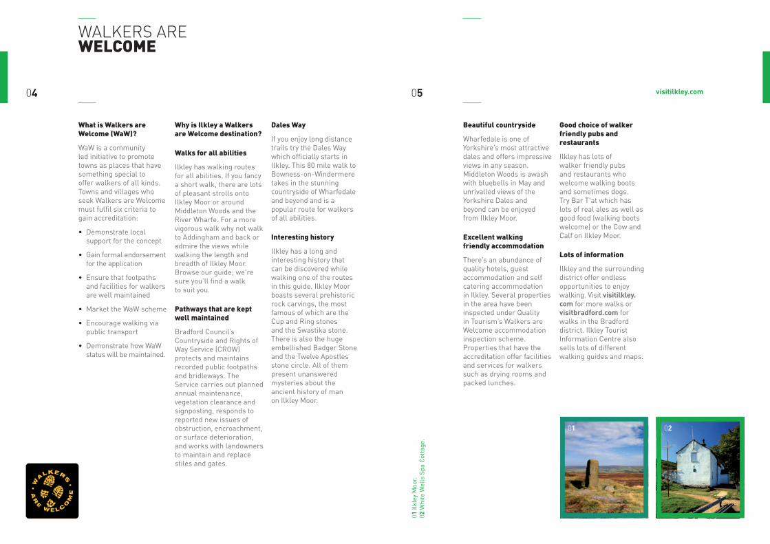
what is walkers are welcome (waw)?
WaW is a community led initiative to promote towns as places that have something special to offer walkers of all kinds. Towns and villages who seek Walkers are Welcome must fulfil six criteria to gain accreditation:
• Demonstrate local support for the concept
• Gain formal endorsement for the application
• Ensure that footpaths and facilities for walkers are well maintained
• Market the WaW scheme
• Encourage walking via public transport
• Demonstrate how WaW status will be maintained.
why is ilkley a walkers are welcome destination?
walks for all abilities
Ilkley has walking routes for all abilities. If you fancy a short walk, there are lots of pleasant strolls onto Ilkley Moor or around Middleton Woods and the River Wharfe. For a more vigorous walk why not walk to Addingham and back or admire the views while walking the length and breadth of Ilkley Moor. Browse our guide; we’re sure you’ll find a walk to suit you.
pathways that are kept well maintained
Bradford Council’s Countryside and Rights of Way Service (CROW) protects and maintains recorded public footpaths and bridleways. The Service carries out planned annual maintenance, vegetation clearance and signposting, responds to reported new issues of obstruction, encroachment, or surface deterioration, and works with landowners to maintain and replace stiles and gates.
dales way
If you enjoy long distance trails try the Dales Way which officially starts in Ilkley. This 80 mile walk to Bowness-on-Windermere takes in the stunning countryside of Wharfedale and beyond and is a popular route for walkers of all abilities.
interesting history
Ilkley has a long and interesting history that can be discovered while walking one of the routes in this guide. Ilkley Moor boasts several prehistoric rock carvings, the most famous of which are the Cup and Ring stones and the Swastika stone. There is also the huge embellished Badger Stone and the Twelve Apostles stone circle. All of them present unanswered mysteries about the ancient history of man on Ilkley Moor.
beautiful countryside
Wharfedale is one of Yorkshire’s most attractive dales and offers impressive views in any season. Middleton Woods is awash with bluebells in May and unrivalled views of the Yorkshire Dales and beyond can be enjoyed from Ilkley Moor.
excellent walking friendly accommodation
There’s an abundance of quality hotels, guest accommodation and self catering accommodation in Ilkley. Several properties in the area have been inspected under Quality in Tourism’s Walkers are Welcome accommodation inspection scheme. Properties that have the accreditation offer facilities and services for walkers such as drying rooms and packed lunches.
good choice of walker friendly pubs and restaurants
Ilkley has lots of walker friendly pubs and restaurants who welcome walking boots and sometimes dogs. Try Bar T’at which has lots of real ales as well as good food (walking boots welcome) or the Cow and Calf on Ilkley Moor.
lots of information
Ilkley and the surrounding district offer endless opportunities to enjoy walking. Visit visitilkley.com for more walks or visitbradford.com for walks in the Bradford district. Ilkley Tourist Information Centre also sells lots of different walking guides and maps.
01 02
01 Il
kley
Moo
r. 02
Whi
te W
ells
Spa
Cot
tage
.
visitilkley.com
visitilkley.com
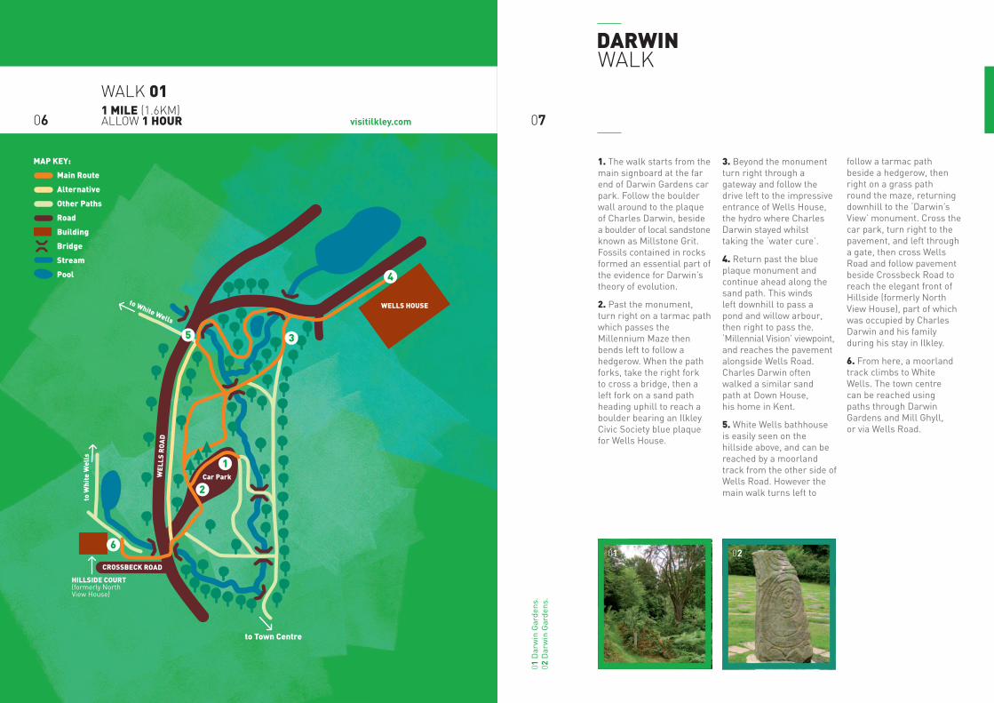
dArwin walk
1. The walk starts from the main signboard at the far end of Darwin Gardens car park. Follow the boulder wall around to the plaque of Charles Darwin, beside a boulder of local sandstone known as Millstone Grit. Fossils contained in rocks formed an essential part of the evidence for Darwin’s theory of evolution.
2. Past the monument, turn right on a tarmac path which passes the Millennium Maze then bends left to follow a hedgerow. When the path forks, take the right fork to cross a bridge, then a left fork on a sand path heading uphill to reach a boulder bearing an Ilkley Civic Society blue plaque for Wells House.
3. Beyond the monument turn right through a gateway and follow the drive left to the impressive entrance of Wells House, the hydro where Charles Darwin stayed whilst taking the ‘water cure’.
4. Return past the blue plaque monument and continue ahead along the sand path. This winds left downhill to pass a pond and willow arbour, then right to pass the‚ ‘Millennial Vision’ viewpoint, and reaches the pavement alongside Wells Road. Charles Darwin often walked a similar sand path at Down House, his home in Kent.
5. White Wells bathhouse is easily seen on the hillside above, and can be reached by a moorland track from the other side of Wells Road. However the main walk turns left to
follow a tarmac path beside a hedgerow, then right on a grass path round the maze, returning downhill to the ‘Darwin’s View’ monument. Cross the car park, turn right to the pavement, and left through a gate, then cross Wells Road and follow pavement beside Crossbeck Road to reach the elegant front of Hillside (formerly North View House), part of which was occupied by Charles Darwin and his family during his stay in Ilkley.
6. From here, a moorland track climbs to White Wells. The town centre can be reached using paths through Darwin Gardens and Mill Ghyll, or via Wells Road.
0706
01 D
arw
in G
arde
ns.
02 D
arw
in G
arde
ns.
walk 011 mile (1.6km) allow 1 hour
0201
HILLSIDE COURT(formerly North View House)
0 metres 25North
W
E
S
WEL
LS R
OA
D
Car Park
to Town Centre
CROSSBECK ROAD
to White Wells
WELLS HOUSE
to W
hite
Wel
ls
1
2
3
4
5
6
MAP KEY:
Main Route
Alternative
Other Paths
Road
Building
Bridge
Stream
Pool
visitilkley.com
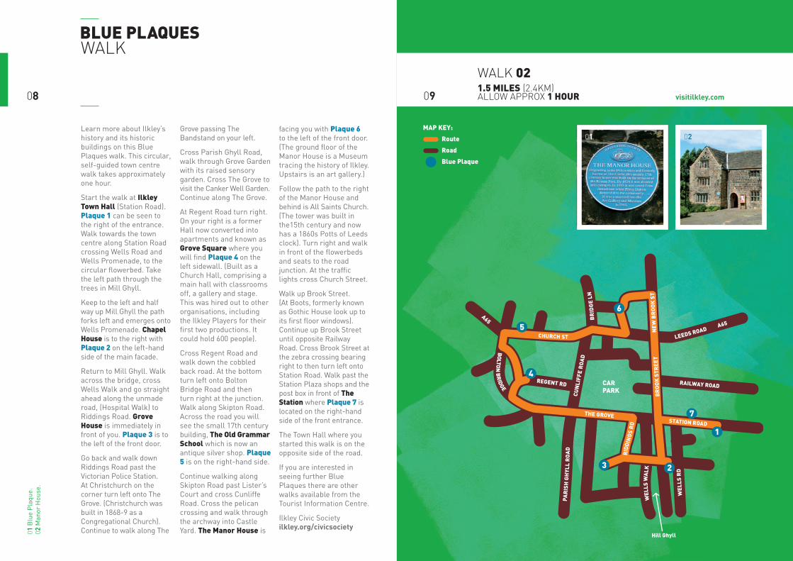
Learn more about Ilkley’s history and its historic buildings on this Blue Plaques walk. This circular, self-guided town centre walk takes approximately one hour.
Start the walk at ilkley town hall (Station Road). plaque 1 can be seen to the right of the entrance. Walk towards the town centre along Station Road crossing Wells Road and Wells Promenade, to the circular flowerbed. Take the left path through the trees in Mill Ghyll.
Keep to the left and half way up Mill Ghyll the path forks left and emerges onto Wells Promenade. chapel house is to the right with plaque 2 on the left-hand side of the main facade.
Return to Mill Ghyll. Walk across the bridge, cross Wells Walk and go straight ahead along the unmade road, (Hospital Walk) to Riddings Road. grove house is immediately in front of you. plaque 3 is to the left of the front door.
Go back and walk down Riddings Road past the Victorian Police Station. At Christchurch on the corner turn left onto The Grove. (Christchurch was built in 1868-9 as a Congregational Church). Continue to walk along The
Grove passing The Bandstand on your left.
Cross Parish Ghyll Road, walk through Grove Garden with its raised sensory garden. Cross The Grove to visit the Canker Well Garden. Continue along The Grove.
At Regent Road turn right. On your right is a former Hall now converted into apartments and known as grove square where you will find plaque 4 on the left sidewall. (Built as a Church Hall, comprising a main hall with classrooms off, a gallery and stage. This was hired out to other organisations, including the Ilkley Players for their first two productions. It could hold 600 people).
Cross Regent Road and walk down the cobbled back road. At the bottom turn left onto Bolton Bridge Road and then turn right at the junction. Walk along Skipton Road. Across the road you will see the small 17th century building, the old grammar school which is now an antique silver shop. plaque 5 is on the right-hand side.
Continue walking along Skipton Road past Lister’s Court and cross Cunliffe Road. Cross the pelican crossing and walk through the archway into Castle Yard. the manor house is
facing you with plaque 6 to the left of the front door. (The ground floor of the Manor House is a Museum tracing the history of Ilkley. Upstairs is an art gallery.)
Follow the path to the right of the Manor House and behind is All Saints Church. (The tower was built in the15th century and now has a 1860s Potts of Leeds clock). Turn right and walk in front of the flowerbeds and seats to the road junction. At the traffic lights cross Church Street.
Walk up Brook Street. (At Boots, formerly known as Gothic House look up to its first floor windows). Continue up Brook Street until opposite Railway Road. Cross Brook Street at the zebra crossing bearing right to then turn left onto Station Road. Walk past the Station Plaza shops and the post box in front of the station where plaque 7 is located on the right-hand side of the front entrance.
The Town Hall where you started this walk is on the opposite side of the road.
If you are interested in seeing further Blue Plaques there are other walks available from the Tourist Information Centre.
Ilkley Civic Society ilkley.org/civicsociety
blue plAqueswalk
0908
walk 021.5 miles (2.4km) allow approx 1 hour
01 B
lue
Pla
que.
02
Man
or H
ouse
.
0201
BOLTON
BR
IDGE THE GROVE STATION ROAD
B
RO
OK
STR
EET
NEW
BR
OO
K S
T
CHURCH ST
LEEDS ROAD A65
P
AR
ISH
GH
YLL
RO
AD
C
UN
LIFF
E R
OA
D
BR
IDG
E LN
WEL
LS W
ALK
RID
DIN
GS
RD
WEL
LS R
D
RAILWAY ROAD REGENT RD
A65
Hill Ghyll0 metres 25
North
W E
S
MAP KEY:
Route
Road
Blue Plaque
5
6
4
7
1
23
CAR PARK
visitilkley.com
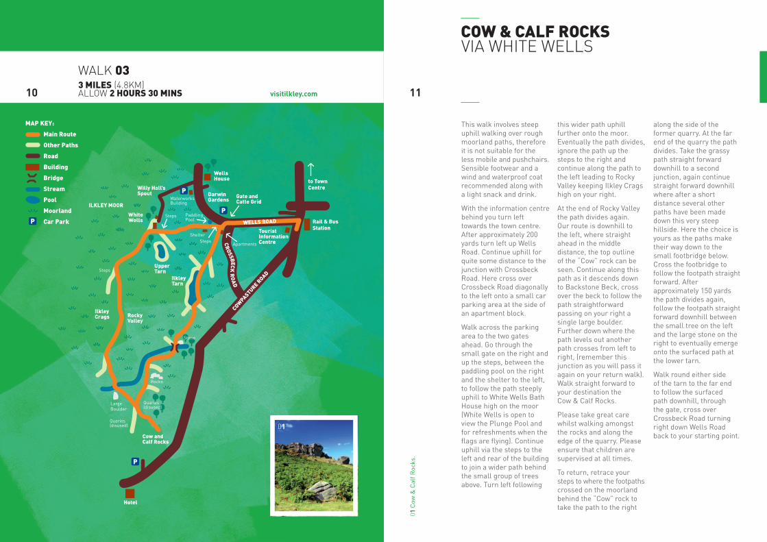
This walk involves steep uphill walking over rough moorland paths, therefore it is not suitable for the less mobile and pushchairs. Sensible footwear and a wind and waterproof coat recommended along with a light snack and drink.
With the information centre behind you turn left towards the town centre. After approximately 200 yards turn left up Wells Road. Continue uphill for quite some distance to the junction with Crossbeck Road. Here cross over Crossbeck Road diagonally to the left onto a small car parking area at the side of an apartment block.
Walk across the parking area to the two gates ahead. Go through the small gate on the right and up the steps, between the paddling pool on the right and the shelter to the left, to follow the path steeply uphill to White Wells Bath House high on the moor (White Wells is open to view the Plunge Pool and for refreshments when the flags are flying). Continue uphill via the steps to the left and rear of the building to join a wider path behind the small group of trees above. Turn left following
this wider path uphill further onto the moor. Eventually the path divides, ignore the path up the steps to the right and continue along the path to the left leading to Rocky Valley keeping Ilkley Crags high on your right.
At the end of Rocky Valley the path divides again. Our route is downhill to the left, where straight ahead in the middle distance, the top outline of the “Cow” rock can be seen. Continue along this path as it descends down to Backstone Beck, cross over the beck to follow the path straightforward passing on your right a single large boulder. Further down where the path levels out another path crosses from left to right, (remember this junction as you will pass it again on your return walk). Walk straight forward to your destination the Cow & Calf Rocks.
Please take great care whilst walking amongst the rocks and along the edge of the quarry. Please ensure that children are supervised at all times.
To return, retrace your steps to where the footpaths crossed on the moorland behind the “Cow” rock to take the path to the right
along the side of the former quarry. At the far end of the quarry the path divides. Take the grassy path straight forward downhill to a second junction, again continue straight forward downhill where after a short distance several other paths have been made down this very steep hillside. Here the choice is yours as the paths make their way down to the small footbridge below. Cross the footbridge to follow the footpath straight forward. After approximately 150 yards the path divides again, follow the footpath straight forward downhill between the small tree on the left and the large stone on the right to eventually emerge onto the surfaced path at the lower tarn.
Walk round either side of the tarn to the far end to follow the surfaced path downhill, through the gate, cross over Crossbeck Road turning right down Wells Road back to your starting point.
cow & cAlf rocks via white wells
1110
walk 033 miles (4.8km) allow 2 hours 30 mins
01 C
ow &
Cal
f Roc
ks.
01
COWPASTURE R
OAD
WELLS ROAD
CR
OSSBECK
RO
AD
to Town Centre
Rail & Bus Station
Gate andCatte Grid
WellsHouse
DarwinGardens
TouristInformationCentre
Willy Hall’sSpout
WhiteWells
UpperTarn
IlkleyTarn
Hotel
RockyValley
IlkleyCrags
ILKLEY MOOR
Cow andCalf Rocks
Quaries(disused)
Quaries(disused)
Rocks
Stone
Steps
Steps
StepsApartments
WaterworksBuilding
Shelter
PaddlingPool
Large Boulder
P
P
P
P
North
W
E
S
?
0 metres 25?
MAP KEY:
Main Route
Other Paths
Road
Building
Bridge
Stream
Pool
Moorland
Car Park
visitilkley.com
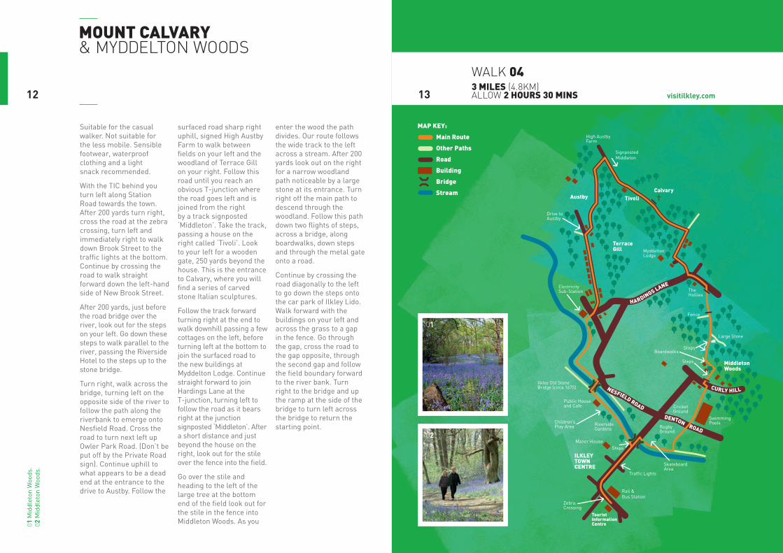
mount cAlvAry & myddelton woods
1312
walk 043 miles (4.8km) allow 2 hours 30 mins
Suitable for the casual walker. Not suitable for the less mobile. Sensible footwear, waterproof clothing and a light snack recommended.
With the TIC behind you turn left along Station Road towards the town. After 200 yards turn right, cross the road at the zebra crossing, turn left and immediately right to walk down Brook Street to the traffic lights at the bottom. Continue by crossing the road to walk straight forward down the left-hand side of New Brook Street.
After 200 yards, just before the road bridge over the river, look out for the steps on your left. Go down these steps to walk parallel to the river, passing the Riverside Hotel to the steps up to the stone bridge.
Turn right, walk across the bridge, turning left on the opposite side of the river to follow the path along the riverbank to emerge onto Nesfield Road. Cross the road to turn next left up Owler Park Road. (Don’t be put off by the Private Road sign). Continue uphill to what appears to be a dead end at the entrance to the drive to Austby. Follow the
surfaced road sharp right uphill, signed High Austby Farm to walk between fields on your left and the woodland of Terrace Gill on your right. Follow this road until you reach an obvious T-junction where the road goes left and is joined from the right by a track signposted ‘Middleton’. Take the track, passing a house on the right called ‘Tivoli’. Look to your left for a wooden gate, 250 yards beyond the house. This is the entrance to Calvary, where you will find a series of carved stone Italian sculptures.
Follow the track forward turning right at the end to walk downhill passing a few cottages on the left, before turning left at the bottom to join the surfaced road to the new buildings at Myddelton Lodge. Continue straight forward to join Hardings Lane at the T-junction, turning left to follow the road as it bears right at the junction signposted ‘Middleton’. After a short distance and just beyond the house on the right, look out for the stile over the fence into the field.
Go over the stile and heading to the left of the large tree at the bottom end of the field look out for the stile in the fence into Middleton Woods. As you
enter the wood the path divides. Our route follows the wide track to the left across a stream. After 200 yards look out on the right for a narrow woodland path noticeable by a large stone at its entrance. Turn right off the main path to descend through the woodland. Follow this path down two flights of steps, across a bridge, along boardwalks, down steps and through the metal gate onto a road.
Continue by crossing the road diagonally to the left to go down the steps onto the car park of Ilkley Lido. Walk forward with the buildings on your left and across the grass to a gap in the fence. Go through the gap, cross the road to the gap opposite, through the second gap and follow the field boundary forward to the river bank. Turn right to the bridge and up the ramp at the side of the bridge to turn left across the bridge to return the starting point.
02
01 M
iddl
eton
Woo
ds.
02 M
iddl
eton
Woo
ds.
01
NESFIELD ROAD DENTON ROAD
HARDINGS LANE
CURLY HILL
CalvaryAustby Tivoli
TouristInformationCentre
ILKLEYTOWNCENTRE
TerraceGill
MiddletonWoods
Fence
TheHollies
Boardwalks
SkateboardArea
RugbyGround
High AustbyFarm
MyddeltonLodge
ElectricitySub-Station
Cricket Ground
Traffic Lights
SignpostedMiddleton
Drive toAustby
Steps
Steps
Steps
Large Stone
Swimming Pools
Rail & Bus Station
ZebraCrossing
Manor House
RiversideGardens
Children’sPlay Area
Public Houseand Cafe
Ilkley Old StoneBridge (circa 1675)
0 metres 25
North
W
E
SMAP KEY:
Main Route
Other Paths
Road
Building
Bridge
Stream
?
?

visitilkley.com
This walk involves steep uphill walking and rough wood and moorland paths, therefore it is not suitable for the less mobile and pushchairs. Sensible footwear and wind and waterproof clothing is recommended along with a light snack and drink.
With the information centre behind you turn left along Station Road towards the town centre. After approximately 200 yards turn left up Wells Road. Walk up Wells Road for quite some distance going through the gate next to the cattle grid. Continue your climb passing on your right Darwin Gardens and the entrance to a housing development incorporating the imposing building of Wells House, and on your left high upon Ilkley Moor - White Wells Bath House. A short distance further up after the stone built former waterworks building and the entrance to White Wells car park on the left, the road divides.
Turn left uphill (known locally as Weary Hill). Continue uphill to turn right off the road, as it levels out after the steep climb. Follow the well-defined footpath along the edge of Ilkley Moor keeping the houses on the right and moorland to the left. Follow this path for quite some distance, almost to the last house on the right. Look out for the wooden field gate and kissing gate on the right, here turn left over the drainage ditch onto the moor. Follow this wide path uphill as it bears right and continue straight forward through the wooden gate. From here walk straight towards the railings, which can clearly be seen ahead. Behind these railings the Swastika Stone can be found.
To return take the narrow path which is to the left of, and parallel to the path on which you arrived. Walk carefully along the edge of the moor, ignore a path downhill to the left and continue straight forward for a short distance to a metal kissing gate. Once through the gate turn left
off the path down the less well defined path diagonally heading towards the trees and reservoir. After a short distance the path joins several other paths under the trees near a footbridge and a metal gate. This is the top end of Hebers Ghyll and to continue your walk go through the metal gate and follow the path as it zig zags down hill crossing over several bridges to emerge onto Hebers Ghyll Drive.
Turn right and follow Hebers Ghyll Drive as it bears right at its junction with Grove Road, continue down Hebers Ghyll Drive to a second junction with Grove Road, here turn right and follow Grove Road to the town centre passing along the way the mansions built by wealthy merchants at the end of the 19th century.
the swAstikA stone & hebers ghyll
1514
walk 053.5 miles (5.6km) allow 2 hours 30 mins
02
01
01 Il
kley
Moo
r. 02
The
Sw
astik
a St
one.
HEBERS GHYLL DR
IVE
GR
OVE R
OA
D
GROV
E RO
AD
PAN
OR
AM
A D
RIVE W
ESTWO
OD
DR
IIVE
CROS
SB
EC
KS RD
WELLS ROAD
P
P
P
SwastikaStone
HebersGhyll
IlkleyTownCentre
TouristInformationCentre
ILKLEY MOOR
Heathcote
Rail & BusStation
PaddlingPool
Apartments
WaterworksBuilding
DarwinGardens
WellsHouse
Cattle Grid
WhiteWells
Willy Hall’sSpout
SpiceyGill
PanoramaWood
Reservoir
Black Beck
HeathPark
0 metres 25
North
W
E
S
?
?
MAP KEY:
Main Route
Other Paths
Road
Building
Bridge
Stream
Pool
visitilkley.com
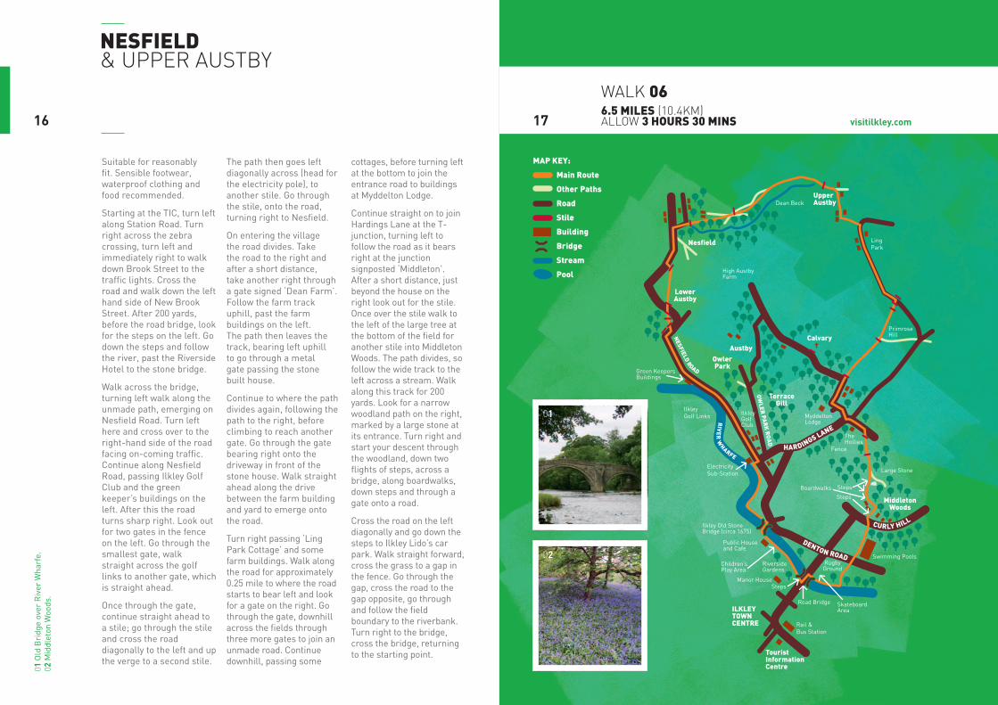
nesfield & upper austby
1716
walk 066.5 miles (10.4km) allow 3 hours 30 mins
Suitable for reasonably fit. Sensible footwear, waterproof clothing and food recommended.
Starting at the TIC, turn left along Station Road. Turn right across the zebra crossing, turn left and immediately right to walk down Brook Street to the traffic lights. Cross the road and walk down the left hand side of New Brook Street. After 200 yards, before the road bridge, look for the steps on the left. Go down the steps and follow the river, past the Riverside Hotel to the stone bridge.
Walk across the bridge, turning left walk along the unmade path, emerging on Nesfield Road. Turn left here and cross over to the right-hand side of the road facing on-coming traffic. Continue along Nesfield Road, passing Ilkley Golf Club and the green keeper’s buildings on the left. After this the road turns sharp right. Look out for two gates in the fence on the left. Go through the smallest gate, walk straight across the golf links to another gate, which is straight ahead.
Once through the gate, continue straight ahead to a stile; go through the stile and cross the road diagonally to the left and up the verge to a second stile.
The path then goes left diagonally across (head for the electricity pole), to another stile. Go through the stile, onto the road, turning right to Nesfield.
On entering the village the road divides. Take the road to the right and after a short distance, take another right through a gate signed ‘Dean Farm’. Follow the farm track uphill, past the farm buildings on the left. The path then leaves the track, bearing left uphill to go through a metal gate passing the stone built house.
Continue to where the path divides again, following the path to the right, before climbing to reach another gate. Go through the gate bearing right onto the driveway in front of the stone house. Walk straight ahead along the drive between the farm building and yard to emerge onto the road.
Turn right passing ‘Ling Park Cottage’ and some farm buildings. Walk along the road for approximately 0.25 mile to where the road starts to bear left and look for a gate on the right. Go through the gate, downhill across the fields through three more gates to join an unmade road. Continue downhill, passing some
cottages, before turning left at the bottom to join the entrance road to buildings at Myddelton Lodge.
Continue straight on to join Hardings Lane at the T- junction, turning left to follow the road as it bears right at the junction signposted ‘Middleton’. After a short distance, just beyond the house on the right look out for the stile. Once over the stile walk to the left of the large tree at the bottom of the field for another stile into Middleton Woods. The path divides, so follow the wide track to the left across a stream. Walk along this track for 200 yards. Look for a narrow woodland path on the right, marked by a large stone at its entrance. Turn right and start your descent through the woodland, down two flights of steps, across a bridge, along boardwalks, down steps and through a gate onto a road.
Cross the road on the left diagonally and go down the steps to Ilkley Lido’s car park. Walk straight forward, cross the grass to a gap in the fence. Go through the gap, cross the road to the gap opposite, go through and follow the field boundary to the riverbank. Turn right to the bridge, cross the bridge, returning to the starting point.
02
01
01 O
ld B
ridg
e ov
er R
iver
Wha
rfe.
02
Mid
dlet
on W
oods
.
RIV
ER
WHARFE
NESFIELD ROAD
CURLY HILL
DENTON ROAD
HARDINGS LANE
OW
LER PA
RK
RO
AD
CalvaryAustby
LowerAustby
UpperAustby
Nesfield
TouristInformationCentre
ILKLEYTOWNCENTRE
OwlerPark
TerraceGill
MiddletonWoods
Fence
TheHollies
SkateboardArea
RugbyGround
LingPark
PrimroseHill
High AustbyFarm
MyddeltonLodge
Dean Beck
ElectricitySub-Station
IlkleyGolfClub
IlkleyGolf Links
Green KeepersBuildings
Steps
Steps
Large Stone
Swimming Pools
Road Bridge
Rail & Bus Station
Manor House
RiversideGardens
Children’sPlay Area
Public Houseand Cafe
Ilkley Old StoneBridge (circa 1675)
Boardwalks Steps
0 metres 25
North
W
E
SMAP KEY:
Main Route
Other Paths
Road
Stile
Building
Bridge
Stream
Pool
?
?
visitilkley.com
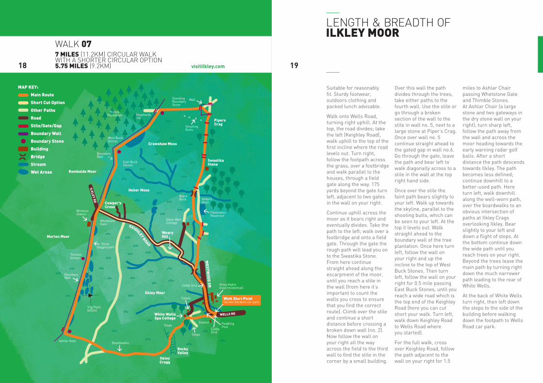
Suitable for reasonably fit. Sturdy footwear, outdoors clothing and packed lunch advisable.
Walk onto Wells Road, turning right uphill. At the top, the road divides; take the left (Keighley Road), walk uphill to the top of the first incline where the road levels out. Turn right, follow the footpath across the grass, over a footbridge and walk parallel to the houses, through a field gate along the way. 175 yards beyond the gate turn left, adjacent to two gates in the wall on your right.
Continue uphill across the moor as it bears right and eventually divides. Take the path to the left; walk over a footbridge and onto a field gate. Through the gate the rough path will lead you on to the Swastika Stone. From here continue straight ahead along the escarpment of the moor, until you reach a stile in the wall (from here it’s important to count the walls you cross to ensure that you find the correct route). Climb over the stile and continue a short distance before crossing a broken down wall (no. 2). Now follow the wall on your right all the way across the field to the third wall to find the stile in the corner by a small building.
Over this wall the path divides through the trees, take either paths to the fourth wall. Use the stile or go through a broken section of the wall to the stile in wall no. 5, next to a large stone at Piper’s Crag. Once over wall no. 5 continue straight ahead to the gated gap in wall no.6. Go through the gate, leave the path and bear left to walk diagonally across to a stile in the wall at the top right hand side.
Once over the stile the faint path bears slightly to your left. Walk up towards the skyline, parallel to the shooting butts, which can be seen to your left. At the top it levels out. Walk straight ahead to the boundary wall of the tree plantation. Once here turn left, follow the wall on your right and up the incline to the top of West Buck Stones. Then turn left, follow the wall on your right for 0.5 mile passing East Buck Stones, until you reach a wide road which is the top end of the Keighley Road (here you can cut short your walk. Turn left, walk down Keighley Road to Wells Road where you started).
For the full walk, cross over Keighley Road, follow the path adjacent to the wall on your right for 1.5
miles to Ashlar Chair passing Whetstone Gate and Thimble Stones. At Ashlar Chair (a large stone and two gateways in the dry stone wall on your right), turn sharp left, follow the path away from the wall and across the moor heading towards the early warning radar golf balls. After a short distance the path descends towards Ilkley. The path becomes less defined; continue downhill to a better-used path. Here turn left, walk downhill along the well-worn path, over the boardwalks to an obvious intersection of paths at Ilkley Crags overlooking Ilkley. Bear slightly to your left and down a flight of steps. At the bottom continue down the wide path until you reach trees on your right. Beyond the trees leave the main path by turning right down the much narrower path leading to the rear of White Wells.
At the back of White Wells turn right, then left down the steps to the side of the building before walking down the footpath to Wells Road car park.
length & breadth of ilkley moor
1918
walk 077 miles (11.2km) circular walk with a shorter circular option 5.75 miles (9.2km)
WELLS RD
KEIGHLEY ROAD
ILKLEY R
D
WESTW
OO
D D
R
Rombalds Moor
Morton Moor
Ilkley Moor
White WellsSpa Cottage
ShootingButts
StandingBoundaryStone
Wall
BoundaryWall
BoundaryWall
ShepherdsHill
RivockPlantation
West BuckStones
East BuckStones
WhetstoneGate
ThimbleStones
Trig Point(402m)
Ashlar Gate
Steps
Steps
Shelter
Boardwalks
PaddlingPool
Ilkley Hydro(now residential)
Cattle Grid
Cattle Grid
Silver WellCottage
BlackBeck Hebers
Ghyll
PanoramicReservoir
Toilets
Stone flagged path
WirelessStation
SwastikaStone
PipersCrag
Crawshaw Moss
Heber Moss
Cowper’sCross
WearyHill
RockyValley
IlkleyCragg
Walk Start PointDarwin Gardens car park
0 metres 25
North
W
E
S
MAP KEY:
Main Route
Short Cut Option
Other Paths
Road
Stile/Gate/Gap
Boundary Wall
Boundary Stone
Building
Bridge
Stream
Wet Areas
?
visitilkley.com
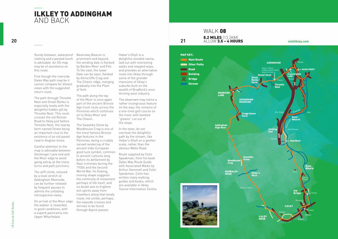
Sturdy footwear, waterproof clothing and a packed lunch is advisable. An OS map may be of assistance on this route.
Fine though the riverside Dales Way path may be it cannot compare for distant views with the suggested return route.
The path through Throstle Nest and Small Banks is especially lovely with the delightful hidden gill by Throstle Nest. This route crosses the old Roman Road to Ilkley just before Throstle Nest, the nearby farm named Street being an important clue to the existence of an old paved road in Anglian times.
Careful attention to the map is advisable between Stockinger Lane end and the Moor edge to avoid going astray at the many turns and path junctions.
The stiff climb, relieved by a level stretch at Addingham Moorside, can be further relieved by frequent pauses to admire the unfolding retrospective views.
On arrival at the Moor edge the walker is rewarded, in good conditions, with a superb panorama into Upper Wharfedale.
Beamsley Beacon is prominent and beyond, the winding dale is flanked by Barden Moor and Fell. To the east, the lower Dale can be seen, flanked by Almscliffe Crag and The Chevin ridge, merging gradually into the Plain of York.
The path along the top of the Moor is once again part of the ancient Bronze Age track route across the Pennines which continues on to Ilkley Moor and The Chevin.
The Swastika Stone by Woodhouse Crag is one of the most famous Bronze Age features in the Pennines, being a crudely carved rendering of the ancient Indo-European good luck symbol, common to ancient cultures long before its defilement by Nazi criminals during the 1930s and the Second World War. Its flowing, moving shape suggests the continuity of movement perhaps of life itself, and no doubt was to frighten evil spirits away from travellers along that lonely route; not unlike, perhaps, the wayside crosses and shrines to be found through Alpine passes.
Heber’s Ghyll is a delightful wooded ravine, laid out with interesting walks and stepped ways, and provides an alternative route into Ilkley through some of the grander mansions of llkley’s suburbs built on the wealth of Bradford’s once thriving wool industry.
The observant may notice a rather incongruous feature on the way; the remains of a one-time golf course on the moor with levelled “greens” cut out of the slope.
In the town, do not overlook the delightful path by the stream, like Heber’s Ghyll on a gentler scale, rather than the obvious Wells Road.
Route supplied by Colin Speakman, from his book Dales Way Route Guide with Associated Walks by Arthur Gemmell and Colin Speakman. Colin has written many walking guides and books, which are available in Ilkley Tourist Information Centre.
ilkley to AddinghAm and back
2120
walk 088.2 miles (13.2km) allow 3.5 – 4 hours
01 C
ow &
Cal
f Roc
ks.
01
MOORSIDELANE
Street FarmSmall BanksFarm
STOCKHINGERLANE
MAIN STREET
CockingEnd
SwastikaStone
Cragg HouseFarm
RiverWharfe
RiverWharfe
OldBridge
ThrostleNest
Red Beck
Heber’sGhyll
WoodhouseCrag
AddinghamHigh Moor
ILKLEYMOOR
ILKLEY
A65
ROMBALDSMOOR
ADDINGHAMMOORSIDE
ADDINGHAM
Fence
Gate in fence hidden below bank beyond trees
Toilets
Toilets
Golf Course
Station
Museum
Toilets
Weir
Quie
t Roa
d
Quiet Rd
Edge of Moor
College
Buses
Buses
Bus Stops
Buses
SportsCentre
Farm
P
A65
P
NorthW
ES
0 1/4 1/2m
MAP KEY:
Main Route
Other Paths
Road
Building
Bridge
Stream
long distAnce wAlks/points of interest/ guided walks
long distAnce wAlks
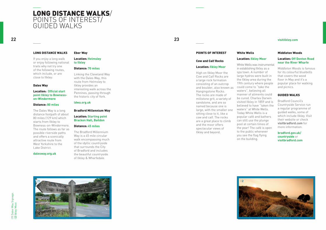
If you enjoy a long walk or enjoy following national trails why not try one of the following routes, which include, or are close to Ilkley:
dales way
location: Official start point Ilkley to Bowness-on-Windermere
distance: 80 miles
The Dales Way is a long distance footpath of about 80 miles (129 km) which starts from Ilkley to Bowness-on-Windermere. The route follows as far as possible riverside paths and offers a scenically attractive route from West Yorkshire to the Lake District.
dalesway.org.uk
ebor way
location: Helmsley to Ilkley
distance: 70 miles
Linking the Cleveland Way with the Dales Way, this route from Helmsley to Ilkley provides an interesting walk across the Pennines, passing through the historic city of York.
ldwa.org.uk
bradford millennium way
location: Starting point Bracken Hall, Baildon
distance: 45 miles
The Bradford Millennium Way is a 45 mile circular walk encompassing much of the idyllic countryside that surrounds the City of Bradford and includes the beautiful countryside of Ilkley & Wharfedale.
points of interest
cow and calf rocks
location: Ilkley Moor
High on Ilkley Moor the Cow and Calf Rocks are a large rock formation consisting of an outcrop and boulder, also known as Hangingstone Rocks. The rocks are made of millstone grit, a variety of sandstone, and are so named because one is large, with the smaller one sitting close to it, like a cow and calf. The rocks are a great place to climb and the moor offers spectacular views of Ilkley and beyond.
white wells
location: Ilkley Moor
White Wells was instrumental in establishing Ilkley as a spa town. A number of large hydros were built in the Ilkley area during the 19th century where people could come to “take the waters”, believing all manner of aliments could be cured. Charles Darwin visited Ilkley in 1859 and is believed to have “taken the waters” at White Wells. Today White Wells is a popular café and bathers can still use the plunge pool at certain times of the year! The café is open to the public whenever you see the flag flying on the building.
middleton woods
location: Off Denton Road near the River Wharfe
Middleton Woods is famous for its colourful bluebells that covers the wood floor in May and it’s a popular place for walking and picnics.
guided wAlks
Bradford Council’s Countryside Service run a regular programme of guided walks, some of which include Ilkley. Visit their website or check visitbradford.com for more information.
bradford.gov.uk/countryside or visitbradford.com
2322 visitilkley.com
0201
01 D
ales
Way
Sig
nage
.02
Ilkl
ey M
oor.
02
visitilkley.com
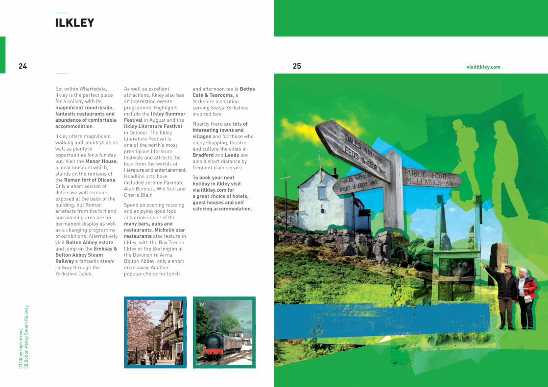
Set within Wharfedale, Ilkley is the perfect place for a holiday with its magnificent countryside, fantastic restaurants and abundance of comfortable accommodation.
Ilkley offers magnificent walking and countryside as well as plenty of opportunities for a fun day out. Visit the Manor House, a local museum which, stands on the remains of the Roman fort of Olicana. Only a short section of defensive wall remains exposed at the back of the building, but Roman artefacts from the fort and surrounding area are on permanent display as well as a changing programme of exhibitions. Alternatively visit Bolton Abbey estate and jump on the Embsay & Bolton Abbey Steam Railway a fantastic steam railway through the Yorkshire Dales.
As well as excellent attractions, Ilkley also has an interesting events programme. Highlights include the Ilkley Summer Festival in August and the Ilkley Literature Festival in October. The Ilkley Literature Festival is one of the north’s most prestigious literature festivals and attracts the best from the worlds of literature and entertainment. Headline acts have included Jeremy Paxman, Alan Bennett, Will Self and Cherie Blair.
Spend an evening relaxing and enjoying good food and drink in one of the many bars, pubs and restaurants. Michelin star restaurants also feature in Ilkley, with the Box Tree in Ilkley or the Burlington at the Devonshire Arms, Bolton Abbey, only a short drive away. Another popular choice for lunch
and afternoon tea is Bettys Café & Tearooms, a Yorkshire institution serving Swiss-Yorkshire inspired fare.
Nearby there are lots of interesting towns and villages and for those who enjoy shopping, theatre and culture the cities of Bradford and Leeds are also a short distance by frequent train service.
To book your next holiday in Ilkley visit visitilkley.com for a great choice of hotels, guest houses and self catering accommodation.
ilkley
2524
01 Il
kley
hig
h st
reet
. 02
Bol
ton
Abb
ey S
team
Rai
lway
. 0201
RiverWhar
fe
© Crown copyright. All rights reserved.Bradford Metropolitan District Council 100019304 2009.Produced by 2.9.09 www.fwt.co.uk
SPRINGS LANE
STATION ROADTHE GROVE
BOLTO
NB
R IDGEROAD
NEW
BRO
OK
STREET
BR O
OK
ST.
GROVE ROAD
QUEEN’S ROAD
QUE
EN’S
ROAD
WELL
SROAD
WEL
LSRO
AD
WEL
LSPR
OM
.
CROSSBECK ROAD
COWPASTURE
ROAD
WHE
ATLE
YRO
AD
KEIGHLEYROAD
LAN
GB
AR
ROADDENTON ROAD
MID
DLETO
NA V EN
UE
GILSTEAD
W AY
CLIFFORDRO
AD
STUBHAM RISE
RUPERT ROAD
BRIDGELANE
STO
CKEL
D
LIST
ERST
REET
ALEXAND
RA
MID
DLE
TON
RD.
TERR
ACE
CHAPEL LA.
KINGS ROAD
WESTV
ILLERO
AD
EATON
ROA
D ST. JAMES’ ROAD
OAKB
UR
NRO
AD
PARIS HGH
YLL
ROA
D
PARISHGHYLL DRIVE
ALBANY WALKBA
CKPA
RISH
GH
YLL
RIDD
INGS
RD.
WEL
LSW
ALK
C OLLEG
E
DRIVE
BRODRICK DR IVEQUEEN’S DR.
RICH
MO
ND
TIVO
LIPL
.
BELLE
VUE
SED
BU
R GH
PARK
SE FTO
N
ILKLEYHALL
PARK
SKELD A
MAYFIELD ROAD
RAILWAY ROAD GO
LDEN
BU
TTS
WEL
LIN
GTO
NRD
.
NEL
SON
ROA
D
NIL
E
CASTLE ROAD
WHARFE VIEWWESTO
N
DEA N
ST.
EAST
PARADE
N.
PARA
DE
LEEDS ROAD A65
LEEDS ROADCHURCH LANE
A65 SKIPTONROAD
LITTLE LANE
BATH
ASH
ST.
BEANLANDS
ASH GROVE
PAR.
ASH
LAN
DS
ROA
D
REGENT ROAD
CUN
LIFF
ERO
AD
WEST ST.
SPRINGFIELD
PRINCESS R OADPARISH
QUEEN’S DR.
KINGSW
AY
WILTON
RD.
TRAFALGAR RD.
ROA
D
ROAD
ROA
D
ROA
D
STREET
DRIVE
ROA
D
CR.
YEW
BA
NK
ROA
D
RISE
AVE.
PLA
CE
GHYLLLANE
DRIVE
WESTWOOD DRIVE
LANE
B6382
DENTON ROAD
White WellsSpa Cottage
ILKLEY
Ilkley Moor
MillenniumGreen
DarwinGardens
Ilkley Swimming Pool and Lido
Start of theDales Way
Bandstand
RiversideGardens
IlkleyPlayhouse
ManorHouse
Town Hall,Kings Hall &Winter Gardens
Bus Station
Ilkley ToyMuseum
Old Bridge
ParishChurch
to Cow andCalf Rocks
to Golf Club
AB
C
1
2
4
3
LEGENDPlace of Interest
Public buildings
Car Park
Taxi ranks
Public toilets withdisabled facilities
Tourist Information Centre
m0520
5 mins0
Approximate walking time
visitilkley.com
getting here/tic/accommodation
getting here
public transport
As a Walkers are Welcome town we encourage the use of public transport. Ilkley is well connected by bus and trains.
public transport to ilkey from leeds
buses X84 – runs daily and on Sundays
trains Regular train service between Leeds and Ilkley, including a Sunday service.
public transport to ilkley from bradford
trains Regular train service between Bradford Forster Square and Ilkley, including a Sunday service.
public transport to ilkley from harrogate
buses X52 – Monday to Saturday only
trains Change at Leeds for a train to Ilkley
dales bus service
There are many bus services within the Yorkshire Dales which run throughout the year. These are supplemented by extra services during the summer period, which mainly operate on Sundays and Bank Holidays from Easter or May Day weekends until mid-October. For more information visit dalesbus.org.
AccommodAtion
Ilkley has an abundance of quality accommodation including hotels, guest houses and self catering accommodation. Visit visitilkley.com to book your next break online!
For more information on Ilkley, walking routes and the surrounding area visit Ilkley Tourist Information Centre:
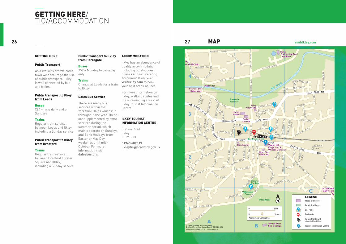
ilkey tourist informAtion centre
Station Road Ilkley LS29 8HB
01943 602319 [email protected]
mAp2726

ilkley tourist information centreStation Rd Ilkley LS29 8HB
01943 602319 [email protected]
Great care has been taken in the production of this leaflet. However, the Countryside and Rights of Way Service accept no responsibility for omissions or changes which have occurred since publication.