heavy-oil and bitumen resources of the big clifty
TRANSCRIPT

University of KentuckyUKnowledge
Kentucky Geological Survey Report ofInvestigations Kentucky Geological Survey
2016
Heavy-Oil and Bitumen Resources of the Big CliftySandstone, Northeastern Grayson County andAdjacent Hardin County, KentuckyJ. Richard BowersoxUniversity of Kentucky, [email protected]
Click here to let us know how access to this document benefits you.
Follow this and additional works at: https://uknowledge.uky.edu/kgs_ri
Part of the Environmental Monitoring Commons, and the Geology Commons
This Report is brought to you for free and open access by the Kentucky Geological Survey at UKnowledge. It has been accepted for inclusion inKentucky Geological Survey Report of Investigations by an authorized administrator of UKnowledge. For more information, please [email protected].
Repository CitationBowersox, J. Richard, "Heavy-Oil and Bitumen Resources of the Big Clifty Sandstone, Northeastern Grayson County and AdjacentHardin County, Kentucky" (2016). Kentucky Geological Survey Report of Investigations. 36.https://uknowledge.uky.edu/kgs_ri/36

Kentucky Geological SurveyUniversity of Kentucky, Lexington
Heavy-Oil and Bitumen Resources of the Big Clifty Sandstone, Northeastern Grayson County and Adjacent Hardin County, Kentucky
J. Richard Bowersox
Report of Investigations 35 Series XII, 2016https://doi.org/10.13023/kgs.ri35.12

© 2006University of Kentucky
For further information contact:Technology Transfer OfficerKentucky Geological Survey
228 Mining and Mineral Resources BuildingUniversity of Kentucky
Lexington, KY 40506-0107
ISSN 0075-5591
Technical Level
General Intermediate Technical
Our MissionOur mission is to increase knowledge and understanding of the mineral, energy, and water resources, geologic hazards, and geology of Kentucky for the benefit of the Commonwealth and Nation.
Earth Resources—Our Common Wealth
www.uky.edu/kgs
Technical Level
General Intermediate Technical
ISSN 0075-5591

Abstract .........................................................................................................................................................1Introduction .................................................................................................................................................1Previous Work .............................................................................................................................................2Geology .........................................................................................................................................................6Reservoir Properties ...................................................................................................................................7Reservoir Volume and Resources ...........................................................................................................11Heavy-Oil and Bitumen Production in Grayson County ...................................................................12Discussion ..................................................................................................................................................13 Additional Resources Southwest of Clifty Creek ....................................................................15 Developing Heavy Oil and Bitumen in the Big Clifty Sandstone.........................................16 Legacy of the Rock-Asphalt Industry in the Northeastern Grayson County Area ............17Conclusions ................................................................................................................................................17References Cited ........................................................................................................................................19
Figures 1. Map showing location of the western Kentucky tar-sand belt in the southern Illinois
Basin and Western Kentucky Coal Field ....................................................................................2 2. (A) Map showing generalized locations of tar sands in western Kentucky.
(B) Stratigraphy of the northeastern Grayson County area .....................................................3 3. Map showing generalized geology and locations of historical rock-asphalt quarries,
rock-asphalt surface sample sites, prospect test pits, outcrops of rock asphalt, and locations of oil and gas wells in northeastern Grayson County and adjacent Hardin County .............................................................................................................................................4
4. Map showing location of surface samples with bitumen-content analysis...........................6 5. Index of oil and gas wells drilled in the study area ..................................................................9 6. Map showing structure of northeastern Grayson and adjacent Hardin Counties and
cross section ..................................................................................................................................10 7. Graph showing sieve-analysis grain-size distributions of three samples from the Big
Clifty ..............................................................................................................................................11 8. Photograph of a 12-m section of the Big Clifty Sandstone exposed in Big Clifty Creek,
northeastern Grayson County ....................................................................................................11 9. Photographs of roadcut on the Western Kentucky Parkway ................................................12 10. (A) Photograph of entrance to a Federal Asphalt Co. mine adit in Flutter Creek,
Grayson County. (B) Photograph of interior of one of the Federal Asphalt Co.’s abandoned mines in Flutter Creek. (C) Photograph of section of Big Clifty core from Megawest corehole 102 Clark, Warren County .......................................................................13
11. Map showing thickness of the net oil- and bitumen-saturated interval in the Big Clifty ..............................................................................................................................................14
12. Map showing Big Clifty rock-asphalt outcrops along the southwest wall of Clifty Creek and southeast wall of Beaver Dam Creek from southwest Carter coordinate quadrangle M-41 to northwest Carter coordinate quadrangle M-39 by Jillson (1926a) ....16
13. LiDAR images showing surface impact of rock-asphalt mining in the northeastern Grayson County area ...................................................................................................................18
Contents
Tables 1. Locations of historical rock-asphalt quarries in northwestern Grayson County and
adjacent Hardin County ................................................................................................................5 2. Locations of surface samples of rock asphalt in northwestern Grayson County, with
the thickness of the bitumen-saturated section at the sample sites and bitumen content analyses ...........................................................................................................................................7
3. Locations and analyses of rock-asphalt samples collected by Kerr-McGee in 1963 in northwestern Grayson County and adjacent Hardin County .................................................8

1
Heavy-Oil and Bitumen Resources of the Big Clifty Sandstone, Northeastern Grayson County and
Adjacent Hardin County, KentuckyJ. Richard Bowersox
AbstractRock asphalt (bitumen-saturated sandstone) was produced from the Big Clifty Sand-
stone near Tar Hill and Big Clifty in northeastern Grayson County, and at Summit in ad-jacent Hardin County, from 1889 to 1940. Noncommercial amounts of oil were distilled from Big Clifty rock asphalt before 1930. Resource assessments conducted throughout the area during the mid-1920’s described substantial rock-asphalt deposits. Later assess-ments in 1951, 1965, and the early 1980’s, however, overlooked the northeastern Grayson County area. A new evaluation in 2015 estimated that the historically developed area between Clifty Creek and Meeting Creek, and between the Summit Fault and Eveleigh Fault Zone, contained 200.3 million barrels of heavy oil and bitumen in place in the Big Clifty Sandstone. This study estimates an additional 29.6 million barrels of heavy oil and bitumen in place in less than 9,600 ha of the Big Clifty southwest of Clifty Creek, or about 7,600 barrels per hectare.
The rock-asphalt industry in the northeastern Grayson County area left substantial surface damage that is still visible, especially at Summit, more than 70 yr later. Although leaching of hydrocarbons from rock-asphalt mine-spoil piles is a reasonable environmen-tal concern, tests have shown no leaching of hydrocarbons using a synthetic rainwater at a pH above 3.5; natural rainwater has a pH of about 5.5.
IntroductionThe western Kentucky heavy oil- and bitu-
men-saturated sandstones, historically called tar sands, rock asphalt, and black rock, are found in the southeastern Illinois Basin on the southern and eastern margins of the Western Kentucky Coal Field (Figs. 1, 2A). They occur in a belt of surface outcrops extending from southern Hardin and eastern Breckinridge Counties on the north to Lo-gan County on the south, encompassing an area of about 3,100 km2 (Eldridge, 1901; Crump, 1913; Jillson, 1924; Russell, 1932, 1933; McGrain, 1976; Williams and others, 1982; Noger, 1984, 1987; Bow-ersox, 2014a, b, 2016, in press). These resources are hosted in Upper Mississippian to Lower Pennsyl-vanian (Serpukhovian to Bashkirian; Chesterian North American Stage) (Swezey, 2009) Big Clifty
Sandstone (Cypress Sandstone of Jillson, 1927), Hardinsburg Sandstone (Fig. 2B), and the Kyrock and Bee Springs Sandstone Members of the Early Pennsylvanian Caseyville Formation (McGrain, 1976; Williams and others, 1982; Noger, 1984, 1987). Rock asphalt in the Big Clifty is exposed in outcrops on the north and south flanks of the Rough Creek Graben and Western Kentucky Coal Field (Figs. 1, 2A), and commercially developed in northeast-ern Grayson County and adjacent Hardin County in northern Carter coordinate quadrangles1 M-40 and M-41 from 1889 to 1946 (Fig. 3, Table 1). These quadrangles were not, however, the only known rock-asphalt deposits in the region, and additional prospecting conducted during the 1920’s defined a rock-asphalt resource area of about 110 km2 (Fig. 4, Tables 2–3).
1For an explanation of the Carter coordinate system, see www.uky.edu/KGS/emsweb/kyogfaq/kyogfaq9.html.

2
Figure 1. Location of the western Kentucky tar-sand belt in the southern Illinois Basin (dashed blue line) and Western Kentucky Coal Field (from Bowersox, in press). Tar sands are hosted in the Upper Mississippian (Chesterian) Big Clifty Sandstone (red), Hardinsburg Sandstone (green), and Lower Pennsylvanian Caseyville Formation (blue) on the margins of the Western Kentucky Coal Field (dashed line). The margin of the coal field approximates the Big Clifty outcrop belt.
Previous WorkThe first commercial development of west-
ern Kentucky’s bituminous sandstone deposits, tar sands, or rock asphalt began in the late 19th century and continued, somewhat sporadically, until the mid-20th century (Bowersox, 2016). Or-ton (1891) described the Big Clifty section on the Whitfield farm in Grayson County. Jillson (1923, 1925) later sampled and analyzed the bitumen content, commenting on the irregular distribution of bitumen-saturated sand in its uppermost beds. The geology and rock-asphalt resources of the Big Clifty and quarries in northern Grayson County were described by Eldridge (1901). Eldridge (1901) described the stratigraphy of the Big Clifty in the idled Breyfogle Quarry in Flutter Creek Canyon, south of Tar Hill, commenting on the irregular dis-tribution of bitumen, cross-cutting crossbedded intervals and lacking continuity within a layer. Nevertheless, the productive interval in the quarry was about 3 m thick, the richest 1.5 to 2 m contain-ing an estimated 7 weight-percent bitumen and seeping heavy oil (Eldridge, 1901). Jillson (1924) discussed development of the Big Clifty rock-as-phalt deposits in Grayson and Hardin Counties, providing analyses of bitumen content in samples
from quarries, although without disclosing where these samples were collected. Richardson (1924) discussed rock-asphalt mining in Grayson and Hardin Counties, providing details of thicknesses of the rock-asphalt deposits being mined by Conti-nental Rock Asphalt Co. near Tar Hill and by Ohio Valley Rock Asphalt Co. at Summit. The earliest mapping of rock-asphalt deposits in the northern Grayson County area was by Jillson (1926a), where outcrops were identified along the creeks dissect-ing the area. Jillson (1923, 1925, 1926b, c) also con-ducted some of the earliest resource evaluations of rock-asphalt deposits in the area, including de-tailed descriptions of the deposits and their thick-nesses, analysis of the bitumen content, and esti-mates of their commercial value.
Later resource evaluations were largely com-pilations of earlier reports of the Kentucky Geolog-ical Survey. Ball (1951, p. 6), in a regional survey of strippable tar-sand deposits in Kentucky, dis-counted the northern Grayson County deposits for lack of information demonstrating that they met minimum thickness and bitumen richness re-quirements of the study, “at least 10 million tons within 5 square miles in beds at least 15 feet thick under no more than their own thickness of over-
Previous Work

3
Figu
re 2
. Gen
eral
ized
loca
tions
of t
ar s
ands
in w
este
rn K
entu
cky
and
stra
tigra
phy
of th
e no
rthea
ster
n G
rays
on C
ount
y re
gion
. Bou
ndar
y of
the
Wes
tern
Ken
tuck
y C
oal F
ield
is s
how
n by
the
dash
ed li
ne. (
A) T
he B
ig C
lifty
tar s
ands
are
pre
sent
in o
utcr
ops
flank
ing
the
Rou
gh C
reek
Gra
ben
on th
e no
rth a
nd s
outh
(mod
ified
from
B
ower
sox,
in p
ress
). C
omm
erci
al d
epos
its w
ere
min
ed fo
r roc
k-as
phal
t roa
d to
ppin
g in
Bre
ckin
ridge
, Gra
yson
, Har
din,
and
Log
an C
ount
ies.
A n
onco
mm
erci
al d
epos
it of
tar s
ands
hos
ted
in th
e H
ardi
nsbu
rg S
ands
tone
is lo
cate
d on
the
sout
hern
mar
gin
of th
e B
ig C
lifty
dep
osits
in G
rays
on C
ount
y. (B
) Stra
tigra
phy
of th
e no
rthea
st-
ern
Gra
yson
Cou
nty
area
(mod
ified
from
Sw
adle
y, 1
962)
. The
Big
Clif
ty c
onsi
sts
of in
terb
edde
d sa
ndst
one
and
thin
sha
les,
and
rang
es fr
om 1
8 to
34.
5 m
thic
k. N
et
com
mer
cial
bitu
men
-sat
urat
ed in
terv
als
in th
e B
ig C
lifty
rang
e fro
m a
bout
1.5
to 7
.6 m
thic
k.
Previous Work

4
Figure 3. Generalized geology and locations of historical rock-asphalt quarries, rock-asphalt surface sample sites, prospect test pits, outcrops of rock asphalt, and locations of oil and gas wells in northeastern Grayson County and adjacent Hardin County. This map is used as a base in following figures. Geology is modified from Swadley (1962), Moore (1964), and Johnson (1978). Areas underlain by the Big Clifty Sandstone are shaded red, Haney Limestone and younger strata are in gray, and Beech Creek Limestone and older strata are in blue. The 5-minute Carter coordinate quadrangle grid for the region is shown by the blue dashed lines. The northern boundary between Grayson and Hardin Counties (heavy dashed green line) is Meeting Creek. Clifty Creek runs northwest from southern Carter coordinate quadrangle M-41 to northeast quadrangle M-39 where it joins Meeting Creek. Outcrops of tar sands in the Big Clifty mapped by Jillson (1926a) are shown by the dashed heavy black lines. Quarry locations are from descriptions in Eldridge (1901) and maps by Jillson (1923, 1925, 1926a–c), Swadley (1962), Moore (1964), and Johnson (1978). Details of quarry locations and elevations, and the thickness of rock asphalt mined in the quarries and its bitumen content are in Table 1.
burden and averaging not less than 10 gallons of oil per ton.” Ball and Associates (1965), as part of a national evaluation of oil sands and shallow oil reserves in the United States, evaluated the north-eastern Grayson County tar-sand deposits. De-posits were classified as reserve, known potential,
occurrence, or inadequate information (Ball and Associates, 1965, p. 12):
As used in this report a reserve is any deposit big enough, accessible enough, and well enough known to appear to be potentially valuable as a commercial rock asphalt or bitumen source under present or foreseeable local conditions in the opin-ion of the compiling author.
Previous Work

5
Ball and Associates evaluated northern Grayson County in five resource areas, based on descrip-tions in the literature, giving thicknesses of the de-posits and weight-percent bitumen content where available. These deposits were then classified as ei-ther occurrences without other information avail-able (two deposits), minor occurrences (two depos-its, both with historical commercial production), and possibly commercial (one deposit at Big Clifty with historical commercial rock-asphalt produc-tion) (Ball and Associates, 1965). McGrain (1976) summarized the prior reports of Ball (1951) and Ball and Associates (1965) and provided routine core-analysis data from surface samples collected in Grayson County. McGrain (1979) summarized the geology of the western Kentucky tar sands, noting that significant deposits of rock asphalt in the Big Clifty were present in parts of Grayson and Hardin Counties.
Regional reevaluations of western Kentucky tar-sand resources were conducted in the 1980’s in association with a national effort to assess the U.S. heavy-oil and bitumen resources (Lewin and Asso-ciates Inc., 1984a, b). Using the methodology out-lined in Lewin and Associates Inc. (1982), Lewin and Associates Inc. (1984b) evaluated the heavy-oil and bitumen resources in the Kentucky tar sands, reporting measured resources of 1,190 million bar-rels of oil and speculative resources of 910 million barrels of oil in the Big Clifty. Omitted from this evaluation, however, were the Big Clifty rock-as-phalt deposits in the northeastern Grayson County area and its estimated 200 million barrels of heavy oil and bitumen (Bowersox, in press). Noger (1984, 1987), in a review conducted by the Kentucky Geo-logical Survey, slightly revised the western Ken-tucky tar-sand evaluation of Lewin and Associates Inc. (1984b), although accepting the prior estimate of Big Clifty heavy oil and bitumen resources.
The regional heavy oil and bitumen resources of the western Kentucky tar sands were reevalu-ated by Bowersox (in press). Although the Big Clifty resources in northeastern Grayson and adja-cent Hardin Counties were included, evaluation of the area was presented only in summary without specific discussion of the deposits. Thus, the pur-pose of the present report is to supplement Bower-sox (in press), providing the data and geologic de-tails defining the heavy-oil and bitumen resources Ta
ble
1. L
ocat
ions
of h
isto
rical
rock
-asp
halt
quar
ries
in n
orth
wes
tern
Gra
yson
Cou
nty
and
adja
cent
Har
din
Cou
nty
(Eld
ridge
, 190
1; J
illso
n, 1
923,
192
5, 1
926a
–c,
Sw
adle
y, 1
962;
Moo
re,
1964
; Jo
hnso
n, 1
978;
Bow
erso
x, i
n pr
ess)
. D
escr
iptiv
e an
d m
appe
d lo
catio
ns a
nd e
leva
tions
wer
e ve
rified
fro
m s
atel
lite
phot
ogra
-ph
y se
rved
by
Goo
gle
Ear
th a
nd 5
-ft L
iDA
R im
ager
y se
rved
by
the
Ken
tuck
y G
eolo
gica
l Sur
vey’
s G
eolo
gic
Map
Inf
orm
atio
n S
ervi
ce (
kgs.
uky.
edu/
kgsm
ap/
kgsg
eose
rver
/vie
wer
.asp
). A
ll lo
catio
ns s
houl
d be
con
side
red
appr
oxim
ate.
Roc
k-as
phal
t-dep
osit
thic
knes
ses
and
bitu
men
con
tent
in w
eigh
t-per
cent
are
from
E
ldrid
ge (1
901)
, Ric
hard
son
(192
4), J
illso
n (1
928)
, and
Bal
l and
Ass
ocia
tes
(196
5). C
onve
rsio
n of
wei
ght-p
erce
nt b
itum
en to
bul
k vo
lum
e of
oil
in p
lace
(Soɸ
) is
disc
usse
d in
Bow
erso
x (in
pre
ss).
Loca
tion
Ope
rato
rP
rodu
ctio
nC
ount
yG
eolo
gic
Qua
dran
gle
Map
Loca
tion
Ele
vatio
n (m
)H
eigh
t (m
)B
itum
en
(wt-%
)Soɸ
(c
alcu
late
d)O
pene
dC
lose
dLa
titud
eLo
ngitu
de
AA
mer
ican
Bitu
min
ous
Roc
k C
o.18
8918
95G
rays
onB
ig C
lifty
37.5
5084
2–8
6.22
2875
169
3.0
7.00
0.06
7
BS
chill
inge
r Bro
ther
s, P
rosp
ect 1
1892
1892
Gra
yson
Mad
rid37
.558
395
–86.
2624
4718
92.
45.
500.
053
CFe
dera
l Roc
k A
spha
lt C
o.19
0119
04G
rays
onB
ig C
lifty
37.5
5054
7–8
6.22
2598
168
3.0
9.50
0.09
2
DU
nite
d R
ock
Asp
halt
Co.
1927
1930
Gra
yson
Big
Clif
ty37
.552
613
–86.
2195
0217
53.
09.
170.
088
EC
ontin
enta
l Roc
k A
spha
lt C
o.19
2319
24G
rays
onB
ig C
lifty
37.5
5719
8–8
6.20
5880
217
3.2
8.29
0.08
0
FC
row
n R
ock
Asp
halt
Co.
1925
1940
Gra
yson
Big
Clif
ty37
.533
061
–86.
1612
0720
51.
86.
500.
063
GO
hio
Valle
y R
ock
Asp
halt
Co.
1922
1946
Har
din
Sum
mit
37.5
6307
8–8
6.08
7860
252
1.8
7.50
0.07
2
Previous Work

6
Figure 4. Location of surface samples with bitumen-content analysis. Details of locations and elevations, rock-asphalt thickness at the sample sites, and bitumen content are in Table 2. Samples labeled with a G were analyzed by the Kentucky State Chemi-cal Laboratories (Jillson, 1923, 1925, 1926b, c) (Table 2), and samples labeled K–M were collected by Kerr-McGee Oil Industries Inc., March 15–18, 1963 (Table 3). Most samples are from the historical quarry sites in Flutter Creek Canyon. No samples were collected south of Clifty Creek in Carter coordinate quadrangles M-39 to M-41, despite the extensive exposure along the creek mapped by Jillson (1926a), likely because of the poor accessibility, steep creek bank along Clifty Creek, and limited exposures farther south in Grayson County.
in the area. This study discusses the potential for additional rock-asphalt resources in northeastern Grayson County and gives a conservative estimate of their volume pending new industry activity and acquisition of additional data on the extent and richness of these deposits.
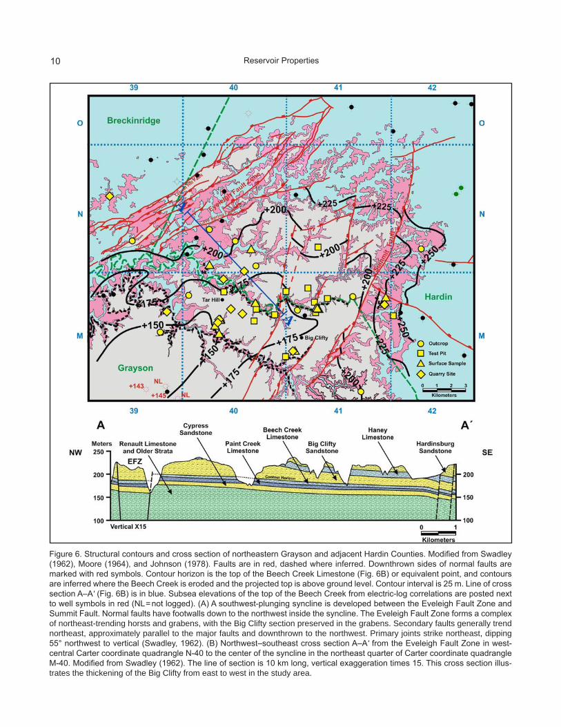
GeologySurface geology in the study area was mapped
at a scale of 1:24,000 by Swadley (1962), Moore (1964), and Johnson (1978). Only a limited set of
subsurface data is available for the area, however. Records are available from 29 wells drilled in the area (Fig. 5). Of these wells, 25 were drilled on or outside of the Big Clifty outcrops and provide no additional data. Only two of the wells drilled through the Big Clifty in Carter coordinate quad-rangle M-39 have geophysical electric logs of the interval. A southwest-plunging asymmetrical syn-cline is developed between the Eveleigh Fault Zone on the northwestern flank and the Summit Fault on the southeastern flank (Fig. 6A). Strata in the
Geology

7
syncline are cut by near-vertical northeast-trend-ing normal faults with hanging walls generally down to the northwest, and a complex of north-east-trending horsts and grabens inside the Eve-leigh Fault Zone (Fig. 6A, B). The Big Clifty is ex-posed west of the Locust Hill Fault, bounding the Eveleigh Fault Zone on the northwest, inside the Eveleigh Fault Zone, on the synclinal flanks, and southeast of the Summit Fault (Fig. 6A). Inside the syncline, the Big Clifty is exposed in valleys eroded by creeks (Fig. 6A, B). In the northeastern Grayson County area, thin shales at the base of the Big Clifty unconformably overlie the Beech Creek Limestone and, in turn, thin shales at the top of the Big Clifty section are unconformably overlain by the Haney Limestone (Swadley, 1962) (Figs. 2B, 6B). The Big Clifty is composed of fine- to medium-grained, silica-cemented quartzarenite (Fig. 7) with inter-bedded thin shales (Swadley, 1962) (Fig. 2B). The Big Clifty is thick-bedded, commonly crossbedded, and ranges from 18 to 33.5 m thick (Swadley, 1962) (Fig. 6B, 8). The Big Clifty is interpreted to have been deposited in rivers and river-mouth intertidal bars (see the discussion in Bowersox, in press).
Reservoir PropertiesRock and reservoir properties of the Big
Clifty tar sand in the northeastern Grayson County (Fig. 9) region were determined from analysis of surface samples of bituminous sandstones. Anal-ysis of samples taken during the 1920’s (Jillson, 1923, 1925, 1926b, c) measured weight-percent bi-tumen content (Table 2). The process for measur-ing weight-percent bitumen in rock-asphalt sam-ples by ignition is described in Crump (1913) and by solvent in Jillson (1923). Laboratory analysis of samples collected in 1963 by Kerr-McGee (Ta-ble 3) measured permeability (k, in millidarcys) and porosity (φ, in percent) before and after bitu-men extraction, then measured bitumen content (as oil saturation, So, as a percentage of the pore space) and water saturation (Sw, as a percentage of the pore space). Bulk volume of hydrocarbon, bitumen, and heavy oil in rock-asphalt samples (Soφ; e.g., So × φ) (Table 2) and weight-percent bi-tumen (Bw) content in the samples in which So and φ were measured (Table 3) can be calculated as dis-cussed in Bowersox (in press). One aspect of reser-voir properties of the western Kentucky tar sands
Table 2. Locations of surface samples of rock asphalt in northwestern Grayson County, with the thickness of the bitumen-saturated section at the sample sites and bitumen content analyses (Jillson, 1923, 1925, 1926a–c). Descriptive and mapped locations and elevations were verified as described in Table 1. Soɸ was calculated from weight-percent bitumen content as described in Bowersox (in press).
Sample CountyGeologic
Quadrangle Map
Latitude Longitude Elevation (m)
Height (m)
Bitumen (wt-%)
Soɸ (calculated)
G-4068 Grayson Big Clifty 37.563078 –86.087860 252 1.8 7.50 0.072G-4131 Grayson Big Clifty 37.552705 –86.219182 176 1.8 9.17 0.089G-4132 Grayson Big Clifty 37.552561 –86.219587 176 1.8 8.28 0.080G-4133 Grayson Big Clifty 37.548439 –86.223619 176 3.0 8.68 0.084G-4134 Grayson Big Clifty 37.548775 –86.223676 176 3.0 6.83 0.066G-4138 Grayson Big Clifty 37.563423 –86.191273 178 2.3 5.70 0.055G-4233 Grayson Big Clifty 37.550656 –86.222483 168 2.3 7.20 0.070G-4234 Grayson Big Clifty 37.550656 –86.222483 168 2.3 7.30 0.071G-4235 Grayson Big Clifty 37.550656 –86.222483 168 2.3 9.00 0.087G-4236 Grayson Big Clifty 37.550656 –86.222483 168 2.3 7.80 0.076G-4248 Grayson Big Clifty 37.559666 –86.140329 202 7.6 6.80 0.066G-4249 Grayson Big Clifty 37.560351 –86.142067 191 6.1 5.40 0.052G-4250 Grayson Big Clifty 37.560351 –86.142067 191 6.1 5.10 0.050G-4139 Hardin Big Clifty 37.588203 –86.228211 175 2.7 9.92 0.096G-4140 Hardin Big Clifty 37.598392 –86.195006 181 1.8 9.92 0.096
Average 3.2 7.64 0.074
Reservoir Properties
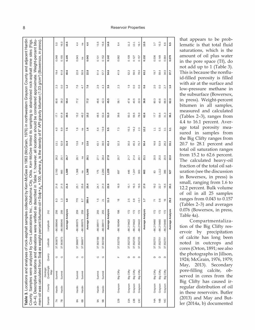
8Ta
ble
3. L
ocat
ions
and
ana
lyse
s of
rock
-asp
halt
sam
ples
col
lect
ed b
y K
err-
McG
ee in
196
3 (M
cGra
in, 1
976)
in n
orth
wes
tern
Gra
yson
Cou
nty
and
adja
cent
Har
din
Cou
nty.
Sam
ples
wer
e an
alyz
ed b
y C
ore
Labo
rato
ries
Inc.
, Okl
ahom
a C
ity, O
kla.
Ker
r-M
cGee
lim
ited
its s
ampl
ing
to a
band
oned
roc
k-as
phal
t min
e si
tes
(Fig
s.x3
–4).
Des
crip
tive
loca
tions
and
ele
vatio
ns w
ere
verifi
ed a
s de
scrib
ed in
Tab
le 1
; how
ever
, all
loca
tions
sho
uld
be c
onsi
dere
d ap
prox
imat
e. W
eigh
t-per
cent
bitu
-m
en-o
il w
as c
alcu
late
d fro
m S
oɸ a
s w
eigh
t-per
cent
bitu
men
-oil =
Soɸ
× ρ
B ×
100
, whe
re ρ
B is
the
dens
ity o
f 6° A
PI g
ravi
ty b
itum
en (1
.03
g/cm
3 ) (B
ower
sox,
in p
ress
).
Sam
ple
Cou
nty
Geo
logi
c Q
uadr
angl
e M
apQ
uarr
yLa
titud
eLo
ngitu
de(m
)
7AH
ardi
nS
umm
itG
37.5
6387
3–8
6.08
8046
256
8.3
21.6
2,19
328
.213
.14.
017
.180
.62.
319
.40.
048
5.0
7BH
ardi
nS
umm
itG
37.5
6387
3–8
6.08
8046
256
1.3
21.5
985
25.1
52.9
8.9
61.8
38.2
0.0
61.8
0.15
516
.0
Aver
age
Ana
lysi
s4.
821
.61,
589
26.7
31.9
7.5
39.5
59.4
1.2
40.6
0.10
510
.5
8AH
ardi
nS
umm
itG
37.5
6697
7–8
6.08
0575
259
770
25.1
1,36
828
.113
.61.
615
.277
.27.
622
.80.
043
4.4
8BH
ardi
nS
umm
itG
37.5
6697
7–8
6.08
0575
259
8.7
25.6
nana
nana
46.2
4.7
50.9
nana
Aver
age
Ana
lysi
s38
9.4
25.4
1,36
828
.113
.61.
615
.277
.27.
622
.80.
043
4.4
9AH
ardi
nS
umm
itG
37.5
6316
6–8
6.08
9111
255
1.5
24.1
175
27.1
43.1
5.4
48.5
48.6
2.9
51.4
0.13
113
.5
9BH
ardi
nS
umm
itG
37.5
6316
6–8
6.08
9111
255
2121
.02,
280
28.4
39.5
13.9
53.4
42.3
4.3
57.7
0.15
215
.6
Aver
age
Ana
lysi
s11
.322
.61,
228
27.8
41.4
9.5
51.0
45.5
3.6
54.6
0.14
214
.6
12B
Gra
yson
Big
Clif
tyF
37.5
3275
5–8
6.16
0494
198
1816
.969
720
.732
.37.
339
.658
.12.
341
.90.
082
8.4
13A
Gra
yson
Big
Clif
tyD
37.5
5272
5–8
6.21
9422
172
2.5
15.1
446
21.7
35.0
15.3
50.3
47.8
1.9
52.2
0.10
911
.2
13B
Gra
yson
Big
Clif
tyD
37.5
5272
5–8
6.21
9422
172
0.8
16.3
1,24
121
.445
.314
.259
.540
.50.
059
.50.
127
13.1
13C
Gra
yson
Big
Clif
tyD
37.5
5272
5–8
6.21
9422
172
< 0.
119
.530
320
.175
.72.
378
.022
.00.
078
.00.
157
16.1
Aver
age
Ana
lysi
s1.
717
.066
321
.150
.412
.262
.636
.80.
663
.20.
132
13.5
14A
Gra
yson
Big
Clif
tyD
37.5
5270
1–8
6.21
9480
172
7119
.283
20.5
16.6
1.1
17.7
80.3
2.0
19.7
0.03
63.
7
14B
Gra
yson
Big
Clif
tyD
37.5
5270
1–8
6.21
9480
172
0.6
22.7
1,11
225
.053
.95.
559
.440
.60.
059
.40.
149
15.3
14C
Gra
yson
Big
Clif
tyD
37.5
5270
1–8
6.21
9480
172
1618
.538
620
.528
.23.
131
.366
.02.
734
.00.
064
6.6
Aver
age
Ana
lysi
s29
.220
.152
722
.033
.13.
136
.162
.31.
637
.70.
079
8.5
that appears to be prob-lematic is that total fluid saturations, which is the amount of oil plus water in the pore space (Tf), do not add up to 1 (Table 3). This is because the nonflu-id-filled porosity is filled with air at the surface and low-pressure methane in the subsurface (Bowersox, in press). Weight-percent bi tumen in all samples, measured and calculated (Tables 2–3), ranges from 4.4 to 16.1 percent. Aver-age total porosity mea-sured in samples from the Big Clifty ranges from 20.7 to 28.1 percent and total oil saturation ranges from 15.2 to 62.6 percent. The calculated heavy-oil fraction of the total oil sat-uration (see the discussion in Bowersox, in press) is small, ranging from 1.6 to 12.2 percent. Bulk volume of oil in all 25 samples ranges from 0.043 to 0.157 (Tables 2–3) and averages 0.076 (Bowersox, in press, Table 4a).
Compartmentaliza-tion of the Big Clifty res-ervoir by precipitation of calcite has long been noted in outcrops and cores (Orton, 1891; see also the photographs in Jillson, 1924; McGrain, 1976, 1979; May, 2013). Secondary pore-filling calcite, ob-served in cores from the Big Clifty has caused ir-regular distribution of oil in these reservoirs. Butler (2013) and May and But-ler (2014a, b) documented
Reservoir Properties

9
Figure 5. Index of oil and gas wells drilled in the study area. KGS record number noted in purple. Of 30 wells drilled in the study area, four in southeast Carter coordinate quadrangle M-39 drilled through a complete section of the Big Clifty inside of its outcrop area, although logs of the interval were available for only two of these (Fig. 6).
compartmentalization of the Big Clifty reservoir from possible redox reactions precipitating calcite and pyrite, replacing quartz framework grains and primary quartz cement, to form intraformational seals. May and Butler (2014a) speculated on whether these diagenetic minerals precipitated from water migrating from the deeper basin or from post-ex-posure meteoric water. This diagenetic mineral suite, however, is a product of hydrocarbon migra-tion, discussed in Bowersox (in press), leading to a reducing geochemical environment in the reser-voir rocks (Bowersox, in press, and sources cited therein). A consequence of hydrocarbon-induced diagenesis is the irregular distribution of oil in the
reservoir rocks, as observed during the develop-ment of the western Kentucky tar-sand industry (Richardson, 1924; McGrain, 1976) and illustrated in historic photographs of mine and quarry walls (Jillson, 1924; Richardson, 1924) (Fig. 10A, B). Al-though the reducing geochemical environment has been preserved in the subsurface (Fig. 10C), uplift and exposure of the Big Clifty has moved it into a near-surface oxidizing meteoric environment close to the outcrop. Oxidizing conditions led to the development of an opal-CT, kaolinite, potassium feldspar, and plagioclase mineral suite. The lack of secondary calcite suggests dissolution in the
Reservoir Properties
10
Figure 6. Structural contours and cross section of northeastern Grayson and adjacent Hardin Counties. Modified from Swadley (1962), Moore (1964), and Johnson (1978). Faults are in red, dashed where inferred. Downthrown sides of normal faults are marked with red symbols. Contour horizon is the top of the Beech Creek Limestone (Fig. 6B) or equivalent point, and contours are inferred where the Beech Creek is eroded and the projected top is above ground level. Contour interval is 25 m. Line of cross section A–A' (Fig. 6B) is in blue. Subsea elevations of the top of the Beech Creek from electric-log correlations are posted next to well symbols in red (NL = not logged). (A) A southwest-plunging syncline is developed between the Eveleigh Fault Zone and Summit Fault. Normal faults have footwalls down to the northwest inside the syncline. The Eveleigh Fault Zone forms a complex of northeast-trending horsts and grabens, with the Big Clifty section preserved in the grabens. Secondary faults generally trend northeast, approximately parallel to the major faults and downthrown to the northwest. Primary joints strike northeast, dipping 55° northwest to vertical (Swadley, 1962). (B) Northwest–southeast cross section A–A' from the Eveleigh Fault Zone in west-central Carter coordinate quadrangle N-40 to the center of the syncline in the northeast quarter of Carter coordinate quadrangle M-40. Modified from Swadley (1962). The line of section is 10 km long, vertical exaggeration times 15. This cross section illus-trates the thickening of the Big Clifty from east to west in the study area.
Reservoir Properties

11
Figure 7. Sieve-analysis grain-size distributions of three samples from the Big Clifty (data from Jillson, 1926c; grain size in φ units) (Krumbein and Aberdeen, 1937). Sample sites are shown in Figure 4. Although the analysis used a limited number of sieves, the sample mean, either at 50 weight-percent or the graphic mean of Folk (1968), is 2.5 φ, fine sand.
Figure 8. A 12-m section of the Big Clifty Sandstone exposed in Big Clifty Creek, northeastern Grayson County, about 0.4 km downstream of the Il-linois Central Railroad trestle in the southwest quarter of the northwest quarter of Carter coordinate section 20-M-40. Photo modified from Butts (1917, Plate 22A). View is to the east. Crossbeds are visible throughout the section.
meteoric zone is contributing to secondary reservoir porosity (Bowersox, in press).
Reservoir Volume and Resources
This evaluation was com-pleted using Petra version 3.8.3 petroleum database and analy-sis software to calculate reser-voir volumetrics. The resource area evaluated is area 7 of Bow-ersox (in press). An isopach map of the net thickness of com-mercial oil and bitumen-satu-rated sand deposits in the Big Clifty was constructed (Fig. 11) and its reservoir volume cal-culated in Petra. Because the 29 wells drilled in the study area provided only very limited structural data (Fig. 6A), oil in place was calculated from reser-voir properties measured in the 35 mine and surface samples (Figs. 3–4, Tables 1–3). Net oil-saturated intervals in the res-ervoir sands, where available, were compiled by sample site into the Petra database. Consid-ering the limitations of relying on surface samples largely sat-urated with bitumen measured as weight-percent (Tables 1–2), oil in place was calculated with-out differentiating the small heavy-oil fraction from bitumen (Table 3). The total defined re-source area is 11,740 ha, aver-age reservoir height is 3.6 m,
Reservoir Volume and Resources

12
Figure 9. Roadcut on the Western Kentucky Parkway 4 km south of the town of Big Clifty at mile marker 115.2. This exposure is about 5 m high. (A) In this cut, resistant beds of gray Haney Limestone overlie yellow-weathered, crossbedded Big Clifty Sandstone. (B) An approximately 2-m-high section of clay-bounded, thin channels filled with light brown, unsorted crinoidal bio-sparite limestone is exposed at the base of the Big Clifty section exposed in the cut. For scale, the hammer is 34 cm long and the yellow oval on the handle is 3 cm long and 1 cm wide.
and average bulk volume of hydrocarbons is 0.076 (Bowersox, in press). Total oil in place is estimated to be 200.3 million barrels (Bowersox, in press), or about 17,060 barrels of oil per hectare.
Heavy-Oil and Bitumen Production in Grayson County
Rock-asphalt–bearing outcrops were de-scribed in early geologic reports of the northeast-ern Grayson County region (Orton, 1891; Eldridge, 1901; Bryant, 1914) and mapped in a later study by Jillson (1926a). The potential economic value of the heavy-oil and bitumen resources in the rock-asphalt deposits of northeastern Grayson County was first recognized in the early 1880’s by Charles F. Very, a geology professor from New Albany, Ind. (Bower-sox, 2016). Very began examining the deposits on the eastern margin of the Western Kentucky Coal Field in 1887 for William L. Breyfogle of Louisville (Weller, 1927), who subsequently acquired proper-ties in northeastern Grayson County, near the town
of Tar Hill, and incorporated the American Bitumi-nous Rock Co. (Fig. 3, location A) in 1888 (Bow-ersox, in press). American Bituminous Rock Co.’s mine began operations by early 1889 (Bowersox, in press), and produced 112 tons of rock asphalt, the first commercial rock asphalt from Kentucky, that year (Orton, 1891; Parker, 1892). Quarrying rock asphalt for road topping soon expanded through-out the rest of the tar-sand belt (Bowersox, 2016, and sources cited therein). In northeastern Gray-son and adjacent Hardin Counties, rock-asphalt development occurred in three periods: 1889–1904 near Tar Hill, 1923–40 near Tar Hill and near Big Clifty in Grayson County, and 1922–46 at Summit in adjacent Hardin County (Bowersox, 2016). Mi-nor amounts of petroleum products were refined from the Big Clifty rock asphalt before 1930, but production was insufficient to support commercial development (McCormack, 1925; Weller, 1927; Ha-gan, 1942).
Heavy-Oil and Bitumen Production in Grayson County

13
Figure 10. Evidence for diagenesis during oil migration into the Big Clifty Sandstone. (A) Entrance to a Federal Asphalt Co. mine adit in Flutter Creek, Grayson County (1903) showing a thick section of bitumen-saturated Big Clifty sandstone in the mine face above the miners and in the waste-rock piles in the foreground. Compartmentalization of the Big Clifty oil reservoir is visible as light-colored streaks and areas in the waste rock pile to the right of the miners. Photo is from Municipal Engineering (1903, p. 301). (B) Interior of one of the Federal Asphalt Co.’s abandoned mines in Flutter Creek (about 1923). Compartmentalization of the Big Clifty oil reservoir is visible in the tunnel face on the right where dark-colored, bitumen-saturated sandstone has in-terbeds of light-colored, calcite-cemented sandstone. The overlying light-colored rock shows thin layers of bitumen-saturated sandstones in an otherwise barren section of calcite-cemented sandstone. Photo from Jillson (1924, Plate 25C). (C) Section of Big Clifty core from Megawest corehole 102 Clark, Warren County, at 158.5–158.7 m. White layers and streaks in this core are intervals of sandstone with reservoir-compartmentalizing calcite cement (white) and brown to black oil-saturated intervals. Calcite was precipitated in a reducing geochemical environment during migration of oil into the reservoir (Bowersox, in press, and sources cited therein).
DiscussionMany resource assessments were undertaken
in the early 20th century to determine the value of individual rock-asphalt deposits for quarrying as road-topping material. Jillson (1923, 1925, 1926a–c) mapped the locations of coreholes and outcrops of rock asphalt in northeastern Grayson County
and adjacent Hardin County in Carter coordinate quadrangle N-40, as well as the locations of operat-ing and former rock-asphalt quarries. Jillson (1923, 1925, 1926a–c) also collected and analyzed the bitu-men content in 15 samples (Figs. 3–4, Tables 1–2). Additional sampling at three abandoned mine and quarry sites, supplementing the earlier work, was
Discussion
C

14
Figure 11. Isopach thickness of the net oil- and bitumen-saturated interval in the Big Clifty constructed from descriptions of ore-body thicknesses in the rock-asphalt mines, quarries, and sections present at surface sample sites (Tables 1–2). As outlined on the map, this is resource area 7 of Bowersox (in press). Because ore thicknesses reported at mines and sample sites are for only the ore with the minimum commercial bitumen content of 7 to 7.25 weight-percent (Richardson, 1924; Jillson, 1925), and bitumen-saturated sections as much as 9 m thick are known (Jillson, 1925), for the purposes of this evaluation, maximum inferred net reservoir thickness is conservatively estimated as slightly more than 5 m.
conducted by Kerr-McGee in 1963 (unpublished data; see McGrain, 1976) (Fig. 4, Table 3). Together, these mapping and sampling efforts define three rock-asphalt resource areas: (1) between Meeting and Clifty Creeks northwest of the Summit Fault in Grayson County, (2) a less well-defined area north of Meeting Creek and southeast of the Eve-leigh Fault Zone, and (3) the small fault-bounded outcrop area at Summit in Hardin County (Figs. 4, 11). All of the commercial rock-asphalt mining was conducted inside these areas (Fig. 3) where access
to the rock-asphalt deposits was possible in creek valleys and canyons with relatively gently slop-ing walls (Jillson, 1923). Lateral access to the Big Clifty rock-asphalt deposits in creek walls avoided the substantial effort and expense of underground mining or large-scale open-pit mining, which would otherwise have been necessary for quarry-ing through 12 to 30 m of Hardinsburg Sandstone and Haney Limestone overburden (Fig. 6B). Al-though the Big Clifty in this area may reach thick-nesses of 24 to 27 m, bitumen-saturated intervals
Discussion

15
occur in lenses 1 to 9 m thick (Jillson, 1923, 1925, 1926b). Commercial rock-asphalt deposits, with 7.0 to 7.5 weight-percent bitumen content, range from 1.5 to 4.9 m thick (Jillson, 1923, 1925, 1926b). Thick-nesses of lean rock-asphalt deposits with subcom-mercial bitumen content are generally not reported in the literature (see Jillson, 1923). Net thicknesses of commercial rock-asphalt deposits therefore understate the total saturated intervals and total heavy-oil and bitumen resources in the Big Clifty. Thus, the resources in the northeastern Grayson County area presented in Bowersox (in press) are conservative.
Additional Resources Southwest of Clifty Creek
Jillson (1926a) mapped outcrops of rock as-phalt in the Big Clifty Sandstone along the south-western wall of Clifty Creek, downstream of the southeastern walls of Rough River and Peter Cave Creek (Fig. 11), suggesting substantial rock-as-phalt deposits southwest of Clifty Creek. Jillson’s mapping has not been field checked as part of this study and it is notable that neither Swadley (1962) nor Johnson (1978) mapped rock-asphalt outcrops in the Big Clifty other than on a tributary of Beaver Dam Creek in east-central Carter coordinate quad-rangle M-39 (Fig. 11). Swadley (1962) did not map rock-asphalt outcrops anywhere in the Big Clifty quadrangle, however, even adjacent to historic rock-asphalt mines or where rock-asphalt outcrops were mapped and sampled by Jillson (1923, 1925, 1926a–c) or sampled by Kerr-McGee (McGrain, 1976) (Table 3). Lack of subsequent verification of Jillson’s (1926a) mapping is problematic. Any ex-posure of rock asphalt in the south wall of Clifty Creek will be difficult to verify, however, because of steep walls along the creek and limited access at three road crossings along Clifty Creek.
One limited rock-asphalt prospect pit in the Hardinsburg Sandstone was opened southwest of Clifty Creek in the early 1890’s by Schillinger Brothers, a Toledo, Ohio, paving contractor, at a location in northeast Carter coordinate quadran-gle M-39 (Fig. 3, location B). Eldridge (1901, p. 252) provided the only description of the rock asphalt in the Schillinger Brothers pit:
The sandstone in which bitumen is found has a thickness of 8 feet, but only 3 feet is sufficiently
rich to be worked. The sandstone differs from that in which bitumen is found at the Breyfogle quarry in being fine grained and thin bedded.
Commercial development never followed (El-dridge, 1901), and Schillinger Brothers ceased operations and left Kentucky by 1893 (Bowersox, 2016). Likely, the problems with developing any Big Clifty rock-asphalt deposit southwest of Clifty Creek were the greater overburden thickness, in excess of 20 m (Swadley, 1962), requiring expen-sive underground mining for development, and remoteness from rail transport. Although over-burden thicknesses northeast of Clifty Creek are comparable (Jillson, 1925) (Fig. 6B), extensive topo-graphic dissection by creeks there (Swadley, 1962) made for comparatively easier access for commer-cial development in open pits and underground mines.
Assuming that Jillson’s (1926a) map is accu-rate, the Big Clifty rock-asphalt outcrops mapped along the synclinal axis in Clifty Creek, west-cen-tral Carter coordinate quadrangle M-40 (Fig. 11) lie at subsea structural elevations of slightly less than +150 to +185 m (Fig. 6A). The most western exposures, mapped by Jillson (1926a) on the south-eastern bank of Peter Cave Creek in west-central Carter coordinate quadrangle M-39 (Fig. 11), lie at +170 to about +180 m subsea structural elevation. The Barron Kidd 1 Argile Willis well (KGS record number 9062, Fig. 5), drilled in southeastern Carter coordinate quadrangle M-39 about 3 km south of the nearest rock-asphalt outcrop on Beaver Dam Creek, penetrated a 14.3-m section of the Big Clifty at +162 m subsea elevation, as recorded on the well’s geophysical electric log, below 54 m of over-burden and 3 m downdip of the nearest rock-as-phalt outcrop (Figs. 6A, 11). The driller’s log of this well has no oil show in the Big Clifty, thus no discernible oil-water contact in the Big Clifty (Bow-ersox, in press). Hence, the Barron Kidd 1 Argile Willis well may have coincidentally penetrated the Big Clifty at a location where compartmental-ization excluded oil emplacement, which Jillson (1923, 1925, 1926b) also observed while describing outcrops to the north. The prospective area shown in Figure 12, limited to the area inside of a line con-necting the outcrops along the southwestern wall of Clifty Creek and Beaver Dam Creek, is 3,900 ha. Assuming an average 1.8 m of bitumen-saturated
Discussion

16
Figure 12. Jillson (1926a) mapped Big Clifty rock-asphalt outcrops along the southwest wall of Clifty Creek and southeast wall of Beaver Dam Creek from southwest Carter coordinate quadrangle M-41 to northwest Carter coordinate quadrangle M-39. Jillson (1926a) did not map rock asphalt in the walls of Barton Run in west-central Carter coordinate quadrangle M-40, however, suggesting that he had reached the limit of what he was able to access. In southeast Carter coordinate quadrangle M-41, the Barron Kidd No. 1 Argile Willis well did not encounter hydrocarbons (labeled “NS,” no show) while drilling through the Big Clifty. Thus, the evaluation area southwest of Clifty Creek was limited by bounding the southern side by a straight line connecting the limits of the Big Clifty rock-asphalt deposits mapped in southwest Carter coordinate quadrangle M-41 to the rock-asphalt outcrop mapped in west-central Carter coordinate quadrangle M-39, or approximately halfway between the rock-asphalt outcrops and the Barron Kidd No. 1 Argile Willis well. The resulting prospective area is 3,900 ha.
rock asphalt in this area, half of the average thick-ness evaluated in area 7 in Bowersox (in press) (Fig. 11) and a 7 weight-percent commercial bitu-men content, oil in place in the prospective area is 29.6 million barrels, or about 7,600 barrels of bitu-men per hectare.
Developing Heavy Oil and Bitumen in the Big Clifty Sandstone
The only commercial development of any of the western Kentucky tar sands was the rock-as-phalt industry from 1889 to 1957 (Bowersox, 2016, in press). Although the shallow depth to the Big Clifty below overburden in the northeastern Gray-
Discussion

17
son County area does not preclude enhanced oil re-covery, projects at comparable depths were tested in the Caseyville Formation in Edmonson County, the Gulf Oil Co. fireflood (Terwilliger, 1976) and Pi-lot Oil project at Kyrock (May, 2013), and oil recov-eries were insufficient to support commercial de-velopment. Heavy-oil and bitumen deposits in the Big Clifty are generally thin and have variable res-ervoir continuity (Bowersox, in press), precluding an effective project design for enhanced oil recov-ery. Oil extraction from the Big Clifty by retorting (heating in a furnace) the rock asphalt was tested in the Grayson County area before 1930 (McCor-mack, 1925; Weller, 1927; Hagan, 1942), and small noncommercial volumes were recovered. Larger- scale pilot projects for bitumen recovery from the Big Clifty in surface mines have been tested in Lo-gan County (Groves and Hastings, 1983; Kelley and Fedde, 1985; Bartlett, 2014; Bowersox, in press) without demonstrable commercial success. Al-though the northeastern Grayson County area and Logan County tar-sand deposits are comparable, the thicker overburden in the Grayson County area may discourage surface mining and bitumen-ex-traction development.
Legacy of the Rock-Asphalt Industry in the Northeastern Grayson County Area
During the historic period of rock-asphalt production, mine-site reclamation and surface re-contouring were not required, as is mandated by current regulations. Consequently, even though the last active quarry in the northeastern Gray-son County area closed in 1940, scars of mine and quarry operations are still evident. Figure 13A–C shows LiDAR (light detection and ranging; an aerial pulsed-laser method for imaging the earth’s surface) imaging, served by KGS’s Kentucky Geo-logic Map Information Service (kgs.uky.edu/ kgsmap/kgsgeoserver/viewer.asp) for rock-as-phalt mines and quarry sites near Tar Hill, Big Clifty, and at Summit. Pits and mine-spoil piles are visible (Fig. 13A, B) as well as areas that have been filled (Fig. 13C). A reasonable environmental concern would be surface and groundwater con-tamination by hydrocarbons leaching from the mined areas and spoil piles. Rock asphalt in west-ern Kentucky has been exposed at the surface since the Late Cretaceous (Cenomanian) (Bowersox, in
press) and any mobile hydrocarbons should have long since been degraded. What remains are solid to semisolid bitumen in rock-asphalt outcrops and sparse natural seeps of heavy oil. Kasulavada (2013) measured the leaching of hydrocarbons from Caseyville Formation rock-asphalt mine spoil in Edmonson County. He tested leaching in six samples of synthetic rainwater with a pH range of 3 to 9 and found that hydrocarbons were leached only by very acidic water with a pH of 3. Natural rainwater in western Kentucky has a higher pH of about 5.5 (Merideth, 2009). Thus, although the un-reclaimed mine and quarry sites may be unsightly where not covered by vegetation, it is unlikely that hydrocarbons are being leached from the mine and quarry sites and mine-spoil piles in the northeast-ern Grayson County area and contaminating sur-face- or groundwater resources.
ConclusionsRock asphalt was produced from the Big Clifty
Sandstone for about 57 yr in northeastern Grayson County and adjacent Hardin County (Bowersox, 2016). Although Jillson (1923, 1925, 1926b, c) con-ducted resource assessments throughout the area, describing substantial rock-asphalt deposits and estimating their commercial values, development centered on sites in Flutter Creek Canyon, at Big Clifty, and at Summit. Later assessments by Ball (1951), Ball and Associates (1965), Lewin and Asso-ciates Inc. (1984a, b), and Noger (1984, 1987) over-looked the northeastern Grayson County area.
1. Historical rock-asphalt production in northeastern Grayson County was from the area between Clifty Creek and Meet-ing Creek and between the Summit Fault and Eveleigh Fault Zone, as well as the area around Summit in adjacent Hardin County. Bowersox (in press) summarized the heavy-oil and bitumen resources of the Big Clifty Sandstone in this area and esti-mated 200.3 million barrels of oil in place.
2. Jillson (1926a) mapped outcrops of rock asphalt in the Big Clifty Sandstone along the southwestern wall of Clifty Creek. Rock asphalt was never commercially pro-duced from this 3,900-ha area, and wells drilled here encountered no oil shows in the Big Clifty. Despite these limitations,
Conclusions

18
Figure 13. Surface impact of rock-asphalt mining in the north-eastern Grayson County area. Three areas of surface disturbance are evident on the 5-ft-resolution LiDAR image of Flutter Creek, about 1.5 km south of Tar Hill, served by KGS’s Geologic Map Information Service (kgs.uky.edu/kgsmap/ kgsgeoserver/viewer.asp). (A) The American Bitumi-nous Rock Co. mined rock asphalt in Flutter Creek from 1889 to 1895; then its mines were reopened and operated by Federal Asphalt Co. from 1901 to 1904 (Bowersox, 2016, and sources cited therein). Mine adits are visible as six to eight black spots above a ledge along the canyon wall. United Rock Asphalt Co. quarried rock asphalt in Flutter Creek across from the Federal Asphalt Co. mine from about 1927 to 1930 (Bower-sox, 2016). The mine-spoil pile is visible in the southwestern cor-ner of the box. Continental Rock Asphalt Co. briefly quarried rock asphalt from the Big Clifty at three pits in Flutter Creek from 1923 to 1924 (Bowersox, 2016), transport-ing the material to Big Clifty for milling and shipment. (B) After the failure of Continental Rock Asphalt Co. in 1924, Crown Rock Asphalt Co., acquired the mill at Big Clifty and commenced quarrying rock asphalt on a nearby tributary of the Sugar Branch of Clifty Creek, about 1.4 km to the southwest (Bowersox, 2016). Crown oper-ated the mill and quarry sporad-ically from 1925 to its closure in 1940. (C) Ohio Valley Rock As-phalt Co. operated a quarry and mill in Summit, Hardin County, from 1922 to 1940 (Bowersox, 2016). Its pit and mill were adja-cent to the southeast side of the Illinois Central Railway tracks in Summit, providing for easy trans-port of rock asphalt from its pit to its mill, then from the mill directly into rail cars (Bowersox, 2016). Although this was an effective production process, the surface impact at Summit was substantial. The company closed its Summit operations in 1940 and moved them to Black Rock, Grayson County, before ceasing business operations in 1946 (Ball, 1951; Havens and Williams, 1956).
Conclusions

19
the prospective area is estimated to hold 29.6 million barrels of heavy-oil and bitu-men resources in place in the Big Clifty. Access to these resources would require stripping more than 50 m of overburden or underground mining, however.
3. Although the shallow depths to the Big Clifty resources does not preclude en-hanced oil recovery, no commercial pro-cess has been demonstrated to date. Like-wise, no commercial bitumen extraction has been demonstrated to date.
4. The rock-asphalt industry in the northeast-ern Grayson County area left substantial surface damage and rock-asphalt mine-spoil piles that are still visible, especially at Summit, more than 70 yr later. A study of rock-asphalt mine spoil using synthetic rainwater showed no leaking hydrocar-bons at a pH above 3.5 (Kasulavada, 2013); thus, these legacy issues should not pose a serious groundwater or surface-water contamination threat in the area.
References CitedBall, M.W., 1951, The synthetic liquid fuel poten-
tial of Kentucky, oil impregnated strippable deposits: New York, Ford, Davis and Bacon Inc., 347 p.
Ball and Associates Ltd., 1965, Surface and shallow oil-impregnated rocks and shallow oil fields in the United States: U.S. Bureau of Mines Monograph 12, 375 p.
Bartlett, G., 2014, Oil recovery technology–Oil sands development [abs.]: 2014 Eastern Unconven-tional Oil & Gas Symposium, Lexington, Ky., www.euogs.org/ proceedings/2014/0019-bartlett-dani-euogs2014.pdf, 2 p. [accessed 09/18/2015].
Bowersox, J.R., 2014a, Evaluation of western Ken-tucky’s heavy oil and bitumen resources [abs.]: 2014 Eastern Unconventional Oil & Gas Sym-posium, Lexington, Ky., www. euogs.org/proceedings/2014/034-bowersox- euogs2014.pdf, 5 p. [accessed 02/27/2015].
Bowersox, J.R., 2014b, Evaluation of western Ken-tucky’s heavy oil and bitumen resources [slides]: 2014 Eastern Unconventional Oil & Gas Symposium, Lexington, Ky., www.
euogs.org/proceedings/2014/034-bowersox- euogs2014ppt.pdf [accessed 02/27/2015].
Bowersox, J.R., 2016, Rocks, roads, and ruin: A his-tory of western Kentucky’s rock-asphalt in-dustry, 1888–1957: Kentucky Geological Sur-vey, ser. 12, Information Circular 33.
Bowersox, J.R., in press, Heavy oil and bitumen resources of the western Kentucky tar sands: Kentucky Geological Survey, ser. 12, Report of Investigations 36.
Bryant, J.O., 1914, The economic geology of a por-tion of Edmonson and Grayson Counties: Kentucky Geological Survey, ser. 4, v. 2, pt. 1, p. 155–218.
Butler, K.H., 2013, Diagenetic compartmentaliza-tion of a Late Mississippian reservoir in War-ren and Butler Counties, KY [abs.]: Geological Society of America, Abstracts with Programs, v. 45, no. 7, p. 174.
Butts, C., 1917, Descriptions and correlation of the Mississippian formations of western Ken-tucky: Kentucky Geological Survey, ser. 5, Re-port 4, No. 4, 119 p.
Crump, M.H., 1913, Kentucky rock asphalt: Ken-tucky Geological Survey, ser. 4, v. 1, pt. 2, p. 1053–1065.
Eldridge, G.H., 1901, The asphalt and bituminous rock deposits of the United States: U.S. Geo-logical Survey Annual Report 22, pt. 1, p. 209–452.
Folk, R.L., 1968, Petrology of sedimentary rocks: Austin, Texas, Hemphhill’s, 170 p.
Groves, K.O., and Hastings, L., 1983, The Tarco process: For the surface extraction of tar sands: Synthetic Fuels from Oil Shale and Tar Sands: Symposium No. 3, p. 579–594.
Hagan, W.W., 1942, Geology of the Cub Run quad-rangle, Kentucky: Urbana, University of Illi-nois, doctoral thesis, 242 p.
Havens, J.H., and Williams, E.G., 1956, Report No. 2: A study of the properties and perfor-mance of Kentucky (natural sandstone) rock asphalt: Kentucky Transportation Center Re-search Reports, Paper 1250, 56 p., uknowledge.uky.edu/ktc_researchreports/1250 [accessed 10/20/2014].
Jillson, W.R., 1923, Report of geologic reconnais-sance, state of Kentucky, county of Grayson and Hardin, waters of Big Clifty and Big Meet-
References Cited

20
ing Creek: Property examined owned by Con-tinental Rock Asphalt Co.: Report prepared for Continental Rock Asphalt Co., Big Clifty, Ky.: Dated Oct. 13, 1923: Frankfort, Ky., Willard Rouse Jillson, 21 p., kgs.uky.edu/ kgsweb/ olops/pub/kgs/ JillsonTarSandsReport15.pdf [accessed 01/30/2014].
Jillson, W.R., 1924, Kentucky rock asphalt: Pan-American Geologist, v. 41, p. 251–258.
Jillson, W.R., 1925, Report of geologic reconnais-sance, state of Kentucky, county of Grayson and Hardin, waters of Green River: Property examined owned by W.H. Giltner, Trustees, Louisville, Kentucky: Report prepared for Curtis C. Webb, 1505 Rosewood Ave., and William Crawford, Intersouthern Bldg., Lou-isville: Dated Dec. 24, 1925: Frankfort, Ky., Willard Rouse Jillson, 19 p., kgs.uky.edu/ kgsweb/olops/pub/kgs/JillsonTarSands Report04.pdf [accessed 02/10/2014].
Jillson, W.R., 1926a, Map of Grayson County show-ing approximate distribution of bituminous sandstone outcrops, fault pattern, and oil and gas wells: Kentucky Geological Survey, ser. 6, scale 1 in. = 1 mi.
Jillson, W.R., 1926b, Report of geologic reconnais-sance, state of Kentucky, county of Grayson and Logan, waters of Ohio and Green Rivers: Property examined owned by United Rock Asphalt Company, Republic Building, Lou-isville, Ky.: Report prepared for United Rock Asphalt Company, E.J. Bigley, P.O.B. 54, Al-toona, Pa.: Dated March 13, 1926: Frankfort, Ky., Willard Rouse Jillson, 12 p., kgs.uky.edu/ kgsweb/olops/pub/kgs/JillsonTarSands Report07.pdf [accessed 02/04/2014].
Jillson, W.R., 1926c, Report of geologic reconnais-sance, state of Kentucky, county of Grayson, waters of Big Meeting Creek: Property exam-ined owned by A.A. Hulette, Frankfort, Ky.: Report prepared for A.A. Hulette: Dated April 15, 1926: Frankfort, Ky., Willard Rouse Jillson, 3 p., kgs.uky.edu/kgsweb/olops/pub/kgs/ JillsonTarSandsReport13.pdf [accessed 03/09/ 2015].
Jillson, W.R., 1927, The topography of Kentucky: Kentucky Geological Survey, ser. 6, v. 30, p. 1–60.
Johnson, W.D., Jr., 1978, Geologic map of the Ma-drid quadrangle, western Kentucky: U.S. Geological Survey Geologic Quadrangle Map GQ-1482, scale 1:24,000.
Kasulavada, S.K., 2013, Analysis of Kyrock for leaching of impurities in synthetic rainwater: Bowling Green, Western Kentucky Univer-sity, master’s thesis, 46 p., digitalcommons.wku.edu/theses/1276 [accessed 01/21/2016].
Kelley, M.N., and Fedde, P.A., 1985, The Kentucky tar sand project: Bitumen recovery by solvent extraction: Proceedings of the American Pe-troleum Institute Conference on Refining, American Petroleum Institute, Refining De-partment, New Orleans, La., 14 May 1984, v. 63, 5 p.
Krumbein, W.C., and Aberdeen, E., 1937, The sed-iments of Barataria Bay: Journal of Sedimen-tary Petrology, v. 7, p. 3–7.
Lewin and Associates Inc., 1982, Letter from Lewin and Associates to Martin C. Noger, Ken-tucky Geological Survey, February 1, 1982: Kentucky Geological Survey, Open-File Re-port OF-15-01, [15 p.], kgs.uky.edu/kgsweb/ olops/pub/kgs/OFR%2015-01.pdf [accessed 03/09/2015].
Lewin and Associates Inc., 1984a, Major tar sand and heavy oil deposits of the United States, in Kuuskraa, V.A., and Hammershaimb, E.C., eds., Major tar sand and heavy oil deposits of the United States: Interstate Oil Compact Commission, p. 1–7.
Lewin and Associates Inc., 1984b, Kentucky, in Kuuskraa, V.A., and Hammershaimb, E.C., eds., Major tar sand and heavy oil deposits of the United States: Interstate Oil Compact Commission, p. 85–116.
May, M.T., 2013, Oil-saturated Mississippian–Pennsylvanian sandstones of south-central Kentucky, in Hein, F.J., Leckie, D., Larter, S., and Sutre, J.R., eds., Heavy-oil and oil-sand petroleum systems in Alberta and beyond: American Association of Petroleum Geolo-gists Studies in Geology 64, p. 373–405.
May, M.T., and Butler, K.H., 2014a, Diagenetic partitioning in near-surface unconventional oil trends in south central Kentucky: Eastern Unconventional Oil & Gas Symposium 2014,
References Cited

21
Lexington, Ky., Nov. 5–7, 2014, Abstract 35, p. 40.
May, M.T., and Butler, K.H., 2014b, Diagenetic partitioning in near-surface unconventional oil trends in south central Kentucky: Eastern Unconventional Oil & Gas Symposium, Lex-ington, Ky., Nov. 5–7, 2014, www.euogs.org/ proceedings/2014/035-may-euogs2014ppt.pdf [accessed 02/27/2015].
McCormack, C.P., 1925, The Kentucky rock as-phalts—Their character and utilization: Na-tional Petroleum News, v. 17, no. 6, p. 41–42.
McGrain, P., 1976, Tar sands (rock asphalt) of Ken-tucky—A review: Kentucky Geological Sur-vey, ser. 10, Report of Investigations 19, 16 p.
McGrain, P., 1979, Bitumen-impregnated Carbon-iferous sandstones along the southeastern rim of the Illinois Basin, in Palmer, J.E., and Dutcher, R.R., eds., Depositional and struc-tural history of the Pennsylvanian System of the Illinois Basin, Part 2, Invited papers: Ninth International Congress of Carboniferous Ge-ology and Stratigraphy, Field Trip No. 9, p. 62–65.
Merideth, J., 2009, Vadose zone hydrology near the vicinity of Edna’s Dome, Mammoth Cave, Kentucky: Bowling Green, Western Kentucky University, master’s thesis, 46 p., digitalcommons.wku.edu/theses/65 [accessed 01/21/2016].
Moore, F.B., 1964, Geology of the Summit quadran-gle, Kentucky: U.S. Geological Survey Geo-logic Quadrangle Map GQ-298, scale 1:24,000.
Municipal Engineering, 1903, Pavement and roads: v. 24, no. 4, p. 301–305.
Noger, M.C., 1984, Tar-sand resources of western Kentucky: Proceedings, 1984 Eastern Oil Shale Symposium, University of Kentucky Institute for Mining and Minerals Research, p. 151–178.
Noger, M.C., 1987, Tar-sand exploration in Ken-tucky, in Meyer, R.F., ed., Exploration for heavy crude oil and natural bitumen: Amer-ican Association of Petroleum Geologists Studies in Geology 25, p. 521–536.
Orton, E., 1891, Report on the occurrence of petro-leum, natural gas and asphalt rock in western Kentucky, based on examinations made in 1888 and 1889: Kentucky Geological Survey, ser. 2, v. E, 233 p.
Parker, E.W., 1892, Asphaltum, in Day, D.T., Report of the mineral industries of the United States at the eleventh census: 1890: U.S. Department of the Interior, Census Office, p. 581–587.
Richardson, C.H., 1924, Road materials of Ken-tucky: Kentucky Geological Survey, ser. 6, v. 22, 209 p.
Russell, W.L., 1932, Geology of the oil and gas fields of western Kentucky: American Asso-ciation of Petroleum Geologists Bulletin, v. 16, p. 231–254.
Russell, W.L., 1933, The origin of the asphalt de-posits of western Kentucky: Economic Geol-ogy, v. 28, p. 571–586.
Swadley, W C, 1962, Geology of the Big Clifty quadrangle, Kentucky: U.S. Geological Sur-vey Geologic Quadrangle Map GQ-192, scale 1:24,000.
Swezey, C.S., 2009, Regional stratigraphy and pe-troleum systems of the Illinois Basin, U.S.A.: U.S. Geological Survey Scientific Investiga-tions Map 3068, 1 sheet.
Terwilliger, P.L., 1976, Fireflooding shallow tar sands—A case history: Journal of Canadian Petroleum Technology, v. 15, no. 4, p. 41–48.
Weller, J.M., 1927, The geology of Edmonson County, Kentucky: Kentucky Geological Sur-vey, ser. 6, v. 28, 248 p.
Williams, D.A., Noger, M.C., and Gooding, P.J., 1982, Investigation of subsurface tar-sand de-posits in western Kentucky: A preliminary study of the Big Clifty Sandstone Member of the Golconda Formation (Mississippian) in Butler County and parts of Edmonson, Gray-son, Logan, and Warren Counties: Kentucky Geological Survey, ser. 11, Information Circu-lar 7, 25 p.
References Cited