hec ras…… step by step floods
TRANSCRIPT

Session: Flood Hazard
Assessment Methodologies
Dr Eleni A. Tzanou
HEC RAS…... step by step

Session: Flood Hazard
Assessment Methodologies
• HEC-RAS has been developed for the U.S. Army Corps
of Engineers.
• Download from
http://www.hec.usace.army.mil/software/hec-
ras/downloads.aspx and follow installation instructions

Session: Flood Hazard
Assessment Methodologies
Hydraulic Analysis
• HEC-RAS performs one-dimensional hydraulic calculations for a full network of natural and constructed channels
Capabilities of HEC-RAS:
• Hydraulic Analysis
• Data Storage and Management
• Graphics and Reporting
• RAS Mapper
• HEC-RAS 4.1(among others…new Mapper
and Sediment Transport Model)
This software is free, widely used and scientifically accepted
Large documentation on its use and technical background

Session: Flood Hazard
Assessment Methodologies
HEC-RAS. How to…..
Structure of HEC-RAS
• Creates and saves project files(.prj file)
Each project includes:
1. Unit system (SI/US customary)
2. Geometry (XS, bridges, weirs, etc.) (.g file)
3. Flow Data (steady, unsteady) (.f file)
4. Plan data(combination of flow/geometry to use for the analysis) (.p file)
Many files of geometry flow and plan data can be created!!!!!!!

Session: Flood Hazard
Assessment Methodologies
• Main HEC-RAS Window….start from scratch
• Set Unit System (can be done later too)
08/12/2015
All main functions
are accessed
from this menu

Session: Flood Hazard
Assessment Methodologies
How to Create and Save a New Project (.prj) (can always
be done later on too). Go to File and select New Project.
08/12/2015
Set folder and project title
IMPORTANT: Set units now if not already done!!!!

Session: Flood Hazard
Assessment Methodologies
How to create and work with Geometry Files (.g)
All geometric data and edits are inserted here and must be
SAVED….
08/12/2015
Click to open geometric
data editor window
Geometric
data
window

Session: Flood Hazard
Assessment Methodologies
• The first thing in geometry is to create a reach (…one
or more intersecting reaches)
\
08/12/2015
Click to create a reach
from upstream to down
stream!!!!!!!
Double click to finish
Then insert river and reach
name and click ok

Session: Flood Hazard
Assessment Methodologies
Dealing with geometry and Cross Sections
• Cross sections define the channel geometry
• Cross sections are defined by Station(x) and Elevation (y)
• Cross sections (among other parameters) define the channel slope
• Overbank stations differentiate channel and floodplain characteristics
• Manning n coefficients define resistance to flow
• Expansion and contraction coefficients define energy losses
associated with velocity head changes between cross sections
• Ineffective flow areas can store but not convey water downstream
• Obstruction areas block flow completely
• Levee elevations confine flow to channel until the levees are
overtopped
08/12/2015

Session: Flood Hazard
Assessment Methodologies
• Cross Section data input.
08/12/2015
Click here and
….. Add a new cross
section

Session: Flood Hazard
Assessment Methodologies 08/12/2015
Cross-sectional data are
set from left to right
looking downstream
X and Y of every
point of the cross
section
Distance to next
downstream cross section
Manning
values
Contraction/Expansion
coefficients
Don’t forget to click on Apply Data
for your XS to appear!

Session: Flood Hazard
Assessment Methodologies
• Follow the same steps to create all cross cross sections.
• The geometry in rivers (not culverts) is not uniform so one needs to
define all cross sections’ characteristics every time manually. If
uniform geometry occurs though (i.e. structured channels, culverts)
cross sections can be copied.
Once a cross section is defined
all the options become
available.
When finished exit cross section
Editor and save geometry data.
08/12/2015
This is how the geometry data
looks with many cross sections
added

Session: Flood Hazard
Assessment Methodologies
Image files can be inserted only as background (but already
georeferenced!!) in HEC-RAS so as to overcome the problem of
coordinates (the software does not “accept” or recognize coordinates as a
geographic or spatial feature.
Insert
picture
Add image file,
check image file
and close
If the image is not
visible set image
computed extends
from schematic plot
extend in view menu
Cross sections may be also
added through a .csv file format

Session: Flood Hazard
Assessment Methodologies
CREATE GEOMETRY
• Or….import the ΧS geometry exported from QGIS.
• Or…. use Plugin QGIS2RAS • Or….csv file (see format in HEC-RAS manual)
Session: Flood Hazard
Assessment Methodologies
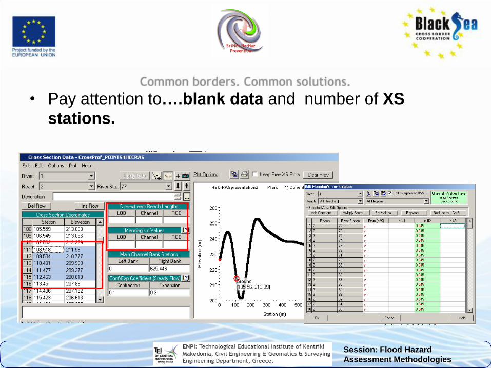
• Pay attention to….blank data and number of XS
stations.

Session: Flood Hazard
Assessment Methodologies
• Check geometry and save the correct file

Session: Flood Hazard
Assessment Methodologies
How to work with Flow data
• Flow data are the .f files
• HEC-RAS can compute the following:
Steady flow (constant with time)
Unsteady flow(varies with time)
Quasi-unsteady flow
• Regimes(supercritical, subcritical, mixed)
Boundary conditions:
1. Supercritical-upstream
2. Subcritical-downstream
3. Mixed-both

Session: Flood Hazard
Assessment Methodologies
FLOW DATA
• Flow data is obtained from appropriate precipitation data
collection for each region and the creation of a Unit Hydrograph.
• Flow measurement data
• Rainfall Intensity Duration Frequency Curves,
• STEEL equation,
• Peak Stormwater Runoff Rate Equations
• In our case …
10y 50y 100y
Flow Discharge (m3/s) 64.50 117.46 240.85
Sediment Discharge(m3/s) 14.15 25.77 52.84

Session: Flood Hazard
Assessment Methodologies
Click here to open the steady flow data menu
1.Set the number of profiles…for different flow rates
2.Set the flow
rate…. watch
the units
3.Click on the
apply data
button

Session: Flood Hazard
Assessment Methodologies
Decide on and set the boundary conditions…assume if no
other way the condition of flow upstream or downstream
Save the flow
Data, (the first
time use the
“save as”
option
From the
main HEC-
RAS menu a
plan may by
saved…but
not necessary.

Session: Flood Hazard
Assessment Methodologies
• Following the last steps unsteady and quasi-steady data
can be created and saved.
• Now all the necessary parameters have been created for
a successful run.
Click on this button to perform the analysis-simulation for
steady flow.

Session: Flood Hazard
Assessment Methodologies 08/12/2015
On the Analysis menu different .g files, flow rates and regimes may be
chosen. Once they are set click Compute to run the simulation
If computations are successful
the following window appears,
otherwise…
Errors and problems’
reports appear in this area
and everything should be
corrected… then run the
simulation again
Congrats ,
you did it!

Session: Flood Hazard
Assessment Methodologies
This is how the simulation results appear in cross sections,
profile plots and tables.

Session: Flood Hazard
Assessment Methodologies
• To map flood extends or to export floodplain results table
data (top width of flow) has to be copied in a text editor
or .xls file.
• The top width of flow has to
be related to the first station
of the cross section. That is
easy to do from geometry
data.
By clicking on the
water surface line
the distance from
the first station is
given.

Session: Flood Hazard
Assessment Methodologies
• Finally, we need to save the project file
we have been working on….and continue
in QGIS for floodplain mapping.

Session: Flood Hazard
Assessment Methodologies
• How to Export HEC-RAS to QGIS

Session: Flood Hazard
Assessment Methodologies
• The .sdf file is for ArcGIS
only….but contains all
information needed !!!
(open with notepad)

Session: Flood Hazard
Assessment Methodologies
• Prepare a .csv or .txt file and import to QGIS

Session: Flood Hazard
Assessment Methodologies
• RAS Mapper

Session: Flood Hazard
Assessment Methodologies
Create a .rasmap file and import it to RAS Mapper

Session: Flood Hazard
Assessment Methodologies
…import .shp in QGIS….

Session: Flood Hazard
Assessment Methodologies
Create depth contours in GGIS

Session: Flood Hazard
Assessment Methodologies
Alternative method to create results in QGIS
• Another way to create results…
• Copy as image the XYZ Perspective Plot from HEC-RAS save it as png, or another image format.
• In QGIS go to Raster Georeferencer and georeference the image.
• Import the image and use the tools to georeference by matching the cross sections of the image to the ones created and extracted at the beginning of the process from QGIS.
• More time-consuming method that needs to add elevation data for each point…but it works too.

Session: Flood Hazard
Assessment Methodologies
Thank you!
Acknowledgments:
The research was partially funded by the EU within the context of the
Black Sea Basin Joint Operational Programme 2007-2013 and
partially by National funds