help dialogue - maps and apps
TRANSCRIPT


Help Dialogue
Welcome to the Vanderburgh County Assessor’s Web Map! This website is a very useful resource for searching and research on properties within Vanderburgh County, Indiana. This help dialogue will cover the various tools and functions that a user can complete

Table of Contents
Website Layout ...................................................................................................................................... 3
Website Tools ........................................................................................................................................ 4
Tools – Quick Look .............................................................................................................................. 4
Navigation Tools ................................................................................................................................. 6
Tools – In-depth Look ......................................................................................................................... 7
Find a Location ................................................................................................................................ 7
Search and Identify ......................................................................................................................... 9
Legend .......................................................................................................................................... 15
Driving Directions ......................................................................................................................... 18
Elevation Profiles .......................................................................................................................... 22
Google Street View ....................................................................................................................... 24
Draw and Measure ....................................................................................................................... 25
Favorites ....................................................................................................................................... 26
Contact Us .................................................................................................................................... 27
Print/Export Map .......................................................................................................................... 28

Website Layout
Upon the website loading, a number of tools become available to the user. At the top of the screen
there is a Title Bar, and two hyperlinks for users to load the Help Dialogue and also load the Maps
and Apps website. Also, when tools are closed, they are stored here to better assist the user. The
right side of the website loads the Toolbox for the website. These tools can be opened by simply
clicking on their icons. In the top-left corner, the Basemap tool allows the user to change the
basemap, and slide between basemaps. Also, in the same corner is where the user can find all of
the navigation tools which can be used to interact with the map. At the bottom of the website, a
dynamic scale and overview map are provided for additional spatial assistance. Also at the bottom
of the screen is the Search Results tab bar.

Tools – Quick Look
Find a Location o This tool can be used to locate an
address, intersection, or Decimal Degree Coordinate location on the map.
Search and Identify o This tool can be used to search certain
map layers and identify the some features on the map.
Legend o This tool allows the user to turn map
layers on and off.
Driving Directions o This tool allows users to get driving
directions between locations. Users can add up to 10 locations.
Elevation Profiles o This tool allows users to see the “lay-
of-the-land” profile along a user-drawn line segment.
Google Street View o This tool allows users to drop the
Street View icon and load Google Street View images of the location.
Draw and Measure o This tool allows users to draw dynamic
shapes and take their measurements.
Favorites o This tool allows users to save their
current view of the map locally.

Contact Us
o This is a simple tool which allows the user to send a comment or question to the
appropriate department based on the premise of their inquiry.
Print / Export Map
o This tool allows users to export the map with or without map elements to an Alive
PDF which can be saved or printed.
The Toolbox also has controls so the user can move the tools into view, and also hide the tools
when needed.
Navigation Tools
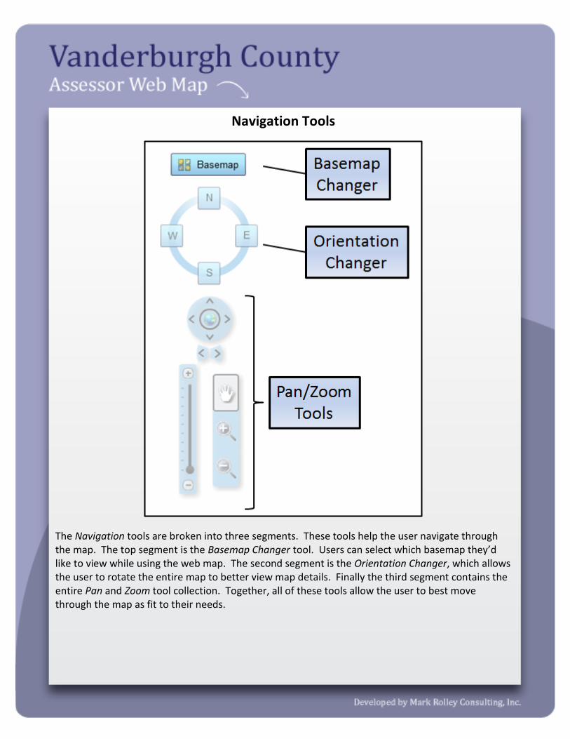
The Navigation tools are broken into three segments. These tools help the user navigate through the map. The top segment is the Basemap Changer tool. Users can select which basemap they’d like to view while using the web map. The second segment is the Orientation Changer, which allows the user to rotate the entire map to better view map details. Finally the third segment contains the entire Pan and Zoom tool collection. Together, all of these tools allow the user to best move through the map as fit to their needs.
Tools – In-depth Look
Find a Location
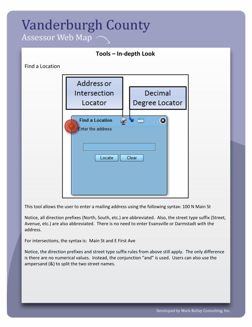
This tool allows the user to enter a mailing address using the following syntax: 100 N Main St
Notice, all direction prefixes (North, South, etc.) are abbreviated. Also, the street type suffix (Street, Avenue, etc.) are also abbreviated. There is no need to enter Evansville or Darmstadt with the address.
For intersections, the syntax is: Main St and E First Ave
Notice, the direction prefixes and street type suffix rules from above still apply. The only difference is there are no numerical values. Instead, the conjunction “and” is used. Users can also use the ampersand (&) to split the two street names.

The Decimal Degree Locator can be used to enter Decimal Degree X and Y values and find a location.
When a location is found, it will appear in the results. The closest an input location matches the actual name of the location will result in a higher score. For addresses, if a search result has a Zip Code as well as the input address, then the location is not exact. Locations with Zip Codes are determined by using an algebraic equation. Locations without Zip Codes are centered on an individual property (more accurate).
Search and Identify
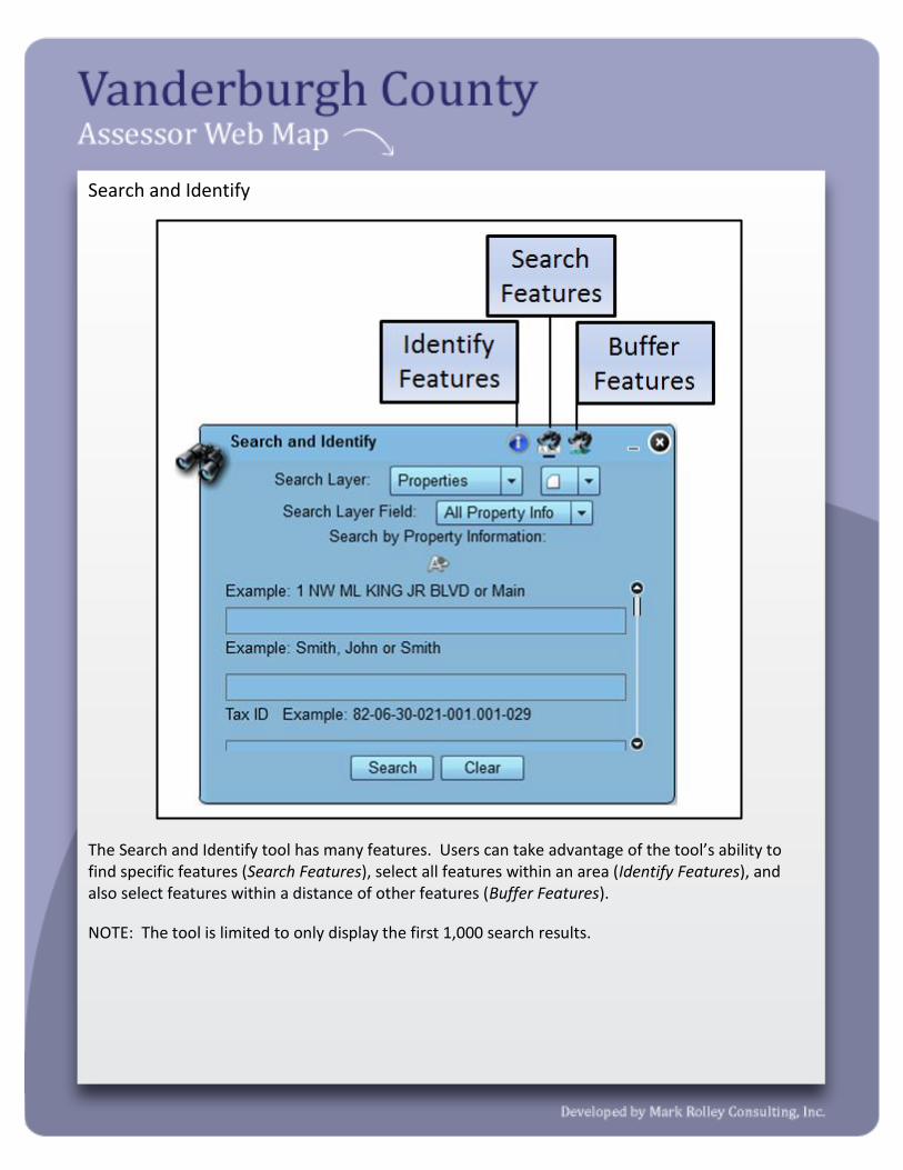
The Search and Identify tool has many features. Users can take advantage of the tool’s ability to find specific features (Search Features), select all features within an area (Identify Features), and also select features within a distance of other features (Buffer Features).
NOTE: The tool is limited to only display the first 1,000 search results.

The Search Features part of the tool allows users to search three different Search Layers; Properties, Neighborhood Associations, or Inspector Zones. Each Search Layer has their own Layer Fields that users can search against.

The Autocomplete Tool gives the user the option to search for valid addresses and owner names. The tool is recommended when users are look for a specific address or owner. The tool will ensure that the user has supplied the correct syntax when searching these values.

The Identify Features part of the tool allows the user to select features on the map, simply by drawing a shape. The user simply selects the Search Layer that they would like to identify, the Selection Tool shape they want to use, and then draw on the map where they want to identify. Other settings of the Identify Features include a multi-part graphic search. This allows a user to draw multiple shapes on the map and then search the features. Also, users can add a search tolerance or buffer to a point selection. The Buffer Settings can be configured to create a custom graphic for the buffer. Also, the user can select to include a text query which will take the value from the Search Features section of the tool and include it with the identify tool. For example, if a user wants to only search Property Owners with “Smith” in the name, and then only find possible results within 1 mile of a specific place on the map, then they would type in Smith on the Search Features part of the tool (not selecting an autocomplete value), then on the identify Features part of the tool, select the point tool, check “Add search tolerance”, select buffer graphic, edit the Buffer Settings to read 1 mile, then click on the map.

The Buffer Features part of the tool allows the user to add a buffer around their search results, and search features that share a spatial relationship with the buffer. For example, if the user searched for Neighborhood 801, and wanted to know all of the properties within the 1 mile of the zone, they could add the 1 mile buffer to that neighborhood and select all Properties within the buffer.
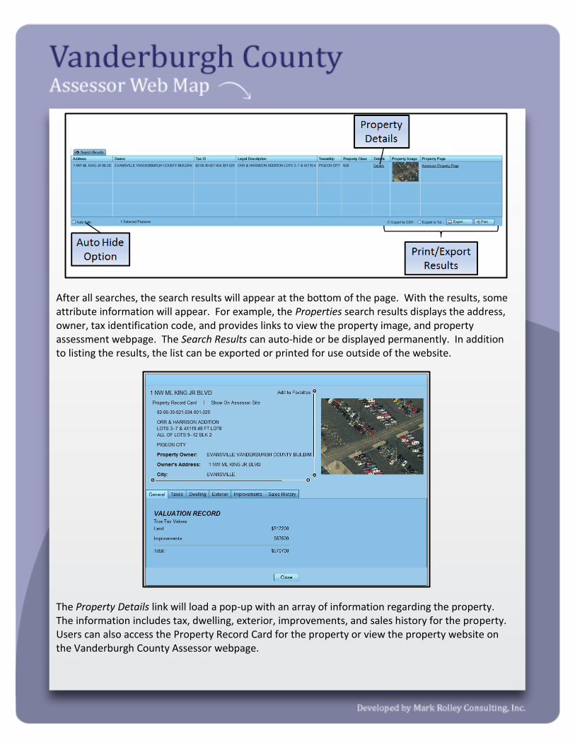
After all searches, the search results will appear at the bottom of the page. With the results, some attribute information will appear. For example, the Properties search results displays the address, owner, tax identification code, and provides links to view the property image, and property assessment webpage. The Search Results can auto-hide or be displayed permanently. In addition to listing the results, the list can be exported or printed for use outside of the website.
The Property Details link will load a pop-up with an array of information regarding the property. The information includes tax, dwelling, exterior, improvements, and sales history for the property. Users can also access the Property Record Card for the property or view the property website on the Vanderburgh County Assessor webpage.

Legend
This tool gives the users the ability to turn map layers on and off. The tool displays both the legend and table of contents for the application. The user can simply turn a layer on an off by toggling the Layer On/Off Switch. There are two switches, one for Layer Groups (in bold letters), and one for individual layers.

Each Layer Group has a drop down options menu. Users can use this menu to set layer transparency, drawing order, collapse/expand all individual layers in the group, and also view the online ArcGIS REST Endpoint page. The ArcGIS REST Endpoint page contains metadata for the Layer Group.

Some Layers when turned on, such as the Assessment or Sales Layers, have custom pop-up screens to display information. For example, above the Assessment layer is turned on and a property was clicked on. The pop-up window then displays the Assessment information for the property. This is a great way to alternatively see the information.

Driving Directions
This tool gives users the ability to find and export driving directions. The tool allows up to 10 (ten) input locations. To add a location, the user simply clicks the Add Stop button, and an additional Address Entry will be displayed. The user can also Add Barriers which will force the route calculation to avoid certain places on the map.

The toolset for locating, editing, and deleting locations is on the right side of the tool. The Search Buttons need to be clicked to locate an input address. Users can type in an address or intersection using the following syntax: 100 N Main St (address) or Main St and E First Ave (intersection). The Location Order can be changed, by simply clicking in the address field of the location, then using the Location Order buttons to rearrange the list. The user can also pick the location by using the Pick Locations from Map buttons. This will add a location to the list wherever the user clicks within Vanderburgh County. Finally, a user can remove or delete a location by clicking the Clear Location button.

The Route Tools and Route Calculation Settings give the user more functionality when identifying a route. Within the Route Tools the user can Add Stops, Add Barriers, and Reset or clear the current route. The Route Calculation Settings allows the user to specify what type of calculation (Time or Distance). Also, users can have the route be rearranged to so that the best sequence is used from and to each location. Users can also have the route bring them back to their original location.
The route above was created by typing in the address, 1 NW MLK JR BLVD in the Address 1 field, and the second address was selected by clicking on the map.

The Driving Directions tab of the tool allows the user to visually see each direction of the route. Users can simply click on the numbered direction, and the website will zoom to that route segment, and highlight the segment as the user would drive it.
The Print/Export tab of the tool allows the users to export the directions to a PDF and either save them locally or print them off on a personal printer. The directions can contain a map showing the route, and all turn-by-turn directions.

Elevation Profiles
This tool allows users to get a topographic profile of the surface. Simply by selecting a Drawing Tool and drawing the line on the map, the surface profile is captured and displayed.
The output window then shows the topographic surface profile along the drawn line. The values are exaggerated on the graph to emphasize the changes in elevation above sea level.

The user can also drag their mouse cursor over the output window and see exactly on the map where that elevation value exists.

Google Street View
This tool allows the user to add the Google Street View icon on the map and see the current Google Street View of that location.
When the icon is added to the map the Google Street View loads at the bottom of the screen. To remove the Google Street View, the user can simply minimize or close the tool in the toolbar on the right side of the screen.

Draw and Measure
This tool allows the user to make more elaborate measurements and graphics on the map. The tool contains an array of Drawing Tools which the user can select. The Drawing Settings allow the user to modify the graphics color and appearance. The Measurement Settings are an option for all of the drawings, and allow the user to obtain certain measurements of their graphics in respect to the map.
The tool also allows users to Save Graphics and Open Graphics that have been drawn on the website. The Save Graphics option will save all drawn graphics as a text file, which can be stored locally and even sent via email to someone else. The Open Graphics part of the tool allows the user to navigate to a saved graphics text file, and open it on their screen. This is a very useful way of sharing information with others such as markups.
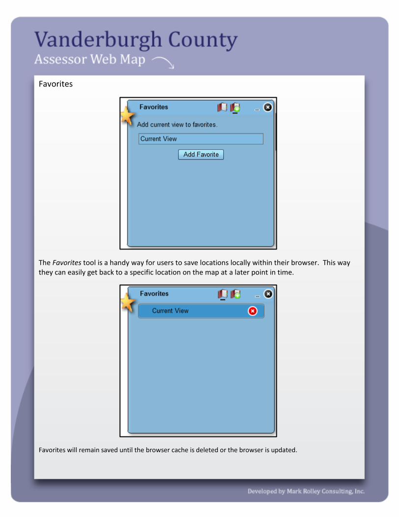
Favorites
The Favorites tool is a handy way for users to save locations locally within their browser. This way they can easily get back to a specific location on the map at a later point in time.
Favorites will remain saved until the browser cache is deleted or the browser is updated.

Contact Us
This tool is a great resource for contacting the appropriate department regarding a question or
comment a user has about the website. The contact form requires a valid email address to be able
to contact the appropriate department.

Print / Export Map
This tool allows users to export and/or print the current map on their screen. The user can specify a Title, Author, Copyright, Layout, File Format, and Scale of map to be printed. The tool creates an online PDF which the user then chooses to save locally or print.