heywood strategic directions - glenelg.vic.gov.au · 26 heywood heywood has a complete range of...
TRANSCRIPT

26
Heywood
Heywood has a complete range of commercial and community facilities, including health, education, community and employment uses that provide the foundation for its ongoing development and growth. For this reason it is an attractive location for a wide range of demographic groups, from young families to mature aged residents.
Two highways and two railway corridors intersect at the northern end of Heywood, which makes the settlement ideal for the location of a major freight transfer terminal and storage facility.
It is well located to capitalise on employment generated from the timber industry being proximate to plantations within the green triangle region.
The designation of a major industry corridor between Portland and Heywood and to the immediate north of Heywood, as identified in the Industrial Land Use Plan (ILUP), provides significant opportunities for the industrial development associated with the processing of materials which require excellent road and/or rail infrastructure and proximity to the port of Portland. The
current availability of the 24 hour fuel depot in Heywood is important in this regard.
The proximity of Heywood to the Fitzroy River is a major feature of the town. The floodplain of the River does affect the northern end of Heywood, including the northern end of the commercial centre, sports playing fields and facilities on the north side of the river and residential zoned land to the north and east of the Heywood commercial strip along Edgar Street. Flood controls will need to be introduced into the scheme in consultation with the Glenelg Hopkins Catchment Management Authority to help address this issue.
Active frontages for commercial premises need to be maintained to Edgar Street and help contribute to the appearance and safety of the public realm. This is truly a vibrant main street and a hub for community activity which will continue to be a feature of the town.
Existing flood affected low density residential zoned land to the east of the Heywood Township could be supplemented with rural living opportunities further to the south; however, any provision of reticulated
sewerage would also require the provision of a pumping station by Wannon Water.
Infill residential development should be encouraged within walking and cycling distance of the Heywood Consolidated School and the Heywood and District Secondary College. Opportunities for expanding the Township Zone are available to the west of the Heywood District Memorial Hospital and might be required if future development within the industrial corridor contributes to the growth of the Township. New uses and development should not be allowed to undermine that area’s growth potential.
Heywood Town Centre
Strategic Directions

27
Strategic Directions
The development of two residential corridors, to the south of Barclay Street; and west of Beavis Street is proposed.
Extension of the range of residential opportunities by providing new areas for rural living at the periphery of the town is proposed.
Development of industrial corridors based on the existing industrial areas and along the Henty Highway and Portland- Maroona Railway line is to be encouraged. Continued promotion of the Heywood-Mount Gambier railway and the investigation of areas for rural freight and modal interchange is proposed.
The Special Use Zone formerly intended for the Heywood Pulp Mill located to the north east should be reviewed in the light of other proposals for timber industry related project at this site to deliver employment opportunities for Heywood.
A flood study of the Fitzroy River and Sunday Creek is to be undertaken in consultation with the Glenelg Hopkins Catchment Management Authority in order to update flooding information and to help inform the application of flood controls under the scheme.
Connectivity is to be improved between schools, medical and community facilities, the commercial centre, residential areas and recreation nodes.
Infill development is to be promoted within walking distance of schools, the hospital and other facilities and be supported by pedestrian links that include utilising the Fitzroy River, reserves and extensions of existing pedestrian pathways.
The Department of Sustainability and Environment is to be consulted on proposed new uses and development, including pedestrian and cycling paths and trails, adjacent to public land and the Fitzroy River in order to ensure minimal impact on the river and associated public land.
Heywood KindergartenRiver Project Sign in Heywood

28
The establishment of a freight storage and transfer facility should be encouraged in proximity to the confluence of the two highways and two railway corridors provided that any flood prone land is avoided.
Existing flood information (based on LIDAR re-modelling of the Flood Data Transfer Project) must be taken into account in the consideration of new uses and development until a new flood study of the Fitzroy River and Sunday Creek has been undertaken.
Rural living opportunities should be made available south of Barclay Street East and Mt Clay Road to supplement existing low density residential areas, especially the flood affected lots to the north of Mt Clay Road.
Heavier industries are to be located in the outer industrial zones and highway and rail corridors and should be supported by the provision of a reliable power supply. There is capability for a range of business activities to increase turnover as a result of growth within the timber industry.
Heywood Hotel Fitzroy River, Heywood

29
Heywood
Fitzroy River
Sund
ay C
reek
Hen
ty H
wy
Hent
y H
wy
Henty H
wy
Princes Hwy
Pardingtons Rd
Bond
St
Pardingtons Rd
Legend
HeywoodÊ ResidentialÊ 1Ê Zone
ProposedÊ IndustrialÊ 1Ê Zone
ProposedÊ IndustrialÊ 3Ê Zone
PotentialÊ Floodway
ProposedÊ RuralÊ LivingÊ Zone
HEYWOODGLENELGÊ PLANNINGÊ SCHEME
Promote further infill residential development within walking distance of Primary School and Heywood District Hospital. Investigate for Residential use
See Glenelg Municipal Strategic Framework Map for Portland - Heywood Industrial Corridor
Investigate use of Henty Hwy and Princes Hwy and potential significance of the Mt Gambier to Heywood rail link, to provide a freight storage and transfer facility for wood chips, mineral sands, grain and other resources
Proposed rezoning to Industrial 1 Zone to acknowledge existing heavy industrial use and adequate access
Proposed rezoning to Industrial 1 Zone to acknowledge existing heavy industrial use and adequate access
Proposed future wood pellet production mill
Acknowledge extent of potential inundation areas through new flood study in consultation with GHCMA
In association with future development approvals extend pedestrian pathways within residential areas
Promote connections of recreation and pedestrian links between Heywood District Secondary College, Primary School, Heywood District Hospital and along the Fitzroy River and Sunday Creek
study in consultation with GHCMA
Examine the proposed rezoning of this area to Rural Living Zone 1 to 2 hectares
Investigate rezoning of this area to Industrial 3 Zone
Princes Hwy
area to Rural Living Zone 1 to 2 hectares
Please note this plan serves to illustrate the broad strategic issues of the area depicted, and does not represent zoning or overlay information. For zone and overlay information see the Glenelg Planning Scheme mapping.
NN

30
Casterton
Casterton has a rich heritage and is renowned as the birthplace of the kelpie. A major cultural festival has been developed around this theme. The township contains significant heritage fabric and the surrounding district provides many reminders of the western district’s rich squatting history. These elements provide tourism opportunities that could help broaden the area’s economic base.
The composition of land use within the town of Casterton, like Heywood provides a complete range of commercial, community
and recreational facilities that are well in excess of those which may be expected within a town of this size. This has major benefits for existing residents as they mature, and for future new members of the community. Like many older established towns, it has an active local community that is keenly involved in the ongoing maintenance and improvement of its facilities. This is evident in the comprehensive range of health, education and recreation facilities, many of which have been achieved and maintained by active community involvement.
Casterton Town Centre
Strategic Directions
Ess Lagoon and artwork

31
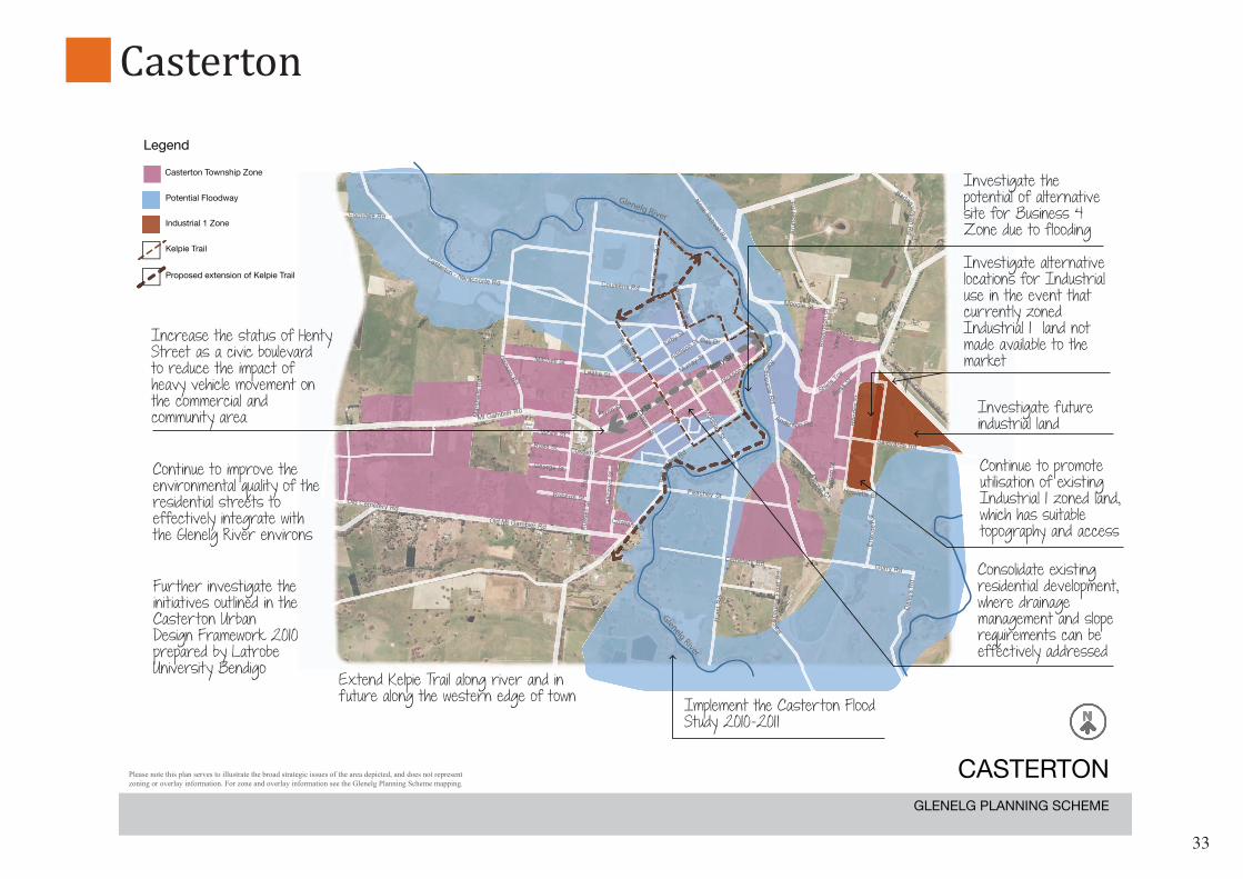
Industrial activity and growth is to be encouraged within Casterton’s industrial areas, and priority given to the investigation of alternative locations for industrial use in the town, in the event that the currently zoned Industrial 1 is not available to the market. An alternative industrial area is also to be investigated, for future use if required.
Improvement in the comfort, quality and cultural value of the commercial and civic areas of the town centre is to continue to be achieved.
Improved connectivity is to be achieved between the town centre, residential areas, recreation areas and the Glenelg River.
Improved currency of flood overlays is to be achieved taking into account any new studies, changes in land use patterns and any altered rainfall patterns and intensities as consequences of climate change. The Casterton Flood Study 2010-2011 and any subsequent new flood studies will be applied to the review of existing flood overlays in consultation with the Glenelg Hopkins Catchment Management Authority.
The Glenelg and Wannon Rivers provide a very attractive natural setting; however their associated floodplains also affect much of the township and constrain the direction of any future expansion of the current 15 hectares of useable vacant industrial land to the east of the saleyards.
Casterton has a livestock exchange which is integral to the agricultural industry within the surrounding area. It also has the Shire’s only racecourse, which is an important recreation asset that supports rural activity with the Shire.
Strategic Directions
Encouragement of infill and greenfield development on elevated land to the west of the township not affected by the flood plain of the Glenelg River is proposed to encourage increased sustainability in the use of infrastructure and promote pedestrian access.
The Development Plan Overlay will be retained over undeveloped residential land to the west of the township in order to encourage the orderly planning of the area;
Casterton Kelpie Festival

32
Further work should be undertaken to support the initiatives outlined in the Casterton Urban Design Framework 2010, including improvements to paths and trails along the Glenelg River and improved connectivity between the river, recreation areas, town centre and residential areas.
Improvements to paths and trails should only be undertaken in consultation with the Department of Sustainability and Environment to help ensure minimal impact on the Glenelg River and associated public land.
Investigation in the future of an alternative route that could be developed would allow heavy vehicles to by-pass the town centre in order to facilitate the improvement of Henty Street as a civic boulevard. Because this may require a new crossing of the Wannon and Glenelg Rivers it is a long term initiative.
Taking direction from the Green Triangle Freight Action Plan, continue to promote the movement of heavy vehicles for freight and timber products along routes away from the Casterton township.
Casterton Town Centre
Casterton’s 2011 Kelpie FestivalCasterton Railway Station Casterton Livestock Exchange
33
Glenelg River
Glenelg River
Henty St
Henty St
Legend
CastertonÊ TownshipÊ Zone
PotentialÊ Floodway
IndustrialÊ 1Ê Zone
KelpieÊ Trail
ProposedÊ extensionÊ ofÊ KelpieÊ Trail
CASTERTONGLENELGÊ PLANNINGÊ SCHEME
Implement the Casterton Flood Study 2010-2011
Consolidate existing residential development, where drainage management and slope requirements can be effectively addressed
Extend Kelpie Trail along river and in future along the western edge of town
Further investigate the initiatives outlined in the Casterton Urban Design Framework 2010 prepared by Latrobe University Bendigo
Continue to improve the environmental quality of the residential streets to effectively integrate with the Glenelg River environs
Increase the status of Henty Street as a civic boulevard to reduce the impact of heavy vehicle movement on the commercial and community area
Continue to promote utilisation of existing Industrial 1 zoned land, which has suitable topography and access
Investigate future industrial land
Investigate the potential of alternative site for Business 4 Zone due to flooding
Investigate alternative locations for Industrial use in the event that currently zoned Industrial 1 land not made available to the market
Please note this plan serves to illustrate the broad strategic issues of the area depicted, and does not represent zoning or overlay information. For zone and overlay information see the Glenelg Planning Scheme mapping.
NN
Casterton

34
Settlements:
The small settlements within Glenelg Shire are extremely important. Each is highly unique, occupying a diverse range of physical settings, on spectacular coastline, in picturesque countryside or enriched by heritage and cultural assets. They are characteristically small in population, which promotes a more socially cohesive, and self-sustaining community. The foundations of the community are well established, and some have already been recognized as a focus for tourist and recreational use.
While each settlements has some existing facilities and infrastructure, they have the capacity to achieve higher levels of sustainability and self sufficiency. Because of the proximity of these attractive settlements to the larger townships of Glenelg, existing and future residents have enormous potential to access the major economic resources of Portland and Casterton, such as educational and medical, other commercial and community uses. They are also able to build a more resilient locally based economy that provides an expanded range of tourist and recreation services, and increased local employment.
With the anticipated continued growth of Portland, Hamilton and Mount Gambier there will be increased desirability in choosing to live in these more unique settings, with increased attention being given to meeting the needs of local and regional tourism, particularly during weekend and holiday periods.
Creating a New Strategic Future
Cape Bridgewater Wind Turbines

35
To attract residents who could have located within Portland for example, increased opportunities for home-based enterprises, community operated facilities, and tourist facilities are required. Cape Bridgewater and Nelson are examples of settlements which have tourist orientated uses that can be attractive to locals.
To encourage and promote more innovative and sustainable forms of living, strategic planning policies seek to streamline and reduce the scope of planning controls, and activate potential development initiatives.
This Strategy provides the opportunity to create a strong ethos and spirit within these settlements that challenges the current paradigms on service delivery and resource use. In effect, the intention is not to follow the urban development pathway of existing larger townships but rather address the needs and aspirations of each of these communities in a completely different way.
Community consultation with the residents of each settlements, has confirmed that while there is some consistency in the challenges such as providing access to employment, and maintaining critical mass for the supply of convenience shopping and community needs, there are also quite specific and diverse needs for each. This Strategy seeks to build upon and promote these differences, which will of itself be a factor in attracting new residents.
As in most forms of rural settlement, residents are attracted by a more relaxed and affordable lifestyle. It is important to provide the widest possible range of allotment size and accommodation options.
Princess Margaret Rose CavesNelson General Store