high grade cobalt carlow castle project - karratha
TRANSCRIPT
1 | P a g e
Artemis Resources Limited ARBN: 80 107 051 749 Level 3, IBM Building, 1060 Hay Street, West Perth, WA Australia, 6006 PO Box R933 Royal Exchange NSW Australia, 1225 Phone: +61 2 9078 7670 Facsimile: +61 2 9078 7661 Email: [email protected] Website: artemisresources.com.au
Directors: Executive Chairman David Lenigas Executive Directors Ed Mead Alex Duncan-Kemp Non-Executive Directors George Frangeskides Campbell Baird
Company Secretary: Guy Robertson
Corporate Information ASX Code: ARV
ASX / Media Announcement 13 February 2017
HIGH GRADE COBALT CARLOW CASTLE PROJECT - KARRATHA, WESTERN AUSTRALIA.
High grade Cobalt grades above 1% identified in primary sulphide ore at
Carlow Castle Copper/Gold Project near Karratha.
Drill hole GC04 intersected 4 metres at 33.6g/t gold and 1.12% Cobalt from 36 metre downhole (Figure 1).
Drill hole DDH4 intersected 3.2 metres at 2.1% Copper and 0.54% Cobalt from 78m downhole (Figure 1).
Up to 5.88% cobalt and 4.2% copper recorded from historic underground mining at the Quod Est Mine.
Quod Est Mine at Carlow Castle waste dump samples from mine workings taken in 1967 averaged 3.22% copper, 0.4% cobalt and 4.1 g/t gold.
Strong correlation between gold, copper and cobalt mineralisation.
Cobalite and Erythrite minerals identified in historical mining operations.
Carlow Castle lodes were mined from 1880 to 1910.
The Radio Hill sulphide processing facility is 20km by public roads.
The current Carlow Castle JORC resource of 418Kt @ 3 g/t gold and 0.6% copper also contains cobalt. The cobalt has not been incorporated into the resource.
The Carlow Castle resource remains open in all directions.
David Lenigas, Artemis’s Chairman, commented; “The Carlow Castle area holds significant potential for primary Cobalt mineralisation associated with high grades of Copper and Gold. Previous mining and exploration efforts in the area were primarily focused on gold and copper with only cursory historic efforts made to understand the area’s significant Cobalt potential. Recent work by Artemis has identified cobalt mineralisation in strong association with copper and gold with Cobalt grades from shallow drilling recording above 1% cobalt, and assays recording up to 5.88% from the Quod Est mine ore. We believe that Cobalt, Copper and Gold now need to be considered on an integrated basis at Carlow Castle and Artemis is now undertaking a complete re-evaluation of this very exciting 100% owned project. Cobalt is a key component in the growing EV and energy storage market with 97% of global production being a by-product of nickel and copper production. The battery industry uses approximately 46% of global production with the balance used in diverse industrial and military applications. Analysts predict increasing demand and supply shortages will see the cobalt price move beyond the current $39,000 per tonne.”

2 | P a g e
Artemis Resources Limited (“Artemis” or “the Company”) (ASX: ARVDA) is pleased to report a review of it’s 100% owned Carlow Castle Project 10km South east of Roebourne in the Pilbara Region of Western Australia (Figure 2), has identified significant cobalt mineralisation that has not previously been reported.
The cobalt mineralisation at Carlow Castle has been previously ignored as companies focused on the gold and/or copper mineralisation as single commodities. The review by Artemis shows that an integrated approach to mineralisation and an expansion of exploration is required to better define the Carlow Castle Project. Work to date highlights a potentially material asset that has remained under explored. The project has previously been the focus of gold and copper mining with production between 1880 and 1910. In more recent times drilling has identified a JORC (2012) Inferred Mineral Resource (figure 1) of 418,000 tonnes at 3.0 g/t Au and 0.6% Cu, for total contained metal of 40,000 ounces of Au and 2,500 tonnes of Cu1.
The current gold copper resource also contains cobalt mineralisation, which has not been included in the resource estimation.
A review of data associated with the Quod Est Mine at Carlow Castle has identified waste dump samples from mine workings taken in 1967 that averaged 3.22% copper, 0.4% cobalt and 4.1 g/t gold (WAMEX A10031).
Figure 1: Carlow Castle Project area with location of the Quod Est Cobalt mine and Carlow Castle gold/copper resource.
The maximum assay reported from 1971 samples from the Cobaltiferous underground ore of Cobalite and Erythrite contained a maximum of 5.88% cobalt and 4.2% copper and 0.29% nickel (WAMEX A12684). Other results reported were ore grading 14.81% copper, 2.21% cobalt, 0.27% nickel; and 12.8% copper, 1.63% cobalt, 0.29% nickel.
The best underground ore results from the Quod Est Mine reported from 1971 samples (WAMEX A12684) were 4.24% copper, 1% cobalt, 0.67% nickel; and 14.17% copper, 0.4% cobalt, 0.36% nickel; and 4% copper, 1.87% cobalt, 0.45% nickel.
More recent drilling (Figure 1, Table 1) intercepted 4 metres @ 33.6 g/t gold and 1.12% cobalt from 36 metres
downhole in GC04; Drill hole DDH4 intersected 3.2 metres at 2.1% copper and 0.54% cobalt from 78m downhole
1 As per ASX announcement dated 30 June 2014

3 | P a g e
(Figure 1); and drill hole CC04 intersected 6 metres at 0.53 g/t gold, 1.25% copper and 0.28% cobalt from 31
metres downhole depth (Figure 1).
The tenor of mineralisation and large [32 km2] 100% owned tenement makes the Carlow Castle Project a valuable asset for Artemis. Artemis also owns the surrounding tenements.
Figure 2: Fox Resources and Artemis Resources Projects
Table 1: Drillhole Collar Information – GC4, DDH4 and CC04
Hole ID Type Total Depth Dip Azimuth East MGA94 North MGA94
GC04 RC 60 -60 280 506936 7698925
CC04 RC 72 -60 278 506921 7698901
DDH4 DD 91.7 -60 280 506946 7698874

4 | P a g e
BACKGROUND INFORMATION ON ARTEMIS RESOURCES Artemis Resources Limited is a resources exploration and development company with a focus on its prospective West Pilbara (gold, base metals, platinum and platinum group elements) and Mt Clement-Paulsens (gold) project (Figure 1) in Western Australia. On 16 December 2016, Artemis announced the signing of a binding conditional agreement (“Agreement”) with Fox Resources Limited (“Fox”) for a 3 month exclusive option to buy their fully permitted AGIP 425,000tpa Radio Hill nickel and copper operations, processing plant and associated mining and exploration tenements with significant existing JORC 2004 and 2012 compliant resources of Nickel, Copper and Zinc situated within a 15 km radius of the Radio Hill plant, for a total consideration of $3.5 million. The Radio Hill Plant is located 35 km south of Karratha in the Pilbara Region of Western Australia. CONTACTS For further information on this update or the Company generally, please visit our website at www.artemisresources.co.au or contact:
Investors / Shareholders Edward Mead Executive Director Telephone: +61 407 445 351 Email: [email protected]
Media David Tasker Professional Public Relations Telephone: +61 433 112 936 Email: [email protected]
COMPETENT PERSONS STATEMENT The information in this document that relates to Exploration Results and Exploration Targets is based on information compiled or reviewed by Edward Mead, who is a Member of the Australasian Institute of Mining and Metallurgy. Mr Mead is a Director of Artemis Resources Limited and is a consultant to the Company, and is employed by Doraleda Pty Ltd. Mr Mead has sufficient experience which is relevant to the style of mineralisation and type of deposit under consideration and to the activity which he is undertaking to qualify as a Competent Person as defined in the 2012 Edition of the ‘Australasian Code for Reporting of Exploration Results, Mineral Resources and Ore Reserves’. Mr Mead consents to the inclusion in the report of the matters based on his information in the form and context in which it appears. FORWARD LOOKING STATEMENTS AND IMPORTANT NOTICE This report contains forecasts, projections and forward looking information. Although the Company believes that its expectations, estimates and forecast outcomes are based on reasonable assumptions it can give no assurance that these will be achieved. Expectations, estimates and projections and information provided by the Company are not a guarantee of future performance and involve unknown risks and uncertainties, many of which are out of Artemis’ control. Actual results and developments will almost certainly differ materially from those expressed or implied. Artemis has not audited or investigated the accuracy or completeness of the information, statements and opinions contained in this presentation. To the maximum extent permitted by applicable laws, Artemis makes no representation and can give no assurance, guarantee or warranty, express or implied, as to, and takes no responsibility and assumes no liability for (1) the authenticity, validity, accuracy, suitability or completeness of, or any errors in or omission from, any information, statement or opinion contained in this report and (2) without prejudice to the generality of the foregoing, the achievement or accuracy of any forecasts, projections or other forward looking information contained or referred to in this report. Investors should make and rely upon their own enquiries before deciding to acquire or deal in the Company’s securities.

5 | P a g e
JORC Code, 2012 Edition – Table 1
Section 1 Sampling Techniques and Data
(Criteria in this section apply to all succeeding sections.)
Criteria JORC Code explanation Commentary
Sampling
techniques
Nature and quality of sampling (eg cut channels, random chips, or specific specialised industry standard measurement tools appropriate to the minerals under investigation, such as down hole gamma sondes, or handheld XRF instruments, etc). These examples should not be taken as limiting the broad meaning of sampling.
Include reference to measures taken to ensure sample representivity and the appropriate calibration of any measurement tools or systems used.
Aspects of the determination of mineralisation that are Material to the Public Report.
In cases where ‘industry standard’ work has been done this would be relatively simple (eg ‘reverse circulation drilling was used to obtain 1 m samples from which 3 kg was pulverised to produce a 30 g charge for fire assay’). In other cases more explanation may be required, such as where there is coarse gold that has inherent sampling problems. Unusual commodities or mineralisation types (eg submarine nodules) may warrant disclosure of detailed information.
Historic drilling results reported are based on
work completed Consolidated Gold Mining
Areas (1969), Open Pit Mining (1985-1987),
and Legend Mining (1995-2008). Compilation of
this data has been completed based on Annual
Exploration Reports available through WAMEX.
The completed historic drilling was designed to
target a number of shear systems in the Carlow
Castle area.
Sampling of diamond drillholes completed by
Consolidated Gold Mining Areas was based on
geological boundaries. Sampling of RC drilling
completed by Open Pit Mining and Legend
Mining was generally on a 1m basis, with some
composite samples being collected. Although
limited information is available regarding
procedures implemented during this period,
work completed by Artemis to date at Carlow
Castle has validated much of this historic data.
It is considered that the historic work was
completed professionally, and that certain
assumptions can reasonably be based on
results reported throughout this period.
Geochemical results relate to soil sampling
completed by Legend Mining between 1995
and 2008. This soil sampling was completed on
a 25 x 25m grid, with samples collected from a
depth of approximately 20cm, and sieved to
between -5 and +2mm. Approximately 1.5
kilograms of sample was collected for analysis.
Drilling
techniques
Drill type (eg core, reverse circulation,
open-hole hammer, rotary air blast,
auger, Bangka, sonic, etc) and details
(eg core diameter, triple or standard
tube, depth of diamond tails, face-
sampling bit or other type, whether core
is oriented and if so, by what method,
etc).
No detailed specifications regarding the historic
RC or diamond drilling drilling have been
identified in historic Legend or Open Pit reports.
Drill sample
recovery
Method of recording and assessing core
and chip sample recoveries and results
assessed.
Measures taken to maximise sample
recovery and ensure representative
nature of the samples.
Whether a relationship exists between
sample recovery and grade and
whether sample bias may have
occurred due to preferential loss/gain of
fine/coarse material.
No information regarding recoveries has been
identified in the historic reports.
Logging Whether core and chip samples have
been geologically and geotechnically
logged to a level of detail to support
Historic geological logs are provided in historic
exploration reports for a majority of the Open Pit
and Legend drillholes. Analysis of this available
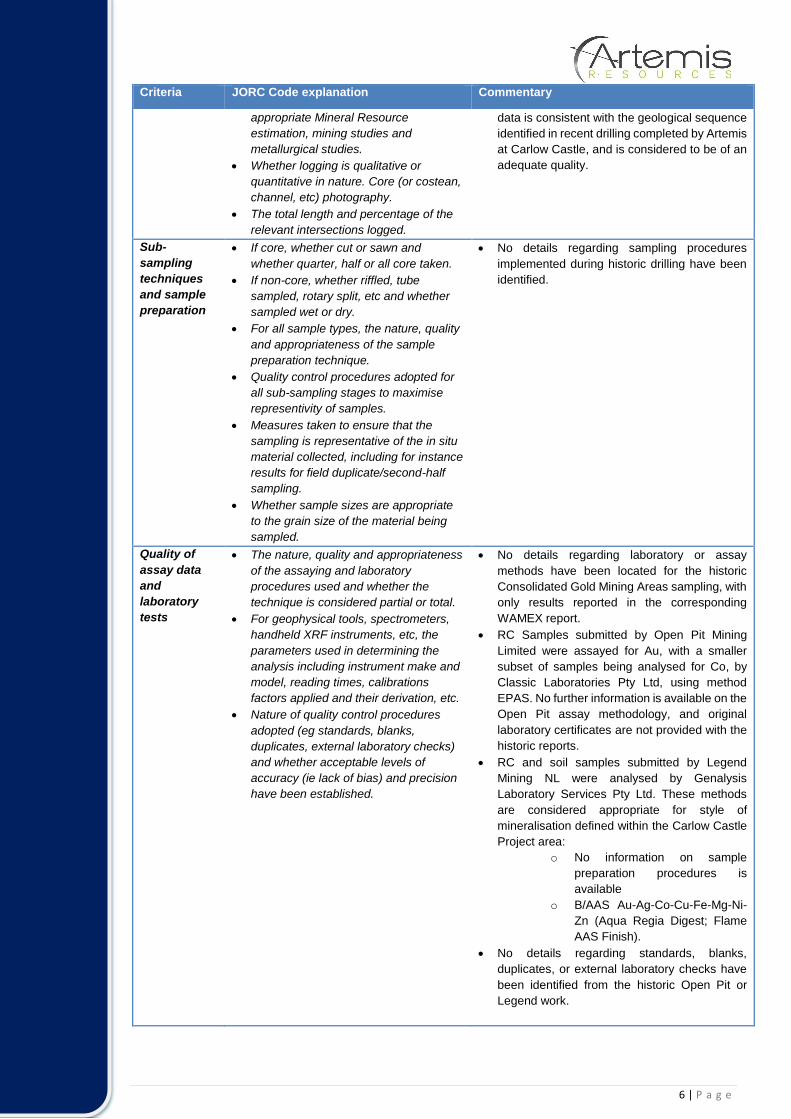
6 | P a g e
Criteria JORC Code explanation Commentary
appropriate Mineral Resource
estimation, mining studies and
metallurgical studies.
Whether logging is qualitative or
quantitative in nature. Core (or costean,
channel, etc) photography.
The total length and percentage of the
relevant intersections logged.
data is consistent with the geological sequence
identified in recent drilling completed by Artemis
at Carlow Castle, and is considered to be of an
adequate quality.
Sub-
sampling
techniques
and sample
preparation
If core, whether cut or sawn and
whether quarter, half or all core taken.
If non-core, whether riffled, tube
sampled, rotary split, etc and whether
sampled wet or dry.
For all sample types, the nature, quality
and appropriateness of the sample
preparation technique.
Quality control procedures adopted for
all sub-sampling stages to maximise
representivity of samples.
Measures taken to ensure that the
sampling is representative of the in situ
material collected, including for instance
results for field duplicate/second-half
sampling.
Whether sample sizes are appropriate
to the grain size of the material being
sampled.
No details regarding sampling procedures
implemented during historic drilling have been
identified.
Quality of
assay data
and
laboratory
tests
The nature, quality and appropriateness
of the assaying and laboratory
procedures used and whether the
technique is considered partial or total.
For geophysical tools, spectrometers,
handheld XRF instruments, etc, the
parameters used in determining the
analysis including instrument make and
model, reading times, calibrations
factors applied and their derivation, etc.
Nature of quality control procedures
adopted (eg standards, blanks,
duplicates, external laboratory checks)
and whether acceptable levels of
accuracy (ie lack of bias) and precision
have been established.
No details regarding laboratory or assay
methods have been located for the historic
Consolidated Gold Mining Areas sampling, with
only results reported in the corresponding
WAMEX report.
RC Samples submitted by Open Pit Mining
Limited were assayed for Au, with a smaller
subset of samples being analysed for Co, by
Classic Laboratories Pty Ltd, using method
EPAS. No further information is available on the
Open Pit assay methodology, and original
laboratory certificates are not provided with the
historic reports.
RC and soil samples submitted by Legend
Mining NL were analysed by Genalysis
Laboratory Services Pty Ltd. These methods
are considered appropriate for style of
mineralisation defined within the Carlow Castle
Project area:
o No information on sample
preparation procedures is
available
o B/AAS Au-Ag-Co-Cu-Fe-Mg-Ni-
Zn (Aqua Regia Digest; Flame
AAS Finish).
No details regarding standards, blanks,
duplicates, or external laboratory checks have
been identified from the historic Open Pit or
Legend work.
7 | P a g e
Criteria JORC Code explanation Commentary
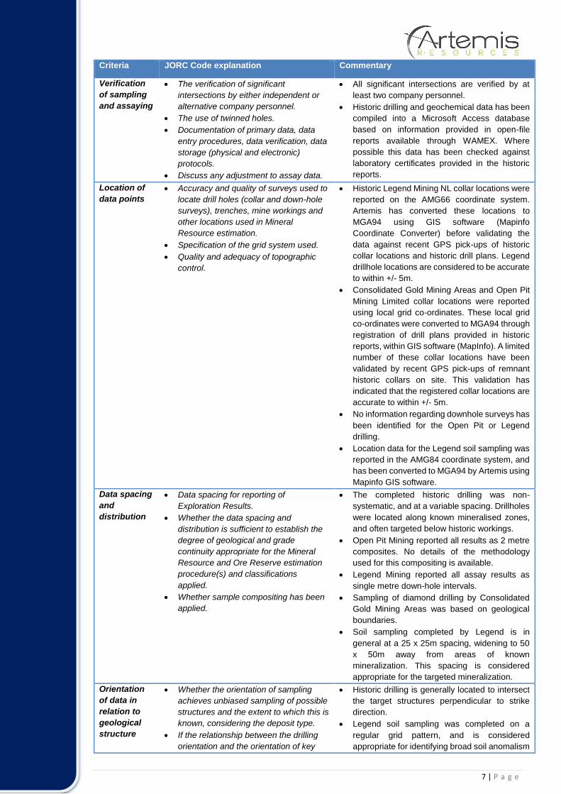
Verification
of sampling
and assaying
The verification of significant
intersections by either independent or
alternative company personnel.
The use of twinned holes.
Documentation of primary data, data
entry procedures, data verification, data
storage (physical and electronic)
protocols.
Discuss any adjustment to assay data.
All significant intersections are verified by at
least two company personnel.
Historic drilling and geochemical data has been
compiled into a Microsoft Access database
based on information provided in open-file
reports available through WAMEX. Where
possible this data has been checked against
laboratory certificates provided in the historic
reports.
Location of
data points
Accuracy and quality of surveys used to
locate drill holes (collar and down-hole
surveys), trenches, mine workings and
other locations used in Mineral
Resource estimation.
Specification of the grid system used.
Quality and adequacy of topographic
control.
Historic Legend Mining NL collar locations were
reported on the AMG66 coordinate system.
Artemis has converted these locations to
MGA94 using GIS software (Mapinfo
Coordinate Converter) before validating the
data against recent GPS pick-ups of historic
collar locations and historic drill plans. Legend
drillhole locations are considered to be accurate
to within +/- 5m.
Consolidated Gold Mining Areas and Open Pit
Mining Limited collar locations were reported
using local grid co-ordinates. These local grid
co-ordinates were converted to MGA94 through
registration of drill plans provided in historic
reports, within GIS software (MapInfo). A limited
number of these collar locations have been
validated by recent GPS pick-ups of remnant
historic collars on site. This validation has
indicated that the registered collar locations are
accurate to within +/- 5m.
No information regarding downhole surveys has
been identified for the Open Pit or Legend
drilling.
Location data for the Legend soil sampling was
reported in the AMG84 coordinate system, and
has been converted to MGA94 by Artemis using
Mapinfo GIS software.
Data spacing
and
distribution
Data spacing for reporting of
Exploration Results.
Whether the data spacing and
distribution is sufficient to establish the
degree of geological and grade
continuity appropriate for the Mineral
Resource and Ore Reserve estimation
procedure(s) and classifications
applied.
Whether sample compositing has been
applied.
The completed historic drilling was non-
systematic, and at a variable spacing. Drillholes
were located along known mineralised zones,
and often targeted below historic workings.
Open Pit Mining reported all results as 2 metre
composites. No details of the methodology
used for this compositing is available.
Legend Mining reported all assay results as
single metre down-hole intervals.
Sampling of diamond drilling by Consolidated
Gold Mining Areas was based on geological
boundaries.
Soil sampling completed by Legend is in
general at a 25 x 25m spacing, widening to 50
x 50m away from areas of known
mineralization. This spacing is considered
appropriate for the targeted mineralization.
Orientation
of data in
relation to
geological
structure
Whether the orientation of sampling
achieves unbiased sampling of possible
structures and the extent to which this is
known, considering the deposit type.
If the relationship between the drilling
orientation and the orientation of key
Historic drilling is generally located to intersect
the target structures perpendicular to strike
direction.
Legend soil sampling was completed on a
regular grid pattern, and is considered
appropriate for identifying broad soil anomalism

8 | P a g e
Criteria JORC Code explanation Commentary
mineralised structures is considered to
have introduced a sampling bias, this
should be assessed and reported if
material.
for the targeted mineralization.
Sample
security
The measures taken to ensure sample
security.
No information regarding sample security has
been identified in the historic reports.
Audits or
reviews
The results of any audits or reviews of
sampling techniques and data.
Data is validated upon up-loading into the
master database. Any validation issues
identified are investigated prior to reporting of
results.
Section 2 Reporting of Exploration Results
(Criteria listed in the preceding section also apply to this section.)
Criteria JORC Code explanation Commentary
Mineral
tenement and
land tenure
status
Type, reference name/number,
location and ownership including
agreements or material issues with
third parties such as joint ventures,
partnerships, overriding royalties,
native title interests, historical sites,
wilderness or national park and
environmental settings.
The security of the tenure held at the
time of reporting along with any
known impediments to obtaining a
licence to operate in the area.
All information within this announcement pertains
to E47/1797 – 100% owned by Artemis
Resources Ltd. This tenement forms a part of a
broader tenement package that comprises the
West Pilbara Project.
This tenement is in good standing and no known
impediments exist (see map provided in this
report for location).
Exploration
done by other
parties
Acknowledgment and appraisal of
exploration by other parties.
The most significant work to have been
completed historically in the Carlow Castle area
was completed by Open Pit Mining Limited
between 1985 and 1987, and subsequently
Legend Mining NL between 1995 and 2008.
Work completed by Open Pit consisted of
geological mapping, geophysical surveying (IP),
and RC drilling and sampling.
Work completed by Legend Mining Ltd consisted
of geological mapping and further RC drilling.
Legend also completed an airborne ATEM
survey over the project area, with follow up
ground-based FLTEM surveying. Re-processing
of this data was completed by Artemis, and was
critical in developing drill targets for the
completed RC drilling.
Compilation and assessment of historic drilling
and mapping data completed by both Open Pit
and Legend has indicated that this data is
compares well with data collected to date by
Artemis. Validation and compilation of historic
data is ongoing.
All exploration and analysis techniques
conducted by both Open Pit and Legend are
considered to have been appropriate for the style
of deposit.

9 | P a g e
Criteria JORC Code explanation Commentary
Geology Deposit type, geological setting and
style of mineralisation.
The Quod Est and Carlow South prospects are
both shear-hosted gold and base metal deposits,
located on the northern margin of the Andover
Intrusive Complex. Mineralisation is exposed in
numerous workings at surface along numerous
quartz rich shear zones. Both oxide and sulphide
mineralisation is evident at surface associated
with these shear zones.
Drill hole
Information
A summary of all information material
to the understanding of the
exploration results including a
tabulation of the following information
for all Material drill holes:
o easting and northing of the drill
hole collar
o elevation or RL (Reduced Level –
elevation above sea level in
metres) of the drill hole collar
o dip and azimuth of the hole
o down hole length and interception
depth
o hole length.
If the exclusion of this information is
justified on the basis that the
information is not Material and this
exclusion does not detract from the
understanding of the report, the
Competent Person should clearly
explain why this is the case.
Collar information for the reported drillholes is
provided in the body of the report.
Data
aggregation
methods
In reporting Exploration Results,
weighting averaging techniques,
maximum and/or minimum grade
truncations (eg cutting of high grades)
and cut-off grades are usually Material
and should be stated.
Where aggregate intercepts
incorporate short lengths of high
grade results and longer lengths of
low grade results, the procedure used
for such aggregation should be stated
and some typical examples of such
aggregations should be shown in
detail.
The assumptions used for any
reporting of metal equivalent values
should be clearly stated.
All drillhole intervals reported are composed of
either 2 metre down hole composite intervals, or
1m sample intervals. All intervals reported are
length weighted.
A lower cutoff grade of 500ppm Co has been
used.
No metal equivalent calculations are used in this
report.
Relationship
between
mineralisatio
n widths and
intercept
lengths
These relationships are particularly
important in the reporting of
Exploration Results.
If the geometry of the mineralisation
with respect to the drill hole angle is
known, its nature should be reported.
If it is not known and only the down
hole lengths are reported, there
should be a clear statement to this
effect (eg ‘down hole length, true
width not known’).
True widths of mineralisation have not been
calculated for this report, and as such all
intersections reported are down-hole
thicknesses.
A better understanding of the deposit geometry
will be achieved on thorough interpretation of the
data. True thicknesses may be reported at a later
date if warranted. Due to the moderately to
steeply dipping nature of the mineralised zones,
it is expected that true thicknesses will be less
than the reported down-hole thicknesses.

10 | P a g e
Criteria JORC Code explanation Commentary
Diagrams Appropriate maps and sections (with
scales) and tabulations of intercepts
should be included for any significant
discovery being reported These
should include, but not be limited to a
plan view of drill hole collar locations
and appropriate sectional views.
Appropriate maps are available in the body of
this announcement.
Balanced
reporting
Where comprehensive reporting of all
Exploration Results is not practicable,
representative reporting of both low
and high grades and/or widths should
be practiced to avoid misleading
reporting of Exploration Results.
Reporting of results in this report is considered
balanced.
Other
substantive
exploration
data
Other exploration data, if meaningful
and material, should be reported
including (but not limited to):
geological observations; geophysical
survey results; geochemical survey
results; bulk samples – size and
method of treatment; metallurgical test
results; bulk density, groundwater,
geotechnical and rock characteristics;
potential deleterious or contaminating
substances.
No other substantive exploration data is relevant
at this time.
Further work The nature and scale of planned
further work (eg tests for lateral
extensions, depth extensions or large-
scale step-out drilling).
Diagrams clearly highlighting the
areas of possible extensions,
including the main geological
interpretations and future drilling
areas, provided this information is not
commercially sensitive.
Further work is required to verify the historic
cobalt results identified. This work may include
geophysical surveying, and further drilling,
including twinning historic drillholes to verify the
historic intersections.