high spatiotemporal et mapping using multi-sensor data fusion · high spatiotemporal et mapping...
TRANSCRIPT

High Spatiotemporal ET Mapping Using Multi-Sensor Data Fusion
M.C. Anderson, W.P. KustasUSDA-ARS, Hydrology and Remote SensingLaboratory
C. Hain, J.R. MecikalskiU Alabama-Huntsville, Atmospheric Science
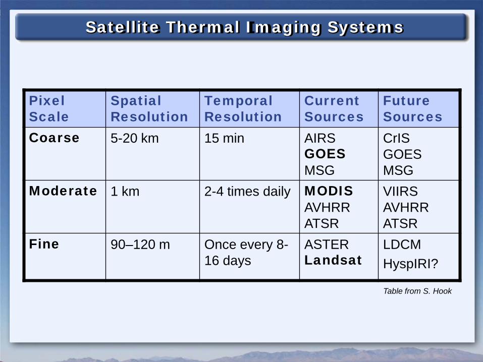
Satellite Thermal Imaging Systems
PixelScale
Spatial Resolution
Temporal Resolution
CurrentSources
FutureSources
Coarse 5-20 km 15 min AIRSGOESMSG
CrISGOESMSG
Moderate 1 km 2-4 times daily MODISAVHRRATSR
VIIRSAVHRRATSR
Fine 90–120 m Once every 8-16 days
ASTERLandsat
LDCMHyspIRI?
Table from S. Hook

Atmosphere-Land Exchange Inverse (ALEXI)
TRAD (φ), fcTRAD (φ), fc
Rsoil
TcTac
Hs
Ts
Ra H = Hc + Hs
Rx
Hc
Ta
ABL
Ta
ALEXI DisALEXI5 km
30 m
Tw
o-S
ou
rce M
od
el
TRAD,i(φi), fc,i
i
Ra,i
Blending height
Regional scale∆TRAD - GOESLAI from MODIS
Landscape scaleTRAD - TM, MODIS, HyspIRILAI = f(NDVI)
Surface temp:Vegetation:
ET = (RNET - G) - HAvailable energy

MODIS (1km) Landsat (~100m)
(hourly) (daily) (monthly)
FORT PECK, MONTANAGOES (10km)
(Wm-2)
Evapotranspiration100
200
300
400
30 J
un 2
002
18 A
ug 2
002
2 S
ep 2
002

MODIS (1km) Landsat (~100m)
(hourly) (daily) (monthly)
SAN PEDRO RIVER, ARIZONAGOES (10km)
(Wm-2)
Evapotranspiration100
200
300
400
11 J
un 2
004
30 A
ug 2
004

HIGH-RESOLUTION INTERPOLATIONLA
ND
SA
T(D
isA
LEXI
)
DOY 328 336
Landsat 5 Landsat 7
329 330 331 332 333 334 335
Conserve ET/PET
Daily Evapotranspiration – Orlando, FL, 2002
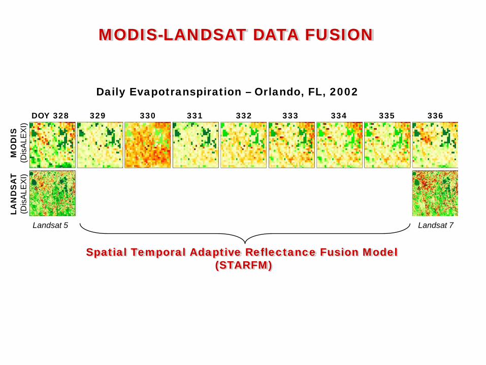
MODIS-LANDSAT DATA FUSIONLA
ND
SA
T(D
isA
LEXI
)
DOY 328 336
Landsat 5 Landsat 7
Daily Evapotranspiration – Orlando, FL, 2002
Spatial Temporal Adaptive Reflectance Fusion Model (STARFM)
329 330 331 332 333 334 335
MO
DIS
(Dis
ALE
XI)

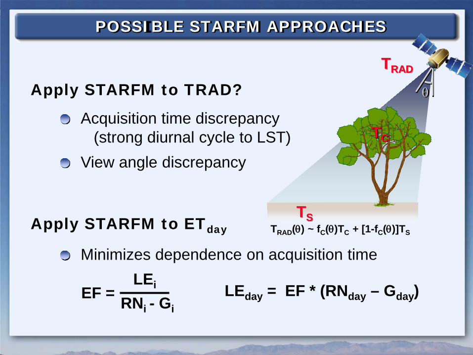
POSSIBLE STARFM APPROACHES
Apply STARFM to TRAD?
Acquisition time discrepancy(strong diurnal cycle to LST)
View angle discrepancy
TC
TRAD
θ
TSTRAD(θ) ~ fC(θ)TC + [1-fC(θ)]TS
POSSIBLE STARFM APPROACHES
Apply STARFM to TRAD?
Acquisition time discrepancy(strong diurnal cycle to LST)
View angle discrepancy
TC
TRAD
θ
Apply STARFM to ETday
Minimizes dependence on acquisition time
EF = LEi
RNi - GiLEday = EF * (RNday – Gday)
TSTRAD(θ) ~ fC(θ)TC + [1-fC(θ)]TS

POSSIBLE STARFM APPROACHES
Apply STARFM to TRAD?
Acquisition time discrepancy(strong diurnal cycle to LST)
View angle discrepancy
TS
TC
TRAD
θ
Apply STARFM to ETday
Minimizes dependence on acquisition timeALEXI/DisALEXI account for view angle
TA
H
HC
HS
TRAD(θ) ~ fC(θ)TC + [1-fC(θ)]TS

Daily ET(November 28, 2002)
GO
ES
(ALE
XI)
MO
DIS
(Dis
ALE
XI)
LAN
DS
AT
(Dis
ALE
XI)
CO
NU
SFlorida
Orlando
Google MapsDaily ET
(December 2, 2002)

GOES/MODIS/Landsat FUSIONG
OE
S(A
LEXI
)M
OD
IS(D
isA
LEXI
)
DOY 328 329 330 331 332 333 334 335 336
LAN
DS
AT
(Dis
ALE
XI/S
TAR
FM)
Landsat 5 Landsat 7
(Gao et al, 2006)Spatial Temporal Adaptive Reflectance Fusion Model
(STARFM)
Daily Evapotranspiration – Reedy Lake, FL, 2002

LEAF AREA INDEX2002328 2002336 2003019 2003043 2003083
MO
DIS
(1k
m)
Land
sat
(30m
)
k2 - NDVITMLAITM = -k1 * lnk2 – k3
Land
sat
(1km
)
k1, k2, k3 fit to MODIS LAI

LANDSURFACE TEMPERATURE
Landsat 5 Landsat 7Landsat 7 Landsat 7 Landsat 5
2002328 2002336 2003019 2003043 2003083
MO
DIS
MO
DIS
(sh
arpe
ned)
Land
sat

EVALUATION OF PREDICTED FIELDS2002328 2002336 2003019 2003043 2003083
MO
DIS
(Dis
ALE
XI)
Land
sat
(Dis
ALE
XI)
Land
sat
(STA
RFM
)O
bservedP
redicted
Landsat 50.7710%
Landsat 70.6312%
Landsat 70.839%
Landsat 70.8111%
Landsat 50.6712%
R2:% Err:

EVALUATION OF PREDICTED FIELDS2002328 2002336 2003019 2003043 2003083
MO
DIS
(Dis
ALE
XI)
Land
sat
(Dis
ALE
XI)
Land
sat
(STA
RFM
)O
bservedP
redicted
Landsat 50.7710%
Landsat 70.6312%
Landsat 70.839%
Landsat 70.8111%
Landsat 50.6712%
R2:% Err:
0
5
10
15
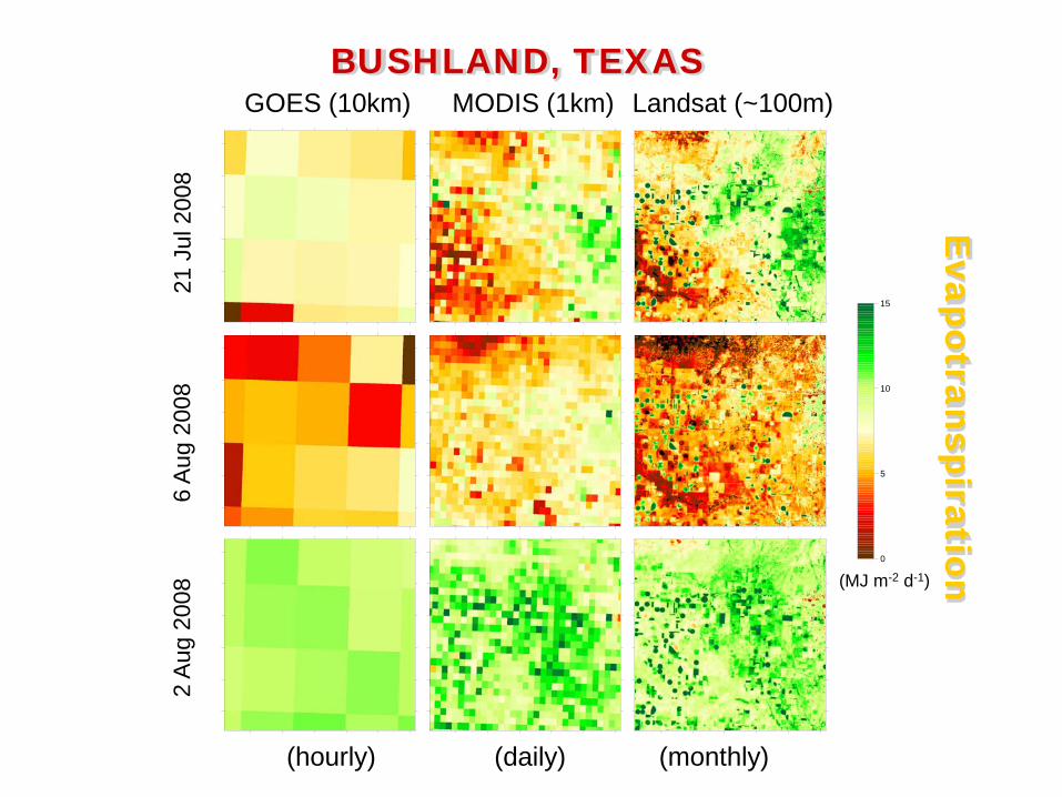
MODIS (1km) Landsat (~100m)
(hourly) (daily) (monthly)
BUSHLAND, TEXASGOES (10km)
(MJ m-2 d-1)
Evapotranspiration
21 J
ul 2
008
6 A
ug 2
008
2 A
ug 2
008

JULY AUGUST SEPTEMBER OCTOBER DECEMBERNOVEMBER
2008Midday Latent Heat Flux
(Wm-2)
LandsatMODIS
Met
eosa
t(A
LEXI
)

MODIS-Landsat daily ET fusion appears feasible
CONCLUSIONS
STILL NEED > TWO LANDSATS!
Fusion results are optimized for MODIS-Landsat in formation
Consistent MODIS-Landsat LAI products will be valuable