highest tides for year 2015 - maritime safety...
TRANSCRIPT

Highest tides for year 2015
Highest Summer Tide Highest Winter Tide Place
Date Time Height Date Time Height
Gold Coast Seaway HAT 1.91
21/01/2015 08:50 1.84m 19/02/2015 08:31 1.84m
18/05/2015 20:42 1.81m 01/08/2015 21:09 1.81m
Brisbane Bar HAT 2.73
21/01/2015 10:11 2.69m 01/08/2015 22:29 2.63m
Mooloolaba HAT 2.17
21/01/2015 08:39 2.12m 19/02/2015 08:19 2.12m
18/05/2015 20:29 2.06m 01/08/2015 20:58 2.06m
Noosa Head HAT 2.28
21/01/2015 08:37 2.25m 18/05/2015 20:22 2.20m
Urangan HAT 4.28
19/02/2015 08:55 4.20m 30/08/2015 21:14 4.08m
Fraser Island (Waddy Point) HAT 2.37
21/01/2015 08:26 2.28m 18/05/2015 20:25 2.18m
Bundaberg (Burnett Heads) HAT 3.67
19/02/2015 08:49 3.52m 30/08/2015 21:05 3.35m
Gladstone HAT 4.83
19/02/2015 09:27 4.73m 30/08/2015 21:46 4.52m
Port Alma HAT 5.98
19/02/2015 09:26 5.82m 29/08/2015 21:02 5.58m
Rosslyn Bay HAT 5.14
19/02/2015 09:17 5.06m 29/08/2015 20:49 4.83m
Hay Point HAT 7.14
19/02/2015 11:00 7.04m 29/08/2015 22:36 6.74m
Mackay Outer Harbour HAT 6.58
19/02/2015 11:03 6.49m 29/08/2015 22:39 6.20m
Shute Harbour HAT 4.33
19/02/2015 10:56 4.22m 17/05/2015 22:30 3.97m 31/07/2015 22:55 3.97m
Bowen HAT 3.73
18/02/2015 09:22 3.62m 29/08/2015 21:38 3.37m
Abbot Point HAT 3.60
18/02/2015 09:09 3.48m 29/08/2015 21:24 3.24m
Townsville HAT 4.11
19/02/2015 09:14 4.08m 29/08/2015 20:51 3.82m
Lucinda Offshore HAT 3.96
19/02/2015 09:18 3.93m 29/08/2015 20:55 3.66m
Mourilyan Harbour HAT 3.50
19/02/2015 09:18 3.47m 29/08/2015 20:54 3.23m
Cairns HAT 3.50
19/02/2015 09:31 3.41m 29/08/2015 21:07 3.17m
Port Douglas HAT 3.36
19/02/2015 09:20 3.33m 29/08/2015 20:58 3.07m
Twin Island HAT 3.80
18/02/2015 11:47 3.66m 29/08/2015 23:58 3.58m
Thursday Island HAT 3.86
18/02/2015 12:24 3.62m
Goods Island HAT 4.07
29/01/2015 11:20 3.94m
Booby Island HAT 4.31
28/01/2015 10:45 4.26m
Weipa HAT 3.38
21/01/2015 16:30 3.18m
Karumba HAT 4.88
05/01/2015 20:01 4.37m 27/12/2015 20:58 4.38m
Mornington Island HAT 3.87
21/01/2015 22:21 3.63m
The highest tides listed - often referred to as king tides - are the highest spring tides that occur during summer and winter. Boat owners and people living along the waterfront should be vigilant at the times of these highest tides particularly in the summer, as storms and cyclones may elevate tidal levels significantly above the predicted tide heights.
96

Tidal notes Tidal datum epoch Australian tidal authorities have adopted the 20 year Tidal Datum Epoch 1992 to 2011 (inclusive) as the basis for calculating tidal datum and the associated tidal planes.
Accordingly in the 2010 edition the standard ports’ semidiurnal and diurnal tidal planes were updated - to incorporate the latest available tidal observations, prediction information and allowance for sea level rise. It is intended that the 2010 tidal plane values will now remain fixed until the tidal datum epoch review in 2018 unless significant change occurs. The mean sea levels listed in the table ‘Mean Sea Level Used for the Tidal Predictions’ will change over the course of the tidal epoch as they include the most recent observations and an allowance for sea level rise. Datum of tidal heights The height of the tide (expressed as metres and decimals) is referred to the port datum (LAT datum). When a low water falls below datum, it is marked with a minus sign (-). When utilising a navigational chart, tidal height should be added to chart depth. If preceded by a minus sign, it should be subtracted. Standard port Standard ports are those provided as daily tables of the predicted times and heights of high and low waters. The tide times are referred to Australian Eastern Standard Time and the tide heights are referred to LAT datum. Secondary places Secondary places are those for which daily predictions are not provided in the Queensland Tide Tables. These locations are grouped and associated to the adjacent standard port with a similar tidal pattern. Data sufficient for calculating their times and heights is supplied following the standard port prediction tables. Tidal Levels A list of tidal levels referred to LAT datum for standard ports and selected secondary places is given in the following tables: - Standard Port Datum Levels Semidiurnal Tidal Planes Diurnal Tidal Planes
In addition, the tables for semidiurnal and diurnal tidal planes provide the factors necessary to calculate tidal predictions at the selected secondary places (referred to LAT datum at each secondary place) from the tidal predictions of the standard ports.
Rise The rise of the tide is the height of the high water above port datum. Range The range of the tide is the difference between the height of high water and the next succeeding or last preceding low water. Semidiurnal tide Semidiurnal tide refers to a tide which has a period or cycle of approximately half of one tidal day (about 12.5 hours). Semidiurnal tides usually have two high and two low tides each day. The tides at Brisbane Bar are a typical example of semidiurnal tides. Diurnal tide Diurnal tide refers to a tide which has a period or cycle of approximately one tidal day (about 25 hours). Diurnal tides usually have one high and one low tide each day. The tides at Karumba are a typical example of diurnal tides. Highest tides for year King tide is a non-scientific term, but the popular concept is that it is the higher high waters which occur around Christmas time. Equally high tides occur in the winter months during the night. Meteorological effects on tides Meteorological conditions which differ significantly from the seasonal averages, will cause corresponding differences between the predicted and the actual tide. Variations in tidal heights are mainly caused by strong or prolonged winds and by unusually high or low barometric pressure. Tidal predictions are computed for average barometric pressure. Low pressure systems tend to raise sea levels, and high pressure systems tend to lower them. However, the water does not adjust itself immediately to a change of pressure, but responds to the average change in pressure over a considerable area. The effect of wind on sea level, and therefore on tidal heights and times, is variable and depends on the topography of the area in question. In general, it can be said that wind will raise the sea level in the direction towards which it is blowing. A strong wind blowing straight onshore will cause the water to "pile up" resulting in high waters to be higher than predicted. Winds blowing off the land will have the reverse effect.
97

Tidal definitionsLAT (lowest astronomical tide) HAT (highest astronomical tide) These are the lowest and highest levels which can be predicted to occur under average meteorological conditions and any combination of astronomical conditions. These levels will not be reached every year. LAT and HAT are not the extreme levels which can be reached, as storm surges may cause considerably lower and higher levels to occur. LAT has been used as port and chart datum since 1994. MSL (mean sea-level) The mean level of the sea over a long period (preferably 18.6 years) or the mean level which would exist in the absence of tides. AHD (Australian height datum) This datum has been adopted by the National Mapping Council as the datum to which all vertical control for land based mapping is to be referred. MHWS (mean high water springs) The long term mean of the heights of two successive high waters during those periods of 24 hours (approximately once a fortnight) when the range of tide is greatest during the full and new moon. MLWS (mean low water springs) The long term mean of the heights of two successive low waters over the same periods as defined for MHWS. MHWN (mean high water neaps) The long term mean of the heights of two successive high waters when the range of tide is the least at the time of first and last quarter of the moon. MLWN (mean low water neaps) The long term mean of the heights of two successive low waters over the same periods as defined for MHWN. MHHW (mean higher high water) The mean of the higher of the two daily high waters over a long period of time. When only one high water occurs on a day, this is taken as the higher high water.
MLHW (mean lower high water) The mean of the lower of the two daily high waters over a long period of time. When only one high water occurs on most days, no value is printed in the MLHW column, indicating that the tide is usually diurnal. MHLW (mean higher low water) The mean of the higher of the two daily low waters over a long period of time. When only one low water occurs on most days, no value is printed in the MHLW column, indicating that the tide is usually diurnal. MLLW (mean lower low water) The mean of the lower of the daily low waters over a long period of time. When only one low water occurs a day, this is taken as the lower low water. MHW (mean high water) The mean of all high waters observed over a sufficiently long period (preferably over the current tidal datum epoch). For those stations with shorter series, simultaneous observational comparisons are made with a control tide station in order to derive the equivalent datum. MLW (mean low water) The mean of all low waters observed over a sufficiently long period (preferably over the current tidal datum epoch). For those stations with shorter series, simultaneous observational comparisons are made with a control tide station in order to derive the equivalent datum.
LWD (Low Water Datum) The mean height of the lower low waters at springs. This was a local plane which usually satisfied the criterion that the tide seldom fell below it. In the past, this was generally chosen for port and chart datum in Queensland waters however it was superseded by LAT datum in 1994.
98

Guide to tidal planes
Tidal datum epoch The Queensland standard ports’ semidiurnal and diurnal tidal planes were updated for the current tidal datum epoch 1992 – 2011, using the latest available tidal observations, prediction information and allowance for sea level rise. It is intended to maintain the standard port datum planes until 2018 when the current tidal datum epoch will be subject to review. The secondary place tidal planes have also been updated to match the new values adopted at the standard ports.
99

Standard port datum levels Height above Lowest Astronomical Tide (LAT)
Standard Port Benchmark Number
Level Above LAT
AHD Above LAT
Standard Port Benchmark Number
Level Above LAT
AHD Above LAT
Gold Coast Seaway PM QGS564 6.688 0.760 Abbot Point PM 66022 8.740 1.626 Brisbane Bar PM 21764 3.102 1.243 Townsville PM 10011 9.025 1.856 Mooloolaba PM 14102 3.131 0.990 Lucinda (Offshore) PM H&M 14 5.543 1.844 Noosa Head PM 19728 3.781 1.123 Mourilyan Harbour PM 4855 5.037 1.729 Waddy Point (Fraser Island) PM NMV/B/417 3.165 1.007 Cairns PM 96052 5.008 1.643 Urangan PM 11028 5.835 2.040 Port Douglas PM 10077 6.058 1.581 Bundaberg (Burnett Heads) PM 3853 6.061 1.693 Leggatt Island Mean Sea Level 1.691 N.A. Gladstone PM 10855 5.660 2.268 Twin Island PM NMV/B/463 2.990 N.A. Port Alma PM 22966 6.706 2.854 Thursday Island PM 10078 6.375 1.769 Rosslyn Bay PM 47784 6.640 2.360 Goods Island PM NMV/B/477 5.330 N.A. Hay Point PM 38627 18.040 3.340 Booby Island PM BM1 10.770 N.A. Mackay Outer Harbour PM 20035 10.595 2.941 Weipa (Humbug Point) PM 15094 7.287 1.752 Bugatti Reef PM BM. No. 1 2.330 N.A. Karumba PM 10222 6.808 2.184 Shute Harbour PM 8295 5.103 1.907 Mornington Island PM RM3 4.894 2.000 Bowen PM 10009 8.689 1.776
The elevation of AHD datum above LAT datum applies at the standard port benchmark only and will vary at secondary locations.
Mean Sea level used for the tidal predictions – 2015 An allowance of 2.0 mm per year for sea level change has been made in the mean sea level (MSL) estimate. The allowance is calculated from the central date of the observation period to the central date of the prediction year. The heights are referred to Lowest Astronomical Tide datum.
Place Observation Period MSL Place Observation Period MSL
Gold Coast Seaway Jan 1993 to Feb 1999 0.789 Abbot Point May 1985 to Dec 1995 1.718 Brisbane Bar Jan 1985 to Dec 2012 1.298 Townsville Jan 1985 to Dec 2011 1.975 Mooloolaba Jan 1987 to Dec 2012 0.982 Lucinda (Offshore) Jan 1985 to Dec 2011 1.919 Noosa Head Dec 1970 to Dec 1971 1.124 Mourilyan Harbour Jan 1985 to Dec 2011 1.769 Waddy Point (Fraser Island) Oct 1976 to Feb 1978 1.157 Cairns Jan 1985 to Dec 2011 1.726 Urangan Sep 1986 to Dec 2012 2.111 Port Douglas Jan 1987 to Dec 2011 1.628 Bundaberg (Burnett Heads) Jan 1985 to Dec 2012 1.747 Leggatt Island Sep 1995 to Apr 1996 1.700 Gladstone Jan 1985 to Dec 2012 2.367 Twin Island Jul 1974 to Jul 1975 1.775 Port Alma Jan 1986 to Dec 2012 2.930 Thursday Island Jan 1985 to Dec 2002 1.896 Rosslyn Bay Jan 1993 to Dec 2012 2.452 Goods Island Jan 1990 to Dec 2011 2.168 Hay Point Jan 1985 to Dec 2012 3.400 Booby Island Jan 1990 to Dec 2011 2.450 Mackay Outer Harbour Jan 1988 to Dec 2011 3.045 Weipa (Humbug Point) Jan 1985 to Dec 2011 1.870 Bugatti Reef Oct 1996 to Mar 1997 1.544 Karumba Dec 1985 to Dec 2011 2.147 Shute Harbour Jan 1987 to Dec 2011 1.947 Mornington Island Jun 2007 to Dec 2012 2.124 Bowen Jan 1986 to Dec 2011 1.789
100

Height above lowest astronomical tidePlace Latitude Longitude MHWS MHWN MLWN MLWS AHD MSL Ratio Cons HAT
South East HW LWTidal Datum Epoch 1992 - 2011 1 2 3 4 5 6 7 8 9 10 11
H M H M m m m m m m m mGold Coast Seaway 27 57 153 25 1.42 1.13 0.39 0.11 0.760 0.76 1.00 0.00 1.91
North Coast New South Wales -
Ballina (Richmond River) 28 53 153 35 +0 06 +0 06 1.4 1.1 0.5 0.2 0.80 1.9 Brunswick Heads 28 32 153 33 +0 07 +0 07 1.5 1.2 0.5 0.2 0.86 2.0 Kingscliff 28 16 153 35 +0 09 +0 09 1.4 1.1 0.4 0.2 0.76 1.9 Tweed River Breakwater 28 10 153 33 -0 04 +0 00 1.47 1.22 0.55 0.29 0.86 0.91 0.92 +0.04 1.91 Gold Coast Beaches -
Snapper Rocks (Coolangatta) 28 10 153 33 -0 26 -0 15 1.64 1.32 0.49 0.20 0.98 0.97 1.10 0.00 2.11 Ocean Beaches Jumpinpin Bar to Snapper Rocks tides occur 20 mins earlier than Gold Coast Seaway. Broadwater & Nerang River-
Isle of Capri 28 00 153 25 +0 41 +0 56 1.17 0.90 0.28 0.08 0.59 0.67 0.72 +0.24 1.60 Gold Coast Bridge 27 59 153 25 +0 10 +0 20 1.51 1.23 0.51 0.24 0.79 0.83 0.97 +0.13 1.98 Grand Hotel Jetty 27 57 153 25 +0 16 +0 31 1.39 1.11 0.38 0.11 0.79 0.80 0.98 0.00 1.87 Nerang Township 28 00 153 20 +1 53 +2 39 1.08 0.87 0.17 0.03 0.48 0.58 0.78 0.00 1.49 Paradise Point 27 53 153 24 +1 01 +1 25 1.20 0.93 0.23 0.05 0.61 0.64 0.87 0.00 1.66 Runaway Bay 27 55 153 24 +0 31 +0 52 1.18 0.91 0.22 0.05 0.62 0.62 0.86 0.00 1.65 Coomera River (Saltwater Creek) 27 52 153 20 +1 44 +2 21 1.23 0.99 0.37 0.13 0.56 0.67 0.84 +0.04 1.64 Sanctuary Cove 27 51 153 22 +1 34 +2 06 1.23 0.99 0.37 0.13 0.56 0.67 0.84 +0.04 1.65 Couran Cove 27 49 153 25 +1 19 +1 20 1.34 1.06 0.35 0.09 0.78 0.76 0.96 -0.02 1.81 The Bedroom 27 46 153 26 +1 14 +1 06 1.34 1.06 0.35 0.09 0.76 0.96 -0.02 1.81
Brisbane Bar 27 22 153 10 2.17 1.78 0.76 0.37 1.243 1.27 1.00 0.00 2.73
Pimpama River (Kerkin Rd Weir) 27 48 153 20 +0 57 +1 27 1.36 1.05 0.30 0.15 0.60 0.73 1.78 Albert River -
Junction Logan River 27 42 153 14 +1 22 +2 14 2.05 1.66 0.54 0.33 0.98 1.12 2.59 Pacific Highway Bridge 27 44 153 13 +1 37 +2 42 1.90 1.50 0.44 0.25 0.91 0.94 2.45 Wolffdene 27 47 153 11 +2 12 1.32 0.98 0.91 1.79 Logan River -
Rocky Point (Mouth Logan River) 27 42 153 21 +0 40 +0 55 2.09 1.72 0.74 0.37 1.10 1.21 0.96 +0.01 2.63 Junction Albert River 27 42 153 14 +1 22 +2 14 2.05 1.66 0.54 0.33 0.98 1.12 2.59 Slacks Creek (Mouth) 27 40 153 10 +2 13 +3 05 1.79 1.45 0.40 0.21 0.82 0.96 2.27 Waterford 27 42 153 09 +2 39 +3 34 1.59 1.27 0.28 0.11 0.66 0.81 2.03 Brisbane River -
Boat Passage 27 24 153 10 +0 00 +0 00 2.17 1.78 0.76 0.37 1.24 1.27 1.00 0.00 2.73 Pinkenba 27 26 153 07 +0 10 +0 10 2.22 1.82 0.78 0.38 1.24 1.27 1.02 0.00 2.79 Cairncross Dock 27 27 153 05 +0 20 +0 20 2.30 1.89 0.81 0.39 1.24 1.34 1.06 0.00 2.89 New Farm 27 28 153 03 +0 25 +0 25 2.30 1.89 0.81 0.39 1.24 1.34 1.06 0.00 2.89 Port Office (Edward St Ferry) 27 28 153 02 +0 30 +0 30 2.30 1.89 0.81 0.39 1.24 1.32 1.06 0.00 2.89 Tennyson (Long Pocket) 27 32 153 00 +0 50 +0 50 2.37 1.94 0.83 0.40 1.15 1.38 1.09 0.00 2.98 Indooroopilly 27 31 152 59 +1 10 +1 10 2.34 1.92 0.82 0.40 1.15 1.37 1.08 0.00 2.95 Seventeen Mile Rocks 27 33 152 58 +1 20 +1 20 2.30 1.89 0.81 0.39 1.05 1.30 1.06 0.00 2.89 Jindalee 27 32 152 56 +1 20 +1 20 2.32 1.90 0.81 0.39 1.05 1.30 2.92 Wacol (Wolston Creek) 27 34 152 54 +1 55 +1 55 2.18 1.83 0.56 0.27 1.00 1.20 2.69 Goodna (Woogaroo Creek) 27 36 152 54 +2 00 +2 10 2.10 1.76 0.50 0.24 1.00 1.13 2.60 Moggill Ferry 27 36 152 51 +2 20 +2 30 2.13 1.77 0.39 0.12 0.95 1.09 2.64 Kholo Creek 27 32 152 51 +2 30 +2 50 2.14 1.79 0.37 0.18 0.90 1.09 2.65 Bremer River
Warrego Highway Bridge 27 35 152 49 +2 30 +2 55 2.34 1.96 0.61 0.40 0.95 1.31 2.89 Ipswich (Bremer River) 27 35 152 47 +2 40 +3 10 2.16 1.76 0.71 0.30 0.95 1.30 2.81 Moreton Bay Area -
Ocean Beaches Cape Moreton to Snapper Rocks tides occur 1hr 30min earllier than Brisbane Bar. Woogoompah Island 27 47 153 24 +0 14 +0 02 1.50 1.23 0.52 0.26 0.82 0.69 -0.02 1.88 Jacobs Well 27 47 153 22 +0 28 +0 18 1.59 1.29 0.49 0.19 0.74 0.86 0.78 -0.10 2.03 Cabbage Tree Point 27 44 153 22 +0 30 +0 29 1.84 1.50 0.61 0.27 0.89 1.03 0.87 -0.05 2.33 Kalinga Bank 27 44 153 26 -0 34 -0 47 1.49 1.22 0.53 0.26 0.87 0.68 +0.01 1.87
Semidiurnal Tidal Planes - 2015
Standard Port
Standard Port
Time Difference
101

Height above lowest astronomical tidePlace Latitude Longitude MHWS MHWN MLWN MLWS AHD MSL Ratio Cons HAT
South East HW LWTidal Datum Epoch 1992 - 2011 1 2 3 4 5 6 7 8 9 10 11
H M H M m m m m m m m m
Semidiurnal Tidal Planes - 2015
Time Difference
Brisbane Bar continued
Moreton Bay Area continued
Oak Island 27 42 153 24 +0 15 -0 30 1.71 1.41 0.60 0.29 0.96 0.79 0.00 2.16 Koureyabba 27 42 153 24 +0 30 +0 06 1.76 1.44 0.62 0.30 1.00 0.81 0.00 2.21 Russell Island (Canaipa Point) 27 39 153 25 +0 31 +0 42 2.30 1.89 0.81 0.39 1.39 1.33 1.06 0.00 2.89 Macleay Island (Southern Jetty) 27 38 153 22 +0 30 +0 42 2.25 1.83 0.73 0.31 1.29 1.25 1.08 -0.09 2.86 Redland Bay 27 37 153 18 +0 30 +0 45 2.37 1.94 0.83 0.40 1.41 1.35 1.09 0.00 2.98 Victoria Point 27 35 153 19 +0 14 +0 18 2.38 1.97 0.91 0.50 1.41 1.39 1.04 +0.12 2.96 Macleay Island (Potts Point) 27 35 153 22 +0 15 +0 23 2.28 1.87 0.80 0.39 1.32 1.05 0.00 2.87 Toondah Harbour (Cleveland) 27 32 153 17 +0 13 +0 16 2.21 1.82 0.78 0.38 1.25 1.29 1.02 0.00 2.78 Cleveland Point 27 31 153 18 +0 13 +0 16 2.21 1.82 0.78 0.38 1.25 1.29 1.02 0.00 2.78 Peel Island 27 30 153 21 +0 10 +0 17 2.21 1.82 0.78 0.38 1.23 1.02 0.00 2.78 Dunwich 27 30 153 24 +0 11 +0 16 2.15 1.76 0.75 0.37 1.30 1.22 0.99 0.00 2.70 Raby Bay (Canals Entrance) 27 30 153 16 +0 02 +0 02 2.27 1.86 0.81 0.41 1.36 1.32 1.03 +0.03 2.84 Tingalpa Creek (Mouth) 27 28 153 13 +0 02 +0 06 2.34 1.92 0.82 0.40 1.29 1.08 0.00 2.95 Wellington Point 27 28 153 14 -0 06 -0 03 2.26 1.85 0.79 0.38 1.33 1.26 1.04 0.00 2.84 Lota 27 28 153 11 +0 02 +0 07 2.24 1.83 0.78 0.38 1.29 1.27 1.03 0.00 2.81 Huybers Light 27 27 153 15 +0 12 +0 03 2.17 1.78 0.76 0.37 1.26 1.00 0.00 2.73 Manly 27 27 153 11 +0 02 +0 07 2.24 1.83 0.78 0.38 1.29 1.27 1.03 0.00 2.81 D'Arcy Light 27 26 153 12 +0 02 +0 07 2.17 1.78 0.76 0.37 1.26 1.00 0.00 2.73 Rous Light 27 24 153 20 +0 09 +0 06 2.17 1.78 0.76 0.37 1.21 1.00 0.00 2.73 Amity Point 27 24 153 26 -0 40 -0 54 1.78 1.46 0.62 0.30 1.02 1.09 0.82 0.00 2.24 Saint Helena (South) 27 24 153 13 +0 00 +0 00 2.28 1.87 0.80 0.39 1.32 1.05 0.00 2.87 Nudgee Beach 27 21 153 06 +0 01 -0 01 2.08 1.71 0.73 0.36 1.31 1.19 0.96 0.00 2.62 Cabbage Tree Creek (Mouth) 27 20 153 06 +0 01 -0 01 2.08 1.71 0.73 0.36 1.31 1.19 0.96 0.00 2.62 Shorncliffe and Sandgate 27 20 153 05 +0 01 -0 01 2.08 1.71 0.73 0.36 1.31 1.19 0.96 0.00 2.62 Woody Point 27 16 153 06 +0 00 +0 02 2.06 1.69 0.72 0.35 1.23 1.15 0.95 0.00 2.59 Measured Mile-Rear Recip. Lead 27 15 153 15 -0 25 -0 23 2.04 1.67 0.71 0.35 1.14 0.94 0.00 2.57 Margate 27 15 153 07 +0 00 +0 02 2.06 1.69 0.72 0.35 1.23 1.15 0.95 0.00 2.59 Redcliffe 27 14 153 07 +0 00 +0 00 2.08 1.71 0.73 0.36 1.11 0.96 0.00 2.62 East Channel 27 14 153 20 -0 09 -0 13 2.06 1.69 0.72 0.35 1.20 0.95 0.00 2.59 Scarborough Boat Harbour 27 12 153 06 +0 05 +0 05 1.93 1.58 0.68 0.33 1.17 1.11 0.89 0.00 2.43 Tangalooma 27 11 153 22 -0 23 -0 27 2.00 1.65 0.73 0.38 1.15 0.90 +0.05 2.51 Beachmere(Caboolture River) 27 08 153 02 +0 06 +0 18 2.08 1.71 0.73 0.36 1.26 1.21 0.96 0.00 2.62 Bulwer Wrecks 27 05 153 22 -0 25 -0 30 1.76 1.44 0.62 0.30 1.02 0.81 0.00 2.21 North West Channel Fairway 26 51 153 09 -1 30 -1 40 1.63 1.34 0.57 0.28 0.99 0.95 0.75 0.00 2.05 North Pine River -
Deepwater Bend 27 18 153 02 +0 13 +0 41 2.17 1.78 0.78 0.40 1.24 1.28 0.98 +0.04 2.72 Petrie 27 17 152 58 +0 24 +0 52 2.26 1.85 0.79 0.38 1.26 1.27 1.04 0.00 2.84 Pumicestone Passage-Bribie
Bribie Beacon (South Point) 27 06 153 09 -0 09 -0 13 1.91 1.57 0.69 0.36 1.09 0.86 +0.04 2.39 Bongaree 27 05 153 09 +0 00 -0 15 1.87 1.53 0.65 0.32 1.10 1.06 0.86 0.00 2.35 Woorim 27 05 153 12 -0 22 -0 34 1.71 1.41 0.60 0.29 0.93 0.79 0.00 2.16 Toorbul 27 02 153 06 +0 30 +0 20 1.95 1.60 0.68 0.33 1.10 1.13 0.90 0.00 2.46 Donnybrook 27 00 153 04 +1 00 +0 56 1.88 1.55 0.69 0.35 1.12 1.11 0.85 +0.04 2.36 Hussey Creek (Mouth) 26 56 153 04 +2 04 +2 56 1.35 1.04 0.40 0.32 1.80 The Skids 26 54 153 04 +1 48 +2 05 0.98 0.66 0.28 0.14 0.41 0.51 1.38 Halls Creek (Mouth) 'The Farm' 26 52 153 07 +0 47 +1 33 0.87 0.62 0.46 0.59 1.21 Golden Beach (Caloundra) 26 48 153 07 -0 53 -0 11 1.12 0.82 0.43 0.32 0.66 0.77 1.52
102

Height above lowest astronomical tidePlace Latitude Longitude MHWS MHWN MLWN MLWS AHD MSL Ratio Cons HAT
South East HW LWTidal Datum Epoch 1992 - 2011 1 2 3 4 5 6 7 8 9 10 11
H M H M m m m m m m m m
Semidiurnal Tidal Planes - 2015
Time Difference
Mooloolaba 26 41 153 08 1.66 1.33 0.58 0.26 0.990 0.96 1.00 0.00 2.17
Caloundra Head 26 48 153 09 +0 00 +0 00 1.63 1.34 0.57 0.28 0.99 0.95 2.05 Parrearra (Mooloolah River) 26 43 153 07 +0 23 +0 44 1.67 1.23 0.55 0.20 0.93 0.94 0.00 2.21 Mooloolaba Beach 26 41 153 06 +0 00 +0 00 1.66 1.33 0.58 0.26 0.99 0.97 1.00 0.00 2.17 Maroochydore Beach 26 40 153 06 +0 00 +0 00 1.66 1.33 0.58 0.26 0.99 0.97 1.00 0.00 2.17 Coolum 26 31 153 06 +0 00 +0 00 1.66 1.33 0.58 0.26 0.99 0.97 1.00 0.00 2.17 Maroochy River -
Picnic Point 26 39 153 05 +1 02 +1 52 0.93 0.65 0.27 0.13 0.46 0.52 1.36 David Low Bridge 26 38 153 03 +1 35 +2 27 0.90 0.66 0.30 0.19 0.44 0.53 1.28 Dunethin Rock 26 35 153 02 +2 09 +3 06 1.03 0.78 0.28 0.15 0.44 0.53 1.41 Junction North Maroochy River 26 34 152 58 +2 18 +3 12 1.15 0.88 0.34 0.22 0.49 0.60 1.57 Noosa Head 26 23 153 06 1.78 1.45 0.71 0.38 1.123 1.08 1.00 0.00 2.28
Noosa River -
Munna Point 26 24 153 04 +0 42 +1 35 0.78 0.65 0.29 0.17 0.42 0.45 0.40 +0.13 1.10 Tewantin 26 24 153 02 +1 07 +1 49 0.61 0.53 0.28 0.20 0.34 0.38 0.31 +0.09 0.89 Noosa Beaches -
Noosa Beach 26 23 153 05 +0 00 +0 00 1.78 1.45 0.71 0.38 1.12 1.06 1.00 0.00 2.28 Teewah Sands 26 16 153 04 +0 00 +0 00 1.78 1.45 0.71 0.38 1.12 1.06 1.00 0.00 2.28 Cooloola 26 11 153 04 +0 00 +0 00 1.78 1.45 0.71 0.38 1.12 1.06 1.00 0.00 2.28 Double Island Point 25 55 153 11 +0 00 +0 00 1.78 1.45 0.71 0.38 1.12 1.06 1.00 0.00 2.28 Rainbow Beach 25 54 153 05 +0 00 +0 00 1.78 1.45 0.71 0.38 1.12 1.06 1.00 0.00 2.28 Waddy Point (Fraser Island) 24 58 153 21 1.75 1.45 0.81 0.50 1.007 1.13 1.00 0.00 2.37
Wide Bay Bar (Ocean Side) 25 49 153 03 +0 00 +0 00 Eurong 25 30 153 07 +0 00 +0 00 Happy Valley 25 20 153 12 +0 00 +0 00 Indian Head 25 00 153 22 +0 00 +0 00 Orchid Beach 24 58 153 19 +0 00 +0 00 Urangan 25 18 152 55 3.49 2.80 1.38 0.68 2.040 2.09 1.00 0.00 4.28
Kingfisher Bay 25 24 153 06 +0 11 +0 18 3.73 3.00 1.48 0.73 2.26 1.07 0.00 4.58 Bundaberg (Burnett Heads) 24 46 152 23 2.88 2.30 1.14 0.56 1.693 1.72 1.00 0.00 3.67
Great Sandy Strait -
Tin Can Bay (Snapper Creek) 25 54 153 00 +0 44 -0 16 2.31 1.84 0.91 0.45 1.36 1.36 0.80 0.00 2.94 Elbow Point 25 48 153 01 +0 15 -0 03 2.14 1.71 0.85 0.42 1.28 0.74 0.01 2.73 Snout Point 25 42 152 59 +0 55 +0 29 2.34 1.86 0.92 0.45 1.39 0.81 0.00 2.97 Big Tuan 25 41 152 53 +0 55 +1 05 2.16 1.73 0.86 0.42 1.19 1.37 0.75 0.00 2.75 Boonooroo 25 39 152 54 +0 55 +1 05 2.16 1.73 0.86 0.42 1.19 1.37 0.75 0.00 2.75 Boonlye Point 25 34 152 56 +1 09 +0 57 3.14 2.51 1.24 0.61 1.89 1.09 0.00 4.00 Ungowa Jetty 25 30 152 59 +0 51 +0 49 3.83 3.06 1.52 0.74 2.39 1.33 0.00 4.88 Mary River -
Bingham (River Heads) 25 26 152 55 +1 13 +1 11 3.70 3.05 1.19 0.64 2.17 2.17 4.60 Baumgarts 25 30 152 44 +2 00 +3 10 3.30 2.56 0.62 0.31 1.49 4.39 Maryborough 25 33 152 43 +1 57 +3 00 3.22 2.55 0.53 0.14 1.40 4.10 Copenhagen Bend 25 31 152 39 +2 46 +3 53 3.24 2.50 0.37 0.22 1.22 4.22 Barrage 25 37 152 37 +3 03 +5 09 2.92 2.24 0.18 0.09 0.86 3.79
Standard Port
Standard Port
Standard Port
Standard Port
Standard Port
103

Height above lowest astronomical tidePlace Latitude Longitude MHWS MHWN MLWN MLWS AHD MSL Ratio Cons HAT
South East HW LWTidal Datum Epoch 1992 - 2011 1 2 3 4 5 6 7 8 9 10 11
H M H M m m m m m m m m
Semidiurnal Tidal Planes - 2015
Time Difference
Bundaberg (Burnett Heads) cont.
Hervey Bay -
Point Vernon 25 15 152 48 -0 10 -0 10 3.23 2.58 1.28 0.63 1.89 1.90 1.12 0.00 4.11 Burrum Heads 25 11 152 37 +0 12 +0 30 3.05 2.42 1.17 0.54 1.82 1.78 1.08 -0.06 3.90 Woodgate (Theodolite Creek) 25 04 152 33 -0 15 -0 15 3.06 2.44 1.21 0.59 1.77 1.78 1.06 0.00 3.89 Wathumba Creek (Fraser Island) 24 58 153 14 -0 12 +0 36 3.03 2.43 1.18 0.55 1.86 1.06 0.00 3.88 Elliott River Entrance 24 55 152 30 -0 09 -0 09 2.96 2.35 1.13 0.52 1.70 1.73 1.05 -0.07 3.78 Burnett River (Town Reach) 24 52 152 21 +0 32 +0 57 3.17 2.53 1.25 0.62 1.79 1.83 1.10 0.00 4.04 Bargara 24 49 152 27 +0 00 +0 00 2.88 2.30 1.14 0.56 1.69 1.73 1.00 0.00 3.67 Kolan River (Booyan Bridge) 24 42 152 11 +0 23 +1 30 2.60 2.02 0.86 0.66 1.31 1.51 0.89 0.00 3.37 Baffle Creek (Winfield) 24 32 152 02 +1 05 +1 56 2.22 1.74 1.02 1.02 1.32 1.56 2.83 Lady Elliot Island 24 07 152 43 -0 21 -0 21 2.07 1.64 0.78 0.35 1.19 0.74 -0.06 2.67 Gladstone 23 50 151 15 3.96 3.11 1.57 0.72 2.268 2.34 1.00 0.00 4.83
Seventeen Seventy 24 11 151 53 -0 35 -0 22 2.79 2.20 1.12 0.52 1.61 1.60 0.70 0.00 3.58 Pancake Creek 24 01 151 44 -0 35 -0 35 2.97 2.33 1.18 0.54 1.74 0.75 0.00 3.62 Clews Point 24 01 151 45 -0 45 -0 45 2.9 2.2 1.1 0.4 1.64 3.5 Lady Musgrave Island 23 55 152 23 -0 52 -0 52 2.2 1.7 0.9 0.4 1.30 2.9 Gatcombe Head 23 53 151 22 -0 17 -0 16 3.45 2.71 1.37 0.56 2.08 0.87 0.00 4.29 South Trees Wharf 23 51 151 19 -0 11 -0 10 3.80 2.99 1.51 0.69 2.21 2.20 0.96 0.00 4.63 Fishermans Landing 23 47 151 11 +0 15 +0 12 4.20 3.30 1.66 0.76 2.43 2.41 1.06 0.00 5.12 Graham Creek 23 45 151 11 +0 19 +0 10 4.34 3.41 1.72 0.79 2.55 2.58 1.10 0.00 5.30 The Narrows (Boat Creek) 23 39 151 06 +0 31 +0 26 4.58 3.59 1.79 0.79 2.68 1.17 -0.05 5.60 The Narrows (Ramsay Crossing) 23 38 151 05 +0 19 +0 22 5.08 4.01 2.07 1.00 3.01 1.26 0.09 6.17 Sea Hill 23 30 150 59 -0 01 -0 07 4.47 3.51 1.77 0.81 2.63 1.13 0.00 5.45 Polmaise Reef 23 34 151 39 -0 29 -0 29 3.0 2.3 1.1 0.4 1.71 3.7 Heron Island 23 27 151 55 -0 33 -0 33 2.69 2.09 0.99 0.39 1.46 0.71 -0.12 3.31 Rockhampton 23 23 150 31 +1 23 +2 31 5.18 4.16 1.63 0.95 2.52 2.86 6.42 Tryon lsland 23 14 151 46 -0 18 -0 18 2.9 2.2 1.1 0.4 1.63 3.6 Great Keppel Island 23 11 150 56 +0 05 +0 03 4.16 3.27 1.65 0.76 2.43 1.05 0.00 5.07 Cape Manifold 22 41 150 50 +0 17 +0 29 4.36 3.42 1.73 0.79 2.52 1.10 0.00 5.31 Port Clinton 22 32 150 45 +0 34 +0 34 4.3 3.3 1.6 0.5 2.44 5.2 Gannet Cay 21 59 152 28 -0 09 -0 09 2.1 1.6 0.8 0.4 1.23 2.8 Port Alma 23 35 150 52 4.93 3.83 1.98 0.88 2.854 2.90 1.00 0.00 5.98
Rosslyn Bay 23 10 150 48 4.23 3.24 1.60 0.62 2.360 2.42 1.00 0.00 5.14
Hay Point 21 16 149 18 5.80 4.48 2.25 0.94 3.340 3.37 1.00 0.00 7.14
Marquis Island 22 20 150 27 -0 26 -0 26 6.5 5.0 2.5 1.0 3.73 7.5 McEwen Islet 22 09 149 36 +0 24 +0 24 7.4 5.6 2.6 0.8 4.13 9.1 High Peak Island 21 57 150 41 -0 45 -0 45 4.8 3.7 1.8 0.7 2.75 5.9 Bell Cay 21 49 151 15 -0 58 -0 58 3.6 2.7 1.3 0.4 2.00 4.3 Middle Island (Percy Isles) 21 39 150 15 -0 27 -0 27 5.67 4.42 2.30 1.05 3.34 0.95 0.16 6.94 Cullen Islet 21 25 149 29 -0 03 -0 03 6.09 4.70 2.36 0.99 3.51 1.05 0.00 7.50 Penrith Island 21 00 149 54 -0 07 -0 07 4.6 3.5 1.6 0.5 2.56 5.6 Scawfell Island 20 52 149 37 -0 04 -0 04 4.4 3.4 1.7 0.6 2.51 5.4 Mackay Outer Harbour 21 06 149 14 5.29 4.07 1.96 0.74 2.941 3.02 1.00 0.00 6.58
Thirsty Sound 22 08 150 02 -0 26 -0 37 6.08 4.68 2.25 0.85 3.45 1.15 0.00 7.57 Keswick Island 20 55 149 26 -0 03 +0 04 4.71 3.62 1.74 0.66 2.69 0.89 0.00 5.86 Halliday Bay 20 54 148 59 +0 09 +0 23 5.03 3.73 1.69 0.56 2.63 2.65 0.92 0.00 6.14 Finlayson Point 20 53 148 56 +0 20 +0 20 5.40 4.15 2.00 0.75 3.07 1.02 0.00 6.71 Carlisle Island 20 47 149 17 +0 02 -0 02 4.44 3.42 1.65 0.62 2.53 0.84 0.00 5.53 Laguna Quays Marina 20 36 148 40 +0 30 +0 25 4.74 3.74 1.87 0.88 2.81 2.74 0.91 +0.02 6.30
Standard Port
Standard Port
Standard Port
Standard Port
Standard Port
104

Height above lowest astronomical tidePlace Latitude Longitude MHWS MHWN MLWN MLWS AHD MSL Ratio Cons HAT
South East HW LWTidal Datum Epoch 1992 - 2011 1 2 3 4 5 6 7 8 9 10 11
H M H M m m m m m m m m
Semidiurnal Tidal Planes - 2015
Time Difference
Bugatti Reef 20 05 150 18 2.6 2.0 1.1 0.5 1.56 3.5
Rib Reef 18 28 146 52 -0 45 -0 45 2.8 1.9 1.4 0.6 1.68 3.6 Cato Island 23 15 155 32 -2 03 -2 03 1.6 1.3 0.7 0.3 0.99 2.2 Creal Reef 20 32 150 22 +0 20 +0 20 3.2 2.5 1.1 0.4 1.80 4.1 Shute Harbour 20 17 148 47 3.30 2.57 1.27 0.54 1.907 1.92 1.00 0.00 4.33
East Repulse Island 20 35 148 53 +0 15 +0 15 4.5 3.5 1.7 0.8 2.64 5.7 Lindeman Island 20 28 149 03 +0 06 +0 08 3.78 2.95 1.49 0.66 2.32 1.13 +0.05 4.94 Hamilton Island 20 21 148 57 +0 02 +0 02 3.80 2.97 1.51 0.68 2.10 1.13 +0.07 4.96 Abel Point (Airlie Beach) 20 16 148 43 -0 07 -0 06 3.00 2.34 1.16 0.49 1.75 1.75 0.91 0.00 3.94 Cid Harbour 20 15 148 55 -0 02 -0 02 3.3 2.5 1.3 0.5 1.87 4.2 Double Bay 20 11 148 38 -0 20 -0 20 3.0 2.4 1.2 0.6 1.77 3.9 Nara Inlet 20 10 148 54 -0 12 -0 12 3.26 2.55 1.29 0.58 1.89 0.97 +0.06 4.26 Hayman Island 20 04 148 53 -0 24 -0 24 3.3 2.6 1.3 0.6 1.93 4.3 Hook Island 20 04 148 56 -0 13 -0 13 2.9 2.3 1.1 0.5 1.69 3.8 Bowen 20 01 148 15 2.83 2.21 1.31 0.67 1.78 1.76 1.00 0.00 3.73
Abbot Point 19 51 148 05 2.70 2.07 1.30 0.67 1.626 1.69 1.00 0.00 3.60
Oyster Rocks (Burdekin River) 19 44 147 35 -0 03 +0 32 2.54 1.95 1.22 0.63 1.47 1.59 0.94 0.00 3.38 Townsville 19 15 146 50 3.11 2.26 1.63 0.77 1.856 1.94 1.00 0.00 4.11
Rocky Ponds Creek 19 50 147 39 +0 58 +1 14 2.47 1.93 1.23 0.70 1.41 1.50 3.38 Cape Ferguson 19 17 147 03 +0 00 -0 01 2.89 2.09 1.49 0.67 1.69 1.76 0.95 -0.06 3.84 Cape Pallarenda 19 11 146 47 +0 02 +0 03 3.10 2.24 1.61 0.75 1.88 1.01 0.00 4.10 Magnetic Island 19 09 146 52 +0 06 +0 02 3.01 2.17 1.57 0.75 1.84 1.91 0.96 0.00 3.98 Townsville Fairway Beacon 19 08 146 54 -0 04 -0 06 2.99 2.17 1.56 0.74 1.86 0.96 0.00 3.95 Britomart Reef 18 15 146 43 -0 15 -0 20 2.67 1.94 1.40 0.66 1.69 0.86 0.00 3.53 Goold Island 18 10 146 09 -0 02 -0 02 2.9 2.2 1.6 0.8 1.88 3.8 Dunk Island 17 56 146 08 -0 02 -0 02 2.8 2.1 1.5 0.8 1.79 3.6 Flinders Reef 17 43 148 27 -0 25 -0 15 2.31 1.72 1.28 0.69 1.48 0.69 +0.16 3.00 Lucinda (Offshore) 18 31 146 23 2.98 2.18 1.60 0.80 1.844 1.89 1.00 0.00 3.96
Albino Rock 18 47 146 43 +0 01 +0 01 2.7 1.9 1.3 0.5 1.56 3.5 Cardwell 18 16 146 02 +0 01 -0 05 3.14 2.28 1.68 0.81 1.86 1.94 1.06 0.00 4.13 Mourilyan Harbour 17 36 146 07 2.65 1.98 1.49 0.83 1.729 1.74 1.00 0.00 3.50
Clump Point 17 51 146 06 +0 01 +0 01 2.72 2.01 1.49 0.79 1.68 1.73 1.06 -0.09 3.62 Nathan Reef 17 32 146 30 -0 07 -0 04 2.39 1.78 1.34 0.74 1.61 0.90 0.00 3.15 Innisfail 17 31 146 02 +0 25 +0 55 1.97 1.31 1.12 0.83 0.96 1.06 0.98 -0.63 2.80 Flying Fish Point 17 30 146 05 +0 05 +0 15 2.62 1.96 1.48 0.82 1.63 1.69 0.99 0.00 3.47 Peart Reef 17 29 146 25 -0 08 -0 02 2.51 1.86 1.49 0.83 1.64 0.95 0.00 3.47 Cairns 16 56 145 47 2.62 1.94 1.46 0.78 1.643 1.70 1.00 0.00 3.50
Saxon Reef 16 28 145 59 +0 17 +0 11 2.30 1.70 1.28 0.68 0.88 0.00 3.08 Low Islets 16 23 145 34 +0 00 +0 00 2.37 1.83 1.34 0.81 1.55 0.93 0.00 3.25 Cooktown 15 28 145 15 -0 02 +0 06 2.40 1.77 1.32 0.71 1.48 1.49 0.92 0.00 3.20 Cape Flattery 14 57 145 19 -0 10 -0 10 2.38 1.71 1.32 0.65 1.48 0.89 0.00 3.08 Morris Island 13 29 143 42 +0 14 +0 14 2.5 1.8 1.4 0.7 1.58 3.3 Portland Roads 12 36 143 25 +0 19 +0 08 2.62 1.94 1.46 0.78 1.63 1.00 0.00 3.50 Cape Grenville 11 58 143 16 +0 51 +0 51 2.6 1.8 1.3 0.5 1.53 3.3
Standard Port
Standard Port
Standard Port
Standard Port
Standard Port
Standard Port
Standard Port
Standard Port
105

Height above lowest astronomical tidePlace Latitude Longitude MHWS MHWN MLWN MLWS AHD MSL Ratio Cons HAT
South East HW LWTidal Datum Epoch 1992 - 2011 1 2 3 4 5 6 7 8 9 10 11
H M H M m m m m m m m m
Semidiurnal Tidal Planes - 2015
Time Difference
Port Douglas 16 29 145 28 2.49 1.83 1.37 0.70 1.581 1.60 1.00 0.00 3.36
Leggatt Island 14 32 144 51 1.70 1.00 0.00 3.4
Normanby River 14 26 144 09 +0 05 +0 05 2.5 1.6 1.2 0.3 1.39 3.4 Flinders Island 14 10 144 14 +0 11 +0 11 2.5 1.7 1.4 0.6 1.52 3.3 Eden Reef 14 04 143 54 -0 10 -0 10 2.8 2.0 1.5 0.7 1.77 3.6 Pelican Island 13 55 143 50 +0 07 +0 07 3.0 2.2 1.7 0.9 1.93 3.9 Fife Island 13 39 143 43 +0 03 +0 03 2.6 1.8 1.4 0.7 1.63 3.3 Round Point 11 54 143 06 +0 42 +0 42 2.8 1.9 1.4 0.5 1.67 3.6 Hannibal Islands 11 36 142 56 +0 56 +0 56 3.0 2.1 1.5 0.6 1.78 3.8 Collette Reef 11 14 142 56 +0 34 +0 34 2.7 1.9 1.3 0.5 1.60 3.5
The secondary place time differences and tidal planes are based on short observation sets and are updated as new observations become available.
Height above lowest astronomical tidePlace Latitude Longitude MHHW MLHW MHLW MLLW AHD MSL Ratio Cons HAT
South East HW LWTidal Datum Epoch 1992 - 2011 1 2 3 4 5 6 7 8 9 10 11
H M H M m m m m m m m mShute Harbour 20 17 148 47 1.907 1.92 1.00 0.00 4.33
Molle Island 20 15 148 50 -0 01 -0 01 3.5 2.2 1.5 0.2 1.81 4.1 Bugatti Reef 20 05 150 18 1.56 1.00 0.00 3.5
Pith Reef 18 13 147 01 -0 59 -0 59 2.6 1.6 1.5 0.5 1.55 3.3 Mellish Reef 17 25 155 52 -1 43 -1 43 1.5 0.9 0.8 0.2 0.85 1.7 Willis Island 16 13 150 01 -1 06 -1 06 2.2 1.3 1.3 0.5 1.32 2.7 Townsville 19 15 146 50 1.856 1.94 1.00 0.00 4.11
Unnamed Reef No2 19 37 149 50 -0 03 -0 03 2.5 1.6 1.3 0.4 1.48 3.2 Jaguar Reef 18 59 148 25 -0 13 -0 13 2.4 1.5 1.3 0.4 1.36 2.9 Shrimp Reef 18 56 148 04 -0 04 -0 04 2.5 1.5 1.3 0.3 1.41 3.0 John Brewer Reef 18 38 147 03 +0 04 +0 04 2.5 1.6 1.4 0.4 1.48 3.4 Unnamed Reef No1 17 52 146 43 -0 08 -0 08 2.6 1.7 1.5 0.5 1.58 3.3 Mourilyan Harbour 17 36 146 07 2.79 1.85 1.63 0.69 1.729 1.74 1.00 0.00 3.50
South Barnard Island 17 44 146 09 -0 05 -0 05 2.7 1.7 1.5 0.6 1.62 3.4 Cairns 16 56 145 47 2.74 1.81 1.58 0.65 1.643 1.70 1.00 0.00 3.50
Russell Island 17 13 146 06 -0 17 -0 17 2.4 1.5 1.4 0.6 1.48 2.8 High Island 17 10 146 00 -0 10 -0 10 2.6 1.7 1.5 0.6 1.59 3.2 Sudbury Cay 16 57 146 08 -0 06 -0 06 2.6 1.6 1.5 0.6 1.57 3.0 Fitzroy Island 16 55 146 00 -0 09 -0 09 2.6 1.6 1.5 0.5 1.57 3.2 Green Island 16 45 145 58 -0 05 -0 05 2.5 1.6 1.4 0.6 1.54 3.1 Palm Cove 16 44 145 40 -0 07 -0 07 2.5 1.6 1.4 0.5 1.52 3.1 Michaelmas Cay 16 36 145 59 -0 11 -0 11 2.5 1.6 1.5 0.6 1.52 3.1 Bailay Creek 16 12 145 27 +0 16 +0 16 2.2 1.3 1.2 0.3 1.27 2.6 Cape Bedford 15 13 145 20 +0 04 +0 04 2.3 1.4 1.3 0.5 1.38 2.8 Low Wooded Isle 15 05 145 23 -0 04 -0 04 2.5 1.5 1.5 0.4 1.47 3.0 Lizard Island 14 39 145 27 -0 09 -0 09 2.31 1.50 1.30 0.50 1.40 0.87 -0.07 2.98
Diurnal Tidal Planes - 2015
Standard Port
Standard Port
Standard Port
Standard Port
Standard Port
Standard Port
Standard Port
Time Difference
106

Height above lowest astronomical tidePlace Latitude Longitude MHHW MLHW MHLW MLLW AHD MSL Ratio Cons HAT
South East HW LWTidal Datum Epoch 1992 - 2011 1 2 3 4 5 6 7 8 9 10 11
H M H M m m m m m m m mPort Douglas 16 29 145 28 2.62 1.70 1.49 0.58 1.581 1.60 1.00 0.00 3.36
East Hope Island 15 44 145 28 -0 11 -0 11 2.5 1.5 1.4 0.4 1.47 3.1 Leggatt Island 14 32 144 51 2.7 1.8 1.6 0.7 1.70 1.00 0.00 3.4
North Direction Island 14 45 145 30 -0 06 -0 06 2.4 1.5 1.4 0.5 1.44 3.0 East Petherbridge Island 14 44 145 06 -0 01 -0 01 2.6 1.6 1.5 0.6 1.57 3.2 Pipon Island 14 07 144 30 -0 02 -0 02 2.5 1.5 1.4 0.5 1.48 3.1 Creech Reef 13 38 144 05 +0 01 +0 01 2.5 1.5 1.5 0.5 1.50 3.1 Unnamed Reef No3 13 20 143 58 -0 04 -0 04 2.4 1.6 1.5 0.6 1.51 3.1 Suchen Reef 13 18 143 47 -0 01 -0 01 2.5 1.6 1.5 0.6 1.57 3.3 Night Island 13 11 143 34 +0 01 +0 01 2.5 1.6 1.4 0.5 1.50 3.0 Jubilee Reef 13 10 143 46 +0 00 +0 00 2.5 1.6 1.5 0.6 1.55 3.2 Ham Reef 13 02 143 52 -0 07 -0 07 2.3 1.5 1.4 0.5 1.42 3.0 Restoration Island 12 38 143 27 +0 12 +0 12 2.4 1.4 1.3 0.4 1.36 2.9 Piper Island 12 15 143 14 +0 18 +0 18 2.7 1.7 1.5 0.4 1.58 3.3 Sir Charles Hardy Island 11 55 143 26 +0 27 +0 27 2.7 1.6 1.5 0.4 1.57 3.3 Raine Island 11 36 144 03 -0 10 -0 10 2.3 1.4 1.4 0.5 1.42 2.9 Shadwell Reef 11 27 143 46 -0 01 -0 01 2.3 1.4 1.2 0.3 1.30 2.8 Twin Island 10 28 142 26 2.97 1.97 1.51 0.51 1.74 1.00 0.00 3.80
Thursday Island 10 35 142 13 3.07 2.36 1.38 0.68 1.769 1.87 1.00 0.00 3.86
Red Island Point (Bamaga) 10 51 142 22 +0 00 +0 00 2.8 2.2 1.0 0.4 1.56 3.2 Goods Island 10 34 142 09 3.72 2.67 1.59 0.54 2.13 1.00 0.00 4.07
Booby Island 10 36 141 55 4.24 2.81 2.01 0.58 2.41 1.00 0.00 4.31
Crab Island 10 58 142 07 -0 12 -0 12 3.7 2.4 1.7 0.5 2.10 3.7 Bampfield Head 10 42 142 06 -0 09 -0 09 4.3 3.0 1.9 0.6 2.44 4.3 Merauke 08 29 140 24 -2 50 -2 50 5.5 3.2 2.9 0.6 3.04 5.7 Weipa (Humbug Point) 12 40 141 52 2.95 2.21 1.46 0.72 1.752 1.83 1.00 0.00 3.38
Aurukun (Archer River) 13 22 141 43 +0 14 +0 23 2.33 1.75 1.15 0.57 1.18 1.50 0.79 0.00 2.67 Archer River (Worbody Point) 13 20 141 39 +0 25 +0 25 2.1 1.7 0.8 0.4 1.26 2.2 Pennefather River 12 18 141 42 -0 33 -0 33 3.13 2.34 1.55 0.76 1.87 1.06 0.00 3.58 Karumba 17 30 140 50 3.77 3.38 0.83 0.45 2.184 2.11 1.00 0.00 4.88
Sweers Island Offshore 16 52 139 36 +0 13 +0 13 3.8 3.7 0.9 0.8 2.27 4.7 Inscription Point (Sweers Is.) 17 07 139 36 +0 52 +0 36 3.71 3.33 0.86 0.49 2.06 0.97 +0.05 4.78
Mornington Island 16 40 139 10 3.12 2.84 1.09 0.81 2.00 1.96 1.00 0.00 3.87
The secondary place time differences and tidal planes are based on short observation sets and are updated as new observations become available.
Standard Port
Diurnal Tidal Planes - 2015
Standard Port
Standard Port
Standard Port
Standard Port
Time Difference
Standard Port
Standard Port
Standard Port
Standard Port
107
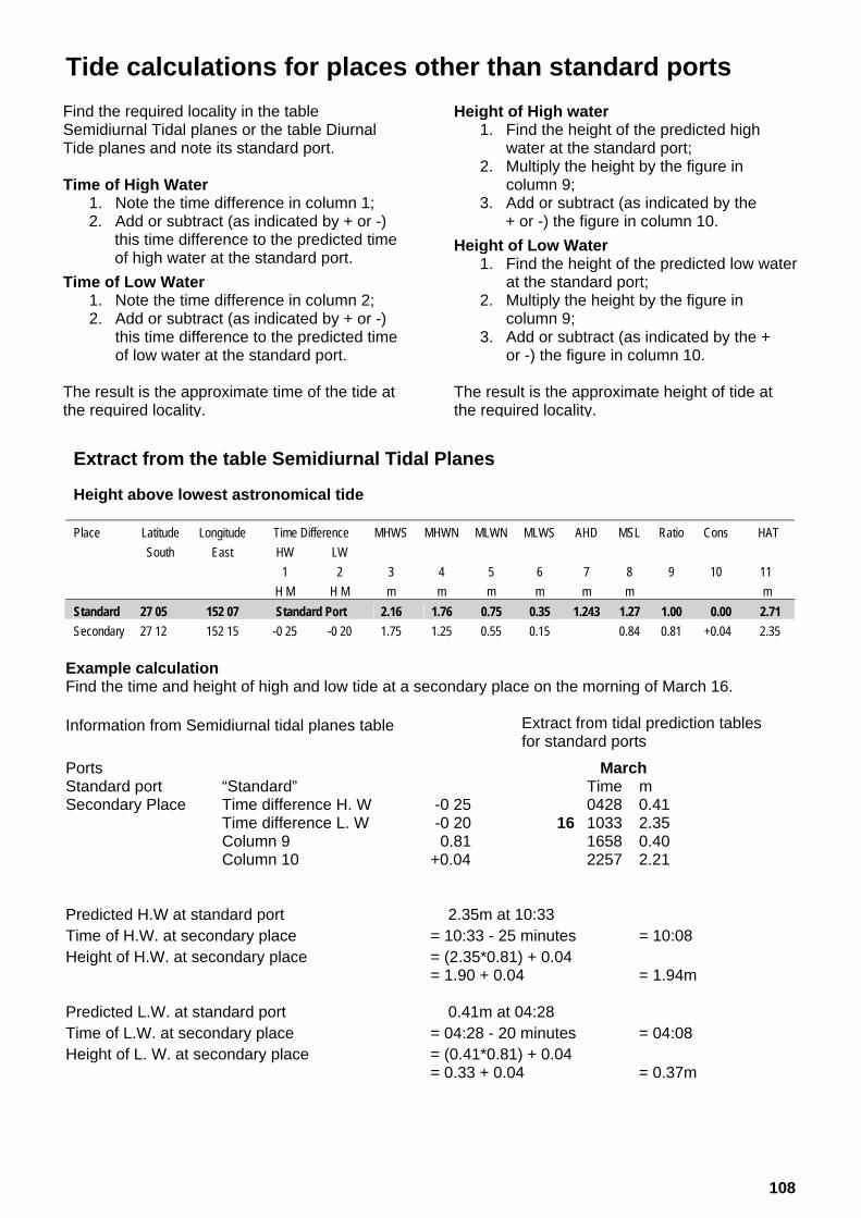
Tide calculations for places other than standard ports Extract from the table Semidiurnal Tidal Planes
Height above lowest astronomical tide
Place Latitude Longitude Time Difference MHWS MHWN MLWN MLWS AHD MSL Ratio Cons HAT
South East HW LW
1 2 3 4 5 6 7 8 9 10 11
H M H M m m m m m m m
Standard 27 05 152 07 Standard Port 2.16 1.76 0.75 0.35 1.243 1.27 1.00 0.00 2.71
Secondary 27 12 152 15 -0 25 -0 20 1.75 1.25 0.55 0.15 0.84 0.81 +0.04 2.35
Example calculation Find the time and height of high and low tide at a secondary place on the morning of March 16.
Extract from tidal prediction tables for standard ports
Ports March Standard port “Standard” Time m Secondary Place Time difference H. W -0 25 0428 0.41 Time difference L. W -0 20 16 1033 2.35 Column 9 -0.81 1658 0.40 Column 10 +0.04 2257 2.21 Predicted H.W at standard port 2.35m at 10:33 Time of H.W. at secondary place = 10:33 - 25 minutes = 10:08 Height of H.W. at secondary place = (2.35*0.81) + 0.04 = 1.90 + 0.04 = 1.94m Predicted L.W. at standard port 0.41m at 04:28 Time of L.W. at secondary place = 04:28 - 20 minutes = 04:08 Height of L. W. at secondary place = (0.41*0.81) + 0.04 = 0.33 + 0.04 = 0.37m
Height of High water 1. Find the height of the predicted high
water at the standard port; 2. Multiply the height by the figure in
column 9; 3. Add or subtract (as indicated by the
+ or -) the figure in column 10.
Height of Low Water 1. Find the height of the predicted low water
at the standard port; 2. Multiply the height by the figure in
column 9; 3. Add or subtract (as indicated by the +
or -) the figure in column 10. The result is the approximate height of tide at the required locality.
Find the required locality in the table Semidiurnal Tidal planes or the table Diurnal Tide planes and note its standard port. Time of High Water
1. Note the time difference in column 1; 2. Add or subtract (as indicated by + or -)
this time difference to the predicted time of high water at the standard port.
Time of Low Water 1. Note the time difference in column 2; 2. Add or subtract (as indicated by + or -)
this time difference to the predicted time of low water at the standard port.
The result is the approximate time of the tide at the required locality.
Information from Semidiurnal tidal planes table
108

Tide calculations between high and low water
Conversion – Metres to Feet
Metres 0.00 0.10 0.20 0.30 0.40 0.50 0.60 0.70 0.80 0.90 Feet 0 0.00 0.33 0.66 0.98 1.31 1.64 1.97 2.30 2.62 2.95 1 3.28 3.61 3.94 4.27 4.59 4.92 5.25 5.58 5.91 6.23 2 6.56 6.89 7.22 7.55 7.87 8.20 8.53 8.86 9.19 9.51 3 9.84 10.17 10.50 10.83 11.15 11.48 11.81 12.14 12.47 12.80 4 13.12 13.45 13.78 14.11 14.44 14.76 15.09 15.42 15.75 16.08 5 16.40 16.73 17.06 17.39 17.72 18.04 18.37 18.70 19.03 19.36 6 19.69 20.01 20.34 20.67 21.00 21.33 21.65 21.98 22.31 22.64 7 22.97 23.29 23.62 23.95 24.28 24.61 24.93 25.26 25.59 25.92 8 26.25 26.57 26.90 27.23 27.56 27.89 28.22 28.54 28.87 29.20 9 29.53 29.86 30.18 30.51 30.84 31.17 31.50 31.82 32.15 32.48
10 32.81 33.14 33.46 33.79 34.12 34.45 34.78 35.10 35.43 35.76 11 36.09 36.42 36.75 37.07 37.40 37.73 38.06 38.39 38.71 39.04 12 39.37 39.70 40.03 40.35 40.68 41.01 41.34 41.67 41.99 42.32 13 42.65 42.98 43.31 43.64 43.96 44.29 44.62 44.95 45.28 45.60 14 45.93 46.26 46.59 46.92 47.24 47.57 47.90 48.23 48.56 48.88 15 49.21 49.54 49.87 50.20 50.52 50.85 51.18 51.51 51.84 52.17
Example Calculations – Secondary Place Required: Tidal height at 0840 hours 1. Calculate the high and low water times and
heights for the secondary place
Low water 04:08 0.37m High water 10:08 1.94m
2. High water 1.94
Low water -0.37 Range (Height difference) 1.57
3. Required time 0840 hours, which is 1 hour
and 28 minutes before high water. Enter the appropriate Standard Tidal Curves (or interpolated graph) for the 1.57m range to 1 hour 28 minutes before high water. Read off the height at this point, which in this case is approximately 1.4m
4. Add the height obtained in step three above
to the height of low water.
L.W 0.4m (rounded off) +1.4m +1.8m (approx.) at 08:40
Example Calculations – Standard Port Required: Tidal height at 0840 hours 1. Obtain the tidal predictions from the tables. Extract from tidal prediction Time m tables for standard ports 0428 0.41
16 1033 2.35 1658 0.40 2257 2.21
2. High water 2.35
Low water -0.41 Range (Height difference) 1.94
3. Required time 0840 hours, which is 1 hour and 53 minutes before high water. Enter the appropriate Standard Tidal Curves (or interpolated graph) for the 1.94m range to 1 hour 53 minutes before high water. Read off the height at this point, which in this case is approximately 1.6m
4. Add the height obtained in step three above to the height of low water.
L.W +0.4m (rounded off)
+1.6m +2.0m (approx.) at 08:40
109

Standard tidal curves
110

Calculation of overhead clearance
With the introduction of the tidal datum epoch 1992-2011, the semidiurnal and diurnal tidal planes information was updated.
At some localities, this had a minor impact on the highest astronomical tide values. The clearance value assigned to overhead structures across tidal waters is being reviewed.
Mariners are advised to refer to this publication, boating safety charts, the Beacon to Beacon Directory and the respective management authority signage for warnings and clearance information.
Highest astronomical tide values for standard ports and secondary locations are tabulated on pages 101 to 107.
Overhead clearance This is defined as the vertical distance between the lowest under-surface of the overhead structure and the water level at the highest astronomical tide. For electricity cables, this also incorporates an additional mandatory safety margin to satisfy electrical regulations.
The difference in elevation between the highest astronomical tide value and the predicted tide height at the time of passing under the structure, can be added to the nominated minimum clearance shown on the chart/directory so as to derive the total clearance available.
A further safety margin should be included to provide a guaranteed air space above the uppermost part of the vessel and the under-surface of the overhead structure, therefore further reducing available overhead clearance.
Weather conditions, storm surge, flood runoff, current, wave action or wash from other vessels should be considered as factors that can cause an additional reduction of your calculated clearance.
Consult your chart first, the deepest part of a channel may not occur at the maximum point of clearance.
To ensure the safety of your vessel and persons onboard, know the maximum height of your vessel above the waterline, its maximum draught, always keep a proper lookout, and navigate beneath the overhead structure at an appropriate speed.
Bridges and overhead pipelines The value shown is the maximum clearance above HAT (highest astronomical tide).
For a bridge that slopes continuously downwards from one bank to the other, the clearance value shown is for the position beneath the lowest part of the span. For an example, refer to NTM 630 of 2009 for details of the Kurilpa Bridge across the Brisbane River.
In all instances, the deepest part of the navigation channel may not occur at the point of maximum clearance.
111

Overhead cable clearance The value shown indicates the maximum height of a vessel which may pass beneath the cable and are given for the lowest point of the sag. Allowances have been made for safety margins required to satisfy the electricity regulations. Clearances are given with respect to HAT. The deepest part of the navigation channel may not occur at the point of maximum clearance.
Boat operators should always be responsible for maintaining a proper lookout at all times for crossings which may not be shown on the chart or those which have altered in some way.
112

2015 Phases and apsides of the moon
The moon phases given in this table are the times when the sun, moon, and earth lie approximately in the same line (180o) at full and new moon and at first and last quarter when the moon is (90o) to the line of the sun and earth. Times are Australian Eastern Standard Time
2015 Seasons and apsides of the earth
Perihelion d h m
Vernal Equinox d h m
Summer Solstice d h m
Aphelion d h m
Autumnal Equinox d h m
Winter Solstice d h m
Jan 04 17:00 Mar 21 08:45 Jun 22 02:38 Jul 07 05:00 Sep 23 18:20 Dec 22 14:48 Equinox and Solstice named by Northern Hemisphere convention Times are Australian Eastern Standard Time
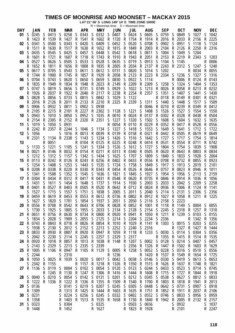
Using the moonrise and moonset table
The average time between the rising and setting of the moon is 12 hours 25 minutes. It follows that successive rises (or sets) of the moon will be 24 hours and 50 minutes apart or in other words the moon will rise (or set) on average 50 minutes later each successive day of the year. As a consequence of the above – unlike the sun which always rises in the morning and sets in the afternoon of the same day – the moon will frequently set on the day after it has risen. Occasionally there is no entry in the table for the moon set time, this means that the moon will set on the next day. Occasionally there is no entry in the table for the moonrise time, this means the moon rose on the previous day.
New Moon d h m
First Quarter d h m
Full Moon d h m
Last Quarter d h m
Perigee d h m
Apogee d h m
Jan 20 23:14 Feb 19 09:47 Mar 20 19:36 Apr 19 04:57 May 18 14:13 Jun 17 00:05 Jul 16 11:24 Aug 15 00:53 Sep 13 16:41 Oct 13 10:06 Nov 12 03:47 Dec 11 20:29
Jan 27 14:48 Feb 26 03:14 Mar 27 17:43 Apr 26 09:55 May 26 03:19 Jun 24 21:02 Jul 24 14:04 Aug 23 05:31 Sep 21 18:59 Oct 21 06:31 Nov 19 16:27 Dec 19 01:14
Jan 05 14:53 Feb 04 09:09 Mar 06 04:05 Apr 04 22:05 May 04 13:42 Jun 03 02:19 Jul 02 12:20 Jul 31 20:43 Aug 30 04:35 Sep 28 12:50 Oct 27 22:05 Nov 26 08:44 Dec 25 21:11
Jan 13 19:46 Feb 12 13:50 Mar 14 03:48 Apr 12 13:44 May 11 20:36 Jun 10 01:42 Jul 09 06:24 Aug 07 12:03 Sep 05 19:54 Oct 05 07:06 Nov 03 22:24 Dec 03 17:40
Jan 22 06:07 Feb 19 17:31 Mar 20 05:39 Apr 17 13:54 May 15 10:24 Jun 10 14:40 Jul 06 04:55 Aug 02 20:12 Aug 31 01:25 Sep 28 11:47 Oct 26 23:00 Nov 24 06:07 Dec 21 18:54
Jan 10 04:18 Feb 06 16:27 Mar 05 17:36 Apr 01 23:00 Apr 29 13:56 May 27 08:14 Jun 24 03:02 Jul 21 21:03 Aug 18 12:34 Sep 14 21:29 Oct 11 23:18 Nov 08 07:50 Dec 06 00:57
113

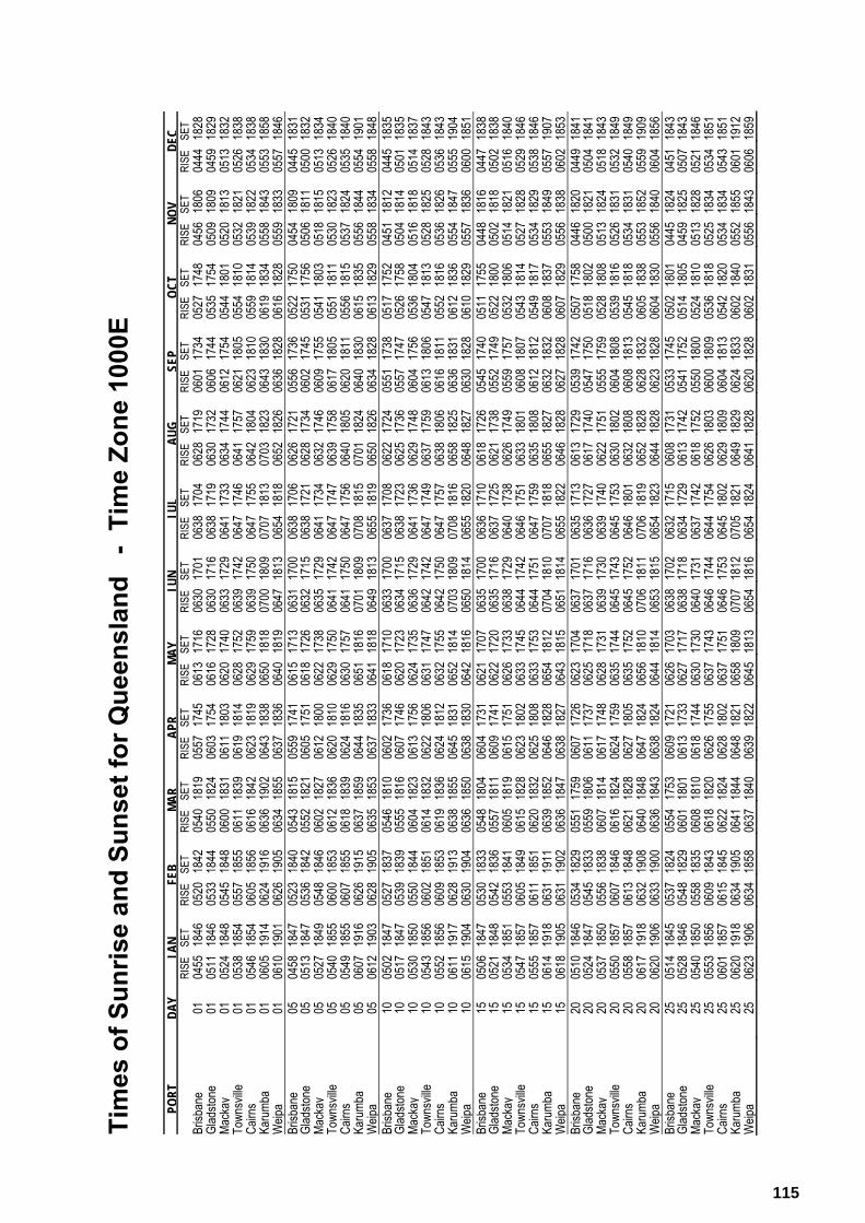
Sun and moon rise and set tables The tables of moon and sun rise and set have been prepared by Maritime Safety Queensland using information from Geoscience Australia. The tables detail the times of the rise and set phenomena for an observer at sea level for the following tidal stations:-
Brisbane Bar Gladstone Mackay Outer Harbour Townsville Cairns Karumba Weipa
The time of the rise and set varies from place to place. However for adjacent places the variation is small and as a result the entries in the table may be used for adjacent tidal stations. The times of moon rise and set are given for every day of the month. The times of sunrise and set are given for every 5th day of the month.
The following groupings are applicable:-
Brisbane representing Gold Coast Seaway, Brisbane Bar and Mooloolaba. Gladstone representing Bundaberg, Gladstone, Port Alma and Rosslyn Bay. Mackay representing Hay Pt, Mackay, Shute Harbour, Bowen and Abbot Point. Townsville representing Townsville and Lucinda. Cairns representing Mourilyan, Cairns and Port Douglas. Karumba representing Karumba and Mornington Island. Weipa representing Weipa and Thursday Island.
It should be noted that:-
The grouping introduces an approximation which does not exceed 10 minutes; atmospheric refraction that is different from the standard refraction; and, the height of eye of the observer (above sea level), will affect the time at which the sun
and moon appear to rise and set. Definitions:-
Sun rise is defined as the instant in the morning under ideal meteorological conditions, with standard refraction of the sun's rays, when the upper edge of the sun's disk is coincident with an ideal horizon.
Sun set is defined as the instant in the evening under ideal meteorological conditions, with standard refraction of the sun's rays, when the upper edge of the sun's disk is coincident with an ideal horizon.
Moon rise is defined as the instant when, in the eastern sky, under ideal meteorological conditions, with standard refraction of the moon's rays, the upper edge of the moon's disk is coincident with an ideal horizon.
Moon set is defined as the instant when, in the western sky, under ideal meteorological conditions, with standard refraction of the moon's rays, the upper edge of the moon's disk is coincident with an ideal horizon.
An ideal horizon exists when the surface forming the horizon is at a right angle to the vertical line passing through the observer's position on the earth. If the terrain surrounding the observer was flat and all at the same height above sea level, the horizon seen by the observer standing on the earth would approximate the ideal horizon.
114
Tim
es o
f Sun
rise
and
Suns
et fo
r Que
ensl
and
- T
ime
Zone
100
0E
PO
RT
DA
YJA
NFE
BM
AR
APR
MA
YJU
NJU
LA
UG
SEP
OC
TN
OV
DEC
RISE
SE
T RI
SE
SET
RISE
SET
RISE
SET
RISE
SET
RISE
SET
RISE
SE
TRI
SESE
TRI
SESE
TRI
SESE
TRI
SESE
TRI
SE
SET
Brisb
ane
0104
55 1
846
0520
184
205
4018
1905
5717
4506
1317
1606
3017
0106
38 1
704
0628
1719
0601
1734
0527
1748
0456
1806
0444
182
8 Gl
adsto
ne
0105
11 1
846
0533
184
405
5018
2406
0317
5406
1617
2806
3017
1606
38 1
719
0630
1732
0606
1744
0535
1754
0509
1809
0459
182
9 Ma
ckay
01
0524
184
8 05
45 1
848
0600
1831
0611
1803
0620
1740
0633
1729
0641
173
306
3417
4406
1217
5405
4418
0105
2018
1305
13 1
832
Town
sville
01
0538
185
4 05
57 1
855
0611
1839
0619
1814
0628
1752
0639
1742
0647
174
606
4117
5706
2118
0505
5418
1005
3218
2105
26 1
838
Cairn
s 01
0546
185
4 06
05 1
856
0616
1842
0623
1819
0629
1759
0639
1750
0647
175
506
4218
0406
2318
1005
5918
1405
3918
2205
34 1
838
Karu
mba
0106
05 1
914
0624
191
606
3619
0206
4318
3806
5018
1807
0018
0907
07 1
813
0703
1823
0643
1830
0619
1834
0558
1843
0553
185
8 W
eipa
0106
10 1
901
0626
190
506
3418
5506
3718
3606
4018
1906
4718
1306
54 1
818
0652
1826
0636
1828
0616
1828
0559
1833
0557
184
6 Br
isban
e 05
0458
184
7 05
23 1
840
0543
1815
0559
1741
0615
1713
0631
1700
0638
170
606
2617
2105
5617
3605
2217
5004
5418
0904
45 1
831
Glad
stone
05
0513
184
7 05
36 1
842
0552
1821
0605
1751
0618
1726
0632
1715
0638
172
106
2817
3406
0217
4505
3117
5605
0618
1105
00 1
832
Mack
ay
0505
27 1
849
0548
184
606
0218
2706
1218
0006
2217
3806
3517
2906
41 1
734
0632
1746
0609
1755
0541
1803
0518
1815
0513
183
4 To
wnsv
ille
0505
40 1
855
0600
185
306
1218
3606
2018
1006
2917
5006
4117
4206
47 1
747
0639
1758
0617
1805
0551
1811
0530
1823
0526
184
0 Ca
irns
0505
49 1
855
0607
185
506
1818
3906
2418
1606
3017
5706
4117
5006
47 1
756
0640
1805
0620
1811
0556
1815
0537
1824
0535
184
0 Ka
rumb
a 05
0607
191
6 06
26 1
915
0637
1859
0644
1835
0651
1816
0701
1809
0708
181
507
0118
2406
4018
3006
1518
3505
5618
4405
54 1
901
Weip
a 05
0612
190
3 06
28 1
905
0635
1853
0637
1833
0641
1818
0649
1813
0655
181
906
5018
2606
3418
2806
1318
2905
5818
3405
58 1
848
Brisb
ane
1005
02 1
847
0527
183
705
4618
1006
0217
3606
1817
1006
3317
0006
37 1
708
0622
1724
0551
1738
0517
1752
0451
1812
0445
183
5 Gl
adsto
ne
1005
17 1
847
0539
183
905
5518
1606
0717
4606
2017
2306
3417
1506
38 1
723
0625
1736
0557
1747
0526
1758
0504
1814
0501
183
5 Ma
ckay
10
0530
185
0 05
50 1
844
0604
1823
0613
1756
0624
1735
0636
1729
0641
173
606
2917
4806
0417
5605
3618
0405
1618
1805
14 1
837
Town
sville
10
0543
185
6 06
02 1
851
0614
1832
0622
1806
0631
1747
0642
1742
0647
174
906
3717
5906
1318
0605
4718
1305
2818
2505
28 1
843
Cairn
s 10
0552
185
6 06
09 1
853
0619
1836
0624
1812
0632
1755
0642
1750
0647
175
706
3818
0606
1618
1105
5218
1605
3618
2605
36 1
843
Karu
mba
1006
11 1
917
0628
191
306
3818
5506
4518
3106
5218
1407
0318
0907
08 1
816
0658
1825
0636
1831
0612
1836
0554
1847
0555
190
4 W
eipa
1006
15 1
904
0630
190
406
3618
5006
3818
3006
4218
1606
5018
1406
55 1
820
0648
1827
0630
1828
0610
1829
0557
1836
0600
185
1 Br
isban
e 15
0506
184
7 05
30 1
833
0548
1804
0604
1731
0621
1707
0635
1700
0636
171
006
1817
2605
4517
4005
1117
5504
4818
1604
47 1
838
Glad
stone
15
0521
184
8 05
42 1
836
0557
1811
0609
1741
0622
1720
0635
1716
0637
172
506
2117
3805
5217
4905
2218
0005
0218
1805
02 1
838
Mack
ay
1505
34 1
851
0553
184
106
0518
1906
1517
5106
2617
3306
3817
2906
40 1
738
0626
1749
0559
1757
0532
1806
0514
1821
0516
184
0 To
wnsv
ille
1505
47 1
857
0605
184
906
1518
2806
2318
0206
3317
4506
4417
4206
46 1
751
0633
1801
0608
1807
0543
1814
0527
1828
0529
184
6 Ca
irns
1505
55 1
857
0611
185
106
2018
3206
2518
0806
3317
5306
4417
5106
47 1
759
0635
1808
0612
1812
0549
1817
0534
1829
0538
184
6 Ka
rumb
a 15
0614
191
8 06
31 1
911
0639
1852
0646
1828
0654
1812
0704
1810
0707
181
806
5518
2706
3218
3206
0818
3705
5318
4905
57 1
907
Weip
a 15
0618
190
5 06
31 1
902
0636
1847
0638
1827
0643
1815
0651
1814
0655
182
206
4618
2806
2718
2806
0718
2905
5618
3806
02 1
853
Brisb
ane
2005
10 1
846
0534
182
905
5117
5906
0717
2606
2317
0406
3717
0106
35 1
713
0613
1729
0539
1742
0507
1758
0446
1820
0449
184
1 Gl
adsto
ne
2005
24 1
847
0545
183
305
5918
0606
1117
3706
2517
1806
3717
1606
36 1
727
0617
1740
0547
1750
0518
1802
0500
1821
0504
184
1 Ma
ckay
20
0537
185
0 05
56 1
838
0607
1814
0617
1748
0628
1731
0639
1730
0639
174
006
2217
5105
5517
5905
2818
0805
1318
2405
18 1
843
Town
sville
20
0550
185
7 06
07 1
846
0616
1824
0624
1759
0635
1744
0645
1743
0645
175
306
3018
0206
0418
0805
3918
1605
2618
3105
32 1
849
Cairn
s 20
0558
185
7 06
13 1
848
0621
1828
0627
1805
0635
1752
0645
1752
0646
180
106
3218
0806
0818
1305
4518
1805
3418
3105
40 1
849
Karu
mba
2006
17 1
918
0632
190
806
4018
4806
4718
2406
5618
1007
0618
1107
06 1
819
0652
1828
0628
1832
0605
1838
0553
1852
0559
190
9 W
eipa
2006
20 1
906
0633
190
006
3618
4306
3818
2406
4418
1406
5318
1506
54 1
823
0644
1828
0623
1828
0604
1830
0556
1840
0604
185
6 Br
isban
e 25
0514
184
5 05
37 1
824
0554
1753
0609
1721
0626
1703
0638
1702
0632
171
506
0817
3105
3317
4505
0218
0104
4518
2404
51 1
843
Glad
stone
25
0528
184
6 05
48 1
829
0601
1801
0613
1733
0627
1717
0638
1718
0634
172
906
1317
4205
4117
5205
1418
0504
5918
2505
07 1
843
Mack
ay
2505
40 1
850
0558
183
506
0818
1006
1817
4406
3017
3006
4017
3106
37 1
742
0618
1752
0550
1800
0524
1810
0513
1828
0521
184
6 To
wnsv
ille
2505
53 1
856
0609
184
306
1818
2006
2617
5506
3717
4306
4617
4406
44 1
754
0626
1803
0600
1809
0536
1818
0525
1834
0534
185
1 Ca
irns
2506
01 1
857
0615
184
506
2218
2406
2818
0206
3717
5106
4617
5306
45 1
802
0629
1809
0604
1813
0542
1820
0534
1834
0543
185
1 Ka
rumb
a 25
0620
191
8 06
34 1
905
0641
1844
0648
1821
0658
1809
0707
1812
0705
182
106
4918
2906
2418
3306
0218
4005
5218
5506
01 1
912
Weip
a 25
0623
190
6 06
34 1
858
0637
1840
0639
1822
0645
1813
0654
1816
0654
182
406
4118
2806
2018
2806
0218
3105
5618
4306
06 1
859
115

TIMES OF MOONRISE AND MOONSET – BRISBANE 2015 LAT 27° 22’ S LONG 153° 10’ E TIME ZONE 1000E
R = Moonrise time S = Moonset time
DAY JAN FEB MAR APR MAY JUN JUL AUG SEP OCT NOV DEC 01 S 0134 S 0246 S 0134 S 0255 S 0321 S 0443 S 0519 S 0639 S 0733 S 0742 S 0901 S 0934
R 1506 R 1632 R 1515 R 1550 R 1534 R 1606 R 1626 R 1816 R 2019 R 2114 R 2248 R 2255 02 S 0220 S 0337 S 0226 S 0346 S 0413 S 0539 S 0615 S 0726 S 0818 S 0832 S 0956 S 1028
R 1603 R 1717 R 1557 R 1625 R 1609 R 1652 R 1723 R 1921 R 2124 R 2215 R 2335 R 2333 03 S 0308 S 0430 S 0317 S 0436 S 0505 S 0635 S 0708 S 0812 S 0904 S 0924
R 1657 R 1758 R 1637 R 1659 R 1647 R 1742 R 1825 R 2026 R 2227 R 2313 S 1051 S 1120 04 S 0358 S 0522 S 0409 S 0527 S 0558 S 0731 S 0759 S 0856 S 0952 R 0018 R 0009
R 1748 R 1837 R 1714 R 1734 R 1727 R 1837 R 1927 R 2130 R 2327 S 1018 S 1145 S 1212 05 S 0450 S 0613 S 0500 S 0619 S 0653 S 0824 S 0847 S 0940 R 0006 R 0058 R 0044
R 1835 R 1913 R 1749 R 1810 R 1811 R 1935 R 2031 R 2233 S 1041 S 1112 S 1237 S 1302 06 S 0543 S 0704 S 0550 S 0711 S 0748 S 0916 S 0932 S 1023 R 0025 R 0055 R 0134 R 0118
R 1919 R 1948 R 1824 R 1848 R 1858 R 2036 R 2134 R 2335 S 1132 S 1205 S 1328 S 1353 07 S 0636 S 0755 S 0641 S 0804 S 0843 S 1004 S 1016 R 0120 R 0139 R 0209 R 0153
R 2000 R 2022 R 1858 R 1929 R 1949 R 2137 R 2237 S 1108 S 1224 S 1258 S 1419 S 1444 08 S 0728 S 0845 S 0732 S 0858 S 0937 S 1050 S 1058 R 0036 R 0210 R 0220 R 0244 R 0229
R 2037 R 2057 R 1933 R 2013 R 2044 R 2239 R 2339 S 1155 S 1317 S 1351 S 1509 S 1535 09 S 0819 S 0936 S 0823 S 0953 S 1028 S 1133 R 0134 R 0257 R 0258 R 0318 R 0307
R 2113 R 2132 R 2010 R 2101 R 2142 R 2341 S 1140 S 1244 S 1410 S 1442 S 1600 S 1628 10 S 0910 S 1028 S 0915 S 1047 S 1118 R 0040 R 0230 R 0340 R 0334 R 0353 R 0348
R 2147 R 2209 R 2048 R 2153 R 2242 S 1215 S 1224 S 1335 S 1503 S 1533 S 1651 S 1722 11 S 1000 S 1121 S 1009 S 1140 S 1205 R 0043 R 0141 R 0323 R 0420 R 0408 R 0430 R 0433
R 2221 R 2249 R 2130 R 2249 R 2343 S 1257 S 1309 S 1427 S 1555 S 1624 S 1743 S 1816 12 S 1051 S 1215 S 1103 S 1231 R 0145 R 0241 R 0413 R 0457 R 0443 R 0510 R 0522
R 2256 R 2332 R 2215 R 2348 S 1249 S 1340 S 1356 S 1520 S 1646 S 1714 S 1836 S 1909 13 S 1143 S 1157 R 0045 R 0247 R 0339 R 0458 R 0533 R 0517 R 0552 R 0615
R 2332 S 1310 R 2305 S 1320 S 1333 S 1424 S 1446 S 1614 S 1737 S 1805 S 1929 S 2001 14 R 0021 S 1252 R 0049 R 0148 R 0348 R 0435 R 0541 R 0607 R 0553 R 0638 R 0710
S 1236 S 1407 R 2359 S 1407 S 1415 S 1511 S 1538 S 1707 S 1828 S 1856 S 2022 S 2050 15 R 0011 R 0114 R 0153 R 0251 R 0449 R 0528 R 0620 R 0641 R 0631 R 0727 R 0809
S 1330 S 1503 S 1345 S 1452 S 1459 S 1601 S 1632 S 1759 S 1918 S 1948 S 2114 S 2137 16 R 0054 R 0212 R 0058 R 0257 R 0355 R 0548 R 0616 R 0657 R 0716 R 0711 R 0820 R 0908
S 1427 S 1558 S 1437 S 1537 S 1543 S 1653 S 1726 S 1851 S 2009 S 2040 S 2204 S 2222 17 R 0141 R 0315 R 0200 R 0402 R 0458 R 0643 R 0701 R 0732 R 0752 R 0754 R 0916 R 1009
S 1525 S 1651 S 1527 S 1621 S 1630 S 1747 S 1821 S 1942 S 2100 S 2133 S 2252 S 2304 18 R 0233 R 0421 R 0304 R 0507 R 0601 R 0735 R 0743 R 0806 R 0830 R 0840 R 1014 R 1110
S 1623 S 1741 S 1616 S 1707 S 1719 S 1842 S 1914 S 2032 S 2152 S 2225 S 2337 S 2346 19 R 0331 R 0528 R 0411 R 0613 R 0702 R 0822 R 0821 R 0840 R 0911 R 0931 R 1114 R 1211
S 1721 S 1829 S 1702 S 1753 S 1811 S 1936 S 2006 S 2123 S 2244 S 2316 20 R 0433 R 0635 R 0517 R 0717 R 0801 R 0906 R 0857 R 0916 R 0956 R 1025 S 0021 S 0028
S 1815 S 1915 S 1748 S 1842 S 1905 S 2030 S 2057 S 2214 S 2337 R 1215 R 1313 21 R 0539 R 0742 R 0624 R 0820 R 0855 R 0945 R 0932 R 0952 R 1044 S 0006 S 0104 S 0111
S 1907 S 2000 S 1833 S 1933 S 1959 S 2123 S 2148 S 2305 R 1122 R 1317 R 1415 22 R 0645 R 0847 R 0730 R 0919 R 0944 R 1022 R 1006 R 1032 S 0030 S 0053 S 0147 S 0156
S 1955 S 2045 S 1919 S 2025 S 2054 S 2214 S 2238 S 2358 R 1137 R 1222 R 1420 R 1518 23 R 0752 R 0951 R 0835 R 1014 R 1029 R 1058 R 1040 R 1115 S 0122 S 0140 S 0230 S 0243
S 2041 S 2130 S 2006 S 2118 S 2148 S 2305 S 2329 R 1234 R 1324 R 1525 R 1621 24 R 0857 R 1052 R 0937 R 1105 R 1110 R 1132 R 1116 S 0052 S 0212 S 0225 S 0315 S 0334
S 2125 S 2216 S 2055 S 2212 S 2240 S 2356 R 1202 R 1334 R 1428 R 1630 R 1722 25 R 1000 R 1151 R 1037 R 1152 R 1148 R 1206 S 0021 S 0146 S 0301 S 0309 S 0403 S 0429
S 2207 S 2303 S 2145 S 2305 S 2332 R 1155 R 1253 R 1438 R 1533 R 1735 R 1820 26 R 1102 R 1248 R 1133 R 1234 R 1224 S 0047 S 0114 S 0240 S 0349 S 0354 S 0454 S 0525
S 2250 S 2353 S 2237 S 2357 R 1242 R 1236 R 1350 R 1543 R 1639 R 1839 R 1914 27 R 1203 R 1340 R 1225 R 1313 S 0023 S 0139 S 0209 S 0333 S 0435 S 0440 S 0548 S 0622
S 2334 S 2329 R 1259 R 1319 R 1322 R 1450 R 1649 R 1746 R 1939 R 2004 28 R 1301 S 0043 R 1312 S 0049 S 0113 S 0232 S 0304 S 0425 S 0521 S 0528 S 0644 S 0719
R 1430 R 1350 R 1333 R 1359 R 1412 R 1554 R 1756 R 1852 R 2035 R 2049 29 S 0019 S 0021 S 0140 S 0204 S 0327 S 0400 S 0514 S 0607 S 0618 S 0741 S 0815
R 1358 R 1356 R 1425 R 1408 R 1444 R 1508 R 1700 R 1903 R 1957 R 2127 R 2129 30 S 0106 S 0113 S 0230 S 0256 S 0423 S 0455 S 0602 S 0654 S 0711 S 0838 S 0909
R 1453 R 1436 R 1459 R 1444 R 1532 R 1608 R 1807 R 2009 R 2058 R 2213 R 2207 31 S 0155 S 0204 S 0349 S 0548 S 0648 S 0805 S 1002
R 1544 R 1514 R 1523 R 1711 R 1913 R 2156 R 2243
116

TIMES OF MOONRISE AND MOONSET – GLADSTONE 2015 LAT 23° 50’ S LONG 151° 15’ E TIME ZONE 1000E
R = Moonrise time S = Moonset time
DAY JAN FEB MAR APR MAY JUN JUL AUG SEP OCT NOV DEC 01 S 0240 S 0409 S 0254 S 0337 S 0324 S 0355 S 0411 S 0554 S 0752 S 0844 S 1023 S 1037
R 1411 R 1526 R 1414 R 1531 R 1555 R 1715 R 1750 R 1909 R 2007 R 2021 R 2143 R 2214 02 S 0336 S 0456 S 0339 S 0413 S 0400 S 0440 S 0507 S 0658 S 0855 S 0946 S 1114 S 1118
R 1458 R 1618 R 1505 R 1621 R 1645 R 1811 R 1845 R 1957 R 2054 R 2113 R 2238 R 2306 03 S 0431 S 0540 S 0420 S 0449 S 0438 S 0529 S 0606 S 0801 S 0958 S 1045 S 1159 S 1156
R 1548 R 1709 R 1556 R 1710 R 1737 R 1906 R 1938 R 2043 R 2141 R 2206 R 2331 R 2357 04 S 0524 S 0621 S 0459 S 0524 S 0517 S 0622 S 0707 S 0904 S 1059 S 1141
R 1639 R 1800 R 1646 R 1800 R 1830 R 2001 R 2029 R 2128 R 2230 R 2300 S 1241 S 1233 05 S 0613 S 0659 S 0536 S 0601 S 0600 S 0718 S 0809 S 1007 S 1158 S 1232 R 0023 R 0046
R 1731 R 1850 R 1736 R 1851 R 1924 R 2054 R 2117 R 2213 R 2321 R 2353 S 1320 S 1308 06 S 0659 S 0736 S 0613 S 0639 S 0646 S 0817 S 0911 S 1108 R 0114 R 0135
R 1823 R 1939 R 1825 R 1943 R 2019 R 2145 R 2202 R 2258 S 1254 S 1319 S 1357 S 1343 07 S 0742 S 0812 S 0648 S 0719 S 0736 S 0917 S 1013 S 1208 R 0013 R 0046 R 0203 R 0225
R 1915 R 2029 R 1914 R 2036 R 2113 R 2233 R 2246 R 2345 S 1347 S 1402 S 1433 S 1420 08 S 0822 S 0847 S 0724 S 0803 S 0829 S 1018 S 1114 R 0105 R 0138 R 0253 R 0315
R 2005 R 2118 R 2004 R 2129 R 2206 R 2318 R 2330 S 1307 S 1435 S 1443 S 1508 S 1458 09 S 0900 S 0923 S 0800 S 0849 S 0925 R 0034 R 0158 R 0228 R 0342 R 0407
R 2055 R 2208 R 2055 R 2223 R 2257 S 1118 S 1214 S 1404 S 1521 S 1521 S 1544 S 1538 10 S 0936 S 1000 S 0839 S 0939 S 1023 R 0002 R 0014 R 0124 R 0250 R 0318 R 0432 R 0459
R 2145 R 2259 R 2147 R 2316 R 2346 S 1219 S 1314 S 1458 S 1603 S 1557 S 1621 S 1622 11 S 1011 S 1039 S 0920 R 0046 R 0059 R 0216 R 0341 R 0408 R 0522 R 0552
R 2234 R 2352 R 2240 S 1033 S 1123 S 1319 S 1413 S 1549 S 1643 S 1633 S 1700 S 1710 12 S 1047 S 1004 R 0009 R 0033 R 0129 R 0146 R 0309 R 0432 R 0457 R 0614 R 0646
R 2324 S 1122 R 2333 S 1130 S 1223 S 1420 S 1512 S 1637 S 1720 S 1708 S 1742 S 1801 13 R 0046 R 0100 R 0119 R 0214 R 0236 R 0401 R 0522 R 0546 R 0706 R 0738
S 1123 S 1208 S 1052 S 1230 S 1324 S 1520 S 1608 S 1722 S 1756 S 1744 S 1827 S 1855 14 R 0015 R 0142 R 0028 R 0149 R 0203 R 0301 R 0327 R 0454 R 0611 R 0636 R 0759 R 0829
S 1201 S 1259 S 1144 S 1331 S 1426 S 1620 S 1703 S 1804 S 1832 S 1822 S 1915 S 1951 15 R 0108 R 0238 R 0122 R 0236 R 0247 R 0350 R 0420 R 0546 R 0701 R 0727 R 0851 R 0918
S 1243 S 1355 S 1240 S 1433 S 1528 S 1720 S 1754 S 1843 S 1907 S 1902 S 2006 S 2050 16 R 0203 R 0334 R 0215 R 0323 R 0333 R 0442 R 0514 R 0636 R 0750 R 0818 R 0942 R 1005
S 1328 S 1455 S 1340 S 1536 S 1630 S 1817 S 1841 S 1920 S 1944 S 1944 S 2100 S 2148 17 R 0259 R 0429 R 0307 R 0409 R 0420 R 0535 R 0608 R 0726 R 0840 R 0910 R 1032 R 1050
S 1419 S 1559 S 1443 S 1640 S 1732 S 1910 S 1925 S 1956 S 2022 S 2029 S 2157 S 2248 18 R 0357 R 0522 R 0358 R 0455 R 0509 R 0629 R 0700 R 0816 R 0931 R 1002 R 1119 R 1133
S 1514 S 1704 S 1547 S 1744 S 1834 S 2000 S 2006 S 2031 S 2102 S 2118 S 2255 S 2347 19 R 0455 R 0612 R 0446 R 0542 R 0600 R 0723 R 0752 R 0905 R 1022 R 1054 R 1205 R 1216
S 1614 S 1810 S 1652 S 1848 S 1933 S 2047 S 2044 S 2107 S 2145 S 2210 S 2354 20 R 0552 R 0701 R 0534 R 0631 R 0653 R 0817 R 0842 R 0954 R 1114 R 1144 R 1250 S 0047
S 1717 S 1916 S 1757 S 1950 S 2029 S 2129 S 2120 S 2144 S 2232 S 2305 R 1300 21 R 0646 R 0748 R 0621 R 0722 R 0747 R 0909 R 0932 R 1045 R 1207 R 1234 S 0054 S 0148
S 1823 S 2020 S 1902 S 2051 S 2121 S 2208 S 2156 S 2223 S 2323 R 1334 R 1345 22 R 0738 R 0834 R 0708 R 0814 R 0841 R 1000 R 1021 R 1136 R 1259 S 0003 S 0155 S 0250
S 1928 S 2123 S 2006 S 2148 S 2209 S 2245 S 2231 S 2304 R 1322 R 1418 R 1433 23 R 0826 R 0920 R 0756 R 0907 R 0935 R 1050 R 1111 R 1229 S 0017 S 0103 S 0257 S 0352
S 2032 S 2225 S 2108 S 2241 S 2252 S 2321 S 2307 S 2350 R 1351 R 1409 R 1504 R 1523 24 R 0912 R 1006 R 0845 R 1000 R 1027 R 1139 R 1201 R 1322 S 0115 S 0204 S 0401 S 0453
S 2135 S 2324 S 2209 S 2330 S 2333 S 2357 S 2345 R 1442 R 1455 R 1552 R 1616 25 R 0956 R 1054 R 0935 R 1053 R 1118 R 1229 R 1253 S 0039 S 0216 S 0307 S 0505 S 0552
S 2236 S 2306 R 1417 R 1531 R 1541 R 1643 R 1712 26 R 1040 S 0021 R 1026 S 0015 S 0011 S 0032 S 0026 S 0134 S 0319 S 0411 S 0608 S 0649
S 2336 R 1143 S 2359 R 1145 R 1208 R 1319 R 1346 R 1511 R 1619 R 1628 R 1736 R 1809 27 R 1125 S 0115 R 1118 S 0057 S 0047 S 0110 S 0110 S 0232 S 0424 S 0516 S 0710 S 0741
R 1233 R 1236 R 1258 R 1410 R 1440 R 1604 R 1707 R 1716 R 1831 R 1905 28 S 0035 S 0206 S 0050 S 0136 S 0123 S 0150 S 0159 S 0333 S 0529 S 0622 S 0808 S 0829
R 1210 R 1323 R 1209 R 1326 R 1347 R 1504 R 1536 R 1655 R 1754 R 1806 R 1928 R 2001 29 S 0132 S 0136 S 0212 S 0158 S 0233 S 0252 S 0437 S 0635 S 0726 S 0903 S 0912
R 1257 R 1301 R 1415 R 1437 R 1558 R 1631 R 1745 R 1842 R 1859 R 2025 R 2055 30 S 0227 S 0219 S 0248 S 0235 S 0320 S 0350 S 0542 S 0740 S 0829 S 0952 S 0953
R 1345 R 1352 R 1505 R 1528 R 1654 R 1726 R 1833 R 1931 R 1953 R 2120 R 2147 31 S 0319 S 0259 S 0314 S 0451 S 0647 S 0928 S 1030
R 1435 R 1442 R 1621 R 1818 R 1920 R 2048 R 2238
117
TIMES OF MOONRISE AND MOONSET – MACKAY 2015 LAT 21° 06’ S LONG 149° 14’ E TIME ZONE 1000E
R = Moonrise time S = Moonset time
DAY JAN FEB MAR APR MAY JUN JUL AUG SEP OCT NOV DEC 01 S 0245 S 0413 S 0258 S 0343 S 0332 S 0407 S 0424 S 0605 S 0759 S 0849 S 1027 S 1042
R 1423 R 1539 R 1427 R 1541 R 1602 R 1720 R 1754 R 1914 R 2016 R 2033 R 2156 R 2225 02 S 0341 S 0500 S 0343 S 0420 S 0409 S 0452 S 0520 S 0708 S 0902 S 0951 S 1118 S 1124
R 1511 R 1630 R 1517 R 1630 R 1652 R 1815 R 1849 R 2003 R 2104 R 2126 R 2250 R 2316 03 S 0435 S 0545 S 0425 S 0457 S 0448 S 0542 S 0618 S 0811 S 1004 S 1049 S 1204
R 1601 R 1721 R 1607 R 1718 R 1743 R 1910 R 1943 R 2051 R 2153 R 2219 R 2343 S 1203 04 S 0527 S 0626 S 0505 S 0533 S 0528 S 0635 S 0719 S 0913 S 1104 S 1145 R 0006
R 1652 R 1811 R 1656 R 1808 R 1835 R 2005 R 2034 R 2137 R 2243 R 2312 S 1247 S 1240 05 S 0617 S 0705 S 0543 S 0611 S 0612 S 0731 S 0820 S 1014 S 1202 R 0034 R 0055
R 1744 R 1900 R 1745 R 1857 R 1929 R 2058 R 2123 R 2223 R 2334 S 1236 S 1327 S 1316 06 S 0704 S 0743 S 0620 S 0650 S 0659 S 0830 S 0922 S 1114 R 0006 R 0124 R 0143
R 1835 R 1949 R 1834 R 1948 R 2023 R 2149 R 2209 R 2309 S 1258 S 1324 S 1404 S 1353 07 S 0747 S 0819 S 0656 S 0731 S 0749 S 0929 S 1022 S 1213 R 0026 R 0058 R 0213 R 0232
R 1926 R 2037 R 1922 R 2040 R 2117 R 2238 R 2254 R 2357 S 1351 S 1407 S 1441 S 1430 08 S 0828 S 0856 S 0733 S 0815 S 0842 S 1029 S 1122 R 0118 R 0149 R 0301 R 0321
R 2016 R 2126 R 2011 R 2133 R 2210 R 2325 R 2339 S 1311 S 1440 S 1448 S 1517 S 1509 09 S 0906 S 0932 S 0811 S 0902 S 0938 R 0046 R 0210 R 0239 R 0349 R 0412
R 2105 R 2215 R 2101 R 2227 R 2302 S 1128 S 1221 S 1408 S 1526 S 1527 S 1554 S 1550 10 S 0943 S 1010 S 0850 S 0952 S 1035 R 0010 R 0024 R 0137 R 0302 R 0328 R 0438 R 0504
R 2154 R 2305 R 2152 R 2320 R 2351 S 1227 S 1320 S 1502 S 1608 S 1604 S 1632 S 1635 11 S 1019 S 1050 S 0931 R 0054 R 0110 R 0229 R 0352 R 0417 R 0528 R 0556
R 2242 R 2357 R 2244 S 1046 S 1134 S 1327 S 1418 S 1553 S 1649 S 1641 S 1712 S 1722 12 S 1056 S 1016 R 0013 R 0039 R 0139 R 0158 R 0321 R 0442 R 0505 R 0619 R 0649
R 2331 S 1134 R 2338 S 1143 S 1234 S 1426 S 1516 S 1642 S 1727 S 1717 S 1754 S 1814 13 R 0051 R 0104 R 0125 R 0225 R 0248 R 0414 R 0531 R 0554 R 0711 R 0742
S 1133 S 1221 S 1105 S 1241 S 1334 S 1526 S 1612 S 1727 S 1804 S 1754 S 1839 S 1908 14 R 0021 R 0146 R 0032 R 0154 R 0211 R 0313 R 0340 R 0505 R 0620 R 0643 R 0803 R 0834
S 1212 S 1312 S 1157 S 1342 S 1434 S 1625 S 1707 S 1809 S 1840 S 1833 S 1928 S 2004 15 R 0113 R 0242 R 0126 R 0243 R 0256 R 0402 R 0433 R 0556 R 0708 R 0732 R 0855 R 0923
S 1254 S 1408 S 1253 S 1443 S 1535 S 1724 S 1758 S 1849 S 1917 S 1913 S 2019 S 2101 16 R 0208 R 0338 R 0220 R 0330 R 0343 R 0454 R 0526 R 0646 R 0757 R 0823 R 0946 R 1011
S 1341 S 1508 S 1352 S 1545 S 1636 S 1821 S 1845 S 1927 S 1954 S 1956 S 2113 S 2159 17 R 0304 R 0434 R 0312 R 0417 R 0431 R 0548 R 0620 R 0735 R 0846 R 0914 R 1036 R 1056
S 1431 S 1611 S 1454 S 1648 S 1737 S 1914 S 1930 S 2003 S 2033 S 2042 S 2209 S 2258 18 R 0401 R 0527 R 0403 R 0505 R 0520 R 0642 R 0712 R 0824 R 0936 R 1006 R 1124 R 1141
S 1527 S 1715 S 1557 S 1751 S 1838 S 2005 S 2011 S 2040 S 2114 S 2131 S 2306 S 2356 19 R 0459 R 0619 R 0453 R 0553 R 0612 R 0736 R 0802 R 0912 R 1027 R 1058 R 1211 R 1225
S 1627 S 1820 S 1701 S 1854 S 1937 S 2051 S 2050 S 2116 S 2158 S 2223 20 R 0556 R 0708 R 0542 R 0643 R 0706 R 0828 R 0852 R 1001 R 1118 R 1149 S 0004 S 0055
S 1730 S 1925 S 1805 S 1955 S 2033 S 2134 S 2128 S 2154 S 2245 S 2318 R 1257 R 1310 21 R 0651 R 0756 R 0630 R 0734 R 0800 R 0920 R 0941 R 1050 R 1211 R 1239 S 0103 S 0155
S 1834 S 2028 S 1909 S 2055 S 2125 S 2214 S 2204 S 2234 S 2336 R 1342 R 1356 22 R 0743 R 0843 R 0718 R 0826 R 0854 R 1010 R 1029 R 1141 R 1303 S 0015 S 0203 S 0255
S 1938 S 2130 S 2012 S 2152 S 2213 S 2252 S 2240 S 2316 R 1327 R 1427 R 1444 23 R 0833 R 0930 R 0807 R 0920 R 0947 R 1059 R 1118 R 1233 S 0030 S 0114 S 0304 S 0356
S 2042 S 2230 S 2114 S 2245 S 2257 S 2329 S 2317 R 1355 R 1415 R 1514 R 1535 24 R 0920 R 1018 R 0857 R 1013 R 1038 R 1148 R 1207 S 0002 S 0128 S 0214 S 0407 S 0457
S 2143 S 2329 S 2213 S 2335 S 2339 S 2356 R 1326 R 1447 R 1502 R 1603 R 1629 25 R 1005 R 1106 R 0947 R 1105 R 1129 S 0005 R 1258 S 0052 S 0228 S 0316 S 0510 S 0556
S 2244 S 2310 R 1236 R 1420 R 1537 R 1549 R 1654 R 1725 26 R 1050 S 0025 R 1039 S 0020 S 0017 S 0042 S 0038 S 0146 S 0330 S 0419 S 0613 S 0653
S 2342 R 1155 R 1157 R 1218 R 1326 R 1350 R 1515 R 1626 R 1637 R 1748 R 1821 27 R 1136 S 0119 S 0004 S 0102 S 0054 S 0120 S 0123 S 0244 S 0433 S 0523 S 0714 S 0745
R 1245 R 1130 R 1247 R 1306 R 1416 R 1444 R 1608 R 1715 R 1727 R 1844 R 1918 28 S 0040 S 0210 S 0054 S 0142 S 0131 S 0201 S 0212 S 0345 S 0538 S 0627 S 0812 S 0833
R 1222 R 1336 R 1222 R 1336 R 1355 R 1509 R 1540 R 1700 R 1803 R 1818 R 1941 R 2013 29 S 0136 S 0141 S 0219 S 0207 S 0245 S 0305 S 0448 S 0642 S 0731 S 0907 S 0918
R 1309 R 1313 R 1425 R 1444 R 1603 R 1635 R 1751 R 1852 R 1911 R 2037 R 2106 30 S 0231 S 0224 S 0256 S 0245 S 0332 S 0402 S 0552 S 0746 S 0833 S 0956 S 0959
R 1358 R 1403 R 1513 R 1535 R 1658 R 1730 R 1840 R 1942 R 2005 R 2132 R 2157 31 S 0323 S 0304 S 0325 S 0503 S 0656 S 0932 S 1037
R 1448 R 1452 R 1627 R 1823 R 1928 R 2101 R 2247
118

TIMES OF MOONRISE AND MOONSET – TOWNSVILLE 2015 LAT 19° 15’ S LONG 146° 50’ E TIME ZONE 1000E
R = Moonrise time S = Moonset time
DAY JAN FEB MAR APR MAY JUN JUL AUG SEP OCT NOV DEC 01 S 0252 S 0420 S 0305 S 0352 S 0342 S 0419 S 0437 S 0617 S 0809 S 0857 S 1034 S 1050
R 1435 R 1552 R 1439 R 1552 R 1612 R 1728 R 1801 R 1923 R 2027 R 2045 R 2209 R 2237 02 S 0348 S 0508 S 0351 S 0429 S 0420 S 0505 S 0533 S 0720 S 0911 S 0958 S 1125 S 1132
R 1524 R 1643 R 1529 R 1640 R 1701 R 1822 R 1856 R 2012 R 2115 R 2138 R 2303 R 2328 03 S 0442 S 0552 S 0433 S 0506 S 0459 S 0555 S 0631 S 0822 S 1012 S 1057 S 1212
R 1614 R 1733 R 1619 R 1728 R 1751 R 1917 R 1950 R 2100 R 2205 R 2232 R 2355 S 1212 04 S 0534 S 0634 S 0513 S 0544 S 0540 S 0648 S 0731 S 0923 S 1112 S 1152 R 0017
R 1705 R 1822 R 1708 R 1817 R 1843 R 2012 R 2042 R 2147 R 2255 R 2325 S 1255 S 1249 05 S 0624 S 0714 S 0552 S 0621 S 0624 S 0744 S 0832 S 1023 S 1210 R 0046 R 0105
R 1757 R 1911 R 1756 R 1906 R 1936 R 2106 R 2131 R 2234 R 2346 S 1243 S 1335 S 1326 06 S 0711 S 0752 S 0629 S 0701 S 0711 S 0842 S 0933 S 1123 R 0018 R 0135 R 0153
R 1848 R 1959 R 1844 R 1957 R 2030 R 2157 R 2218 R 2321 S 1305 S 1331 S 1413 S 1403 07 S 0755 S 0829 S 0706 S 0743 S 0801 S 0941 S 1032 R 0038 R 0110 R 0223 R 0241
R 1938 R 2047 R 1932 R 2048 R 2124 R 2246 R 2304 S 1221 S 1358 S 1415 S 1451 S 1441 08 S 0836 S 0906 S 0743 S 0827 S 0855 S 1040 S 1131 R 0009 R 0131 R 0201 R 0311 R 0330
R 2028 R 2135 R 2020 R 2141 R 2217 R 2334 R 2350 S 1319 S 1447 S 1457 S 1527 S 1520 09 S 0915 S 0943 S 0822 S 0914 S 0950 R 0059 R 0223 R 0250 R 0359 R 0420
R 2116 R 2224 R 2110 R 2234 R 2309 S 1139 S 1230 S 1415 S 1533 S 1536 S 1605 S 1602 10 S 0952 S 1021 S 0901 S 1005 S 1048 R 0019 R 0035 R 0149 R 0314 R 0339 R 0447 R 0511
R 2204 R 2314 R 2200 R 2327 R 2359 S 1238 S 1328 S 1509 S 1616 S 1614 S 1643 S 1647 11 S 1029 S 0943 R 0104 R 0122 R 0241 R 0404 R 0427 R 0536 R 0604
R 2252 S 1102 R 2252 S 1059 S 1146 S 1336 S 1426 S 1601 S 1657 S 1651 S 1723 S 1735 12 S 1106 R 0005 S 1029 R 0020 R 0047 R 0150 R 0211 R 0334 R 0454 R 0515 R 0627 R 0656
R 2340 S 1146 R 2345 S 1155 S 1245 S 1435 S 1523 S 1649 S 1736 S 1728 S 1806 S 1826 13 R 0058 R 0112 R 0134 R 0236 R 0301 R 0426 R 0542 R 0603 R 0718 R 0749
S 1144 S 1233 S 1117 S 1254 S 1344 S 1534 S 1620 S 1735 S 1813 S 1805 S 1852 S 1920 14 R 0030 R 0153 R 0039 R 0202 R 0220 R 0325 R 0353 R 0517 R 0630 R 0651 R 0810 R 0841
S 1224 S 1325 S 1210 S 1354 S 1444 S 1633 S 1714 S 1817 S 1850 S 1844 S 1941 S 2016 15 R 0121 R 0249 R 0133 R 0251 R 0307 R 0415 R 0446 R 0608 R 0718 R 0741 R 0902 R 0931
S 1307 S 1421 S 1306 S 1454 S 1544 S 1731 S 1805 S 1857 S 1927 S 1925 S 2032 S 2113 16 R 0215 R 0345 R 0227 R 0339 R 0354 R 0507 R 0539 R 0657 R 0806 R 0831 R 0953 R 1019
S 1353 S 1521 S 1405 S 1556 S 1645 S 1828 S 1853 S 1936 S 2005 S 2008 S 2126 S 2211 17 R 0311 R 0441 R 0320 R 0427 R 0442 R 0601 R 0632 R 0746 R 0854 R 0922 R 1043 R 1105
S 1444 S 1623 S 1506 S 1658 S 1745 S 1921 S 1938 S 2013 S 2044 S 2054 S 2221 S 2308 18 R 0408 R 0535 R 0412 R 0515 R 0533 R 0655 R 0723 R 0834 R 0944 R 1013 R 1132 R 1150
S 1540 S 1727 S 1609 S 1800 S 1845 S 2012 S 2020 S 2050 S 2126 S 2143 S 2318 19 R 0506 R 0627 R 0502 R 0604 R 0625 R 0748 R 0814 R 0921 R 1034 R 1105 R 1219 S 0006
S 1640 S 1831 S 1712 S 1902 S 1944 S 2059 S 2059 S 2127 S 2210 S 2236 R 1235 20 R 0604 R 0717 R 0551 R 0655 R 0719 R 0841 R 0903 R 1010 R 1126 R 1156 S 0015 S 0105
S 1742 S 1935 S 1815 S 2003 S 2040 S 2142 S 2137 S 2205 S 2258 S 2330 R 1305 R 1320 21 R 0659 R 0806 R 0640 R 0746 R 0813 R 0932 R 0951 R 1059 R 1218 R 1246 S 0114 S 0204
S 1846 S 2038 S 1918 S 2102 S 2132 S 2223 S 2214 S 2246 S 2348 R 1351 R 1407 22 R 0752 R 0854 R 0729 R 0839 R 0906 R 1021 R 1039 R 1149 R 1310 S 0027 S 0213 S 0304
S 1950 S 2139 S 2021 S 2159 S 2220 S 2301 S 2251 S 2329 R 1335 R 1438 R 1456 23 R 0842 R 0942 R 0819 R 0932 R 0959 R 1110 R 1127 R 1241 S 0043 S 0126 S 0314 S 0404
S 2052 S 2238 S 2122 S 2252 S 2305 S 2339 S 2328 R 1403 R 1424 R 1525 R 1548 24 R 0929 R 1030 R 0909 R 1025 R 1050 R 1157 R 1216 S 0015 S 0140 S 0226 S 0415 S 0505
S 2153 S 2337 S 2221 S 2342 S 2347 R 1334 R 1454 R 1511 R 1615 R 1642 25 R 1016 R 1118 R 1000 R 1118 R 1140 S 0015 S 0008 S 0105 S 0240 S 0327 S 0518 S 0603
S 2253 S 2317 R 1246 R 1306 R 1428 R 1545 R 1559 R 1707 R 1738 26 R 1101 S 0033 R 1051 S 0028 S 0026 S 0053 S 0050 S 0159 S 0342 S 0429 S 0620 S 0700
S 2351 R 1208 R 1209 R 1229 R 1334 R 1358 R 1522 R 1635 R 1648 R 1801 R 1834 27 R 1147 S 0126 S 0011 S 0110 S 0104 S 0132 S 0135 S 0257 S 0444 S 0532 S 0721 S 0752
R 1258 R 1143 R 1258 R 1317 R 1425 R 1452 R 1616 R 1724 R 1738 R 1857 R 1930 28 S 0048 S 0217 S 0101 S 0150 S 0141 S 0213 S 0224 S 0358 S 0548 S 0636 S 0819 S 0841
R 1234 R 1349 R 1235 R 1347 R 1405 R 1516 R 1547 R 1708 R 1813 R 1830 R 1954 R 2025 29 S 0144 S 0148 S 0228 S 0218 S 0257 S 0318 S 0500 S 0651 S 0739 S 0914 S 0926
R 1322 R 1325 R 1435 R 1453 R 1610 R 1642 R 1800 R 1903 R 1923 R 2050 R 2117 30 S 0238 S 0232 S 0305 S 0256 S 0345 S 0415 S 0603 S 0755 S 0841 S 1004 S 1007
R 1411 R 1415 R 1523 R 1543 R 1705 R 1737 R 1849 R 1954 R 2018 R 2144 R 2208 31 S 0330 S 0313 S 0336 S 0515 S 0706 S 0939 S 1046
R 1501 R 1504 R 1635 R 1831 R 1938 R 2114 R 2257
119
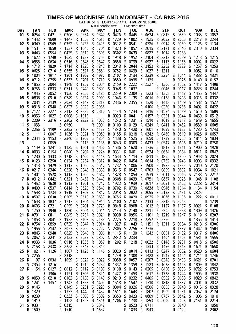
TIMES OF MOONRISE AND MOONSET – CAIRNS 2015 LAT 16° 56’ S LONG 145° 47’ E TIME ZONE 1000E
R = Moonrise time S = Moonset time
DAY JAN FEB MAR APR MAY JUN JUL AUG SEP OCT NOV DEC 01 S 0254 S 0421 S 0306 S 0354 S 0347 S 0426 S 0445 S 0624 S 0813 S 0859 S 1035 S 1052
R 1442 R 1600 R 1447 R 1558 R 1615 R 1729 R 1802 R 1925 R 2032 R 2053 R 2217 R 2244 02 S 0349 S 0509 S 0352 S 0433 S 0425 S 0512 S 0541 S 0726 S 0914 S 0959 S 1126 S 1134
R 1531 R 1650 R 1537 R 1645 R 1704 R 1823 R 1857 R 2015 R 2121 R 2146 R 2310 R 2334 03 S 0443 S 0554 S 0435 S 0510 S 0505 S 0602 S 0639 S 0827 S 1014 S 1058
R 1622 R 1740 R 1625 R 1732 R 1753 R 1918 R 1952 R 2104 R 2212 R 2239 S 1213 S 1215 04 S 0535 S 0636 S 0516 S 0548 S 0547 S 0656 S 0739 S 0927 S 1113 S 1153 R 0002 R 0022
R 1713 R 1829 R 1714 R 1820 R 1845 R 2013 R 2044 R 2152 R 2302 R 2333 S 1257 S 1253 05 S 0625 S 0716 S 0555 S 0627 S 0631 S 0752 S 0839 S 1027 S 1211 R 0052 R 0110
R 1804 R 1917 R 1801 R 1909 R 1937 R 2107 R 2134 R 2239 R 2354 S 1244 S 1338 S 1331 06 S 0712 S 0755 S 0633 S 0707 S 0719 S 0850 S 0938 S 1125 R 0026 R 0140 R 0157
R 1855 R 2004 R 1848 R 1959 R 2031 R 2159 R 2222 R 2327 S 1306 S 1332 S 1417 S 1408 07 S 0756 S 0833 S 0711 S 0749 S 0809 S 0948 S 1037 R 0046 R 0117 R 0228 R 0244
R 1945 R 2052 R 1936 R 2050 R 2125 R 2249 R 2309 S 1223 S 1358 S 1417 S 1455 S 1447 08 S 0838 S 0910 S 0749 S 0834 S 0903 S 1046 S 1135 R 0016 R 0138 R 0208 R 0315 R 0332
R 2034 R 2139 R 2024 R 2142 R 2218 R 2336 R 2355 S 1320 S 1448 S 1459 S 1532 S 1527 09 S 0918 S 0948 S 0827 S 0922 S 0958 R 0106 R 0230 R 0256 R 0402 R 0422
R 2122 R 2227 R 2112 R 2235 R 2310 S 1144 S 1233 S 1416 S 1534 S 1539 S 1610 S 1609 10 S 0956 S 1027 S 0908 S 1013 R 0023 R 0041 R 0157 R 0321 R 0344 R 0450 R 0512
R 2209 R 2316 R 2202 R 2328 S 1055 S 1242 S 1331 S 1510 S 1618 S 1617 S 1649 S 1655 11 S 1033 S 0950 R 0001 R 0109 R 0129 R 0249 R 0411 R 0432 R 0539 R 0605
R 2256 S 1109 R 2253 S 1107 S 1153 S 1340 S 1428 S 1601 S 1659 S 1655 S 1730 S 1743 12 S 1111 R 0007 S 1036 R 0021 R 0050 R 0155 R 0218 R 0342 R 0459 R 0519 R 0628 R 0657
R 2344 S 1153 R 2346 S 1203 S 1251 S 1438 S 1525 S 1650 S 1739 S 1733 S 1814 S 1834 13 R 0059 R 0113 R 0138 R 0243 R 0309 R 0433 R 0547 R 0606 R 0719 R 0750
S 1149 S 1241 S 1125 S 1301 S 1350 S 1536 S 1620 S 1736 S 1817 S 1811 S 1900 S 1928 14 R 0033 R 0154 R 0040 R 0204 R 0224 R 0331 R 0401 R 0524 R 0634 R 0654 R 0811 R 0842
S 1230 S 1333 S 1218 S 1400 S 1448 S 1634 S 1714 S 1819 S 1855 S 1850 S 1948 S 2024 15 R 0123 R 0250 R 0134 R 0254 R 0312 R 0422 R 0454 R 0614 R 0722 R 0743 R 0903 R 0932
S 1313 S 1429 S 1313 S 1500 S 1547 S 1732 S 1806 S 1900 S 1932 S 1932 S 2040 S 2120 16 R 0217 R 0346 R 0228 R 0343 R 0359 R 0515 R 0547 R 0703 R 0809 R 0832 R 0954 R 1021
S 1401 S 1528 S 1412 S 1600 S 1647 S 1828 S 1854 S 1939 S 2011 S 2016 S 2133 S 2217 17 R 0312 R 0442 R 0321 R 0432 R 0449 R 0608 R 0639 R 0751 R 0857 R 0923 R 1045 R 1108
S 1452 S 1630 S 1513 S 1701 S 1747 S 1922 S 1939 S 2017 S 2051 S 2102 S 2228 S 2314 18 R 0409 R 0537 R 0414 R 0520 R 0540 R 0702 R 0730 R 0838 R 0946 R 1014 R 1134 R 1154
S 1548 S 1734 S 1615 S 1803 S 1847 S 2013 S 2022 S 2055 S 2133 S 2151 S 2325 19 R 0507 R 0630 R 0505 R 0610 R 0633 R 0756 R 0820 R 0925 R 1036 R 1106 R 1222 S 0011
S 1648 S 1837 S 1717 S 1904 S 1945 S 2100 S 2102 S 2133 S 2218 S 2243 R 1239 20 R 0605 R 0721 R 0555 R 0701 R 0726 R 0848 R 0908 R 1012 R 1127 R 1157 S 0021 S 0108
S 1750 S 1940 S 1820 S 2004 S 2041 S 2144 S 2140 S 2211 S 2305 S 2338 R 1309 R 1326 21 R 0701 R 0811 R 0645 R 0754 R 0821 R 0938 R 0956 R 1101 R 1219 R 1247 S 0119 S 0207
S 1853 S 2041 S 1922 S 2103 S 2133 S 2225 S 2218 S 2252 S 2356 R 1355 R 1413 22 R 0754 R 0859 R 0735 R 0847 R 0914 R 1027 R 1043 R 1151 R 1311 S 0034 S 0218 S 0306
S 1956 S 2142 S 2023 S 2200 S 2222 S 2305 S 2256 S 2336 R 1337 R 1442 R 1503 23 R 0845 R 0948 R 0825 R 0940 R 1006 R 1115 R 1130 R 1242 S 0051 S 0132 S 0317 S 0406
S 2057 S 2241 S 2123 S 2253 S 2307 S 2342 S 2334 R 1404 R 1426 R 1531 R 1555 24 R 0933 R 1036 R 0916 R 1033 R 1057 R 1202 R 1218 S 0022 S 0148 S 0231 S 0418 S 0506
S 2158 S 2338 S 2222 S 2343 S 2349 R 1334 R 1456 R 1515 R 1621 R 1650 25 R 1021 R 1126 R 1007 R 1125 R 1146 S 0020 S 0014 S 0113 S 0247 S 0332 S 0520 S 0604
S 2256 S 2318 R 1249 R 1308 R 1428 R 1547 R 1604 R 1714 R 1746 26 R 1107 S 0034 R 1059 S 0029 S 0029 S 0058 S 0057 S 0207 S 0348 S 0433 S 0621 S 0701
S 2354 R 1216 R 1216 R 1234 R 1337 R 1359 R 1523 R 1638 R 1653 R 1809 R 1842 27 R 1154 S 0127 S 0012 S 0112 S 0107 S 0138 S 0143 S 0305 S 0450 S 0535 S 0722 S 0753
R 1306 R 1151 R 1305 R 1321 R 1427 R 1453 R 1617 R 1728 R 1744 R 1905 R 1938 28 S 0050 S 0218 S 0102 S 0153 S 0145 S 0219 S 0232 S 0405 S 0552 S 0638 S 0820 S 0842
R 1241 R 1357 R 1242 R 1353 R 1409 R 1518 R 1547 R 1710 R 1818 R 1837 R 2001 R 2032 29 S 0145 S 0149 S 0231 S 0223 S 0304 S 0326 S 0506 S 0655 S 0740 S 0915 S 0928
R 1329 R 1333 R 1440 R 1457 R 1611 R 1643 R 1802 R 1909 R 1931 R 2057 R 2124 30 S 0239 S 0233 S 0309 S 0302 S 0353 S 0423 S 0609 S 0757 S 0842 S 1005 S 1010
R 1419 R 1422 R 1528 R 1546 R 1706 R 1738 R 1853 R 2000 R 2026 R 2151 R 2214 31 S 0331 S 0315 S 0342 S 0523 S 0711 S 0940 S 1050
R 1509 R 1510 R 1637 R 1833 R 1943 R 2122 R 2302
120
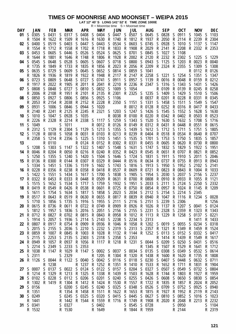
TIMES OF MOONRISE AND MOONSET – WEIPA 2015 LAT 12° 40’ S LONG 141° 52’ E TIME ZONE 1000E
R = Moonrise time S = Moonset time
DAY JAN FEB MAR APR MAY JUN JUL AUG SEP OCT NOV DEC 01 S 0305 S 0431 S 0317 S 0408 S 0404 S 0447 S 0507 S 0645 S 0828 S 0911 S 1045 S 1103
R 1504 R 1622 R 1509 R 1616 R 1630 R 1740 R 1812 R 1937 R 2050 R 2114 R 2239 R 2304 02 S 0400 S 0519 S 0403 S 0447 S 0443 S 0534 S 0603 S 0745 S 0928 S 1010 S 1137 S 1147
R 1554 R 1712 R 1558 R 1702 R 1718 R 1833 R 1908 R 2029 R 2141 R 2208 R 2332 R 2353 03 S 0453 S 0605 S 0446 S 0526 S 0524 S 0625 S 0701 S 0845 S 1027 S 1108
R 1644 R 1801 R 1646 R 1748 R 1806 R 1928 R 2002 R 2120 R 2232 R 2302 S 1225 S 1229 04 S 0545 S 0648 S 0528 S 0605 S 0607 S 0718 S 0800 S 0943 S 1125 S 1203 R 0023 R 0040
R 1735 R 1849 R 1733 R 1835 R 1856 R 2023 R 2056 R 2209 R 2324 R 2355 S 1309 S 1308 05 S 0635 S 0729 S 0609 S 0645 S 0652 S 0814 S 0859 S 1041 R 0112 R 0126
R 1826 R 1936 R 1819 R 1922 R 1948 R 2117 R 2147 R 2258 S 1221 S 1254 S 1351 S 1347 06 S 0723 S 0809 S 0648 S 0727 S 0741 S 0911 S 0957 S 1139 R 0016 R 0048 R 0159 R 0212
R 1917 R 2022 R 1905 R 2011 R 2041 R 2210 R 2236 R 2347 S 1316 S 1343 S 1431 S 1426 07 S 0808 S 0848 S 0727 S 0810 S 0832 S 1009 S 1054 R 0109 R 0139 R 0245 R 0258
R 2006 R 2108 R 1951 R 2101 R 2135 R 2301 R 2325 S 1235 S 1409 S 1429 S 1510 S 1506 08 S 0850 S 0927 S 0806 S 0856 S 0925 S 1106 R 0037 R 0201 R 0228 R 0331 R 0345
R 2053 R 2154 R 2038 R 2152 R 2228 R 2350 S 1151 S 1331 S 1458 S 1511 S 1549 S 1547 09 S 0931 S 1006 S 0846 S 0944 S 1020 R 0012 R 0128 R 0252 R 0316 R 0417 R 0433
R 2140 R 2241 R 2125 R 2245 R 2321 S 1203 S 1247 S 1426 S 1545 S 1552 S 1628 S 1630 10 S 1010 S 1047 S 0928 S 1035 R 0038 R 0100 R 0220 R 0342 R 0402 R 0503 R 0523
R 2226 R 2328 R 2214 R 2338 S 1117 S 1259 S 1343 S 1520 S 1630 S 1632 S 1708 S 1716 11 S 1049 S 1011 R 0012 R 0126 R 0149 R 0312 R 0431 R 0448 R 0551 R 0615
R 2312 S 1129 R 2304 S 1129 S 1213 S 1355 S 1439 S 1612 S 1712 S 1711 S 1751 S 1805 12 S 1128 R 0018 S 1058 R 0031 R 0103 R 0213 R 0239 R 0404 R 0518 R 0534 R 0640 R 0707
R 2358 S 1214 R 2356 S 1225 S 1310 S 1451 S 1535 S 1701 S 1753 S 1750 S 1835 S 1857 13 R 0110 R 0124 R 0152 R 0302 R 0331 R 0455 R 0605 R 0620 R 0730 R 0800
S 1208 S 1303 S 1147 S 1322 S 1407 S 1548 S 1631 S 1747 S 1832 S 1829 S 1922 S 1951 14 R 0046 R 0204 R 0050 R 0216 R 0240 R 0352 R 0423 R 0545 R 0651 R 0707 R 0821 R 0852
S 1250 S 1355 S 1240 S 1420 S 1504 S 1646 S 1724 S 1831 S 1911 S 1910 S 2011 S 2046 15 R 0136 R 0300 R 0144 R 0307 R 0329 R 0444 R 0516 R 0634 R 0737 R 0755 R 0913 R 0943
S 1334 S 1451 S 1336 S 1519 S 1602 S 1743 S 1816 S 1913 S 1950 S 1952 S 2102 S 2141 16 R 0228 R 0356 R 0238 R 0358 R 0418 R 0537 R 0609 R 0721 R 0823 R 0843 R 1004 R 1033
S 1422 S 1551 S 1434 S 1617 S 1700 S 1838 S 1905 S 1954 S 2030 S 2037 S 2156 S 2237 17 R 0322 R 0453 R 0333 R 0448 R 0509 R 0631 R 0700 R 0808 R 0910 R 0933 R 1055 R 1121
S 1515 S 1652 S 1534 S 1717 S 1759 S 1932 S 1951 S 2033 S 2111 S 2124 S 2250 S 2332 18 R 0419 R 0549 R 0426 R 0538 R 0601 R 0725 R 0750 R 0854 R 0957 R 1024 R 1145 R 1209
S 1611 S 1754 S 1634 S 1817 S 1858 S 2023 S 2034 S 2112 S 2154 S 2214 S 2345 19 R 0517 R 0643 R 0519 R 0630 R 0655 R 0817 R 0839 R 0940 R 1047 R 1116 R 1234 S 0028
S 1710 S 1856 S 1735 S 1916 S 1955 S 2111 S 2116 S 2151 S 2239 S 2306 R 1256 20 R 0615 R 0736 R 0611 R 0722 R 0749 R 0909 R 0926 R 1026 R 1137 R 1207 S 0041 S 0124
S 1812 S 1957 S 1836 S 2016 S 2051 S 2156 S 2155 S 2231 S 2328 S 2359 R 1323 R 1343 21 R 0712 R 0827 R 0702 R 0815 R 0843 R 0958 R 1012 R 1113 R 1229 R 1258 S 0137 S 0221
S 1914 S 2057 S 1936 S 2114 S 2143 S 2238 S 2234 S 2313 R 1411 R 1433 22 R 0807 R 0917 R 0754 R 0909 R 0936 R 1046 R 1058 R 1202 S 0019 S 0055 S 0234 S 0318
S 2015 S 2155 S 2036 S 2210 S 2232 S 2319 S 2313 S 2357 R 1321 R 1349 R 1459 R 1524 23 R 0859 R 1007 R 0845 R 1003 R 1028 R 1132 R 1144 R 1252 S 0113 S 0152 S 0332 S 0417
S 2115 S 2253 S 2135 S 2303 S 2318 S 2358 S 2353 R 1414 R 1439 R 1549 R 1617 24 R 0949 R 1057 R 0937 R 1056 R 1117 R 1218 R 1231 S 0044 S 0209 S 0250 S 0431 S 0516
S 2214 S 2349 S 2233 S 2353 R 1345 R 1507 R 1529 R 1641 R 1712 25 R 1038 R 1147 R 1029 R 1147 S 0002 S 0037 S 0034 S 0135 S 0308 S 0349 S 0532 S 0614
S 2311 S 2329 R 1205 R 1304 R 1320 R 1438 R 1600 R 1620 R 1735 R 1808 26 R 1126 S 0044 R 1122 S 0040 S 0042 S 0116 S 0118 S 0230 S 0407 S 0448 S 0632 S 0711
R 1238 R 1237 R 1252 R 1351 R 1410 R 1533 R 1652 R 1711 R 1831 R 1904 27 S 0007 S 0137 S 0022 S 0124 S 0122 S 0157 S 0204 S 0327 S 0507 S 0549 S 0732 S 0804
R 1214 R 1329 R 1213 R 1325 R 1338 R 1439 R 1503 R 1628 R 1744 R 1803 R 1927 R 1959 28 S 0102 S 0228 S 0112 S 0206 S 0201 S 0240 S 0255 S 0426 S 0608 S 0650 S 0830 S 0854
R 1302 R 1419 R 1304 R 1412 R 1424 R 1530 R 1557 R 1722 R 1835 R 1857 R 2024 R 2052 29 S 0156 S 0200 S 0245 S 0240 S 0325 S 0348 S 0526 S 0709 S 0752 S 0925 S 0940
R 1351 R 1354 R 1458 R 1511 R 1622 R 1653 R 1815 R 1927 R 1952 R 2119 R 2143 30 S 0249 S 0245 S 0325 S 0320 S 0415 S 0445 S 0627 S 0810 S 0852 S 1016 S 1023
R 1441 R 1442 R 1544 R 1559 R 1716 R 1749 R 1908 R 2020 R 2048 R 2213 R 2232 31 S 0341 S 0327 S 0402 S 0545 S 0728 S 0950 S 1104
R 1532 R 1530 R 1649 R 1844 R 1959 R 2144 R 2319
121

TIMES OF MOONRISE AND MOONSET – KARUMBA 2015 LAT 17° 30’ S LONG 140° 50’ E TIME ZONE 1000E
R = Moonrise time S = Moonset time
DAY JAN FEB MAR APR MAY JUN JUL AUG SEP OCT NOV DEC 01 S 0315 S 0442 S 0328 S 0415 S 0407 S 0446 S 0504 S 0644 S 0834 S 0920 S 1057 S 1113
R 1502 R 1619 R 1507 R 1618 R 1636 R 1750 R 1823 R 1946 R 2052 R 2112 R 2236 R 2304 02 S 0410 S 0530 S 0413 S 0453 S 0445 S 0532 S 0600 S 0746 S 0935 S 1021 S 1148 S 1155
R 1551 R 1710 R 1556 R 1705 R 1725 R 1844 R 1919 R 2036 R 2142 R 2206 R 2330 R 2354 03 S 0504 S 0615 S 0456 S 0531 S 0525 S 0622 S 0659 S 0847 S 1035 S 1119
R 1641 R 1800 R 1645 R 1753 R 1814 R 1939 R 2013 R 2125 R 2231 R 2259 S 1234 S 1235 04 S 0556 S 0657 S 0537 S 0609 S 0607 S 0716 S 0759 S 0948 S 1135 S 1214 R 0022 R 0042
R 1733 R 1849 R 1734 R 1841 R 1906 R 2034 R 2105 R 2212 R 2322 R 2353 S 1318 S 1314 05 S 0646 S 0737 S 0616 S 0647 S 0651 S 0812 S 0859 S 1047 R 0112 R 0130
R 1824 R 1937 R 1821 R 1930 R 1959 R 2128 R 2155 R 2300 S 1232 S 1306 S 1359 S 1351 06 S 0733 S 0816 S 0653 S 0727 S 0738 S 0909 S 0959 S 1146 R 0014 R 0045 R 0201 R 0217
R 1915 R 2025 R 1909 R 2020 R 2052 R 2220 R 2243 R 2347 S 1327 S 1353 S 1437 S 1428 07 S 0817 S 0853 S 0731 S 0809 S 0829 S 1008 S 1058 R 0106 R 0137 R 0248 R 0305
R 2005 R 2112 R 1956 R 2111 R 2146 R 2310 R 2329 S 1244 S 1420 S 1438 S 1515 S 1507 08 S 0859 S 0931 S 0809 S 0854 S 0922 S 1107 R 0036 R 0158 R 0227 R 0335 R 0353
R 2054 R 2159 R 2044 R 2203 R 2240 R 2357 S 1156 S 1342 S 1509 S 1520 S 1552 S 1547 09 S 0938 S 1008 S 0847 S 0942 S 1018 R 0015 R 0126 R 0250 R 0316 R 0423 R 0443
R 2142 R 2248 R 2133 R 2256 R 2332 S 1205 S 1254 S 1437 S 1556 S 1559 S 1630 S 1629 10 S 1016 S 1047 S 0928 S 1033 R 0044 R 0101 R 0217 R 0341 R 0405 R 0511 R 0534
R 2229 R 2337 R 2223 R 2350 S 1115 S 1303 S 1352 S 1531 S 1639 S 1638 S 1709 S 1714 11 S 1054 S 1010 R 0022 R 0129 R 0149 R 0309 R 0431 R 0452 R 0600 R 0626
R 2316 S 1129 R 2314 S 1126 S 1213 S 1401 S 1449 S 1623 S 1720 S 1715 S 1750 S 1803 12 R 0028 R 0043 R 0111 R 0215 R 0238 R 0401 R 0519 R 0539 R 0650 R 0719
S 1131 S 1213 S 1056 S 1223 S 1311 S 1459 S 1546 S 1711 S 1759 S 1753 S 1833 S 1854 13 R 0004 R 0121 R 0007 R 0135 R 0158 R 0303 R 0328 R 0453 R 0607 R 0627 R 0741 R 0811
S 1209 S 1300 S 1145 S 1321 S 1410 S 1557 S 1642 S 1757 S 1837 S 1831 S 1919 S 1948 14 R 0054 R 0215 R 0101 R 0225 R 0245 R 0351 R 0420 R 0544 R 0655 R 0715 R 0832 R 0903
S 1250 S 1352 S 1237 S 1420 S 1509 S 1656 S 1736 S 1840 S 1915 S 1910 S 2008 S 2044 15 R 0145 R 0311 R 0155 R 0315 R 0332 R 0442 R 0513 R 0634 R 0742 R 0804 R 0924 R 0953
S 1333 S 1449 S 1333 S 1520 S 1608 S 1754 S 1827 S 1921 S 1952 S 1952 S 2059 S 2140 16 R 0238 R 0408 R 0249 R 0404 R 0420 R 0534 R 0607 R 0723 R 0830 R 0853 R 1016 R 1042
S 1420 S 1548 S 1432 S 1621 S 1708 S 1850 S 1915 S 2000 S 2031 S 2035 S 2153 S 2237 17 R 0333 R 0504 R 0343 R 0452 R 0509 R 0628 R 0659 R 0811 R 0918 R 0944 R 1106 R 1129
S 1512 S 1650 S 1533 S 1722 S 1808 S 1944 S 2000 S 2038 S 2111 S 2122 S 2248 S 2334 18 R 0431 R 0558 R 0435 R 0541 R 0600 R 0722 R 0750 R 0858 R 1007 R 1035 R 1155 R 1214
S 1608 S 1754 S 1635 S 1824 S 1908 S 2034 S 2043 S 2115 S 2153 S 2211 S 2345 19 R 0529 R 0651 R 0526 R 0630 R 0652 R 0815 R 0840 R 0946 R 1057 R 1127 R 1243 S 0032
S 1707 S 1857 S 1738 S 1925 S 2006 S 2121 S 2123 S 2153 S 2237 S 2303 R 1300 20 R 0626 R 0742 R 0616 R 0721 R 0746 R 0907 R 0928 R 1033 R 1148 R 1218 S 0042 S 0129
S 1810 S 2000 S 1840 S 2026 S 2102 S 2205 S 2201 S 2231 S 2325 S 2358 R 1329 R 1346 21 R 0722 R 0831 R 0705 R 0813 R 0840 R 0958 R 1016 R 1122 R 1240 R 1309 S 0140 S 0228
S 1913 S 2102 S 1943 S 2125 S 2154 S 2246 S 2238 S 2312 R 1416 R 1433 22 R 0815 R 0920 R 0755 R 0907 R 0934 R 1047 R 1103 R 1212 S 0016 S 0054 S 0238 S 0327
S 2016 S 2203 S 2044 S 2221 S 2243 S 2325 S 2316 S 2355 R 1333 R 1358 R 1503 R 1523 23 R 0906 R 1008 R 0845 R 1000 R 1026 R 1135 R 1151 R 1303 S 0110 S 0152 S 0338 S 0427
S 2118 S 2302 S 2145 S 2315 S 2328 S 2354 R 1425 R 1447 R 1551 R 1615 24 R 0954 R 1056 R 0936 R 1053 R 1117 S 0003 R 1239 S 0042 S 0207 S 0252 S 0439 S 0527
S 2218 S 2359 S 2243 R 1222 R 1356 R 1517 R 1535 R 1641 R 1709 25 R 1041 R 1146 R 1027 S 0004 S 0010 S 0040 S 0034 S 0133 S 0307 S 0352 S 0541 S 0626
S 2317 S 2340 R 1145 R 1206 R 1310 R 1329 R 1450 R 1608 R 1624 R 1734 R 1805 26 R 1127 S 0055 R 1119 S 0050 S 0050 S 0118 S 0116 S 0227 S 0408 S 0454 S 0643 S 0722
R 1235 R 1236 R 1254 R 1358 R 1421 R 1544 R 1659 R 1713 R 1828 R 1902 27 S 0015 S 0149 S 0033 S 0133 S 0128 S 0157 S 0202 S 0324 S 0510 S 0556 S 0744 S 0815
R 1214 R 1326 R 1211 R 1325 R 1342 R 1448 R 1514 R 1638 R 1749 R 1804 R 1925 R 1957 28 S 0111 S 0239 S 0123 S 0213 S 0205 S 0239 S 0252 S 0425 S 0613 S 0659 S 0842 S 0904
R 1301 R 1416 R 1302 R 1413 R 1429 R 1539 R 1609 R 1731 R 1839 R 1856 R 2021 R 2052 29 S 0206 S 0210 S 0252 S 0243 S 0324 S 0346 S 0527 S 0716 S 0802 S 0936 S 0949
R 1349 R 1352 R 1501 R 1517 R 1633 R 1704 R 1823 R 1929 R 1951 R 2117 R 2144 30 S 0300 S 0254 S 0330 S 0322 S 0412 S 0443 S 0629 S 0818 S 0903 S 1026 S 1031
R 1438 R 1442 R 1548 R 1607 R 1728 R 1800 R 1914 R 2020 R 2046 R 2211 R 2234 31 S 0352 S 0336 S 0402 S 0543 S 0732 S 1002 S 1110
R 1529 R 1530 R 1658 R 1854 R 2003 R 2141 R 2322
122