highlights from the new rules - tn.gov › content › dam › tn › environment › ...•improve...
TRANSCRIPT


• Highlights from the new rules
• Process to develop the Stream Mitigation Guidelines
• Highlights from the 2019 Stream Mitigation Guidelines
• Overview of the TN Debit Tool
• Compensatory Mitigation webpage
• Questions

Jimmy Smith, Jonathon Burr, Joshua Frost, Tammy Turley, Will Harman, Cidney Jones, Eric Somerville, Debbie Arnwine, Greg Jennings, Jason Zink, Travis Wiley, Caitlin Elam, Peyton Abernathy, Mark McIntosh, Robert Wayne, Robby Baker, Will Worrall, Ryan Evans, Tim Wilder, Dan Bacon, Kelly Laycock, Terry Horne, West TN River Basin Authority, Memphis District COE, Robb Todd, Robbie Sykes, Stream Design Review Group, Ashley Monroe, and Kim Pilarski-Hall

• Improve explanation of what activities constitute a loss of resource value and when is mitigation required.
• Provide a quantitative and scientifically defensible
framework for how the amount of mitigation required to ensure no net loss will be evaluated.
• Modernize what type of activities are eligible for offsetting
lost resource value.
• Provide mitigation site selection evaluation guidance.
• Improve performance standards and monitoring.
Inform us on how to calculate debits and credits.

• Ratio Based – Broad ranges of ratios for
credits – Describes activity based
crediting-pattern, profile, and dimension
• Narrative Criteria
– Does not require baseline information
– Subjective – Creates crediting drift
– Debits • Encapsulation 1:1 • Riprap 0.75:1 for double
bank

Realized deficiencies in the 2004 mitigation guidelines; qualitative/subjective
• Wanted to be consistent with USACE requirements
• Wanted to align state guidelines with the 2008 Final Rule to the extent practical for TN
• Wanted to establish functional lift
• Move away from linear footage/ratio based system
Shortcomings
• Received significant comment on efficacy of functional assessment parameters and methods
• Division lacked capacity to create a robust functional assessment

• Engage our stakeholders
• Evaluate potential assessment methods
• Establish parallel pathways
– Education and outreach
– Incremental and iterative document development
– Data gathering
– Tool development
– Tools to policy

• Update
– Stream Mitigation Guidelines
– TDEC rules on mitigation
• Develop Tools
– Stream functional assessment to capture function lift of compensatory mitigation
– Companion debit calculator
• Streamline Process – Bring consistency
• Banking templates
• Land Use Protection documents
• Checklists
• Mitigation crosswalk
• Communicate changes – Series of joint education
and outreach events over several years
– Training, webinars and workshops

• Measurable. Transparent. Predictable. Repeatable
• Partner with USACE and IRT to develop/adopt functional assessment guidance tools
• Based on known stream functions
• Inherent relationships in stream channel metrics
• Incorporate TDEC biological and water quality data
• Regionalize as information becomes available

• Over 120 sites across the state with multiple levels of data.
• Over 60% of those sites have reference data for all five stream categories

• TDEC and the USACE developed a series of workshops, delivered across the state for all stakeholders focused on small changes, introduce concepts on big changes and keep an open line of communication. Three years of “Joint Education Outreach Events” from 2015-2018.

• Provided webinars with national experts
• In house workshops
• Conferences
• Seminars


• Benefits of the Stream Quantification Tool
• Determine numerical existing condition score for impact sites.
• Determine numerical difference between existing and proposed conditions of a stream for mitigation (functional lift).
• Links restoration activities to function-based parameters.
• Incentivize high-quality stream mitigation.
• Inform stream mitigation site selection
• Developing success criteria and a monitoring plan.
Restoration Activities
Credits Functional Lift
SQT

The basic framework, underlying logic, and technical aspects of a Functional-Foot methodology is laid out in detail in the recently published Tennessee Stream Quantification Tool, available on the Division’s mitigation web site.

• TN SQT User Manual – How to use the SQT Workbook.
• Rapid Data Collection Methods Manual – How to rapidly collect data without surveying equipment.
• Detailed Data Collection and Analysis Manual – Explains thorough data collection.
• Science Support and Rationale (Coming Soon)

• Stream Mitigation Guidelines-interprets rules, establishes performance standards, align with USACE
• Aquatic Resource Alteration Rules- defines mitigation requirements
• Water Quality Standards- ensures all features maintain classified uses, flow, and use quantitative methods

• any appreciable permanent loss of resource values associated with the proposed impact is offset by mitigation sufficient to result in no overall net loss of resource values from existing conditions
• Mitigation for impacts to streams must be developed in a scientifically defensible manner approved by the Division that demonstrates a sufficient increase in resource values to compensate for permitted impacts.
• At a minimum, all new or relocated streams must include a vegetated riparian zone, demonstrate lateral and vertical channel stability, and have a natural channel bottom.
• All mitigation watercourses must maintain or improve flow and classified uses after mitigation is complete.

• Existing Conditions- means the biological, chemical, bacteriological, radiological, and physical conditions of a stream or wetland at the time the project is proposed as measured by a quantitative assessment tool or other defensible scientific method as approved or determined by the Division.
• Because all streams and wetlands serve important functions, the determination of existing conditions shall ensure at least minimal protection for all streams and wetlands notwithstanding prior degradation
• The Division will evaluate resource value compensation through the use of an appropriate quantitative assessment or other defensible scientific method
• Mitigation for impacts to Tennessee streams and wetlands shall occur in Tennessee.

• Minimum Mitigation Requirement : “Because all streams and wetlands serve important functions, the determination of existing conditions shall ensure at least minimal protection for all streams and wetlands not withstanding prior degradation”
Even currently degraded streams (including many in urban areas) have resource values outside of those addressed in the functional quantification evaluation that must be offset if lost.
Therefore the Guidelines establish a minimum Existing Condition Score for all streams, to ensure overall net mitigation is sufficient to maintain classified uses and water quality standards.

• Movement from a qualitative, narrative, more generalized evaluation of lift and loss (e.g. ratio-based categories of credits and debits), to a more quantitative, data-driven, site-specific assessment of lift and loss (e.g. functional-foot calculation of credits and debits)
• Approved quantitative assessments base credits on the actual lift produced, regardless of the type or extent of “work”
• Temporal Loss : Should complete mitigation prior to or concurrent with impacts, and the Division may “account for temporal loss of resource value” with additional required mitigation.
• Proximity: “Mitigation should occur as close to the impact location as practical”. Guidelines propose multipliers for proximity, based on existing USACE methodology.
• Unique or Exceptional Waters: Not all standard mitigation practices may be adequate to address sites with special resource value.

• Stream Fill and Replacement (relocation) projects – Minimum requirements based on scale and current condition
• 12-point Mitigation Plan – Matches USACE requirements (level of detail based on scale)
• Permittee-Responsible Mitigation vs. Third-Party Providers – Most of the same standards apply (based on scale & complexity)
• Performance Standards and Monitoring Requirements – Most align with USACE requirements, see joint guidance
document
• “Commonly Encountered Variants” (Frequently Encountered Scenarios) - section expanded with more examples

• Preservation Crediting – Allowed under certain circumstances – may be credited up to 10% of
the Existing Condition Score
• Urban Mitigation Sites – May be incentivized up to 15% additional credits (TDEC only)
• Perpetual Site Protection

• Meet the minimum requirements in rule
• Proposed condition must meet or exceed existing condition
• Demonstrate success through monitoring
• Laterally and vertically stable
• Riparian vegetation
• Natural substrate
• Maintain status as a stream (flow)
• Maintain use support if supporting
No additional credit is generated AND no additional loss is debited

• Relocation must demonstrate they meet requirements from previous slide AND
• Demonstrate a sufficient increase in resource values to compensate for permitted impacts
• Must meet the minimum expectations of a credit generating compensatory mitigation project
• Functioning in the “Big 4” Stream Functional Categories of the TN SQT – Floodplain Connectivity
– Riparian Vegetation
– Lateral Migration
– Bedform Diversity


• Impacts to Waters of the State and WOTUS range from minimal to significant
• Debit Tool determines the amount of loss based on specific impact type and existing stream condition (ECS)
• Objective, consistent, transparent method for evaluating debits, or amount of compensatory mitigation required for impacts
MINIMAL SIGNIFICANT

Impact Severity Tiers

Impact Severity Tiers


• Vegetative bank stabilization

• Span bridge
• Half bank riprap
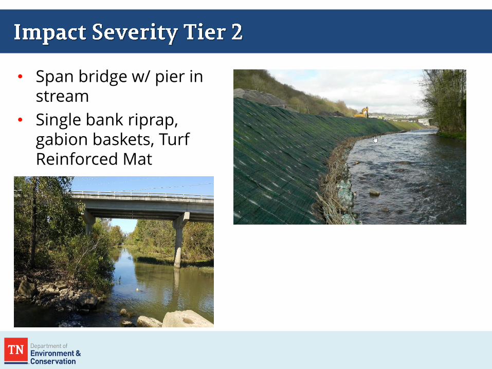
• Span bridge w/ pier in stream
• Single bank riprap, gabion baskets, Turf Reinforced Mat

• Bottomless culvert
• Double bank riprap
• Grade control

• Bed and bank armoring
• Bottomless culvert w/ impact to channel walls

• Box or pipe culvert
• Channelization

• Spreadsheet based calculator and written guidance
• Existing Condition Score (ECS)
– Option 1: Applicant completes ECS field assessment for all parameters
– Option 2: Applicant completes ECS field assessment for some parameters
– Option 3: Standard Existing Condition Score
• Applicant uses standard ECS (1.0, 0.8, or 0.32)
– No ECS can be lower than 0.4, except for relocations
• Impact Severity Tier
– Applicant determines severity tier based on impact type and description
– Tier 0 (no functional loss) to Tier 6 (100% functional loss)

• Option 1 and Option 2 require field visits and stream assessment
• Option 3 does not require field visits; standard ECS used • ECS = 1.0: ETW/
ONRWs • ECS = 0.8: intermittent/
perennial • ECS = 0.32 ephemeral

• Determine Existing Condition Score (ECS)
• ECS x existing stream length = EFF
• PCS = Impact Severity Tier x ECS
• PCS x proposed stream length = PFF
• Debits = PFF - EFF
• PCS = Proposed Condition Score • Existing Condition Score cannot be
less than 0.4 • Existing stream length is equal to or
greater than proposed stream length • EFF – Existing Functional Feet • PFF – Proposed Functional Feet
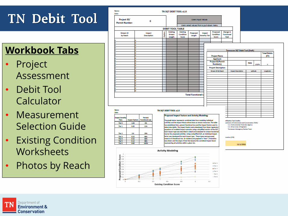
Workbook Tabs
• Project Assessment
• Debit Tool Calculator
• Measurement Selection Guide
• Existing Condition Worksheets
• Photos by Reach


• Important component of tools
• Frequent cause of errors
• Determines which reference curves to use in calculations.
• Always use pull down menu if available; do not type into the boxes.
• Unique stratification


• Index Values are averaged to get parameter Scores
• Parameter Scores are averaged to get functional category scores.
• Category Scores are multiplied by 0.2 (1/5) and summed to get the overall ECS or PCS.

• Scoring system for each stream category, parameter, measurement method, and overall score is based on a range of 0-1.0.
THE SAME SCORING SYSTEMS AS THE TN SQT

Improved explanation of what activities constitute a loss of resource value and when is mitigation required.
Provides a quantitative and scientifically defensible framework for how
the amount of mitigation required to ensure no net loss will be evaluated.
Modernizes what type of activities are eligible for offsetting lost resource value.
Provides mitigation site selection evaluation guidance.
Improves performance standards and monitoring.
Changes the currency to Functional Feet with the use of the TN Debit Tool
and the TN SQT
This allows Credits and Debits to be evaluated using the same scientifically defensible methodology (functional-feet), as required to defend no net loss.

• TN Debit Tool and TN SQT – tools to calculate functional loss and functional lift in Functional Feet.
• Credits and debits evaluated using same scientifically defensible methodology to defend no net loss.
• The currency of credits and debits has changed


• TN Debit Tool – Used for permitted impacts to estimate functional loss.
• TN Stream Quantification Tool – Calculates functional change (existing, proposed, and
monitoring years)
• List of Metrics – List of all parameters, measurement methods, reference
standards, stratification methods, and references
All of this supports the Stream Mitigation Guidelines

• TN Stream Quantification Tool and supporting manuals
• Regional Curves – statewide by Level III ecoregion
• Stream Bank and In-Lieu Fee Draft Prospectus Checklist
• Stream Bank and In-lieu Fee Draft MBI Guidance
• Permittee-Responsible Mitigation Guidance
• Links to RIBITS, TDOT Mitigation Program
• Overview of the 2008 Federal Rule for Compensatory Mitigation
• Perpetual Protection Templates
google : TDEC compensatory mitigation

• TN SQT documents can be found at: TDEC’s mitigation website, USACE website, and the 1-mitigation folder 2019 Stream Mitigation Guidelines

Strategic Planning for the Future: • Build a process for:
• Version control of tools • Version updates • Parameter or
measurement method substitutions specific to a project
• MOU with USACE on process
615-253-5320