hinchinbrook plan of management i
TRANSCRIPT


iHINCHINBROOK PLAN OF MANAGEMENT
HinchinbrookPlan of Management 2004

© Great Barrier Reef Marine Park Authority 2004Published by the Great Barrier Reef Marine Park Authority 2004
The National Library of Australia Cataloguing-in-Publication data:
Great Barrier Reef Marine Park Authority.Hinchinbrook plan of management.
ISBN 1 876945 36 2.
1. Marine parks and reserves-Queensland-Hinchinbrook Region -- Management.2. Marine ecology -- Queensland -- Hinchinbrook Region. 3. Conservation of naturalresources -- Queensland -- Hinchinbrook Region. 4. Environmental management --Queensland -- Hinchinbrook Region. I. Title.
333.9164099436
Great Barrier Reef Marine Park Authority.Hinchinbrook plan of management.
ISBN 1 876945 35 4.
1. Marine parks and reserves-Queensland-Hinchinbrook Region -- Management.2. Marine ecology -- Queensland -- Hinchinbrook Region. 3. Conservation of naturalresources -- Queensland -- Hinchinbrook Region. 4. Environmental management --Queensland -- Hinchinbrook Region. I. Title.
333.9164099436
2 - 68 Flinders StreetPO Box 1379TOWNSVILLE QLD 4810Phone: (07) 4750 0700Fax: (07) 4772 6093Email: [email protected]
www.gbrmpa.gov.au
ii Great Barrier Reef Marine Park Authority
HINCHINBROOK PLAN OF MANAGEMENT iii
Foreword
6 February 2004 The Hinchinbrook Plan of Management has been developed in partnership with local communities through the Hinchinbrook Local Marine Advisory Committee. This committee is comprised of representatives from Local Government Authorities, commercial and recreational Fishing organisations, tourism operators, cane grower organisations, Chamber of Commerce, traditional owners, other community groups and resource managers. The recommendations and management strategies outlined in this plan will have significant future economic and social benefits for communities that are adjacent to the planning area. It was also recognised that local communities have a great wealth of knowledge about natural processes, social activities and patterns of use in the planning area. This plan is the result of several years of consultation, during which time there were many contentious issues that required careful consideration. The committee was focused on recommending best practice for sustainable use and also our obligation to pass onto future generations, the wonderful natural assets that we enjoy today. It was also recognised that this plan must be a living document which will require future revision and ongoing involvement by local communities. This plan of management is and should always be a matter of community pride and unity of purpose.
Bill Whiteman CHAIR Hinchinbrook Local Marine Advisory Committee

iv Great Barrier Reef Marine Park Authority
Intentionally blank

H I N C H I N B R O O K P L A N O F M A N A G E M E N T
v
Contents
Part 1 Management of the Hinchinbrook Planning Area
Division 1 Preliminary 1.1 Name of Plan 1 1.2 The Planning Area and the application of this Plan 1 1.3 General intent 1 1.4 Duration of Plan 2 1.5 Objectives for the Planning Area 2 1.6 Interpretation 3
Division 2 Cultural and heritage: values, issues and strategies 1.7 General intent 3 1.8 Cultural and heritage values 3 1.9 Cultural and heritage issues 4 1.10 Cultural and heritage strategies 4
Division 3 Nature conservation: values, issues and strategies Subdivision 1 General 1.11 General intent 4 1.12 Nature conservation values 5 1.13 Nature conservation issues 5 1.14 Nature conservation strategies 5 Subdivision 2 Marine animals, plants and habitat conservation 1.15 General intent 6 1.16 Marine animals, plants and habitat conservation values 6 1.17 Marine animals, plants and habitat conservation issues 6 1.18 Marine animals, plants and habitat conservation strategies 7 Subdivision 3 Corals and associated biota conservation 1.19 General intent 8 1.20 Corals and associated biota conservation values 8 1.21 Corals and associated biota conservation issues 8 1.22 Corals and associated biota conservation strategies 8 Subdivision 4 Bird conservation 1.23 General intent 9 1.24 Bird conservation values 9 1.25 Bird conservation issues 9 1.26 Bird conservation strategies 10
Division 4 Use of the Planning Area 1.27 Use of the Planning Area — general strategies 10 1.28 Management of tourism operations 13 1.29 Restrictions on installing certain facilities in the Planning Area 15 1.30 Management of certain tourism operations and commercial uses 16 1.31 Management of motorised water sports operations 17 1.32 Sensitive Location strategies 18

vi G r e a t B a r r i e r R e e f M a r i n e P a r k A u t h o r i t y
Division 5 Transitional arrangements 1.33 Tourism management 24 1.34 Eligibility criteria and exemptions for certain tourism operations 25 1.35 Evidentiary requirements for tourism operations 27 1.36 Relevant permission replication issues for tourism operations 27
Part 2 Enforcement provisions
Division 1 Preliminary 2.1 How many people in a tourism operation 29 2.2 Number of operations in a period 29 2.3 Length of a vessel 29 2.4 Part not to apply to certain activities 29
Division 2 General restrictions for tourism operations 2.5 Tourism operation restrictions in certain management setting
Locations 30 2.6 Operation of vessels or aircraft for tourism operations 30 2.7 Passenger transport operations 31 2.8 Support service operations 31 2.9 Restriction on access to Sensitive Locations for tourism
operations 31 2.10 Limits on use of large vessels 32 2.11 Limited exemption for activities under certain older permissions 33
Division 3 Wildlife protection 2.12 Certain marine animals not to be taken or interfered with 33 2.13 Missionary Bay Location 33 2.14 Activities near significant bird sites 33 2.15 Coral and other marine species or environments 34
Division 4 Other activities 2.16 Certain commercial activities 34 2.17 Motorised water sports 34 2.18 Motorised water sports operations 35 2.19 Limits on operation of aircraft 35 2.20 Limits on use of hovercraft and high-speed vessels 35 2.21 Guided interpretive tour (including fishing) operations 36
Division 5 Limit on Authority’s power to grant permissions 2.22 Limit on the number of moorings in the Planning Area 36 2.23 Limit on the number of tourist facilities in the Planning Area 36 2.24 Limit on number of bareboat operations in the Planning Area 37 2.25 Limit on number of long range roving operations in the Planning
Area 37 2.26 New permissions for crewed vessel open tour operations 37

H I N C H I N B R O O K P L A N O F M A N A G E M E N T
vii
Schedule 1 The Hinchinbrook Planning Area 39
Schedule 2 Locations 41
Schedule 3 Setting Locations 49
Schedule 4 Levels of use at Sensitive Locations 50
Schedule 5 Significant bird sites 52
Schedule 6 No-anchoring area 53
Schedule 7 Cruise ship anchorages 54
Schedule 8 Maps 55
Schedule 9 Activities to which Part 2 of this Plan do not apply 59
Schedule 10 Definitions 60

viii G r e a t B a r r i e r R e e f M a r i n e P a r k A u t h o r i t y
Intentionally blank

HINCHINBROOK PLAN OF MANAGEMENT ix
Introduction The Hinchinbrook area is a place of rugged beauty and inspiration. The area’s natural attractions include vast passage landscapes, cloud-covered mountaintops, luxuriant rainforests and small islands with dense tropical vegetation, sandy beaches and fringing reefs. The area contains a diverse array of habitats, which support a range of fauna such as dugong, turtles and dolphins, as well as a host of birds and the occasional migrating whale. The area has become internationally renowned for offering a relatively untouched nature-based experience where the scenery is superb. Uses of the area are diverse and include bush walking, camping, low-key commercial tourism, cultural activities, recreational fishing and boating and commercial fishing.
Managing the area The Commonwealth’s Hinchinbrook Plan of Management (the Plan) has been developed to fulfil national and international obligations for the protection of World Heritage and other values that make the Hinchinbrook Island area a special part of Australia. The Great Barrier Reef Marine Park Authority (the GBRMPA) recognises the intrinsic qualities of the area and plans to coordinate the protection of those qualities for the future, whilst allowing for appropriate levels of nature-based experiences through a range of commercial and recreational opportunities. The provisions contained within the Plan provide the GBRMPA with the mechanism to perform this important task. The Planning Area, (the area to which the Plan applies) consists of waters within the Commonwealth’s Great Barrier Reef Marine Park and lies generally offshore from Cardwell in North Queensland, from the town of Mission Beach in the north to as far south as the mouth of Crystal Creek, south of Ingham. The Planning Area does not include the Hinchinbrook Channel or the inter-tidal waters. The GBRMPA and Queensland Environmental Protection Agency (primarily the Queensland Parks and Wildlife Service) are joint managers of the Great Barrier Reef World Heritage Area. These management agencies have adopted a coordinated approach to ensure that the values of the region are maintained. For this reason, the Plan should be read in conjunction with the Hinchinbrook Marine Management Plan, a management plan produced by the Queensland Parks and Wildlife Service that covers Queensland marine waters of the Hinchinbrook area including Hinchinbrook Channel. Efficient and effective management of use in the Hinchinbrook region relies upon the development of complementary management arrangements across marine and terrestrial environments. This Plan seeks to complement the provisions outlined in management plans for island national parks and those islands held as reserves by Local Government within the Planning Area.

x G r e a t B a r r i e r R e e f M a r i n e P a r k A u t h o r i t y
The Great Barrier Reef Marine Park Act 1975, the Great Barrier Reef Marine Park Regulations 1983, the Zoning Plan and this Plan of Management provide the statutory foundation for managing those areas in the Hinchinbrook region that lie within the Great Barrier Reef Marine Park. The GBRMPA believes that the statutory management strategies made within the Plan can be complemented by other actions to ensure wise use whilst protecting the values of the area. Consequently, the GBRMPA encourages widespread use of best environmental practices and cooperative working arrangements with Marine Park stakeholder groups and the public. It is intended that the Plan will be in force indefinitely, however in the future it may be necessary to modify the Plan in response to new information obtained through the programs that are in place to monitor threatened species (e.g. dugong, turtles and seabirds), site visitation and changing community attitudes. Any proposed amendments to the Plan will involve community consultation.
Consultation The GBRMPA has worked with community groups and Traditional Owners to identify issues and mechanisms to ensure the protection of the natural, cultural heritage and presentation values of the area. Discussions with the Hinchinbrook Local Marine Advisory Committee have been instrumental in identifying issues and a range of potential management strategies. The Great Barrier Reef Marine Park Act 1975 outlines the process for how a plan of management is to be prepared and provides for two phases of public consultation. During the first phase of consultation, people were asked to submit information of any nature relevant to the management of the region and seven submissions were received. For the second phase of consultation, a draft plan was released for public comment and 50 submissions providing input on the draft Plan were received. The information contained in these submissions was considered and the draft plan was subsequently altered and then finalised.
How to read this Plan of Management In reading this Plan, please note there are two parts: Part 1 and Part 2.
• Part 1 introduces the reader to the values of the Hinchinbrook Planning Area, the diversity of the uses and a range of concerns for the Area. It then explores the key elements of the Plan that the Authority will implement to manage the Area.
• Part 2 sets out Statutory Policy and the legal provisions, which are enforced
under the Great Barrier Reef Marine Park Act 1975 and the Great Barrier Reef Marine Park Regulations 1983.
This Plan has been released in conjunction with a series of ‘Information Sheets’ that summarise the major provisions of the Plan. The Plan and the explanatory material may be obtained by contacting the GBRMPA on (07) 4750 0700 or by downloading the documents from http://www.gbrmpa.gov.au/.
HINCHINBROOK PLAN OF MANAGEMENT xi
Hinchinbrook Plan of Management 2004
The GREAT BARRIER REEF MARINE PARK AUTHORITY, having regard to the protection of World Heritage values of the Great Barrier Reef Marine Park and the precautionary principle mentioned in section 3.5.1 of the Intergovernmental Agreement on the Environment (a copy of which is set out in the Schedule to the National Environment Protection Council Act 1994), has prepared the following plan of management under Part VB of the Great Barrier Reef Marine Park Act 1975.
Dated 15 April 2004

xii G r e a t B a r r i e r R e e f M a r i n e P a r k A u t h o r i t y
Intentionally blank

H I N C H I N B R O O K P L A N O F M A N A G E M E N T 1
Part 1 Management of the Hinchinbrook Planning Area
Division 1 Preliminary
1.1 Name of Plan This Plan is the Hinchinbrook Plan of Management 2004.
1.2 The Planning Area and the application of this Plan This Plan applies to the part of the Great Barrier Reef Marine Park within
the Planning Area (that is, the area described in Schedule 1). Note This Plan (except Part 2 — Enforcement Provisions) commences on gazettal: see subsection 39ZF (1) of the Act. Part 2 of this Plan commences on the day on which regulations made under paragraph 66 (2) (ba) of the Act declare that the Part takes effect: see the Act, subsection 39ZF (2).
1.3 General intent (1) The general intent of this Plan is, in conjunction with other management
mechanisms, to protect and conserve identified values of the Planning Area, while allowing for reasonable opportunities to access and use the Planning Area in an ecologically sustainable manner.
(2) The Great Barrier Reef Marine Park Authority (the Authority) is the administering authority for the Great Barrier Reef Marine Park Act 1975. Section 39Y of that Act sets out the objects of plans of management. These are:
(a) to ensure, for particular areas of the Marine Park in which the Authority considers that nature conservation values, cultural and heritage values, or scientific values are, or may be, threatened, that appropriate proposals are developed to reduce or eliminate the threats; and
(b) to ensure management for the recovery and continued protection and conservation of species and ecological communities that are, or may become:
(i) extinct; or (ii) extinct in the wild; or (iii) critically endangered; or (iv) endangered; or (v) vulnerable; or (vi) conservation dependent; and (c) to ensure that activities within areas of the Marine Park are managed on
the basis of ecologically sustainable use; and (d) to provide a basis for managing the uses of a particular area of the
Marine Park that may conflict with other uses of the area or with the values of the area; and

2 G r e a t B a r r i e r R e e f M a r i n e P a r k A u t h o r i t y
(e) to provide for the management of areas of the Marine Park in conjunction with community groups in circumstances where those groups have a special interest in the areas concerned; and
(f) to enable people using the Marine Park to participate in a wide range of recreational activities.
(3) Subsection 39Z (1) of the Act states that the Authority in preparing management plans must have regard to:
(a) the protection of World Heritage values of the Marine Park; and (b) the precautionary principle.
Note Section 39Z of the Act defines the precautionary principle to have the same meaning as in section 3.5.1 of the Intergovernmental Agreement on the Environment. (The Agreement is set out in full in the Schedule to the National Environment Protection Council Act 1994.) The principle is as follows: Where there are threats of serious or irreversible environmental damage, lack of full
scientific certainty should not be used as a reason for postponing measures to prevent environmental degradation.
1.4 Duration of Plan (1) The Authority intends that this Plan will be in force indefinitely, but
recognises that it may be necessary to review and amend this Plan in response to new information.
(2) A review of this Plan may involve assessing whether the intended outcomes are being achieved by the strategies that are used to manage the Planning Area.
(3) The community will be consulted about any proposed amendments to this Plan.
1.5 Objectives for the Planning Area (1) In addition to the objects of plans of management in subclause 1.3 (2), the
Authority has identified additional objectives for the Planning Area. They are:
(a) to ensure maintenance of the biodiversity of the Planning Area by managing marine ecosystems in a manner that retains their natural values and ecological integrity; and
(b) to ensure the conservation of rare, vulnerable or endangered species or communities and their habitats; and
(c) to ensure that cultural heritage values are protected; and (d) to ensure that the wild and natural qualities of the Planning Area are
maintained by minimising impacts of recreational and commercial use on these qualities, including minimising disturbance to users caused by noisy and intrusive activities; and
(e) to ensure that Australia’s obligations to protect, conserve, present, rehabilitate and transmit to future generations the outstanding universal values of this portion of the Great Barrier Reef World Heritage Area are upheld.
(2) The Authority does not intend that this Plan will impair or extinguish any native title rights in the Planning Area.

H I N C H I N B R O O K P L A N O F M A N A G E M E N T 3
1.6 Interpretation (1) In this Plan, a term defined in Schedule 10 has the meaning given in that
Schedule, unless the context elsewhere in this Plan indicates otherwise in a particular case.
(2) If 2 Locations described in this Plan overlap, the boundary between them, in the area of the overlap, is taken to be the median line between the boundaries as described.
(3) A reference in this Plan to an island, reef or other place, followed by an identification number in brackets (for example, South Island (18–008C)), is a reference to:
(a) the island, reef or place as named and identified in the Zoning Plan; or (b) if the name of the island, reef or place has changed since it was named
and identified in the Zoning Plan — the name by which it is currently known.
(4) A geographic coordinate mentioned in this Plan is to be determined by reference to the Geocentric Datum of Australia (known as GDA94), as defined in Gazette No. GN 35 of 6 September 1995. Note 1 Schedule 10 defines Location (which includes Sensitive Locations) as an area, which may be an island, reef or other place, described in Schedule 2.
Note 2 The intertidal areas and the land on most of the islands are managed by the Queensland Parks and Wildlife Service unless leased or privately owned.
Note 3 The Commonwealth island of South Island (18–008C), and its intertidal area, is managed by the Great Barrier Reef Marine Park Authority.
Note 4 The Great Barrier Reef Marine Park Authority, under a Memorandum of Understanding with other Commonwealth portfolio agencies, is the lead agency for the Commonwealth in managing and assessing activities in the Great Barrier Reef World Heritage Area.
Division 2 Cultural and heritage: values, issues and strategies
1.7 General intent (1) The Authority will involve the Planning Area’s traditional inhabitants and
any other relevant groups about ways of managing the Planning Area to protect the cultural and heritage values of indigenous people.
(2) This Plan sets aside a significant number of places for recreational activities while ensuring that the Planning Area’s existing traditional and cultural values are preserved.
1.8 Cultural and heritage values The Authority has identified the following cultural and heritage values in
the Planning Area: (a) the relationship of indigenous people with the marine environment; (b) evidence of Aboriginal connections to the islands; (c) relics, including shipwrecks and the remains of aircraft; (d) historical facilities such as the South Brook Island lighthouse;

4 G r e a t B a r r i e r R e e f M a r i n e P a r k A u t h o r i t y
(e) the recreational activities available to the Planning Area’s visitors and the community.
Note A number of sites in the region are specifically referred to in the Register of the National Estate, prepared under the Australian Heritage Commission Act 1975. These include the Great Barrier Reef Region and Great Barrier Reef World Heritage Area, the Wet Tropics Forests of North Queensland and the Wet Tropics World Heritage Area, and the Rockingham Bay and Scraggy Point Fish Traps.
1.9 Cultural and heritage issues Issues relating to cultural and heritage values include the risk that the
cultural and heritage values of, and use of the Planning Area by, traditional inhabitants will be compromised by inappropriate use of the Planning Area.
1.10 Cultural and heritage strategies To protect cultural and heritage values, the Authority will: (a) assign high levels of protection to sites of significant cultural and
heritage value; and (b) consult with the traditional inhabitants and other relevant indigenous
people to: (i) develop ways to manage the Planning Area that will protect
known cultural and heritage values that relate to Aboriginal occupation of the Planning Area; and
(ii) identify and protect other cultural sites in the Planning Area; and (c) negotiate cooperative management arrangements with the Planning
Area’s traditional inhabitants and other relevant indigenous people, especially for the conservation and management of dugong and marine turtles; and
(d) ensure that the existing range of nature-based recreational activities can be maintained and enhanced.
Division 3 Nature conservation: values, issues and strategies
Subdivision 1 General
1.11 General intent (1) The Authority considers that protection of the nature conservation values of
the Marine Park is a major management consideration, and intends that any use of the Park that threatens, or potentially threatens, nature conservation values will be managed to reduce or eliminate the threats.
(2) The Authority intends that this Plan will: (a) maintain and enhance biodiversity within the Planning Area; and (b) protect marine ecosystems to ensure that their natural values and
ecological integrity are retained; and (c) ensure that all of the habitats within the Planning Area remain viable
and functional; and
H I N C H I N B R O O K P L A N O F M A N A G E M E N T 5
(d) uphold Australia’s international obligations to protect, and conserve for future generations, the values of the Great Barrier Reef World Heritage Area that are represented in the Planning Area; and
(e) ensure that processes that affect threatened species are identified and, in accordance with the precautionary principle, minimised or eliminated.
1.12 Nature conservation values Values relating to nature conservation in the Planning Area are the
following: (a) dugong, marine turtles and the extensiveness of the seagrass beds; (b) corals and associated biota; (c) birds and their habitats in, or adjacent to, the Planning Area; (d) scenic integrity.
1.13 Nature conservation issues Issues relating to the nature conservation values in the Planning Area are the
following: (a) the impact of human activities on marine ecosystems; (b) the decline of, threats to and disturbance of dugong populations; (c) the disturbance of whales and dolphins; (d) the disturbance of marine turtles, particularly when they are feeding; (e) the damage to coral from direct human activities including anchoring; (f) the disturbance of birds when they are roosting or nesting; (g) the potential for the scenic integrity of the Planning Area to be
degraded by human activities.
1.14 Nature conservation strategies To reduce or eliminate the threats to, and disturbance of, nature
conservation values in the Planning Area, high levels of protection will be assigned to areas of unique or outstanding nature conservation value. Note The Authority is involved in programs, other than this Plan, that will benefit the nature conservation values in the Planning Area. For example: (a) tertiary treatment standards have been implemented for direct discharge of sewage
from islands in the Planning Area; and (b) the Authority is working with Queensland agencies and stakeholders to implement
appropriate reef-wide standards for vessel sewage discharges; and (c) the Authority is actively encouraging and assisting in the development of catchment-
wide initiatives which will lead to the reduction of discharge loads of sediment, phosphorus and nitrogen from agricultural and other activities undertaken on land adjacent to the Marine Park; and
(d) as tourism is an important activity in the Planning Area, the Authority is working with the tourism industry to ensure best environmental practices through accreditation, training, education programs and materials.

6 G r e a t B a r r i e r R e e f M a r i n e P a r k A u t h o r i t y
Subdivision 2 Marine animals, plants and habitat conservation
1.15 General intent The Authority intends that, in the Planning Area, to ensure the retention of
the natural values and ecological integrity of estuarine, seagrass and other marine communities:
(a) the distribution, extent and biological diversity of the communities will be maintained; and
(b) marine species will be protected from threatening processes; and (c) water quality is of a suitable standard to enhance the ecological
sustainability of aquatic systems.
1.16 Marine animals, plants and habitat conservation values Some indicative values relating to the conservation of marine animals,
plants and habitats in the Planning Area are: (a) the seagrass beds that: (i) provide shelter and a nutrient-rich environment for a diverse
array of flora and fauna, including dugong and marine turtles; and
(ii) are nurseries for a variety of marine life; and (b) estuarine communities that are of major ecological and economic
importance in the Planning Area; and (c) soft bottom habitats (the most extensive habitat in the Planning Area)
that support a diversity of marine animals and plants; and (d) dugongs, dolphins, whales, crocodiles, marine turtles and seabirds.
1.17 Marine animals, plants and habitat conservation issues Issues relating to the conservation of marine animals, plants and habitats in
the Planning Area are the following: (a) seagrass, estuarine and other soft bottom communities, that are
important to a variety of marine life, may be damaged by inappropriate human activity (see Map 2 in Schedule 8 for distribution of seagrass);
(b) the following species are, or may become, threatened: (i) dugong (Dugong dugon); (ii) Irrawaddy dolphin (Orcaella brevirostris); (iii) Indo-Pacific hump-backed dolphin (Sousa chinensis); (iv) green turtle (Chelonia mydas); (v) hawksbill turtle (Eretmochelys imbricata); (vi) loggerhead turtle (Caretta caretta); (vii) flatback turtle (Natator depressus); (viii) olive-ridley turtle (Lepidochelys olivacea); (ix) humpback whale (Megaptera novaeangliae); (x) leatherback turtle (Dermochelys coriacea);

H I N C H I N B R O O K P L A N O F M A N A G E M E N T 7
(c) dugongs, dolphins and marine turtles may be displaced by disturbance caused by vessels, particularly in the Planning Area’s shallow waterways;
(d) dugong numbers have declined more than 90% along the urban coast of Queensland over the last 4 decades, resulting from causes including habitat degradation, gill-netting, displacement from feeding areas, incidental kills, illegal netting and hunting;
(e) dugongs have a low reproductive capability and inhabit inshore areas that are susceptible to human activities, which means that a slight decrease in adult numbers (particularly of breeding-age females) can cause a long-term decline in the dugong population;
(f) dugongs and green turtles feed primarily on seagrass which is easily damaged by human activities.
1.18 Marine animals, plants and habitat conservation strategies (1) To protect marine animals, plants and habitats in the Planning Area, the
Authority intends to: (a) prevent the taking of, or intentional disturbance of, or interference
with, dugongs or marine turtles; and (b) manage the number of people on tourism operation vessels or aircraft,
and, in some cases, the size, nature and speed of tourism operation vessels operating in Sensitive Locations that have significant dugong populations; and
(c) encourage vessel traffic north-westerly of Hinchinbrook Island and in the Missionary Bay Location to use the marked voluntary transit lanes (see Map 3 in Schedule 8), and travel at the recommended voluntary maximum speed of:
(i) 25 knots within transit lanes, including transit lanes over seagrass beds; and
(ii) 10 knots over seagrass beds outside transit lanes; and (iii) 10 knots when travelling near a large sea animal, for example, a
dugong, dolphin or marine turtle; and (d) introduce a maximum overall length of 20 metres for all vessels in the
Missionary Bay Location, except for vessels using a transit lane; and (e) prevent aircraft from landing in, taking off from or taxiing in the
Hinchinbrook Island Dugong Protection Area (see Map 3 in Schedule 8).
(2) The Authority will continue to monitor and develop measures for the protection of fish spawning aggregation sites in the Planning Area as part of reef-wide conservation programs to minimise damage to and disturbance of fish when they aggregate at these sites. Note 1 A significant population of dugong occurs in the Planning Area and a portion of the Planning Area has been declared a Dugong Protection Area under Queensland legislation (see Map 3 in Schedule 8).
Note 2 Voluntary transit lanes can be used to concentrate boating activity away from shallow water habitats, thereby reducing disturbance to dugong and marine turtles, habitat degradation and the risk of boat strike. Operators of commercial and recreational vessels of all types (including personal watercraft) using Missionary Bay will be requested to use the transit lanes that are marked by navigation aids, and to travel at the recommended speed limits. If adverse weather makes travelling in these lanes unsafe, other routes may be used.

8 G r e a t B a r r i e r R e e f M a r i n e P a r k A u t h o r i t y
Note 3 The Authority is monitoring the level of use of voluntary transit lanes and observance of recommended speed limits to determine the effectiveness of these strategies.
Subdivision 3 Corals and associated biota conservation
1.19 General intent The Authority intends that corals and associated biota will be afforded high
levels of protection, including protection from known threats such as vessel anchoring.
1.20 Corals and associated biota conservation values Values relating to the conservation of corals and associated biota in the
Planning Area are: (a) the diversity of the reef systems; and (b) the size of the corals, especially those on the fringing reefs adjacent to
the Brook Islands which are some of the oldest and largest massive corals found in the Great Barrier Reef; and
(c) the shallow reef benthos that are supported by inshore reefs and contain a high percentage of live coral and a high species diversity.
1.21 Corals and associated biota conservation issues Issues relating to the conservation of corals and associated biota in the
Planning Area are that: (a) the accessibility of the fringing reefs makes them vulnerable to damage
from anchoring, diving, reef walking, fishing and collecting; and (b) coral and associated biota have the potential to be affected by run-off
from adjacent coastal development; and (c) coral is most susceptible to damage in high-use areas.
1.22 Corals and associated biota conservation strategies (1) Damaging coral will not be permitted — however the Regulations will: (a) allow anchoring by the use of a lightweight reef pick if care is taken to
avoid damaging coral; and (b) allow the collection of coral in accordance with a relevant permission.
(2) Areas of coral reef that are most susceptible to damage and known sites for rare species will be identified as no-anchoring areas and marked by reef protection markers where appropriate.
(3) Anchoring, including the use of diver descent lines and other facilities, will not be allowed within no-anchoring areas — however public moorings will be provided at key locations to provide for both public access and the protection of corals and associated biota.
(4) Because the anchors of larger vessels pose a greater risk of damage to coral and other marine ecosystems, large vessels will generally not be permitted to enter a Location. Exceptions will apply for barges servicing a resort at an intensive use setting Location, large vessels operating in accordance with an

H I N C H I N B R O O K P L A N O F M A N A G E M E N T 9
authorisation and crewed large vessel operations accessing the Dunk (Coonanglebah) Island Spit Location.
(5) If coral damage is occurring, restrictions on access through no-anchoring areas and the addition of public moorings may be implemented through site plans.
(6) Information about the best environmental practices, with particular emphasis on corals and associated biota, will be widely disseminated so that the practices can be adopted when anchoring in the Planning Area.
(7) The restrictions on anchoring mentioned in this clause will not apply in a situation in which human safety is at risk or vessels are seeking a safe anchorage for protection from adverse weather.
Subdivision 4 Bird conservation
1.23 General intent The Authority intends that birds will be protected, especially during their
breeding season, by the introduction of complementary provisions with Queensland National Park Management Plans, because seabirds use extensive areas of the Planning Area and are especially dependent on the beaches, foreshores and vegetation on the adjacent islands for breeding and roosting sites.
1.24 Bird conservation values Values relating to the conservation of birds and their habitats in the
Planning Area are: (a) birds are an important and integral part of the ecosystems that exist
within the Planning Area; and (b) the stopover area for migratory birds that is in the Planning Area is
recognised as important for birds such as seabirds, shorebirds and the Pied Imperial Pigeon (Ducula bicolour).
1.25 Bird conservation issues Issues relating to the conservation of birds and their habitats in the Planning
Area are that: (a) seabirds that are nesting and roosting are susceptible to disturbance
from human activity in waters adjacent to islands, rocks, sandbars, mudflats and beaches; and
(b) the following species, found within the Planning Area, are, or may become, threatened:
(i) beach stone-curlew (Esacus neglectus); (ii) sooty oystercatcher (Haematopus fuliginosus); (iii) little tern (Sterna albifrons).

10 G r e a t B a r r i e r R e e f M a r i n e P a r k A u t h o r i t y
1.26 Bird conservation strategies Strategies to reduce or eliminate the threats to birds and their habitats in the
Planning Area include requiring that a person must not operate: (a) an aircraft below 1 500 feet (above ground or water) to approach within
1 000 metres lateral distance of a significant bird site during the restriction period mentioned in Schedule 5 for the site; or
(b) a vessel at more than 6 knots within: (i) 100 metres of the Mound (Purtaboi) Island bird site; or (ii) 200 metres of any other significant bird site; during the restriction period mentioned in Schedule 5 for the site.
Division 4 Use of the Planning Area
1.27 Use of the Planning Area — general strategies
General (1) This Plan focuses on the protection and conservation of specific ecosystems
and species through the management of use, including tourism operations, where activities take place in Great Barrier Reef Marine Park waters of the Planning Area (see Map 1 in Schedule 8).
Tourism use
(2) An aspect of managing tourism operations in the Planning Area relates to addressing existing permit latency, since the present permitted use of the Planning Area is many times the actual level of use. This Plan proposes to address the latency in permitted use by managing access to the Planning Area for both existing permitted tourism operations and proposed new tourism operations, and by establishing a booking system for some tourism operations. The Authority’s intent is to review permit latency on the basis of demonstrated use.
(3) Locations, as set out in Schedule 2, are designated places in the Planning Area that are a focus for specific management. The management setting (see Table 1 and Map 4 in Schedule 8) for each Location reflects the Authority’s intent to:
(a) create group size limits by limiting the number of people (other than transfer passengers) per tourism operation visiting a Location; and
(b) limit the size of tourism operation vessels visiting a Location; and (c) manage the type of tourist related activities in a Location.
(4) Management settings create conditions for tourism operations, such that a tourism operation may not access:
(a) any Location, using a large vessel; or (b) a moderate use setting Location if the operation is operating with more
than 30 people; or (c) a low use setting Location if the operation is operating with more than
15 people.
H I N C H I N B R O O K P L A N O F M A N A G E M E N T 11
(5) However, paragraph (4) (a) will not apply to: (a) a large vessel transiting to or from a cruise ship anchorage for which a
booking has been secured by that vessel; or (b) a crewed large vessel operation being conducted in the Dunk
(Coonanglebah) Island Spit Location; or (c) a vessel being operated in accordance with an authorisation.
(6) Also, paragraphs (4) (b) and (c) will not apply in respect of: (a) a vessel transiting through a Location; or (b) a long range roving operation conducted by a vessel that is carrying
30 passengers or less; or (c) a vessel operating under a relevant permission and conducting a
passenger transport operation in the Cape Richards Location; or (d) a vessel being operated in accordance with an authorisation.
(7) Also, if a permission granted in accordance with this Plan provides that a person may do a thing despite subclause (4), that subclause will not prevent the person from doing that thing according to the permission.
Other use
(8) In relation to aircraft, it is the Authority’s intention that a person will not land in, take off from or taxi an aircraft in:
(a) a Location; or (b) the Hinchinbrook Island Dugong Protection Area (see Map 3 in
Schedule 8).
(9) The Authority recognises that commercial shipping that involves the operation of trading vessels is a valid use of the Planning Area and intends that it be allowed to continue.
(10) Vessels over 20 metres in length will not be permitted to operate in, or transit through, the Missionary Bay Location. Note Vessels over 20 metres in length may use transit lanes which are not part of the Missionary Bay Location: see item 10 of Schedule 2.
(11) Other strategies relating to use of the Planning Area, such as those outlined in clauses 1.10, 1.14, 1.18, 1.22 and 1.26, apply to all users of the Planning Area.
(12) The Authority intends that, given current levels of recreational use of the Planning Area, group size limits will only apply to tourism operations. Note In a Location, the limit on vessel length is 35 metres, which applies to recreational users as well as tourism operators.

12 G r e a t B a r r i e r R e e f M a r i n e P a r k A u t h o r i t y
Table 1 Management settings for designated Locations INTENSIVE USE SETTING Immediately adjacent to resorts. Locations in intensive use settings are the access points to the parks and may be a focus for intensive tourism and recreation use. Expect these Locations to be heavily used by a wide range of craft, and to contain permanent facilities (for example, jetties and boat ramps).
Conservation values
Although these are intensively used and developed Locations, they often contain elements of high conservation and cultural value which require protection through intensive management.
Recreation values
Natural harbours or protected anchorages favoured for beach hire, motorised water sports and transfer passengers. Emphasis on access and resort style recreation and tourism.
Management intent
These Locations will require detailed assessment of individual development proposals to protect the Great Barrier Reef World Heritage Area values and may require additional site planning to determine appropriate use patterns eg moorings placement, segregated swimming and boating areas. Site plans may be developed as required.
Note Site management plans for specific sites adjacent to the marine parks (eg the Port of Lucinda) may be developed by the relevant management agency (eg Queensland Parks and Wildlife Service) in consultation with other stakeholders.
Use levels Maximum number of people per operation (including crew) — no limit on group size. Maximum vessel length — 35 metres, except crewed large vessel operations in the Dunk (Coonanglebah) Island Location. Barges larger than 35 metres will be exempt from vessel length limits when servicing a resort.
MODERATE USE SETTING A natural setting that may have moderate levels of visitation. Locations in moderate use settings are easily accessed, and facilities such as moorings would generally be inappropriate except as management tools to minimise impacts or assist in visitor interpretation of the Location.
Conservation values
Although these Locations experience moderate use, they often contain elements of high nature conservation, scientific, cultural and World Heritage value that will require protection through appropriate management arrangements.
Recreation values
Favoured Locations for day use and overnight use by smaller vessels. Emphasis on passive recreation, including, in some cases, provision for moderate-sized groups of people.
Management intent
Site plans will be developed as required, but these Locations are not suitable for beach hire operations, motorised water sports or goods and service vending. However, tourism operators are able to sell goods (eg food, drink) and services (eg scuba diving, snorkelling) to their passengers.
Use levels Maximum number of people per operation (including crew) — 30 group size.

H I N C H I N B R O O K P L A N O F M A N A G E M E N T 13
LOW USE SETTING A natural setting with low levels of visitation. Expect Locations in low use settings to be free from facilities except those required for management purposes.
Conservation values
High nature conservation, scientific, cultural and World Heritage values associated with seagrass meadows, dugongs, marine turtles, mangroves, coral reefs, seabird breeding sites and other sensitive habitats or features. Often remote, with access restrictions that aim to maintain low levels of visitation and impact to achieve protection and conservation of values. Management actions are being undertaken to protect and maintain these values.
Recreation values
Favoured Locations for locals and small roving vessels. Emphasis on isolation and passive recreation for small groups of people.
Management intent
Site plans may be developed if required. Locations are not suitable for beach hire operations, motorised water sports or goods and service vending. However, tourism operators are able to sell goods (eg food, drink) and services (eg scuba diving, snorkelling) to their passengers.
Use levels Maximum number of people per operation (including crew) — 15 group size.
Note It is the Authority’s intention that group size limits will only apply to tourism operations (see subclause 1.27 (12)); however vessel length limits will apply to all users.
1.28 Management of tourism operations
Tourism operations (1) The Authority intends that a broad range of tourism operations will, subject
to a relevant permission, be allowed access to the Planning Area.
Limited tour operations and open tour operations
(2) Four types of operation (cruise ship, crewed vessel, crewed large vessel and aircraft operations) will, depending on whether they meet the eligibility criteria set out in clause 1.34, be classified as limited tour operations or open tour operations.
(3) An operation of a kind mentioned in subclause (2) that does not meet the eligibility criteria will be classified as a limited tour operation and will be allowed to operate in the Planning Area with a booking:
(a) for a cruise ship operation — for an unlimited number of days per year; or
(b) for a crewed vessel, crewed large vessel or aircraft operation — for up to 50 days per year.
Note If more than 12 cruise ships book to visit the Planning Area in any calendar year, cruise ship management arrangements will be reviewed: see subclause 1.30 (3).
(4) Limited tour operations may access the Planning Area for up to a maximum of:
(a) for vessels engaged in crewed vessel or crewed large vessel operations — 10 vessels per day; and
(b) for ships engaged in cruise ship operations — 1 ship per day; and

14 G r e a t B a r r i e r R e e f M a r i n e P a r k A u t h o r i t y
(c) for aircraft engaged in aircraft operations — 2 aircraft per day.
(5) An operation of a kind mentioned in subclause (2) that meets the eligibility criteria will be classified as an open tour operation and:
(a) will be exempt from booking requirements for the Planning Area; and (b) will be given: (i) for a crewed large vessel operation or cruise ship operation — the
level of access permitted before the eligibility process commencement day; or
(ii) for a crewed vessel operation or an aircraft operation — 365 days per year access to the Planning Area.
Note The types of tourism operations mentioned in subclauses (2), (3), (4) and (5) are defined in Schedule 10.
Other operations
(6) Nine types of operation (bareboat, craftless, hire, long range roving, motorised water sports, non-motorised craft, passenger transport, guided interpretive tour (including fishing) and support service operations):
(a) need not make bookings to enter the Planning Area; and (b) will be allowed access to the Planning Area for 365 days per year, or,
in the case of a long range roving operation, 100 days per year.
(7) Of the operations mentioned in subclause (6), only motorised water sports must meet eligibility criteria. Note For motorised water sports operations, see clause 2.18.
(8) A craftless operation that uses a vessel or aircraft to enter the Planning Area will be limited to the same access and activities permitted for the vessel or aircraft.
New permissions for open tour operations
(9) The Authority intends to grant up to 6 permissions (new open tour permissions) for crewed vessel open tour operations that:
(a) will have 365 days per year access to the Planning Area without a booking; and
(b) will allow access to Sensitive Locations for no more than 50 days per year but will require a booking.
Note See column 3 (‘Limit on open tour operation bookings’) of the table in Schedule 4 for booking limits to access Sensitive Locations.
(10) Three of the new open tour permissions mentioned in subclause (9) will provide opportunities for Aboriginal involvement in tourism in the Planning Area, and will be made available to persons who are traditional inhabitants and have traditional affiliations. Paragraph (9) (b) will not apply to these operations.
(11) A new open tour permission will not be granted until: (a) the Authority has prepared a system of allocating permissions for
crewed vessel open tour operations; and

H I N C H I N B R O O K P L A N O F M A N A G E M E N T 15
(b) an application for a permission has been assessed in accordance with the Regulations.
Note 1 It is intended that new open tour permissions will have complementary access to both the Planning Area and the Hinchinbrook Management Area and Family Islands Management Area of the Townsville/Whitsunday Marine Park.
Note 2 The new open tour permissions are likely to be issued under joint permitting arrangements by the Authority, having responsibility for the Great Barrier Reef Marine Park, and the Queensland Parks and Wildlife Service who have responsibility for management of the Townsville/Whitsunday Marine Park.
1.29 Restrictions on installing certain facilities in the Planning Area (1) Because the installation of moorings and tourist facilities at popular
destinations may lead to exclusivity and displacement of other users, the number of such facilities permitted in the Planning Area are capped under this Plan, except:
(a) in an intensive use setting Location; or (b) in an area outside a Location; or (c) a public mooring; or (d) a service mooring in the Cape Richards Location; or (e) a mooring as part of its temporary relocation or replacement under
subclause (4).
Marine Tourism Contingency Plan
(2) No permitted tourist facility or permitted tourist program will be allowed to temporarily relocate to a different place in the Planning Area until a Marine Tourism Contingency Plan has been prepared and adopted by the Authority.
(3) A Marine Tourism Contingency Plan must specify: (a) the circumstances in which the Authority will allow a permitted tourist
facility or permitted tourist program to temporarily relocate to a different place in the Planning Area; and
(b) the places to which a permitted tourist facility or permitted tourist program can relocate.
(4) If a place (the original place) in the Planning Area is severely damaged by a severe environmental incident, the Authority may, subject to the Marine Tourism Contingency Plan adopted by the Authority:
(a) if a permitted tourist facility was, before the incident, installed at the original place — allow the facility to be temporarily relocated to a different place in the Planning Area; or
(b) if a permitted tourist facility was, before the incident, installed at the original place and the facility was destroyed by the incident — allow the operator of the facility to temporarily install another facility in a different place in the Planning Area; or
(c) if a permitted tourist program normally operates at the original place — allow the program to operate temporarily at a different place in the Planning Area.
(5) For subclause (4), a severe environmental incident may be, for example, an oil spill or a cyclone.

16 G r e a t B a r r i e r R e e f M a r i n e P a r k A u t h o r i t y
(6) For subclause (4), a permitted tourist facility is a tourist facility the operation of which is authorised by a relevant permission. Note The installation of a tourist facility mentioned in subclauses (1) and (4), or the operation of a tourist program mentioned in paragraph (4) (c), is subject to the application, assessment and decision-making processes under the Regulations for a relevant permission to install a tourist facility or operate a tourist program. The processes under the Regulations include an assessment of the suitability of the proposed installation site for a tourist facility.
1.30 Management of certain tourism operations and commercial uses
Cruise ship operations (1) Although cruise ships may transit the Planning Area outside Locations,
cruise ship operations will not be permitted in Locations in the Planning Area, except when transiting to or from a cruise ship anchorage, as set out in Schedule 7, for which a booking has been secured.
(2) Cruise ship operations that are limited tour operations (that is, those that do not meet the eligibility criteria set by this Plan) will be required to secure a booking for the Planning Area and a maximum of 1 booking per day will be accepted. Note A ship that is engaged in a cruise ship operation may transit the Planning Area without a booking provided it does not access a Location: see Table 2.
(3) Initially, there will be no limit on the number of limited cruise ship operations per year, but if more than 12 bookings are made in any calendar year this will trigger a review of the management of cruise ship operations. The review may result in a limit being placed on the number of bookings that may be made per year, or a decision that another review would be undertaken if a higher trigger number was reached.
(4) Cruise ship operations will not be permitted to transit through Sensitive Locations unless endorsed (see Table 2 (b)).
Bareboat operations
(5) The Authority is concerned that there are a limited number of Locations in the Planning Area for bareboats to visit and that there is already a significant number of permissions for bareboats in the Planning Area. Because the Authority recognises that it is more environmentally sensitive to have accredited bareboat operations, and guided rather than unguided bareboats, the Authority:
(a) has capped the number of bareboats permitted to operate in the Planning Area; and
(b) will allow bareboat operations to provide sail guides as required; and (c) will develop an accreditation and training program which, once
implemented, will require compliance by all bareboat operations in the Planning Area.

H I N C H I N B R O O K P L A N O F M A N A G E M E N T 17
Aircraft operations
(6) In addition to strategies relevant to all aircraft in paragraph 1.26 (a) and subclause 1.27 (8), the Authority intends that a person must not operate an aircraft as part of a tourism operation below 1 500 feet (above ground or water), other than to land or take off as provided for in subclause (7):
(a) in a Location; or (b) within 1 000 metres seaward from the east coast of Hinchinbrook
Island.
(7) The Authority has requested both commercial and private aircraft to remain above 1 500 feet over the Planning Area other than to take off from, and land at, an aerodrome in the Planning Area that is used for regular public transport operations. Note Airservices Australia has issued a ‘Fly Neighbourly Advice’ asking all aircraft to fly at an altitude of at least 1 500 feet over the Planning Area: see the Aeronautical Information Publication entitled ‘En route Supplement Australia’.
Other operations and commercial uses
(8) Tourism operations using large vessels will not be allowed to operate their tenders in the Planning Area, except to transfer passengers (by the most direct reasonable route) between their vessel and:
(a) a place outside the Planning Area; or (b) a tourist facility within, or partly within, the Planning Area.
(9) Hire operations and retail activities, other than as part of a tourist operation, may only be conducted in intensive use setting Locations. Note 1 A person who hires a vessel from a hire operation may operate the vessel anywhere in the Planning Area.
Note 2 Locations are set out in Schedule 2. Intensive use setting Locations are set out in item 1 of Schedule 3.
(10) The Authority intends that a person must not operate any of the following in a Location, other than an intensive use setting Location:
(a) a vessel for motorised water sports; (b) a high speed vessel as part of a tourism operation; (c) a hovercraft.
1.31 Management of motorised water sports and motorised water sports operations
(1) The Authority intends that motorised water sports take place only in an intensive use setting Location or outside a Location.
(2) The Authority acknowledges that applications for motorised water sports operations may require a more detailed assessment because of the sensitive nature of the activity; and
(3) The Authority intends to allow an operator engaged in a crewed vessel or long range roving operation to use an ancillary vessel for motorised water sports without the activity being classed as a motorised water sports operation (see clause 2.17).

18 G r e a t B a r r i e r R e e f M a r i n e P a r k A u t h o r i t y
(4) The Authority intends that motorised water sports operations will be operated only:
(a) using a vessel that is 6 metres or less in length; and (b) from land (rather than from another, larger, vessel); and (c) in an intensive use setting Location or outside a Location.
Note For motorised water sports operation, see Table 2 (c), and for exemptions to paragraph 1.31 (4) (c), see subclause 2.18 (3).
1.32 Sensitive Location strategies (1) Sensitive Locations, listed in Schedule 4, have been identified for their
special combination of high nature conservation, scientific, cultural and World Heritage values, their present use levels and opportunities, and the need for further specific management provisions.
(2) The intensity of tourism will be managed at Sensitive Locations by regulating the number of vessels associated with certain types of tourism operations visiting each Sensitive Location during any particular day or week, as set out in Schedule 4. Management setting provisions (described in Table 1), as well as tourism operation provisions and eligibility criteria (mentioned in Table 2 and clause 1.34), also apply to Sensitive Locations.
(3) Tourism operations that meet Sensitive Location eligibility criteria will be exempt from booking requirements and limits on the number of days the Sensitive Location may be entered, providing the number of days allowed does not exceed that granted under an existing permission.
(4) Tourism operations that meet Sensitive Location eligibility criteria are exempt from limits on the maximum number of people per vessel or aircraft entering the Sensitive Location, providing the number of people allowed does not exceed that granted under an existing permission.
(5) Tourism operations that meet Sensitive Location eligibility criteria will be exempted from vessel length limits for the Sensitive Location, providing the vessel length allowed does not exceed that granted under an existing permission.
(6) The following tourism operations will be required to have a booking to enter a Sensitive Location:
(a) a crewed vessel operation that is a limited tour operation; (b) a crewed vessel operation that is an open tour operation that cannot
satisfy eligibility criteria for access to a Sensitive Location; (c) a long range roving operation.
(7) The following tourism operations will not be required to have a booking to enter a Sensitive Location:
(a) aircraft operations; (b) bareboat operations; (c) craftless operations; (d) hire operations; (e) guided interpretive tour (including fishing) operations; (f) non-motorised craft operations;

H I N C H I N B R O O K P L A N O F M A N A G E M E N T 19
(g) passenger transport operations; (h) support service operations.
Note 1 Crewed large vessel limited tour operations, cruise ship limited tour operations and motorised water sports operations cannot access a Sensitive Location, see clauses 2.10 and 2.18.
Note 2 An aircraft being operated as part of a tourism operation must not fly below 1 500 feet in a location: see paragraph 2.19 (2) (a).
Table 2 Tourism operations — Access to Planning Area (a) Access for limited tour operations
Limited tour operations
Access to Planning Area
Access to Locations other than Sensitive Locations
Access to Sensitive Locations
Crewed vessel operation (equal to or less than 35 m in length)
50 days access per year, subject to booking
Access subject to setting restrictions
50 days access per year, subject to booking Access subject to settings restrictions
Crewed large vessel operation (over 35 m and less than or equal to 70 m in length) Note 1 Anchoring limited to cruise ship anchorages, the Dunk (Coonanglebah) Island Spit Location or outside any Location in the Planning Area
Note 2 Large vessels must book to use cruise ship anchorages
50 days access per year subject to booking
No access permitted except when transiting to or from a cruise ship anchorage or when operating in the Dunk (Coonanglebah) Island Spit Location
No access permitted
Cruise ship operation (over 70 m in length) Note 1 Anchoring limited to cruise ship anchorages or outside any Location in the Planning Area.
Note 2 Ships must book to visit the Planning Area and to use cruise ship anchorages. (If bookings exceed 12 per year, cruise ship management will be reviewed: see subclause 1.30 (3))
Access is subject to booking, except if transiting 1 booking per day, (see subclause 1.30 (2))
No access permitted except when transiting to or from a cruise ship anchorage
No access permitted

20 G r e a t B a r r i e r R e e f M a r i n e P a r k A u t h o r i t y
Limited tour operations
Access to Planning Area
Access to Locations other than Sensitive Locations
Access to Sensitive Locations
Aircraft operation 50 days access per year subject to booking
No access below 1 500 feet over a Location
Not required to book No access below 1 500 feet over a Location
(b) Access for open tour operations
Open tour operations Access to Planning Area
Access to Locations other than Sensitive Locations
Access to Sensitive Locations
Crewed vessel operation (equal to or less than 35 m in length)
All year access without a booking if the operation meets eligibility criteria (see subclause 1.34 (6))
May be endorsed to operate as permitted immediately before the eligibility process commencement day under an existing permission if the operation meets eligibility criteria (see subclause 1.34 (11))
May be endorsed to operate as permitted immediately before the eligibility process commencement day under an existing permission, to operate in specific Sensitive Locations, without a booking, if the operation meets eligibility criteria (see subclauses 1.34 (12), (13), (14), and (15))
Crewed large vessel operation (over 35 m and less than or equal to 70 m in length) Note 1 Anchoring limited to cruise ship anchorages, the Dunk (Coonanglebah) Island Spit Location or outside any Location in the Planning Area, unless otherwise endorsed
Note 2 All large vessels must book to use cruise ship anchorages
May be endorsed to operate as permitted immediately before the eligibility process commencement day, without a booking, if the operation meets eligibility criteria (see subclause 1.34 (6))
May be endorsed to operate as permitted immediately before the eligibility process commencement day under an existing permission if the operation meets eligibility criteria (see subclause 1.34 (11))
May be endorsed to operate as permitted immediately before the eligibility process commencement day under an existing permission, to operate in specific Sensitive Locations, without a booking, if the operation meets eligibility criteria (see subclauses 1.34 (12), (13), (14), and (15))

H I N C H I N B R O O K P L A N O F M A N A G E M E N T 21
Open tour operations Access to Planning Area
Access to Locations other than Sensitive Locations
Access to Sensitive Locations
Cruise ship operation (over 70 m in length) Note 1 Anchoring limited to cruise ship anchorages or outside any Location in the Planning Area, unless otherwise endorsed
Note 2 Ships must book to visit the Planning Area and to use cruise ship anchorages
May be endorsed to operate as permitted immediately before the eligibility process commencement day, without a booking, if the operation meets eligibility criteria (see subclause 1.34 (6))
May be endorsed to operate as permitted immediately before the eligibility process commencement day under an existing permission if the operation meets eligibility criteria (see subclause 1.34 (11))
May be endorsed to operate as permitted immediately before the eligibility process commencement day under an existing permission, to operate in specific Sensitive Locations, without a booking, if the operation meets eligibility criteria (see subclauses 1.34 (12), (13), (14), and (15))
Crewed vessel operation under a new open tour permission (mentioned in subclause 1.28 (9))
All year access without a booking
Access subject to Setting restrictions
Access subject to Setting restrictions 50 days access per year subject to a booking, or, for an operation mentioned in subclause 1.28 (10) that provides indigenous cultural interpretative tours, all year access without a booking
Aircraft operation All year access without a booking if the operation meets eligibility criteria (see subclause 1.34 (6))
May be endorsed to operate as permitted immediately before the eligibility process commencement day under an existing permission if the operation meets eligibility criteria (see subclause 1.34 (11)) No access below 1 500 feet over a Location
No access below 1 500 feet over a Location Not required to book

22 G r e a t B a r r i e r R e e f M a r i n e P a r k A u t h o r i t y
(c) Access for other Tourism operations
Tourism operations Access to Planning Area
Access to Locations other than Sensitive Locations
Access to Sensitive Locations
100 days access per year, not required to book
100 days access per year Subject to setting restrictions, except in low use setting Locations where 30 passengers or less may be carried (see subclause 2.5 (3) and paragraph 2.5 (5) (b))
50 days access per year subject to booking Subject to setting restrictions, except in low use setting Locations where 30 passengers or less may be carried (see subclause 2.5 (3) and paragraph 2.5 (5) (b))
Long range roving operation
The following permit conditions also apply: • maximum vessel length of 35 m • vessel must be surveyed for overnight operation and have 8 or
more sleeping berths • limited to 30 passengers (not including crew). However a
larger number may be carried on 10 days or less per year if the operator:
(a) tells the Authority in writing about such an operation before conducting it; and
(b) accesses only intensive use setting Locations or waters outside a Location
• limited to 2 visits totalling no more than 48 hours per Location in any week
• must not operate to a fixed schedule, or advertise or promote a regular destination, route or timetable
• must only operate as a whole vessel charter with a single client, without bookings from individual passengers or agents
Hire operation Note 1 Hire craft and hire equipment only
Note 2 Only from an intensive use setting Location (see subclause 2.16 (3))
All year access, not required to book
All year access Access subject to setting restrictions
All year access, not required to book Access subject to setting restrictions
Bareboat operation Note No new permissions will be issued for the Planning Area
All year access, not required to book
All year access Access subject to setting restrictions
All year access, not required to book Access subject to setting restrictions

H I N C H I N B R O O K P L A N O F M A N A G E M E N T 23
Tourism operations Access to Planning Area
Access to Locations other than Sensitive Locations
Access to Sensitive Locations
Craftless operation Note 1 No vessel or aircraft attached, but may ‘piggy back’ on a permitted vessel or aircraft (see subclause 1.28 (8))
Note 2 May include craftless fishing guides
All year access, not required to book
All year access Access subject to setting restrictions
All year access, not required to book Access subject to setting restrictions
All year access, not required to book
All year access Access subject to setting restrictions
All year access, not required to book Access subject to setting restrictions
Guided interpretive tour (including fishing) operation Note For restrictions see clause 2.21 The following conditions apply:
• maximum vessel length of 6 m • conducted from a base on land • activities must consist of interpretive tours and may include
fishing
All year access, not required to book
All year access only to intensive use setting Locations and outside a Location, unless endorsed otherwise
No access permitted Motorised water sports operation Note 1 An operation may consist of water skiing (tubing etc), parasailing or personal watercraft tours
Note 2 For restrictions see clause 2.18
The following conditions apply: • maximum vessel length of 6 m • conducted from a base on land
Non-motorised craft operation Note Must use crew or a guide (see subclause 2.16 (4))
All year access, not required to book
All year access Access subject to setting restrictions
All year access, not required to book Access subject to setting restrictions

24 G r e a t B a r r i e r R e e f M a r i n e P a r k A u t h o r i t y
Tourism operations Access to Planning Area
Access to Locations other than Sensitive Locations
Access to Sensitive Locations
Passenger transport operation Note For restrictions see clause 2.7
All year access, not required to book
All year access Access subject to setting restrictions, except at the Cape Richards Location where, for this kind of operation, passenger limits may be exceeded (see subclause 2.5 (5))
All year access, not required to book Access subject to setting restrictions
Support service operation Note For restrictions see clause 2.8
All year access, not required to book
All year access Access subject to setting restrictions
All year access, not required to book Access subject to setting restrictions
Note 1 This table provides a summary of the types of tourism operations in the Planning Area and the conditions of operation that apply. This table also refers to the eligibility criteria in clause 1.34 that apply to tourism operations. This summary covers most, but not necessarily all, types of tourism operations. All tourism operations, including those not covered, require normal assessment processes for the granting of the relevant permissions.
Note 2 Commercial access to National Parks adjacent to the Planning Area requires a Commercial Activity Permit from the Queensland Parks and Wildlife Service.
Note 3 For setting restrictions, see subclauses 1.27 (4) and 2.5 (1), (2) and (3).
Division 5 Transitional arrangements
1.33 Tourism management (1) This Plan provides for: (a) relevant permissions that may be granted to tourism operations; and (b) exemptions to certain requirements of this Plan for tourism operations
that meet this Plan’s required eligibility criteria.
(2) This approach requires a clear definition of the types of tourism operations operating in the Planning Area (see Table 2), and has been adopted because tourism operations are expected to become more numerous, and cumulative in effect, than other uses of the Planning Area.
(3) The Authority intends that the only relevant permissions for tourism operations that may be granted in the Planning Area are those consistent with the provisions of this Plan. If a proposal is of the nature of a tourism operation requiring the written permission of the Authority or its delegate under the Zoning Plan and is not provided for in this Plan, then it may lead to a proposal to amend this Plan in accordance with section 39ZG of the Act.

H I N C H I N B R O O K P L A N O F M A N A G E M E N T 25
(4) Requirements and procedures for application, assessment and decisions and review of decisions concerning relevant permissions are otherwise as provided for in the Act and the Regulations.
1.34 Eligibility criteria and exemptions for certain tourism operations
Management of tourism operations (1) The Authority recognises that a number of tourism operations operate daily
in the Planning Area and need to be managed, particularly when anchoring or setting down passengers, to protect the nature conservation, scientific, cultural and World Heritage values of the Planning Area.
(2) Accordingly, a crewed vessel, crewed large vessel, cruise ship or an aircraft operation will, unless it qualifies for an exemption under subclause (6), be classified as a limited tour operation and required to make a booking to access the Planning Area.
(3) A limited tour operation that is a cruise ship operation will be required to make a booking to access the Planning Area, and only 1 booking will be accepted per day.
(4) A limited tour operation will be: (a) if it is not a cruise ship operation — limited to 50 days access to the
Planning Area per year; and (b) required to make a booking to access the Planning Area.
Eligibility criteria for exemption to 50 day limit and booking requirement for access to the Planning Area
(5) To assist in determining eligibility for exemption from the 50 day limit and the requirement to book, the Authority will publish a notice in the Gazette specifying a day on which the eligibility process commences (the eligibility process commencement day).
(6) An operation is eligible to be classified as an open tour operation only if: (a) the operation was, immediately before the eligibility process
commencement day, permitted to operate in the Planning Area on more than 50 days per year; and
(b) it can be demonstrated that the operation operated for a total of at least 50 days in the 18 months finishing at the end of 15 April 2004, in the area made up of:
(i) the Planning Area; and (ii) the Hinchinbrook Management Area and Family Islands
Management Area of the Townsville/Whitsunday Marine Park described in the Townsville/Whitsunday Marine Park Zoning Plan 1987 under the Marine Parks Act 1982 of Queensland.
(7) However, if special circumstances warrant an exception to the requirement in paragraph (6) (b), the Authority will consider allowing the exception.
(8) An open tour operation will be given an exemption from: (a) the 50 days per year access limit; and

26 G r e a t B a r r i e r R e e f M a r i n e P a r k A u t h o r i t y
(b) the requirement to make a booking to access the Planning Area.
Other operations
(9) Operators of the following operations may access the Planning Area an unlimited number of times per year and are not required to book to access the Planning Area:
(a) bareboat operations; (b) craftless operations; (c) guided interpretive tour (including fishing) operations; (d) hire operations; (e) motorised water sports operations; (f) non-motorised craft operations; (g) passenger transport operations; (h) support service operations.
(10) Operators of long range roving operations may access the Planning Area up to 100 days per year and are not required to book to access the Planning Area.
Eligibility criteria for exemptions to vessel length and group size limits for Locations and Sensitive Locations
(11) An exemption to the vessel length or group size limits (up to the level of use permitted immediately before the eligibility process commencement day) may be given for a tourism operation in a Location (other than a Sensitive Location) if:
(a) the operation is an open tour operation; and (b) the applicant had, immediately before the eligibility process
commencement day, a permission to operate above vessel length or group size limits in the Location.
(12) An exemption to the vessel length or group size limits per vessel for a Sensitive Location (up to the level of use permitted immediately before the eligibility process commencement day) may be granted for a tourism operation, if:
(a) the operation is an open tour operation; and (b) the operation had, immediately before the eligibility process
commencement day, a permission to operate above vessel length or group size limits in a particular Sensitive Location; and
(c) the applicant demonstrates that the operation operated to that Sensitive Location on at least 1 day in the 12 months finishing at the end of 15 April 2004.
(13) However, if special circumstances warrant an exception to the requirement in paragraph (12) (c) and the circumstances are consistent with the management setting intent for the Location, the Authority will consider allowing the exception.

H I N C H I N B R O O K P L A N O F M A N A G E M E N T 27
Eligibility criteria for exemption to booking requirement for Sensitive Locations
(14) An exemption to the booking requirement to a Sensitive Location (up to the level of use permitted immediately before the eligibility process commencement day) may be granted for a tourism operation if:
(a) the operation is an open tour operation; and (b) the operation had, immediately before the eligibility process
commencement day, an existing permission to operate to a particular Sensitive Location; and
(c) the applicant can demonstrate that the operation operated to that Sensitive Location on at least 1 day in the 12 months finishing at the end of 15 April 2004.
(15) However, if special circumstances warrant an exception to the requirement in paragraph (14) (c), the Authority will consider allowing the exception.
1.35 Evidentiary requirements for tourism operations (1) When applying for a new permission or authorisation, proof of eligibility
may be by: (a) reference to Environmental Management Charge returns held by the
Authority; or Note For Environmental Management Charge returns, see regulation 107 of the Regulations.
(b) reference to other official documents or records such as vessel or aircraft log books and passenger manifests or dive logs; or
(c) reference to Commercial Activity Permit returns given under the Nature Conservation Act 1992 of Queensland.
(2) A person seeking to prove eligibility by reference to documents or records not held by the Authority on or before 15 April 2004 will be required to provide satisfactory evidence of:
(a) the number of days entry to the Planning Area or Location required for the eligibility criteria; and
(b) all tourism operations conducted in the Marine Park during the period in which it is claimed the eligibility criteria are met.
(3) A person seeking to prove eligibility will be required to make application to the Authority no later than 3 months after the eligibility process commencement day and to provide all relevant supporting information.
(4) However, for subclause (3), the Authority may consider an application received more than 3 months after the eligibility process commencement day if special circumstances warrant its doing so.
1.36 Relevant permission replication issues for tourism operations It will not be possible to manage tourism use effectively if several relevant
permissions can be held for the same purpose using the same vessels or aircraft. Note 1 A person who holds a relevant permission or authorisation for an open tour operation for a vessel with an authorisation allowing more than 50 days entry to a Sensitive
28 G r e a t B a r r i e r R e e f M a r i n e P a r k A u t h o r i t y
Location without a requirement to make a booking will not be able to make a booking for that vessel to enter the Sensitive Location.
Note 2 The 50-day access and booking requirement is intended to allow roving tourist operations to access the Planning Area on an occasional basis. It is not intended to provide for the establishment of new daily operations in the Area.

H I N C H I N B R O O K P L A N O F M A N A G E M E N T 29
Part 2 Enforcement provisions Note 1 Regulations may be made for giving effect to the enforcement provisions of a plan of management or to the enforcement provisions of an amendment of a plan of management. See paragraph 66 (2) (ba) of the Act.
Note 2 The Act provides for offences in relation to: (a) the use or entry of a zone for a purpose other than a purpose permitted under a zoning
plan; or (b) the use or entry of a zone without a relevant permission where permission is required
under the zoning plan; or (c) the contravention of a condition to which a relevant permission is subject.
See the Act, sections 38A, 38B, 38C, 38CA, 38CB, 38CC, 38M, 38MA and 38MB.
Division 1 Preliminary
2.1 How many people in a tourism operation (1) When deciding how many people are participating in a tourism operation,
everybody must be counted, including officers and members of the crew, and anybody participating in an activity (for example, a tour guide or diving instructor).
(2) Despite subclause (1), the following are not taken to be participating in a tourism operation:
(a) transfer passengers; (b) the crew of a vessel engaged in a long range roving operation.
2.2 Number of operations in a period For a decision whether, under this Plan, a limited tour operation may be
conducted on a particular day: week means the week immediately preceding the day. year means the year immediately preceding the day.
2.3 Length of a vessel For this Plan, the length of a vessel is its overall length.
2.4 Part not to apply to certain activities (1) This Part does not apply to an activity that is carried out for a purpose
mentioned in an item in Table 1 of Schedule 9.
(2) This Part does not apply to an activity that is carried out for a purpose mentioned in an item in Table 2 of Schedule 9 by a person who notifies the Authority before carrying out the activity and complies with any relevant direction given by the Authority.
(3) This Part does not apply to an activity that is carried out in accordance with a relevant permission granted under the Regulations, authorising the carrying on of an activity not mentioned in this Plan.
30 G r e a t B a r r i e r R e e f M a r i n e P a r k A u t h o r i t y
(4) If the Authority gives written permission under the Zoning Plan to carry on an activity for the purpose of research, nothing in this Part prevents or restricts that activity being carried on in accordance with that permission.
Division 2 General restrictions for tourism operations
2.5 Tourism operation restrictions in certain management setting Locations
(1) A person must not conduct a tourism operation in a Location by using a large vessel in the Location. Note Locations are set out in Schedule 2.
(2) A person must not operate a tourism operation in a moderate use setting Location, as set out in item 2 of Schedule 3, if more than 30 people are participating in the operation.
(3) A person must not operate a tourism operation in a low use setting Location, as set out in item 3 of Schedule 3, if more than 15 people are participating in the operation.
(4) However, other than for the Missionary Bay Location, subclause (1) does not apply in relation to:
(a) a large vessel transiting to or from a cruise ship anchorage for which a booking has been secured by that vessel; or
(b) a crewed large vessel operation accessing the Dunk (Coonanglebah) Island Spit Location; or
(c) a vessel being operated in accordance with an authorisation.
(5) Also, subclauses (2) and (3) do not apply in relation to: (a) a vessel transiting through a Location; or (b) a long range roving operation conducted by a vessel that is carrying
30 passengers or less; or (c) a vessel operating under a relevant permission and conducting a
passenger transport operation in the Cape Richards Location; or (d) a vessel being operated in accordance with an authorisation.
(6) Also, if a new permission provides that a person may do a thing despite subclause (1), (2) or (3), those subclauses do not prevent the person doing that thing according to the permission.
2.6 Operation of vessels or aircraft for tourism operations (1) A person must not operate a tourism operation in the Planning Area on
more than 50 days per year if the operation involves the use of a vessel or aircraft.
(2) A person must not operate a tourism operation in the Planning Area without a booking if the operation involves the use of a vessel or aircraft.
(3) Subclauses (1) and (2) do not apply to a person: (a) conducting a tourism operation in accordance with an authorisation; or (b) operating a vessel or aircraft to transit the Planning Area; or
H I N C H I N B R O O K P L A N O F M A N A G E M E N T 31
(c) conducting a bareboat operation; or (d) conducting a motorised water sports operation; or (e) conducting a guided interpretive tour (including fishing) operation; or (f) conducting a non-motorised craft operation; or (g) conducting a long range roving operation; or (h) conducting a craftless operation; or (i) conducting a hire operation; or (j) conducting a passenger transport operation; or (k) conducting a support service operation; or (l) conducting an operation authorised by a permission of a kind
mentioned in clause 2.26. Note A ship engaged in a cruise ship operation may transit the Planning Area without a booking provided that it does not access a Location: see Table 2.
(4) Also, if a new permission allows a person to do a thing despite subclauses (1) and (2), those subclauses do not prevent the person doing that thing according to the permission.
2.7 Passenger transport operations A person conducting a passenger transport operation must ensure that when
transporting passengers on a vessel through the Planning Area: (a) the operation is conducted using: (i) if it is practicable to use a transit lane — the transit lane; or (ii) otherwise — the most direct reasonable route; and (b) on the route, the vessel does not stop except: (i) to pick up passengers; or (ii) for passengers to disembark at their destination; or (iii) in the case of an emergency.
2.8 Support service operations A person conducting a support service operation must ensure that a vessel
used to conduct the operation: (a) is not operated in continuous association with another vessel or aircraft
being serviced as part of the support service operation; and (b) does not remain associated with the vessel or aircraft being serviced for
longer than is necessary to provide the service; and (c) is used only to offer services (not including, for example, the sale of
food and drink) that are essential to the continued safe and effective operation of the vessel or aircraft being serviced; and
(d) is not used to transport a person for the purpose of tourism.
2.9 Restriction on access to Sensitive Locations for tourism operations
(1) A person must not operate a tourism operation in a Sensitive Location on more than 50 days a year if the operation involves the use of a vessel. Note Sensitive Locations are set out in Schedule 4 and described in Schedule 2.

32 G r e a t B a r r i e r R e e f M a r i n e P a r k A u t h o r i t y
(2) A person must not operate a tourism operation in a Sensitive Location without a booking if the operation involves the use of a vessel.
(3) A person must not accept a booking for a vessel to enter a Sensitive Location mentioned in column 2 of an item in the table in Schedule 4 on a day, if accepting the booking would result in the number of bookings for that Location exceeding a limit set out in column 3 or 4 of that item.
(4) However, subclauses (1) and (2) do not prevent a person from operating a vessel to conduct any of the following operations in a Sensitive Location:
(a) a bareboat operation; (b) a craftless operation; (c) a guided interpretive tour (including fishing) operation; (d) a hire operation; (e) a non-motorised craft operation; (f) a passenger transport operation; (g) a support service operation; (h) an operation authorised by a permission of a kind mentioned in
subclause 2.26 (2); (i) an operation that is conducted in accordance with an authorisation.
Note Crewed large vessel operations, cruise ship operations and motorised water sports operations cannot access a Sensitive Location — see clauses 2.10 and 2.18.
(5) Also, if a new permission allows a person to operate a vessel or aircraft in a Sensitive Location despite subclauses (1) and (2), those subclauses do not prevent the person doing that thing according to the permission.
2.10 Limits on use of large vessels (1) A person must not operate a large vessel in a Location, except: (a) to reach a cruise ship anchorage in accordance with paragraph
2.5 (4) (a); or (b) to conduct a crewed large vessel operation mentioned in paragraph
2.5 (4) (b); or (c) in accordance with an authorisation mentioned in paragraph 2.5 (4) (c);
or (d) in accordance with a permission mentioned in subclause 2.5 (6).
Note 1 Locations are set out in Schedule 2.
Note 2 Cruise ship anchorages are set out in Schedule 7.
(2) Subclause (1) does not apply in relation to a barge that has been granted a relevant permission to enter an intensive use setting Location to deliver goods or services to a resort.
(3) If a large vessel is anchored in a cruise ship anchorage, a person must not anchor another large vessel in that anchorage.
(4) A person must not operate a large vessel’s tender as part of a tourism operation in the Planning Area except to transport passengers between the large vessel and:
(a) a place outside the Planning Area; or
H I N C H I N B R O O K P L A N O F M A N A G E M E N T 33
(b) a tourist facility within, or partly within, the Planning Area.
2.11 Limited exemption for activities under certain older permissions (1) This clause applies to a person who holds a relevant permission that: (a) was granted before the eligibility process commencement day; and (b) permits the person to operate in the Planning Area on more than
50 days per year.
(2) If clause 2.5, 2.6, 2.9 or 2.18 prevents an activity permitted by the permission, or regulates the activity in a way that is inconsistent with the permission, then, despite the clause, the person may continue the activity in accordance with the permission if, within 3 months after the eligibility process commencement day:
(a) the person applies to the Authority, in accordance with the Regulations, for an authorisation to continue to carry on the activity in that way; and
(b) the Authority has not made a decision on the application.
(3) For subclause (2), the Authority will consider an application received more than 3 months after the eligibility process commencement day if special circumstances warrant it doing so.
Division 3 Wildlife protection
2.12 Certain marine animals not to be taken or interfered with (1) In the Planning Area, a person must not take, or interfere with, a dugong or
a marine turtle. Note taking, for animals, plants and marine products, includes removing, gathering, catching, capturing, killing, destroying, dredging for, raising, carrying away, bringing ashore, interfering with or obtaining by any means, or attempting to carry out any of these acts: see the Zoning Plan.
(2) Subclause (1) does not apply to a person who takes a dugong or marine turtle:
(a) in the course of a lawful activity that was not directed towards the taking; and
(b) in circumstances in which the taking could not have been reasonably avoided.
2.13 Missionary Bay Location A person must not operate a vessel of more than 20 metres in length in the
Missionary Bay Location. Note 1 The size restriction set out in this clause is to minimise disturbance to dugong: see clause 1.18.
Note 2 Vessels over 20 metres in length may use the transit lane.
2.14 Activities near significant bird sites (1) A person must not operate a vessel at more than 6 knots within: (a) 100 metres of the Mound (Purtaboi) Island bird site; or

34 G r e a t B a r r i e r R e e f M a r i n e P a r k A u t h o r i t y
(b) 200 metres of any other significant bird site; during the restriction period mentioned in Schedule 5 for the site.
(2) A person must not operate an aircraft below 1 500 feet (above ground or water) to approach within 1 000 metres lateral distance of a significant bird site during the restriction period mentioned in Schedule 5 for that site.
2.15 Coral and other marine species or environments (1) A person must not damage coral.
(2) However, subclause (1) does not apply to a person who: (a) damages coral by anchoring, if the person: (i) takes reasonable care to avoid damaging the coral; and (ii) uses an anchor of the kind commonly called a reef pick; or (b) collects coral in accordance with a relevant permission.
(3) A person must not anchor a vessel, an aircraft, or any other facility in a no-anchoring area set out in Schedule 6 and shown on Map 3 in Schedule 8.
Division 4 Other activities
2.16 Certain commercial activities (1) A person may conduct retail activities in the Planning Area only: (a) in an intensive use setting Location; or (b) as part of a tourist operation.
(2) However, subclause (1) does not prevent a person from conducting a support service operation in accordance with a relevant permission.
(3) A person must not conduct a hire operation in the Planning Area except in an intensive use setting Location. Note 1 A person who hires a vessel from a hire operation may operate the vessel anywhere in the Planning Area.
Note 2 Locations are set out in Schedule 2. Intensive use setting Locations are set out in item 1 of Schedule 3.
(4) A person conducting a non-motorised craft operation must provide a guide or crew for the operation.
2.17 Motorised water sports (1) A person must not operate a vessel for motorised water sports in a Location,
except in an intensive use setting Location.
(2) The operator of a vessel engaged in a crewed vessel operation or a long range roving operation may operate an ancillary vessel for motorised water sports only if:
(a) the ancillary vessel is less than 6 metres in length; and (b) each person using the ancillary vessel is a participant in a tourist
operation on board the main vessel; and

H I N C H I N B R O O K P L A N O F M A N A G E M E N T 35
(c) the ancillary vessel remains within half a nautical mile of the main vessel.
Note 1 Motorised water sports are permitted outside a Location.
Note 2 Locations are set out in Schedule 2. Intensive use setting Locations are set out in item 1 of Schedule 3.
2.18 Motorised water sports operations (1) A person may conduct a motorised water sports operation only: (a) in an intensive use setting Location or outside a Location; and (b) from a base that is on land; and (c) using a vessel that is less than 6 metres in length.
(2) However, paragraph (1) (a) does not apply to a person who is conducting a tour that is authorised under subclause (3).
(3) If a person held a relevant permission, that was in force immediately before the eligibility process commencement day, entitling the person to conduct personal watercraft tours:
(a) in waters within the coastal 500 metre line of Dunk (Coonanglebah) Island and Mound (Purtaboi) Island (the island waters); and
(b) on more than 50 days per year; the Authority may authorise the person to conduct personal watercraft tours in the island waters up to the level permitted under the relevant permission. Note The Authority acknowledges that applications for motorised water sports operations may require a more detailed assessment because of the sensitive nature of the activity.
2.19 Limits on operation of aircraft (1) A person must not land in, take off from or taxi an aircraft in: (a) a Location; or (b) the Hinchinbrook Island Dugong Protection Area.
(2) A person must not operate an aircraft as part of a tourism operation below 1 500 feet (above ground or water):
(a) in a Location; or (b) less than 1 000 metres seaward of any part of the east coast of
Hinchinbrook Island that lies south of Cape Sandwich (see Map 1 in Schedule 8).
(3) Subclause (2) does not apply in relation to an aircraft when it is landing at, or taking off from, an aerodrome that may be used for regular public transport operations. Note Airservices Australia has issued a ‘Fly Neighbourly Advice’ asking all aircraft to fly at an altitude of at least 1 500 feet over the Planning Area: see the Aeronautical Information Publication entitled ‘En route Supplement Australia’.
2.20 Limits on use of hovercraft and high-speed vessels (1) A person must not operate a hovercraft in a Location, except in an intensive
use setting Location.

36 G r e a t B a r r i e r R e e f M a r i n e P a r k A u t h o r i t y
(2) A person, other than a person who is exempt under subclause 2.18 (2), must not operate a high-speed vessel as part of a tourism operation, other than in an intensive use setting Location or outside a Location. Note For motorised water sports operation, see Table 2 (c).
2.21 Guided interpretive tour (including fishing) operations A guided interpretive tour (including fishing) operation: (a) must: (i) be operated from a base that is on land; and (ii) use a vessel that is not more than 6 metres in length; and (iii) include interpretation of the natural heritage or cultural heritage
(or both) of the surroundings; and (b) may include fishing.
Note Commercial access to National Parks adjacent to the Planning Area (eg Lumholtz National Park) requires a Commercial Activity Permit from the Queensland Parks and Wildlife Service.
Division 5 Limit on Authority’s power to grant permissions
2.22 Limit on the number of moorings in the Planning Area (1) The Authority must not grant a relevant permission for the installation of a
mooring in the Planning Area if granting the permission would result in the number of such permissions in force at that time being greater than the number of such permissions in force immediately before the commencing day.
(2) However, subclause (1) does not apply to the grant of a relevant permission for the installation of:
(a) a mooring in an intensive use setting Location; or (b) a mooring in an area in the Planning Area outside a Location; or (c) a public mooring; or (d) a service mooring in the Cape Richards Location; or (e) a mooring as part of its temporary relocation or replacement under
subclause 1.29 (4). Note 1 Even though a limit under subclause (1) does not apply to a mooring mentioned in subclause (2), the installation of the mooring is subject to the application, assessment and decision-making processes under the Regulations for a relevant permission to install a mooring. The processes under the Regulations include an assessment of the suitability of the proposed installation site.
Note 2 A permitted tourist facility (which includes a mooring mentioned in paragraph (2) (e)) will not be allowed to temporarily relocate to a different place in the Planning Area until a Marine Tourism Contingency Plan has been prepared and adopted by the Authority: see subclause 1.29 (2).
2.23 Limit on the number of tourist facilities in the Planning Area (1) The Authority must not grant a relevant permission for the installation of a
tourist facility in the Planning Area if granting the permission would result

H I N C H I N B R O O K P L A N O F M A N A G E M E N T 37
in the number of such permissions in force at that time being greater than the number of such permissions in force immediately before the commencing day.
(2) However, subclause (1) does not apply to the grant of a relevant permission for the installation of a tourist facility:
(a) in an intensive use setting Location; or (b) in an area outside a Location; or (c) to temporarily relocate or replace a tourist facility under subclause
1.29 (4). Note 1 Even though a limit under subclause (1) does not apply to a tourist facility mentioned in subclause (2), the installation of the tourist facility is subject to the application, assessment and decision-making processes under the Regulations for a relevant permission to install a tourist facility. The processes under the Regulations include an assessment of the suitability of the proposed installation site.
Note 2 Under subclause 1.29 (2), no permitted tourist facility will be allowed to be temporarily relocated to a different place in the Planning Area until a Marine Tourism Contingency Plan has been prepared and adopted by the Authority.
2.24 Limit on number of bareboat operations in the Planning Area The Authority must not grant a relevant permission to conduct a bareboat
operation in the Planning Area if granting the permission would result in the number of such permissions in force at that time being more than the number of relevant permissions for bareboat operations in force immediately before the commencing day.
2.25 Limit on number of long range roving operations in the Planning Area
The Authority may grant a relevant permission (the replacement permission) for a long range roving operation only if:
(a) the permission is of the same kind in relation to the carrying on of the same activity in the same zone or area as a relevant permission (the old permission) that is in force immediately before the replacement permission is granted; and
(b) the replacement permission replaces the old permission which will cease to be in force.
Note Subregulation 22 (4) and regulation 51 of the Regulations provide for when a relevant permission ceases to be in force.
2.26 New permissions for crewed vessel open tour operations (1) The Authority may grant up to 6 permissions (new open tour permissions)
for crewed vessel open tour operations that will allow access: (a) to a Sensitive Location: (i) only if a booking is made; and (ii) for a maximum of 50 days per year; and (b) to the remainder of the Planning Area for 365 days per year.
38 G r e a t B a r r i e r R e e f M a r i n e P a r k A u t h o r i t y
(2) However: (a) 3 of the new open tour permissions will be granted only to persons who
are traditional inhabitants and have traditional affiliations; and (b) paragraph (1) (a) will not apply to those permissions.
(3) Before granting a new open tour permission the Authority must: (a) prepare a system for allocating new open tour permissions; and (b) assess the application for the new open tour permission in accordance
with the Regulations.

H I N C H I N B R O O K P L A N O F M A N A G E M E N T 39
Schedule 1 The Hinchinbrook Planning Area (clause 1.2)
The Planning Area The Planning Area is the area bounded by a notional line beginning at the
intersection of 18° 55.61′ S by the 5 kilometre line and running progressively as follows:
(a) north-westerly, north north-easterly and northerly along that 5 kilometre line to its intersection by the parallel 18° 29.91′ S;
(b) west south-westerly along the geodesic to the point of intersection of the coastline at low water of the mainland by the meridian 146° 19.06′ E, in the vicinity of the Herbert River mouth (Enterprise Channel);
(c) generally northerly along that coastline at low water to its intersection by the parallel 18° 01.84′ S, in the vicinity of the Tully River;
(d) east along that parallel to its intersection by the 5 kilometre line; (e) generally north-easterly along that 5 kilometre line to its southernmost
intersection by the coastal 1 kilometre line around Richards (Bedarra) Island (18–001);
(f) generally north-westerly, northerly and north-easterly along that coastal 1 kilometre line to its westernmost intersection by the coastal 1 kilometre line around Thorpe (Timana) Island (17–055A);
(g) generally westerly, north-westerly, northerly and north-easterly along that coastal 1 kilometre line to its westernmost intersection by the 1 kilometre line around the unnamed reef (17–054);
(h) generally northerly along that 1 kilometre line to its westernmost intersection by the coastal 1 kilometre line around Dunk (Coonanglebah) Island (17–053B);
(i) generally northerly along that coastal 1 kilometre line to its southernmost intersection by the coastal 1 kilometre line around Mound (Purtaboi) Island (17–053A);
(j) generally northerly, north-easterly, easterly and south-easterly along that coastal 1 kilometre line to its easternmost intersection by the 5 kilometre line;
(k) generally north-easterly along that 5 kilometre line to its intersection by the parallel 17° 52.81′ S;
(l) east along the parallel to its intersection with 146° 13.66′ E; (m) generally southerly along the geodesic to 17° 57.6′ S, 146° 14.03′ E; (n) generally south south-easterly along the geodesic to 18° 0.85′ S,
146° 14.98′ E; (o) south-easterly along the geodesic to 18° 7.78′ S, 146° 21.06′ E; (p) generally south south-easterly along the geodesic to 18° 23.67′ S,
146° 24.44′ E; (q) south-easterly along the geodesic to 18° 25.9′ S, 146° 27.06′ E; (r) southerly along the geodesic to 18° 55.61′ S, 146° 27.06′ E;

40 G r e a t B a r r i e r R e e f M a r i n e P a r k A u t h o r i t y
(s) westerly along that parallel to the point where the line began. Note 1 The Planning Area extends vertically to 915 metres above ground or water — see the Proclamation in Gazette S409 of 15 October 1984.
Note 2 If 2 Locations described in this Plan overlap, the boundary between them, in the area of overlap, is taken to be the median line between their boundaries as described.
Note 3 If for this Plan an area has as its seaward boundary a notional line of which every point is a particular distance seaward from a reef or coastline (for example, the coastal 500 metre line) but the area does not extend all the way around the reef or coastline, the lateral boundaries of the area are the lines that are perpendicular to the reef or coastline at each end of the area.
Note 4 The Planning Area excludes internal waters of Queensland.

H I N C H I N B R O O K P L A N O F M A N A G E M E N T 41
Schedule 2 Locations (subclause 1.27 (3))
1 Dunk (Coonanglebah) Island Spit Location The area bounded by a notional line beginning at the westernmost
intersection of the parallel 17° 56.53′ S by the coastline at low water of Dunk (Coonanglebah) Island (17–053B) in the vicinity of the Dunk Island Spit, and running progressively as follows:
(a) west along that parallel to its intersection by the coastal 500 metre line around Dunk (Coonanglebah) Island (17–053B);
(b) generally northerly, north-easterly and easterly along that coastal 500 metre line to its intersection by the parallel 17° 55.88′ S;
(c) east along that parallel to its westernmost intersection with the coastline at low water around Dunk (Coonanglebah) Island (17–053B) at the northern end of Brammo Bay;
(d) generally south-easterly, westerly and south-easterly along that coastline at low water to the point where the line began.
2 Dunk (Coonanglebah) Island Location The area bounded by a notional line beginning at the westernmost
intersection of the parallel 17° 55.88′ S by the coastline of Dunk (Coonanglebah) Island (17–053B) at the northern end of Brammo Bay, and running progressively as follows:
(a) west along that parallel to its intersection by the coastal 500 metre line around Dunk (Coonanglebah) Island (17–053B);
(b) generally northerly along that coastal 500 metre line to its southernmost intersection by the coastal 500 metre line around Mound (Purtaboi) Island (17–053A);
(c) generally north-easterly along the median line between Mound (Purtaboi) Island (17–053A) and Dunk (Coonanglebah) Island (17–053B) to the northernmost intersection by its coastal 500 metre line around Dunk (Coonanglebah) Island (17–053B);
(d) generally north-easterly, easterly, south-easterly and southerly along that coastal 500 metre line to its northernmost intersection by the coastal 500 metre line around Woln-Garin Island (17–053C);
(e) generally southerly along the median line between Dunk (Coonanglebah) Island (17–053B) and Woln-Garin Island (17–053C) to its southernmost intersection by the coastal 500 metre line around Dunk (Coonanglebah) Island (17–053B);
(f) generally westerly, north-westerly and westerly along that coastal 500 metre line to its easternmost intersection by the coastal 500 metre line around Kumboola Island (17–053E);
(g) generally north-easterly along the geodesic to 17° 57.35′ S, 146° 8.88′ E;
(h) generally north-westerly along the geodesic to 17° 56.8′ S, 146° 8.52′ E;

42 G r e a t B a r r i e r R e e f M a r i n e P a r k A u t h o r i t y
(i) west along the parallel 17° 56.8′ S to its intersection with the coastal 500 metre line around Dunk (Coonanglebah) Island (17–053B);
(j) generally northerly and north-westerly along that coastal 500 metre line to its intersection by the parallel 17° 56.53′ S;
(k) east along that parallel to its intersection by the coastline at low water of Dunk (Coonanglebah) Island (17–053B);
(l) generally south-easterly, northerly, north-westerly, and south-westerly along that coastline at low water to the point where the line began.
3 Kumboola Island Location The area bounded by a notional line beginning at the southernmost
intersection of the coastal 500 metre line around Kumboola Island (17–053E) and the coastal 500 metre line around Dunk (Coonanglebah) Island (17–053B), and running progressively as follows:
(a) south-westerly, westerly, north-westerly, and northerly along the coastal 500 metre line around Kumboola Island (17–053E) to its intersection with the coastal 500 metre line around Dunk (Coonanglebah) Island (17–053B);
(b) generally northerly along the coastal 500 metre around Dunk Island to its intersection with the parallel 17° 56.8′ S;
(c) east along the parallel to 17° 56.8′ S, 146° 8.52′ E; (d) generally south-easterly along the geodesic to 17° 57.35′ S,
146° 8.88′ E; (e) generally south-westerly along the geodesic to the point where the line
began.
4 Bedarra Island Location 1 The area bounded by a notional line beginning at the easternmost
intersection of the coastline at low water of Richards (Bedarra) Island (18–001A) with the parallel 17° 59.97′ S and running progressively as follows:
(a) south-easterly along that geodesic to 18° 0.42′ S, 146° 9.35′ E; (b) southerly along the geodesic to 18° 0.69′ S, 146° 9.37′ E; (c) west along the parallel to 18° 0.69′ S, 146° 9.04′ E; (d) north along the meridian 146° 9.04′ Ε to its southernmost intersection
with the coastline at low water of Richards (Bedarra) Island (18–001A);
(e) generally easterly, north-easterly, south-easterly, northerly, westerly and northerly along the coastline at low water of Richards (Bedarra) Island (18–001A) to the point where the line began.
5 Bedarra Island Location 2 The area bounded by a notional line beginning at the westernmost
intersection of the coastline at low water of Richards (Bedarra) Island (18–001A) with the parallel 18° 0.39′ S and running progressively as follows:
(a) west along that parallel to 18° 0.39′ S, 146° 8.45′ E;

H I N C H I N B R O O K P L A N O F M A N A G E M E N T 43
(b) north-westerly along the geodesic to 18° 0.2′ S, 146° 8.29′ E; (c) north along the meridian 146° 8.29′ E to its intersection with the
coastal 500 metre line around Richards (Bedarra) Island (18–001A); (d) generally north-easterly along that coastal 500 metre line to its
intersection with the parallel 17° 59.85′ S; (e) south-easterly along the geodesic to 17° 59.92′ S, 146° 8.77′ E; (f) east along the parallel 17° 59.92′ S to its westernmost intersection with
the coastline at low water of Richards (Bedarra) Island (18–001A); (g) generally southerly, westerly and southerly along the coastline at low
water to the point where the line began.
6 Bedarra Island Location 3 The area bounded by a notional line beginning at the westernmost
intersection of the coastal 500 metre line around Richards (Bedarra) Island (18–001A) and the parallel 17° 59.85′ S and running progressively as follows:
(a) generally northerly, easterly and south-easterly to its northernmost intersection with the coastal 500 metre line around Pee Rahm Ah Island (18–001B);
(b) generally south-easterly, southerly and south-westerly along that coastal 500 metre line to its southernmost intersection with the coastal 500 metre line around Richards (Bedarra) Island (18–001A);
(c) generally westerly, north-westerly, northerly and north-easterly along that coastal 500 metre line to its point where the line began;
but excluding Bedarra Island Locations 1 and 2.
7 Brook Islands Location (18–008) The area bounded by a notional line which is the coastal 500 metre line
around the Brook Islands group comprising North Island (18–008A), Tween Island (18–008B), Middle Island (18–008D) and South Island (18–008C). This area includes the intertidal area and all the land of South Island, which is a Commonwealth owned island.
8 Meunga Creek Location The area bounded by a notional line beginning at the intersection of the
coastline at low water of the mainland by the parallel 18° 14.82′ S, and running progressively as follows:
(a) generally northerly along the coastline at low water to the intersection by the parallel 18° 12.79′ S;
(b) easterly along the geodesic to 18° 12.9′ S, 146° 01.42′ E; (c) south-easterly along the geodesic to 18° 14.42′ S, 146° 02.18′ E; (d) south-westerly along the geodesic to 18° 14.82′ S, 146° 02.04′ E; (e) west along the parallel 18° 14.82′ S to the point where the line began.
44 G r e a t B a r r i e r R e e f M a r i n e P a r k A u t h o r i t y
9 Missionary Bay Location — Hinchinbrook Island (18–014) The area bounded by a notional line beginning at the westernmost
intersection of the coastal 500 metre line around Goold Island (18–010) with the parallel 18° 9.23′ S and running progressively as follows:
(a) generally south-westerly along that coastal 500 metre line to its northernmost intersection with the coastal 500 metre line around Garden (Tindappah) Island (18–011);
(b) westerly, southerly, easterly and north-easterly along that coastal 500 metre line to its southernmost intersection with the coastal 500 metre line around Goold Island (18–010);
(c) easterly along that coastal 500 metre line to its intersection with the meridian 146° 9.36′ E;
(d) south along that meridian to 18° 12.34′ S, 146° 9.36′ E; (e) easterly along the geodesic to 18° 11.87′ S, 146° 13.16′ E; (f) north along the meridian 146° 13.16′ E to the intersection of the
parallel 18° 11.71′ S with the boundary of the Cape Richards location (described in item 12);
(g) south-easterly along the boundary of the Cape Richards location to its intersection with the coastline
(h) southerly along the coastline at low water around Hinchinbrook Island (18–014) to its intersection with the boundary of the Macushla location (described in item 13);
(i) north-westerly, westerly, south-westerly, southerly, south-easterly and easterly along the boundary of the Macushla location to its intersection by the coastline at low water of Hinchinbrook Island (18–014);
(j) southerly, westerly, north-westerly and south-westerly along the coastline at low water around Hinchinbrook Island (18–014) to its intersection with the parallel 18° 14.82′ S in the vicinity of Hecate Point;
(k) west along that parallel to 18° 14.82′ S, 146° 3.12′ E; (l) north-easterly along the geodesic to 18° 13.87′ S, 146° 4.69′ E; (m) north north-easterly along the geodesic to 18° 10.49′ S, 146° 5.67′ E; (n) north-easterly along the geodesic to the point where the line began;
but excluding those parts of the Missionary Bay Transit Lanes lying within that area.
10 Missionary Bay Transit Lanes
Section 1 (1) The 400 metre wide transit lane beginning at the Cardwell jetty/boat ramp
(described on Map 3 in Schedule 8 as ‘Jetty’ — 18° 15.72′ S, 146° 1.63′ E) and the 200 metre wide transit lane beginning at the mouth of the access channel to the Port Hinchinbrook Marina (described on Map 3 in Schedule 8 as ‘Marina’ — 18° 16.65′ S, 146° 3.01′ E) going to a navigation marker in Missionary Bay, this being, from the Jetty or Marina, generally north-easterly along the geodesic to 18° 13.87′ S, 146° 4.69′ E (Point B).

H I N C H I N B R O O K P L A N O F M A N A G E M E N T 45
(2) From Point B, the lane travels to a navigation marker in Missionary Bay, this being generally north-easterly along the geodesic to 18° 12.38′ S, 146° 6.3′ E (Point C).
Section 2 (3) The transit lane at Point C becomes 200 metres wide and splits going to a
navigation marker in Missionary Bay and to the Goold Island and Garden Island Locations, these being:
(a) from Point C, generally easterly along the geodesic to 18° 12.34′ S, 146° 9.36′ E (Point D); or
(b) from Point C, generally north-easterly along the geodesic to the westernmost intersection of the parallel 18° 10.62′ S and the coastal 500 metre line around Goold Island (18–010).
(4) From Point D, the lane travels to a navigation marker in Missionary Bay this being, from Point D, generally south-easterly along the geodesic to 18° 13.5′ S, 146° 11.3′ E (Point E).
(5) From Point E, the lane splits again to a navigation marker in southern Missionary Bay and to allow access to the Macushla Location, these being:
(a) from Point E, generally southerly along the geodesic to 18° 15.2′ S, 146° 11.79′ E (Point F); or
(b) from Point E, generally south-easterly along the geodesic to the westernmost intersection of the parallel 18° 13.61′ S and the Macushla location (described in item 13).
Section 3
(6) The transit lane at Point F becomes 100 metres wide to allow entry into the narrow mouth of the access creek to the Ramsay Bay Boardwalk this being:
(a) from Point F, generally south-easterly along the geodesic to 18° 16.14′ S, 146° 13.05′ E (Point G); and
(b) from Point G, generally south-easterly along the geodesic to 18° 16.56′ S, 146° 13.61′ E.
11 Shepherd Bay Location — Hinchinbrook Island (18–014) The area bounded by a notional line beginning at the intersection of the
boundary of the Cape Richards location and the meridian 146° 13.48′ E and running progressively as follows:
(a) easterly along the geodesic to 18° 11.35′ S, 146° 13.70′ E; (b) south-easterly along the geodesic to 18° 13.66′ S, 146° 17.92′ E; (c) south along the meridian 146° 17.92′ E to its northernmost intersection
with the coastline at low water around Hinchinbrook Island (18–014); (d) generally south-westerly, westerly and north-westerly along the
coastline at low water around Hinchinbrook Island (18–014) to the point where the line began.
46 G r e a t B a r r i e r R e e f M a r i n e P a r k A u t h o r i t y
12 Cape Richards Location — Hinchinbrook Island (18–014) The area of water within a circle of 500 metres radius around the point 18° 11.61′ S, 146° 13.41′ E.
13 Macushla Location — Hinchinbrook Island (18–014) The area of water within a circle of 500 metres radius around the point
18° 13.63′ S, 146° 12.99′ E.
14 Ramsay Bay Location — Hinchinbrook Island (18–014) The area bounded by a notional line beginning at the intersection of the
coastline at low water of Hinchinbrook Island (18–014) by the meridian 146° 17.92′ E, and running progressively as follows:
(a) north along that meridian to its intersection with the coastal 500 metre line around Hinchinbrook Island (18–014);
(b) generally south-easterly, south-westerly and south-easterly along that coastal 500 metre line to its intersection with the parallel 18° 19.62′ S;
(c) west along that parallel to its intersection with the coastline at low water of Hinchinbrook Island (18–014);
(d) generally north-westerly and northerly along the coastline at low water of Hinchinbrook Island (18–014) to the point where the line began.
15 East Coast of Hinchinbrook Island Location — Hinchinbrook Island (18–014)
The area bounded by a notional line beginning at the intersection of the coastline at low water of Hinchinbrook Island (18–014) by the parallel 18° 19.62′ S, and running progressively as follows:
(a) east along that parallel to its intersection with the coastal 500 metre line around Hinchinbrook Island (18–014);
(b) generally southerly, south-easterly and easterly along that coastal 500 metre line to its northernmost intersection with the coastal 500 metre line around Agnes Island (18–015);
(c) generally easterly and southerly along that coastal 500 metre line to its southernmost intersection with the coastal 500 metre line around Hinchinbrook Island (18–014);
(d) generally southerly along that coastal 500 metre line to its intersection with the parallel 18° 23.06′ S;
(e) west along that parallel to its intersection with the coastline at low water of Hinchinbrook Island (18–014);
(f) generally north-westerly and northerly along the coastline at low water of Hinchinbrook Island (18–014) to the point where the line began.

H I N C H I N B R O O K P L A N O F M A N A G E M E N T 47
16 Zoe Bay Location — Hinchinbrook Island (18–014) The area bounded by a notional line beginning at the intersection of the
coastline at low water of Hinchinbrook Island (18–014) by the parallel 18° 23.06′ S, and running progressively as follows:
(a) east along that parallel to its intersection with the coastal 500 metre line around Hinchinbrook Island (18–014);
(b) generally south-westerly along that coastal 500 metre line to its intersection by the meridian 146° 20.3′ E;
(c) south-easterly along the geodesic to the northernmost intersection of the meridian 146° 21.12′ E with the coastal 500 metre line around Hinchinbrook Island (18–014);
(d) generally south-easterly along the coastal 500 metre line around Hinchinbrook Island (18–014) to its intersection by the parallel 18° 25.17′ S;
(e) west along that parallel to its intersection with the coastline at low water of Hinchinbrook Island (18–014);
(f) generally north-westerly, northerly, south-easterly and easterly along the coastline at low water of Hinchinbrook Island (18–014) to the point where the line began.
17 Mulligan Bay Location — Hinchinbrook Island (18–014) The area bounded by a notional line beginning at the intersection of the
coastline at low water of Hinchinbrook Island (18–014) by the parallel 18° 25.17′ S, and running progressively as follows:
(a) east along that parallel to its intersection with the coastal 500 metre line around Hinchinbrook Island (18–014);
(b) generally south-easterly and southerly along that coastal 500 metre line to its intersection by the parallel 18° 28.9′ S;
(c) west along that parallel to its intersection with the coastline at low water of Hinchinbrook Island (18–014);
(d) generally northerly and north-westerly along the coastline at low water of Hinchinbrook Island (18–014) to the point where the line began.
18 Picnic Beach Location — Hinchinbrook Island (18–014) The area bounded by a notional line beginning at the intersection of the
coastline at low water of Hinchinbrook Island (18–014) by the parallel 18° 28.9′ S, and running progressively as follows:
(a) east along that parallel to its intersection with the coastal 500 metre line around Hinchinbrook Island (18–014);
(b) generally south-westerly along that coastal 500 metre line to its intersection by the meridian 146° 19.06′ S;
(c) north along that meridian to its intersection with the coastline at low water of Hinchinbrook Island (18–014);
(d) generally north-easterly along the coastline at low water of Hinchinbrook Island (18–014) to the point where the line began.

48 G r e a t B a r r i e r R e e f M a r i n e P a r k A u t h o r i t y
19 Pandora Reef Location The area bounded by a notional line which is the 500 metre line around the
Pandora Reef (18–051).
20 Island Locations (1) The area between the coastal 500 metre line and the low water mark of each
of the islands mentioned in column 2 of the Table is a Location.
(2) The name of the Location for an island mentioned in column 2 of the Table is the name mentioned in column 3 of the Table for that Location.
Item Island Name of Location
1 Mound (Purtaboi) Island (17–053A) Mound (Purtaboi) Island Location 2 Woln-Garin Island (17–053C) Woln-Garin Island Location 3 Thorpe (Timana) Island (17–055A) Thorpe (Timana) Island Location 4 Wheeler (Toolgbar) Island (18–003) Wheeler (Toolgbar) Island Location 5 Coombe Island (18–004) Coombe Island Location 6 Hudson (Coolah) Island (18–006) Hudson (Coolah) Island Location 7 Bowden (Budg-Joo) Island (18–005B) Bowden (Budg-Joo) Island Location 8 Smith (Kurrumbah) Island (18–005A) Smith (Kurrumbah) Island Location 9 Goold Island (18–010) Goold Island Location
10 Garden (Tindappah) Island (18–011) Garden (Tindappah) Island Location 11 Eva Island (18–013B) Eva Island Location
Note The Island Locations in the Hinchinbrook Planning Area are part of the Great Barrier Reef Marine Park. The boundaries of the Island Locations are defined by the coastal 500 metre lines around the islands listed up to low water, except where other Locations in this Plan are within 500 metres. In those cases, the median line between the Locations forms the boundary.

H I N C H I N B R O O K P L A N O F M A N A G E M E N T 49
Schedule 3 Setting Locations (clause 2.5)
1 Intensive use setting Locations The Intensive use setting Locations are the following: (a) Dunk (Coonanglebah) Island Spit Location; (b) Bedarra Island Location 1; (c) Bedarra Island Location 2.
2 Moderate use setting Locations The moderate use setting Locations are the following: (a) Dunk (Coonanglebah) Island Location; (b) Thorpe (Timana) Island Location; (c) Wheeler (Toolgbar) Island Location; (d) Goold Island Location; (e) Garden (Tindappah) Island Location; (f) Macushla Location; (g) Cape Richards Location; (h) Missionary Bay Transit Lanes.
3 Low use setting Locations The low use setting Locations are the following: (a) Mound (Purtaboi) Island Location; (b) Woln-Garin Island Location; (c) Kumboola Island Location; (d) Bedarra Island Location 3; (e) Coombe Island Location; (f) Hudson (Coolah) Island Location; (g) Bowden (Budg-Joo) Island Location; (h) Smith (Kurrumbah) Island Location; (i) Meunga Creek Location; (j) Brook Islands Location; (k) Missionary Bay Location; (l) Shepherd Bay Location; (m) Eva Island Location; (n) Ramsay Bay Location; (o) East Coast of Hinchinbrook Island Location; (p) Zoe Bay Location; (q) Mulligan Bay Location; (r) Picnic Beach Location; (s) Pandora Reef Location.
50 G r e a t B a r r i e r R e e f M a r i n e P a r k A u t h o r i t y
Schedule 4 Levels of use at Sensitive Locations (subclauses 1.32 (1), 1.32 (2) and 2.9 (3))
Item Sensitive Location
Limit on open tour operation bookings
Limit on limited tour operation and long range roving operation bookings
Management setting
Rationale for management
1 Bowden (Budg-Joo) Island
1 per week 1 per week Low use Maintains wilderness values and maintains balance between tourism and private use
2 Brook Islands 1 per week 1 per week Low use Birds roosting and breeding, and significant fringing coral reefs
3 Coombe Island No access No access Low use Maintains wilderness values and complements Family Island Management Plan
4 East Coast of Hinchinbrook Island
1 per week 2 per week Low use Complements the wilderness nature of the Thorsborne Trail
5 Eva Island 1 per week 1 per week Low use Birds roosting and breeding
6 Hudson (Coolah) Island
2 per week 2 per week Low use Maintains wilderness values, and maintains balance between tourism and private use
7 Macushla 2 per week 1 per day Moderate use
Maintains balance between tourism and private use
8 Missionary Bay
2 per day 1 per day Low use except in transit lanes where a moderate use setting applies
Significant populations of dugong, marine turtles and extensive seagrass
9 Mulligan Bay No further access
1 per week Low use Complements the wilderness nature of the Thorsborne Trail

H I N C H I N B R O O K P L A N O F M A N A G E M E N T 51
Item Sensitive Location
Limit on open tour operation bookings
Limit on limited tour operation and long range roving operation bookings
Management setting
Rationale for management
10 Picnic Beach Location
No further access
No further access
Low use Complements the wilderness nature of the Thorsborne Trail
11 Mound (Purtaboi) Island
No further access
No further access
Low use Birds roosting and breeding
12 Ramsay Bay 1 per week 1 per week Low use Maintains wilderness values
13 Shepherd Bay 1 per week 2 per week Low use Maintains wilderness values
14 Smith Island No access No access Low use Maintains wilderness values and complements Family Island Management Plan
15 Wheeler (Toolgbar) Island
2 per week 2 per week Moderate use
Maintains balance between tourism and private use
16 Zoe Bay 1 per week 1 per week Low use Complements the wilderness nature of the Thorsborne Trail and maintains balance between tourism and private use
Note The effect of column 4 of the table is that, for each Sensitive Location mentioned in an item in the table, the maximum number of bookings in that Location, regardless of whether a booking is for a limited tour operation or a long range roving operation, is the number of bookings specified in column 4 of the item.
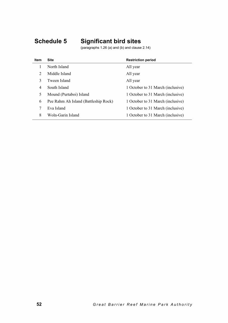
52 G r e a t B a r r i e r R e e f M a r i n e P a r k A u t h o r i t y
Schedule 5 Significant bird sites (paragraphs 1.26 (a) and (b) and clause 2.14)
Item Site Restriction period
1 North Island All year 2 Middle Island All year 3 Tween Island All year 4 South Island 1 October to 31 March (inclusive) 5 Mound (Purtaboi) Island 1 October to 31 March (inclusive) 6 Pee Rahm Ah Island (Battleship Rock) 1 October to 31 March (inclusive) 7 Eva Island 1 October to 31 March (inclusive) 8 Woln-Garin Island 1 October to 31 March (inclusive)

H I N C H I N B R O O K P L A N O F M A N A G E M E N T 53
Schedule 6 No-anchoring area (subclause 2.15 (3))
Map No-anchoring Area (Brook Islands)
1 Brook Islands Reef (18–008) — No-anchoring area The area bounded by a notional line beginning at the westernmost point of
the coastline at low water of North Island (18–008A), and running progressively as follows:
(a) generally south-easterly along that coastline at low water to its southernmost point;
(b) south-easterly along the geodesic to the northernmost point of the coastline at low water of Tween Island (18–008B);
(c) generally southerly and easterly along that coastline at low water to its easternmost point;
(d) easterly along the geodesic to the westernmost point of the coastline at low water of Middle Island (18–008D);
(e) generally southerly, south-easterly and easterly along that coastline at low water to its easternmost point;
(f) southerly along the geodesic to 18° 09.188′ S, 146° 17.465′ E (marked by no-anchoring marker);
(g) north-westerly along the geodesic to 18° 09.091′ S, 146° 17.282′ E (marked by no-anchoring marker);
(h) north-westerly along the geodesic to 18° 08.973′ S, 146° 17.095′ E (marked by no-anchoring marker);
(i) northerly along the geodesic to 18° 08.866′ S, 146° 16.924′ E (marked by no-anchoring marker);
(j) north-westerly along the geodesic to 18° 08.794′ S, 146° 16.904′ E (marked by no-anchoring marker);
(k) north-westerly along the geodesic to 18° 08.727′ S, 146° 16.824′ E (marked by no-anchoring marker);
(l) north-westerly along the geodesic to 18° 08.662′ S, 146° 16.719′ E (marked by no-anchoring marker);
(m) north-westerly along the geodesic to 18° 08.520′ S, 146° 16.655′ E (marked by no-anchoring marker);
(n) northerly along the geodesic to the point where the line began. Note 1 Public moorings are located about the Brook Islands at the northern end of North Island (18–008A) and at the north-westerly edge of South Island (18–008C).
Note 2 Reef protection markers are used in the Brook Islands to protect the reef.

54 G r e a t B a r r i e r R e e f M a r i n e P a r k A u t h o r i t y
Schedule 7 Cruise ship anchorages (subclause 1.30 (1))
1 Hecate Point Cruise Ship Anchorage Within a 500 metre radius around the point 18° 14.00′ S, 146° 3.50′ E.
2 Cape Richards Cruise Ship Anchorage Within a 250 metre radius around the point 18° 11.70′ S, 146° 12.70′ E.

H I N C H I N B R O O K P L A N O F M A N A G E M E N T 55
Schedule 8 Maps (paragraphs 1.17 (a), 1.18 (1) (c) and (e), subclauses 1.27 (1) and (3), paragraph 1.27 (8) (b), subclause 2.15 (3) and paragraph 2.19 (2) (b))

56 G r e a t B a r r i e r R e e f M a r i n e P a r k A u t h o r i t y

H I N C H I N B R O O K P L A N O F M A N A G E M E N T 57

58 G r e a t B a r r i e r R e e f M a r i n e P a r k A u t h o r i t y

H I N C H I N B R O O K P L A N O F M A N A G E M E N T 59
Schedule 9 Activities to which Part 2 of this Plan do not apply (clause 2.4)
Table 1 Purposes — activities not requiring notification
Item Purpose
1 To save human life or avoid the risk of injury to a person 2 To locate or secure the safety of an aircraft, vessel (except a ship) or structure that is,
or may be, endangered by stress of weather or by navigational or operational hazards 3 To enforce a law of the Commonwealth or Queensland by a person authorised under
that law, or under another law of that kind, to enforce the law 4 To carry out reconnaissance or surveillance for the Commonwealth or Queensland
Table 2 Purposes — activities requiring notification
Item Purpose
1 To locate or secure the safety of a ship that is, or may be, endangered by stress of weather or by navigational or operational hazards if the activity is carried out in accordance with the Regulations
2 To remove a vessel or an aircraft, or a section of a vessel or an aircraft, that is wrecked, stranded, sunk or abandoned, except a wreck to which the Historic Shipwrecks Act 1976 applies
3 To construct, conduct or service navigational aids, and their ancillary buildings and works, that are authorised under a law of the Commonwealth or of Queensland, including the operation of vessels and aircraft for those purposes
4 To remove, in accordance with an order under the Regulations (being an order to which section 38H of the Act applies) or a deed of arrangement, property described in the order or deed
5 To undertake defence activities not otherwise allowed without permission under the Zoning Plan
6 To conduct government geodetic surveys, government bathymetric surveys or similar surveys
7 To undertake urgent maintenance or works on essential public services (including power, water, sewerage and communication systems) that are authorised under a law of the Commonwealth, Queensland or a local government authority
8 To deal with an emergency involving a serious threat to the environment 9 To carry out an activity for the purposes of the management of the Planning Area

60 G r e a t B a r r i e r R e e f M a r i n e P a r k A u t h o r i t y
Schedule 10 Definitions (subclause 1.6 (1))
500 metre line in relation to a reef, means the notional line of which every point is 500 metres seaward from the nearest point of the reef edge.
1 kilometre line in relation to a reef, means the notional line of which every point is 1 kilometre seaward from the nearest point of the reef edge.
5 kilometre line means the notional line of which every point is 5 kilometres seaward from the nearest point of the mainland at low water.
Act means the Great Barrier Reef Marine Park Act 1975. aircraft has the same meaning as in subsection 3 (1) of the Act. aircraft operation means an operation of that name:
(a) mentioned in Table 2; and (b) comprising activities: (i) permitted under a relevant permission; and (ii) all carried out using the same aircraft.
anchor includes an anchor chain and attached tackle. ancillary vessel means a tender that is used for motorised water sports
authorisation has the same meaning as in subregulation 4 (1) of the Regulations.
Authority has the same meaning as in the Act. Note Authority means the Great Barrier Reef Marine Park Authority established by the Act: see subsection 3 (1) of the Act.
bareboat means a vessel that is: (a) a commercial ship registered under the Transport
Operations (Marine Safety) Regulation 1995 of Queensland, as in force from time to time, as a class 1F ship; and
(b) over 6 metres in length; and (c) when hired or otherwise made available under a
commercial arrangement, made available: (i) for a person’s recreational use; and (ii) without a master or crew.
Examples of a bareboat A cruiser, houseboat or yacht.
bareboat operation means an operation of that name: (a) mentioned in Table 2; and (b) comprising activities: (i) permitted under a relevant permission; and (ii) all carried out using the same bareboat.
Bedarra Island Location 1 means the area described in item 4 of Schedule 2.
H I N C H I N B R O O K P L A N O F M A N A G E M E N T 61
Bedarra Island Location 2 means the area described in item 5 of Schedule 2. Bedarra Island Location 3 means the area described in item 6 of Schedule 2. Bowden (Budg-Joo) Island Location
means the area described in item 7 of the Table in item 20 of Schedule 2.
Brook Islands Location means the area described in item 7 of Schedule 2. Cape Richards Location means the area described in item 12 of Schedule 2. Central Section has the same meaning as in subregulation 4 (1) of the
Regulations. coastal 200 metre line in relation to an island or the mainland, means the line
every point of which is 200 metres seaward from: (a) the nearest point of the coastline, at low water, of the
island or mainland; or (b) if there is a fringing reef wholly or partly around the
island, or wholly or partly along the mainland — the nearest point of the reef edge of the fringing reef.
coastal 500 metre line in relation to an island or the mainland, means the line every point of which is 500 metres seaward from: (a) the nearest point of the coastline, at low water, of the
island or mainland; or (b) if there is a fringing reef wholly or partly around the
island, or wholly or partly along the mainland — the nearest point of the reef edge of the fringing reef.
coastal 1 kilometre line in relation to an island or the mainland, means the line every point of which is 1 kilometre seaward from: (a) the nearest point of the coastline, at low water, of the
island or mainland; or (b) if there is a fringing reef wholly or partly around the
island, or wholly or partly along the mainland — the nearest point of the reef edge of the fringing reef.
collecting has the same meaning as in the Zoning Plan. commencing day means the day on which this Plan is gazetted. Coombe Island Location means the area described in item 5 of the Table in item 20
in Schedule 2. craftless operation means an operation of that name:
(a) mentioned in Table 2; and (b) comprising activities: (i) permitted under a relevant permission; and (ii) in which neither an aircraft nor a vessel is used.
crewed large vessel operation means an operation of that name: (a) mentioned in Table 2; and (b) comprising activities: (i) permitted under a relevant permission; and (ii) all carried out using the same vessel.
Note Table 2 summarises some of the conditions attaching to a permission for this activity.

62 G r e a t B a r r i e r R e e f M a r i n e P a r k A u t h o r i t y
crewed vessel operation means an operation of that name: (a) mentioned in Table 2; and (b) comprising activities: (i) permitted under a relevant permission; and (ii) all carried out using the same vessel. Note Table 2 summarises some of the conditions attaching to permission for this activity.
cruise ship anchorage means an area referred to in Schedule 7. cruise ship operation means an operation of that name:
(a) mentioned in Table 2; and (b) comprising activities: (i) permitted under a relevant permission; and (ii) all carried out using the same ship.
day means a period of 24 hours commencing at midnight. dugong includes a part of, or a product derived from, a dugong. Dunk (Coonanglebah) Island Location
means the area described in item 2 of Schedule 2.
Dunk (Coonanglebah) Island Spit Location
means the area described in item 1 of Schedule 2.
East Coast Hinchinbrook Island Location
means the area described in item 15 of Schedule 2.
eligibility process commencement day
means the day specified by the Authority in a notice published in the Gazette as the day on which the eligibility process commences.
Eva Island Location means the area described in item 11 of the Table in item 20 of Schedule 2.
existing permission means a relevant permission in force immediately before the commencing day.
facility has the same meaning as in subsection 3A (9) of the Act. fishing has the same meaning as in the Zoning Plan. Garden (Tindappah) Island Location
means the area described in item 10 of the Table in item 20 of Schedule 2.
Goold Island Location means the area described in item 9 of the Table in item 20 of Schedule 2.
guided interpretive tour (including fishing) operation
means an operation of that name: (a) mentioned in Table 2; and (b) comprising activities: (i) permitted under a relevant permission; and (ii) all carried out using the same vessel.
high speed vessel means a personal watercraft, hovercraft or wing-in-ground-effect, or a vessel of any kind if operated faster than 35 knots.

H I N C H I N B R O O K P L A N O F M A N A G E M E N T 63
hire craft means a motorised vessel, less than 6 metres in overall length, that is available for timeshare, hire or charter without a master or crew (eg dinghy, half cabin, personal watercraft).
hire equipment means non-motorised craft (eg kayak, paddleboard, windsurfer) that are available for timeshare, hire or charter without a master or crew.
hire operation means an operation of that name: (a) mentioned in Table 2; and (b) comprising activities: (i) permitted under a relevant permission; and (ii) all carried out using a hire craft or hire
equipment. holder, of a relevant permission means the person to whom a relevant permission that is in
force was granted, or transferred, as the case may be. hovercraft has the same meaning as in subsection 3 (1) of the Act. Hudson (Coolah) Island Location
means the area described in item 6 of the Table in item 20 of Schedule 2.
intensive use setting Location means a Location identified in item 1 of Schedule 3. interfere with includes harass, chase, herd, tag, mark and brand. Kumboola Island Location means the area described in item 3 of Schedule 2. large vessel means any vessel with an overall length of 35 metres or
more. limited tour operation means an operation that:
(a) is mentioned in Table 2; and (b) does not meet the eligibility criteria mentioned in
subclause 1.34 (6); and (c) comprises activities: (i) permitted under a relevant permission; and (ii) all carried out using the same vessel or aircraft.
Location means a location within the meaning of subclause 1.27 (3) and described in an item in Schedule 2.
long range roving operation means an operation of that name: (a) mentioned in Table 2; and (b) comprising activities: (i) permitted under a relevant permission; and (ii) all carried out using the same vessel.
low use setting Location means a Location identified in item 3 of Schedule 3. Macushla Location means the area described in item 13 of Schedule 2. Management Agencies means the Great Barrier Reef Marine Park Authority and
the Queensland Parks and Wildlife Service. management setting means a setting described in Table 1. Marine Park has the same meaning as in subsection 3 (1) of the Act.

64 G r e a t B a r r i e r R e e f M a r i n e P a r k A u t h o r i t y
marine turtle means a member of the family Cheloniidae or Dermochelyidae and includes a part of such a member and any product derived from such a member.
median line between a coastline or reef edge and another coastline or reef edge, means the line every point of which is equidistant from the nearest points of the reef edge or coastline at low water.
Meunga Creek Location means the area described in item 8 of Schedule 2. Missionary Bay Location means the area described in item 9 of Schedule 2. Missionary Bay Transit Lanes means the areas described in item 10 of Schedule 2. moderate use setting Location means a Location identified in item 2 of Schedule 3. mooring means a permanently located facility that is designed
solely for mooring a vessel or aircraft, and includes the mooring buoy, tackle and the point of attachment to the seabed.
motorised water sport means any of the following: (a) irregular driving on a motorised vessel — that is,
driving a motorised vessel other than in a straight line — and includes:
(i) driving in a circle or other pattern; and (ii) weaving or diverting; and (iii) surfing down, or jumping over or across, any
swell, wave or wash; but does not include making any necessary turn or
diversion; (b) any activity in which a high speed vessel or
motorised vessel tows a person on top of the water or in the air, for example, water skiing or para-sailing;
(c) any activity in which a personal watercraft is used, other than for transport by the most direct reasonable route (not including irregular driving) between 2 places in the Planning Area.
motorised water sports operation
means an operation of that name: (a) mentioned in Table 2; and (b) consisting of a motorised water sport, or a similar
operation comprising activities permitted under a relevant permission.
Note Motorised water sport conducted using an ancillary vessel is not a motorised water sport operation: see clause 2.17.
Mound (Purtaboi) Island Location
means the area described in item 1 of the Table in item 20 of Schedule 2.
Mulligan Bay Location means the area described in item 17 of Schedule 2. new permission means a relevant permission granted on or after the
commencing day. no-anchoring area means the part of the Planning Area within an area referred
to in Schedule 6 and shown on Map 3 in Schedule 8.

H I N C H I N B R O O K P L A N O F M A N A G E M E N T 65
non-motorised craft means craft moved only by human or wind power (for example, sea kayaks, sailboards and other small sail craft or paddle boards).
non-motorised craft operation means an operation of that name: (a) mentioned in Table 2; and (b) comprising activities using a non-motorised craft
permitted under a relevant permission. open tour operation means an operation of that name that:
(a) is mentioned in Table 2; and (b) either: (i) meets the eligibility criteria mentioned in
subclause 1.34 (6); or (ii) is a new open tour permission of a kind
mentioned in subclause 1.28 (9); and (c) comprises activities that are: (i) permitted under a relevant permission; and (ii) all carried out using the same vessel or aircraft.
overall length has the same meaning as in subsection 3 (1) of the Act. Pandora Reef Location means the area described in item 19 of Schedule 2. passenger transport operation means an operation of that name:
(a) mentioned in Table 2; and (b) comprising activities: (i) in which passengers are transported between
Locations or between a Location and a place outside the Planning Area; and
(ii) permitted under a relevant permission; and (iii) all carried out using 1 particular vessel.
permanently moored facility means: (a) a facility that is moored in the one place for more
than: (i) 14 consecutive days; or (ii) 30 days in any period of 60 days; or (b) if the Regulations provide otherwise, a facility
within the meaning given in the Regulations. permitted mooring means a mooring permitted by the Management Agencies.

66 G r e a t B a r r i e r R e e f M a r i n e P a r k A u t h o r i t y
personal watercraft has the same meaning as in the Transport Operations (Marine Safety) Regulation 1995 of Queensland, as in force from time to time. Note 1 At the commencement of this Plan, Schedule 11 of the Transport Operations (Marine Safety) Regulation 1995 of Queensland defined personal watercraft as a power driven ship that: (a) has a fully enclosed hull that does not take on water if
capsized; and (b) is designed to be operated by a person standing,
crouching, or kneeling on it or sitting astride it. Note 2 Ship includes any kind of boat or other vessel: see section 10 of the Transport Operations (Marine Safety) Act 1994 of Queensland.
Picnic Beach Location means the area described in item 18 of Schedule 2. Planning Area means the Hinchinbrook Planning Area described in
Schedule 1. pontoon means a permanently moored facility that is used primarily
for tourism activities (except solely as a landing area for aircraft).
public mooring means a mooring that is installed by, or on behalf of, the Authority or the State of Queensland for use by the public.
Ramsay Bay Location means the area described in item 14 of Schedule 2. reef has the same meaning as in the Zoning Plan. reef edge has the same meaning as in the Zoning Plan. reef protection marker means a marker that:
(a) is installed by or for the Authority or an authority of Queensland; and
(b) marks the seaward boundary of an area where anchoring is not permitted.
regular public transport operations
has the meaning given in the Civil Aviation Safety Regulations 1998.
Regulations means the Great Barrier Reef Marine Park Regulations 1983.
relevant permission has the same meaning as in subregulation 4 (1) of the Regulations.
restriction period means the period mentioned in Schedule 5 for a significant bird site.
sea-bed has the same meaning as in subsection 3 (2) of the Act. Sensitive Location means a Location identified in Schedule 4. service mooring means a mooring used by a resort for the purpose of
servicing the resort. setting Locations means the part of the Planning Area within a Location
mentioned in Schedule 3. Shepherd Bay Location means the area described in item 11 of Schedule 2.

H I N C H I N B R O O K P L A N O F M A N A G E M E N T 67
ship means any vessel with an overall length of more than 70 metres.
significant bird site means an island, islet, rock, inlet or bay mentioned in Schedule 5 (from the coastline at high water extending to the coastal 200 metre line).
Smith (Kurrumbah) Island Location
means the area described in item 8 in the Table in item 20 in Schedule 2.
support service operation means an operation of that name: (a) mentioned in Table 2; and (b) comprising activities: (i) permitted under a relevant permission; and (ii) all carried out using the same vessel.
Examples A support service operation may offer such services as: • delivering spare parts or equipment • landing torn sails for repair • medivac support • assisting in pollution control.
Table 1 means the table following clause 1.27. Table 2 means the table following clause 1.32. take has the meaning given in the Zoning Plan. Thorpe (Timana) Island Location
means the area described in item 3 of the Table in item 20 of Schedule 2.
tourism operation means any of the following: (a) an aircraft operation; (b) a bareboat operation; (c) a craftless operation; (d) a crewed vessel operation;
(e) a cruise ship operation; (f) a guided interpretive tour (including fishing)
operation; (g) a hire operation;
(h) a large crewed vessel operation; (i) a long range roving operation; (j) a motorised water sports operation; (k) a non-motorised craft operation; (l) a passenger transport operation; (m) a support service operation.
tourist has the same meaning as in subsection 3A (9) of the Act. tourist facility has the same meaning as in subsection 3A (4) of the Act. traditional affiliation means that the person concerned has a connection with the
Planning Area based on spiritual and other associations with, rights in relation to, and responsibilities for, that area under Aboriginal tradition.

68 G r e a t B a r r i e r R e e f M a r i n e P a r k A u t h o r i t y
traditional inhabitant means a person of Aboriginal or Torres Strait Islander descent, who is recognised in the community as an Aboriginal or Torres Strait Islander, and who identifies himself or herself as an Aboriginal or Torres Strait Islander.
transfer, of a relevant permission
means transfer under regulation 52 of the Regulations.
transfer passenger has the same meaning as in subregulation 74 (1) of the Regulations. Note Transfer passengers are not taken to be part of a tourism operation: see clause 2.1.
transiting means in transit, by the most direct reasonable route, to a place outside the Location or area concerned.
transit lane means an area within a prescribed distance on either side of a direct line between 2 points defined either by latitude and longitude, or marked with buoys, within the Planning Area.
transport purposes means use of a vessel or aircraft, primarily for transporting people to a specific destination, including transiting.
vessel has the same meaning as in subsection 3 (1) of the Act. week means a period of 7 consecutive days. Wheeler (Toolgbar) Island Location
means the area described in item 4 of the Table in item 20 of Schedule 2.
Woln-Garin Island Location means the area described in item 2 of the Table in item 20 of Schedule 2.
year means a period of 365 consecutive days. Zoe Bay Location means the area described in item 16 of Schedule 2. zone means a zone mentioned in the Zoning Plan. Zoning Plan means the Zoning Plan that applies to the Planning Area.


2 - 68 Flinders StreetPO Box 1379TOWNSVILLE QLD 4810Phone: (07) 4750 0700Fax: (07) 4772 6093Email: [email protected]
www.gbrmpa.gov.au