historic winter storm (february 8-9, 2013) conference call wednesday 2:30 pm february 6, 2013
TRANSCRIPT

HISTORIC WINTER STORM (FEBRUARY 8-9, 2013)
CONFERENCE CALL
Wednesday 2:30 PM February 6, 2013

MAIN IMPACTS
• WIDESPREAD PROLONGED POWER OUTAGES
• 1 TO 2 FEET OF SNOW WITH 2 TO 3 FOOT DRIFTS
• WIND DAMAGE TO STRUCTURES; FALLING TREES
• POTENTIAL FOR COASTAL FLOODING
• POSSIBILITY OF STRANDED VEHICLES
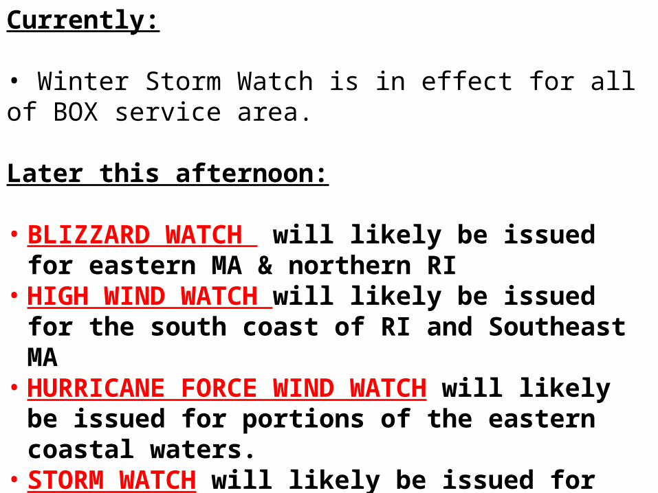
Currently:
• Winter Storm Watch is in effect for all of BOX service area.
Later this afternoon:
• BLIZZARD WATCH will likely be issued for eastern MA & northern RI
• HIGH WIND WATCH will likely be issued for the south coast of RI and Southeast MA
• HURRICANE FORCE WIND WATCH will likely be issued for portions of the eastern coastal waters.
• STORM WATCH will likely be issued for all remaining coastal waters

TIMING:
SNOW: Light snow will begin before daybreak Friday. It may be light through the morning and early afternoon. Then it will come with a roar and could fall at rates of 2 to 4 inches per hour beginning between 3 PM and 6 PM. Heavy snow will be winding down Saturday morning, except continuing through the day on Cape Cod/Islands, where it will likely start as rain on Friday.
Note: Travel to destinations (like home from work or school) may become impossible by the evening commute on Friday.

ONSET OF HEAVY SNOW
Noon-2 PM Friday
1-3 PM Friday
2-4 PM Friday

CURRENT SNOWFALL PROJECTIONS:
14-24 INCHES IN NE ½ OF AREA
PROBABILITIES ARE HIGH FOR MORE THAN 1 FOOT OF SNOW.
COULD BE MUCH HIGHER !!!
CURRENT SNOWFALL PROBABILITIES:

HIGH IMPACT END OF WEEK STORM
• Southern NH/Northern MA Temperatures– Friday afternoon 25-30. (Wet)– Height of storm 15-20. (Dry)
• CT/RI/Southern MA Temperatures– Friday afternoon 30-35. (Wet)– Height of storm 30 20. (Transition Wet to Dry)
SNOW WATER CONTENT

WIND GUSTS FRIDAY NIGHT FEBRUARY 8
60 TO 80 MPH
40 TO 50 MPH
50 TO 60 MPH

COASTAL FLOOD THREATMassachusetts East Coast
• Two Tide cycles– Friday evening 930 PM to 10 PM
• Moderate coastal flooding possible• Storm surge around 3 feet possible
– On top of 10.1 ft MLLW Astronomical Tide at Boston
• Waves 15 to 20 feet several miles offshore
– Saturday morning around 10 AM• Moderate to Major coastal flooding possible
– Dependent upon timing of wind shift to northwest
• Storm surge 1.5 to 2.5 feet possible– Dependent upon direction of wind at high tide– On top of 11.5 ft MLLW Astronomical Tide at Boston
• Waves may be 25 to 30 feet several miles offshore
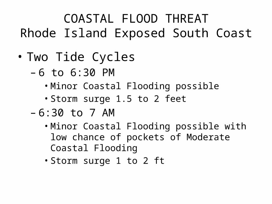
COASTAL FLOOD THREATRhode Island Exposed South Coast
• Two Tide Cycles– 6 to 6:30 PM
• Minor Coastal Flooding possible• Storm surge 1.5 to 2 feet
– 6:30 to 7 AM• Minor Coastal Flooding possible with low chance of
pockets of Moderate Coastal Flooding• Storm surge 1 to 2 ft

RISK FOR BEACH EROSION FEB 8 – 9Friday Night and Saturday
HIGH
MODERATE
HIGH
HIGH

MARINE IMPACTS FEB 8 – 9Max Midnight – 2 PM Saturday
60 TO 70 KT
50 TO 60 KT
50 TO 60 KTSEAS 20 TO 30 FT
SEAS 25 TO 30 FTSEAS 20 TO 25 FT

SUMMARY• Snow starts Friday morning…then increases to Heavy Snow
Friday afternoon. Heavy Snow continues Friday night and tapers off Saturday. Rain/snow mix possible south coast and islands Friday afternoon.
• Damaging winds possible in Eastern Massachusetts and Rhode Island (gusts to 80 mph possible near southeast coast)
• Snow and wind will cause widespread power outages across interior southern New England from late Friday through Saturday.
• Moderate to Major coastal flooding and significant erosion likely Friday night and Saturday high tide cycles.
• Seas may build to 30 feet Friday night/Saturday with storm to hurricane force winds possible – extremely dangerous for mariners.