historical heritage assessment - major projects
TRANSCRIPT

Appendix F Historical heritage assessment


The Petrified Tree Stump, Moobi Road,
Scone The Scone Advertiser, 7 Sept 1937
ARCHAEOLOGICAL & HERITAGE MANAGEMENT SOLUTIONS PTY LTD
AHMS 349 Annandale Street Annandale NSW 2038 T: 02 9555 4000 F: 02 9555 7005 E: [email protected] ABN 45 088 058 388 ACN 088 058 388
PREPARED ON BEHALF OF
MANIDIS ROBERTS
PRELIMINARY HISTORICAL HERITAGE ASSESSMENT
QUEENSLAND HUNTER GAS PIPELINE

QUEENSLAND HUNTER GAS PIPELINE – PRELIMINARY HISTORICAL HERITAGE ASSESSMENT
AHMS 2
ARCHAEOLOGICAL & HERITAGE MANAGEMENT SOLUTIONS PTY LTD April 2008
CONTENTS Contents................................................................................................... 2 Abbreviations ............................................................................................ 5 Figures..................................................................................................... 6 Tables...................................................................................................... 7 Executive Summary..................................................................................... 9
Preamble............................................................................................... 9 Aims ..................................................................................................... 9 Results .................................................................................................. 9 Recommendations...................................................................................10
1. Background ........................................................................................11 1.1 The Pipeline Project.......................................................................11 1.2 Approach and Scope of Work ............................................................12 1.3 Study Limitations...........................................................................13 1.4 Authorship ...................................................................................13 1.5 Acknowledgements ........................................................................14
2. Statutory Context ................................................................................15 2.1 Environmental Planning & Assessment Act, 1979 ...................................15
2.1.1 Regional and Local Environmental Plans ........................................16 2.2 Heritage Act, 1977.........................................................................17
2.2.1 The State Heritage Register (SHR) ................................................18 2.2.2 Archaeological sites and ‘Relics’ not listed on the SHR or Subject to an IHO ...........................................................................................19 2.2.3 Section 170 Heritage & Conservation Registers ...............................20
2.3 Environment Protection Biodiversity & Conservation Act, 1999.................20 2.3.1 National and Commonwealth Heritage Lists ....................................21
2.4 Non-Statutory Lists.........................................................................21 2.4.1 The Australian Heritage Database ................................................21 2.4.2 Register of the National Trust of Australia......................................22
3. Thematic history of places along the pipeline route .....................................23 3.1 Methodology.................................................................................23 3.2 Environment.................................................................................23 3.3 Aboriginal Cultures.........................................................................25 3.4 Exploration ..................................................................................27 3.5 Forestry ......................................................................................29 3.6 Mining.........................................................................................29 3.7 Pastoralism ..................................................................................31 3.8 Agriculture...................................................................................33 3.9 Industries ....................................................................................35 3.10 Transport..................................................................................35
3.10.1 Rivers ...................................................................................35 3.10.2 Roads....................................................................................36

QUEENSLAND HUNTER GAS PIPELINE – PRELIMINARY HISTORICAL HERITAGE ASSESSMENT
AHMS 3
ARCHAEOLOGICAL & HERITAGE MANAGEMENT SOLUTIONS PTY LTD April 2008
3.10.3 Railways ................................................................................38 3.10.4 Travelling Stock Routes .............................................................39
3.11 Towns......................................................................................40 3.11.1 Hexham.................................................................................40 3.11.2 Maitland ................................................................................40 3.11.3 Morpeth ................................................................................40 3.11.4 Singleton ...............................................................................41 3.11.5 Muswellbrook..........................................................................41 3.11.6 Scone ...................................................................................41 3.11.7 Murrurundi.............................................................................42 3.11.8 Quirindi.................................................................................42 3.11.9 Gunnedah ..............................................................................42 3.11.10 Boggabri .............................................................................43 3.11.11 Narrabri .............................................................................43 3.11.12 Moree ................................................................................43 3.11.13 Soldier Settlements ...............................................................44
3.12 Law and Order ...........................................................................44 3.13 Birth and Death ..........................................................................46
4. Known heritage items & places ...............................................................48 4.1 Methodology.................................................................................48 4.2 Lists of Known Items & Places within 0-1km of the Proposed Pipeline Study area. .................................................................................................... 49
4.2.1 Moree Plains Shire Council .........................................................49 4.2.2 Narrabri Shire Council...............................................................50 4.2.3 Gunnedah Shire Council ............................................................50 4.2.4 Liverpool Plains Shire Council .....................................................50 4.2.5 Upper Hunter Shire Council........................................................50 4.2.6 Muswellbrook Shire Council ........................................................51 4.2.7 Singleton Shire Council .............................................................51 4.2.8 Maitland City Council ................................................................51 4.2.9 Port Stephens Council ...............................................................52 4.2.10 Newcastle City Council ..............................................................52
4.3 List of Known Items Located within 1-3km of the Proposed Pipeline Study area .................................................................................................... 53
4.3.1 Moree Plains Shire Council .........................................................53 4.3.2 Narrabri Shire Council...............................................................53 4.3.3 Gunnedah Shire Council ............................................................53 4.3.4 Liverpool Plains Shire Council .....................................................54 4.3.5 Upper Hunter Shire Council........................................................54 4.3.6 Muswellbrook Shire Council ........................................................55 4.3.7 Singleton Shire Council .............................................................55 4.3.8 Maitland City Council ................................................................55 4.3.9 Port Stephens Council ...............................................................55 4.3.10 Newcastle City Council ..............................................................56
4.4 Maps...........................................................................................56

QUEENSLAND HUNTER GAS PIPELINE – PRELIMINARY HISTORICAL HERITAGE ASSESSMENT
AHMS 4
ARCHAEOLOGICAL & HERITAGE MANAGEMENT SOLUTIONS PTY LTD April 2008
4.5 Summary .....................................................................................57
5. Predictive model – potential items & places................................................59 5.1 Methodology.................................................................................59
5.1.1 Identifying .............................................................................59 5.1.2 Mapping.................................................................................60 5.1.3 Grouping and Further Identification .............................................60
5.2 Thematic framework Interpretation of Potential Heritage Items ................61 5.3 Maps and Lists of Potential Items .......................................................62 5.4 Potential Items located within the Pipeline Study area up to 1km of the Pipeline................................................................................................... .................................................................................................62 5.5 Rural Fencing in NSW......................................................................62
6. Significance........................................................................................74 6.1 Known Items and Places ..................................................................74 6.2 Themes assigned to known heritage items ...........................................75 6.3 Maps and Lists of Known Items ..........................................................76 6.4 Potential Places and Items ...............................................................76 6.5 Maps and Lists of Potential Items .......................................................77
7. Impacts and Constraints Assessment .........................................................78 7.1 Impacts - Methodology ....................................................................78 7.2 Constraints - Methodology................................................................79 7.3 Heritage Items Excluded from Constraints Assessment ............................80
7.3.1 Heritage Items located between 1km and 3km of the Pipeline Study area
80
8. Recommendations................................................................................81 8.1 Known Heritage Items.....................................................................81
8.1.1 Hard Constraints and Recommendations ........................................81 8.1.2 Recommendations for Known Items and Places that are Hard Constraints . ...........................................................................................82 8.1.3 Moderate Constraints and Recommendations ..................................83 8.1.4 Recommendations for Known Items and Places that are Moderate Constraints.........................................................................................84 8.1.5 Low Constraints and Recommendations .........................................85 8.1.6 Recommendations for Known Items and Places that are Low Constraints .. ...........................................................................................88
8.2 Potential Heritage Items ..................................................................88 8.2.1 Recommendations for Potential items that are Hard Constraints..........89 8.2.2 Recommendations for Potential Items that cannot be identified – Default Hard constraints ..................................................................................92 8.2.3 Recommendations for Potential Items that are Moderate Constraints....92 8.2.4 Recommendations for Potential Items that are Low Constraints...........95
8.3 Rural Fencing situated within the pipeline study area which has potential
heritage values (representing Hard and Moderate Constraints)...........................98
9. References.........................................................................................99

QUEENSLAND HUNTER GAS PIPELINE – PRELIMINARY HISTORICAL HERITAGE ASSESSMENT
AHMS 5
ARCHAEOLOGICAL & HERITAGE MANAGEMENT SOLUTIONS PTY LTD April 2008
ABBREVIATIONS
AHC Australian Heritage Council
CHL Commonwealth Heritage List
CEMP Construction Environmental Management Plan
OEMP Operational Environmental Management Plan
DoP Department of Planning
ICOMOS International Council on Monuments and Sites
LEP Local Environmental Plan
LGA Local Government Area
MGA Map Grid of Australia – unless otherwise specified all coordinates are in MGA94
NHL National Heritage List
NTA National Trust of Australia
REP Regional Environmental Plan
RNE Register of the National Estate
SHI State Heritage Inventory
SHR State Heritage Register
SOHI Statement of Heritage Impact
S.170 Section 170 of the NSW Heritage Act 1977
S.140 Section 140 of the NSW Heritage Act 1977
S.60 Section 60 of the NSW Heritage Act 1977

QUEENSLAND HUNTER GAS PIPELINE – PRELIMINARY HISTORICAL HERITAGE ASSESSMENT
AHMS 6
ARCHAEOLOGICAL & HERITAGE MANAGEMENT SOLUTIONS PTY LTD April 2008
FIGURES
Figure 3.1 Newcastle Railway Station App B
Figure 3.2 Hexham Bridge, 1952 App B
Figure 3.3 West Maitland, 1837 App B
Figure 3.4 High Street, West Maitland, c 1900 App B
Figure 3.5 Flood at Maitland Railway Station, 1950 App B
Figure 3.6 Aborigines at St Clair near Singleton, 1903 App B
Figure 3.7 Muswellbrook from Hospital Hill, 1880 App B
Figure 3.8 St Helier’s Colliery, Muswellbrook, 1928 App B
Figure 3.9 Blood horse sale at ‘Turanville’, near Scone App B
Figure 3.10 Scone Railway Station, 1910 App B
Figure 3.11 Murrurundi shale works, 1925 App B
Figure 3.12 Royal Hotel, Murrurundi, 1890 App B
Figure 3.13 Castle Mountain, Quirindi, 1900 App B
Figure 3.14 Bullock teams in Quirindi, 1910 App B
Figure 3.15 Flood at Quirindi, 1910 App B
Figure 3.16 Bird's eye view of Quirindi, 1930 App B
Figure 3.17 Trunk road 72 two miles north of Boggabri, 1957 App B
Figure 3.18 Trunk Road 72 eight miles north of Gunnedah, 1957 App B
Figure 3.19 Gunnedah-Narrabri road between Turrawon and Tarriaro, 1933 App B
Figure 3.20 Flood at Narrabri Post Office, 1910 App B
Figure 3.21 Flood in Maitland St, Narrabri, 1920 App B
Figure 3.22 Narrabri from Town Hall tower, 1939 App B
Figure 3.23 Newell Highway near Gurley, 1966 App B
Figure 3.24 Moree Bore App B

QUEENSLAND HUNTER GAS PIPELINE – PRELIMINARY HISTORICAL HERITAGE ASSESSMENT
AHMS 7
ARCHAEOLOGICAL & HERITAGE MANAGEMENT SOLUTIONS PTY LTD April 2008
TABLES
Table 2.1 Environmental Planning Instruments Reviewed 17
Table 4.1 Summary of known heritage items within and up to a distance of
1km of the pipeline study area organised by Local Government
Area
57
Table 4.2 Summary of known heritage items between 1km and 3km of the
pipeline study area organised by Local Government Area
58
Table 5.1 Thematic framework for interpretating of potential heritage
items
64-73
Table 5.2 Number of Potential heritage items arranged by Local
Government Areas
62
Table 6.1 Significance Gradings for Known Heritage Items. 75
Table 6.2 Historical Themes assigned to known heritage items assessed
within the pipeline study area and up to1km of the study area
75-76
Table 6.3 Significance Gradings colours for Potential Heritage Items. 77
Table 7.1 Impact Assessment Criteria 79
Table 7.2 Constraint Assessment Table 79
Table 8.1 Hard Constraints – Known heritage items of high or medium
heritage Significance that are located within the pipeline study
area
82
Table 8.2 Moderate Constraints - Known heritage items of Low heritage
significance that are located within 100m of the pipeline study
area
83-84
Table 8.3 Moderate Constraints - Known heritage items of high or medium
heritage significance that are located within 100m of the pipeline
study area.
84
Table 8.4 Low Constraints - Known heritage items of high, medium or low 85-88

QUEENSLAND HUNTER GAS PIPELINE – PRELIMINARY HISTORICAL HERITAGE ASSESSMENT
AHMS 8
ARCHAEOLOGICAL & HERITAGE MANAGEMENT SOLUTIONS PTY LTD April 2008
heritage significance that are located between 100m and 1km of
the pipeline study area.
Table 8.5 Hard Constraints - Potential Heritage Items of likely high or
medium heritage significance that are located within the pipeline
study area
90-91
Table 8.6 Default Hard constraints – Potential Heritage Items of unknown
heritage significance that are located within the pipeline study
area
92
Table 8.7 Moderate Constraints – Potential Heritage Items of likely Low
Heritage significance that are located within the pipeline study
area
93
Table 8.8 Moderate Constraints – Potential Heritage Items of likely unknown
heritage significance that are located within 100m of the pipeline
study area
93-94
Table 8.9 Low Constraints – Potential Heritage Items of likely high,
moderate, low and unknown heritage significance that are
located between 100m of the pipeline study area and 1km from
the study area
95-97
QUEENSLAND HUNTER GAS PIPELINE – PRELIMINARY HISTORICAL HERITAGE ASSESSMENT
AHMS 9
ARCHAEOLOGICAL & HERITAGE MANAGEMENT SOLUTIONS PTY LTD April 2008
EXECUTIVE SUMMARY
Preamble Hunter Gas Pipeline Pty Ltd is proposing a 850km high pressure gas pipeline from the Wallumbilla Gas Hub in South Central Queensland, to near Hexham, NSW.
Archaeological & Heritage Management Solutions Pty Ltd has prepared a preliminary historic heritage assessment of the NSW part of the pipeline route. The assessment is required to inform the Environmental Assessment development application for the project.
The gas pipeline Proposal has been declared a ‘critical infrastructure’ Major Development project under Part 3A of the Environmental Planning and Assessment Act 1979 (EP&A Act). Part 3A of the EP&A Act voids the operation of key heritage provisions of the Heritage Act 1977 and Environmental Planning Instruments that would otherwise apply to the pipeline project.
Aims The primary aims of the heritage assessment were to:
• Identify known heritage items and potential sites and places with heritage values that may be adversely impacted by the proposal and
• Recommend measures to manage and mitigate heritage impacts and constraints to the project.
Results The assessment has identified twelve (13) known heritage items that could be considered a hard constraint to the proposal, nine (9) known items that could be considered a moderate constraint to the proposal and just over one hundred (114) known items and places that could be considered a low (or unlikely) constraint to the proposal. The 13 hard constraint known items are of high or medium heritage significance and located within the 200m pipeline study area.

QUEENSLAND HUNTER GAS PIPELINE – PRELIMINARY HISTORICAL HERITAGE ASSESSMENT
AHMS 10
ARCHAEOLOGICAL & HERITAGE MANAGEMENT SOLUTIONS PTY LTD April 2008
The heritage impact assessment identified 49 potential heritage items that could be considered a potential hard constraint, 20 potential items could be considered a potential moderate constraint and to the proposal and 142 low constraint potential items. The 49 potential items that could be a hard constraint are located within the 200m pipeline study area and of potential high heritage significance.
Recommendations In summary, the assessment recommends that:
• Further heritage and impact assessment is undertaken for known and potential heritage items that are hard and moderate constraints. The assessments to include heritage impact and project constraint mitigation recommendations.
• This preliminary assessment and the further comprehensive heritage assessments, inform the alignment design detail of the pipeline to avoid and minimise adverse heritage impacts and project constraints.
• Consultation with Heritage Branch, Department of Planning, local councils and other relevant stakeholders with regards to further heritage assessments and the proposed mitigation measures is maintained.
• The heritage constraints and heritage impact mitigation and management recommendations and measures are included in the Construction and Operation Environmental Management Plans (CEMP and OEMP).

QUEENSLAND HUNTER GAS PIPELINE – PRELIMINARY HISTORICAL HERITAGE ASSESSMENT
AHMS 11
ARCHAEOLOGICAL & HERITAGE MANAGEMENT SOLUTIONS PTY LTD April 2008
1. BACKGROUND
In late 2007 Archaeological Heritage Management Solutions (AHMS) was engaged by Manidis Roberts Pty Ltd to undertake Preliminary Historic Heritage Assessment on behalf of Hunter Gas Pipeline Pty Ltd, for a proposed 850km long high pressure gas pipeline from the Wallumbilla Gas Hub in South Central Queensland to near Hexham, NSW. The gas pipeline project has been declared a ‘critical infrastructure’ major development pursuant to Part 3A of the Environmental Planning and Assessment Act 1979 and staged approval is being sought.
The Preliminary Historic Heritage Assessment (the assessment) is required to inform the Environmental Assessment Application (EA). If required, a separate, more detailed historical heritage assessment and report would be undertaken to inform and assess later project applications and approvals.
1.1 The Pipeline Project From north to south in NSW, the pipeline would generally be located in agricultural or pastoral land near the NSW/ Queensland border, skirt around Moree, cross the Gunnedah-Tamworth Pipeline, traverse the Liverpool Ranges near Murrurundi and follow the New England Highway towards Muswellbrook. The pipeline travels to the east of Muswellbrook in a southerly direction on the northern side of the Hunter River. It skirts Morpeth and crosses the Hunter River twice at Raymond Terrace and finishes at the south-eastern end of Koorgang Island in Stockton. The pipeline would provide a missing link in the eastern Australia gas supply network securing the supply of gas to Sydney and Newcastle for industrial, commercial and domestic use.
The proposed pipeline would be buried underground for its entire length except at supply and delivery points en-route and at main line valves. Construction would require a minimum easement 20 metres wide to provide vehicle access and room for temporary stockpiling of spoil during excavation. Where the pipeline route would cross major roads, rail lines, rivers or major creeks, horizontal directional drilling techniques would be employed that would prevent disturbance of soil and vegetation.

QUEENSLAND HUNTER GAS PIPELINE – PRELIMINARY HISTORICAL HERITAGE ASSESSMENT
AHMS 12
ARCHAEOLOGICAL & HERITAGE MANAGEMENT SOLUTIONS PTY LTD April 2008
1.2 Approach and Scope of Work The work undertaken for this assessment has generally complied, where relevant, with the heritage assessment and evaluations approaches outlined in the NSW Heritage Manual published in 1996 (updated in 2001)1.
The assessment has focused on identifying the potential impact of the pipeline and its construction on:
• the heritage values of known sites and places of heritage significance that would be directly or indirectly impacted by the pipeline and
• the likely heritage values of potential (currently unidentified) sites and places along the pipeline route could be of high heritage significance.
The primary aim of the focused approach has been to identify sites and places with high heritage values that may be adversely impacted by the proposal and which would require a route adjustment and/or detailed mitigation measures to be set out in the EA.
In summary, the work undertaken included:
• Identifying and mapping known historical heritage sites within the 200m pipeline study area and up to approximately 3km from the proposed pipeline study area route(s) including ‘places, buildings, works, relics, moveable objects or precincts’ as defined by the Heritage Act, 1977.
• Undertaking a thematic history of the study area to assist and contextualize site identification and significance impacts and constraints asessments.
• Consultation with local Councils, relevant state agencies and local historical societies.
• Inspection of heritage registers, schedules or lists in Local or Regional Environmental Plans, including the Register of the National Trust, the Australian Heritage Database and the State Heritage Register.
1 NSW Heritage Office 1996 & 2001

QUEENSLAND HUNTER GAS PIPELINE – PRELIMINARY HISTORICAL HERITAGE ASSESSMENT
AHMS 13
ARCHAEOLOGICAL & HERITAGE MANAGEMENT SOLUTIONS PTY LTD April 2008
• Identifying and mapping previously unrecorded sites or places of potential heritage value within 1km of the pipeline and assigning them a likely level of heritage significance (low, medium, high).
• Identifying key heritage themes2, cultural values and research issues.
• Identifying the likely impact of the proposal on sites, places and areas of known heritage significance and sites, places and areas of potential heritage significance.
• Identifying and mapping known and potential heritage items that may be constraints to the proposal ( hard, moderate or low constraints).
• Developing recommendations to manage and mitigate heritage impacts and constraints to the project including identifying any further assessment or survey that may be required.
1.3 Study Limitations The preliminary historic heritage assessment has largely relied on secondary written material along with pictorial evidence, early maps and information provided by local historians. Field survey and detailed primary research was not undertaken.
Historical evidence of Aboriginal occupation of the study area was not included in the scope of works, as it is the subject of a separate Preliminary Aboriginal Heritage Assessment prepared by Archaeological & Heritage Management Solutions Pty Ltd.
1.4 Authorship This report was written by a number of AHMS staff including Sophie Brettell, Adam Paterson, Matthew Kelly and Felicity Barry. Dr. Anne-Maree Whitaker undertook the Thematic History and Michael Andon undertook the ARCGIS mapping in conjunction with Laura Matarese and Felicity Barry, also of AHMS.
This report was reviewed by Lisa Newell, Associate Director, AHMS.
2 NSW Heritage Council 2001

QUEENSLAND HUNTER GAS PIPELINE – PRELIMINARY HISTORICAL HERITAGE ASSESSMENT
AHMS 14
ARCHAEOLOGICAL & HERITAGE MANAGEMENT SOLUTIONS PTY LTD April 2008
1.5 Acknowledgements AHMS would like to acknowledge the assistance of the following people and organizations during the production of this report:
• Sandi Shrimski, Marcus Sainsbury and Daniel Hall of Manidis Roberts.
• The following Local Historical Societies and Family History Groups for providing advice for this project including: Murrurundi & District Historical Society; Gunnedah & District Historical Society Inc; Veritas Archaeology & History Service for Muswellbrook Local & Family History Society; Quirindi & District Historical Society; Boggabri & District Historical Society; Raymond Terrace & District Historical Society; Narrabri & District Historical Society; Scone & Upper Hunter Historical Society and the Morpeth Heritage Conservation Group. In particular we would like to thank Barbara Riddell, Judy Smart, Bob Tickle and Shirley Coote.
• Mari Metzke and the staff of the Royal Australian Historical Society.
• Dr. John Pickard, Macquarie University.
• Ms. Lillian Cullen (Heritage Advisor, Upper Hunter Shire Council).
• Ms. Pamela Daniel (NSW Dept of Lands).
• Mr. Murray Amos, (Planning Officer, Moree Shire Council).
• Ms. Sarah Cameron (Heritage Officer, Newcastle City Council).
• Mr. Stewart Watters (Heritage Officer, Heritage Branch, Dept of Planning).

QUEENSLAND HUNTER GAS PIPELINE – PRELIMINARY HISTORICAL HERITAGE ASSESSMENT
AHMS 15
ARCHAEOLOGICAL & HERITAGE MANAGEMENT SOLUTIONS PTY LTD April 2008
2. STATUTORY CONTEXT
The Environmental Planning and Assessment Act 1979 (EP&A Act) in conjunction with the Heritage Act 1977 provide the statutory framework for managing non-Indigenous (historic) heritage in New South Wales. A further level of heritage protection can be established under the Commonwealth Environment Protection Biodiversity Conservation Act, 1999 (EPBC Act) in certain circumstances.
The system of heritage management in NSW and Australia more broadly comprises a system of heritage listings associated with the legislation (identified above). Historic heritage listing in NSW currently consists of both statutory and non-statutory registers administered by local and State Government agencies in addition to ‘not for profit’ community organizations.
The relevant historic heritage legislation and associated statutory and non-statutory registers reviewed for this project are outlined below.
2.1 Environmental Planning & Assessment Act, 1979
The Environmental Planning and Assessment Act 1979 (EP&A Act) is the dominant piece of legislation that provides a statutory framework for planning processes required for development in NSW. The Act sets out specific statutory assessment processes for proposed developments within the State under Parts 3A, 4 and 5.
Part 3A of the EP&A Act establishes the approval process for projects which qualify as being of ‘State or Regional Environmental Planning Significance’ within the meaning of both this Act3 and the State Environmental Planning Policy (SEPP) for Major Projects (2005). Part 3A also makes allowance for a higher level of state significant project to NSW, which are known as ‘critical infrastructure projects’ and which follow a slightly different process of assessment4. Projects which are 3 Section 75B(2) of the EP&A Act enables the Minister, through an Order made under Section 75B(1) of the EP&A Act, to declare a development to be of ‘State or Regional Environmental Planning Significance’. 4 Section 75C of the EP&A act defines Critical Infrastructure projects and differences in the legislation and processing of a Part3A critical infrastructure project and one being assessed only as a State Significant project under Part 3A.

QUEENSLAND HUNTER GAS PIPELINE – PRELIMINARY HISTORICAL HERITAGE ASSESSMENT
AHMS 16
ARCHAEOLOGICAL & HERITAGE MANAGEMENT SOLUTIONS PTY LTD April 2008
assessed under Part 3A (regardless of whether they are critical infrastructure projects or not), undergo a streamlined development assessment and approval process. This means separate approvals, normally required under certain pieces of NSW legislation (including the Heritage Act, 1977), are not required. Part 3A Projects are determined by the (NSW) Minister for Planning.
Section 75U5 of the EP & A Act specifically outlines sections of the Heritage Act, 1977 that do not require separate approval for a project approved under Part 3A of the EP&A Act. These sections include:
1. Approval under Part 4 or an excavation permit under Section 139 (This means no approvals are required for items listed on the State Heritage Register (SHR) or places subject to an Interim Heritage Order. It also means no approval is required for excavation of archaeological relics/sites on land subject to part 3A Approval); and
2. Approval under Division 8 of Part 6 of the Act (This means items which are not listed on the SHR or subject to an IHO cannot be protected by ‘protection orders’ e.g. under s136).
Not withstanding the application of Part 3A to the Pipeline Project, historic heritage has been included as a matter for consideration for the Environmental Assessment development application documentation.
2.1.1 Regional and Local Environmental Plans
Part 3 of the Environmental Planning and Assessment Act, 1979 relates to the preparation of Environmental Planning Instruments (EPI) within the State of NSW. These instruments include Local Environmental Plans (LEPs) which are intended to assist local councils within NSW to prepare EPIs to direct and assess development within the area to which it relates. The EP&A Act also allows for the preparation of Regional Environmental Plans (REPs) which provide a broader (regional) level of developmental protection and State Environmental Planning Policies (SEPPs).
LEPs, and in some cases REPs, generally contain specific provisions for protecting heritage items in development contexts.
5 Section 75U (1) (d)
QUEENSLAND HUNTER GAS PIPELINE – PRELIMINARY HISTORICAL HERITAGE ASSESSMENT
AHMS 17
ARCHAEOLOGICAL & HERITAGE MANAGEMENT SOLUTIONS PTY LTD April 2008
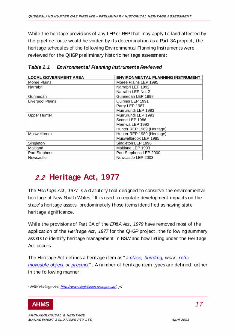
While the heritage provisions of any LEP or REP that may apply to land affected by the pipeline route would be voided by its determination as a Part 3A project, the heritage schedules of the following Environmental Planning Instruments were reviewed for the QHGP preliminary historic heritage assessment:
Table 2.1 Environmental Planning Instruments Reviewed
LOCAL GOVERNMENT AREA ENVIRONMENTAL PLANNING INSTRUMENTMoree Plains Moree Plains LEP 1995 Narrabri Narrabri LEP 1992
Narrabri LEP No. 2 Gunnedah Gunnedah LEP 1998 Liverpool Plains Quirindi LEP 1991
Parry LEP 1987 Murrurundi LEP 1993
Upper Hunter Murrurundi LEP 1993 Scone LEP 1986 Merriwa LEP 1992 Hunter REP 1989 (Heritage)
Muswellbrook Hunter REP 1989 (Heritage) Muswellbrook LEP 1985
Singleton Singleton LEP 1996 Maitland Maitland LEP 1993 Port Stephens Port Stephens LEP 2000 Newcastle Newcastle LEP 2003
2.2 Heritage Act, 1977 The Heritage Act, 1977 is a statutory tool designed to conserve the environmental heritage of New South Wales.6 It is used to regulate development impacts on the state’s heritage assets, predominately those items identified as having state heritage significance.
While the provisions of Part 3A of the EP&A Act, 1979 have removed most of the application of the Heritage Act, 1977 for the QHGP project, the following summary assists to identify heritage management in NSW and how listing under the Heritage Act occurs.
The Heritage Act defines a heritage item as “a place, building, work, relic, moveable object or precinct”. A number of heritage item types are defined further in the following manner:
6 NSW Heritage Act, http://www.legislation.nsw.gov.au/, p1

QUEENSLAND HUNTER GAS PIPELINE – PRELIMINARY HISTORICAL HERITAGE ASSESSMENT
AHMS 18
ARCHAEOLOGICAL & HERITAGE MANAGEMENT SOLUTIONS PTY LTD April 2008
"building" includes a part of a building, a structure or a part of a structure.
"moveable object" means a moveable object that is not a relic.
"place" means an area of land, with or without improvements.
"precinct" means an area, a part of an area, or any other part of the State.
"relic" means any deposit, object or material evidence: (a) which relates to the settlement of the area that comprises New South Wales, not being Aboriginal settlement, and (b) which is 50 or more years old.
To assist the identification and management of Heritage items within NSW, the Act distinguishes between items of local and State heritage significance. These are defined by fulfilling the criterion for significance to either the Local area or the State in relation to the ‘historical, scientific, cultural, social, archaeological, architectural, natural or aesthetic value of the item’7.
The Heritage Act (when it applies) essentially provides statutory protection for items of State Heritage Significance through listing of items on the State Heritage Register and Interim Heritage Orders (IHOs). It further provides statutory protection for archaeological ‘relics’ regardless of whether they are listed on the SHR or subject to an IHO within NSW.
Protection can also be afforded to items of Local heritage significance through protection of items from demolition (under s136) and authorisation of some Local Councils to place IHOs on items of Local significance. Other aspects of the Act provide for State Government Agencies to identify heritage items of local and state significance within their jurisdiction under Section 170 of the Act and the ability of the NSW Heritage Council to comment on certain development applications relating to items of local and state heritage significance within NSW.
2.2.1 The State Heritage Register (SHR)
The State Heritage Register is list of heritage items of State heritage significance established under the Heritage Act . The Register lists a diverse range of items that are deemed to be of particular importance to the State and which enrich our 7 Heritage Act, 1977 Section 4A

QUEENSLAND HUNTER GAS PIPELINE – PRELIMINARY HISTORICAL HERITAGE ASSESSMENT
AHMS 19
ARCHAEOLOGICAL & HERITAGE MANAGEMENT SOLUTIONS PTY LTD April 2008
understanding of the history of NSW. Heritage items listed on the Register are legally protected under the Act and (except for Part 3A projects and in some other circumstances) approval from the Heritage Council of NSW or its delegate is required prior to undertaking work that results in their alteration or modification.
Interim Heritage Orders (IHOs) provide statutory protection for a period of one (1) year. This essentially means that during this time the item is afforded the same protection as an item listed on the State Heritage Register with approvals (where applicable) required from the Heritage Council of NSW for any works within the gazetted boundary. The limited timeframe provides for time to investigate whether the item is of State heritage significance and should be formally listed on the SHR.
Items listed under the State Heritage Register or subject to an Interim Heritage Order along or near the pipeline route have been identified in this study.
2.2.2 Archaeological sites and ‘Relics’ not listed on the SHR or Subject to an IHO
Archaeological relics and sites as defined by the Heritage Act are provided automatic protection under the Heritage Act of NSW. These provisions are set out in Section 139 which establishes the need for an approval under either s139(4) or s140 of the Act (where applicable) to:
‘disturb or excavate any land knowing or having reasonable cause to suspect that the disturbance or excavation will or is likely to result in a relic being discovered, exposed, moved, damaged or destroyed8’
Provision is made within the Act to enable ‘relics’ to be assessed according to their level of heritage significance and where appropriate a lesser form of approval may be granted. This type of approval is provided for under s139(4) as an exception to the requirement for a s140 permit.
There are a number of Archaeological Management Plans (AMPs) and Archaeological Zoning Plans (AZPs) which have been prepared for certain areas within NSW. These plans generally indicate where ‘relics’ may survive in certain locations. The only relevant document of this type affecting the pipeline route is the Newcastle AMP.
8 Section 139(1) of the Heritage Act, 1977

QUEENSLAND HUNTER GAS PIPELINE – PRELIMINARY HISTORICAL HERITAGE ASSESSMENT
AHMS 20
ARCHAEOLOGICAL & HERITAGE MANAGEMENT SOLUTIONS PTY LTD April 2008
However this document does not extend outside the Newcastle Central Business District and as such does not present items or constraints to the proposed development.
The predictive modelling exercise for this project has been devised to identify where ‘relics’ may survive.
2.2.3 Section 170 Heritage & Conservation Registers
The Heritage Act also provides for identifying and managing heritage assets in the care, control and management of State government agencies (section 170 (s170)). To assist this process, all State government agencies in NSW are required to prepare S170 Heritage and Conservation registers (S170 Registers). These registers identify items of both State and local heritage significance within the jurisdiction of that agency for their future protection and conservation.
Four (4) S170 Heritage and conservation Registers were reviewed for this project and include:
STATE GOVERNMENT AGENCY ABBREVIATION Roads and Traffic Authority, NSW RTA RailCorp RailCorp Australian Rail Track Corporation ARTC Dept of Primary Industries DPI
2.3 Environment Protection Biodiversity & Conservation Act, 1999
The Commonwealth Environment Protection and Biodiversity Conservation Act 1999 (the EPBC Act) provides a statutory framework for the protection and management of Commonwealth, National and internationally significant heritage places, flora, fauna and environmental communities. Protection under the Act is provided to items which classify as being of National significance, of World Heritage Significance and/or which hold heritage significance and are located within the jurisdiction or ownership, of a Commonwealth Government Agency. Approvals are required where a ‘significant’ impact is identified to the heritage values of an item listed on the National Heritage List, World Heritage List or the Commonwealth Heritage List established under the Act.

QUEENSLAND HUNTER GAS PIPELINE – PRELIMINARY HISTORICAL HERITAGE ASSESSMENT
AHMS 21
ARCHAEOLOGICAL & HERITAGE MANAGEMENT SOLUTIONS PTY LTD April 2008
2.3.1 National and Commonwealth Heritage Lists
The National Heritage List provides statutory protection for heritage places (natural, historic and Indigenous) which have been determined by the Australian Heritage Council to hold ‘outstanding’ national heritage significance to Australia.
The Commonwealth Heritage List consists of those natural, historic or Indigenous heritage places which are situated on Commonwealth lands, waters or under Australian Government control, and have been listed under the EPBC Act.
The Environment Protection and Biodiversity Conservation Act 1999 provides for the statutory protection of items listed on the National Heritage List (NHL) and the Commonwealth Heritage List (CHL). This means federal approval must be obtained before any action takes place which has, will have, or is likely to have, a significant impact on the national heritage values of a listed place.
No historic place or item currently included on the National or the Commonwealth Heritage Lists, was identified within 3km of the QHGP.
2.4 Non-Statutory Lists
2.4.1 The Australian Heritage Database
The Australian Heritage Database (AHD) is a non-statutory register, maintained by the Commonwealth Department of Environment & Water Resources (DEW), of sites, places and landscapes with either Aboriginal or historic heritage values. It encompasses the current National Heritage List, Commonwealth Heritage List, World Heritage List, List of Overseas Places of Historic Significance to Australia and the former Register of the National Estate.
The Register of the National Estate was a database established under the previous Federal heritage act and remains a non-statutory list.
The former Register of the National Estate was reviewed for the QHGP project and items identified within 3km of the route have been included in this report. Many of these items are also listed on the SHR and in LEPs and REPs.

QUEENSLAND HUNTER GAS PIPELINE – PRELIMINARY HISTORICAL HERITAGE ASSESSMENT
AHMS 22
ARCHAEOLOGICAL & HERITAGE MANAGEMENT SOLUTIONS PTY LTD April 2008
2.4.2 Register of the National Trust of Australia
The National Trust of Australia is a non-statutory community charity which advocates the protection and conservation of natural, built and cultural heritage in Australia. It is an independent community organization which maintains a list of over 11,000 items which it has identified as holding heritage significance within Australia. The NSW chapter of the National Trust of Australia holds a register relevant to the heritage of this State. Some of these items have been formally registered within statutory heritage registers while others have not.
A copy of the 2006 National Trust Register for NSW was reviewed for this project. At the time of this report preparation it was the most recent copy made available for review.

QUEENSLAND HUNTER GAS PIPELINE – PRELIMINARY HISTORICAL HERITAGE ASSESSMENT
AHMS 23
ARCHAEOLOGICAL & HERITAGE MANAGEMENT SOLUTIONS PTY LTD April 2008
3. THEMATIC HISTORY OF PLACES ALONG THE PIPELINE ROUTE
Thematic histories are built on themes that describe a major force or process which has contributed to historical development. Thematic histories provide the context within which heritage significance can be understood, assessed and compared. The Australian and NSW historical themes which are drawn from the NSW Historical Themes9 are listed in Appendix A.
3.1 Methodology This history was intended as a strategic thematic history designed to identify key themes and significance values relevant to the local areas that the pipeline is proposed to traverse. It did not include site-specific or chain-of-title research.
The ultimate aim of this study was to produce a contextual framework to understand both known and potential heritage items and identify physical elements/sites/areas which embody these themes along the pipeline route. Both this thematic history and the associated contextual framework which demonstrate elements of these themes were then incorporated into a system for attributing significance values to potential heritage items along the route. This is discussed further in Chapters 5 and 6 of this report.
3.2 Environment The area between Newcastle and Maitland incorporates the floodplains of the Hunter, Williams and Paterson rivers. The Hunter River coastal catchment at 22,000 square kilometres is the third largest in NSW. At the time of European arrival the Hunter River delta was a complex of intersecting tidal channels, tidal flats and mangrove swamps, much of which has now been altered by reclamation. The river channel is bounded by a floodplain up to 40 kilometres wide, with alluvial deposits known to be eight metres thick at Maitland tapering to four metres near Hexham.
9 NSW Heritage Council 2001

QUEENSLAND HUNTER GAS PIPELINE – PRELIMINARY HISTORICAL HERITAGE ASSESSMENT
AHMS 24
ARCHAEOLOGICAL & HERITAGE MANAGEMENT SOLUTIONS PTY LTD April 2008
The wetlands still comprise 20 per cent of the Newcastle LGA, most notably the Hexham Swamp Nature Reserve.10
The pipeline route crosses the Great Dividing Range at the Liverpool Range between Murrurundi and Gunnedah. The northern part of the study area is located in another large alluvial system known as the Barwon Basin formed by the Bogan, Macquarie and Castlereagh Rivers flowing north, and the Namoi, Gwydir and Barwon-McIntyre Rivers flowing southwest, all eventually feeding into the Darling River. The Barwon basin is characterised by black alluvial cracking clays and extensive flood plains. This soil is not conducive to retaining archaeological material and it has been noticeable that traces of Aboriginal occupation have been mainly confined to red soil uplands rather than the black soil plains.11
An unusual natural phenomenon in the Upper Hunter near Scone is Mount Wingen, known as the ‘burning mountain’. It was first mentioned in The Australian newspaper on 30 July 1828 as a volcano with flame and smoke coming from it but no lava. The site was also visited by Major Mitchell on his journey of exploration in 1831-1832. Mount Wingen is actually a slowly-burning coal seam.12
The rivers of the Hunter Valley and northern plains not only create fertile soil but also subject both regions to frequent severe floods. The largest was probably the flood in 1955 which inundated 10,000 homes in 20 towns and killed 22 people, 11 of them in Maitland. Affected towns on the pipeline route include Maitland, Quirindi, Gunnedah, Boggabri, Narrabri and Moree. Most recently there have been serious floods in Quirindi, Gunnedah and Narrabri in 2000, Narrabri and Moree in 2004 and Maitland in 2007. Over 200 floods have occurred on the Hunter River since settlement, an average of nearly one a year.
Apart from the rivers the main source of irrigation is the Great Artesian Basin, which has an area of about 600,000 square miles and covers one-fifth of Australia. The first flowing water from the Great Artesian Basin was from a bore on ‘Kallara’
10 Australian Museum Business Services, ‘Aboriginal Heritage Study: Newcastle local government area’, 2004, p 28 11 Heritage Concepts Pty Ltd, ‘Aboriginal Heritage Study: Moree Plains Shire Council Local Environmental Plan’, 2007, pp 29, 39 12 J H M Abbott, ‘Mount Wingen: burning mountain of the Kingdon Ponds Valley, its story during the last century’, Journal of the Royal Australian Historical Society, volume 7, part 3, 1921, pp 131-147

QUEENSLAND HUNTER GAS PIPELINE – PRELIMINARY HISTORICAL HERITAGE ASSESSMENT
AHMS 25
ARCHAEOLOGICAL & HERITAGE MANAGEMENT SOLUTIONS PTY LTD April 2008
Station in north-western NSW in 1878. Water from bores was generally used for domestic and stock use, but not for irrigation owing to its mineral content, although the Walgett town water supply was from bores. The deepest bore (at 4338 feet) was at Boronga north of Moree. At Moree the temperature of the water is 100°F (37°C), and it is thought to have curative properties for rheumatism. The Moree bore was sunk in 1895 and therapeutic baths soon drew tourists to the town.13
3.3 Aboriginal Cultures The territory of the Awabakal people covered Newcastle, the Central Coast and out to Maitland. Their lifestyle was based around the rivers which provided birds, plants and fish. The high proliferation of axe grinding grooves in Newcastle and at sites along the Hunter River confirms the existence of a large scale stone implement manufacturing industry, which also used fire to harden points and melt gum used in tool-making. Canoes were made from bark tied with vines and sealed with river gum. Before the establishment of heavy industry in Newcastle, shell middens extended along the river banks from Port Waratah to Sandgate.14
After the convict settlement of Newcastle was wound down in the 1820s the Reverend Lancelot Threlkeld established a mission to the Aborigines at Lake Macquarie and witnessed the decline of their numbers and way of life. Harry Brown, considered the ‘last of the Newcastle tribe’, died in 1854, followed in 1900 by Margaret, known as the ‘last of the Awabakal’. When the Board for the Protection of Aborigines set aside land in 1883 for reserves in areas of high Aboriginal population they bypassed Newcastle in favour of Karuah and Singleton.15 Under the Aboriginal Re-Settlement Programme which wound down the reserves, Newcastle became one of the locations to which people were moved from towns such as Moree, Brewarrina, Walgett and Bourke in the 1960s and 1970s.16
13 Laurie Walker, ‘Irrigation in NSW 1884-1940’, Journal of the Royal Australian Historical Society, volume 27, part 3, 1941, pp 224-226; Moree Bore Hot Water Baths, NSW Government Tourist Bureau, Sydney, 1900 14 John Maynard, ‘Muloobinbah (Newcastle) an Aboriginal industrial presence: past and present’, Journal of the Royal Australian Historical Society, volume 87, part 2, December 2001, pp 249-250, 252 15 Suters Architects, ‘Newcastle City Wide Heritage Study’, 4 vols, 1997, p 2/13 16 Maynard, John, ‘Muloobinbah (Newcastle) an Aboriginal industrial presence: past and present’, Journal of the Royal Australian Historical Society, volume 87, part 2, December 2001, p 258

QUEENSLAND HUNTER GAS PIPELINE – PRELIMINARY HISTORICAL HERITAGE ASSESSMENT
AHMS 26
ARCHAEOLOGICAL & HERITAGE MANAGEMENT SOLUTIONS PTY LTD April 2008
The Upper Hunter River region was the land of the Wonnarua people. European settlement of the area began in earnest in the 1820s and in 1825-26 large parties of Aboriginals attacked settlers and shepherds and plundered farms. Subsequently the mounted police shot several Aborigines which brought an end to their widespread resistance to settlement. By the middle of the nineteenth century the pre-European social structures and lifestyle were eradicated. In 1883 an Aboriginal reserve was established at St Clair between Singleton and Muswellbrook which operated until 1923. After its closure many of the families moved to Taree and Kempsey.17
From Murrurundi to the Queensland border the pipeline crosses the land of the Kamilaroi people, whose language was spoken across a large part of northern and western NSW. The Kamilaroi population was estimated to have been 7000 in the 1840s, and Major Mitchell described two Kamilaroi villages he encountered with huts built of sticks and reeds. Surviving Aboriginal sites in the study area include carved trees and ceremonial bora grounds.18 Traces of such bora grounds were reported in 1962 at ‘Northcote’ near Boomi, ‘Tikitere’ and ‘Derra’ near Croppa Creek, and ‘Old Pokataroo’.19
The most famous Aboriginal of the period before European settlement was Gambu Gunera, a warrior and leader who lived in the Gunnedah district during the seventeenth-eighteenth centuries. He was buried sitting upright below a tree which was carved with intricate totemic designs, and his remains were dug up in the 1880s. Gambu Gunera was immortalised by Ion Idriess in his novel The Red Chief (1953).20 Conflict between Aborigines and Europeans included massacres of Aborigines in 1838 by Major Nunn at Waterloo Creek (west of Gurley), followed by a murderous rampage by settlers across the district, described as ‘the drive’ or ‘the bushwack’, in which up to 300 Aborigines were said to have been killed around
17 John W Turner, ‘Muswellbrook Shire Heritage Study: historical themes of the Shire of Muswellbrook’, 1995, pp 8-10 18 Heritage Concepts Pty Ltd, ‘Aboriginal Heritage Study: Moree Plains Shire Council Local Environmental Plan’, 2007, pp 31-33, 39-40. See also Lindsay Black, Burial Trees, Robertson and Mullens, Melbourne, 1941 and Lindsay Black, The Bora Ground, author, Sydney, 1944 19 R J Webb, The Rising Sun: a history of Moree and district, Moree Municipal Council, Moree, 1962 (reprinted 1972), p 13 20 Ron McLean (ed), The Way We Were: sesquicentenary of Gunnedah 1856-2006, Gunnedah and District Historical Society, Gunnedah, 2006, p 8

QUEENSLAND HUNTER GAS PIPELINE – PRELIMINARY HISTORICAL HERITAGE ASSESSMENT
AHMS 27
ARCHAEOLOGICAL & HERITAGE MANAGEMENT SOLUTIONS PTY LTD April 2008
‘Terry Hie Hie’. Reprisal killings continued virtually unabated by both Aborigines and Europeans across northern NSW until the formation of the native police in 1849 specifically to counteract frontier violence.21
As in many other country towns, race relations in Moree remained troubled, and an ABC radio team visited Moree in the 1950s to report on worsening racism. Aborigines were not allowed in the swimming pool, the memorial hall, the town clubs and most of the bars. There were separate sections for them in the hospital and cemetery. In 1965 a group of university students emulating the ‘freedom rides’ in the southern US states arrived in the town by bus to take Aboriginal children into the town pool. While their action did not immediately end segregation in the town it raised national publicity for the issue and eventually led to long-term change.22
3.4 Exploration The first Europeans arrived in the Hunter region by sea from Sydney. Port Stephens was visited twice in 1795; the Hunter River and its coal deposits were officially ‘discovered’ in 1797 and from then coastal ships came to bring timber-getters and coal miners. Exploration of the interior was carried out by parties from Newcastle seeking timber, hunting game and pursuing escapees. Because of the rugged sandstone country north of Sydney the exploration of a land route took considerably longer. In 1819 John Howe and Benjamin Singleton reached the Hunter region near Jerrys Plains from Windsor via the Colo River.23
Also in 1818 John Oxley heading north from Wellington followed the Macquarie River until he reached the Macquarie Marsh. He then headed east and named the Castlereagh River before crossing the Warrumbungle Range and naming the Liverpool Plains. He recorded in his journal the change from: ‘the miserable harassing deserts through which we had been struggling for the last six weeks, to
21 Heritage Concepts Pty Ltd, ‘Aboriginal Heritage Study: Moree Plains Shire Council Local Environmental Plan’, 2007, pp 53-55; Roger Milliss, Waterloo Creek: the Australia Day massacre of 1838, George Gipps, and the British conquest of NSW, UNSW Press, Sydney, 1992 22 Peter Read, Charles Perkins: a biography, Viking, Melbourne, 1990, pp 107-117 23 Suters Architects, ‘Newcastle City Wide Heritage Study’, 4 vols, 1997, p 2/12

QUEENSLAND HUNTER GAS PIPELINE – PRELIMINARY HISTORICAL HERITAGE ASSESSMENT
AHMS 28
ARCHAEOLOGICAL & HERITAGE MANAGEMENT SOLUTIONS PTY LTD April 2008
this beautiful and fertile country’. He continued eastwards to reach the coast at the future site of Port Macquarie.24
The opening of the Hunter Valley to free settlers in 1821 marked the start of several exploring and surveying expeditions throughout the district. Henry Dangar made a detailed survey of the Upper Hunter in 1824, showing that the Hunter Valley extended for more than 45 miles. Later he surveyed a passable route and then a stock route over the Liverpool Range, and discovered the confluence of the Goulburn and Hunter rivers. He claimed to have surveyed 579,000 acres, and his favourable reports on the Liverpool Plains pastures caused an immediate rush of land squatters who subsequently applied for formal land grants. Dangar and his four brothers became prominent landholders and businessmen around Singleton and Scone.25
In 1826 convict George Clarke escaped from Singleton and crossed the Liverpool Range. He lived with the Kamilaroi people and taught them to steal the cattle which were being brought into the Liverpool Plains area from 1827 and build stockyards to confine them. Clarke was known as ‘The Barber’ and this nickname provides the origin of the placenames Barber’s Lagoon and Barber’s Pinnacle near Boggabri. Clarke was recaptured in 1831 and offered to accompany Mitchell’s expedition that year. Clarke was sentenced to death for horse stealing but reprieved, although he was later hanged in Hobart in 1835.26
The next official expedition into the northern part of the study area was Charles Sturt’s 1828-1829 expedition to follow the course of the Macquarie River, reaching as far as its confluence with the Barwon River. Perhaps the most significant expedition and early European description of the Moree area was that of Surveyor-General T L Mitchell in 1831-32.27 Mitchell’s party travelled from Sydney and crossed the Liverpool Range in December 1831, travelling on to the Namoi River where they
24 Richard Johnson, The Search for the Inland Sea: John Oxley, explorer, 1783-1828, Melbourne University Press, Melbourne, 2001, p 127 25 Keith R Binney, Horsemen of the First Frontier 1788-1900 and the Serpent’s Legacy, Volcanic Publications, Sydney, 2005, pp 224-225 26 Boggabri and District Historical Society, George Clarke (alias The Barber), the Society, Boggabri, nd; Dean Boyce, Clarke of the Kindur: convict, bushranger, explorer, Melbourne University Press, Melbourne, 1970 27 Heritage Concepts Pty Ltd, ‘Aboriginal Heritage Study: Moree Plains Shire Council Local Environmental Plan’, 2007, p 49

QUEENSLAND HUNTER GAS PIPELINE – PRELIMINARY HISTORICAL HERITAGE ASSESSMENT
AHMS 29
ARCHAEOLOGICAL & HERITAGE MANAGEMENT SOLUTIONS PTY LTD April 2008
located Clarke’s stockyard near modern Boggabri. They then cut across country reaching the Gwydir River in January 1832 and later that month located and named the McIntyre River before returning to the Hunter Valley. Mitchell left valuable descriptions of the countryside and Aboriginal life.28
3.5 Forestry Timber-getting in the lower Hunter began before 1800 when the first cedar parties arrived from Sydney, and continued from 1804 to 1822 when Newcastle was a convict settlement. With an increased demand for timber after the gold rushes commenced in 1850, the scale of the industry increased. As areas were logged mill villages sprang up, some of them short-lived. In the late nineteenth and early twentieth century the Hunter Valley forest produced millions of tonnes of hardwoods for railway sleepers and building. The timber industry had a massive impact on the landscape and on fauna and flora which is still evident. As well as deforestation this includes the remains of railways, mills, wharves and village sites.29
Timber felling and sawmilling were also important industries in Narrabri which was a service town for the Pilliga Scrub, an area of 5,000 square miles which by the 1880s was heavily timbered with pine and ironbark. Pine was cut for flooring and weatherboards, and ironbark for railway sleepers, fence posts and girders. The Pilliga timber industry continued until 1951 when its gradual decline was accelerated by bushfires.30 The forestry industry in the study area is now largely confined to plantations managed by Forests NSW.
3.6 Mining The first coal mine in Australia was at the mouth of the Hunter River in 1801. From then until 1831 several small government mines operated in the same vicinity using convicts to extract coal from the upper seams. In 1830 the Australian Agricultural Company opened its first colliery on the south side of Newcastle harbour to supply
28 James Jervis, ‘Exploration and Settlement of the North-Western Plains’, Journal of the Royal Australian Historical Society, volume 48, part 5, December 1962, pp 378-379 29 Suters Busteed Corner Clode Pty Ltd, ‘Hunter Regional Environmental Plan: heritage register report and thematic study’, 1988, pp 20-23 30 R Ian Jack and Dennis N Jeans, Regional Histories of NSW, Heritage Office, Sydney, 1996, p 82

QUEENSLAND HUNTER GAS PIPELINE – PRELIMINARY HISTORICAL HERITAGE ASSESSMENT
AHMS 30
ARCHAEOLOGICAL & HERITAGE MANAGEMENT SOLUTIONS PTY LTD April 2008
coal to steamships in the port. In 1848 the company discovered the Borehole Seam at Hamilton, which became the heart of the Newcastle coal industry for over half a century producing over 140 million tons. From around 1900 coal production switched to new mines at Lake Macquarie and South Maitland. Cessnock’s population grew from 165 in 1901 to 4000 ten years later. The industry went into decline in the inter-war period but picked up again during World War 2. In the 1960s construction of thermal power stations at Lake Macquarie and Lake Munmorah led to increased demand for coal, and the extension of mining into the mid and upper Hunter, particularly open cut mining around Singleton.31
Coal was also mined on a small scale at Muswellbrook from the 1890s but production grew with the opening of Muswellbrook Coal Company’s open cut mine during World War 2.32 The Hunter coalfield is now the largest producing area in NSW, containing approximately 60 seams in three measures: the Greta Coal Measures, Wittingham Coal Measures and Wollombi Coal Measures. Most of the coal is at a low depth, making it accessible to large-scale, multi-seam open cut operations near the major regional centres of Singleton and Muswellbrook. The major mining companies operating in the area are Coal and Allied, and Xstrata.33
Construction of power stations in the Hunter region created an on-going demand for coal. These include Wangi (1953-1986), Vales Point (1963), Munmorah (1970), Liddell (1974), Eraring (1982), Bayswater (1985) and Redbank (1999). Coal is also exported through the Kooragang Coal Loader which opened in 1984.34 Kerosene shale was also mined north-east of Murrurundi from 1905 until the end of World War 1 and possibly into the 1920s.35
31 Suters Busteed Corner Clode Pty Ltd, ‘Hunter Regional Environmental Plan: heritage register report and thematic study’, 1988, pp 23-25 32 John W Turner, ‘Muswellbrook Shire Heritage Study: historical themes of the Shire of Muswellbrook’, 1995, pp 26-27 33 Hunter Valley Research Foundation, Hunter Region Yearbook 2005-2006, Newcastle, 2006, pp 104-110 34 Hunter Valley Research Foundation, ‘Hunter History Highlights’, http://www.hvrf.com.au/pages/hrf/hunter_history_highlights.php, accessed 7 February 2008 35 G H Eardley and E M Stephens, The Shale Railways of NSW, Australian Railways Historical Society, Sydney, 2000 edition, pp 182-189

QUEENSLAND HUNTER GAS PIPELINE – PRELIMINARY HISTORICAL HERITAGE ASSESSMENT
AHMS 31
ARCHAEOLOGICAL & HERITAGE MANAGEMENT SOLUTIONS PTY LTD April 2008
3.7 Pastoralism The best farmlands of the Hunter Valley were taken up after 1821 under a new policy to transfer the cost of maintaining convicts onto private employers. This created large estates growing crops such as wheat, maize and tobacco. The owners built large houses with substantial estates and outbuildings. The climate of the lower Hunter district was suited to agriculture while the drier upper Hunter was ideal for sheep, and the Hunter farmers led the squatters’ land rushes of the 1820s and 1830s, acquiring vast pastoral runs in the interior. However the severe depression of 1843 followed by the 1850s gold rushes led to labour shortages and, in turn, the breaking up of large holdings to create smaller farms which could be leased.36
Movement of stock north-west over the Liverpool Range began in 1827, and the first known squatter in the district was Sir John Jamison who held 107,520 acres known as ‘Baan Baa’. Edward Cox, son of William Cox of Windsor, was in the district in 1835 and held the ‘Namoi Hut’ station at Boggabri. George Bowman established ‘Terry Hie Hie’ in 1836 and eventually held 200,000 acres grazing 12,000 cattle and 12,000 sheep by 1874.37
The Australian Agricultural Company was formed in London in 1824 to develop the fine-wool industry and cultivate Mediterranean crops such as grapes, flax and olives. It initially received a grant of 1 million acres at Port Stephens, but in 1830 exchanged part of this land for 127,000 hectares at ‘Goonoo Goonoo’ on the Peel River near Tamworth and 101,000 hectares at ‘Warrah’ near Quirindi. The AAC retained this land until the early twentieth century, effectively locking up much of the lower Liverpool Plains to private settlement and pushing the squatters further out.38
36 Suters Busteed Corner Clode Pty Ltd, ‘Hunter Regional Environmental Plan: heritage register report and thematic study’, 1988, pp 26-30 37 James Jervis, ‘Exploration and Settlement of the North-Western Plains’, Journal of the Royal Australian Historical Society, volume 48, part 5, December 1962, pp 383-386 38 Damaris Bairstow, A Million Pounds, a Million Acres: the pioneer settlement of the Australian Agricultural Company, author, Sydney, 2003; Jesse Gregson , The Australian Agricultural Company 1824-1875, Angus and Robertson, Sydney, 1907

QUEENSLAND HUNTER GAS PIPELINE – PRELIMINARY HISTORICAL HERITAGE ASSESSMENT
AHMS 32
ARCHAEOLOGICAL & HERITAGE MANAGEMENT SOLUTIONS PTY LTD April 2008
Before the mass production of wire in the 1870s and 1880s allowed for fencing, stock were tended by shepherds.39 The Upper Hunter is significant in the history of the use of dogs for herding stock. The first ‘rough colley’ sheepdogs were imported from Scotland in 1825 by Thomas Potter Macqueen for use on his property ‘Segenhoe’ near Aberdeen. In the 1830s Thomas Simpson Hall of ‘Dartbrook’, north of Muswellbrook, crossed dingoes with Northumberland Blue Merle dogs to create the Australian blue heeler cattle dog.40 In the Upper Hunter the shepherds left material evidence in the form of post-and-rail fences and stone pounds and fireplaces, as well as occasional lone graves.41
For the first 60 years of Australian wool growing the sheep were washed in a stream or pond before shearing, rather than washing the wool afterwards. This system was abandoned in favour of washing or ‘scouring’ wool after shearing towards the end of the nineteenth century, and the place where this was done moved from the point of shearing to regional processing centres and later to textile factories in Britain. NSW sheep growers exported only 18 per cent of their wool in greasy form in 1873, but this figure grew to 71 per cent by 1900.42
Across the Liverpool Range there were more cattle runs than sheep stations. The wealthy sheep owners preferred New England, which had very few cattle stations. The rough grazing of the plains, and the danger of dingoes, made the plains more suitable for cattle, which were driven down to fattening pastures in the Hunter or Sydney. In 1848, Liverpool Plains had 67 runs with sheep and 94 with cattle: the Gwydir had 26 with sheep and 70 with cattle. Sheep stations required far more employees than cattle, which needed only a few men, a few stockyards, and a grain paddock. Droving cattle was also less labour intensive than transporting wool. The gold rushes in the 1850s saw a new demand for cattle in Victoria, high prices, and a new long-distance droving route via Dubbo.43 Cattle farming also saw the
39 Ted Henzell, Australian Agriculture: its history and challenges, CSIRO Publishing, Melbourne, 2007, p 64 40 Eric Rolls, A Million Wild Acres, Penguin, Melbourne, 1984, p 66 41 A study of rural fencing funded by the NSW Department of Planning’s Heritage Branch is currently being undertaken by Dr John Pickard of Macquarie University, and is due for completion in May 2008. 42 Ted Henzell, Australian Agriculture: its history and challenges, CSIRO Publishing, Melbourne, 2007, p 65 43 R Ian Jack and Dennis N Jeans, Regional Histories of NSW, Heritage Office, Sydney, 1996, pp 80-81

QUEENSLAND HUNTER GAS PIPELINE – PRELIMINARY HISTORICAL HERITAGE ASSESSMENT
AHMS 33
ARCHAEOLOGICAL & HERITAGE MANAGEMENT SOLUTIONS PTY LTD April 2008
development of saleyards and abattoirs in the towns which provided secondary employment.
Horse breeding has been a significant industry in the Upper Hunter district since the 1820s. Significant early horse breeders included Robert Scott of ‘Glendon’, George Bowman of ‘Archerfield’ and James Bowman of ‘Ravensworth’, all near Singleton, Thomas Potter Macqueen at ‘Segenhoe’, and William Dumaresq of ‘Kingdon Ponds’ and the White family of ‘Belltrees’, both near Scone.44 The advent of horse and cattle sales, and race meetings, helped to promote the Upper Hunter’s reputation as a major contributor to the development of quality race horses.45 Modern horse studs in the area include ‘Coolmore’ at Jerrys Plains, ‘Woodlands’ at Denman, ‘Arrowfield’ at Scone, ‘Emirates Park’ at Murrurundi and ‘Kendel Park’ at Willow Tree.
3.8 Agriculture Wheat was a common crop from the 1820s both in the Hunter Valley and areas surrounding Sydney, generating a demand for flourmills. The introduction of the rust disease in 1857 effectively ended wheat-growing and flour-milling, and the introduction of prickly pear in 1839 and rabbits in the 1850s created challenges for arable farming. The solution adopted was dairy farming which became an important primary industry in the lower Hunter as it did in the Manning Valley and Illawarra. The introduction of centrifugal cream separators from 1881 enabled dairy farmers to make butter more efficiently and boosted production. Dairying spread to the upper Hunter later in the century to serve the growing populations around the South Maitland coal towns and the industrialising city of Newcastle.46
By 1895 fruit and vegetables had become important crops in the mid and upper Hunter. Agricultural shows at major towns showcased the produce of the districts, beginning with the Maitland show which was first held in 1847.47 The first vineyards 44 Keith R Binney, Horsemen of the First Frontier 1788-1900 and the Serpent’s Legacy, Volcanic Publications, Sydney, 2005 45 Brian McDonald and Associates, ‘Maitland Heritage Survey Review: thematic history’, 1994, p 59; John W Turner, ‘Muswellbrook Shire Heritage Study: historical themes of the Shire of Muswellbrook’, 1995, pp 18-19 46 Suters Busteed Corner Clode Pty Ltd, ‘Hunter Regional Environmental Plan: heritage register report and thematic study’, 1988, pp 29-30 47 Brian McDonald and Associates, ‘Maitland Heritage Survey Review: thematic history’, 1994, p 53-54

QUEENSLAND HUNTER GAS PIPELINE – PRELIMINARY HISTORICAL HERITAGE ASSESSMENT
AHMS 34
ARCHAEOLOGICAL & HERITAGE MANAGEMENT SOLUTIONS PTY LTD April 2008
were established in the 1830s at Irrawang and Porphry on the Williams River, and by 1847 the Hunter River Vignerons Association was formed. From the 1860s grapes were grown and processed at Pokolbin with 2360 hectares planted there by 1866. Other centres of wine production were Raymond Terrace, Maitland, Singleton and Paterson.48 Winemaking was set back by phylloxera insects from 1917 when whole vineyards had to be dug up. Eventually the problem was solved by grafting European plants onto American phylloxera-resistant rootstocks.49 Vineyards saw a significant revival in the 1960s with a growth in demand for table wines. Areas around Cessnock and Muswellbrook were planted with vines and along with the economic boost of wine production created an additional dimension to the tourist industry.50
The discovery in the twentieth century of new strains of wheat which were resistant to rust and could thrive in high temperatures brought wheat farming to the Moree district, where many farms also run sheep for wool. Along with mechanisation this combination helped to reduce the size of properties, and the average now is 10,000 to 20,000 acres.51 A more recent crop is cotton which was first grown on the Namoi River near Narrabri following completion of the Keepit Dam in 1959. Experienced farmers from California invested there, making up 27 of the 60 cotton growers on the Namoi by 1967, using large-scale highly mechanised irrigated farming with heavy use of insecticides. A second phase of expansion began in 1977 with the construction of dams on the Gwydir and border rivers. By 1983 the Gwydir Valley supplanted the Namoi as the major cotton-producing region in NSW.52
48 Suters Busteed Corner Clode Pty Ltd, ‘Hunter Regional Environmental Plan: heritage register report and thematic study’, 1988, pp 29-30 49 Ted Henzell, Australian Agriculture: its history and challenges, CSIRO Publishing, Melbourne, 2007, p 262 50 John W Turner, ‘Muswellbrook Shire Heritage Study: historical themes of the Shire of Muswellbrook’, 1995, pp 21-22 51 R Ian Jack and Dennis N Jeans, Regional Histories of NSW, Heritage Office, Sydney, 1996, pp 84-85 52 Ted Henzell, Australian Agriculture: its history and challenges, CSIRO Publishing, Melbourne, 2007, pp 213-216

QUEENSLAND HUNTER GAS PIPELINE – PRELIMINARY HISTORICAL HERITAGE ASSESSMENT
AHMS 35
ARCHAEOLOGICAL & HERITAGE MANAGEMENT SOLUTIONS PTY LTD April 2008
3.9 Industries Early industries in the Newcastle area during the convict era included limeburning, brick making and salt making. From the 1830s factories grew up at strategic points near farming areas and river transport to process primary products including soap-works, tanneries, tobacco curing, flour mills, breweries and boiling down works. Most of these relatively primitive industries did not outlive the nineteenth century, or were moved to more remote locations away from residential areas. From the 1840s other secondary industries developed at Stockton and Merewether, including textile mills to process wool, and foundries and engineering works to take advantage of the region’s iron and coal resources. Potteries and brickworks also developed along with copper smelters. A railway line was built from Newcastle to Maitland in 1857, and the regional network developed before the completion of the line from Sydney in 1889.53
Railways and collieries provided a demand for electricity generation, engineering services and rolling stock manufacture. From 1896 the economy of Newcastle and the lower Hunter was dominated for nearly a century by smelting and iron and steelmaking by BHP and its subsidiaries. Shipbuilding was also carried out at Newcastle from the convict era, with river shipping being an important means of communication long before the road and rail network.54 Aluminium smelting has also become an important regional industry with Hydro Aluminium at Kurri Kurri (opened as Alcan in 1969) and Tomago (from 1983).55
3.10 Transport
3.10.1 Rivers
Lower Hunter valley settlements developed along the rivers because it was easier to move people, stock and produce by water than across swampy land with primitive roads. Settlements grew up on the Williams River (Raymond Terrace,
53 Suters Busteed Corner Clode Pty Ltd, ‘Hunter Regional Environmental Plan: heritage register report and thematic study’, 1988, pp 32-34 54 Suters Busteed Corner Clode Pty Ltd, ‘Hunter Regional Environmental Plan: heritage register report and thematic study’, 1988, pp 32-34 55 Hunter Valley Research Foundation, ‘Hunter History Highlights’, http://www.hvrf.com.au/pages/hrf/hunter_history_highlights.php, accessed 7 February 2008

QUEENSLAND HUNTER GAS PIPELINE – PRELIMINARY HISTORICAL HERITAGE ASSESSMENT
AHMS 36
ARCHAEOLOGICAL & HERITAGE MANAGEMENT SOLUTIONS PTY LTD April 2008
Seaham and Clarencetown), the Paterson River (Paterson and Vacy) and the Hunter River (Maitland and Morpeth). In 1831 steamships began to replace the sailboats, and in 1835 the construction of the Great North Road from Sydney was lambasted because steamers were providing much better access from Sydney. Water transport continued to dominate the region until the development of the railways and the siltation of the rivers in the 1850s and 1860s. Even so, the regular steamship service from Morpeth to Newcastle continued until 1931 and the Hunter River Steamship Company only ceased operations in 1950.56
3.10.2 Roads
The rivers provided access only to a certain point, and the interior could only be reached by roads. Crossing points by ford or punt created a focal point for settlement, and one of the first major towns of the interior was Singleton, where Benjamin Singleton built an inn and a mill in 1829 next to a punt crossing of the Hunter River. Muswellbrook (known as Muscle Brook until 1839) was proclaimed in 1833, followed by Scone and Aberdeen in 1837. The towns provided food and lodging to workers moving stock or timber to and from distant worksites. The Great North Road from Sydney via Baulkham Hills and Wisemans Ferry to Wollombi, with branches to Maitland and to Singleton (via Broke) was built by convict gangs from 1826 to 1836. It was immediately superseded by steamship services from Sydney to Newcastle. Early water crossings were mostly by punt rather than bridges; however there are now over 500 bridges in the Hunter Valley carrying both road and rail traffic.57
The pipeline route roughly follows the New England Highway from Hexham to Willow Tree, then the Kamilaroi Highway from Willow Tree to Narrabri, and the Newell Highway from Narrabri to Moree before heading north to the Queensland border. The Great Northern Road from Hexham to Willow Tree, then north via Tamworth to the border, was built in the late 1830s. A report in 1857 stated: ‘the want of bridges suspends inter-communication when the rains set in and too frequently lives are lost.’ In 1858-1859 deviations were being built to avoid sections
56 Suters Busteed Corner Clode Pty Ltd, ‘Hunter Regional Environmental Plan: heritage register report and thematic study’, 1988, p 36; Brian McDonald and Associates, ‘Maitland Heritage Survey Review: thematic history’, 1994, p 47 57 Suters Busteed Corner Clode Pty Ltd, ‘Hunter Regional Environmental Plan: heritage register report and thematic study’, 1988, pp 36, 40

QUEENSLAND HUNTER GAS PIPELINE – PRELIMINARY HISTORICAL HERITAGE ASSESSMENT
AHMS 37
ARCHAEOLOGICAL & HERITAGE MANAGEMENT SOLUTIONS PTY LTD April 2008
such as the ascent and descent over the Black Hills near Muswellbrook, the abrupt spur at Warland’s Range, and the ascent over the Murrurundi Gap.58
Annual floods and wet weather continued to affect the road, which was progressively metalled or gravelled during the 1860s and 1870s. In 1928 the route from Sydney to Newcastle, Hexham and north to the border was named the Great Northern Highway, but the Sydney-Newcastle section was renamed Pacific Highway in 1931 and two years later the section from Hexham to the border was renamed New England Highway.59
The road from Willow Tree to Narrabri, now part of the Kamilaroi Highway, was previously known as Trunk Road No 72. In the 1930s it was reported that in wet weather parts of the road were impassable, particularly on the Breeza Plain between Gunnedah and Quirindi, while in hot dry weather further surface damage resulted. In addition old timber bridges were unsatisfactory for modern motor vehicle traffic. At that stage the road from Gunnedah to Moree was known as Main Road No 126, but was renamed Trunk Road No 72 in 1933.60 This road was gravelled until the 1950s when sections were progressively surfaced with bitumen. 61
In 1938 a south-north inland highway was proclaimed running from Tocumwal on the Victorian border to Goondiwindi on the Queensland border. This basically consolidated existing roads and was later named the Newell Highway after the Commissioner for Main Roads from 1932 to 1941. In the 1960s the road between Narrabri and Moree was still unsealed, with numerous gravel causeways. The road
58 ‘Historical Roads of NSW: the story of the New England Highway’, Main Roads, volume 17, no 3, March 1952, p 72 59 ‘Historical Roads of NSW: the story of the New England Highway’, Main Roads, volume 17, no 3, March 1952, p 68, 74 60 ‘Lower Northern Division’, Main Roads, volume 1, no 4, January 1930, p 76; ‘Lower Northern Division’, Main Roads, volume 3, no 4, December 1931, p 51; ‘North-western Division’, Main Roads, volume 4, no 3, November 1932, p 35; ‘Main Road System in the Shire of Namoi’, Main Roads, volume 4, no 11, July 1933, p 162 61 ‘Willow Tree-Gunnedah-Narrabri (Trunk Road No 72)’, Main Roads, volume 23, no 2, December 1957, pp 44-45

QUEENSLAND HUNTER GAS PIPELINE – PRELIMINARY HISTORICAL HERITAGE ASSESSMENT
AHMS 38
ARCHAEOLOGICAL & HERITAGE MANAGEMENT SOLUTIONS PTY LTD April 2008
was partly surfaced and new bridges and culverts built in the 1960s.62 Bitumen sealing of the entire Newell Highway was completed in 1972-73.63
3.10.3 Railways
The northern railway was built in stages starting with Newcastle to East Maitland in 1857, then on to Lochinvar (1860), Singleton and Morpeth (1864), Muswellbrook (1869), Scone (1871), Murrurundi (1872) and Quirindi (1877). The railway then turned north to Werris Creek, with this section opening in 1878, and from there to Boggabri and Narrabri in 1882. The extension to Moree opened in 1897. The railway brought prosperity along its route, both during and after construction, and the by-passed settlements tended to decline.64 As well as the government railways carrying passengers and freight, there were also numerous private railway lines associated with mines and sawmills.
From Newcastle to Singleton the line was generally level, but beyond this point the route ascended the Liverpool Range with grades of 1 in 40. One of the biggest engineering projects on this line was the bridge over the Hunter River at Aberdeen, built entirely from imported steel. The bridge had three spans of 150 feet (45.7 metres) with two continuous wrought-iron lattice girders. Because there was no complete rail link between Newcastle and Sydney until 1889, railway workshops were built in Newcastle, and in 1923 a new workshop was opened at Cardiff.65 The railway workshops at Murrurundi were transferred to Werris Creek in 1896, and a coal mine was opened to supply the railway, creating a major railway town which went into a decline after the change to diesel locomotives in the 1950s.66
The railway line from Newcastle to Maitland was quadruplicated when two separate mineral lines separated from the passenger lines were opened in 1913-1915. From Maitland the main northern line reduces to a double track while two lines also run
62 ‘The Newell Highway Reconstruction: Narrabri to Moree’, Main Roads, volume 31, no 3, March 1966, pp 91-93 63 ‘The Newell Highway’, Main Roads, volume 39, no 2, December 1973, p 42-45 64 Suters Busteed Corner Clode Pty Ltd, ‘Hunter Regional Environmental Plan: heritage register report and thematic study’, 1988, pp 40-41 65 Leonie I Paddison, The Railways of NSW 1855-1955, Department of Railways, Sydney, 1955, pp 33-34, 61-65, 144 66 R Ian Jack and Dennis N Jeans, Regional Histories of NSW, Heritage Office, Sydney, 1996, p 85

QUEENSLAND HUNTER GAS PIPELINE – PRELIMINARY HISTORICAL HERITAGE ASSESSMENT
AHMS 39
ARCHAEOLOGICAL & HERITAGE MANAGEMENT SOLUTIONS PTY LTD April 2008
to the South Maitland coalfields. The age of the facilities and the long history of upgrading and extension mean the Maitland railway area has significant heritage value.67 Another significant heritage item on the pipeline route is the Ardglen tunnel near Murrurundi, which was opened in 1877 and is the oldest rail tunnel still in use in NSW. The tunnel is 488 metres long and has a single track, causing a significant bottleneck in the rail network. A study by the Australian Rail Track Corporation released in January 2007 recommended duplication or a new alignment to avoid the Ardglen tunnel, but no action has yet resulted.
3.10.4 Travelling Stock Routes
Travelling stock routes originated from the need to move stock to pastures and markets. Early routes generally followed rivers or roads, and by the 1860s legislation was introduced to protect the rights of adjacent run-holders and drovers. The Occupation Act 1861 and the Pastures and Stock Protection Act 1880 attempted to regulate the use and administration of stock routes. By this time railway lines were also used as stock routes in some areas. During the 1880s and 1890s improvements were made to administration of travelling stock routes, culminating in the Pastures Protection Act 1902 which established Pastures Protection Districts and Boards.68
Use and growth of stock routes peaked during the two world wars, and continued in the post-war period particularly during the droughts of the late 1950s. Since then there has been a decline in use of the routes except during drought periods when they are used mainly for grazing stock rather than transporting them. The Rural Lands Protection Acts of 1989 and 1998 transferred administration of the routes to Rural Lands Protection Boards. The Boards now manage almost 600,000 hectares of travelling stock routes on crown land throughout NSW. Following renewed use of the routes during the drought of the early twenty-first century, concerns have
67 H J Wright, ‘The Northern Coal Story’, Australian Railway Historical Society Bulletin, no 387, January 1970, pp 1-17, and no 388, February 1970, pp 25-38; Derek Rogers, ‘The Hunter Valley’, Australian Railway Historical Society Bulletin, March 1995, pp 16-27 68 Tom Lee McKnight, The Long Paddock: Australia’s travelling stock routes, University of New England, Armidale, 1977, pp 42-69; Maura O’Connor, ‘Mapping Australia’s Transhumance: snow lease and stock route maps of NSW’, The Globe, no 56, 2004, pp 17-18

QUEENSLAND HUNTER GAS PIPELINE – PRELIMINARY HISTORICAL HERITAGE ASSESSMENT
AHMS 40
ARCHAEOLOGICAL & HERITAGE MANAGEMENT SOLUTIONS PTY LTD April 2008
grown about soil erosion and weed control, and protection of wildlife and remnant native vegetation.69
3.11 Towns
3.11.1 Hexham
Originally sited in the Ironbark Creek area where the Church of England was built in 1849, the village moved to the north with the opening of the railway which shipped coal from the Minmi mines.70 Hexham was named after a town near Newcastle in England. The punt over the Hunter River at Hexham was finally replaced by a bridge in 1952.
3.11.2 Maitland
Convicts formed the nucleus of the first settlement of the Maitland area from 1818-1821 on the future site of West Maitland. This area was flood-prone and therefore in 1829 Governor Darling founded the town of Maitland on higher ground. This was renamed East Maitland in 1835 at the same time as Wallis Plains was renamed West Maitland. The two had been connected by a bridge over Wallis Creek in 1827. East Maitland failed to thrive as it did not have an adequate water supply, and throughout the nineteenth century had less than half the population of its western neighbour. Nevertheless East Maitland was proclaimed a municipality in 1862 the year before West Maitland.71
3.11.3 Morpeth
This site at the head of navigation of the Hunter River was the government’s original choice for an inland town in the region, but the landowner E. C. Close refused to allow sales and laid out his own town in 1832. The town combined deep-water access with high flood-free land, and shipping goods there meant avoiding the then tortuous meanders which took the river up to West Maitland. By 1832
69 Maura O’Connor, ‘Mapping Australia’s Transhumance: snow lease and stock route maps of NSW’, The Globe, no 56, 2004, p 19; Rural Lands Protection Boards, Annual Report 2006, pp 12-13 70 Suters Architects, ‘Newcastle City Wide Heritage Study’, 4 vols, 1997, p 2/18 71 Brian McDonald and Associates, ‘Maitland Heritage Survey Review: thematic history’, 1994, pp 20-27, 46

QUEENSLAND HUNTER GAS PIPELINE – PRELIMINARY HISTORICAL HERITAGE ASSESSMENT
AHMS 41
ARCHAEOLOGICAL & HERITAGE MANAGEMENT SOLUTIONS PTY LTD April 2008
Morpeth was a busy port with inns and wharves. Steamship services to Sydney began in 1831, but the opening of the railway and the reduction of the river traffic caused its gradual decline to a ‘quiet backwater’.72
3.11.4 Singleton
The Singleton district was explored by John Howe in 1820, and the following year he and all his exploring party received land grants in the area. One of them was Benjamin Singleton, who opened an inn and gave his name to the adjacent ford over the Hunter River. When the town was gazetted in 1836 it also took his name. Mining began in the area in 1860 and dairying is also a significant local economic activity. In addition to the usual town facilities Singleton hosts a major army base which was established during World War 2.73
3.11.5 Muswellbrook
The plan of Muswellbrook (then called Musclebrook) was gazetted in 1833. As the village grew a hotel was built in 1835 and a post office opened in 1837, and by 1840 it had a population of 215. The coming of the railway line in 1869 confirmed Muswellbrook as the major town of the district and it continued to grow steadily. By 1902 it had 71 businesses including eight hotels and seven general stores. In the late twentieth century coal mining and power generation boosted the town’s economy.74
3.11.6 Scone
Settlement at Scone began in 1825 with the arrival of Peter McIntyre and a party of settlers from England and Scotland, who were sent out to select and farm 20,000 acres granted to Thomas Potter Macqueen MP. This property was named ‘Segenhoe’ after his home village in Bedfordshire. The great estate grew and declined rapidly, and by 1871 it was described as ‘stone walls, arcades, solitary chimneys, fragments of masonry, a ruined hospital and deserted barracks, looking like a heap of roofless
72 Brian McDonald and Associates, ‘Maitland Heritage Survey Review: thematic history’, 1994, pp 28-30 73 Singleton, Municipality and Shire: 125 years on 1866-1991, the council, Singleton, 1991 74 Turner, John W, ‘Muswellbrook Shire Heritage Study: historical themes of the Shire of Muswellbrook’, 1995, pp 28-30
QUEENSLAND HUNTER GAS PIPELINE – PRELIMINARY HISTORICAL HERITAGE ASSESSMENT
AHMS 42
ARCHAEOLOGICAL & HERITAGE MANAGEMENT SOLUTIONS PTY LTD April 2008
desolation’. The village was named Scone in 1831 and gazetted in 1837. St Luke’s Church of England, built here in 1841, served a parish extending from Muswellbrook to Murrurundi.75
3.11.7 Murrurundi
Murrurundi was gazetted in 1839 although an inn had opened there two years earlier. While it began as a roadside stopping place it achieved greater economic self-sufficiency through food processing plants, principally flour mills. The railway reached Murrurundi in 1872, and as the railhead it enjoyed a period of prosperity until the line was extended to Quirindi in 1877. Murrurundi reached a population peak in 1914 and since then has been in a steady but slow decline.76
3.11.8 Quirindi
White settlement began in the district of Quirindi in 1829 when the Hawkesbury Benevolent Society sent George Loder to the area to choose 1000 acres on its behalf. Loder and his brother also chose land for themselves, and their overseer Ned Dwyer was ‘discovered’ by Surveyor-General Mitchell on his 1830-1831 expedition. The district remained essentially rural with inns and a blacksmith to cater to travellers, and the town was not gazetted until 1856.77 The local economy is still based on agriculture with wheat and sorghum being major crops.
3.11.9 Gunnedah
The first settlers arrived in Gunnedah soon after the explorers, led by John Johnston who built a slab hut on the future site of the town in 1834. By the late 1840s a large part of the district was taken up by squatters including Johnston’s 22,400-acre ‘Hartfell’ station. The town was gazetted in 1856 and land sales began the following year. In 1864 a massive flood caused the commercial centre to move to higher ground. The courthouse was built in 1879, the same year the railway reached the town from Werris Creek. Coal has been mined in the district since the
75 Nancy Gray, The Promised Land: a summary of early settlement in the shire of Scone, Scone and Upper Hunter Historical Society, Scone, 1975, quote from p 32 76 Suters Busteed Corner Clode Pty Ltd, ‘Murrurundi Heritage Study Final Report’, 1988, pp 99, 102, 109-111, 113 77 Dorothy Durrant, Quirindi in the 19th century: how a town began, author, Quirindi, 1994

QUEENSLAND HUNTER GAS PIPELINE – PRELIMINARY HISTORICAL HERITAGE ASSESSMENT
AHMS 43
ARCHAEOLOGICAL & HERITAGE MANAGEMENT SOLUTIONS PTY LTD April 2008
1880s and is still an important industry. The last colliery closed in 1998 and was replaced by new open cut mines from 2000.78
3.11.10 Boggabri
A licence for a run named ‘Boggybry’ in 1842 seems to be the first use of the name. The town was gazetted in 1859 and the first sale of town lots took place in 1861 although development was slow until the 1870s when a school, church, hotels and stores were built. The arrival of the railway in 1882 caused further growth and the establishment of saw mills.79
3.11.11 Narrabri
The station from which this town derives its name was taken up by Andrew Doyle and Patrick Quinn in 1834. The town was gazetted in 1859 and the first sale of town lots held in 1860. The town developed rapidly with two hotels and three stores within the year, and a school, hospital and church by the end of the decade. The railway arrived in 1882 but the station was about three miles west of the town and attracted a new commercial district. By 1885 Narrabri had three banks, six large stores, and ten hotels, and in 1888 a court house and post office were completed. Artesian water came into use in 1896 when Woolabra bore was opened, providing a flow of 1 million gallons a day for use by the railways.80
3.11.12 Moree
Official settlement of the Moree district began in 1836, although there were already around a dozen squatters in occupation. The town already had two hotels, two stores and a post office and court house when it was gazetted in 1862. 81 Wheat cultivation increased after World War 2 and a flour mill was built in 1951. The postwar years also saw the displacement of many Aboriginal people who had
78 Ron McLean (ed), The Way We Were: sesquicentenary of Gunnedah 1856-2006, Gunnedah and District Historical Society, Gunnedah, 2006 79 James Jervis, ‘Exploration and Settlement of the North-Western Plains’, Journal of the Royal Australian Historical Society, volume 48, part 6, March 1963, pp 439-442 80 James Jervis, ‘Exploration and Settlement of the North-Western Plains’, Journal of the Royal Australian Historical Society, volume 48, part 6, March 1963, pp 449-452 81 R J Webb, The Rising Sun: a history of Moree and district, Moree Municipal Council, Moree, 1962 (reprinted 1972)

QUEENSLAND HUNTER GAS PIPELINE – PRELIMINARY HISTORICAL HERITAGE ASSESSMENT
AHMS 44
ARCHAEOLOGICAL & HERITAGE MANAGEMENT SOLUTIONS PTY LTD April 2008
lived and worked on the land, but were forced to move into Moree. Aboriginal people now make up 17 per cent of the area’s population. Around 300,000 tourists annually visit the town’s artesian spa. Along with wheat which is a staple crop, around two-thirds of Australia’s cotton is grown in the district.
3.11.13 Soldier Settlements
Soldier settlement began in 1916 to provide returned servicemen with rural holdings by lease or sale. The scheme attracted many applicants but due to poor land selection and crippling financial arrangements, most left their properties and the scheme was wound up in 1936. Soldier settlements in the study area include Warrah (west of Willow Tree), Walhallow and Piallaway (north of Breeza) and Tibbereena (south of Narrabri).
3.12 Law and Order Activities by bushrangers have given rise to local legend, with sites of their hideouts or camps entering folklore along with the locations of their robberies. The first was George Clarke, reputedly the first white settler in the north-west. Clarke, known as ‘George the Barber’, absconded from the service of Benjamin Singleton in late 1825 and crossed the Liverpool Range where he was adopted by the Kamilaroi Aborigines. Clarke taught the Aborigines to steal the cattle then being introduced onto the Liverpool Plains, and built a stockyard near the future site of Boggabri. He was captured in 1831. The landmark Barber’s Pinnacle near Boggabri which is named after him was painted by Blagdon Chambers.82
William Macdonald was an ex-convict who was the leader of a large gang by 1832. He was renowned for sudden and daring raids throughout the Wollombi, Patrick’s Plains and Liverpool Plains and was a major reason for the decision to shift the headquarters of the Hunter river Mounted Police from Maitland to Jerry’s Plains in March 1833. The following year Macdonald’s gang raided several stations on the Liverpool Plains and Dumaresq’s ‘Invermein’ near Scone. Macdonald was shot dead in late 1834 after plundering ‘George the Barber’s’ Stockyard’.83
82 Boggabri and District Historical Society, George Clarke (alias The Barber), the Society, Boggabri, nd; Dean Boyce, Clarke of the Kindur: convict, bushranger, explorer, Melbourne University Press, Melbourne, 1970 83 Cliff Hanna, Bandits on the Great North Road, Nimrod Publications, Newcastle, 1993, pp 66-73

QUEENSLAND HUNTER GAS PIPELINE – PRELIMINARY HISTORICAL HERITAGE ASSESSMENT
AHMS 45
ARCHAEOLOGICAL & HERITAGE MANAGEMENT SOLUTIONS PTY LTD April 2008
Edward Davis, an ex-convict known as ‘Teddy the Jewboy’, headed a gang which committed robberies at Quirindi, Scone and Murrurundi in late 1840. His targets included ‘Warrah’ station, William Dangar’s ‘Turanville’ near Scone, Thomas Dangar’s store at Scone, and the Traveller’s Home Inn at Murrurundi. Davis was captured at Doughboy Hollow in December 1840 and hanged with six other members of his gang the following March.84
A site associated with a bushranger’s victim is the monument to Peter Clarke near Blandford. Clarke was a 27-year-old stockman from Bulga who was shot dead by Henry Wilson near Murrurundi on 9 April 1863. His murderer was executed six months later at Maitland Gaol. The incident was immortalised in two Australian ballads and the residents of Murrurundi opened an appeal to build a monument to Clarke which received subscriptions from ‘all parts of the colony’. The monument survives on the stock route near Blandford, close to the pipeline route.85
Frederick Ward, known as Captain Thunderbolt, is most frequently associated with the Uralla district where he was shot dead in 1870. However much of his bushranging career was spent in the Hunter Valley, with centres of activity including Dungog-Stroud-Singleton in 1863-64, and the Liverpool Plains in 1865. In 1866 he held up a hotel in Gunnedah and for the next year conducted a series of robberies of stations and mail coaches in the Barraba-Manilla districts. In 1867 he transferred his attentions to Scone, Merriwa and Singleton. Thunderbolt’s criminal career lasted for over seven years, and he was acknowledged as the most successful and the last of the ‘professional’ bushrangers.86
Policing of the rural districts began in 1825 when Governor Brisbane established the military mounted police. Recruits were drawn from army regiments stationed in Sydney, remained under military discipline and were permitted to count their military police service towards the qualifying period for an army pension. In 1826 they dispersed Aborigines from Mudgee who were marauding through the Hunter Valley attacking shepherds and other isolated workers. By 1829 there was a mounted police base at Wallis Plains (Maitland), and they were also called on to
84 Colin Roope and Patricia Gregson, An Organised Banditti: the story behind the ‘Jewboy’ bushranger gang, authors, Lake Macquarie, 2002 85 Peter Clarke vertical file, Royal Australian Historical Society 86 Jillian Oppenheimer, ‘Thunderbolt’s Mary Ann – an Aboriginal bushranger’, Journal of the Royal Australian Historical Society, volume 78, parts 3-4, December 1992, pp 92-107

QUEENSLAND HUNTER GAS PIPELINE – PRELIMINARY HISTORICAL HERITAGE ASSESSMENT
AHMS 46
ARCHAEOLOGICAL & HERITAGE MANAGEMENT SOLUTIONS PTY LTD April 2008
deal with escaped convicts and bushrangers out as far as the Liverpool Plains. The mounted police headquarters moved to Jerrys Plains near Singleton in 1833. The force was disbanded in 1850 when civilian police took over, with the number of districts rising from 42 in 1847 to 77 in 1850. In 1862 a centralised police system was established with bases at Maitland, Tamworth and Armidale.87
3.13 Birth and Death Cemeteries are an important part of local and national heritage. They have a special significance for individuals and communities as a result of personal sentiment or attachment to those buried. This can extend beyond those personally known, to include ancestors, community pioneers or war veterans. Information from monumental inscriptions about people buried in cemeteries is used by family and local historians. Many cemetery monuments have been transcribed by local history and family history societies, and the best collection of transcripts is held by the Society of Australian Genealogists, http://www.sag.org.au.
Many cemeteries are examples of formal nineteenth century garden design. In nineteenth century cemeteries evergreen trees such as pine and cypress were favoured for symbolic reasons. Tree plantings were supplemented by grave plantings and other landscaping elements, such as rare species of roses and bulbs, which have not survived elsewhere. In addition cemeteries can provide a reserve for native vegetation. The design of monuments may also have architectural and artistic significance. Some monuments identify local stonemasons or include cast or wrought iron made by local blacksmiths.
In country areas most cemeteries are under the control of local government. Typically cemeteries are non-denominational and are located some way out of the town or settlement. Those cemeteries which are denominational, such as Glenridding Presbyterian Cemetery near Singleton, or St Clement’s Church of England at Camberwell, are usually surrounding or adjacent to a church or former church site. Many rural properties throughout NSW include private family cemeteries, which usually contain a small number of graves of early settlers. In addition there are an unknown number of lone burials of people who died away from rural centres. The vast majority of lone graves were marked only by wooden
87 John O’Sullivan, Mounted Police in NSW, Rigby, Adelaide, 1979

QUEENSLAND HUNTER GAS PIPELINE – PRELIMINARY HISTORICAL HERITAGE ASSESSMENT
AHMS 47
ARCHAEOLOGICAL & HERITAGE MANAGEMENT SOLUTIONS PTY LTD April 2008
memorials or stone cairns which are no longer visible. The National Trust Cemeteries Committee has been conducting surveys of all known cemeteries and lone graves since the 1980s. A report on the survey of burial grounds in the Hunter region was compiled by the National Trust in 1984. Survey records are retained by the Trust, http://www.nsw.nationaltrust.org.au.88
88 National Trust NSW, Cemeteries: a policy paper, National Trust, Sydney, 1987, pp 6-8, 15-19

QUEENSLAND HUNTER GAS PIPELINE – PRELIMINARY HISTORICAL HERITAGE ASSESSMENT
AHMS 48
ARCHAEOLOGICAL & HERITAGE MANAGEMENT SOLUTIONS PTY LTD April 2008
4. KNOWN HERITAGE ITEMS & PLACES
4.1 Methodology This section of the report identifies known historic heritage items (places and sites) near the pipeline. The items were identified through a comprehensive desktop review of statutory and non-statutory listings of heritage items located within a maximum of 3km from the proposed pipeline study area. The statutory lists included the State Heritage Register (SHR), Local Environment Plans (LEPs) and Regional Environmental Plans (REPs) pertaining to Local Government Areas (LGAs) impacted by the proposed pipeline study area. Additional items were also identified by the Draft Upper Hunter Regional Heritage Study (UHRHS) which was prepared for the Upper Hunter Shire Council in 200789 and the Moree Plains Draft Heritage Study, 200890. A search of the State Heritage Inventory was not undertaken, as items contained in this list are drawn from the SHR and heritage schedules of LEPs, and as such was considered to be an unnecessary duplication of results.
The desktop survey also included searches of the S170 Registers compiled by the Australian Rail Track Corporation (ARTC), RailCorp, the Roads and Traffic Authority (RTA) and the Department of Primary Industries. ARTC also provided details of a number of items which they considered to be of potential heritage significance despite not being listed on their S170 Register.
The Register of The National Estate, Commonwealth Heritage List and the Register of the National Trust (NSW) were also searched for heritage items within the 3km study area either side of the proposed pipeline study area.
Fifteen (15) Local and Family Historical Societies were identified by the Royal Australian Historical society within relevant Local Government Areas along the study area. These groups were approached during the preparation of this report, and asked to contribute details of items they considered to be of heritage
89 Brian Carberry of CoAssociates Architects, 2007, Upper Hunter Shire Rural Heritage Study, unpublished report to Upper Hunter Shire Council 90 Kirk, Ian (Inheritage Heritage Advisors and Consultants) 2008, Community Based Heritage Study for Moree and District, unpublished draft report to Moree Plains Shire Council.

QUEENSLAND HUNTER GAS PIPELINE – PRELIMINARY HISTORICAL HERITAGE ASSESSMENT
AHMS 49
ARCHAEOLOGICAL & HERITAGE MANAGEMENT SOLUTIONS PTY LTD April 2008
significance along the proposed pipeline. Nine (9) societies provided feedback91. Additional information was obtained, where required, to clarify the location of identified heritage items.
Each item identified through this process was given a unique number and these items were then mapped using a Geographical Information System (GIS). The proximity of these items to the pipeline was recorded and where necessary, information was sought to confirm available property/item details from the relevant sources to assist this process.
The following chapters present the results of the searches detailed above. Chapter 4.2 deals with known items that are located between 0 and 1km from the proposed pipeline study area, while Chapter 4.3 presents the known heritage items which are located between 1 and 3km from the proposed pipeline study area. Each chapter is further subdivided into Local Government areas. Tables of known sites between the pipeline study area and 1km of its alignment arranged by LGA are at Appendix C. Tables of known sites located between 1km and 3km of the pipeline study area and organized by LGA are shown in Appendix D of this report.
4.2 Lists of Known Items & Places within 0-1km of the Proposed Pipeline Study area.
A summary of known heritage items located within 1km of the proposed study area is below. Full lists, organized by Local Government Area, are provided in Appendix C of this report.
4.2.1 Moree Plains Shire Council
Fifteen (15) known heritage items have been identified within 0 – 1km of the proposed pipeline study area in the Moree Plains LGA. These items include the Boonanga Bridge over the Barwon River at Boomi, which is identified on the RTA s170 register, the Euraba Mission which is listed on the Register of the National Estate & the Tramby graves near Gurley. A series of underbridges, culverts and 91 Local and Family Historical Societies who provided feedback included Boggabri & District Historical Society Inc., Narrabri & District Historical Society Inc., Gunnedah & District Historical Society Inc., Quirindi & District Historical Society Inc., Scone & Upper hunter Historical society Inc., Murrurundi & District Historical Society, Muswellbrook Local & Family History Society Inc., Morpeth Heritage Conservation Group and the Raymond Terrace & District Historical Society Inc.

QUEENSLAND HUNTER GAS PIPELINE – PRELIMINARY HISTORICAL HERITAGE ASSESSMENT
AHMS 50
ARCHAEOLOGICAL & HERITAGE MANAGEMENT SOLUTIONS PTY LTD April 2008
creek and road crossings have also been identified by the ARTC s170 register. ARTC have indicated these items will require further heritage assessment.
4.2.2 Narrabri Shire Council
The Narrabri Local Historical Society has identified ‘Barber’s Pinnacle’ at Boggabri as an item of heritage significance. This item was identified by the Boggabri & District Historical Society Inc. No other known heritage items have been identified within 0 – 1km of the proposed pipeline study area in the Narrabri LGA.
4.2.3 Gunnedah Shire Council
Seven (7) known heritage items have been identified within 0 – 1 km of the proposed pipeline study area within the Gunnedah LGA. These items include five culverts which were identified by the ARTC and an area of plains grass identified by the Dept of Primary Industries’ s170 register. Gunnedah & District Local Historical Society Inc also identified two burials at Breeza, which are the interments of Margaret Leary and James Tierney.
4.2.4 Liverpool Plains Shire Council
Three (3) known heritage items have been identified within 0 – 1 km of the proposed pipeline study area inside the Liverpool Plains LGA. These items were identified by the ARTC as an underbridge located to the south of Murrurundi Railway Station, the (former) Ardglen Railway Station and the State Heritage Listed Ardglen Tunnel.
4.2.5 Upper Hunter Shire Council
Sixty-four (64) known heritage items have been identified within 0 – 1km of the proposed study area of the pipeline inside the Upper Hunter Shire Local Government Area (LGA). Most of these items were located within the town of Murrurundi. Of the items identified in this LGA, thirteen (13) comprise residences and homesteads such as Kingdon Park, Invermien and Turanville. A variety of civic, commercial and religious buildings such as the former Literary Institute, Public School, former Sisters of Mercy Convent and St Josephs Church, have also been identified, many of which are located within the Murrurundi Urban Conservation Area. This Conservation area is listed on the Register of the National Estate.

QUEENSLAND HUNTER GAS PIPELINE – PRELIMINARY HISTORICAL HERITAGE ASSESSMENT
AHMS 51
ARCHAEOLOGICAL & HERITAGE MANAGEMENT SOLUTIONS PTY LTD April 2008
Five (5) of the heritage items are associated with rail and road transport, including the Togal Railway Signal Box, a Station Master’s residence and the State Heritage Listed Ardglen Tunnel. The remainder of the known heritage items include the pumphouse at Aberdeen associated with the Aberdeen Beef Company Abattoir, St Luke’s Church and Rectory in Blandford and two items identified by the Scone and Upper Hunter and the Murrurundi & District Historical Societies. These items included a petrified stump and a memorial/grave marking the location where Peter Clark was killed by a bushranger in the 1860s.
4.2.6 Muswellbrook Shire Council
Three (3) known heritage items have been identified inside 0 – 1km of the proposed pipeline study area within the boundaries of Muswellbrook Shire Council. These items were all identified by the Muswellbrook Local & Family History Society Inc and are associated with the homestead of Lieutenant Colonel Henry Dumaresq named St Heliers. St Heliers was built in the 1820s and demolished in the 1850s, with subsequent occupation including the property known as Gelston (see Appendix D). Other features of the St Heliers homestead/town include an early cemetery/burial and outbuildings and industry such as a lime kiln associated with the St Heliers property.
4.2.7 Singleton Shire Council
Two (2) known heritage items have been identified between 0 – 1km of the proposed pipeline study area within the boundaries of Singleton Shire Council. These items comprise two homesteads/residences, named Greylands and Bendeich Cottage, both of which are located near the town of Stanhope.
4.2.8 Maitland City Council
A total of thirty-seven (37) known heritage items have been identified within 0 –1km of the proposed pipeline study area. Twenty-nine (29) of these items are associated with the township of Morpeth which is identified as a heritage entity in its own right and is listed as such on the Register of the National Estate. The township of Morpeth was also identified by the Morpeth Heritage Conservation Group. The town centre of Morpeth is located approximately 1km west of the proposed study area of the pipeline. Heritage items listed within the township include three private residences (‘Kiora’, the former ‘Morpeth House’ and

QUEENSLAND HUNTER GAS PIPELINE – PRELIMINARY HISTORICAL HERITAGE ASSESSMENT
AHMS 52
ARCHAEOLOGICAL & HERITAGE MANAGEMENT SOLUTIONS PTY LTD April 2008
‘Dunmore House’) and a variety of civic, commercial and religious buildings such as the police station, former railway station, former bank, bakery, courthouse, a grandstand on Edward Street, Morpeth Bridge, Morpeth Museum, the Bond Stores Group on Edward Street and the Primitive Methodist Church on Swan Street. The property known as Berry Park is located outside but in association with the town of Morpeth.
In addition to the items identified within Morpeth township eight (8) properties and residences are identified by the Matiland LEP 1993 and the Register of the National Estate. These include ‘Anambah’ house and gardens in nearby Gosforth (also listed on the State Heritage Register), in addition to ‘Mindaribba’ and ‘Bellevue’ which are located in Mindaribba.
The Maitland LEP identifies the Public School and former Catholic School and Presbytery at Largs as heritage items. It also identifies the Government Railway as an item of heritage significance although it does not detail specific location(s) for this item. Review of the ARCGIS file for Maitland LEP reveals one of these Railway locations to be at Mindaribba. The LEP also identified a stone quarry located within the suburb of Bishops Bridge.
4.2.9 Port Stephens Council
A total of three (3) known heritage items have been identified within 0 – 1km of the proposed pipeline study area in the Port Stephens Council district. These items include a bridge over the Paterson River at Dunmore which is listed on the State Heritage Register in addition to a former church and a general store both located in Woodville.
4.2.10 Newcastle City Council
Three (3) known heritage items were identified within 0 – 1km of the proposed pipeline within the Newcastle LGA. These include a civic building (‘School Master’s House’) and an associated cultural planting known as ‘Tongues Tree Fig’ within Kooragang. The remaining heritage item consists of a radar igloo also located in Kooragang.

QUEENSLAND HUNTER GAS PIPELINE – PRELIMINARY HISTORICAL HERITAGE ASSESSMENT
AHMS 53
ARCHAEOLOGICAL & HERITAGE MANAGEMENT SOLUTIONS PTY LTD April 2008
4.3 List of Known Items Located within 1-3km of the Proposed Pipeline Study area
The following Report section (4.3) summarises all known heritage items which are located between 1km and 3km of the proposed study area. Full lists organized by Local Government Area, are provided in Appendix D of this report. This chapter contains a word summary of these items only. No further assessment of impacts or constraints was undertaken for these items in this report.
4.3.1 Moree Plains Shire Council
Eleven (11) known heritage items have been identified within 1 – 3km of the proposed pipeline study area. These include two homesteads known as ‘Midkin Homestead’ and ‘Wee Bolla Bolla’, both of which are listed on the Council’s LEP. It also includes a further nine (9) items listed in a draft heritage study prepared for Council in 2008. These items are located within the town of Boomi and include a number of religious, government and commercial items including the St Stephens Presbyterian Church, Boomi Post Office and Pioneer Hotel.
4.3.2 Narrabri Shire Council
Eleven (11) known heritage items have been identified within Narrabri Shire, located 1km – 3km from the proposed pipeline study area and represent a variety of civic, commercial and religious buildings. These items are predominately located within the towns of Narrabri. These items include a Public School, Gaol and Residence, Fire Station, Railway Station, Court House Group (comprising Police Sergeants Residence, Courthouse and Court Office), Post Office, a hotel, a bank, Gallipoli House and the Maitland Street Group (comprising Faulkner’s Cordial Factory, Ice Works and Cold Store). The Narrabri & District Historical Society additionally identified an unusual element known as an ‘Outcrop of salt’.
4.3.3 Gunnedah Shire Council
A total of three (3) known heritage items have been identified within 1 – 3 km of the proposed pipeline study area. These comprise three pastoral stations known as ‘Pullaming’, ‘Gunnible’ and ‘Ruvigne’ which are all listed in the 1998 LEP. As the

QUEENSLAND HUNTER GAS PIPELINE – PRELIMINARY HISTORICAL HERITAGE ASSESSMENT
AHMS 54
ARCHAEOLOGICAL & HERITAGE MANAGEMENT SOLUTIONS PTY LTD April 2008
town of Gunnedah is located outside the 3km area reviewed, no items from this township were included in the study.
4.3.4 Liverpool Plains Shire Council
Three (3) known heritage items have been identified within 1 – 3km of the proposed pipeline study area. These comprise the Quirindi Railway Station Group which is listed on the SHR. ‘Price Cottage’ in Quirindi, is identified on the Register of the National Estate and the Old Rural Bank Building is listed by the Quirindi LEP. No Heritage items were identified by the Quirindi and District Historical Society Inc.
4.3.5 Upper Hunter Shire Council
A total of sixty (60) known heritage items have been identified within 1 – 3km of the proposed pipeline study area in the Upper Hunter Shire LGA. These items were mostly located within the towns of Scone, Wingen, Murrurundi, Blandford and Aberdeen. Twenty (20) of the identified items are private residences, properties or homesteads such as ‘Bloomfield’ in Murrurundi, ‘Cliffdale Wyoming Stud’ in Wingen, ‘Kelvinside’ at Aberdeen, ‘Cressfield Station’ in Parkville,‘Mill Cottage’ in Scone and a number of items such as timber houses, located within Wingen. A variety of religious buildings are listed representing Presbyterian, Church of England and Catholic faiths such as the former Sister’s of Mercy Convent, St Luke’s Church and Rectory and the former Presbyterian Church which is now occupied by a Masonic Temple all of which are located in Scone.
Several government buildings including gaols, post offices and structures associated with the railway were identified, in addition to eight (8) industries including the former oil-shale works in Murrurundi, a mill, former Butter Factory and a Meat works, located in Aberdeen as well as a brickworks in Wingen. Many of the remaining items consisted of commercial buildings located within the towns, particularly Scone and Aberdeen and included hotels, banks and shops such as the CBC Bank in Scone, the Belmore Hotel in Scone, the Commercial Hotel in Aberdeen and the Former M. Campbell and Co. Store in Aberdeen.

QUEENSLAND HUNTER GAS PIPELINE – PRELIMINARY HISTORICAL HERITAGE ASSESSMENT
AHMS 55
ARCHAEOLOGICAL & HERITAGE MANAGEMENT SOLUTIONS PTY LTD April 2008
4.3.6 Muswellbrook Shire Council
One (1) known heritage item was identified inside 1- 3 km of the proposed pipeline study area in the Muswellbrook LGA. This item was a homestead known as Gelston which was built by the Campbell family after the subdivision of the St Heliers property in the mid 1880s. It is located on the original St Heliers grant to Henry Dumaresq.
4.3.7 Singleton Shire Council
Four (4) known heritage items were identified within 1-3km of the proposed pipeline within the Singleton Shire Council LGA. These items include three homesteads/residences located in Westbrook and Stanhope including ‘Glen Nevis’, Johnstons Cottage and Spottiswood. The Roselands Uniting church at Goorangoola was also listed on the Singleton LEP.
4.3.8 Maitland City Council
Nine (9) known heritage items have been identified within 1 – 3km of the proposed pipeline study area. These include several residences/homesteads including Berry House and the nearby Duckenfield House remains and state heritage listed Closebourne House outside of Morpeth, Maitland Vale and Eelah located within Maitland Vale and Owlpen near Farley. A quarry, located within the suburb of Bishops Bridge and two parts of the Morpeth Cemetery, located just outside the township, were also identified.
4.3.9 Port Stephens Council
Twenty-seven (27) known heritage items were identified within 1 – 3km of the proposed pipeline study area. A large number of these items were identified within the town of Hinton, however items were also identified in Hexham and Wallalong. These heritage items included homesteads/residential sites such as Tomago House and Tressingfield, civic structures like the Grandstand and Police Station at Hinton as well as commercial items such as the Former Broom Factory in Wallalong. The Hinton Bridge, which is listed on the state Heritage Register was also identified by this study.

QUEENSLAND HUNTER GAS PIPELINE – PRELIMINARY HISTORICAL HERITAGE ASSESSMENT
AHMS 56
ARCHAEOLOGICAL & HERITAGE MANAGEMENT SOLUTIONS PTY LTD April 2008
Other items included religious, civic and commercial buildings such as the Hinton Pioneer Cemetery, the former St John the Evangelist Church, two Schools of Arts, a grandstand in Stuart Park, a War Memorial and the Victoria Hotel. A number of private residences such as ‘Prospect House’, two timber cottages and a Georgian cottage have also been identified by the Port Stephens LEP as items of heritage significance.
4.3.10 Newcastle City Council
Twenty-two (22) known heritage items have been identified within 3km of the proposed pipeline study area. These include a cultural planting, civic, religious and commercial buildings and a cemetery complex. The cultural planting comprises a Palm located in Kooragang. The remaining heritage items consist of elements of the Sandgate Cemetery and a separate Family Burial in Hexham, industrial items such as the Hexham Shipyards, the Oak Factory, several substations, a pumping station, the 2HD Studio, the J and A Brown Workshops and Railway items in Hexham and Sandgate. Other elements identified include residential, commercial and religious buildings such as the Goninans Administration building, Tarro Community Hall and Our Lady of Lourdes Church as well as the Hexham Road Bridge. Both the Sandgate Cemetery and Former Travellers Rest Hotel were also identified by the Raymond Terrace & District Historical Society Inc.
4.4 Maps Each known heritage item identified for this study was located through a series of tools including Real Property information sourced from the Department of Land’s Six Portal and 1970s topographic map series for NSW also available through the Department of Lands. The sites which were located within the pipeline study area and up to 3km from that study area were mapped in an ARCGIS system. The mapped known sites/items are displayed in the ARCGIS system through a series of coded points and polygons.
Items/sites shown as polygons were based on real property data where available. There were a number of items where discrepancies with the real property data meant another method of displaying the boundary of some items/sites was necessary. Where this occurred the boundary of an extant complex, e.g. a farming homestead, was shown with a polygon around the complex of extant structures

QUEENSLAND HUNTER GAS PIPELINE – PRELIMINARY HISTORICAL HERITAGE ASSESSMENT
AHMS 57
ARCHAEOLOGICAL & HERITAGE MANAGEMENT SOLUTIONS PTY LTD April 2008
such as the Harben Vale Group in Blandford (ID 102) and the Bickham Homestead group also located in Blandford (ID 104)
In the particular instance of the St. Heliers property (ID 303 & 302), located in the Muswellbrook Local Government Area (LGA), the shape of this polygon attempted to encompass details available in the Parish Map (for the original grant to Dumaresq) in addition to 1970s topographic details and the Geographical Positioning System (GPS) coordinates supplied by the Local Historical Society. Similarly the Tramby Graves (ID 268), located in the Moree Plains LGA was shown as a polygon due to the limited information that could be obtained to clarify the exact position of the graves without field investigation, other than their location on Settlers Road, Coomooma, 6.5km north-east of Gurley. The Murrurundi Urban Conservation Area (ID 275) listed by the Register of the National Estate provided a very broad reference for mapping this item as a 4km radius from the post office. This description has been applied to the ARCGIS polygon which encompasses Murrurundi.
4.5 Summary One hundred and thirty-nine (13892) known heritage items were identified within a distance of 1km of the pipeline study area (see full list at Appendix C). These items were divided amongst ten (10) local government areas as follows:
Table 4.1 Summary of known heritage items within and up to a distance of 1km of the pipeline study area organized by Local Government Area
Local government Area Number Identified Heritage Items Moree Plains 15 Narrabri 1 Gunnedah 7 Liverpool Plains 3* Upper Hunter 64* Muswellbrook 3 Singleton 2 Maitland 37** Port Stephens 3** Newcastle 3
*The Ardglen Tunnel is listed by both the Liverpool Plains and Upper Hunter Shire Councils; ** The Dunmore
Bridge is listed by both the Maitland and Port Stephens Councils
92 Two items (The Ardglen Tunnel and Dunmore Bridge) are listed by more than one Local Government Area. Consequently these items have been counted twice in Table 4.1

QUEENSLAND HUNTER GAS PIPELINE – PRELIMINARY HISTORICAL HERITAGE ASSESSMENT
AHMS 58
ARCHAEOLOGICAL & HERITAGE MANAGEMENT SOLUTIONS PTY LTD April 2008
A further one hundred and fifty-one (15193) known heritage items were identified between 1km and 3km of the pipeline study area. These items are listed in Appendix D of this report and a summary by local government area is provided in Table 4.2 below.
Appendix F is a map of all known heritage items located up to 3km from the pipeline route.
Table 4.2 Summary of known heritage items between 1km and 3km of the pipeline study area organized by Local Government Area
Local government Area Number Identified Heritage Items Moree Plains 11 Narrabri 11 Gunnedah 3 Liverpool Plains 3 Upper Hunter 60 Muswellbrook 1 Singleton 4 Maitland 9* Port Stephens 31* ⁿ Newcastle 22 ⁿ
* Closebourne House is listed by both the Maitland and Port Stephens Councils; ⁿ Hexham Bridge is listed by
both the Port Stephens and Newcastle Councils
93 Two items (Closebourne House and Hexham Bridge) are listed by more than one Local Government Area. Consequently these items have been counted twice in Table 4.2

QUEENSLAND HUNTER GAS PIPELINE – PRELIMINARY HISTORICAL HERITAGE ASSESSMENT
AHMS 59
ARCHAEOLOGICAL & HERITAGE MANAGEMENT SOLUTIONS PTY LTD April 2008
5. PREDICTIVE MODEL – POTENTIAL ITEMS & PLACES
5.1 Methodology
5.1.1 Identifying
Identifying the locations of potential heritage items along the proposed pipeline route consisted of analysing a series of historic aerial photographs of the entire study area, from Stockton to Boomi. The aerial photographs were obtained from the NSW Department of Lands and range in date from late 1950s to mid 1960s. Over 100 historical aerial photographs were inspected.
For each photo frame, the NSW Department of Lands provided a print showing the complete frame and two A3, half frame enlargements. These enlargements were visually inspected using magnifying lenses or stereoscope for indications of features and elements that would suggest the presence (at that time) of an extant structural or landscape element, or substantial structural remains. A premise of the predictive model was that the elements identified in the 1950s or 1960s aerial photographs, should they still exist, had potential to be of some heritage value, or to be a ‘relic’ as defined by the NSW Heritage Act.
The predictive modelling, by its overview desk-top nature and the scale and volume of sites examined, did not extend to assessing the potential survival of any element identified until the aerial photograph identified locations were superimposed onto current aerial maps. Those that clearly had not survived, or had been identified in error, were not included in the final maps and plans of potential items.
Historic parish maps for the entire study area were also downloaded from the NSW Department of Lands website. An initial review of these maps indicated that they were likely to include limited information relevant to identifying potential heritage items. They were therefore not reviewed in detail during the preparation of the predictive model.

QUEENSLAND HUNTER GAS PIPELINE – PRELIMINARY HISTORICAL HERITAGE ASSESSMENT
AHMS 60
ARCHAEOLOGICAL & HERITAGE MANAGEMENT SOLUTIONS PTY LTD April 2008
5.1.2 Mapping
Potential heritage items within three kilometres of the proposed pipeline were plotted on the hard copy of the historic aerial photograph prints using removable adhesive labels. Kilometre points for the proposed pipeline were also plotted to provide spatial reference points to aid with digital mapping. Potential heritage items identified through the review of the historic aerial photographs included structures such as solitary buildings and complexes, and works, such as embankments, drainage ditches and dams. An electronic backup copy of these ‘marked up’ aerial photographs was made using a flat bed A3 scanner.
Potential items identified during the review of the aerial photographs were then mapped. At this stage, the methodology for the predictive modelling was refined due to the volume of potential sites identified and only potential heritage items identified within one kilometre of the proposed pipeline study area were subsequently digitally mapped. Elements further than one kilometre of the pipeline were considered unlikely to be affected by the pipeline route.
Some potential heritage items such as earthen dams, stock boundaries and roadways were also excluded from the predictive model during the digital mapping. These items were excluded because they were considered either to be ephemeral features that would be unlikely to survive or so numerous that their heritage significance as individual items was considered likely to be negligible.
5.1.3 Grouping and Further Identification
Identification of potential features and elements also included identifying their association with, or potential to demonstrate or embody, an historic theme as identified in the thematic history (Chapter 3). A single theme was assigned to each item and an alphabetic letter code denoting this theme was indicated adjacent to each item as it was mapped (thematic coding).
Details of the themes and the codes that relate to them are discussed in detail below (Section 5.2). The heritage significance of each potential item was also assessed with reference to the framework of historical themes and this is outlined in Chapter 6.

QUEENSLAND HUNTER GAS PIPELINE – PRELIMINARY HISTORICAL HERITAGE ASSESSMENT
AHMS 61
ARCHAEOLOGICAL & HERITAGE MANAGEMENT SOLUTIONS PTY LTD April 2008
Rural Fencing was also identified as an area where potential heritage items may be identified. Dr. John Pickard, author of a thematic study of rural fencing in NSW94 was consulted in regard to the possibility of predicting the location of certain types of fences within the study area. Dr. Pickard reviewed the proposed pipeline route and has provided some brief advice regarding identification of fence-types for this project. This advice is outlined in Chapter 5.5 below.
5.2 Thematic framework Interpretation of Potential Heritage Items
The thematic history presented in Chapter 3 of this report provided a framework with which to interpret known and potential heritage items. In Chapter 3, themes relevant to particular geographical areas were identified and grouped by local government area, and where possible specific places or areas within each local government area were also identified. The likely physical expression of these themes at particular places or areas was also identified, based on information included in the thematic history. Table 5.1 presents a summary of the themes by local government area, place/area and the likely physical expression of these themes at particular sites or locations.
Table 5.1 was then used as the basis for identifying the likely relevant State theme for each potential heritage item within 0-1km of the proposed pipeline. Identifying and grouping items by theme was considered to be the most appropriate way to interpret and assess the large number of sites identified by the initial review of the historical aerial photographs. By applying the framework of themes it was possible to identify and include particular site types where likely to be relevant to the local historical themes of each geographical area and exclude (or rank) sites that were not, or to a lesser degree, associated with historical themes identified for that area.
Potential items for which local historical themes could not be confidently identified were included in the predictive model as unidentified items (UNID).
94 Note this study is due for completion in May 2008 and was assisted with funding from the Heritage Branch, Dept of Planning

QUEENSLAND HUNTER GAS PIPELINE – PRELIMINARY HISTORICAL HERITAGE ASSESSMENT
AHMS 62
ARCHAEOLOGICAL & HERITAGE MANAGEMENT SOLUTIONS PTY LTD April 2008
5.3 Maps and Lists of Potential Items The maps of potential heritage items located up to 1km from the pipeline route are attached at Appendix H.
Lists of the potential items are provided in Appendix E. This appendix identifies each potential item by a discrete number and latitude and longitude. A short description of some items and an indication of what it may be for example, house, tunnel etc., is also included along with its alphabetic thematic coding. Appendix E also includes kilometre points near each potential item, significance values and constraints. Significance and constraints are explained in Chapters 6 and 7.
5.4 Potential Items located within the Pipeline Study area up to 1km of the Pipeline
Two hundred and thirteen (213) potential heritage items were identified within the pipeline study area and up to 1km (0.00km-1.00km) of the proposed pipeline route. These items in ten (10) local government areas as follows:
Table 5.2 No of Potential heritage items arranged by Local Government Area
Local government Area Number Identified Potential Heritage Items Moree Plains 40 Narrabri 35 Gunnedah 27 Liverpool Plains 34 Upper Hunter 37 Muswellbrook 5 Singleton 12 Maitland 14 Port Stephens 2 Newcastle 7
5.5 Rural Fencing in NSW A Thematic Study of Rural Fences in NSW was undertaken by Dr. John Pickard of Macquarie University with financial assistance of the Heritage Office, Department

QUEENSLAND HUNTER GAS PIPELINE – PRELIMINARY HISTORICAL HERITAGE ASSESSMENT
AHMS 63
ARCHAEOLOGICAL & HERITAGE MANAGEMENT SOLUTIONS PTY LTD April 2008
of Planning in 2006-2008. This study involved a targeted investigation of transects of land across the state. Dr. Pickard was contacted to discuss implications of his study for the proposed pipeline project and confirmed the difficultly in predicting where sections of ‘unusual’ fence-types (which are likely to have a higher significance value) may be expected to be found in NSW.
In this regard it is considered that the information which Dr. Pickards’ study could potentially provide would not assist early or proactive identification of certain fence types, which may have heritage significance values, without full survey of the study area. Dr. Pickard has, however, generously indicated he can provide advice to assist the field identification of fence types which would be considered ‘unusual’ and require some form of further investigation and management during construction. General recommendations have been prepared in Chapter 8 to allow for Dr. Pickard’s advice to be included in the next stage of works for this project if appropriate.

QU
EEN
SLA
ND
HU
NTE
R G
AS
PIPE
LIN
E –
PREL
IMIN
AR
Y H
ISTO
RIC
AL
HER
ITA
GE
ASS
ESSM
ENT
AH
MS
6
4
AR
CH
AEO
LOG
ICA
L &
HER
ITA
GE
MA
NA
GEM
ENT
SOLU
TIO
NS
PTY
LTD
Apr
il 20
08
Tab
le 5
.1 –
The
mat
ic f
ram
ewor
k fo
r in
terp
reti
ng p
oten
tial
her
itag
e it
ems
NSW
The
me
Rel
evan
t Loc
al
Gov
ernm
ent A
rea
Are
a/Si
te/P
lace
Like
ly E
lem
ent/E
xpre
ssio
n C
ode
New
cast
le
Mai
tland
Floo
dpla
ins
of th
e H
unte
r, W
illia
ms
and
Pat
erso
n R
iver
s
New
cast
le
Por
t Ste
phen
s H
exha
m
H
exha
m S
wam
p N
atur
e R
eser
ve
Upp
er H
unte
r G
unne
dah
Mur
ruru
ndi
Gun
neda
h Li
verp
ool R
ange
Mor
ee P
lain
s B
oom
i B
arw
on R
iver
Upp
er H
unte
r S
cone
M
ount
Win
gen
Li
verp
ool P
lain
s G
unne
dah
Nar
rabr
i M
oree
Pla
ins
Mai
tland
Qui
rindi
G
unne
dah
Nar
rabr
i M
oree
M
aitla
nd
Sev
ere
Floo
ding
Env
ironm
ent
Mor
ee P
lain
s B
oron
ga (M
oree
) Irr
igat
ion
- bor
es, d
ams,
cha
nnel
s, s
oaks
, pum
ps.
E
New
cast
le
Por
t Ste
phen
s M
aitla
nd
New
cast
le, S
andg
ate
Por
t Ste
phen
s M
aitla
nd
Aw
abak
al p
eopl
e
Mor
ee P
lain
s S
ingl
eton
M
usw
ellb
rook
Boo
mi
St C
lair
(Sin
glet
on)
Mus
wel
lbro
ok
Abo
rigin
al R
eser
ves
/Mis
sion
s –
inst
itutio
nal
build
ings
, rem
ote
chur
ches
, sup
ply
stor
es
A
New
cast
le
New
cast
le
Abo
rigin
al re
settl
emen
t fro
m R
eser
ves/
Mis
sion
s –
inst
itutio
nal b
uild
ings
, rem
ote
chur
ches
, sup
ply
stor
es
A
Upp
er H
unte
r
Won
naru
a pe
ople
Abo
rigin
al
cultu
res
Upp
er H
unte
r G
unne
dah
Live
rpoo
l Pla
ins
Nar
rabr
i M
oree
Pla
ins
Mur
ruru
ndi (
north
) N
orth
cote
(Boo
mi),
Ti
kite
re, D
erra
(Cro
ppa
Cre
ek),
O
ld P
okat
aroo
Kam
ilaro
i Peo
ple

QU
EEN
SLA
ND
HU
NTE
R G
AS
PIPE
LIN
E –
PREL
IMIN
AR
Y H
ISTO
RIC
AL
HER
ITA
GE
ASS
ESSM
ENT
AH
MS
6
5
AR
CH
AEO
LOG
ICA
L &
HER
ITA
GE
MA
NA
GEM
ENT
SOLU
TIO
NS
PTY
LTD
Apr
il 20
08
Gun
neda
h G
unne
dah
dist
rict
Gam
bu G
uner
a
Mor
ee P
lain
s W
ater
loo
Ck
(Gur
ley)
Te
rry H
ie H
ie
Mas
sacr
es –
icon
ic s
ites
– ve
ry li
ttle
mat
eria
l re
mai
ns
A
Mor
ee P
lain
s M
oree
Fr
eedo
m R
ides
– S
wim
min
g P
ool,
mee
ting
halls
A
P
ort S
teph
ens
New
cast
le
Sin
glet
on
Live
rpoo
l Pla
ins
Por
t Ste
phen
s N
ewca
stle
H
unte
r Riv
er
Sin
glet
on
War
ram
bung
le R
ange
Ear
ly E
xplo
ratio
n (1
790s
) 18
10s
John
How
e an
d B
enja
min
Sin
glet
on
Upp
er H
unte
r S
ingl
eton
Upp
er H
unte
r Li
verp
ool R
ange
S
ingl
eton
S
cone
Hen
ry D
anga
r (ex
plor
er a
nd s
ettle
r)
Upp
er H
unte
r Li
verp
ool R
ange
B
ogga
bri
Geo
rge
Cla
rke
(the
Bar
ber)
Mor
ee P
lain
s M
acqu
arie
Riv
er (B
arw
on)
Cha
rles
Stu
rt (1
820s
)
Exp
lora
tion
Mor
ee P
lain
s M
oree
N
amoi
Riv
er
Live
rpoo
l Ran
ge
Bog
gabr
i
T.L.
Mitc
hell
(183
0s)
Mus
wel
lbro
ok
Low
er H
unte
r and
Hun
ter V
alle
y Ti
mbe
r-ge
tting
(pre
180
0 –
1820
s) -
Saw
mill
s,
fore
st ro
ads,
cam
ps
F Fo
rest
ry
Nar
rabr
i N
arra
bri
Pilli
ga (W
allg
ett L
GA
) Ti
mbe
r fel
ling
and
saw
mill
ing
- sa
wm
ills, f
ores
t ro
ads,
cam
ps
F
Upp
er H
unte
r N
ewca
stle
H
unte
r Riv
er
Coa
l Min
ing
(180
1-18
30s)
-sha
fts, t
unne
ls, r
oads
, ca
mps
, adi
ts, e
xpos
ed s
eam
s, ri
ver j
etty
rem
ains
M
New
cast
le
Mai
tland
S
ingl
eton
U
pper
Hun
ter
Sth
New
cast
le
Ham
ilton
S
th M
aitla
nd
Lake
Mac
quar
ie
Lake
Mun
mor
ah S
ingl
eton
U
pper
Hun
ter
Aus
tralia
n A
gric
ultu
ral C
ompa
ny (A
A C
o.)
Incl
. ope
n cu
t - s
hafts
, tun
nels
, roa
ds, c
amps
, to
wns
adi
ts, e
xpos
ed s
eam
s/cu
ts, r
iver
jetty
and
ra
il re
mai
ns
M
Min
ing
Mus
wel
lbro
ok
Mus
wel
lbro
ok
Coa
l min
ing
(ope
n cu
t) -
shaf
ts, t
unne
ls, r
oads
, cam
ps, t
owns
adi
ts,
expo
sed
seam
s/cu
ts, r
iver
jetty
and
rail
rem
ains
M

QU
EEN
SLA
ND
HU
NTE
R G
AS
PIPE
LIN
E –
PREL
IMIN
AR
Y H
ISTO
RIC
AL
HER
ITA
GE
ASS
ESSM
ENT
AH
MS
6
6
AR
CH
AEO
LOG
ICA
L &
HER
ITA
GE
MA
NA
GEM
ENT
SOLU
TIO
NS
PTY
LTD
Apr
il 20
08
Mus
wel
lbro
ok
Sin
glet
on
Hun
ter C
oalfi
eld
(sin
glet
on a
nd M
usw
ellb
rook
) C
oal M
inin
g (o
pen
cut)
- sha
fts, t
unne
ls, r
oads
, ca
mps
, tow
ns a
dits
, exp
osed
sea
ms/
cuts
, riv
er
jetty
and
rail
rem
ains
M
H
unte
r Val
ley
???
??
Cro
p Fa
rmin
g fro
m 1
821
Mus
wel
lbro
ok
Low
er H
unte
r
Agr
icul
ture
Upp
er H
unte
r U
pper
Hun
ter
G
razi
ng o
f Liv
esto
ck 1
820s
-184
0s –
larg
e ho
ldin
g lo
t sub
divi
sion
& fe
ncel
ines
, wat
erin
g ho
les,
mus
ter
yard
rem
ains
P
Upp
er H
unte
r M
usw
ellb
rook
U
pper
Hun
ter
Low
er H
unte
r D
epre
ssio
n –
subd
ivis
ion
of h
oldi
ngs
crea
ting
smal
ler f
arm
s –
smal
ler l
ot s
ubdi
visi
on a
nd
fenc
elin
es
P
Upp
er H
unte
r N
arra
bri
Mor
ee P
lain
s
Live
rpoo
l Ran
ge
Baa
n B
aa (J
amis
on
Nam
oi H
ut (C
ox) n
ear B
ogga
bri
Terr
y H
ie H
ie (B
owm
an)
Sto
ck m
ovem
ent –
sto
ck ro
utes
, wat
erin
g ho
les,
S
tock
rout
es, w
ater
ing
hole
s, m
uste
ring
yard
re
mai
ns
P
Por
t Ste
phen
s Li
verp
ool P
lain
s P
ort S
teph
ens
Tam
wor
th
War
rah
(Qui
rindi
)
Aus
tralia
n A
gric
ultu
ral C
o. (A
A C
o.) W
ool a
nd
agric
ultu
re –
Hom
etea
d w
ith s
hear
ing
shed
s an
d qu
arte
rs, l
arge
ope
n pa
ddoc
ks, w
ool w
ashe
s on
w
ater
, ope
n da
ms.
P
Mus
wel
lbro
ok
Upp
er H
unte
r S
egen
hoe
(Abe
rdee
n)
Dar
tbro
ok (M
usw
ellb
rook
) U
pper
Hun
ter
Her
ding
Sto
ck (p
re-fe
ncin
g te
chni
ques
) e.g
. dog
s R
emai
ns o
f she
pher
ds h
uts,
sap
ling
herd
ing
yard
s P
Upp
er H
unte
r Li
verp
ool P
lain
s U
pper
Hun
ter (
e.g.
Abe
rdee
n)
Mos
tly C
attle
- m
ixed
farm
ing,
rem
ote
stat
ions
ith
few
out
build
ings
. Sto
ck ro
utes
, wat
erin
g ho
les,
m
uste
ring
yard
rem
ains
. Ab
atto
irs a
nd s
aley
ards
(in
tow
ns)
P
Pas
tora
lism
Upp
er H
unte
r S
ingl
eton
G
lend
on (R
. Sco
tt)
Rav
ensw
orth
(J. B
owm
an),
Arc
herfi
eld
(G. B
owm
an),
S
egen
hoe
(T. M
acqu
een)
and
K
ingd
on P
onds
(W. D
umar
esq)
&
Bel
ltree
s, (W
hite
Fam
ily) (
Scon
e)
Hor
se B
reed
ing
– m
ultip
le b
uild
ing
com
plex
es w
ith
larg
e st
able
s/ho
se y
eard
s, s
mal
ler h
oldi
ngs,
re
gula
r fen
ce e
nclo
sure
s, ir
rigat
ion,
exe
rcis
e ya
rds,
on
road
tran
spor
t
P

QU
EEN
SLA
ND
HU
NTE
R G
AS
PIPE
LIN
E –
PREL
IMIN
AR
Y H
ISTO
RIC
AL
HER
ITA
GE
ASS
ESSM
ENT
AH
MS
6
7
AR
CH
AEO
LOG
ICA
L &
HER
ITA
GE
MA
NA
GEM
ENT
SOLU
TIO
NS
PTY
LTD
Apr
il 20
08
Upp
er H
unte
r C
oolm
ore
(Jer
ry P
lain
s)
Woo
dlan
d (D
enm
an)
Arr
owfie
ld, S
atur
&
Inve
rmei
n (S
cone
) E
mira
tes
Par
k (M
urru
rund
i) K
ende
l Par
k (W
illow
Tre
e)
Mod
ern
Hor
se S
tuds
– m
ultip
le b
uild
ing
com
plex
es
with
larg
e st
able
s/ho
se y
eard
s, s
mal
ler h
oldi
ngs,
re
gula
r fen
ce e
nclo
sure
s, ir
rigat
ion,
exe
rcis
e ya
rds,
on
road
tran
spor
t
P
Mus
wel
lbro
ok
H
unte
r Val
ley
Whe
at fa
rmin
g (1
820s
– 1
850s
). S
mal
ler
sele
ctio
ns/h
omes
tead
s, S
tone
silo
s, ro
ad a
cces
s.
G
Mus
wel
lbro
ok
Upp
er H
unte
r M
aitla
nd
Low
er H
unte
r U
pper
Hun
ter
Dai
ry F
arm
ing
(188
0s-)
Sm
all h
oldi
ngs,
sm
all
padd
ock
size
s, m
ilkin
g sh
eds.
Roa
d or
rive
r ac
cess
G
Upp
er H
unte
r M
usw
ellb
rook
M
aitla
nd
Fr
uit a
nd v
eget
able
pro
duct
ion
– ve
ry s
mal
l ho
ldin
gs, p
acki
ng s
heds
. Roa
d or
rive
r acc
ess
G
Sin
glet
on
Por
t Ste
phen
s N
ewca
stle
Irraw
ang
Por
phry
P
okol
bin
Ray
mon
d Te
rrac
e M
aitla
nd
Sin
glet
on
Pat
erso
n (L
GA
DU
NG
OG
) C
essn
ock
Win
e pr
oduc
tion.
Den
se s
ubdi
visi
on p
atte
rn a
nd
smal
l fie
ld s
izes
. N-S
orie
nted
tillin
g, o
n-si
te
pres
sing
and
bot
tling
wor
ks.
G
Mor
ee P
lain
s M
oree
dis
trict
W
heat
Far
min
g (2
0th
cent
ury)
Sm
alle
r se
lect
ions
/hom
este
ads,
rail
acce
ss, l
ocal
col
lect
ive
silo
s
G
Agr
icul
ture
Nar
rabr
i N
amoi
Riv
er, N
arra
bri
‘Kee
pit D
am’
Cot
ton
and
Wat
er s
tora
ge to
ass
ist t
his
indu
stry
G
New
cast
le
Mus
wel
lbro
ok
New
cast
le
St H
elie
rs
Ear
ly –
lim
e bu
rnin
g, b
rick
mak
ing,
sal
t mak
ing
pans
, wor
ks/ru
ins,
kiln
s, q
uarr
ies
I In
dust
ries
R
emot
e Lo
catio
ns a
way
from
re
side
ntia
l are
as b
ut c
lose
to ri
vers
an
d fa
rms
1803
s on
war
ds in
dust
ry n
ear f
arm
s an
d riv
ers
– so
ap w
orks
, tan
nerie
s, to
bacc
o, fl
our m
ills,
brew
erie
s, b
oilin
g do
wn
wor
ks –
189
0s
I

QU
EEN
SLA
ND
HU
NTE
R G
AS
PIPE
LIN
E –
PREL
IMIN
AR
Y H
ISTO
RIC
AL
HER
ITA
GE
ASS
ESSM
ENT
AH
MS
6
8
AR
CH
AEO
LOG
ICA
L &
HER
ITA
GE
MA
NA
GEM
ENT
SOLU
TIO
NS
PTY
LTD
Apr
il 20
08
New
cast
le
Upp
er H
unte
r M
usw
ellb
rook
M
aitla
nd
Por
t Ste
phen
s
Stoc
kton
M
erew
ethe
r M
urru
rund
i (oi
l/sha
le)
1840
s on
war
ds te
xtile
mill
s, fo
undr
ies,
eng
inee
ring
wor
ks (i
ron
and
coal
pro
cess
ing)
Pot
terie
s an
d br
ickw
orks
, cop
per s
mel
ters
I
New
cast
le
Mai
tland
M
usw
ellb
rook
New
cast
le
Low
er H
unte
r R
ailw
ays
and
colli
erie
s –
elec
trici
ty &
rolli
ng s
tock
m
anuf
actu
re
I
Live
rpoo
l Pla
ins
Wer
ris C
reek
(tow
n)
Coa
l Min
ing
used
to s
uppl
y ra
ilway
I
New
cast
le
New
cast
le
Shi
pbui
ldin
g I
New
cast
le
BH
P (N
ewca
stle
) S
mel
ting
and
iron/
ste
el m
anuf
actu
ring
I N
ewca
stle
P
ort S
teph
ens
Kur
ri K
urri
Tom
ago
Alu
min
um s
mel
ting
I
Mai
tland
N
ewca
stle
P
ort S
teph
ens
Low
er H
unte
r Val
ley
- W
illiam
s R
iver
(Ray
mon
d T
erra
ce,
Sea
ham
, Cla
renc
etow
n)
Pat
erso
n R
iver
(Pat
erso
n, V
acy)
, H
unte
r Riv
er (M
aitla
nd, M
orpe
th)
Ear
ly S
ettle
men
ts a
long
Riv
ers
T Tr
ansp
ort:
Riv
er
Mai
tland
N
ewca
stle
P
ort S
teph
ens
Mor
peth
to N
ewca
stle
Tr
ansp
ort s
ervi
ces
– H
unte
r Riv
er S
team
ship
co.
T
Sin
glet
on
Mus
wel
lbro
ok
Upp
er H
unte
r
Sin
glet
on (H
unte
r Riv
er)
Mus
wel
lbro
ok
Sco
ne
Abe
rdee
n
Set
tlem
ent a
ssoc
iate
d w
ith P
unts
/ford
s T
Tran
spor
t: R
oads
Upp
er H
unte
r M
usw
ellb
rook
S
ingl
eton
P
ort S
teph
ens
New
cast
le
500+
Hun
ter V
alle
y e.
g. H
exha
m B
ridge
, Dun
mor
e B
ridge
Roa
d an
d R
ail B
ridge
s cr
ossi
ng ri
vers
T

QU
EEN
SLA
ND
HU
NTE
R G
AS
PIPE
LIN
E –
PREL
IMIN
AR
Y H
ISTO
RIC
AL
HER
ITA
GE
ASS
ESSM
ENT
AH
MS
6
9
AR
CH
AEO
LOG
ICA
L &
HER
ITA
GE
MA
NA
GEM
ENT
SOLU
TIO
NS
PTY
LTD
Apr
il 20
08
New
cast
le
Mus
wel
lbro
ok
Mai
tland
U
pper
Hun
ter
Live
rpoo
l Pla
ins
Nar
rabr
i G
unne
dah
Mor
ee P
lain
s
New
Eng
land
Hw
y (H
exha
m -
Will
ow T
ree)
; Kam
ilaro
i Hw
y (W
illow
Tr
ee –
Nar
rabr
i); N
ewel
l Hw
y (N
arra
bri –
Mor
ee –
boa
rder
);
Gre
at N
th R
d (H
exha
m –
Willo
w
Tree
)
Mai
n ro
ads
T
Upp
er H
unte
r M
usw
ellb
rook
D
esce
nt o
ver t
he B
lack
Hill
s (M
usw
ellb
rook
) S
pur a
t War
land
’s R
ange
A
scen
t ove
r Mur
ruru
ndi G
ap
Mai
n ro
ad d
evia
tions
to a
void
floo
ding
T
Nar
rabr
i M
oree
Pla
ins
Gun
neda
h Li
verp
ool P
lain
s
Willo
w T
ree
to N
arra
bri
Bre
eza
Pla
in b
etw
een
Gun
neda
h an
d Q
uirin
di
Kam
ilaro
i Hw
y (T
runk
Roa
d 72
) T
Gun
neda
h N
arra
bri
Mor
ee P
lain
s
Mai
n ro
ad b
etw
een
Gun
neda
h an
d M
oree
M
ain
Roa
d 12
6 la
ter r
enam
ed T
runk
Roa
d 72
T
Nar
rabr
i M
oree
Pla
ins
Nar
rabr
i to
Mor
ee
New
brid
ges
and
culv
erts
con
stru
cted
and
road
pa
ved
New
ell H
wy
T
New
cast
le
Mai
tland
M
usw
ellb
rook
U
pper
Hun
ter
Live
rpoo
l Pla
ins
Gun
neda
h N
arra
bri
Mor
ee P
lain
s
New
cast
le to
Eas
t Mai
tland
Lo
chin
var,
Sin
glet
on a
nd M
orpe
th,
Mus
wel
lbro
ok, S
cone
, Mur
ruru
ndi,
Qui
rindi
, Wer
ris C
reek
, Bog
gabr
i an
d N
arra
bri a
nd la
ter M
oree
Con
stru
ctio
n of
Nor
ther
n R
ailw
ay 1
857
– 18
97 a
nd
decl
ine
of s
ettle
men
ts a
way
from
Rai
lway
T
New
cast
le
Min
mi M
ines
(Hex
ham
) B
ogga
bri?
P
rivat
e R
ailw
ay a
ssoc
iate
d w
ith m
ines
and
sa
wm
ills
T
Tran
spor
t: R
ailw
ays
New
cast
le
Sin
glet
on
Upp
er H
unte
r
Eng
inee
ring
to p
ass
Live
rpoo
l R
ange
(Abe
rdee
n br
idge
) N
ewca
stle
to S
ingl
eton
Lin
e T

QU
EEN
SLA
ND
HU
NTE
R G
AS
PIPE
LIN
E –
PREL
IMIN
AR
Y H
ISTO
RIC
AL
HER
ITA
GE
ASS
ESSM
ENT
AH
MS
7
0
AR
CH
AEO
LOG
ICA
L &
HER
ITA
GE
MA
NA
GEM
ENT
SOLU
TIO
NS
PTY
LTD
Apr
il 20
08
Live
rpoo
l Pla
ins
New
cast
le, C
ardi
ff, M
urru
rund
i, W
erris
Cre
ek
Rai
l wor
ksho
ps
T
New
cast
le
Mai
tland
M
aitla
nd to
Sou
th M
aitla
nd
New
cast
le (M
aitla
nd ra
ilway
are
a hi
gh h
erita
ge v
alue
)
New
cast
le to
Mai
tland
Lin
e T
Upp
er H
unte
r A
rdgl
en T
unne
l (hi
gh h
erita
ge
valu
e)
Nor
ther
n R
ailw
ay L
ine
T
Ear
ly ro
utes
follo
wed
rive
rs/ro
ads
S
R
ail l
ines
use
d as
TS
Rs
1860
s on
war
ds s
aw re
gula
tion
of u
se
S
Tran
spor
t: Tr
avel
ling
Sto
ck
Rou
tes
C
row
n la
nd
Cha
nge
of u
se to
gra
zing
sto
ck
S
New
cast
le
1849
onw
ards
- Iro
nbar
k C
reek
are
a (o
rigin
al lo
catio
n); M
inm
i Min
es
Brid
ge o
ver H
unte
r Riv
er a
t Hex
ham
Hex
ham
O
Mai
tland
18
18 o
nwar
ds -
Wes
t Mai
tland
(o
rigin
al lo
catio
n) n
ow W
allis
Pla
ins,
m
oved
to E
ast M
aitla
nd, B
ridge
ove
r W
allis
Cre
ek
Mai
tland
O
Mai
tland
E
C C
lose
laid
out
tow
n in
183
2 –
deep
wat
er a
cces
s an
d flo
od fr
ee
land
, ste
amsh
ip s
ervi
ces
to S
ydne
y fro
m 1
831,
afte
r rai
lway
ope
ned
it de
clin
ed
Mor
peth
O
Sin
glet
on
Exp
lore
d 18
20, B
enja
min
Sin
glet
on
early
gra
ntee
(ass
ocia
ted
with
inn
and
ford
ove
r hun
ter r
iver
). To
wn
form
ed 1
836.
Min
es a
nd d
airy
ing
maj
or e
cono
mic
act
iviti
es, m
ajor
ar
my
base
est
ablis
hed
WW
2
Sin
glet
on
O
Tow
ns
Mus
wel
lbro
ok
Tow
n ga
zette
d 18
33, g
rew
afte
r ra
ilway
ope
ned.
Lat
e 20
th c
entu
ry
min
ing
and
pow
er g
ener
atio
n m
ajor
in
dust
ries
Mus
wel
lbro
ok
O

QU
EEN
SLA
ND
HU
NTE
R G
AS
PIPE
LIN
E –
PREL
IMIN
AR
Y H
ISTO
RIC
AL
HER
ITA
GE
ASS
ESSM
ENT
AH
MS
7
1
AR
CH
AEO
LOG
ICA
L &
HER
ITA
GE
MA
NA
GEM
ENT
SOLU
TIO
NS
PTY
LTD
Apr
il 20
08
Upp
er H
unte
r S
ettle
d 18
25 (P
eter
McI
ntyr
e se
lect
ed &
farm
ed la
nd fo
r Tom
M
acqu
een)
– S
egen
hoe.
Gaz
ette
d 18
37. S
t Luk
es C
oE s
erve
d la
rge
paris
h in
this
are
a
Sco
ne
O
Upp
er H
unte
r G
azet
ted
1839
, maj
or in
dust
ries
food
pro
cess
ing
(e.g
flou
r). R
ailw
ay
assi
sted
dev
elop
men
t the
n to
wn
decl
ined
Mur
ruru
ndi
O
Live
rpoo
l Pla
ins
1829
set
tlem
ent b
egan
, Geo
rge
Lode
r sel
ecte
d la
nd, r
ural
are
a, n
ot
gaze
tted
until
185
6. A
gric
ultu
ral
base
d ec
onom
y (w
heat
, sor
ghum
)
Qui
rindi
O
Gun
neda
h 18
34 o
nwar
ds le
d by
Joh
n Jo
hnst
on
(Har
tfell
Sta
tion)
, by
1840
s sq
uatte
rs e
stab
lishe
d, to
wn
gaze
tted
1856
. 186
4 flo
od m
oved
to
wn
cent
re. C
oal m
inin
g fro
m
1880
s to
pre
sent
day
.
Gun
neda
h O
Nar
rabr
i To
wn
gaze
tted
1859
, firs
t pro
perty
(r
un) i
n 18
42, t
own
deve
lopm
ent
slow
, rai
lway
ass
iste
d de
velo
pmen
t e.
g. e
stab
lishm
ent o
f saw
mills
Bog
gabr
i O
Nar
rabr
i To
wn
nam
ed a
fter s
tatio
n of
And
rew
D
oyle
and
Pat
rick
Qui
nn (1
834)
. G
azet
ted
1859
, tow
n de
velo
ped
but
railw
ay p
ositi
on c
hang
ed to
wn
loca
tion
to 3
mile
s w
est.
Arte
sian
w
ater
from
Woo
labr
a bo
re fo
r use
on
railw
ays
Nar
rabr
i O

QU
EEN
SLA
ND
HU
NTE
R G
AS
PIPE
LIN
E –
PREL
IMIN
AR
Y H
ISTO
RIC
AL
HER
ITA
GE
ASS
ESSM
ENT
AH
MS
7
2
AR
CH
AEO
LOG
ICA
L &
HER
ITA
GE
MA
NA
GEM
ENT
SOLU
TIO
NS
PTY
LTD
Apr
il 20
08
Mor
ee P
lain
s O
ffici
al s
ettle
men
t sta
rted
1836
, sq
uatte
rs a
lread
y th
ere.
Gaz
ette
d 18
62. W
heat
cro
ps in
crea
sed
afte
r W
W2
(incl
. flo
ur m
ills).
Dis
plac
emen
t of A
borig
inal
peo
ple
post
WW
2 in
to M
oree
. Cot
ton
anot
her m
ajor
cro
p fo
r dis
trict
.
Mor
ee
O
Nar
rabr
i Li
verp
ool P
lain
s G
unne
dah
War
rah
(Wes
t Willo
w T
ree)
W
alha
llow
and
Pia
llaw
ay (N
th o
f B
reez
a), T
ibbe
rene
na (S
th N
arra
bri)
Sol
dier
s S
ettle
men
ts
O
Live
rpoo
l Pla
ins
Bog
gabr
i (B
arbe
r’s p
inna
cle
and
stoc
kyar
d ne
ar B
ogga
bri)
Bus
hran
gers
– G
eorg
e C
lark
e (th
e B
arbe
r)
L
Live
rpoo
l Pla
ins
Upp
er H
unte
r W
ollo
mbi
, Pat
rick’
s P
lain
s an
d Li
verp
ool P
lain
s (r
aide
d In
verm
ein
and
othe
r sta
tions
at L
iver
pool
P
lain
s)
Bus
hran
ger -
Will
iam
Mac
dona
ld
L
Live
rpoo
l Pla
ins
Upp
er H
unte
r Q
uirin
di, S
cone
and
Mur
ruru
ndi
(War
rah
Stn
, W. D
anga
r’s
Tura
nville
, T. D
anga
r’s s
tore
in
Sco
ne a
nd T
rave
ller’s
hom
e In
n,
Mur
ruru
ndi
Bus
hran
ger -
Edw
ard
Dav
is
Upp
er H
unte
r M
emor
ial t
o P
eter
Cla
rke
(vic
tim o
f H
enry
Wils
on) s
hot d
ead
near
M
urru
rund
i. S
ubsc
riptio
ns re
ceiv
ed
from
all
over
the
colo
ny to
con
stru
ct
the
mon
umen
t nea
r Bla
ndfo
rd
Bus
hran
ger –
Hen
ry W
ilson
L
Upp
er H
unte
r S
ingl
eton
Li
verp
ool P
lain
s G
unne
dah
Hun
ter V
alle
y –
Dun
gog,
Sto
ud,
Sin
glet
on a
nd L
iver
pool
Pla
ins
– G
unne
dah
and
Bar
raba
–M
anilla
di
stric
ts, S
cone
, Mer
riwa
and
Sin
glet
on
Bus
hran
ger –
Fre
deric
k W
ard
(Cap
t Thu
nder
bolt)
Law
and
Ord
er
Mai
tland
S
ingl
eton
M
usw
ellb
rook
N
ewca
stle
Hun
ter V
alle
y 18
29 B
ase
in W
allis
Pla
ins
(Mai
tland
) Je
rry
Pla
ins
(Sin
glet
on)
Rur
al P
olic
ing
– M
ilita
ry M
ount
ed P
olic
e 18
25 to
18
50 –
barr
acks
, loc
k-up
s, c
ourt
hous
es, p
olic
e st
atio
ns
L

QU
EEN
SLA
ND
HU
NTE
R G
AS
PIPE
LIN
E –
PREL
IMIN
AR
Y H
ISTO
RIC
AL
HER
ITA
GE
ASS
ESSM
ENT
AH
MS
7
3
AR
CH
AEO
LOG
ICA
L &
HER
ITA
GE
MA
NA
GEM
ENT
SOLU
TIO
NS
PTY
LTD
Apr
il 20
08
Mai
tland
B
ased
in M
aitla
nd, T
amw
orth
and
A
rmid
ale
Rur
al P
olic
ing
–Civ
ilian
Pol
ice
1850
- –b
arra
cks,
lo
ck-u
ps, c
ourt
hous
es, p
olic
e st
atio
ns, p
rison
s,
pris
on fa
rms
L
Mor
ee P
lain
s N
arra
bri
Gun
neda
h Li
verp
ool P
lain
s U
pper
Hun
ter
Mus
wel
lbro
ok
Sin
glet
on
Mai
tland
P
ort S
teph
ens
New
cast
le
e.g.
St H
elie
rs C
emet
ery
Sin
glet
on
Cam
berw
ell
Cem
eter
ies
(ass
ocia
ted
with
form
er s
ettle
men
ts,
curr
ent s
ettle
men
ts a
nd c
hurc
hes)
D
B
irth
and
Dea
th
Mor
ee P
lain
s N
arra
bri
Gun
neda
h Li
verp
ool P
lain
s U
pper
Hun
ter
Mus
wel
lbro
ok
Sin
glet
on
Mai
tland
P
ort S
teph
ens
New
cast
le
Bree
za B
uria
ls
Pet
er C
lark
Mem
oria
l S
t Hel
iers
Cem
eter
y/gr
ave
Pet
er C
lark
mem
oria
l/gra
ve
Lone
Bur
ials
D

QUEENSLAND HUNTER GAS PIPELINE – PRELIMINARY HISTORICAL HERITAGE ASSESSMENT
AHMS 74
ARCHAEOLOGICAL & HERITAGE MANAGEMENT SOLUTIONS PTY LTD April 2008
6. SIGNIFICANCE
Chapter 6 broadly identifies the significance of known and potential heritage items and places located within 0 – 100m of the pipeline study area and within approximately 1km of the pipeline route.
6.1 Known Items and Places Known heritage items with existing and readily available significance assessments have not been re-assessed. For the purposes of this report, it has been assumed that all known items and places on the State Heritage Register (SHR) are of high heritage significance. Known items identified on other statutory lists, like Local Environmental Plans, however, (and not included on the SHR) have been mostly graded as either of medium or high heritage significance, depending on their perceived ability to express or embody the relevant historic themes that apply to their local area. All known items identified have been assigned a key thematic context by an alphabetic code (thematic code).
A summary of the thematic codes used for known heritage items is at Table 6.2. Many of the same codes have been used to identify and assess potential heritage items and this is explained in Chapter 5.
Known items graded as low heritage significance are predominantly those about which little is known, that require further assessment or are as yet only nominally identified on lists for example ‘culvert’. Sensitive sites like cemeteries and grave sites have all been graded of high heritage significance.
Table 6.1 outlines the significance/values attributed to all known items identified by this study and located between the pipeline study area and 1km away.

QUEENSLAND HUNTER GAS PIPELINE – PRELIMINARY HISTORICAL HERITAGE ASSESSMENT
AHMS 75
ARCHAEOLOGICAL & HERITAGE MANAGEMENT SOLUTIONS PTY LTD April 2008
Table 6.1 Significance Gradings for Known Heritage Items.
SIGNIFICANCE /VALUE
LOW
MEDIUM
HIGH
KNOWN SHR LISTED ITEM/PLACE
N/A
N/A
KNOWN OTHER LISTING ITEM/PLACE OF KNOWN VALUES
N/A
KNOWN OTHER LISTING ITEM/PLACE OF UNKNOWN VALUES.
N/A
All known heritage items have also been generally aligned to likely relevant historical themes identified both by the Thematic History (present in Chapter 3 of this report) and outlined in section 6.2 below.
6.2 Themes assigned to known heritage items Table 6.2 Historical Themes assigned to known heritage items within the pipeline study area and up to1km of the study area.
Australian Theme NSW Themes (and Report Codes) Code Theme 1: Tracing the natural evolution of Australia,
Environment – naturally evolved (E) Aboriginal cultures and interactions with other cultures (A)
E A
Theme 2 Peopling Australia Convict Ethnic influences Migration
Theme 3 Developing local, regional and national economies
Agriculture (G) Commerce (B) Communication (C) Environment – cultural landscape Events (X) Exploration (K) Fishing Forestry (F) Health Industry (I) Mining (M) Pastoralism (P) Science Technology (H) Transport (T, S)
G B C X K F I M P H T S
Theme 4 Building settlements, towns and cities
Towns, suburbs and villages (O) Land tenure Utilities Accommodation
O

QUEENSLAND HUNTER GAS PIPELINE – PRELIMINARY HISTORICAL HERITAGE ASSESSMENT
AHMS 76
ARCHAEOLOGICAL & HERITAGE MANAGEMENT SOLUTIONS PTY LTD April 2008
Theme 5 Working Labour Theme 6 Educating Education (j) J Theme 7 Governing
Defence Government and administration (U) Law and order (L) Welfare
U L
Theme 8 Developing Australia’s cultural life
Domestic life (W) Creative endeavour (Y) Leisure Religion (R) Social institutions (V) Sport (Sp)
W Y R V Sp
Theme 9 Marking the phases of life
Birth and Death (D) Persons (Q)
D Q
6.3 Maps and Lists of Known Items The Maps of all known heritage items are attached at Appendix F.
Lists of the known items (0-1km of the pipeline) are at Appendix D.
6.4 Potential Places and Items Due to the large number of potential heritage items and places identified that could be impacted by the proposal (Chapter 5 and Appendixes E and G) a thematic approach was applied to their strategic significance assessment. This approach has been based on the thematic study (Chapter 3 of this report).
As explained in Chapter 5, each group or typology of likely elements or likely expressions of a certain theme, have been assigned an alphabetic thematic code identifier (A, B, C etc). This identifier has been used to identify the like-groups of potential items on the aerial photographs and maps. Groups of places and sites likely to contain surviving elements relevant to those themes or which would embody or illustrate those themes were identified as categories of places likely to have some potential heritage value.
To indicate likely heritage significance, each alphabetic identifier has also been colour-coded. In some instances, a potential item type (for example, an irrigation line), may be of potentially high significance in one location but will be considered of potentially lower significance at another. This is because certain site types (e.g. an irrigation line) may be considered a critical indicator of the investment and

QUEENSLAND HUNTER GAS PIPELINE – PRELIMINARY HISTORICAL HERITAGE ASSESSMENT
AHMS 77
ARCHAEOLOGICAL & HERITAGE MANAGEMENT SOLUTIONS PTY LTD April 2008
growth of the cotton industry in e.g. Moree Plains, but is not to be considered critical or of high value in the Hunter where water is less scarce and multiple small irrigation channels exist.
Table 6.3 Significance Gradings Colours for Potential Heritage Items.
POTENTIAL SIGNIFICANCE/VALUE
LOW
MEDIUM
HIGH
POTENTIAL ITEM/PLACE THAT FULFILLS THEMATIC CRITERIA
POTENTIAL ITEM/PLACE THAT MAY NOT FULFILL THEMATIC CRITERIA
POTENTIAL ITEM 0F UNKNOWN VALUES
6.5 Maps and Lists of Potential Items Lists of the potential items are provided in Appendix E. These items are shown with their significance colour coding. This appendix identifies each potential item by a discrete number and latitude and longitude. A short description of some items and an indication of what it may be for example, house, tunnel etc is also included along with its thematic coding. The list at Appendix E also includes kilometre points nearest the potential item, significance values and constraints. Constraints are explained in Chapter 7.

QUEENSLAND HUNTER GAS PIPELINE – PRELIMINARY HISTORICAL HERITAGE ASSESSMENT
AHMS 78
ARCHAEOLOGICAL & HERITAGE MANAGEMENT SOLUTIONS PTY LTD April 2008
7. IMPACTS AND CONSTRAINTS ASSESSMENT
This section of the report identifies and assesses the potential impacts of the proposal on both known and potential heritage items and identifies if those impacts would potentially be considered a ‘constraint’ to the proposal. Its primary purpose is to identify which items and places should be subject to further consideration/investigation prior to determining the final location of the pipeline study area. The level of further consideration/investigation has been qualified by the level of significance assigned to the known/potential item and the impact, through its proximity to the identified 200m pipeline study area. Recommendations to mitigate impacts are discussed in Chapter 8 of this report.
7.1 Impacts - Methodology The impact methodology applied in this report was based on the proximity of known and potential heritage items to the proposed pipeline study area. To enable this identification all known and potential heritage items were located in relation to the pipeline (refer to Appendixes C, D, E, F and G).
All mapped known and potential heritage items were reviewed against the location of the pipeline study area and recorded by distance in kilometers from the study area. Where known or potential items were identified within and up to 1km from the pipeline study area, further review was undertaken to more fully determine their known or likely significance value (Chapter 6).
All known and potential heritage items located within the 200m wide pipeline study area (0.00km) were considered to be potentially impacted by the proposal (high impact items). Moderate Impact items were those assessed as being within 100m of the pipeline study area (0.01-0.10km). Low Impact items were assessed as an item located between 100m of the pipeline study area and up to 1km of the study area (0.11-1.00km). The application of the impact assessment is demonstrated in Table 7.1 below and shown in Appendixes C, D and E.

QUEENSLAND HUNTER GAS PIPELINE – PRELIMINARY HISTORICAL HERITAGE ASSESSMENT
AHMS 79
ARCHAEOLOGICAL & HERITAGE MANAGEMENT SOLUTIONS PTY LTD April 2008
Table 7.1 Impact Assessment Criteria
IMPACT CRITERIA
HIGH LOCATED WITHIN THE 200M PIPELINE STUDY AREA
MODERATE LOCATED WITHIN 100M FROM THE 200M PIPELINE STUDY AREA
LOW LOCATED 100M TO 1KM OF THE PIPELINE STUDY AREA
7.2 Constraints - Methodology Constraints have been identified and ranked by cross referencing (in a matrix) each impacted known or potential item with its significance value. The matrix adopts the approach that the higher the significance value and impact, the higher (and by definition, harder) the constraint on the project.
Table 7.2 outlines the matrix of impact/significance/constraint that was applied to each item located within the pipeline study area and up to 1km of that study area for this project.
Table 7.2 Constraint Assessment Table:
IMPACT LEVEL LOW SIGNIFICANCE MEDIUM SIGNIFICANCE
HIGH SIGNIFICANCE
HIGH MOD CONSTRAINT HARD CONSTRAINT HARD CONSTRAINT
MODERATE LOW CONSTRAINT MOD CONSTRAINT MOD CONSTRAINT
LOW LOW CONSTRAINT LOW CONSTRAINT LOW CONSTRAINT
Appendix C presents the results of the assessment of significance values, impact and constraint for all known heritage items located within the pipeline study area and up to 1km from the study area. Appendix F maps those known items (as well as other known items that would not be impacted or could be considered a constraint).

QUEENSLAND HUNTER GAS PIPELINE – PRELIMINARY HISTORICAL HERITAGE ASSESSMENT
AHMS 80
ARCHAEOLOGICAL & HERITAGE MANAGEMENT SOLUTIONS PTY LTD April 2008
Appendix E is a summary of the results of the assessment of likely significance value, impact and constraint for all potential heritage items identified within the study area alignment and up to 1km of the pipeline study area. Appendix H is a constraints map of potential heritage items up to 1km of the pipeline study area. Hard constraints in Appendix H are dark green, moderate constraints are emerald green, and low constraints are light green.
All known and potential heritage items were mapped in accordance with the assessment of the type of constraint they represent (as outlined above) in a Geographical Information System (GIS).
Recommendations for managing known and potential heritage items identified by and assessed in this report as hard and moderate constraints are detailed in Chapter 8.
7.3 Heritage Items Excluded from Constraints Assessment
7.3.1 Heritage Items located between 1km and 3km of the Pipeline Study area
Known and potential heritage items located between 1km and 3km of the pipeline study area were not considered to represent a direct heritage constraint to the proposed alignment of the QHGP. Consequently these items have been identified in this report as a ‘low’ constraint. However, substantial deviation to the proposed pipeline route that would bring it within 1km of any such item, has the potential to impact these items. In the event modification to the pipeline study area may impact one or more of these items, further impact, significance, and constraint assessment would be required.

QUEENSLAND HUNTER GAS PIPELINE – PRELIMINARY HISTORICAL HERITAGE ASSESSMENT
AHMS 81
ARCHAEOLOGICAL & HERITAGE MANAGEMENT SOLUTIONS PTY LTD April 2008
8. RECOMMENDATIONS
8.1 Known Heritage Items This section of the report provides recommendations for minimising and managing the impacts and constraints explained in Chapter 7. The impact and constraints assessment has concluded that there were thirteen (13) known heritage items that could be considered a hard constraint to the proposal, nine (9) known items that could be considered a moderate constraint to the proposal and just over one hundred (114) known items and places that could be considered a low (or unlikely) constraint to the proposal.
The approach to mitigating constraints has been to identify measures that, if implemented, would avoid or minimise any potential adverse impacts of the proposal on the heritage values of known and potential heritage items and places. The rationale behind this approach is that if heritage impacts are avoided or minimised to an acceptable level and those mitigative measures do not unacceptably constrain or risk the development, then the heritage item does not pose a ‘real’ constraint to the development.
The items and places that may in some capacity be considered a constraint, are identified below in Figures 8.1 to 8.4.
8.1.1 Hard Constraints and Recommendations
Known heritage items and places that could be considered a likely hard constraint to the proposal are those that are of high or medium heritage significance that are located within the 200m pipeline study area. They could be impacted directly by construction or operation of the pipeline and/or be at high risk should pipeline route deviations be required. They are summarised below.

QUEENSLAND HUNTER GAS PIPELINE – PRELIMINARY HISTORICAL HERITAGE ASSESSMENT
AHMS 82
ARCHAEOLOGICAL & HERITAGE MANAGEMENT SOLUTIONS PTY LTD April 2008
Table 8.1 Hard Constraints – Known heritage items of high or medium heritage significance that are located within the pipeline study area
SHEET NO.
ID # LGA
ITEM NAME
CONSTRAINT
1 3 MOREE Boonanga Bridge over Barwon River
HARD
1 269 MOREE Euraba Mission HARD
4 268 MOREE Tramby Graves
HARD
12 57A-B
LIVERPOOL PLAINS/UPPER
HUNTER Ardglen Tunnel HARD
12 305 LIVERPOOL PLAINS Ardglen Railway Station HARD
12 275 UPPER HUNTER Murrurundi Urban Conservation Area HARD
13 284 UPPER HUNTER Residence, Middle Brook HARD
12 291 UPPER HUNTER
Peter Clark Memorial (grave) HARD
12 293 UPPER HUNTER Residence, Murrurundi HARD
13 303 MUSWELLBROOK St Helier's Cemetery
HARD
13 302 MUSWELLBROOK St Helier's township - associated buildings HARD
13 301 MUSWELLBROOK St Helier's township - limestone kiln HARD
14 173 SINGLETON Greylands & Outbuildings HARD
8.1.2 Recommendations for Known Items and Places that are Hard Constraints
• Research, survey and identify the values and heritage curtilage of each known item (in Table 8.1) in a comprehensive heritage assessment.
• Identify the material expression and embodiment of those values in fabric, form and spatial relationships of the item.
• Use this potential heritage assessment and if required, the comprehensive heritage assessment at the detailed design phase to inform the alignment of

QUEENSLAND HUNTER GAS PIPELINE – PRELIMINARY HISTORICAL HERITAGE ASSESSMENT
AHMS 83
ARCHAEOLOGICAL & HERITAGE MANAGEMENT SOLUTIONS PTY LTD April 2008
the pipeline to avoid and minimise any potential adverse impacts to the values of the item.
• Undertake a detailed heritage impact assessment of the final pipeline route and construction methods on the identified heritage values of the item/place.
• The heritage impact assessment should include recommendations for mitigating any adverse impacts that may arise.
• Maintain consultation with Heritage Branch, Department of Planning, local councils and other relevant stakeholders with regards to any further heritage assessments and the proposed mitigation measures
• Include known and potential heritage constraints and heritage impact mitigation and management recommendations and measures in the Construction Environmental Management Plan (CEMP) and Occupational Environmental Management Plan (OEMP).
8.1.3 Moderate Constraints and Recommendations
Known heritage items and places that could be considered a likely moderate constraint to the proposal are those that are of low heritage significance that are located within the pipeline study area or of high or medium heritage significance within 100m of the study area. They could be impacted directly by construction or operation of the pipeline and/or be at high risk from pipeline route deviations.
Table 8.2 Moderate Constraints - Known heritage items of Low heritage significance that are located within 100m of the pipeline study area
SHEET NO.
ID # LGA
ITEM NAME
CONSTRAINT
3 307 MOREE Road Crossing MODERATE
3 313 MOREE Road crossing MODERATE
3 316 MOREE Road crossing MODERATE
10 295 GUNNEDAH culvert MODERATE
10 296 GUNNEDAH culvert MODERATE

QUEENSLAND HUNTER GAS PIPELINE – PRELIMINARY HISTORICAL HERITAGE ASSESSMENT
AHMS 84
ARCHAEOLOGICAL & HERITAGE MANAGEMENT SOLUTIONS PTY LTD April 2008
10 297 GUNNEDAH culvert MODERATE
10 298 GUNNEDAH culvert MODERATE
Table 8.3 Moderate Constraints - Known heritage items of high or medium heritage significance that are located within 100m of the pipeline study area.
SHEET NO.
ID # LGA
ITEM NAME
CONSTRAINT
13 277 UPPER HUNTER Pumphouse, Aberdeen MODERATE
17 246 NEWCASTLE 131 Radar Igloo
MODERATE
8.1.4 Recommendations for Known Items and Places that are Moderate Constraints
• Research, survey and identify the values of the culverts and road crossings in a comprehensive heritage assessment.
• Research, survey and identify the values of the Pumphouse, Aberdeen and the Radar Igloo, Kooragang in comprehensive heritage assessments.
• Identify the material expression and embodiment of those values in fabric, form and spatial relationships of the item(s).
• Use this potential heritage assessment and if required, the comprehensive heritage assessment at the detailed design phase to inform the alignment of the pipeline to avoid and minimise any potential adverse impacts to the values of the item.
• Undertake a detailed heritage impact assessment of final pipeline route and construction methods on the identified heritage values of the item/place.
• The heritage impact assessment should include recommendations for mitigating any adverse impacts that may be identified.

QUEENSLAND HUNTER GAS PIPELINE – PRELIMINARY HISTORICAL HERITAGE ASSESSMENT
AHMS 85
ARCHAEOLOGICAL & HERITAGE MANAGEMENT SOLUTIONS PTY LTD April 2008
• Maintain consultation with Heritage Branch, Department of Planning, local councils and other relevant stakeholders with regards to any further heritage assessments and the proposed mitigation measures.
• Include known and potential heritage constraints and heritage impact mitigation and management recommendations and measures in the CEMP and OEMP.
8.1.5 Low Constraints and Recommendations
Known heritage items and places that could be considered a likely low (or nil) constraint to the proposal are those that are of high, medium or low heritage significance that are located between 100m and 1km of the pipeline study area. It is unlikely that they would be impacted directly by construction or operation of the pipeline, however, they could be at some risk should substantial pipeline route deviations be required. They are summarized below. Many known items in this category are in towns and urban areas and are substantial built structures and as such are unlikely to be singly impacted.
Table 8.4 Low Constraints - Known heritage items of high, medium or low heritage significance that are located between 100m and 1km of the pipeline study area.
SHEET NO.
ID # LGA
ITEM NAME
CONSTRAINT
3 306 MOREE culvert LOW 2 317 MOREE underbridge LOW 3 308 MOREE culvert LOW 3 315 MOREE underbridge LOW 3 309 MOREE Creek Crossing LOW 3 314 MOREE underbridge LOW 3 310 MOREE Road crossing LOW
3 311 MOREE Road crossing with North Street LOW
3 312 MOREE Road crossing LOW 8 12 NARRABRI Barber's Pinnacle LOW
10 27 GUNNEDAH Plains Grass LOW 10 299 GUNNEDAH culvert LOW 10 26 GUNNEDAH Breeza Burials LOW
16 201 LIVERPOOL
PLAINS Dunmore House LOW
12 294 LIVERPOOL
PLAINS Underbridge south of Murrurundi Station LOW
12 288 UPPER HUNTER Lassen Park (homestead) LOW

QUEENSLAND HUNTER GAS PIPELINE – PRELIMINARY HISTORICAL HERITAGE ASSESSMENT
AHMS 86
ARCHAEOLOGICAL & HERITAGE MANAGEMENT SOLUTIONS PTY LTD April 2008
12 90 UPPER HUNTER Roman Catholic Presbytery LOW 12 290 UPPER HUNTER Kingdon Park (homestead) LOW 13 258 UPPER HUNTER Fitzgerald Bridge LOW 13 279 UPPER HUNTER Residence LOW 13 278 UPPER HUNTER Togal Railway Signal Box LOW 13 282 UPPER HUNTER Yarramoor (homestead) LOW 13 285 UPPER HUNTER Residence and shed LOW 13 153 UPPER HUNTER Turanville LOW 12 292 UPPER HUNTER Railway Signal Box LOW 13 129 UPPER HUNTER Invermien LOW 12 289 UPPER HUNTER Residence LOW 12 287 UPPER HUNTER Residence LOW 12 100 UPPER HUNTER St Lukes Church LOW
13 281 UPPER HUNTER Jocelyn Park (Puen Nuen) (Homestead) LOW
12 58 UPPER HUNTER Rosebank LOW
12 59 UPPER HUNTER Temple Court Station and Railway Cottage LOW
12 62 UPPER HUNTER Former Tattersalls Hotel LOW 12 63 UPPER HUNTER Railway Hotel LOW 12 64 UPPER HUNTER Ethelston LOW 12 65 UPPER HUNTER Rosedale Cottage LOW 12 66 UPPER HUNTER Council Chambers LOW 12 67 UPPER HUNTER Post Office LOW 12 71 UPPER HUNTER Pink Cottage LOW 12 72 UPPER HUNTER Former Telegraph Office LOW 12 73 UPPER HUNTER Former "Haydonton Inn" LOW 12 74 UPPER HUNTER White Hart Hotel LOW 12 75 UPPER HUNTER J. Dooley General Store LOW 12 76 UPPER HUNTER Bridge House LOW 12 77 UPPER HUNTER Former Manchester Unity Hall LOW 12 78 UPPER HUNTER Methodist Church LOW 12 79 UPPER HUNTER Former CBC Bank LOW 12 80 UPPER HUNTER Royal Hotel LOW 12 81 UPPER HUNTER Royal Hotel Stables LOW 12 82 UPPER HUNTER Rose Cottage LOW 12 83 UPPER HUNTER Bobadil House LOW 12 84 UPPER HUNTER St Pauls Church of England LOW 12 85 UPPER HUNTER St Pauls Rectory LOW 12 86 UPPER HUNTER Police Sergeant's Residence LOW 12 87 UPPER HUNTER Gaol and Police Residence LOW 12 88 UPPER HUNTER Courthouse and Police Station LOW 12 89 UPPER HUNTER Footbridge LOW 12 93 UPPER HUNTER Railway Guard's Cottage LOW 12 95 UPPER HUNTER Railway Gatekeeper's Cottage LOW 12 96 UPPER HUNTER Greenhayes LOW 12 97 UPPER HUNTER Murrurundi Railway Station LOW 12 98 UPPER HUNTER Glenalvon Group LOW 13 135 UPPER HUNTER Petrified Stump LOW 12 259 UPPER HUNTER Blandford Bridge LOW 12 68A – B UPPER HUNTER Presbyterian Church LOW 12 69A – B UPPER HUNTER Former Literary Institute LOW 12 70A – B UPPER HUNTER Public School LOW 12 91A – B UPPER HUNTER Former Sisters of Mercy LOW

QUEENSLAND HUNTER GAS PIPELINE – PRELIMINARY HISTORICAL HERITAGE ASSESSMENT
AHMS 87
ARCHAEOLOGICAL & HERITAGE MANAGEMENT SOLUTIONS PTY LTD April 2008
Convent 12 92A – E UPPER HUNTER St Josephs Church LOW 12 94 A - E UPPER HUNTER Station Master's Cottage LOW 13 167 UPPER HUNTER Timber house LOW
13 325 UPPER HUNTER Aberdeen Beef Co P/L (AMH Abattoir) LOW
12 276 UPPER HUNTER Murrurundi Civic Group LOW 15 177 SINGLETON Bendeich Cottage LOW
16 228 MAITLAND/ PORT STEPHENS Dunmore Bridge LOW
16 196 MAITLAND Bellevue LOW 16 195 MAITLAND Mindaribba LOW 16 201 MAITLAND Dunmore House LOW 17 328 MAITLAND Georgian Cottage, Morpeth LOW
17 329 MAITLAND Former Roman Catholic School & Convent Group LOW
17 330 MAITLAND Roman Catholic Church, Morpeth LOW
17 331 MAITLAND State School, Morpeth LOW 17 332 MAITLAND Marlborough House, Morpeth LOW 17 333 MAITLAND Villa, Morpeth LOW
17 334 MAITLAND Former Campbell’s Store, Morpeth LOW
17 335 MAITLAND Post Office & Residence, Morpeth LOW
17 336 MAITLAND White’s Factory, Morpeth LOW 17 337 MAITLAND Former Cinema, Morpeth LOW 17 338 MAITLAND Commercial Hotel, Morpeth LOW 17 339 MAITLAND Former CBC Bank LOW 17 340 MAITLAND Former Bakery, Morpeth LOW 17 341 MAITLAND St James Group LOW 17 342 MAITLAND School of Arts LOW 17 343 MAITLAND Former Courthouse LOW 17 344 MAITLAND Timber Cottage, Morpeth LOW 17 345 MAITLAND St James Parish Hall LOW 16 189 MAITLAND Fm Cath Sch & Presbytery LOW 16 190 MAITLAND Largs Public School LOW 16 188 MAITLAND Anambah House LOW 17 197 MAITLAND Grandstand, Morpeth LOW 17 198 MAITLAND Kiora, Morpeth LOW 17 199 MAITLAND Former Morpeth House LOW 16 191 MAITLAND Government Railway LOW 17 183 MAITLAND Berry Park LOW 17 200 MAITLAND Morpeth Bridge LOW 17 261 MAITLAND Bond Stores Group LOW 17 263 MAITLAND Morpeth Museum LOW 17 264 MAITLAND Morpeth Township LOW 17 265 MAITLAND Police Station LOW 17 266 MAITLAND Primitive Methodist Church LOW 17 267 MAITLAND Former Railway Station LOW
16 222 PORT STEPHENS
Former All Saints Church, Woodville LOW
16 225 PORT STEPHENS
General store and Post Office, Woodville LOW

QUEENSLAND HUNTER GAS PIPELINE – PRELIMINARY HISTORICAL HERITAGE ASSESSMENT
AHMS 88
ARCHAEOLOGICAL & HERITAGE MANAGEMENT SOLUTIONS PTY LTD April 2008
17 247 NEWCASTLE School Master's House LOW 17 244 NEWCASTLE Tongues Tree Fig LOW
8.1.6 Recommendations for Known Items and Places that are Low Constraints
No further action is recommended for these elements unless substantial pipeline route deviation is proposed (ie, the 200m pipeline study area moves/route changes). In that event, the impact assessment should be re-visited and amended recommendations identified.
8.2 Potential Heritage Items The heritage impact assessment concluded that there were 49 potential heritage items that could be considered a potential hard constraint to the proposal as they were located within the pipeline study area or very near the pipeline and were considered to be of potential high heritage significance. A further 20 of potential items could be considered a potential moderate constraint to the proposal because they were located within the pipeline study area or very nearby and were of potential medium heritage significance.
Potential items of likely low heritage significance within the pipeline study area and nearby and the remainder of identified potential items in the broader study area are all considered to be low or nil likely constraint to the proposal. There are 142 low constraint potential items.
The vast majority of identified potential items and places are considered to be of likely low or nil constraint to the proposal. This is primarily because most are located outside the pipeline study area and most, both within and outside the study area, because of their likely representative nature, are unlikely to have heritage values that would be so significant or rare that they would warrant deviating or modifying the pipeline route. Nor, because of the sequences of development and change most would have experienced, are they likely to have archaeological or other research values that would warrant or justify intensive archaeological investigation and recording prior to disturbance.
There are some hard constraint potential items, however, that may require further investigation and assessment and/or recording prior to identifying their level of

QUEENSLAND HUNTER GAS PIPELINE – PRELIMINARY HISTORICAL HERITAGE ASSESSMENT
AHMS 89
ARCHAEOLOGICAL & HERITAGE MANAGEMENT SOLUTIONS PTY LTD April 2008
potential constraint to the proposal. They include some (but not all) items and places of likely high heritage significance within the pipeline study area and within 100m of the pipeline study area. They have been attributed a likely high heritage value because they appear to have the potential to embody and demonstrate with a high degree of material integrity, key historical themes that apply to their local area.
The potential items and places that may in some capacity be considered a constraint have been mapped and are at Appendix H. Those that could be a potential hard constraint to the proposal are those within the pipeline study area and 100m of the study area coloured dark green. Those that could be a moderate constraint to the proposal are those within the pipeline study area and 100m of the pipeline study area that are coloured emerald green and those that are of potential low constraint are coloured light green.
All potential items identified between 100m – 1km of the pipeline study area are considered to be low or nil constraint to the proposal.
8.2.1 Recommendations for Potential items that are Hard Constraints
• Undertake research and survey to identify the survival and integrity of the potential item.
• If item is extant, intact or an archaeological resource of likely high research or other value and likely to be directly impacted, identify the values and heritage curtilage of the item in a comprehensive heritage assessment.
• Identify the material expression and embodiment of those values in fabric, form and spatial relationships of the item.
• Use this potential heritage assessment and if required, the comprehensive heritage assessment at the detailed design phase to inform the alignment of the pipeline to avoid and minimise any potential adverse impacts to the values of the item.
• Undertake a detailed heritage impact assessment of final pipeline route and construction methods on the identified heritage values of the item/place.
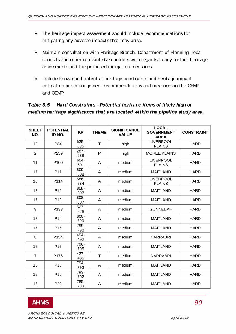
QUEENSLAND HUNTER GAS PIPELINE – PRELIMINARY HISTORICAL HERITAGE ASSESSMENT
AHMS 90
ARCHAEOLOGICAL & HERITAGE MANAGEMENT SOLUTIONS PTY LTD April 2008
• The heritage impact assessment should include recommendations for mitigating any adverse impacts that may arise.
• Maintain consultation with Heritage Branch, Department of Planning, local councils and other relevant stakeholders with regards to any further heritage assessments and the proposed mitigation measures.
• Include known and potential heritage constraints and heritage impact mitigation and management recommendations and measures in the CEMP and OEMP.
Table 8.5 Hard Constraints – Potential heritage items of likely high or medium heritage significance that are located within the pipeline study area.
SHEET
NO. POTENTIAL
ID NO. KP THEME SIGNIFICANCE VALUE
LOCAL GOVERNMENT
AREA CONSTRAINT
12 P84 635-635 T high LIVERPOOL
PLAINS HARD
2 P239 287-288 P high MOREE PLAINS HARD
11 P100 604-601 A medium LIVERPOOL
PLAINS HARD
17 P11 809-808 A medium MAITLAND HARD
10 P114 586-584 A medium LIVERPOOL
PLAINS HARD
17 P12 808-807 A medium MAITLAND HARD
17 P13 808-807 A medium MAITLAND HARD
9 P133 527-526 A medium GUNNEDAH HARD
17 P14 800-799 A medium MAITLAND HARD
17 P15 799-798 A medium MAITLAND HARD
8 P154 494-492 A medium NARRABRI HARD
16 P16 796-795 A medium MAITLAND HARD
7 P176 437-435 T medium NARRABRI HARD
16 P18 794-793 A medium MAITLAND HARD
16 P19 793-792 A medium MAITLAND HARD
16 P20 785-783 A medium MAITLAND HARD

QUEENSLAND HUNTER GAS PIPELINE – PRELIMINARY HISTORICAL HERITAGE ASSESSMENT
AHMS 91
ARCHAEOLOGICAL & HERITAGE MANAGEMENT SOLUTIONS PTY LTD April 2008
5 P205 383-384 E medium MOREE PLAINS HARD
16 P21 784-780 A medium MAITLAND HARD
5 P213 372-373 E medium MOREE PLAINS HARD
16 P22 781-779 A medium MAITLAND HARD
3 P235 296-297 E medium MOREE PLAINS HARD
2 P237 291-292 E medium MOREE PLAINS HARD
2 P238 287-288 E medium MOREE PLAINS HARD
14 P36 714-713 A medium MUSWELLBROOK HARD
17 P4 817-816 A medium NEWCASTLE HARD
13 P41 703-701 A medium MUSWELLBROOK HARD
13 P45 694-691 A medium UPPER HUNTER HARD
13 P46 694-691 A medium UPPER HUNTER HARD
13 P47 692-691 A medium UPPER HUNTER HARD
13 P48 691-690 T medium UPPER HUNTER HARD
17 P5 816-815 A medium NEWCASTLE HARD
13 P50 690-681 A medium UPPER HUNTER HARD
13 P54 681-680 A medium UPPER HUNTER HARD
13 P62 677-675 A medium UPPER HUNTER HARD
12 P64 671-670 A medium UPPER HUNTER HARD
12 P69 659-658 A medium UPPER HUNTER HARD
12 P77 642-640 O medium UPPER HUNTER HARD
12 P85 635-633 M medium LIVERPOOL
PLAINS HARD
11 P87 628-627 A medium LIVERPOOL
PLAINS HARD
11 P88 627-625 A medium LIVERPOOL
PLAINS HARD
11 P89 625-622 A medium LIVERPOOL
PLAINS HARD
11 P92 621-620 A medium LIVERPOOL
PLAINS HARD

QUEENSLAND HUNTER GAS PIPELINE – PRELIMINARY HISTORICAL HERITAGE ASSESSMENT
AHMS 92
ARCHAEOLOGICAL & HERITAGE MANAGEMENT SOLUTIONS PTY LTD April 2008
8.2.2 Recommendations for Potential Items that cannot be identified – Default Hard constraints
• Undertake survey to identify the survival and integrity of the potential item.
• If extant structure or landscape or likely archaeological remains, assess heritage significance.
• If not of likely potential heritage value, undertake general location and photographic recording.
• If assessment indicates item is of potential high heritage value and so a hard constraint, follow procedure outlined in 8.2.1.
• If assessment indicates item is likely of moderate or low constraint , follow procedures outlined in 8.2.3 or 8.2.4 respectively.
Table 8.6 Default Hard Constraints – Potential heritage items of Unknown heritage significance that are located within the pipeline study area.
SHEET NO.
POTENTIAL ID NO. KP THEME SIGNIFICANCE
VALUE LOCAL
GOVERNMENT AREA
CONSTRAINT
17 P1 819-818 unided Default high NEWCASTLE HARD 17 P6 816-815 unided Default high NEWCASTLE HARD
11 P93 621-620 unided Default high LIVERPOOL PLAINS HARD
11 P95 619-618 unided Default high LIVERPOOL PLAINS HARD
11 P112 590-589 unided Default high LIVERPOOL PLAINS HARD
9 P137 520-519 unided Default high GUNNEDAH HARD 8 P145 503-502 unided Default high GUNNEDAH HARD
8.2.3 Recommendations for Potential Items that are Moderate Constraints
• Undertake survey to identify the nature, survival and integrity of the potential item.

QUEENSLAND HUNTER GAS PIPELINE – PRELIMINARY HISTORICAL HERITAGE ASSESSMENT
AHMS 93
ARCHAEOLOGICAL & HERITAGE MANAGEMENT SOLUTIONS PTY LTD April 2008
• If extant structure/landscape or likely archaeological remains, assess heritage significance.
• If not of likely potential heritage value, undertake general location and photographic recording.
• If assessment indicates item is actually of potential high heritage value and so a hard constraint, follow procedure outlined in 8.2.1.
• If assessment confirms moderate constraint, undertake a heritage impact assessment of final pipeline route and construction methods on the identified heritage values of the item/place.
• The heritage impact assessment should include recommendations for mitigating any adverse impacts that may arise.
• Maintain consultation with Heritage Branch, Department of Planning, local councils and other relevant stakeholders with regards to any further heritage assessments and the proposed mitigation measures.
• Include known and potential heritage constraints and heritage impact mitigation and management recommendations and measures in the CEMP and OEMP
• If re-assessment indicates item is a low constraint follow procedures outlined in 8.2.4
.
Table 8.7 Moderate Constraints – Potential heritage items of Likely Low heritage significance that are located within the pipeline study area.
SHEET
NO. POTENTIAL
ID NO. KP THEME SIGNIFICANCE VALUE
LOCAL GOVERNMENT
AREA CONSTRAINT
16 P17 795-794 E low MAITLAND MODERATE
11 P111 591-590 A low LIVERPOOL
PLAINS MODERATE

QUEENSLAND HUNTER GAS PIPELINE – PRELIMINARY HISTORICAL HERITAGE ASSESSMENT
AHMS 94
ARCHAEOLOGICAL & HERITAGE MANAGEMENT SOLUTIONS PTY LTD April 2008
Table 8.8 Moderate Constraints – Potential heritage items of Likely Medium and unknown heritage significance that are located within 100m of the pipeline study area.
SHEET
NO. POTENTIAL
ID NO. KP THEME SIGNIFICANCE VALUE
LOCAL GOVERNMENT AREA CONSTRAINT
17 P2 819-818 A medium NEWCASTLE MODERATE
17 P3 817-816 unided Default high NEWCASTLE MODERATE
17 P9 812-811 E medium MAITLAND/NEWCASTLE MODERATE
15 P27 758-757 A medium SINGLETON MODERATE
13 P43 700-699 A medium MUSWELLBROOK MODERATE
13 P55 681-680 A medium UPPER HUNTER MODERATE
13 P57 679-678 A medium UPPER HUNTER MODERATE
13 P59 678-677 A medium UPPER HUNTER MODERATE
12 P73 654-652 A medium UPPER HUNTER MODERATE
12 P81 639-637 A medium UPPER HUNTER MODERATE
12 P83 637-636 T medium UPPER HUNTER MODERATE
12 P86 632-630 A medium LIVERPOOL PLAINS MODERATE
9 P136 521-519 unided Default high GUNNEDAH MODERATE
8 P149 501-500 unided Default high GUNNEDAH MODERATE
8 P156 488-487 unided Default high NARRABRI MODERATE
8 P162 481-480 unided Default high NARRABRI MODERATE
7 P169 443-442 A medium NARRABRI MODERATE
4 P220 356-357 E medium MOREE PLAINS MODERATE

QUEENSLAND HUNTER GAS PIPELINE – PRELIMINARY HISTORICAL HERITAGE ASSESSMENT
AHMS 95
ARCHAEOLOGICAL & HERITAGE MANAGEMENT SOLUTIONS PTY LTD April 2008
8.2.4 Recommendations for Potential Items that are Low Constraints
No further action is recommended for these elements unless substantial pipeline route deviation is proposed (ie, the 200m pipeline study area moves). In that event, the impact assessment should be re-visited and amended recommendations identified
Table 8.9 Low Constraints – Potential heritage items of Likely High, Moderate, Low and unknown heritage significance that are located between 100m of the pipeline study area and 1km from the study area.
SHEET
NO. POTENTIAL
ID NO. KP THEME Significance Value
LOCAL GOVERNMENT
AREA CONSTRAINT
17 P7 815-814 I medium PORT STEPHENS LOW 17 P8 814-813 unided Default high PORT STEPHENS LOW 17 P10 810-809 E low MAITLAND LOW 16 P23 769-768 A medium SINGLETON LOW 15 P24 759-758 A medium SINGLETON LOW 15 P25 758-757 A medium SINGLETON LOW 15 P28 758-757 A medium SINGLETON LOW 15 P29 757-756 A medium SINGLETON LOW 15 P30 756-755 A medium SINGLETON LOW 15 P31 753-752 A medium SINGLETON LOW 14 P32 741-740 A medium SINGLETON LOW 14 P33 739-738 unided Default high SINGLETON LOW 14 P34 738-737 A medium SINGLETON LOW 14 P35 735-734 A medium SINGLETON LOW 13 P37 712-711 A medium MUSWELLBROOK LOW 13 P39 707-706 E low MUSWELLBROOK LOW 13 P44 697-696 M low UPPER HUNTER LOW 13 P49 691-690 A medium UPPER HUNTER LOW 13 P51 689-688 unided Default high UPPER HUNTER LOW 13 P53 681-680 A medium UPPER HUNTER LOW 13 P56 680-679 A medium UPPER HUNTER LOW 13 P58 679-678 A medium UPPER HUNTER LOW 13 P60 677-676 A medium UPPER HUNTER LOW 13 P61 677-676 A medium UPPER HUNTER LOW 12 P63 672-671 A medium UPPER HUNTER LOW 12 P65 666-665 A medium UPPER HUNTER LOW 12 P66 662-661 A medium UPPER HUNTER LOW 12 P67 660-659 A medium UPPER HUNTER LOW 12 P70 657-656 unided Default high UPPER HUNTER LOW 12 P71 657-656 A medium UPPER HUNTER LOW 12 P74 648-646 O medium UPPER HUNTER LOW 12 P75 645-643 A medium UPPER HUNTER LOW 12 P76 644-643 A medium UPPER HUNTER LOW

QUEENSLAND HUNTER GAS PIPELINE – PRELIMINARY HISTORICAL HERITAGE ASSESSMENT
AHMS 96
ARCHAEOLOGICAL & HERITAGE MANAGEMENT SOLUTIONS PTY LTD April 2008
12 P78 641-640 unided Default high UPPER HUNTER LOW 12 P79 641-640 unided Default high UPPER HUNTER LOW 12 P80 639-638 A low UPPER HUNTER LOW 12 P82 637-636 T low UPPER HUNTER LOW 11 P90 624-622 M low LIVERPOOL PLAINS LOW 11 P91 622-621 A medium LIVERPOOL PLAINS LOW 11 P94 620-619 unided Default high LIVERPOOL PLAINS LOW 11 P96 618-617 A medium LIVERPOOL PLAINS LOW 11 P97 618-617 A medium LIVERPOOL PLAINS LOW 11 P98 605-606 A medium LIVERPOOL PLAINS LOW 11 P99 605-604 unided Default high LIVERPOOL PLAINS LOW 11 P101 602-601 A medium LIVERPOOL PLAINS LOW 11 P102 601-600 unided Default high LIVERPOOL PLAINS LOW 11 P103 599-597 E low LIVERPOOL PLAINS LOW 11 P104 598-597 A medium LIVERPOOL PLAINS LOW 11 P105 596-595 A medium LIVERPOOL PLAINS LOW 11 P106 595-594 A low LIVERPOOL PLAINS LOW 11 P107 595-594 A medium LIVERPOOL PLAINS LOW 11 P108 595-594 A medium LIVERPOOL PLAINS LOW 11 P109 592-591 A medium LIVERPOOL PLAINS LOW 11 P110 592-591 A medium LIVERPOOL PLAINS LOW 10 P113 586-585 A medium LIVERPOOL PLAINS LOW 10 P115 583-582 A medium LIVERPOOL PLAINS LOW 10 P116 582-581 A medium LIVERPOOL PLAINS LOW
10 P117 579-578 unided Default high LIVERPOOL PLAINS/GUNNEDAH LOW
10 P118 578-577 unided Default high GUNNEDAH LOW 10 P119 569-568 unided Default high GUNNEDAH LOW 10 P120 564-563 A medium GUNNEDAH LOW 10 P121 557-556 unided Default high GUNNEDAH LOW 10 P122 556-555 A medium GUNNEDAH LOW 10 P123 556-555 A medium GUNNEDAH LOW 9 P124 549-548 A medium GUNNEDAH LOW 9 P125 545-544 unided Default high GUNNEDAH LOW 9 P127 539-538 A medium GUNNEDAH LOW 9 P129 531-530 A medium GUNNEDAH LOW 9 P130 531-530 A medium GUNNEDAH LOW 9 P131 529-528 unided Default high GUNNEDAH LOW 9 P132 528-527 A medium GUNNEDAH LOW 9 P134 521-520 A medium GUNNEDAH LOW 9 P135 521-520 A medium GUNNEDAH LOW 9 P138 517-516 A medium GUNNEDAH LOW 9 P139 514-513 A medium GUNNEDAH LOW 8 P143 506-505 A medium GUNNEDAH LOW 8 P146 503-502 A medium GUNNEDAH LOW 8 P147 501-500 A medium GUNNEDAH LOW 8 P148 501-500 unided Default high GUNNEDAH LOW 8 P150 498-497 unided Default high NARRABRI LOW 8 P151 497-496 unided Default high NARRABRI LOW 8 P152 496-495 unided Default high NARRABRI LOW 8 P153 494-493 A medium NARRABRI LOW 8 P155 491-490 A medium NARRABRI LOW 8 P159 485-484 unided Default high NARRABRI LOW 8 P160 485-484 unided Default high NARRABRI LOW

QUEENSLAND HUNTER GAS PIPELINE – PRELIMINARY HISTORICAL HERITAGE ASSESSMENT
AHMS 97
ARCHAEOLOGICAL & HERITAGE MANAGEMENT SOLUTIONS PTY LTD April 2008
8 P161 483-482 A medium NARRABRI LOW 8 P163 480-479 unided Default high NARRABRI LOW 8 P164 475-474 A medium NARRABRI LOW 7 P166 473-472 A medium NARRABRI LOW 7 P170 442-441 A medium NARRABRI LOW 7 P171 440-439 A medium NARRABRI LOW 7 P173 349-348 A medium NARRABRI LOW 7 P174 349-348 A medium NARRABRI LOW 6 P180 430-429 A medium NARRABRI LOW 6 P182 430-429 unided Default high NARRABRI LOW 6 P183 427-428 A medium NARRABRI LOW 6 P186 427-426 A medium NARRABRI LOW 6 P187 426-425 A medium NARRABRI LOW 6 P189 424-423 A medium NARRABRI LOW 6 P191 418-419 A medium NARRABRI LOW 6 P195 404-405 A medium NARRABRI LOW 6 P196 404-405 A medium NARRABRI LOW 5 P199 395-396 E medium NARRABRI LOW 5 P200 390-391 P medium NARRABRI LOW 5 P201 388-389 P medium NARRABRI LOW 5 P202 388-389 P medium NARRABRI LOW 5 P203 387-388 E medium NARRABRI LOW 5 P204 385 E medium NARRABRI LOW 5 P207 381-382 P medium MOREE PLAINS LOW 5 P208 380-381 unided Default high MOREE PLAINS LOW 5 P209 377-378 P medium MOREE PLAINS LOW 5 P212 372-373 E medium MOREE PLAINS LOW 5 P214 370-371 P medium MOREE PLAINS LOW 5 P215 369-370 E medium MOREE PLAINS LOW 4 P217 364-365 E medium MOREE PLAINS LOW 4 P218 363-364 E medium MOREE PLAINS LOW 4 P221 352-353 E medium MOREE PLAINS LOW 4 P222 351-352 E medium MOREE PLAINS LOW 4 P225 348-349 E medium MOREE PLAINS LOW 4 P226 341-342 E medium MOREE PLAINS LOW 4 P227 339-340 E medium MOREE PLAINS LOW 4 P228 334-335 P medium MOREE PLAINS LOW 3 P229 331-332 P medium MOREE PLAINS LOW 3 P230 319-320 E medium MOREE PLAINS LOW 3 P231 310-311 E medium MOREE PLAINS LOW 3 P232 308-309 E medium MOREE PLAINS LOW 3 P233 303-304 E medium MOREE PLAINS LOW 3 P234 302-303 unided Default high MOREE PLAINS LOW 2 P236 293-294 E medium MOREE PLAINS LOW 2 P240 276-275 P medium MOREE PLAINS LOW 2 P241 272-273 P medium MOREE PLAINS LOW 2 P242 271-272 E medium MOREE PLAINS LOW 2 P243 270-271 E medium MOREE PLAINS LOW 2 P244 267-268 E medium MOREE PLAINS LOW 2 P245 265-266 P medium MOREE PLAINS LOW 1 P246 258-259 E medium MOREE PLAINS LOW 1 P247 248-249 P medium MOREE PLAINS LOW 1 P248 247-248 unided Default high MOREE PLAINS LOW 1 P250 240-241 E medium MOREE PLAINS LOW

QUEENSLAND HUNTER GAS PIPELINE – PRELIMINARY HISTORICAL HERITAGE ASSESSMENT
AHMS 98
ARCHAEOLOGICAL & HERITAGE MANAGEMENT SOLUTIONS PTY LTD April 2008
1 P251 239-240 O medium MOREE PLAINS LOW 1 P252 228-229 unided Default high MOREE PLAINS LOW
8.3 Rural Fencing situated within the pipeline study area which has potential heritage values (representing Hard and Moderate Constraints)
The advice of Dr. John Pickard, author of a Thematic History of Rural Fencing in NSW, indicates that certain types of rural fencing are likely to hold varying levels of heritage significance in NSW. However due to the nature of this type of item it is virtually impossible to identify where significant types of fencing will be located except through field investigation.
Dr. Pickard has indicated he will be able to provide advice on how to identify ‘unusual’ types of fencing during survey work for the pipeline. It is most likely this advice will need to be provided to contractors working along the route prior to construction to identify whether impacted fencing meets these criteria. Although Dr. Pickard’s criteria are not yet available, in the event that the criteria outlined by Dr. Pickard are met the following recommendations are made:
• Undertake survey to identify the survival and integrity of the potential item.
• If extant assess heritage significance.
• If not of likely potential heritage value, undertake general location and photographic recording.
• If of potential high heritage value and so a hard constraint, follow procedure outlined in 8.2.1.
• If of moderate or low constraint, follow procedures outlined in 8.2.3 or 8.2.4 respectively.

QUEENSLAND HUNTER GAS PIPELINE – PRELIMINARY HISTORICAL HERITAGE ASSESSMENT
AHMS 99
ARCHAEOLOGICAL & HERITAGE MANAGEMENT SOLUTIONS PTY LTD April 2008
9. REFERENCES
Abbott, J H M, ‘Mount Wingen: burning mountain of the Kingdon Ponds Valley, its story during the last century’, Journal of the Royal Australian Historical Society, volume 7, part 3, 1921, pp 131-147
Andrews, Brian Robert, Coal, Railways and Mines: the story of the railways and collieries of J and A Brown, Iron Horse Press, Redfern, 2004
Australian Museum Business Services, ‘Aboriginal Heritage Study: Newcastle local government area’, 2004
Bairstow, Damaris, A Million Pounds, a Million Acres: the pioneer settlement of the Australian Agricultural Company, author, Sydney, 2003
Binney, Keith R, Horsemen of the First Frontier 1788-1900 and the Serpent’s Legacy, Volcanic Publications, Sydney, 2005
Black, Lindsay, The Bora Ground, author, Sydney, 1944
Black, Lindsay, Burial Trees, Robertson and Mullens, Melbourne, 1941
Blyton, Greg, Deidre Heitmeyer and John Maynard, Wannin Thanbarran: a history of Aboriginal and European contact in Muswellbrook and the Upper Hunter Valley, Muswellbrook Shire Aboriginal Reconciliation Committee, Muswellbrook, 2004
Boggabri and District Historical Society, A Brief History of Early Boggabri, the Society, Boggabri, 1974
Boggabri and District Historical Society, George Clarke (alias The Barber), the Society, Boggabri, nd
Boggabri: the story of our town, Golden Grain Festival, Boggabri, 1957 (updated edition 1979)
Boyce, Dean, Clarke of the Kindur: convict, bushranger, explorer, Melbourne University Press, Melbourne, 1970

QUEENSLAND HUNTER GAS PIPELINE – PRELIMINARY HISTORICAL HERITAGE ASSESSMENT
AHMS 100
ARCHAEOLOGICAL & HERITAGE MANAGEMENT SOLUTIONS PTY LTD April 2008
Brian Carberry Coassociates Architects Pty Ltd, ‘Upper Hunter Shire Council Rural Heritage Study’, 2007
Brian McDonald and Associates, ‘Maitland Heritage Survey Review: thematic history’, 1994
Collins, Graeme, and Dorothy Durrant, Quirindi 2000: a pictorial record, authors, Quirindi, 2000
Durrant, Dorothy, Quirindi in the 19th century: how a town began, author, Quirindi, 1994
Durrant, Dorothy, Quirindi 1900-1919: confidence and patriotism, author, Quirindi, 1996
Durrant, Dorothy, Quirindi 1919-1939: between the world wars, author, Quirindi, 1997
Durrant, Dorothy, Quirindi 1939-1950: courage and commitment, author, Quirindi, 1998
Durrant, Dorothy, Quirindi 1950-1966: a time of development, author, Quirindi, 1989
Durrant, Dorothy, Quirindi 1966-1990: years of change, author, Quirindi, 1990
Eardley, G H , and E M Stephens, The Shale Railways of NSW, Australian Railways Historical Society, Sydney, 2000 edition
Ellis, M H, A Saga of Coal: the Newcastle Wallsend Coal Company’s centenary volume, Angus and Robertson, Sydney, 1969
Everingham, Sam, Wild Ride: the rise and fall of Cobb and Co, Penguin Viking, Melbourne, 2007
Environmental Planning and Assessment Act, 1979 (No. 203)
Environment Protection and Biodiversity Conservation Act 1999
Heritage Act, 1977 (No. 136)
QUEENSLAND HUNTER GAS PIPELINE – PRELIMINARY HISTORICAL HERITAGE ASSESSMENT
AHMS 101
ARCHAEOLOGICAL & HERITAGE MANAGEMENT SOLUTIONS PTY LTD April 2008
Fink, Elizabeth, Hunter Regional Estate Project: the built environment of the Shire of Singleton, Hunter Valley Research Foundation, Newcastle, 1977
Gray, Nancy, The Promised Land: a summary of early settlement in the shire of Scone, Scone and Upper Hunter Historical Society, Scone, 1975
Gregson, Jesse, The Australian Agricultural Company 1824-1875, Angus and Robertson, Sydney, 1907
Gunnedah Local Environmental Plan 1998
Hanna, Cliff, Bandits on the Great North Road, Nimrod Publications, Newcastle, 1993
Henzell, Ted, Australian Agriculture: its history and challenges, CSIRO Publishing, Melbourne, 2007
Heritage Concepts Pty Ltd, ‘Aboriginal Heritage Study: Moree Plains Shire Council Local Environmental Plan’, 2007
‘Historical Roads of NSW: the story of the New England Highway’, Main Roads, volume 17, no 3, March 1952, pp 68-76
Heritage Council of NSW, NSW Historical Themes, 2001, NSW Heritage Office
Hunter, Cynthia, ‘Port Stephens Heritage: historical context report including thematic analysis prepared for the Port Stephens Council community based heritage study’, 2001
Hunter, Cynthia (ed), Riverchange: six new histories of the Hunter, Newcastle Region Public Library, Newcastle, 1998
Hunter Valley Research Foundation, ‘Hunter History Highlights’, http://www.hvrf.com.au/pages/hrf/hunter_history_highlights.php, accessed 7 February 2008
Hunter Valley Research Foundation, Hunter Region Yearbook 2005-2006, Newcastle, 2006
Hunter Regional Environmental Plan 1989 (Heritage)

QUEENSLAND HUNTER GAS PIPELINE – PRELIMINARY HISTORICAL HERITAGE ASSESSMENT
AHMS 102
ARCHAEOLOGICAL & HERITAGE MANAGEMENT SOLUTIONS PTY LTD April 2008
Jervis, James, ‘Exploration and Settlement of the North-Western Plains’, Journal of the Royal Australian Historical Society, volume 48, part 5, December 1962, pp 377-394; volume 48, part 6, March 1963, 436-457
Johnson, Richard, The Search for the Inland Sea: John Oxley, explorer, 1783-1828, Melbourne University Press, Melbourne, 2001
Kass, Terry, ‘Roads and Traffic Authority Heritage and Conservation Register Volume 1: thematic history’, 1996
Kirk, Ian (Inheritage Heritage Advisors and Consultants) ‘Community Based Heritage Study for Moree and District’, Moree Plains Shire Council, 2008
Koettig, Margrit, ‘Aboriginal Sites within Singleton Shire Heritage Study’, 1990
Lands Department of NSW (1957-1964), Historic Aerial Photographic Runs (Various)
Main Roads, journal of the Department of Main Roads, 1929-1984
Maitland Local Environmental Plan 1993
Maynard, John, ‘Muloobinbah (Newcastle) an Aboriginal industrial presence: past and present’, Journal of the Royal Australian Historical Society, volume 87, part 2, December 2001, pp 248-266
McKnight, Tom Lee, The Long Paddock: Australia’s travelling stock routes, University of New England, Armidale, 1977
McLean, Ron (ed), The Way We Were: sesquicentenary of Gunnedah 1856-2006, Gunnedah and District Historical Society, Gunnedah, 2006
Merriwa Local Environmental Plan 1992
Milliss, Roger, Waterloo Creek: the Australia Day massacre of 1838, George Gipps, and the British conquest of NSW, UNSW Press, Sydney, 1992
Moree Bore Hot Water Baths, NSW Government Tourist Bureau, Sydney, 1900
Moree Plains Local Environmental Plan 1995
Murrurundi Local Environmental Plan 1993

QUEENSLAND HUNTER GAS PIPELINE – PRELIMINARY HISTORICAL HERITAGE ASSESSMENT
AHMS 103
ARCHAEOLOGICAL & HERITAGE MANAGEMENT SOLUTIONS PTY LTD April 2008
Muswellbrook Local Environmental Plan 1985
Narrabri Jubilee Celebrations Official Souvenir, Narrabri Municipality, 1933
National Trust NSW, Cemeteries: a policy paper, National Trust, Sydney, 1987
National Trust NSW, National Trust Register Local Government, The National Trust of Australia (NSW), 2006
Narrabri Local Environmental Plan 1992
Narrabri Local Environmental Plan No. 2
Newcastle Local Environmental Plan 2003
Noble, Lillian May, St Clement’s Church of England, Camberwell NSW, author, Sydney, 1978
NSW Heritage Office, 1996, NSW Heritage Manual, Heritage Office and the Department of Urban Affairs and Planning
NSW Heritage Office, 2001, Assessing Heritage Significance (an update to the NSW Heritage Manual), NSW Heritage Office
O’Connor, Maura, ‘Mapping Australia’s Transhumance: snow lease and stock route maps of NSW’, The Globe, no 56, 2004, pp 13-24
Oppenheimer, Jillian, ‘Thunderbolt’s Mary Ann – an Aboriginal bushranger’, Journal of the Royal Australian Historical Society, volume 78, parts 3-4, December 1992, pp 92-107
O’Sullivan, John, Mounted Police in NSW, Rigby, Adelaide, 1979
Paddison, Leonie I, The Railways of NSW 1855-1955, Department of Railways, Sydney, 1955
Parkes, W S, Jim Comerford and Max Lake, Mines, Wines and People: a history of Greater Cessnock, Council of the City of Greater Cessnock, Newcastle, 1979
Parry Local Environmental Plan 1987

QUEENSLAND HUNTER GAS PIPELINE – PRELIMINARY HISTORICAL HERITAGE ASSESSMENT
AHMS 104
ARCHAEOLOGICAL & HERITAGE MANAGEMENT SOLUTIONS PTY LTD April 2008
Perumal, Wrathall and Murphy Pty Ltd, ‘Hunter Region Heritage Study: historic towns and settlements’, 1982
Pickard, (Dr.) John, ‘Draft Thematic History of Fencing in NSW’, Department of Planning, Heritage Branch, in prep
Port Stephens Local Environmental Plan 2000
Quirindi Local Environmental Plan 1991
Ravensworth Public School: centenary of public education 1876 to 1976, the school, Ravensworth, 1976
Read, Peter, Charles Perkins: a biography, Viking, Melbourne, 1990
Readford, M R (ed), Historical Narrabri, Narrabri and District Historical Society, Narrabri, 1967
Rogers, Derek, ‘The Hunter Valley’, Australian Railway Historical Society Bulletin, March 1995, pp 16-27
Rolls, Eric, A Million Wild Acres, Penguin, Melbourne, 1984
Roope, Colin, and Patricia Gregson, An Organised Banditti: the story behind the ‘Jewboy’ bushranger gang, authors, Lake Macquarie, 2002
Roworth, Heather, A Kamilaroi Dreaming: a history of the Aboriginal people of the Quirindi area before 1850, author, Quirindi, 2000
Rural Lands Protection Boards, Annual Report 2006
Scone Local Environmental Plan 1986
Singleton Local Environmental Plan 1996
Singleton, Municipality and Shire: 125 years on 1866-1991, the council, Singleton, 1991
Stapleton, Ian, ‘Moree Plains Local Environmental Plan: heritage assessment’, 1984
Suters Architects, ‘Newcastle City Wide Heritage Study’, 4 vols, 1997

QUEENSLAND HUNTER GAS PIPELINE – PRELIMINARY HISTORICAL HERITAGE ASSESSMENT
AHMS 105
ARCHAEOLOGICAL & HERITAGE MANAGEMENT SOLUTIONS PTY LTD April 2008
Suters Busteed Corner Clode Pty Ltd, ‘Hunter Regional Environmental Plan: heritage register report and thematic study’, 1988
Suters Busteed Corner Clode Pty Ltd, ‘Murrurundi Heritage Study Final Report’, 1988
Turner, John W, ‘Muswellbrook Shire Heritage Study: historical themes of the Shire of Muswellbrook’, 1995
Walker, Laurie, ‘Irrigation in NSW 1884-1940’, Journal of the Royal Australian Historical Society, volume 27, part 3, 1941, pp 181-232
Webb, R J, The Rising Sun: a history of Moree and district, Moree Municipal Council, Moree, 1962 (reprinted 1972)
Wright, H J, ‘The Northern Coal Story’, Australian Railway Historical Society Bulletin, no 387, January 1970, pp 1-17, and no 388, February 1970, pp 25-38
QUEENSLAND HUNTER GAS PIPELINE – PRELIMINARY HISTORICAL HERITAGE ASSESSMENT
AHMS 106
ARCHAEOLOGICAL & HERITAGE MANAGEMENT SOLUTIONS PTY LTD April 2008
APPENDIX A: HISTORICAL THEMES AND CODES

QUEENSLAND HUNTER GAS PIPELINE – PRELIMINARY HISTORICAL HERITAGE ASSESSMENT
AHMS 107
ARCHAEOLOGICAL & HERITAGE MANAGEMENT SOLUTIONS PTY LTD April 2008
AUSTRALIAN THEME NSW THEMES (AND REPORT CODES) CODE Theme 1: Tracing the natural evolution of Australia,
Environment – naturally evolved (E) Aboriginal cultures and interactions with other cultures (A)
E A
Theme 2 Peopling Australia Convict Ethnic influences Migration
Theme 3 Developing local, regional and national economies
Agriculture (G) Commerce (B) Communication (C) Environment – cultural landscape Events (X) Exploration (K) Fishing Forestry (F) Health Industry (I) Mining (M) Pastoralism (P) Science Technology (H) Transport (T, S)
G B C X K F I
M P H T S
Theme 4 Building settlements, towns and cities
Towns, suburbs and villages (O) Land tenure Utilities Accommodation
O
Theme 5 Working Labour Theme 6 Educating Education (j) J Theme 7 Governing
Defence Government and administration (U) Law and order (L) Welfare
U L
Theme 8 Developing Australia’s cultural life
Domestic life (W) Creative endeavour (Y) Leisure Religion (R) Social institutions (V) Sport (Sp)
W Y R V Sp
Theme 9 Marking the phases of life
Birth and Death (D) Persons (Q)
D Q

QUEENSLAND HUNTER GAS PIPELINE – PRELIMINARY HISTORICAL HERITAGE ASSESSMENT
AHMS 108
ARCHAEOLOGICAL & HERITAGE MANAGEMENT SOLUTIONS PTY LTD April 2008
APPENDIX B: IMAGES FROM THE THEMATIC HISTORY

QUEENSLAND HUNTER GAS PIPELINE – PRELIMINARY HISTORICAL HERITAGE ASSESSMENT
AHMS 109
ARCHAEOLOGICAL & HERITAGE MANAGEMENT SOLUTIONS PTY LTD April 2008
3.1. Newcastle Railway Station. (Leonie I Paddison, The Railways of NSW 1855- 1955, Department of Railways, Sydney, 1955, p 63)
3.2. Opening of Hexham Bridge, 17 December 1952. (NSW State Library, Home and Away - 26836)

QUEENSLAND HUNTER GAS PIPELINE – PRELIMINARY HISTORICAL HERITAGE ASSESSMENT
AHMS 110
ARCHAEOLOGICAL & HERITAGE MANAGEMENT SOLUTIONS PTY LTD April 2008
3.3. Robert Russell, Entrance to West Maitland, 1837. (National Library of Australia R7209)
3.4. High Street, West Maitland, c 1900-1910. (NSW State Library, PXE 711/602)

QUEENSLAND HUNTER GAS PIPELINE – PRELIMINARY HISTORICAL HERITAGE ASSESSMENT
AHMS 111
ARCHAEOLOGICAL & HERITAGE MANAGEMENT SOLUTIONS PTY LTD April 2008
3.5. Flood at Maitland Railway Station, 21 June 1950. (NSW State Library, Home and Away - 26836)
3.6. Aborigines at first Australian Indigenous Ministries station, St Clair near Singleton, c 1903. (NSW State Library, PXA 773/box 6/item 21)

QUEENSLAND HUNTER GAS PIPELINE – PRELIMINARY HISTORICAL HERITAGE ASSESSMENT
AHMS 112
ARCHAEOLOGICAL & HERITAGE MANAGEMENT SOLUTIONS PTY LTD April 2008
3.7. Muswellbrook from Hospital Hill, c 1880. (NSW State Library, At Work and Play - 05494)
3.8. Rail loading facility at St Helier’s Colliery, Muswellbrook, January 1928. (NSW State Library, At Work and Play - 05476)

QUEENSLAND HUNTER GAS PIPELINE – PRELIMINARY HISTORICAL HERITAGE ASSESSMENT
AHMS 113
ARCHAEOLOGICAL & HERITAGE MANAGEMENT SOLUTIONS PTY LTD April 2008
3.9. Mr T Cook’s annual blood horse sale at ‘Turanville’, near Scone. (NSW State Library, At Work and Play - 03917)
3.10. Scone Railway Station, c 1910. (NSW State Library, At Work and Play - 03811)

QUEENSLAND HUNTER GAS PIPELINE – PRELIMINARY HISTORICAL HERITAGE ASSESSMENT
AHMS 114
ARCHAEOLOGICAL & HERITAGE MANAGEMENT SOLUTIONS PTY LTD April 2008
3.11. Murrurundi shale works, c 1925. (NSW State Library, At Work and Play - 03787)
3.12. Royal Hotel, Murrurundi, c 1890. (NSW State Library, At Work and Play – 04146)

QUEENSLAND HUNTER GAS PIPELINE – PRELIMINARY HISTORICAL HERITAGE ASSESSMENT
AHMS 115
ARCHAEOLOGICAL & HERITAGE MANAGEMENT SOLUTIONS PTY LTD April 2008
3.13. Castle Mountain, Quirindi, c 1900-1910. (NSW State Library, PXE 711/601)
3.14. Bullock teams in George Street, Quirindi, loaded with goods from Tebbutt’s stores for Barnet River and Barry district, 5 March 1910. (NSW State Library, At Work and Play - 04165)

QUEENSLAND HUNTER GAS PIPELINE – PRELIMINARY HISTORICAL HERITAGE ASSESSMENT
AHMS 116
ARCHAEOLOGICAL & HERITAGE MANAGEMENT SOLUTIONS PTY LTD April 2008
3.15. Flood at Quirindi, 15 January 1910. (NSW State Library, At Work and Play – 04011)
3.16. Bird's eye view of Quirindi from ‘Who'd a thought it’ hill, looking east towards Gaspard, c 1930. (NSW State Library, At Work and Play – 04124)

QUEENSLAND HUNTER GAS PIPELINE – PRELIMINARY HISTORICAL HERITAGE ASSESSMENT
AHMS 117
ARCHAEOLOGICAL & HERITAGE MANAGEMENT SOLUTIONS PTY LTD April 2008
3.17. Countryside and Trunk road 72, in the Shire of Namoi, two miles north of Boggabri. Main Roads, vol 23, no 2 (December 1957), p 44.
3.18. New bitumen surfacing on Trunk Road 72, in the Shire of Liverpool Plains, eight miles north of Gunnedah. Main Roads, vol 23, no 2 (December 1957), p 44.

QUEENSLAND HUNTER GAS PIPELINE – PRELIMINARY HISTORICAL HERITAGE ASSESSMENT
AHMS 118
ARCHAEOLOGICAL & HERITAGE MANAGEMENT SOLUTIONS PTY LTD April 2008
3.19. Gunnedah-Narrabri road between Turrawon and Tarriaro, 1933.
The low-lying black soil section before improvement.
The same road after forming, dressing with 2 ½ inches of sand and gravelling.
Main Roads, vol 4, no 12 (August 1933), p 167.

QUEENSLAND HUNTER GAS PIPELINE – PRELIMINARY HISTORICAL HERITAGE ASSESSMENT
AHMS 119
ARCHAEOLOGICAL & HERITAGE MANAGEMENT SOLUTIONS PTY LTD April 2008
3.20. Flood at Narrabri Post Office, 17 January 1910. (NSW State Library, At Work and Play - 00352)
3.21. Flooding in Maitland St, Narrabri, 3 July 1920. (NSW State Library, At Work and Play - 04775)
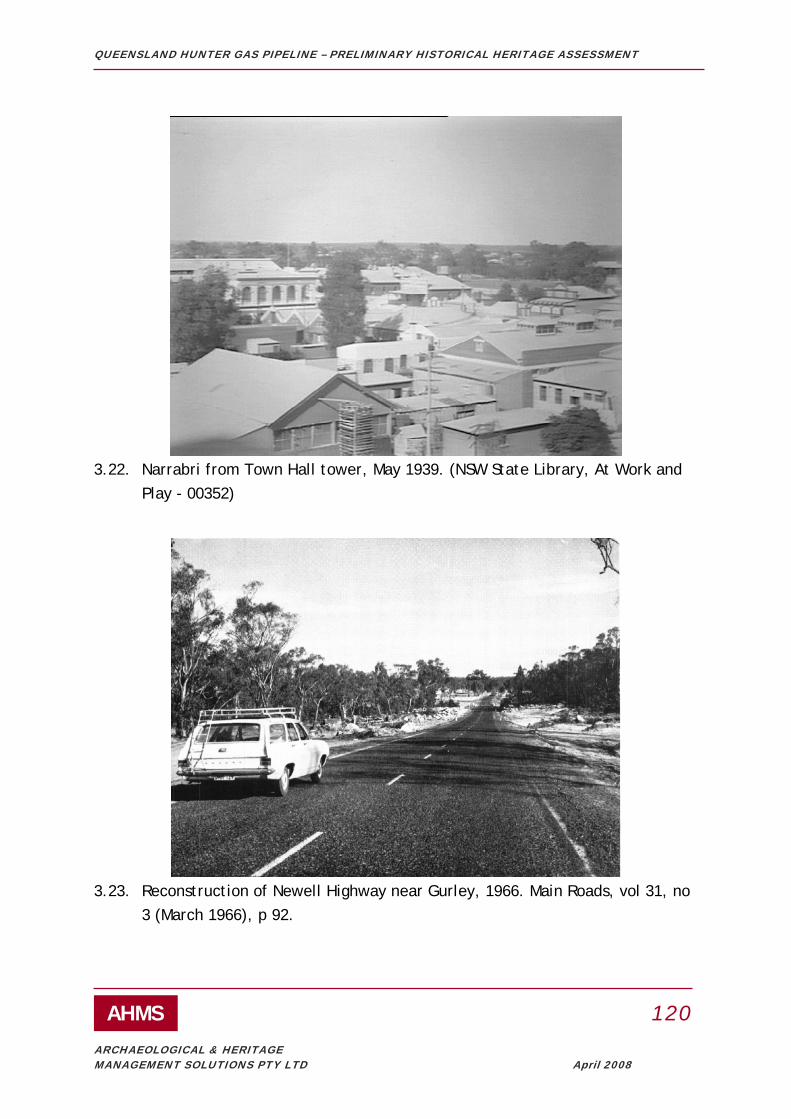
QUEENSLAND HUNTER GAS PIPELINE – PRELIMINARY HISTORICAL HERITAGE ASSESSMENT
AHMS 120
ARCHAEOLOGICAL & HERITAGE MANAGEMENT SOLUTIONS PTY LTD April 2008
3.22. Narrabri from Town Hall tower, May 1939. (NSW State Library, At Work and Play - 00352)
3.23. Reconstruction of Newell Highway near Gurley, 1966. Main Roads, vol 31, no 3 (March 1966), p 92.

QUEENSLAND HUNTER GAS PIPELINE – PRELIMINARY HISTORICAL HERITAGE ASSESSMENT
AHMS 121
ARCHAEOLOGICAL & HERITAGE MANAGEMENT SOLUTIONS PTY LTD April 2008
3.24. Moree Bore, depth 2792 ft, flow 1,108,080 gallons, temperature 115 degrees F, no date. (NSW Government Printer, State Library, GPO 1 – 12623)
3.25. Moree in November 1937. (NSW Government Printer, State Library, GPO 1 – 28609)

QUEENSLAND HUNTER GAS PIPELINE – PRELIMINARY HISTORICAL HERITAGE ASSESSMENT
AHMS 122
ARCHAEOLOGICAL & HERITAGE MANAGEMENT SOLUTIONS PTY LTD April 2008
APPENDIX C: KNOWN SITES LOCATED WITHIN THE PIPELINE STUDY AREA AND UP TO A DISTANCE OF APPROXIMATELY 1KM OF THE PIPELINE STUDY AREA: SIGNIFICANCE, IMPACTS AND CONSTRAINTS

QU
EEN
SLA
ND
HU
NTE
R G
AS
PIPE
LIN
E –
PREL
IMIN
AR
Y H
ISTO
RIC
AL
HER
ITA
GE
ASS
ESSM
ENT
AH
MS
1
23
AR
CH
AEO
LOG
ICA
L &
HER
ITA
GE
MA
NA
GEM
ENT
SOLU
TIO
NS
PTY
LTD
Apr
il 20
08
LEG
END
SI
GN
IFIC
AN
CE
CO
LOU
R C
OD
E IM
PAC
T (K
M F
RO
M
PIPE
LIN
E ST
UD
Y A
REA
)
CO
LOU
R C
OD
E C
ON
STR
AIN
T C
OLO
UR
CO
DE
HIG
H
RE
D
0.00
N
/A
HA
RD
D
AR
K G
RE
EN
M
ED
IUM
O
RA
NG
E
0.01
-0.1
0 N
/A
MO
DER
ATE
M
IDD
LE G
RE
EN
LO
W
YE
LLO
W
0.11
-1.0
0 N
/A
LOW
LI
GH
T G
RE
EN
MO
REE
PLA
INS
LI
STIN
G
Shee
t N
o.
ID #
Item
N
ame
Th
emes
Sign
ifica
nce
IMPA
CT
Prox
imity
to
200m
pi
pelin
e st
udy
area
bo
unda
ry
(km
)
C
onst
rain
t
SHR
N
TA
LEP/
REP
A
RTC
S1
70
RN
E &
C
HL
LHS
UH
RH
S 20
07/
MPH
S 20
08
1 3
Boon
anga
B
ridge
ov
er
Bar
won
R
iver
T
ME
DIU
M
0.
00
H
ARD
RTA
1 26
9 Eu
raba
M
issi
on
A, U
H
IGH
0.
00
HAR
D
R
NE
1721
5
4 26
8 Tr
amby
G
rave
s D
H
IGH
0.
00
HAR
D
Y
es
R
NE
1006
84
3 30
7 R
oad
Cro
ssin
g
T LO
W
0.00
M
OD
Yes
A
RTC
3 31
3 R
oad
cros
sing
T
LOW
0.
00
MO
D
Y
es
AR
TC
3 31
6 R
oad
cros
sing
T
LOW
0.
00
MO
D
Y
es
AR
TC
3 30
6 cu
lver
t T
LOW
0.
06
LOW
Yes
A
RTC
2 31
7 un
derb
ridg
e
T LO
W
0.24
LO
W
Y
es
AR
TC
3 30
8 cu
lver
t T
LOW
0.
50
LOW
Yes
A
RTC

QU
EEN
SLA
ND
HU
NTE
R G
AS
PIPE
LIN
E –
PREL
IMIN
AR
Y H
ISTO
RIC
AL
HER
ITA
GE
ASS
ESSM
ENT
AH
MS
1
24
AR
CH
AEO
LOG
ICA
L &
HER
ITA
GE
MA
NA
GEM
ENT
SOLU
TIO
NS
PTY
LTD
Apr
il 20
08
3 31
5 un
derb
ridg
e
T LO
W
0.55
LO
W
Y
es
AR
TC
3 30
9 C
reek
C
ross
ing
T LO
W
0.58
LO
W
Y
es
AR
TC
3 31
4 un
derb
ridg
e T
LOW
0.
59
LOW
Yes
A
RTC
3 31
0 R
oad
cros
sing
T
LOW
0.
63
LOW
Yes
A
RTC
3 31
1 R
oad
cros
sing
w
ith N
orth
S
treet
T LO
W
0.84
LOW
Y
es
AR
TC
3 31
2 R
oad
cros
sing
T
LOW
0.
93
LOW
Yes
A
RTC
NA
RR
AB
RI
LIST
ING
Shee
t N
o.
ID
#
Item
Nam
e
Th
emes
Sign
ifica
nce
IMPA
CT
Prox
imity
to
200m
pi
pelin
e st
udy
area
bo
unda
ry
(km
)
C
onst
rain
t
SHR
H
TA
LEP/
REP
A
RTC
S1
70
RN
E &
C
HL
LHS
UH
RH
S 20
07/
MPH
S 20
08
8 12
B
arbe
r's
Pinn
acle
L,
O, A
, Q
, K
ME
DIU
M
0.27
LO
W
Yes
GU
NN
EDA
H
LIST
ING
Shee
t N
o.
ID
#
Item
Nam
e
Th
emes
Sign
ifica
nce
IMPA
CT
Prox
imity
to
200m
pi
pelin
e st
udy
area
bo
unda
ry
(km
)
C
onst
rain
t SH
R
N
TA
LEP/
R
EP
AR
TC
S170
R
NE
&
CH
L
LHS
UH
RH
S 20
07/
MPH
S 20
08
10
295
culv
ert
T LO
W
0.00
M
OD
Yes
10
29
6 cu
lver
t T
LOW
0.
00
MO
D
Y
es

QU
EEN
SLA
ND
HU
NTE
R G
AS
PIPE
LIN
E –
PREL
IMIN
AR
Y H
ISTO
RIC
AL
HER
ITA
GE
ASS
ESSM
ENT
AH
MS
1
25
AR
CH
AEO
LOG
ICA
L &
HER
ITA
GE
MA
NA
GEM
ENT
SOLU
TIO
NS
PTY
LTD
Apr
il 20
08
10
297
culv
ert
T LO
W
0.00
M
OD
Yes
10
29
8 cu
lver
t T
LOW
0.
00
MO
D
Y
es
10
27
Plai
ns G
rass
E
, G
ME
DIU
M
0.55
LO
W
Dep
t P
rimar
y In
dust
ries
10
299
culv
ert
T LO
W
0.67
LO
W
Y
es
10
26
Bre
eza
Bur
ials
D
H
IGH
0.
72
LOW
Y
es
LIV
ERPO
OL
PLA
INS
LIST
ING
Shee
t N
o.
ID #
Item
Nam
e
Th
emes
Sign
ifica
nce
IMPA
CT
Prox
imity
to
200m
pi
pelin
e st
udy
area
bo
unda
ry
(km
)
C
onst
rain
t
SHR
N
TA
LEP/
REP
A
RTC
S1
70
RN
E &
C
HL
LHS
UH
RH
S 20
07/
MPH
S 20
08
12
57A
-B
A
rdgl
en
Tunn
el
T, W
, U
HIG
H
0.00
H
ARD
Y
es
LE
P 19
93
A
RTC
12
305
Ard
glen
R
ailw
ay
Stat
ion
T, U
, O
ME
DIU
M
0.00
H
ARD
Yes
A
RTC
12
294
Und
erbr
idge
so
uth
of
Mur
ruru
ndi
Stat
ion
T M
ED
IUM
0.80
LOW
Y
es
UPP
ER H
UN
TER
SH
IRE
CO
UN
CIL
LI
STIN
G
Sh
eet
No.
ID
#
Item
Nam
e
Th
emes
Sign
ifica
nce
IMPA
CT
Prox
imity
to
200m
pi
pelin
e st
udy
area
bo
unda
ry
(km
)
C
onst
rain
t
SHR
N
TA
LEP/
REP
A
RTC
S1
70
RN
E &
CH
L LH
S U
HR
HS
2007
/ M
PHS
2008

QU
EEN
SLA
ND
HU
NTE
R G
AS
PIPE
LIN
E –
PREL
IMIN
AR
Y H
ISTO
RIC
AL
HER
ITA
GE
ASS
ESSM
ENT
AH
MS
1
26
AR
CH
AEO
LOG
ICA
L &
HER
ITA
GE
MA
NA
GEM
ENT
SOLU
TIO
NS
PTY
LTD
Apr
il 20
08
13
284
Res
iden
ce,
Mid
dle
Broo
k W
M
ED
IUM
0.
00
HAR
D
U
HR
HS
2007
12
291
Pet
er c
lark
M
emor
ial
(gra
ve)
L, D
, Q
HIG
H
0.00
HAR
D
UH
RH
S 20
07
12
57A
- B
A
rdgl
en
Tunn
el
T, W
, U
HIG
H
0.00
H
ARD
Y
es
M
urru
rund
i LE
P 19
93
A
RTC
12
27
5 M
urru
rund
i U
rban
C
onse
rvat
ion
Area
O
M
ED
IUM
0.00
HAR
D
RN
E 13
74
12
293
Res
iden
ce,
Mur
ruru
ndi
W
ME
DIU
M
0.05
H
ARD
UH
RH
S 20
07
13
277
Pum
phou
se,
Abe
rdee
n I,
B
HIG
H
0.10
M
OD
Yes
RN
E 10
0957
12
98
Gle
nalv
on
Gro
up
Q, W
, Y,
P
HIG
H
0.16
LO
W
Y
es
M
urru
rund
i LE
P 19
93
RN
E 13
65
12
288
Lass
en P
ark
(hom
este
ad)
W, P
M
ED
IUM
0.
18
LOW
UH
RH
S 20
07
12
90
Rom
an
Cat
holic
P
resb
yter
y
R, O
M
ED
IUM
0.30
LO
W
Mur
ruru
ndi
LEP
1993
12
290
King
don
Par
k (h
omes
tead
)
P, W
M
ED
IUM
0.
30
LOW
U
HR
HS
2007
13
258
Fitz
gera
ld
Brid
ge
T, O
M
ED
IUM
0.33
LO
W
Y
es
Hun
ter R
EP
Sc
one
LEP
1986
RTA
R
NE
1594
0
13
279
Res
iden
ce,
Scon
e W
, O
ME
DIU
M
0.36
LO
W
U
HR
HS
2007
13
16
7 Ti
mbe
r ho
use,
A
berd
een
W
, O
M
ED
IUM
0.42
LOW
Scon
e LE
P 19
86
13
325
Abe
rdee
n B
eef C
o P
/L
(AM
H
Aba
ttoir)
I,
O, B
, P
M
ED
IUM
0.
48
LO
W
Hun
ter R
EP
UH
RH
S 20
07
13
278
Toga
l R
ailw
ay
Sign
al B
ox
T, U
M
ED
IUM
0.
50
LOW
U
HR
HS
2007

QU
EEN
SLA
ND
HU
NTE
R G
AS
PIPE
LIN
E –
PREL
IMIN
AR
Y H
ISTO
RIC
AL
HER
ITA
GE
ASS
ESSM
ENT
AH
MS
1
27
AR
CH
AEO
LOG
ICA
L &
HER
ITA
GE
MA
NA
GEM
ENT
SOLU
TIO
NS
PTY
LTD
Apr
il 20
08
13
282
Yar
ram
oor
(hom
este
ad)
P, W
M
ED
IUM
0.
50
LOW
UH
RH
S 20
07
13
285
Res
iden
ce
and
shed
, M
iddl
e Br
ook
W
ME
DIU
M
0.50
LOW
U
HR
HS
2007
13
153
Tura
nville
, Sc
one
L, P
, Q,
O
ME
DIU
M
0.
55
LOW
Yes
Sc
one
LEP
1986
12
292
Rai
lway
Si
gnal
Box
T,
U
ME
DIU
M
0.57
LO
W
U
HR
HS
2007
13
129
Inve
rmie
n P
, O, Q
, L
HIG
H
0.
60
LOW
Yes
S
cone
LE
P19
86 /
Hun
ter R
EP
R
NE
1410
12
289
Res
iden
ce
W
ME
DIU
M
0.70
LO
W
U
HR
HS
2007
12
287
Res
iden
ce
W
ME
DIU
M
0.80
LOW
UH
RH
S 20
07
12
10
0 S
t Luk
es
Chu
rch
R, O
M
ED
IUM
0.
90
LOW
Yes
M
urru
rund
i LE
P 19
93
13
28
1
Joce
lyn
Par
k (P
uen
Nue
n)
(Hom
este
ad)
Q, P
M
ED
IUM
0.
90
LOW
U
HR
HS
2007
12
58
R
oseb
ank,
M
urru
rund
i W
, O
ME
DIU
M
1.00
LO
W
Mur
ruru
ndi
LEP
1993
12
59
Tem
ple
Cou
rt S
tatio
n an
d R
ailw
ay
Cot
tage
T, U
, O
ME
DIU
M
1.00
LO
W
Mur
ruru
ndi
LEP
1993
12
62
Form
er
Tatte
rsal
ls
Hot
el
B, O
M
ED
IUM
1.
00
LOW
M
urru
rund
i LE
P 19
93
12
63
Rai
lway
H
otel
B
, O
ME
DIU
M
1.00
LO
W
Mur
ruru
ndi
LEP
1993
12
64
Ethe
lsto
n,
Mur
ruru
ndi
W, O
M
ED
IUM
1.
00
LOW
M
urru
rund
i LE
P 19
93
12
65
Ros
edal
e C
otta
ge,
Mur
ruru
ndi
W, O
M
ED
IUM
1.
00
LOW
Yes
M
urru
rund
i LE
P 19
93

QU
EEN
SLA
ND
HU
NTE
R G
AS
PIPE
LIN
E –
PREL
IMIN
AR
Y H
ISTO
RIC
AL
HER
ITA
GE
ASS
ESSM
ENT
AH
MS
1
28
AR
CH
AEO
LOG
ICA
L &
HER
ITA
GE
MA
NA
GEM
ENT
SOLU
TIO
NS
PTY
LTD
Apr
il 20
08
12
66
Cou
ncil
Cha
mbe
rs
U, O
M
ED
IUM
1.
00
LOW
M
urru
rund
i LE
P 19
93
12
67
Pos
t Offi
ce,
Mur
ruru
ndi
C, U
, O
ME
DIU
M
1.00
LO
W
ye
s M
urru
rund
i LE
P 19
93
12
71
Pink
C
otta
ge,
Mur
ruru
ndi
W, O
M
ED
IUM
1.
00
LOW
M
urru
rund
i LE
P 19
93
12
72
Form
er
Tele
grap
h O
ffice
C, U
, O
ME
DIU
M
1.00
LO
W
Mur
ruru
ndi
LEP
1993
12
73
Form
er
"Hay
dont
on
Inn"
B, O
M
ED
IUM
1.
00
LOW
M
urru
rund
i LE
P 19
93
12
74
Whi
te H
art
Hot
el
B, O
M
ED
IUM
1.
00
LOW
Yes
M
urru
rund
i LE
P 19
93
12
75
J. D
oole
y G
ener
al
Sto
re
B, O
M
ED
IUM
1.
00
LOW
Yes
M
urru
rund
i LE
P 19
93
12
76
Brid
ge
Hou
se,
Mur
ruru
ndi
W, O
M
ED
IUM
1.
00
LOW
Yes
M
urru
rund
i LE
P 19
93
12
77
Form
er
Man
ches
ter
Uni
ty H
all,
Mur
ruru
ndi
O
, V
M
ED
IUM
1.00
LO
W
Mur
ruru
ndi
LEP
1993
12
78
Met
hodi
st
Chu
rch,
M
urru
rund
i
R
, O
ME
DIU
M
1.00
LO
W
Mur
ruru
ndi
LEP
1993
12
79
Form
er C
BC
Ban
k,
Mur
ruru
ndi
B
, O
ME
DIU
M
1.00
LO
W
Y
es
Mur
ruru
ndi
LEP
1993
12
80
Roy
al H
otel
, M
urru
rund
i O
, B
ME
DIU
M
1.00
LO
W
Y
es
Mur
ruru
ndi
LEP
1993
12
81
Roy
al H
otel
S
tabl
es,
Mur
ruru
ndi
O, B
M
ED
IUM
1.
00
LOW
M
urru
rund
i LE
P 19
93

QU
EEN
SLA
ND
HU
NTE
R G
AS
PIPE
LIN
E –
PREL
IMIN
AR
Y H
ISTO
RIC
AL
HER
ITA
GE
ASS
ESSM
ENT
AH
MS
1
29
AR
CH
AEO
LOG
ICA
L &
HER
ITA
GE
MA
NA
GEM
ENT
SOLU
TIO
NS
PTY
LTD
Apr
il 20
08
12
82
Ros
e C
otta
ge,
Mur
ruru
ndi
W
, O
ME
DIU
M
1.00
LO
W
Mur
ruru
ndi
LEP
1993
12
83
Boba
dil
Hou
se,
Mur
ruru
ndi
W
, O
ME
DIU
M
1.00
LO
W
Y
es
Mur
ruru
ndi
LEP
1993
12
84
St P
auls
C
hurc
h of
E
ngla
nd,
Mur
ruru
ndi
R
, O
ME
DIU
M
1.00
LO
W
Y
es
Mur
ruru
ndi
LEP
1993
R
NE
1371
12
85
St P
auls
R
ecto
ry,
Mur
ruru
ndi
R
, O
ME
DIU
M
1.00
LO
W
Y
es
Mur
ruru
ndi
LEP
1993
R
NE
1370
12
86
Polic
e S
erge
ant's
R
esid
ence
, M
urru
rund
i
L,
O, U
M
ED
IUM
1.
00
LOW
Yes
M
urru
rund
i LE
P 19
93
12
87
Gao
l and
Po
lice
Res
iden
ce,
Mur
ruru
ndi
L,
O, U
H
IGH
1.
00
LOW
Yes
M
urru
rund
i LE
P 19
93
RN
E 13
72
12
88
Cou
rthou
se
and
Polic
e S
tatio
n,
Mur
ruru
ndi
L,
U, O
H
IGH
1.
00
LOW
Yes
M
urru
rund
i LE
P 19
93
RN
E 13
73
12
89
Foot
brid
ge
T M
ED
IUM
1.
00
LOW
M
urru
rund
i LE
P 19
93
12
93
Rai
lway
G
uard
's
Cot
tage
, M
urru
rund
i
T,
U
M
ED
IUM
1.00
LOW
M
urru
rund
i LE
P 19
93
12
95
Rai
lway
G
atek
eepe
r's
Cot
tage
T, U
M
ED
IUM
1.
00
LOW
M
urru
rund
i LE
P 19
93
12
96
Gre
enha
yes,
M
urru
rund
i W
, O
ME
DIU
M
1.00
LO
W
Mur
ruru
ndi
LEP
1993
12
97
Mur
ruru
ndi
Rai
lway
S
tatio
n
T,
U, O
ME
DIU
M
1.
00
LO
W
Mur
ruru
ndi
LEP
1993
R
ailc
orp

QU
EEN
SLA
ND
HU
NTE
R G
AS
PIPE
LIN
E –
PREL
IMIN
AR
Y H
ISTO
RIC
AL
HER
ITA
GE
ASS
ESSM
ENT
AH
MS
1
30
AR
CH
AEO
LOG
ICA
L &
HER
ITA
GE
MA
NA
GEM
ENT
SOLU
TIO
NS
PTY
LTD
Apr
il 20
08
13
135
Petri
fied
Stu
mp,
Sc
one
E, O
, X
ME
DIU
M
1.00
LO
W
Scon
e LE
P 19
86/
Hun
ter R
EP
Yes
12
259
Blan
dfor
d B
ridge
T,
O
ME
DIU
M
1.00
LO
W
RTA
12
68
A -
B
Pre
sbyt
eria
n C
hurc
h,
Mur
ruru
ndi
R
,O
M
ED
IUM
1.00
LOW
M
urru
rund
i LE
P 19
93
12
69
A -
B
Form
er
Lite
rary
In
stitu
te,
Mur
ruru
ndi
J,
O
M
ED
IUM
1.00
LOW
M
urru
rund
i LE
P 19
93
12
70A-
B
Publ
ic
Sch
ool,
Mur
ruru
ndi
J, U
, O
ME
DIU
M
1.00
LO
W
Mur
ruru
ndi
LEP
1993
12
91
A -
B
Form
er
Sis
ters
of
Mer
cy
Con
vent
, M
urru
rund
i
R
, O
M
ED
IUM
1.00
LOW
M
urru
rund
i LE
P 19
93
12
92
A -
E
St J
osep
hs
Chu
rch,
M
urru
rund
i
R
, O
M
ED
IUM
1.00
LOW
M
urru
rund
i LE
P 19
93
12
94
A-E
S
tatio
n M
aste
r's
Cot
tage
, M
urru
rund
i
T,
U
M
ED
IUM
1.00
LOW
M
urru
rund
i LE
P 19
93
12
276
Mur
ruru
ndi
Civ
ic G
roup
O
M
ED
IUM
1.
00
LOW
Yes
RN
E 13
69
MU
SWEL
LBR
OO
K S
HIR
E C
OU
NC
IL
ID
Ite
m N
ame
IMPA
CT
LI
STIN
G

QU
EEN
SLA
ND
HU
NTE
R G
AS
PIPE
LIN
E –
PREL
IMIN
AR
Y H
ISTO
RIC
AL
HER
ITA
GE
ASS
ESSM
ENT
AH
MS
1
31
AR
CH
AEO
LOG
ICA
L &
HER
ITA
GE
MA
NA
GEM
ENT
SOLU
TIO
NS
PTY
LTD
Apr
il 20
08
SHR
NTA
LE
P/R
EP
AR
TC
S170
R
NE
&
CH
L LH
S U
HR
HS
2007
/ M
PHS
2008
13
303
St H
elie
r's
Cem
eter
y O
, Q, T
, D
H
IGH
0.
00
HAR
D
Yes
13
302
St H
elie
r's
tow
nshi
p -
asso
ciat
ed
build
ings
O, Q
, T
HIG
H
0.00
HAR
D
P
art
Yes
13
301
St H
elie
r's
tow
nshi
p -
limes
tone
kiln
O, Q
, T,
I M
ED
IUM
0.
00
HAR
D
Yes
SIN
GLE
TON
SH
IRE
CO
UN
CIL
LI
STIN
G
Sh
eet
No.
ID
#
Item
Nam
e
Th
emes
Si
gnifi
canc
e
IMPA
CT
Prox
imity
to
200m
pi
pelin
e st
udy
area
bo
unda
ry
(km
)
C
onst
rain
t
SHR
N
TA
LEP/
REP
A
RTC
S1
70
RN
E &
C
HL
LHS
UH
RH
S 20
07/
MPH
S 20
08
14
173
Gre
ylan
ds &
O
utbu
ildin
gs
G, O
, W
ME
DIU
M
0.00
H
ARD
LE
P
1996
15
177
Ben
deic
h C
otta
ge
G, O
, W
ME
DIU
M
0.97
LO
W
LEP
19
96
MA
ITLA
ND
CIT
Y C
OU
NC
IL
LI
STIN
G
Shee
t N
o.
ID
#
Item
Nam
e
Th
emes
Sign
ifica
nce
IMPA
CT
Prox
imity
to
200m
pi
pelin
e st
udy
area
bo
unda
ry
(km
)
C
onst
rain
t
SHR
N
TA
LEP/
REP
A
RTC
S1
70
RN
E &
C
HL
LHS
UH
RH
S 20
07/
MPH
S 20
08

QU
EEN
SLA
ND
HU
NTE
R G
AS
PIPE
LIN
E –
PREL
IMIN
AR
Y H
ISTO
RIC
AL
HER
ITA
GE
ASS
ESSM
ENT
AH
MS
1
32
AR
CH
AEO
LOG
ICA
L &
HER
ITA
GE
MA
NA
GEM
ENT
SOLU
TIO
NS
PTY
LTD
Apr
il 20
08
16
228
Dun
mor
e B
ridge
T,
O
HIG
H
0.17
LO
W
Yes
Yes
LEP
19
93
R
TA
RN
E 15
948
16
196
Bel
levu
e
G,
W
M
ED
IUM
0.
19
LOW
LE
P
1993
Ite
m 1
91
16
195
Min
darib
ba
G
, W
M
ED
IUM
0.
32
LOW
LE
P
1993
Ite
m 1
90
17
199
Form
er
Mor
peth
H
ouse
W
, Q, O
HIG
H
0.35
LO
W
Yes
Yes
LE
P
1993
Ite
m 2
03
17
198
Kio
ra,
Mor
peth
O, W
ME
DIU
M
0.40
LOW
LE
P
1993
Ite
m 1
95
17
197
Gra
ndst
and,
M
orpe
th
S
p, O
ME
DIU
M
0.50
LO
W
LEP
19
93
Item
193
16
201
Dun
mor
e H
ouse
T, O
ME
DIU
M
0.50
LOW
Y
es
LEP
19
93
Item
231
R
NE
1269
17
328
Geo
rgia
n C
otta
ge,
Mor
peth
O, W
M
ED
IUM
0.
50
LOW
LE
P
1993
17
329
Form
er
Rom
an
Cat
holic
Sc
hool
&
conv
ent
Gro
up
R, O
, J
ME
DIU
M
0.50
LO
W
LEP
19
93
17
330
Rom
an
Cat
holic
ch
urch
, M
orpe
th
R, O
M
ED
IUM
0.
50
LOW
Y
es
LEP
19
93
17
331
Stat
e Sc
hool
, M
orpe
th
J, O
M
ED
IUM
0.
50
LOW
LE
P
1993
17
332
Mar
lbor
ough
H
ouse
, M
orpe
th
O, W
M
ED
IUM
0.
50
LOW
LE
P
1993

QU
EEN
SLA
ND
HU
NTE
R G
AS
PIPE
LIN
E –
PREL
IMIN
AR
Y H
ISTO
RIC
AL
HER
ITA
GE
ASS
ESSM
ENT
AH
MS
1
33
AR
CH
AEO
LOG
ICA
L &
HER
ITA
GE
MA
NA
GEM
ENT
SOLU
TIO
NS
PTY
LTD
Apr
il 20
08
17
333
Villa
, Mor
peth
O
, W
ME
DIU
M
0.50
LO
W
LEP
19
93
17
334
Form
er
Cam
pbel
l’s
Stor
e,
Mor
peth
O, B
M
ED
IUM
0.
50
LOW
Y
es
LEP
19
93
17
335
Post
Offi
ce &
R
esid
ence
, M
orpe
th
O, B
,I M
ED
IUM
0.
50
LOW
LE
P
1993
17
336
Whi
te’s
Fa
ctor
y,
Mor
peth
O, B
M
ED
IUM
0.
50
LO
W
Yes
LE
P
1993
17
337
Form
er
Cin
ema,
M
orpe
th
O, B
,Yy
ME
DIU
M
0.50
LO
W
LEP
19
93
17
338
Com
mer
cial
H
otel
, M
orpe
th
O, B
, M
ED
IUM
0.
50
LOW
LE
P
1993
17
339
Form
er C
BC
B
ank
O, B
, M
ED
IUM
0.
50
LOW
LE
P
1993
17
340
Form
er
Bak
ery,
M
orpe
th
O, B
,I M
ED
IUM
0.
50
LOW
LE
P
1993
17
341
St J
ames
G
roup
O
, R
ME
DIU
M
0.50
LO
W
LEP
19
93
17
342
Scho
ol o
f A
rts
O, J
M
ED
IUM
0.
50
LOW
LE
P
1993
17
343
Form
er
Cou
thou
se
O, U
,L
ME
DIU
M
0.50
LO
W
LEP
19
93
17
344
Tim
ber
Cot
tage
, M
orpe
th
O, W
M
ED
IUM
0.
50
LOW
LE
P
1993
17
345
St J
ames
Pa
rish
Hal
l O
, R
ME
DIU
M
0.50
LO
W
LEP
19
93
16
189
Fm C
ath
Sch
& P
resb
yter
y R
, O
ME
DIU
M
0.60
LO
W
LEP
19
93
Item
90
16
190
Larg
s Pu
blic
Sc
hool
J,
O
ME
DIU
M
0.60
LO
W
LEP
19
93
Item
91

QU
EEN
SLA
ND
HU
NTE
R G
AS
PIPE
LIN
E –
PREL
IMIN
AR
Y H
ISTO
RIC
AL
HER
ITA
GE
ASS
ESSM
ENT
AH
MS
1
34
AR
CH
AEO
LOG
ICA
L &
HER
ITA
GE
MA
NA
GEM
ENT
SOLU
TIO
NS
PTY
LTD
Apr
il 20
08
16
188
Ana
mba
h H
ouse
&
Gar
dens
T,
G, W
H
IGH
0.
65
LOW
Y
es
Y
es
LEP
19
93
Item
89
RN
E 10
1391
16
191
Gov
ernm
ent
Rai
lway
T,
U
ME
DIU
M
0.72
LO
W
LEP
19
93
Item
112
17
183
Ber
ry P
ark
G, O
, W
ME
DIU
M
0.77
LO
W
LEP
19
93
Item
14
17
200
Mor
peth
B
ridge
T,
O
HIG
H
1.00
LO
W
Yes
Yes
LE
P
1993
Ite
m 2
06
RN
E 15
926
17
261
Bon
d St
ores
G
roup
T,
B, O
M
ED
IUM
1.
00
LOW
LE
P
1993
R
NE
1247
17
263
Mor
peth
M
useu
m
T, O
M
ED
IUM
1.
00
LOW
RN
E 12
49
17
264
Mor
peth
To
wns
hip
O
ME
DIU
M
1.00
LO
W
R
NE
1246
Y
es
17
265
Polic
e St
atio
n L,
U
ME
DIU
M
1.00
LO
W
LEP
19
93
RN
E 12
65
17
266
Prim
itive
M
etho
dist
C
hurc
h
R
ME
DIU
M
1.00
LO
W
LEP
19
93
RN
E 10
2250
17
267
Form
er
Rai
lway
St
atio
n
T, U
, O
ME
DIU
M
1.00
LO
W
R
NE
1258
POR
T ST
EPH
ENS
CIT
Y C
OU
NC
IL
LIST
ING
Shee
t N
o.
ID
#
Item
Nam
e
Th
emes
Sign
ifica
nce
IMPA
CT
Prox
imity
to
200m
pi
pelin
e st
udy
area
bo
unda
ry
(km
)
C
onst
rain
t
SHR
NTA
LE
P/R
EP
AR
TC
S170
R
NE
&
CH
L LH
S U
HR
HS
2007
/ M
PHS
2008
16
228
Dun
mor
e B
ridge
T
HIG
H
0.17
LO
W
Yes
Y
es
RTA
15
948

QU
EEN
SLA
ND
HU
NTE
R G
AS
PIPE
LIN
E –
PREL
IMIN
AR
Y H
ISTO
RIC
AL
HER
ITA
GE
ASS
ESSM
ENT
AH
MS
1
35
AR
CH
AEO
LOG
ICA
L &
HER
ITA
GE
MA
NA
GEM
ENT
SOLU
TIO
NS
PTY
LTD
Apr
il 20
08
16
222
Form
er A
ll Sa
ints
Chu
rch,
W
oodv
ille
R, O
M
ED
IUM
0.
75
LOW
Yes
LEP
20
00
16
225
Gen
eral
sto
re
and
Post
O
ffice
, W
oodv
ille
B, C
, U,
O
ME
DIU
M
0.75
LOW
LE
P
2000
NEW
CA
STLE
CIT
Y C
OU
NC
IL
LIST
ING
Shee
t N
o.
ID
#
Item
Nam
e
Th
emes
Sign
ifica
nce
IMPA
CT
Prox
imity
to
200m
pi
pelin
e st
udy
area
bo
unda
ry
(km
)
C
onst
rain
t
SHR
N
TA
LEP/
REP
A
RTC
S1
70
RN
E &
C
HL
LHS
UH
RH
S 20
07/
MPH
S 20
08
17
246
131
Rad
ar
Iglo
o (B
uild
ing)
,
U
ME
DIU
M
0.05
M
OD
ER
ATE
LE
P
17
247
Scho
ol
Mas
ter's
Hou
se
J M
ED
IUM
0.
60
LOW
LE
P
17
244
Tong
ues
Tree
Fi
g E
, J
ME
DIU
M
0.70
LO
W
LEP

QUEENSLAND HUNTER GAS PIPELINE – PRELIMINARY HISTORICAL HERITAGE ASSESSMENT
AHMS 136
ARCHAEOLOGICAL & HERITAGE MANAGEMENT SOLUTIONS PTY LTD April 2008
APPENDIX D: KNOWN SITES LOCATED BY THE STUDY WITHIN 1KM AND UP TO 3KM OF THE PROPOSED PIPELINE STUDY AREA: SIGNIFICANCE, IMPACTS AND CONSTRAINTS NOT IDENTIFIED.
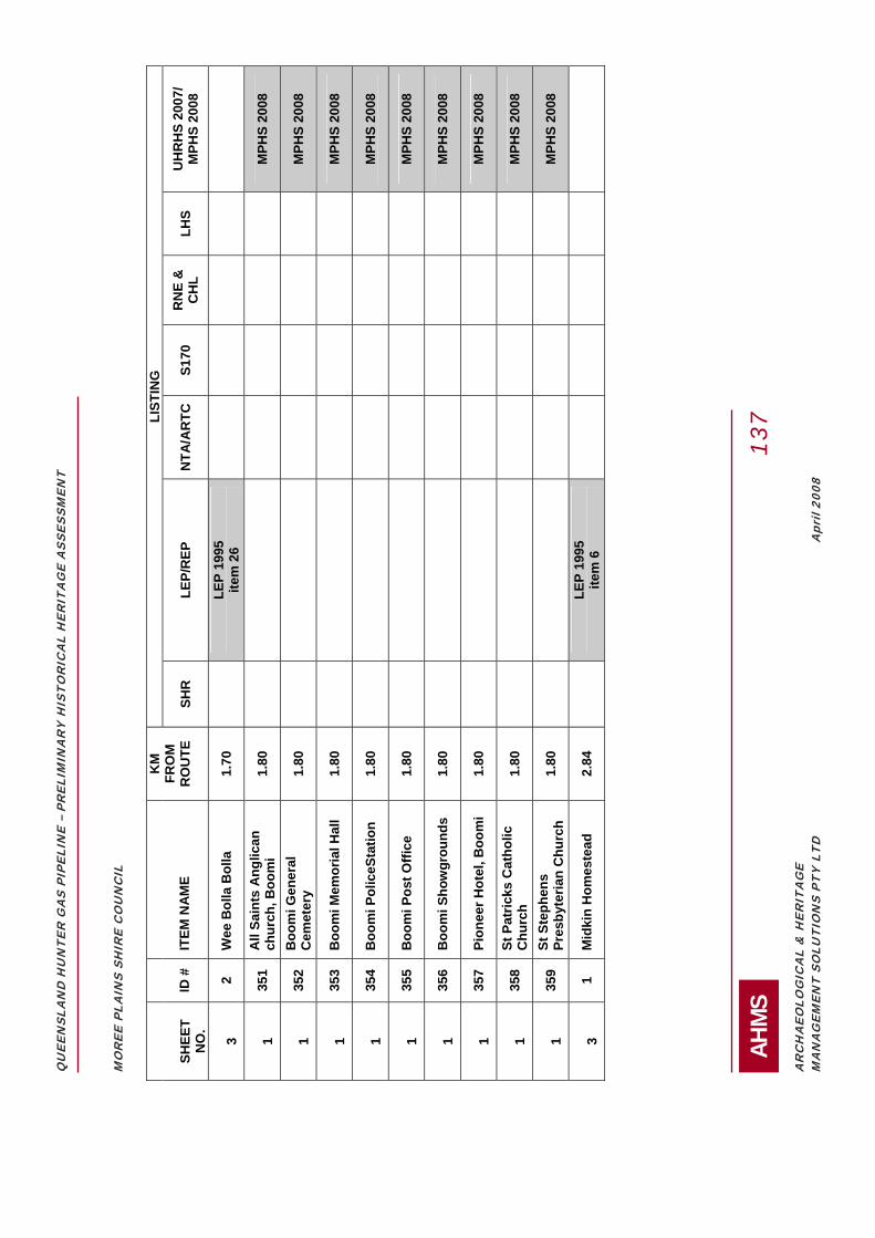
QU
EEN
SLA
ND
HU
NTE
R G
AS
PIPE
LIN
E –
PREL
IMIN
AR
Y H
ISTO
RIC
AL
HER
ITA
GE
ASS
ESSM
ENT
AH
MS
1
37
AR
CH
AEO
LOG
ICA
L &
HER
ITA
GE
MA
NA
GEM
ENT
SOLU
TIO
NS
PTY
LTD
Apr
il 20
08
MO
REE
PLA
INS
SHIR
E C
OU
NC
IL
LI
STIN
G
SH
EET
NO
. ID
#
IT
EM N
AM
E
KM
FR
OM
R
OU
TE
SH
R
LEP/
REP
N
TA/A
RTC
S1
70
RN
E &
C
HL
LHS
UH
RH
S 20
07/
MPH
S 20
08
3 2
Wee
Bol
la B
olla
1.
70
LE
P 19
95
item
26
1 35
1 A
ll Sa
ints
Ang
lican
ch
urch
, Boo
mi
1.80
M
PHS
2008
1 35
2 B
oom
i Gen
eral
C
emet
ery
1.80
M
PHS
2008
1 35
3 B
oom
i Mem
oria
l Hal
l 1.
80
MPH
S 20
08
1 35
4 B
oom
i Pol
iceS
tatio
n 1.
80
MPH
S 20
08
1 35
5 B
oom
i Pos
t Offi
ce
1.80
M
PHS
2008
1 35
6 B
oom
i Sho
wgr
ound
s 1.
80
MPH
S 20
08
1 35
7 Pi
onee
r Hot
el, B
oom
i 1.
80
MPH
S 20
08
1 35
8 St
Pat
ricks
Cat
holic
C
hurc
h 1.
80
MPH
S 20
08
1 35
9 St
Ste
phen
s Pr
esby
teria
n C
hurc
h 1.
80
MPH
S 20
08
3 1
Mid
kin
Hom
este
ad
2.84
LEP
1995
ite
m 6
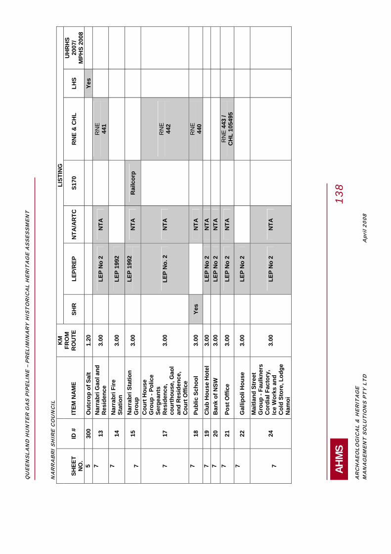
QU
EEN
SLA
ND
HU
NTE
R G
AS
PIPE
LIN
E –
PREL
IMIN
AR
Y H
ISTO
RIC
AL
HER
ITA
GE
ASS
ESSM
ENT
AH
MS
1
38
AR
CH
AEO
LOG
ICA
L &
HER
ITA
GE
MA
NA
GEM
ENT
SOLU
TIO
NS
PTY
LTD
Apr
il 20
08
NA
RR
AB
RI S
HIR
E C
OU
NC
IL
LIST
ING
SHEE
T N
O.
ID #
ITEM
NA
ME
KM
FR
OM
R
OU
TE
SH
R
LEP/
REP
N
TA/A
RTC
S1
70
RN
E &
CH
L LH
S U
HR
HS
2007
/ M
PHS
2008
5
300
Out
crop
of S
alt
1.20
Yes
7
13
Nar
rabr
i Gao
l and
R
esid
ence
3.
00
LE
P N
o 2
NTA
RN
E
441
7 14
N
arra
bri F
ire
Stat
ion
3.00
LEP
1992
7 15
N
arra
bri S
tatio
n G
roup
3.
00
LE
P 19
92
N
TA
Rai
lcor
p
7 17
Cou
rt H
ouse
G
roup
- Po
lice
Serg
eant
s R
esid
ence
, co
urth
ouse
, Gao
l an
d R
esid
ence
, C
ourt
Offi
ce
3.00
LEP
No.
2
NTA
RN
E
442
7 18
Pu
blic
Sch
ool
3.00
Ye
s
NTA
RN
E
440
7 19
C
lub
Hou
se H
otel
3.
00
LE
P N
o 2
NTA
7
20
Ban
k of
NSW
3.
00
LE
P N
o 2
NTA
7
21
Post
Offi
ce
3.00
LEP
No
2 N
TA
R
NE
443
/ C
HL
1054
95
7 22
G
allip
oli H
ouse
3.
00
LE
P N
o 2
7 24
Mai
tland
Str
eet
Gro
up -
Faul
kner
s C
ordi
al F
acto
ry,
Ice
Wor
ks a
nd
Col
d St
ore,
Lod
ge
Nam
oi
3.00
LEP
No
2 N
TA

QU
EEN
SLA
ND
HU
NTE
R G
AS
PIPE
LIN
E –
PREL
IMIN
AR
Y H
ISTO
RIC
AL
HER
ITA
GE
ASS
ESSM
ENT
AH
MS
1
39
AR
CH
AEO
LOG
ICA
L &
HER
ITA
GE
MA
NA
GEM
ENT
SOLU
TIO
NS
PTY
LTD
Apr
il 20
08
GU
NN
EDA
H S
HIR
E C
OU
NC
IL
LI
STIN
G
SH
EET
NO
. ID
#
IT
EM N
AM
E
KM
FR
OM
R
OU
TE
SH
R
LEP/
REP
N
TA/A
RTC
S1
70
RN
E &
CH
L LH
S U
HR
HS
2007
/ M
PHS
2008
9 28
A-D
G
unni
ble
Stat
ion
1.80
LEP
1998
ite
m 1
6 N
TA
9 29
A-D
R
uvig
ne
2.15
LEP
1998
Ite
m 2
2 N
TA
R
NE
101
045
9 31
Pu
llam
ing
2.80
LEP
1998
Ite
m 1
8 N
TA
LIV
ERPO
OL
PLA
INS
SHIR
E C
OU
NC
IL
LI
STIN
G
SH
EET
NO
. ID
#
IT
EM N
AM
E
KM
FR
OM
R
OU
TE
SH
R
LEP/
REP
N
TA/A
RTC
S1
70
RN
E &
CH
L LH
S U
HR
HS
2007
/ M
PHS
2008
11
26
0 Pr
ice
Cot
tage
2.
00
NTA
RN
E 1
0376
4
11
54
O
ld R
ural
B
ank
Bui
ldin
g 2.
55
Q
uirin
di L
EP
NTA
11
53
Qui
rindi
R
ailw
ay
Stat
ion
Gro
up
2.66
Ye
s
R
ailC
orp
UPP
ER H
UN
TER
SH
IRE
CO
UN
CIL
LIST
ING
Shee
t No.
ID
#
ITEM
NA
ME
KM
fr
om
rout
e
SHR
LE
P/R
EP
NTA
/AR
TC
S170
R
NE
& C
HL
LHS
UH
RH
S 20
07/
MPH
S 20
08
13
159
Nan
dow
ra,
Abe
rdee
n 1.
10
Sc
one
LEP
1986
12
156
Mur
ulla
, Win
gen
1.2
Sc
one
LEP
1986

QU
EEN
SLA
ND
HU
NTE
R G
AS
PIPE
LIN
E –
PREL
IMIN
AR
Y H
ISTO
RIC
AL
HER
ITA
GE
ASS
ESSM
ENT
AH
MS
1
40
AR
CH
AEO
LOG
ICA
L &
HER
ITA
GE
MA
NA
GEM
ENT
SOLU
TIO
NS
PTY
LTD
Apr
il 20
08
13
304
Abe
rdee
n R
ailw
ay
Stat
ion
1.25
Rai
lCor
p
12
60
The
Ran
ch,
Mur
ruru
ndi
1.50
Mur
ruru
ndi L
EP 1
993
12
61
Mur
ruru
ndi O
il Sh
ale
Ref
iner
y an
d Te
mi
Shal
e M
ine
1.50
Mur
ruru
ndi L
EP 1
993
NTA
12
99
Old
Cem
eter
y,
Mur
ruru
ndi
1.50
Mur
ruru
ndi L
EP 1
993
NTA
12
103
Blo
omfie
ld,
Mur
ruru
ndi
1.50
Mur
ruru
ndi L
EP 1
993
12
151
Clif
fdal
e W
yom
ing
Stud
, Win
gen
1.50
Scon
e LE
P 19
86,
Hun
ter R
EP
NTA
12
320
Mou
ntai
n H
ouse
, W
inge
n 1.
50
H
unte
r REP
N
TA
12
321
Tim
ber H
ouse
s,
Win
gen
1.50
Hun
ter R
EP
12
322
Tim
ber H
ouse
s,
Win
gen
1.50
Hun
ter R
EP
12
323
Bak
ers
Bric
kwor
ks,
Win
gen
1.50
Hun
ter R
EP
12
324
Red
Cot
tage
, W
inge
n 1.
50
H
unte
r REP
12
155
Abb
otsf
ord,
Win
gen
1.6
Sc
one
LEP
1986
12
101
Bar
sham
, Bla
ndfo
rd
1.80
Mur
ruru
ndi L
EP 1
993
12
104
Bic
kham
Hom
este
ad
Gro
up, B
land
ford
2.
80
M
urru
rund
i LEP
199
3 N
TA
12
105
Bic
kham
Woo
lshe
d an
d Sh
eare
r's
Qua
rter
s B
land
ford
2.
80
M
urru
rund
i LEP
199
3 N
TA
13
136
Com
mer
cial
Hot
el,
Abe
rdee
n 2.
00
Sc
one
LEP
1986

QU
EEN
SLA
ND
HU
NTE
R G
AS
PIPE
LIN
E –
PREL
IMIN
AR
Y H
ISTO
RIC
AL
HER
ITA
GE
ASS
ESSM
ENT
AH
MS
1
41
AR
CH
AEO
LOG
ICA
L &
HER
ITA
GE
MA
NA
GEM
ENT
SOLU
TIO
NS
PTY
LTD
Apr
il 20
08
13
137
Form
er M
. Cam
pbel
l an
d C
o. S
tore
, A
berd
een
2.00
Scon
e LE
P 19
86
NTA
RN
E 1
4359
13
138
The
Gra
nge,
A
berd
een
2.00
Scon
e LE
P 19
86
NTA
12
102
Har
ben
Vale
Gro
up,
Bla
ndfo
rd
2.20
Mur
ruru
ndi L
EP 1
993
NTA
13
139
Sege
nhoe
Mill
R
uins
, Abe
rdee
n 3.
00
Sc
one
LEP
1986
H
unte
r REP
N
TA
13
141
Form
er B
utte
r Fa
ctor
y an
d M
eatw
orks
Wat
er
Supp
ly, A
berd
een
2.00
Scon
e LE
P 19
86
13
142
Com
mer
cial
Hot
el,
Abe
rdee
n 2.
00
Sc
one
LEP
1986
13
143
Sege
nhoe
Inn,
A
berd
een
2.00
Scon
e LE
P 19
86
13
144
F.J.
Wal
kers
M
eatw
orks
, A
berd
een
2.00
Scon
e LE
P 19
86
13
170
Satu
r (re
ar S
ledm
ere
Hor
se S
tud)
2.
00
Sc
one
LEP
1986
13
169
Rus
sley
and
Gar
den
2.20
Scon
e LE
P 19
86
13
147
Kel
vins
ide
and
outb
uild
ings
, A
berd
een
2.50
Scon
e LE
P 19
86
NTA
RN
E 1
4360
13
148
Kel
vins
ide
Priv
ate
Cem
eter
y M
onum
ent.,
A
berd
een
2.50
Scon
e LE
P 19
86
13
157
Yarr
andi
, Sco
ne
2.5
Sc
one
LEP
1986
12
166
Cre
ssfie
ld S
tatio
n,
Park
ville
2.
72
Sc
one
LEP
1986

QU
EEN
SLA
ND
HU
NTE
R G
AS
PIPE
LIN
E –
PREL
IMIN
AR
Y H
ISTO
RIC
AL
HER
ITA
GE
ASS
ESSM
ENT
AH
MS
1
42
AR
CH
AEO
LOG
ICA
L &
HER
ITA
GE
MA
NA
GEM
ENT
SOLU
TIO
NS
PTY
LTD
Apr
il 20
08
13
106
Mill
Cot
tage
, Sco
ne
3.00
Scon
e LE
P 19
86
13
107
Form
er H
arpe
rs
Boo
t Fac
tory
, Sco
ne
3.00
Scon
e LE
P 19
86
NTA
13
108
Form
er B
oore
rs
Mill
s, S
cone
3.
00
Sc
one
LEP
1986
N
TA
13
109
Form
er C
atho
lic
Chu
rch,
Sco
ne
3.00
Scon
e LE
P 19
86
NTA
13
110
St L
uke'
s C
hurc
h an
d R
ecto
ry, S
cone
3.
00
Sc
one
LEP
1986
N
TA
13
111
Shop
s, 9
5-97
, Sco
ne
3.00
Scon
e LE
P 19
86
13
112
Bel
mor
e H
otel
, Sc
one
3.00
Scon
e LE
P 19
86
13
113
CB
C B
ank,
Sco
ne
3.00
Scon
e LE
P 19
86
NTA
13
114
St A
ubin
s A
rms
(form
er W
ool P
ack
Inn)
, Sco
ne
3.00
Scon
e LE
P 19
86
NTA
RN
E 1
0193
5
13
115
Mon
umen
ts, R
otar
y Pa
rk, S
cone
3.
00
Sc
one
LEP
1986
13
116
Form
er B
elm
ore
Hou
se, n
ow
"Ger
aldt
on",
Sco
ne
3.00
Scon
e LE
P 19
86
NTA
13
117
Form
er C
onve
nt o
f Si
ster
s of
Mer
cy,
Scon
e 3.
00
Sc
one
LEP
1986
N
TA
13
118
Form
er G
ram
mar
Sc
hool
. Sco
ne
3.00
Scon
e LE
P 19
86
NTA
RN
E 1
7133
?
13
119
Form
er C
onst
able
qu
arte
rs a
nd L
ock-
up, S
cone
3.
00
Sc
one
LEP
1986
13
120
Form
er S
choo
l of
Art
s, S
cone
3.
00
Sc
one
LEP
1986
N
TA
13
121
Pres
byte
rian
Man
se,
Scon
e 3.
00
Sc
one
LEP
1986
N
TA

QU
EEN
SLA
ND
HU
NTE
R G
AS
PIPE
LIN
E –
PREL
IMIN
AR
Y H
ISTO
RIC
AL
HER
ITA
GE
ASS
ESSM
ENT
AH
MS
1
43
AR
CH
AEO
LOG
ICA
L &
HER
ITA
GE
MA
NA
GEM
ENT
SOLU
TIO
NS
PTY
LTD
Apr
il 20
08
13
122
Form
er H
ospi
tal,
1871
. Sco
ne
3.00
Scon
e LE
P 19
86
13
123
Scon
e R
ailw
ay
Stat
ion,
187
1.
3.00
Scon
e LE
P 19
86
NTA
R
ailC
orp
RN
E 1
416
13
124
Form
er C
ourt
Hou
se
1848
-9 a
nd 1
882,
Sc
one
3.00
Scon
e LE
P 19
86
NTA
RN
E 14
17
13
125
Post
Offi
ce 1
879,
Sc
one
3.00
Scon
e LE
P 19
86
NTA
13
126
Form
er P
resb
yter
ian
Chu
rch
1861
, now
M
ason
ic T
empl
e,
Scon
e 3.
00
Sc
one
LEP
1986
N
TA
13
127
Hou
se, c
. 189
3,
Scon
e 3.
00
Sc
one
LEP
1986
13
128
St A
ubin
s H
ouse
, Sc
one
3.00
Scon
e LE
P 19
86
NTA
RN
E 14
09
13
130
Ban
k of
New
Sou
th
Wal
es, S
cone
3.
00
Sc
one
LEP
1986
13
131
Cam
pbel
l's C
orne
r, Sc
one
3.00
Scon
e LE
P 19
86
13
132
St M
ary'
s R
oman
C
atho
lic C
hurc
h,
Scon
e 3.
00
Sc
one
LEP
1986
13
133
Form
er W
illow
Tre
e H
otel
, Sco
ne
3.00
Scon
e LE
P 19
86
13
134
Rai
lway
G
atek
eepe
rs
Cot
tage
, 187
5,
Scon
e 3.
00
Sc
one
LEP
1986

QU
EEN
SLA
ND
HU
NTE
R G
AS
PIPE
LIN
E –
PREL
IMIN
AR
Y H
ISTO
RIC
AL
HER
ITA
GE
ASS
ESSM
ENT
AH
MS
1
44
AR
CH
AEO
LOG
ICA
L &
HER
ITA
GE
MA
NA
GEM
ENT
SOLU
TIO
NS
PTY
LTD
Apr
il 20
08
MU
SWEL
LBR
OO
K S
HIR
E C
OU
NC
IL
LI
STIN
G
SH
EET
NO
. ID
#
IT
EM N
AM
E
KM
FR
OM
R
OU
TE
SH
R
LEP/
REP
N
TA/A
RTC
S1
70
RN
E &
C
HL
LHS
UH
RH
S 20
07/
MPH
S 20
08
13
270
Gel
ston
1.
20
H
unte
r REP
SIN
GLE
TON
SH
IRE
CO
UN
CIL
LIST
ING
SHEE
T N
O.
ID #
ITEM
NA
ME
KM
FR
OM
R
OU
TE
SH
R
LEP/
REP
N
TA/A
RTC
S1
70
RN
E &
C
HL
LHS
UH
RH
S 20
07/
MPH
S 20
08
15
179
Gle
n N
evis
1.
60
SI
NG
LETO
N L
EP
1996
15
319
John
ston
s C
otta
ge
1.97
SIN
GLE
TON
LEP
19
96
15
178
Spot
tisw
ood
2.44
SIN
GLE
TON
LEP
19
96
14
175
Ros
elan
ds (U
nitin
g C
hurc
h), G
oora
ngoo
la
2.70
SIN
GLE
TON
LE
P 19
96
MA
ITLA
ND
CIT
Y C
OU
NC
IL
LI
STIN
G
SH
EET
NO
.
ID #
ITEM
NA
ME
KM
FR
OM
R
OU
TE
SH
R
LEP/
REP
N
TA/A
RTC
S1
70
RN
E &
CH
L LH
S U
HR
HS
2007
/ M
PHS
2008
16
18
2 St
one
Qua
rry
1.30
LEP
1993
Ite
m 3
16
187
Ow
lpen
1.
61
LE
P 19
93
Item
88
16
262
Clo
sebo
urne
Hou
se,
Mor
peth
1.
65
Yes
LEP
1993
Ite
m
NTA
RN
E 12
48
17
184
Ber
ry H
ouse
1.
68
LE
P 19
93
Item
15
NTA
RN
E 10
0409

QU
EEN
SLA
ND
HU
NTE
R G
AS
PIPE
LIN
E –
PREL
IMIN
AR
Y H
ISTO
RIC
AL
HER
ITA
GE
ASS
ESSM
ENT
AH
MS
1
45
AR
CH
AEO
LOG
ICA
L &
HER
ITA
GE
MA
NA
GEM
ENT
SOLU
TIO
NS
PTY
LTD
Apr
il 20
08
17
326
Gen
eral
Cem
eter
y (M
orpe
th)
1.70
LEP1
993
NTA
17
327
Gen
eral
Cem
eter
y (M
orpe
th)
1.70
LEP1
993
NTA
16
192
Eela
h 3.
00
LE
P 19
93
Item
187
17
185
Duc
kenf
ield
Hou
se
Rem
ains
2.
79
LE
P 19
93
Item
16
16
193
Mai
tland
Val
e 3.
00
LE
P 19
93
Item
188
POR
T ST
EPH
ENS
CIT
Y C
OU
NC
IL
LI
STIN
G
SH
EET
NO
. ID
#
IT
EM N
AM
E
KM
FR
OM
R
OU
TE
SH
R
LEP/
REP
N
TA/A
RTC
S1
70
RN
E &
C
HL
LHS
UH
RH
S 20
07/
MPH
S 20
08
17
208
Hin
ton
Brid
ge
1.10
LEP
2000
N
TA
RTA
R
NE
15
950
17
212
Vict
oria
Hot
el
1.15
LEP
2000
N
TA
R
NE
14
611
17
210
Form
er P
olic
e St
atio
n 1.
19
LE
P 20
00
NTA
17
20
9 Pu
blic
sch
ool,
1.
22
LE
P 20
00
17
21
3 Ti
mbe
r cot
tage
, Hin
ton
1.20
LEP
2000
17
215
Tim
ber c
otta
ge, H
into
n 1.
20
LE
P 20
00
17
21
6 G
eorg
ian
cotta
ge, H
into
n 1.
20
LE
P 20
00
17
21
7 Fo
rmer
St J
ohn
the
Evan
gelis
t C
hurc
h, H
into
n 1.
20
LE
P 20
00
NTA
17
226
Scho
ol o
f Art
s, H
into
n 1.
20
LE
P 20
00
17
22
9 Po
mfr
ett's
Cot
tage
- sla
b co
ttage
, H
into
n 1.
20
LE
P 20
00
17
203
A-B
B
aptis
t Chu
rch,
Hin
ton
1.20
LEP
2000
17
204
Scho
ol o
f Art
s,
1.31
LEP
2000
N
TA
17
202
Ang
lican
Cem
eter
y 1.
37
LE
P 20
00
17
20
5 H
into
n Pi
onee
r Cem
eter
y 1.
42
LE
P 20
00
NTA
RN
E
1355

QU
EEN
SLA
ND
HU
NTE
R G
AS
PIPE
LIN
E –
PREL
IMIN
AR
Y H
ISTO
RIC
AL
HER
ITA
GE
ASS
ESSM
ENT
AH
MS
1
46
AR
CH
AEO
LOG
ICA
L &
HER
ITA
GE
MA
NA
GEM
ENT
SOLU
TIO
NS
PTY
LTD
Apr
il 20
08
27
3 Po
lice
Stat
ion
1.50
N
TA
R
NE
13
33
17
206
A-F
R
osem
ount
1.
50
LE
P 20
00
NTA
17
218
Gra
ndst
and,
Stu
art P
ark
1.60
LEP
2000
N
TA
17
262
Clo
sebo
urne
Hou
se, M
orpe
th
1.65
Ye
s M
aitla
nd L
EP 1
993
NTA
RN
E
1248
17
207
Pros
pect
Hou
se,
1.74
LEP
2000
17
211
Wal
lalo
ng/B
owth
orne
War
M
emor
ial
2.00
LEP
2000
17
219
Tom
ago
Hou
se C
hape
l 2.
00
LE
P 20
00
RN
E
1325
17
220
Tom
ago
Hou
se a
nd it
s la
ndsc
ape
setti
ng,
2.00
LEP
2000
R
NE
13
24
17
221
Wal
lalo
ng H
ouse
2.
00
LE
P 20
00
NTA
16
22
7 Tr
essi
ngfie
ld (f
orm
erly
Car
lton
Cot
tage
) 2.
25
LE
P 20
00
NTA
17
214
Tree
s-2
spec
imen
of (
Mor
eton
B
ay F
ig)
3.00
LEP
2000
17
243
Hex
ham
Brid
ge
3.00
LEP
2000
RTA
17
224
Form
er W
alla
long
Bro
om F
acto
ry
3.00
LEP
2000
NEW
CA
STLE
CIT
Y C
OU
NC
IL
LI
STIN
G
SH
EET
NO
. ID
#
IT
EM N
AM
E
KM
FR
OM
R
OU
TE
SH
R
LEP/
REP
N
TA/A
RTC
S1
70
RN
E &
CH
L LH
S U
HR
HS
2007
/ M
PHS
2008
17
24
5 Pa
lm
1.80
LEP
17
25
0 Sa
ndga
te C
emet
ery
Offi
ce
2.00
LEP
NTA
17
248
Sand
gate
Cem
eter
y 2.
00
LE
P N
TA
Yes
17
24
9 Sa
ndga
te C
emet
ery
Rai
lway
Spu
r 2.
00
LE
P
17
240
Hex
ham
Shi
pbui
ldin
g Ya
rds
3.00
LEP
17
241
Gon
inan
s A
dmin
istr
atio
n B
uild
ing
3.00
LEP

QU
EEN
SLA
ND
HU
NTE
R G
AS
PIPE
LIN
E –
PREL
IMIN
AR
Y H
ISTO
RIC
AL
HER
ITA
GE
ASS
ESSM
ENT
AH
MS
1
47
AR
CH
AEO
LOG
ICA
L &
HER
ITA
GE
MA
NA
GEM
ENT
SOLU
TIO
NS
PTY
LTD
Apr
il 20
08
17
242
J &
A B
row
n's
Hex
ham
W
orks
hops
3.
00
LE
P
17
243
Hex
ham
Brid
ge
2.26
LEP
R
TA
17
23
9 Fo
rmer
Hex
ham
Pub
lic
Scho
ol
3.00
LEP
17
251
A-D
2H
D S
tudi
o 2.
50
LE
P
17
235
Han
nel F
amily
Vau
lt 3.
00
LE
P N
TA
17
232
Hex
ham
Rai
lway
Sta
tion
3.00
LEP
17
23
3 Fo
rmer
Tra
velle
rs R
est
Hot
el
3.00
LEP
Ye
s
17
234
Oak
Fac
tory
3.
00
LE
P
17
236
Slab
She
d 3.
00
LE
P
17
237
Form
er U
nitin
g C
hurc
h an
d H
all
3.00
LEP
17
238
Form
er G
len
Love
tt H
all
3.00
LEP
17
25
2 Ta
rro
Subs
tatio
n 3.
00
LE
P N
TA
17
254
Res
iden
ce
3.00
LEP
17
25
5 Ta
rro
Com
mun
ity H
all
3.00
LEP
17
25
6 Pu
mpi
ng S
tatio
n 3.
00
LE
P
17
257
Subs
tatio
n 3.
00
LE
P

QUEENSLAND HUNTER GAS PIPELINE – PRELIMINARY HISTORICAL HERITAGE ASSESSMENT
AHMS 148
ARCHAEOLOGICAL & HERITAGE MANAGEMENT SOLUTIONS PTY LTD April 2008
APPENDIX E: SUMMARY OF POTENTIAL HERITAGE ITEMS LOCATED WITHIN THE PIPELINE STUDY AREA UP TO A DISTANCE OF 1KM OF THE STUDY AREA

QU
EEN
SLA
ND
HU
NTE
R G
AS
PIPE
LIN
E –
PREL
IMIN
AR
Y H
ISTO
RIC
AL
HER
ITA
GE
ASS
ESSM
ENT
AH
MS
1
49
AR
CH
AEO
LOG
ICA
L &
HER
ITA
GE
MA
NA
GEM
ENT
SOLU
TIO
NS
PTY
LTD
Apr
il 20
08
LEG
END
S
IGN
IFIC
AN
CE
C
OLO
UR
CO
DE
IM
PA
CT
(KM
FR
OM
P
IPE
LIN
E S
TUD
Y
AR
EA
)
CO
LOU
R C
OD
E
CO
NS
TRA
INT
CO
LOU
R C
OD
E
HIG
H
RE
D
0.00
N
/A
HA
RD
D
AR
K G
RE
EN
M
ED
IUM
O
RA
NG
E
0.01
-0.1
0 N
/A
MO
DER
ATE
M
IDD
LE G
RE
EN
LO
W
YE
LLO
W
0.11
-1.0
0 N
/A
LOW
LI
GH
T G
RE
EN
UN
KNO
WN
D
EFA
ULT
HIG
H
MO
REE
PLA
INS
SHIR
E C
OU
NC
IL
Shee
t No.
ID
# K
m P
oint
Ite
m T
ype
Sign
ifica
nce
Valu
e IM
PAC
T Pr
oxim
ity to
20
0m p
ipel
ine
stud
y ar
ea
(km
)
Con
stra
int
Latit
ude
Long
itude
C
omm
ent
5 P2
05
383-
384
E m
ediu
m
0.00
ha
rd
29°
51'4
7.72
"S
149°
50'4
0.50
"E
5
P213
37
2-37
3 E
med
ium
0.
00
hard
2
9°46
'4.5
3"S
149°
51'2
9.90
"E
3
P235
29
6-29
7 E
med
ium
0.
00
hard
2
9° 9
'49.
24"S
14
9°42
'46.
56"E
2 P2
37
291-
292
E m
ediu
m
0.00
ha
rd
29°
8'1
3.17
"S
149°
40'4
6.72
"E
2
P238
28
7-28
8 E
med
ium
0.
00
hard
2
9° 6
'1.8
9"S
149°
40'2
5.49
"E
2
P239
28
7-28
8 P
high
0.
00
hard
2
9° 6
'3.4
9"S
149°
40'2
9.09
"E
4
P220
35
6-35
7 E
med
ium
0.
11
mod
erat
e 2
9°37
'50.
74"S
14
9°52
'22.
47"E
4 P2
27
339-
340
E m
ediu
m
0.16
lo
w
29°
28'4
7.50
"S
149°
54'5
.44"
E
3
P232
30
8-30
9 E
med
ium
0.
20
low
2
9°15
'27.
52"S
14
9°46
'40.
47"E
2 P2
40
276-
275
P m
ediu
m
0.28
lo
w
29°
0'2
0.30
"S
149°
39'4
8.54
"E
1
P247
24
8-24
9 P
med
ium
0.
28
low
2
8°46
'36.
16"S
14
9°37
'19.
17"E
4 P2
25
348-
349
E m
ediu
m
0.36
lo
w
29°
33'2
6.94
"S
149°
53'2
9.33
"E
1
P248
24
7-24
8 un
ided
D
efau
lt hi
gh
0.36
lo
w
28°
46'4
.81"
S 14
9°36
'41.
00"E
4 P2
21
352-
353
E m
ediu
m
0.37
lo
w
29°
35'4
5.42
"S
149°
53'8
.56"
E
2
P243
27
0-27
1 E
med
ium
0.
40
low
2
8°57
'22.
35"S
14
9°40
'0.8
6"E
3 P2
29
331-
332
P m
ediu
m
0.44
lo
w
29°
24'3
5.52
"S
149°
55'1
8.76
"E
3
P231
31
0-31
1 E
med
ium
0.
45
low
2
9°16
'50.
54"S
14
9°47
'52.
87"E
3 P2
34
302-
303
unid
ed
Def
ault
high
0.
46
low
2
9°12
'28.
53"S
14
9°45
'3.4
4"E
1 P2
46
258-
259
E m
ediu
m
0.46
lo
w
28°
51'2
0.22
"S
149°
40'3
2.73
"E
5
P214
37
0-37
1 P
med
ium
0.
48
low
2
9°45
'10.
90"S
14
9°51
'15.
14"E

QU
EEN
SLA
ND
HU
NTE
R G
AS
PIPE
LIN
E –
PREL
IMIN
AR
Y H
ISTO
RIC
AL
HER
ITA
GE
ASS
ESSM
ENT
AH
MS
1
50
AR
CH
AEO
LOG
ICA
L &
HER
ITA
GE
MA
NA
GEM
ENT
SOLU
TIO
NS
PTY
LTD
Apr
il 20
08
4 P2
18
363-
364
E m
ediu
m
0.50
lo
w
29°
41'3
7.51
"S
149°
52'2
2.25
"E
5
P212
37
2-37
3 E
med
ium
0.
51
low
2
9°46
'24.
06"S
14
9°51
'51.
54"E
5 P2
09
377-
378
P m
ediu
m
0.52
lo
w
29°
48'4
0.81
"S
149°
51'3
0.10
"E
2
P241
27
2-27
3 P
med
ium
0.
59
low
2
8°59
'10.
54"S
14
9°39
'15.
39"E
2 P2
44
267-
268
E m
ediu
m
0.62
lo
w
28°
55'5
7.76
"S
149°
40'3
4.67
"E
4
P217
36
4-36
5 E
med
ium
0.
64
low
2
9°41
'59.
57"S
14
9°52
'23.
32"E
4 P2
22
351-
352
E m
ediu
m
0.66
lo
w
29°
35'6
.95"
S 14
9°52
'27.
11"E
1 P2
52
228-
229
unid
ed
Def
ault
high
0.
67
low
2
8°37
'8.2
2"S
149°
35'8
.50"
E
5
P208
38
0-38
1 un
ided
D
efau
lt hi
gh
0.68
lo
w
29°
50'2
6.10
"S
149°
51'2
0.35
"E
2
P245
26
5-26
6 P
med
ium
0.
74
low
2
8°55
'0.0
3"S
149°
39'4
6.40
"E
2
P242
27
1-27
2 E
med
ium
0.
75
low
2
8°57
'59.
30"S
14
9°40
'12.
60"E
5 P2
07
381-
382
P m
ediu
m
0.84
lo
w
29°
51'4
.96"
S 14
9°51
'22.
48"E
1 P2
51
239-
240
O
med
ium
0.
84
low
2
8°43
'4.0
3"S
149°
35'8
.27"
E
4
P228
33
4-33
5 P
med
ium
0.
86
low
2
9°25
'41.
45"S
14
9°54
'12.
59"E
3 P2
33
303-
304
E m
ediu
m
0.87
lo
w
29°
13'1
9.42
"S
149°
44'3
7.71
"E
5
P215
36
9-37
0 E
med
ium
0.
88
low
2
9°44
'43.
86"S
14
9°52
'4.8
9"E
4 P2
26
341-
342
E m
ediu
m
0.94
lo
w
29°
29'3
5.46
"S
149°
54'3
5.33
"E
3
P230
31
9-32
0 E
med
ium
0.
96
low
2
9°21
'4.6
6"S
149°
49'4
2.76
"E
2
P236
29
3-29
4 E
med
ium
0.
97
low
2
9° 9
'27.
58"S
14
9°41
'9.0
4"E
1 P2
50
240-
241
E m
ediu
m
1.00
lo
w
28°
43'1
9.42
"S
149°
35'2
1.36
"E
N
AR
RA
BR
I SH
IRE
CO
UN
CIL
Sh
eet N
o.
ID#
Km
Poi
nt
Item
Typ
e Si
gnifi
canc
e Va
lue
IMPA
CT
Prox
imity
to
200m
pi
pelin
e st
udy
area
(k
m)
Con
stra
int
Latit
ude
Long
itude
C
omm
ent
8 P1
54
494-
492
A m
ediu
m
0.00
ha
rd
30°
41'4
2.98
"S
150°
7'3
3.12
"E
nc
7 P1
76
437-
435
T m
ediu
m
0.00
ha
rd
30°
19'1
8.79
"S
149°
49'3
2.32
"E
8
P156
48
8-48
7 un
ided
D
efau
lt hi
gh
0.05
m
oder
ate
30°
39'5
6.29
"S
150°
6'2
7.91
"E
nc
8 P1
62
481-
480
unid
ed
Def
ault
high
0.
06
mod
erat
e 3
0°37
'35.
59"S
15
0° 3
'6.0
8"E
7
P169
44
3-44
2 A
med
ium
0.
09
mod
erat
e 3
0°22
'23.
09"S
14
9°50
'35.
99"E
8 P1
61
483-
482
A m
ediu
m
0.17
lo
w
30°
37'5
5.96
"S
150°
4'6
.68"
E
8
P152
49
6-49
5 un
ided
D
efau
lt hi
gh
0.18
lo
w
30°
43'3
7.62
"S
150°
7'3
0.40
"E
6
P191
41
8-41
9 A
med
ium
0.
21
low
3
0°10
'32.
28"S
14
9°49
'29.
61"E
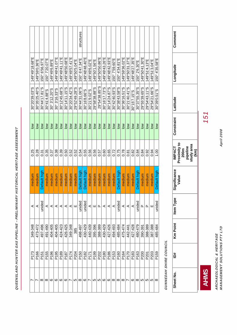
QU
EEN
SLA
ND
HU
NTE
R G
AS
PIPE
LIN
E –
PREL
IMIN
AR
Y H
ISTO
RIC
AL
HER
ITA
GE
ASS
ESSM
ENT
AH
MS
1
51
AR
CH
AEO
LOG
ICA
L &
HER
ITA
GE
MA
NA
GEM
ENT
SOLU
TIO
NS
PTY
LTD
Apr
il 20
08
7 P1
73
349-
348
A m
ediu
m
0.25
lo
w
30°
20'3
9.03
"S
149°
49'1
8.68
"E
7
P166
47
3-47
2 A
med
ium
0.
28
low
3
0°35
'25.
40"S
14
9°59
'0.3
6"E
8 P1
51
497-
496
unid
ed
Def
ault
high
0.
31
low
3
0°44
'17.
81"S
15
0° 6
'56.
97"E
8 P1
55
491-
490
A m
ediu
m
0.35
lo
w
30°
41'4
.88"
S
150°
7'2
0.07
"E
6
P196
40
4-40
5 A
med
ium
0.
37
low
3
0° 3
'12.
20"S
14
9°49
'6.8
9"E
6 P1
95
404-
405
A m
ediu
m
0.38
lo
w
30°
3'1
6.33
"S
149°
49'4
1.07
"E
6
P189
42
4-42
3 A
med
ium
0.
39
low
3
0°12
'45.
68"S
14
9°49
'41.
11"E
6 P1
87
426-
425
A m
ediu
m
0.50
lo
w
30°
14'1
1.15
"S
149°
48'5
0.68
"E
7
P174
34
9-34
8 A
med
ium
0.
52
low
3
0°20
'34.
42"S
14
9°49
'57.
41"E
5 P2
04
385
E m
ediu
m
0.52
lo
w
29°
52'4
9.28
"S
149°
50'5
.04"
E
8
P150
49
8-49
7 un
ided
D
efau
lt hi
gh
0.54
lo
w
30°
44'3
1.06
"S
150°
6'4
7.34
"E
stru
ctur
es
6 P1
82
430-
429
unid
ed
Def
ault
high
0.
55
low
3
0°16
'8.6
6"S
149°
48'4
8.40
"E
7
P171
44
0-43
9 A
med
ium
0.
56
low
3
0°21
'9.0
2"S
149°
49'6
.02"
E
5
P199
39
5-39
6 E
med
ium
0.
56
low
2
9°58
'38.
88"S
14
9°50
'1.5
6"E
5 P2
02
388-
389
P m
ediu
m
0.57
lo
w
29°
54'3
8.85
"S
149°
50'5
0.86
"E
6
P180
43
0-42
9 A
med
ium
0.
60
low
3
0°16
'17.
73"S
14
9°49
'43.
26"E
6 P1
86
427-
426
A m
ediu
m
0.65
lo
w
30°
14'2
4.87
"S
149°
48'4
2.93
"E
8
P153
49
4-49
3 A
med
ium
0.
72
low
3
0°42
'40.
93"S
15
0° 7
'59.
60"E
8 P1
60
485-
484
unid
ed
Def
ault
high
0.
75
low
3
0°38
'43.
58"S
15
0° 4
'34.
81"E
8 P1
64
475-
474
A m
ediu
m
0.78
lo
w
30°
36'1
6.51
"S
149°
59'3
6.02
"E
7
P170
44
2-44
1 A
med
ium
0.
81
low
3
0°21
'40.
41"S
14
9°50
'31.
37"E
6 P1
83
427-
428
A m
ediu
m
0.82
lo
w
30°1
5'7.
15"S
14
9°48
'27.
35"E
8 P1
63
480-
479
unid
ed
Def
ault
high
0.
84
low
3
0°37
'55.
35"S
15
0° 2
'6.3
0"E
5 P2
00
390-
391
P m
ediu
m
0.84
lo
w
29°
55'3
9.65
"S
149°
50'4
1.30
"E
5
P201
38
8-38
9 P
med
ium
0.
92
low
2
9°54
'43.
11"S
14
9°51
'4.1
3"E
5 P2
03
387-
388
E m
ediu
m
0.94
lo
w
29°
54'2
1.66
"S
149°
51'3
.04"
E
8
P159
48
5-48
4 un
ided
D
efau
lt hi
gh
1.00
lo
w
30°
39'0
.51"
S
150°
4'3
5.58
"E
G
UN
NED
AH
SH
IRE
CO
UN
CIL
Sh
eet N
o.
ID#
Km
Poi
nt
Item
Typ
e Si
gnifi
canc
e Va
lue
IMPA
CT
Prox
imity
to
200m
pi
pelin
e st
udy
area
(k
m)
Con
stra
int
Latit
ude
Long
itude
C
omm
ent

QU
EEN
SLA
ND
HU
NTE
R G
AS
PIPE
LIN
E –
PREL
IMIN
AR
Y H
ISTO
RIC
AL
HER
ITA
GE
ASS
ESSM
ENT
AH
MS
1
52
AR
CH
AEO
LOG
ICA
L &
HER
ITA
GE
MA
NA
GEM
ENT
SOLU
TIO
NS
PTY
LTD
Apr
il 20
08
9 P1
33
527-
526
A m
ediu
m
0.00
ha
rd
30°
56'4
7.54
"S
150°
16'5
0.16
"E
nc
9 P1
37
520-
519
unid
ed
Def
ault
high
0.
00
hard
3
0°53
'51.
38"S
15
0°14
'50.
71"E
un
ided
fe
atur
e 8
P145
50
3-50
2 un
ided
D
efau
lt hi
gh
0.00
ha
rd
30°
46'5
5.62
"S
150°
9'1
4.66
"E
8 P1
49
501-
500
unid
ed
Def
ault
high
0.
02
mod
erat
e 3
0°45
'39.
09"S
15
0° 8
'38.
60"E
un
ided
st
ruct
ure
9 P1
36
521-
519
unid
ed
Def
ault
high
0.
05
mod
erat
e 3
0°53
'54.
56"S
15
0°15
'23.
39"E
nc
9
P131
52
9-52
8 un
ided
D
efau
lt hi
gh
0.15
lo
w
30°
57'4
1.29
"S
150°
18'5
.21"
E
9
P124
54
9-54
8 A
med
ium
0.
17
low
3
1° 7
'6.0
4"S
150°
22'4
7.37
"E
9
P130
53
1-53
0 A
med
ium
0.
17
low
3
0°58
'20.
28"S
15
0°18
'29.
23"E
8 P1
46
503-
502
A m
ediu
m
0.18
lo
w
30°
46'3
2.00
"S
150°
9'1
1.96
"E
8
P148
50
1-50
0 un
ided
D
efau
lt hi
gh
0.20
lo
w
30°
45'4
2.17
"S
150°
8'5
2.70
"E
10
P118
57
8-57
7 un
ided
D
efau
lt hi
gh
0.21
lo
w
31°
19'2
.04"
S 15
0°32
'53.
43"E
si
te o
f for
mer
co
mpl
ex
8 P1
43
506-
505
A m
ediu
m
0.21
lo
w
30°
47'4
7.77
"S
150°
10'1
9.79
"E
9
P129
53
1-53
0 A
med
ium
0.
22
low
3
0°58
'30.
79"S
15
0°18
'29.
71"E
10
P117
57
9-57
8 un
ided
D
efau
lt hi
gh
0.23
lo
w
31°
19'1
7.89
"S
150°
33'1
3.42
"E
10
P1
21
557-
556
unid
ed
Def
ault
high
0.
28
low
3
1°10
'7.0
3"S
150°
26'0
.81"
E
8
P147
50
1-50
0 A
med
ium
0.
29
low
3
0°45
'54.
97"S
15
0° 8
'29.
95"E
9 P1
38
517-
516
A m
ediu
m
0.47
lo
w
30°
52'2
1.82
"S
150°
13'2
3.14
"E
9
P132
52
8-52
7 A
med
ium
0.
52
low
3
0°57
'11.
36"S
15
0°17
'7.7
1"E
9 P1
25
545-
544
unid
ed
Def
ault
high
0.
69
low
3
1° 5
'24.
52"S
15
0°20
'15.
89"E
9 P1
39
514-
513
A m
ediu
m
0.69
lo
w
30°
51'5
.96"
S 15
0°12
'29.
93"E
10
P122
55
6-55
5 A
med
ium
0.
70
low
3
1° 9
'48.
76"S
15
0°26
'3.6
4"E
10
P123
55
6-55
5 A
med
ium
0.
70
low
3
1° 9
'31.
66"S
15
0°25
'44.
41"E
9 P1
34
521-
520
A m
ediu
m
0.70
lo
w
30°
54'3
4.00
"S
150°
15'4
2.86
"E
9
P135
52
1-52
0 A
med
ium
0.
70
low
3
0°54
'8.9
4"S
150°
14'3
6.06
"E
9
P127
53
9-53
8 A
med
ium
0.
87
low
3
1° 2
'42.
71"S
15
0°18
'12.
67"E
10
P120
56
4-56
3 A
med
ium
0.
88
low
3
1°13
'55.
47"S
15
0°27
'8.9
4"E
10
P119
56
9-56
8 un
ided
D
efau
lt hi
gh
0.92
lo
w
31°
15'2
4.20
"S
150°
28'1
2.39
"E
LI
VER
POO
L PL
AIN
S SH
IRE
CO
UN
CIL
Sh
eet N
o.
ID#
Km
Poi
nt
Item
Typ
e Si
gnifi
canc
e Va
lue
IMPA
CT
Prox
imity
to
200m
pi
pelin
e st
udy
area
(k
m)
Con
stra
int
Latit
ude
Long
itude
C
omm
ent

QU
EEN
SLA
ND
HU
NTE
R G
AS
PIPE
LIN
E –
PREL
IMIN
AR
Y H
ISTO
RIC
AL
HER
ITA
GE
ASS
ESSM
ENT
AH
MS
1
53
AR
CH
AEO
LOG
ICA
L &
HER
ITA
GE
MA
NA
GEM
ENT
SOLU
TIO
NS
PTY
LTD
Apr
il 20
08
11
P100
60
4-60
1 A
med
ium
0.
00
hard
3
1°30
'23.
56"S
15
0°38
'38.
49"E
11
P111
59
1-59
0 A
low
0.
00
mod
erat
e 3
1°25
'27.
96"S
15
0°34
'42.
34"E
11
P112
59
0-58
9 un
ided
D
efau
lt hi
gh
0.00
ha
rd
31°
25'7
.14"
S 15
0°34
'33.
82"E
10
P114
58
6-58
4 A
med
ium
0.
00
hard
3
1°22
'43.
56"S
15
0°34
'9.0
6"E
S
erie
s of
Ag
allo
tmen
ts
12
P84
635-
635
T hi
gh
0.00
ha
rd
31°
44'2
8.31
"S
150°
47'4
5.65
"E
ardg
len
tunn
el
12
P85
635-
633
M
med
ium
0.
00
hard
3
1°44
'13.
84"S
15
0°46
'57.
78"E
nc
11
P87
628-
627
A m
ediu
m
0.00
ha
rd
31°
41'5
0.71
"S
150°
44'2
8.55
"E
two
ag
allo
tmen
ts
11
P88
627-
625
A m
ediu
m
0.00
ha
rd
31°
41'1
0.88
"S
150°
44'1
6.38
"E
ag a
llotm
ents
11
P8
9 62
5-62
2 A
med
ium
0.
00
hard
3
1°40
'15.
58"S
15
0°43
'56.
44"E
nc
11
P9
2 62
1-62
0 A
med
ium
0.
00
hard
3
1°38
'41.
52"S
15
0°42
'51.
69"E
11
P93
621-
620
unid
ed
Def
ault
high
0.
00
hard
3
1°38
'27.
02"S
15
0°42
'51.
52"E
11
P95
619-
618
unid
ed
Def
ault
high
0.
00
hard
3
1°37
'17.
69"S
15
0°42
'39.
23"E
site
of f
orm
er
unid
ed
stru
ctur
es
12
P86
632-
630
A m
ediu
m
0.09
m
oder
ate
31°
43'3
.91"
S 15
0°44
'56.
46"E
nc
11
P1
09
592-
591
A m
ediu
m
0.13
lo
w
31°
26'2
.01"
S 15
0°34
'32.
49"E
10
P116
58
2-58
1 A
med
ium
0.
13
low
3
1°20
'42.
39"S
15
0°33
'23.
47"E
11
P98
605-
606
A m
ediu
m
0.13
lo
w
31°
31'1
9.42
"S
150°
38'4
9.98
"E
11
P9
1 62
2-62
1 A
med
ium
0.
15
low
3
1°38
'56.
75"S
15
0°43
'4.6
8"E
11
P94
620-
619
unid
ed
Def
ault
high
0.
15
low
3
1°37
'53.
15"S
15
0°42
'47.
60"E
site
of f
orm
er
unid
ed
stru
ctur
es
11
P97
618-
617
A m
ediu
m
0.15
lo
w
31°
36'5
1.73
"S
150°
42'4
2.44
"E
ag c
ompl
ex
11
P104
59
8-59
7 A
med
ium
0.
16
low
3
1°28
'11.
69"S
15
0°36
'37.
59"E
11
P107
59
5-59
4 A
med
ium
0.
20
low
3
1°27
'34.
10"S
15
0°34
'46.
66"E
11
P102
60
1-60
0 un
ided
D
efau
lt hi
gh
0.22
lo
w
31°
29'2
0.97
"S
150°
37'5
6.31
"E
11
P1
05
596-
595
A m
ediu
m
0.22
lo
w
31°
27'5
3.76
"S
150°
35'4
3.26
"E
11
P1
08
595-
594
A m
ediu
m
0.22
lo
w
31°
27'2
2.60
"S
150°
35'6
.18"
E
10
P1
17
579-
578
unid
ed
Def
ault
high
0.
23
low
3
1°19
'17.
89"S
15
0°33
'13.
42"E
11
P106
59
5-59
4 A
low
0.
25
low
3
1°27
'36.
25"S
15
0°35
'19.
49"E
11
P103
59
9-59
7 E
low
0.
26
low
3
1°28
'41.
67"S
15
0°37
'26.
15"E
11
P99
605-
604
unid
ed
Def
ault
high
0.
26
low
3
1°30
'59.
62"S
15
0°39
'17.
47"E
10
P115
58
3-58
2 A
med
ium
0.
32
low
3
1°21
'33.
81"S
15
0°33
'28.
13"E
11
P110
59
2-59
1 A
med
ium
0.
33
low
3
1°25
'55.
08"S
15
0°34
'26.
19"E
11
P90
624-
622
M
low
0.
34
low
3
1°39
'44.
63"S
15
0°42
'41.
77"E
nc
11
P1
01
602-
601
A m
ediu
m
0.36
lo
w
31°
29'5
7.72
"S
150°
37'5
6.69
"E

QU
EEN
SLA
ND
HU
NTE
R G
AS
PIPE
LIN
E –
PREL
IMIN
AR
Y H
ISTO
RIC
AL
HER
ITA
GE
ASS
ESSM
ENT
AH
MS
1
54
AR
CH
AEO
LOG
ICA
L &
HER
ITA
GE
MA
NA
GEM
ENT
SOLU
TIO
NS
PTY
LTD
Apr
il 20
08
10
P113
58
6-58
5 A
med
ium
0.
44
low
3
1°23
'5.5
3"S
150°
33'4
3.37
"E
11
P9
6 61
8-61
7 A
med
ium
0.
63
low
3
1°37
'0.7
8"S
150°
43'1
.62"
E
ag c
ompl
ex
UPP
ER H
UN
TER
SH
IRE
CO
UN
CIL
Sh
eet N
o.
ID#
Km
Poi
nt
Item
Typ
e Si
gnifi
canc
e Va
lue
IMPA
CT
Prox
imity
to
200m
pi
pelin
e st
udy
area
(k
m)
Con
stra
int
Latit
ude
Long
itude
C
omm
ent
13
P45
694-
691
A m
ediu
m
0.00
ha
rd
32°
8'3
2.58
"S
150°
53'1
0.92
"E
nc
13
P46
694-
691
A m
ediu
m
0.00
ha
rd
32°
8'4
4.13
"S
150°
52'5
0.71
"E
nc
13
P47
692-
691
A m
ediu
m
0.00
ha
rd
32°
8'2
0.05
"S
150°
52'5
0.84
"E
13
P4
8 69
1-69
0 T
med
ium
0.
00
hard
3
2° 8
'5.9
7"S
150°
52'3
5.32
"E
13
P5
0 69
0-68
1 A
med
ium
0.
00
hard
3
2° 7
'11.
40"S
15
0°51
'24.
40"E
nc
13
P5
4 68
1-68
0 A
med
ium
0.
00
hard
3
2° 3
'27.
33"S
15
0°49
'54.
87"E
13
P62
677-
675
A m
ediu
m
0.00
ha
rd
32°
1'4
.39"
S 15
0°49
'21.
05"E
nc
12
P6
4 67
1-67
0 A
med
ium
0.
00
hard
3
1°58
'22.
18"S
15
0°49
'13.
93"E
nc
12
P69
659-
658
A m
ediu
m
0.00
ha
rd
31°
52'5
3.04
"S
150°
51'4
4.03
"E
site
of f
orm
er
stru
ctur
e
12
P77
642-
640
O
med
ium
0.
00
hard
3
1°46
'9.9
8"S
150°
49'5
5.84
"E
tow
n al
lotm
ents
m
urru
rund
i 12
P8
1 63
9-63
7 A
med
ium
0.
04
mod
erat
e 3
1°45
'45.
65"S
15
0°48
'37.
00"E
re
side
nce
12
P73
654-
652
A m
ediu
m
0.05
m
oder
ate
31°
50'2
9.75
"S
150°
52'5
5.84
"E
nc
13
P55
681-
680
A m
ediu
m
0.07
m
oder
ate
32°
3'1
8.29
"S
150°
49'4
0.81
"E
12
P8
3 63
7-63
6 T
med
ium
0.
08
mod
erat
e 3
1°45
'5.6
2"S
150°
48'1
.04"
E
13
P5
9 67
8-67
7 A
med
ium
0.
09
mod
erat
e 3
2° 2
'10.
12"S
15
0°49
'19.
13"E
13
P57
679-
678
A m
ediu
m
0.10
m
oder
ate
32°
2'5
1.68
"S
150°
49'1
6.04
"E
13
P5
3 68
1-68
0 A
med
ium
0.
17
low
3
2° 3
'31.
42"S
15
0°49
'46.
64"E
12
P74
648-
646
O
med
ium
0.
21
low
3
1°47
'32.
48"S
15
0°53
'39.
52"E
va
rious
tow
n al
lotm
ents
12
P80
639-
638
A lo
w
0.22
lo
w
31°
46'2
.56"
S 15
0°48
'22.
38"E
si
ngle
st
ruct
ure
12
P70
657-
656
unid
ed
Def
ault
high
0.
25
low
3
1°51
'51.
20"S
15
0°52
'21.
89"E
12
P65
666-
665
A m
ediu
m
0.27
lo
w
31°
55'5
8.85
"S
150°
50'1
1.79
"E
13
P5
6 68
0-67
9 A
med
ium
0.
28
low
3
2° 3
'3.6
4"S
150°
48'5
7.25
"E
13
P6
0 67
7-67
6 A
med
ium
0.
28
low
3
2° 1
'39.
11"S
15
0°48
'59.
32"E
ag
com
plex

QU
EEN
SLA
ND
HU
NTE
R G
AS
PIPE
LIN
E –
PREL
IMIN
AR
Y H
ISTO
RIC
AL
HER
ITA
GE
ASS
ESSM
ENT
AH
MS
1
55
AR
CH
AEO
LOG
ICA
L &
HER
ITA
GE
MA
NA
GEM
ENT
SOLU
TIO
NS
PTY
LTD
Apr
il 20
08
12
P78
641-
640
unid
ed
Def
ault
high
0.
28
low
3
1°46
'35.
75"S
15
0°49
'47.
15"E
12
P71
657-
656
A m
ediu
m
0.32
lo
w
31°
52'1
.04"
S 15
0°52
'46.
41"E
nc
13
P4
4 69
7-69
6 M
lo
w
0.35
lo
w
32°
10'1
7.73
"S
150°
54'4
2.61
"E
13
P4
9 69
1-69
0 A
med
ium
0.
46
low
3
2° 7
'58.
86"S
15
0°52
'56.
10"E
12
P63
672-
671
A m
ediu
m
0.51
lo
w
31°
59'1
2.38
"S
150°
48'3
9.54
"E
12
P7
9 64
1-64
0 un
ided
D
efau
lt hi
gh
0.52
lo
w
31°
46'4
1.08
"S
150°
49'2
9.25
"E
12
P82
637-
636
T lo
w
0.54
lo
w
31°
45'2
9.76
"S
150°
47'3
7.44
"E
site
of f
orm
er
rail
stru
ctur
es
13
P61
677-
676
A m
ediu
m
0.61
lo
w
32°
1'2
6.91
"S
150°
48'4
5.07
"E
13
P5
1 68
9-68
8 un
ided
D
efau
lt hi
gh
0.66
lo
w
32°
6'4
5.58
"S
150°
52'1
2.46
"E
12
P7
5 64
5-64
3 A
med
ium
0.
79
low
3
1°46
'30.
21"S
15
0°52
'26.
30"E
nc
13
P5
8 67
9-67
8 A
med
ium
0.
85
low
3
2° 2
'47.
28"S
15
0°48
'32.
16"E
12
P67
660-
659
A m
ediu
m
0.89
lo
w
31°
53'4
5.28
"S
150°
52'7
.36"
E
12
P7
6 64
4-64
3 A
med
ium
0.
99
low
3
1°46
'12.
74"S
15
0°51
'38.
65"E
12
P66
662-
661
A m
ediu
m
1.00
lo
w
31°
54'3
0.80
"S
150°
52'7
.33"
E
M
USW
ELLB
RO
OK
SH
IRE
CO
UN
CIL
Sh
eet N
o.
ID#
Km
Poi
nt
Item
Typ
e Si
gnifi
canc
e Va
lue
IMPA
CT
Prox
imity
to
200m
pi
pelin
e st
udy
area
(k
m)
Con
stra
int
Latit
ude
Long
itude
C
omm
ent
14
P36
714-
713
A m
ediu
m
0.00
ha
rd
32°
17'6
.18"
S 15
1° 0
'35.
10"E
13
P41
703-
701
A m
ediu
m
0.00
ha
rd
32°
12'3
8.70
"S
150°
56'2
7.54
"E
nc
13
P43
700-
699
A m
ediu
m
0.08
m
oder
ate
32°
11'3
6.68
"S
150°
55'3
8.39
"E
13
P3
7 71
2-71
1 A
med
ium
0.
39
low
3
2°16
'40.
78"S
15
0°59
'27.
88"E
13
P39
707-
706
E lo
w
0.76
lo
w
32°
14'4
9.97
"S
150°
57'0
.68"
E
SI
NG
LETO
N S
HIR
E C
OU
NC
IL
Shee
t No.
ID
# K
m P
oint
Ite
m T
ype
Sign
ifica
nce
Valu
e IM
PAC
T Pr
oxim
ity to
20
0m
pipe
line
stud
y ar
ea
(km
)
Con
stra
int
Latit
ude
Long
itude
C
omm
ent
15
P27
758-
757
A m
ediu
m
0.04
m
oder
ate
32°
31'0
.43"
S 15
1°19
'41.
04"E

QU
EEN
SLA
ND
HU
NTE
R G
AS
PIPE
LIN
E –
PREL
IMIN
AR
Y H
ISTO
RIC
AL
HER
ITA
GE
ASS
ESSM
ENT
AH
MS
1
56
AR
CH
AEO
LOG
ICA
L &
HER
ITA
GE
MA
NA
GEM
ENT
SOLU
TIO
NS
PTY
LTD
Apr
il 20
08
14
P32
741-
740
A m
ediu
m
0.13
lo
w
32°
26'1
5.98
"S
151°
11'2
6.31
"E
15
P2
5 75
8-75
7 A
med
ium
0.
16
low
3
2°31
'14.
79"S
15
1°19
'36.
24"E
15
P24
759-
758
A m
ediu
m
0.19
lo
w
32°
31'2
5.42
"S
151°
20'1
1.17
"E
15
P3
1 75
3-75
2 A
med
ium
0.
21
low
3
2°29
'45.
96"S
15
1°17
'11.
98"E
14
P35
735-
734
A m
ediu
m
0.30
lo
w
32°
23'2
5.89
"S
151°
10'2
5.47
"E
16
P2
3 76
9-76
8 A
med
ium
0.
35
low
3
2°35
'0.9
5"S
151°
23'3
8.75
"E
15
P2
9 75
7-75
6 A
med
ium
0.
44
low
3
2°30
'36.
35"S
15
1°19
'22.
51"E
14
P34
738-
737
A m
ediu
m
0.46
lo
w
32°
24'3
8.22
"S
151°
10'5
8.25
"E
15
P3
0 75
6-75
5 A
med
ium
0.
58
low
3
2°30
'22.
91"S
15
1°19
'18.
98"E
15
P28
758-
757
A m
ediu
m
0.67
lo
w
32°
30'5
8.87
"S
151°
20'1
0.90
"E
14
P3
3 73
9-73
8 un
ided
D
efau
lt hi
gh
0.72
lo
w
32°
25'2
4.59
"S
151°
11'1
4.92
"E
M
AIT
LAN
D C
ITY
CO
UN
CIL
Sh
eet N
o.
ID#
Km
Poi
nt
Item
Typ
e Si
gnifi
canc
e Va
lue
IMPA
CT
Prox
imity
to
200m
pi
pelin
e st
udy
area
(k
m)
Con
stra
int
Latit
ude
Long
itude
C
omm
ent
17
P11
809-
808
A m
ediu
m
0.00
ha
rd
32°
46'2
9.65
"S
151°
41'6
.17"
E
17
P1
2 80
8-80
7 A
med
ium
0.
00
hard
3
2°46
'12.
11"S
15
1°40
'45.
64"E
17
P13
808-
807
A m
ediu
m
0.00
ha
rd
32°
46'5
.80"
S 15
1°40
'36.
65"E
17
P14
800-
799
A m
ediu
m
0.00
ha
rd
32°
42'5
0.67
"S
151°
37'5
2.61
"E
Smal
l gro
up
of A
g st
ruct
ures
17
P1
5 79
9-79
8 A
med
ium
0.
00
hard
3
2°42
'20.
59"S
15
1°37
'43.
24"E
ag
stru
ctur
e
16
P16
796-
795
A m
ediu
m
0.00
ha
rd
32°
41'1
.35"
S 15
1°36
'9.7
2"E
Gro
up o
pf A
g st
ruct
ures
al
ong
road
16
P1
7 79
5-79
4 E
low
0.
00
mod
erat
e 3
2°40
'43.
84"S
15
1°35
'52.
42"E
ca
nals
16
P1
8 79
4-79
3 A
med
ium
0.
00
hard
3
2°40
'20.
84"S
15
1°35
'34.
51"E
nc
16
P1
9 79
3-79
2 A
med
ium
0.
00
hard
3
2°39
'46.
25"S
15
1°35
'16.
45"E
nc
16
P20
785-
783
A m
ediu
m
0.00
ha
rd
32°
39'1
.52"
S 15
1°30
'37.
98"E
sm
all a
g co
mpl
exes
16
P2
1 78
4-78
0 A
med
ium
0.
00
hard
3
2°38
'52.
16"S
15
1°29
'27.
02"E
ag
com
plex
es
16
P22
781-
779
A m
ediu
m
0.00
ha
rd
32°
38'1
7.74
"S
151°
28'4
5.69
"E
smal
l ag
com
plex
es
17
P9
812-
811
E m
ediu
m
0.06
m
oder
ate
32°4
8'14
.10"
S
151°
41'5
6.46
"E

QU
EEN
SLA
ND
HU
NTE
R G
AS
PIPE
LIN
E –
PREL
IMIN
AR
Y H
ISTO
RIC
AL
HER
ITA
GE
ASS
ESSM
ENT
AH
MS
1
57
AR
CH
AEO
LOG
ICA
L &
HER
ITA
GE
MA
NA
GEM
ENT
SOLU
TIO
NS
PTY
LTD
Apr
il 20
08
17
P10
810-
809
E lo
w
0.25
lo
w
32°
47'2
.06"
S 15
1°41
'43.
79"E
POR
T ST
EPH
ENS
CO
UN
CIL
Sh
eet N
o.
ID#
Km
Poi
nt
Item
Typ
e Si
gnifi
canc
e Va
lue
IMPA
CT
Prox
imity
to
200m
pi
pelin
e st
udy
area
(k
m)
Con
stra
int
Latit
ude
Long
itude
C
omm
ent
17
P7
815-
814
I m
ediu
m
0.14
lo
w
32°
49'3
1.68
"S
151°
42'4
9.62
"E
17
P8
81
4-81
3 un
ided
D
efau
lt hi
gh
0.21
lo
w
32°
48'4
6.64
"S
151°
42'4
8.22
"E
nc
NEW
CA
STLE
CIT
Y C
OU
NC
IL
Shee
t No.
ID
# K
m P
oint
Ite
m T
ype
Sign
ifica
nce
Valu
e IM
PAC
T Pr
oxim
ity to
20
0m
pipe
line
stud
y ar
ea
(km
)
Con
stra
int
Latit
ude
Long
itude
C
omm
ent
17
P1
819-
818
unid
ed
Def
ault
high
0.
00
hard
32
°51'
21.3
1"S
15
1°42
'39.
02"E
17
P4
817-
816
A m
ediu
m
0.00
ha
rd
32°
50'2
8.27
"S
151°
42'3
0.13
"E
nc
17
P5
816-
815
A m
ediu
m
0.00
ha
rd
32°
50'9
.48"
S 15
1°42
'51.
70"E
nc
17
P6
81
6-81
5 un
ided
D
efau
lt hi
gh
0.00
ha
rd
32°
50'1
.95"
S 15
1°42
'31.
89"E
nc
17
P2
81
9-81
8 A
med
ium
0.
05
mod
erat
e 3
2°51
'15.
29"S
15
1°42
'38.
59"E
17
P9
812-
811
E m
ediu
m
0.06
m
oder
ate
32°4
8'14
.10"
S
151°
41'5
6.46
"E
17
P3
81
7-81
6 un
ided
D
efau
lt hi
gh
0.10
m
oder
ate
32°
50'3
0.80
"S
151°
42'5
3.71
"E
nc

QUEENSLAND HUNTER GAS PIPELINE – PRELIMINARY HISTORICAL HERITAGE ASSESSMENT
AHMS 158
ARCHAEOLOGICAL & HERITAGE MANAGEMENT SOLUTIONS PTY LTD April 2008
APPENDIX F: MAPS SHOWING ALL KNOWN HERITAGE ITEMS LOCATED FROM THE PIPELINE STUDY AREA UP TO 3KM AWAY FROM THE STUDY AREA

QUEENSLAND HUNTER GAS PIPELINE – PRELIMINARY HISTORICAL HERITAGE ASSESSMENT
AHMS 165
ARCHAEOLOGICAL & HERITAGE MANAGEMENT SOLUTIONS PTY LTD April 2008

QUEENSLAND HUNTER GAS PIPELINE – PRELIMINARY HISTORICAL HERITAGE ASSESSMENT
AHMS 166
ARCHAEOLOGICAL & HERITAGE MANAGEMENT SOLUTIONS PTY LTD April 2008
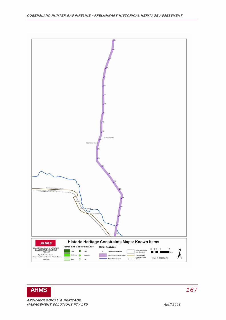
QUEENSLAND HUNTER GAS PIPELINE – PRELIMINARY HISTORICAL HERITAGE ASSESSMENT
AHMS 167
ARCHAEOLOGICAL & HERITAGE MANAGEMENT SOLUTIONS PTY LTD April 2008
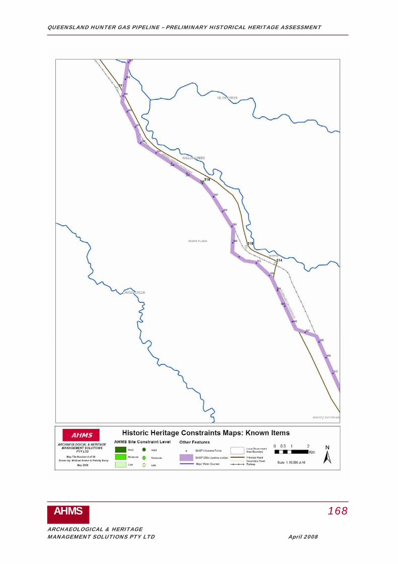
QUEENSLAND HUNTER GAS PIPELINE – PRELIMINARY HISTORICAL HERITAGE ASSESSMENT
AHMS 168
ARCHAEOLOGICAL & HERITAGE MANAGEMENT SOLUTIONS PTY LTD April 2008

QUEENSLAND HUNTER GAS PIPELINE – PRELIMINARY HISTORICAL HERITAGE ASSESSMENT
AHMS 169
ARCHAEOLOGICAL & HERITAGE MANAGEMENT SOLUTIONS PTY LTD April 2008

QUEENSLAND HUNTER GAS PIPELINE – PRELIMINARY HISTORICAL HERITAGE ASSESSMENT
AHMS 170
ARCHAEOLOGICAL & HERITAGE MANAGEMENT SOLUTIONS PTY LTD April 2008

QUEENSLAND HUNTER GAS PIPELINE – PRELIMINARY HISTORICAL HERITAGE ASSESSMENT
AHMS 171
ARCHAEOLOGICAL & HERITAGE MANAGEMENT SOLUTIONS PTY LTD April 2008

QUEENSLAND HUNTER GAS PIPELINE – PRELIMINARY HISTORICAL HERITAGE ASSESSMENT
AHMS 172
ARCHAEOLOGICAL & HERITAGE MANAGEMENT SOLUTIONS PTY LTD April 2008

QUEENSLAND HUNTER GAS PIPELINE – PRELIMINARY HISTORICAL HERITAGE ASSESSMENT
AHMS 173
ARCHAEOLOGICAL & HERITAGE MANAGEMENT SOLUTIONS PTY LTD April 2008

QUEENSLAND HUNTER GAS PIPELINE – PRELIMINARY HISTORICAL HERITAGE ASSESSMENT
AHMS 174
ARCHAEOLOGICAL & HERITAGE MANAGEMENT SOLUTIONS PTY LTD April 2008

QUEENSLAND HUNTER GAS PIPELINE – PRELIMINARY HISTORICAL HERITAGE ASSESSMENT
AHMS 175
ARCHAEOLOGICAL & HERITAGE MANAGEMENT SOLUTIONS PTY LTD April 2008

QUEENSLAND HUNTER GAS PIPELINE – PRELIMINARY HISTORICAL HERITAGE ASSESSMENT
AHMS 176
ARCHAEOLOGICAL & HERITAGE MANAGEMENT SOLUTIONS PTY LTD April 2008

QUEENSLAND HUNTER GAS PIPELINE – PRELIMINARY HISTORICAL HERITAGE ASSESSMENT
AHMS 177
ARCHAEOLOGICAL & HERITAGE MANAGEMENT SOLUTIONS PTY LTD April 2008

QUEENSLAND HUNTER GAS PIPELINE – PRELIMINARY HISTORICAL HERITAGE ASSESSMENT
AHMS 178
ARCHAEOLOGICAL & HERITAGE MANAGEMENT SOLUTIONS PTY LTD April 2008

QUEENSLAND HUNTER GAS PIPELINE – PRELIMINARY HISTORICAL HERITAGE ASSESSMENT
AHMS 179
ARCHAEOLOGICAL & HERITAGE MANAGEMENT SOLUTIONS PTY LTD April 2008

QUEENSLAND HUNTER GAS PIPELINE – PRELIMINARY HISTORICAL HERITAGE ASSESSMENT
AHMS 180
ARCHAEOLOGICAL & HERITAGE MANAGEMENT SOLUTIONS PTY LTD April 2008

QUEENSLAND HUNTER GAS PIPELINE – PRELIMINARY HISTORICAL HERITAGE ASSESSMENT
AHMS 181
ARCHAEOLOGICAL & HERITAGE MANAGEMENT SOLUTIONS PTY LTD April 2008

QUEENSLAND HUNTER GAS PIPELINE – PRELIMINARY HISTORICAL HERITAGE ASSESSMENT
AHMS 182
ARCHAEOLOGICAL & HERITAGE MANAGEMENT SOLUTIONS PTY LTD April 2008

QUEENSLAND HUNTER GAS PIPELINE – PRELIMINARY HISTORICAL HERITAGE ASSESSMENT
AHMS 183
ARCHAEOLOGICAL & HERITAGE MANAGEMENT SOLUTIONS PTY LTD April 2008

QUEENSLAND HUNTER GAS PIPELINE – PRELIMINARY HISTORICAL HERITAGE ASSESSMENT
AHMS 184
ARCHAEOLOGICAL & HERITAGE MANAGEMENT SOLUTIONS PTY LTD April 2008

QUEENSLAND HUNTER GAS PIPELINE – PRELIMINARY HISTORICAL HERITAGE ASSESSMENT
AHMS 185
ARCHAEOLOGICAL & HERITAGE MANAGEMENT SOLUTIONS PTY LTD April 2008

QUEENSLAND HUNTER GAS PIPELINE – PRELIMINARY HISTORICAL HERITAGE ASSESSMENT
AHMS 186
ARCHAEOLOGICAL & HERITAGE MANAGEMENT SOLUTIONS PTY LTD April 2008

QUEENSLAND HUNTER GAS PIPELINE – PRELIMINARY HISTORICAL HERITAGE ASSESSMENT
AHMS 187
ARCHAEOLOGICAL & HERITAGE MANAGEMENT SOLUTIONS PTY LTD April 2008

QUEENSLAND HUNTER GAS PIPELINE – PRELIMINARY HISTORICAL HERITAGE ASSESSMENT
AHMS 188
ARCHAEOLOGICAL & HERITAGE MANAGEMENT SOLUTIONS PTY LTD April 2008

QUEENSLAND HUNTER GAS PIPELINE – PRELIMINARY HISTORICAL HERITAGE ASSESSMENT
AHMS 189
ARCHAEOLOGICAL & HERITAGE MANAGEMENT SOLUTIONS PTY LTD April 2008

QUEENSLAND HUNTER GAS PIPELINE – PRELIMINARY HISTORICAL HERITAGE ASSESSMENT
AHMS 190
ARCHAEOLOGICAL & HERITAGE MANAGEMENT SOLUTIONS PTY LTD April 2008

QUEENSLAND HUNTER GAS PIPELINE – PRELIMINARY HISTORICAL HERITAGE ASSESSMENT
AHMS 191
ARCHAEOLOGICAL & HERITAGE MANAGEMENT SOLUTIONS PTY LTD April 2008
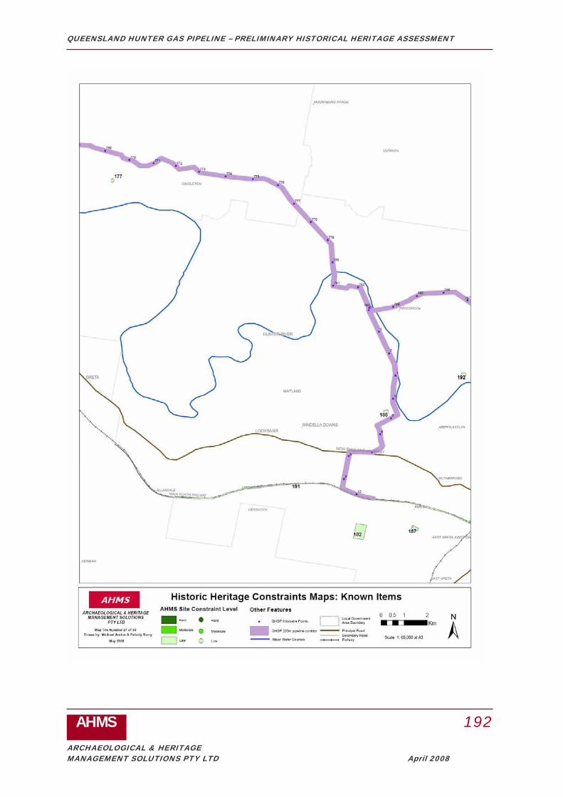
QUEENSLAND HUNTER GAS PIPELINE – PRELIMINARY HISTORICAL HERITAGE ASSESSMENT
AHMS 192
ARCHAEOLOGICAL & HERITAGE MANAGEMENT SOLUTIONS PTY LTD April 2008

QUEENSLAND HUNTER GAS PIPELINE – PRELIMINARY HISTORICAL HERITAGE ASSESSMENT
AHMS 193
ARCHAEOLOGICAL & HERITAGE MANAGEMENT SOLUTIONS PTY LTD April 2008

QUEENSLAND HUNTER GAS PIPELINE – PRELIMINARY HISTORICAL HERITAGE ASSESSMENT
AHMS 194
ARCHAEOLOGICAL & HERITAGE MANAGEMENT SOLUTIONS PTY LTD April 2008

QUEENSLAND HUNTER GAS PIPELINE – PRELIMINARY HISTORICAL HERITAGE ASSESSMENT
AHMS 195
ARCHAEOLOGICAL & HERITAGE MANAGEMENT SOLUTIONS PTY LTD April 2008
