history & geographymedia.glnsrv.com/pdf/products/sample_pages/sample_his...1. geography north...
TRANSCRIPT

804 N. 2nd Ave. E.Rock Rapids, IA 51246-1759
800-622-3070www.aop.com
GEOGRAPHYHISTORY &STUDENT BOOK
4th Grade | Unit 9
HISTORY & GEOGRAPHY 409NORTH AMERICA
Introduction |3
1. Geography ...................................................4Land, Lakes, and Rivers |6Peninsulas, Oceans, and Islands |10Other Facts |14Self Test 1 |19
2. Northern Countries ................................ 22Greenland |23Canada |26United States |33States and Capitals Test |55Self Test 2 |56
3. Southern Countries ................................ 59Mexico |60Central America |62West Indies |66Self Test 3 |71
LIFEPAC Test |Pull-out
| 1
Unit 9 | NORTH AMERICA

Author: Theresa K. Buskey, B.A., J.D.
Editor: Alan Christopherson, M.S.
Assistant Editor: Annette M. Walker, B.S.
Media Credits: Page 3: © 1xpert, iStock,Thinkstock; 4: © alehnia, iStock, Thinkstock; 6: © Oleg Fedorkin, Hemera, Thinkstock; 7: © WerksMedia, iStock, Thinkstock; 8: © Ricardo Reitmeyer, iStock, Thinkstock ; © Jim Pintar, iStock, Thinkstock; 11: © Stocktrek Images, Thinkstock © devans1, iStock, Thinkstock, © shalamov, iStock, Thinkstock; 13: © JPaulB, iStock, Thinkstock; 15: © venturecx, iStock, Thinkstock, © Dodge65, iStock, Thinkstock, © jvdwolf, iStock, Thinkstock; 17: © Mike Watson Images, iStock, Thinkstock; 22: © Stockbyte, Thinkstock; 24: © Enrique Jggarcia, iStock, Thinkstock; 25: © Henri Vdl, iStock, Thinkstock; 27: © Androsov, iStock, Thinkstock, © Purestock, Thinkstock; 29: © Hemera Technologies, AbleStock.com, Thinkstock; 30: © Vladone, iStock, Thinkstock; 31: © Bee Creative, iStock, Thinkstock; © ErikaMitchell, iStock, Thinkstock; 32, 36, 40: © Dorling Kindersley, Thinkstock; 37: © DebraMillet, Thinkstock; 41: © Livinus, iStock, Thinkstock; 44: © Linda Parton, iStock, Thinkstock; 46: © prudkov, iStock, Thinkstock; 48: © kojihirano, iStock, Thinkstock; 51: © theartist312, iStock, Thinkstock; 59: © Bill Berry Photography, iStock, Thinkstock; 61: © dubassy, iStock, Thinkstock; 64: © Castillo Dominici, iStock, Thinkstock; 67: © fatchoi, iStock, Thinkstock; 67: © brocreative, iStock, Thinkstock;
All maps in this book © Image Resources, unless otherwise stated.
804 N. 2nd Ave. E. Rock Rapids, IA 51246-1759
© MCMXCVIII by Alpha Omega Publications, Inc. All rights reserved. LIFEPAC is a registered trademark of Alpha Omega Publications, Inc.
All trademarks and/or service marks referenced in this material are the property of their respective owners.
Alpha Omega Publications, Inc. makes no claim of ownership to any trademarks and/or service marks other than
their own and their affiliates, and makes no claim of affiliation to any companies whose trademarks may be listed
in this material, other than their own.
2 |
NORTH AMERICA | Unit 9

ObjectivesRead these objectives. The objectives tell you what you will be able to do when you have successfully completed this LIFEPAC. Each section will list according to the numbers below what objectives will be met in that section. When you have finished this LIFEPAC, you should be able to:
1. Name and find on a map many of the geographic features of North America.2. Name the major countries/regions of North America.3. Name the states on a blank map of the United States.4. Match U.S. states and their capitals.5. Tell about the geography, history, and people of the major countries/regions of
North America.6. Recognize the names of the countries of Central America.7. Recognize the names of the major islands of the West Indies.
NORTH AMERICAThis LIFEPAC® will teach the basic geography of North America. This
will require you to memorize many names and places. You will learn
the features of the continent and the countries. Then, when there is an
oil spill near the Aleutian Islands, a volcanic eruption in Honduras, or a
shipwreck near the Bahamas, you will know what the news reporter is
talking about. You will also learn your U.S. states and capitals in this
LIFEPAC. Many of the terms you have used this year will be reviewed
and used to identify places on the continent. Places you need to be
able to find on a map will be underlined. So, sharpen your brain and
start learning your way around North America!!
| 3
Unit 9 | NORTH AMERICA

1. GEOGRAPHYNorth America is the third largest continent on earth. It stretches
from inside the Arctic Circle to a point only 700 miles (1,126 km)
from the equator. It is shaped sort of like a big triangle balanced on
one corner. The continent includes Greenland, Canada, the United
States, Mexico, Central America (the countries south of Mexico), and
the West Indies. The map on the next page shows the size, shape, and
many of the important features of North America.
ObjectivesReview these objectives. When you have completed this section, you should be able to:
1. Name and find on a map many of the geographic features of North America.2. Name the major countries/regions of North America.5. Tell about the geography, history, and people of the major countries/regions of
North America.
VocabularyStudy these new words. Learning the meanings of these words is a good study habit and will improve your understanding of this LIFEPAC.
abundance ( bun’ d ns). Great plenty; quantity that is more than enough.
cordillera (kôr’ dil yâr’ ). A group of mountain ranges, often consisting of a number of parallel chains. Usually the largest group on a continent.
heritage (her’ tij). What is handed down from one generation to the next.
lock (lok). The part of a canal in which the level of the water can be changed by letting water in or out, to raise or lower ships.
mainland (mān’ land). The main part of a continent or country, not including islands or small peninsulas.
4 | Section 1
NORTH AMERICA | Unit 9

| North America with its major features
migrate (mī’ grāt). To move from one place to settle in another.
overwhelm (ō’ v r hwelm’). To crush or defeat; overcome completely.
province (prov’ ins). One of the main divisions of a country.
range (rānj). A row or line of mountains.
source (sôrs). A person or place from which anything comes or is obtained.
Note: All vocabulary words in this LIFEPAC appear in boldface print the first time they are used. If you are unsure of the meaning when you are reading, study the definitions given.
Pronunciation Key: hat, āge, cãre, fär; let, ēqual, tėrm; it, īce; hot, ōpen, ôrder; oil; out; cup, pu·t, rüle; child; long; thin; /ŦH/ for then; /zh/ for measure; /u/ or / e/ represents /a/ in about, /e/ in taken, /i/ in pencil, /o/ in lemon, and /u/ in circus.
UNITED STATES
CANADA
GREENLAND
ICELAND
MEXICO
CENTRAL AMERICASOUTH AMERICA
WEST INDIES
ATLANTICOCEAN
PACIFICOCEAN
GULF OFMEXICO
MIS
SISS
IPP
I RIV
ER
COASTAL PLAINSAPPALACHIA
N
MOUNTAIN
S
HUDSONBAY
LABRADORSEA
ARCTICOCEAN
BAFFINBAY
BERINGSEA
CENTRAL LOWLANDS
CANADIANSHIELD
LAURENTIAN
MOUNTAINSGREAT PLAINS
CO
RD
ILLER
A
CO
RD
ILLERA
CO
RD
ILL
ER
AC
OR
DIL
LE
RA
ARCTIC CIRCLE
ALEUTIANISLANDS
TROPIC OF CANCER
BAFFIN ISLAND
ALASKA(USA)
Section 1 | 5
Unit 9 | NORTH AMERICA

Land, Lakes, and Rivers
The Land. North America has a set of mountain ranges on both sides and a large plain in the center. All along western (left, on a map) Canada and the United States are a group of mountains called the cordillera. These mountains continue south to cover most of Mexico and Central America. On the eastern (right) side of Canada and the U.S. is another set of mountain ranges, the Appalachian Mountains and Laurentian Mountains. The Appalachians are south of the St. Lawrence River, while the Laurentians are to the north. Between the eastern and western mountain ranges spreads a huge, fertile plain.
The cordillera are better known by the names given to the different ranges. The Rocky Mountains are probably the best known range in the American cordillera. They are the mountains that seem to spring up out of the Great Plains when you travel west across America. Even further west, there are other ranges along the Pacific coast. Between the Rocky Mountains and the coastal mountains is the Great Basin.
The Great Basin is a desert area of bowl-shaped plateaus between the mountains. It is a desert because the mountains block moisture from getting there. Any rain that does fall there is likely to be trapped in the bottom, like a basin, which gives the area its name.
In Mexico the cordillera form three ranges, called the Sierra Madres. The Sierra Madre Occidental are along the west coast, while the Sierra Madre Oriental are along the east coast. In the south is the Sierra Madre Del Sur. Between all of the mountain ranges is a plateau, where most of the people of Mexico live.
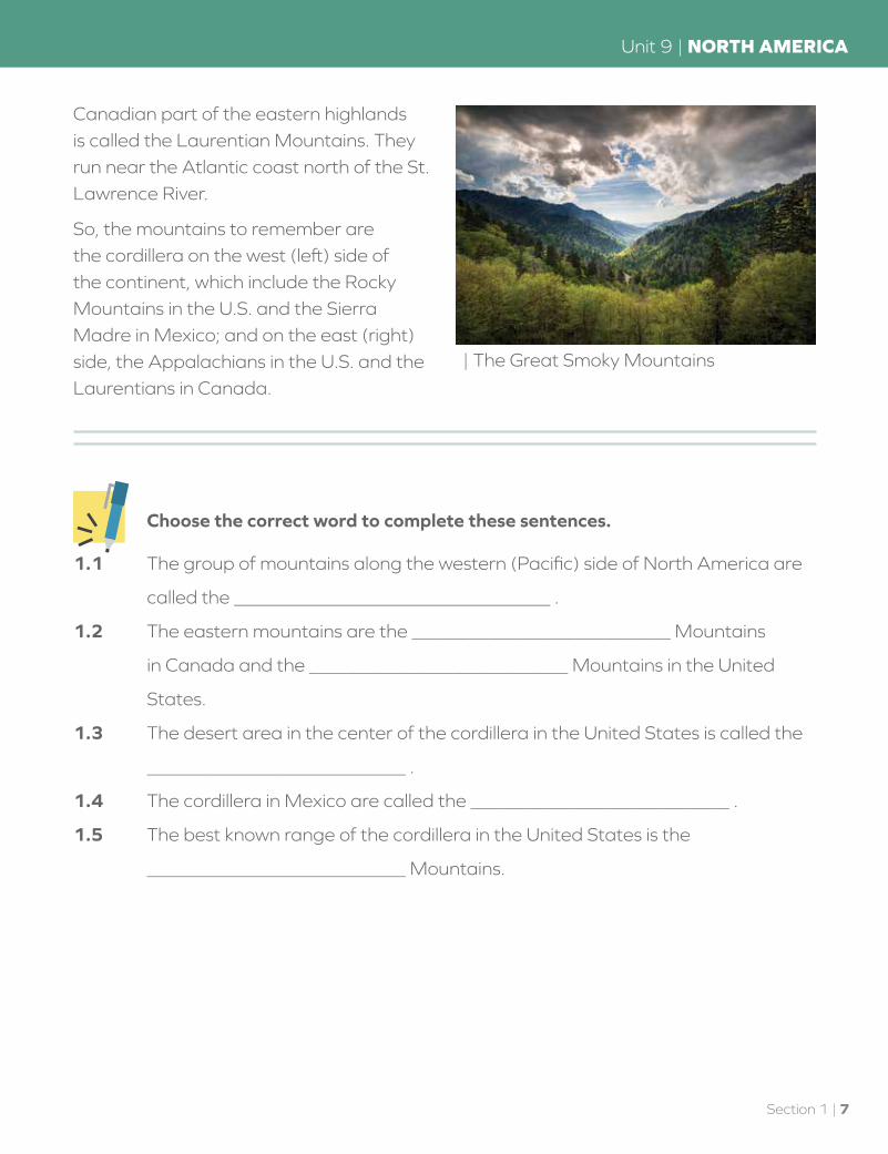
The eastern mountains are not as tall as the cordillera. The White, Green, Blue Ridge, and Great Smoky Mountains are part of the Appalachians, which stretch from Maine to Alabama. The European colonists who settled the Atlantic coast had to cross these mountains to reach the American frontier. The difficult traveling kept most Americans along the east coast until after the Revolutionary War. The
| The Great Basin includes Death Valley
6 | Section 1
NORTH AMERICA | Unit 9
Canadian part of the eastern highlands is called the Laurentian Mountains. They run near the Atlantic coast north of the St. Lawrence River.
So, the mountains to remember are the cordillera on the west (left) side of the continent, which include the Rocky Mountains in the U.S. and the Sierra Madre in Mexico; and on the east (right) side, the Appalachians in the U.S. and the Laurentians in Canada.
| The Great Smoky Mountains
Choose the correct word to complete these sentences.
1.1 The group of mountains along the western (Pacific) side of North America are
called the _________________________________ .
1.2 The eastern mountains are the ___________________________ Mountains
in Canada and the ___________________________ Mountains in the United
States.
1.3 The desert area in the center of the cordillera in the United States is called the
___________________________ .
1.4 The cordillera in Mexico are called the ___________________________ .
1.5 The best known range of the cordillera in the United States is the
___________________________ Mountains.
Section 1 | 7
Unit 9 | NORTH AMERICA
The plains between the eastern and western mountains are divided into three parts. The northern part is the Canadian Shield. (Also called the Laurentian Plateau). It is a plateau of rock that runs across northern Canada, around Hudson Bay, and as far south as the Great Lakes. There are many rivers which can be used for hydroelectric power. The soil is thin and not very good for crops, but the rocks are rich in mineral resources.
The southern part of the plains is the Central Lowlands. The western side, near the cordillera, is called the Great Plains. The Great Plains run from central Canada to Texas. It is a grassland of rich soil that gets drier the further west it goes.
Besides the eastern mountains, the cordillera, the Canadian Shield, the Great Plains, and the Central Lowlands, there is one other area of you should know. That is the Coastal Plains of the east. They run along the Atlantic coast in the United States and around the Gulf of Mexico. This area was quickly settled by the Europeans. It has good farmland, and rivers for transportation. This is where thirteen British colonies formed a new nation they called the United States of America.
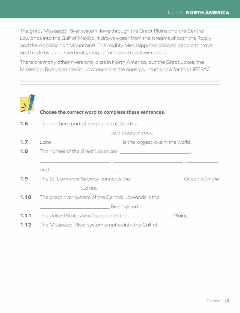
Lakes and Rivers. South of the Canadian Shield are five large lakes called the Great Lakes. They are on the border between Canada and the United States. Lake Superior, the largest freshwater lake in the world, is the one farthest to the west. Then comes Lake Michigan (the only one completely inside the United States), Lake Huron, Lake Erie, and Lake Ontario.
A system of rivers, canals, and locks connects all of the Great Lakes. They are also connected to the St. Lawrence River, which flows to the Atlantic Ocean. The whole system is called the St. Lawrence Seaway, because it allows ocean ships to sail into the center of the continent. This means that cities like Detroit, Chicago, Toronto, and Montreal are ocean port cities even though they are far inland.
| The Great Plains
| A light house on Lake Superior
8 | Section 1
NORTH AMERICA | Unit 9
The great Mississippi River system flows through the Great Plains and the Central Lowlands into the Gulf of Mexico. It draws water from the streams of both the Rocky and the Appalachian Mountains! The mighty Mississippi has allowed people to travel and trade by using riverboats, long before good roads were built.
There are many other rivers and lakes in North America, but the Great Lakes, the Mississippi River, and the St. Lawrence are the ones you must know for this LIFEPAC.
Choose the correct word to complete these sentences.
1.6 The northern part of the plains is called the __________________________
___________________________ , a plateau of rock.
1.7 Lake ___________________________ is the largest lake in the world.
1.8 The names of the Great Lakes are: ___________________________ ,
___________________________ , ___________________________ , ____________ ,
and _________________________ .
1.9 The St. Lawrence Seaway connects the ____________________ Ocean with the
________________ Lakes.
1.10 The great river system of the Central Lowlands is the
___________________________ River system.
1.11 The United States was founded on the _________________ Plains.
1.12 The Mississippi River system empties into the Gulf of _______________________ .
Section 1 | 9
Unit 9 | NORTH AMERICA

Peninsulas, Oceans, and Islands
The map of North America shows the major oceanside features of North America. Many of these are easy to remember if you can connect them with something nearby. The Gulf of California, for example, is south of California. The Gulf of Mexico is next to Mexico. Find little tricks and hints to help you remember each place and its name.
There are three important peninsulas you need to know. Baja California is the name of the Mexican peninsula that extends south of the state of California. It is a long, narrow, mountainous finger of land. The Florida Peninsula is easy: it is the state of Florida. The Yucatán Peninsula is on the southeast side of Mexico on the Gulf of Mexico. It divides the Gulf of Mexico from the Caribbean Sea. It was the home of an ancient Indian civilization called the Maya. Today the ruins of their cities are a tourist attraction for the peninsula. These are three important peninsulas in North America.
There is also an important isthmus you should know in North America. The Isthmus of Panama connects North and South America. It is one of the two most important land bridges in the world. (The other is the Isthmus of Suez, which connects Africa and Asia.)
There are four archipelagoes and three islands you should be able to find on the map. The archipelagoes are the Bahamas and the Antilles in the West Indies. The Bahama Islands are one independent country that is a part of the British Commonwealth. The Antilles Islands are made up of many island nations and territories. The Greater Antilles are the four large islands in the north (top), while the Lesser Antilles are the many smaller islands to the east and south.
The Queen Elizabeth Islands are part of the northern islands, which together are sometimes called the Arctic or Canadian Archipelago. They are so far north that they were not explored until the 1800s. This archipelago of the most northern islands was
UNITED STATES
CANADA
GREENLAND
ICELAND
MEXICO
CENTRAL AMERICASOUTH AMERICA
ATLANTICOCEAN
PACIFICOCEAN
GULF OFMEXICO
CARIBBEAN SEA
BA
JA C
ALIFO
RN
IA
YUCATAN
PENINSULA
FLORIDA
PENINSULA
NEWFOUNDLAND
BAHAMAS
LESSER
ANTILLES
GREATER
ANTILLES
ISTHMUS OF
PANAMA
HUDSONBAY
LABRADORSEA
ARCTICOCEAN
BAFFINBAY
BEAUFORTSEA
BERINGSEA QUEEN ELIZABETH
ISLANDS
ALASKA(USA)
ALEUTIANISLANDS
BAFFIN ISLAND
| North America
10 | Section 1
NORTH AMERICA | Unit 9

named after Queen Elizabeth II, who is the ruler of Britain and the official head of the government of Canada.
The Aleutian Islands are a long string of islands stretching out from Alaska toward Asia. They are named after the Aleuts, the Native American people who live there.
The islands you must find on the map are Greenland, Baffin Island, and Newfoundland. Greenland is the world’s largest island, and you will learn more about it in the section on countries. Baffin Island is Canada’s largest island and the fifth largest in the world. It is named after William Baffin, an English explorer, who visited it in 1616. The island has an arctic climate and few people live there.
Newfoundland (nü’ f nd l nd) is an island off the coast of Canada near the mouth of the St. Lawrence River. The mainland north of it is called Labrador. The two together are a province of Canada. It was here that the Vikings tried to start a colony after traveling from Greenland around the year A.D. 1000. The colony was eventually abandoned and it was not until 1497 that Europeans again set eyes on the “new found land.”
| Queen Elizabeth Islands, Canada
| Newfoundland, Canada
| Bahama Islands
Section 1 | 11
Unit 9 | NORTH AMERICA

Match each item with the correct description.
1.13 _________ Bahamas
1.14 _________ Baja
1.15 _________ Antilles
1.16 _________ Queen Elizabeth
1.17 _________ Yucatan
1.18 _________ Aleutian
1.19 _________ Greenland
1.20 _________ Florida
1.21 _________ Baffin
1.22 _________ Newfoundland
1.23 _________ Panama
a. island string from Alaska toward Asia
b. Mexican peninsula south of California
c. island near the mouth of the St. Lawrence
d. isthmus connecting North and South America
e. British Commonwealth island nation
f. peninsula that divides Caribbean from the Gulf of Mexico
g. world’s largest island
h. largest island in Canada
i. archipelago in northern Canada
j. peninsula off the southeast corner of the U.S.
k. West Indies archipelago, divided into Greater and Lesser
12 | Section 1
NORTH AMERICA | Unit 9
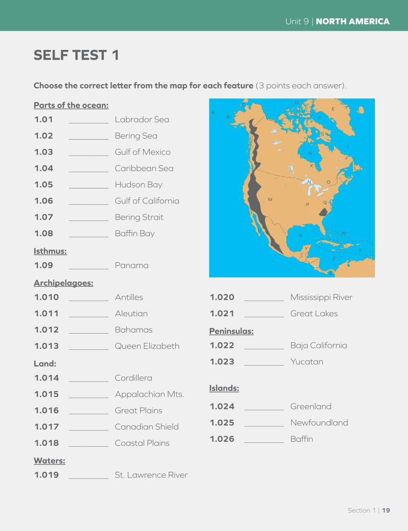
SELF TEST 1
Choose the correct letter from the map for each feature (3 points each answer).
Parts of the ocean:
1.01 _________ Labrador Sea
1.02 _________ Bering Sea
1.03 _________ Gulf of Mexico
1.04 _________ Caribbean Sea
1.05 _________ Hudson Bay
1.06 _________ Gulf of California
1.07 _________ Bering Strait
1.08 _________ Baffin Bay
Isthmus:
1.09 _________ Panama
Archipelagoes:
1.010 _________ Antilles
1.011 _________ Aleutian
1.012 _________ Bahamas
1.013 _________ Queen Elizabeth
Land:
1.014 _________ Cordillera
1.015 _________ Appalachian Mts.
1.016 _________ Great Plains
1.017 _________ Canadian Shield
1.018 _________ Coastal Plains
Waters:
1.019 _________ St. Lawrence River
1.020 _________ Mississippi River
1.021 _________ Great Lakes
Peninsulas:
1.022 _________ Baja California
1.023 _________ Yucatan
Islands:
1.024 _________ Greenland
1.025 _________ Newfoundland
1.026 _________ Baffin
M
T
U
Y
VW
X
Z
S
P Q
N O
L
I
K
H
G
F
EDC
BA
R
J
Section 1 | 19
Unit 9 | NORTH AMERICA

Choose the best word to complete each sentence from the list below (2 points each answer).
Sierra Madre Great Basin Rocky Canada Greenland Laurentian United States Mexico West Indies
1.027 The desert in the center of the mountains of the cordillera in the United States
is called the ________________________ .
1.028 The people of ________________________ are a mix of Inuit and Viking.
1.029 The people of ________________________ are a mix of Spanish and Indian.
1.030 ________________________ is a country that has the Central Lowlands, the
Great Plains, and the Coastal Plains for good farmland.
1.031 Many of the people of ________________________ came from France and
Britain.
1.032 The ________________________ Mountains are part of the cordillera in Mexico.
1.033 The ________________________ Mountains are the most famous part of the
cordillera in the United States.
1.034 The people of ________________________ are a mix of African and several
European countries.
1.035 The ________________________ Mountains are in Canada along the east
(Atlantic) coast.
20 | Section 1
NORTH AMERICA | Unit 9

Teacher check: Initials ___________
Score _____________________ Date ___________
80
100
Write true or false on the blank (1 point each answer).
1.036 _________ The Great Plains is one of the best areas in the world for growing grain.
1.037 _________ Almost all of the mineral resources in North America are in the United States.
1.038 _________ North America does not have and never did have many forests.
1.039 _________ The first settlers in North America came from Asia and became the many Native American tribes.
Section 1 | 21
Unit 9 | NORTH AMERICA
804 N. 2nd Ave. E.Rock Rapids, IA 51246-1759
800-622-3070www.aop.com
GEOGRAPHYHISTORY &STUDENT BOOK
ISBN 978-1-58095-159-3
9 7 8 1 5 8 0 9 5 1 5 9 3
HIS0409 – Jan ‘16 Printing