holborn - camden
TRANSCRIPT
HOLBORN VISION & URBAN STRATEGY
DraftNovember 2018
REG
ENER
ATIO
NA
ND
PLA
CE
INTRODUCTION
HOLBORN TODAY
VISION AND OBJECTIVES
URBAN STRATEGY HOLBORN GATEWAY
MUSEUM QUARTER
HOLBORN TO THE CITY
DELIVERY
CONTENTS
3
7
15
17
26
3 HOLBORN Vision and Urban Strategy
INTRODUCTION
Holborn is fundamental to the success of London. With a rich mix of employment sectors, a vibrant residential community and some of the city’s most iconic historic architecture, Holborn is a fantastic example of a thriving economic hub in a preserved historic setting.
In light of Holborn’s success, significant development and investment is already committed to the area with much more in the pipeline as the Elizabeth Line and significant other investments, such as TfL’s recently committed investment into Holborn’s public realm, in the area’s transport infrastructure is being injected into the area. As a result, Holborn is emerging as a key destination that links the City of London to the core of the West End and is evolving into an area that is capable of supporting London’s competitive status. We want to capture this opportunity to achieve the highest quality of development and environment that benefits all our communities and reinforces Holborn role as a centre for living, culture and business.
The role of this document
This document is the draft Holborn Vision and Urban Strategy, prepared by the Council’s Regeneration and Place Team. It sets out guidance to help coordinate development and investment in the area.
It is the Council’s intention that the final version of this document will be adopted as a Supplementary Planning Document (SPD). SPD’s play an important role, supporting the Council’s Development Plan, including the Local Plan, which sets the borough’s planning policies covering the period to 2031. It will be a material consideration in decision making and in determining planning applications.
Camden is seeking to work with its partners including the local residents, landowners, developers, the business community including the BeeMidTown and Hatton Garden Business Imporvement Districts and others to achieve our ambitions for the area. All communities and partners will have a role.
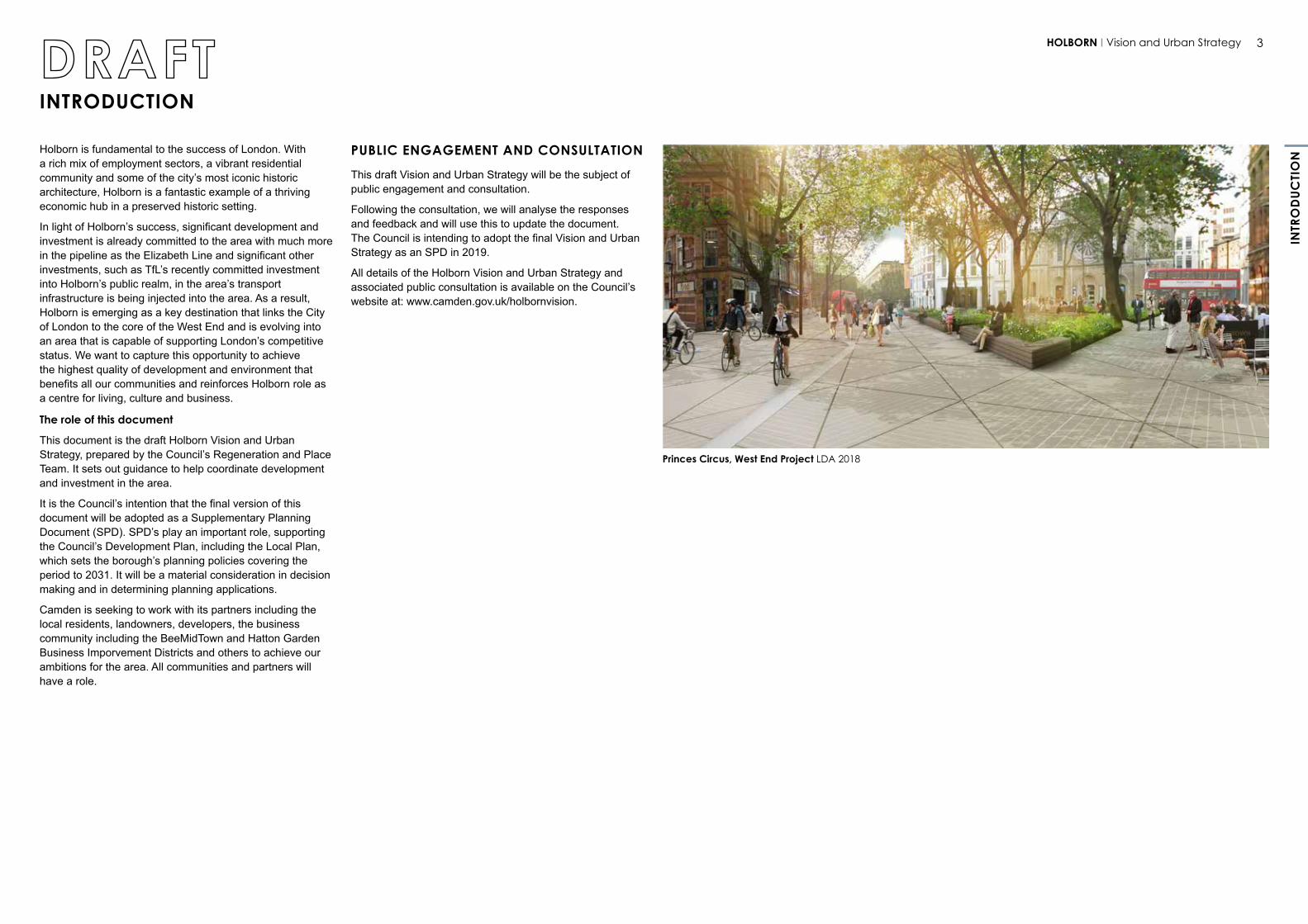
Princes Circus, West End Project LDA 2018
PUBLIC ENGAGEMENT AND CONSULTATION
This draft Vision and Urban Strategy will be the subject of public engagement and consultation.
Following the consultation, we will analyse the responses and feedback and will use this to update the document. The Council is intending to adopt the final Vision and Urban Strategy as an SPD in 2019.
All details of the Holborn Vision and Urban Strategy and associated public consultation is available on the Council’s website at: www.camden.gov.uk/holbornvision.
INTR
OD
UCTI
ON
4 HOLBORN Vision and Urban Strategy
INTR
OD
UCTI
ONCAMDEN’S LOCAL PLAN
Camden is experiencing significant change and population growth and has an identified need for 16,800 additional homes, 695,000sqm of office floor space and c30,000sqm of retail floor space by 2031. To meet these huge pressures, the Council’s objective is to create the conditions for sustainable growth that delivers opportunities and benefits for our residents and businesses.
Holborn is identified in Camden’s Local Plan as a key growth area and is expected to make a substantial contribution towards meeting the borough’s identified needs, including a minimum of 200 new homes and 2000 additional jobs by 2031. Holborn could exceed these figures if the area’s potential is realised through the measures outlined in this document.
The Council’s Local Plan aspirations for the Holborn area include:
• A mix of land uses, with offices and housing as the predominant uses in development schemes.
• Appropriate retail, food, drink and entertainment and service uses in the area’s Central London Frontage, taking opportunities to introduce ground floor town centre uses where the continuity of the frontage is currently broken.
• Development of a decentralised energy network.
• Improvements to the street environment, in particular the pedestrian environment to and around Holborn Underground station.
• Improved linkages and connections with the City of London, the Tottenham Court Road area and other neighbouring areas making walking and ‘way-finding’ easier and the provision of improved cycling facilities, particularly for visitors;
• Working with partners including TfL to relieve congestion at Holborn Underground station.
• Appropriate contributions to open space, community facilities, regeneration initiatives and employment and training schemes.
• High quality, sustainable design that respects its surroundings and conserves and enhances the area’s heritage assets and wider historic environment; and improving community safety.
• Address open space deficiencies
THE CAMDEN PLAN
The Council has worked together with communities to create a new borough-wide vision for Camden for 2025 and the Camden Plan sets out how the Council will help achieve these ambitions. We want to make sure that development and investment in the Holborn delivers on Camden Plan objectives to benefit our communities.
Some of the key ambitions of the Plan include affordable housing, making Camden a great place to do business and encouraging walking, cycling of public transport.
Camden’s 2025 borough-wide vision - key drivers for Holborn
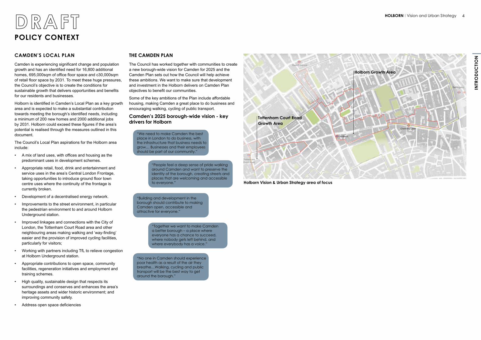
POLICY CONTEXT
Holborn Growth Area
Tottenham Court Road Growth Area
Holborn Vision & Urban Strategy area of focus
“We need to make Camden the best place in London to do business, with the infrastructure that business needs to grow… Businesses and their employees should be part of our community.”
“People feel a deep sense of pride walking around Camden and want to preserve the identity of the borough, creating streets and places that are welcoming and accessible to everyone.”
“Building and development in the borough should contribute to making Camden open, accessible and attractive for everyone.”
“No one in Camden should experience poor health as a result of the air they breathe…Walking, cycling and public transport will be the best way to get around the borough.”
“Together we want to make Camden a better borough – a place where everyone has a chance to succeed, where nobody gets left behind, and where everybody has a voice.”

THE CITY
SOUTHBANK
ST PANCRAS/KING’S CROSS
OXFORD STREET
WATERLOO
SOHO SEVEN DIALS
FITZROVIA
CLERKENWELL
MOUNT PLEASANT
SMITHFIELDBARBICAN
ST PAUL’S
HATTON GARDEN
COVENT GARDEN
NORTHBANK
CORAM’S FIELDS
BRITISH MUSEUM
UCL
CHINATOWN
TRAFALGAR SQUARE
LINCOLN’S INN
TEMPLE
GRAY’S INN
FARRINGDON
FETTER LANE
CHANCERY LANE
LEATHER LANE
BRUNSWICK CENTRE
HOLBORN
LAMB’S CONDUIT
STREET
EUSTON
LSE
GREAT ORMOND
STREETRUSSELL SQUARE
6 HOLBORN Vision and Urban Strategy
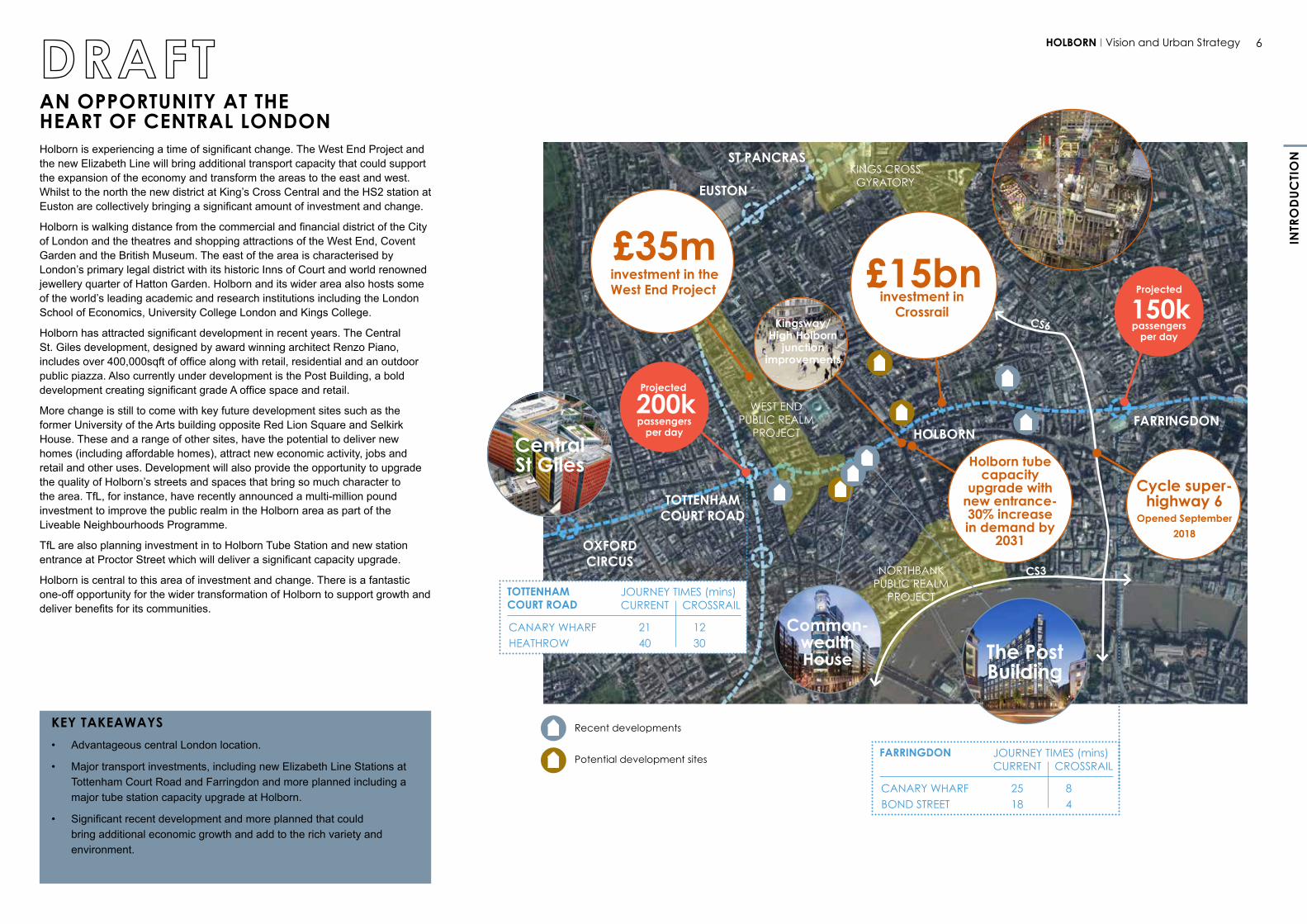
Holborn is experiencing a time of significant change. The West End Project and the new Elizabeth Line will bring additional transport capacity that could support the expansion of the economy and transform the areas to the east and west. Whilst to the north the new district at King’s Cross Central and the HS2 station at Euston are collectively bringing a significant amount of investment and change.
Holborn is walking distance from the commercial and financial district of the City of London and the theatres and shopping attractions of the West End, Covent Garden and the British Museum. The east of the area is characterised by London’s primary legal district with its historic Inns of Court and world renowned jewellery quarter of Hatton Garden. Holborn and its wider area also hosts some of the world’s leading academic and research institutions including the London School of Economics, University College London and Kings College.
Holborn has attracted significant development in recent years. The Central St. Giles development, designed by award winning architect Renzo Piano, includes over 400,000sqft of office along with retail, residential and an outdoor public piazza. Also currently under development is the Post Building, a bold development creating significant grade A office space and retail.
More change is still to come with key future development sites such as the former University of the Arts building opposite Red Lion Square and Selkirk House. These and a range of other sites, have the potential to deliver new homes (including affordable homes), attract new economic activity, jobs and retail and other uses. Development will also provide the opportunity to upgrade the quality of Holborn’s streets and spaces that bring so much character to the area. TfL, for instance, have recently announced a multi-million pound investment to improve the public realm in the Holborn area as part of the Liveable Neighbourhoods Programme.
TfL are also planning investment in to Holborn Tube Station and new station entrance at Proctor Street which will deliver a significant capacity upgrade.
Holborn is central to this area of investment and change. There is a fantastic one-off opportunity for the wider transformation of Holborn to support growth and deliver benefits for its communities.
AN OPPORTUNITY AT THE HEART OF CENTRAL LONDON
£35m investment in the West End Project £15bn
investment in Crossrail
200kpassengers
per day
Projected
Cycle super-highway 6
Opened September 2018
FARRINGDONHOLBORN
KINGS CROSSGYRATORY
WEST END PUBLIC REALM
PROJECT
NORTHBANKPUBLIC REALM
PROJECT
EUSTON
OXFORD CIRCUS
TOTTENHAM COURT ROAD
ST PANCRAS
Recent developments
Potential development sites
KEY TAKEAWAYS• Advantageous central London location.
• Major transport investments, including new Elizabeth Line Stations at Tottenham Court Road and Farringdon and more planned including a major tube station capacity upgrade at Holborn.
• Significant recent development and more planned that could bring additional economic growth and add to the rich variety and environment.
CANARY WHARFHEATHROW
TOTTENHAM COURT ROAD
2140
1230
JOURNEY TIMES (mins)CURRENT CROSSRAIL
CANARY WHARFBOND STREET
FARRINGDON
2518
84
JOURNEY TIMES (mins)CURRENT CROSSRAIL
150kpassengers
per day
Projected
Common-wealth House
Central St Giles
The Post Building
Holborn tube capacity
upgrade with new entrance- 30% increase in demand by
2031
CS3
CS6Kingsway/High Holborn
junction improvements
INTR
OD
UCTI
ON
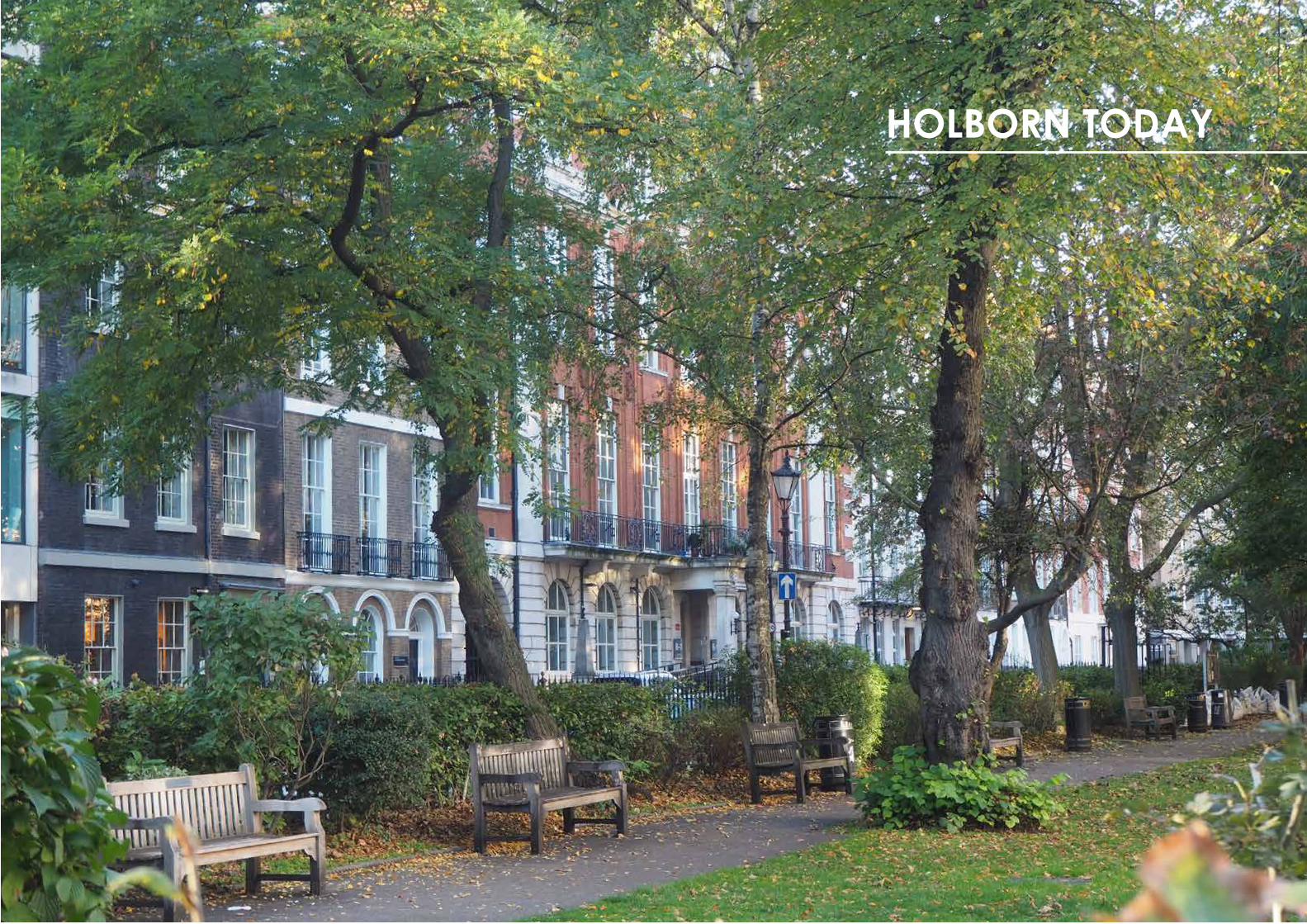
HOLBORN TODAY
8 HOLBORN Vision and Urban Strategy
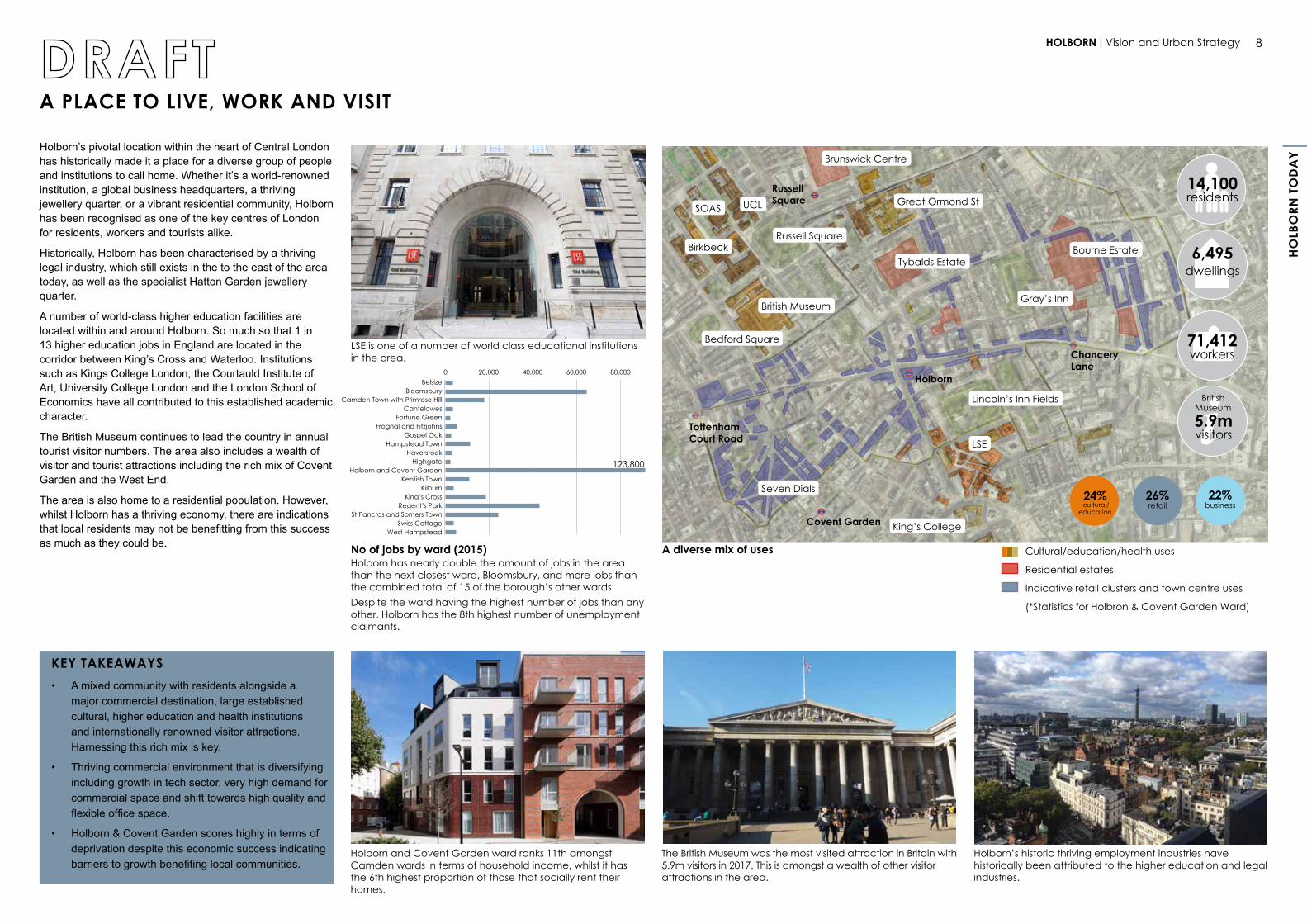
Holborn’s pivotal location within the heart of Central London has historically made it a place for a diverse group of people and institutions to call home. Whether it’s a world-renowned institution, a global business headquarters, a thriving jewellery quarter, or a vibrant residential community, Holborn has been recognised as one of the key centres of London for residents, workers and tourists alike.
Historically, Holborn has been characterised by a thriving legal industry, which still exists in the to the east of the area today, as well as the specialist Hatton Garden jewellery quarter.
A number of world-class higher education facilities are located within and around Holborn. So much so that 1 in 13 higher education jobs in England are located in the corridor between King’s Cross and Waterloo. Institutions such as Kings College London, the Courtauld Institute of Art, University College London and the London School of Economics have all contributed to this established academic character.
The British Museum continues to lead the country in annual tourist visitor numbers. The area also includes a wealth of visitor and tourist attractions including the rich mix of Covent Garden and the West End.
The area is also home to a residential population. However, whilst Holborn has a thriving economy, there are indications that local residents may not be benefitting from this success as much as they could be.
A PLACE TO LIVE, WORK AND VISIT
KEY TAKEAWAYS• A mixed community with residents alongside a
major commercial destination, large established cultural, higher education and health institutions and internationally renowned visitor attractions. Harnessing this rich mix is key.
• Thriving commercial environment that is diversifying including growth in tech sector, very high demand for commercial space and shift towards high quality and flexible office space.
• Holborn & Covent Garden scores highly in terms of deprivation despite this economic success indicating barriers to growth benefiting local communities.
The British Museum was the most visited attraction in Britain with 5.9m visitors in 2017. This is amongst a wealth of other visitor attractions in the area.
BelsizeBloomsbury
Camden Town with Primrose HillCantelowes
Fortune GreenFrognal and Fitzjohns
Gospel OakHampstead Town
HaverstockHighgate
Holborn and Covent GardenKentish Town
KilburnKing’s Cross
Regent’s ParkSt Pancras and Somers Town
Swiss CottageWest Hampstead
20,000 40,000 60,000 80,0000
123,800
No of jobs by ward (2015)
HO
LBO
RN T
OD
AY
A diverse mix of uses
Holborn’s historic thriving employment industries have historically been attributed to the higher education and legal industries.
26% retail
24% cultural/
education
22% business
14,100 residents
i5.9m visitors
6,495 dwellings
71,412 workers
British Museum
Holborn
Covent Garden
Chancery Lane
Russell Square
Tottenham Court Road
Bourne EstateTybalds Estate
British Museum
UCL
Birkbeck
King’s College
LSE
Lincoln’s Inn Fields
Russell Square
Great Ormond St
Brunswick Centre
Seven Dials
Gray’s Inn
SOAS
Bedford Square
Holborn and Covent Garden ward ranks 11th amongst Camden wards in terms of household income, whilst it has the 6th highest proportion of those that socially rent their homes.
Holborn has nearly double the amount of jobs in the area than the next closest ward, Bloomsbury, and more jobs than the combined total of 15 of the borough’s other wards.Despite the ward having the highest number of jobs than any other, Holborn has the 8th highest number of unemployment claimants.
Cultural/education/health uses
Residential estates
Indicative retail clusters and town centre uses
(*Statistics for Holbron & Covent Garden Ward)
LSE is one of a number of world class educational institutions in the area.
9 HOLBORN Vision and Urban Strategy
HO
LBO
RN T
OD
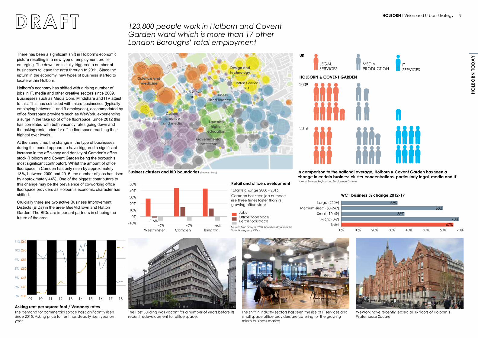
AYThere has been a significant shift in Holborn’s economic
picture resulting in a new type of employment profile emerging. The downturn initially triggered a number of businesses to leave the area through to 2011. Since the upturn in the economy, new types of business started to locate within Holborn.
Holborn’s economy has shifted with a rising number of jobs in IT, media and other creative sectors since 2009. Businesses such as Media Com, Mindshare and ITV attest to this. This has coincided with micro businesses (typically employing between 1 and 9 employees), accommodated by office floorspace providers such as WeWork, experiencing a surge in the take up of office floorspace. Since 2012 this has correlated with both vacancy rates going down and the asking rental price for office floorspace reaching their highest ever levels.
At the same time, the change in the type of businesses during this period appears to have triggered a significant increase in the efficiency and density of Camden’s office stock (Holborn and Covent Garden being the borough’s most significant contributor). Whilst the amount of office floorspace in Camden has only risen by approximately 13%, between 2000 and 2016, the number of jobs has risen by approximately 44%. One of the biggest contributors to this change may be the prevalence of co-working office floorspace providers as Holborn’s economic character has shifted.
Cruicially there are two active Business Improvement Districts (BIDs) in the area- BeeMidTown and Hatton Garden. The BIDs are important partners in shaping the future of the area.
The demand for commercial space has significantly risen since 2015. Asking price for rent has steadily risen year on year.
Asking rent per square foot / Vacancy rates
09 10 11 12 13 14 15 16 17 18
£65
£60
£55
£50
£45
£40
£35
10%
9%
8%
7%
6%
5%
11%
WeWork have recently leased all six floors of Holborn’s 1 Waterhouse Square
The shift in industry sectors has seen the rise of IT services and small space office providers are catering for the growing micro business market
The Post Building was vacant for a number of years before its recent redevelopment for office space.
2009
Retail and office developmentTotal % change 2000 - 2016Camden has seen job numbers rise three times faster than its growing office stock.
0%
10%
20%
30%
40%
50%
-10%
Westminster Camden Islington
-1.6%-6%-6%-6%
JobsOffice floorspaceRetail floorspace
Source: Arup analysis (2018) based on data from the Valuation Agency Office.
In comparison to the national average, Holborn & Covent Garden has seen a change in certain business cluster concentrations, particularly legal, media and IT. (Source: Business Register and Employment Survey)
Large (250+)Medium-sized (50-249)
Small (10-49)Micro (0-9)
Total
WC1 business % change 2012-17
0% 10% 20% 30% 40% 50% 60% 70%
33%60%
38%70%
67%
2016
UK
LEGAL SERVICES
MEDIA PRODUCTION
IT SERVICES
HOLBORN & COVENT GARDEN
Business clusters and BID boundaries (Source: Arup)
Hatton Garden BID
Bee Midtown BID
123,800 people work in Holborn and Covent Garden ward which is more than 17 other London Boroughs’ total employment
Culture, creative
and media
Science and medicine
Law and higher
education
Design and technology
Business and finance
Governmental institutions
10 HOLBORN Vision and Urban Strategy
HO
LBO
RN T
OD
AY
CHARACTER AND HERITAGE
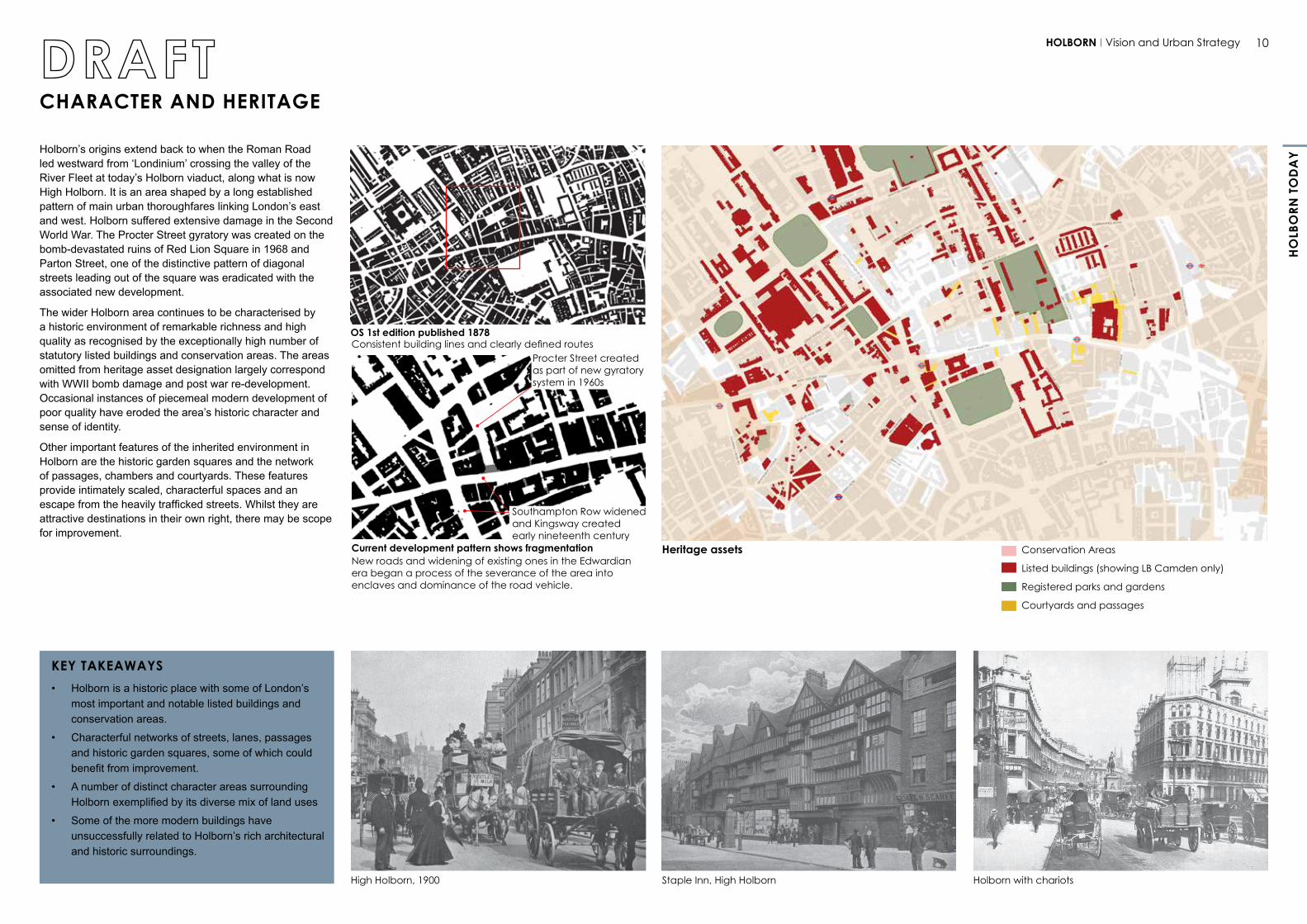
Holborn’s origins extend back to when the Roman Road led westward from ‘Londinium’ crossing the valley of the River Fleet at today’s Holborn viaduct, along what is now High Holborn. It is an area shaped by a long established pattern of main urban thoroughfares linking London’s east and west. Holborn suffered extensive damage in the Second World War. The Procter Street gyratory was created on the bomb-devastated ruins of Red Lion Square in 1968 and Parton Street, one of the distinctive pattern of diagonal streets leading out of the square was eradicated with the associated new development.
The wider Holborn area continues to be characterised by a historic environment of remarkable richness and high quality as recognised by the exceptionally high number of statutory listed buildings and conservation areas. The areas omitted from heritage asset designation largely correspond with WWII bomb damage and post war re-development. Occasional instances of piecemeal modern development of poor quality have eroded the area’s historic character and sense of identity.
Other important features of the inherited environment in Holborn are the historic garden squares and the network of passages, chambers and courtyards. These features provide intimately scaled, characterful spaces and an escape from the heavily trafficked streets. Whilst they are attractive destinations in their own right, there may be scope for improvement.
KEY TAKEAWAYS• Holborn is a historic place with some of London’s
most important and notable listed buildings and conservation areas.
• Characterful networks of streets, lanes, passages and historic garden squares, some of which could benefit from improvement.
• A number of distinct character areas surrounding Holborn exemplified by its diverse mix of land uses
• Some of the more modern buildings have unsuccessfully related to Holborn’s rich architectural and historic surroundings.
Conservation Areas
Listed buildings (showing LB Camden only)
Registered parks and gardens
Courtyards and passages
Heritage assetsCurrent development pattern shows fragmentation
OS 1st edition published 1878
Southampton Row widened and Kingsway created early nineteenth century
Procter Street created as part of new gyratory system in 1960s
Consistent building lines and clearly defined routes
New roads and widening of existing ones in the Edwardian era began a process of the severance of the area into enclaves and dominance of the road vehicle.
High Holborn, 1900 Staple Inn, High Holborn Holborn with chariots
11 HOLBORN Vision and Urban Strategy
Bloomsbury represents a period of London’s early expansion northwards, dating from around 1660, which continued through the Georgian and Regency periods to around 1840.
The historic character derives from its robustly detailed buildings of the late 19th-mid 20th centuries, combined with an intricate street pattern overlaid on undulating topography.
Within the Strand Conservation Area there are areas of distinct character; the two main routes of the Strand and the Victoria Embankment holding the area together.
Camden Conservation Areas
City of London Conservation Areas
Westminster Conservation Areas
Conservation Areas
Seven Dials’ unique character sees vibrant economic activity combined with the conservation of built heritage, creating a place that is important to Camden and to London.
Kingsway Conservation Area is characterised by a complete example of large scale Edwardian architecture.
Chancery Lane has significant historic associations with the legal profession, with origins as a centre for medieval legal administration, around buildings such as Staple Inn (above) .
Bloomsbury
Hatton Garden
Seven Dials
Kingsway
Denmark Street
Chancery Lane (City of London)
Strand (Westminster City Council)
1234567
Denmark Street Conservation Area sees seven centuries of history expressed in the street layout, the legacy of buildings, open spaces and mix of uses.
1 22
3
5 6 7
4
HO
LBO
RN T
OD
AY
12 HOLBORN Vision and Urban Strategy
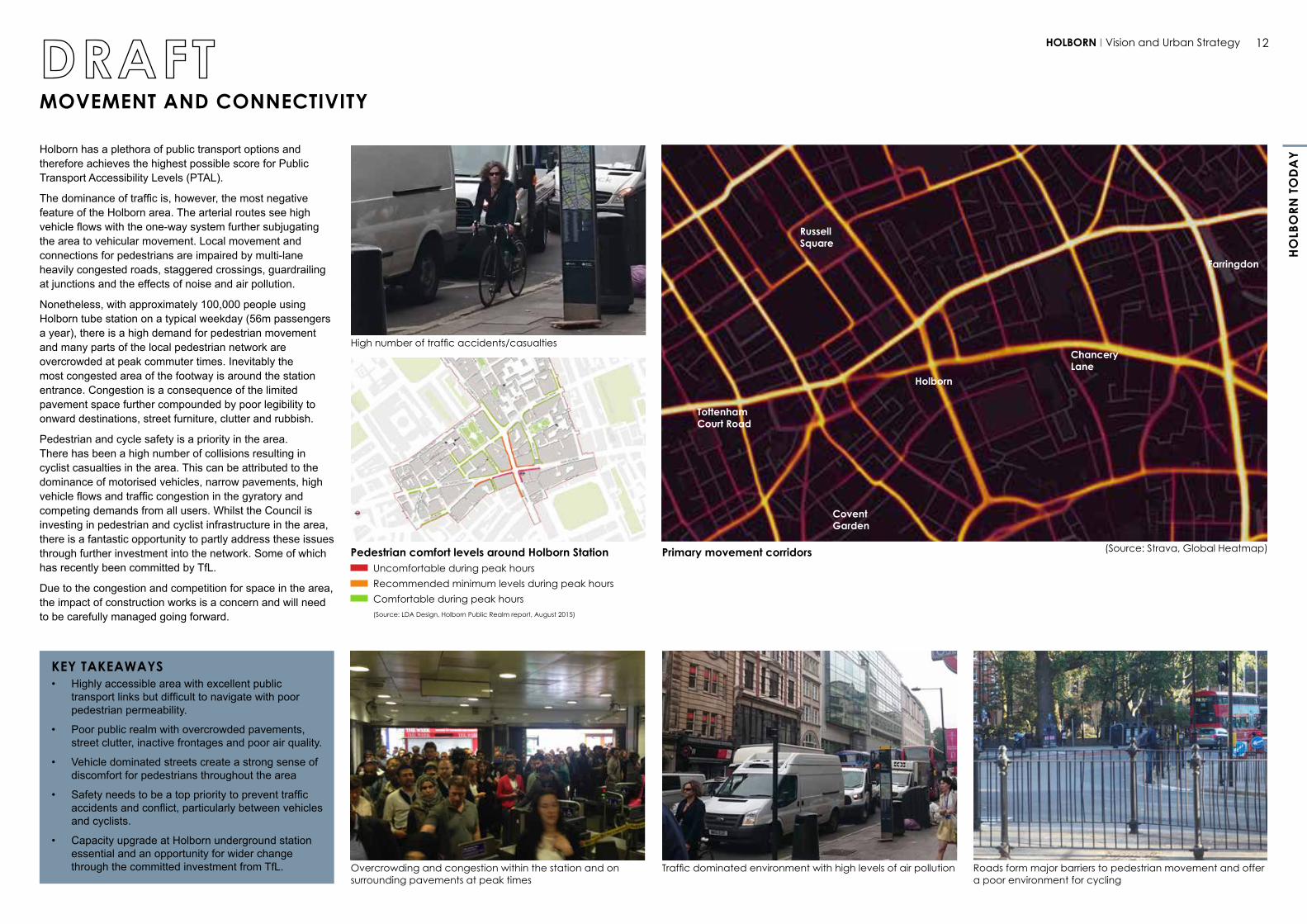
Holborn has a plethora of public transport options and therefore achieves the highest possible score for Public Transport Accessibility Levels (PTAL).
The dominance of traffic is, however, the most negative feature of the Holborn area. The arterial routes see high vehicle flows with the one-way system further subjugating the area to vehicular movement. Local movement and connections for pedestrians are impaired by multi-lane heavily congested roads, staggered crossings, guardrailing at junctions and the effects of noise and air pollution.
Nonetheless, with approximately 100,000 people using Holborn tube station on a typical weekday (56m passengers a year), there is a high demand for pedestrian movement and many parts of the local pedestrian network are overcrowded at peak commuter times. Inevitably the most congested area of the footway is around the station entrance. Congestion is a consequence of the limited pavement space further compounded by poor legibility to onward destinations, street furniture, clutter and rubbish.
Pedestrian and cycle safety is a priority in the area. There has been a high number of collisions resulting in cyclist casualties in the area. This can be attributed to the dominance of motorised vehicles, narrow pavements, high vehicle flows and traffic congestion in the gyratory and competing demands from all users. Whilst the Council is investing in pedestrian and cyclist infrastructure in the area, there is a fantastic opportunity to partly address these issues through further investment into the network. Some of which has recently been committed by TfL.
Due to the congestion and competition for space in the area, the impact of construction works is a concern and will need to be carefully managed going forward.
Overcrowding and congestion within the station and on surrounding pavements at peak times
Traffic dominated environment with high levels of air pollution Roads form major barriers to pedestrian movement and offer a poor environment for cycling
Pedestrian comfort levels around Holborn Station
MOVEMENT AND CONNECTIVITY
KEY TAKEAWAYS• Highly accessible area with excellent public
transport links but difficult to navigate with poor pedestrian permeability.
• Poor public realm with overcrowded pavements, street clutter, inactive frontages and poor air quality.
• Vehicle dominated streets create a strong sense of discomfort for pedestrians throughout the area
• Safety needs to be a top priority to prevent traffic accidents and conflict, particularly between vehicles and cyclists.
• Capacity upgrade at Holborn underground station essential and an opportunity for wider change through the committed investment from TfL.
30% of Holborn’s area is covered by roadways, the highest of any other ward.
(Source: LDA Design, Holborn Public Realm report, August 2015)
Uncomfortable during peak hoursRecommended minimum levels during peak hoursComfortable during peak hours
HO
LBO
RN T
OD
AY
Primary movement corridors
High number of traffic accidents/casualties
Holborn
Covent Garden
Chancery Lane
Russell Square
Tottenham Court Road
Farringdon
(Source: Strava, Global Heatmap)
13 HOLBORN Vision and Urban Strategy
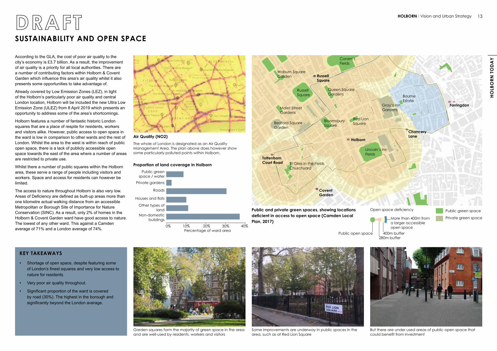
According to the GLA, the cost of poor air quality to the city’s economy is £3.7 billion. As a result, the improvement of air quality is a priority for all local authorities. There are a number of contributing factors within Holborn & Covent Garden which influence this area’s air quality whilst it also presents some opportunities to take advantage of.
Already covered by Low Emission Zones (LEZ), in light of the Holborn’s particularly poor air quality and central London location, Holborn will be included the new Ultra Low Emission Zone (ULEZ) from 8 April 2019 which presents an opportunity to address some of the area’s shortcomings.
Holborn features a number of fantastic historic London squares that are a place of respite for residents, workers and visitors alike. However, public access to open space in the ward is low in comparison to other wards and the rest of London. Whilst the area to the west is within reach of public open space, there is a lack of publicly accessible open space towards the east of the area where a number of areas are restricted to private use.
Whilst there a number of public squares within the Holborn area, these serve a range of people including visitors and workers. Space and access for residents can however be limited.
The access to nature throughout Holborn is also very low. Areas of Deficiency are defined as built-up areas more than one kilometre actual walking distance from an accessible Metropolitan or Borough Site of Importance for Nature Conservation (SINC). As a result, only 2% of homes in the Holborn & Covent Garden ward have good access to nature. The lowest of any other ward. This against a Camden average of 71% and a London average of 74%.
KEY TAKEAWAYS
• Shortage of open space, despite featuring some of London’s finest squares and very low access to nature for residents.
• Very poor air quality throughout.
• Significant proportion of the ward is covered by road (30%). The highest in the borough and significantly beyond the London average.
SUSTAINABILITY AND OPEN SPACE
But there are under used areas of public open space that could benefit from investment
Some improvements are underway in public spaces in the area, such as at Red Lion Square
Garden squares form the majority of green space in the area and are well-used by residents, workers and visitors
Air Quality (NO2)The whole of London is designated as an Air Quality Management Area. The plan above does however show some particularly polluted points within Holborn.
Proportion of land coverage in HolbornPublic green
space / waterPrivate gardens
Roads
Houses and flats
Other types of land
Non-domestic buildings
0% 10% 20% 30% 40%Percentage of ward area
Public green space
Private green space
Public and private green spaces, showing locations deficient in access to open space (Camden Local Plan, 2017)
HO
LBO
RN T
OD
AY
Lincoln’s Inn Fields
Gray’s Inn Gardens
Russell Square
Coram’s Fields
Bloomsbury Square
Red Lion Square
Woburn Square Garden
Bedford Square Garden
Malet Street Gardens
St Giles in the Fields Churchyard
Bourne Estate
Queen Square Gardens
Open space deficiency
More than 400m from a larger accessible open space
400m buffer280m buffer
Public open space
Holborn
Covent Garden
Chancery Lane
Russell Square
Tottenham Court Road
Farringdon

14 HOLBORN Vision and Urban Strategy
HO
LBO
RN T
OD
AY
Overcrowding and congestion within the station and on surrounding pavements at peak times
Unnecessary street clutter and public realm generally low in quality
Traffic dominated environment with high levels of air pollution
Roads form major barriers to pedestrian movement and offer a poor environment for cycling
High number of traffic accidents/casualties Inactive frontages and a lack of permeability Poor legibility due to bridges and severance caused by roads
Poor quality piecemeal development leading to erosion of historic character and identity
SUMMARY OF THE PHYSICAL CHALLENGES
SUMMARY
15 HOLBORN Vision and Urban Strategy
VIS
ION
& O
BJEC
TIV
ES
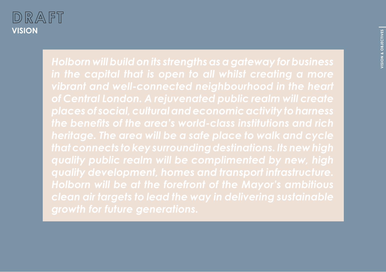
Holborn will build on its strengths as a gateway for business in the capital that is open to all whilst creating a more vibrant and well-connected neighbourhood in the heart of Central London. A rejuvenated public realm will create places of social, cultural and economic activity to harness the benefits of the area’s world-class institutions and rich heritage. The area will be a safe place to walk and cycle that connects to key surrounding destinations. Its new high quality public realm will be complimented by new, high quality development, homes and transport infrastructure. Holborn will be at the forefront of the Mayor’s ambitious clean air targets to lead the way in delivering sustainable growth for future generations.
VISION

16 HOLBORN Vision and Urban Strategy
VIS
ION
& O
BJEC
TIV
ES
A leading centre for living, business and cultural activity
World class public realm, green space and a transport network that supports active travel
A sustainable place that delivers for its communities
Celebrating Holborn’s diverse identity and distinctiveness
• A genuinely mixed-use place, where development delivers on the priorities of housing and officespace.
• A combination of commercial, retail and other uses on the high streets that build on Holborn’s existing economic base and add to the vibrancy, diversity and cultural offer of the area by activatingkeyfrontages.
• A place where businesses and institutions want to locate, stay and grow, creating jobs and opportunities to ensure Holborn’s successisbenefittingallofitsusers.
• Deliver the maximum viable amount of housing with a significantproportionofaffordable housing
• Celebrate Holborn’s varied identity where distinct parts of the city collide and interact, creating a place that brings its historic past to life that celebrates its squares and layered road network
• The highest quality architecture that complements Holborn’s historic form, character and context
• Encourage the use of Holborn’s historic garden squares by all members of the community to allow Holborn’s distinct historic identity
• A brand new arrival space and gateway to the area through the creation of Crossrail and the removal of the gyratory
• Transformation of the public realm to make the area safe and shift the priority to pedestrian and cyclist road users
• Improved connections to surrounding areas to make Holborn an integrated part of the borough to all users
• Provide a public realm that meets the needs of the Holborn’s diverse user base and create an environment that supports continued investment into the area’s movement networks and public spaces
• Ensure that development contributes towards the Mayor’s air quality targets for London through the implementation of clear sustainability measures such as the Low Emission City Fringe.
• Develop a strategy of urban greening by enhancing the biodiversity and ecology of this dense urban area through the conservation and enhancement of the area’s network of green spaces
• Developers to minimise construction impacts through effective planning and management, engagement and ensuring they fully meet Camden’s construction standards and requirements
• Require developments to provide affordable housing, workspace and local employment training
OBJECTIVES
URBAN STRATEGY
18 HOLBORN Vision and Urban Strategy
URBA
N S
TRA
TEG
Y
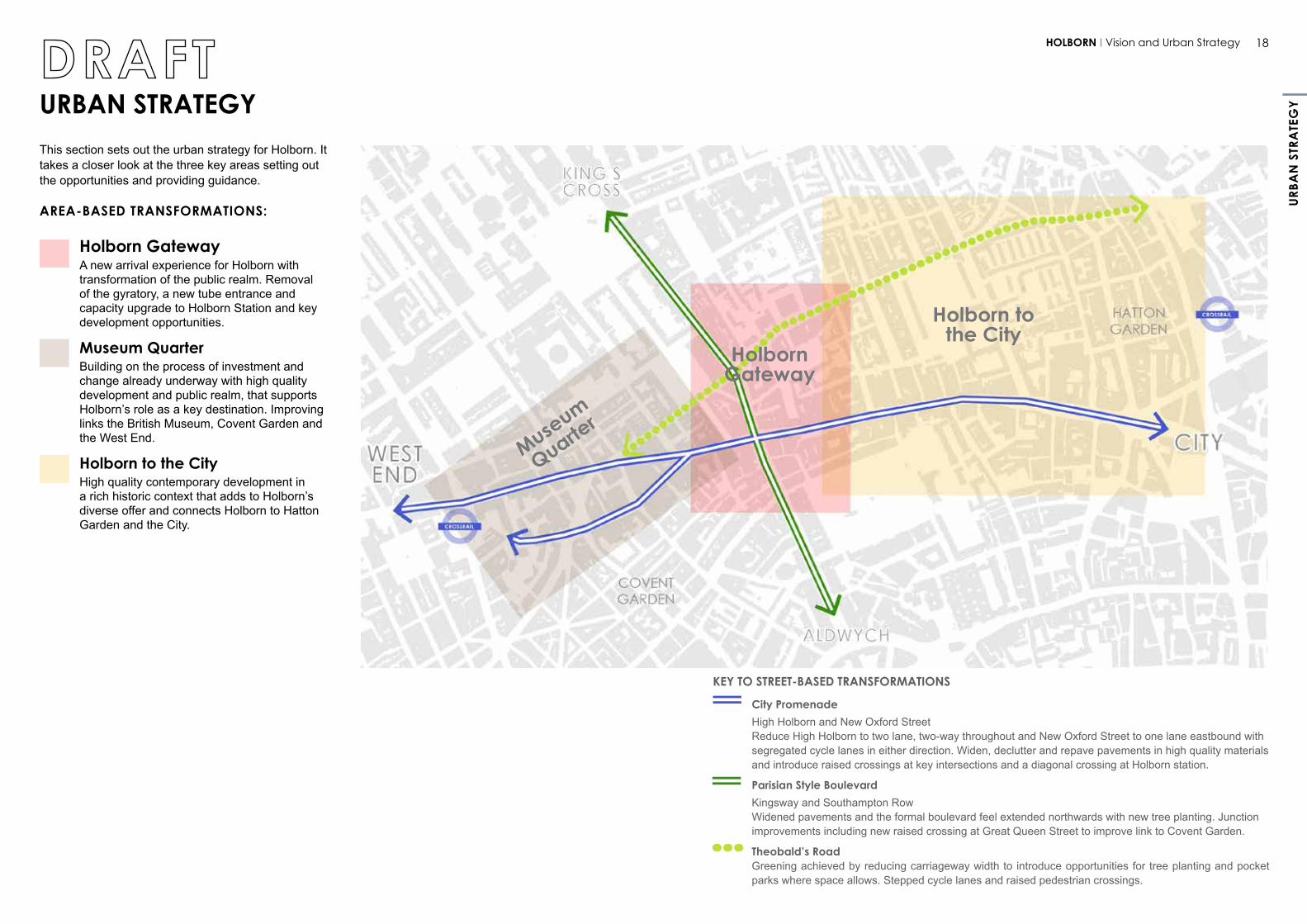
This section sets out the urban strategy for Holborn. It takes a closer look at the three key areas setting out the opportunities and providing guidance.
URBAN STRATEGY
City PromenadeHigh Holborn and New Oxford StreetReduce High Holborn to two lane, two-way throughout and New Oxford Street to one lane eastbound with segregated cycle lanes in either direction. Widen, declutter and repave pavements in high quality materials and introduce raised crossings at key intersections and a diagonal crossing at Holborn station.
Parisian Style BoulevardKingsway and Southampton RowWidened pavements and the formal boulevard feel extended northwards with new tree planting. Junction improvements including new raised crossing at Great Queen Street to improve link to Covent Garden.
Theobald’s Road Greening achieved by reducing carriageway width to introduce opportunities for tree planting and pocket parks where space allows. Stepped cycle lanes and raised pedestrian crossings.
Holborn GatewayA new arrival experience for Holborn with transformation of the public realm. Removal of the gyratory, a new tube entrance and capacity upgrade to Holborn Station and key development opportunities.
Museum QuarterBuilding on the process of investment and change already underway with high quality development and public realm, that supports Holborn’s role as a key destination. Improving links the British Museum, Covent Garden and the West End.
Holborn to the CityHigh quality contemporary development in a rich historic context that adds to Holborn’s diverse offer and connects Holborn to Hatton Garden and the City.
KEY TO STREET-BASED TRANSFORMATIONS
Holborn Gateway
Museum
Quarter
Holborn to the City
AREA-BASED TRANSFORMATIONS:
19 HOLBORN Vision and Urban Strategy
HO
LBO
RN G
ATE
WA
Y
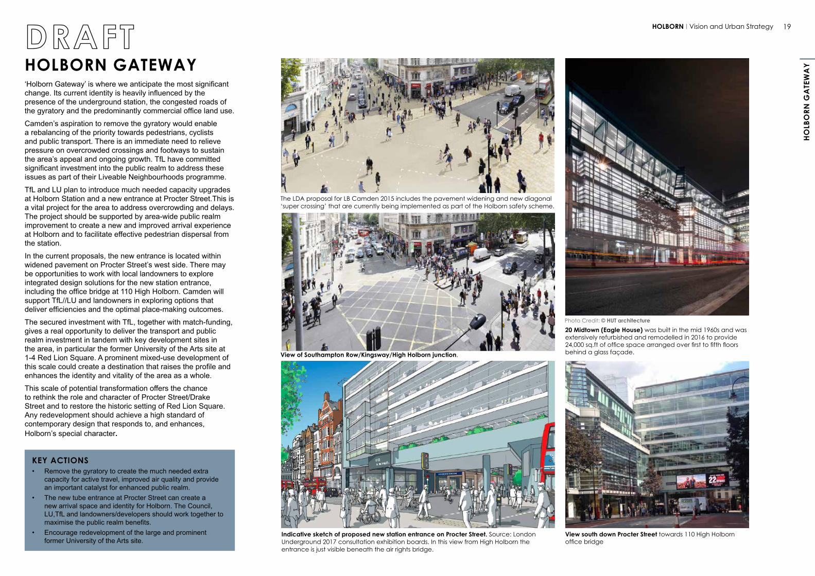
‘Holborn Gateway’ is where we anticipate the most significant change. Its current identity is heavily influenced by the presence of the underground station, the congested roads of the gyratory and the predominantly commercial office land use.
Camden’s aspiration to remove the gyratory would enable a rebalancing of the priority towards pedestrians, cyclists and public transport. There is an immediate need to relieve pressure on overcrowded crossings and footways to sustain the area’s appeal and ongoing growth. TfL have committed significant investment into the public realm to address these issues as part of their Liveable Neighbourhoods programme.
TfL and LU plan to introduce much needed capacity upgrades at Holborn Station and a new entrance at Procter Street.This is a vital project for the area to address overcrowding and delays. The project should be supported by area-wide public realm improvement to create a new and improved arrival experience at Holborn and to facilitate effective pedestrian dispersal from the station.
In the current proposals, the new entrance is located within widened pavement on Procter Street’s west side. There may be opportunities to work with local landowners to explore integrated design solutions for the new station entrance, including the office bridge at 110 High Holborn. Camden will support TfL//LU and landowners in exploring options that deliver efficiencies and the optimal place-making outcomes.
The secured investment with TfL, together with match-funding, gives a real opportunity to deliver the transport and public realm investment in tandem with key development sites in the area, in particular the former University of the Arts site at 1-4 Red Lion Square. A prominent mixed-use development of this scale could create a destination that raises the profile and enhances the identity and vitality of the area as a whole.
This scale of potential transformation offers the chance to rethink the role and character of Procter Street/Drake Street and to restore the historic setting of Red Lion Square. Any redevelopment should achieve a high standard of contemporary design that responds to, and enhances, Holborn’s special character.
HOLBORN GATEWAY
Photo Credit: © HUT architecture20 Midtown (Eagle House) was built in the mid 1960s and was extensively refurbished and remodelled in 2016 to provide 24,000 sq.ft of office space arranged over first to fifth floors behind a glass façade.
View south down Procter Street towards 110 High Holborn office bridge
The LDA proposal for LB Camden 2015 includes the pavement widening and new diagonal ‘super crossing’ that are currently being implemented as part of the Holborn safety scheme.
Indicative sketch of proposed new station entrance on Procter Street. Source: London Underground 2017 consultation exhibition boards. In this view from High Holborn the entrance is just visible beneath the air rights bridge.
View of Southampton Row/Kingsway/High Holborn junction.
KEY ACTIONS• Remove the gyratory to create the much needed extra
capacity for active travel, improved air quality and provide an important catalyst for enhanced public realm.
• The new tube entrance at Procter Street can create a new arrival space and identity for Holborn. The Council, LU,TfL and landowners/developers should work together to maximise the public realm benefits.
• Encourage redevelopment of the large and prominent former University of the Arts site.
20 HOLBORN Vision and Urban Strategy
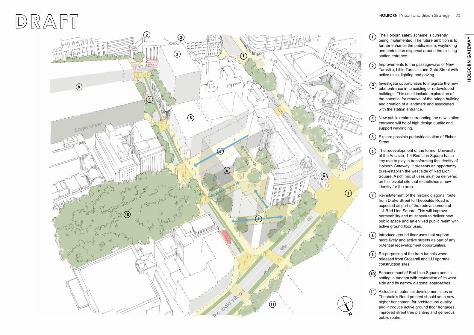
The Holborn safety scheme is currently being implemented. The future ambition is to further enhance the public realm, wayfinding and pedestrian dispersal around the existing station entrance.
Improvements to the passageways of New Turnstile, Little Turnstile and Gate Street with active uses, lighting and paving.
Investigate opportunities to integrate the new tube entrance in to existing or redeveloped buildings. This could include exploration of the potential for removal of the bridge building and creation of a landmark and associated with the station entrance.
New public realm surrounding the new station entrance will be of high design quality and support wayfinding.
Explore possible pedestrianisation of Fisher Street
The redevelopment of the former University of the Arts site, 1-4 Red Lion Square has a key role to play in transforming the identity of Holborn Gateway. It presents an opportunity to re-establish the west side of Red Lion Square. A rich mix of uses must be delivered on this pivotal site that establishes a new identity for the area.
Reinstatement of the historic diagonal route from Drake Street to Theobalds Road is expected as part of the redevelopment of 1-4 Red Lion Square. This will improve permeability and must seek to deliver new public space and an enlived public realm with active ground floor uses.
Introduce ground floor uses that support more lively and active streets as part of any potential redevelopment opportunities.
Re-purposing of the tram tunnels when released from Crossrail and LU upgrade construction sites.
Enhancement of Red Lion Square and its setting in tandem with restoration of its west side and its narrow diagonal approaches.
A cluster of potential development sites on Theobald’s Road present should set a new higher benchmark for architectural quality and introduce active ground floor frontages, improved street tree planting and generous public realm.
11
2
3
4
5
6
7
8
1
22
3
4
5
6
7
8
11
N
Red Lion Square
High Holborn
Theobald’s
Road
11
HO
LBO
RN G
ATE
WA
Y
Eagle Street
Southampton Row
9
10
10
9
8
11
21 HOLBORN Vision and Urban Strategy
HO
LBO
RN G
ATE
WA
Y
1
1
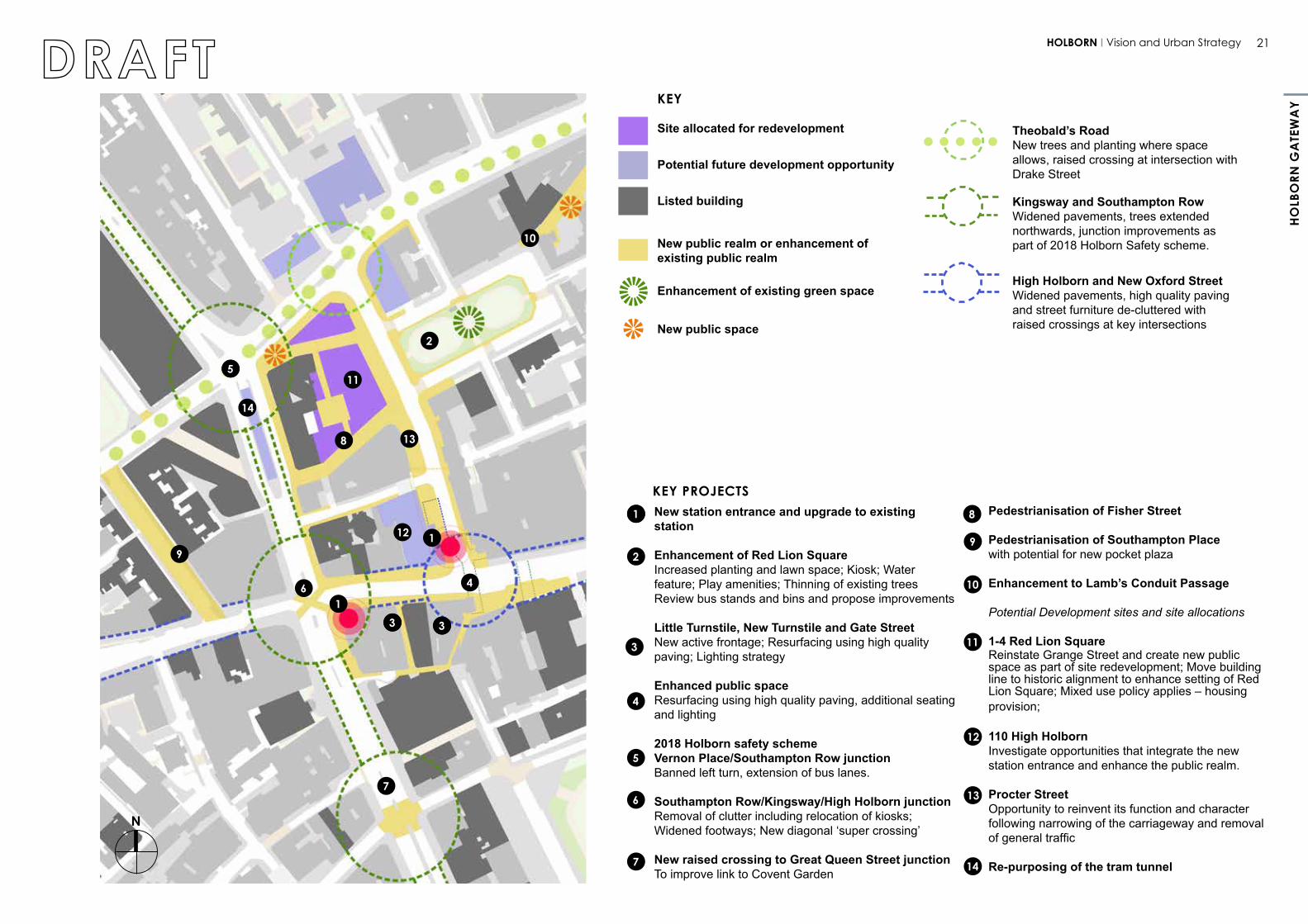
New station entrance and upgrade to existing station
Enhancement of Red Lion SquareIncreased planting and lawn space; Kiosk; Water feature; Play amenities; Thinning of existing trees Review bus stands and bins and propose improvements
Little Turnstile, New Turnstile and Gate StreetNew active frontage; Resurfacing using high quality paving; Lighting strategy
Enhanced public spaceResurfacing using high quality paving, additional seating and lighting
2018 Holborn safety schemeVernon Place/Southampton Row junctionBanned left turn, extension of bus lanes.
Southampton Row/Kingsway/High Holborn junctionRemoval of clutter including relocation of kiosks; Widened footways; New diagonal ‘super crossing’
New raised crossing to Great Queen Street junction To improve link to Covent Garden
2
Pedestrianisation of Fisher Street
Pedestrianisation of Southampton Place with potential for new pocket plaza
Enhancement to Lamb’s Conduit Passage
Potential Development sites and site allocations
1-4 Red Lion SquareReinstate Grange Street and create new public space as part of site redevelopment; Move building line to historic alignment to enhance setting of Red Lion Square; Mixed use policy applies – housing provision;
110 High HolbornInvestigate opportunities that integrate the new station entrance and enhance the public realm.
Procter StreetOpportunity to reinvent its function and character following narrowing of the carriageway and removal of general traffic
Re-purposing of the tram tunnel
1
2
3
4
5
6
7
8
9
10
12
11
KEY
Site allocated for redevelopment
Potential future development opportunity
Listed building
New public realm or enhancement of existing public realm
Enhancement of existing green space
New public space
Theobald’s RoadNew trees and planting where space allows, raised crossing at intersection with Drake Street
Kingsway and Southampton RowWidened pavements, trees extended northwards, junction improvements as part of 2018 Holborn Safety scheme.
High Holborn and New Oxford StreetWidened pavements, high quality paving and street furniture de-cluttered with raised crossings at key intersections
33 33
4
55
6
7
8
9
10
11
12
KEY PROJECTS
1
N
13
13
14
14
22 HOLBORN Vision and Urban Strategy
MUS
EUM
QUA
RTER
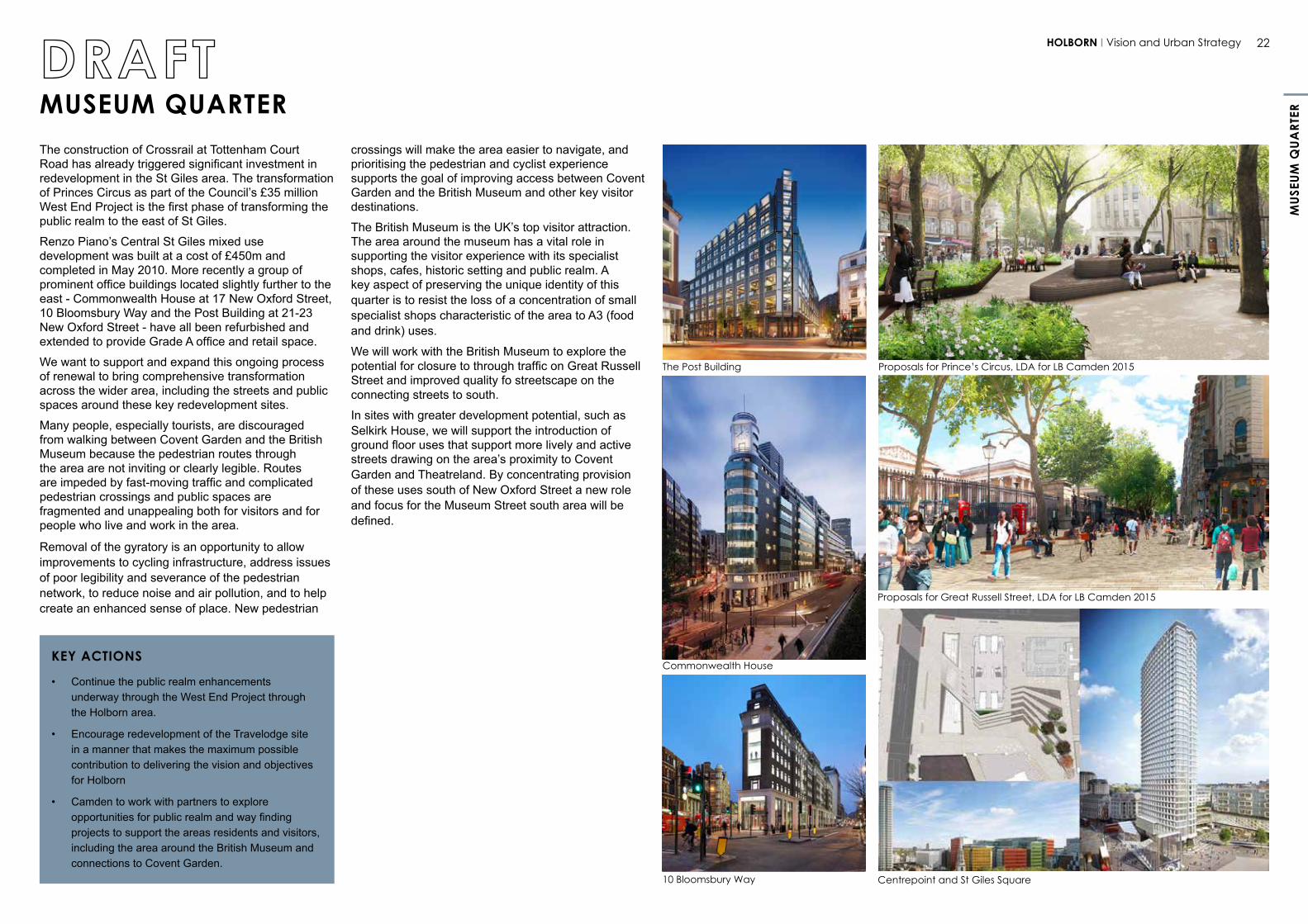
The construction of Crossrail at Tottenham Court Road has already triggered significant investment in redevelopment in the St Giles area. The transformation of Princes Circus as part of the Council’s £35 million West End Project is the first phase of transforming the public realm to the east of St Giles.
Renzo Piano’s Central St Giles mixed use development was built at a cost of £450m and completed in May 2010. More recently a group of prominent office buildings located slightly further to the east - Commonwealth House at 17 New Oxford Street, 10 Bloomsbury Way and the Post Building at 21-23 New Oxford Street - have all been refurbished and extended to provide Grade A office and retail space.
We want to support and expand this ongoing process of renewal to bring comprehensive transformation across the wider area, including the streets and public spaces around these key redevelopment sites.
Many people, especially tourists, are discouraged from walking between Covent Garden and the British Museum because the pedestrian routes through the area are not inviting or clearly legible. Routes are impeded by fast-moving traffic and complicated pedestrian crossings and public spaces are fragmented and unappealing both for visitors and for people who live and work in the area.
Removal of the gyratory is an opportunity to allow improvements to cycling infrastructure, address issues of poor legibility and severance of the pedestrian network, to reduce noise and air pollution, and to help create an enhanced sense of place. New pedestrian
MUSEUM QUARTER
KEY ACTIONS
• Continue the public realm enhancements underway through the West End Project through the Holborn area.
• Encourage redevelopment of the Travelodge site in a manner that makes the maximum possible contribution to delivering the vision and objectives for Holborn
• Camden to work with partners to explore opportunities for public realm and way finding projects to support the areas residents and visitors, including the area around the British Museum and connections to Covent Garden.
crossings will make the area easier to navigate, and prioritising the pedestrian and cyclist experience supports the goal of improving access between Covent Garden and the British Museum and other key visitor destinations.
The British Museum is the UK’s top visitor attraction. The area around the museum has a vital role in supporting the visitor experience with its specialist shops, cafes, historic setting and public realm. A key aspect of preserving the unique identity of this quarter is to resist the loss of a concentration of small specialist shops characteristic of the area to A3 (food and drink) uses.
We will work with the British Museum to explore the potential for closure to through traffic on Great Russell Street and improved quality fo streetscape on the connecting streets to south.
In sites with greater development potential, such as Selkirk House, we will support the introduction of ground floor uses that support more lively and active streets drawing on the area’s proximity to Covent Garden and Theatreland. By concentrating provision of these uses south of New Oxford Street a new role and focus for the Museum Street south area will be defined.
The Post Building Proposals for Prince’s Circus, LDA for LB Camden 2015
Proposals for Great Russell Street, LDA for LB Camden 2015
Centrepoint and St Giles Square10 Bloomsbury Way
Commonwealth House
23 HOLBORN Vision and Urban Strategy
MUS
EUM
QUA
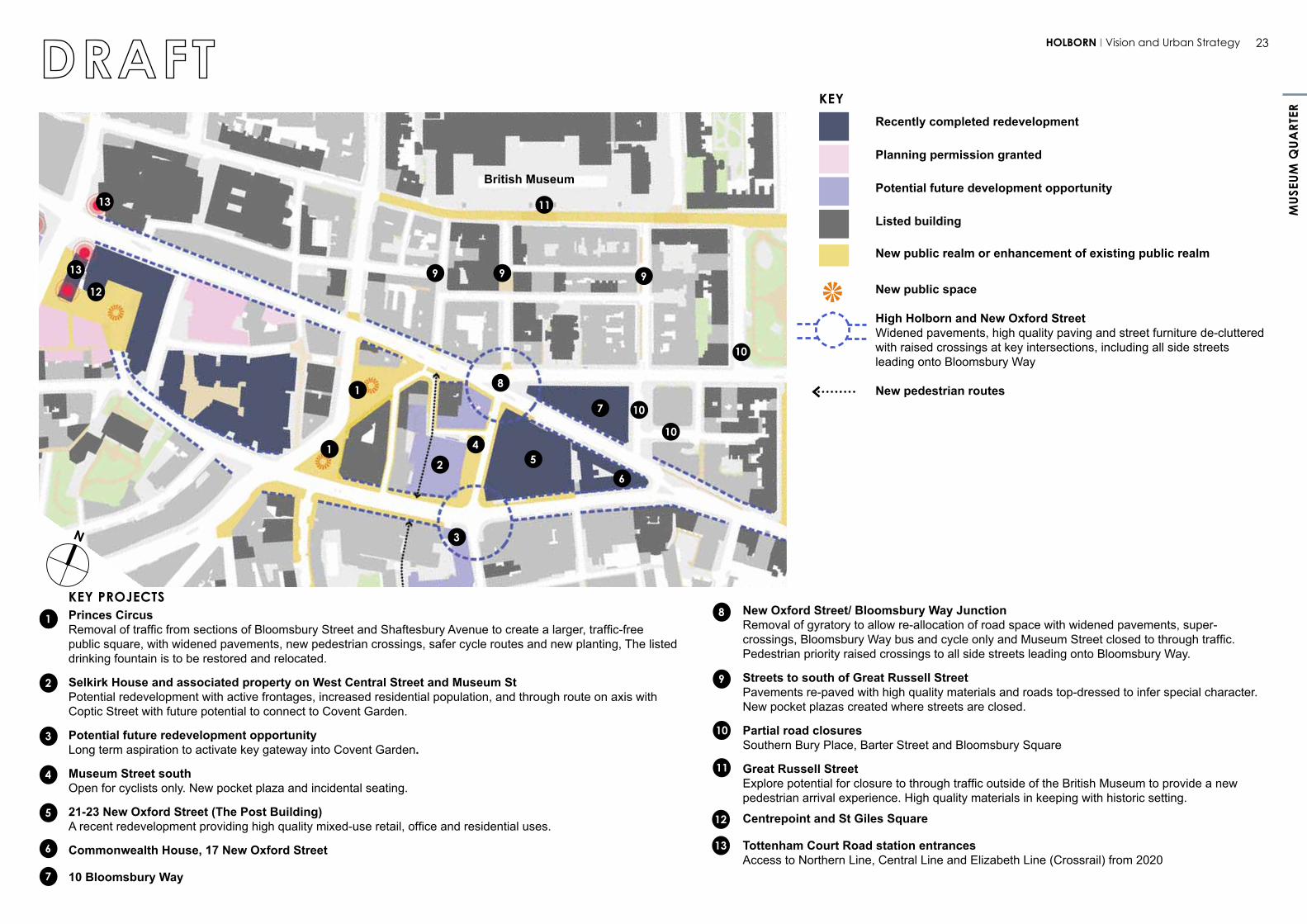
RTERRecently completed redevelopment
Planning permission granted
Potential future development opportunity
Listed building
New public realm or enhancement of existing public realm
New public space
High Holborn and New Oxford StreetWidened pavements, high quality paving and street furniture de-cluttered with raised crossings at key intersections, including all side streets leading onto Bloomsbury Way
New pedestrian routes
1New Oxford Street/ Bloomsbury Way JunctionRemoval of gyratory to allow re-allocation of road space with widened pavements, super-crossings, Bloomsbury Way bus and cycle only and Museum Street closed to through traffic. Pedestrian priority raised crossings to all side streets leading onto Bloomsbury Way.
Streets to south of Great Russell Street Pavements re-paved with high quality materials and roads top-dressed to infer special character. New pocket plazas created where streets are closed.
Partial road closuresSouthern Bury Place, Barter Street and Bloomsbury Square
Great Russell Street Explore potential for closure to through traffic outside of the British Museum to provide a new pedestrian arrival experience. High quality materials in keeping with historic setting.
Centrepoint and St Giles Square
Tottenham Court Road station entrancesAccess to Northern Line, Central Line and Elizabeth Line (Crossrail) from 2020
1
2
3
4
5
6
KEY
1
12
3
45
7
8
9
8
99 9
10
10
10
11
N
10
11
6
7
British Museum
Princes Circus Removal of traffic from sections of Bloomsbury Street and Shaftesbury Avenue to create a larger, traffic-free public square, with widened pavements, new pedestrian crossings, safer cycle routes and new planting, The listed drinking fountain is to be restored and relocated.
Selkirk House and associated property on West Central Street and Museum StPotential redevelopment with active frontages, increased residential population, and through route on axis with Coptic Street with future potential to connect to Covent Garden.
Potential future redevelopment opportunityLong term aspiration to activate key gateway into Covent Garden.
Museum Street southOpen for cyclists only. New pocket plaza and incidental seating.
21-23 New Oxford Street (The Post Building) A recent redevelopment providing high quality mixed-use retail, office and residential uses.
Commonwealth House, 17 New Oxford Street
10 Bloomsbury Way
12
12
13
13
13
KEY PROJECTS
24 HOLBORN Vision and Urban Strategy
HO
LBO
RN T
O T
HE
CIT
YHOLBORN TO THE CITY
KEY ACTIONS• Encourage new development of high quality modern
design that is sensitive to context to reverse the process of erosion of historic character and identity
• Address issue of open space deprivation by creating new improved public space at Brooke’s Market
• Improve quality of public realm, including de-cluttering and provision of seating to support the ongoing success of the Leather Lane food market
AREA WIDE DESIGN GUIDANCE
The following guidance applies to the whole Holborn Vision and Urban Strategy Area of focus (seepage4).
• New buildings should achieve the highest standards of contemporary design whilst acknowledging the prevailing scale, mass, form and rhythm created by the historic pattern of development.
• Development should restore or maintain a fine grained street, resisting plot amalgamation
• Development should reflect the materiality, detailing, texture and colour of the historic context.
• In preparing development proposals consideration should be given to whether the development will affect both strategic and local views and/or archaeological priority area.
• Development should prioritise ground floor retail over office lobby uses on designated frontages and other appropriate locations and smaller units are preferred.
• Heritage assets should be maintained as the foundation of the street’s character
• Prevailing building heights should be maintained to preserve the strong sense of enclosure to High Holborn without overwhelming the narrow side streets, passages and alleyways
Photo Credit: © Peter Cook
Shaftesbury Theatre fly tower extensionBennetts Associates
The angular weathering steel-clad extension above the Grade II listed Shaftesbury Theatres’ roofline provides the only visible evidence of a £5m upgrade to the stage. The project allows the theatre to accommodate the ever-increasing demands of large-scale musical theatre, and to continue to welcome audiences from all over the world to the West End.
The design acknowledges that the building is viewed from surrounding tall buildings, as well as along narrow streets and picks up on the grain, texture and colour of the adjacent Edwardian mansion blocks.
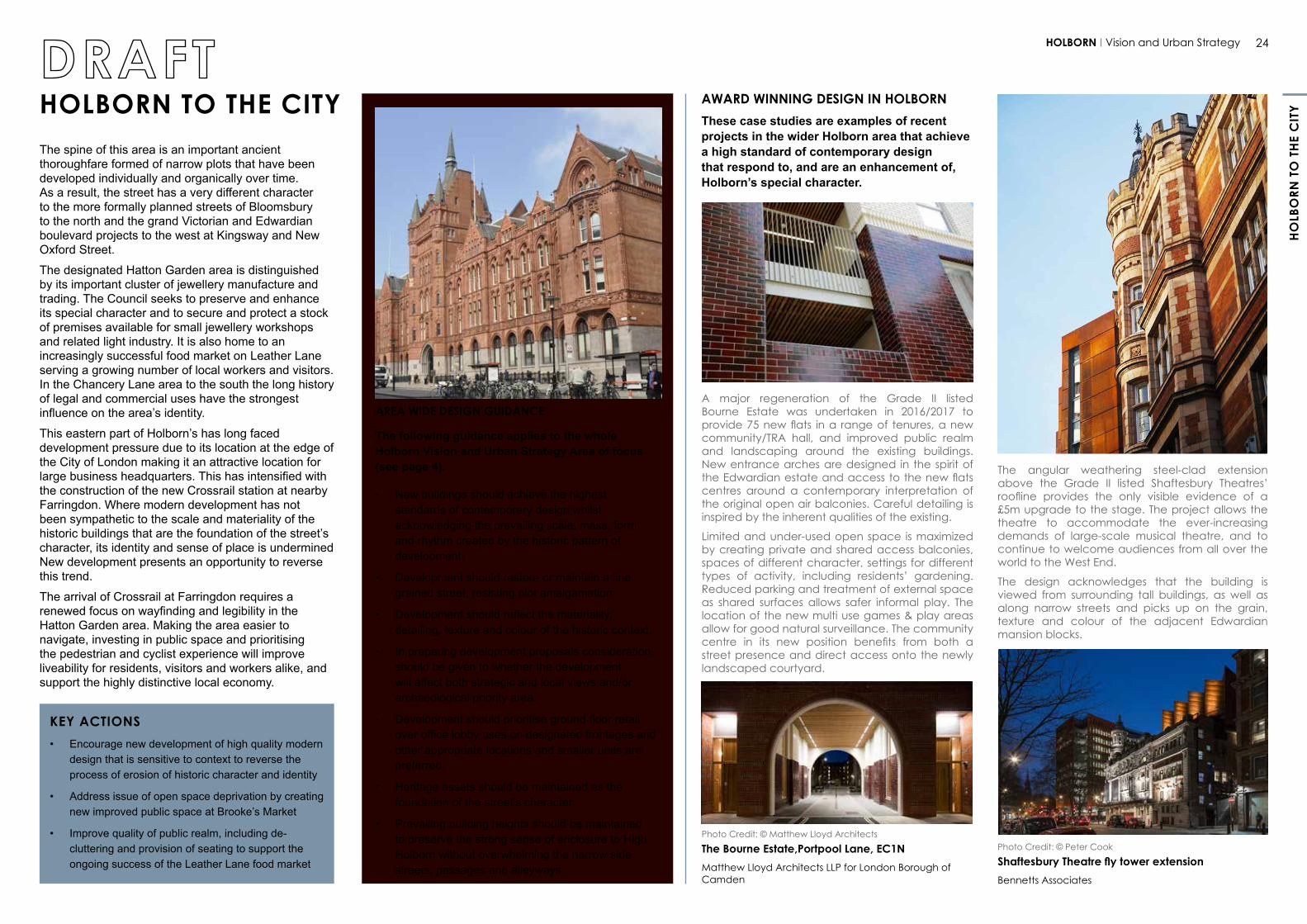
A major regeneration of the Grade II listed Bourne Estate was undertaken in 2016/2017 to provide 75 new flats in a range of tenures, a new community/TRA hall, and improved public realm and landscaping around the existing buildings. New entrance arches are designed in the spirit of the Edwardian estate and access to the new flats centres around a contemporary interpretation of the original open air balconies. Careful detailing is inspired by the inherent qualities of the existing.
Limited and under-used open space is maximized by creating private and shared access balconies, spaces of different character, settings for different types of activity, including residents’ gardening. Reduced parking and treatment of external space as shared surfaces allows safer informal play. The location of the new multi use games & play areas allow for good natural surveillance. The community centre in its new position benefits from both a street presence and direct access onto the newly landscaped courtyard.
Photo Credit: © Matthew Lloyd Architects
The Bourne Estate,Portpool Lane, EC1NMatthew Lloyd Architects LLP for London Borough of Camden
AWARD WINNING DESIGN IN HOLBORNThese case studies are examples of recent projects in the wider Holborn area that achieve a high standard of contemporary design that respond to, and are an enhancement of, Holborn’sspecialcharacter.
The spine of this area is an important ancient thoroughfare formed of narrow plots that have been developed individually and organically over time. As a result, the street has a very different character to the more formally planned streets of Bloomsbury to the north and the grand Victorian and Edwardian boulevard projects to the west at Kingsway and New Oxford Street.
The designated Hatton Garden area is distinguished by its important cluster of jewellery manufacture and trading. The Council seeks to preserve and enhance its special character and to secure and protect a stock of premises available for small jewellery workshops and related light industry. It is also home to an increasingly successful food market on Leather Lane serving a growing number of local workers and visitors. In the Chancery Lane area to the south the long history of legal and commercial uses have the strongest influence on the area’s identity.
This eastern part of Holborn’s has long faced development pressure due to its location at the edge of the City of London making it an attractive location for large business headquarters. This has intensified with the construction of the new Crossrail station at nearby Farringdon. Where modern development has not been sympathetic to the scale and materiality of the historic buildings that are the foundation of the street’s character, its identity and sense of place is undermined New development presents an opportunity to reverse this trend.
The arrival of Crossrail at Farringdon requires a renewed focus on wayfinding and legibility in the Hatton Garden area. Making the area easier to navigate, investing in public space and prioritising the pedestrian and cyclist experience will improve liveability for residents, visitors and workers alike, and support the highly distinctive local economy.
25 HOLBORN Vision and Urban Strategy
Planning permission granted
Site allocated for redevelopment
Potential future development opportunity
Listed building
New public realm or enhancement of existing public realm
Designated Hatton Garden Area
High Holborn Widened pavements, high quality paving and street furniture de-cluttered with raised crossings at key intersections
Theobald’s RoadNew trees and planting where space allows
Borough boundary
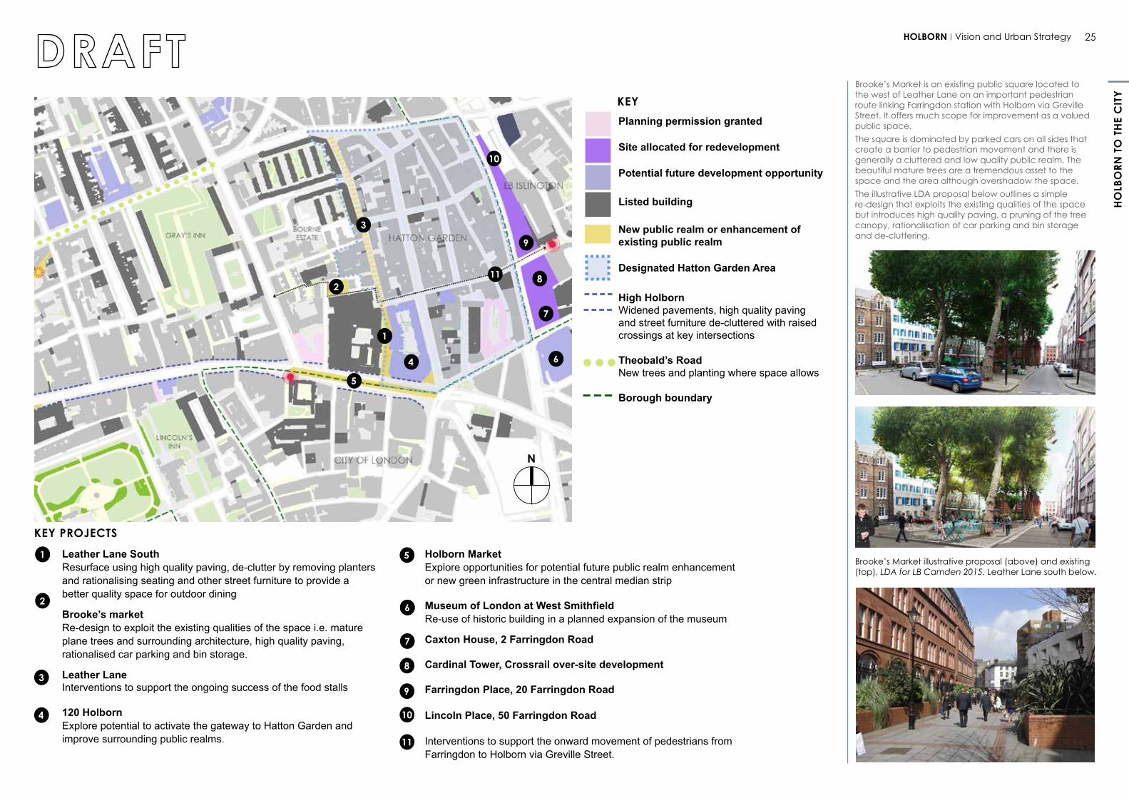
KEY
1 Leather Lane SouthResurface using high quality paving, de-clutter by removing planters and rationalising seating and other street furniture to provide a better quality space for outdoor dining
Brooke’s marketRe-design to exploit the existing qualities of the space i.e. mature plane trees and surrounding architecture, high quality paving, rationalised car parking and bin storage.
Leather LaneInterventions to support the ongoing success of the food stalls
120 HolbornExplore potential to activate the gateway to Hatton Garden and improve surrounding public realms.
1
2
3
HO
LBO
RN T
O T
HE
CIT
Y
Brooke’s Market is an existing public square located to the west of Leather Lane on an important pedestrian route linking Farringdon station with Holborn via Greville Street. It offers much scope for improvement as a valued public space.The square is dominated by parked cars on all sides that create a barrier to pedestrian movement and there is generally a cluttered and low quality public realm. The beautiful mature trees are a tremendous asset to the space and the area although overshadow the space. The illustrative LDA proposal below outlines a simple re-design that exploits the existing qualities of the space but introduces high quality paving, a pruning of the tree canopy, rationalisation of car parking and bin storage and de-cluttering.
Brooke’s Market illustrative proposal (above) and existing (top), LDA for LB Camden 2015. Leather Lane south below.
N
4
KEY PROJECTS
Holborn MarketExplore opportunities for potential future public realm enhancement or new green infrastructure in the central median strip
MuseumofLondonatWestSmithfieldRe-use of historic building in a planned expansion of the museum
Caxton House, 2 Farringdon Road
Cardinal Tower, Crossrail over-site development
Farringdon Place, 20 Farringdon Road
Lincoln Place, 50 Farringdon Road
Interventions to support the onward movement of pedestrians from Farringdon to Holborn via Greville Street.
5
16
7
8
9
10
16
7
8
9
10
5
4
3
2
11
11
11

DELIVERY
27 HOLBORN Vision and Urban Strategy
Wynne-Williams Associates Ltd Chartered Landscape Architects Camden Design Awards l 2015
CAMDEN DESIGN AWARDS: ST GILES-IN-THE-FIELDS CHURCHYARD RENOVATION PROJECT
St Giles church is a Grade 1 listed building in the heart of the west end of London. Its churchyard is leased to Camden Council who maintains it as a public park. The church is known as ‘the poet’s church’ and has been associated with a number of famous poets throughout its history.
The churchyard forms an important cut-through route from Covent Garden to Tottenham Court Road and has the potential to be a really valuable open space in an area without many parks.
The landscape had become worn out and unappealing. Anti-social behaviour discouraged people from using the space which was hard to maintain and falling into disrepair. Camden raised finance from Section 106 monies and the Mayor of London’s Pocket Parks Fund, and Wynne-Williams Associates won the tender to design and oversee a scheme of renovation and enhancement.
The listed status of the church meant a wide and varied consultee and stakeholder interest. We liaised with the Church’s committee, the Council’s conservation officer, English Heritage and the Georgian Society to ensure that the designs would be acceptable in this historic setting. Their requirements were balanced with the desires of the local community who use the open space and whose views were also sought.
The site has a number of mature trees which are of great amenity value and are protected as both the setting for the church and as part of the Denmark Street conservation area. The works were specially designed to retain the trees and enhance their growing conditions.
The result respects the historic setting but refreshes the space with new planting, paths, street furniture and a new play area. Of key importance are the entrance works which have been designed to make the space more visible and welcoming.
Resurrection Gate - before and after restoration
South Churchyard - new playground North Churchyard - new terrace
South Churchyard after renovation
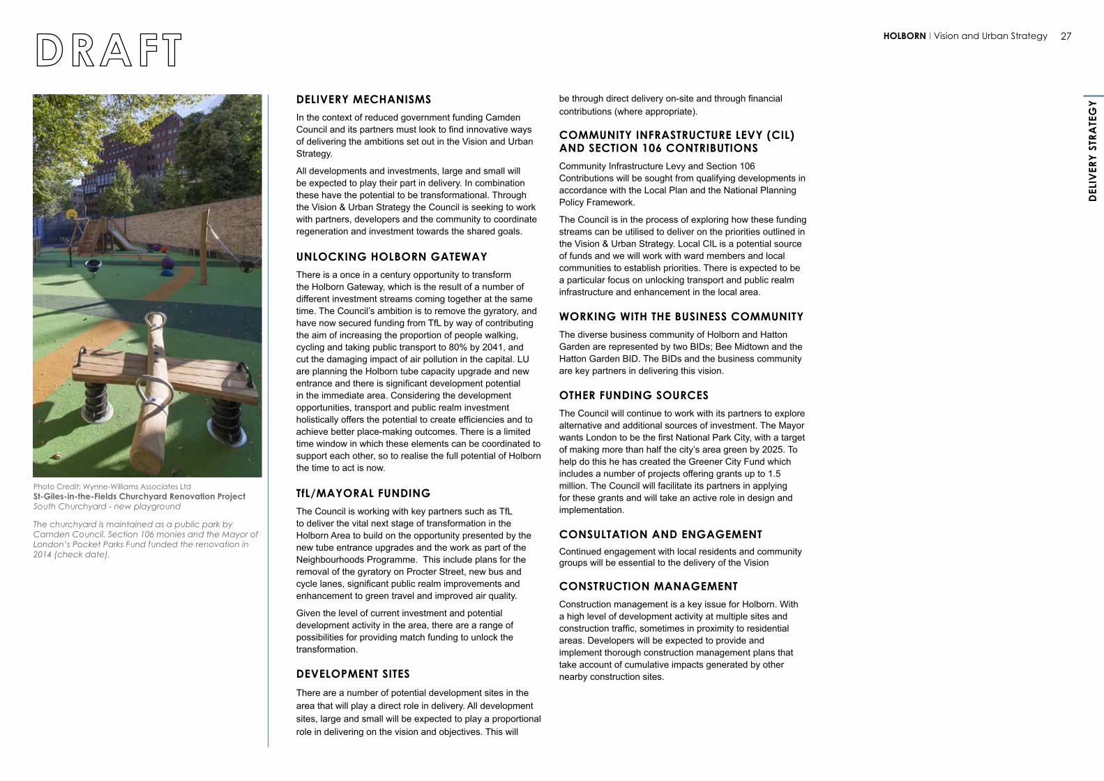
Photo Credit: Wynne-Williams Associates LtdSt-Giles-in-the-Fields Churchyard Renovation ProjectSouth Churchyard - new playground
The churchyard is maintained as a public park by Camden Council. Section 106 monies and the Mayor of London’s Pocket Parks Fund funded the renovation in 2014 (check date).
DELIVERY MECHANISMSIn the context of reduced government funding Camden Council and its partners must look to find innovative ways of delivering the ambitions set out in the Vision and Urban Strategy.
All developments and investments, large and small will be expected to play their part in delivery. In combination these have the potential to be transformational. Through the Vision & Urban Strategy the Council is seeking to work with partners, developers and the community to coordinate regeneration and investment towards the shared goals.
UNLOCKING HOLBORN GATEWAYThere is a once in a century opportunity to transform the Holborn Gateway, which is the result of a number of different investment streams coming together at the same time. The Council’s ambition is to remove the gyratory, and have now secured funding from TfL by way of contributing the aim of increasing the proportion of people walking, cycling and taking public transport to 80% by 2041, and cut the damaging impact of air pollution in the capital. LU are planning the Holborn tube capacity upgrade and new entrance and there is significant development potential in the immediate area. Considering the development opportunities, transport and public realm investment holistically offers the potential to create efficiencies and to achieve better place-making outcomes. There is a limited time window in which these elements can be coordinated to support each other, so to realise the full potential of Holborn the time to act is now.
TfL/MAYORAL FUNDINGThe Council is working with key partners such as TfL to deliver the vital next stage of transformation in the Holborn Area to build on the opportunity presented by the new tube entrance upgrades and the work as part of the Neighbourhoods Programme. This include plans for the removal of the gyratory on Procter Street, new bus and cycle lanes, significant public realm improvements and enhancement to green travel and improved air quality.
Given the level of current investment and potential development activity in the area, there are a range of possibilities for providing match funding to unlock the transformation.
DEVELOPMENT SITESThere are a number of potential development sites in the area that will play a direct role in delivery. All development sites, large and small will be expected to play a proportional role in delivering on the vision and objectives. This will
DEL
IVER
Y ST
RATE
GYbe through direct delivery on-site and through financial
contributions (where appropriate).
COMMUNITY INFRASTRUCTURE LEVY (CIL) AND SECTION 106 CONTRIBUTIONS Community Infrastructure Levy and Section 106 Contributions will be sought from qualifying developments in accordance with the Local Plan and the National Planning Policy Framework.
The Council is in the process of exploring how these funding streams can be utilised to deliver on the priorities outlined in the Vision & Urban Strategy. Local CIL is a potential source of funds and we will work with ward members and local communities to establish priorities. There is expected to be a particular focus on unlocking transport and public realm infrastructure and enhancement in the local area.
WORKING WITH THE BUSINESS COMMUNITYThe diverse business community of Holborn and Hatton Garden are represented by two BIDs; Bee Midtown and the Hatton Garden BID. The BIDs and the business community are key partners in delivering this vision.
OTHER FUNDING SOURCESThe Council will continue to work with its partners to explore alternative and additional sources of investment. The Mayor wants London to be the first National Park City, with a target of making more than half the city’s area green by 2025. To help do this he has created the Greener City Fund which includes a number of projects offering grants up to 1.5 million. The Council will facilitate its partners in applying for these grants and will take an active role in design and implementation.
CONSULTATION AND ENGAGEMENTContinued engagement with local residents and community groups will be essential to the delivery of the Vision
CONSTRUCTION MANAGEMENTConstruction management is a key issue for Holborn. With a high level of development activity at multiple sites and construction traffic, sometimes in proximity to residential areas. Developers will be expected to provide and implement thorough construction management plans that take account of cumulative impacts generated by other nearby construction sites.