holyoke’s center city vision plan - mhp · center city vision plan steering committee kathleen...
TRANSCRIPT
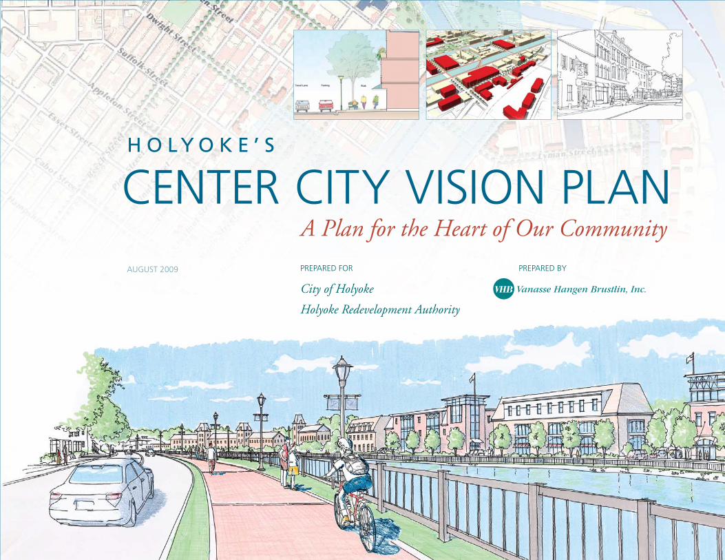
CENTER CITY VISION PLANH O L Y O K E ’ S
A Plan for the Heart of Our Community
PREPARED BYPREPARED FOR
City of Holyoke
Holyoke Redevelopment Authority
AUGUST 2009

AcknowledgementsTh is plan was produced by over 400 Holyokers who shaped this agenda for our
City’s future by participating in public forums, interviews, focus groups and other
activities. Participants came from all of the city’s neighborhoods, and represented a
wide range of cultural, ethnic and socioeconomic backgrounds to be found here.
Center City Vision Plan Steering CommitteeKathleen Anderson / Jeff rey Burkott / Th omas Creed / John Dyjach / Carl Eger, Jr.
David Guzman / Karen Mendrala / Eileen Regan
The Holyoke Redevelopment AuthorityCarl Eger, Jr., Chair / Patricia Duff y, Vice-Chair / Th omas Creed, Treasurer / Leida
Cartagena, Assistant Treasurer / Jacqueline Watson, Member
Vanasse Hangen Brustlin (VHB), Inc.Geoff rey Morrison-Logan / James “Jef” Fasser
Funding for this study was provided through a Gateway Plus Action Grant awarded by:Th e Massachusetts Department of Housing and Community Development
with special thanks to Mayor Michael J. Sullivan, the support of City Councilors and to the following Holyoke individuals, institutions, merchants, restaurateurs, & residents:Amedeo’s Restaurant & Pizzeria / Church of God Mission Board / Th e Log Cabin
& Th e Delaney House / Holyoke Council on Aging / Holyoke School
Department / Holyoke Department of Public Works / McDonald’s Restaurant /
Templo Ebenezer / Our Lady of Guadalupe Church / War Memorial
Commissioners / residents Virgenmina Viera and Joseph Kingsley

| 3
Table of Contents
1 Project Overview page 5
2 Alternatives page 15
3 Vision Plan page 19
4 Transportation page 37
5 Implementation page 41


CONTENTS
• Overview
• Holyoke Facts
• Holyoke Today
• Process
• Goals and Objectives
• Opportunities & Challenges
• Community & Stakeholders Common
Recommendations
Project Overview1

6 | CENTER CITY VISION PLAN, HOLYOKE, MASSACHUSETTS
Project Overview1
Holyoke is a place of many unique attractions
• St. Patrick’s Day Parade
• Heritage State Park
• Mount Tom State Reservation
• Connecticut River
• Volleyball Hall of Fame
• Wistariahurst Museum
• Children’s Museum
• Holyoke Merry-Go-Round
Holyoke has an exceptional history
• Named after Elizur Holyoke, explored area in 1660.
• Th e nation’s fi rst planned industrial community
• Known as the Paper City of the World.
• Birthplace of Volleyball
• Th e City is 22.8 mi2 and has 1.5 mi2 of water
• Proposed Data Center—public private partnership between state, city, private business and universities.
• Proposed Passenger Rail Station—State initiative.
OverviewTh is following Center City Vision Plan was prepared to set the framework for the revitalization of the historic core of the city, which was once the vibrant centerpiece of this planned industrial community. As with many other industrial cities throughout New England, Holyoke is proactively planning ahead for the future reinvestment in its Center City area by working closely with its diverse community of residents, business owners, institutions and numerous organizations, to help shape a plan. Th e Vision Plan identifi es opportunities to capitalize on the unique aspects of Holyoke’s industrial heritage and green power generation, while embracing new opportunities for job growth, population growth and place making. Th is will set the direction for the Center City and its neighborhoods to realize their future potential.
Th e Center City project area consists of four census tracts (fi gure 1) and includes the neighborhoods of South Holyoke, Th e Flats, Downtown/Prospect Heights and Churchill. Th is area has frontage along the Connecticut River and includes the three power generating canals that helped support the original growth of Holyoke. Th ese neighborhoods once comprised the urban core of the City including a central business district along High and Maple Streets, manufacturing sites along the three canals, associated employee housing surrounding these areas and commercial uses to support urban living. However, this part of the City has seen a signifi cant disinvestment in recent years, leaving many vacant and underutilized parcels and buildings. Presently, the area has a great need for reinvestment and revitalization in order for it to prosper and thrive, and, fortunately, the City is currently taking action and seeing signs of new investment in this area.
Some of the investment that is currently taking place includes:
• Canalwalk Construction Phase 1 being constructed, Phase 2 under design.
• Intermodal Center under construction.
• Transit Oriented Development (TOD) Project—Circulation improvements designed for Dwight and Heritage streets in design.
• South Holyoke Plan master plan completed.
• Private Investment in various buildings ongoing.
Holyoke Facts…did you know?
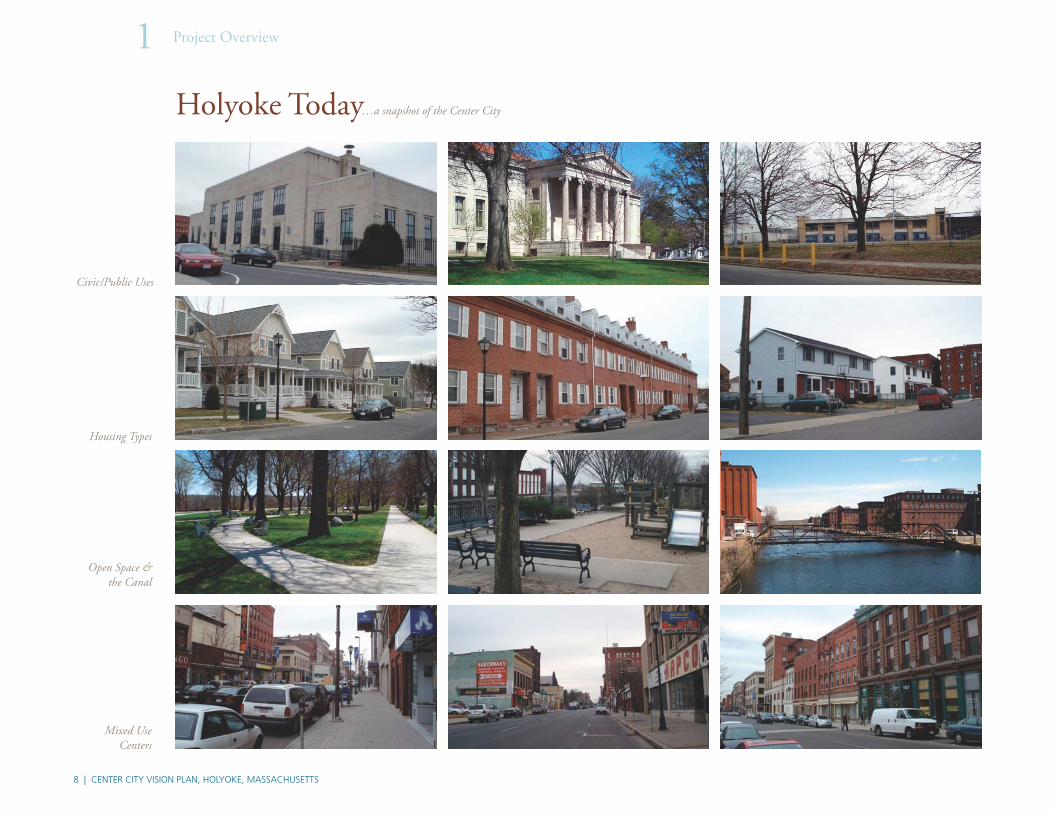
Pages 8 and 9 showcase photographs of some of the more notable buildings and scenes in the Center City area. Th ese photographs are grouped by the Vision Plan topic they best represent, including civic/public buildings, types of housing, open space, mixed-use corridors, historic structures and mills, industrial buildings, vacant buildings/parcels and community character.

| 7
fi gure 1Locus Map & Study Areaaerial source: MassGIS
"
"
"
"
"
"
"
"
""
!"#$91
!"#$90
!"#$391
£¤5
£¤202
UV141
UV116
UV33
UV10
UV141
CH ICOP EE
EASTHAMP TON
SOUTH HADLEY
SOUTHAMP TON
WE STFIELD
WE ST SPRINGFIE LD
NORTHAMPTONHADLEY
HOLYOKE
Exit 4 Exit 3
Exit 5
Exit 4
Exit 5
Exit 6
Exit 14
Exit 15
Exit 16
Exit 17
Locus…City of Holyoke
(8117)(8117)
(8116)(8116)
(8115)(8115)
(8114)(8114)
8 | CENTER CITY VISION PLAN, HOLYOKE, MASSACHUSETTS
Project Overview1
Mixed Use Centers
Civic/Public Uses
Housing Types
Open Space & the Canal
Holyoke Today…a snapshot of the Center City

| 9
Community Character
Mill Buildings & Structures
Industrial Uses
Vacant Land & Buildings

10 | CENTER CITY VISION PLAN, HOLYOKE, MASSACHUSETTS
Project Overview1
ProcessTh e Center City Vision Plan was developed over a fi ve month period structured around initial stakeholder interviews and three public workshops, each organized to gain input about issues and opportunities, Vision Plan alternatives and the preferred Vision Plan.
Th e planning process started by conducting a series of interviews with stakeholders over a two-day period to gain insight on the issues and opportunities that were relevant to the Center City study area. Th e interviews were held at City’s Offi ce of Planning and Development and at the Visitors Center in Heritage State Park, where more than 100 people attended. Th e interviews were organized by topic area and included representatives from the business, non-profi t, housing, healthcare, and education industries. In addition, City Councilors, multiple City departments, private property owners, retailers, realtors and developers were interviewed.
Th e three public workshops were advertised through the local media including the City cable access channel, City web site and Spanish radio Station WSPR, at local churches, as well as through the use of fl yers and community boards that were distributed and/or placed within the neighborhoods in the study area. Th ese materials were translated into Spanish to expand community outreach eff orts.
Th e extensive outreach eff orts led an average turnout of 80–100 people for each of the public meetings, where the consultants and City staff provided a brief presentation followed by “break-out” group discussions on the material that was presented that evening. Translation services were provided at the public meetings to accommodate Spanish speaking participants. Each group was asked to “report back” what they discussed so that their concerns and goals could be considered in developing the vision for the Center City. Th e meetings focus on the following topics;
• First Public Forum “Understanding the Issues and Opportunities” and “Set a Vision/Framework for the Alternatives”
• Second Public Forum “Review the Preliminary Vision Plan Alternatives”
• Th ird Public Forum “Review Downtown Vision Plan” and preliminary “Urban Renewal considerations”
Th e City appointed a Steering Committee that worked closely with the consultants throughout the development of the Vision Plan. Th e committee consisted of members from the City Offi ce of Planning and Development and members of the Holyoke Redevelopment Authority (HRA), the Holyoke
(above)Scenes from the public forums
Recently, the City has initiated a number of actions to guide the revitalization eff ort of the Center City area. Th e City has recently formed the Holyoke Redevelopment Authority (HRA) whose immediate focus is the revitalization of this area of the city.
One of the fi rst tasks undertaken by the HRA was the preparation of this Vision Plan. Th is process included a comprehensive analysis of the project area, preparation of a development framework for the various sections within the Center City, and recommendations for redevelopment actions to revitalize the area. Actions address all elements of the Center City area including housing, streets and open space along with commercial and industrial development. Anticipated results include job creation, expanded housing choices, improved urban environment and quality of life issues such as walkability, cultural activities and education.
A major component of this planning study was signifi cant public outreach to assure that the Vision Plan evolved from the community. Th e outreach process included focus group meetings with numerous interest groups, three public meetings and additional outreach by City staff . Th e outreach concentrated on building and strengthening existing community collaborations and initiatives as well as working to build new relationships with organizations, community groups and individuals.
Th e result of this visioning process will lay the groundwork for an Urban Renewal Plan to create vibrant, diverse, safe neighborhoods in downtown Holyoke where all residents can live, work and play.
Th e following report provides a summary of the items considered in the planning process and the elements that constitute the Center City Vision Plan.
• An overview of the process that was undertaken.
• A summary of the issues and opportunities that were considered.
• An overview of the alternatives that were discussed.
• A summary of the elements that constitute the Vision Plan.
• A set of strategies for implementing aspects of the Vision Plan.

| 11
Planning Board and the Holyoke Economic Development and Industrial Corporation (HEDIC). Meetings with the Steering Committee were held regularly to provide guidance on project coordination, development of the alternatives, refi nement of the preferred Vision Plan and strategies for implementation actions that will result from this plan.
Goals and ObjectivesTh e City of Holyoke and the HRA prepared this Vision Plan to understand community values that will guide the preparation of an Urban Renewal Plan for the Center City area that refl ects citizen aspirations and preferences for the future of their community. Th e broad public involvement and resulting plan are essential to provide guidance to municipal offi cials and board members as they advance eff orts and actions intended to stimulate the revitalization of this area of the City.
In order to address the critical issues that will impact the redevelopment potential of the Center City area, this vision planning process addressed the following goals and objectives:
Goal: Conduct an extensive public outreach process to achieve broad community input into the Center City Vision Plan
• Understand community values and preferences for the Center City area.
• Identify strengths, weaknesses, opportunities and challenges within the area.
• Achieve broad-based community understanding of the City’s plans for this area.
Goal: Solicit community input into a number of issues that impact revitalization activities in the area. Understand community opinion regarding:
• Preferred mix of land uses—retail, offi ce, entertainment, government/civic, schools and education, housing, industrial, community/cultural, mixed-use development.
• Improvement of the open space system—large city parks, neighborhood parks, playing fi elds/courts, Canalwalk, Connecticut River, community gardens.
• Transportation options—vehicular, pedestrian, buses, trains, bicycles, walking, and multimodal.
Save the date!!Public Forum
When? June 25th What Time? 6:00–9:00pm
Where? War Memorial Building 310 Appleton St
What will we discuss?
Study Area
South Holyoke
The Flats
Prospect Heights / Downtown
Church Hill
Kathleen AndersonCity of Holyoke Planning Department (413) 322-5575
Center City Vision PlanProject Background: The City of Holyoke is undertaking a comprehensive planning study of the Flats, Churchill, South Holyoke, Prospect Heights and Downtown areas that have a great need for reinvestment and revitalization in order for Holyoke’s City Center to thrive and prosper. The goal of this study is to create vibrant, diverse, safe neighborhoods in downtown Holyoke where all residents can live, work and play. The study will lay the groundwork for a future Urban Renewal Plan and the 2010-2014 HUD Consolidated Plan for this area.
To date, the planning process has included two public forums that focused on understanding the issues and opportunities, andreviewing alternative vision plans for the future of the City Center. During the next public forum we will outline the key aspects of the preferred vision plan and what will be developed for the
Your participation is important to the success of these events and we hope that you will join us on June 25th to build a vision for the future of our City Center.
Funding for this study was provided through a Gateway Plus Action Grant from the Massachusetts Department of Housing and Community Development.
• Street treatments—arterials and “entry” roads, main streets, secondary or access streets, residential streets, service streets (alleys), streetscape treatments, and gateways.
• Activities or events—cultural/social/ethnic events, entertainment, recreational activities, community celebrations, and family events.
• Schools, Health & Social Services—public and private schools, institutions and colleges, health care.
• Culture and Heritage—community values, historic resources, signifi cant events/resources.
Goal: Develop a preferred Vision Plan that can be used to guide the preparation of an Urban Renewal Plan that will identify specifi c actions for the redevelopment of the Center City area.
• Identify public actions intended to stimulate private investment, improved housing and job creation.
• Identify principals that will guide future redevelopment.
• Prioritize proposed activities to help focus public actions.
Th e benefi t of this community visioning process was that it provided an oppor-tunity for citizen input into the municipal planning process and revitalization plan. Th is process provided a sense of community ownership in the development of a plan and, thus, support for its recommendations. Furthermore, this on-going process of communication among the citizens helped reconcile confl icting views resulting in an agreement on preferred courses of action. It also helped to facilitate intergovernmental cooperation and partnerships to resolve problems.
(left) Flyers prepared in both Spanish and English advertised the three public forums.
Guarde esta fecha!!Foro Público
Cuando: 25 de junio
Hora: 6:00–9:00pm
Donde: di cio Comemora i o de uerra 0 de la calle pple on
u di cu iremo
área de estudio
South Holyoke
The Flats
Prospect Heights / Downtown
Church Hill
Para más información comunicarse con:
Sra. Kathleen Anderson
(413) 322-5575
Proyecto Visión delCentro de la Ciudad
ran ondo del Pro ec o:
urbanística dentro de esta áreas.
discutira; a un o opor unidade el anal i del plan i i nario del cen ro de la Ciudad. Su participación es impor-
-sachusetts

12 | CENTER CITY VISION PLAN, HOLYOKE, MASSACHUSETTS
Project Overview1
Opportunities & Challenges Th e Opportunities and Challenges Map (opposite page) was developed to iden-tify a series of issues that the Vision Plan should consider and/or build upon. Th e map refl ects observations, community input and information provided at the stakeholder interviews, and has helped set the planning framework for the Vision Plan. Each of the components identifi ed on the map is summarized in the paragraphs below. Th e adjacent text box includes a list of the ideas that emerged from the stakeholder interviews and fi rst public forum. Th e list is not organized by priority, but rather by common recommendations that were discussed.
1. Gateway Opportunities: Gateway elements such as unique architectural features, signage, landscaping features and streetscape enhancements can be used to accentuate arrival to the Center City.
2. Streets/Connections: Enhance the connections along streets that link various portions of the Center City together, connecting neighborhoods and activity centers.
3. Canal & Canalwalk: Build on the planned improvements to the Canalwalk and seek opportunities to extend the Canalwalk to other portions of the Center City.
4. Civic Buildings & Parks: Leverage civic buildings and parks as assets to the community and a focal point for adjacent redevelopment.City Initiatives: Advance the planned city initiatives (5 and 6)
5. Transit-Oriented Development (TOD): Encourage Transit-Oriented Development.
6. Massachusetts General Law Chapter 40R (40 R): Encourage smart growth in accordance with the purposes of 40R.
7. Arts & Industry: Expand, encourage reuse, redevelopment, and revitalization of historic resources within the existing Arts & Industry Overlay District, along the canals and on the periphery of Holyoke’s traditional city center.
8. Vacant Properties: Plan for, redevelop and enhance the numerous vacant properties within the Center City.
9. Neighborhood Identity: Capitalize on the unique characteristics of Holyoke’s urban neighborhoods.
10. Enhanced Connections: Enhance connections to destinations adjacent to the Center City (Springdale Park, Mitchell Field, Pulaski Park).
Community & Stakeholder Recommendations
• Creation of jobs.
• Workforce training.
• Higher education opportunities.
• Maintain properties and selectively remove blight.
• Maintain a clean City and educate about littering and clean-up—start clean up in highly visible areas.
• Improve safety (both perceived and real)/implementation of beat police, improved lighting.
• Promote green…green power, green industry, and green identity.
• Celebrate culture and ethnic diversity.
• Preserving the architecture and historical value of the area.
• Build on the City’s successes and civic assets.
• More entertainment. e.g. Family-friendly restaurants, movie theatre, family activities.
• Strengthen the Arts District.
• Mixed income, mixed use, mixed housing choices.
• Encouraging small, diverse and local businesses.
• Create a strong downtown core with small businesses and mixed uses.
• Local foods/local markets.
• Address transition areas in land use, create buff ers.
• Rename the area. Positive marketing.
• Increase the safety and attractiveness of public parks.
• Creating a walkable City with complete streets.
• Develop an approach for the vacant buildings
• Consider zoning updates and design guidelines, strategic zoning.

| 13
fi gure 2Challenges and Opportunities
source data: MassGIS, City of Holyoke
OPPORTUNITIES & CHALLENGES MAP


CONTENTS
• The Preferred Plan
• Principles
Alternatives2CONTENTS
• Alternatives Overview
• Alternative 1
• Alternative 2
• Alternative 3

16 | CENTER CITY VISION PLAN, HOLYOKE, MASSACHUSETTS
Alternatives2
AlternativesTh ree preliminary Alternatives were prepared for the study area based on the issues and opportunities that were identifi ed during the stakeholder interviews, results from the fi rst public forum and the Opportunities Map that was prepared. Th e alternatives identify a framework for revitalization activities, both public and private, such as areas for future development and redevelopment, areas recommended for rehabilitation, infrastructure improvements, open space and streetscape improvements, recommended land uses and similar activities that will help to revitalize the area.
Each alternative includes a series of elements that are common to all three. Th ese include considerations for: Complete Streets, City Parks, City Bridges, Streetscape, Canalwalk, Neighborhood Initiatives, Mix Use Centers, Arts/History, Jobs/Industry/Commerce, and Transit-Oriented Development (TOD). Each of these “Common Elements” is shown in the legend on the opposite page.
Th e diff erences between the alternatives are denoted by their individual approaches to certain land uses within sub-areas of the Center City. Th ese diff erences are shown with darker colors as indicated in the legend below. During the initial discussions with the stakeholders and community members, multiple ideas emerged about how to treat future growth within these areas. Th e summary of these diff erences are highlighted in the description of each alternative plan.
Based on the feedback from the second public forum and comments from the City and Steering Committee, a preferred Vision Plan was created that incorporates many of the aspects shown in alternative three.
Legend Prospect Heights/
Downtown
The Flats
Churchill
South
Holyoke
Alternative 1
• Expand the mix of uses along High and Maple Streets south towards I-391 with a focus on Offi ce and Retail.
• Focus Cultural Uses and activities along the 1st and 2nd Level Canals—between Appleton and Cabot Streets.
• Target redevelopment of the southern blocks along the 1st and 2nd Level Canals—between Commercial, Race, Cabot and Jackson Streets as mixed-use with a focus on Housing.
• Expand the mix of uses along Main Street towards I-391 with a focus on Offi ce and Retail.
• Target Jobs and Commerce along the 2nd Level Canal with emphasis on the land between the canal and river. Continue to promote Jobs and Commerce in the southeastern portions of the Flats neighborhood.
• Explore opportunities for views and open spaces along the riverfront, and between redevelopment sites.

| 17
Legend
Prospect Heights/
Downtown
The Flats
Churchill
South
Holyoke
Prospect Heights/
Downtown
The Flats
Churchill
South
Holyoke
Alternative 2
• Expand the mix of uses along High and Maple Streets south towards I-391 with a focus on Retail and Housing.
• Focus the Cultural Uses and activities along the 1st and 2nd Level Canals—between Appleton and Sargeant Streets, one block larger than Alternative 1.
• Target redevelopment of the southern blocks along the 1st and 2nd Level Canals—between Commercial, Sargeant, Main and I-391 for Jobs and Commerce. Extend Jobs and Commerce along the 3rd Level Canal on the southern edges of South Holyoke.
• Target Jobs and Commerce along 2nd Level Canal with emphasis on the land between the canal and the river. Continue to promote Jobs and Commerce in the southeastern portions of the Flats neighborhood.
• Explore opportunities for views and open spaces along the riverfront, and between redevelopment sites
Alternative 3
• Expand the mix of uses along High and Maple Streets south towards I-391 with a focus on Offi ce and Retail
• Focus Cultural Uses along High and Maple Streets within downtown—between Heritage Park, Appleton, Dwight, and Chestnut Streets.
• Target redevelopment of the southern blocks along the 1st and 2nd Level Canals—Between Commercial, Race, Cabot and Jackson Streets with a focus on Jobs and Commerce.
• Expand the mix of uses along Main Street towards I-391 focusing on mixed-use with Retail and Housing
• Extend housing along the 3rd Level Canal in South Holyoke.
• Target Jobs and Commerce along the 3rd Level Canal, emphasizing land between the canal and river. Explore opportunities for housing within the southeastern portions of the Flats.
• Explore opportunities for views and open spaces along the riverfront, near the damn and between redevelopment sites along the 3rd Level Canal.


CONTENTS
• The Preferred Plan
• Principles
Vision Plan3CONTENTS
• The Vision Plan
• Develop Key Nodes
• Enhance the Arts & Innovation District
• Expand Open Space Amenities
• Transform the Riverfront
• Enhance the Urban Neighborhoods
• Reconnect the City through Gateways
& Complete Streets

20 | CENTER CITY VISION PLAN, HOLYOKE, MASSACHUSETTS
Vision Plan3
The Vision PlanBased on the results from the second and third public forums and comments received from the Steering Committee, a Vision Plan and revised framework diagram was created for the Center City area that outlines goals and objectives for its future redevelopment and revitalization. Th is chapter provides an overview of the six key elements that defi ne the Vision Plan. Th e plan identifi es both site specifi c strategies and broad principles that will provide guidance to the community and the City as plans and initiatives are advanced and projects are implemented.
Th rough the community process and feedback received on the Vision Plan, it was evident that increasing the density and types of development, creating new jobs, providing more housing choices and preserving Holyoke’s historic character were all important considerations. Equally important was the desire to improve connectivity to and throughout the Center City, making the neighborhoods and the downtown amenities more accessible. Th ese and other “core principles” are outlined on the opposite page. Th e Vision Plan expands upon these initiatives and is described in the following pages of this chapter that describe:
1. Develop Key “Nodes”
2. Enhance the “Arts and Innovation” District
3. Expand Open Space Amenities
4. Transform the Riverfront
5. Enhance the Urban Neighborhoods
6. Reconnect the City through gateways and complete streets
The Framework
Th e Vision Plan was prepared in conjunction with the revised Framework Diagram that illustrates various goals for land uses, initiatives, and connections within the Center City.
Mixed Use / Housing FocusMixed Use / Office – Retail Focus
Jobs and Commerce
Transit-Oriented Development
Arts and Innovation
Neighborhood Initiatives
Legend
Prospect Heights/
Downtown
The Flats
Churchill
South
Holyoke

| 21
fi gure 3Center City Vision Plan
source: City of Holyoke GIS
CENTER CITY VISION PLAN
PRINCIPLES
1. Revitalize the Center City by increasing the density and types of development (more residents, more jobs)
2. Create an active Center City with a variety of 24/7 uses for day and night (Events, retail, restaurants, family destinations, etc.)
3. Preserve Holyoke’s historic urban character and valuable architectural resources (blocks, streets, buildings)
4. Increase housing choices with building styles that compliment the character within each urban neighborhood (multi-family, townhouse, duplex, etc.)
5. Improve downtown circulation with walkable, safe, and pedestrian-friendly streets and open spaces (Sidewalks, crosswalks, landscaping, lighting, etc)
6. Promote local utilities, green technology, and the innovative sectors as economic development initiatives (HG&E’s water power, renewable energy, creative jobs)
Legend
22 | CENTER CITY VISION PLAN, HOLYOKE, MASSACHUSETTS
Vision Plan3
GOALS
• Promote cultural activities within each node
• Enhance the streetscape to create places
for people
• Focus redevelopment and future development to
create the sense of place
• Create links or “portholes” to the adjacent
neighborhoods
• Connect the nodes through streetscape and
transportation enhancements
• Plan for a transportation “Hub” in each node
• Create a transportation “Loop” that connects
each node
EXAMPLES
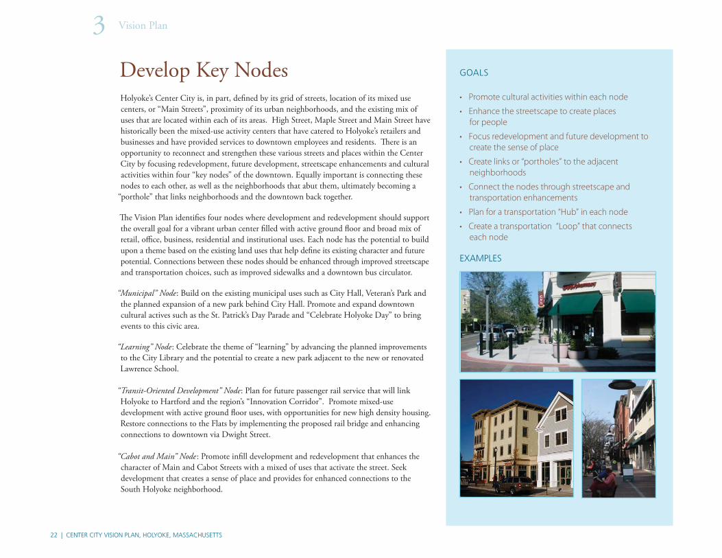
Develop Key NodesHolyoke’s Center City is, in part, defi ned by its grid of streets, location of its mixed use centers, or “Main Streets”, proximity of its urban neighborhoods, and the existing mix of uses that are located within each of its areas. High Street, Maple Street and Main Street have historically been the mixed-use activity centers that have catered to Holyoke’s retailers and businesses and have provided services to downtown employees and residents. Th ere is an opportunity to reconnect and strengthen these various streets and places within the Center City by focusing redevelopment, future development, streetscape enhancements and cultural activities within four “key nodes” of the downtown. Equally important is connecting these nodes to each other, as well as the neighborhoods that abut them, ultimately becoming a
“porthole” that links neighborhoods and the downtown back together.
Th e Vision Plan identifi es four nodes where development and redevelopment should support the overall goal for a vibrant urban center fi lled with active ground fl oor and broad mix of retail, offi ce, business, residential and institutional uses. Each node has the potential to build upon a theme based on the existing land uses that help defi ne its existing character and future potential. Connections between these nodes should be enhanced through improved streetscape and transportation choices, such as improved sidewalks and a downtown bus circulator.
“Municipal” Node: Build on the existing municipal uses such as City Hall, Veteran’s Park and the planned expansion of a new park behind City Hall. Promote and expand downtown cultural actives such as the St. Patrick’s Day Parade and “Celebrate Holyoke Day” to bring events to this civic area.
“Learning” Node: Celebrate the theme of “learning” by advancing the planned improvements to the City Library and the potential to create a new park adjacent to the new or renovated Lawrence School.
“Transit-Oriented Development” Node: Plan for future passenger rail service that will link Holyoke to Hartford and the region’s “Innovation Corridor”. Promote mixed-use development with active ground fl oor uses, with opportunities for new high density housing. Restore connections to the Flats by implementing the proposed rail bridge and enhancing connections to downtown via Dwight Street.
“Cabot and Main” Node : Promote infi ll development and redevelopment that enhances the character of Main and Cabot Streets with a mixed of uses that activate the street. Seek development that creates a sense of place and provides for enhanced connections to the South Holyoke neighborhood.

| 23
1. KEY “NODES”
fi gure 4Develop Key “Nodes”
Development

24 | CENTER CITY VISION PLAN, HOLYOKE, MASSACHUSETTS
Vision Plan3
1. DEVELOP KEY “NODES” (CONTINUED)
Main Street—A Mixed-Use Center
Main Street—Today
Façade & storefront enhancements
Sidewalk & streetscape improvements
Improvements to crosswalks can emphasize the pedestrian aspects of Main Street.
Infi ll development along Main Street,buildings should front the street & be in scale with the existing context.

| 25
Center City—Existing
Center City—Future Development
City Hall
Heritage State Park
Canalwalk
Potential future train station
AAPPPPPPPLLLEEETTTOOOONNNSSTTTRRRRTTTT
EEEEEEEETT
MMMAAAMMMMIIINNN SSTTTRRRRTTTT EEEEEEETT
CANAL 2
CANAL 1
DD
RRREEEETT
Legend
Existing Development
Potential Future Development
New or Future Open Space/Parks

26 | CENTER CITY VISION PLAN, HOLYOKE, MASSACHUSETTS
Vision Plan3
Enhance the Arts & Innovation DistrictHolyoke was founded on its innovative approach to power generation, by capturing energy from the Connecticut River. Its history as an industrial city and inventory of architecturally rich mill buildings provides a unique foundation for a continued emergence of an “Arts and Innovation” district. Th e community process identifi ed the existing artist community that is occupying space within buildings near the 1st and 2nd Level Canals. In addition, the community stated a preference to extend the Arts & Industry Overlay District to with the Arts and Innovation District extending from the 1st and 2nd Level Canals to Maple and High Streets so that the Victory Th eater and War Memorial Building are part of the district.
Th e Vision Plan identifi es a general boundary where the theme of Arts and Innovation should be explored (see fi gure 5). Multiple eff orts will continue to support the emergence of this district by:
• Unlocking the development potential for offi ce, commercial, retail and housing to reoccupy the vacant fl oors of existing buildings that are suitable for renovation.
• Integrating the ground fl oor uses with the Canalwalk.
• Expanding programmed events within the district to include:
• Walking & Historic tours—that showcase the unique building inventory and history of the Canal.
• Cultural events—Bring back Celebrate Holyoke and seek new events that bring together Holyoke’s diverse population.
• Enhancing the edges of streets—By renovating buildings, providing new development and improving the streetscape along the streets that cross the canals (Lyman, Dwight, Appleton, Cabot, Sargeant Streets).
• Making the bridges a design element—Work with Mass Highway to explore ways to illuminate the bridges and improve the sidewalks.
• Seeking opportunities for new parking lots/structures that can facilitate redevelopment.
EXAMPLES
GOALS
• Celebrate the arts community
• Unlock development potential for offi ce, commercial, retail and housing
• Integrate uses with the Canalwalk
• Expand programmed events• Walking tours• Historic tours• Cultural events
• Enhance the edges of streets
• Make bridges a design element—lighting sidewalks
• New parking lots/structures

| 27
State
l
fi gure 5 “Arts and Innovation” District
2. “ARTS AND INNOVATION” DISTRICT
PlannedCanalwalk

28 | CENTER CITY VISION PLAN, HOLYOKE, MASSACHUSETTS
Vision Plan3
EXAMPLES
Expand Open Space AmenitiesHolyoke is home to several notable parks such as the Heritage State Park that celebrates Holyoke’s unique history as the fi rst planned industrial city; Pulaski Park, which was designed by Frederick Law Olmsted—an internationally recognized landscape architect. Figure 6 identifi es these and other existing parks and suggests ways to introduce new open spaces, parks, expansions to the Canalwalk and potential streetscape enhancements that will connect these amenities throughout the Center City. Th e following summarizes the potential enhancements to the network of open spaces.
Veterans Park
• Continue with and expand programmed activities that activate the park.
• Seek infi ll and redevelopment opportunities for sites that surround the park.
• Explore the potential for additional enhancements the park with the conversion of Maple Street into a two-way street (see Chapter 4, Transportation).
Heritage State Park Area
• Advance the City’s plan to remove the parking structure behind City Hall, making way for a new park that will abut Heritage State Park.
• Seek opportunities to celebrate Holyoke as “the Birthplace of Volleyball” (park improvements, special events).
New Lawrence School Park
• Work with the School Department to advance plans for the Lawrence School and the opportunity for a new recreational park.
• Infi ll vacant sites that surround the park to provide more “eyes on the street”.
• Work with the city to explore options to close a portion of Chestnut Street.
Expand McNally Field to Canal
• Explore potential redevelopment opportunities along North Canal Street adjacent to Kelly School to expand the existing playing fi elds and open views to the canal.
• Expand the Canalwalk System along Canal Street and other potential areas.
Build a network of linkages to connect open spaces
• Enhance sidewalks and the streetscape along key streets that link neighborhoods to parks and open spaces.
GOALS
• Enhance existing open spaces
• Open access to the river in collaboration with redevelopment opportunities
• Build a network of linkages to connect open spaces through streets and the canalwalk
• Expand the Canalwalk System to the second and third canals
Expand South Holyoke’s playground at Morgan School
• Advance plans to expand the elementary school.
• Work with the City to develop plans for the new park, considering closing South Bridge Street, building a new ball fi eld and closing Bonin Field off Jackson Street.

| 29
3. OPEN SPACE AMENITIES
fi gure 6Open Space Amenities
Vacant parcels on Chestnut Street
Potential park near the Lawrence School
Planned Canalwalk
30 | CENTER CITY VISION PLAN, HOLYOKE, MASSACHUSETTS
Vision Plan3
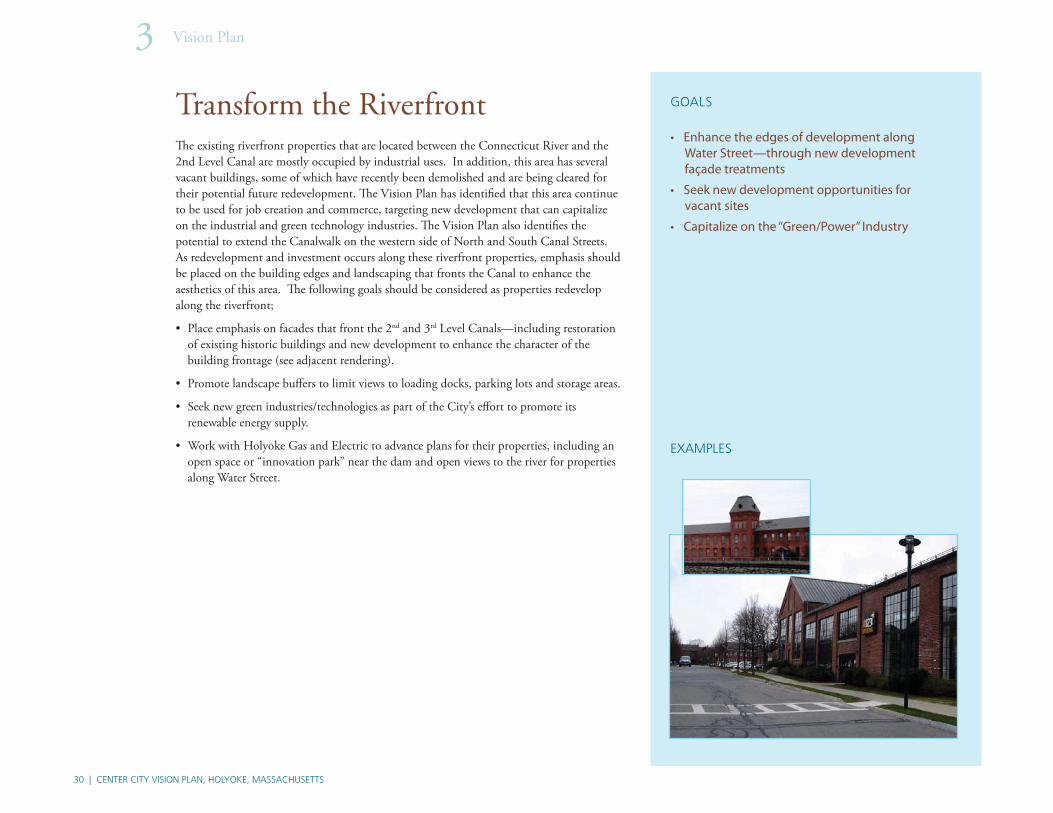
Transform the RiverfrontTh e existing riverfront properties that are located between the Connecticut River and the 2nd Level Canal are mostly occupied by industrial uses. In addition, this area has several vacant buildings, some of which have recently been demolished and are being cleared for their potential future redevelopment. Th e Vision Plan has identifi ed that this area continue to be used for job creation and commerce, targeting new development that can capitalize on the industrial and green technology industries. Th e Vision Plan also identifi es the potential to extend the Canalwalk on the western side of North and South Canal Streets. As redevelopment and investment occurs along these riverfront properties, emphasis should be placed on the building edges and landscaping that fronts the Canal to enhance the aesthetics of this area. Th e following goals should be considered as properties redevelop along the riverfront;
• Place emphasis on facades that front the 2nd and 3rd Level Canals—including restoration of existing historic buildings and new development to enhance the character of the building frontage (see adjacent rendering).
• Promote landscape buff ers to limit views to loading docks, parking lots and storage areas.
• Seek new green industries/technologies as part of the City’s eff ort to promote its renewable energy supply.
• Work with Holyoke Gas and Electric to advance plans for their properties, including an open space or “innovation park” near the dam and open views to the river for properties along Water Street.
GOALS
• Enhance the edges of development along Water Street—through new development façade treatments
• Seek new development opportunities for vacant sites
• Capitalize on the “Green/Power” Industry
EXAMPLES

| 31
Rehab / Redevelopment
t itiopportunities
Redevelopment
Extended Canalwalk
New park and
Redevelopment opportunities
views to river
Landscape buffers
Façade treatments
4. THE RIVERFRONT
fi gure 7The Riverfront
North Canal Street
Future improvements on Canal Street
New “Innovation” Park

32 | CENTER CITY VISION PLAN, HOLYOKE, MASSACHUSETTS
Vision Plan3
Enhance the Urban NeighborhoodsTh ere are opportunities to “enhance” each of the four Center City neighborhoods by advancing new infi ll development, improving their appearance through cleanup programs, and creating new community gardens where residents benefi t from access to locally grown foods.
Th e Vision Plan has identifi ed various opportunities for infi ll sites that can accommodate a wide range of housing and mixed-use development. Th ese are sites that are vacant, underutilized, or could be redeveloped. Figure 8 illustrates that these sites are scattered throughout each of the Center City’s four census tracts. Future development on these sites should be in scale and character with the surrounding context and should contribute to their urban setting by fronting buildings towards the street and accommodating parking within the internal portions of their lots or at the rear of the buildings.
Many of the existing vacant lots are adjacent to the residential uses. New development should expand upon the existing housing choices to provide a variety of unit types that can cater to Holyoke’s existing and future population and income levels. Opportunities for home ownership should be expanded to provide balance between the higher concentrations of rental units that are located within the Center City.
Existing neighborhood clean-up programs should continue to advance eff orts to help these neighborhoods improve their appearance. Th e City should work closely with its neighborhood-based organizations and the Department of Public Works to advance eff orts on trash pick-up and litter education.
During the planning processes, participants noted the need for improved code enforcement to ensure that buildings and properties are in compliance with health and safety codes. In addition, participants expressed a desire to add more community gardens within each neighborhood so that residents can benefi t from access to locally grown foods. Th e City should explore opportunities to convert appropriately placed and accessible vacant lots into community gardens.
GOALS
• Provide a mix of urban housing choices that complement the existing Center City neighborhoods
• Advance infi ll development opportunities throughout the Center City
• Expand neighborhood clean-up programs to enhance the appearance of the neighborhoods
• Seek opportunities for community gardens with the four neighborhood in the Center City
EXAMPLES

| 33
5. URBAN NEIGHBORHOODS
fi gure 8Urban Neighborhoods

34 | CENTER CITY VISION PLAN, HOLYOKE, MASSACHUSETTS
Vision Plan3
Reconnect the City through Gateways & Complete StreetsTh e Center City area has a set of distinct boundaries that include; the Connecticut River to north and east, I-391 to the south and Route 202 to the west. Celebrating arrival to the Center City can be highlighted by making enhancements to key points of entry or “gateways”. Internally, the Center City is home to four urban neighborhoods, each geographically located at its four corners. Improvements to the existing grid of streets off er the opportunity to reconnect these urban neighborhoods to each other and the adjacent mixed-use centers like High and Main Streets.
Th e Vision Plan has identifi ed a series of gateway locations that should be enhanced to celebrate arrival to the downtown (See fi gure 9). In addition, the Vision Plan recommends improvements to several east-west streets that will link the four neighborhoods and downtown together. During the planning process, residents, business owners and other stakeholders raised a number of transportation-related issues. Th ese issues included improving the following: existing sidewalks, roadway infrastructure, truck access, traffi c circulation and streetscape/gateways. Enhancing these transportation elements, along with strategic roadway planning to improve connectivity, will improve the transportation network and assist in economic development and revitalization of the downtown. See Chapter 4 for further information regarding Transportation improvements.
Gateways locations:
• Beech Street (north near Lyman Street and the River, south near the High School).
• High and Maple Streets (north at Lyman Street, south at the entrance to I-391).
• Main Street (south at the crossing of the 3rd Level Canal and I-391).
• Cabot Street (east at the crossing of the 3rd Level Canal).
• North Bridge Street (north at the between the 3rd Level Canal and river).
Streetscape and Street Improvements:
• Jackson Street, Sargeant Street, Cabot Street, Appleton Street, Dwight Street, Lyman Street, Main Street, High Street, Maple Street.
• Advance plans to convert Maple and High Streets to two-ways streets, from Lyman to Cabot Streets.
GOALS
• Create a network of complete streets that connect the Center City’s neighborhoods and mixed use centers
• Enhance “gateway areas” to identify entry to the Center City• Expand and implement wayfi nding • Highlight new or existing architectural features
on buildings
• Improve vehicular circulation and convert sections of High and Maple to two way streets
EXAMPLES

| 35
City of Holyoke – City Center Vision Plan
Gateways
High & Maple(Two-way street, Cabot to Lyman)
Streetscape Improvements
a
fi gure 9Gateways & Complete Streets
6. Gateways & Complete Streets
Design for streets should consider vehicles, bikes, pedestrians, landscaping and amenities such as lighting and street furniture.


CONTENTS
• The Preferred Plan
• Principles
Transportation4CONTENTS
• Connectivity
• Pedestrian Enhancements
• Circulation

38 | CENTER CITY VISION PLAN, HOLYOKE, MASSACHUSETTS
Transportation4
TransportationDuring the planning process, residents, business owners and other stakeholders raised a number of transportation-related issues. Th ese issues included improving the following: existing sidewalks, roadway infrastructure, truck access, traffi c circulation and streetscape/gateways. Enhancing these transportation elements, along with strategic roadway planning to improve connectivity, will improve the transportation network and assist in economic development and revitalization of the downtown. Furthermore, the transportation elements of this plan present a strategic eff ort to make the downtown transportation system a safer, more effi cient and attractive asset to the City. Th e following are strategic elements that can be implemented; these elements are highlighted in Chapter 3 of the Vision Plan.
Connectivity
Street connectivity needs to be improved to eliminate the need for vehicles and pedestrians to take indirect and ineffi cient routes via one-way, residential streets or streets without sidewalks when accessing destinations. Without improvement, increased traffi c loads and pedestrian activity could reduce safety and effi ciency. Goals for this element could include:
Pedestrian and Bicycle: Creating more attractive opportunities to park and walk, or park and cycle in and around the downtown is a primary goal. An eff ort is already being made by the City to improve this by revitalizing the Holyoke Canal and creating a Canalwalk that will provide linkage between many cultural amenities, businesses and other destinations. Chapter 3 of the Vision Plan discusses opportunities to reconnect the Center City by creating complete streets, developing key nodes, and restoring the urban neighborhoods. Special consideration should be given to connect parks, civic uses, neighborhoods, schools, open spaces, the canals, and destinations like the Volleyball Hall of Fame, Heritage State Park, Children’s Museum, etc. via an enhanced pedestrian and bicycle network.
Non-Motorized Transportation: Decrease the reliance upon the automobile. Th e Intermodal Transportation Center is a key element that will bring Peter Pan Bus Service to the City. Th e City should use this as an opportunity to create opportunities to expand bus service throughout the downtown to key destinations to/from the center.
Future Passenger Rail: Planning for future passenger rail can help revitalize the downtown by promoting another alternative transportation mode that can draw people into Holyoke from other cities, towns and states. In addition, this type of service will provide an opportunity to the redevelopment of the area around the passenger rail station, which is often referred to as Transit Oriented Development (TOD). Providing adequate parking, circulation/access for pick-up and drop-off , and designing a transportation/pedestrian network that will connect to the downtown nodes, will ensure the success of passenger rail.
Pedestrian connectivity at Mitchell Field: Mitchell Field is separated by Route 202 between Linden Street and Beech Street on the northerly end of the downtown. Connecting the fi elds on the northerly and southerly side of Route 202 would improve pedestrian connectivity and increase opportunities to utilize this area more effi ciently. However, traffi c circulation would need to be reviewed more closely, as joining this park would divert traffi c and increase traffi c fl ow on the adjacent streets of Linden Street, Dwight Street and Beech Street.
Truck Circulation: Truck access and circulation is critical to the revitalization of the downtown. A truck routing plan should be prepared to meet the needs for developing key nodes and reconnecting the City. Th is plan should pay particular attention to the future redevelopment of the riverfront and the major roadways/highways used to access downtown, including I-391, Route 202, Route 141 and Route 116. Additionally, the location of low clearance bridges on local streets should be reviewed, including Jackson Street, Sargeant Street, Cabot Street, Appleton Street (south of Main Street), Mosher Street, and Race Street. Improvements at low clearance bridges or improving infrastructure on adjacent roadways to support a truck route should be explored.
Pedestrian Enhancements
Bicycling, walking and the use of other non-motorized forms of transportation are integral elements of the downtown transportation network. Attractive and safe pedestrian, bicycle and recreation facilities can help improve the downtown’s sense of character, charm, accessibility, and circulation. As evidenced in future plans to enhance downtown, i.e. the Canalwalk Project and the Intermodal Transportation Center, the importance of establishing a continuous network for non-motorized transportation users is essential. A fl uid non-motorized transportation network can signifi cantly decrease the reliance upon the automobile, increase pedestrian circulation (near shops and retail) and help

| 39
relieve congestion on area roadways. Additionally, the establishment of such a network can have profound positive impacts on social equity and access as well as the health of a community. Implementing enhancements and sidewalk features along major corridors (Maple, High and Main Street) and other connector streets (Appleton, Dwight and Lyman Street) would reconnect the Center City. Th e following lists enhancements that could be implemented:
Neckdowns: Th ese curb extensions shorten the walking distance for pedestrians crossing the roadway from curb to curb. Th ese extensions call attention to pedestrians and help defi ne on-street parking. Th is treatment works well in downtown settings.
Enhanced Crosswalks: Include pavement markings, colored and textured treatments and raised crosswalks which can also be called speed tables. Raised crosswalks are good for locations where drivers may not expect pedestrians to be crossing the roadway and where vehicle speeds are excessive.
Sidewalks Features: Brick accent strips and other sidewalk patterns and amenities can enhance and defi ne a transportation corridor including streetscape and street lighting. Th e City has made the transformation of the downtown area into a vibrant place a top priority. Th e underlying goals of this vast revitalization include increased economic development, improved housing and improved community facilities. Aesthetic enhancements will likely not only result in increased pedestrian circulation through downtown but will also likely attract more businesses to the area. Conversely, a poor or unattractive environment can be a repellent to visitors and businesses and hinder economic development.
Circulation
Th e existing street network in the downtown area has a tendency to detour or direct visitors along specifi c routes, sometime bypassing key destinations. Th is has extremely signifi cant consequences for the economic development of certain areas. Visual and aesthetic improvements to the transportation network will help draw visitors to the City, but improved circulation will help bring visitors and businesses in with the ultimate goal of redeveloping key areas. Th e circulation patterns of traffi c can be very infl uential because they can help dictate future economic development areas by exposing more traffi c to businesses. Goals for this element include:
Downtown Gateways: Develop a supplemental gateway program that builds upon the City’s signage gateway program already in place. Th is plan should be harmonious with the City’s streetscape elements for the primary gateways into the City that clearly defi ne City character and effi ciently guide the roadway user. Gateways often provide the fi rst impression of the City to the visitor.
Two-Way Streets: Creating two-way streets from one-way streets. Previous studies have evaluated the conversion of High Street and Maple Street, between Appleton Street and Lyman Street, to a two-way roadway. Th e results of this study appeared to be favorable; however, further studies need to be conducted to determine the actual costs to make this transformation and evaluate if the existing roadway cross-section can accommodate two-way traffi c fl ow without widening. In addition, the limits of this improvement should be further reviewed to extend to the limits that are consistent with this Vision Plan and the location of developing key nodes; this may mean extending the two-way confi guration to Cabot Street.
Wayfi nding Signs: Th e City is currently in the process of implementing a wayfi nding program that creates a visual aid to guide the transportation user to parking and attractions, as well as identify historic areas of the downtown. Th e intent of a wayfi nding signage program is to create a clear and inviting community feel, preserving and enhancing the character of the community while also guiding the roadway user effi ciently to their destination. Th is program can have signifi cant benefi ts to the community.
One-Way Streets/Dead-Ends: Creating one-way streets or dead-ends in the Flats or South Holyoke to discourage cut-through traffi c and promote traffi c fl ow on major corridors.
Pavement Marking, Signage, and Traffi c Signals: Th e presentation of the downtown character can be largely conveyed through its transportation system. A network of signage and pavement markings that is clear, clean, and concise can safely and effi ciently guide the transportation network user through the downtown. In addition, ornamental traffi c signals and implementation of new traffi c signals can help control traffi c and still provide character to the downtown.


CONTENTS
• The Preferred Plan
• Principles
Implementation5CONTENTS
• Implementation Strategies
• Urban Renewal Plan
• Implementation Table
42 | CENTER CITY VISION PLAN, HOLYOKE, MASSACHUSETTS
Implementation5
Implementation StrategiesTh e Center City Vision Plan sets the goals and framework for a number of initiatives to help transform this part of the City into a vibrant Center City. With this Vision Plan in place, many individual but unifi ed actions can occur within the revitalization framework that will support the overall recommendations of this plan. For example, public improvements to streets, parks and buildings, as well as private actions for parcel development or building rehabilitation, can now be planned and occur knowing how they will fi t into this larger framework for the entire Center City area.
Th ere are a number of actions the City and HRA can initiate to start achieving the recommendations of the Vision Plan. Th ese include:
• Preparation of an Urban Renewal Plan as a implementation tool.
• Changes to the Zoning Ordinance text and/or Zoning Map to support the redevelopment recommendations for this area of the City.
• Development of Design Guidelines, either as a stand-alone document or as part of the Urban Renewal Plan, to set standards for the rehabilitation or construction of buildings.
• Use of the Vision Plan to guide proposed development to those locations that support the larger vision.
• Use of the Vision Plan by various City Departments and other governmental agencies to guide any initiatives or improvements in the area of the City, such as improvements to parks, streets, utilities, schools, housing, etc.
In addition to these general initiatives for the Center City area, prioritized and key specifi c initiatives for the six Vision Plan elements are described in the table beginning on the opposite page.
Urban Renewal Plan
One of the primary goals of Vision Plan was to provide the basis for the Holyoke Redevelopment Authority (HRA) to prepare an urban renewal plan for all or a portion of the Center City area. An urban renewal plan is an implementation strategy and tool for revitalization projects, and preparing such a plan will enable the HRA to take certain action to stimulate private investment in the area. One of the main reasons for doing an Urban Renewal
Plan is to document why public investment and actions are needed to stimulate private investment. Th is is typically referred to as the “But For” factor – “But For” public action, the normal activities of private enterprise alone would not result in economic investment in the identifi ed area. It is important to note that the City and HRA cannot dictate private investment in the area, but they can assist and promote private investment through an urban renewal plan. Th e Urban Renewal Plan must be prepared an implemented in accordance with M.G.L. Chapter 121B, and the Urban Renewal Guidelines prepared by the Commonwealth of Massachusetts.
One of the fi rst steps in the Urban Renewal Planning process is to defi ne the proposed urban renewal area. Once an initial area is identifi ed, critical data and statistics can be collected, an in-depth analysis can occur and public actions can be identifi ed that are intended to attract private investment into the area. Key elements of an urban renewal plan include:
• Confi rm the Project Area—in-depth analysis to verify that the area qualifi es as an urban renewal area.
• Parcel and building evaluation—to document existing conditions and, where applicable, determine the redevelopment potential of a vacant or underutilized parcel.
• Documenting that the area qualifi es as an Urban Renewal Area.
• Specifi c recommendations for:
• Public actions intended to attract and support private investment
• Private actions expected as the result of public initiatives in the area
• Financing Plan—estimated project costs for public actions and potential funding sources.
• Expected Results—examples include job creation, increased property values, additional housing options.
• Phase implementation—how the entire plan is to be implemented over a 10–20 year period.
Th e City and HRA should build upon the momentum of the Vision Plan and begin using it as a planning tool for future actions in the Center City area and also as the basis for the preparation of an Urban Renewal Plan.

| 43
Implementation Table
VISION PLAN ELEMENT INITIATIVES LOCATION
Develop Key Nodes
To strengthen the four nodes, City offi cials should continue to advance various initiates within each node.
Municipal Node Work with the potential developer of the Diocese property to advance plans for residential development in those currently vacant buildings. Complete the Intermodal Center and pedestrian connections to this multi-modal facility.
Municipal Node
Transit-Oriented Development Node
Continue to work with State offi cials to identify the preferred loca-tion for the new passenger rail station and then begin planning for mixed-use Transit Oriented Development around that location.
Transit-Oriented Development Node
Learning Node Advance the School Department’s plan for the expansion or reuse of the Lawrence school, which will then inform the use of the adjacent vacant block of land.
Learning Node
Cabot and Main Node Encourage additional economic development in the area as well as connections into the South Holyoke Neighborhood.
Cabot and Main Node
Enhance the Arts &
Innovation District
Continue to encourage and support the growing artist’s com-munity and businesses in this area. Support plans to restore the Victory Theater.
Look for opportunities to attract new “innovation” businesses into this area.
Continue to construct the Canalwalk to improve pedestrian connections throughout this area.
Arts & Innovation District
Expand Open Space
Amenities
Design and construct all phases of the current Canalwalk Master Plan and expand the Master Plan to include connections to and along the 3rd Level Canal.
Continue to make improvements to Pulaski Park, work with the Friends of Pulaski Park for joint initiatives.
Enhance and expand open space resources as funding permits.
Throughout Downtown

44 | CENTER CITY VISION PLAN, HOLYOKE, MASSACHUSETTS
Implementation5Implementation Table
VISION PLAN ELEMENT INITIATIVES LOCATION
Transform the Riverfront There are many opportunities for new development and building rehabilitation along the riverfront. The City should consider using the Holyoke Economic Development and Industrial Corporation as the implementation agency for the redevelopment of this area.
Continue brownfi eld assessments and clean-up as appropriate.
Support HG&E plans for improvements to their land, including an open space element at the dam and along Canal Street that provides views to the River.
Riverfront
Restore the Urban
Neighborhoods
Continue initiatives to stabilize current housing and introduce new housing options, including moderately priced housing to complement the existing aff ordable housing in these areas.
Support the Holyoke’s Housing Authority’s application for Hope VI funds to reconstruct the Lyman Terrace complex and the develop-ment of housing within a 3 mile radius.
Target for rehabilitation key vacant residential units that have valuable architectural character.
Throughout Downtown
Reconnect the City
through Gateways &
Complete Streets
Many improvements can be initiated to begin developing complete streets throughout the Center City area.
Improve Streetscaping Creating a unifi ed streetscaping program which incorporates elements such as landscaping, roadside furniture and signage along key corridors in the downtown. This program should be more substantial for the downtown than other areas in the City, as this will send a clear message to the transportation network user that the conditions and character of these streets is diff erent than other areas of the City. The diff erentiation of street conditions will help inform the motorist of the changing environment and better prepare them to drive appropriately.
Throughout Downtown
Incorporate Wayfi nding Signage
The City is developing a local wayfi nding signage program that is well defi ned and bold in appearance for use along major corridors in the downtown. Wayfi nding signage located in other areas of City should not be consistent with that which is specifi cally used in downtown, but could be smaller in magnitude, consistent with the diff erent environment surrounding local roadways.
Throughout Downtown

| 45
Implementation Table
VISION PLAN ELEMENT INITIATIVES LOCATION
Reconnect the City
through Gateways &
Complete Streets cont’d...
Gateway Improvements A combination of enhanced signage, landscaping and streetscap-ing can highlight a gateway and provide a positive experience. Eff ective signage should notify the user that they are entering the downtown, provide information regarding primary attractions and provide simple directions to these attractions. Signage, streetscap-ing and landscaping should be consistent.
Bridge Locations and Key Corridors into the Downtown
Update Traffi c Signage, Signalization and Pavement Markings
Update pavement markings and faded or damaged traffi c signs. Investigate antiquated traffi c signals to incorporate pedestrian accommodations or new signal timings to improve traffi c fl ow, and investigate opportunities for new traffi c signals to improve traffi c fl ow.
At Major Intersections and along Major Corridors
Connectivity Investigate traffi c fl ow and circulation patterns in downtown, including the Flats and South Holyoke. Identify a means to complete streets and connections to the riverfront and the center of downtown to promote economic development and preserve traffi c capacity and access.
Park Connection Study the feasibility of discontinuing Route 202 between Linden Street and Dwight Street and connect the fi eld on the south side to the fi eld on the north side. Perform traffi c studies to evaluate diverted traffi c impacts as a result of eliminating this section of Route 202. Redesignating Route 202 may need to be investigated.
Mitchell Field on Route 202
Maple & High Street Update traffi c signals, pavement markings, signage and parking to accommodate two-way traffi c fl ow. Updated traffi c studies would be needed to confi rm feasibility and costs of these modifi cations.
Between Appleton Street and Lyman Street
Pedestrian Enhancements Implement crosswallk treatments at major intersection where pedestrian traffi c is high and investigate intersections where pedestrian activity may be increased.
At Major Intersections and along Major Corridors


Vanasse Hangen Brustlin, Inc.