homeowner's guide to fire_watershed management
TRANSCRIPT
8/8/2019 Homeowner's Guide to Fire_watershed Management
http://slidepdf.com/reader/full/homeowners-guide-to-firewatershed-management 1/50
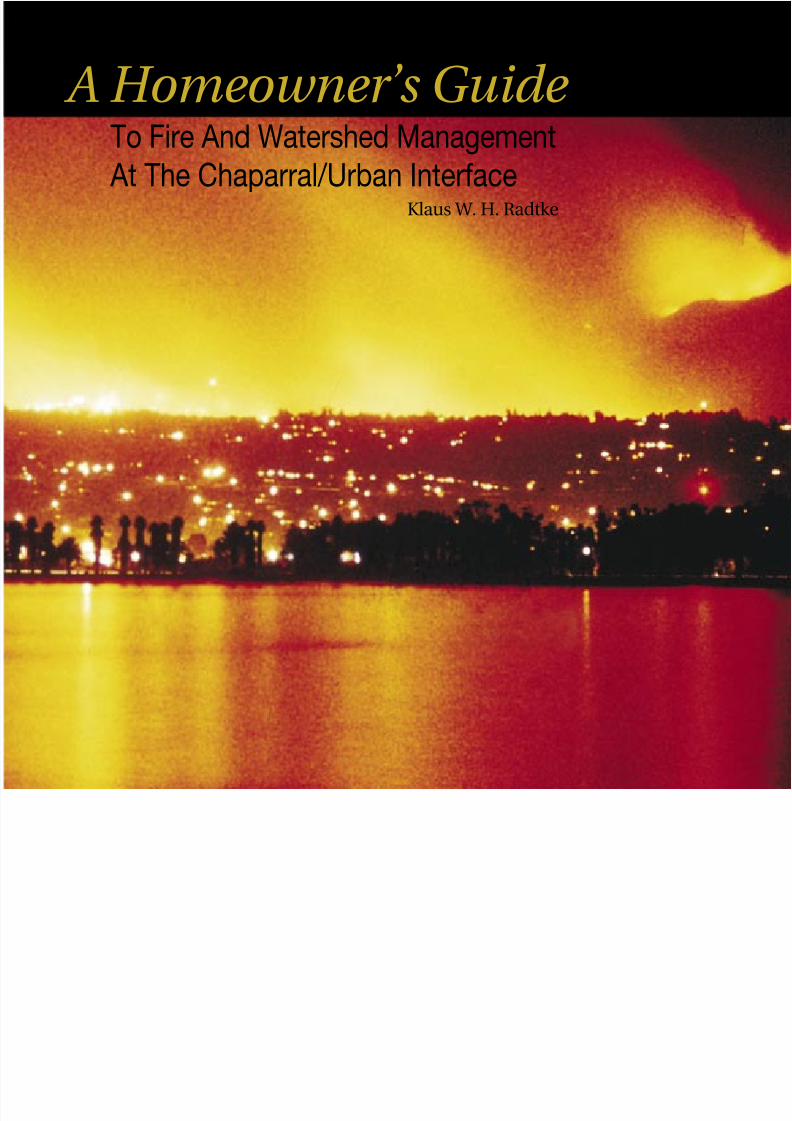
To Fire And Watershed Management At The Chaparral/Urban Interface
A Homeowner’s Guide
Klaus W. H. Radtke

8/8/2019 Homeowner's Guide to Fire_watershed Management
http://slidepdf.com/reader/full/homeowners-guide-to-firewatershed-management 2/50
Table of Contents:
Background From the early 1970s to the early 1980s, I supported, conducted,and spearheaded research projects on urban-wildland interfacere and watershed management problems under CooperativeChaparral Research and Development Agreement 21-436
and related research programs carried out by scientists of theRiverside Forest Fire Laboratory of the Pacic Southwest Forestand Range Experiment Station, Forest Service, with the Countyof Los Angeles as a cooperator. The research was gearedtowards producing practical guides for homeowners as wellas resource professionals. By the late 1970s I had completedthe wildland re prediction mapping for the Santa MonicaMountains of Los Angeles County. Working closely withRiverside Fire Laboratory and University of California,
Berkeley scientists, I applied the wildland re behavior andprediction research spearheaded by the U.S. Forest ServiceMissoula Fire Laboratory to watersheds in urban interfaceareas in an attempt to balance effective watershed manage-ment and re protection. By 1980 a draft publication had beencompleted titled Living More Safely in the Chaparral/UrbanInterface. It had received peer reviews by over 20 scientistsand resource professionals and was presented as aprepublication information copy by the Forest Service at the
international conference and symposium, Dynamics andManagement of Mediterranean-Type Ecosystems, held in June1981 in San Diego.
While this unabridged version was being prepared forpublication (Forest Service General Technical ReportPSW-67), representatives of the Los Angeles County Boardof Supervisors requested that a publication on watershedand re safety be made available to the general public by thebeginning of the 1982 re season. In close cooperation withForest Service scientists, I therefore produced an abridgedversion of PSW-67 titled A Homeowner’s Guide to Fire and Watershed Management at the Chaparral/Urban Interface.It was almost immediately republished by the Santa MonicaMountains Residents Association under its original title anddistributed to this date, and also republished sepa-rately many more times by the County of Los Angeles asHomeowner’s Guide to Fire and Watershed Safety at theChaparral/Urban Interface with minor changes to t theirneeds. Being in the public domain as it was intended tobe, excerpts of it have been widely used over the years bymany authors and agencies as part of their own books or
pamphlets. This practice should continue with this updatedpublication by making it available for downloading on theInternet. It is based on and updates the original June 1982homeowner’s guide at the request of and with the cooperation
of the San Diego Fire Recovery Network formed in San Diegoafter the 2003 wildland res. For additional information andliterature references, please also refer to PSW-67.
A more technical publication, Living in the Chaparral of Southern California: An Integrated Approach to Public Safety , waspublished in 1985 by the National Foundation for EnvironmentalSafety in cooperation with the National Park Service, Santa MonicaMountains National Recreation Area. It is a natural extension ofthe two publications Living More Safely… and A Homeowner’s
Guide… and summarizes the proceedings of the conferenceand workshop held at the Los Angeles County Museum ofNatural History on October 20, 1984. As program organizer,I coordinated the presentations of experienced professionals intheir elds that included such wide-ranging subjects as LandUse and Planning, Development and Public Safety, WildlandFire and Watershed Management, Flood and Erosion Control,Geology, Fire Ecology, Insurance Coverage & Cost, DisasterPreparation & Assistance, and Disaster Psychology.
Klaus Radtke, Ph.D.Wildland Resource ScientistOctober 15, 2004
Introduction 1
The Chaparral Plant Community 3Watershed Management Considerations 5
Fire Management Considerations 9
Owning a Fire-safe Home 13
Landscaping for Fire and Watershed Safety 21
Maintenance for Fire and Watershed Safety 29
What To Do When Caught in a Wildre 32
Evacuation and Road Closure 35
Post-re Emergency Measures 37 Applying The Lessons Learned 41
Firebreak/Fuel Modication Information 46

8/8/2019 Homeowner's Guide to Fire_watershed Management
http://slidepdf.com/reader/full/homeowners-guide-to-firewatershed-management 3/50
Several guides and booklets have been written to help the
homeowner deal with particular aspects of living in the
re-prone wildlands of the Pacic Southwest. Until the
1982 publication A Homeowner’s Guide to Fire and
Watershed Management at the
Chaparral/Urban Interface, none
had given homeowners compre-
hensive advice on managing their
properties effectively so as to reducethe chances of wildre and mudow
disasters and the hardships, both
personal and nancial, they bring.
The 1982 publication was subse-
quently identied by the Wildre
Safety Panel investigating the
disastrous November 2, 1993
Malibu/Topanga Fire as the basisfor developing denite guidelines
for vegetation management plans in
Los Angeles County. This panel and
other post-re disaster panels such
as the San Diego Fire Recovery
Network have also time and again
acknowledged that continuous
education programs are necessaryto mitigate hazardous situations.
This revised and updated book
attempts to further such an
ongoing education process by
providing advice in a practical,
nonscientic, yet professional man-
ner, through basic principles and guidelines. It is also based
on and contains excerpts from the 1983 PSW GeneralTechnical Report Living More Safely in the Chaparral-Urban
Interface, a guide to hillside property management for
Introduction
re and watershed protection. Both publications were
written by the same author under cooperative contracts
between the Pacic Southwest Forest and Range
Experiment Station (Forest Service, U. S.
Department of Agriculture) and
the County of Los Angeles, with
funding provided by the Forest
Service. They also incorpo-
rated state-of-the-art knowledgein various wildland disciplines, and
the experience gained by the author
in dealing with re and oods in his
work and as a homeowner at the
chaparral boundary.
This book rst provides a brief
description of the chaparral plant
community, followed by sections
describing some basic consi-
derations of watershed and re
management. Later sections deal
with improving safety around
the home through home design,
landscaping, and maintenance; eva-
cuation and road closure, protecting
oneself and one’s property during awildre; providing emergency treat-
ment of hillsides after a re; and,
nally, applying the lessons learned.
For more comprehensive and
area-specic fuel modication
and public safety code require-
ments applicable to your community, please also con-
sult planning departments, and re protection and ood
control agencies having jurisdiction there.
1
8/8/2019 Homeowner's Guide to Fire_watershed Management
http://slidepdf.com/reader/full/homeowners-guide-to-firewatershed-management 4/50

8/8/2019 Homeowner's Guide to Fire_watershed Management
http://slidepdf.com/reader/full/homeowners-guide-to-firewatershed-management 5/50
California’s chaparral plant communities consist of many
different woody shrubs and herbaceous species that
have adapted over millions of years to frequent res and
extended periods of drought. The mixture of plant species in
the chaparral communities varies with such factors as aspect
and steepness of slope, soils, elevation, re frequency, and
local climate. Although California’s climate causes chapar-
ral vegetation to be especially subject to large devastatingwildres, similar plant communities and associated re and
watershed problems occur in other western states and other
countries.
Chaparral communities are characterized by a rich diversity
of plant species. Although no single characteristic is present
in all chaparral species, several adaptations to the hot, dry
climate commonly occur. For example, some species
have thick leathery leaves that are small or even needle-like.
This design helps the plants to tolerate severe summer
drought. Other drought tolerance characteristics include
waxy and hairy leaf surfaces and leaves that have a high
aromatic oil content. Some plants become dormant and
shed some or all of their leaves during prolonged drought.
A deep, extensive root system, which increases drought
tolerance and plant survival on steep slopes, is anothercharacteristic common to many chaparral species.
Chaparral plants survive periodic re by sprouting and by
germination of seeds stimulated by the re. Soon after
burning, new sprouts grow from the roots and root crowns
of many plants. Then, fall and winter rains trigger prolic
germination of herbaceous species, often resulting in a
colorful array of wildowers in spring. Seeds of woody plantsalso germinate prolically.
The Chaparral Plant Community
Plant species differ in their susceptibility to re. Their age
and physiological state (whether owering or dormant, forexample) also inuence how well they burn. For chapar-
ral-type vegetation in general, the most important factors
inuencing ammability and re behavior are fuel moisture
(the moisture content of living and dead plant material), fuel
loading (the amount of plant material per unit area), and the
ratio of ne dead fuel to living fuel.
Fuel moisture is high in winter and spring, but graduallydecreases during the hot, dry summer months. The dead-
to-live ratio, as well as the fuel loading increase, causing
greater re danger as plants mature and become old.
3
After re, chaparral recovers by means of seeds, sprouts, and bulbs.

8/8/2019 Homeowner's Guide to Fire_watershed Management
http://slidepdf.com/reader/full/homeowners-guide-to-firewatershed-management 6/50
Fire history records indicate that plant succession patternsinuence re frequency in chaparral communities. Chances
of having a second re within the rst few years after an area
burns are high because of the large amount of herbaceous
fuels such as grasses and owering annual plants that follow
the rst burn. These plants readily become dry and carry a
low-intensity re. As the woody plants begin to dominate an
area again, germination of the shorter-lived herbaceous spe-
cies is inhibited. This greatly reduces re danger for about
the next 10 years because of the high proportion of live,
succulent plant parts and the low proportion of ne dead
plant material on the shrubs.
Fire frequency tends to be greatest in a subunit of chaparral
called coastal sage vegetation. This specialized chapar-
ral type is dominated by plants that tend to grow more
herbaceous material each year than do woody chaparralshrubs. Plants and soil on south-facing slopes are drier than
on north-facing slopes because they are exposed to more
4
Summary
Chaparral communities have adapted to summer drought, frequent res, and steep unstable slopes.
Chaparral plants are able to recover after re by sprouting and by re-stimulated germination of seeds.
The ammability of chaparral vegetation depends on its moisture content, the ratio of dead-to-living fuel, and the amount of vegetation per unit area.
The stage of plant succession, as may be reected
by fuel loading and the severity of a site, affects the likelihood and intensity of a re.
Periodic res rejuvenate the chaparral plant community. Five years later young woody plants have replaced the herba-ceous species; at this stage they do not carry re readily.
direct heat from the sun. Species on these sites burn morereadily than vegetation on cooler, wetter sites.

8/8/2019 Homeowner's Guide to Fire_watershed Management
http://slidepdf.com/reader/full/homeowners-guide-to-firewatershed-management 7/50
A watershed can be dened as
all the land and water within the
connes of a drainage area. Its
depth extends from the top of
the vegetation through the soil
to the underlying geologic strata
that restrict water movement.
Chaparral soils and their underlyingsoil mantle can store great quanti-
ties of water. Rainfall intensities
rarely exceed the soil inltration
rate of well-vegetated chaparral
watersheds. Watershed problems
occur when protective vegetation
is removed, as by wildre or land
development.
The main objective in watershed
management of chaparral lands
is to maintain vigorous, multi-
aged stands of vegetation, which
can respond favorably to periodic disturbance (by re).
The main objective in homeowner watershed management is
to maintain a dense cover of deep-rooted, healthy vegetationthat will stabilize the watershed and control the ow of water
from it. Soils engineering techniques, which are discussed in
detail in Living More Safely at the Chaparral-Urban Interface,
may also be necessary to control runoff and drainage.
In order to meet the various objectives, a watershed has to
be managed as a unit and the erosional processes must be
well understood. The rst requirement means cooperationamong property owners, the second is outlined below.
Watershed Management Considerations
5
Erosional Processes
Chaparral vegetation is commonly found on steep hillsides,
even on slopes that exceed the angle of maximum slope.This angle, often called the angle of repose, is the steepest
angle that bare soil will maintain. For most natural slopes
and most soils, the angle of repose is about 34° (67%).
Beyond this angle, soil and rocks are totally under the
inuence of gravity and may slide downhill unless anchored
by plants. Vegetative cover, root depth, and root strength
affect the extent to which landslides occur. Slope failures are
much less common with deep-rooted vegetation than with
grasses, and with dry soils than with soils that have been
saturated by winter storms or overwatering.
A landslide in a residential area endangers homes.

8/8/2019 Homeowner's Guide to Fire_watershed Management
http://slidepdf.com/reader/full/homeowners-guide-to-firewatershed-management 8/50
6
Steep slopes undercut by roads are especially susceptible to slips and slides.
Slopes of varying steepness are
illustrated in Figure 1. The relation-
ship between slope ratio, degree
of slope, and percent slope is also
presented.
Soil failures are most common on
slopes ranging from 25° to 45° (49%
to 100% or approximately 2:1 to
1:1), making proper manage-
ment of such steep hillsides
extremely critical. Beyond 45°,
rockslides are the most common
erosional processes. Dry creep,the downhill movement of dry soil
and debris, is common on steep
slopes with little vegetative cover.
It often exceeds wet erosion during
low rainfall years and is especially
important after re. The dry creep
settles at the base of slopes where
it waits to be ushed downstream
and perhaps into homes by
occasional storms of high intensity.
Soil slips and landslides account for almost 50% of the
total erosion on a watershed. Unlike dry creep, these soil
movements normally occur when the soil is saturated. They
are readily visible and directly translate into nancial losses
to downstream as well as upstream homeowners. When
heavy rains fall on hillsides left bare by re or improper fuel
management, the water cannot inltrate rapidly enough into
the soil, running instead over the soil surface and causing
excessive erosion and swollen streams. The soil from the
bare hillsides and the dry creep that has collected in the
canyons then combine to create mudow disasters.
Water-repellent SoilDamaging res not only burn the vegetative cover, but
can also cause the soil to become hydrophobic (water
repellent). Normally, slight water repellency of soils is
caused by the breakdown of organic material and certain
chemicals in plant litter. Hot res accentuate this by
concentrating these water-repellent chemicals. Some
of the chemicals are volatilized by heat from the re,resulting in gases that penetrate deeper into the
soil. There the gases cool and condense, coat-
ing the soil particles with the water-repellent sub-
stances. Since rains cannot readily penetrate this
layer of coated soil particles, water quickly saturates the
shallow wettable surface layer. Sheet or rill erosion
occurs after the surface layer is saturated. More
information on hydrophobic soils is presented in the
watershed management chapter ofLiving More Safely at the
Chaparral-Urban Interface.

8/8/2019 Homeowner's Guide to Fire_watershed Management
http://slidepdf.com/reader/full/homeowners-guide-to-firewatershed-management 9/50
7
Figure 1. Slope ratio, percent slope, and degree of slope are shown for some hillsides of varying steepness. On natural
slopes, the danger of soil slipfailures is related to slope angles.The angle may be expressed asthe ratio of run to rise, either as
a percent (rise/run) or in degrees(angle between run and slope)(Campbell 1975).
A steep backyard ll slope has failed, creating great nancial hardship for the affected homeowner.
Summary
Watershed management aims at maintaining a
deep-rooted, dense cover of healthy plants.Such a plant cover controls surface erosion and
reduces slippage by anchoring the soil.
Deep-rooted plants pump water out of the soil, leaving it free to absorb winter rains.
Most post-re mudow originates from debris accumulated in canyons by previous surfaceerosion, soil slips, and landslides.
Fire can accentuate the water repellency of soil.

8/8/2019 Homeowner's Guide to Fire_watershed Management
http://slidepdf.com/reader/full/homeowners-guide-to-firewatershed-management 10/50

8/8/2019 Homeowner's Guide to Fire_watershed Management
http://slidepdf.com/reader/full/homeowners-guide-to-firewatershed-management 11/50
Wildland re management at-
tempts to predict and control re
behavior by managing vegetative
fuels to control ame length, rate
of spread, heat intensity, and the
potential for spot res.
Fire Factors
Wind is an important element
affecting re behavior. Wind not
only controls the direction, spread,
and size of a re, but also greatly
affects the ammability of plants by
reducing fuel moisture, preheating
the plants, and bending the ames
ahead of the re. Wind is also
responsible for spreading re-
brands (burning embers) even
thousands of feet ahead of a re
front and starting new res whenever these rebrands land
on receptive vegetative or structural fuels. Dry grasses and
wood shingle roofs are often the most likely fuel sources toalmost immediately start new spot res.
Most major wildres occur during extreme re weather
brought on by the warm Santa Ana or foehn winds. With the
onset of these winds, which blow from the north or east, tem-
peratures increase rapidly, even into the night, and relative
humidity declines drastically. Under such conditions, res
in mature chaparral cannot be controlled unless the fuelsare exhausted.
Fire Management Considerations
Topography is also a critical factor in re safety. It af-
fects windspeed and direction, and is responsible for
differences in heat radiation and re spread. The mostimportant topographic effect to remember is that re
spreads much faster uphill than downhill.
Ignition
A re is the ame, heat, and light caused by burn-
ing (oxidation) after an object has reached ignitiontemperatures and has been ignited. Ignition tem-
peratures are inuenced by the rate of airow (supply
9
Even in light fuels, convection currents in steep terrain can create long ames that can ignite a house.

8/8/2019 Homeowner's Guide to Fire_watershed Management
http://slidepdf.com/reader/full/homeowners-guide-to-firewatershed-management 12/50
of oxygen), rate of heating, and size and shape of the
object. Once ignition has occurred, sustained combustion
requires a continuous supply of oxygen and fuel.
Wildland fuels, such as grasses, coastal sage scrub,
chaparral, and trees, have various ignition requirements,which depend largely on their moisture content and size.
For example, dry grass has the lowest heat requirement for
ignition, and grassy areas therefore have the highest re fre-
quency. Woody chaparral shrubs in coastal areas normally
do not become dangerously dry until late summer or fall
except under severe drought conditions.
Heat Sources
Heat transfer is by conduction, convection, and radiation.
The ame is the visible burning gas and vapor produced
by the re and provides (along with airborne sparks)
a direct ignition source for fuels that have reachedignition temperatures.
Conduction is the direct transfer of heat by objects touching
each other. An example would be the transfer of heat from a
stack of burning rewood to the side of the garage against
which it is stacked.
Convection heat is the transfer of heat by atmospheric
currents and is most critical under windy conditions andin steep terrain. With light wind and on level terrain, the
10
This burning mountain shows that houses situated on ridges and sideslopes are extremely vulnerable to re.

8/8/2019 Homeowner's Guide to Fire_watershed Management
http://slidepdf.com/reader/full/homeowners-guide-to-firewatershed-management 13/50
11
convection heat column is almost vertical. Reducing the
duration of heat and length of ames produced by nearby
vegetation can be critical to protecting your home from re.
Flame length in chaparral fuels can be reduced by main-
taining low growing, widely spaced plants. For example,
on steep slopes, 30-foot-long convection heat ames canoccur in 6-foot-tall mature chaparral at wind speeds of less
than 10 miles per hour. Reducing the vegetation to 2 feet in
height would reduce the ames to 10 feet. When wind speed
increases to 50 mph, as it often does during extreme Santa
Ana weather conditions, the ame length for 2-foot-tall non-
maintained continuous woody fuels with a high dead-to-live
fuel ratio increases to 35 feet and for 6-foot-tall fuels to more
than 100 feet.
Radiation heat is the transfer of heat by electromag-
netic waves and can, therefore, travel against the wind. For
example, it can preheat the opposite side of a burning slope
in a steep canyon or a neighboring home to the ignition
point. Again, it can be predictably managed if you are in con-
trol of your situation as the following landscape examples
illustrate. For a point source of radiation, the heat intensity
decreases with the square of the distance. This means that
a burning tree 40 feet from a roof or picture window trans-
fers only one-fourth of the heat to the house comparedwith a tree burning within 20 feet, and one-sixteenth the
heat compared with a tree burning within 10 feet. A line
source of radiation such as a burning hedge of junipers or
cypresses is even more critical than a single point source
because the house receives a broad expanse of heat from
all points along the line. In this case, heat intensity varies
with the distance instead of the square of the distance, so
that the heat intensity at a home located within 40 feet of
the burning hedge is still one-half that at 20 feet. This is a
powerful incentive not to plant potentially ammable hedges
or hedge-like “groundcovers” near structures, as well as
keeping ammable shrubs and trees as far away from your
house as possible.
Fine dead fuels in the interior crown make many broad-leaved trees ammable.
Conifers generally are also highly ammable and produce long ames.

8/8/2019 Homeowner's Guide to Fire_watershed Management
http://slidepdf.com/reader/full/homeowners-guide-to-firewatershed-management 14/50
Summary
12
Figure 2. These matches show the interaction of the threetypes of heat transfer.
The interaction of the three types of heat transfer with
topography can be illustrated by visualizing a burning match
as shown in Figure 2. When the match is held head up, heat
transfer is by conduction only, and the match burns slowly.
The situation is comparable to a wildre burning downhill.
If the match is held horizontally, heat transfer is by con-duction and radiation, and the match burns a little faster.
When the match is held head down, it is consumed rapidly
because conduction, convection, and radiation heating are
occurring together. The situation is comparable to a wildre
burning uphill.
The duration of heat transfer can also be a critical factor.
For example, the time period for heavy chaparral fuels tobe consumed may be more than 10 minutes, but if the
continuity and height of such fuels are reduced and the
ne dead fuels removed, the duration of the ame and its
associated heat can often be shortened to seconds. Thus,
a yard tree, which may take many minutes to burn, may
represent a greater hazard to a home than nearby discon-
tinuous, well-maintained chaparral.
Wildland re management includes modication of the size, arrangement, and kinds of vegetative fuels.
Vegetation modications reduce the ignition potential, ame length, and heat output of a re.
Heat transfer methods (conduction, convection, and radiation) vary in their contributions to a redepending on wind and topography.

8/8/2019 Homeowner's Guide to Fire_watershed Management
http://slidepdf.com/reader/full/homeowners-guide-to-firewatershed-management 15/50
13
The re safety of a home depends
on the continuity and loading
of the fuels around it, the loca-
tion of the home with respect to
topography, and also on home
design and building materials.
Legal Fuel ModicationRequirements
California Resource Code 4219
requires maintaining an effective
rebreak around structures in re
hazardous areas for a minimum
distance of 30 feet, and fuel
modication of ammable veg-etation for another 70 feet, for a
total minimum fuel modication
distance of 100 feet. These,
however, are minimum code requirements and do not
necessarily insure a re-safe environment. Therefore, fuel
modication distances enforced by local re authorities
may extend beyond 200 feet, so be sure to check with
local re authorities about minimum applicable re hazard
requirements in your community.
Realize, however, that during a large wildland re, burning
embers (rebrands) may be deposited onto your house
even thousands of feet ahead of the re front, ready to
ignite it if they nd receptive fuels irrespective of fuel
modication carried out around the home. Fire loss statis-
tics have clearly indicated—and it is common knowledgeamong re personnel—that homes that are attended
(either by re personnel or knowledgeable homeowners
Owning a Fire-safe Home
or their support team) have a much higher chance of
surviving a re than unattended homes.
Also realize that there is no true safety net for protecting
your home in a large-scale wildland re or even severalsmaller wildland res burning simultaneously in your area,
as re personnel and support equipment may be spread
thin and you may be prevented from returning to your
home to help protect it. To have a truly re-safe home
environment, you must therefore ask yourself the com-
pound question, “Could (and under what conditions) my
home survive unattended in a wildland re?” Few homes
can make it on their own unless “luck” such as a windshift is on their side!
Wood shingle roofs require an inappropriate amount of manpower and water during a wildre because they are easily ignited by ying sparks.

8/8/2019 Homeowner's Guide to Fire_watershed Management
http://slidepdf.com/reader/full/homeowners-guide-to-firewatershed-management 16/50
14
Figure 4. On narrow ridges, homes without adequate setbacks, such as those on the left, are particularly vulnerable to re.Figure 3. Winds tend to channel through natural chimneys, making narrow canyons and saddles particularly re-prone.
Do not expect that the Fire Department will and/or must
protect your home at any cost or that the codes are
adequate to safeguard it. You have the nal responsibility
of protecting your home and can best do it through (hope-
fully) effective preplanning and continuous maintenance.
An added incentive for creating and maintaining a re-safe environment should be the realization that in high
re danger areas, insurance coverage generally limits
replacement costs (as the actual rates would be generally
prohibitive, as one cannot require the general public to
take on the extra burden of such costs or subsidize living
in such areas) and that you will be required to rebuild to
current code requirements. Therefore, people are gener-
ally under insured for re damage. Worse yet, there is
generally no insurance coverage available for hillside slip
and slide damage that can be very expensive to repair.
The chapter towards the end of the book titled Firebreak/
Fuel Modication Information (for Structures in Fire-
hazardous Areas) provides more detailed information
about fuel modication requirements. However, it cannot
be emphasized enough that the intent of the re code
is readily defeated if basic re safety principles are not
already initiated during the land use planning process and
carried over into home site selection, home design, and
use of re-safe exterior building materials.
Fire Topography The relationship between topography and re behavior is
a factor over which the homeowner has little control. He
should, however, be aware of the relationship as it relates
specically to his property. Figure 3 points out that homes
located in natural chimneys, such as narrow canyons and
saddles, are especially re-prone because winds are fun-
neled into these canyons and eddies are created. Studieson homes burned along ridges have shown that those
located where a canyon meets a ridge are more likely to
burn than other ridge-top homes. In very steep and nar-
row canyons, radiating heat may also be a major factor in
re spread and home losses.
Figure 4 illustrates how homes without adequate set-
backs on narrow ridges are often lost because amesand convection heat hit the home directly. Homes located

8/8/2019 Homeowner's Guide to Fire_watershed Management
http://slidepdf.com/reader/full/homeowners-guide-to-firewatershed-management 17/50
15
on the slope, especially stilt and cantilevered homes, are
particularly vulnerable in this respect.
Building Materials and Design
Building density, design, and building materials are
important safety considerations because a burning home
can ignite adjacent homes.
The roof is the most vulnerable part of a home because it
is exposed to airborne sparks. The wood shingle roof has
been the single most important element in home losses
during wildland res. It is also a major source of airborne
rebrands capable of igniting nearby structures. Studies
of structural losses during wildres in southern California
have shown that with 100 feet of brush clearance, a home
with a wooden roof has a 21 times greater chance of
burning than a home with a nonwood roof. Although most
re insurance rates are higher for wood roofs than for
nonwood roofs, this rate increase does not compensate
for the true difference in risk.
Exterior materials used on wildland homes should have
a re-resistance rating of 1 to 2 hours, meaning that they
should consist of materials such as stucco, metal siding,
brick, concrete block, and rock. This is especially critical
for parts of a home exposed to winds from the north or
east, or that are positioned at the top of a slope. Figures 5
and 6 graphically summarize the principles of topography,vegetation, and architectural design that can improve the
re safety of a planned or an existing home. Many positive
features of home design are shown in gure 5. Note that
reduced overhangs or boxed eaves protect the house
from ignition and heat or ame entrapment. Undereave
vents should be located near the rooine rather than
near the wall so that rebrands and heat sources are not
trapped and funneled into the vents. Exterior attic andunderoor vents should not face possible re corridors
and should be covered with wire screen (not to exceed
1/4 inch mesh). Picture windows and sliding glass doors
should be made only of thick, tempered safety glass, with
other windows made of double-pane glass. Where facingre winds or possible convection heat sources, windows
should be protected with nonammable shutters. This is
especially important if there is only limited slope setback.
Stone walls, where effectively used, can reduce the length
of ll and cut slopes, can increase the pad size for the
home, can act as heat shields, and can also deect the
ames. Swimming pools, decks, and patios can also be
used to create a setback safety zone as well as providesafety accessories.
Properly placed rooftop sprinklers or misters under the
eaves can be quite helpful in preventing ignition from all
sources. Note, however, that sprinklers placed on a
wooden roof generally provide only limited re safety
even if you have your own water supply pumped by
an independent power source unless you use foam orgel water mixtures. But don’t depend on these factors;
change the roof!
The burned roof demonstrates that nonammable roofs are a key to re safety.

8/8/2019 Homeowner's Guide to Fire_watershed Management
http://slidepdf.com/reader/full/homeowners-guide-to-firewatershed-management 18/50
Figure 5. Reducing Fire Risk Through Preplanning.
Class A re-resistant roof such as tile with seams and joints between tiles sealed.
No exposed wood surfaces but stucco or other nonammablesiding of 1 to 2 hours re-resistant rating.
Reduced overhang preferably with closed eaves.
Roof slanted to accommodate convection heat.
Safety zone and slope setback of approximately 30 feet for asingle story home and vegetation properly thinned within the
next 70 feet.
Pool or other low fuel hardscapes used to create buffer zone between house and slope or potential ame sources.
Shrubs and trees not directly adjacent to home nor overhang- ing the roof.
Decks enclosed (skirted) and constructed of materials of 1 to 2 hours re-resistant rating.
Adequate screening of vents to prevent entrance of embers.Preferably no vents on north to east side of house (side facingre winds) or downslope side of house and no ammablevegetation planted near vents or ammable materials stored
nearby.
Double-pane and tempered safety glass used as appropriate.
Protection of windows with re-proof shutters.
16
THE FIRE-SAFE HOME DESIGN
ALLOWS FOR GREATER FLEXIBILITY
IN FUEL MODIFICATION, THEREBY
REATAINIING GREATER SLOPE
STABILITY. BENCH DRAINS AND
DOWN DRAINS WERE INSTALLED
DURING FUEL CONVERSIONS.
WITHOUT THESE SAFEGUARDS,
FUEL CONVERSION IS NOT
RECOMMENDED ON STEEP
SLOPES SUCH AS THESE.

8/8/2019 Homeowner's Guide to Fire_watershed Management
http://slidepdf.com/reader/full/homeowners-guide-to-firewatershed-management 19/50
Figure 6. Some ways to modify an existing property to reduce re risks.
Negative Features Positive Features
1. Wood shingle roof 1. Fire-resistant roof (non-wood)
2. Wood siding 2. Non-ammable siding
3. Large overhang (open eaves) 3. Reduced overhang (closed eaves)
4. High gable roof 4. Redesigning may be too expensive. Review design with your architect.
5. No safety zone (no slope setback) 5. Create slope setbacks with retaining walls (stone walls) to provide level yard extensions and raise stone wall above ground to create heat shields in critical
areas; or build totally re-safe, enclosed deck of 1 to 2 hours re-resistance(such as stucco siding and stone decking).
6. Large picture window 6. Install non-ammable shutters
7. Tree crown overhanging the roof 7. Prune or remove tree
8. Steep slope 8. Increase length of fuel modication zone. Maintain continuously. Also see #5 above.
On steep slopes in high re danger areas, re safety can be further increased by the removal of the most ammable plant materialsto twice (200 ft.) the legal minimum clearance distance. However, retaining thinned, deep-rooted native, woody plants as well as
native bunchgrasses and herbaceous subshrubs is critical for maintaining slope stability and assisting in controlling the invasion of ash-fuel weedy annuals. Maintenance of thinned shrubbery is important because dead, woody vegetation can quickly accumulate
in non-watered zones.
17
SEEK GEOLOGICAL AND ENGINEERING ADVICE AS WELL AS HELP FROM
EROSION CONTROL SPECIALISTS
BEFORE ATTEMPTING INTENSIVE
FUEL MODIFICATION ON STEEP
SLOPES. DRASTIC FUEL REDUCTION
LEADS TO SLOPE INSTABILITY.
8/8/2019 Homeowner's Guide to Fire_watershed Management
http://slidepdf.com/reader/full/homeowners-guide-to-firewatershed-management 20/50
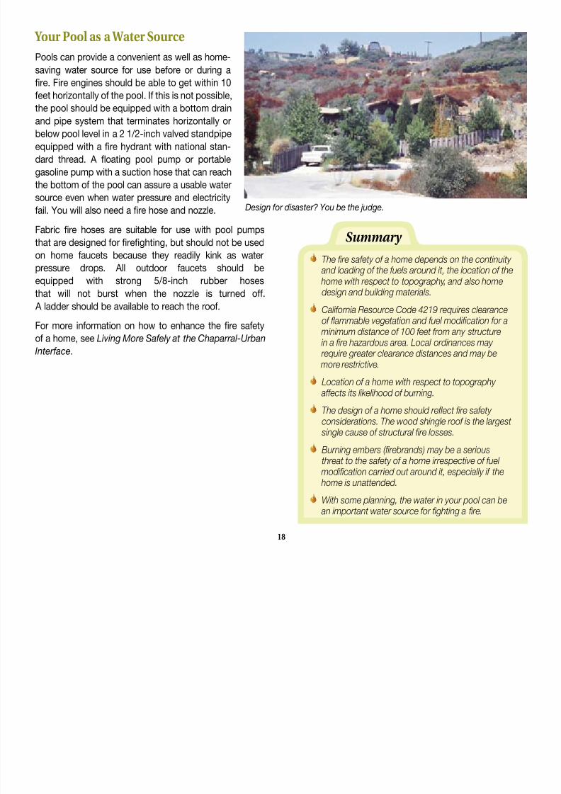
Your Pool as a Water Source
Pools can provide a convenient as well as home-
saving water source for use before or during a
re. Fire engines should be able to get within 10
feet horizontally of the pool. If this is not possible,
the pool should be equipped with a bottom drain
and pipe system that terminates horizontally or
below pool level in a 2 1/2-inch valved standpipe
equipped with a re hydrant with national stan-
dard thread. A oating pool pump or portable
gasoline pump with a suction hose that can reach
the bottom of the pool can assure a usable water
source even when water pressure and electricityfail. You will also need a re hose and nozzle.
Fabric re hoses are suitable for use with pool pumps
that are designed for reghting, but should not be used
on home faucets because they readily kink as water
pressure drops. All outdoor faucets should be
equipped with strong 5/8-inch rubber hoses
that will not burst when the nozzle is turned off. A ladder should be available to reach the roof.
For more information on how to enhance the re safety
of a home, see Living More Safely at the Chaparral-Urban
Interface.
Design for disaster? You be the judge.
Summary
The re safety of a home depends on the continuity and loading of the fuels around it, the location of the home with respect to topography, and also homedesign and building materials.
California Resource Code 4219 requires clearanceof ammable vegetation and fuel modication for a
minimum distance of 100 feet from any structure in a re hazardous area. Local ordinances may require greater clearance distances and may be more restrictive.
Location of a home with respect to topography
affects its likelihood of burning.The design of a home should reect re safety considerations. The wood shingle roof is the largest single cause of structural re losses.
Burning embers (rebrands) may be a seriousthreat to the safety of a home irrespective of fuel
modication carried out around it, especially if the home is unattended.
With some planning, the water in your pool can be an important water source for ghting a re.
18

8/8/2019 Homeowner's Guide to Fire_watershed Management
http://slidepdf.com/reader/full/homeowners-guide-to-firewatershed-management 21/50
Boxed eaves that prevent heat entrapment even if the wood siding catches on re.
Gasoline pool pumps and accessories. Shutters, even emergency plywood shutters, that protect windows.
Vents located near the rooine rather than the wall.
The following safety features may save your home during a wildre:
19

8/8/2019 Homeowner's Guide to Fire_watershed Management
http://slidepdf.com/reader/full/homeowners-guide-to-firewatershed-management 22/50

8/8/2019 Homeowner's Guide to Fire_watershed Management
http://slidepdf.com/reader/full/homeowners-guide-to-firewatershed-management 23/50
Planting the right plant in the right place is as important on manufactured slopes (foreground) as on natural slopes (right background).
Landscaping for Fire and Watershed Safety
The key to landscaping in re-prone watershed areas is to
selectively replace highly am-
mable plants with lower growing,
less ammable plants of equal root
depth and root strength. In reality,
optimum rooting depth and fuel
volume generally work at odds with
one another. That is, low-grow-
ing plants usually have relatively
shallow root systems and tall plants
have relatively deep and broad
lateral root systems. Landscaping
requires a compromise between
minimizing fuel volume and maxi-
mizing root depth.
The key to effective low mainte-
nance landscaping is to use the
right plant in the right place. Native plants should generally
be planted only on the slope aspects they occupy naturally
or areas that are not subject to over-watering. More water-
demanding ornamental plants should generally be planted
only in more shaded locations, not on harsher southern
exposures with thin soils.
Rooting Depth and Fuel Volume As a rule, nonwoody ground covers have an effective root
depth of less than 3 feet and can be labeled “shallow
rooted” for use in steep terrain. Grasses also belong in this
category. Shallow-rooted plants should not be used as per-
manent cover on steep slopes unless they are interplanted
at approximately 10-foot centers with spreading shrubs
and approximately 20-foot centers with hillside-anchoring,
taller shrubs, or small trees. Interplanting is also required in
stabilization of ll slopes.
Woody ground cover shrubs generally are moderately deep-rooted, with roots ranging from 3 to 6 feet in depth, and can be
effectively used on slopes in conjunction with taller shrubs
and trees. Most plant species found in the coastal sage
community fall into this root depth category. Plants with
roots ranging from 6 to 15 feet or more in depth include most
woody shrubs in the chaparral community as well as small,
drought-tolerant landscape trees. Very few commercially
available woody ground covers, with the exception perhaps
of prostrate coyote brush and prostrate acacia, have an
21

8/8/2019 Homeowner's Guide to Fire_watershed Management
http://slidepdf.com/reader/full/homeowners-guide-to-firewatershed-management 24/50
This native plant (center) is dying because of root rot caused by over-watering of the young coyote brush around it.
effective root depth greater than 6 feet. Plants with roots
much in excess of 15 feet include some native shrubs such
as scrub oak and laurel sumac, and trees of larger stature.
Laurel sumac and scrub oak are two of the most watershed-
effective, deep-rooted hillside anchoring plant species
within the chaparral plant community, and their syste-matic removal often leads to soil slippage and slides
on steeper slopes. Additionally, Laurel sumac has been
misrepresented as being highly ammable because
of its generally high oil content (which is not much
different from that of coyote brush) and the lack of mainte-
nance it often receives. However, in the critical summer time
period, Laurel sumac has one of the highest fuel moisture
contents of any tall-growing woody chaparral plant tested;
does not contain or readily accumulate ne, dead fuels
when compared to sages and ceanothus species; and can
be easily maintained. It takes much heat energy to drive the
moisture out of Laurel sumac leaves and dry them to the
ignition point, thereby making the plants quite ‘re-retardant’
if they are occasionally pruned and ammable fuels regularly
removed around them.
Drought Tolerance and Sprouting Ability
Drought tolerance and sprouting ability are also important
considerations when selecting plants. Water will be an
increasingly sparse and expensive resource in the future.
The plant’s ability to survive on little water, as well as toresprout after a re or when neglected (neglect could be a
result of water shortage), can mean savings over the years
on water bills, maintenance costs, replanting costs, and
hillside repairs.
Herbaceous or semiwoody ground covers like capeweed,
lippia, or prostrate myoporum; woody ground covers such
as coyote brush, prostrate ceanothus, and manzanita spe-
cies (where applicable); hedges such as oleander and myo-
porum; and even some coniferous trees like Canary Island
pine and Chir pine do not need to be replanted because they
generally resprout readily, depending on the severity of the
re and post-re drought conditions.
Most native plants also resprout, and some native shrubssuch as sugarbush, scrub oak, ceanothus species, and
chokecherries can be nurtured into short-stemmed trees.
At spacings of about 25 feet, these plants can be kept
relatively re retardant through occasional pruning.
Resprouting native broadleaved trees such as oaks,
sycamores, California bay laurel, Catalina ironwood, and
California black walnut, and ornamental trees such as Cali-
fornia pepper, and black locust, to name just a few, can beeffectively blended into the landscape setting. However, the
named ornamental trees may become invasive within native
habitats close to the home. Also, since leaves of California
bay laurel are highly ammable, the tree should not be plant-
ed close to structures. The hardy southern California black
walnut offers an excellent deciduous alternative that can be
planted even close to homes. For re safety, trees must be
pruned and should be limited to the number necessary to
provide shade and slope stability.
22
8/8/2019 Homeowner's Guide to Fire_watershed Management
http://slidepdf.com/reader/full/homeowners-guide-to-firewatershed-management 25/50
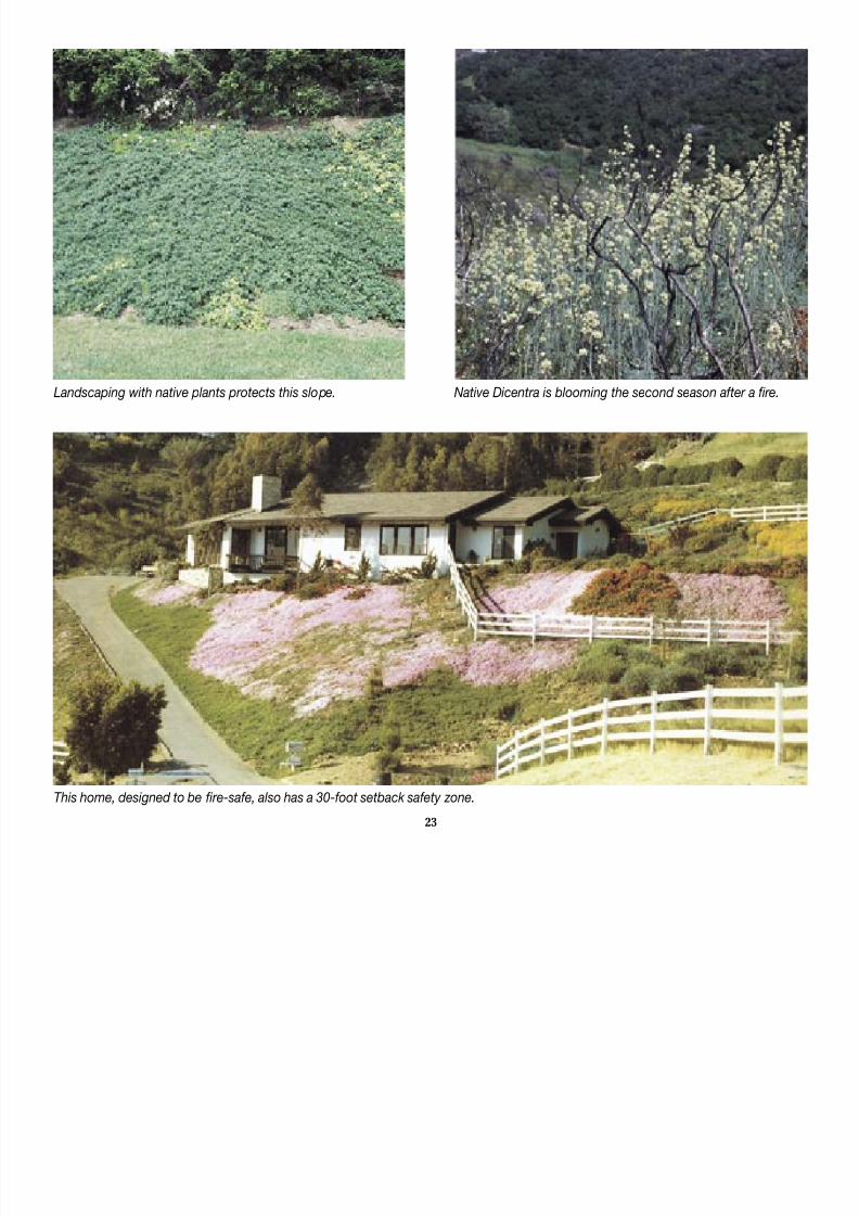
This home, designed to be re-safe, also has a 30-foot setback safety zone.
Landscaping with native plants protects this slope. Native Dicentra is blooming the second season after a re.
23

8/8/2019 Homeowner's Guide to Fire_watershed Management
http://slidepdf.com/reader/full/homeowners-guide-to-firewatershed-management 26/50
The use of herbicides and pre-emergent chemicals must
be closely monitored in hillside landscaping. Overuse can
kill landscape plants and sterilize soils. Fortunately, the
deepest-rooted chaparral shrubs are also the hardest to kill
with herbicides. Since these shrubs serve the dual function
of anchoring the soil to the bedrock and pumping waterout of the ground, soil slippage is almost never observed
where they are present. Mortality of such plants often results
in slippage 5 to 10 years later after the roots have rotted
away. The original cause of such delayed slippage is seldom
recognized.
Hillside Landscaping Some ground covers and low-fuel shrubs commonly used
for hillside landscaping in southern California are listed in
Table 1 along with their characteristics and some sugges-
tions about where they should be used. The plant species
listed, except where indicated, are able to form a solid
ground cover for the slopes recommended. However, there
is no guarantee that the species prevent slippage when thesoil becomes saturated. Interplanting ground covers with
shrubs and trees, as discussed earlier, will maximize slope
stability. Plants that require high maintenance or that are
readily browsed, such as most ceanothus species, are not
included in Table 1.
The columns in Table 1 headed “aspect,” “soil depth,”
and “irrigation” must be read as a unit. Soil depth guresapply to medium-textured, loamy soils. The irrigation gures
apply to coastal regions of southern California and attempt
to show relative watering needs of the plants listed. The
gures assume that soil moisture is recharged to a 12-inch
depth during watering. In reality, this goal is rarely achieved
through overhead watering because of sprinkler design
and the time period necessary for irrigation. The effective
rooting depths indicated in Table 1 are based on moisture
withdrawal by roots after soil moisture has been depleted in
the upper soil layers.
The term “re retardance” as used in Table 1 reects
differences in fuel volume, inherent ammability
characteristics of the plant, and ease of re spread.
For example, under extreme autumn re conditions,
on steep slopes with nongusting winds of 30 mph,a 2-foot-tall solid ground cover with “high” re retardance
is expected to produce a ame less than 10 feet long and
to reduce the rate of re spread. Under similar conditions,
a plant with “low” re retardance may ignite readily, will
carry the re, and can produce ames approaching 25 feet
in length.
The following example will illustrate the use of Table 1.Capeweed is listed in row 2 of the table. Column 1 shows
that the species is most effective for planting on slopes
Concrete bench and down drain systems need to be main-tained year-round.
24
di 25º b b d li i d l

8/8/2019 Homeowner's Guide to Fire_watershed Management
http://slidepdf.com/reader/full/homeowners-guide-to-firewatershed-management 27/50
Summary
Slope stabilization may be achieved by the use of deep-rooted plants in conjunction with slopeengineering.
Fire management requires low-fuel or low-growing plants to reduce ame length and heat output.
As a compromise between watershed and resafety, a combination of taller, deeper-rooted plantsshould be interplanted with ground covers.
not exceeding 25º, but may be used on a limited scale on
slightly steeper slopes if interplanted with deeper-rooted
vegetation. The shallow root system of capeweed may trig-
ger soil slippage. The next three columns are to be read as
a unit and show the relationship between aspect, soil depth,
and irrigation requirements. For example, the rst line showsthat on a north-to-east aspect with less than 1 foot of soil
depth, established plants require summer irrigation once to
twice a month. The remaining columns are self-explanatory.
Ice plants, listed in row 6, have been used extensively for
hillside planting because they are low-growing, drought-
tolerant, re-retardant, and aesthetically pleasing; they
are easily established on harsh sites, and require minimalmaintenance and watering. However, during high intensity
storms, by far the greatest slope failures are found on hill-
sides planted with ice plants. A wise homeowner will acquire
the written opinion of a geologist regarding slope stability
before planting ice plants extensively on slopes in excess
of 15º. Most species of ice plants are best suited for rock
garden situations or for harsher sites with relatively stable
geology and thin soils.
Slope Engineering
Slope engineering techniques such as concrete bench and
down drains, designed to slow and direct excess water ow,
are necessary on most steep slopes around homes. Their
use becomes critical when modication of native vegetationis attempted in geologically unstable areas or areas with
past soil slip problems. The homeowner is responsible for
the maintenance of any drainage devices on his land and
the devices should be listed in the deed for the property. Any
modication of vegetation on the hillside where the layering
(dip) of the bedrock parallels the slope, as shown in Figure
7, should be undertaken with extreme caution because of
the natural instability of the slope. Increasing the inltration
rate of water into the soil and reducing the root strength and
Figure 7. Rock strata may determine hillside problems.
25
root depth per unit area can result in almost immediate soil
failures during winter rains.
More information on various aspects of hillside landscaping
including slope engineering techniques, proper watering
methods, plant selection, and selective brush conversion
is available in Living More Safely in the Chaparral-Urban
Interface. No book, however, should be a substitute for
onsite expert advice from specialists familiar with hillside
landscaping and hillside problems.
Table 1. Evaluation of some popular low-growing plants used in hillside landscaping (check with your local nursery for
plants adapted to your site conditions and climate)

8/8/2019 Homeowner's Guide to Fire_watershed Management
http://slidepdf.com/reader/full/homeowners-guide-to-firewatershed-management 28/50
26
SPECIES
Acacia ongerup
Arctotheca calendula
(Capeweed)
Baccharis pilularis
dwarf varietiesCoyote brush
Ceanothus griseus,
horizontalis
Carmel creeper
Cistus crispus
Descanso rockrose
Delosperma, Drosanthemum
Iceplants (See text)
Hedera canariensis
Algerian ivy (Freeway ivy)
Osteospermumfructicosum
African daisy
Vinca major
Periwinkle
On slopes (degrees)
to 25 25 to 35 35+
Seetext
On aspects
N to E S to W
If irrigated
summer to fall
<1M<1MNone>1M2M1S
1-2M1M2S2M1M
<1M<1M
1S‘None’>1M2S1S1M2S
‘None’<2M<1M1-2S<1M
2S‘None’<2M<1M1-2S<1M2-3S
‘None’1M
<1M‘1-2 S’
1W
1M2S1W2M1M2M1M
<1M1W2M
1-2M>2M
1M<1M2M
1-2M
At elevations(feet)
Up to 2,000
Up to 2,000
Up to 4,000
Up to 3,000
Up to 4,000
Up to 2,000
Up to 2,000
Up to 2,000
Up to 2,000
plants adapted to your site conditions and climate).
EFFECTIVE. . .
At soil depths (feet)
to 1’ 1’-3’ 3’+
Abbreviations: = Suitable for this category = Plant not totally suitable for this categoryW = Week M = Month S = Summer

8/8/2019 Homeowner's Guide to Fire_watershed Management
http://slidepdf.com/reader/full/homeowners-guide-to-firewatershed-management 29/50
27
Spread
Spreading
shrub 12 to30 inches tall
Spreadinggroundcover 6 to 8inches tall
Spreadingshrub12 to 24inches tall
Semi-uprightshrub 18 to 30inches tall
Semi-uprightshrub 12 to 24inches tall
Trailing groundcover 4 to 18inches tall
Trailing groundcover 8 to 12inches tall
Trailing groundcover less than12 inches tall
Trailing ground
cover less than18 inches tall
Fire retardance
Low; decreases
with increase in
fuel
High
Low
Low to medium
Low to medium
Generally high
Medium
Medium to high
Medium
Resprouting
ability
Poor
If watered
Vigorous
If wateredafter light re
Poor
Depends onseverity ofre
If watered
If watered
If watered
Rooting depth
(effective)
Greater than6 feet
I to 3 feet
Approximately6 feet
3 to 6 feet
3 to 4 feet
Mostly
1 to 2 feet
3 to 4 feet
3 feet +
3 feet
COMMENTS
Low maintenance. No foot trafc. Showy yellow owers.
Draws bees. Most drought-tolerant and quickest-spreadingwoody plant tested. Full sun.
Very low maintenance. Takes occasional foot trafc. Showyyellow owers. Weedy in manicured setting. Frost sensitive.Draws bees. Spreads by runners. Full sun to partial shade.Use non-seed producing varieties only.
Prune back every ve years or less often. No foot trafc.Inconspicuous owers. Hard to establish from ats inmidsummer. Healthy green color. Full sun.
Low maintenance. No foot trafc. Showy light blue owers.Draws bees. Ground cover for easily accessible drysite areasin soils with good drainage. Little or no water in the summer.Deep watering only when needed. Full sun to partial shade.Short lived.
Medium to low maintenance. No foot trafc. Showy pink
owers. Draws bees. Ground cover for easily accessibledrysite areas. Attractive if watered; unattractive if notmaintained. Full sun.
Low maintenance. No foot trafc. Showy multi-coloredowers. High foliage moisture and weak root system causesslippage on steeper slopes, especially lls. Full sun to partialshade. May become invasive. Do not plant within a nativeplant environment.
Low maintenance. Tolerates foot trafc. excellent for
minimizing erosion on long steep cuts. Leaves will burn ifwatering is neglected. Excellent understory to a variety oftrees if maintained and cut back so that it does not climb.No owers. Full sun to shade. May become invasive.
Moderate to high maintenance. Tolerates some foot trafc.Showy white owers and other hybrid colors. Freezes at 25°F.Fertilize and water regularly. Full sun to partial shade.
Low maintenance. Occasional foot trafc. Showy blueowers. Does well under partial overstory where somewhatneglected. Sun to shade. May become invasive. Do not plantwithin a native plant environment.
CHARACTERIZED BY . . .
W = Week M = Month S = Summer
Design for Disaster: You Decide

8/8/2019 Homeowner's Guide to Fire_watershed Management
http://slidepdf.com/reader/full/homeowners-guide-to-firewatershed-management 30/50
M i t f Fi d W t h d S f t

8/8/2019 Homeowner's Guide to Fire_watershed Management
http://slidepdf.com/reader/full/homeowners-guide-to-firewatershed-management 31/50
Native plants can be thinned out to form an effective greenbelt zone that is easily maintained.Concrete bench drains should be cleaned as required.
Landscape maintenance is neces-sary to keep man-made structures
separated from surrounding
vegetative fuels; to keep the
amount of vegetative fuels at a
safe level; to create a safety zone
for residents, reghters, and re
equipment; and to assure that
water ow from the property is
channeled properly. Giving correct
priorities to maintenance needs
and carrying out maintenance and
safety inspections on a regular
basis is the key to minimizing the
effects of “natural” disasters.
For re and watershed mainte-nance, the area around the home
should be divided into three
perimeters of defense:
1. 0-to-30-foot setback zone:
year-round maintenance (regular watering)
2. 30-to-100-foot greenbelt zone:
seasonal maintenance (watering as needed)
3. 100-to-200-foot thinning zone:yearly inspections, periodic maintenance (dry zone).
0-to-30-Foot Setback Zone-Maintenance Adjacent to the Home
The area within approximately 30 feet of the home is most
critical for re and watershed safety. Maintenance of non-
Maintenance for Fire and Watershed Safety
ammable landscaping such as lawns, border plantings,
ower gardens and vegetable beds, and structures such as
pools, concrete decks, and recreation areas help to reduce
re hazards close to the home. This area, for the most part,
is level and all water from it should drain toward the street.Rain gutters, pipes, and drainage devices should be cleaned
out on a regular basis. Additionally, all debris such as leaves,
pine needles, twigs, and overhanging branches should be
removed from the roof before the re season begins.
Foundation shrubs and trees are a necessary part of the
landscaping. However, these plants often grow into “urban
forest” fuel problems, so that landscape plants, ratherthan surrounding native plants, become the primary cause
of re losses. Year-round maintenance should consist
29
cypress, and palms (e.g., Washingtonia) are also notori-M d G 6” T ll N t M d
8/8/2019 Homeowner's Guide to Fire_watershed Management
http://slidepdf.com/reader/full/homeowners-guide-to-firewatershed-management 32/50
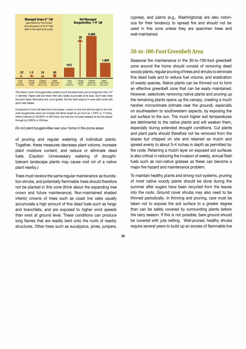
The interior crown of bougainvillea contains much ne dead fuels such as twigs less than 1/2”
in diameter. Papery leaf and ower litter also readily accumulate at its base. Such fuels make
the plant highly ammable and, once ignited, the ne fuels respond in even light winds with
quick heat release.
Compared to 6 inch tall dead and cured grass, a seven to nine foot tall and eight to ten foot
wide bougainvillea plant can increase the ame length by as much as 1,700% or 17 times,
reline intensity by 36,000% or 360 times, and heat per unit area released as the re passes
through by 2,800% or 28 times.
Do not plant bougainvillea near your home in re-prone areas.
of pruning and regular watering of individual plants.
Together, these measures decrease plant volume, increase
plant moisture content, and reduce or eliminate dead
fuels. (Caution: Unnecessary watering of drought-
tolerant landscape plants may cause root rot of a native
plant nearby.)
Trees must receive the same regular maintenance as founda-tion shrubs, and potentially ammable trees should therefore
not be planted in this zone (think about the expanding tree
crown and future maintenance). Non-maintained shaded
interior crowns of trees such as coast live oaks usually
accumulate a high amount of ne dead fuels such as twigs
and branchlets, and are exposed to higher wind speeds
than exist at ground level. These conditions can produce
long ames that are readily bent onto the roofs of nearby
structures. Other trees such as eucalyptus, pines, junipers,
cypress, and palms (e.g., Washingtonia) are also notori
ous for their tendency to spread re and should not be
used in this zone unless they are specimen trees and
well-maintained.
30-to-100-Foot Greenbelt Area
Seasonal re maintenance in the 30-to-100-foot greenbelt
zone around the home should consist of removing dead
woody plants, regular pruning of trees and shrubs to eliminate
ne dead fuels and to reduce fuel volume, and eradication
of weedy species. Native plants can be thinned out to form
an effective greenbelt zone that can be easily maintained.However, selectively removing native plants and pruning up
the remaining plants opens up the canopy, creating a much
harsher microclimate (climate near the ground), especially
on southeastern to southwestern aspects, by exposing the
soil surface to the sun. The much higher soil temperatures
are detrimental to the native plants and will weaken them,
especially during extended drought conditions. Cut plants
and plant parts should therefore not be removed from theslopes but chipped on site and retained as mulch and
spread evenly to about 3–4 inches in depth as permitted by
re code. Retaining a mulch layer on exposed soil surfaces
is also critical in reducing the invasion of weedy, annual ash
fuels such as non-native grasses as these can become a
major re hazard and maintenance problem.
To maintain healthy plants and strong root systems, pruningof most native woody plants should be done during the
summer after sugars have been recycled from the leaves
into the roots. Ground cover shrubs may also need to be
thinned periodically. In thinning and pruning, care must be
taken not to expose the soil surface to a greater degree
than can be safely covered by surrounding plants before
the rainy season. If this is not possible, bare ground should
be covered with jute netting. Well-pruned, healthy shrubs
require several years to build up an excess of ammable live
30
.37 1.5 15 65
10.0
255,400
1,800
FuelLoad
( Tons/acre)
FlameLength( Feet)
FirelineIntensity
( Btu/ft./sec.)
Heat/ Unit Area( Btu/sq.ft.)
FuelLoad
( Tons/acre)
FlameLength( Feet)
FirelineIntensity
( Btu/ft./sec.)
Heat/ Unit Area( Btu/sq.ft.)
Managed Grass 6” Tall(permitted by Fire Code)
Annual grass cut to 6” high
after it has died and cured.
Not ManagedBougainvillea 7-9’ tall
and dead fuel. Therefore, a complete maintenance job can 100-to-200-Foot Thinning Zone

8/8/2019 Homeowner's Guide to Fire_watershed Management
http://slidepdf.com/reader/full/homeowners-guide-to-firewatershed-management 33/50
p j
last a long time.
Erosion during fuel modication can be severe on even
moderately steep slopes of about 15° (27 percent). First-
year erosion rates can exceed 1 inch of topsoil loss. On an
acre basis this would amount to as much as 100 cubic yards
of soil (enough to ll about 25 dump trucks) that would nd
its way into properties at the base of the slope or natural or
man-made drainages located there. The loss of topsoil is
very critical because topsoil contains more nutrients, has
better structure, greater inltration rates, and greater water
storage capacity than subsoil and is therefore more capable
of producing vigorous, healthy plants.
Watershed problems in this greenbelt zone are often critical.
Yearly, before the winter rainy season, all drainage devices
must be inspected to assure that they are functional and
not clogged with debris. After major storms, all rain gutters,
pipes, concrete bench and down drains, and other such
devices must be reinspected. Bench drains are easily
blocked by minor soil slips. This forces uncontrolled water
ow over the slope and results in supersaturated soils and
mudow.
The automatic irrigation system is the primary cause for soil
slips and slides on steeper slopes in urban areas. Failure to
properly maintain or adjust such a system to the minimum
watering requirements of plants and their changing watering
needs during the seasons often leaves sections of slopes
overwatered, even saturated, prior to the onset of the winter
rains.
Rodents such as gophers and ground squirrels can also
be a major cause of soil slips because they weaken root
systems and build underground tunnels where water can
concentrate. For further discussion of animals detrimental
to hillside stability, see the Watershed Management chapter
in Living More Safely in the Chaparral-Urban Interface.
100 to 200 Foot Thinning Zone
The intensity of re maintenance beyond 100 feet from the
home is dictated by topography, design, and exterior build-
ing materials of the structure. Minimum maintenance for a
home designed with re safety in mind should consist of
reducing the amount and continuity of the vegetation as well
as thinning out the most ammable species. Selective main-
tenance can be done in areas where topography is favorable
and geology stable (gentle slopes, rock outcroppings, etc.)
every 5 years or less without causing any accelerated
soil erosion. Such “feathering out” of older vegetation on
portions of a watershed while favoring younger plants
reduces the possibility and effect of major wildres.
Summary
Maintenance of landscaping and structural additions around the home is essential for re safety and watershed protection.
Maintenance needs are most critical within 30 feet of the home, but periodic fuel reduction and
maintenance of drainage devices are required at greater distances from the home.
Covering exposed soil surfaces with a mulch layer reduces erosion, retains soil moisture, and controls
the invasion of weedy annual ash fuels.
31
What To Do When Caught in a Wildre

8/8/2019 Homeowner's Guide to Fire_watershed Management
http://slidepdf.com/reader/full/homeowners-guide-to-firewatershed-management 34/50
What To Do When Caught in a Wildre
If your home is threatened by wildre, you may becontacted by re or law enforcement ofcials and advised
to evacuate. If you are not contacted in time to evacuate,
or if you decide to stay with your home, the following
suggestions will increase your chances of safely and
successfully defending your property. (For further infor-
mation, contact your local re protection agency.)
Before the re approaches your house:
1. If you plan to stay, evacuate your pets and all
family members who are not essential to protecting the
home, but do not jeopardize your life.
2. Be properly dressed to survive the re. Cotton fabrics
are preferable to synthetics. Wear long pants and bootsand carry with you for protection a long-sleeved shirt or
jacket, gloves, a handkerchief to shield the face, water
to wet it, and goggles.
3. Remove combustible items from around the house.
This includes lawn and poolside furniture, umbrellas,
and tarp coverings. If they catch re, the added heat
could ignite your house.
4. Close or cover outside attic, eave, and basement
vents. This will eliminate the possibility of sparks blow-
ing into hidden areas within the house. Close window
shutters.
5. Place large plastic trash cans or buckets around
the outside of the house and ll them with water. Soak
burlap sacks, small rugs, and large rags. They can behelpful in beating out burning embers or small res. In-
side the house, ll bathtubs, sinks, and other containers
with water. Toilet tanks and water heaters are importantwater reservoirs.
6. Locate garden hoses so they will reach any
place on the house. Use the spray-gun type nozzle,
adjusted to a spray.
7. If you have portable gasoline-powered pumps to take
water from a swimming pool or tank, make sure they are
operating and in place.
8. Place a ladder against the roof of the house
opposite the side of the approaching re. If you have
a combustible roof, wet it down or turn on any roof
sprinklers. Turn on any special re sprinklers installed to
add protection. Do not waste water. Waste can drain the
entire water system quickly.
9. Back your car into the garage and roll up the car win-
dows. Disconnect the automatic garage door opener (in
case of power failure, you may not be able to remove
the car). Close all garage doors.
10. Place valuable papers and mementos inside the
car in the garage for quick departure, if necessary. Any
pets still with you should also be put in the car. In this
case, open the car windows partially as the garage may
become very hot.
11. Close windows and doors to the house to prevent
sparks from blowing inside. Close all doors inside the
house to prevent draft. Open the damper on your re-
place to help stabilize outside-inside pressure, but close
the replace screen so sparks will not ignite the room.
Turn on a light in each room to make the house more
visible in heavy smoke.
32
12. Turn off pilot lights. When caught in the open:

8/8/2019 Homeowner's Guide to Fire_watershed Management
http://slidepdf.com/reader/full/homeowners-guide-to-firewatershed-management 35/50
13. If you have time, take down your drapes and
curtains. Close all venetian blinds or noncombus-
tible window coverings to reduce the amount of heat
radiating into your home. This gives added safety in
case the windows give way because of heat or wind.
When the re approaches:
As the refront approaches, go inside the house.
Stay calm; you are in control of the situation.
After the re passes:
After the re passes, check the roof immediately. Extin-
guish any sparks or embers. Then, check under the eaves
and inside the attic for hidden burning sparks. If you have
a re, get your neighbors to help ght it. The water in your
pool and the water in your garbage cans, sinks, toilet
tanks, etc., will come in handy now. For several hoursafter the re, recheck for smoke and sparks throughout
the house.
Remember:
In a major conagration, re protection agencies will
probably not have enough equipment and manpowerto be at every home. You cannot depend totally on their
help. One of the reghters’ principal responsibilities is to
stop the spread of re from house to house. Therefore, if
one home is on re, reghters might have to pass it by to
save another in the path of the re. Your careful planning
and action during a re can save your home. Be prepared.
Talk with your neighbors to see what resources you have.
Ask your re or forestry personnel for professional advice
and assistance.
When you are caught in the open, the best
temporary shelter will be found where fuel is
sparse and ame and heat exposure is hopefully
reduced. These places could include road cuts
and banks, large boulders, rock outcroppings,
large logs, and depressions in the ground. Here are
comments on some good and bad places to go:
Automobile
Move the car to bare ground or sparse fuel areas,
close all windows and doors, lie on the oor, and
cover yourself with a jacket or blanket. The fueltank of the car will normally not explode until the
car is well on re or may not explode at all. So,
keep calm and let the re pass.
Road Cut
If caught without shelter along a road, lie face
down along the road cut or the ditch on the uphill
side (less fuel and less convection heat). Coveryourself with anything that will shield you from the
heat of the re.
Topographic Chimneys
Never be caught by re in natural chimneys.
These are narrow, steep, dead-end canyons that
concentrate heat, explosive gases, and updrafts.
Temperatures may exceed several thousand de-
grees Fahrenheit during a re.
Topographic Saddles
While hiking out of an area where re is in progress,
avoid topographic saddles if possible. Saddles are
wide natural paths for re winds, and vegetation
here will normally ignite rst.
33
SummaryIn the Open

8/8/2019 Homeowner's Guide to Fire_watershed Management
http://slidepdf.com/reader/full/homeowners-guide-to-firewatershed-management 36/50
Summary Look for areas with sparse fuel (for example, soft
chaparral such as black sage or grassland rather
than chamise chaparral), if possible, within a depres-
sion. Clear as much fuel as you can while the re is
approaching and then lie face down in the depressionand cover yourself with anything that will shield you
from the heat. Smoke may create as great a survival
problem as the ames. If you are caught on a steep
mountaintop or sharp ridge, the backside (or re
leeward side) will provide more safety. Be aware,
however, that re eddies often curl over ridges. Before
hiking in re-prone areas, seek additional advice from
wildland reghting and park service personnel. They
may supply pamphlets and can give you specic tips
for wildland re survival.
Remember, even a seemingly non-threatening grass
re is a potential threat to your life if you are caught
in the open and exposed to its quick heat release.
Breathing very hot air can scorch your lungs and
kill you.
Stay calm--you are in control of the situation.
If you decide to stay with your home during a
wildre, evacuate all family members who are not essential to protecting the home.
Dress properly to shield yourself from the heat and ames.
Take steps to prepare your home for the approaching re.
As the re approaches, move inside and stay until it
has passed.Move outside, survey the situation, take action, and
help neighbors.
If caught in the open, seek shelter where fuel issparse.
Remember that wildres are erratic, unpredictable, and often underestimated. Life safety should be the most important consideration.
34
Evacuation and Road Closure

8/8/2019 Homeowner's Guide to Fire_watershed Management
http://slidepdf.com/reader/full/homeowners-guide-to-firewatershed-management 37/50
Summary
Evacuation and Road Closure
Fire suppression agencies are responsible for determiningwhen the need for evacuation exists and the jurisdictional
law enforcement agency is responsible for carrying out
an ordered evacuation. The purpose is to protect people
from life-threatening situations. Under Section 409.5 of the
California Penal Code, the jurisdictional law enforcement
agency is responsible for carrying out an ordered evacu-
ation and closing and restricting access to disaster areas.
The news media is legally exempt from this provision.
Persons have the right to stay on their property if they so
desire, if in doing so, they do not hinder the efforts of re
personnel or do not contribute to the danger of the disaster
situation. In res or oods, able-bodied persons who wish
to remain may be able to aid public safety personnel in
saving their property or may even save their own home
unassisted.
If at all possible, there should be several phases of road
closures within an impending disaster area:
(1) In an area that could potentially be involved in the
disaster, but presently is not, people without purpose
(such as people not living in the area) would be re-
stricted from entry to reduce trafc problems or the
potential for looting.
(2) In areas of imminent danger with limited access or
egress, people would be discouraged from entry even
though they live in the area. Those who are adamant
after being informed of the dangers would probably be
permitted entry.
(3) In areas presently involved in an emergency whereextreme danger to life exists and where trafc must
During evacuations persons have the right to stay
on their property if they so desire.
Depending on the level of emergency, you may not
be able to return to your property during road
closures.
35
be restricted due to movement of emergency vehicles,people, including residents, would be refused entry.

8/8/2019 Homeowner's Guide to Fire_watershed Management
http://slidepdf.com/reader/full/homeowners-guide-to-firewatershed-management 38/50
Post-re Emergency Measures
8/8/2019 Homeowner's Guide to Fire_watershed Management
http://slidepdf.com/reader/full/homeowners-guide-to-firewatershed-management 39/50
The steps to take in emergency rehabilitation of an areaafter a re depend on the location of the property, the time
of year, the intensity of the re, the erosion potential, and
the kinds of plants present. Figure 8 illustrates some post-
re emergency rehabilitation measures.
If the re occurs in midsummer and the burned watershed
cover consists primarily of landscape plants with a large
proportion of resprouting ground covers and shrubs, allthat may be necessary for rehabilitation is to periodically
irrigate and perhaps fertilize. Adequate moisture, heat, and
nutrients will encourage rapid resprouting so that a good
foundation plant cover can be established before the heavy
winter rains return.
Postre management of native plants is similar to the pro-
cedure outlined above. Plants should be allowed to resprout
and establish themselves from seeds. Thinning of seedlings,
as well as removal of dead stems and branches, can begin
the following spring after the rainy season is over. The rst
year’s thinning of native plants should be very light, followed
by heavier thinning the second and third years after clear spe-
cies patterns and densities have emerged. Timing becomes
critical when a hot re occurs in late fall. In neighborhoods
where steep, long slopes overlook canyons and endangerthe lives and property of canyon residents, neighbors should
work together to quickly establish an emergency vegetation
cover before heavy winter rains begin.
Vegetative Measures
Aerial emergency seeding efforts by public agenciesprimarily employ ryegrass which can be viewed as a “band-
aid” measure meant to duplicate or complement nature’s
Post re Emergency Measures
own “band-aid” of post-re herbaceous plants. However,in 1980 the biological group of resource professionals and
scientists of an interagency task assembled to produce an
Interagency Field Guide for Vegetative Emergency Burn
Rehabilitation for California recommended against broad-
cast-seeding burns in chaparral and coastal sage scrub
ecosystems. They stated that seeding is primarily done in
response to perceived political and social needs, and as
far as the natural system is concerned the introduction ofexotic species, in most cases, is not necessary. Neverthe-
less, when home-owners face excessive erosion on steep,
burned slopes previously largely covered with landscaping
where little or no post-re herbaceous regeneration of native
vegetation can be expected, a quick vegetative emergency
erosion control cover is often required that could include
hand-seeding with grains. This is especially important if
downslope values to be protected are homes.
Seeds of annual grasses present before the re will ger-
minate quickly with any moisture because most seeds are
incorporated into the soil layer. On the other hand seeds
exposed at the soil surface will not germinate and root un-
less encouraged by 4 to 5 days of moist, overcast weather.
The least time- and labor-consuming emergency measure
for homeowners is therefore to broadcast annual ryegrass or
other quickly germinating species at the rate of 15 to 30 lb./
acre, rake the seeds about 1/2 inch deep into the soil where
feasible, and then water lightly and regularly. Watering may
be necessary two or more times a day during hot weather.
Grasses have brous root systems that are very effective in
competing for soil moisture. When replanting of shrubs or
ground covers is planned for the spring or begins immedi-ately after the re, annual grasses must be separated from
37

8/8/2019 Homeowner's Guide to Fire_watershed Management
http://slidepdf.com/reader/full/homeowners-guide-to-firewatershed-management 40/50
such plants and should be seeded in contour rows. Such
rows should parallel the slope and are easily established
with a hoe. They should be spaced about 3 feet apart but
could be closer in steeper terrain and on ne-textured soils
with low inltration rates. The ground covers are planted
between the contour rows. Contours are very effective in
reducing erosion because the ridges and trenches form a
series of mini-terraces allowing water to inltrate into the
soil. This increases plant growth, reduces runoff, conservessoil moisture, and prevents soil losses. Do not use contour
rows in active landslide areas. Cover these areas with plastic
using the guidelines discussed in the next section.
Barley is an effective species for contour row planting.
Seeds should be soaked overnight in gunnysacks (cloth
bags) in leaky trashcans. The recommended seeding rate
is 150 lb./acre with about an equal amount of ammonium
phosphate fertilizer. Seeds should be buried about 1/2 to
1 inch deep and the soil tamped. Where possible, the site
should be lightly watered to promote rapid germination.
Rapid germination also reduces excessive depredation of
seeds by birds and rodents. Barley is readily available from
feed stores, but buy only recleaned barley; rolled barley
(used for feed) will not germinate. Annual grasses, such
as ryegrass and barley, die with the return of hot weather
and then present a re hazard and also continued competi-
tion with landscape plants if allowed to go to seed. Plants
should therefore be cut down to stubble in spring before thishappens and the stubble used as mulch.
Mechanical Measures
Flood control ofces in many jurisdictions provide excel-
lent advice and pamphlets on mechanical measures
for use in emergency situations. The most effectivemethods for homeowner use are wooden deector
barriers (usually plywood) and sandbags that rechannel
Figure 8. Immediately after a re,emergency measures should betaken to rehabilitate the watershed.
38

8/8/2019 Homeowner's Guide to Fire_watershed Management
http://slidepdf.com/reader/full/homeowners-guide-to-firewatershed-management 41/50
mudow safely around structures. Figure 9 shows that
the placement of such structures is critical in achieving
the desired results. Sandbags should be lled half-full
with sand or soil and the aps tied under and pointed in
the direction of the water source. Bags should be tamped
and tightly tted and each layer staggered, as when
building a brick wall. Rows should not be more than three
layers high unless they are pyramidal or supported by abuilding.
Figure 9. Sandbags divert owing mud.
Post-re emergency control measures are effectively used to protect the foundations/building sites of burned homes.
Barley contours effectively reduce soil erosion.
39
Summary Some other effective measures are check dams to reduce
gully erosion, chain link fences to control rock fall, and

8/8/2019 Homeowner's Guide to Fire_watershed Management
http://slidepdf.com/reader/full/homeowners-guide-to-firewatershed-management 42/50
The plastic is well anchored and covers the whole slope.
g y
guniting of steep slopes and spreading of plastic to
eliminate water inltration. Plastic sheets should be 6 mil
(0.006-inch-thick) because they are sturdier than 4 mil.
The slope should be covered completely and the plastic
should be anchored by partially lled sandbags. On steep
slopes, the sandbags should be connected using ropes.
Plastic sheets that cover only a small section of a slope
(as when some sheets have blown away) concentrate the
rainwater and are responsible for localized saturated soils
and slippage.
Survey re damage in relation to topography (the
whole watershed) and structures.
Obtain expert advice immediately and coordinatequick action with other residents.
Use vegetative as well as mechanical emergency measures effectively, taking care to avoid possibledamage to other properties.
40
Applying The Lessons Learned

8/8/2019 Homeowner's Guide to Fire_watershed Management
http://slidepdf.com/reader/full/homeowners-guide-to-firewatershed-management 43/50
pp y g
Basic Wildland-Urban InterfaceFire Safety Concepts
(Re) building
1. A wood shingle roof has a generally higher probability
of igniting from burning rebrands than native chaparral
vegetation.
2. Even with 100 feet of ‘brush clearance,’ a house witha wooden roof has a 21 times greater probability of
burning than a house with a non-wood roof.
3. Even a small two-story structure on level ground can
create enough radiant heat during its burnout period
to ignite wood siding, etc., on homes within an
approximately 60-foot radius.
4. While the burnout period for chaparral fuels in a wind-driven re is generally less than 15 minutes, the burnout
period for structural fuels (houses) may last hours.
During this time period your home may be subjected
not only to invisible radiation heat from a neighboring
burning house that raises surrounding vegetation and
structural fuels to the ignition point, but also to visible
rebrands that may invade your home unnoticed.
(Re) landscaping
5. For a point source of radiation such as a tree or bush,
the heat intensity decreases with the square of the
distance from the source. Thus, a tree burning within 20
feet of a window transfers only one-fourth the heat to
the house compared with a tree burning within 10 feet
and only one-sixteenth of the heat compared with a treewithin 5 feet.
6. For a line source of radiation, such as a hedge orrow of trees, the heat intensity only decreases with the
distance instead of the square of the distance and a
house receives this heat from all points along the line.
Thus the heat intensity received 20 feet from a burning
hedge is still one-half that at 10 feet and one-fourth that
at 5 feet.
7. Increasing the number of ammable landscape plants
around a home and increasing the number of trees, or
both, will make a home more prone to re, despite legal
brush clearance.
8. The term ‘re resistant’ is a misnomer in relation
to ammability of plants and gives the homeowner a
false sense of security, as all plants will burn under
the proper re weather conditions. In re ecology the
term ‘re-resistant’ denotes that a plant is adapted to
re such as having thick bark (e.g., mature Ponderosa
Pine) or will readily resprout from epicormic roots or
shoots (e.g., Coast Live Oak) or will regenerate through
prolic seeding (e.g., Cistus spp.). The species named
can burn under the proper conditions if not maintained
in a re-safe manner.
9. Landscape fuels that burn adjacent to a house
create enough conductive and radiant heat to ignite
wood siding, wooden decks, trellises, and to break
windows. Unprotected windows are often the ‘Achilles
heel’ for re entry even on a ‘re-safe’ designed home.
10. A six-foot-tall mature, continuous chaparral
fuel mass burning on steep slopes can create enough
radiant and convective heat during its burnout period toignite upslope homes more than 100 feet away (in other
41
words the ames and heat produced can reach across
a 100–foot-wide re safety zone (inclusive of the 30-to-
10. Homes situated in steep canyons, at the top of
canyons, draws, saddles, along narrow ridges, without

8/8/2019 Homeowner's Guide to Fire_watershed Management
http://slidepdf.com/reader/full/homeowners-guide-to-firewatershed-management 44/50
100-foot irrigated zone) to ignite ammable components
on the house, especially if the house is unattended.
Lessons from the Ashes
Major factors of home losses during the 1961
Bel Air/Brentwood Fire
Home construction
1. 75% of buildings destroyed had wooden shingle
roofs.
2. 66% of dwellings, which sustained any damage, were
rst ignited on the roof.
3. 12% of dwellings destroyed had unprotected eaves
as their point of re entry.
4. 3% of dwellings destroyed had underooring as their
point of re entry.
5. 1.5% of dwellings destroyed had windows as their
point of re entry.
Home Location
6. 70% of dwellings destroyed were located within 50
feet of chaparral.
7. 45% of dwellings destroyed had minimal or no slopesetback.
8. 45% of all stilted or cantilevered homes were
destroyed (mostly side slope).
9. The burning of homes along ridge tops was not ran-
dom but was directly correlated with the intersection of
main and tributary canyons.
adequate slope setback, etc., were especially vulner-
able to re.
A Few More Things to Keep In Mind InProtecting your Home
During the critical time period when a re front moves
through an area, there are only limited resources such as
reghters and water available, with the latter being gene-
rally the most critical factor. Adequate hydrant water pres-
sure and ow is dependent on limited hydrant use. When
homes burn simultaneously or need to be protected from
multiple hydrants by re personnel, water pressure and ow
drop quickly. It is the same as when your family attempts to
take simultaneous showers throughout the house.
Wood homes often require a huge amount of water to be
saved, compromising the safety and protection of other
houses. In excess of 50,000 gallons of water have been
documented as used by homeowners in protecting their
large wooden homes as the re front moved into an area
and then did not actually move on as surrounding houses
burned and showered the neighborhood with rebrands.
Wood homes, even wood shingle homes and wood
accessory structures such as decks, are nevertheless
still permitted (even sideslope on steep hillsides or in re
funnels) in many highly re-prone mountain communities,even after disastrous wildland res. Permitting the placing
of wood shingles over 1-hour re resistive materials in
high to extreme re danger areas or buffer zones, and not
developing standards for siting of homes, is still a socially
and politically acceptable compromise that largely ignores
sound wildland re safety principles and leads to cycli-
cal recurrences of re disasters. The ready availability of
prefabricated homes that are comparatively quick, easy,and cheap to build (unless re-safe upgrades are required
42
or voluntarily incorporated) makes it feasible to develop
even low-value lots in high-risk areas that often provide only
li i d i f i
structures for many hours even under Santa Ana drying
wind conditions, and can be rejuvenated by applying a ne
i Wh i h i d ll

8/8/2019 Homeowner's Guide to Fire_watershed Management
http://slidepdf.com/reader/full/homeowners-guide-to-firewatershed-management 45/50
limited infrastructure protection.
Water is generally now, and probably will always
be, the most limited factor in effective re protec-
tion. For that reason innovative ways are constantlybeing developed to improve the effectiveness of water.
Where re is imminent a safety zone can be established in
the vegetation around homes with long-term “indirect” re
retardants that last weeks to months to limit the spread
of re. These retardants generally remain effective until
removed by rain or erosion and are usually applied by re
protection agencies. Since they are based on ammonium
phosphate, a fertilizer, they should be hosed off trees and
shrubbery after the re danger has passed. A “fertilizer” burn
can be expected on some vegetation.
Foam and gel water mixtures as well as pool and pond
pumps are probably the most innovative/effective
approaches to house-to-house wildland re protection to
become established practices in the last 20 years and can
be readily adapted for homeowner use. It has been docu-
mented time and time again that homes burned because of
lack of water from primary sources such as storage tank
systems and public hydrants, while perhaps in excess of
500,000 gallons of auxiliary water supplies in private pools
were not used. But water alone may not do the job.
Foam and gel water mixtures are short-term direct attackmethods that can be effectively applied by the homeowner.
Foams are quite effective in extinguishing res but lose their
effectiveness within a short period of time (generally less
than one-half hour after application) since water drains from
the foam, air bubbles burst, and the foam collapses.
Gels, the basis for home re protection systems, can be
readily applied by the homeowner prior to a re even with asprayer attached to a garden hose. They stick to and coat
mist. When coating a house, windows as well as accessory
structures such as fences and propane tanks should also
be coated. But, remember, you have to be at home to do
the job. Since res may start when you are not at home,
be prepared and rst create a re-safe home environment
as your rst line of defense. Use of homeowner applied gel
systems is an effective secondary line of defense.
The Internet should also not be overlooked as a source for
up-to-date information on these state-of-the art home re-
saving devices.
Mutual reghting aid (the pooling of re personnel andequipment resources during emergencies) has been
ne-tuned for over twenty years but has generally been
overrated in effective house-to-house re protection. It may
be of limited use during the critical early hours because of
lack of proper equipment adapted to steep terrain in areas
of limited ingress and egress, limited wildland re training
of urban reghting personnel, and lack of familiarity with
the local terrain by out-of-town reghting agencies. U.S.
Forest Service and California Department of Forestry
and Fire personnel are outtted with small vehicles more
adapted to hit-and-run tactics. If circumstances and
terrain permit, they can also stay put in safe or hunker-
down areas as the re front passes and carry foam and
pool/pond pumps as standard equipment.
Where feasible, such hit-and-run tactics by a limited seg-ment of the reghting force, being properly equipped and
familiar with mountainous terrain, can effectively protect
homes during the initial phase as the re front passes. But
they will not protect homes during a longer burnout period
if such reghting forces try to keep ahead of an erratic
re front. While the burnout period of a stand of mature
chaparral may last up to fteen minutes as a re front
moves through, a mixture of trees and ammable structures
and erratic winds that often result in incomplete burnout
43
and a return of the re as the wind shifts can extend this
burnout period to many hours. Homes must therefore
b tt d d th h t th b t i d f
ammable fuels leads to man-made re disasters on a cycli-
cal basis.

8/8/2019 Homeowner's Guide to Fire_watershed Management
http://slidepdf.com/reader/full/homeowners-guide-to-firewatershed-management 46/50
be attended throughout the burnout period of
surrounding fuels.
Fire Exposure (Risk)
Wildland re exposure or risk can be dened as the
probability that a given home, subdivision, or community will
experience wildland res within a given time period. So, be
prepared, understand, and work to minimize the risks. Fire
becomes a way of life and it is highly likely that your com-
munity will encounter re on an average of about every ten
years if situated adjacent to or within watersheds covered by
native chaparral.
The degree of exposure (risk) an individual home, commu-
nity, or section of a community faces is a function of the re
history (frequency and severity) in the surrounding vegeta-
tion or probability of re within a certain vegetation type,
increase in re frequency brought on by encroachment of
the community into ammable watershed areas and nearby
human activity, and site-specic exposure factors such as
the proximity to ammable vegetation, siting of structures,
construction materials, construction style, etc. (see: Fire
Hazard).
Remember that effective re protection starts in the
planning process. Homeowners and homeowner as-
sociations, as responsible partners, should get involvedin this process as well as in preparing pre-re plans
in cooperation with re protection agencies. Allowing
homes to be rebuilt after a re on an even larger scale
and with greater density, not signicantly improving
the infrastructure to enhance ingress and egress,
not widening streets and driveways, not improving
water supply and water ow, and not strictly enforcing
fuel modication and maintenance that eliminate
To account for site-specic risk and hazard factors often not
addressed by public agencies, re insurance carriers gener-
ally require “brush clearance” much in excess of 200 feet.
Satellite imagery to assess risk factors such as proximity to“brush” will be an ever-increasing rst low-cost step in the
future in assessing insurability in re-prone environments.
Where the risk cannot be spread, insurers are unlikely to
insure or will raise their rates.
Fire Hazard
You, as a homeowner or homebuyer, can affect re hazard
much more than re risk. By remembering and understand-
ing the basic principles, you can turn the odds in your favor
and make your home and community safer. So, again, be
prepared, understand where you can be effective, and work
to minimize the risks.
Wildland re hazard can be dened as the potential severityof a re in a given area due to the availability of:
1. Natural vegetative fuels
Type and size of fuels, age, fuel continuity, fuel loading
(amount of fuel), litter production (amount and type
of litter produced by the plant during its seasonal
growing cycle).
2. Landscaping/ornamental fuels
Type and size of fuels, age, fuel continuity, fuel loading
(amount of fuel), litter production (amount and type
of litter produced by the plant during its seasonal
growing cycle), maintenance of ammable landscape
vegetation (or lack thereof) to make it less ammable
or ‘nonammable.’
44
3. Man-made structural fuels and their design/location
Size and type of ammable structural components

8/8/2019 Homeowner's Guide to Fire_watershed Management
http://slidepdf.com/reader/full/homeowners-guide-to-firewatershed-management 47/50
45
such as wood roofs, wood decks, wood siding, exposed
windows, wood window frames, open/non-enclosed
eaves, non-protected exterior attic and underoor
vents (permitting re entry into the interior of thestructure), ammable fencing and railing, non-skirted
underooring of houses or decks (unprotected from
re entry from underneath or the sides), ammable
outdoor furniture, etc.
4. Topography (terrain)
Topography and the siting of a structure are very
critical factors in re exposure or risk. For example,
re can travel uphill 16 times faster than downhill. A re
spreading uphill resembles a re spreading before a
strong wind. Other factors being equal, a re burning
on level ground will spread twice as fast when it reaches
30% slopes. The rate of spread will again double as
the slope reaches 55%. Heat energy release rates will
be correspondingly faster and greater as indicated bygreater ame length per foot of re line.
5. Typical re weather conditions
Low humidity, strong drying winds, and high
temperatures.
6. The overall development pattern of the area
Location and siting of homes within mountain topog-raphy (side-slope homes, homes located along ridges
with minimum setback, homes located in saddles or
draws, etc., are at greater risk and are often consid-
ered ‘a design for disaster’). Construction of homes,
exposure of construction materials, exposure distance
to ammable vegetation and ammable structural fuels
(such as closeness of homes to each other).
Firebreak/Fuel Modication Information (f St t i Fi h d A )

8/8/2019 Homeowner's Guide to Fire_watershed Management
http://slidepdf.com/reader/full/homeowners-guide-to-firewatershed-management 48/50
46
You are required to clear ammable vegetation only on your own property. Clearance on adjacent properties is the
responsibility of the owner. Contact your local forestry or
re personnel if such clearance is needed. However, be
aware that if private homes abut public property or their
siting was chosen to take advantage of views irrespective of
natural resource protection, required fuel modication may
often have devastating impacts on budgets of public park
agencies. This is especially true in situations where requiredfuel modication distances were increased beyond 100 feet
without a focused EIR and without assessment of impacts
on the environment and the ability of public agencies to
fund such protection for private individuals. If beneting
homeowners or homeowner associations are not willing to
take on the cost of required fuel modication maintenance of
public land directly adjacent to their homes, it discourages
the further dedication of pocket parks and open space.
Fireghters who must protect your home from a brush re
would like every advantage they can get. Ideally, they would
like to see every bit of hazardous vegetation cleared away,
right down to mineral soil.
Homeowners, on the other hand, want the beauty of native
vegetation and the seclusion it offers. They also realize thatduring a major re conagration, reghting personnel are
‘spread thin’ and homeowners may become the key to
saving their own homes. Are you prepared? Can you save
your home or can it save itself?
Both natural resource professionals and homeowners realize
the danger from soil erosion that will result from a barren
hillside; nevertheless, the native brush must be cleared or
(for Structures in Fire-hazardous Areas)
modied by law to a point where a home will stand a good
chance of being saved in the event of a re.
California law requires you to:
1. Maintain an effective rebreak by removing and
clearing away ammable vegetation and combustible
growth from areas within (a minimum of) thirty feet of
buildings or structures (Exception: Single specimens oftrees, ornamental shrubbery, or similar plants used as
ground covers, provided they do not form a means of
rapidly transmitting re from the native growth to any
structure);
2. Maintain additional re protection or rebreaks by
removing brush, ammable vegetation and combustible
growth located within one hundred feet of such build-
ings or structures, when such buildings or structures
are located within very high re hazard zones, and
are designated by the California Fire Department of
Forestry and Fire Protection’s Fire Hazard Severity
Zone Classication system (Exception: Grass and other
vegetation located more than thirty feet from buildings
or structures and less than eighteen inches in height
above the ground need not be removed where neces-sary to stabilize the soil and prevent erosion);
3. Remove portions of trees which extend within ten feet
of the outlet of a chimney;
4. Maintain trees adjacent to or overhanging a building
free of deadwood; and
5. Maintain the roof of a structure free of leaves, needles,or other dead vegetative growth.
To Provide Added Fire Protection in and Around Your Home and Garage:
8/8/2019 Homeowner's Guide to Fire_watershed Management
http://slidepdf.com/reader/full/homeowners-guide-to-firewatershed-management 49/50
Remove any combustible structural fuels within the 100-foot
minimum safety zone. Realize that wooden fences can act
as re fuses that lead re directly to a structure.
As required by code, screen the chimney to prevent sparks
from igniting the roof or ammable vegetation. Use half-inch
wire mesh.
Not only keep all trees, shrubs, or other vegetation adjacent
to or overhanging any structure free of dead limbs, branches,
and other combustible matter, but also ideally, do not even
allow tree limbs to encroach within ten feet of your house.
Also keep trellises away from any structures.
Keep the roof and rain gutters free of dead leaves, twigs,
and other combustible matter.
Keep all combustible rubbish in non-combustible rubbish
containers with tight-tting lids.
Stack woodpiles neatly and compactly in a location remote
from buildings, wood fences, and other combustible
materials.
Clear all ammable fuels for a minimum of twenty feet from
liqueed petroleum gas storage tanks.
Provide effective fuel breaks in excess of twenty feet wide
on either side of roads leading to your house by clearing all
ammable fuels. Greatly increase this distance in steeperterrain.
47

8/8/2019 Homeowner's Guide to Fire_watershed Management
http://slidepdf.com/reader/full/homeowners-guide-to-firewatershed-management 50/50
This Handbook was brought to you by:
The City of San Diego Water Department in cooperation with
The San Diego Fire Recovery Network and The Conservation Action Committee.
For water conservation information call (619) 235-1984
or visit www.sandiego.gov/water.
10-2004 (6,000)