how rewilding reduces flood risk - welcome - … rewilding reduces flood risk a natural approach to...
TRANSCRIPT

1 2
How rewilding reduces f lood risk
A natural approach toflood managementthat repairs andrevitalises our brokenecosystems
Image: Joe Cornish, Courtesy of National Trust Images

3 4
Who we are Rewilding Britain is a charity with a wild vision – to help restore natural ecological processes and enable key species to return to at least one million hectares of Britain’s land and 30% of our territorial waters over the next 100 years.
Why this report Rewilding has a crucial role to play in our efforts to reduce flood risk and adapt to the impacts of climate change. Rewilding projects are long- lasting, involve communities in decision-making and improve areas for wildlife as well as people. This report looks closely at a wide range of examples and also considers findings from academic sources and NGOs. The overall conclusion is that rewilding can and does make a difference.

5 6
As our climate changes, more and more communities across Britain are experiencing the impacts of flooding – and the costs to individuals and businesses are staggering.
On average, flooding costs the UK economy £1.1 billion annually and the disastrous floods of winter 2015 may have cost as much as £5 billion1. One in six properties is at risk of flooding2. And the number of households at serious risk of flooding could
double by 2050 as a result of climate change3.
While more frequent heavy rainfall has increased flood risk, another major influence is the way in which land and water is traditionally managed. This report looks at how reconsidering these methods and restoring our damaged ecosystems instead can play a big role in reducing the risk of the kind of floods that have devastated communities in recent years.
Introduction

7 8
Natural water cycles have been disrupted by decades of managing land and water to meet needs such as food production and built developments.
Our cities and towns have huge expanses of hard surfaces and super-fast drainage systems to ensure that water leaves urban areas as quickly and efficiently as possible. Our wetlands have been drained for development and agriculture. Rivers have been straightened so they flow faster. Run-off has been allowed to drain upland peat bogs dry and carry soils into our waterways.
Measures such as these have seriously compromised nature’s ability to provide valuable environmental services that we take for granted, such as keeping our water clean, storing carbon and providing wild spaces and interconnected habitats. This has resulted in a decline in species and a reduction
TheProblem
in the ability of our natural environments to cope with intense periods of heavy rainfall. In line with climate change predictions, we can expect such events to occur more frequently in the years to come.
The time is ripe for change and a number of organisations, including conservation bodies, water companies and private landowners have taken decisive steps. They have been running projects that restore naturalprocesses to deliver a range of benefits, including reduced flood risk. They might not be labelled “rewilding” but, in essence, that is often what they have been doing.
What is rewilding?
It is about helping ecological restoration to happen, while enabling people and wildlife to thrive together.
Rewilding secures the good things that nature provides – clean air and water, carbon storage, flood control and more.It offers a chance to reverse trends such as the loss of forest cover and species.
Rewilding also means restoring our sense of wonder and enchantment with wild nature.
Rewilding is an approach that works with natural processes to restore ecosystems and reconnect society with the natural world.
Image: Mike Birkin/Friends of the Earth
Image: Brian Tozer

9 10
Schemes that work with nature to reduce flood risk have been happening for some time. Scientific evidence of their effectiveness and economic viability has, however, been lacking.
To address this, the Department for Environment Food and Rural Affairs (Defra) provided funding for three long-term trial schemes. They were: • Slowing the Flow in Pickering,
Yorkshire• Source to Sea in Holnicote,
Somerset• Making Space for Water in the
Peak District in Derbyshire.
The numbers add up
The final report 4, covering all three projects, finds that natural flood management can and does help reduce flood risk. Beneficial measures include increasing upland flood storage areas, re-vegetating bare peat on moors and creating leaky woody dams either in waterways or in wet woodlands alongside main channels.
The report states: “The measured local effects of a variety of these techniques has shown that flood peak heights may be reduced by 4% or more on a 9km2 catchment scale in the Derbyshire project, by 4% on a 69km2 scale in the
North Yorkshire project and by 25% on an 18km2 scale in the Somerset project. These estimated effects apply to significant-sized flood peaks in the order of 1 in 25 annual chance of occurring. Multiple (or more intense single) NFM measures (carefully-planned and catchment-specific) are more likely to exert a larger positive cumulative effect.”
It goes on to say: “The total value of the flood risk reduction and other benefits arising from these projects substantially outweigh the total costs involved in implementation.”
These techniques also provide a range of other positive impacts including: • Preventing erosion, trapping
sediment, reducing loss of soil/peat particles, carbon storage and improving water quality downstream.
• New habitat creation, more attractive landscapes and increased wildlife interest.
• A better understanding among communities of the many wider benefits of good land management.
The examples here, along with others across the country, show what can happen when we rewild our land and water.

11 12
WWhen can we call it rewilding?
Natural flood management harnesses natural ecological and hydrological processes to reduce flooding. So the synergies with rewilding approaches are clear.
Key elements of rewilding that we believe make something more about rewilding than basic conservation are when one or more of the following features is/are present:• When the overall aim of the
project seeks to recreate natural processes that have been lost (often due to human intervention).
• When introducing plants, trees or wildlife occurs in efforts to replace lost species that would have naturally appeared in the area and will benefit wildlife and people.
• When the project re-engages local people with their environment and gives them
a sense of ownership and reconnection with nature.
• When those involved in the scheme are open to unexpected outcomes or accept that uncertainty is part of the process.
All the case studies in this report demonstrate rewilding techniques, from placing blockages in streams and rivers echoing how nature would work, to allowing scrub to regenerate alongside rivers, to planting trees in places where they would grow naturally if not overgrazed. They also help to inspire people to regain their sense of wonder at what wild places can offer.
When habitats and living systems are being restored and ecological damage is being repaired, that’s rewilding.
“Rewilding takes inspiration from past environments without necessarily attempting to recreate them.”
Dr Paul Jepson, University of Oxford

13 14
Every patch of land in a catchment, including those in urban areas, can help reduce flood risk.
Uplands and floodplains, for example, can play vital roles in slowing the flow of water and providing enhanced water storage. Methods include creating wetlands and restoring peatland by blocking moorland ditches to stop water draining off bogs. Changes to farming practices, such as low tillage and reduced stocking densities, also reduce soil erosion and compaction.
Tree planting and natural regeneration of trees and scrub, in particular, can significantly reduce flooding, soil erosion and water pollution5.
Studies of the Pontbren Project6 in mid-Wales, where shelter belts of trees were planted across sheep pastures, discovered that water infiltrates into the soil under the trees up to 60 times the rate at which it infiltrates into the soil under pasture. The tree roots appear to create channels for water flow, allowing the soil to act as a sponge.
Rewilding is a big-picture solutionRe-establishing the balance ofnature across entire catchments is an opportunity to embrace
Image: Steve Lucker

15 16
Another study focused on a whole river catchment in the New Forest over an area of 100 square kilometres. It found that strategic planting of trees could reduce the height of flooding in towns downstream by up to 20%7.
By contrast, heavy grazing, due to the removal of deep vegetation and compaction of soil by the feet of livestock, make land much less permeable. Studies in the Upper Ure catchment showed that grassland areas where sheep had been excluded for five years had significantly lower soil compaction than areas from which sheep had been excluded for three years or less8.
Findings like these may not always be applicable elsewhere due to factors such as differences
in soil, tree types and the topography of the local area. However, studies do show that, in general, woodland on upland slopes and floodplains provides a range of benefits including restoration of wildlife habitats and reduced water pollution. This is why the Forestry Commission is mapping areas that would be suitable for more tree planting9.
One research paper10 estimates that reforesting just 5% of the upland landscape reduces flood peaks by around 29%, while full reforestation would reduce them by some 50%.
A study for the National Trust11 concluded that at a small catchment scale (less than 100km2) – applicable to 97% of England and Wales – land management has a real impact on run-off and can be used as part of an integrated approach to flood risk management.
In urban areas, where impermeable surfaces such as roads and roofs prevent rainwater soaking into the ground, re-creating natural processes can help reduce flood risk.
Sustainable Urban Drainage Systems (SUDS)12 refers to various measures that deal with urban run-off water and they are being used more frequently. Growing vegetation on roofs and walls, for example, can slow surface water run-off, while creating ponds or wetlands near built environments helps to store water during storms. This also, of course, encourages wildlife.
Techniques like these, each aiming to repair ecological damage in the built environment, can be classed as rewilding.
It is important to note that the gathering of evidence into whether rewilding for flood risk works at a catchment scale is in its early stages. And just because something works in one area it may not do so in others. The devil is in the detail – in terms of types of soils, size of catchments, interactions between different landscapes and so on.
However, even those who are saying we need more evidence of the impact of natural flood management when scaled up to whole catchments, do agree that it is worth carrying out more of it13.
Image: Steve Lucker
Image: Steven Lucker

17 18
The Stroud Valleys in Gloucestershire have a history of flooding. And after the catastrophic floods of 2007, community flood action groups decided to adopt a new approach to the problem.
Together, they realised that the River Frome and its tributaries weren’t suited to hard engineering solutions. This was due to the geographical nature of the area as well as its heritage and beauty. As a result, a partnership between the Environment Agency, Gloucestershire County Council, Stroud District Council and the Severn and Wye Regional Flood and Coastal Committee
Case Study: Stroud Valleys
Scheme mimics nature to reduce floods
(RFCC) was set up to fund a project14 to work with natural processes throughout the catchment of the river and its tributaries.
The project has used and mimicked natural processes to reduce flooding and restore biodiversity. Hundreds of tree trunks and large branches have been added to the upper catchment to slow flood flows and rewild the stream channels. Water is stored in fields and flood plains using ponds, bunds and ditches. Soils are encouraged to store and drain water slowly via soakaways and reduced compaction created using farm machinery.
The project works with a mix of private and conservation group landowners in the area. For example, the two private owners of Cranham Woods on the Upper Painswick stream (a tributary of the River Frome) and Toadsmoor Woods in the Upper Frome have installed 16 large woody debris leaky structures on the stream flowing through their woodland. These will slow and calm peak flows and, importantly, allow sediment and soil to accumulate behind them. This will provide flood risk benefit in the longer term to communities downstream in Painswick.
An event earlier this year showed just how effective the initiative is.
On March 9 2016, half of the average monthly rainfall fell in 10 hours – intensity that previously would have significantly increased flood risk downstream. When, for instance, an equivalent amount of rain fell on similar ground conditions in November 2012, the flow in the Slad Brook reached a peak of over 1.5m. The peak in 2016 after the installation of the 40 leaky dams was just under 0.5m. At a total cost of £215,000 over two years, this project appears to be showing the benefits and cost effectiveness of working to restore natural processes to rivers and streams.
Image: Alistair Driver

19 20
Many residents of Lewes in East Sussex hold strong memories of the devastating flood that occurred in October 200015. After days of heavy rain, the river Ouse burst its banks, leading to the evacuation of 600 homes and millions of pounds of damage.
The Sussex Flow Initiative16 seeks to make the whole of the catchment area more resilient to heavy rainfall, flooding and climate change. The Sussex Wildlife Trust, supported by the Woodland Trust and the Environment Agency, encourages local landowners to work with nature to slow water flows and help reduce flooding
Case Study: The Sussex Flow
InitiativeNatural processes address the threat
of flooding around the River Ouse
downstream. This approach provides a range of benefits. Slowing and storing more water on the land reduces stress on existing flood infrastructure, at the same time as creating better spaces for wildlife to thrive.
Tree branches and trunks positioned at strategic places in the river network replicate natural processes. These leaky dams help to create a more varied and rough structure to slow and break up the water’s progress while also capturing silt and run-off. They are specially designed to allow fish passage underneath. Such measures are much cheaper
than traditional flood defence schemes, easily replicable and can be tailored to local needs. Another bonus is that they make use of locally sourced and natural materials.
Volunteers have helped create floodplain woodlands across the catchment, planting 23,000 trees, including 3.5 kilometres of new hedgerow. Both trees and hedgerows can substantially increase the natural ‘sponge’ effect of the landscape, increasing water percolation into soils and helping to slow flood flows as well as offering a haven for wildlife.
When it rains heavily, natural washland areas near streams can be used for short-term flood water storage. These meadows extend the time the water lies on the land allowing it to drain through the soil and more slowly back into rivers. Slower-moving flood water on floodplains can then filter out flood debris and
sediment, which otherwise can harm water quality.
In Sussex, floodplain meadows and natural wetlands are one of the most threatened habitats17. They have shrunk in size, have been drained and have become disconnected from each other. Yet they are rich in wildlife, often supporting more than 40 species of plant per square metre and an abundance of wildlife. Floodplain vegetation and soils also help to store carbon. So the work this project is doing will reap big rewards in future.
Flooding is a natural phenomenon, and it can’t be prevented completely. However, working with local people, this project aims to significantly reduce the likelihood of houses and businesses being affected, as rainfall events become more extreme in the future.
Image: F Southgate

21 22
The Defra-funded Source to Sea project at The National Trust’s Holnicote Estate in Exmoor trialled various measures to slow flows and store water18. Techniques included moorland restoration in the headwaters, re-creating flood meadows and making woody dams that mimic beaver activity.
In combination, small-scale catchment-wide initiatives had significant effects where a single scheme would not necessarily have worked or been economical.
Crucially, the project led to a reduction in downstream flood risk. During the unprecedented rainfall in Somerset in winter 2013, there was no flooding in villages that regularly suffered
Case Study: Holnicote Estate
Proof that rewilding land and rivers works
in the past. There was also a 10% reduction in flood peak in late December 2013 on an already saturated catchment containing over 90 properties at risk.
Central to the success of this project was the engagement and support of local landowners and the wider community. One notable outcome of this was a widespread change in perception of land and water management.
While the project did not explicitly set out to rewild the landscape, much of it can be described as rewilding. This is because it has restored natural processes to enable a better functioning environment for people and wildlife.
“It has been really exciting to lead a project that works at a landscape scale, from source to sea. By working with nature, we are showing that flood risk can be significantly reduced in addition to providing a range of environmental gains for people, wildlife and natural resources, especially soils and water.”
Nigel Hester, National Trust, Holnicote Flood Trial project manager
Image: N Hester

23 24
U Over the past two centuries, huge swathes of upland peat bogs have been drained for agriculture – leaving behind bare, desert landscapes and a host of problems. They include reduced wildlife habitat, flooding of downstream communities due to poor water retention and limited carbon storage capacity.
To address these issues, landowners throughout the country have been working across catchments to impressive effect.
At the headwaters of the River Derwent, on the highest plateau in the Peak District National Park, three football pitch-sized areas of moorland were used to study the effects of blocking gullies and re-planting peat bogs with moorland grasses, heathers and other plants. It was found that re-vegetation significantly reduces run-off, while re-vegetation plus gully-blocking works even better.
Average peak flows reduced by 30% and average run-off slowed by around 20 minutes19. Modelling results concluded that moorland regeneration would help reduce flood risk in the lower reaches of the River Derwent.
The multiple benefits of restoring peat uplands have also been demonstrated in the Upstream Thinking project20 on Exmoor in Devon and the Pumlumon Living Landscapes Project21 in the Cambrian mountains in Montgomeryshire.
Similar techniques to those used in the Peak District have raised the water table by an average of five centimetres – retaining an extra 155 million litres of water at the Pumlumon Project and reducing water volume leaving the monitoring sites on Exmoor by two thirds during storm events.
Uplands Projectsundo the damage
Projects in the Peak District, Montgomeryshire and Exmoor are holding back water as nature intended

25 26
“Vegetation acts as a sponge, soaking up water, storing it for dry periods and releasing it gradually. This can reduce the height, effects and ultimately the cost of floodwater. Sustainable land management practices can increase the water retention capacity of the environment, alleviating the effects of both droughts and floods.”
Clive Faulkner, Montgomeryshire Wildlife Trust
Case Studies: Belford,
Northumberland and Pickering,
YorkshireHow close partnerships
reap rewards for all
Any successful rewilding project must have people at its heart. So it is important that authorities bring communities together to exchange information between different areas, learn and move forward – introducing schemes that reduce flood risk while also restoring nature.
A pioneering project in Belford, Northumberland is a good example. The Environment Agency worked with the community across a catchment
to manage run-off and slow river flow through a range of mechanisms including barriers and storage ponds. It was relatively low-cost, at £300,000 compared with a conventional scheme estimate of £4million22.Another example of strong partnership working is in Yorkshire where a sustainable approach to managing flood risk has reduced the risk of flooding in Pickering from a 25% chance in any year to a less than 4% chance23.
It’s clear that flood-prone communities should have a lead role in catchment management. There is a need, therefore, for community planning processes that enable communities to negotiate with landowners upstream and to determine how flood management budgets should best be allocated. To optimise outcomes, they should be supported by professional facilitators, expert advice, public money and official empowerment. Image: Mike Potter

27 28
Rivers respond to soft solutions
Letting nature run its course reduces flood risks and fosters biodiversity
The management of rivers can have a major impact on the speed and severity of flooding. Canalised and embanked rivers, for example, cause water to flow rapidly downstream, often where our villages, towns and cities are located.
Conversely, restoring rivers to a naturally meandering state and allowing stones and wood to partially block flows has been shown to increase wildlife and reduce flood risk downstream.
Additionally, reducing the height of river banks allows water to overflow naturally into floodplains – creating areas for wildlife to thrive and water to be stored
either in times of drought or excessive rainfall.
During the 2014 Somerset floods, there was much discussion about dredging as a solution. This involves removing build-up of sediment and soils from the bottom of rivers. Often, however, dredging is uneconomic, damages rivers and produces only minor and temporary effects. What’s more, increased river flow created by dredging can simply send the flooding problem further downstream.
A better, longer-term solution to sediment build-up is to tackle the source of the problem – and that means more soil conservation upstream24.

29 30
During the devastating floods in Cumbria in 2009, river managers noted a significant difference in the responses of two rivers – the St John’s Beck in Thirlmere and the River Liza in Ennerdale25.
The former had been canalised and straightened. The latter had been allowed to rewild, braiding and meandering naturally, forming islands and accumulating banks of stone and woody debris.
The St John’s Beck suffered a major pulse of floodwater, roaring down the river valley. The River Liza was still clear and fordable the day after the downpour. Its combination of meanders and obstructions
Lost Effra27 is a project led by the London Wildlife Trust that empowers communities to create green landscape features to increase local resilience to climate change. The developments also improve neighbourhoods for people and wildlife.
The culverted river Effra is one of London’s lost rivers, running beneath a highly urbanised and socially diverse area of South
Case Study: Wild Ennerdale
Case Study: Lost Effra
Naturally meandering river protects communities
downstream
London’s lost river Effra – an empowering
restoration project
slowed and filtered the water, protecting settlements from flooding. At least twice within the past six years, downstream from Ennerdale, neither Ennerdale Bridge, Egremont or other smaller villages flooded when torrential rain fell on the Western Lake District fells.
Towns and villages on the western edge of the Lake District, however, suffered severe flooding, and have done so more than once. They include Cockermouth, Workington and several other smaller villages26. Here, rivers flow down adjacent valleys and are subject to traditional management and land-use.
London. It is also vulnerable to flooding in times of heavy rainfall.
The project is restoring nature by working with communities to create green roofs, rain gardens and wildlife gardens by removing hard paving. These new green spaces increase drainage, hold back rainwater and create habitats for urban wildlife, while simultaneously improving areas for local people.
Imag
e: L
ondo
n W
ildlif
e Tr
ust

31 32
The main focus of the project is to create demonstration schemes in visible communal areas through working closely with local people.
From these, communities are encouraged and supported in replicating the ideas in their own households and local areas.
One example, on the Cressingham Gardens estate, is the creation of a 30-metre green corridor of raingardens. Rainwater from the roof of a large residential building is now diverted through downpipes into three gardens, rather than being sent running downhill into the Brixton flood risk area. Now, when it rains, water is caught and held temporarily in the gardens before being taken up by plants
and naturally soaking into the ground. The gardens provide food and shelter for urban wildlife and greatly enhance the busy walkthrough for residents and passers-by.
Another project removed the concrete forecourt and a path at the Rosendale Allotments in Herne Hill. Rainwater is now stored in a thick layer of recycled crushed stone and the once-sudden flows of water that caused flash flooding when it rained heavily are reduced. In time, the water evaporates back into the air, or is slowly released into the sewers after the main flow of run-off in a storm has passed. The Lost Effra Project is currently funded by Thames Water, WREF and Lambeth Council.
Image: iStock

33 34
Beavers to the rescue
Encouraging beavers to return to Britain could go a long way in helping to rewild our rivers and wetlands. The dams they build and woody debris they place in watercourses can have a powerful influence in slowing the flow.
Research across North America and Europe has highlighted the impact that beavers are known to have. Following the re-introduction of beavers to Belgium, one study28 found a significant lowering of the height of flood water downstream of dams and an increase in the interval between major floods. In a US study, water took three-to-
four hours to travel 2.6km where there were no beaver dams. When a single, leaky beaver dam, 1.5m high, was established, it took 11 days to cover the same distance29.
Natural England30 has confirmed that beavers can regulate river flows and beneficially reduce flood levels downstream31. The wetlands that beavers create also provide food, shelter and homes for all kinds of wildlife including dragonflies, butterflies, brown trout and bats. All of this makes them a keystone species, which is one of the many reasons that Rewilding Britain wants to see them back.
These ecological engineers work fast and could be our best friends when it comes to flood management
Image: Peter Cairns
35 36
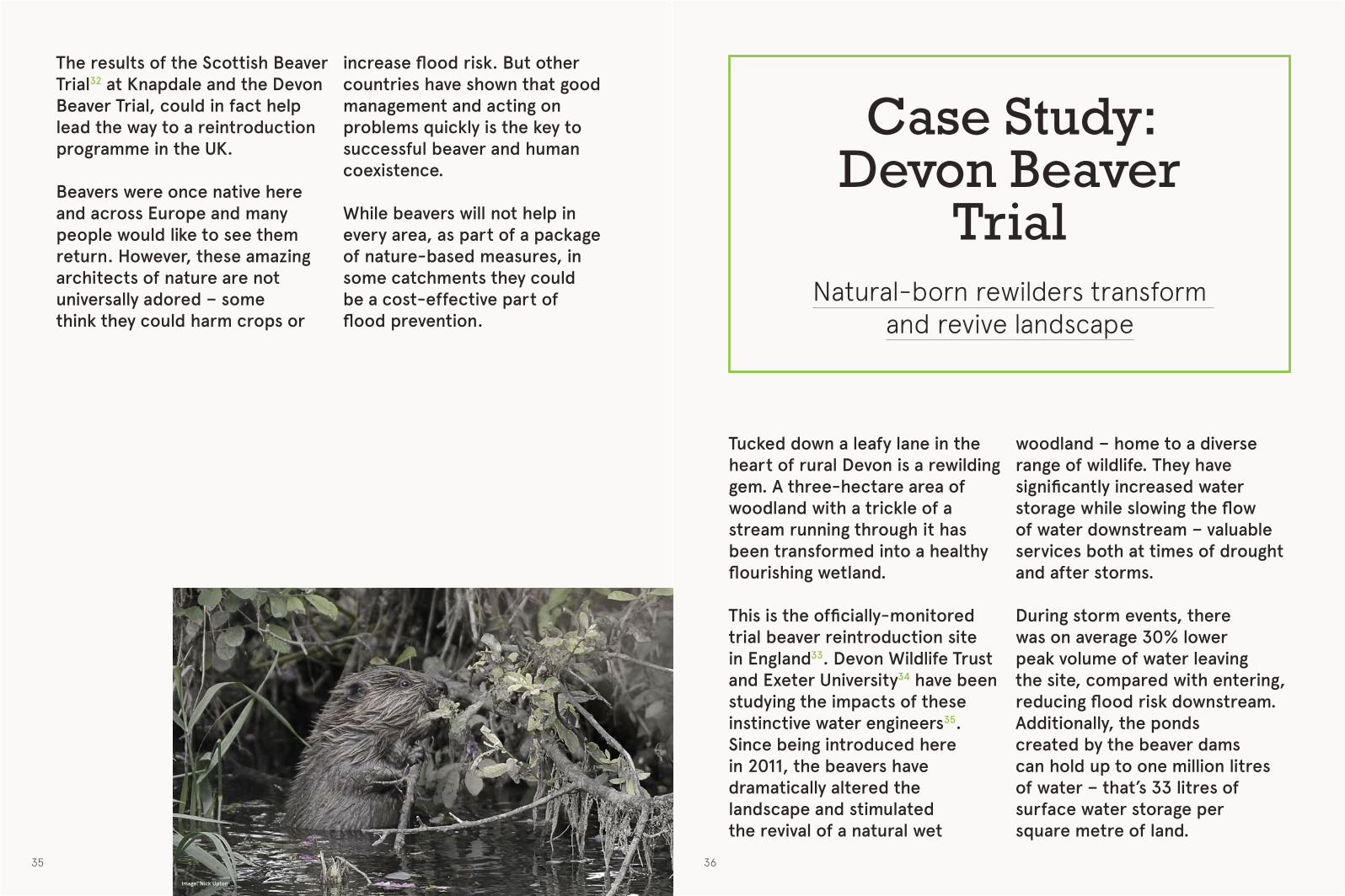
The results of the Scottish Beaver Trial32 at Knapdale and the Devon Beaver Trial, could in fact help lead the way to a reintroduction programme in the UK.
Beavers were once native here and across Europe and many people would like to see them return. However, these amazing architects of nature are not universally adored – some think they could harm crops or
Case Study: Devon Beaver
TrialNatural-born rewilders transform
and revive landscape
Tucked down a leafy lane in the heart of rural Devon is a rewilding gem. A three-hectare area of woodland with a trickle of a stream running through it has been transformed into a healthy flourishing wetland.
This is the officially-monitored trial beaver reintroduction site in England33. Devon Wildlife Trust and Exeter University34 have been studying the impacts of these instinctive water engineers35. Since being introduced here in 2011, the beavers have dramatically altered the landscape and stimulated the revival of a natural wet
woodland – home to a diverse range of wildlife. They have significantly increased water storage while slowing the flow of water downstream – valuable services both at times of drought and after storms.
During storm events, there was on average 30% lower peak volume of water leaving the site, compared with entering, reducing flood risk downstream. Additionally, the ponds created by the beaver dams can hold up to one million litres of water – that’s 33 litres of surface water storage per square metre of land.
increase flood risk. But other countries have shown that good management and acting on problems quickly is the key to successful beaver and human coexistence.
While beavers will not help in every area, as part of a package of nature-based measures, in some catchments they could be a cost-effective part of flood prevention.
Image: Nick Upton

37 38
WWhat’s holdingus back?
While there is now a good understanding of the benefits of working with natural processes to reduce flood risk, some believe that more evidence is required in order to assess exactly which measures do best and where to locate them.
We feel, however, that with appropriate modelling and learning from existing case studies, more projects should be happening, particularly in high flood risk areas.
Natural flood risk management has been shown to be successful at the small-catchment scale,
generating a host of direct and indirect benefits for people and wildlife.
As demonstrated by the case studies in this report, there is little to lose and a lot to gain by restoring natural processes in and around our rivers.
Funding for projects
Funding is a major barrier to the development of more schemes that work with nature. Grants for flood schemes are very focused on delivering direct benefits in terms of the numbers of properties expected to be at
Calls for more evidence and funding issues are limiting progress when it comes to rewilding – but the benefits are clear to see

39 40
less risk of flood, defined in property values. This can lead to macro-level projects that don’t properly address the issues.
As traditional, large-scale-engineered flood defence schemes take up the bulk of grant money, funding for natural flood alleviation projects is limited. Many schemes rely on levering in non-traditional sources of funding, such as local authority or Lottery Fund grants as well as corporate donations.
More novel ways of sourcing funds for projects need to be developed and best practice shared. Communities can come together to crowd-source funding for projects as has been done in a few places.
For example, a community-led partnership, formed by Bucklebury residents in Berkshire, raised £65,000 towards a flood defence scheme. And in Norfolk, residents set
“We rely on our rivers, reservoirs, aquifers and moorland for our water supply and this vital resource can be significantly affected by the decisions made by landowners in the surrounding area. Upstream Thinking is a sustainable approach, working with the expertise of partners, the knowledge of farmers and nature itself to improve water quality. This keeps down costs for our customers and reduces the impact of water treatment on the environment, as well as providing better homes for wildlife.”
Dr David Smith, South West Water, Upstream Thinking programme manager
up the East Wash Coastal Management Community Interest Company to pool contributions from local businesses to help fund coastal defence works.
Councils sometimes raise funds via levies on new development projects or increasing council taxes. After the 2007 flood, for instance, Gloucestershire held a local referendum to allow council tax to be increased by 1.1% to raise funds for flood work37.
For example, the Sussex Flow Initiative has received funding from the Royal Bank of Canada and Lewes District Council.
The Upstream Thinking scheme on Exmoor is funded by South West Water who raised money by adding 50p per annum on customer’s water bills36. These bodies clearly see that benefits such as lower storm damage costs are worth paying for.
Image: F Southgate

41 42
Further afield, in Washington DC, a scheme has been set up which requires developers of new buildings to either build storm water clean-up facilities on site (preventing dirty storm water overflowing into the city’s sewerage systems) or to pay for credits which can be used to fund projects to create green spaces to absorb run off water in the city.
This is a novel way of funding projects and easing the costs of clean-up for local authorities38. It could be replicated as a way of increasing funds for projects aiming to manage flood risk and
Incentives for land owners
Incentivising landowners can be a helpful approach to encourage positive changes to land use.
For example, farmers could be paid to store water, in ponds or on floodplain fields40. Such compensation could make landowners feel it is more viable to support nature restoration projects which lower flood risk.
In some cases, farmers have been paid compensation. At Belford in Northumberland, for example, a payment of £1000 was made for each leaky
dam installed, while in Somerset a farmer was compensated for loss of grazing fields as water storage bunds were built and received a contribution to the cost of building a new barn to enable improved land management practices to take place41.
While there are grants available for tree planting, there needs to be a more pro-active approach to encouraging landowners to take these up. New woodlands on uplands as well as alongside rivers further downstream could be encouraged more through targeted funding programmes.
improve waterways and wetlands.
Another approach could be to add a premium on insurance policies to fund flood management schemes that work with nature and provide benefits to people.
A scheme from Forest Carbon39 is also worth considering. This allows companies to offset their carbon emissions by funding projects that lock carbon into the atmosphere through planting trees. This type of plan matches companies with projects aiming to reduce flood risk and improve local areas.
Image: Friends of the Earth

43 44
This report outlines the importance of rewilding in restoring land and water not just for wildlife but also for humans to thrive and prosper. A diverse range of people and organisations are leading the way – showing what is possible. But we want to see faster delivery of more schemes like these. To encourage more rewilding that helps with flood management we need:• A policy framework that supports rewilding as a
part of the package of measures needed to manage flood risk.
• More ring-fenced funding and signposting to novel funding opportunities.
• A very pro-active approach by Government agencies to incentivise good land and water management.
• An agency to take the lead on spreading good practice and guidance to landowners and communities affected by flooding so that they understand how working with nature can help.
• Local people to be at the heart of decision making on flood management
• A programme of beaver reintroduction• Open access data to enable the best possible
decision-making on priorities and funds.
Conclusion
Image: Steve Lucker

45 46
1 . £1.1bn average annual costs of flooding to UK: Flood defence spending in England, House of Commons Briefing , Nov 2014 www.parliament.uk/briefing-papers/sn05755.pdf
Estimate that winter 2015 floods could cost as much as £5bn: KPMG
home.kpmg.com/uk/en/home/media/press-releases/2015/12/flooding-economic-impact-will-breach-5bn.html
2 . Strategic Flood Risk Assessment Report, Public Accounts Committee, March 2015
www.parliament.uk/business/committees/committees-a-z/commons-select/public-accounts-committee/news/report-strategic-flood-risk-management/
3. Climate Change Risk Assessment Study: Floods and Coastal Erosion Summary, 2012
4. www.moorsforthefuture.org.uk/sites/default/files/Appraisal%20of%20the%20three%20UK%20multi-demonstration%20projects.pdf
5 . The Role of Productive Woodlands in Water Manage-ment, Confor and Forest Research, March 2015
www.charteredforesters.org/news/item/362-confor-report-woodland-flood-risk-prevention/
6. The Pontbren Project – a Farmer led approach to Sustainable Land Management in the Uplands, The Woodland Trust Wales
www.woodlandtrust.org.uk/mediafile/100263187/rr-wt-71014-pontbren-project-2014.pdf?cb=55ecfe71bb3a4162b6ec22caa729ca24
7. The effects of river restoration on catchment scale flood risk and flood hydrology. S.J. Dixon, D.A. Sear, N.A. Odoni, T. Sykes, S.N. Lane, Earth Surface Process-es and Landforms, 2016
8. Flood modelling and compaction studies for the Up-per Ure. Final report to Yorkshire Dales National Park Authority, Project UUCP1/2015, Gao et al, University of Leeds, Leeds
9. Briefing on Woodlands and Flood Risk Management; December 2015, Dr T R Nisbet, H Thomas & S Broad-meadow, Forest Research
References
10. Impacts of Upland Land Management on Flood Risk, FRMRC, 2008
nora.nerc.ac.uk/5890/1/ur16_impacts_upland_land_management_wp2_2_v1_0.pdf
11. Land Management and Flood Risk Evidence for the Pitt Review, the National Trust, March 2008
12 . Sustainable Drainage Systems: a guide for developers, Environment Agency www.rtpi.org.uk/media/12399/suds_a5_booklet_final_080408.pdf
13. Centre for Ecology and Hydrology. What difference could natural flood management techniques make?
www.ceh.ac.uk/news-and-media/blogs/what-difference-could-natural-flood-management-techniques-make
14. www.stroud.gov.uk/rsuds
15. news.bbc.co.uk/1/hi/uk/967952.stm
16. sussexwildlifetrust.org.uk/discover/around-sussex/a-living-wetland-land-scape/sussex-flow-initiative-river-ouse
17. sussexwildlifetrust.org.uk/discover/around-sussex/wetland-habitats/flood-plain-grasslands
18. www.nationaltrust.org.uk/features/living-with-change---managing-water-and-flooding
19. Making Space for Water www.moorsforthefuture.org.uk/making-space-water-project-summary
20. www.upstreamthinking.org/
21. www.montwt.co.uk/what-we-do/living-landscapes/pumlumon-project
22. Belford: A case study of catchment scale natural flood management, Newcastle University and Environment Agency, a workshop presentation, November 2011 www.parliament.uk/documents/post/QuinnPOST.pdf
23. Slowing the flow at Pickering
www.forestry.gov.uk/fr/slowingtheflow
24. Floods and Dredging – A reality Check, CIWEM, Febuary 2014. Also see the discussion and references at
therivermanagementblog.wordpress.com/2013/03/18/the-geomorphic-effects-of-river-dredging/
25. See Wild Ennerdale website
www.wildennerdale.co.uk/
26. Presentation by Sir John Lawton to the National NIA event, Coin St conference centre, 23rd February 2016
27. www.wildlondon.org.uk/lost-effra
28. The Journal of Hydrology, Effect of beaver dams on the hydrology of small mountain streams: Exam-ple from the Chevral in the Ourthe Orientale basin, Ardennes, Belgium, J Nyssen et al, May 2011
www.sciencedirect.com/science/article/pii/S0022169411001685
29. The Beaver: Natural History of a Wetlands Engineer, Müller-Schwarze, D., and L. Sun. 2003
30. The feasibility and acceptability of reintroducing the European beaver to England, Natural England NERC002 – 2009 publications.naturalengland.org.uk/publication/45003
31. Exeter University have not yet published their findings. See article: “Should the UK bring back beavers to help manage floods?” New Scientist, November 2015
www.newscientist.com/article/dn28488-should-the-uk-bring-back-beavers-to-help-manage-floods/
32. www.scottishbeavers.org.uk/
33. www.devonwildlifetrust.org/devon-beaver-project
34. Brazier, R., Puttock, A., Graham, H., Anderson, K., Cunliffe, A., Elliott, M., 2016. Quantifying the multiple, environmental benefits of reintroducing the Eurasian Beaver. EGU Gen. Assem. 2016, held17-22 April. 2016 Vienna Austria, p.7243 18, 7243. doi:2016EGUGA..18.7243B
35. www.devonwildlifetrust.org/devon-beaver-project
36. The Restoration Game. How landscape restoration reduces flooding, improves water quality and combats climate change
www.exeter.ac.uk/media/universityofexeter/research/gateway/feature/research/pdfs/Exeter__policy_briefing.pdf
37. Securing alternative sources of funding for flood and coastal erosion risk management, An interim guide, Local Government Group, July 2011
khub.net/c/document_library/get_file?uuid=e1f720a6-299e-4e09-a1b4-8c3cd6568714&groupId=6084608
38. Financing solutions for storm water run off. Craig Holland, Nature Conservancy, 15 June 2016
39. www.forestcarbon.co.uk/
40. Farmers in England could be paid to let land flood. BBC news online
www.bbc.co.uk/news/uk-35246752
41. Natural Flood Management: Assessing the Mechanisms for Compensating Land Managers, Case Study Report for Scottish Government. RPA, Allathan Associates and RHDHV, August 2015
www.gov.scot/Topics/Environment/Water/Flooding/resources/research
slidercreative.com

47 48Image: Montgomeryshire Wildlife Trust