hoyle and gowan tps. - ontario · precambrian geology hoyle and gowan townships ontario geological...
TRANSCRIPT

Precambrian Geology
Hoyle and Gowan Townships
Ontario Geological SurveyReport 299
1998


Precambrian Geology
Hoyle and Gowan Townships
Ontario Geological SurveyReport 299
B.R. Berger
1998

ii
�Queen’s Printer for Ontario, 1998 ISSN 0704-2582ISBN 0-7778-7002-9
All publications of the Ontario Geological Survey and the Ministry of NorthernDevelopment andMines are available for viewing and purchase at the following locations:
Mines and Minerals Information Centre Mines Library900 Bay Street, Room M2-17 933 Ramsey Lake Road, Level A3Toronto, Ontario M7A 1C3 Sudbury, Ontario P3E 6B5Telephone: 1-800-665-4480 (within Ontario) Telephone: (705) 670--5614
(416) 314-3800Fax: (416) 314-3797
Purchases may be made only through:
Publication Sales933 Ramsey Lake Road, Level A3Sudbury, Ontario P3E 6B5Telephone: (705) 670-5691Fax: (705) 670-5770
1-888-415-9847 (toll-free)E-mail: [email protected]
Use of Visa or Mastercard ensures the fastest possible service. Cheques or money ordersshould be made payable to the Minister of Finance.
Canadian Cataloguing in Publication Data
Berger, B.R. (Ben R.)Precambrian geology, Hoyle and Gowan townships
(Ontario Geological Survey report, ISSN 0704-2582 ; 299)Includes bibliographical references.ISBN 0-7778-7002-9
1. Geology, Stratigraphic–Precambrian. 2. Geology–Ontario–Hoyle (Township).3. Geology--Ontario--Gowan. I. Ontario Geological Survey. II. Title. II. Series.
QE653.B47 1998 551.7’1’09713142 C98-964004--3
Every possible effort has been made to ensure the accuracy of the information contained inthis report; however the Ontario Ministry of Northern Development and Mines does notassume any liability for errors that may occur. Source references are included in the reportand users may wish to verify critical information.
If youwish to reproduce anyof the text, tables or illustrations in this report, please write forpermission to the Team Leader, Publication Services, Ministry of Northern Developmentand Mines, 933 Ramsey Lake Road, Level B4, Sudbury, Ontario P3E 6B5.
Cette publication est disponible en anglais seulement.
Parts of this report may be quoted if credit is given. It is recommended that reference bemade in the following form:
Berger, B.R., 1998. Precambrian geology, Hoyle and Gowan townships; Ontario Geologi-cal Survey, Report 299, 49p.
Critical Readers: B.O. Dressler and G.W. JohnsEditor: R.F. Davie, M.E. Grant

iii
Contents
Abstract v. . . . . . . . . . . . . . . . . . . . . . . . . . . . . . . . . . . . . . . . . . . . . . . . . . . . . . . . . . . . . . . . . . . . . . . . . . . . . . . . . .
Introduction 1. . . . . . . . . . . . . . . . . . . . . . . . . . . . . . . . . . . . . . . . . . . . . . . . . . . . . . . . . . . . . . . . . . . . . . . . . . . . . . .History of Exploration 1. . . . . . . . . . . . . . . . . . . . . . . . . . . . . . . . . . . . . . . . . . . . . . . . . . . . . . . . . . . . . . . . . . .Previous Geological Work 2. . . . . . . . . . . . . . . . . . . . . . . . . . . . . . . . . . . . . . . . . . . . . . . . . . . . . . . . . . . . . . . .Present Survey 2. . . . . . . . . . . . . . . . . . . . . . . . . . . . . . . . . . . . . . . . . . . . . . . . . . . . . . . . . . . . . . . . . . . . . . . . .Physiography 3. . . . . . . . . . . . . . . . . . . . . . . . . . . . . . . . . . . . . . . . . . . . . . . . . . . . . . . . . . . . . . . . . . . . . . . . . .Acknowledgements 3. . . . . . . . . . . . . . . . . . . . . . . . . . . . . . . . . . . . . . . . . . . . . . . . . . . . . . . . . . . . . . . . . . . . .
General Geology 4. . . . . . . . . . . . . . . . . . . . . . . . . . . . . . . . . . . . . . . . . . . . . . . . . . . . . . . . . . . . . . . . . . . . . . . . . . .Neoarchean 5. . . . . . . . . . . . . . . . . . . . . . . . . . . . . . . . . . . . . . . . . . . . . . . . . . . . . . . . . . . . . . . . . . . . . . . . . . . .
Ultramafic Metavolcanic Rocks 5. . . . . . . . . . . . . . . . . . . . . . . . . . . . . . . . . . . . . . . . . . . . . . . . . . . . . . . .Mafic Metavolcanic Rocks 6. . . . . . . . . . . . . . . . . . . . . . . . . . . . . . . . . . . . . . . . . . . . . . . . . . . . . . . . . . . .
Tisdale Assemblage 6. . . . . . . . . . . . . . . . . . . . . . . . . . . . . . . . . . . . . . . . . . . . . . . . . . . . . . . . . . . . . .Kidd–Munro Assemblage 8. . . . . . . . . . . . . . . . . . . . . . . . . . . . . . . . . . . . . . . . . . . . . . . . . . . . . . . . . .
Intermediate Metavolcanic Rocks 9. . . . . . . . . . . . . . . . . . . . . . . . . . . . . . . . . . . . . . . . . . . . . . . . . . . . . . .Felsic Metavolcanic Rocks 9. . . . . . . . . . . . . . . . . . . . . . . . . . . . . . . . . . . . . . . . . . . . . . . . . . . . . . . . . . . .Metasedimentary Rocks 10. . . . . . . . . . . . . . . . . . . . . . . . . . . . . . . . . . . . . . . . . . . . . . . . . . . . . . . . . . . . . .Ultramafic and Mafic Intrusive Rocks 12. . . . . . . . . . . . . . . . . . . . . . . . . . . . . . . . . . . . . . . . . . . . . . . . . . .Felsic Intrusive Rocks 13. . . . . . . . . . . . . . . . . . . . . . . . . . . . . . . . . . . . . . . . . . . . . . . . . . . . . . . . . . . . . . . .Mafic Intrusive Rocks 15. . . . . . . . . . . . . . . . . . . . . . . . . . . . . . . . . . . . . . . . . . . . . . . . . . . . . . . . . . . . . . . .
Mesozoic 15. . . . . . . . . . . . . . . . . . . . . . . . . . . . . . . . . . . . . . . . . . . . . . . . . . . . . . . . . . . . . . . . . . . . . . . . . . . . . .Cretaceous 15. . . . . . . . . . . . . . . . . . . . . . . . . . . . . . . . . . . . . . . . . . . . . . . . . . . . . . . . . . . . . . . . . . . . . . . . .
Cenozoic 15. . . . . . . . . . . . . . . . . . . . . . . . . . . . . . . . . . . . . . . . . . . . . . . . . . . . . . . . . . . . . . . . . . . . . . . . . . . . . .Quaternary and Recent 15. . . . . . . . . . . . . . . . . . . . . . . . . . . . . . . . . . . . . . . . . . . . . . . . . . . . . . . . . . . . . . .
Geochemistry 18. . . . . . . . . . . . . . . . . . . . . . . . . . . . . . . . . . . . . . . . . . . . . . . . . . . . . . . . . . . . . . . . . . . . . . . . . . . . . .
Structure and Metamorphism 25. . . . . . . . . . . . . . . . . . . . . . . . . . . . . . . . . . . . . . . . . . . . . . . . . . . . . . . . . . . . . . . . .
Economic Geology 28. . . . . . . . . . . . . . . . . . . . . . . . . . . . . . . . . . . . . . . . . . . . . . . . . . . . . . . . . . . . . . . . . . . . . . . . .Gold 28. . . . . . . . . . . . . . . . . . . . . . . . . . . . . . . . . . . . . . . . . . . . . . . . . . . . . . . . . . . . . . . . . . . . . . . . . . . . . . . . .Copper and Zinc 28. . . . . . . . . . . . . . . . . . . . . . . . . . . . . . . . . . . . . . . . . . . . . . . . . . . . . . . . . . . . . . . . . . . . . . . .Description of Properties 28. . . . . . . . . . . . . . . . . . . . . . . . . . . . . . . . . . . . . . . . . . . . . . . . . . . . . . . . . . . . . . . . .
Hoyle Township 28. . . . . . . . . . . . . . . . . . . . . . . . . . . . . . . . . . . . . . . . . . . . . . . . . . . . . . . . . . . . . . . . . . . . .Block 1 28. . . . . . . . . . . . . . . . . . . . . . . . . . . . . . . . . . . . . . . . . . . . . . . . . . . . . . . . . . . . . . . . . . . . . . . .Block 2 31. . . . . . . . . . . . . . . . . . . . . . . . . . . . . . . . . . . . . . . . . . . . . . . . . . . . . . . . . . . . . . . . . . . . . . . .Block 3 32. . . . . . . . . . . . . . . . . . . . . . . . . . . . . . . . . . . . . . . . . . . . . . . . . . . . . . . . . . . . . . . . . . . . . . . .The Remainder of Hoyle Township 34. . . . . . . . . . . . . . . . . . . . . . . . . . . . . . . . . . . . . . . . . . . . . . . . . .
Gowan Township 34. . . . . . . . . . . . . . . . . . . . . . . . . . . . . . . . . . . . . . . . . . . . . . . . . . . . . . . . . . . . . . . . . . . .Block 1 34. . . . . . . . . . . . . . . . . . . . . . . . . . . . . . . . . . . . . . . . . . . . . . . . . . . . . . . . . . . . . . . . . . . . . . . .The Remainder of Gowan Township 36. . . . . . . . . . . . . . . . . . . . . . . . . . . . . . . . . . . . . . . . . . . . . . . . .
Recommendations to Prospectors 36. . . . . . . . . . . . . . . . . . . . . . . . . . . . . . . . . . . . . . . . . . . . . . . . . . . . . . . . . .
Appendix 1 - Drill Hole Locations and Information 38. . . . . . . . . . . . . . . . . . . . . . . . . . . . . . . . . . . . . . . . . . . . . . . .
References 47. . . . . . . . . . . . . . . . . . . . . . . . . . . . . . . . . . . . . . . . . . . . . . . . . . . . . . . . . . . . . . . . . . . . . . . . . . . . . . . .
Metric Conversion Table 49. . . . . . . . . . . . . . . . . . . . . . . . . . . . . . . . . . . . . . . . . . . . . . . . . . . . . . . . . . . . . . . . . . . . .
FIGURES1. Location map, Hoyle and Gowan townships 1. . . . . . . . . . . . . . . . . . . . . . . . . . . . . . . . . . . . . . . . . . . . . . . .
2. Isopach map; depth to bedrock for Hoyle and Gowan townships; contour interval in metres 17. . . . . . . . . .
3. Areas of major exploration in Hoyle Township 29. . . . . . . . . . . . . . . . . . . . . . . . . . . . . . . . . . . . . . . . . . . . . .

iv
4. Areas of major exploration in Gowan Township 35. . . . . . . . . . . . . . . . . . . . . . . . . . . . . . . . . . . . . . . . . . . . .
TABLES1. Table of lithologic units for Hoyle and Gowan townships 4. . . . . . . . . . . . . . . . . . . . . . . . . . . . . . . . . . . . . . . . .
2. Ultramafic metavolcanic rocks 6. . . . . . . . . . . . . . . . . . . . . . . . . . . . . . . . . . . . . . . . . . . . . . . . . . . . . . . . . . . . . .
3. Mafic metavolcanic rocks 7. . . . . . . . . . . . . . . . . . . . . . . . . . . . . . . . . . . . . . . . . . . . . . . . . . . . . . . . . . . . . . . . . .
4. Felsic metavolcanic rocks 9. . . . . . . . . . . . . . . . . . . . . . . . . . . . . . . . . . . . . . . . . . . . . . . . . . . . . . . . . . . . . . . . . .
5. Metasedimentary rocks 11. . . . . . . . . . . . . . . . . . . . . . . . . . . . . . . . . . . . . . . . . . . . . . . . . . . . . . . . . . . . . . . . . . . .
6. Ultramafic and mafic intrusive rocks 12. . . . . . . . . . . . . . . . . . . . . . . . . . . . . . . . . . . . . . . . . . . . . . . . . . . . . . . . .
7. Felsic intrusive rocks 14. . . . . . . . . . . . . . . . . . . . . . . . . . . . . . . . . . . . . . . . . . . . . . . . . . . . . . . . . . . . . . . . . . . . . .
8. Exploration work reported for Hoyle and Gowan townships 19. . . . . . . . . . . . . . . . . . . . . . . . . . . . . . . . . . . . . . .
9. Assay results for Hoyle and Gowan townships 30. . . . . . . . . . . . . . . . . . . . . . . . . . . . . . . . . . . . . . . . . . . . . . . . . .
GEOLOGICAL MAPSMap 2532 – Precambrian Geology, Hoyle Township back pocket. . . . . . . . . . . . . . . . . . . . . . . . . . . . . . . . . . . . . . . .
Map 2533 – Precambrian Geology, Gowan Township back pocket. . . . . . . . . . . . . . . . . . . . . . . . . . . . . . . . . . . . . . . .

v
Abstract
Hoyle and Gowan townships, bounded by latitudes 48_ 32� 08�N and 48_ 42� 51�N and longitudes 81_ 04� 28�Wand 81_ 12� 13�W respectively, are characterized by the virtual absence of outcrop in all but the southwestern partof Hoyle Township. Traditional pace and compass traverses were supplemented with extensive compilation, ex-amination of diamond-drill core and interpretation of geophysical data in order to complete the geological maps.Computer enhanced images of the airbornemagnetic data, in particular the directionally filtered second derivativemagnetic maps, proved most useful in the delineation of geological and structural features.
The map area is underlain by Neoarchean ultramafic, mafic and felsic metavolcanic rocks, metasedimentaryrocks, and ultramafic and felsic intrusive rocks. These supracrustal rocks were subdivided into the Tisdale assem-blage in southernHoyleTownship, and are composedofmafic and ultramaficmetavolcanic rocks and related ultra-mafic intrusions. TheHoyle assemblage in central and northernHoyle Township, andwestern and northernGowanTownship, is composed of clastic metasedimentary rocks. The Kidd–Munro assemblage in central Gowan Town-ship and northeastern Hoyle Township is composed of ultramafic, mafic to intermediate and felsic metavolcanicrocks and related ultramafic and felsic intrusive rocks.
Neoarchean to Paleoproterozoic diabase dikes cut all rock types and are generally oriented north to north-northwest. ACretaceous regolith is preserved only locally but indicates that the map area was subjected to lateriticweathering. Quaternary and Recent deposits extend over much of the area and are over 65 m in thickness in someplaces.
A layer-parallel foliation is weakly to moderately developed throughout all lithostratigraphic assemblages. Afoliation oriented between and 045_ and 060_ commonly overprints and dextrally offsets the layer-parallel foli-ation and is referred to by mine geologists as the “northeast foliation”. The northeast foliation localizes the bulk ofthe high grade goldmineralization in themap area. Three previously unrecognized, large scale, northeast-trendingfaults are interpreted to have cut the Neoarchean rocks in the map area. An east-trending shear fabric is best devel-oped within the Tisdale assemblage in the southern part of Hoyle Township. This fabric is localized within narrowshear zones andhas sinistrally overprinted the northeast foliation. Goldmineralization is associatedwith this fabricat the Bell Creek gold deposit and may have provided at least some structural control on mineralization at the OwlCreek and Hoyle Pond gold deposits. This fabric may be related to the Destor–Porcupine fault or to a related splayfault. Late, north to northwest-trending brittle faults are best documented in the southern part of the map areawhere movement was predominantly vertical. One of these faults is inferred to have offset the western part of theOwl Creek gold deposit.
Low grade greenschist metamorphism has affected all Neoarchean rocks in the map area. Intrusion of ultra-mafic rocks in central Gowan Township imparted a thermal metamorphic aureole onto the surrounding clasticmetasedimentary rocks as indicated byporphyroblastic biotite and the rare development of garnet in graphiticmud-stone.
Gold is currently commercially extracted from theHoyle PondMine anduntil recently from theOwl Creek andBell Creekmines, all of which are hosted by the Tisdale assemblage. Goldmineralization occurs along selvages ofquartz veins and wall rocks, in stylolitic fractures in quartz veins, in fine-grained pyrite and in association withamorphous carbon. High grade mineralization occurs within quartz veins contained within alteration zones. Thealteration zones are characterized by carbonate, graphitic and amorphous carbon, fine-grained pyrite, sericite and/or paragonite and are enriched in gold, arsenic, bismuth and tungsten. This style of alteration is referred to byminegeologists as “grey zones” and they are the main exploration targets in the map area.
Disseminated copper and zinc mineralization is hosted in ultramafic rocks at the contact with felsic metavol-canic and intrusive rocks in the Kidd–Munro assemblage in central Gowan Township. Thismineralization may bestructurally controlled by a northeast-trending fault. A similar style of mineralization may occur elsewhere in thisenvironment and, due to the overburden depth and complex geology, may not have been detected by previous air-borne electromagnetic (AEM) surveys.

1
Introduction
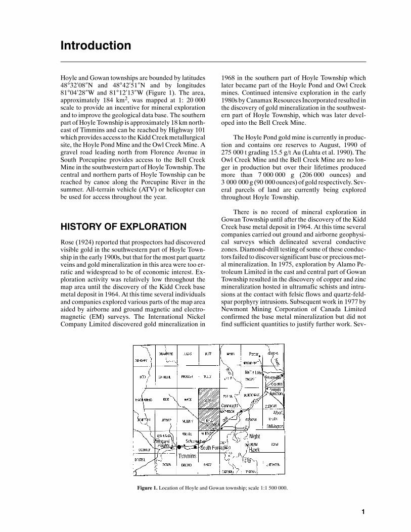
Hoyle and Gowan townships are bounded by latitudes48�32�08�N and 48�42�51�N and by longitudes81�04�28�W and 81�12�13�W (Figure 1). The area,approximately 184 km2, was mapped at 1: 20 000scale to provide an incentive for mineral explorationand to improve the geological data base. The southernpart of Hoyle Township is approximately 18 km north-east of Timmins and can be reached by Highway 101which provides access to theKiddCreekmetallurgicalsite, the Hoyle PondMine and the Owl Creek Mine. Agravel road leading north from Florence Avenue inSouth Porcupine provides access to the Bell CreekMine in the southwestern part of Hoyle Township. Thecentral and northern parts of Hoyle Township can bereached by canoe along the Porcupine River in thesummer. All-terrain vehicle (ATV) or helicopter canbe used for access throughout the year.
HISTORY OF EXPLORATION
Rose (1924) reported that prospectors had discoveredvisible gold in the southwestern part of Hoyle Town-ship in the early 1900s, but that for themost part quartzveins and gold mineralization in this area were too er-ratic and widespread to be of economic interest. Ex-ploration activity was relatively low throughout themap area until the discovery of the Kidd Creek basemetal deposit in 1964. At this time several individualsand companies explored various parts of the map areaaided by airborne and ground magnetic and electro-magnetic (EM) surveys. The International NickelCompany Limited discovered gold mineralization in
1968 in the southern part of Hoyle Township whichlater became part of the Hoyle Pond and Owl Creekmines. Continued intensive exploration in the early1980s byCanamaxResources Incorporated resulted inthe discovery of gold mineralization in the southwest-ern part of Hoyle Township, which was later devel-oped into the Bell Creek Mine.
The Hoyle Pond gold mine is currently in produc-tion and contains ore reserves to August, 1990 of275 000 t grading 15.5 g/t Au (Luhta et al. 1990). TheOwl Creek Mine and the Bell Creek Mine are no lon-ger in production but over their lifetimes producedmore than 7 000 000 g (206 000 ounces) and3 000 000 g (90 000ounces) of gold respectively. Sev-eral parcels of land are currently being exploredthroughout Hoyle Township.
There is no record of mineral exploration inGowan Township until after the discovery of the KiddCreek base metal deposit in 1964. At this time severalcompanies carried out ground and airborne geophysi-cal surveys which delineated several conductivezones. Diamond-drill testing of some of these conduc-tors failed to discover significant base or preciousmet-al mineralization. In 1975, exploration by Alamo Pe-troleum Limited in the east and central part of GowanTownship resulted in the discovery of copper and zincmineralization hosted in ultramafic schists and intru-sions at the contact with felsic flows and quartz-feld-spar porphyry intrusions. Subsequent work in 1977 byNewmont Mining Corporation of Canada Limitedconfirmed the base metal mineralization but did notfind sufficient quantities to justify further work. Sev-
Figure 1. Location of Hoyle and Gowan township; scale 1:1 500 000.

OGS Report 299
2
eral mining claimswere in good standing at the time ofwriting (December, 1991).
PREVIOUS GEOLOGICALWORKRose (1924) produced the first geological map ofHoyle Township and Berry (1941) mapped HoyleTownship and the southern part ofGowanTownship aspart of the BigwaterLake area.Ginn et al. (1964) com-piled the first small scale map covering Hoyle andGowan townships at 1:253 440 scale and this mapwasrevised and reinterpreted in 1973 (ODM 1973).
Data seriesmaps byHunt andMaharaj (1980) andHunt et al. (1980) are available for Hoyle and Gowantownships.
In 1961, an aeromagnetic survey was flown overthe map area and the final maps were published at ascale of 1:63 360 (ODM–GSC 1961). An airborneelectromagnetic and total-intensity magnetometersurvey carried out in 1988 covered the entire map area(OGS 1988a, 1988b).
A number of scientific studies and summary re-ports have been carried out on the gold deposits insouthern Hoyle Township. Reports by Knutson (1986)andKent (1990) deal with the Bell Creek gold deposit.Coad et al. (1986), described the geology of the OwlCreek Mine. Downes et al. (1984), Rye (1987), andWilson and Rucklidge (1987, 1986) deal with variousaspects of the geology and gold mineralization at theHoyle Pond and Owl Creek mines. Readers are re-ferred to these studies for further information.
PRESENT SURVEYHoyle and Gowan townships were mapped at a scaleof 1: 20 000 during the 1991 field season. The map-ping crew consisted of the author and one geologicalassistant. Traditional OGS geological mapping pro-jects of this type rely upon standard pace and compasstraverses to locate and map outcrop. As outcrop is ex-tremely limited in Hoyle and Gowan townships a dif-ferent approach to data collection and synthesis had tobe devised. A combination of outcrop mapping, ex-amination of diamond-drill core and bedrock chipsfrom overburden drill programs, compilation of geo-logical and geophysical data and use of computer en-hanced images of geophysical data were used to com-plete the geological maps of Hoyle and Gowan town-ships.
Diamond-drill core stored at the Ministry ofNorthern Development andMines’ Drill Core Libraryin Timmins was examined and in some placessampled. Exploration companies were approachedand askedpermission tomake drill core, bedrock chipsand drill logs available for integration into the maps.The locations of drill hole collars provided on drill
logs and sketches in assessment and private companyfiles were transferred to the base maps. The locationsof these holes were referenced to the lot and conces-sion in each township, and as very fewof the drill holeswere actually located in the field there may be someerror in their actual location. The geology of each dia-mond-drill hole, based on the azimuth and declina-tions recorded on the drill logs, was projected to sur-face on themaps. Emphasiswas placed on the positionof contacts between major rock types. The geology of95 diamond-drill holes is included on the maps ( seeMap2532,Map2533). Drill cores examinedby the au-thor contain no prefixes before the codes on the maps.Geology codes taken from the drill logs where no corewas examined by the author are prefixed by the letter“D” on the maps ( see Map 2532, Map 2533).
The location of more than 250 reverse circulationdrill holes are included on the maps. These holes areessentially vertical and designed to prospect the over-burden for glacially entrained minerals of economicimportance, most commonly gold and base metals. Itis common practice when boring these holes to pene-trate at least 1.5 m into the bedrock. Bedrock chips arecommonly examined, sampled, described on the drilllogs and in some instances stored by the operators ofthe exploration programs. The author examined somebedrock chips; but asmostwere not available the geol-ogy was inferred from the drill logs. It is the author’sexperience that bedrock chips examined in the fieldonly are commonly misidentified; therefore, more re-liable data such as outcrop and diamond-drill coreshould be consulted wherever possible to confirm thegeology.
There are numerous geophysical and geologicalreports and maps available to the public in the assess-ment files in the Mines Library, Ministry of NorthernDevelopment and Mines (MNDM), Sudbury and inthe Resident Geologist’s Office, MNDM, Timmins.All of these files were examined and pertinent datawere incorporated into the maps.
Airborne total intensitymagnetic and EMsurveyscarried out for the Ontario Geological Survey (OGS)in 1988 were used extensively to delineate geologicalcontacts and to infer the presence of fault and foldstructures (OGS 1988a, 1988b). Coloured versions ofthe total intensity magnetic data were produced to en-hance subtle geological and structural features in thearea. Coloured image maps of the calculated secondvertical derivative and directionally filtered secondvertical derivative magnetic data (Barlow 1988b,1988c) were consulted and formed a valuable part ofthe interpretation of the geological features in themaparea. These data were manipulated with respect to in-clination anddeclination of the “sun” angle to enhancesubtle features and to provide maximum use of thedata.
An important component of the approach to map-ping Hoyle and Gowan townships is communicationand co-operation. Valuable information and ideas
Hoyle and Gowan Townships
3
were exchanged with geologists familiar with themaparea and themines in southernHoyleTownship. In thisinstance, geologists from Falconbridge Limited,Cominco Limited, Canamax Resources Incorporatedand the collective expertise of the Resident Geolo-gist’s Office and Drill Core Library in Timmins great-ly aided the mapping project.
Once collected, all data were compiled and syn-thesized. Inevitably the various bits of informationpresented some conflicts and contradictions. In orderto resolve these problems the data were interpreted as“best fit” from all sources. This type of holistic ap-proach proved invaluable in the preparation of themaps.
PHYSIOGRAPHYAll streams and rivers in the map area are part of theArctic watershed. Drainage patterns are poorly devel-oped due to the topographic relief, which is generallyless than 15 m, and to the extensive clay cover imme-diately below the vegetation layer. Outcrop density is
less than 1% in Hoyle Township and there are only 6outcrops in Gowan Township. Extensive cedar and al-der swamps covermost of the area, making access dif-ficult.
ACKNOWLEDGEMENTSJames Egan capably assisted the author. FalconbridgeLimited, Falconbridge Gold Limited, Canamax Re-sources Incorporated and Cominco Limited providedaccess to diamond-drill core, bedrock chips fromoverburden drilling programs and drill logs withoutwhich this project would have been most difficult tocomplete. Conversations with D. Duff, FalconbridgeLimited; L. Burns, Falconbridge Gold Limited; R.Roussain and G. Kent, Canamax Resources Incorpo-rated provided information and ideas useful to the in-terpretation of the data. C. Hamblin andM. Leroux oftheDrill CoreLibraryweremost helpful and their con-tribution to this project is acknowledged. The help ofthe staff of theResident Geologist’sOffice inTimminsis gratefully acknowledged.

4
General Geology
Hoyle andGowan townships are underlain byArcheanrocks of the Abitibi subprovince of the CanadianShield. Ultramafic, mafic, intermediate and felsicmetavolcanic rocks and clastic metasedimentaryrocks have been intruded by ultramafic, mafic andfelsic plutonic rocks and by Archean to Proterozoicdiabase dikes (Table 1).
The supracrustal rocks were grouped into recog-nizable subdivisions based on composition, morphol-ogy and geographic distribution. The subdivisonswere correlated with lithostratigraphic assemblagesusing the terminology proposed by Jackson and Fyon(1991). An “assemblage” is defined as a unit of strati-
fied volcanic and/or sedimentary rocks built during adiscrete interval of time in a common depositional orvolcanic setting. An assemblage is typically boundedby faults, unconformities or intrusions (Thurston1991).
Ultramafic and mafic metavolcanic rocks insouthern Hoyle Township are correlated with the Tis-dale assemblage (Fyon and Jackson 1990, Jackson andFyon 1991; Kent 1990; Labine 1990) which is compa-rable to the Tisdale group discussed by Ferguson et al.(1968) and Pyke (1982). Ultramafic and mafic flowsare typical of the lowermost unit (formation IV, Pyke1982) whereas the variolitic flows and iron tholeiites
Table 1. Table of lithologic units for Hoyle and Gowan townships.
PHANEROZOICCENOZOIC
QUATERNARYRECENT
Lake, stream and wetland deposits
PLEISTOCENESand and gravel deposited by glacial outwash, lacustrine clay,boulder and gravel till
UNCONFORMITY
MESOZOICCRETACEOUS
Clay and grit regolith (paleosol)
UNCONFORMITY
PRECAMBRIANARCHEANNEOARCHEAN
Mafic Intrusive RocksDiabase dikes
Metamorphosed Intermediate and Felsic Intrusive RocksQuartz ¦ feldspar porphyry, feldspar porphyry, aplite, granodiorite
Mafic Intrusive RocksPeridotite, talc-carbonate schist, gabbro, lamprophyre, gabbroic dikes
Clastic Metasedimentary RocksWacke, siltstone, mudstone, graphitic and pyritic mudstone
Felsic Metavolcanic RocksFlows, tuff, breccia, quartz-sericite schist
Intermediate Metavolcanic RocksMassive and pillowed flows, tuff
Mafic Metavolcanic RocksMassive, pillowed and plagioclase-bearing flows, pillow and flow top breccia, tuff and lapilli tuff, schist, variolitic andamygdaloidal units
Ultramafic Metavolcanic RocksMassive, spinifex-textured and polysutured-textured flows, talc-carbonate schist

Hoyle and Gowan Townships
5
are most commonly associated with the middle unit(formationV, Pyke 1982). The upper unit composedoffelsic pyroclastic rocks (Krist fragmental, Ferguson etal. 1968; formation VI, Pyke 1982) is not present inHoyle Township.
Clastic metasedimentary rocks inHoyle andGowantownships are correlated with the Hoyle assemblage(Jackson and Fyon1991)which is equivalentwith part ofthe Porcupine Group discussed by Pyke (1982). Theserocks are interlayered with the Tisdale assemblage to thesouth and contact relationships are well preserved in drillcore where they appear to be conformable. In many dia-mond-drill holes south of the Bell Creek Mine, pillowbreccia with a hyaloclastite matrix belonging to the Tis-dale assemblage passes upwards into pillow breccia witha carbonaceous-graphitic matrix which in turn passesinto carbonaceous-graphitic pyritic mudstone correlatedwith the Hoyle assemblage. The same stratigraphy wasobserved in 1 drill hole northeast of the mine and is re-ported in several other diamond-drill holes in the samearea.
It is inferred that themetasedimentary rocks in theeastern part of Gowan Township are part of the Hoyleassemblage as they are contiguous with the metasedi-mentary rocks in Hoyle Township. The stratigraphicrelationship of these unitswith themetavolcanic rocksin Gowan Township is not clear. Contacts are not ex-posed at surface and only limited diamond drilling hasintersected them. In these few drill cores it appearsthat the metasedimentary rocks conformably overliemafic and intermediate metavolcanic units and are in-terstratifiedwith felsic tuff and flows. Porphyroblasticbiotite in wacke in northeastern Gowan Township isinferred to result from contact metamorphism im-posed on the metasedimentary rocks by the nearby ul-tramafic intrusions. This indicates that the metasedi-mentary rocks are older than the intrusions.
Ultramafic metavolcanic rocks and intrusions,mafic metavolcanic rocks and felsic metavolcanicrocks and intrusions in Gowan Township are corre-lated with the Kidd–Munro assemblage (Jackson andFyon 1991). This correlation is based on the apparentcontiguous relationship of the rocks in the map areawith other units of the assemblage to the north andwest and the composition of the rock units which aregenerally the same as the Kidd–Munro assemblage.This assemblage hosts the Kidd Creek base metalmine and rock units in the map area represent a goodexploration environment.
The lack of outcrop hampers detailed structuralanalysis of the map area. In the available outcrop andin the diamond-drill core, a layer-parallel foliation isdeveloped throughout themaparea. The layer-parallelfoliation has been dextrally offset by a northeasterlytrending foliation in southern Hoyle Township which,in turn, is locally sinistrally offset by an easterly trend-ing foliation which is possibly related to the Destor–Porcupine fault. Reversals in stratigraphic facings in-dicate the Hoyle assemblage is folded about west to
northwest--trending fold axes. Interpretation of com-puter enhanced airborne magnetic data indicate atleast 3 previously unrecognized major northeast-trending faults have disrupted the geology in the maparea.
In southernHoyle Township, gold is commercial-ly extracted from the Hoyle Pond Mine; whereas BellCreekMine andOwl CreekMine produced gold in thepast. Potential remains for further gold discoveries inthe southwestern part of the township. Copper andzinc mineralization occurs in subeconomic quantitiesin central Gowan Township in association with ultra-mafic and felsic metavolcanic and plutonic rocks.There remains much untested base metal potential inthis area.
NEOARCHEAN
Ultramafic Metavolcanic RocksUltramafic metavolcanic rocks occur in the Tisdaleassemblage and in the Kidd–Munro assemblage in themap area. Ultramafic metavolcanic rocks are com-posed of massive flows, spinifex and polysutured tex-tured flows and derived schist. These rocks are alwaysassociated with mafic metavolcanic rocks and com-monly with ultramafic and mafic intrusive rocks. Va-riolitic massive and pillowed mafic flows were ob-served in close spatial association with several ultra-mafic units in Hoyle Township. Ultramafic metavol-canic flows too narrow to be represented on the maps(see Map 2532, Map 2533) were observed in dia-mond-drill core from several drill holes in southernHoyle Township indicating these units are widespreadin the Tisdale assemblage. The salient macroscopicand microscopic features of ultramafic metavolcanicrocks are outlined in Table 2.
Well developed spinifex and polysutured textures(Pyke 1982) were observed in outcrop in lots 11 and12, Concession I, Hoyle Township and polysuturedtextures occur in the only outcrop in Lot 5, ConcessionI, Hoyle Township. These features, inferred to have re-sulted from rapid cooling of themagma, are character-istic of ultramafic flows (Pyke 1982). Spinifex texturehas been identified in diamond-drill core by variousexploration geologists in Hoyle and Gowan townshipsand forms the basis for the delineation of some of theseunits on the maps (see Map 2532, Map 2533).
Talc-tremolite-bearing and locally serpentine-bearing ultramafic rocks are inferred to be massiveflows where they are in close spatial association withspinifex and polysutured textured rocks. However, theexact nature of the contacts of these rocks with spini-fex and polysutured textured ultramafic rocks is com-monly obscured and it is possible that many of themassive rocks are sills or plutons as has been inferredfor most of the ultramafic rocks in Gowan Township(see below). The presence of talc in thin section indi-cates the ultramafic nature of these rocks.
OGS Report 299
6
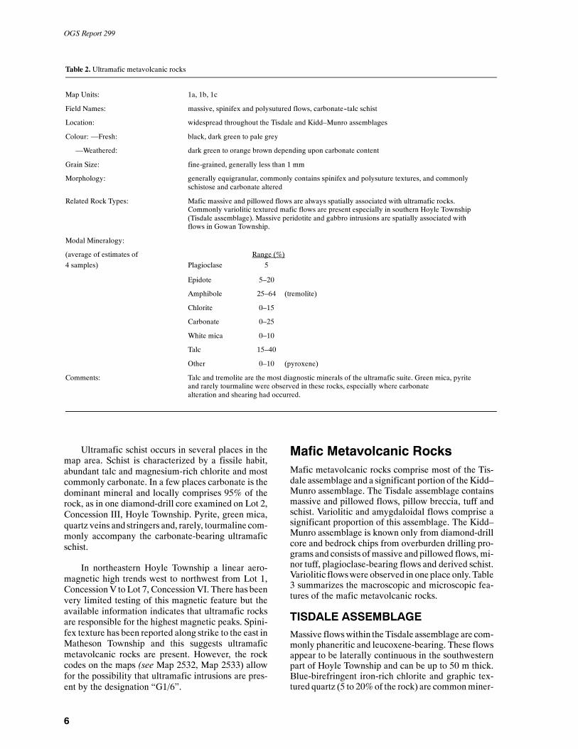
Table 2. Ultramafic metavolcanic rocks
Map Units: 1a, 1b, 1c
Field Names: massive, spinifex and polysutured flows, carbonate--talc schist
Location: widespread throughout the Tisdale and Kidd–Munro assemblages
Colour: —Fresh: black, dark green to pale grey
—Weathered: dark green to orange brown depending upon carbonate content
Grain Size: fine-grained, generally less than 1 mm
Morphology: generally equigranular, commonly contains spinifex and polysuture textures, and commonlyschistose and carbonate altered
Related Rock Types: Mafic massive and pillowed flows are always spatially associated with ultramafic rocks.Commonly variolitic textured mafic flows are present especially in southern Hoyle Township(Tisdale assemblage). Massive peridotite and gabbro intrusions are spatially associated withflows in Gowan Township.
Modal Mineralogy:
(average of estimates of Range (%)4 samples) Plagioclase 5
Epidote 5–20
Amphibole 25–64 (tremolite)
Chlorite 0–15
Carbonate 0–25
White mica 0–10
Talc 15–40
Other 0–10 (pyroxene)
Comments: Talc and tremolite are the most diagnostic minerals of the ultramafic suite. Green mica, pyriteand rarely tourmaline were observed in these rocks, especially where carbonatealteration and shearing had occurred.
Ultramafic schist occurs in several places in themap area. Schist is characterized by a fissile habit,abundant talc and magnesium-rich chlorite and mostcommonly carbonate. In a few places carbonate is thedominant mineral and locally comprises 95% of therock, as in one diamond-drill core examined on Lot 2,Concession III, Hoyle Township. Pyrite, green mica,quartz veins and stringers and, rarely, tourmaline com-monly accompany the carbonate-bearing ultramaficschist.
In northeastern Hoyle Township a linear aero-magnetic high trends west to northwest from Lot 1,ConcessionV to Lot 7, Concession VI. There has beenvery limited testing of this magnetic feature but theavailable information indicates that ultramafic rocksare responsible for the highest magnetic peaks. Spini-fex texture has been reported along strike to the east inMatheson Township and this suggests ultramaficmetavolcanic rocks are present. However, the rockcodes on the maps (see Map 2532, Map 2533) allowfor the possibility that ultramafic intrusions are pres-ent by the designation “G1/6”.
Mafic Metavolcanic RocksMafic metavolcanic rocks comprise most of the Tis-dale assemblage and a significant portion of the Kidd–Munro assemblage. The Tisdale assemblage containsmassive and pillowed flows, pillow breccia, tuff andschist. Variolitic and amygdaloidal flows comprise asignificant proportion of this assemblage. The Kidd–Munro assemblage is known only from diamond-drillcore and bedrock chips from overburden drilling pro-grams and consists ofmassive and pillowed flows, mi-nor tuff, plagioclase-bearing flows and derived schist.Variolitic flowswere observed in one place only. Table3 summarizes the macroscopic and microscopic fea-tures of the mafic metavolcanic rocks.
TISDALE ASSEMBLAGEMassive flowswithin the Tisdale assemblage are com-monly phaneritic and leucoxene-bearing. These flowsappear to be laterally continuous in the southwesternpart of Hoyle Township and can be up to 50 m thick.Blue-birefringent iron-rich chlorite and graphic tex-tured quartz (5 to 20%of the rock) are commonminer-
Hoyle and Gowan Townships
7
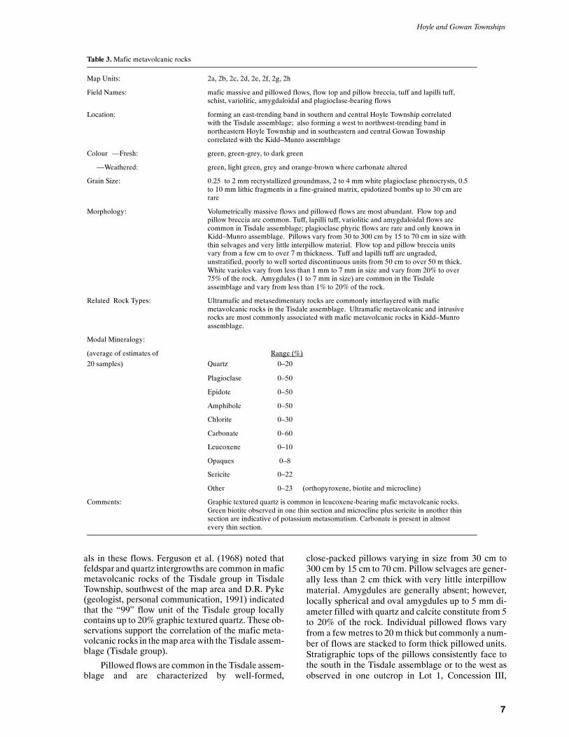
Table 3.Mafic metavolcanic rocks
Map Units: 2a, 2b, 2c, 2d, 2e, 2f, 2g, 2h
Field Names: mafic massive and pillowed flows, flow top and pillow breccia, tuff and lapilli tuff,schist, variolitic, amygdaloidal and plagioclase-bearing flows
Location: forming an east-trending band in southern and central Hoyle Township correlatedwith the Tisdale assemblage; also forming a west to northwest-trending band innortheastern Hoyle Township and in southeastern and central Gowan Townshipcorrelated with the Kidd–Munro assemblage
Colour —Fresh: green, green-grey, to dark green
—Weathered: green, light green, grey and orange-brown where carbonate altered
Grain Size: 0.25 to 2 mm recrystallized groundmass, 2 to 4 mm white plagioclase phenocrysts, 0.5to 10 mm lithic fragments in a fine-grained matrix, epidotized bombs up to 30 cm arerare
Morphology: Volumetrically massive flows and pillowed flows are most abundant. Flow top andpillow breccia are common. Tuff, lapilli tuff, variolitic and amygdaloidal flows arecommon in Tisdale assemblage; plagioclase phyric flows are rare and only known inKidd–Munro assemblage. Pillows vary from 30 to 300 cm by 15 to 70 cm in size withthin selvages and very little interpillow material. Flow top and pillow breccia unitsvary from a few cm to over 7 m thickness. Tuff and lapilli tuff are ungraded,unstratified, poorly to well sorted discontinuous units from 50 cm to over 50 m thick.White varioles vary from less than 1 mm to 7 mm in size and vary from 20% to over75% of the rock. Amygdules (1 to 7 mm in size) are common in the Tisdaleassemblage and vary from less than 1% to 20% of the rock.
Related Rock Types: Ultramafic and metasedimentary rocks are commonly interlayered with maficmetavolcanic rocks in the Tisdale assemblage. Ultramafic metavolcanic and intrusiverocks are most commonly associated with mafic metavolcanic rocks in Kidd–Munroassemblage.
Modal Mineralogy:
(average of estimates of Range (%)20 samples) Quartz 0–20
Plagioclase 0–50
Epidote 0–50
Amphibole 0–50
Chlorite 0–30
Carbonate 0–60
Leucoxene 0–10
Opaques 0–8
Sericite 0–22
Other 0–23 (orthopyroxene, biotite and microcline)
Comments: Graphic textured quartz is common in leucoxene-bearing mafic metavolcanic rocks.Green biotite observed in one thin section and microcline plus sericite in another thinsection are indicative of potassium metasomatism. Carbonate is present in almostevery thin section.
als in these flows. Ferguson et al. (1968) noted thatfeldspar and quartz intergrowths are common inmaficmetavolcanic rocks of the Tisdale group in TisdaleTownship, southwest of the map area and D.R. Pyke(geologist, personal communication, 1991) indicatedthat the “99” flow unit of the Tisdale group locallycontains up to 20% graphic textured quartz. These ob-servations support the correlation of the mafic meta-volcanic rocks in themap area with the Tisdale assem-blage (Tisdale group).
Pillowed flows are common in the Tisdale assem-blage and are characterized by well-formed,
close-packed pillows varying in size from 30 cm to300 cm by 15 cm to 70 cm. Pillow selvages are gener-ally less than 2 cm thick with very little interpillowmaterial. Amygdules are generally absent; however,locally spherical and oval amygdules up to 5 mm di-ameter filled with quartz and calcite constitute from 5to 20% of the rock. Individual pillowed flows varyfrom a fewmetres to 20 m thick but commonly a num-ber of flows are stacked to form thick pillowed units.Stratigraphic tops of the pillows consistently face tothe south in the Tisdale assemblage or to the west asobserved in one outcrop in Lot 1, Concession III,

OGS Report 299
8
Hoyle Township. Other than this west facing pillowthere is no evidence that themafic metavolcanic rocksof the Tisdale assemblage are folded.
Well-developed mafic pillow and flow top brec-cia occurs throughout the Tisdale assemblage. Goodexposures were observed in Lot 11, Concession I,Hoyle Township approximately 1 km southwest of theBell Creek Mine headframe. Here a series of flowunits occur each with a pillowed base and pillowbrec-ciated top. Each pillowbreccia unit is gradationalwiththe underlying pillowed flow and is sharply boundedat the top by another pillowed flow. Fragments withineach breccia unit are generally monolithic, angular torounded and are up to 8 cm in size. Local epidotizedfragments up to 75 cm in size are interpreted to bemaf-ic pyroclastic bombs. Pillow breccia units at this loca-tion are generally 1 m thick but one unit up to 7.5 mthick was observed. Pillow breccia and flow top brec-cia units observed in drill core from other locations inthe Tisdale assemblage are generally less than 1 mthick but locally can be over 25 m thick.
Variolitic mafic flows are common throughoutHoyle Township in the Tisdale assemblage. In theeastern part of Hoyle Township variolitic pillowedflows are exposed at the Kidd Creek metallurgical siteand along the eastern side of the Kidd Creek tailingspond. In both places, varioles cluster in the centre ofpillows and are commonly coalesced. Individual va-rioles up to 7 mm diameter were observed close to pil-low selvages. The same morphology was observedwherever diamond-drill core sampled variolitic flowsthroughout the southern part of Hoyle Township.Some variolitic massive flows in drill core display 1 to2 mm oval plagioclase spherules that occur individu-ally, as coalesced aggregates or, rarely, as dendritic ar-rays. Commonly this morphology is closely spatiallyassociated with ultramafic flows. Ferguson et al.(1968) used variolitic flows extensively for correla-tion within the Tisdale group in Tisdale Townshipsouthwest of the map area. Pyke (1982) noted that va-riolitic flows correlated with the V10 unit of the Tis-dale group contained coalesced varioles in the centreof pillows and individual varioles near the rims. Thismorphology is similar to that observed in variolitic pil-lowed flows in Hoyle Township. It is possible that de-tailed mapping of the distribution of the varioliticflows in southern Hoyle Township may aid the delin-eation of the stratigraphy and permit better correlationwith the mafic metavolcanic units in Tisdale Town-ship.
Mafic tuff and lapilli tuff, although widespread,are volumetrically minor in the Tisdale assemblage.Mappable units occur south and southwest of the BellCreek Mine and along the southeast boundary ofHoyle Township at the Kidd Creek metallurgical site.Tuffaceous units are generally green to brown-green,commonly have a granular texture and contain feld-
spar, quartz and lithic fragments (see Table 3). Typi-cally, tuff and lapilli tuff form ungraded, poorly towellsorted and unstratified, discontinuous units whichvary from 50 cm to 50 m thickness. Mafic tuffaceousrocks have not been reported in the Tisdale assem-blage (group) and their usefulness for stratigraphiccorrelation appears to be limited.
Mafic schist occurs within shear zones and faultsin the Tisdale assemblage. Schist is very fine grained,fissile and weathers dark green to orange-brown (seeTable 3). Chlorite and carbonate are themost abundantminerals, less commonly amorphous carbon and seri-cite are present. Blue birefringent chlorite commonlydisplays a strong preferred crystal orientation withinthe schistosity plane, this indicates mineral growthduring deformation. Less commonly, carbonate andsericite display a preferred crystal orientation and arecontained within small stringers and veinlets. This in-dicates that introduction of fluids accompaniedminer-al growth and deformation. Mafic schist is most com-mon in the Bell CreekMine andOwlCreekMine areaswhere it occurs in shear zones less than 10 m wide.
KIDD–MUNRO ASSEMBLAGE
Mafic metavolcanic rocks in the Kidd–Munro assem-blage are known from diamond-drill core andoverbur-den rock chips only. Consequently, the distributionand nature of these rocks is less certain than that of theTisdale assemblage. The few samples of assessmentcore available at the TimminsDrill Core Library,Min-istry of Northern Development and Mines, are green,fine grained, massive and pillowed flows. They aregenerally recrystallized with the dominant mineralsbeing chlorite and amphibole and are inferred by theauthor to be iron tholeiites. Varioles were observed inone piece of drill core from the east-central part ofGowan Township. Mafic feldspar porphyry was ob-served by the author in rock chips from an overburdendrill hole in western Gowan Township. This rock con-tainswhite feldspar phenocrysts up to 2mm in size in adark green fine-grained crystalline groundmass. It ap-pears to be unique to Gowan and northeastern Hoyletownships.
The distribution of the mafic metavolcanic rocksof the Kidd–Munro assemblage is based largely uponinterpretation of the total field and second vertical de-rivative magnetic data (OGS 1988a, 1988b; Barlow1988b, 1988c). Mafic units display much lower mag-netic relief than ultramafic flows and intrusions inGowanand northeasternHoyle townships and are onlyslightlymoremagnetic thanmetasedimentary rocks inthe same area. This latter feature means that the posi-tion of the contact between the mafic metavolcanicrocks of the Kidd–Munro assemblage and the metase-dimentary rocks of the Hoyle assemblage is approxi-mate especially inwestern andnorthernGowanTown-ship.
Hoyle and Gowan Townships
9
Intermediate MetavolcanicRocks
Intermediate metavolcanic rocks are unknown in theTisdale assemblage (Ferguson et al. 1968; Jackson andFyon 1991; Pyke 1982) and nonewere observed by theauthor in the map area. Intermediate metavolcanicrocks are reported from diamond-drill logs in northernHoyle Township and in various locations in GowanTownship where they are correlated with part of theKidd–Munro assemblage.
In northern Gowan Township, light green crystal-line dacite was observed in rock chips from an over-burden drill hole and a similar rock was described inanother drill hole 400 m to the west. A diamond-drillhole completed by New Calumet Mines Limited in1966 (see Economic Geology) intersected rocks de-scribed as “intermediate tuff” and “andesite”. Inter-mediate tuff and pillowed flows are reported from dia-mond-drill holes in northeastern Hoyle Township byDejour Mines Limited and Keevil Mining Group (seeEconomic Geology).
Jackson and Fyon (1991) did not report the pres-ence of intermediate metavolcanic rocks in the Kidd–Munro assemblage. Several rocks variously describedas “andesite” flows and “intermediate” tuff from otherdiamond-drill logs proved to be either mafic flows orfeldspar porphyry dikes in drill core samples ex-amined by the author. Therefore the distribution of in-
termediate metavolcanic rocks is inferred to be muchless than the drill logs alone would suggest.
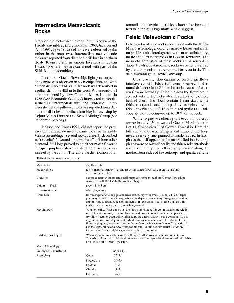
Felsic Metavolcanic RocksFelsic metavolcanic rocks, correlated with the Kidd–Munro assemblage, occur as narrow lenses and smallmappable units interlayered with metasedimentary,mafic and ultramafic rocks in Gowan Township. Themain characteristics of these rocks are described inTable 4. Felsic metavolcanic rocks were not observedby the author and none are reported to occur in the Tis-dale assemblage in Hoyle Township.
Grey to white, flow-laminated porphyritic flowsinterlayered with felsic tuff were observed in dia-mond-drill core from 2 holes in southeastern and east-ern Gowan Township. In both places the flows are incontact with mafic metavolcanic rocks and resemblebedded chert. The flows contain 1 mm sized whitefeldspar crystals and are spatially associated withfelsic breccia and tuff. Disseminated pyrite and chal-copyrite locally compose up to 10 % of the rock.
White to grey weathering tuff occurs in outcropapproximately 450 m west of Gowan Marsh Lake inLot 11, Concession II of Gowan Township. Here thetuff contains quartz, feldspar and minor lithic frag-ments in a very fine-grained to fissile matrix. In mostplaces the tuff appears to be unstratified but beddingplaneswere observed locally and thinwacke interbedsare present rarely. The tuff is highly strained along thenortheastern sides of the outcrops and quartz-sericite
Table 4. Felsic metavolcanic rocks
Map Units: 4a, 4b, 4c, 4e
Field Names: felsic massive, porphyritic, and flow-laminated flows, tuff, agglomerate andquartz-sericite schist
Location: occurs as narrow lenses and small mappable units throughout Gowan Township;correlated with the Kidd–Munro assemblage
Colour —Fresh: grey, white, buff
—Weathered: white, light grey
Grain Size: flows, cryptocrystalline groundmass commonly with small (1 mm) white feldsparphenocrysts: tuff, 1 to 2 mm quartz and feldspar grains in very fine-grained matrix;agglomerate to rounded felsic fragments (up to 8 cm in size) in fine-grained ultramafic to mafic matrix; schist, very fine grained.
Morphology: Volumetrically, flows and schist are most abundant, tuff is common, and breccia israre. Flows commonly contain flow laminations 2 mm to 2 cm apart, in placesstylolitic fractures occur; disseminated pyrite and chalcopyrite are common. Tuff isungraded, well sorted, poorly stratified. Breccia occurs at contacts between felsicflows or porphyry units and ultramafic-mafic units in eastern Gowan Township. Ithas the appearance of a flow or in situ breccia. Quartz-sericite schist is stronglyfoliated and fissile; sulphides, mainly pyrite, are common.
Related Rock Types: Wacke is commonly interlayered with felsic tuff in western and northern GowanTownship. Ultramafic schist and intrusions are interlayered and intermixed with felsicunits in eastern Gowan Township.
Modal Mineralogy:
(average of estimates of Range (%)
3 samples) Quartz 22–55
Plagioclase 20–33
Epidote 0–20
Chlorite 1–5
Carbonate 2–20

OGS Report 299
10
schist displaying sinistral rotation of clasts is devel-oped.
White, unstratified to poorly stratified felsic tuffis also present in diamond-drill core from holes in var-ious locations in Gowan Township with the most ex-tensive occurrences in lots 2 and 3, Concession IV.Felsic rocks interpreted by the author to be tuff andflows are reported from overburden drill holes in sev-eral locations in the northern and southwestern parts ofGowanTownship. Inmost places there are insufficientdata to determine the extent and exact nature of theserocks. It is possible that felsic metavolcanic rocks aremore abundant than indicated on the maps (see Map2532, Map 2533).
Felsic breccia is composed of white, predomi-nantly rounded to angular felsic fragments up to 8 cmin size in a talc and/or chlorite matrix. This rock wasobserved in diamond-drill core from holes drilled inlots 2 and 3, Concession IV, GowanTownship where itoccurs at the contact between felsic and ultramaficunits. The breccia, which varies from 30 cm to 1 mthick, grades frommassive rhyolite at its base to ultra-mafic tomafic schist and massive soapstone. The rockhas the appearance of a flow top breccia and the round-ness of fragments suggests the felsic material wasveryhotwhen the rockwas formed. In someplaces the frag-ments appear to be fused together and the term ag-glomerate can be used to describe the rock where thisoccurs. The strongly bimodal distribution of felsic andultramafic rocks in this area is similar to the geology inthe Kidd Creek base metal mine area, approximately19 km to the west.
Grey to pale yellow quartz-sericite schist occursin outcrop and in diamond-drill core in Gowan Town-ship. In outcrop in Lot 11, Concession II, GowanTownship, the schist is very fine grained and siliceouswith a pronounced southeast plunging mineral linea-tion. The schist is developed within a dextral shearzone displaying “S” and “C” planar shear fabric. Ironcarbonate and disseminated pyrite (up to 5%) are lo-cally developed.
White quartz-sericite schist is common in dia-mond-drill core and overburden rock chips in the east-ern part of Gowan Township. The schist is strongly fo-liated and in places stylolitic cleavage is well devel-oped. Sericite and disseminated to massive pyrite andchalcopyrite are common along the foliation planeswhich have been interpreted by exploration geologiststo be bedding (Middleton1975). However, the schist iscommonly gradational with less sheared, massive rhy-olite or quartz-feldspar porphyry which the author in-fers to be the protolith. The large amount of schist re-ported fromLot 3, Concession IV in GowanTownshipis considered by the author to be evidence for a north-east-trending fault in this area.
Metasedimentary Rocks
Metasedimentary rocks underlie approximately 60%of the map area and form a wide band underlying cen-tral and northern Hoyle Township, and western andnorthern Gowan Township. Metasedimentary rocksalso are interlayered with the Tisdale and Kidd–Munro assemblages as units varying from a fewmetres up to 700 m thick. The metasedimentary rocksare composed ofwacke, siltstone, mudstone, graphiticand pyritic mudstone and all are correlated with theHoyle assemblage (Jackson and Fyon1991). Themaincharacteristics of the these rocks are described inTable 5.
Wacke is the predominant metasedimentary rocktype in the map area. Wacke beds vary from 5 mm toover 1 m thick and most commonly display graingradation although massive wacke beds are common.Wacke is commonly overlain by thin siltstone ormud-stone layers and these are interpreted by the author torepresent the “E” or “DE” divisions of the Bouma se-quence of turbidites. Trains of mudstone chips con-tained in several places in diamond-drill core, indicateamalgamation of turbidite units. For the most part,however, reliable stratigraphic top determinationscould be made. Detrital quartz and feldspar comprisethe majority of the clasts. In more thickly beddedwacke, clasts of mafic metavolcanic rocks are com-mon and rarely are clasts of cryptocrystalline quartz,inferred to be either chert or felsic metavolcanic rock,present. Detrital grains of graphic textured quartzwere observed in thin section from three samples ofwacke located in southern and central Hoyle Town-ship. These grains display a similar crystal habit tographic quartz observed in the phaneritic mafic flowsof the Tisdale assemblage and are inferred to be directevidence that the Tisdale assemblage was the prov-enance for at least some of the detritus of the Hoyle as-semblage. Chlorite and sericite are most common inthe matrix whereas, biotite is generally absent inwacke in Hoyle Township but is common as brownporphyroblasts in most metasedimentary rocks inGowan Township. Other common accessory mineralsin wacke include apatite, zircon and tourmaline.
Siltstone is rare in the Hoyle assemblage andmostcommonly occurs as thin layers overlyingwacke. Lesscommonly, siltstone beds 1 to 5 mm thick occur inter-bedded with mudstone within metasedimentary unitsinterlayered with the Tisdale assemblage. In this envi-ronment grain gradation, load casts and convolutebedding are common primary features. Quartz andfeldspar comprise a very fine-grained mosaic of detri-tal grains in a matrix composed predominantly ofwhite mica. Apart from the grain size and increasedproportion of sericitic matrix, siltstone is mineralogi-cally very similar to wacke.
Green, grey and dark grey mudstone occursthroughout the Hoyle assemblage overlying the

Hoyle and Gowan Townships
11
Table 5.Metasedimentary rocks
Map Units: 5a, 5b, 5c, 5d
Field Names: wacke, siltstone, mudstone, graphitic and pyritic mudstone
Location: occur as a wide band in central and northern Hoyle Township extending into western andnorthern Gowan Township. Also occur as units varying from a few metres to 700 m thickinterlayered with the Tisdale and Kidd–Munro assemblages. The metasedimentary rocksare correlated with the Hoyle assemblage.
Colour —Fresh: grey, grey-green, green, black
—Weathered: grey, brown, black
Grain Size: 0.1 to 4 mm
Morphology: Wacke is most abundant in beds from 5 mm to over a metre thick. Grain gradation andload casts are very common, laminations and convoluted bedding, less common. Siltstoneis relatively rare and most commonly occurs on top of wacke or as thin beds from 1 to 5mm thick. Mudstone is common on top of wacke and siltstone, as laminated beds from 1mm to 5 cm thick and as beds from a few centimetres to over 3 m thick containinggraphite (or amorphous carbon), concretionary and bedded pyrite. Wacke, siltstone andmudstone commonly organized into graded beds are inferred to result from turbiditycurrent deposition (e.g., turbidites). Pyrite is biogenic (Downes et al. 1984).
Related Rock Types: Graphitic and pyritic mudstone commonly occurs at or near the contacts with maficmetavolcanic rocks of the Tisdale and Kidd–Munro assemblages.
Modal Mineralogy:
(average of estimates of Range (%)12 samples) Quartz 20–30
Plagioclase 20–45
Epidote 0–20
Chlorite 0–20
Carbonate 0–20
Sericite 5–30
Biotite 0–25
Opaques 0–20
Other 0–1 (apatite, zircon, tourmaline, amphibole, titanite)
wacke; it is inferred by the author to be the “E” divi-sion of the Bouma sequence. Mudstone in this envi-ronment is generally bedded (5 mm to 5 cm thick) andcomprises approximately 10% of the metasedimenta-ry rocks. Sericite and quartz are the most commonminerals observed in thin section with lesser amountsof chlorite and epidote.
Dark grey to black mudstone is most common inmetasedimentary units interlayered with the Tisdaleand Kidd–Munro assemblages. Mudstone beds, 1 to15 cm thick, aremore thickly bedded than in turbiditesdescribed above and commonly comprise 35% of themetasedimentary rocks. Sericite and opaque mineralsare the most common minerals observed in thin sec-tion. Graphite and amorphorous carbon (Downes et al.1984) are the major opaque minerals and compriseless than 5% of the rock. Pyrite is locally present. Pri-mary features such as load casts, fine laminations andconvolute bedding are remarkably well preserved inthis setting.
Graphitic and pyritic mudstone is a distinctiverock type that generally occurs along or within 400 mof the contacts with mafic metavolcanic rocks of theTisdale and Kidd–Munro assemblages. The well topoorly bedded mudstone is black, soft, commonly hasa sooty texture and varies from 1m to over 25 m thick-ness at the Owl Creek Mine. However, graphitic andpyritic mudstone occurring along the contact betweenthe Hoyle assemblage andKidd–Munro assemblage insoutheastern Gowan Township is indurated and con-tains biotite and garnet; these minerals were not ob-served farther south in southern Hoyle Township.These features are attributed to the higher grade ofmetamorphism that affected the rocks in GowanTownship. These rocks are excellent electrical con-ductors and diamond-drill testing has shown they arecontinuous metasedimentary units that can be used asmarker horizons throughout the map area.
Although much of the carbon in the mudstone isshiny and easily marks hands and paper, suggestive of
OGS Report 299
12
graphite, Ferguson et al. (1968) and Downes et al.(1984) have shown that most of the carbon is amor-phous. Wilson and Rucklidge (1987) demonstratedthat carbon comprises up to 17 weight percent of themudstone at Owl Creek Mine and that 13C isotopesvaried between --19‰ and --31‰, consistent with abiogenic origin.
Pyrite comprises from 1 to 30% of the graphiticmudstone and occurs in two principle forms. Nodularpyrite from 1mm to 2 cm in diameter is the most com-mon habit and is typically spherical with a radial inte-rior and a core composed of silicate and/or carbonateminerals. These spheres are inferred to be diageneticin origin (Wilson and Rucklidge 1986). Bedded tolaminated, massive and disseminated pyrite is lesscommon in the graphitic mudstone and forms layersfrom 1 to 10 mm thick. These beds are generally con-tinuous but locallymay be buckled, faulted or occur asdiscontinuous lenses.
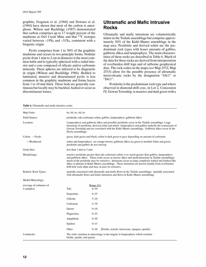
Ultramafic and Mafic IntrusiveRocksUltramafic and mafic intrusions are volumetricallyminor in the Tisdale assemblage but comprise approx-imately 50% of the Kidd–Munro assemblage in themap area. Peridotite and derived schist are the pre-dominant rock types with lesser amounts of gabbro,gabbroic dikes and lamprophyre. The main character-istics of these rocks are described in Table 6. Much ofthe data for these rocks are derived from interpretationof overburden drill logs and of airborne geophysicaldata. The rock codes on the maps (seeMap 2532,Map2533) allow for the possible presence of ultramaficmetavolcanic rocks by the designation “G6/1” or“D6/1”.
Peridotite is the predominant rock type andwhereobserved in diamond-drill core, in Lot 2, ConcessionIV, GowanTownship, ismassive and dark greenwith a
Table 6. Ultramafic and mafic intrusive rocks
Map Units: 6a, 6b, 6c, 6d, 6e
Field Names: peridotite, talc-carbonate schist, gabbro, lamprophyre, gabbroic dikes
Location: Lamprophyre and gabbroic dikes and possibly peridotite occur in the Tisdale assemblage. Largeintrusions of peridotite, derived schist and minor lamprophyre and gabbro underlie the central part ofGowan Township and are correlated with the Kidd–Munro assemblage. Gabbroic dikes occur in theHoyle assemblage.
Colour —Fresh: green, dark green and black; schist is dark green to grey depending on amount of carbonate
—Weathered: schist and lamprophyre are orange-brown; gabbroic dikes are green to mottled white and green;peridotite and gabbro do not outcrop
Grain Size: less than 1 mm to 5 mm
Morphology: massive peridotite greater than talc-carbonate schist; very much greater than gabbro, lamprophyreand gabbroic dikes. These rocks occur as narrow dikes and small intrusions in Tisdale assemblage;much of the peridotite may be extrusive. Intrusions occur as large complexly folded and faulted sills,dikes or plutons in Kidd–Munro assemblage. These intrusions are known mainly from overburdendrill hole rock chips and may, in part, be extrusive.
Related Rock Types: spatially associated with ultramafic and mafic flows in the Tisdale assemblage; spatially associatedwith ultramafic flows and felsic intrusions and flows in Kidd–Munro assemblage
Modal Mineralogy:
(average of estimates of Range (%)4 samples) Talc 0--50
Serpentine 0--25
Chlorite 5--10
Carbonate 4--70
Quartz 0--10
Plagioclase 0--25
Amphibole 0--50
Epidote 0--15
Other 0--28 (biotite, sericite, leucoxene, opaques, apatite)
Comments: The wide variation in mineralogy is due largely to lamprophyre which containsbiotite, apatite, and quartz.
Hoyle and Gowan Townships
13
pronounced greasy feel (“soapstone”). Talc, serpen-tine and carbonate are the major minerals present andmagnetite commonly constitutes from 5 to 10% of therock. The magnetite content makes these rocks verymagnetic and the large, high intensity aeromagneticanomaly in Gowan Township (OGS 1988b) is attrib-uted to magnetite-bearing peridotite. In some dia-mond-drill core samples peridotite contains large (upto 1 cm in size) white carbonate rhombohedrons withblue cores that compose up to 70% of the rock andhave been called magnesite by exploration geologists.
Talc-carbonate schist is dark green to grey, soft tofissile and commonly has a very greasy texture.Whereobserved in diamond-drill core in the eastern part ofGowanTownship, schist occurs asnarrow, strongly fo-liated units between felsic intrusive or metavolcanicunits. Schist is also reported in diamond-drill logsfrom other parts of Gowan Township where it occursin gradational or abrupt contact with peridotite. Al-though much of the schist appears to be coincidentwith faults and shear zones, a number of occurrencesare reported from overburden drill logs which, in theauthor’s opinion, require verification. Thus the re-ported occurrences of schist cannot be used to delin-eate structures solely.
Gabbro is volumetrically minor and occurs main-ly as narrow units within mafic metavolcanic rocks orin spatial association with peridotite in the Kidd–Munro assemblage. Gabbro is dark green to green,nonmagnetic to weakly magnetic and generally me-dium grained. Gabbro is reported in twodiamond-drilllogs from eastern Gowan Township to grade into per-idotite which indicates that the intrusions in this areamay be layered. Again the author emphasizes that be-cause most of the data on this rock type are derivedfrom overburden and diamond-drill logs the distribu-tion of gabbro in the Kidd–Munro assemblage may begreater than indicated on the maps.
Gabbroic dikes occurwithin the Kidd–Munro andHoyle assemblages. These dikes are generally narrow(less than 1 m wide) but one dike in northwesternHoyle Township exceeds 40 m in width. This particu-lar dike (Lot 11, Concession VI) is medium grained,leucocratic, green and white weathering, and is fo-liated parallel to the regional foliation. The dike isvery weakly magnetic, has a 60 to 70 cm thick chilledmargin and has intruded wacke and siltstone of theHoyle assemblage. This clearly indicates igneous ac-tivity persisted after consolidation of the Hoyle assem-blage and similar dikes may account for weak north-west-trending aeromagnetic highs in the map area(Barlow 1988a, 1988b, 1988c; OGS 1988a).
Gabbroic dikes were observed in diamond-drillcore from a hole drilled in Lot 4, Concession IV, Go-wan Township in places where the core was darkgreen, fine-grained and magnetic to nonmagnetic.These dikes intruded quartz-feldspar porphyry andwere recognized as gabbro by the presence of smallwhite plagioclase crystals. It is possible the magnetic
dikes are related to Neoarchean diabase dikes of theMatachewan swarm (Fahrig and West 1986); howev-er, the spatial association with the ultramafic intru-sions suggests they are more closely related to theserocks.
Lamprophyre occurs in both the Tisdale andKidd–Munro assemblages. Lamprophyre dikes occurat the Marlhill gold deposit in Lot 9, Concession II,Hoyle Township. These narrow dikes (5 to 15 cmwide) intruded pillowed basalts of the Tisdale assem-blage and were subsequently folded. The dikes arehighly carbonate altered such that amphibole is theonly primary mineral observed in outcrop. Lampro-phyre was also observed in the north ½, Lot 12, Con-cession I, Hoyle Township in a number of old explora-tion trenches. Here the lamprophyre is massive,weathers orange-brown, and contains coarse biotitecrystals (up to 7 mm in size) which define a pro-nounced easterly plungingmineral lineation. The lam-prophyre is associated with white quartz veins and al-though contacts were not observed the author suspectsthat the lamprophyre occurs as a narrow lens or dikeoriented subparallel to the east-trending regional foli-ation. In thin section the lamprophyre contains biotiteand chlorite intergrowths, recrystallized plagioclaseand quartz and anhedral carbonatewith accessory apa-tite and sericite.
Biotite-bearing ultramafic rock chips were ob-served from one overburden drill hole in north centralGowan Township. The rock chips are from a drill holelocated within the large high intensity aeromagneticanomaly (OGS 1988b) and are inferred by the authorto be part of the suite of ultramafic intrusive rocks inthis area.
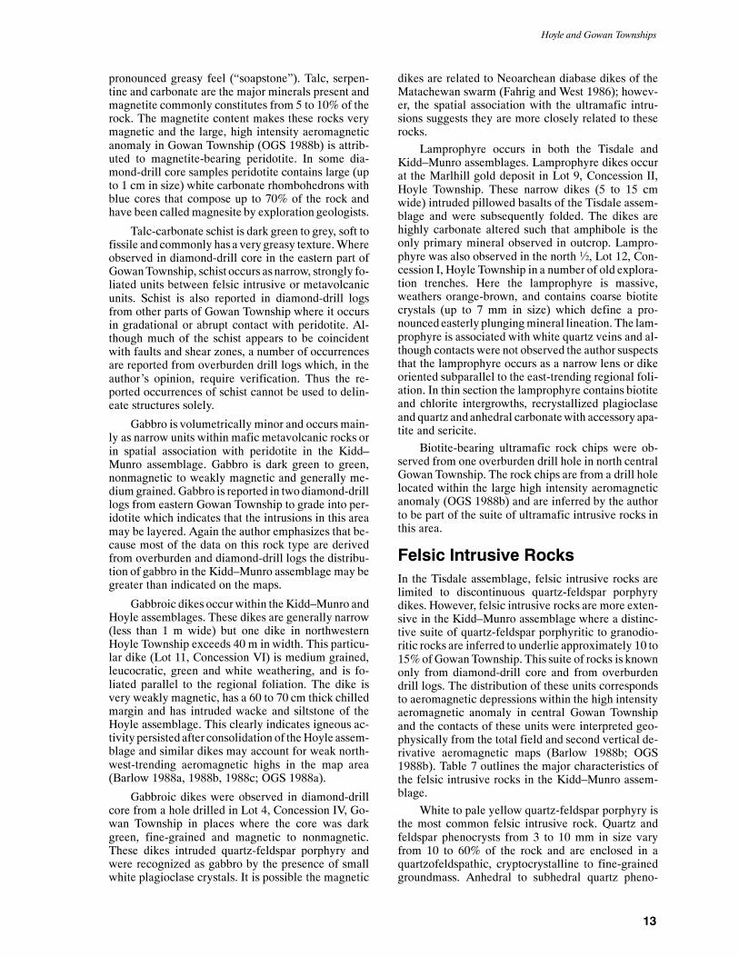
Felsic Intrusive RocksIn the Tisdale assemblage, felsic intrusive rocks arelimited to discontinuous quartz-feldspar porphyrydikes. However, felsic intrusive rocks are more exten-sive in the Kidd–Munro assemblage where a distinc-tive suite of quartz-feldspar porphyritic to granodio-ritic rocks are inferred to underlie approximately 10 to15%ofGowanTownship. This suite of rocks is knownonly from diamond-drill core and from overburdendrill logs. The distribution of these units correspondsto aeromagnetic depressions within the high intensityaeromagnetic anomaly in central Gowan Townshipand the contacts of these units were interpreted geo-physically from the total field and second vertical de-rivative aeromagnetic maps (Barlow 1988b; OGS1988b). Table 7 outlines the major characteristics ofthe felsic intrusive rocks in the Kidd–Munro assem-blage.
White to pale yellow quartz-feldspar porphyry isthe most common felsic intrusive rock. Quartz andfeldspar phenocrysts from 3 to 10 mm in size varyfrom 10 to 60% of the rock and are enclosed in aquartzofeldspathic, cryptocrystalline to fine-grainedgroundmass. Anhedral to subhedral quartz pheno-

OGS Report 299
14
crysts are commonly clear and glassy whereas feld-spar phenocrysts are white to pale green and euhedral.Maficminerals consist of biotite and chlorite and com-monly constitute less than 10% of the rock. There isvery little alteration of themineralogyobserved in thinsection; however, suchminerals as carbonate and seri-cite are commonly contained within stringers andveins indicating they are secondary. In several placesthe porphyry displays a weak to strong foliation andrarely was stylolitic cleavage observed. The morestrongly deformedporphyryhas beenused as evidencefor the location of faults. Pyrite and chalcopyrite occuras disseminated grains in many of the diamond-drillcore samples examined by the author. Sulphide con-tent is generally less than 1%; however, up to 10% islocally present.
Feldspar porphyry is white to grey with over 90%of the phenocrysts composed of subhedral to euhedralalbite (3 to 7 mm in size). This rock type is gradationalinto quartz-feldspar porphyry and represents an endmember of the porphyritic suite of rocks. In thin sec-tion the plagioclase displays simple or Carlsbad twin-ning and is relatively unaltered. Oscillatory zonation,as might be expected in plutonic rockswith a complexhistory of crystallization, is absent. The groundmassof feldspar porphyry is generally coarser grained andthe phenocrysts, including the few quartz crystals
present, are generally more euhedral than those ofquartz-feldspar porphyry. The feldspar porphyry is in-terpreted by the author to have crystallizedprior to andmore slowly than the quartz-feldspar porphyry.
Very fine-grained aplite dikes have been reportedfrom overburden drill logs in Gowan Township. Fromthe general descriptions and distributionof these rocksthe author infers that the aplite belongs to the felsic in-trusive suite but it is possible these rocksmay be extru-sive in origin.
Granodiorite to granite is reported from severaloverburden drill logs from Lot 9, Concession III, andwas observed in diamond-drill core from one hole inLot 4, Concession IV, Gowan Township. This grey topink rock is coarse-grained and equigranular and oc-curs in the most pronounced magnetic depressionswithin the high intensity aeromagnetic anomaly inGowan Township (OGS 1988b). Granodiorite ob-served in drill core is gradational with quartz-feldsparand feldspar porphyry and appears to be a phase of thesame intrusion. However, only granodiorite is re-ported from the drill logs from Lot 9, Concession IIIand it is possible that this occurrence represents asingle phase pluton.
Contact relationships of the felsic plutonic rockswith the ultramafic intrusive rocks in Gowan Town-ship are uncertain. In drill core from one hole, feld-
Table 7. Felsic intrusive rocks
Map Units: 7a, 7b, 7c, 7d
Field Names: quartz-feldspar porphyry, feldspar porphyry, aplite dikes and granodiorite
Location: underlying the central part of Gowan Township; included within the Kidd–Munro assemblage
Colour—Fresh: white, buff, grey
—Weathered: not exposed at surface
Grain Size: quartz and feldspar phenocrysts from 3 mm to 1 cm in size; groundmass cryptocrystalline to 1 mm insize
Morphology: most commonly porphyritic, commonly sheared, rarely equigranular
Related Rock Types: spatially associated with ultramafic and mafic intrusive rocks; most commonly interlayered withperidotite
Modal Mineralogy:
(average of estimates of Range (%)
8 samples) Quartz 30–60
Plagioclase 24–50
Chlorite 0–10
Carbonate 0–10
Sericite 1–20
Opaques tr–1
Biotite 0–10
Other 0–1 (zircon, apatite, titanite, tourmaline)
Comments: Mineralogy is relatively fresh and most alteration is contained within small carbonate stringers or assericite in sheared matrix of the rocks.

Hoyle and Gowan Townships
15
spar-porphyry dikes were observed to have intrudedperidotite and in drill core from a nearby hole, gabbro-ic dikes were observed to have intruded quartz-feld-spar porphyry. In drill core from Lot 4, Concession IV,Gowan Township, quartz-feldspar porphyry, ultra-mafic schist and peridotite alternate every few deci-metres to metres over approximately 30 m of core.Contacts are abruptly sheared and clear intrusive rela-tionships are not apparent. Further, diamond-drill logsindicate that locally the quartz-feldspar porphyrygrades into felsic metavolcanic flows and tuff. This in-dicates that the felsic intrusive rocks were the sourcefor at least some of the felsic metavolcanic rocks in themap area. The intimate spatial relationship of theflows with ultramafic rocks suggests the two rocktypes are approximately coeval. The bimodal distribu-tion of felsic and ultramafic rocks is similar to the geo-logical setting of the Kidd Creek base metal deposit,19 km west of the map area. Based on the author’sfindings it is evident that further study is required.
Mafic Intrusive RocksAnumber of north to northwest-trending diabase dikescorrelated with the Paleoproterozoic Matachewanswarm (Fahrig andWest 1986; OGS1991) intruded allrock types in the map area. These dikes weather oran-ge-brown, commonly contain from 1 to 5% white togreen plagioclase phenocrysts and vary from a fewcentimetres to over 40 m in width. The diabase is darkgreen on the fresh surface and in thin section is com-posed predominantly of subophitic textured clinopy-roxene and plagioclase. The presence of up to 15%magnetite and less commonly pyrrhotite makes thesedikes highly magnetic and their locations in the Tis-dale and Hoyle assemblages are, therefore, easilytraced. However, there is little difference in magne-tism between the ultramafic intrusive rocks of theKidd–Munro assemblage and the diabase. The loca-tions of dikes in central Gowan Township are very dif-ficult to trace.
The diabase dikes are apparently undeformed andintruded along pre-existing structures, most common-ly north-trending faults and northwest-trending foli-ation planes. A north-trending dike crosscuts theNorth “A” Horizon gold zone in the Bell Creek Mineand clearly postdates gold mineralization (G. Kent,Canamax Resources Incorporated, personal commu-nication, 1991).
MESOZOIC
CretaceousIn several reverse circulation overburden drill holes inHoyle Township a regolith was encountered. This unitis described asgreen to gold, clay and gritty clay that iscommonly well indurated and locally forms a “hard-pan” layer. In places, the regolith is only a few centi-
metres thick, but in the northwestern part of HoyleTownship as much as two metres were encounteredbefore the drill holes were abandoned. The regolith iscrudely stratifiedwith anupper clay layer underlain bygritty clay. The proportion of grit to clay increasesgradationally down section until the Archean precur-sor rock is encountered.
Development of the regolith indicates that theArchean rocks were exposed to intense weathering;most likely lateritic in nature. Similar regolith devel-opment is known by the author to occur in other partsof the Abitibi greenstone belt, notably north of Kirk-land Lake and in Matheson Township immediatelyeast of the map area. Lateritic weathering of Archeanrocks has been documented in other parts of Ontariowhere the weathering event has been shown to be Cre-taceous (Machado 1987; Sage 1988). The regolith inthe map area, therefore, is inferred to be Cretaceous.
The widespread development of a regolith hasseveral implications for the explorationist. Firstly, lat-eritic deposits of nickel or gold may be preserved andoverburden drill programs should, therefore, test theregolith for these minerals. Secondly, the develop-ment of a hardpan layer would inhibit the entrainmentof minerals into the glacial lodgement tills and thusoverburden drill programs would be ineffective downice from this layer. Thirdly, laterite is commonly en-riched in gold as the residual product of weatheringand hydromorphic processes. Entrained gold detectedin basal till samples may not be representative of theunweathered bedrock in these instances. Future over-burden exploration drill programs should allow forthese various parameters when results are interpreted.
CENOZOIC
Quaternary and RecentThe surficial Quaternary geology of the map area issummarized by Richard (1983) and consists of two tillsheets (the older Matheson till and the younger Coch-rane Formation), areally extensive glaciolacustrinedeepwater varved silts and clays (the Barlow–Ojib-way Formation) and Recent organic deposits of peatand black muck.
The Matheson till is characterized by grey, sandyto clayey tills and debris flows (Richard 1987). Thetills are typically moderately to very well compactedwith local rock types accounting for 60 to 95% of theclasts (Richard 1987). South to south-southeasterlyice flowdirections are indicated (150 to 180o). All gla-cial striations observed in the map area fall into thisrange.
The Barlow–Ojibway Formation conformably tounconformably overlies the Matheson till and is char-acterized by grey, laminated, noncompacted clay andsilt (Richard 1987). These sediments were derivedfrom glaciolacustrine deposition and were locally in-terbedded with coarse sand and gravel deposits con-

OGS Report 299
16
taining clasts from varied distal provenances (Richard1987).
The Cochrane Formation is composed of tan tobrownish-grey, noncompact clay and silt deposited asdebris flows (Richard 1987). Minor till is present andcontains from 20 to 50% Paleozoic carbonate clasts(Richard 1987). The Cochrane Formation representsdeposition by the re--advance of the Laurentide icesheet and is gradational with the underlying Barlow–Ojibway Formation (Richard 1987).
Two additional Quaternary units, not exposed atsurface, occur throughout the Abitibi region and maybe present in themaparea. These units, as summarizedby Richard (1987), are called the Lower Sedimentsand the Lower Till. The Lower Sediments are com-posed of nonglacial, lacustrine silts and clays inter-beddedwith fine to coarse sand and gravels. The Low-er Till is composed of pebbly, silt and clay till that gen-erally contains clasts composed of up to 95% localrock types. A southwesterly ice flow direction is indi-cated (210 to 245o).
Reverse circulation overburden drilling has beenextensively used to explore themap area. Compilationof the drill logs filed for assessment work credits hasprovided much data with respect to Quaternary geolo-gy concerning Hoyle and Gowan Townships. As illus-trated in Figure 2, an isopach map of depth to bedrockmeasurements, a great variation exists in the paleo-topography from outcrop to overburden depths ex-ceeding 65m in themap area. The greatest overburdenthicknessoccurs in central GowanTownship andover-lies ultramafic and mafic intrusive rocks. This depres-sion contains the most complex Quaternary stratigra-phy and provides a record of multiple glacial events(see below). A broad, northerly trending, sinuouspaleovalley with overburden depths exceeding 25 mextends through the centre of HoyleTownship and intothe central part of Gowan Township. Richard (1987)inferred that this paleovalley coincided with a fault.This interpretation may be valid but the paleovalley isvery broad and there is very little other evidence to in-fer the presence of a fault. The location and shape ofthe paleovalley suggest this feature was a glacial spill-way or Quaternary river. Shilts (1976) and Miller(1984) discuss some of the effects paleotopographyhas upon the dispersal of glacially entrained mineralsand debris in till. The interpretation of results fromoverburden drill exploration programs must accountfor the effects of paleotopography and Figure 2 shouldaid interpretation.
Throughout themap area Recent organic depositsare commonly less than 1 m thick and no more than
2 m thick. These deposits conformably overlie varvedclay and silt of the Barlow–Ojibway Formation. InHoyleTownship, theBarlow–Ojibway Formationvar-ies between 0.6 m and 17 m in thickness with an aver-age thickness of approximately 7 m. In Gowan Town-ship the clay and silt are locally interbedded with sandand gravel and stratigraphic thickness varies between1.8m and 38mwith an average thickness of 13.5m. Ina few overburden drill holes the clay directly overliesbedrock but inmost places it overlies the otherQuater-nary units.
In most overburden drill holes in Hoyle Town-ship, Barlow–Ojibway Formation is in conformablecontact with a simple stratigraphy of gravel overlyinga compacted clay till correlatedwith theMatheson till.Inmany overburdendrill holes gravel directly overliesbedrock and the till is absent. Drill logs indicate thatbetween 45 and 60% of the gravel clasts are composedof metasedimentary and mafic metavolcanic rockswith the remainder of the clasts composed of graniticgranules, minor limestone, diabase and exotic rockfragments. The till is generally composed of 75 to 95%clay with mafic clasts and very little granitic material.The till attains a maximum thickness of 22 m in thesouthern part of the township but is commonly lessthan 10 m thick. In northeastern Hoyle Township andin a few places where overburden exceeds 25 m, amore complex stratigraphy is developedwith sand andgravel overlying till which in turn overlies more sandand gravel. It is possible that these areas are reworkedor represent debris flows.
The Quaternary stratigraphy in Gowan Townshipis more complicated than in Hoyle Township. TheBarlow–Ojibway Formation is thicker than farthersouth and sand and gravel lenses are slightly moreabundant than observed in Hoyle Township. TheFormation conformably overlies sand, gravel andsandy till correlated with the Matheson till. Sand andgravel aremore abundant than farther south and the tillcommonly occurs interbeddedwith the sand and grav-el or is absent. In many overburden drill logs from thecentral part of the township a second varved clay andsilt unit is reported to underlie the Matheson till. Thisunit is brown to grey and commonly more compactedthan the Barlow–Ojibway Formation. Sand and gravelis commonly interbedded with the clay and this unit iscorrelated by the author with the Lower Sediments(Richard 1987). It would appear this area contained along livedglacial lake. In a fewof the deepest overbur-den holes, gravel and sandy till underlie the secondclay layer and based on drill log descriptions this unitappears to have been extensively reworked and is cor-related by the author with the Lower Till (Richard1987).

Hoyle and Gowan Townships
17
Figure 2. Isopach map; depth to bedrock for Hoyle and Gowan townships; contour interval in metres.

18
Geochemistry
The Tisdale assemblage hosts economic gold depositsand consequently most of the published data in the maparea deal with various geochemical aspects of these de-posits and the Tisdale assemblage. Downes et al. 1984discussed various trace element and major oxide varia-tions of the unaltered and altered metavolcanic rocks atthe Hoyle Pond gold deposit. Here, the unaltered maficmetavolcanic rocks hosting the gold deposit are magne-sium tholeiites. The alteration zones, also referred to as“grey zones”, are enriched in tungsten, arsenic, and goldand depleted in zinc with respect to the host rocks.Amorphous carbon imparts a grey colour to the alter-ation zones. These chemical features indicate the HoylePond deposit bears some similarity to epithermal depos-its in Nevada and New Zealand (Downes et al. 1984).Rare earth element (REE) analyses of altered and unal-tered basalts displayed tholeiitic patterns with slightlyelevated concentrations of heavy REEs with respect tolight REEs. The alteration process apparently did not af-fect the mobility of these elements (Downes et al. 1984).
Rye (1987) completed a master’s thesis on theHoyle Pond gold deposit which included major oxideand selected trace element geochemistry. The datawere more widespread than Downes et al. (1984) andwhole rock geochemistry displays a greater variationamong ultramafic andbasaltic komatiites,magnesiumtholeiites and calc-alkalic basalts; these latter mem-bers being most closely associated with the alterationzones. Gold in the ore zones was most positively cor-related with chromium, nickel, arsenic, tungsten, cop-per, manganese, lead and zinc. Negative correlationexisted between gold and scandium, vanadium, lithi-um and cobalt. The negative correlation between goldand zinc found by Downes et al. (1984) was not con-firmed in this study (Rye 1987). REEpatterns formag-nesium-tholeiitic basalts and ultramafic komatiitesare generally flat with slightly elevated concentrationsof heavy REEs (La/Lu = 0.57) and total REE con-centration is generally low (less than 10 times chon-drite) (Rye 1987). Magmas with these characteristicsare usually attributed to 15 to 30% melting of a pre-viously depleted mantle source (Rye 1987). REE pat-terns of rocks within ore zones displayed more vari-able patterns than those described by Downes et al.(1984) which was interpreted by Rye (1987) to indi-cate REE mobility under hydrothermal conditions.
One of the more interesting features of the greyzone alteration was that paragonite was the major spe-cies of white mica (Rye 1987). The sodium-rich micais relatively rare in auriferous alteration zones, potas-sium-rich sericite being more common (Rye 1987).This was explained as resulting from sealing of thesystem after incremental additions of hydrothermalfluids under relatively high partial pressure of CO2(Rye 1987).
There has been very little whole rock geochemi-cal data published on either the Owl Creek or Bell
Creek gold deposits. A few major oxide geochemicalanalysesof bedrock chipswere reported fromoverbur-dendrill results filed for assessment work credits in thesouthwestern part of Hoyle Township by Rosario Re-sources Canada Limited (Table 8). Assay and traceelement data from some of these drill holes can beused to infer the geochemical affinity of the bedrock.In general these data tend to support the studies carriedout by Downes et al. (1984) and Rye (1987).
Pyke (1982) subdivided the Tisdale Group (as-semblage) into three formations south and southwestof themap area. The lowermost formationwas charac-terized geochemically by peridotitic and basaltic ko-matiites and magnesium-rich tholeiitic basalts. Themiddle formation was characterized by the predomi-nance of iron-rich tholeiitic basalts of which varioliticflows comprised a significant portion of the forma-tion. Iron rich tholeiitic basalts commonly containedgreater amounts of leucoxene than magnesium-richbasalts (Pyke 1982). This feature has been used by ex-ploration geologists to chemically characterize maficmetavolcanic rocks of the Tisdale assemblage in thefield. The published geochemical data for the Tisdaleassemblage in the map area generally agree withPyke’s (1982) data; however, separation of the rocktypes into the two formations has not as yet been at-tempted.
The upper formation of the Tisdale Group wascomposed predominantly of felsic calc-alkalic meta-volcanic rocks (Pyke 1982). No members of thisformation have been found in the map area.
There is very little published geochemical datafrom theHoyle assemblage in the map area. Major ox-ide analyses of metasedimentary rocks of the Hoyleassemblage reported from overburden and dia-mond-drill holes in southern Hoyle Township, showthat silica content varies between 58.8% and 61.9%.
There are very few published data on the geo-chemistry of the Kidd–Munro assemblage in the maparea. Selected trace element analyses of ultramaficand felsic rocks are reported by Middleton (1975).Assay data are reported from selected sulphide andgraphite bearing sections of diamond-drill core byKeevil Mining Group Limited, Patino Mining Corpo-ration Limited, Alamo Petroleum Limited and NewCalumet Mines Limited (see Economic Geology).Felsic metavolcanic rocks of the Kidd–Munro assem-blage at the Kidd Creek Mine display flat REE pat-terns with pronounced negative europium anomalies(Lesher et al. 1986). These rocks also contain lowstrontium and high yttrium relative to zirconium.They have been referred to as type FIIIb felsic meta-volcanic rocks and the geochemistry has been used, inpart, to define criteria for distinguishing potentiallybarren felsic sequences from potentially massive sul-phide-bearing felsic sequences (Lesher et al. 1986).

19
Table8.Explorationworkreported
forH
oyleandGow
antownships
HoyleTownship
COMPANY
LOCATION
YEAR
WORK
RESU
LTS
Allerston,R.E.
Lot8,Conc.II
1971–74
mag,V
LEM,1
ddh--171m
EMlocatedconductorw
hich
wasdiam
ond--drilltested
andfoundtobe
graphitic
mudstoneinwacke
--no
econom
icAuvalues.
Allerston,R.E.
lots11
&12,Conc.III
1974
mag,V
LEM
2EMconductorslocated,diabasedike
outlined
Alton,C.B.
S½,lots9&10,Conc.I
1940
5ddh
locationsofdrillholeson
logsdo
notm
atch
thoseon
sketch,holesintersected
TisdaleandHoyleassemblagesrocks,no
Aureported
Amax
ofCanadaLimited
SWHoyleTp.
1981
AEM,m
ag,3
ddh--400.5m
resultsofsurveysinterpretedtogive
locationoffaultsanddiabasedikes;ddh
--graphitic
unitsinTisdaleassemblage
AsarcoExplorationCom
pany
Limited
S½,lots7&8,Conc.IV
1986
6RCDH--168mtotal
bedrockpossiblymaficmetavolcanicin5holesbutm
orelikelytobe
metasedimentaryrocks
Bergeron,J.P.
lots6,7&9,Conc.III
1990
mag,V
LF--EM
1weakEMconductordetected,flatmag
response
Broulan
ReefM
inesLimited
Lot9,Conc.II
1958--63
surfacesampling,7ddh-778
mbestresultsfrom
trenches0.12
oz/tAuover9.1m;0.2oz/tAuover10.7m;
0.37
oz/tAuover7.5m;resultsfrom
ddhnotreported;nowpartofMarlhill
goldzone
CanadianNickelCom
pany
Limited
Lot5,Conc.I
1968--75
EM,2
ddh--515m
explorationdrillingofEMconductors
Lot5,Conc.II
EM,3
ddh--684m
alteredmetavolcanicrocksincontactw
ithmetasediments
Lot6,Conc.III
EM,1
ddh--244m
explorationdrillingofEMconductors
Lot7,Conc.I
EM,4
ddh--856m
explorationdrillingthatdiscovered
goldmineralizationthatwaslater
developedintotheOwlCreek
mine
Canam
axResourcesLimited
lots9--11,conc.I&II
1982--91
Mag,EM,IP,RCD,geology,
ddexplorationleadingtodiscoveryanddevelopm
entofB
ellCreek
Mine
Chiblow
MinesLimited
S½,Lot1,Conc.V
1965
mag,EM
noEMresponse,veryflatmag
profile
Com
inco
Limited
Lot1,Conc.VI
1982--84
8RCD--199.7m
RCDlogsgood
forQ
uaternarygeology,nothingofeconom
icimportance
reported
S½,Lot4,Conc.V
3RCD--101.8m
S½,Lot5,Conc.V
3RCD--27.1m
N½,Lot6,Conc.V
3RCD--78
m
N½,Lot8,Conc.VI
3RCD--72.2m
Consolidated
Manitoba
MinesLimited
Lot6,conc.II&
III
1969
mag,EM,G
rid1
ground
surveysusefulforinterpretationofdiabasedike
locations
partsoflots6--8,conc.IV
&V
mag,EM,G
rid2
partsoflots7--8,Conc.IV
mag,EM,G
rid3
lots8&9,Conc.V
mag,EM,G
rid4

20
Table8.(cont’d)Explorationworkreported
forH
oyleandGow
antownships
COMPANY
LOCATION
YEAR
WORK
RESU
LTS
S½,Lot7,Conc.VI
mag,EM,G
rid5
mag
show
scomplex
geology
partsoflots10--11,conc.
IV--V
mag,EM,G
rid6
ground
surveysusefulforinterpretationofdiabasedike
locations
Lot12,Conc.IV
mag,EM,G
rid7
Lot12,Conc.VI
mag,EM,G
rid8
CopperR
eefM
inesLimited
lots11
&12,Conc.II
1964
mag,EM
2EMconductorsdetected,m
agdetected
diabasedike
andpossibleN--S
faults
DawsonEldoradoMines
centralpartofTp.
1981
VLF--EM
datausefulforinterpretationoftrendofgeneralgeologicalunits
DejourM
inesLimited
N½,Lot4,Conc.V
1989
mag,EM,1
ddh--93
mddhdefinedcontactbetweenmaficmetavolcanicsandwacke
inthisareaof
HoyleTp.
partsoflots6--7,conc.V--VI,
lots3--4,conc.III--IV
mag,EM
nofollow--upwork
EcstallMiningLimited
S½,Lot1,Conc.V
1973
mag,EM
veryweakEMconductor,flatmag
pattern
ElephantCountryExplorersLimited
centralpartofTp.
1968
mag,V
LF--EM
duplicated
resultsofGrid2
Falconbridge
Limited
southpartofTp.
1986--92
geology,geophysics,ddh,
RCD
extensiveexplorationforgold,operationofOwlCreek
andHoylePond
mines,severalareasofsubeconomicgoldmineralizationdiscovered
Glenelm
DevelopersLimited
Lot5,Conc.III
1965
mag,airphotointerpretation
mag
wasinterpreted,usefulforlocationoffaultand
diabasedike
Globe
Exploration&MiningCom
pany
Ltd
N½,Lot8,Conc.VI
1965
mag,EM,1
ddh--152m
Block
11--ddhdefinescontactbetweenmaficmetavolcanicrocksand
graphitic
metasedimentaryrocks,subeconomiccp,sp,po
mineralization
Lot12,Conc.VI
mag,EM,Block
9mag
show
slocationofdiabasedikes,nothingeconom
icreported
lots8--9,conc.IV
&V
mag,EM,Block
10mag
doesnotcoverentireproperty,N
trending
EMconductors
attributed
tofaults
N½,Lot12,Conc.IV
mag,EM,Block
12no
anom
alousgeophysicalresponses
N½,Lot10,Conc.IV
mag,EM,Block
13
S½,Lot11,Conc.V
EMonly,Block
1430
mlong,N
trending
conductordetected
partsoflots4--5,Conc.II
mag,EM,Block
15no
follow--upreported
GoldShieldSyndicate
Lot1,Conc.VI
1980--81
mag,V
LF--EM,2
ddh--213m
ddhencounteredalteredmaficmetavolcanicrocksatcontactw
ithmetasedimentaryrocks,no
econom
icmineralization
HudsonBay
MountainSilverMinesLtd
Lot8,Conc.II
1968
3ddh--964.1m
drillholeslocatednorthofOwlCreek
Audepositencountered
weathered
and
alteredmaficmetavolcanicrocks
21
Table8.(cont’d)Explorationworkreported
forH
oyleandGow
antownships
COMPANY
LOCATION
YEAR
WORK
RESU
LTS
KarpovitchandRousseauproperty
centralpartofTp.
1984
mag,V
LF--EM
mag
resultsindicatecomplex
geology
KeevilM
iningGroup
Limited
lots1--3,Conc.VI
1965
mag,EM,2
ddh--248m
graphitic,pyriticandpyrrhotiticmetasedimentaryrocksatcontactw
ithmetavolcanicrocks,lowCuandZnassays
N½,Lot7,Conc.VI
1965
mag,EM,1
ddh--163m
graphitic,pyriticandpyrrhotiticmetasedimentaryrocksatcontactw
ithmetavolcanicrocks,lowCuandZnassays
KerrA
ddison
MinesLimited
centralpartofTp.
1983--84
mag,6
ddh--1177.4m
sameground
asKarpovitchandRousseau;ddhencounteredwacke
and
mudstone,no
econom
icmineralization
Larche–Guiho
property
N½,Lot10,Conc.V
1984
mag
magnetic
anom
alyinferred
tobe
diabasedike
LostTag
InvestmentSyndicate
lots7,8&12,Conc.VI
1982
mag,V
LF--EM
duplicatesworkperformed
byConsolidated
Manitoba
MinesLimited
MonetaPorcupineMinesLimited
lots11
&12,conc.IV
&V
1987
mag,V
LF--EM
mag
good
fordetectionofdiabasedikes;no
follow--upwork
Pollock,J.A.
centre&NpartsofTp.
1987
33RCDH--607.3m
good
discussion
ofQuaternaryandPrecam
briangeology;nothingeconom
icencountered
ProteusMineralsLimited
lots6&7,Conc.IV
1965
mag,V
LEM
noencouragingresults
RextonMinesLimited
lots7&8,Conc.II
1964
mag,EM
2EMconductorslocatedwith
nomagnetic
expression
--inferred
tobe
graphitic
metasedimentaryrocks
RioAlto
ExplorationsLimited
centralpartofTp.
1981
mag,V
LF--EM
2weakEMconductorsdetected,m
agshow
sgeneralE
trendtogeological
units
RosarioResourcesCanadaLimited
lots9--12,conc.I&II
1978--80
mag,EM,IP,RCD,ddh
propertyoptionedby
Amax
andlaterC
anam
ax,explorationledtodiscovery
anddevelopm
entofB
ellCreek
Mine
Salo,A
.J.
N½,Lot2,Conc.VI
1991
1ddh--56
mnothingofeconom
icsignificanceencountered
S½,Lot8,Conc.V
1991
1ddh--117m
Lot7,Conc.III
1969
mag,EM
nofollow--up
Sheridan,J.P.
N½,lots6&7,Conc.III
1988
mag,V
LF--EM
noEMconductorsdetected,isolatedmag
high
attributed
todissem
inated
magnetiteinwacke
St.Joe
CanadaIncorporated
Lot1,Conc.VI
1982--83
geology
nooutcropfound
SyngoldExplorationIncorporated
N½,lots7&8,Conc.I
1986--87
41ddh--14,260.8m
closelyspaced
andsectionalddh
todelineatedgoldmineralizationSW
ofOwl
Creek
deposit
TexasGulfSulphurCom
pany
S½,Lot2,Conc.II
1965
4ddh--808m
maficmetavolcanicandmetasedimentaryrocks;econom
icresultsnot
reported
S½,Lot2,Conc.III
1965
3ddh--450m
holestotestEMconductors,graphiticmetasedimentaryrocksencountered
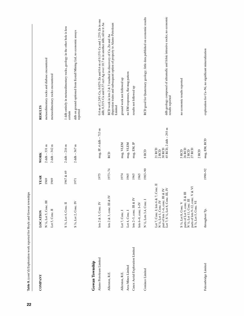
22
Table8.(cont’d)Explorationworkreported
forH
oyleandGow
antownships
COMPANY
LOCATION
YEAR
WORK
RESU
LTS
N½,Lot5,Conc.III
1969
2ddh--331m
metasedimentaryrocksanddiabaseencountered
Lot5,Conc.II
1969
2ddh--342m
metasedimentaryrocksencountered
S½,Lot4,Conc.II
1967
&69
2ddh--216m
1ddhentirelyinmetasedimentaryrocks,geologyintheotherholeisless
certain
S½,Lot2,Conc.IV
1971
2ddh--367m
ddhon
ground
optionedfrom
EcstallMiningLtd,noeconom
icassays
reported
Gow
anTownship
AlamoPetroleumLimited
lots2&3,Conc.IV
1975
mag,IP,4ddh--713m
0.4mof1.24%Cu,0.02%Znand0.6mof0.15%Cuand1.23%Zninone
ddh;0.31%Cuand0.37
oz/tAgover10.7minanotherddh;niltotrAu
Allerston,R.E.
lots2&3,conc.III&IV
1973--74
RCD
RCDworkinlots2&3resultedindiscoveryofCu,ZnandAu
dispersion
trainsandsubsequentoptionofpropertytoAlamoPetroleum
Limited
Allerston,R.E.
Lot7,Conc.I
1974
mag,V
LEM
ground
worknotfollowed
up
AreaMinesLimited
Lot4,Conc.I
1965
mag,V
LEM
noEMresponses,flatmag
pattern
Canex
AerialExplorationLimited
lots2--5,conc.III&
IV1965
mag,EM,IP
resultsnotfollowed
up
lots6--8,conc.I--IV
1965
Com
inco
Limited
N½,Lots3,4,Conc.I
1983--90
8RCD
RCDgood
forQ
uaternarygeology;little
datapublishedon
econom
icresults
Lot7,Conc.I;lots6&7,Conc.II
N½,Lot1,Conc.IV
partoflots1--6,conc.III&
IVLot7;S½,Lot8,Conc.III,IV
21RCD
2RCD
30RCD
45RCD,2
ddh--293m
ddhgeologycomposedofultram
aficandfelsicintrusiverocks;no
econom
icresultsreported
S½,Lot8,Conc.V
partsofLot9,conc.II&
III
N½,Lot11,Conc.III
partsoflots9--12,conc.V
&VI
S½,Lot5,Conc.VI
5RCD
26RCD
2RCD
27RCD
2RCD
noeconom
icresultsreported
Falconbridge
Limited
throughoutTp.
1990--92
mag,EM,RCD
explorationforC
u--Ni,no
significantm
ineralization

23
Table8.(cont’d)Explorationworkreported
forH
oyleandGow
antownships
COMPANY
LOCATION
YEAR
WORK
RESU
LTS
S½,Lot4,Conc.IV
2ddh--493mtotal
ultram
aficflow
sandfelsicQFP
encountered,no
econom
icresultsreported
S½,Lot3,Conc.IV
2ddh--595mtotal
S½,Lot5,Conc.III
1ddh--344m
GeologicalSurveyofCanada
NandcentreofTp.
1971--72
RCD
reconnaissanceoverburden
drillingseeGSC
OpenFile116
Globe
Exploration&MiningCom
pany
Ltd
S½,Lot10,Conc.I
1965
EM,Block
5ground
EMcarriedoutw
ithoutm
ag,noconductorsdetected,no
follow--up
N½,Lot11,Conc.III
EM,Block
6
S½,Lot12,Conc.V
EM,Block
7
N½,Lot11,Conc.V
EM,Block
8
KeevilM
iningGroup
Limited
lots3&7,Conc.I
1965--66
mag,EM,3
ddh--451m
all3
ddhon
Lot3,definescontactbetweenHoyleassemblageand
Kidd–Munroassemblage;conductorsandstratigraphictopsdefine
fold
closureinthisarea,w
eaklydissem
inated
cp,sp,po
andpy
Latam
ExplorationsLimited
lots5&8,Conc.VI
1975,1980
mag,EM
Latam
,asubsidiaryofLacanaMiningCorporation,detected
2conductorsbut
didno
follow--up
MespiMinesLimited
throughoutTp.
1964
Amag
airborne
mag
survey
tocoverm
ostofG
owan
Tp.,supercededby
morerecent
surveys
New
Calum
etMinesLimited
N½,Lot9,Conc.V
1966
mag,EM,1
ddh--148m
ddhinLot9,Conc.Vencounteredgraphitic
andpyritic
“tuff”withinmafic
andintermediatemetavolcanicrocksoftheKidd–Munroassemblage
S½,lots8&10,Conc.VI
mag,EM
NewmontExplorationsofCanadaLimited
lots2--4,conc.III&
IV1976--77
mag,IP,gravity,5
ddh--1106
mddhtoconfirmandextend
limitsofCu--Znmineralizationdiscovered
byAlamoPetroleum;resultsgenerally
disappointing
The
PatinoMiningCorporation
SWpartofGow
anTp.
1965
mag,EM
N½,Lot9,Conc.II
1965
2ddh--240m
ddhencounteredgraphitic
andpyritic
metasedimentaryrocksatcontact
betweenHoyleandKidd–Munroassemblages;w
eaklydissem
inated
cpand
sp
Pollock,J.T.
Lot7,Conc.I
1987
6RCD--108m
drilllogsgood
forQ
uaternaryandPrecam
briangeology;no
significant
econom
icresults
QuontoExplorationsLimited
Lot7,Conc.I
1965
EM
1weakconductordetected,notfollowed
up
RosarioResourcesCanadaLimited
lots5&8,Conc.VI
1980
mag,EM
resultsnotfollowed
up
TexasGulfSulphurCom
pany
N½,lots1&2,Conc.III
1975
mag,Block
36ddhreported
inNew
Calum
etMinesLimitedfilewith
inferred
geologysimilar;no
otherfollow--upreported

24
Table8.(cont’d)Explorationworkreported
forH
oyleandGow
antownships
COMPANY
LOCATION
YEAR
WORK
RESU
LTS
partsoflots4&5,Conc.V
mag,Block
44
N½,Lot1,Conc.IV
mag,Block
46
S½,Lot5,Conc.VI
mag,Block
64
N½,Lot8,Conc.V
1ddh?
Truss,T.
Lot3,Conc.IV
unknow
nddh--183m
ddhencounteredmassive
“soapstone”;no
econom
icmineralizationreported
Abbreviations
Footagegivenwith
diam
ondandreversecirculationdrillworkisthetotalfortheholesreported
mag
--magnetometersurvey
Tp.--township
EM--electrom
agnetic
survey
Conc.--Concession
Amag
--Airbornemagnetometersurvey
Au--gold
AEM--airborneelectrom
agnetic
survey
Cu--copper
VLF--EM--verylowfrequencyelectrom
agnetic
survey
Zn--zinc
VLEM--verticalloop
electrom
agnetic
survey
cp--chalcopyrite
IP--inducedpolarizationsurvey
po--pyrrhotite
dd--diam
onddrilling
sp--sphalerite
ddh--diam
ond--drillhole
py--pyrite
RCD--reversecirculationdrilling
QFP
--quartz--feldsparporphyry
RCDH--reversecirculationdrillhole
Ni--nickel
25
Structure and Metamorphism
Themajor structural features in the map area are poor-ly defined due to the lack of outcrop and detailedstudy. Nevertheless, several structural relationshipswere observed in the available outcrop and in dia-mond-drill core which can be used to aid structuralanalysis. Throughout most of the map area a foliationsemiparallel to bedding and lithologic contacts is de-veloped. This foliation varies from weak to moderateintensity with the strongest development noted in thegraphitic/pyritic mudstone units. In several places indiamond-drill core it was noted that slickensides andpolished surfaces were developed in the graphiticmudstones indicating movement along the beddingplanes. In many drill core specimens of wacke and, toa lesser extent, mafic metavolcanic rocks the beddingparallel foliation is crenulated or cut by a regular arrayof fractures and small veinlets. These structures arecommonly oriented perpendicular to the steeply dip-ping bedding which indicates they are subhorizontal.As these structures were not observed in outcrop theirsignificance is unknown. In southern Hoyle Townshipthe trend of lithologic contacts and bedding varies be-tween 080o and 110o whereas in northern Hoyle andsouthwestern Gowan townships bedding generallytrends 320o.
In many places throughout Hoyle Township afoliation trending 045o to 060o, referred to by theminegeologists as the “northeast trend”, crosscuts the bed-ding-parallel foliation and in most outcrop it is theonly foliation visible. Small scale offsets and foldasymmetry generally indicate dextral movementalong these planes; however, moderate to steeplyplunging mineral lineations on many foliation planesindicate vertical movement also occurred. This north-east fabric occurs in the Bell CreekMine and localizesthe bulk of the high grade gold mineralization at theHoyle Pond and Owl Creek deposits. Distinct darkgrey carbon-bearing alteration zones with or withoutcentral quartz veins are referred to as grey zones andmanyare located by this northeast fabric.North-north-east and northeast-trending faults accompany the foli-ation as observed in the west wall of the Owl Creekopen pit and indicated by the offset of stratigraphysouthwest of the Bell CreekMine.Movement on thesefaults appears to have been largely vertical and offsetsmay appear to be either dextral or sinistral dependingupon the dip of the strata. Piroshco and Kettles (1991)contended that an east-northeast-trending foliation(075o ) is the younger of two structural fabrics in Do-main VII observed in northern Tisdale Township.Their conclusion is supported by the observations insouthern Hoyle Township.
Interpretation of computer enhanced airbornemagnetic data (Barlow 1988b, 1988c) indicates threepreviously unrecognized northeast-trending faultspresent in the map area. The most southeasterly of
these faults appears to be entirely contained withinHoyle Township and occurs approximately 1400 meast of the Bell Creek headframe extending at least 7km along strike. The airborne magnetic patterns ofdiabase dikes appear to be offset and rotated counter-clockwise to the northwest across the fault. A nearbyoutcrop of wacke and mudstone displays northeast-trending bedding and foliation consistent with the in-ference of a fault near this location.
Another northeast-trending fault appears to con-tinue from the Hoyle–Murphy township boundarythrough the south central part of Gowan Township.Airborne magnetic patterns (OGS 1988a, 1988b) aredisrupted in the vicinity of the inferred fault and EMconductorsmarking the lithologic contact between theHoyle assemblage and a member of the Kidd–Munroassemblage appear to be dextrally offset by this struc-ture. On regional airborne magnetic maps (Barlow1988a, 1988b, 1988c) this fault appears to extendsouthwest through Murphy Township and northeastthrough EvelynTownship. Economic and tectonic sig-nificance of this structure is largely unknown.
The third northeast-trending fault is inferred totransect the central part of Gowan Township and hasaffected the ultramafic and felsic units in this area.This structure is characterized by a pronounced dis-ruption of the airbornemagnetic patternwhich is espe-cially noticeable in the vicinity of the copper-zincmineralization in Lot 3, Concession IV, GowanTown-ship. Middleton (1975) noted that the mineralizedzone was northeast-trending and appeared to be con-tained within a shear zone. This fault appears to becontained within Gowan Township and is clearly eco-nomically significant. By analogy to the structural his-tory for northern Tisdale Township (Piroshco andKettles 1991), these northeast-trending faults are in-ferred to postdate the bedding parallel foliation.
In southernHoyle Township a planar shear fabric,trending from 070o to 090o and commonly referred toas the “east-trending fabric” by local mine geologists,is prominently developed at the Bell Creek Mine andthe Marlhill gold zone and less well developed in theOwl Creek open pit and eastern part of the township.This fabric is accompanied bymineral and extensionallineations that are moderately to steeply east to south-east plunging. Gentle westerly plunging quartz veinsand lineations are reported in the Owl Creek andHoyle Pondmine areas (L. Labine, FalconbridgeGoldLimited, personal communication, 1991). Small scalestep faults,mineral lineations, rotated quartz veins androtated pressure shadows on concretionary pyrite indi-cate north side up vertical movement occurred on theshear fabric. The shear fabric is axial planar to foldedquartz veins and sinistrally offsets the northeast-trend-ing foliation at theMarlhill gold zone. The shear fabric

OGS Report 299
26
clearly crosscuts the northeast-trending foliation inthe Owl Creek open pit.
A planar element oriented at 290 10o is devel-oped locally only. The North Zone “A” Horizon andthe North Zone “B” Horizon at the Bell Creek Mineare west-northwest-trending as are lithologic units inthe Owl Creek Mine area. A weakly developed west-northwest-trending foliation was observed in two out-crops in northwestern Hoyle Township and southeast-ern Gowan Township. In Lot 11, Concession II, Go-wan Township a weakly developed, shallow dippingwest-northwest-trending foliation is overprinted by awell developed northwest-trending shear zone. Therelative sense of movement and age relationship ofthis fabric to the other planar fabrics is poorly under-stood in the map area. However, the west-northwest tonorthwest-trending foliation in northern TisdaleTownship is considered by Piroshco and Kettles(1991) to be older than the east-northeast-trendingfoliation. By analogy, the 290o trending structures inthe map area are inferred to be older than the north-east-trending foliation.
Throughout the Hoyle assemblage reversals instratigraphic facings were observed in outcrop anddiamond-drill core. These data together with inter-pretation of the airborne magnetic data (OGS1988a,1988b) indicate the metasedimentary rocks arefolded about west to northwest-trending axes. This de-gree of deformation in themetasedimentary rockswasnot shown on previous OGS maps; therefore, thethickness of the Hoyle assemblage is much less thanpreviously indicated. The geometry of the folds is un-known; however, the generally steep dip (70 to 90o) ofthe bedding and foliation indicates isoclinal folds aremost probable. Piroshco and Kettles (1991) suggestthe presence of isoclinal folding in the Tisdale assem-blage in Tisdale and Whitney townships. Their find-ings indicate that the North Tisdale anticline is anoverturned isoclinal fold with an axial trace approxi-mately parallel to fold axes in the Hoyle assemblage.However, stratigraphic facing reversals were not ob-served in themetavolcanic rocks of the Tisdale assem-blage in the map area and it is uncertain if these rocksare folded.
Structural relationships in Gowan Township arepoorly understood. Stratigraphic facings in outcropanddiamond-drill logs indicate rock units in the south-eastern part of the township are folded about north-west-trending axes. Locally well-developed, north-west-trending shear zones also occur in outcrops offelsic tuff in Lot 11, Concession II. The central part ofGowan Township is underlain by ultramafic and felsicsubvolcanic intrusions and flows. Airborne magneticdata (Barlow 1988b, 1988c; OGS 1988b) indicatecomplex folding and faulting of these units. The air-borne patterns suggest the ultramafic units have un-dergone multiple folding events consistent with dex-tral rotation of all the units in the central part of thetownship.
The structural relationships at all mineral depositsin southern Hoyle Township are complex but there arecommon features observed in each area. The BellCreek gold zone is located along the contact betweenultramafic and basaltic rocks within the well devel-oped portion of the “east-trending” shear fabric at theBell CreekMine. The east-trending fabric is axial pla-nar to folded gold-bearing quartz veins at the Marlhillgold zone. An east-trending reverse fault occurs in theeast wall of the Owl Creek open pit and appears toalign with gold-bearing quartz veins in the floor of thepit. Northeast-trending grey zones contain the bulk ofthe high grade gold mineralization at the Hoyle Pondand Owl Creek deposits and northeast-trendinggold-bearing quartz veins are known to exist in theBell Creek Mine. The North Zone “A” Horizon andthe North Zone “B” Horizon at the Bell Creek Mineare west-northwest-trending. It is possible that the ori-entation of the three structural elements is related tothe development of an easterly trending, vertical shearzone extending through the southern part of HoyleTownship and may represent the extension of the Des-tor–Porcupine fault or a splay through the map area.
In addition to the northeast-trending faults de-scribed above, a number of brittle to brittle-ductilefaults have cut all previous structures and rock types.These are best documented in the southern part ofHoyle Township where north-northwest to northwest-trending faults generally display sinistral offset ofunits and north-trending faults generally display verti-cal and dextral offset. Diabase dikes commonlyoccupy these north and northwest-trending faults.These faults are best observed in drill core and aremost important immediately west of the Owl Creekopen pit where they appear to have displaced part ofthe deposit.
Rocks in southernHoyle Township appear to haveundergone greenschist facies metamorphism; howev-er, widespread hydrothermal alteration has also af-fected these rocks. Blue birefringent chlorite, albiteand rarely epidote are commonmetamorphicmineralsin mafic metavolcanic rocks of the Tisdale assem-blage whereas talc, amphibole and less commonlygrey-brown birefringent chlorite are common in theultramafic units. Blue birefringent chlorite and whitemica with orwithout biotite are characteristic ofmeta-sedimentary rocks of the Hoyle assemblage. Iron car-bonate (siderite) and calcite are nearly ubiquitousthroughout the Tisdale assemblage and are common inthemetasedimentary rock units interlayeredwithmaf-ic metavolcanic rocks in southern Hoyle Township.Carbonate minerals and accompanying silicates formalteration assemblages that approximately correspondwith those described by Fyon (1986). Although thedistribution of these assemblages was not preciselydefined in themaparea, hydrous and transitional alter-ation facies (Fyon 1986) appear to be most common.These facies are characterized by calcite, chlorite, al-bite, tremolite and epidote in the mafic metvolcanicrocks and calcite, chlorite, talc and tremolite in ultra-

Hoyle and Gowan Townships
27
mafic rocks (Fyon 1986). With mineralogy in the maparea similar to that of greenschist facies, it is most dif-ficult to separate regional metamorphism from hydro-thermal metamorphism. In two thin sections of maficmetavolcanic rocks, two generations of epidote wereobserved. Brightly coloured birefringent epidotecoreswere rimmed by blue zoisite suggesting two epi-sodes ofmetamorphismwith two possible origins, oneregional, the other hydrothermal.
The intensive carbonate alteration facies (Fyon1986) occur near the gold deposits inHoyleTownship.Carbonate, quartz and sericite are the most diagnosticminerals while green biotite and microcline rarely oc-cur inmaficmetavolcanic rocks. These latter twomin-erals indicate potassic alteration accompanied car-bonatization.
In the northern part of Hoyle Township and inmost of Gowan Township, metasedimentary rocks arecharacterized by porphyroblastic biotite indicatinghigher grades of metamorphism. Graphitic mudstoneis commonly more highly indurated and epidote ismore abundant than in the southern part of HoyleTownship. Red garnet was observed in one drill coresample from the southeastern part of Gowan Town-ship. The biotite porphyroblasts are commonly sie-ve-textured and randomly orientedwhich is consistentwith their formation in a thermal metamorphic au-reole. The ultramafic and felsic intrusions in the cen-tral part of Gowan Township are the inferred heatsource that thermally metamorphosed the metasedi-mentary rocks. This would imply that the intrusionsare younger than the Hoyle assemblage and most like-ly younger than the metavolcanic rocks of the Kidd–Munro assemblage.

28
Economic Geology
The purpose of this chapter is to briefly summarize theprevious exploration carried out within the map areawith emphasis on the most significant results (seeTable 8). Gold occurs in southern Hoyle Township insufficient quantities and grade to be commercially ex-tracted by the Hoyle Pond Mine and, until recently,from the Bell Creek Mine and the Owl Creek Mine.The exploration history within blocks of ground sur-rounding each mine is summarized and these blocksare presented in Figure 3. Many details of the goldmineralization, alteration and history of productionfor each mine are well documented and readers are re-ferred to these sources for specific information. InGo-wanTownship themost significant exploration hasoc-curred in lots 2, 3 and 4 of Concession IV and this areais treated as a separate block for discussion (Figure 4).
Exploration continues to be active throughout themap area at the time of writing (January 1992). Largeblocks of ground in Hoyle Township are held by Fal-conbridge Limited in their continued effort to findgold mineralization. Falconbridge has also obtainedthe Bell Creek Mine, mill and rights to explorationproperties in Hoyle Township. Several other blocks ofground were held by individuals and companies.
Because much of the land in Gowan Township isheld under patent, exploration has been limited to thefew blocks of ground open for staking. FalconbridgeLimited held much of this ground as of 1991 but a fewindividuals have recently acquired ground in the town-ship (D. Pyke, geologist, personal communication,1991).
GOLDGold mineralization is structurally controlled and oc-curs in three predominant forms. Most of the gold atthe Hoyle Pond Mine and Owl Creek Mine and at theNorth “A” and “B” horizons at the Bell Creek Mine ishosted along the selvages of quartz veins and wallrocks or in stylolitic fractures within quartz veins andis commonly accompanied by hydromuscovite (Kent1990; Labine 1990). Gold also occurs as inclusionswithin fine-grained pyrite at the Owl Creek Mine(Coad et al. 1986), in sulphides in the Bell Creek Zoneand in sulphide-bearingwall rock at theNorth “A” and“B” horizons at the Bell Creek Mine (Kent 1990).Gold associated with amorphous carbon occurs as re-fractory ore at all three mines and its mode of occur-rence has been discussed by Downes et al. (1984).
Chlorite, sericite-carbonate alteration and silici-fication in the form of quartz veins and stringers ac-company the gold mineralization. Sulphide mineral-izationgenerally less than5%but up to 30% in theBellCreek zone is common.Adistinctive type of alterationreferred to as grey zones by the mine geologists is
diagnostic of gold mineralization at the Owl Creek,Hoyle Pond and to a lesser extent at the Bell Creekmines. Amorphous carbon accompanied by enrich-ments in silica, calcium, potassium, iron, arsenic andgold form sharply bounded to diffuse alteration zoneswhich are the primary exploration targets in southernHoyle Township (Downes et al. 1984).
COPPER AND ZINCCopper and zinc mineralization hosted at the contactbetween ultramafic and felsic units was discovered incentral Gowan Township by Alamo Petroleum Limit-ed in 1975. Themineralization appears to be containedwithin a northeast-trending fault; however, follow-upexploration has been limited by the tightly held landsituation, extensive overburden and the disseminatedmineralization which is not easily detected by stan-dard EM surveys. The bimodal ultramafic and felsicintrusive–volcanic suite is similar to that at the KiddCreek base metal deposit and is therefore a good ex-ploration target.
Only a few samples were collected by the authorfor analysis by Geoscience Laboratories, OntarioGeological Survey (Table 9). Other assay values re-ferred to in this section were obtained from reportsfiled for assessment work credit in the AssessmentFiles Research Office, Ontario Geological Survey, theResident Geologist’s office, Timmins and from pub-lished papers and reports. The following section offersobservations and interpretations of the data obtainedduring the field season.
DESCRIPTION OF PROPERTIES
Hoyle Township
BLOCK 1Block 1 (see Figure 3) contains most of the outcrop inHoyle Township and has a long history of exploration.Berry (1941) reported that trenches and pits were sunkintowhite quartz veins in the north½, Lot 12, Conces-sion I. SampleBRB-018 (seeTable 9), collected by theauthor is from one of these pits and no gold was de-tected. Berry (1941) also reported a blue-grey quartzvein containing visible gold had been diamond drilledin lots 9 and 10, Concession II in 1937.
Broulan Reef Mines Limited resampled thetrenches in Lot 9, Concession II in 1958 and their bestresults are listed in Table 8. Seven diamond-drill holeswere also completed at this time but results were notreported.
Copper Reef Mines Limited carried out a groundmagnetic and EM survey over the south½, Lot 11 and

Hoyle and Gowan Townships
29
Figure 3. Areas of major exploration in Hoyle Township; (X) indicates mine site.
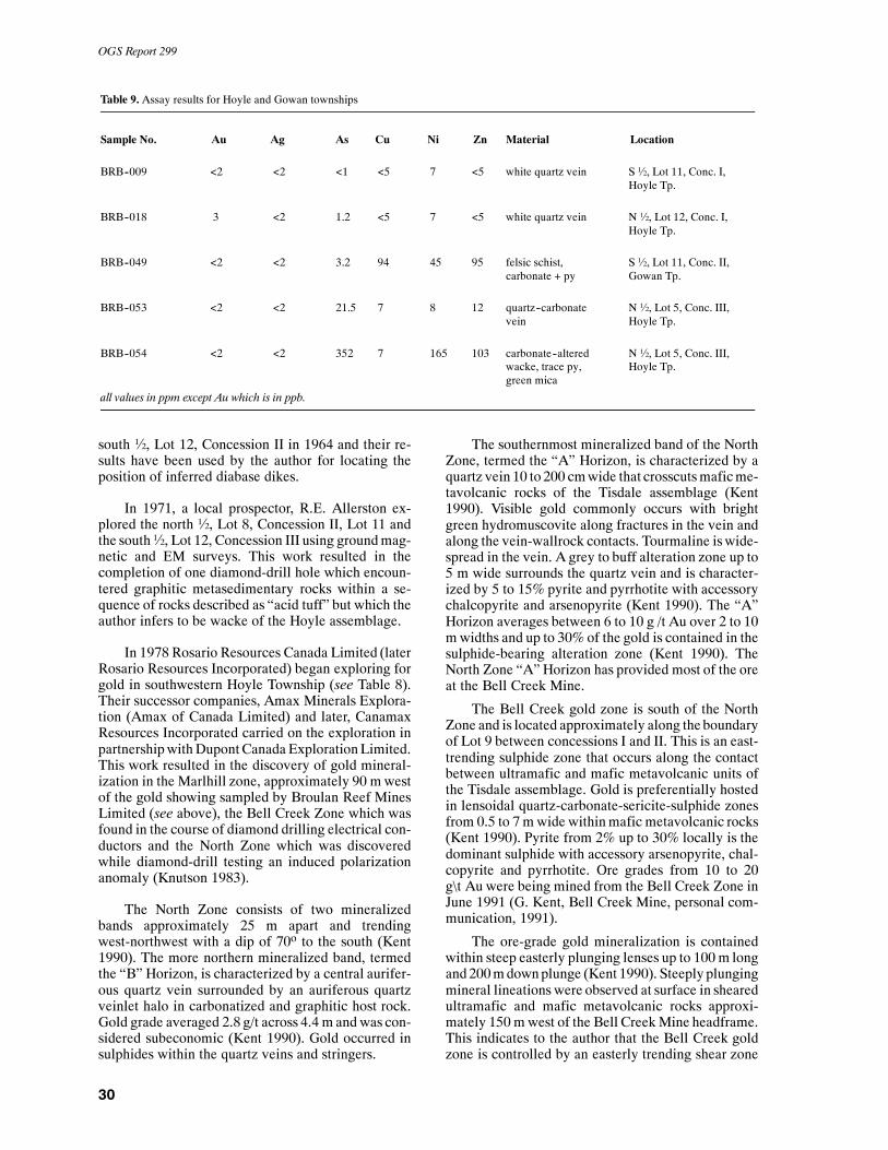
OGS Report 299
30
Table 9. Assay results for Hoyle and Gowan townships
Sample No. Au Ag As Cu Ni Zn Material Location
BRB--009 <2 <2 <1 <5 7 <5 white quartz vein S½, Lot 11, Conc. I,Hoyle Tp.
BRB--018 3 <2 1.2 <5 7 <5 white quartz vein N ½, Lot 12, Conc. I,Hoyle Tp.
BRB--049 <2 <2 3.2 94 45 95 felsic schist, S½, Lot 11, Conc. II,carbonate + py Gowan Tp.
BRB--053 <2 <2 21.5 7 8 12 quartz--carbonate N ½, Lot 5, Conc. III,vein Hoyle Tp.
BRB--054 <2 <2 352 7 165 103 carbonate--altered N ½, Lot 5, Conc. III,wacke, trace py, Hoyle Tp.green mica
all values in ppm except Au which is in ppb.
south ½, Lot 12, Concession II in 1964 and their re-sults have been used by the author for locating theposition of inferred diabase dikes.
In 1971, a local prospector, R.E. Allerston ex-plored the north ½, Lot 8, Concession II, Lot 11 andthe south½, Lot 12, Concession III using groundmag-netic and EM surveys. This work resulted in thecompletion of one diamond-drill hole which encoun-tered graphitic metasedimentary rocks within a se-quence of rocks described as “acid tuff” but which theauthor infers to be wacke of the Hoyle assemblage.
In 1978 Rosario Resources Canada Limited (laterRosario Resources Incorporated) began exploring forgold in southwestern Hoyle Township (see Table 8).Their successor companies, Amax Minerals Explora-tion (Amax of Canada Limited) and later, CanamaxResources Incorporated carried on the exploration inpartnershipwithDupontCanada ExplorationLimited.This work resulted in the discovery of gold mineral-ization in the Marlhill zone, approximately 90 mwestof the gold showing sampled by Broulan Reef MinesLimited (see above), the Bell Creek Zone which wasfound in the course of diamond drilling electrical con-ductors and the North Zone which was discoveredwhile diamond-drill testing an induced polarizationanomaly (Knutson 1983).
The North Zone consists of two mineralizedbands approximately 25 m apart and trendingwest-northwest with a dip of 70o to the south (Kent1990). The more northern mineralized band, termedthe “B” Horizon, is characterized by a central aurifer-ous quartz vein surrounded by an auriferous quartzveinlet halo in carbonatized and graphitic host rock.Gold grade averaged 2.8 g/t across 4.4 m and was con-sidered subeconomic (Kent 1990). Gold occurred insulphides within the quartz veins and stringers.
The southernmost mineralized band of the NorthZone, termed the “A” Horizon, is characterized by aquartz vein 10 to 200 cmwide that crosscutsmaficme-tavolcanic rocks of the Tisdale assemblage (Kent1990). Visible gold commonly occurs with brightgreen hydromuscovite along fractures in the vein andalong the vein-wallrock contacts. Tourmaline iswide-spread in the vein. A grey to buff alteration zone up to5 m wide surrounds the quartz vein and is character-ized by 5 to 15% pyrite and pyrrhotite with accessorychalcopyrite and arsenopyrite (Kent 1990). The “A”Horizon averages between 6 to 10 g /t Au over 2 to 10mwidths and up to 30% of the gold is contained in thesulphide-bearing alteration zone (Kent 1990). TheNorth Zone “A” Horizon has provided most of the oreat the Bell Creek Mine.
The Bell Creek gold zone is south of the NorthZone and is located approximately along the boundaryof Lot 9 between concessions I and II. This is an east-trending sulphide zone that occurs along the contactbetween ultramafic and mafic metavolcanic units ofthe Tisdale assemblage. Gold is preferentially hostedin lensoidal quartz-carbonate-sericite-sulphide zonesfrom 0.5 to 7 mwide withinmafic metavolcanic rocks(Kent 1990). Pyrite from 2% up to 30% locally is thedominant sulphide with accessory arsenopyrite, chal-copyrite and pyrrhotite. Ore grades from 10 to 20g\t Au were being mined from the Bell Creek Zone inJune 1991 (G. Kent, Bell Creek Mine, personal com-munication, 1991).
The ore-grade gold mineralization is containedwithin steep easterly plunging lenses up to 100m longand200mdownplunge (Kent 1990). Steeply plungingmineral lineations were observed at surface in shearedultramafic and mafic metavolcanic rocks approxi-mately 150 mwest of the Bell CreekMine headframe.This indicates to the author that the Bell Creek goldzone is controlled by an easterly trending shear zone

Hoyle and Gowan Townships
31
and that mineralization and deformation are closelylinked. Hattori andHicks (1986) inferred thatmineral-ization and deformation were synchronous. This shearzone was intersected in diamond-drill holes approxi-mately 1200 m west and up to 400 m east of the BellCreek Mine headframe and Kent (1990) reported thatmultiple lenses were located along a strike length of 1km at or near the ultramafic–mafic metavolcanic con-tact. This shear zone warrants further exploration inthe author’s opinion.
The Marlhill zone is unlike any other gold occur-rence inHoyle Township. A number of quartz veins10cm to 300 cmwide trend north to northwest and cross-cut the mafic metavolcanic stratigraphy at a highangle. Quartz veins in other parts of Block 1 are gener-ally parallel to a local or regional foliationwhereas theMarlhill veins are clearly folded with an axial planarcleavage trending 080o. The folded quartz veinsplunge steeply to the east and Kent (1990) indicatedthat the veins appeared to occur in saddle reef struc-tures. The quartz veins contain 2 to 5% fine-grainedpyrite and arsenopyrite. Visible gold is rare and browntourmaline (dravite) is common (Kent 1990). Gold ismost commonly associated with sulphide minerals,most commonly arsenopyrite, and grades are very er-ratic. The Marlhill zone is accessed by ramp. Miningcontributed only a small amount ofmaterial to themill(G. Kent, Bell Creek Mine, personal communication,1991).
Barren quartz stringers and veins occur parallel tothe 080o foliation and locally crosscut auriferousveinsindicating multiple generations of veining occurred.Mineral and stretching lineations on the 080o planesplunge moderately to the southeast and are at variancewith the east plunging auriferous quartz veins. De-tailed mapping by the author of a stripped area, desig-nated the “M-3” vein, showed that the 080o foliation ischaracterized by north side up movement and that ithas sinistrally offset a 060o trending foliation, smallquartz stringers and lamprophyre dikes. The overalllow sulphide content, lack of pyrrhotite and narrowwidths made geophysical detection of Marlhill veinsimpossible (Knutson 1986).
Gold mining operations ceased at the Bell CreekMine and Marlhill gold zone in October 1991. Up to1990, theBell CreekMine andMarlhill zone producedapproximately 87 384 ounces of gold from 277 577tons milled (Luhta et al. 1990). Falconbridge Limitedacquired the property in late 1991 and at the time ofwriting they were evaluating the mine and surround-ing property.
During the course of diamond-drill testing electri-cal conductors, Canamax Resources Incorporatedcompleted several holes in Lot 10, Concession I. Oneof these holes encountered 1 m of massive chalcopy-rite, pyrrhotite and sphalerite hosted in mafic flow topbreccia (see maps in back pocket). Drill core ex-amined by the author contained up to 90% banded sul-phidemineralization in a cherty quartz gangue and oc-
curred at the contact between two mafic, massiveflows. Approximately 5 m of widely spaced sulphidestringers occur south of the massive zone. Althoughassays of themassive sulphideswere not released, val-ues of up to 10% combined copper and zinc were ob-tained (R. Roussain, Canamax Resources Incorpo-rated, personal communication, 1991). There hasbeenno additional testing of this mineralization and the po-tential for base metal deposits in this environment islargely unknown.
BLOCK 2Extensive exploration in Block 2 (see Figure 3) has re-sulted in the discovery of the Owl Creek gold depositand at least two other subeconomic gold occurrences.Because very little outcrop exists in this area, most ex-ploration was expedited by the development of geo-physical techniques. The earliest reported explorationoccurred in 1940 in the south½, Lot 9 and south½, Lot10, Concession I by C.B. Alton. Five diamond-drillholeswere sunk but failed to encounter any significantgold mineralization.
In 1968 Canadian Nickel Company Limited un-dertook an exploration program that concentrated onthe south-central part of Hoyle Township (see Table8). Tendiamond-drill holeswere completed to test EMconductors and, although results were not reported, itiswidely accepted that significant goldmineralizationwas discovered on Lot 7, Concession I (Carlson1974).Hudson Bay Mountain Silver Mines Limited com-pleted 3 diamond-drill holes in Lot 8, Concession II atabout the same time the Canadian Nickel CompanyLimitedwasworking in the area (seeTable 8). Nogoldmineralization was reported from these drill holes.Texas Gulf Sulphur Company was active in southeast-ern Hoyle Township from 1965 to 1969 and 4 dia-mond-drill holes were completed in Block 2. Theseholes, drilled to test EM conductors, encounteredwacke and graphitic mudstone of the Hoyle assem-blage. Assay results were not reported.
Continued exploration by Falconbridge Limitedand its predecessor companies Kidd Creek MinesLimited and Texas Gulf Sulphur Company resulted indelineation of the Owl Creek gold deposit on the origi-nal Canadian Nickel Company Limited gold discov-ery onLot 7, Concession I. TheOwlCreek gold depos-it was exploited by open pit mining from 1981-1989producing 6 413 629 grams of gold from 1 618 451tons milled over its lifetime (Luhta et al. 1990). Goldore stockpiled on site was used in 1990 both for flux atthe Kidd Creek smelter and for ore at the Kidd Creekgold mill (Luhta et al. 1990).
The geology of the Owl Creek gold deposit con-sists of a narrow wedge of basaltic flows (60 to 80 mwide) in contact with highly schistose, graphitic andpyritic mudstone and wacke (Coad et al. 1986). Themetavolcanic rocks strike 070o and are in angular dis-cordancewith the east strikingmetasedimentary rockson the north contact of the open pit (Coad et al. 1986).
OGS Report 299
32
A foliation striking 065o and dipping steeply north ismost obvious and mineral lineations on these planesplunge moderately to the east. Small scale fold axesand crenulation cleavage in the open pit plunge mod-erately to the east-northeast. A large massive quartzvein (up to 20 m wide) occurs along the north contactof themafic metavolcanic and metasedimentary rocksand visible gold commonly occurs along the contactsof the quartz vein and graphitic schist. This vein alongwith smaller quartz veins and stringers in themetavol-canic rocks constituted the bulk of the ore at the mine(Coad et al. 1986). Observationsmade by the author inthe open pit indicate that in addition to the main quartzvein and related subhorizontal veining a number ofbrittle en échelon ladder-type quartz veins are present.There is also an easterly trending, north dipping, shearfault near the structural hanging wall of the open pitand the geometry of the quartz veins in this area indi-cate north side up vertical movement. This reversefault may have been an important factor controllingthe deposition of quartz and gold mineralization (L.Burns, Falconbridge Gold Limited, personal commu-nication, 1991). Shearing at the southern contact be-tween the mafic metavolcanic and metasedimentaryrocks suggests that the Owl Creek gold deposit mayhave been emplaced in a vertical shear zone and thatthe quartz veins record the last incremental deforma-tion in this zone.
A north-northeast-trending late fault cuts the westend of the open pit and has offset the mafic metavol-canic rocks and the gold deposit. Movement on thisfault appears to have largely beenvertical and explora-tion by Syngold Exploration Limited (see below) ap-pears to have located the western extension of the goldmineralization (L. Burns, Falconbridge Gold Limited,personal communication, 1991; Simmons 1988.)
Sulphide content in the rocksof theOwl Creekde-posit varied between 1 to 5% in the maficmetavolcan-ic rocks and from 1 to 30% in the metasedimentaryrocks. Pyrite is the most abundant sulphide and occursas nodular concretions in the graphitic schist and as fi-ne-grained cubic pyrite throughout all rock types.Most of the gold occurred as fine-grained inclusions inthe cubic pyrite (Coad et al. 1986). For further discus-sion regarding pyrite morphology and gold mineral-ization readers are referred to Wilson and Rucklidge1986.
In 1986 and 1987 Syngold Exploration Incorpo-rated, in a joint venture with KiddCreekMines Limit-ed, completed 41 closely spaced diamond-drill holesin the north½, Lot 7 and north½, Lot 8, Concession I(see Table 8). Their work succeeded in outlining sub-economic gold mineralization which was generallybelieved to be the fault offset extension of the OwlCreek gold deposit (Simmons1988). Goldmineraliza-tion was confined to northeast and east-trending (060to 080o) grey alteration zones (see above)withinmaficmetavolcanic rocks of the Tisdale assemblage. Someof the better mineralized sections returned 14.1 m of
2.54 g /t Au, 10m of 11.93 g /t Au, 5 m of 10.42 g /t Auand 6m of 5.69 g/t Au (Simmons 1988). However, thismineralization was not consistent enough to definemineable gold reserves.
Further exploration by Falconbridge Limited inBlock 2 resulted in discovery of subeconomic goldmineralization in the north ½, Lot 9, Concession I.Here, goldmineralization is containedwithin zones ofalteredmaficmetavolcanic rocks that contain sericite,quartz and graphite (grey zones). Disseminatedpyrite,up to 5% of the rock, is present along with traceamounts of chalcopyrite and muscovite in veins andrarely visible gold is present in quartz stringers. Drillcore examined by the author and stored at theTimminsDrill Core Library,Ministry ofNorthernDevelopmentand Mines, displays complex structural relationships.Numerous brittle fractures expressed as en échelonquartz-carbonate stringers and less commonly cre-nulation bands are at low angles to the core axis anddisplay dextral offset. As these diamond-drill holeswere collaredwith dips between 50 and 65o themajor-ity of fractures are near vertical, indicating verticalmovement. This is consistent with observations in out-crop at the Bell CreekMine and in the Owl Creek openpit and would indicate north side up movement. Someof the higher grades encountered included 25.5 g /t Auover 0.5 m, 36.69 g/t Au over 1 m and 7.06 g/t Au over1 m. The mineralization was not consistent enough todefine mineable reserves.
Falconbridge Limited remains active in Block 2and most recently a north-south-trending fence of ver-tical diamond-drill holes was sunk in the south½, Lot7, Concession I in an effort to locate extensions of theTisdale assemblage (see maps in back pocket). Thesedrill holes encountered metasedimentary rocks of theHoyle assemblage only. At the time of writing, exten-sive compilation and re-evaluation of all data in Block2were being undertaken by Falconbridge (D. Duff, se-nior geologist, personal communication, 1991).
BLOCK 3The earliest exploration reported in Block 3 (see Fig-ure 3) was that undertaken by NorandaMines Limitedand Hollinger Mines Limited in 1938 (Berry 1941).Diamond drilling was carried out on lots 2 and 3, Con-cession III to test gold mineralization associated withpyritic quartz stringers in carbonate-altered maficme-tavolcanic rocks.Assays ranging between0.02 and0.1ounce per ton gold were reported.
No further exploration was reported until 1965when Texas Gulf Sulphur Company carried out dia-mond drilling to test electrical conductors (see Table8). Most of the drill holes intersected graphitic mud-stone and wacke of the Hoyle assemblage and a fewholes located the contact between the Tisdale andHoyle assemblages. In 1969, Texas Gulf SulphurCompanywas attempting to follow favourable stratig-raphy eastward from the gold mineralization discov-ered by the Canadian Nickel Company Limited (Owl

Hoyle and Gowan Townships
33
Creek, see above) (Labine 1990). Although assayswere not reported one diamond-drill hole encountered3 m grading 6.5 g /t Au (Labine 1990).
In 1980, KiddCreekMinesLimited started explo-ration to follow up on the gold mineralization discov-ered by Texas Gulf Sulphur Company Limited whichwas subsequently developed into the Hoyle PondMine (Rye 1987; Labine 1990). Falconbridge Limitedsubsequently acquiredKidd CreekMines Limited andcurrently operates themine. To the end of 1990, HoylePond Mine produced 320 467 ounces of gold from602 753 tons milled and reserves toAugust 1990were275 000 t grading 15.5 g/t Au (Luhta et al. 1990).
The geology of the Hoyle Pond gold deposit hasbeen discussed by Downes et al. (1984), Rye (1987)and Labine (1990). Rye (1987) and Labine (1990) in-dicated that wacke of the Hoyle assemblage was thelowest stratigraphic unit in the mine area. This unitwas overlain by a graphitic mudstone to wacke unitwhich is faulted and sheared (Rye 1987). Pillowed,magnesium-rich, tholeiitic basalts unconformablyoverlie the metasedimentary rocks (Labine 1990);however, Rye (1987) indicated the contact betweenthe two units was sheared. The author suggests thatthis may represent structural juxtaposition of the twounits rather than original stratigraphy. Spinifex tex-tured ultramafic flows overlie the basalts and Rye(1987) noted that the contact between these two unitswas also sheared.
Structural relationships in the gold deposit arecomplex and Labine (1990) indicated that a variety oftension and shear veins, reverse faults and folds werecommon. An easterly trending wrench fault was pos-tulated along the contact between the graphitic mud-stone and the basalts (Labine 1990). Rye (1987) indi-cated that the auriferous quartz veins and associatedgrey zone alteration halos were coincident with a pro-nounced shear foliation and that their emplacementpostdated peak metamorphism. Downes et al. (1984)indicated that the majority of quartz veins were em-placed parallel to an S1 foliation trending approxi-mately 060o. The presence of pressure shadows onidioblastic pyrite and numerous deformation struc-tures in the quartz veins suggested deformation con-tinued past the main stages of vein growth (Rye 1987)corresponding to the easterly trending shear fabric ob-served in other parts of Hoyle Township. Hodgson(1983) noted that gold mineralization is, in part, over-printed by deformation in other parts of the Timminsarea as well. The emplacement of the quartz veins atHoyle PondMine is associatedwith stylolitic pressuresolution and grey zone development (Rye 1987). Hy-draulic fracturing of the structurally competent maficmetavolcanic rocks was accompanied by ductile de-formation of the less competent graphitic mudstoneswhich made them impermeable to fluid migration(Rye 1987). Hydrothermal fluids ponded along themaficmetavolcanic –graphitic mudstone contact untilpressure was released permitting vein propagation
into the competent rocks (Rye 1987). A three dimen-sionalmodel of themain gold-bearingquartz veinsob-served by the author at the Hoyle Pond Mine officebroadly conforms with the geometry of sigmoidal ten-sion fractures expected in a vertical shear zone with areverse sense of movement (e.g., north side up move-ment).
Gold mineralization is concentrated on the con-tact between quartz veins and wall rock and along sty-lolitic fractureswithin veins (Rye 1987). In veins, goldis precipitated with phyllosilicates, sphalerite and fi-ne-grained pyrite (Rye 1987) and spectacular samplesof visible gold occur locally. Gold is also present with-in the alteration zones surrounding the quartz veinsand is associated with carbon and fine skeletal tex-tured pyrite (Downes et al. 1984). The alterationzones, also referred to as “grey zones” by mine geolo-gists, are grey to black and characterized by high car-bon and carbonate content. Quartz, feldspar, whitemica (paragonite), chlorite and carbonate make upmost of the mineralogy of the grey zones (Downes etal. 1984). Very fine-grained carbon, some of which isamorphous, makes up 1 to 5% of these zones and fi-ne-grained skeletal pyrite constitutes 1 to 3%(Downeset al. 1984). The grey zones are distinctly enriched intungsten, arsenic and gold with respect to unalteredbasalts and a positive correlation of copper, nickel, tel-lurium, antimony andbismuthwith gold exists in thesezones (Downes et al. 1984). Statistical manipulationof trace element data indicate these elements plus car-bon andCaOwere introduced into the alteration zonesand it was suggested that the gold was remobilizedfrom the stratabound graphitic mudstone units into thealteration zones (Downes et al. 1984). Springer (1985)indicated there was insufficient gold in the graphiticmudstones to account for the Hoyle Pond deposit andthat it wasmore likely to have been introduced into thealteration zones by hydrothermal solutions with car-bon acting as a reductant thus promoting deposition ofthe gold.
Regardless of the source of the mineralizingfluids, gold is associated with graphite, elemental car-bon and other carbon basedminerals at all threeminesinHoyle Township and its presence can be used to suc-cessfully explore for additional mineralization.
Falconbridge Limited has also diamond-drilltested the gold mineralization in lots 1 and 2, Conces-sion III explored by Noranda Mines Limited in 1938.Pervasive carbonate alteration ofmafic andultramaficmetavolcanic units is widespread and smaller zonescontaining pyrite and quartz veining are present. Goldmineralization is contained within quartz veins andone of the better mineralized zones returned 5.49 g /tAu over 1.5m. Themineralization is erratic andmine-able reserves were not defined.
Falconbridge Limited remains active in Block 3and exploration for additional gold mineralizationcontinues. At the time of writing an extensive com-pilation and re-evaluation of all data in Block 3 was
OGS Report 299
34
being undertaken by Falconbridge Limited (D. Duff,senior geologist, personal communication, 1991).
THE REMAINDER OF HOYLETOWNSHIPMost ofHoyle Township has been explored by surfaceand airborne geophysical surveys. However, there hasbeen relatively little subsurface exploration through-out concessions III to VI. Although a number of re-verse circulation overburden drill holes have beencompleted, their spacing (commonly 400 m) anddepth of penetration into the Archean rocks (common-ly less than 1.5 m) is best described as reconnaissancein nature. The work by J. T. Pollock, Prospector (seeTable 8) is considered by the author to be most repre-sentative of the geology in the central and northernparts of the township.
Airborne and ground magnetic anomalies in thecentral part of concessions IV and V were inferred tobe mafic metavolcanic rocks by some reports filed forassessment work credits. Six diamond-drill holes sunkby Kerr Addison Mines Limited (see Table 8) in thecentral part of the township encountered only wackeand mudstone. One diamond-drill hole completed byA.J. Salo, Prospector in the same area also encoun-tered only metasedimentary units (see Table 8). Thecause of the magnetic anomalies remains unexplainedin the author’s opinion.
Limited diamond drilling by Keevil MiningGroup Limited, Globe Exploration and Mining Com-pany Limited, Gold Shield Syndicate and DejourMines Limited in the northeastern part of the townshipconfirmed the presence of mafic metavolcanic rocksand graphitic mudstone units (seeTable 8). Samplesofcore from diamond-drill holes drilled by Keevil Min-ing Group returned up to 160 ppb Au from graphiticand pyritic mudstone and drill logs reported weaklydisseminated chalcopyrite and sphalerite in similarmaterial. The presence of ultramafic metavolcanicand intrusive rocks is inferred, from airbornemagneticpatterns, to occur in the northeastern part of the town-ship; these rocks have not been reported in any dia-mond-drill holes. Many airborne electromagnetic(AEM) anomalies were detected in this area (OGS1988a) and although many of them appear to beformational and coincidental with graphitic mudstoneunits, some are coincidental with the inferred ultra-mafic rocks and with northeast-trending faults. Test-ing of these anomalies is warranted.
Gowan Township
BLOCK 1Most of the economically significant exploration inGowan Township has been completed in lots 1 to 4,concessions III and IV (see Figure 4). It is uncertainwhen exploration first began in this area; however, anundated report in the Resident Geologist’s Office,
Timmins indicated that T. Truss, Prospector com-pleted a 183 m diamond-drill hole on Lot 3, Conces-sion IV (see Table 8). Reverse circulation overburdendrilling was carried out by R.E. Allerston in 1973–74on lots 2 and 3, concessions III and IV (see Table 8).Basal till samples returned anomalous copper, nickeland gold assays and the ground was subsequently op-tioned to Alamo Petroleum Limited. Diamond-drillholes completed by Alamo Petroleum encountereddisseminated copper and zincmineralization hosted inultramafic rocks at the contact with felsicmetavolcan-ic rocks and schist (see Table 8). An additional 5 dia-mond-drill holes completed by Newmont Explora-tions of Canada Limited encountered a similar type ofmineralization but could not establish continuity oreconomic grades (see Table 8).
Middleton (1975) reported that mineralization inone of Alamo Petroleum’s drill holes consisted of 9.4m of semi-massive banded pyrite and chalcopyritecontained within an altered ultramafic rock (soap-stone). Mineralization in this interval returned 0.3%Cu and 0.34 ounce per ton silver (10.6 g/t). Highergrade mineralization of 0.68% Cu was returned over3.8 m and 0.95%Cu over 1 mwithin this interval. Themineralization occurred along the contact with a por-phyritic rhyolite unit, and disseminated pyrite ex-tended into the felsic rocks. In a second hole, AlamoPetroleum encountered two sulphide-bearing hori-zons, each located at the contact between felsic andul-tramafic–mafic schist. Although the disseminated sul-phide content was lower than in the previous hole,grades of 1.24% Cu over 0.38 m were returned fromone sulphide zone and 1.23% Zn and 0.17% Cu over0.6 m were returned from the second sulphide zone.Nickel valueswere commonly less than 900 ppm in allassays and anomalous gold up to 0.02 ounce per ton(625 ppb Au) was encountered in diamond-drill hole(Middleton 1975). The mineralized horizon was in-ferred to be northeast-trending and largely stratigraph-ic. The author noted that from the drill logs and drillcore available for inspection at the Drill Core Library,Ministry of Northern Development and Mines, Tim-mins, a northeast-trending fault or shear zone may oc-cur in the area and mineralization may be structurallycontrolled.
The discovery of copper-zinc mineralization inthis ultramafic–felsic environment is very significantfor three reasons. Firstly, because themineralization isdisseminated and the overburden is deep (see Figure 2)conventional surface horizontal loop, vertical loopand shoot-back EM methods used for massive sul-phide bodieswere not successful at locating the target.Induced polarization (IP) surveys following the initialuse of reverse circulation overburden drilling wereused. Induced polarization surveys and other types ofgeophysical surveys such as pulse EM (PEM) have notbeen widely used. As a result, the potential for discov-ery of othermineralized areas has not been fully testedin Gowan Township. Secondly, the northeast trend ofthe mineralization, whether it is structurally or strati-

Hoyle and Gowan Townships
35
Figure 4.Areas of major exploration in Gowan Township; (X) indicates mineral occurrence.

OGS Report 299
36
graphically controlled, indicates that publicly avail-able AEM surveys (OGS 1988b) oriented with north-trending flight lines may not have detected mineral-izationoriented parallel or oblique to them.Therefore,even weak anomalies or anomalies with questionablesources may be valid bedrock electrical conductors(OGS 1988b). In the author’s opinion, until theseanomalies are ground tested they should be regardedas valid indicators of bedrock electrical conductors.Thirdly, the bimodal association of ultramafic andfelsic rock types is similar to that at the Kidd Creekbasemetal deposit, 19 km to the west of GowanTown-ship. Here, the orebody is located in an area character-ized by north striking lithologic contacts at variancewith the regionally east striking greenstone belt (Bris-bin et al. 1990). The geology of the central part of Go-wan Township, which is underlain by ultramafic andfelsic rock types, is complex and north striking con-tacts are inferred to be present. The economic poten-tial of the map area has not been fully tested.
Most recently, Falconbridge Limited carried outexploration for copper-nickel mineralization in Block1. Four diamond-drill holes were completed to testgeophysical anomalies and all encountered ultramaficunits some of which were spinifex textured (see Table8). Assay valueswere not reported and basedon the in-formation contained in the drill logs it is inferred thatno economic mineralization was encountered.
THE REMAINDER OF GOWANTOWNSHIP
Cominco Limited has carried out extensive reversecirculation overburden drill exploration over much ofGowan Township (see Table 8). Over 140 drill holeshave been completed and their work has providedmuch of the map data (see back pocket) relating toQuaternary and Archean geology. As is commonwithdata filed for assessment work credits results of assayswere not reported; however, a general lapse in Comin-co’smining claims inGowanTownship suggests to theauthor that no economic mineralization was discov-ered.
Diamond drilling by KeevilMining Group Limit-ed in the southeastern part of the township (see Table8) encountered graphitic and pyritic mudstone at thecontact with metavolcanic units of the Kidd–Munroassemblage. Based on data contained in the drill logsand computer enhancedgeophysical data, a syncline isinferred in this area. Disseminated chalcopyrite andsphalerite (up to 2%) was encountered in the graphiticmudstone. Rhyolitic flows and tuff similar to those ob-served in diamond-drill core completed by Alamo Pe-troleum in Lot 2, Concession IVwere also observed inthe Keevil drill core.
Patino Mining Corporation Limited completedtwo diamond-drill holes in Lot 9, Concession II to testelectrical conductors (see Table 8). Graphitic and py-ritic mudstone was encountered at the contact with
mafic metavolcanic rocks of the Kidd–Munro assem-blage. Sparse specks of chalcopyrite and sphaleritewere containedwithin the graphitic material and in themafic rocks. Subsequent reverse circulation overbur-den drilling by the Geological Survey of Canada(Skinner 1972) and Cominco Limited helped to betterdefine the bedrock geology in this area although eco-nomic mineralization was not encountered (see Table8).
A single diamond-drill hole sunk in Lot 9, Con-cession V by New Calumet Mines Limited encoun-tered graphitic and pyritic “tuff” interlayered withmafic and intermediate tuff and flows. Nil gold, nilzinc and trace copperwere reported from two assaysofthe graphitic and pyritic tuff and the mafic tuff. OtherAEM conductors in this area (OGS 1988b) appear tobe associated with along-strike extension of the gra-phitic and pyritic “tuff”; however, structural com-plications appear to have offset some of the geologicalunits and some conductors clearly lie off of the forma-tional trend.
RECOMMENDATIONS TOPROSPECTORSStructurally controlled gold mineralization occurs inthe Tisdale assemblage in southern Hoyle Township.Auriferous quartz veins contained within auriferousalteration zones referred to locally as grey zones arecommonly emplaced in brittle–ductile structurestrending between 045 and 070o. Gold-bearing quartzveins and auriferous sulphide lenses also trendwest-northwest and easterly. The geometry of thequartz veins and small scale structures indicates thatemplacement of the veins and alteration may be re-lated to the development of vertical shear zones thatmay represent the Destor–Porcupine fault or splayfaults. The Tisdale assemblage has been extensivelyexplored with emphasis on the diamond-drill testingof EM conductors in an effort to locate graphitic andcarbonaceous horizons that may lead to discovery ofthe gold-bearing zones. All of these targets have notbeen drilled exhaustively; therefore, further goldmin-eralizationmaybe discovered using this technique, es-pecially in the western and southwestern parts of thetownship. However, if gold mineralization is closelytemporally and spatially linked to vertical shearing, asthis survey indicates, then there remains much untest-ed potential for discovery of gold mineralization atdepth and along the strike of these shear zones. Al-though an easterly trending shear fabric occurs at eachof the gold deposits, it is unknown if a single shearzone or several parallel zones are present in HoyleTownship. It is recommended that detailedmappingofthe structure at all outcrop in the southern part of thetownship, and in each deposit, be carried out to deter-mine the validity of the vertical shearing hypothesis.Recognition and delineation of east-trending shearzones will narrow the focus for exploration of goldmineralization.

Hoyle and Gowan Townships
37
The potential for gold mineralization in otherparts of the map area has not been thoroughly tested.Geochemically anomalous gold has been detected incore extracted from diamond-drill holes by KeevilMiningGroup in the northeastern part of Hoyle Town-ship and in lots 2 and 3, Concession IV in GowanTownship. These and amajority of the other diamond-drill holes in these parts of themap area were drilled totest ground EM and AEM conductors for base metalmineralization. To the author’s knowledge there hasbeen no concerted effort to test for northeast-trendinggold-bearing structures. Reported anomalous goldvalues in basal till from overburden drill programs ineasternGowanTownship (seeAllerston, Table 8) havenot been explained (Middleton 1975). The threemajornortheast-trending faults inferred from the computerenhanced airborne magnetic data (see Structure andMetamorphism; OGS 1988a, 1988b) are obvious tar-gets for additional gold exploration.
The massive pyrrhotite-chalcopyrite-sphaleritehorizon intersected in one diamond-drill hole south ofthe Bell Creek gold deposit in Lot 10, Concession I,Hoyle Township, appears to be unique in the Tisdaleassemblage in the map area. Although narrow (lessthan 1 m thick), the author notes that untested AEManomalies occur along strike of the mineralization.This area warrants further exploration.
Disseminated copper and zinc mineralization oc-curs within the Kidd–Munro assemblage in GowanTownship. The mineralization is contained within ul-tramafic and mafic rocks at the contact with felsic me-tavolcanic and intrusive rocks and appears to be struc-turally controlled by northeast-trending faults. Air-borne electromagnetic surveys (OGS 1998b) did notdetect this mineralization and the amount of diamonddrilling suggests to the author that the potential of thisarea has not been fully tested. Two AEM conductors
approximately 200 to 400 m north-northeast of thismineralization have not been tested.
There are numerousAEMconductors indicated inthe Kidd–Munro assemblage (OGS 1988b). Thesource ofmany of these conductors is not certain as in-dicated by question marks and some explorationistsmay have attributed the conductivity to overburden.Because the known copper-zinc mineralization is dis-seminated and may be structurally controlled theseconductors should be re-evaluated. Further, some ofthe lithologic contacts in the central part of GowanTownship trend north-south, parallel to OGS surveyflight lines; therefore, some anomalies under questionmay include electrical conductors parallel to thoseflight lines.Anomalies coincidentalwith low intensitymagnetic areas may be especially significant as thesemagnetic lows are inferred to be underlain by felsicmetavolcanic or felsic intrusive rocks. Questionableanomalies detected in Lot 8, Concession III and in Lot9, Concession IV warrant consideration. Ultramaficand mafic rocks of the Kidd–Munro assemblage ex-tend into the northeastern part of Hoyle Township andEM conductors in lots 4 and 6, Concession VI appearto be, in part, coincidental with inferred faults or withultramafic rocks. These areas warrant considerationfor future exploration.
Overburden drilling has been extensively used toexplore for gold and base metal mineralization in themap area. As shown in Figure 2, there is a great varia-tion in paleotopography which, in the author’s experi-ence, is not adequately considered in interpretation ofresults. It is hoped that Figure 2 will be useful in guid-ing future overburden drilling programs in the maparea. In particular, bedrock ridges perpendicular to iceflowmaymodifymineral dispersionpatterns such thatsource areas are only apparently indicated. Knowl-edge of the paleotopography of Hoyle Township mayreduce this type of data misinterpretation.
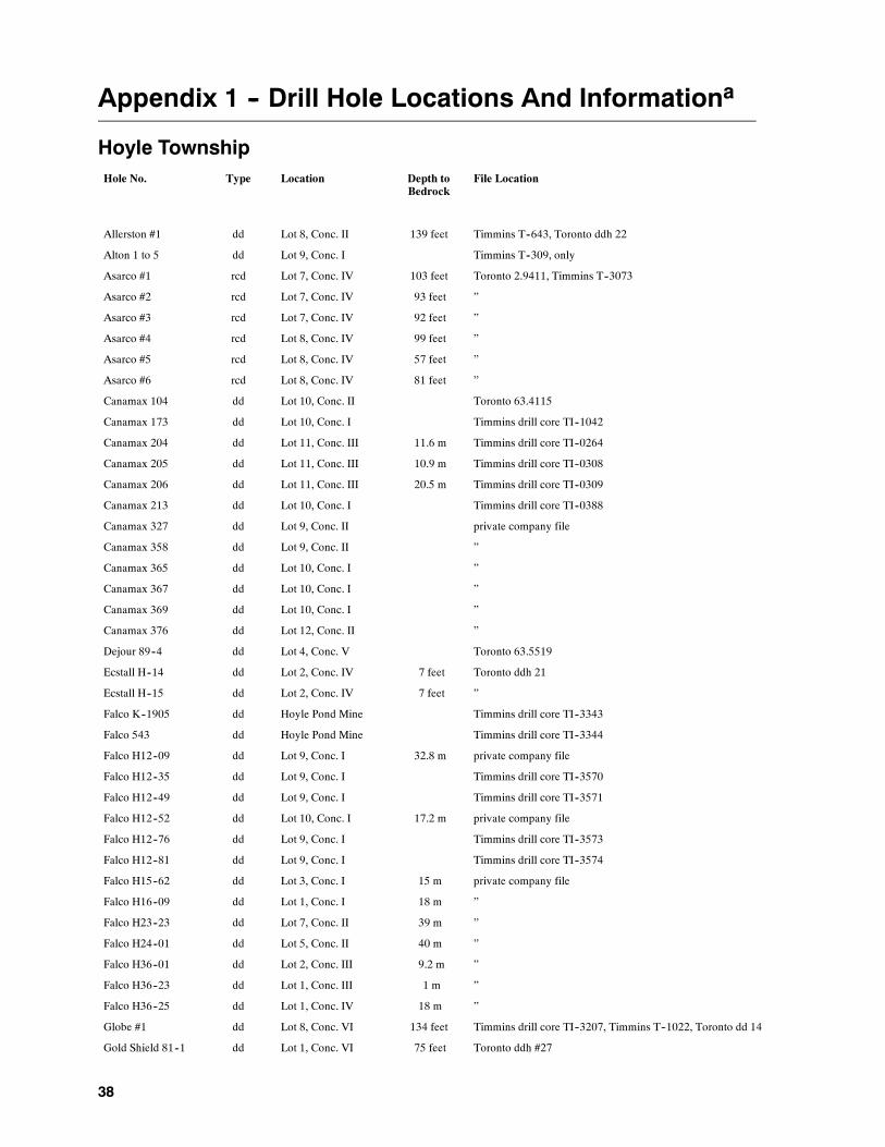
38
Appendix 1 -- Drill Hole Locations And Informationa
Hoyle TownshipHole No. Type Location Depth to
BedrockFile Location
Allerston #1 dd Lot 8, Conc. II 139 feet Timmins T--643, Toronto ddh 22
Alton 1 to 5 dd Lot 9, Conc. I Timmins T--309, only
Asarco #1 rcd Lot 7, Conc. IV 103 feet Toronto 2.9411, Timmins T--3073
Asarco #2 rcd Lot 7, Conc. IV 93 feet ”
Asarco #3 rcd Lot 7, Conc. IV 92 feet ”
Asarco #4 rcd Lot 8, Conc. IV 99 feet ”
Asarco #5 rcd Lot 8, Conc. IV 57 feet ”
Asarco #6 rcd Lot 8, Conc. IV 81 feet ”
Canamax 104 dd Lot 10, Conc. II Toronto 63.4115
Canamax 173 dd Lot 10, Conc. I Timmins drill core TI--1042
Canamax 204 dd Lot 11, Conc. III 11.6 m Timmins drill core TI--0264
Canamax 205 dd Lot 11, Conc. III 10.9 m Timmins drill core TI--0308
Canamax 206 dd Lot 11, Conc. III 20.5 m Timmins drill core TI--0309
Canamax 213 dd Lot 10, Conc. I Timmins drill core TI--0388
Canamax 327 dd Lot 9, Conc. II private company file
Canamax 358 dd Lot 9, Conc. II ”
Canamax 365 dd Lot 10, Conc. I ”
Canamax 367 dd Lot 10, Conc. I ”
Canamax 369 dd Lot 10, Conc. I ”
Canamax 376 dd Lot 12, Conc. II ”
Dejour 89--4 dd Lot 4, Conc. V Toronto 63.5519
Ecstall H--14 dd Lot 2, Conc. IV 7 feet Toronto ddh 21
Ecstall H--15 dd Lot 2, Conc. IV 7 feet ”
Falco K--1905 dd Hoyle Pond Mine Timmins drill core TI--3343
Falco 543 dd Hoyle Pond Mine Timmins drill core TI--3344
Falco H12--09 dd Lot 9, Conc. I 32.8 m private company file
Falco H12--35 dd Lot 9, Conc. I Timmins drill core TI--3570
Falco H12--49 dd Lot 9, Conc. I Timmins drill core TI--3571
Falco H12--52 dd Lot 10, Conc. I 17.2 m private company file
Falco H12--76 dd Lot 9, Conc. I Timmins drill core TI--3573
Falco H12--81 dd Lot 9, Conc. I Timmins drill core TI--3574
Falco H15--62 dd Lot 3, Conc. I 15 m private company file
Falco H16--09 dd Lot 1, Conc. I 18 m ”
Falco H23--23 dd Lot 7, Conc. II 39 m ”
Falco H24--01 dd Lot 5, Conc. II 40 m ”
Falco H36--01 dd Lot 2, Conc. III 9.2 m ”
Falco H36--23 dd Lot 1, Conc. III 1 m ”
Falco H36--25 dd Lot 1, Conc. IV 18 m ”
Globe #1 dd Lot 8, Conc. VI 134 feet Timmins drill core TI--3207, Timmins T--1022, Toronto dd 14
Gold Shield 81--1 dd Lot 1, Conc. VI 75 feet Toronto ddh #27

Hoyle and Gowan Townships
39
Hole No. Type Location Depth toBedrock
File Location
Gold Shield 81--2 dd Lot 1, Conc. VI 72 feet ”
HM--1 rcd Lot 1, Conc. VI 108 feet Toronto 2.7034, Timmins T--2403, private company files
HM--11 rcd Lot 1, Conc. VI 104 feet ”
HM--31 rcd Lot 1, Conc. VI 50 feet Toronto 2.7034, Timmins T--2403, private company files
HM--32 rcd Lot 1, Conc. VI 71.5 feet ”
HM--33 rcd Lot 1, Conc. VI 59 feet ”
HM--34 rcd Lot 1, Conc. VI 70 feet ”
HM--35 rcd Lot 1, Conc. VI 80 feet ”
HM--36 rcd Lot 1, Conc. VI 85 feet ”
HO--32 rcd Lot 4, Conc. V 62 feet Toronto 2.4837, private company files
HO--33 rcd Lot 4, Conc. V 96 feet ”
HO--34 rcd Lot 4, Conc. V 50 feet ”
HO--35 rcd Lot 4, Conc. V 106 feet ”
HO--36 rcd Lot 5, Conc. V 31 feet ”
HO--37 rcd Lot 5, Conc. V 25 feet ”
HO--38 rcd Lot 5, Conc. V 18 feet ”
HO--39 rcd Lot 6, Conc. V 111 feet ”
HO--40 rcd Lot 6, Conc. V 63 feet ”
HO--41 rcd Lot 8, Conc. V 46 feet ”
HO--42 rcd Lot 8, Conc. VI 75 feet ”
HO--43 rcd Lot 8, Conc. VI 61 feet ”
HO--44 rcd Lot 6, Conc. V 67 feet ”
HudBay 1, 2, 3 dd Lot 7, Conc. II Timmins drill core TI--1038--40
Inco 32924 dd Lot 5, Conc. I 77 feet Toronto ddh 20
Inco 32928 dd Lot 5, Conc. II 308 feet ”
Inco 40653--0 dd Lot 6, Conc. II 75 feet Toronto ddh 23
Inco 43202 dd Lot 5, Conc. I 17 feet Toronto ddh 20
Inco 43204 dd Lot 5, Conc. II 15 feet ”
Inco 43221 dd Lot 7, Conc. I 97 feet Toronto ddh 15
Keevil T65--8 dd Lot 7, Conc. VI Timmins drill core TI--3351
Keevil T65--13 dd Lot 2, Conc. VI Timmins drill core TI--0935, Toronto ddh 11
Keevil T65--14 dd Lot 2, Conc. VI Timmins drill core TI--0936, Toronto ddh 11
Kerr KH--83--1 dd Lot 6, Conc. III 83.5 feet Timmins drill core TI--1349, Toronto ddh 32
Kerr KH--83--2 dd Lot 7, Conc. III 92 feet Timmins drill core TI--1350, Toronto ddh 32
Kerr KH--84--1 dd Lot 7, Conc. III 99 feet Timmins T--2767, Toronto ddh 33
Kerr KH--84--2 dd Lot 7, Conc. IV 51 feet ”
Kerr KH--84--3 dd Lot 8, Conc. IV 54 feet ”
Kerr KH--84--4 dd Lot 8, Conc. IV 54 feet ”
Kidd Ck H23--22 dd Lot 7, Conc. II 24 m Timmins T--2487, Toronto ddh 30
MHO--7 rcd Lot 12, Conc. I 7 feet Toronto 2.3694, Timmins T--1928
MHO--12 rcd Lot 11, Conc. II 78 feet ”
MHO--14 rcd Lot 11, Conc. II 61 feet ”
MHO--15 rcd Lot 11, Conc. II 15 feet ”
MHO--18 rcd Lot 11, Conc. II 47 feet ”
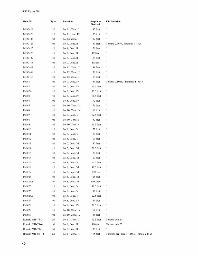
OGS Report 299
40
Hole No. Type Location Depth toBedrock
File Location
MHO--19 rcd Lot 11, Conc. II 45 feet ”
MHO--20 rcd Lot 11, conc. I/II 55 feet ”
MHO--23 rcd Lot 12, Conc. I 27 feet ”
MHO--24 rcd Lot 9, Conc. II 80 feet Toronto 2.3694, Timmins T--1928
MHO--25 rcd Lot 9, Conc. II 70 feet ”
MHO--26 rcd Lot 9, Conc. II 129 feet ”
MHO--27 rcd Lot 8, Conc. II 88 feet ”
MHO--45 rcd Lot 7, Conc. II 105 feet ”
MHO--47 rcd Lot 12, Conc. III 81 feet ”
MHO--49 rcd Lot 12, Conc. III 79 feet ”
MHO--55 rcd Lot 12, Conc. III 74 feet ”
Pol #1 rcd Lot 7, Conc. IV 39 feet Toronto 2.10653, Timmins T--3145
Pol #2 rcd Lot 7, Conc. IV 63.5 feet ”
Pol #2A rcd Lot 7, Conc. IV 77.5 feet ”
Pol #3 rcd Lot 8, Conc. IV 80.5 feet ”
Pol #4 rcd Lot 8, Conc. IV 72 feet ”
Pol #5 rcd Lot 10, Conc. IV 76 feet ”
Pol #6 rcd Lot 10, Conc. IV 66 feet ”
Pol #7 rcd Lot 9, Conc. V 32.5 feet ”
Pol #8 rcd Lot 10, Conc. V 52 feet ”
Pol #9 rcd Lot 10, Conc. V 41.5 feet ”
Pol #10 rcd Lot 9, Conc. V 22 feet ”
Pol #11 rcd Lot 9, Conc. V 30 feet ”
Pol #12 rcd Lot 8, Conc. V 69 feet ”
Pol #13 rcd Lot 7, Conc. VI 37 feet ”
Pol #14 rcd Lot 7, Conc. VI 30.5 feet ”
Pol #15 rcd Lot 8, Conc. VI 29 feet ”
Pol #16 rcd Lot 8, Conc. VI 17 feet ”
Pol #17 rcd Lot 8, Conc. V 63.5 feet ”
Pol #18 rcd Lot 8, Conc. VI 11.5 feet ”
Pol #19 rcd Lot 8, Conc. VI 121 feet ”
Pol #24 rcd Lot 8, Conc. VI 28 feet ”
Pol #24A rcd Lot 8, Conc. VI 100.5 feet ”
Pol #25 rcd Lot 8, Conc. V 48.5 feet ”
Pol #26 rcd Lot 8, Conc. V 16 feet ”
Pol #26A rcd Lot 8, Conc. V 22.5 feet ”
Pol #27 rcd Lot 8, Conc. IV 69 feet ”
Pol #28 rcd Lot 8, Conc. IV 58.5 feet ”
Pol #29 rcd Lot 10, Conc. IV 62 feet ”
Pol #30 rcd Lot 10, Conc. IV 48 feet ”
Rosario MH--78--3 dd Lot 11, Conc. II 73.5 feet Toronto ddh 24
Rosario MH--78--6 dd Lot 8, Conc. II 110 feet Toronto ddh 25
Rosario MH--79--1 dd Lot 8, Conc. II 78 feet ”
Rosario MH--81--14 dd Lot 11, Conc. III 95 feet Timmins drill core TI--1565, Toronto ddh 26
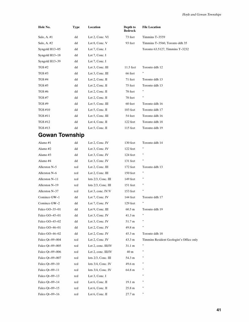
Hoyle and Gowan Townships
41
Hole No. Type Location Depth toBedrock
File Location
Salo, A. #1 dd Lot 2, Conc. VI 73 feet Timmins T--3559
Salo, A. #2 dd Lot 8, Conc. V 93 feet Timmins T--3560, Toronto ddh 35
Syngold H13--05 dd Lot 7, Conc. I Toronto 63.5127, Timmins T--3232
Syngold H13--18 dd Lot 7, Conc. I
Syngold H13--39 dd Lot 7, Conc. I
TGS #2 dd Lot 3, Conc. III 11.5 feet Toronto ddh 12
TGS #3 dd Lot 3, Conc. III 66 feet ”
TGS #4 dd Lot 2, Conc. II 71 feet Toronto ddh 13
TGS #5 dd Lot 2, Conc. II 75 feet Toronto ddh 13
TGS #6 dd Lot 2, Conc. II 78 feet ”
TGS #7 dd Lot 2, Conc. II 78 feet ”
TGS #9 dd Lot 5, Conc. III 60 feet Toronto ddh 16
TGS #10 dd Lot 5, Conc. II 103 feet Toronto ddh 17
TGS #11 dd Lot 5, Conc. III 54 feet Toronto ddh 16
TGS #12 dd Lot 4, Conc. II 122 feet Toronto ddh 18
TGS #13 dd Lot 5, Conc. II 115 feet Toronto ddh 19
Gowan TownshipAlamo #1 dd Lot 2, Conc. IV 130 feet Toronto ddh 14
Alamo #2 dd Lot 3, Conc. IV 122 feet ”
Alamo #3 dd Lot 3, Conc. IV 124 feet ”
Alamo #4 dd Lot 3, Conc. IV 131 feet ”
Allerston N--5 rcd Lot 2, Conc. III 172 feet Toronto ddh 13
Allerston N--6 rcd Lot 2, Conc. III 150 feet ”
Allerston N--11 rcd lots 2/3, Conc. III 149 feet ”
Allerston N--19 rcd lots 2/3, Conc. III 151 feet ”
Allerston N--37 rcd Lot 3, conc. IV/V 153 feet ”
Cominco GW--1 dd Lot 7, Conc. IV 144 feet Toronto ddh 17
Cominco GW--2 dd Lot 7, Conc. IV 129 feet ”
Falco GO--35--01 dd Lot 9, Conc. III 60.5 m Toronto ddh 19
Falco GO--45--01 dd Lot 3, Conc. IV 41.3 m ”
Falco GO--45--02 dd Lot 3, Conc. IV 51.7 m ”
Falco GO--46--01 dd Lot 2, Conc. IV 49.8 m ”
Falco GO--46--02 dd Lot 2, Conc. IV 45.3 m Toronto ddh 18
Falco Qt--89--004 rcd Lot 2, Conc. IV 43.3 m Timmins Resident Geologist’s Office only
Falco Qt--89--005 rcd Lot 2, conc. III/IV 31.1 m ”
Falco Qt--89--006 rcd Lot 2, conc. III/IV 40 m ”
Falco Qt--89--007 rcd lots 2/3, Conc. III 54.3 m ”
Falco Qt--89--10 rcd lots 3/4, Conc. IV 49.6 m ”
Falco Qt--89--11 rcd lots 3/4, Conc. IV 64.8 m ”
Falco Qt--89--13 rcd Lot 3, Conc. I ”
Falco Qt--89--14 rcd Lot 6, Conc. II 19.1 m ”
Falco Qt--89--15 rcd Lot 6, Conc. II 25.8 m ”
Falco Qt--89--16 rcd Lot 6, Conc. II 27.7 m ”

OGS Report 299
42
Hole No. Type Location Depth toBedrock
File Location
Falco Qt--89--17 rcd Lot 6, Conc. II 24.1 m ”
Falco Qt--89--18 rcd Lot 9, Conc. III 22.8 m ”
Falco Qt--89--20 rcd Lot 9, Conc. II 22.7 m ”
GO--1 rcd lots 2/3, Conc. IV 187 feet Toronto file 2.4836
GO--3 rcd lots 3/4, Conc. IV private company files
GO--4 rcd Lot 4, Conc. IV 150 feet Toronto files 2.4836, 2.4837
GO--5 rcd lots 4/5, Conc. IV 138 feet ”
GO--6 rcd Lot 5, Conc. IV 78 feet ”
GO--7 rcd Lot 5, Conc. IV 99 feet ”
GO--8 rcd lots 4/5, Conc. IV private company files
GO--9 rcd Lot 4, Conc. IV ”
GO--10 rcd lots 3/4, Conc. IV ”
GO--12 rcd lots 2/3, Conc. IV 70 feet Toronto file 2.4836
GO--16 rcd Lot 1, Conc. IV private company files
GO--17 rcd Lot 1, Conc. IV ”
GO--23 rcd Lot 7, Conc. III ”
GO--24 rcd Lot 7, Conc. III 206 feet Toronto files 2.4836, 2.4837
GO--25 rcd lots 6/7, Conc. III private company files
GO--26 rcd lots 6/7, Conc. III 201 feet Toronto files 2.4836, 2.4837
GO--27 rcd lots 6/7, Conc. III 123 feet ”
GO--28 rcd Lot 7, Conc. III private company files
GO--29 rcd lots 6/7, Conc. IV 90 feet Toronto files 2.4836, 2.4837
GO--30 rcd lots 6/7, Conc. IV 117 feet ”
GO--31 rcd lots 6/7, Conc. IV 160 feet ”
GO--33 rcd Lot 7, Conc. IV private company files
GO--34 rcd Lot 8, conc. III/IV 155 feet Toronto files 2.4836, 2.4837
GO--35 rcd Lot 8, Conc. IV private company files
GO--36 rcd Lot 10, conc. IV/V 72 feet Toronto files 2.6056, 2.7491
GO--37 rcd Lot 10, conc. IV/V 113 feet ”
GO--38 rcd lots 7/8, Conc. IV private company files
GO--39 rcd Lot 7, Conc. IV ”
GO--40 rcd Lot 7, Conc. IV ”
GO--41 rcd Lot 7, Conc. IV ”
GO--42 rcd lots 7/8, Conc. IV ”
GO--43 rcd Lot 9, Conc. III 25 feet Toronto files 2.4836, 2,4837
GO--44 rcd Lot 9, Conc. III 44 feet ”
GO--45 rcd Lot 9, Conc. III 68 feet ”
GO--46 rcd Lot 9, Conc. III 32 feet ”
GO--47 rcd Lot 9, Conc. II 55 feet ”
GO--48 rcd Lot 9, Conc. II 35 feet ”
GO--49 rcd Lot 9, Conc. II 69 feet ”
GO--50 rcd Lot 9, Conc. II 84 feet ”
GO--51 rcd Lot 4, Conc. I 78 feet ”
GO--52 rcd Lot 4, Conc. I private company files
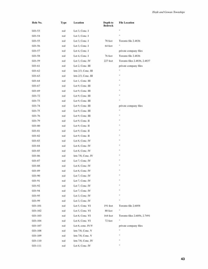
Hoyle and Gowan Townships
43
Hole No. Type Location Depth toBedrock
File Location
GO--53 rcd Lot 3, Conc. I ”
GO--54 rcd Lot 3, Conc. I ”
GO--55 rcd Lot 3, Conc. I 78 feet Toronto file 2.4836
GO--56 rcd Lot 3, Conc. I 64 feet ”
GO--57 rcd Lot 4, Conc. I private company files
GO--58 rcd Lot 4, Conc. I 76 feet Toronto file 2.4836
GO--59 rcd Lot 3, Conc. IV 227 feet Toronto files 2.4836, 2.4837
GO--61 rcd Lot 2, Conc. III private company files
GO--62 rcd lots 2/3, Conc. III ”
GO--63 rcd lots 2/3, Conc. III ”
GO--64 rcd Lot 1, Conc. III ”
GO--67 rcd Lot 9, Conc. III ”
GO--69 rcd Lot 9, Conc. III ”
GO--72 rcd Lot 9, Conc. III ”
GO--73 rcd Lot 9, Conc. III ”
GO--74 rcd Lot 9, Conc. III private company files
GO--75 rcd Lot 9, Conc. III ”
GO--76 rcd Lot 9, Conc. III ”
GO--79 rcd Lot 9, Conc. II ”
GO--80 rcd Lot 9, Conc. II ”
GO--81 rcd Lot 9, Conc. II ”
GO--82 rcd Lot 9, Conc. II ”
GO--83 rcd Lot 8, Conc. IV ”
GO--84 rcd Lot 8, Conc. IV ”
GO--85 rcd Lot 8, Conc. IV ”
GO--86 rcd lots 7/8, Conc. IV ”
GO--87 rcd Lot 7, Conc. IV ”
GO--88 rcd Lot 8, Conc. IV ”
GO--89 rcd Lot 8, Conc. IV ”
GO--90 rcd Lot 7, Conc. IV ”
GO--91 rcd Lot 7, Conc. IV ”
GO--92 rcd Lot 7, Conc. IV ”
GO--94 rcd Lot 7, Conc. IV ”
GO--95 rcd Lot 3, Conc. IV ”
GO--99 rcd Lot 3, Conc. IV ”
GO--101 rcd Lot 5, Conc. VI 191 feet Toronto file 2.6058
GO--102 rcd Lot 5, Conc. VI 88 feet ”
GO--103 rcd Lot 8, Conc. VI 164 feet Toronto files 2.6056, 2.7491
GO--104 rcd Lot 8, Conc. VI 72 feet ”
GO--107 rcd Lot 8, conc. IV/V private company files
GO--108 rcd lots 7/8, Conc. V ”
GO--109 rcd lots 7/8, Conc. V ”
GO--110 rcd lots 7/8, Conc. IV ”
GO--111 rcd Lot 8, Conc. IV ”
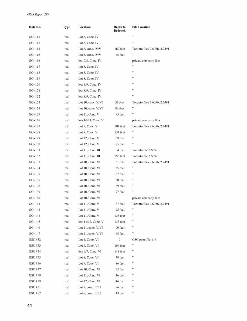
OGS Report 299
44
Hole No. Type Location Depth toBedrock
File Location
GO--112 rcd Lot 8, Conc. IV ”
GO--113 rcd Lot 8, Conc. IV ”
GO--114 rcd Lot 8, conc. IV/V 167 feet Toronto files 2.6056, 2.7491
GO--115 rcd Lot 8, conc. IV/V 68 feet ”
GO--116 rcd lots 7/8, Conc. IV private company files
GO--117 rcd Lot 8, Conc. IV ”
GO--118 rcd Lot 8, Conc. IV ”
GO--119 rcd Lot 8, Conc. IV ”
GO--120 rcd lots 8/9, Conc. IV ”
GO--121 rcd lots 8/9, Conc. IV ”
GO--122 rcd lots 8/9, Conc. IV ”
GO--123 rcd Lot 10, conc. V/VI 51 feet Toronto files 2.6056, 2.7491
GO--124 rcd Lot 10, conc. V/VI 86 feet ”
GO--125 rcd Lot 11, Conc. V 95 feet ”
GO--126 rcd lots 10/11, Conc. V private company files
GO--127 rcd Lot 9, Conc. V 104 feet Toronto files 2.6056, 2.7491
GO--128 rcd Lot 9, Conc. V 134 feet ”
GO--129 rcd Lot 12, Conc. V 69 feet ”
GO--130 rcd Lot 12, Conc. V 85 feet ”
GO--131 rcd Lot 11, Conc. III 84 feet Toronto file 2.6057
GO--132 rcd Lot 11, Conc. III 153 feet Toronto file 2.6057
GO--133 rcd Lot 10, Conc. VI 51 feet Toronto files 2.6056, 2.7491
GO--134 rcd Lot 10, Conc. VI 55 feet ”
GO--135 rcd Lot 10, Conc. VI 57 feet ”
GO--136 rcd Lot 10, Conc. VI 50 feet ”
GO--138 rcd Lot 10, Conc. VI 69 feet ”
GO--139 rcd Lot 10, Conc. VI 77 feet ”
GO--140 rcd Lot 10, Conc. VI private company files
GO--141 rcd Lot 11, Conc. V 87 feet Toronto files 2.6056, 2.7491
GO--142 rcd Lot 11, Conc. V 95 feet ”
GO--144 rcd Lot 11, Conc. V 135 feet ”
GO--145 rcd lots 11/12, Conc. V 133 feet ”
GO--146 rcd Lot 11, conc. V/VI 90 feet ”
GO--147 rcd Lot 11, conc. V/VI 68 feet ”
GSC #52 rcd Lot 4, Conc. VI ? GSC open file 116
GSC #53 rcd Lot 6, Conc. VI 169 feet ”
GSC #54 rcd lots 6/7, Conc. VI 148 feet ”
GSC #55 rcd Lot 8, Conc. VI 79 feet ”
GSC #56 rcd Lot 9, Conc. VI 86 feet ”
GSC #57 rcd Lot 10, Conc. VI 65 feet ”
GSC #58 rcd Lot 11, Conc. VI 46 feet ”
GSC #59 rcd Lot 12, Conc. VI 46 feet ”
GSC #61 rcd Lot 9, conc. II/III 86 feet ”
GSC #62 rcd Lot 8, conc. II/III 43 feet ”
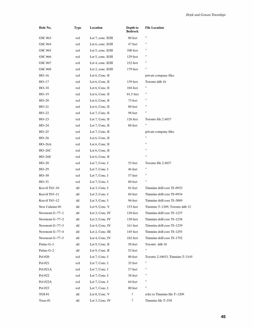
Hoyle and Gowan Townships
45
Hole No. Type Location Depth toBedrock
File Location
GSC #63 rcd Lot 7, conc. II/III 80 feet ”
GSC #64 rcd Lot 6, conc. II/III 47 feet ”
GSC #65 rcd Lot 5, conc. II/III 100 feet ”
GSC #66 rcd Lot 5, conc. II/III 129 feet ”
GSC #67 rcd Lot 4, conc. II/III 152 feet ”
GSC #68 rcd Lot 2, conc. II/III 179 feet ”
HO--16 rcd Lot 6, Conc. II private company files
HO--17 rcd Lot 6, Conc. II 139 feet Toronto ddh 16
HO--18 rcd Lot 6, Conc. II 104 feet ”
HO--19 rcd Lot 6, Conc. II 81.5 feet ”
HO--20 rcd Lot 6, Conc. II 73 feet ”
HO--21 rcd Lot 6, Conc. II 80 feet ”
HO--22 rcd Lot 7, Conc. II 98 feet ”
HO--23 rcd Lot 7, Conc. II 126 feet Toronto file 2.4837
HO--24 rcd Lot 7, Conc. II 88 feet ”
HO--25 rcd Lot 7, Conc. II private company files
HO--26 rcd Lot 6, Conc. II ”
HO--26A rcd Lot 6, Conc. II ”
HO--26C rcd Lot 6, Conc. II ”
HO--26E rcd Lot 6, Conc. II ”
HO--28 rcd Lot 7, Conc. I 53 feet Toronto file 2.4837
HO--29 rcd Lot 7, Conc. I 46 feet ”
HO--30 rcd Lot 7, Conc. I 57 feet ”
HO--31 rcd Lot 7, Conc. I 80 feet ”
Keevil T65--10 dd Lot 3, Conc. I 81 feet Timmins drill core TI--0933
Keevil T65--11 dd Lot 3, Conc. I 84 feet Timmins drill core TI--0934
Keevil T65--12 dd Lot 3, Conc. I 96 feet Timmins drill core TI--3089
New Calumet #1 dd Lot 9, Conc. V 153 feet Timmins T--1209, Toronto ddh 12
Newmont G--77--1 dd Lot 3, Conc. IV 138 feet Timmins drill core TI--1237
Newmont G--77--2 dd Lot 3, Conc. IV 130 feet Timmins drill core TI--1238
Newmont G--77--3 dd Lot 4, Conc. IV 161 feet Timmins drill core TI--1239
Newmont G--77--4 dd Lot 2, Conc. III 145 feet Timmins drill core TI--1293
Newmont G--77--5 dd Lot 4, Conc. IV 182 feet Timmins drill core TI--1792
Patino G--1 dd Lot 9, Conc. II 50 feet Toronto ddh 10
Patino G--2 dd Lot 9, Conc. II 52 feet ”
Pol #20 rcd Lot 7, Conc. I 80 feet Toronto 2.10653, Timmins T--3145
Pol #21 rcd Lot 7, Conc. I 35 feet ”
Pol #21A rcd Lot 7, Conc. I 57 feet ”
Pol #22 rcd Lot 7, Conc. I 38 feet ”
Pol #22A rcd Lot 7, Conc. I 64 feet ”
Pol #23 rcd Lot 7, Conc. I 80 feet ”
TGS #1 dd Lot 8, Conc. V ? refer to Timmins file T--1209
Truss #1 dd Lot 3, Conc. IV ? Timmins file T--558

OGS Report 299
46
Codesdd diamond--drilling rcd reverse circulation drillingddh diamond--drill hole
Alamo Alamo Petroleum Limited HudBay Hudson Bay Mountain Silver Mines LimitedAlton C.B. Alton 1940 Inco Canadian Nickel Company LimitedAmax Amax Minerals Exploration Keevil Keevil Mining Group LimitedFalco Falconbridge Limited Kerr Kerr Addison Mines LimitedGO Cominco Limited MHO Rosario Resources Canada LimitedGSC Geological Survey of Canada Pol Pollock, J.A.HM Cominco Limited TGS Texasgulf SulphurHO Cominco Limited
aThis is a partial listing of drill holes in Hoyle and Gowan townships and represents only those drill holes used to compile the map. Theauthor has interpreted these data with the higher reliability assigned to diamond--drill holes. Lithologic coding may be at variance with dataon the drill logs due to interpretation and the assignment of a higher reliability to other nearby data.
Toronto files are now located, and may be viewed, at the Mines Library, Willet Green Miller Centre, 933 Ramsey Lake Road, Sudbury.

47
References
Barlow,R.B. 1988a.Totalmagnetic field colour image developed fromdigital archives of theOntarioGeological Survey,TimminsArea,districts of Cochrane and Timiskaming; Ontario Geological Sur-vey, Map 81138, scale 1:100 000.
1988b. Calculated second vertical derivative colour image de-veloped from digital archives of the Ontario Geological Survey,Timmins Area, districts of Cochrane and Timiskaming; OntarioGeological Survey, Map 81139, scale 1:100 000.
1988c. Directionally filtered second vertical derivative colourimage developed from digital archives of the OntarioGeologicalSurvey, Timmins Area, districts of Cochrane and Timiskaming;Ontario Geological Survey, Map 81140, scale 1:100 000.
Berry, L.G. 1941.Geology of theBigwater LakeArea; OntarioDepart-ment of Mines, Annual Report, v.48, pt. 12, 11p.
Brisbin, D., Kelly, V. and Cook, R. 1990. Kidd Creek Mine; in FieldTrip Guidebook, 8th IAGOD Symposium, edited by J.A. Fyonand A.H. Green; Geological Survey of Canada, Open File 2161,p.66-76.
Carlson,H.D. 1974.Report onmagnetometer and electromagnetic sur-veys over parts of the properties of Ralph Allerston in HoyleTownship for L.P. Industries Limited;Assessment FilesResearchOffice, file 2.1516, 10p.
Coad, P.R., Labine, R.J. and Caron, D. 1986. Owl CreekMine; inGold’86 Excursion Guidebook, edited by J. Pirie and M. J. Downes,p.34-36.
Downes,M.J., Hodges, D.J. and Derweduwen, J. 1984. A free carbon-and carbonate-bearing alteration zone associated with the HoylePond gold occurrence, Ontario, Canada; in Proceedings of Gold’82: The Geology, Geochemistry, and Genesis of Gold Deposits,R.P. Foster, ed., Geological Society of Zimbabwe, Publication 1,p.435-448.
Fahrig, W. F. and West, T. D. 1986. Diabase dyke swarms of the Cana-dian Shield; Geological Survey of Canada, Map 1627A, scale1:4 873 900 (approx).
Ferguson, S.A., Buffam, B.S.W., Carter, O.F., Griffis, A.T., Holmes,T.C., Hurst, M.E., Jones, W.A., Lane, H.C. and Longley, C.S.1968. Geology and ore deposits of Tisdale Township, District ofCochrane; Ontario Department of Mines, Geological Report 58,177p.
Fyon, A. 1986. Geology of the Timmins area; in Gold ’86 ExcursionGuidebook, edited by J. Pirie and M. J. Downes, p.6-16.
Fyon, A. and Jackson, S. 1990. District geology -- central Abitibigreenstone belt; in Field Trip Guidebook, 8th IAGOD Sympo-sium, edited by J.A. Fyon and A.H. Green; Geological Survey ofCanada, Open File 2161, p.13-22.
Ginn, R.M., Savage, W.S., Thomson, R., Thomson, J.E. and Fenwick,K.G. 1964. Timmins--Kirkland Lake Sheet, Cochrane, Sudburyand Timiskaming Districts; Ontario Department of Mines, Map2046, scale 1 inch to 4 miles.
Hattori, K. and Hicks, K. 1986. Preliminary report of the gold mine atBell Creek, Timmins, Ontario; inCurrent Research, Part B, Geo-logical Survey of Canada, Paper 86--1B, p.77-83.
Hodgson, C.J. 1983. The structure and geological development of thePorcupine camp: a re-evaluation; in The Geology of Gold in On-tario, edited by A.C. Colvine; Ontario Geological Survey, Mis-cellaneous Paper 110, p.211-225.
Hunt, D.S. and Maharaj, D. 1980. Hoyle Township, District of Coch-rane; Ontario Geological Survey, Preliminary Map 2088, scale1:15 840.
Hunt,D.S.,Richard, J.A. andCarey,E.R. 1980.Gowan Township,Dis-trict of Cochrane; Ontario Geological Survey, Preliminary Map729 (rev), scale 1:15 840.
Jackson, S.L. and Fyon, J.A. 1991.TheWesternAbitibi SubprovinceofOntario; inGeology of Ontario, OntarioGeological Survey, Spe-cial Volume 4, Part 1, p.405-484.
Kent,G. 1990. BellCreek andMarlhill mine area; inField TripGuide-book, 8th IAGOD Symposium, edited by J.A. Fyon and A.H.Green, Geological Survey of Canada, Open File 2161,p.124-128.
Knutson, R.A. 1986. Bell Creek Project; inGold ’86 ExcursionGuide-book, edited by J. Pirie and M. J. Downes, p.37-39.
1983. ProgressReportB 1982 program: BellCreek Project,Mur-phy–Hoyle townships, Timmins area, Ontario; Assessment FilesResearch Office, file 63.4115, 15p.
Labine, R.J. 1990. Hoyle PondMine; in Field Trip Guidebook, 8th IA-GODSymposium, edited by J.A. Fyon andA.H. Green,Geologi-cal Survey of Canada, Open File 2161, p.114-123.
Lesher, C.M., Goodwin, A.M., Campbell, I.H. and Gorton, M.P. 1986.Trace-element geochemistry of ore-associated and barren, felsicmetavolcanic rocks in the Superior Province, Canada; CanadianJournal of Earth Sciences, v.23, p.222-237.
Luhta, L.E., Sangster, P.J., Ireland, J.C., Farrow, D.G., Draper, D.M.and Hamblin, C.D. 1990. Timmins Resident Geologist’s Dis-trict–1990; in Report of Activities, 1990, Resident Geologists,Ontario Geological Survey, Miscellaneous Paper 152,p.211-238.
Machado, A. de Barros. 1987. On the origin and age of the Steep Rockbuckshot, Ontario, Canada; in Proceedings, International Semi-nar on Laterite 1985, Chemical Geology, v.60, p.337-349.
Middleton,R.S. 1975. Summary report on the initial diamond drill pro-gram, Gowan Township, Ontario; Assessment Files ResearchOffice, file 63.3400, 41p.
Miller, J.K. 1984. Model for clastic indicator trains in till; in Prospect-ing in areas of glaciated terrain, Canadian Institute ofMining andMetallurgy, p.69-77.
Ontario Department ofMines--Geological Survey ofCanada 1961. Pa-mour, Cochrane District, Ontario; Ontario Department of Mi-nes–Geological Survey of Canada, Map 298G (rev), scale1:63 360.
Ontario Department of Mines 1973. Timmins--Kirkland Lake sheet,Cochrane, Sudbury and Timiskaming districts; Ontario Depart-ment of Mines, Map 2205, scale 1:253 440.
Ontario Geological Survey 1991. Bedrock geology of Ontario, east--central sheet; Ontario Geological Survey, Map 2543, scale1:1 000 000.
1988a.Airborne electromagnetic and total intensity survey,Tim-mins area,Hoyle Township, districts ofCochrane and Timiskam-ing, Ontario; Ontario Geological Survey, Map 81 072, scale1:20 000.
1988b.Airborne electromagnetic and total intensity survey,Tim-mins area, Gowan Township, districts of Cochrane and Timis-kaming, Ontario; Ontario Geological Survey, Map 81 064, scale1:20 000.
Piroshco, D.W. and Kettles, K. 1991. Structural geology of Tisdale andWhitney townships, Abitibi greenstone belt, District of Coch-rane, northeastern Ontario; Ontario Geological Survey, OpenFile Report 5768, 115p.
Pyke, D.R. 1982. Geology of the Timmins area, District of Cochrane;Ontario Geological Survey, Report 219, 141p.
Richard, J.A. 1983. Quaternary geology of the Pamour area, CochraneDistrict; Ontario Geological Survey, Preliminary Map P.2680,scale 1:50 000.
Richard, J.A. 1987. Report on reverse circulation overburden drilling,Hoyle and Gowan townships, Ontario, NTS 42/11 for Mid --North Engineering Ltd; Assessment Files Research Office, file2.10653, 32p.
OGS Report 299
48
Rose, B. 1924. Murphy, Hoyle and Matheson townships (Porcupinegold area); Ontario Department of Mines Report, v.33, pt.3,p.50-54.
Rye,K.A. 1987.Geology and geochemistry of theHoylePond goldde-posit, Timmins, Ontario; unpublished MSc thesis, University ofWestern Ontario, London, Ontario, 219p.
Sage, R.P. 1988. Geology of carbonatite--alkalic rock complexes inOntario, Cargill Township Carbonatite Complex, District ofCochrane; Ontario Geological Survey, Study 36, 92p.
Shilts, W.W. 1976. Glacial till and mineral exploration; in Glacial till:an interdisciplinary study; edited by R.F. Legget, The Royal So-ciety of Canada, Special Publications, No. 12, p.205-224.
Simmons, B.D. 1988. Summary report -- diamond drilling June 03,1987 to December 31, 1987, Owl Creek West Property, HoyleTownship, Ontario,OMEPDesignationNo. OM87-5-L-111;As-sessment Files Research Office, file 63.5127, 3p.
Skinner, R.G. 1972. Drift prospecting in the Abitibi clay belt, overbur-den drilling program; Geological Survey of Canada, Open File116, maps and report.
Springer, J.S. 1985.Carbon inArchean rocks of theAbitibi belt (Ontar-io and Quebec) and its relation to gold distribution; CanadianJournal of Earth Science, v.22, p.945-951.
Thurston, P.C. 1991. Archean geology of Ontario: Introduction; inGeology of Ontario, Ontario Geological Survey, Special Volume4, Part 1, p.73-77.
Wilson,G.C. andRucklidge, J.C. 1987.Grant 262, Geology, geochem-istry and economic significance of carbonaceous host rocks ingold deposits of the Timmins area; inGeoscienceResearchGrantProgram Summary of Research 1986–1987, Ontario GeologicalSurvey, Miscellaneous Paper 136, p.66-76.
1986. Grant 262, Lithological features and economic signifi-cance of reduced carbonaceous rocks in gold deposits; inGeosci-ence Research Grant Program Summary of Research1985–1986, Ontario Geological Survey, Miscellaneous Paper130, p.177-189.

49
Metric Conversion Table
Conversion from SI to Imperial Conversion from Imperial to SI
SI Unit Multiplied by Gives Imperial Unit Multiplied by Gives
LENGTH1 mm 0.039 37 inches 1 inch 25.4 mm1 cm 0.393 70 inches 1 inch 2.54 cm1 m 3.280 84 feet 1 foot 0.304 8 m1 m 0.049 709 chains 1 chain 20.116 8 m1 km 0.621 371 miles (statute) 1 mile (statute) 1.609 344 km
AREA1 cm@ 0.155 0 square inches 1 square inch 6.451 6 cm@1 m@ 10.763 9 square feet 1 square foot 0.092 903 04 m@1 km@ 0.386 10 square miles 1 square mile 2.589 988 km@1 ha 2.471 054 acres 1 acre 0.404 685 6 ha
VOLUME1 cm# 0.061 023 cubic inches 1 cubic inch 16.387 064 cm#1 m# 35.314 7 cubic feet 1 cubic foot 0.028 316 85 m#1 m# 1.307 951 cubic yards 1 cubic yard 0.764 554 86 m#
CAPACITY1 L 1.759 755 pints 1 pint 0.568 261 L1 L 0.879 877 quarts 1 quart 1.136 522 L1 L 0.219 969 gallons 1 gallon 4.546 090 L
MASS1 g 0.035 273 962 ounces (avdp) 1 ounce (avdp) 28.349 523 g1 g 0.032 150 747 ounces (troy) 1 ounce (troy) 31.103 476 8 g1 kg 2.204 622 6 pounds (avdp) 1 pound (avdp) 0.453 592 37 kg1 kg 0.001 102 3 tons (short) 1 ton (short) 907.184 74 kg1 t 1.102 311 3 tons (short) 1 ton (short) 0.907 184 74 t1 kg 0.000 984 21 tons (long) 1 ton (long) 1016.046 908 8 kg1 t 0.984 206 5 tons (long) 1 ton (long) 1.016 046 90 t
CONCENTRATION1 g/t 0.029 166 6 ounce (troy)/ 1 ounce (troy)/ 34.285 714 2 g/t
ton (short) ton (short)1 g/t 0.583 333 33 pennyweights/ 1 pennyweight/ 1.714 285 7 g/t
ton (short) ton (short)
OTHER USEFUL CONVERSION FACTORS
Multiplied by1 ounce (troy) per ton (short) 31.103 477 grams per ton (short)1 gram per ton (short) 0.032 151 ounces (troy) per ton (short)1 ounce (troy) per ton (short) 20.0 pennyweights per ton (short)1 pennyweight per ton (short) 0.05 ounces (troy) per ton (short)
Note: Conversion factors which are in bold type are exact. The conversion factors have been taken from or havebeen derived from factorsgiven in theMetricPracticeGuide for theCanadianMiningandMetallurgical Industries,published by the Mining Association of Canada in co-operation with the Coal Association of Canada.


ISSN 0704--2582ISBN 0--7778--7002--9

