human and physical dimensions of land use/cover change in … · 2015-12-17 · human and physical...
TRANSCRIPT

Human and Physical Dimensions of Land Use/Cover Change in Amazonia:
Towards a Multiscale Synthesis
LBA - LC 09
Mateus BatistellaEmbrapa Satellite Monitoring
Indiana University, Bloomington

Team
• Emilio Moran, PI, Indiana University
• Eduardo Brondizio, Indiana University
• Dalton Valeriano and Simeão de Medeiros, INPE
• Ryan Jensen and Paul Mausel, Indiana State
• Lars Hedin, Princeton University

Goals
• Multiscale synthesis of LCLUC in 7 study locations over the past 25 years
• Develop a multisensor analysis of LCLUC
• Understanding landscape level controls by N and P dynamics in sustainability of Amazonian forests
• Collaboration with other LBA projects to ensure synthesis
• Dissemination of a data management system for LBA (AIS)

Key questions of LBA
• How does Amazonia currently function as a regional entity?
• How will changes in land use and climate affect the biological, chemical and physical functions of Amazonia, including the sustainability of development in the region and the influence of Amazonia on global climate?

Main components of LBA
PHYSICAL CLIMATE SYSTEMWater and Energy
ATMOSPHERIC CHEMISTRY
CARBON STORAGEAND EXCHANGE
BIOGEOCHEMISTRY:Trace Gases and Nutrients
LAND SURFACE HYDROLOGY AND WATER CHEMISTRY
LAND USE/LAND COVER
HUMAN DIMENSIONS

http://www.lba.cnpm.embrapa.br
The project is embedded in Embrapa’s website, making available project data to users of Embrapa Research
and the Brazilian civil society

LCLUC and modeling
• Multiscale approach in space and time
• From inter-location comparisons to intra-location comparisons


0
20
40
60
80
100
Def pre-1969 Def 1970-85 Def 1985-91 Def 1991-95 Def 1995-00Pe
rcen
tage
of t
otal
de
fore
stat
ion
Riverine community 1Riverine community 2Riverine community 3Cooperative_upland community 1Cooperative_upland community 2Cooperative_upland community3Region, Ponta de Pedras area
Brondizio, in press. In: Moran and Ostrom (Eds.). Cambridge, MIT Press.

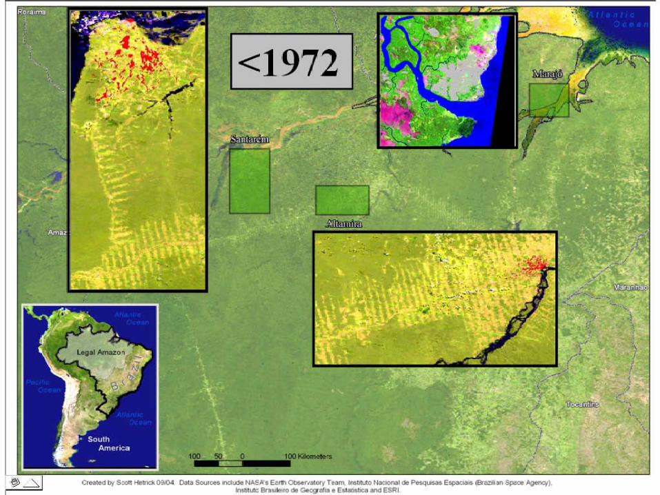
Deforestation, Amazon and Pará State
0
10
20
30
40
50
<1972 1972-79 1979-86 1986-91 1991-2001
Time Period
Perc
ent o
f Def
ores
tatio
n
Amazon Para
Deforestation, Santarém
0
10
20
30
40
50
<1972 1972-79 1979-86 1986-91 1991-2001
Time Period
Perc
ent o
f Def
ores
tatio
n
Deforestation, Altamira
0
10
20
30
40
50
<1972 1972-79 1979-86 1986-91 1991-2001
Time Period
Perc
ent o
f Def
ores
tatio
n
Deforestation, Marajó
0
10
20
30
40
50
<1972 1972-79 1979-86 1986-91 1991-2001
Time Period
Perc
ent o
f Def
ores
tatio
n
Brondizio, in press. In: Moran and Ostrom (Eds.). Cambridge, MIT Press.

Land cover patterns associated with land use systems in Marajo Island, Amazon Estuary
Agroforestry
Mechanized agriculture and cattle ranching
Swidden Agriculture and Agroforestry
1 LOCATION
Brondizio et al., Urban Ecosystems, 6, 2002.
3 SITES

0100002000030000400005000060000700008000090000
100000110000120000130000140000150000160000
1970
1971
1972
1973
1974
1975
1976
1977
1978
1979
1980
1981
1982
1985
1986
1987
1988
1989
1990
1991
1992
1993
1994
1995
1996
1997
1998
1999
2000
Aca
i fru
it (to
ns/y
ear)
0200000400000600000800000100000012000001400000160000018000002000000
Pop
ulat
ion
(thou
sand
s)
Urban population, Belem Açaí fruit, Brazil
Açaí fruit production (1974-2000) & Population growth in Belem (1970-2000)
Source: IBGE
* No data on Açaí fruit production available prior to 1974
*
Urban population growthContinuity in food consumption habitsLow cost staple foodTechnological change in food processing
Export of Amazonian fruitsFetish of rain forest “consumption”Socio-Environmental causesHealth food industry
Brondizio et al., Urban Ecosystems, 6, 2002.

Acai Agroforestry
Floodplain forest
Un
man
ag
ed
In
ten
sively
Man
ag
ed
Classification derived from the integration of field inventory, interviews, spectral analysis
Market incentive led to land use intensification
Acai agroforestry
Brondizio et al., Urban Ecosystems, 6, 2002.

Management intensity and economic return of Acai Agroforestry
What does intensification mean in terms of forest structure and economic return?
Fourfold increase in economic return in intensively managed site. Forest cover is maintained with an increase in the density of economic species.
Brondizio et al., Urban Ecosystems, 6, 2002.

• Fieldwork: training samples• Vegetation structure analysis:
SS1, SS2, SS3, forest• Multitemporal LULC classification• GIS integration• Landscape metrics calculation• Institutional analysis Batistella et al., PERS, 69 (7), 2003.

Land-use/Land-Cover Change
• Less forest cover in Anari (fishbone)• Similar forest cover in both settlements when considering just
private properties (51%)• Pasture conversion increased threefold in fishbone and less
than twofold in Machadinho
Batistella et al., PERS, 69 (7), 2003.
1988
1994
1998

Landscape Structure and Change
• Mean patch size of forest decreases at a higher rate infishbone
• Mean patch size of farmland is greater in fishbone
Machadinho
Anari
• The largest patch index of forest is higher when including reserves
Batistella et al., PERS, 69 (7), 2003.

Land-water processes
• Characterize the N and P hydrologic losses across the Amazon Basin
• Comparison with temperate systems
• Scaling - extrapolate from intensive studies to extensive scales

Geographic gradient
• Currently working on establishing baseline conditions in three locations: Manaus, Santarém, and Altamira
0.01
0.1
1.0
10.0
Ca (
pp
m)
Altamira Santarem Manaus
Hedin et al., III LBA conference, Proceedings, 2004.

0.1
1
10
To
tal
P (
pp
b)
Altamira Santarem Manaus
• P is commonly cited as the primary limiting nutrient in lowland tropical ecosystems
• P leaching occurred at very low levels in all sites • In all cases, inorganic forms of P were not detectable in
stream waters suggesting that the dominant form of P loss is organic P
Hedin et al., III LBA conference, Proceedings, 2004.
0
200
400
600
800
1000
1200
1400
200030004000
DON
NO3-
NH4-
S Temperate NorthAmerica
Hawaii
Brasil
OtherTropical
Hawaii Mainland
N p
pb
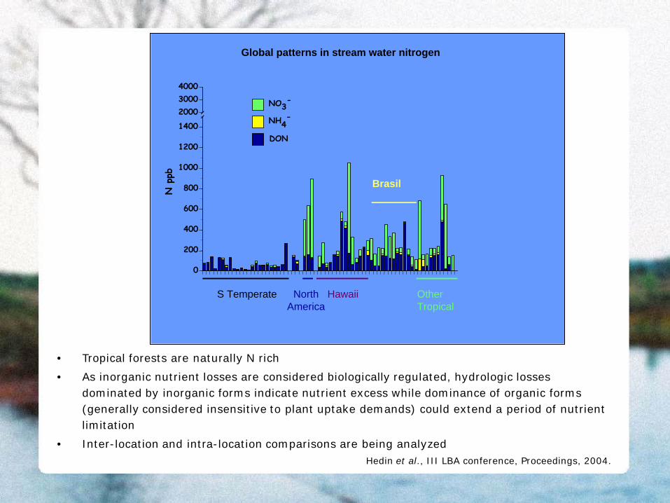
Global patterns in stream water nitrogen
• Tropical forests are naturally N rich
• As inorganic nutrient losses are considered biologically regulated, hydrologic losses dominated by inorganic forms indicate nutrient excess while dominance of organic forms (generally considered insensitive to plant uptake demands) could extend a period of nutrient limitation
• Inter-location and intra-location comparisons are being analyzedHedin et al., III LBA conference, Proceedings, 2004.

Secondary succession, vegetation biomass, and land degradation analysis based on remote sensing data
Accurate classification of successional stages and associated biomass estimation work help reduce uncertainty of carbon emission and
sequestration estimates
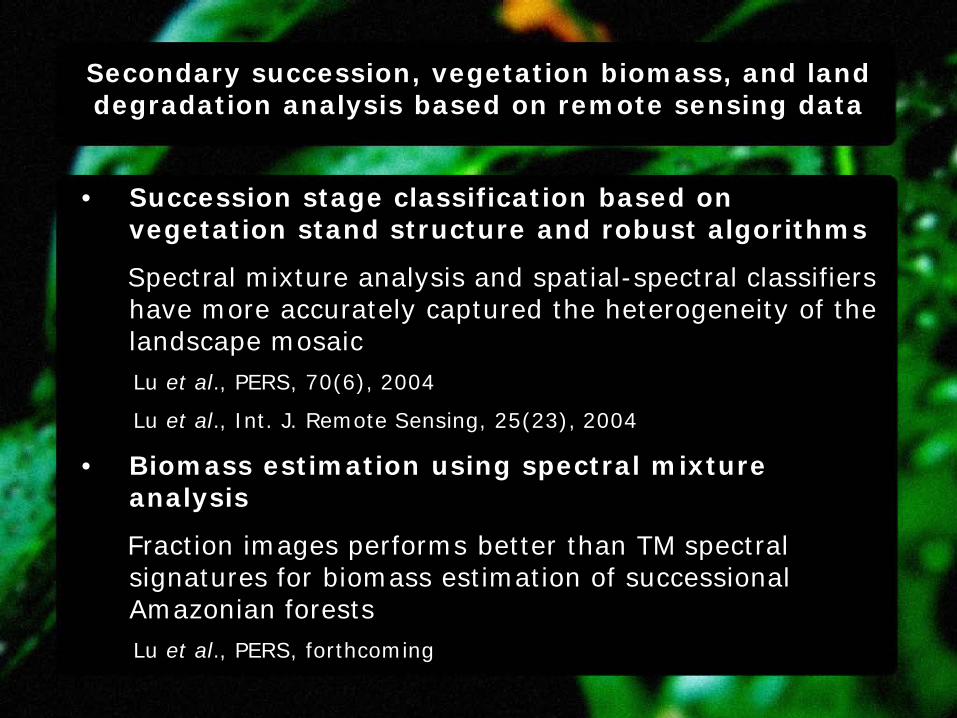
• Succession stage classification based on vegetation stand structure and robust algorithms
Spectral mixture analysis and spatial-spectral classifiers have more accurately captured the heterogeneity of the landscape mosaicLu et al., PERS, 70(6), 2004
Lu et al., Int. J. Remote Sensing, 25(23), 2004
• Biomass estimation using spectral mixture analysis
Fraction images performs better than TM spectral signatures for biomass estimation of successional Amazonian forestsLu et al., PERS, forthcoming
Secondary succession, vegetation biomass, and land degradation analysis based on remote sensing data

• Land degradation analysis based on remote sensing data
10 binary change detection methods were implemented and compared with respect to their capability to detect land cover change conditions in Amazonia. Results indicate that modified image differencing (MID), principal component differencing (PCD), and image differencing (ID) using TM band 5 are significantly better than other binary change detection methods Lu et al., Int. J. Remote Sensing, forthcoming
Secondary succession, vegetation biomass, and land degradation analysis based on remote sensing data

Amazon Information System (AIS)
A primary activity focus for this year

NN
Spectral data
Field data
Images
Other tables
Data Servers Application Servers Presentation
Web Server
Data mining
Statistics
Biophysical
Modeling
Tabulated
Graphics
Images
Reports
Three Tier Architecture• To ensure flexibility, maintainability, reusability, and scalability• The middleware are the application servers and the spatial-web server that run on a shared host
Jensen et al., Geocarto Intal., 19(3),2004.

Training and Education
Our team continues to emphasize training and education as central components of the project

Our T&E activities in 2004 have included:
• Formal graduate training (4 doctoral dissertations defended in 2004 and 9 ongoing studies). Four of our graduate students are Brazilians working in the Amazon
• Courses in Brazil (3)
• Workshops with farmers in Altamira and Santarém (8)
• Presentations in conferences and other venues
• Educational CD-Rom (1)
• Museum exhibit
• Internships (3)
• Other (e.g., radio and TV interviews)

Formal graduate training
IU Students:
Ryan Adams -- Ph.D. candidate, Anthropology. Dissertation title: "The Social Context of Land Use Change: Mechanized Agriculture, Decision-Making, and Economic Development”
Bruce Boucek -- Ph.D. candidate, Geography. Dissertation title: "Dynamics of Land Cover Change in an Amazonian Peri-urban Region”
Anthony Cak -- Ph.D. student, Environmental Science. 1st year
Corey Hayashi -- Ph.D. student, Anthropology. 2nd year. Dissertation title: TBA
Thomas Ludewigs -- Ph.D. candidate, Environmental Science. Dissertation title: "Land Use Decision-Making and Uncertainty in a Government-Sponsored Colonization Project in the Brazilian Amazon”
Doris Navarro -- Ph.D. student, Environmental Science. Dissertation title: "Economic aspects of land use change by floodplain communities on the Amazon estuary"
Angelica Toniolo -- Ph.D. completed, Joint Ph.D. Program in Public Policy. Dissertation title: "The Role of Land Tenure on the Occurrence of Accidental Fires in the Amazon Region: Case Studies from the National Forest of Tapajós"

EMBRAPA Student:
Leticia Orsi -- Master's Thesis: "Deforestation in the Amazon: an analysis integrating remote sensing and socioeconomic data at the property level." Unicamp, Campinas, SP
ISU Students:
Bharath Ganesh -- Ph.D. student engaged in AIS beta testing. He is conducting his dissertation focusing on up-scaling problem minimum mapping units.
Hui Li -- PhD completed. Dissertation title: “Identification of Spatial and Temporal Patterns if Secondary Succession Changes in Altamira, Brazil: Integration of Remote Sensing and GIS Technology“
Vijay Lulla -- Junior graduate M.A. research assistant who did programming for the AIS.
John Menzies -- Ph.D. candidate. Dissertation title: “The Impact of Scaling-up on Remotely Derived Leaf Area Index Estimators in the Brazilian Amazon.”
Genong Yu -- Ph.D. completed. Dissertation title: "The Accuracy of Neural Network Classifiers in Tropical Areas."

LBA-DIS
Complete list, details, and metadata for all data transferred to LBA-Beija-Flor is available with a search under “investigation team,” “LC-09”. This will generate a list of 21 results, each representing a group of data
and related database

ACT data transferred to LBA
Altamira• Precipitation data • Altamira rainfall• Transamazon km 100 rainfall• Land use history and sampling methods• Vegetation composition and structure• Soil• Soil carbon
Bragantina• Land use history and sampling methods• Vegetation composition and structure• Soil• Soil carbon
Marajó (Ponta de Pedras)• Land use history and sampling methods• Vegetation composition and structure• Soil

ACT data transferred to LBA (cont.)
Santarém• Precipitation data (1980-1998)
Tomé Açú• Land use history and sampling methods• Vegetation composition and structure• Soil• Soil carbon
Yapú• Land use history and sampling methods• Vegetation composition and structure• Soil
ACT/LBA posters (2000-2004)ACT/LBA publicationsACT field protocols (training sample)ACT manuals (GPS and pluviometry)

Insights from the current work
• Our research shows the importance of moving back and forth between basin-wide analysis and detailed case studies. Basin-wide analysis alone would miss observations and processes such as Marajo agroforestry intensification and the maintenance of forest cover by extractivists in Rondonia. Public policies based on basin-wide analysis alone could undermine important sustainable practices
• It is possible to have significant increases in income while also achieving declining rates of deforestation in the same area (e.g., agroforestry in Pará)
• Understanding the behavior and drivers of LCLUC cannot be derived from land-cover analysis alone, but requires detailed human dimensions data analysis
• Investment in training and education are fundamental to establish long-term research in Amazonia (e.g., Embrapa Satellite Monitoring partnership)
Batistella & Moran, Acta Amazonica, forthcoming.

Future plans
• Further development of the AIS to ensure ease of use by researchers in the LBA community
• Complete analysis and synthesis on water nutrient data and impact of N and P losses from forested areas
• Continue our commitment to training Brazilian graduate students and to offer workshops and training opportunities in Amazonia
• We foresee our project becoming increasingly led by our Brazilian counterparts
• Increase availability of our data through user interfaces such as LBA-DIS and other web-based services