human health endangered and threatened species
TRANSCRIPT
ENVIRONMENTAL MONITORING
PLAN
For Applications of Malathion
BOLL WEEVIL ERADICATION PROGRAM
Texas 2012
United States Department of Agriculture Animal and Plant Health Inspection Service Plant Protection and Quarantine Prepared by the Environmental Compliance Team
Human Health &
Endangered and Threatened Species
March 2012

2012 Environmental Monitoring Plan, Southwestern U.S. 1
The methods and procedures described in the 2012 Environmental Monitoring Plan are designed to ensure compliance with the National Environmental Policy Act, the Endangered Species Act, Federal Insecticide Fungicide and Rodenticide Act, and APHIS policy. Each program organizational unit (e.g. work unit, zone, region, etc.) should fully implement this plan during the 2012 boll weevil eradication season. PLEASE NOTE THAT THERE ARE SEVERAL CHANGES IN MONITORING PROCEDURES FOR 2012! None should have a major impact on the monitoring program, but need to be followed to ensure that the correct supplies are ordered, that samples are shipped to the new analytical laboratory, and more. Look for !NEW! and !UPDATED! throughout this document for the new procedures or information.
HUMAN HEALTH OBJECTIVES Monitoring for potential human exposure is designed to: 1. demonstrate the effectiveness of Boll Weevil Eradication Program (the Program) operational
procedures in excluding or minimizing exposure of the public to Program-applied malathion; 2. collect data which can be used to evaluate whether the assumptions used in the Environmental
Assessments are valid estimates of potential exposure of the public to Program-applied malathion by: a. monitoring for aerial spray drift to investigate the overall potential for exposure; b. testing crops and water bodies that might be used for human consumption to investigate the
potential for exposure to malathion through ingestion; 3. ensure that quality assurance and quality control procedures were followed; and, 4. conduct additional monitoring to investigate any Program-related complaints or reports of adverse
effects on public health, worker safety, environmental quality, or non-target species. METHODS Drinking Water Monitoring Monitoring will be conducted during all treatments where surface water bodies used for human consumption lie within 500 feet of cotton fields. Make a list of the reservoirs, cisterns, or other water bodies used for human consumption that are within 500 feet of a cotton field. Before Program treatments begin, provide the Environmental Compliance Team (ECT) with a description of each site and its relation to nearby cotton fields. If there are no such sites, inform the ECT in Riverdale, Maryland. Collect two water samples from each water body at least one week before the first Program application of malathion to any nearby field (do not combine these into a single sample). These are pre-program samples. Collect them whether or not treatments are expected at the nearby fields. Refer to Standard Operating Procedure (SOP) EM-03, Collection of Water Samples. Copies of this and other SOPs can be found online at http://www.aphis.usda.gov/plant_health/plant_pest_info/emt/support_docs.shtml.

2012 Environmental Monitoring Plan, Southwestern U.S. 2
When a treatment is scheduled for a cotton field within 500 feet of a water body that is used for human consumption, collect two pre-treatment water samples from different locations at the edge of the water (do not combine these into a single sample) within 24 hours of each application to the field. These are a separate set of pre-treatment samples from those described in the previous paragraph. Collect two post-treatment samples from different locations two to four hours after each application of malathion (do not combine these into a single sample). Monitor these water bodies with pre- and post-treatment samples during every application of malathion within 500 feet of the water body. Ship the samples as described below. Sensitive Site Monitoring Monitoring will be conducted where sensitive sites are within 500 feet of a Program-treated cotton field. Sensitive sites are defined as areas where people congregate such as residences, public buildings, hospitals, day care centers, inpatient clinics, nursing homes, parks, churches, and schools. For those programs that do not monitor all of the sensitive sites in their jurisdiction, monitor a minimum of three sites per work unit/district/program each week that malathion is applied to fields. Monitor these sites by using dye cards to measure potential drift. Vegetation samples will not be required as a part of routine monitoring, except for the Lower Rio Grande Valley zone in Texas. Specific additional operational procedures and mitigation measures for the Lower Rio Grande Valley zone are listed on pages A6-7 (and discussed briefly below). However, collection of vegetation samples is recommended for other program areas at sites where landowners express concern over possible contamination of vegetation. In such situations, it is recommended that pre- and post-treatment vegetation samples be collected. For details, refer to SOP EM-07, Collection of Vegetation Samples. If you will only be monitoring a subset of all sensitive sites, identify the most critical sensitive sites for monitoring. Give priority to sites that are the most sensitive; for example, closest to the fields, near areas occupied by children or medically compromised individuals, etc. Sensitive Site Inventory Each work unit, district, or program will make a list of sensitive sites that are within 500 feet of cotton fields. You may list all sensitive sites within 500 feet of cotton or list sites according to the following criteria:
1. All sensitive sites within 100 feet of cotton fields will be listed. 2. Sensitive sites 100-300 feet from cotton fields that are a priority for the Program will be listed.
These sites may include locations of previous complaints, chemically sensitive individuals, organic farms, etc.
3. Sensitive sites 300-500 feet from cotton fields that are of particular interest to the Program, but not necessarily priorities, will be listed. Exposure at these sites should be negligible at best, but the Program may wish to list the sites based on public concerns.
4. All sensitive sites within 500 feet of cotton fields where children are likely to be found will be listed. These sites include schools, daycare, playgrounds, etc. This is to address a potential

2012 Environmental Monitoring Plan, Southwestern U.S. 3
concern of the Environmental Protection Agency with regard to possible exposure of children to malathion on outdoor surfaces.
Prior to the start of malathion applications, provide the list of sensitive sites to the ECT at the following address: Dr. Robert Baca, USDA-APHIS-PPQ, 4700 River Road, Unit 150, Room 5A-04B, Riverdale, MD 20737 or via email to [email protected] Sensitive site lists are not be required in weevil-free areas. Since any potential treatment in these areas would be limited, sensitive sites can be easily identified on an ad hoc basis. Should a treatment be required in a weevil-free area, all sensitive sites within 500 feet of the cotton field(s) to be treated will be identified and a list provided to the ECT. This list need not be provided to the ECT prior to treatment, and may simply be submitted as part of monitoring documentation at the site. Residents within 500 feet of the cotton field(s) will be notified in advance of the treatment, and environmental monitoring with dye cards will be conducted. Additional sampling is not required but may be conducted at the discretion of the Program, in order to address particular concerns of residents or the Program.
Dye Card Sampling Dye cards are used to monitor potential drift. Before leaving for the field to set-up dye cards, hang a clean dye card from the rear-view mirror of the Program vehicle used during sampling (SOP EM-10, Preparation of Control Samples and Collection of Pesticide Samples). This is a control card and should remain in place throughout the day. !NEW! Send this dye card to the Agricultural Marketing Service, National Science Laboratory (AMS-NSL) in Gastonia, North Carolina at:
Attention: Roger Simonds AMS National Science Laboratory (NSL) 801 Summit Crossing Place Suite B Gastonia, NC 28054 Phone: 704-867-3873 If your program monitors all sensitive sites with dye cards throughout the season, send a representative sample of all control dye cards to the lab for analysis. However, the control dye card does not need to be submitted for analysis if all of the non-control cards for the day are unspotted, but document the control card on the APHIS 2060 Environmental Monitoring Form, and send the form to the ECT to report the unspotted non-control dye cards. Before treatment begins, place three dye cards between the cotton field and the sensitive site, at the edge of the sensitive site (not the edge of the cotton field), and with approximately 30 feet between cards (see SOP EM-01, Collection of Dye Card Samples). Draw a diagram (either on the APHIS 2060 form or on a separate sheet) of the card positions relative to the field and the sensitive site, indicating the distance and direction of the dye cards and sensitive site from the cotton field. Each card should be

2012 Environmental Monitoring Plan, Southwestern U.S. 4
identified and labeled individually on the diagram. The location of each dye card should be selected so that surrounding vegetation does not create an obstruction that could interfere with the deposition of malathion on the dye cards. It is acceptable to place the cards under a tree or other cover if this situation is representative of the area between the treatment site and the sensitive site. Two hours after the treatment is completed, collect the dye cards. Label each sample according to its location on the diagram. DO NOT write on the dye card, but rather on the plastic bag in which the dye card was shipped. Writing on the dye card will ruin it for analysis. Check each dye card for any visible spotting.
If none of the dye cards has a visible spot, then record this information on a single APHIS 2060 form, filling out all of the other information on the sheet as well. Make a note of the total number of dye cards without spots. Send the yellow copy of the form and all diagrams, maps, etc. to the ECT. Do not send these cards to the laboratory for analysis, but keep them in your files. Occasionally submit for laboratory analysis for quality control purposes, a set of unspotted dye cards (including the control dye card) used during monitoring within your work unit, district, or program area.
If any of the dye cards in a set has visible spotting, then submit all of the cards (even those without spots and the control dye card) to the laboratory for analysis. Complete a separate APHIS 2060 form for each individual dye card (i.e. four forms and four dye cards will be submitted to AMS-NSL.) Fill out all of the information on each APHIS 2060 form, being sure to record if that particular dye card was spotted or not. Ship the samples as described below. Send the yellow copy of the APHIS 2060 forms and supporting documents to the ECT.
Monitoring for Incidents or Complaints Sampling will be conducted to investigate incidents of unknown origin involving mortality of non-target species (fish, bees, etc.) or other unintended environmental or human health impacts possibly associated with Program-applied malathion. Such sampling is considered ‘priority’ sampling. Information about priority samples can be found in SOP EM-09, Priority (Emergency) Sampling. Collect priority samples as soon as possible after the complaint, request, or problem is reported. Contact the ECT at 301-851-2292 or 301-526-8521 to collaborate on a sampling plan, sampling methods, and types of samples to collect in order to optimize the investigation. If the incident occurs on a weekend, commence your investigation and sampling without delay, and contact the ECT as soon as possible on Monday. !UPDATED! When investigating an incident, only collect soil, water, fish, insects, vegetation, and/or dye cards as samples. Do not collect clothing or wipe/surface samples, as the analytical lab may not have the capability to analyze these samples. Proper documentation of the incident, investigation, and samples is extremely important. When responding to priority incidents, send to the ECT the GPS maps or hand drawn diagram showing the site, location where you collected samples, the cotton field, and spray lines of recent malathion applications. Be sure to completely fill out all information on the APHIS 2060 forms with each sample. Be sure to provide an incident/complaint report to the ECT, along with any other information that you feel will be helpful in resolving the incident (i.e. photos, observations at the site, etc.).
2012 Environmental Monitoring Plan, Southwestern U.S. 5
Monitoring for Malathion Spills Malathion spills (whether accidental, improper disposal, or aircraft crashes) may be monitored, depending on the nature of the incident, contractual arrangements, Program guidelines or local, state and federal procedures. !UPDATED! Only collect spill samples as required by appropriate regulations. Additional samples, not required by regulations, may be collected beyond the spill site as part of an investigation, but these are not required. Personnel must be aware that they may be sampling materials contaminated with nearly pure malathion, and appropriate safety measures should be taken. Samples containing malathion from spills or accidents can contain enough malathion to ruin shipping containers and analytical equipment. Contact AMS-NSL for information on shipping these samples. Note on each sample and accompanying APHIS 2060 form that this is a "possible spill sample," so that lab personnel may properly process the sample. Quality Assurance and Quality Control (QA/QC) Monitoring A QA/QC checklist can be found on pages A1-2. The checklist describes all of the QA/QC measures to be conducted by each program organizational unit to assure adherence to Program operating procedures, protection measures, and mitigations. At the end of the treatment season, the checklist must be signed by the State Program Manager, State Environmental Monitoring Specialist, or other appropriate personnel indicating that all of the QA/QC activities were followed. Record any deviations along with an explanation and any corrective actions taken. Attach this information to the checklist. After the conclusion of Program operations for the season, promptly submit the signed checklist to the ECT. To determine purity of malathion, designated APHIS or Program personnel will collect neat (undiluted) malathion samples throughout the growing season from the distribution warehouses, airfield or other storage areas. Program personnel may sample neat malathion that they suspect may have a problem, such as contamination, in addition to regular purity sampling. Further details can be found in SOP EM-10, Preparation of Control Samples and Collection of Pesticide Samples. Additional Monitoring Requirements for the Lower Rio Grande Valley Zone in Texas In addition to the operation procedures and mitigation measures listed on pages A3-5 below, the Lower Rio Grande Valley zone has additional procedures and protection measures based on the 2005 Environmental Assessment (EA) for the Lower Rio Grande Valley. Pages A6-7 below show additional operational procedures and mitigation measures based on the EA, which includes monitoring of vegetation. The operational procedures and mitigation measures on pages A6-7 should be reviewed and implemented by the staff in the zone. ENDANGERED, THREATENED AND PROTECTED SPECIES OBJECTIVES Monitoring near endangered and threatened (E&T) and protected species habitat is designed to provide data which can be used to evaluate the effectiveness of protection measures established for E&T

2012 Environmental Monitoring Plan, Southwestern U.S. 6
species and critical habitat. Each year, zones, districts, or programs must reassess the presence of E&T species and their habitats. Should a species be found in the jurisdiction of a Program area that is not addressed in this document or the current Biological Assessment, the ECT must be contacted immediately at (301) 851-2292. Appropriate action will be taken to implement the proper protection measures and monitoring to assure that Program operations do not disturb the species or critical habitat in question. This monitoring plan lists all protected and proposed species known to occur in Texas as of the writing of this document and their associated protection measures on pages B1-7. If any of the listed species is found near cotton fields, the protection measure for that species must be implemented. METHODS Inventory of Endangered and Threatened Species A complete inventory of all E&T sites near cotton fields is needed to fully evaluate the Program’s ability to protect E&T species. Before the first treatments are made, each zone, district, and program staff will contact the local U.S. Fish and Wildlife Service (FWS) office concerning listed E&T species and the location of their habitats in all counties that may receive treatments during 2012 before the first treatments are made. Note that proposed species are also shown on pages B1-7 for information purposes only. No monitoring is required with these proposed species, but if they become listed as threatened or endangered, it is likely that protection measures will come into effect. If proposed species are in an area under your jurisdiction, it is strongly advised that the listed protection measures be implemented. Failure to implement these protection measures could possibly harm the species, potentially resulting in additional and highly restrictive future protection measures. Even if you do not expect to treat any fields this year or are in a weevil-free area, it is recommended that you contact FWS for the location of protected species that may be near cotton fields. Should any fields require treatments, such treatments cannot begin until protected species locations are known. Since it can take some time for FWS to respond with the location of the protected species, it is in the Program’s best interest to identify those locations ahead of time rather than potentially delay possible but unexpected treatments. Submit to the ECT a report that documents your program’s annual contact with local FWS personnel and the location of E&T species and critical habitats near areas expected to be treated by your Program. In your report, include the names and affiliations of those consulted, a list of E&T species and critical habitats in Program counties, a list of fields by field number where treatments would require protection measures for E&T species, and any other details regarding specific protection measures to be implemented. Page B-8 below or the Program database may be used to document the presence and location of each E&T species. Use additional paper if needed. Your list should include any proposed species found near cotton and whether or not the protection measures for them will be implemented. If protected species exist beyond distances from cotton fields required to implement the protection measures, those species should also be listed on the form with a note in the comments section stating that the species are beyond the given limits requiring protection measures. Send the species lists to the ECT before treatments begin for the year to: Dr. Robert Baca, USDA-APHIS-PPQ, 4700 River Road, Unit 150, Room 5A-04B,

2012 Environmental Monitoring Plan, Southwestern U.S. 7
Riverdale, MD 20737 or via email to [email protected] Listed protection measures include buffer zones, observational monitoring, dye card monitoring, water monitoring, and run-off monitoring. If a protected species is located near cotton, the listed protection measures must be fully implemented. Note that many species are excluded from monitoring since it was determined that the Program will have no effect on the species. These species are listed on pages B1-7 with an “NE” (for “no effect”) under the protection measures. Several protection measures do not require sampling. For example, the measures for the Mexican long-nosed bat state, “No aerial use within 100 feet, no ground use within 60 feet of desert land with agave cactus.” There are no sampling requirements for this species, but the buffer zones must be implemented and documented in writing on the “Endangered and Threatened Species Site Reporting Form” provided below or in the Program database. When monitoring is required, the type of monitoring is specified in the protection measures. Descriptions of the types of monitoring are found below. The distance from a cotton field to a protected habitat that triggers required monitoring is listed in the protection measures. For example, if a protection measure states, “No use within 60 feet of identified aquatic habitat. Monitor for run-off,” then run-off monitoring would be required for any cotton field within 60 feet of the habitat. In this example, if any portion of a cotton field extended into the 60-foot no-treatment buffer area, monitoring would be required even though no malathion would be applied within the buffer area. Protected Species In 2007, the bald eagle was removed from protection under the Endangered Species Act, but remains federally protected under the Bald and Golden Eagle Protection Act. As a result, protection measures for the eagle must still be implemented. There should be no aerial applications within 1,000 feet of eagle nests, no ground applications within 660 feet of nests, and no use within 60 feet of large water bodies (25 feet across) within a one mile radius of the nest site. Monitoring for Drift When a protection measure notes to “Monitor for drift”, dye cards are to be used. Dye cards should be placed at the edge of the habitat of the species. Do not place the dye cards next to the cotton field, but rather adjacent to the protected habitat. Placing dye cards next to the cotton field will not show that the species are being protected. Use the methods described in the Human Health section above. Monitoring for Run-off When a protection measure notes to “Monitor for run-off”, water sampling will be conducted from the water body receiving the run-off. !UPDATED! Automatic Runoff Sampling Equipment (ARSE) will no longer be used. When a cotton field is close enough to a protected habitat that it requires run-off monitoring, find the location where the field drains into the protected habitat (usually a stream, river, or lake). Refer to SOP EM-03, Collection of Water Samples. Monitor weather and cancel treatments if rain appears imminent (within 8 hours). If it rains at one of the fields being monitored within five days after it was last treated, then collect two water samples from the water body receiving the run-off within 12 hours of when the rain begins. One water sample will be from above (upstream) where the

2012 Environmental Monitoring Plan, Southwestern U.S. 8
field drains into the water. The second samples will be from below (downstream) where the field drains into the water. Monitoring Water A few species require water sampling as a protection measure, but these species have not been in Program treatment areas in the recent past. If one of these species is found near a treatment area this year, contact the ECT for information on the appropriate method to protect and sample the water body in question. Methods vary depending on if the water body is flowing or stationary. For reference, SOP EM-03, Collection of Water Samples can be reviewed, but this does not currently cover the sampling of flowing water Monitoring by Observation and Field Notes Note-taking is required for most monitoring. Most often a sentence regarding general procedure is sufficient (for example: “nothing unusual noted during or after treatment”). Note the time of treatment, and the presence or absence of any wildlife activity in or around the field at E&T species sites. Refer to SOP EM-12 Using a Field Log Book. Submit photocopies of field log books, or make notes directly into the “remarks” section of the APHIS 2060 form. In the case of monitoring eagle nests, see note-taking recommendations in SOP EM-18 Observing Bald Eagles at Nest Sites. Document your observations as required by the protection measures, and submit these notes to the ECT. GENERAL MONITORING ISSUES DISCRETIONARY MONITORING At the discretion of program managers or staff, additional monitoring samples can be collected. Although the monitoring outlined in this plan should be adequate to generate the data needed to meet the objectives, additional sampling may be necessary around particular sensitive sites. Examples might include sites where there have been problems or complaints in previous years, sites that are highly visible to the public or are politically sensitive, sites where environmental monitoring might help prevent future concerns, and sites of proposed protected species. DOCUMENTATION Draw a clear diagram of the sensitive site and where each sample is collected, either on a Geographic Information System (GIS) map, on a separate piece of paper, or on the APHIS 2060 forms associated with the samples. If you are collecting a series of samples from the same site, submit the map and diagram only once, as long as the site and each sample are clearly indicated on the map and in the appropriate sections of each APHIS 2060 form. Complete a separate APHIS 2060 form for each sample collected. Instructions for completing the APHIS 2060 forms may be found on the back of each form. For each sample, submit the blue copy of the APHIS 2060 form to AMS-NSL with the sample, the white copy of the form to the lab in the sample shipping container but separate from the sample, and the yellow copy of the form (and any maps, photos, etc.) to the ECT. For any samples that are not sent to the laboratory for analysis (i.e.

2012 Environmental Monitoring Plan, Southwestern U.S. 9
unspotted dye cards), send the APHIS 2060 form directly to the ECT. Keep the pink copy of each form you submit as a record in your local office. Properly identify each sample as “routine” or “priority.” An incorrect identification regarding the nature of the sample creates confusion for those who must interpret the data, and delays the processing of samples that are incorrectly marked. Mark samples as “priority” only for instances where a fast turnaround of samples is required. This applies to all complaint investigations, spill incidents, potential human health issues, and other samples considered to be of very high importance. Otherwise, mark the sample as “routine.” SHIPPING OF SAMPLES Ship all samples, including dye cards, by using some form of overnight delivery. See SOP EM-17, Packaging and Shipping of Samples for details. This applies to all samples, whether they are priority or routine. Do not ship samples using USPS Priority Mail or standard ground service with other carriers. Overnight delivery allows the sample to stay frozen or at least cold. Shipping any other way will take several days and can ruin the sample. !UPDATED! As part of sampling supplies, you should order a shipping label for the overnight delivery of monitoring samples (see page C-1). !NEW! All samples must be shipped to the Agricultural Marketing Service, National Science Laboratory (AMS-NSL) in Gastonia, North Carolina at:
Attention: Roger Simonds AMS National Science Laboratory (NSL) 801 Summit Crossing Place Suite B Gastonia, NC 28054 Phone: 704-867-3873 !NEW! This is a new analytical lab; DO NOT ship samples to Gulfport, Mississippi as that lab is now closed. With the exception of neat (pure) chemical, be sure that all samples are frozen, shipped in a cooler box (not a regular cardboard box), and kept cold during shipment. To keep samples cold, use dry ice, since it does not turn to liquid when warmed and will therefore not ruin any forms or samples. However, if water samples are shipped, do not use dry ice, since it will cause the sample containers to crack or break. Since dry ice may not be available in all areas, regular ice can be used for shipping any samples, but only if the ice is placed in a separate sealed container. Either use “blue ice” containers (the reusable plastic containers with the blue liquid/gel inside) or contained regular ice (i.e., sealed in two layers of zip-loc bags). Unsealed ice will melt and leak during shipment, causing unnecessary concern when received at the laboratory. SUPPLIES Although APHIS staff in Mississippi will no longer be conducting chemical analyses, they will continue to provide monitoring supplies. A checklist for ordering supplies is located on page C1. The lab prefers that supply orders be faxed to them using the numbers listed on the checklist rather than leaving a voice message for orders. !UPDATED! Note that certain general office supplies cannot be ordered by this checklist and should be obtained locally by the program. RESPONSIBILITIES USDA-APHIS Environmental Compliance Team

2012 Environmental Monitoring Plan, Southwestern U.S. 10
In addition to preparing this Monitoring Plan, ECT personnel in Riverdale, Maryland, will:
1. Review and interpret field and pesticide residue data from the sample collectors and the laboratory. Contact the sample collector for clarification as soon as possible if any field data is incomplete or unclear. Notify the Program Director or Manager immediately if any residue data indicates the possibility of excessive exposure to malathion.
2. Provide training, clarification, and interpretation on how to implement the Monitoring Plan. 3. Maintain liaison with field personnel to assure monitoring is being conducted and to review
pertinent documentation for accuracy and completeness. Feedback to field personnel will be done in a timely manner so procedures can be modified, if needed.
4. Submit a comprehensive interpretive report to Program within 60 working days of receiving all of the Program’s field data and all residue data. USDA-APHIS-CPHST Mississippi APHIS-PPQ Center for Plant Health Science Technology staff in Mississippi will:
1. Prepare and ship sampling containers and equipment required for collection and submission of environmental monitoring samples.
2. Provide instructions on methods for collecting, preserving, and shipping samples. 3. Coordinate communication between the PPQ - Environmental Compliance staff and the AMS-NSL
to resolve sample condition and analysis issues. 4. Review and report AMS-NSL analysis results to PPQ - Environmental Compliance Program Employees, PPQ Field Service Personnel or Cooperators, Under the Direction of the Program Director Personnel in work unit, district, and program areas will:
1. Ensure that sufficient resources from the Program are allocated for completing the monitoring activities described in this Environmental Monitoring Plan (EMP).
2. Coordinate with Federal and local wildlife officials to identify E&T species and habitats near or within areas that may be affected by Program activities, inform the ECT of these species and locations, and implement the required protection measures.
3. Identify all sensitive sites near cotton fields as described in the EMP. 4. Select sufficient monitoring sites for the collection of samples. Follow instructions in the EMP and
referenced SOPs to develop a plan for sample collection and documentation, including: a. Collection of the type and number of samples recommended in the EMP. b. Completion of a separate APHIS 2060 form for each sample that is collected. c. Providing all the information necessary (as described above) to document the samples.
Following each treatment, send all supporting documentation, including a copy of the appropriate APHIS 2060 forms to the ECT. Send all samples and appropriate APHIS 2060 forms to the AMS Laboratory. Ship all samples and supporting documentation as soon as possible after collection.
d. Notification of the lab prior to shipping any priority, spill, or unusual (i.e. other than water, dye card, soil, or vegetation) samples.
A-1
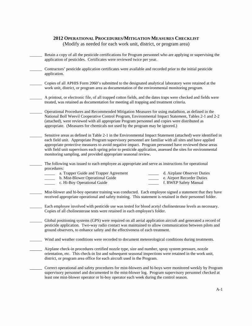
2012 OPERATIONAL PROCEDURES/MITIGATION MEASURES CHECKLIST (Modify as needed for each work unit, district, or program area)
______ Retain a copy of all the pesticide certifications for Program personnel who are applying or supervising the
application of pesticides. Certificates were reviewed twice per year. ______ Contractors’ pesticide application certificates were available and recorded prior to the initial pesticide
application. ______ Copies of all APHIS Form 2060’s submitted to the designated analytical laboratory were retained at the
work unit, district, or program area as documentation of the environmental monitoring program. ______ A printout, or electronic file, of all trapped cotton fields, and the dates traps were checked and fields were
treated, was retained as documentation for meeting all trapping and treatment criteria. ______ Operational Procedures and Recommended Mitigation Measures for using malathion, as defined in the
National Boll Weevil Cooperative Control Program, Environmental Impact Statement, Tables 2-1 and 2-2 (attached), were reviewed with all appropriate Program personnel and copies were distributed as appropriate. (Measures for chemicals not used by the program may be ignored.)
______ Sensitive areas as defined in Table 2-1 in the Environmental Impact Statement (attached) were identified in
each field unit. Appropriate Program supervisory personnel are familiar with all sites and have applied appropriate protective measures to avoid negative impact. Program personnel have reviewed these areas with field unit supervisors each spring prior to pesticide application, assessed the sites for environmental monitoring sampling, and provided appropriate seasonal review.
______ The following was issued to each employee as appropriate and serve as instructions for operational
procedures: _____ a. Trapper Guide and Trapper Agreement _____ d. Airplane Observer Duties _____ b. Mist-Blower Operational Guide _____ e. Airport Recorder Duties _____ c. Hi-Boy Operational Guide _____ f. BWEP Safety Manual ______ Mist-blower and hi-boy operator training was conducted. Each employee signed a statement that they have
received appropriate operational and safety training. This statement is retained in their personnel folder. ______ Each employee involved with pesticide use was tested for blood acetyl cholinesterase levels as necessary.
Copies of all cholinesterase tests were retained in each employee's folder. ______ Global positioning systems (GPS) were required on all aerial application aircraft and generated a record of
pesticide application. Two-way radio contact was maintained to allow communication between pilots and ground observers, to enhance safety and the effectiveness of each treatment.
______ Wind and weather conditions were recorded to document meteorological conditions during treatments. ______ Airplane check-in procedures certified nozzle type, size and number, spray system pressure, nozzle
orientation, etc. This check-in list and subsequent seasonal inspections were retained in the work unit, district, or program area office for each aircraft used in the Program.
______ Correct operational and safety procedures for mist-blowers and hi-boys were monitored weekly by Program
supervisory personnel and documented in the mist-blower log. Program supervisory personnel checked at least one mist-blower operator or hi-boy operator each week during the control season.

A-2
______ A minimum of one aerial application operation was monitored by Program supervisory personnel each week for each contractor. This monitoring procedure was noted on flight records.
______ Pesticide labels were carried in the vehicle of all persons involved with application, i.e. mist-blower
operators, hi-boy operators, airplane observers, field supervisors, and Program supervisory personnel. ______ Dye cards were labeled as to field numbers, date, and time of application. These cards were inspected by
Program supervisory personnel and retained in the work unit or program area office or sent to the designated laboratory for analysis as described in the Environmental Monitoring Plan.
______ Initiation of Program operations was preceded by a notification to the following agencies: _____ a. State Department of Agriculture or similar agency; _____ b. State Conservation and National Resources Agency or similar agency; _____ c. State Forestry Commission or similar agency; _____ d. State Department of the Environment or similar agency; and _____ e. Local governmental and county agencies. (Provide listings below.) ______ Included in the notification letters was a request for assistance in identification of potential sensitive sites
near cotton fields. ______ A safety equipment check-off list was signed by each employee involved in pesticide application. This was
retained in the employee’s personnel folder. ______ Safety procedures dealing with exposure to pesticides were inserted into the Program safety manual and
made available to all employees handling pesticides. ______ Empty pesticide containers were returned to the distributor. ______ All complaints were documented, thoroughly investigated, and resolved. Those involving alleged pesticide
misuse were referred to the appropriate state authority. Copies of complaints and actions taken were maintained on file. Copies of any state investigative reports were retained in the work unit or program area and copies submitted to the USDA-APHIS Environmental Compliance Team.
______ Local contacts with U.S. Fish and Wildlife Service concerning endangered and threatened species habitat
and mitigation measures were documented. The above procedures and measures were performed in the __________________________________ work unit, district, or program area during the 2012 season. Any minor deviations in such were corrected when observed. Deviations and/or pesticide incidents and corrective actions taken have been documented and are described as follows: _____________________________________________________________________________________________ _____________________________________________________________________________________________ _____________________________________________________________________________________________ _____________________________________________________________________________________________ __________________________________________________________________________________________________________________________________________________________________________________________ __________________________________________________________________________________________________________________________________________________________________________________________ _____________________________________________________________________________________________ ______________________________________ _____________________ Signature Date
A-3
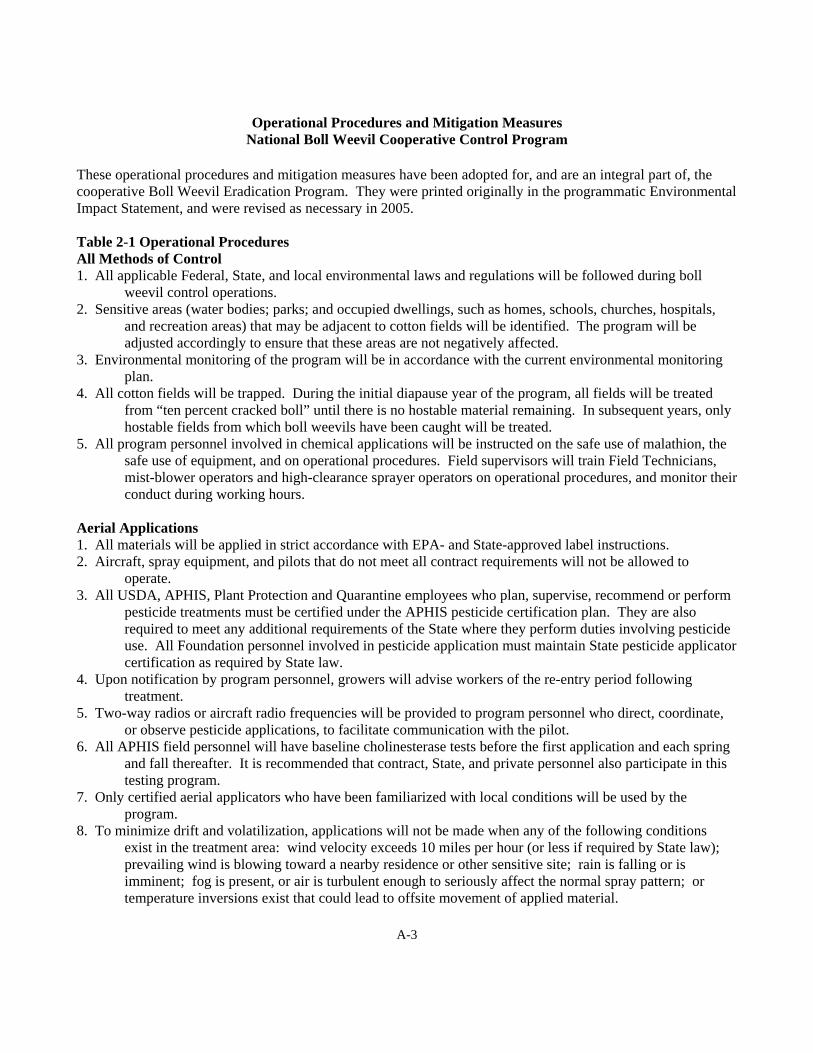
Operational Procedures and Mitigation Measures National Boll Weevil Cooperative Control Program
These operational procedures and mitigation measures have been adopted for, and are an integral part of, the cooperative Boll Weevil Eradication Program. They were printed originally in the programmatic Environmental Impact Statement, and were revised as necessary in 2005. Table 2-1 Operational Procedures All Methods of Control 1. All applicable Federal, State, and local environmental laws and regulations will be followed during boll
weevil control operations. 2. Sensitive areas (water bodies; parks; and occupied dwellings, such as homes, schools, churches, hospitals,
and recreation areas) that may be adjacent to cotton fields will be identified. The program will be adjusted accordingly to ensure that these areas are not negatively affected.
3. Environmental monitoring of the program will be in accordance with the current environmental monitoring plan.
4. All cotton fields will be trapped. During the initial diapause year of the program, all fields will be treated from “ten percent cracked boll” until there is no hostable material remaining. In subsequent years, only hostable fields from which boll weevils have been caught will be treated.
5. All program personnel involved in chemical applications will be instructed on the safe use of malathion, the safe use of equipment, and on operational procedures. Field supervisors will train Field Technicians, mist-blower operators and high-clearance sprayer operators on operational procedures, and monitor their conduct during working hours.
Aerial Applications 1. All materials will be applied in strict accordance with EPA- and State-approved label instructions. 2. Aircraft, spray equipment, and pilots that do not meet all contract requirements will not be allowed to
operate. 3. All USDA, APHIS, Plant Protection and Quarantine employees who plan, supervise, recommend or perform
pesticide treatments must be certified under the APHIS pesticide certification plan. They are also required to meet any additional requirements of the State where they perform duties involving pesticide use. All Foundation personnel involved in pesticide application must maintain State pesticide applicator certification as required by State law.
4. Upon notification by program personnel, growers will advise workers of the re-entry period following treatment.
5. Two-way radios or aircraft radio frequencies will be provided to program personnel who direct, coordinate, or observe pesticide applications, to facilitate communication with the pilot.
6. All APHIS field personnel will have baseline cholinesterase tests before the first application and each spring and fall thereafter. It is recommended that contract, State, and private personnel also participate in this testing program.
7. Only certified aerial applicators who have been familiarized with local conditions will be used by the program.
8. To minimize drift and volatilization, applications will not be made when any of the following conditions exist in the treatment area: wind velocity exceeds 10 miles per hour (or less if required by State law); prevailing wind is blowing toward a nearby residence or other sensitive site; rain is falling or is imminent; fog is present, or air is turbulent enough to seriously affect the normal spray pattern; or temperature inversions exist that could lead to offsite movement of applied material.

A-4
9. Nozzle types and sizes, spray system pressure, and nozzle orientation will be specified in the program’s aerial application contract or as otherwise directed by program personnel.
Ground Applications 1. Mist-Blowers • Operators will be certified applicators, or will be in constant radio or cell phone contact with certified
applicators. • Units will be operated from closed truck cabs with operators using re-circulated air. 2. High-Clearance Sprayers • Operators will be certified applicators, or will be in constant radio or cell phone contact with certified
applicators. • Spray operations will be conducted from closed cabs using re-circulated air. Table 2-2. Recommended Mitigation Measures All required State and local authorities will be notified upon initiation of the program. The notification will advise State and local authorities of the need for any assistance in identifying sensitive areas in proposed treatment areas. Protection of Workers All program personnel will be instructed on emergency procedures to follow in the event of insecticide exposure. Equipment necessary for immediate washing procedures must be available for application personnel. Aerial Applications 1. Pilots, loaders, and other personnel handling insecticides will be advised to wear safety equipment and
protective clothing. 2. Program personnel observing applications of malathion are required to wear protective clothing or remain
inside a closed vehicle with re-circulating air, depending on the circumstances of the application. 3. Application operations will be postponed in fields in which people are working. These fields will not be
treated when workers are present. 4. GPS systems are required on all contract aircraft. They will be used for pilot guidance, mapping fields to be
treated, and assistance in locating fields and marking swaths. Ground Applications 1. Mist-Blowers • Operators will be certified applicators, or will be in constant radio or cell phone contact with certified
applicators. • Operators will wear appropriate safety equipment when loading or servicing the unit, and will be
specially trained by program personnel. • Mist-blower units will be operated from closed truck cabs with operators using re-circulated air. 2. High-Clearance Sprayers • Operators will be certified applicators, or will be in constant radio or cell phone contact with certified
applicators. • Operators will wear appropriate safety equipment and protective clothing when loading or servicing
the unit. • High-clearance sprayers will be operated from closed cabs with operators using re-circulated air.

A-5
Pesticide Handling Precautions 1. Insecticides will be delivered and stored in sealed totes (mini-bulk tanks) or drums and then pumped directly
into the spraying equipment. 2. All insecticides will be stored in accordance with Federal, State, and local regulations and label instructions. 3. All loading and unloading of insecticides will be within a containment area where an accidental spill will not
contaminate a stream or other body of water. 4. In the event of an accidental spill, procedures set forth in the PPQ Treatment Manual, chapter 7, pages 7-3-1
through 7-3-18, entitled, “Guidelines for Managing Pesticide Spills” will be followed. 5. All empty insecticide totes (mini-bulk tanks) and drums will be returned to the distributor for reconditioning. Protection of the Public 1. Application aircraft shall avoid direct spraying of residences, garden plots and adjacent crops at all times. 2. Program personnel shall immediately cease spraying operations if members of the public are observed within
100 feet of a cotton field being sprayed with malathion. Protection of Bees Before beginning treatment with malathion, program personnel shall notify all registered apiarists in or near the treatment area of the date and approximate time of chemical treatment. Protection of Wildlife 1. All control operations will be conducted with appropriate concern for their potential impact on endangered,
threatened, proposed and protected species identified in this document. APHIS has prepared a biological assessment for federally listed endangered, threatened, proposed and protected
species found within all U.S. cotton-producing counties from species information provided by the U.S. Department of the Interior, Fish and Wildlife Service (FWS) and State wildlife agencies.
Adequate protection measures are developed for federally listed endangered, threatened, proposed and protected
species through the Endangered Species Act, section 7, formal and informal consultations with FWS. Specific biological and distributional data for species is gathered in discussions between APHIS, Plant Protection and Quarantine, local FWS offices, State wildlife agencies and the Foundation before operations begin.
Species and habitats protected by State laws are addressed in site-specific assessments as needed. 2. Oil-sensitive dye cards are used to regularly monitor application efficacy. Spray deposition in the target area
and droplet size are critical concerns.

A-6
Additional Operational Procedures and Mitigation Measures Lower Rio Grande Valley Boll Weevil Eradication Program
Environmental Assessment - 2005 Site-specific Protective Measures Leading to a Finding of No Significant Impact The site-specific protective measures described in this subsection were designed specially for the Lower Rio Grande Valley Boll Weevil Eradication Program. These are the minimum measures that, in the estimation of the program managers, are required to ensure that implementation of the proposed program will result in no significant impact. Additional Precautions for Treatments 1. Only malathion (the least toxic of the available organophosphate insecticides) will be used by the Lower Rio
Grande Valley Boll Weevil Eradication Program. 2. Aerial applications of pesticides will be made at a height of 5 feet or less above the cotton canopy, unless
precluded by obstructions. 3. Program personnel will familiarize aerial applicators with applicable operational procedures, mitigation
measures, and protection measures that will be required. 4. Aerial applications of pesticides will not be made to sensitive areas (residences, public buildings, bodies of
water, hospitals, primary and secondary schools, day care centers, inpatient clinics, nursing homes, parks, churches); program pesticides will only be applied to cotton fields.
5. Program personnel will be present during all treatments near colonias; they will use dye cards along field edges to monitor for any offsite movement of pesticide.
6. Before initiating operations, APHIS will obtain a concurrence from the U.S. Fish and Wildlife Service on protection measures that are required for endangered and threatened species, or their critical habitats.
7. The program will report incidents of pesticide poisoning to the Texas Department of Health; information about the validity and probable cause will be used to develop additional protective measures, as necessary.
Additional Notification Procedures 1. For area residents who reside within ¼-mile of treatments and who formally request (providing their name,
address, and telephone number) special notification, program personnel will provide advance written or telephonic notification of the approximate times and dates of treatments.
2. Growers participating in the program will be notified of treatment dates so that they may provide timely and appropriate notice of treatments and protective measures to persons in their employ or residing on their properties who could be exposed to pesticides.
D. Additional Protective Measures for the Lower Rio Grande Valley The following protection measures have been adopted and made mandatory for the Lower Rio Grande Valley Boll Weevil Eradication Program. They may be more stringent than the operational procedures or mitigation measures that were published in the programmatic EIS, or the minimum site-specific protective measures that would be required to ensure that the proposed program will result in no significant environmental impact. Additional Precautions for Treatments 1. During the first year of the program, all cotton fields will be treated after fields have reached “10 percent
cracked boll” stage. Treatments will continue until fields are non-hostable following harvest. In subsequent years, no pesticide will be applied to a cotton field unless it has hostable fruit present and weevils are caught on it (trap triggers are exceeded), or a boll weevil infestation is detected by in-field inspection.
A-7
2. To the extent possible, malathion will be delivered and briefly stored in 260-gallon returnable, refillable totes (mini-bulk containers). The insecticide will be pumped directly from these containers into the spray equipment. This will minimize the potential for leakage or spillage and will prevent prolonged exposure to heat.
Additional Notification Procedures 1. Program personnel will establish a central telephone hot line for the public. The hot line will provide people
with approximate times and places of treatment, program information and emergency referrals. The hot line will be available during the time the program is operational and will be able to provide information in English and Spanish.
2. Program personnel will maintain in each office copies of the programmatic EIS and the EA, with the EA being available in both English and Spanish.
Additional Monitoring and Reporting Procedures 1. The environmental monitoring plan for this program will include (1) the use of dye cards to monitor possible
pesticide drift to sensitive areas, (2) water sampling of major bodies of water that receive drainage from cotton fields, (3) sampling of selected streams and bodies of water for contamination from runoff, and (4) residue sampling on vegetation within sensitive areas.
2. Program personnel will make available to the public, upon written request, data from program environmental monitoring efforts.
3. The program will maintain a list of all complaints received regarding program pesticide applications to cotton fields. Each list entry will include a short summary on findings and resolution.
4. Program personnel will prepare an annual report that relates, at a minimum, the types of treatments used (chemical and nonchemical), the number of applications for each treatment block, and the quantity of pesticide used; successive annual reports will include a summary comparison of pesticide use for each year.
5. At the end of each year, program personnel will provide a report that assesses program success or the lack thereof. The report will generally address the problems encountered and how they were resolved. Succeeding reports will include comparisons of weekly or monthly boll weevil detections for each program year. Copies of the report will be sent to anyone who submits a written request.

Protection measures for endangered & threatened species - 2012 B-1
Protection Measures for Endangered, Threatened, and Proposed Species 2012 Boll Weevil Control Program in Texas
KEY STATUS: E=Endangered; E,CH=Endangered w/ Critical Habitat; T=Threatened; T,CH=Threatened w/ Critical Habitat; PE=Proposed Endangered; PT=Proposed Threatened w/Proposed Critical Habitat; PE,PCH=Proposed Endangered w/Proposed Critical Habitat; XN=Experimental Population. PROTECTION MEASURES: NE=APHIS determines that the Boll Weevil Program will have No Effect on populations of this listed species.
COMMON NAME SCIENTIFIC NAME STATUS PROTECTION MEASURES MAMMALS
Bat, Mexican long- nosed
Leptonycteris navalis E No aerial use within 100 feet, no ground use within 60 feet of desert land with agave cactus.
Bear, Louisiana black Ursus americanus luteolus T NE – Excluded by habitat
Jaguarundi, Gulf Coast
Herpailurus (=Felis) yagouaroundi cacomitli
E Monitor drift at habitat edge if field is within 300 feet of habitat.
Jaguar Panthera onca E NE – Excluded by rarity/habits
Manatee, West Indian
Trichechus manatus E, CH NE – Excluded by habitat
Ocelot Leopardus (=Felis) pardalis
E Monitor drift at habitat edge if field is within 300 feet of habitat.
Wolf, gray Canis lupus E, CH, XN NE – Excluded by habitat BIRDS
Crane, whooping Grus americana E, CH, XN
Trained observer at site prior to each treatment. If crane is present, postpone treatment.
Curlew, Eskimo Numenius borealis E NE – Excluded by rarity
Eagle, bald (Protection measures remain in place for B&GE P Act)
Haliaeetus leucocephalus Delisted
No aerial or ground applications within 1,500 feet of nest when adults, nestlings, or fledglings are present at a nest site. Eagle presence will be established by a trained observer after repeated observations at the nest site before any treatment. No use within 60 feet of large water bodies (25 feet across) within a 1 mile radius of the nest site.
Falcon, northern aplomado
Falco femoralis septentrionalis
E No aerial use within 1 mile or ground use within ¼ mile of nesting sites or release stations.
Flycatcher, southwestern willow
Empidonax traillii extimus E, CH No aerial use within 100 feet or ground use within 60 feet of habitat edge. Monitor for drift.
Owl, Mexican spotted Strix occidentalis lucida T, CH NE – Excluded by habitat
Pelican, brown Pelecanus occidentalis delisted NE – Excluded by habitat
Plover, piping Charadrius melodus T, CH NE – Migratory and excluded by habitat
Prairie-chicken, Attwater’s greater
Tympanuchus cupido attwateri
E Avoid drift into potential habitat. Monitor drift if cotton fields within 300 feet of potential habitat.
Tern, least (Interior) Sterna antillarum E No aerial or ground use within 300 feet of a colony and no use within 60 feet of the water’s edge for 2.5 mile radius around the colony. Monitor for run-off.

Protection measures for endangered & threatened species - 2012 B-2
COMMON NAME SCIENTIFIC NAME STATUS PROTECTION MEASURES Vireo, black-capped Vireo atricapillus E From March 1 to Sept 1 implement the following measures:
TX - Avoid drift into potential habitat. Monitor drift if cotton fields within 500 feet of potential habitat. No fly-over habitat. Swaths parallel to habitat edge. OK - Aerial application is prohibited within 100 feet of habitat, and ground applications are prohibited within 60 feet of habitat.
Warbler, golden-cheeked
Dendroica chrysoparia E From March 1 to August 1 implement the following measures: Avoid drift into potential habitat. Monitor drift if cotton fields within 500 feet of potential habitat. No fly-over habitat. Swaths parallel to habitat edge.
Woodpecker, red-cockaded
Picoides (=Dendrocopos) borealis
E No aerial use within 100 feet or ground use within 60 feet of habitat edge. Monitor for drift
REPTILES Lizard, dunes sagebrush
Sceloporus arenicolus PE NE – Excluded by habitat
Sea turtle, green Chelonia mydas E, T, CH NE – Excluded by habitat
Sea turtle, hawksbill Eretmochelys imbricata E, CH NE – Excluded by habitat
Sea turtle, Kemp's ridley
Lepidochelys kempii E NE – Excluded by habitat
Sea turtle, leatherback Dermochelys coriacea E, CH NE – Excluded by habitat
Sea turtle, loggerhead Caretta caretta T NE – Excluded by habitat
Snake, Concho water Nerodia paucimaculata (= harteri)
delisted Recovered
AMPHIBIANS
Salamander, Barton Springs
Eurycea sosorum E No use within 60 feet of any drainage points that enter into recharge areas of the Edwards Aquifer. Monitor for run-off.
Salamander, San Marcos
Eurycea nana T, CH No use within 60 feet of any drainage points that enter into recharge areas of the Edwards Aquifer. Monitor for run-off.
Salamander, Texas blind
Typhlomolge rathbuni E No use within 60 feet of any drainage points that enter into recharge areas of the Edwards Aquifer. Monitor for run-off.
Toad, Houston Bufo hustonensis E, CH No aerial use within 100 feet or ground use within 60 feet of habitat edge. Monitor drift, water if field within 500' of habitat, and run-off.
FISH Darter, fountain Etheostoma fonticola E, CH No use within 60 feet of identified aquatic habitat or recharge areas of the
Edwards Aquifer. Monitor for run-off.
Gambusia, Big Bend Gambusia gaigeii E NE – Excluded by habitat (only wild population in protected pond in National Park)
Gambusia, Clear Creek
Gambusia heterochir E No aerial use within 100 feet, no ground use within 60 feet of identified aquatic habitat. Monitor for drift and run-off.
Gambusia, Pecos Gambusia nobilis E No aerial use within 100 feet, no ground use within 60 feet of identified aquatic habitat. Monitor for drift and run-off.
Gambusia, San Marcos
Gambusia georgei E, CH No use within 60 feet of identified aquatic habitat or recharge areas of the Edwards Aquifer. Monitor for run-off.
Minnow, Devil’s River
Dionda diaboli E, CH No aerial use within 100 feet and no ground use within 60 feet of identified aquatic habitat. Monitor for drift and run-off.
Minnow, Rio Grande Silvery
Hybognathus amarus E, CH No use within 60 feet of identified aquatic habitat. Monitor for run-off.
Pupfish, Comanche Springs
Cyprinodon elegans E No aerial use within 100 feet, no ground use within 60 feet of identified aquatic habitat. Monitor for drift and run-off.

Protection measures for endangered & threatened species - 2012 B-3
COMMON NAME SCIENTIFIC NAME STATUS PROTECTION MEASURES Pupfish, Leon Springs Cyprinodon bovinus E, CH No aerial use within 100 feet, no ground use within 60 feet of identified
aquatic habitat and recharge areas of springs. Monitor for run-off.
Shiner, Arkansas River
Notropis girardi T, CH No use within 60 feet of identified aquatic habitat. Monitor for run-off.
SNAILS
Snail, Pecos assiminea
Assiminea pecos E, CH No use within 60 feet of identified aquatic habitat. Monitor for run-off.
INSECTS
Beetle, American burying
Nicrophorus americanus E Avoid drift into potential habitat of beetle (=non-cultivated land) at the edge of fields in counties with species. Aerial swaths parallel to edge of beetle habitat. When possible, spray field edges with beetle habitat only from mid morning to late afternoon during March to November.
Beetle, Coffin Cave mold
Batrisodes texanus E No use within 60 feet of any drainage points from which run-off might enter cave or crevice entrance. Monitor for run-off.
Beetle, Comal Springs dryopid
Stygoparnus comalensis E, CH No use within 60 feet of any drainage points that enter into recharge areas of the Edwards Aquifer. Monitor for run-off.
Beetle, Comal Springs riffle
Heterelmis comalensis E, CH No use within 60 feet of any drainage points that enter into recharge areas of the Edwards Aquifer. Monitor for run-off.
Beetle, Helotes mold Batrisodes venyivi E, CH, PCH
To protect invertebrate prey base (e.g., crickets), no ground use within 320 feet and no aerial use within 1320 feet of cave or crevice entrance.
Beetle, Kretschmarr Cave mold
Texamaurops reddelli E No use within 60 feet of any drainage points from which run-off might enter cave or crevice entrance. Monitor for run-off.
Beetle, Tooth Cave ground
Rhadine persephone E No use within 60 feet of any drainage points from which run-off might enter crevice or crevice entrance. Monitor for run-off.
Rhadine exilis Rhadine exilis E, CH, PCH
To protect invertebrate prey base (e.g., crickets), no ground use within 320 feet and no aerial use within 1320 feet of cave or crevice entrance.
Rhadine infernalis Rhadine infernalis E, CH, PCH
To protect invertebrate prey base (e.g., crickets), no ground use within 320 feet and no aerial use within 1320 feet of cave or crevice entrance.
ARACHNIDS
Meshweaver, Bracken Bat Cave
Cicurina venii E, CH, PCH
To protect invertebrate prey base (e.g., crickets), no ground use within 320 feet and no aerial use within 1320 feet of cave or crevice entrance.
Harvestman, Bee Creek Cave
Texella reddelli E No use within 60 feet of any drainage points from which run-off might enter cave or crevice. Monitor for run-off.
Harvestman, Bone Cave
Texella reyesi E No use within 60 feet of any drainage points from which run-off might enter cave or crevice. Monitor for run-off.
Harvestman, Cokendolpher Cave
Texella cokendolpheri E, CH, PCH
To protect invertebrate prey base (e.g., crickets), no ground use within 320 feet and no aerial use within 1320 feet of cave or crevice entrance.
Pseudoscorpion, Tooth Cave
Tartarocreagris (=Microcreagris) texana
E No use within 60 feet of any drainage points from which run-off might enter cave or crevice. Monitor for run-off.
Spider, Government Canyon Bat Cave
Neoleptoneta microps E, PCH To protect invertebrate prey base (e.g., crickets), no ground use within 320 feet and no aerial use within 1320 feet of cave or crevice entrance.
Meshweaver, Madla’s Cave
Cicurina madla E, CH, PCH
To protect invertebrate prey base (e.g., crickets), no ground use within 320 feet and no aerial use within 1320 feet of cave or crevice entrance.
Meshweaver, Robber Baron Cave
Cicurina baronia E, CH, PCH
To protect invertebrate prey base (e.g., crickets), no ground use within 320 feet and no aerial use within 1320 feet of cave or crevice entrance.
Spider, Tooth Cave Neoleptoneta (=Leptoneta) myopica
E No use within 60 feet of any drainage points from which run-off might enter cave or crevice. Monitor for run-off.

Protection measures for endangered & threatened species - 2012 B-4
COMMON NAME SCIENTIFIC NAME STATUS PROTECTION MEASURES Meshweaver, Government Canyon Bat Cave
Cicurina vespera E, PCH To protect invertebrate prey base (e.g., crickets), no ground use within 320 feet and no aerial use within 1320 feet of cave or crevice entrance.
CRUSTACEANS
Amphipod, Peck’s Cave
Stygogromus (=Stygonectes) pecki
E, CH No use within 60 feet of any drainage points that enter into recharge areas of the Edwards Aquifer. Monitor for run-off.
PLANTS
Ashy dogweed Thymophylla (=Dyssodia) tephroleuca
E Avoid drift into potential habitat of pollinators (=areas with native, unmown vegetation) and monitor drift if cotton field is within 500 feet of pollinator habitat. Swaths parallel to habitat edge of pollinators with no flying over pollinator habitat. When possible, spray during plant’s flowering period (February to November) only in the early dawn (no later than 1 hour after sunrise) or in early evening (6 pm or later) for a distance of up to ¼ mile from plant habitat.
Black lace cactus Echinocereus reichenbachii var. albertii (E. melanocentrus)
E Avoid drift into potential habitat of pollinators (=areas with native, unmown vegetation) and monitor drift if cotton field is within 500 feet of pollinator habitat. Swaths parallel to habitat edge of pollinators with no flying over pollinator habitat. When possible, spray during plant’s flowering period (late March to June) only in the early dawn (no later than 1 hour after sunrise) or in early evening (6 pm or later) for a distance of up to ¼ mile from plant habitat.
Bunched cory cactus Coryphantha ramillosa T NE – Excluded by habitat
Chisos Mountains hedgehog cactus
Echinocereus chisoensis chisoensis
T Avoid drift into potential habitat of pollinators (=areas with native, unmown vegetation) and monitor drift if cotton field is within 500 feet of pollinator habitat. Swaths parallel to habitat edge of pollinators with no flying over pollinator habitat. When possible, spray during plant’s flowering period (March to July) only in the early dawn (no later than 1 hour after sunrise) or in early evening (6 pm or later) for a distance of up to ¼ mile from plant habitat.
Davis’ green pitaya Echinocereus viridiflorus var. davisii (E. davisii)
E Avoid drift into potential habitat of pollinators (=areas with native, unmown vegetation) and monitor drift if cotton field is within 500 feet of pollinator habitat. Swaths parallel to habitat edge of pollinators with no flying over pollinator habitat. When possible, spray during plant’s flowering period (March) only in the early dawn (no later than 1 hour after sunrise) or in early evening (6 pm or later) for a distance of up to ¼ mile from plant habitat.
Geocarpon minimum (=Sci. Name)
Geocarpon minimum T NE – Excluded by habitat
Hinckley oak Quercus hinckleyi T NE – No insect pollination
Johnston’s frankenia Frankenia johnstonii E Avoid drift into potential habitat of pollinators (=areas with native, unmown vegetation) and monitor drift if cotton field is within 500 feet of pollinator habitat. Swaths parallel to habitat edge of pollinators with no flying over pollinator habitat. When possible, spray during plant’s flowering period (November to April) only in the early dawn (no later than 1 hour after sunrise) or in early evening (6 pm or later) for a distance of up to ¼ mile from plant habitat.

Protection measures for endangered & threatened species - 2012 B-5
COMMON NAME SCIENTIFIC NAME STATUS PROTECTION MEASURES Large-fruited sand-verbena
Abronia macrocarpa E Avoid drift into potential habitat of pollinators (=areas with native, unmown vegetation) and monitor drift if cotton field is within 500 feet of pollinator habitat. Swaths parallel to habitat edge of pollinators with no flying over pollinator habitat. When possible, spray during plant’s flowering period (late March to early June) only in the early dawn (no later than 1 hour after sunrise) or in early evening (6 pm or later) for a distance of up to 1 mile from plant habitat.
Little Aguja pondweed
Potamogeton clystocarpus E No use within 60 feet of identified aquatic habitat. Monitor for run-off.
Lloyd’s Mariposa cactus
Echinomastus (=Echinocactus, =Sclerocactus, =Neolloydia) mariposensis
T Avoid drift into potential habitat of pollinators (=areas with native, unmown vegetation) and monitor drift if cotton field is within 500 feet of pollinator habitat. Swaths parallel to habitat edge of pollinators with no flying over pollinator habitat. When possible, spray during plant’s flowering period (consult biologist) only in the early dawn (no later than 1 hour after sunrise) or in early evening (6 pm or later) for a distance of up to ¼ mile from plant habitat.
Navasota ladies’-tresses
Spiranthes parksii E Avoid drift into potential habitat of pollinators (=areas with native, unmown vegetation) and monitor drift if cotton field is within 500 feet of pollinator habitat. Swaths parallel to habitat edge of pollinators with no flying over pollinator habitat. When possible, spray during plant’s flowering period (October to November) only in the early dawn (no later than 1 hour after sunrise) or in early evening (6 pm or later) for a distance of up to 1 mile from plant habitat.
Nellie cory cactus Coryphantha (=Escobaria, =Mammillaria) minima (=C. nellieae)
E Avoid drift into potential habitat of pollinators (=areas with native, unmown vegetation) and monitor drift if cotton field is within 500 feet of pollinator habitat. Swaths parallel to habitat edge of pollinators with no flying over pollinator habitat. When possible, spray during plant’s flowering period (consult biologist) only in the early dawn (no later than 1 hour after sunrise) or in early evening (6 pm or later) for a distance of up to ¼ mile from plant habitat.
Pecos (= puzzle) sunflower
Helianthus paradoxus T, CH Avoid drift into potential habitat of pollinators (=areas with native, unmown vegetation) and monitor drift if cotton field is within 500 feet of pollinator habitat. Swaths parallel to habitat edge of pollinators with no flying over pollinator habitat. When possible, spray during plant’s flowering period (September to November) only in the early dawn (no later than 1 hour after sunrise) or in early evening (6 pm or later) for a distance of up to ¼ mile from plant habitat.
Slender rush-pea Hoffmannseggia tenella E Avoid drift into potential habitat of pollinators (=areas with native, unmown vegetation) and monitor drift if cotton field is within 500 feet of pollinator habitat. Swaths parallel to habitat edge of pollinators with no flying over pollinator habitat. When possible, spray during plant’s flowering period (February to June) only in the early dawn (no later than 1 hour after sunrise) or in early evening (6 pm or later) for a distance of up to ¼ mile from plant habitat.
Sneed pincushion cactus
Coryphantha sneedii (=Escobaria, =Mammillaria) var. sneedii
E NE – Excluded by habitat
South Texas ambrosia Ambrosia cheiranthifolia E NE – No insect pollination
Protection measures for endangered & threatened species - 2012 B-6
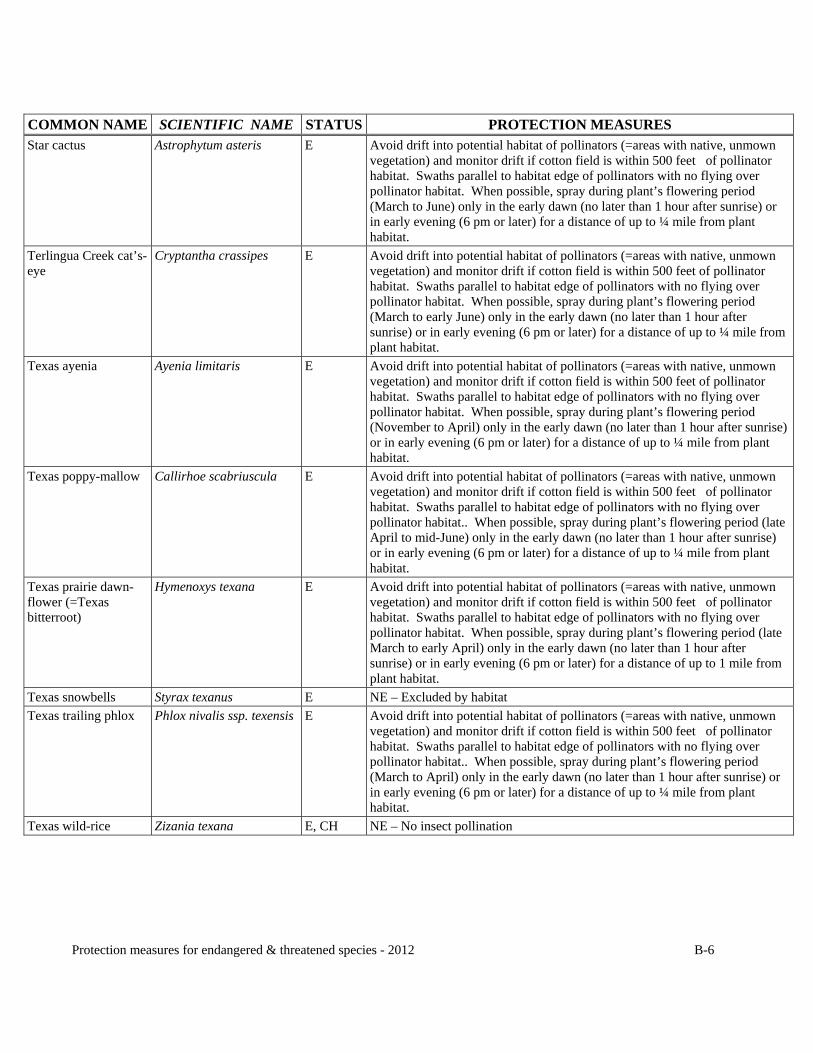
COMMON NAME SCIENTIFIC NAME STATUS PROTECTION MEASURES Star cactus Astrophytum asteris E Avoid drift into potential habitat of pollinators (=areas with native, unmown
vegetation) and monitor drift if cotton field is within 500 feet of pollinator habitat. Swaths parallel to habitat edge of pollinators with no flying over pollinator habitat. When possible, spray during plant’s flowering period (March to June) only in the early dawn (no later than 1 hour after sunrise) or in early evening (6 pm or later) for a distance of up to ¼ mile from plant habitat.
Terlingua Creek cat’s-eye
Cryptantha crassipes E Avoid drift into potential habitat of pollinators (=areas with native, unmown vegetation) and monitor drift if cotton field is within 500 feet of pollinator habitat. Swaths parallel to habitat edge of pollinators with no flying over pollinator habitat. When possible, spray during plant’s flowering period (March to early June) only in the early dawn (no later than 1 hour after sunrise) or in early evening (6 pm or later) for a distance of up to ¼ mile from plant habitat.
Texas ayenia Ayenia limitaris E Avoid drift into potential habitat of pollinators (=areas with native, unmown vegetation) and monitor drift if cotton field is within 500 feet of pollinator habitat. Swaths parallel to habitat edge of pollinators with no flying over pollinator habitat. When possible, spray during plant’s flowering period (November to April) only in the early dawn (no later than 1 hour after sunrise) or in early evening (6 pm or later) for a distance of up to ¼ mile from plant habitat.
Texas poppy-mallow Callirhoe scabriuscula E Avoid drift into potential habitat of pollinators (=areas with native, unmown vegetation) and monitor drift if cotton field is within 500 feet of pollinator habitat. Swaths parallel to habitat edge of pollinators with no flying over pollinator habitat.. When possible, spray during plant’s flowering period (late April to mid-June) only in the early dawn (no later than 1 hour after sunrise) or in early evening (6 pm or later) for a distance of up to ¼ mile from plant habitat.
Texas prairie dawn-flower (=Texas bitterroot)
Hymenoxys texana E Avoid drift into potential habitat of pollinators (=areas with native, unmown vegetation) and monitor drift if cotton field is within 500 feet of pollinator habitat. Swaths parallel to habitat edge of pollinators with no flying over pollinator habitat. When possible, spray during plant’s flowering period (late March to early April) only in the early dawn (no later than 1 hour after sunrise) or in early evening (6 pm or later) for a distance of up to 1 mile from plant habitat.
Texas snowbells Styrax texanus E NE – Excluded by habitat
Texas trailing phlox Phlox nivalis ssp. texensis E Avoid drift into potential habitat of pollinators (=areas with native, unmown vegetation) and monitor drift if cotton field is within 500 feet of pollinator habitat. Swaths parallel to habitat edge of pollinators with no flying over pollinator habitat.. When possible, spray during plant’s flowering period (March to April) only in the early dawn (no later than 1 hour after sunrise) or in early evening (6 pm or later) for a distance of up to ¼ mile from plant habitat.
Texas wild-rice Zizania texana E, CH NE – No insect pollination

Protection measures for endangered & threatened species - 2012 B-7
COMMON NAME SCIENTIFIC NAME STATUS PROTECTION MEASURES Tobush fishhook cactus
Ancistrocactus tobuschii E Avoid drift into potential habitat of pollinators (=areas with native, unmown vegetation) and monitor drift if cotton field is within 500 feet of pollinator habitat. Swaths parallel to habitat edge of pollinators with no flying over pollinator habitat. When possible, spray during plant’s flowering period (mid-February to April) only in the early dawn (no later than 1 hour after sunrise) or in early evening (6 pm or later) for a distance of up to ¼ mile from plant habitat.
Todsen’s pennyroyal Hedeoma todsenii E, CH NE – Excluded by habitat
Walker’s manioc Manihot walkeri E Avoid drift into potential habitat of pollinators (=areas with native, unmown vegetation) and monitor drift if cotton field is within 500 feet of pollinator habitat. Swaths parallel to habitat edge of pollinators with no flying over pollinator habitat. When possible, spray during plant’s flowering period (April to September) only in the early dawn (no later than 1 hour after sunrise) or in early evening (6 pm or later) for a distance of up to 1 mile from plant habitat.
White bladderpod Lesquerella pallida E NE – Excluded by habitat
Zapata bladderpod Lesquerella thamnophila E, CH Avoid drift into potential habitat of pollinators (=areas with native, unmown vegetation) and monitor drift if cotton field is within 500 feet of pollinator habitat. Swaths parallel to habitat edge of pollinators with no flying over pollinator habitat. When possible, spray during plant’s flowering period (early April to May) only in the early dawn (no later than 1 hour after sunrise) or in early evening (6 pm or later) for a distance of up to 1 mile from plant habitat.
Zuni (=Rhizome) fleabane
Erigeron rhizomatus T NE – Excluded by habitat

Endangered and Threatened Species Site Reporting Form - 2012
Use additional copies as needed. Prior to the start of applications of malathion, return the completed form to: Dr. Robert Baca, USDA-APHIS-PPQ, 4700 River Road, Unit 150, Room 5A-04.B, Riverdale, MD 20737 B-8
Work unit/District/Zone/Program:_____________________________________________State:_______ Species Field Number(s) Acres GPS Coordinates
Distance to Field
Comments

Environmental Monitoring Supplies Checklist (ver. Feb. 2012) C-1
Environmental Monitoring Supplies Checklist
- use the blank areas to indicate the number of items to take to the field or how many of that item are being ordered
General Supplies Dye Cards
Monitoring plan/SOP’s Obtain from
ECT Oil-sensitive dye cards (one card per package)
Field log notebook Water-sensitive dye cards (two paired cards per package)
2060 monitoring forms 5' bamboo poles/stakes Obtain locally
Indelible marker Obtain locally Paper/alligator clips Obtain locally
12” x 12" resealable plastic bags Tacks/nails Obtain locally
Styrofoam coolers for mailing Tweezers Obtain locally
Shipping label (AMS-National Science Laboratory in Gastonia, NC)
Nitrile gloves (box of S,M,L,XL) Indicate size
Packing/strapping tape Vegetation/Fish/Insect Samples
Ice chest and wet or blue ice Obtain locally Pruning shears/scissors
Obtain locally
Soil Samples Tweezers/forceps
Obtain locally
Hand trowel Obtain locally Packing/strapping tape
10” x 14” foil envelopes 10” x 14” foil envelopes
Neat (Pure) Chemical & Formulations Water Samples
Amber glass bottle (2 ounce size) Cubitainer (gallon size)
Disposable pipette and bulb Cubitainer (liter size)
Small mailing tubes Sodium sulfate (small vials)
Protective eyewear pH paper (0-14 range)
Nitrile gloves (box of S,M,L,XL) Indicate size Acid or base (in a squeeze bottle) Obtain locally
Program: _________________________________ Requested by: ______________________________ Date: _____________________________________ Phone: ____________________________________ Address: ____________________________________________________________________________________ ____________________________________________________________________________________________ To order supplies, indicate the quantity of each item needed. Fax or email a copy of this form to APHIS-CPHST in Mississippi at 228-822-3137 or [email protected]. If fax machines are not working, leave a message with the monitoring supplies manager at 228-323-5326. It may be difficult to fill orders for large quantities of materials. This is not an exhaustive supply list…items that are not listed here may be available through CPHST. Not all supplies listed above are required for all pest control programs.