human history of the - fraser-cascade mountain school
TRANSCRIPT

of theUpper Skagit
WatershedFirst NationsFur Industry
Gold Rush / MiningHomesteads
HydroelectricLogging
Modern HighwaysWilderness Preservation
HUMANHISTORYHUMAN
HISTORY

Acknowledgements
This booklet is a joint project of Fraser-Cascade Mountain School and
Hope Mountain Centre, Hope BC
The project is funded through a grant from the Skagit Environmental Endowment Commission (SEEC)
January, 2008
For copies, contact Fraser-Cascade Mountain School at 604-869-2411

Table of Contents
FIRST NATIONS HISTORY IN THE UPPER SKAGIT . . . . . . . . . . . . . . . . . . . . . . . . 1Archaeological Heritage . . . . . . . . . . . . . . . . . . . . . . . . . . . . . . . . . . . . . . . . . . . . . . . . . . . . . . . . . . . . 2Nlaka’pamux . . . . . . . . . . . . . . . . . . . . . . . . . . . . . . . . . . . . . . . . . . . . . . . . . . . . . . . . . . . . . . . . . . . . . 2Sto:lo . . . . . . . . . . . . . . . . . . . . . . . . . . . . . . . . . . . . . . . . . . . . . . . . . . . . . . . . . . . . . . . . . . . . . . . . . . . 3Upper Skagit . . . . . . . . . . . . . . . . . . . . . . . . . . . . . . . . . . . . . . . . . . . . . . . . . . . . . . . . . . . . . . . . . . . . . 3Trails and Trade Routes . . . . . . . . . . . . . . . . . . . . . . . . . . . . . . . . . . . . . . . . . . . . . . . . . . . . . . . . . . . . 3
EUROPEAN CONTACT IN THE UPPER SKAGIT . . . . . . . . . . . . . . . . . . . . . . . . . . 4
THE FUR TRADE . . . . . . . . . . . . . . . . . . . . . . . . . . . . . . . . . . . . . . . . . . . . . . 5Fur Trails in the Upper Skagit . . . . . . . . . . . . . . . . . . . . . . . . . . . . . . . . . . . . . . . . . . . . . . . . . . . . . . . . 51846 – An “All-British” Route Through the Cascades . . . . . . . . . . . . . . . . . . . . . . . . . . . . . . . . . . . . . . 51848 – The HBC “Brigade Trail” . . . . . . . . . . . . . . . . . . . . . . . . . . . . . . . . . . . . . . . . . . . . . . . . . . . . . . 6
GOLD FEVER HITS THE CASCADES. . . . . . . . . . . . . . . . . . . . . . . . . . . . . . . . . . 6International Boundary – 49th Parallel . . . . . . . . . . . . . . . . . . . . . . . . . . . . . . . . . . . . . . . . . . . . . . . . . 7Gold Rush Trails in the Skagit . . . . . . . . . . . . . . . . . . . . . . . . . . . . . . . . . . . . . . . . . . . . . . . . . . . . . . . . 8
1858 – Whatcom Trail . . . . . . . . . . . . . . . . . . . . . . . . . . . . . . . . . . . . . . . . . . . . . . . . . . . . . . . . . . . 81860 – Dewdney Trail . . . . . . . . . . . . . . . . . . . . . . . . . . . . . . . . . . . . . . . . . . . . . . . . . . . . . . . . . . . 81861 – The Royal Engineers Road. . . . . . . . . . . . . . . . . . . . . . . . . . . . . . . . . . . . . . . . . . . . . . . . . 91861 – Hope Pass Trail. . . . . . . . . . . . . . . . . . . . . . . . . . . . . . . . . . . . . . . . . . . . . . . . . . . . . . . . . . 91879 to 1880 – Ruby Creek Gold Rush . . . . . . . . . . . . . . . . . . . . . . . . . . . . . . . . . . . . . . . . . . . . 10
1879 – Naming Steamboat Mountain . . . . . . . . . . . . . . . . . . . . . . . . . . . . . . . . . . . . . . . . . . . . . . . . . 121910 to 1911 – Steamboat Mountain Gold Rush . . . . . . . . . . . . . . . . . . . . . . . . . . . . . . . . . . . . . . . . 12Historical Remains of the Steamboat Gold Rush . . . . . . . . . . . . . . . . . . . . . . . . . . . . . . . . . . . . . . . . 14Other Mining Operations – 1913 to the Present . . . . . . . . . . . . . . . . . . . . . . . . . . . . . . . . . . . . . . . . . 14
Silverdaisy Mine . . . . . . . . . . . . . . . . . . . . . . . . . . . . . . . . . . . . . . . . . . . . . . . . . . . . . . . . . . . . . . 141940’s to 1950’s – Foundation Mines . . . . . . . . . . . . . . . . . . . . . . . . . . . . . . . . . . . . . . . . . . . . . . 15
1929 – Ghost Pass Lake Trail . . . . . . . . . . . . . . . . . . . . . . . . . . . . . . . . . . . . . . . . . . . . . . . . . . . . . . . 15
RANCHING AND HOMESTEADING . . . . . . . . . . . . . . . . . . . . . . . . . . . . . . . . . 151883 – George Gordon . . . . . . . . . . . . . . . . . . . . . . . . . . . . . . . . . . . . . . . . . . . . . . . . . . . . . . . . . . . . 151889 – Francis Cawley . . . . . . . . . . . . . . . . . . . . . . . . . . . . . . . . . . . . . . . . . . . . . . . . . . . . . . . . . . . . 161906 – The Whitworth Ranch Site. . . . . . . . . . . . . . . . . . . . . . . . . . . . . . . . . . . . . . . . . . . . . . . . . . . . 161910 – Charlie Howlett Homestead. . . . . . . . . . . . . . . . . . . . . . . . . . . . . . . . . . . . . . . . . . . . . . . . . . . 171930’s – Martin Starret Cabin . . . . . . . . . . . . . . . . . . . . . . . . . . . . . . . . . . . . . . . . . . . . . . . . . . . . . . . 17
HYDROELECTRIC DEVELOPMENT. . . . . . . . . . . . . . . . . . . . . . . . . . . . . . . . . 171930’s to the Present – The Ross Lake Dam . . . . . . . . . . . . . . . . . . . . . . . . . . . . . . . . . . . . . . . . . . . 171941 – The Skagit Goes to War . . . . . . . . . . . . . . . . . . . . . . . . . . . . . . . . . . . . . . . . . . . . . . . . . . . . . 181950’s – Preparing for the Flood . . . . . . . . . . . . . . . . . . . . . . . . . . . . . . . . . . . . . . . . . . . . . . . . . . . . . 181969 – Yankees and Canucks Unite . . . . . . . . . . . . . . . . . . . . . . . . . . . . . . . . . . . . . . . . . . . . . . . . . . 181983 – The Skagit is Saved! . . . . . . . . . . . . . . . . . . . . . . . . . . . . . . . . . . . . . . . . . . . . . . . . . . . . . . . . 19The Skagit Environmental Endowment Commission . . . . . . . . . . . . . . . . . . . . . . . . . . . . . . . . . . . . . 19
LOGGING THE SKAGIT . . . . . . . . . . . . . . . . . . . . . . . . . . . . . . . . . . . . . . . . . 191946 – The Silver-Skagit Logging Road . . . . . . . . . . . . . . . . . . . . . . . . . . . . . . . . . . . . . . . . . . . . . . . 191950’s and 1960’s – Selective Logging . . . . . . . . . . . . . . . . . . . . . . . . . . . . . . . . . . . . . . . . . . . . . . . . 201950’s – C.W. “Curley” Chittenden . . . . . . . . . . . . . . . . . . . . . . . . . . . . . . . . . . . . . . . . . . . . . . . . . . . 20Logging Evidence Today . . . . . . . . . . . . . . . . . . . . . . . . . . . . . . . . . . . . . . . . . . . . . . . . . . . . . . . . . . . 21
MODERN HIGHWAYS . . . . . . . . . . . . . . . . . . . . . . . . . . . . . . . . . . . . . . . . . . 211949 – Hope-Princeton Highway. . . . . . . . . . . . . . . . . . . . . . . . . . . . . . . . . . . . . . . . . . . . . . . . . . . . . 21The Manning Park “Gallows”. . . . . . . . . . . . . . . . . . . . . . . . . . . . . . . . . . . . . . . . . . . . . . . . . . . . . . . . 22
WILDERNESS CONSERVATION . . . . . . . . . . . . . . . . . . . . . . . . . . . . . . . . . . . 23
HISTORIC CHARACTERS & PLACE NAMES. . . . . . . . . . . . . . . . . . . . . . . . . . . . 24
BIBLIOGRAPHY . . . . . . . . . . . . . . . . . . . . . . . . . . . . . . . . . . . . . . . . . . . . . 29
O
O
O
O
O
O
O
O
O
O

Human History of the Upper Skagit WatershedFraser-Cascade Mountain SchoolHope Mountain Centre
Page 1
HUMAN HISTORY IN THE UPPER SKAGIT
The following document provides an overview of human history in the Upper Skagit Watershed, largely focused on the lands upstream of the Ross Lake Reservoir. The information has been gathered from many publications, as well as personal communications. In roughly chronological order, the main eras covered are:
n First NationsnEuropean ContactnFur IndustrynGold Rush / MiningnHomesteadsnHydroelectricnLoggingnModern HighwaysnWilderness Preservation
This document is intended as a research tool for students and educators, but it is not “the last word” on Skagit history. More detailed sources are found in the Bibliography.
FIRST NATIONS HISTORY IN THE UPPER SKAGIT
There is a substantial oral and written history of the general relationship of First Nations to the natural resources of southwestern British Columbia, though specific histories of the Skagit area await further input from the involved aboriginal groups. There is certainly strong archaeological evidence of First Nations use of the Skagit, from valley bottom to subalpine meadows (Sto:lo Nation, 2001). Several of the Skagit's modern trails were originally aboriginal trails, important for food gathering and trade with interior groups. The Skyline, Centennial, and Whatcom Trails were all established by First Nations.
The following information on First Nations relies heavily on a single source; the “Skagit Valley Provincial Park Interpretive Theme Document” by Bufo Inc., 1997 (reprinted here with the kind permission of Harry Parsons). A more recent and detailed source on First Nations use of the Skagit and Lower Fraser region, is the book titled “A Sto:lo Coast Salish Historical Atlas” (see Bibliography).
Cultural History of the Skagit River Drainage
The Skagit River Drainage and surrounding Cascade Mountains were used by a number of First Nations and are considered part of the traditional territory of the Nlaka'pamux (formerly called Thompson), Sto:lo, and Upper Skagit people. The area was also visited by Similkameen (Okanagan) and Nooksack groups. Although aboriginal people hunted, fished, and gathered roots and berries in the Skagit, there is no evidence of permanent pre-contact settlements. Situated within the Cascade Mountains, which divides the coastal and interior regions, the Skagit was not only an area of joint use for local First Nations but an important travel gateway between different cultural groups and ecological zones.
o
Travelers on the Dewdney Trail, 1930’s.
BC
Arc
hiv
es
B-0
27
41
Human History of the Upper Skagit WatershedPage 2
Archaeological Heritage
Compared to many areas in the Pacific Northwest, there has been relatively little archaeological or ethnological work in the north Cascades. Recent archaeological investigations in the US side of the Skagit Valley have identified over 150 prehistoric sites and 1
a record of almost continuous occupation of the Skagit over the past 8,000 years. Sites are located at high, mid and low elevations. A chert quarry on Desolation Peak, 10 miles south of the border has been used for the past 7,600 years with the most intensive use between 5 - 3500 years ago. “Hozameen chert” from this site has been found in large quantities in Skagit-area sites on both sides of the border.
Prehistoric campsites have been identified on high terraces at the mouths of creeks flowing into the Skagit. The charred and ground remains of mountain goat, elk and beaver bones suggest that food processing activities (rendering fat and marrow) took place at these sites along with hunting. Slate knives used for fish processing have also been found in US Skagit sites. The tools found suggest generalized hunting and gathering activities by small mobile groups. Investigations on the Canadian side of the Skagit suggest that sites of similar antiquity are to be found throughout the Skagit River Drainage.
The Skagit was part of a prehistoric trail system connecting the Interior Plateau with the coast. Trails following the mountain ridges were established thousands of years ago. These trails allowed people to exploit the resources of the sub-alpine and travel through the rugged country of the Cascades with relative ease. The remains of tools along the trails show that people from the Princeton area used the trails, as well as people traveling from the US side of the Skagit. The present-day Centennial and Skyline trails follow prehistoric trails leading from the Similkameen to the Fraser River.
Investigations of several prehistoric sites near the Centennial Trail (Bush, 1995) revealed high-density scatters of chipped stone debris, suggesting long-term prehistoric use of the trail. The partially finished stone tools and waste flakes are made from locally available basalt and chert. At one site, cultural deposits were found to a depth of 50 cm. The archaeologist concluded that the Centennial Trail likely followed or intersected a primary prehistoric transportation corridor.
First Nations Use of the Skagit River Drainage
Nlaka'pamux
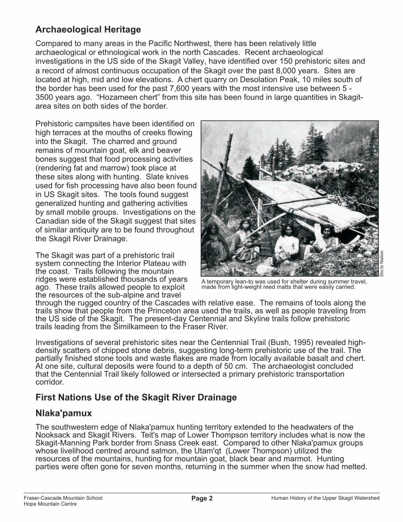
The southwestern edge of Nlaka'pamux hunting territory extended to the headwaters of the Nooksack and Skagit Rivers. Teit's map of Lower Thompson territory includes what is now the Skagit-Manning Park border from Snass Creek east. Compared to other Nlaka'pamux groups whose livelihood centred around salmon, the Utam'qt (Lower Thompson) utilized the resources of the mountains, hunting for mountain goat, black bear and marmot. Hunting parties were often gone for seven months, returning in the summer when the snow had melted.
A temporary lean-to was used for shelter during summer travel,made from light-weight reed matts that were easily carried.
Sto
:lo N
atio
n
Fraser-Cascade Mountain SchoolHope Mountain Centre
Human History of the Upper Skagit WatershedPage 3
The Nlaka'pamux were considered enemies of the Upper Skagit, coming overland into Skagit territory (below the present Canada - US border) in winter on snowshoes and returning in summer to fish.
The Nlaka'pamux obtained stone for arrowheads in the upper reaches of the Skagit River. Ethnobotany of the Nlaka'pamux lists extensive use of plants that can be found in the Cascades, including a decoction of rhododendron bark used as a stomach remedy.
Sto:lo
The term Sto:lo is used for Coast Salish communities living along the Lower Fraser River from just above Yale to the Fraser Delta. Hunting parties from Ohamil (a Sto:lo community near Hope) went into the mountains several days travel east of Hope. They would often meet Nlaka'pamux and Skagit hunting groups, and there appeared to be no conflict over the shared use of the Cascade Mountains and Skagit River. Prior to European settlement, Chilliwack men hunted and trapped in the Cascade Range into the Skagit and Nooksack drainages. Sto:lo ethnobotany includes the use of sub-alpine plants and berries, such as Yellow Glacier Lily (Erythronium grandiflorum). With its mixture of interior and coastal plant and animal species, the Skagit area was important for resources that could not be obtained elsewhere in Sto:lo territory. The Skagit and Coquihalla Rivers were known to the Sto:lo as a source of soapstone used for small carvings and sculptured bowls.
Upper Skagit
The Upper Skagit people based their livelihood on the Skagit River. The original name for the people of this area is bastulekw (meaning “river people'). The name "Skagit" is derived from their name for their language "sqajit ucid." The northwestern boundary of Upper Skagit territory was south of the headwaters of the Skagit River near Big Beaver Creek (now on Ross Lake). Skagit villages were situated around important salmon and steelhead harvesting sites. The northern-most permanent settlement on the Skagit River was deep within the Cascade Mountains near Newhalem in Washington State. Similar to the previous First Nations groups discussed, the Upper Skagit utilized the plant resources of the Cascade Mountains including Camas and Wild Carrot root crops. After 1897, with the establishment of the US National Forests, the Upper Skagit lost their traditional hunting rights in the region.
Trails and Trade Routes
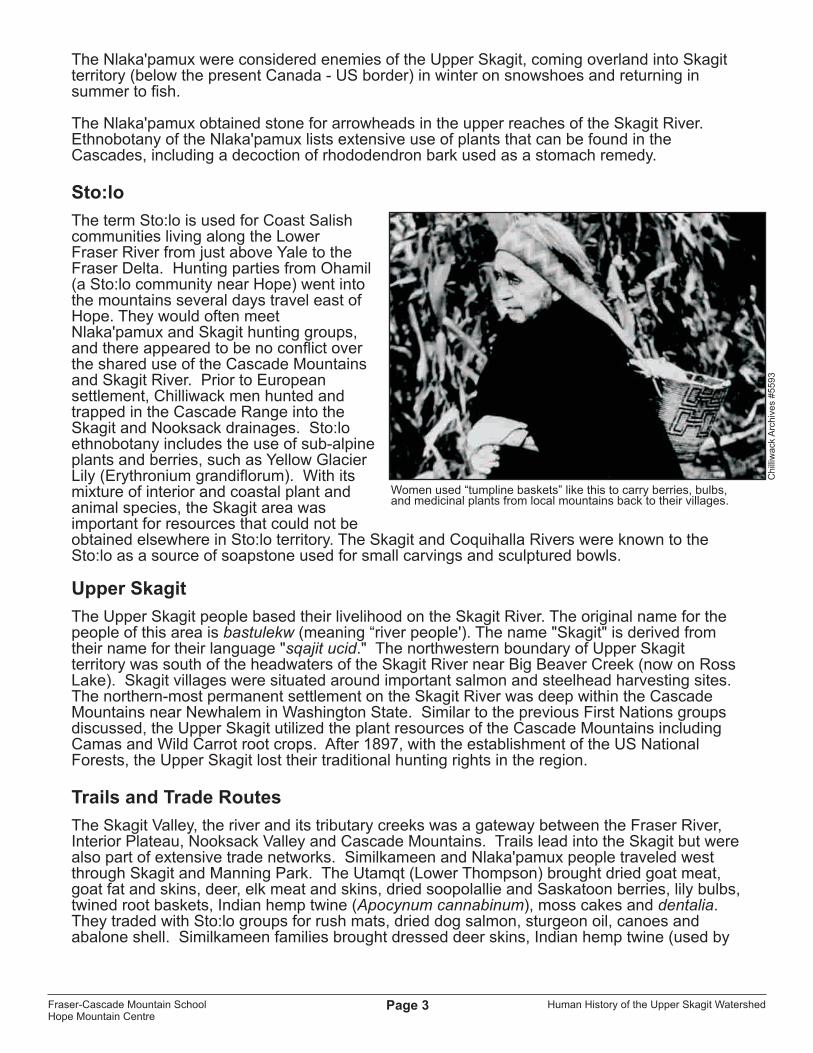
The Skagit Valley, the river and its tributary creeks was a gateway between the Fraser River, Interior Plateau, Nooksack Valley and Cascade Mountains. Trails lead into the Skagit but were also part of extensive trade networks. Similkameen and Nlaka'pamux people traveled west through Skagit and Manning Park. The Utamqt (Lower Thompson) brought dried goat meat, goat fat and skins, deer, elk meat and skins, dried soopolallie and Saskatoon berries, lily bulbs, twined root baskets, Indian hemp twine (Apocynum cannabinum), moss cakes and dentalia. They traded with Sto:lo groups for rush mats, dried dog salmon, sturgeon oil, canoes and abalone shell. Similkameen families brought dressed deer skins, Indian hemp twine (used by
Women used “tumpline baskets” like this to carry berries, bulbs, and medicinal plants from local mountains back to their villages.
Ch
illiw
ack
Arc
hiv
es
#5
59
3
Fraser-Cascade Mountain SchoolHope Mountain Centre

Human History of the Upper Skagit WatershedPage 4
the Sto:lo for fish nets), bitter-root (Lewisia rediviva) and Mariposa Lily (Calochortus macrocarpus) corms in exchange for dried salmon.
As well as the ridge trails mentioned previously, several other trails connected the Fraser River to the Skagit via the Coquihalla River to Nicolum Creek and the Sumallo River. Wells “Map of Indian Territory” (1966) shows a prehistoric trail leading from Chilliwack Lake east along Depot Creek to Maselpanik Creek, flowing into the Klesilkwa and finally Skagit River.
Trails connected the Upper Skagit people with the Nooksack River area. The Upper Skagit also traveled through passes over the Cascades into eastern Washington. Wells map shows an extensive trail system going from the Chilliwack area into the Nooksack River and Bellingham Bay area. The Whatcom Trail later followed these same routes.
EUROPEAN CONTACT IN THE UPPER SKAGIT
The first European man to travel through the Skagit was Alexander Ross. He was an employee of the Pacific Fur Trading Company, which was later taken over by the Northwest Company. He used a traditional native route – the Skyline Trail – to pass east over the Cascades in January 1813. Ross is also noted for his establishment of Fort Kamloops in 1812 (Fraser et al., 1989).
Ma
p D
esi
gn
: K
elly
Pe
arc
e
Fraser-Cascade Mountain SchoolHope Mountain Centre

Human History of the Upper Skagit WatershedPage 5
THE FUR TRADEThe fur trade was the dominant economic activity undertaken by Europeans arriving in BC
thduring the early 19 century. Hudson's Bay Company (HBC) forts were built at Langley (1827), Victoria (1843), Hope (1848), and Yale (1848). The fur trade was largely a mutually-beneficial exchange between Europeans and First Nations during those years. Europeans gained valuable furs, salmon, and cranberries from natives, in addition to detailed geographical knowledge about travel routes in the region. In return, First Nations gained access to valuable goods such as steel tools, cooking pots, guns, and blankets. Some Sto:lo moved their villages closer to HBC forts to facilitate trade (Sto:lo Nation, 2001). Europeans were a small minority at this time, and native culture and political power remained intact.
Fur Trails in the Upper Skagit
All of the aboriginal groups connected with the Skagit Region were directly affected by European exploration and the new fur-trading economies. European explorers and trail builders relied on the expertise of native guides.
1846 – An “All-British” Route Through the Cascades
When the United States and Britain established the 49th parallel as the new international boundary in 1846, British fur traders lost access to the Columbia River. The Columbia had been their most important transportation route to the Pacific Ocean. That same year (1846), Alexander Caulfield Anderson of the Hudson's Bay Company proposed that an “all-British” route was urgently needed through the Cascade Mountains. This overland route would replace the Columbia River, connecting Fort Kamloops in the Okanagan to Fort Langley on the Fraser River (Fraser et al., 1989; Harris & Hatfield, 1982).
With HBC approval, A.C. Anderson began surveying his route in June of 1846. With the help of Sto:lo and Upper Similkameen native guides, he travelled east from the Sto:lo village of “Ts'qo:ls” (later called Fort Hope), up the Coquihalla River to its confluence with Nicolum Creek, then up the Nicolum to Outram Lake (buried by the Hope Slide in 1965). From here, he travelled south-east down the Sumallo River to its junction with the Skagit River (present-day Sumallo Grove rest stop in Manning Park). Highway-3 still follows Anderson's route to this point and slightly beyond. Anderson followed the Skagit River Valley north-east past Rhododendron Flats to the Skagit Bluffs -- here, in the vicinity of the Cascade Recreation Area parking lot, Anderson left the Skagit and turned up Snass Creek. Following the east fork of the Snass, Anderson came upon a lake which he named “the Punch Bowl”. This lake is the source of the Tulameen River which Anderson followed downstream into Paradise Valley and all the way to the settlement of Tulameen in the Okanagan. From there, his party headed north-west to Fort Kamloops (Fraser et al., 1989). Anderson recorded place names such as Nicolum, Sumallo, and Skaist, based on native names given by his guides (Bufo Inc., 1997). This was the first documented trip through BC's Cascade Mountains.
A.C. Anderson
BC
Arc
hiv
es
# A
-01
07
5
Fraser-Cascade Mountain SchoolHope Mountain Centre

Human History of the Upper Skagit WatershedPage 6
1848 – The HBC “Brigade Trail”
Anderson's route was initially considered too rugged (an opinion shared by Anderson). Henry Peers of the HBC founded Fort Hope in 1848 and established a more practical route through the Cascades that year. Called the “Hope Brigade Trail”, this route traveled farther up the Coquihalla River past Nicolum Creek before turning east up Peers Creek. It crossed through the Sowaqua and Podunk Creek watersheds before linking-up with A.C. Anderson's route at the Tulameen River, just downstream from Paradise Valley. But unlike Anderson's route, Peers avoided the rugged canyons of the Tulameen. Instead, his trail took a more direct route over the Tulameen Plateau to the town of Tulameen via an Indian trade route called “Blackeye's Trail”. This route was originally shown to A.C. Anderson by a respected native chief named Blackeye who lived near Tulameen. Blackeye's son-in-law led Henry Peers across this new route (Fraser et al., 1989; Harris & Hatfield, 1982). It would be the HBC's dominant trade route for the next 10 years.
GOLD FEVER HITS THE CASCADES
In 1858, gold was discovered on the Fraser River between Hope and Yale, triggering the “Fraser River Gold Rush” and the arrival of 30,000 miners from California.
Some native people participated in the gold rush economy, selling food and renting boats to miners, and working as steamboat pilots, prospectors and gold panners. In fact, natives had been quietly trading placer gold with HBC forts for years before the rush of ‘58.
But the sudden influx of thousands of miners into Sto:lo, Nlaka'pamux, and Upper Skagit territory was a catastrophic event, undermining their culture, economy, and political power in
the region.
In summer, brigades of up to 400 men, cattle, and pack horses regularlypounded the trails leading over the Cascade Mountains.
Sto:lo people placer mining on the Fraser River.
(Left) Fort Hope in 1860, formerly the Sto:lo village of “Ts'qo:ls”. This quiet fur-trading post became a raucous boom town in 1858.
Hu
dso
n’s
Ba
y C
om
pa
ny
Arc
hiv
es
# N
62
85
BC
Arc
hiv
es
# D
06
81
5B
C A
rchive
s # A
-03
53
0
Fraser-Cascade Mountain SchoolHope Mountain Centre
Human History of the Upper Skagit WatershedPage 7
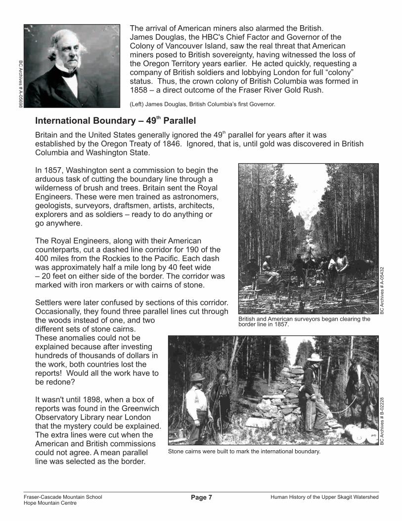
The arrival of American miners also alarmed the British. James Douglas, the HBC's Chief Factor and Governor of the Colony of Vancouver Island, saw the real threat that American miners posed to British sovereignty, having witnessed the loss of the Oregon Territory years earlier. He acted quickly, requesting a company of British soldiers and lobbying London for full “colony” status. Thus, the crown colony of British Columbia was formed in 1858 – a direct outcome of the Fraser River Gold Rush.
thInternational Boundary – 49 Parallel
thBritain and the United States generally ignored the 49 parallel for years after it was established by the Oregon Treaty of 1846. Ignored, that is, until gold was discovered in British Columbia and Washington State.
In 1857, Washington sent a commission to begin the arduous task of cutting the boundary line through a wilderness of brush and trees. Britain sent the Royal Engineers. These were men trained as astronomers, geologists, surveyors, draftsmen, artists, architects, explorers and as soldiers – ready to do anything or go anywhere.
The Royal Engineers, along with their American counterparts, cut a dashed line corridor for 190 of the 400 miles from the Rockies to the Pacific. Each dash was approximately half a mile long by 40 feet wide – 20 feet on either side of the border. The corridor was marked with iron markers or with cairns of stone.
Settlers were later confused by sections of this corridor. Occasionally, they found three parallel lines cut through the woods instead of one, and twodifferent sets of stone cairns. These anomalies could not be explained because after investing hundreds of thousands of dollars in the work, both countries lost the reports! Would all the work have to be redone?
It wasn't until 1898, when a box of reports was found in the Greenwich Observatory Library near London that the mystery could be explained. The extra lines were cut when the American and British commissions could not agree. A mean parallel line was selected as the border.
(Left) James Douglas, British Columbia’s first Governor.
British and American surveyors began clearing theborder line in 1857.
Stone cairns were built to mark the international boundary.
BC
Arch
ives #
A-0
56
98
BC
Arc
hiv
es
# A
-05
43
2B
C A
rch
ive
s #
B-0
22
28
Fraser-Cascade Mountain SchoolHope Mountain Centre

Human History of the Upper Skagit WatershedPage 8
Gold Rush Trails in the Skagit
Gold fever eclipsed the fur trade and drove the construction of new trails and roads to bring miners to the gold fields.
1858 – Whatcom Trail
American businessmen in the town of Whatcom (in Washington State) wanted Whatcom to replace Fort Victoria as the major shipping port on the way to the gold fields. They also wanted American miners to avoid paying customs fees to the British Crown. Thus, U.S. Army engineer Captain W.W. De Lacy was hired to construct a trail to the BC goldfields. Called the Whatcom Trail, it crossed into Canada at a point east of Fort Langley, then turned east to Chilliwack Lake and into the Skagit River Valley. While moving north up the Skagit, De Lacy was thrilled to receive a copy of A.C. Anderson's “Routes to the Goldfields” (printed in San Francisco). He joined Anderson's route at Sumallo Grove and followed it up Snass Creek to the Punch Bowl. From there, the Whatcom Trail passed down the Tulameen before linking-up with the HBC “Hope Brigade Trail” that crossed the Tulameen Plateau to the Okanagan. In total, the route traveled over 400 kilometres and crossed three 1,800-metre summits -- a route so difficult that American miners abandoned it after a few years (Harris & Hatfield, 1982).
1860 – Dewdney Trail
In 1859, a new gold strike at Rock Creek (east of Princeton) brought more American miners from the south. Governor Douglas called for a “mule road to the Similkameen” to give British miners and administrators easier access to the Okanagan gold fields and allow the Colony of British Columbia to collect import taxes on American equipment and supplies, as well as duty on gold leaving the colony.
Edgar Dewdney was awarded the contract to build the “The Queen's Trail” in 1860. His was the lowest bid at 76 pounds sterling (400-500 dollars at that time) per mile. Dewdney was required to build a trail no less than four feet wide, with a 1.5-foot, smooth, hard centre to provide sure footing for pack animals. The grade was required to be no steeper than one foot rise for every twelve feet of trail length. All wet areas were filled or corduroyed with logs, and culverts were installed for drainage. Bridges had to be no less than twelve feet across, for future upgrade to a wagon road (Fraser et al.,1989; Harris & Hatfield, 1982).
Dewdney followed A.C. Anderson's 1846 route from Fort Hope as far as Snass Creek. However, Dewdney's route took the north fork of the Snass, avoiding Anderson's route through the Punch Bowl. After passing over the Cascade Divide and into Paradise Valley, the Dewdney trail turns sharply east toward Hope Pass (on the northeast boundary of Cascade Recreation Area) and down into Whipsaw Creek toward Vermillion Forks (now Princeton). By 1865, the Dewdney Trail was extended all the way to Wildhorse Creek (near Fort Steele) in the Rocky Mountains where yet another gold rush had begun.
EdgarDewdney
53
74
0-A
# sevi
hcrA
CB
Fraser-Cascade Mountain SchoolHope Mountain Centre

Human History of the Upper Skagit WatershedPage 9
1861 – The Royal Engineers' Road
In 1861, as Dewdney was still building his mule trail, the Royal Engineers were commissioned by Governor Douglas to upgrade the Dewdney Trail to a wagon road. In the fall of 1861, the Royal Engineers led by Captain Jack M. Grant upgraded theDewdney Trail as far as Snass Creek. However, they had tohalt construction when miners objected to a proposed road tax and the Cariboo gold rush diverted attention to the Fraser Canyon. Wagons did use the finished portion of the road though, transferring their loads from wagon to pack horse whenthe road returned to trail at the junction of Snass Creek and the Skagit River (Fraser et al., 1989; Harris & Hatfield, 1982).
1861 – Hope Pass Trail
While Captain Grant and his sappers converted Dewdney's trail to a wagon road, they also improved on Dewdney's original route by re-locating the mule trail up Skaist Creek further east. Here the terrain was less rugged – the Skaist was easier to negotiate than the slide-prone canyons of the Snass (Tagles, 1982 in Fraser et al., 1989). Grant's trail went up the Skaist to Hope Pass where it re-connected with the Dewdney Trail and continued as far as Vermillion Forks (now Princeton). Called the Hope Pass Trail, it remained the major pack horse route through the Cascades for the next 60 years (Harris & Hatfield, 1982).
Products such as fur, gold, cattle, and sheep moved from the interior to the coast, bound for English ships. The trail also carried mail, tools, supplies, pioneers, doctors, and magistrates eastward to Interior settlements (Harris & Hatfield, 1982).
The Royal Engineers’ Road, 17 miles east of Fort Hope (pictured here in the 1880’s).
The Royal Engineers, shown here building the Cariboo Wagon Road in 1862. They were just 165 men, but in a few short years they built many of BC’s first roads and towns. They were soldiers, nicknamed “Sappers” – trained as doctors, draftsmen, stone masons, carpenters, blacksmiths, and printers. They also helpedto survey the international border through the Skagit Valley.
The Hope Pass Trail at Skagit Bluffs.
Fo
rgin
g A
Ne
w H
op
e, P
ag
e 5
0B
C A
rchive
s # P
DP
-03
69
6B
C A
rch
ive
s #
D-0
68
05
Fraser-Cascade Mountain SchoolHope Mountain Centre

Human History of the Upper Skagit WatershedPage 10
Hundreds of pack animals would travel together on this trail during the short summer pack season. Each animal carried its load in 90-lb “pieces”, two to a horse (Harris & Hatfield, 1982). Walsh et al. (1984) describe the excitement that would spread through Fort Hope when “brigades” containing 3-400 men, horses and cattle arrived in town, weary from their trek through the Cascades. Overnight camps were located every 15 to 20 miles along the trail, and sites were chosen with ample meadow where the animals could graze. Some meadows were sewn with additional grasses such as Timothy (Harris & Hatfield, 1982). Hilton (1997) comments that good grazing was often in short supply during the intensive pack season, and numerous trails would branch off the main trail in order to access fresh pasture.
Historic Trails of the North CascadesThe map below summarizes some of the fur and gold trails previously discussed.
1879 to 1880 – Ruby Creek Gold Rush
Good placer gold was found in Ruby Creek, a tributary of the Skagit River in the United States, in 1879. Prospectors used the route from Hope via the Dewdney Trail to reach the mines as the British Columbian side of the route was shorter and presented no dangerous obstacles. The distance from Hope to the junction of the Sumallo and Skagit rivers was 23 miles, and Skagit to the diggings another 25 miles. The trail from Seattle was impracticable for pack
o
Ma
p D
esi
gn
: K
elly
Pe
arc
e
Fraser-Cascade Mountain SchoolHope Mountain Centre

Human History of the Upper Skagit WatershedPage 11
animals and dangerous for foot passengers. Victoria's “Daily Colonist” made fun of the American route, stating that "before the miners of the Skagit can be supplied with provisions it will be necessary to institute a new race of quadrupeds – after the model of the flying dragons or winged horses of fairyland ... a sufficient number of eagles might be broken to the service."
The people of Chilliwack set out at their own expense to clear a trail to the Skagit which they believed would capture the bulk of the traffic going to the Ruby Creek Rush. Whatcom also set to work to clear a path to intersect with the trail from Chilliwack. This route, known as the Sourdough Route, encountered such hardships as Cemetery Canyon, Skeleton pass, Lunatic's Leap, Frozen Hill, and Devil's Grip. In addition, the miners themselves blazed a trail from the international boundary to Ruby Creek. But by August 1880, few claims were paying anything and the miners were leaving the area. Miles of wing dams, waterwheels, pumps, machinery, tools, cabins, sluices and lumber were all abandoned in the wilderness.
Although many miners passed through present-day Skagit Valley Provincial Park, no significant discoveries of placer or lode metals were made within present-day park boundaries.
The map below (published in 1880) guided miners from Fort Hope to the Skagit Valley, during the Ruby Creek Gold Rush.
Fraser-Cascade Mountain SchoolHope Mountain Centre
1879 – Naming Steamboat Mountain
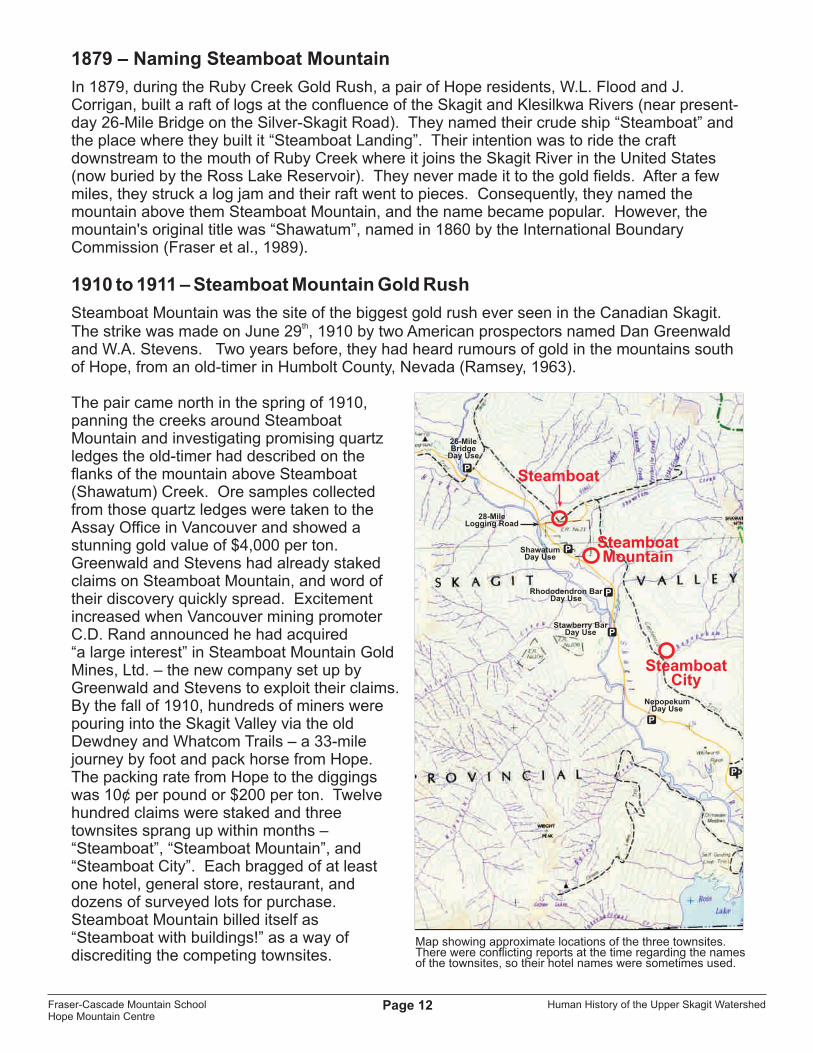
In 1879, during the Ruby Creek Gold Rush, a pair of Hope residents, W.L. Flood and J. Corrigan, built a raft of logs at the confluence of the Skagit and Klesilkwa Rivers (near present-day 26-Mile Bridge on the Silver-Skagit Road). They named their crude ship “Steamboat” and the place where they built it “Steamboat Landing”. Their intention was to ride the craft downstream to the mouth of Ruby Creek where it joins the Skagit River in the United States (now buried by the Ross Lake Reservoir). They never made it to the gold fields. After a few miles, they struck a log jam and their raft went to pieces. Consequently, they named the mountain above them Steamboat Mountain, and the name became popular. However, the mountain's original title was “Shawatum”, named in 1860 by the International Boundary Commission (Fraser et al., 1989).
1910 to 1911 – Steamboat Mountain Gold Rush
Steamboat Mountain was the site of the biggest gold rush ever seen in the Canadian Skagit. th
The strike was made on June 29 , 1910 by two American prospectors named Dan Greenwald and W.A. Stevens. Two years before, they had heard rumours of gold in the mountains south of Hope, from an old-timer in Humbolt County, Nevada (Ramsey, 1963).
The pair came north in the spring of 1910, panning the creeks around Steamboat Mountain and investigating promising quartz ledges the old-timer had described on the flanks of the mountain above Steamboat (Shawatum) Creek. Ore samples collected from those quartz ledges were taken to the Assay Office in Vancouver and showed a stunning gold value of $4,000 per ton. Greenwald and Stevens had already staked claims on Steamboat Mountain, and word of their discovery quickly spread. Excitement increased when Vancouver mining promoter C.D. Rand announced he had acquired “a large interest” in Steamboat Mountain Gold Mines, Ltd. – the new company set up by Greenwald and Stevens to exploit their claims. By the fall of 1910, hundreds of miners were pouring into the Skagit Valley via the old Dewdney and Whatcom Trails – a 33-mile journey by foot and pack horse from Hope. The packing rate from Hope to the diggings was 10¢ per pound or $200 per ton. Twelve hundred claims were staked and three townsites sprang up within months – “Steamboat”, “Steamboat Mountain”, and “Steamboat City”. Each bragged of at least one hotel, general store, restaurant, and dozens of surveyed lots for purchase. Steamboat Mountain billed itself as “Steamboat with buildings!” as a way of discrediting the competing townsites.
Human History of the Upper Skagit WatershedPage 12
Map showing approximate locations of the three townsites.There were conflicting reports at the time regarding the namesof the townsites, so their hotel names were sometimes used.
Rhododendron BarDay Use
Stawberry BarDay Use
ShawatumDay Use
26-Mile Bridge
Day Use
NepopekumDay Use
28-MileLogging Road
Steamboat
SteamboatMountain
SteamboatCity
Fraser-Cascade Mountain SchoolHope Mountain Centre

Human History of the Upper Skagit WatershedPage 13
The town of Steamboat had its own newspaper, the “Hope-Steamboat Nugget”, and was the first to establish a Board of Trade to oversee “sanitation, fire protection, street paving, and lighting”. For its part, Steamboat City announced plans to build an aerial tramway directly from town to the mine site and bragged of “90 surveyed lots” (Walsh et al., 1984; Johnston, 1911).
The satellite towns of Princeton, Hope, and Chilliwack all vied for the title “Gateway to Steamboat” in an attempt to profit from the rush. The Hope newspaper “Hope News & Gold Trail” confidently predicted that Hope would soon become famous for its skyscrapers. All the town newspapers and local boards of trade worked to fan the flames of gold fever, describing the Skagit Valley as an “Eldorado”, “richer than Barkerville” and “bigger than the Klondike” (Patterson, 1977).
But by the summer of 1911, scepticism began to grow among some of the miners on Steamboat Mountain. No one was finding much gold. C.D. Rand, the fiscal agent of the Steamboat Mountain Gold Mines Ltd., traveled to the Skagit to investigate for himself. When he arrived at his company's mine shaft on Steamboat Mountain, he was surprised to find armed guards who were under orders to not let anyone inside the mine. His business associates Dan Greenwald and W.A. Stevens were nowhere to be found, and it was later revealed that they had sold their stake in the company for $80,000 and returned to the United States. Greenwald and Stevens had “salted” the Steamboat mineral samples with gold from other mining areas. The Steamboat gold strike was a hoax! (Walsh et al., 1984).
Greenwald departed for South America, while Stevens returned to California, spending his ill-gotten gains on new mining ventures. When Dan Greenwald appeared in New York a few months after the Steamboat bubble had burst, he was questioned by reporters and piously denounced “wicked men who lure poor miners to worthless ground by sending out false reports”. His partner in crime, W.A. Stevens, committed suicide a few months later – not from guilt, but because his latest mining venture had collapsed (Ramsey, 1963).
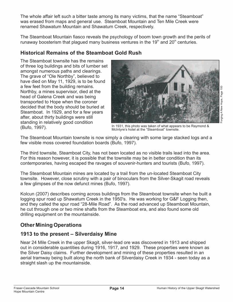
Raymond & McIntyre’s hotel at the “Steamboat” townsite, 1911.
Still & McDonald’s Hotel at the “Steamboat Mountain” townsite, 1911.
Pack horses leaving Hope for the Steamboat gold fields, 1911.
BC
Ma
ga
zin
e, V
ol.
7, N
o..7
, Ju
ly, 1
911
BC
Ma
ga
zin
e, V
ol.
7, N
o..7
, Ju
ly, 1
911
Fo
rgin
g A
Ne
w H
op
e, P
ag
e 1
00
Fraser-Cascade Mountain SchoolHope Mountain Centre
Human History of the Upper Skagit WatershedPage 14
The whole affair left such a bitter taste among its many victims, that the name “Steamboat” was erased from maps and general use. Steamboat Mountain and Ten Mile Creek were renamed Shawatum Mountain and Shawatum Creek, respectively.
The Steamboat Mountain fiasco reveals the psychology of boom town growth and the perils of th th
runaway boosterism that plagued many business ventures in the 19 and 20 centuries.
Historical Remains of the Steamboat Gold Rush
The Steamboat townsite has the remains of three log buildings and bits of lumber set amongst numerous paths and clearings. The grave of “Ole Northby”, believed to have died on May 11, 1929, is to be found a few feet from the building remains. Northby, a mines supervisor, died at the head of Galena Creek and was being transported to Hope when the coroner decided that the body should be buried at Steamboat. In 1929, and for a few years after, about thirty buildings were still standing in relatively good condition (Bufo, 1997).
The Steamboat Mountain townsite is now simply a clearing with some large stacked logs and a few visible moss covered foundation boards (Bufo, 1997).
The third townsite, Steamboat City, has not been located as no visible trails lead into the area. For this reason however, it is possible that the townsite may be in better condition than its contemporaries, having escaped the ravages of souvenir-hunters and tourists (Bufo, 1997).
The Steamboat Mountain mines are located by a trail from the un-located Steamboat City townsite. However, close scrutiny with a pair of binoculars from the Silver-Skagit road reveals a few glimpses of the now defunct mines (Bufo, 1997).
Kolcun (2007) describes coming across buildings from the Steamboat townsite when he built a logging spur road up Shawatum Creek in the 1950's. He was working for G&F Logging then, and they called the spur road “28-Mile Road”. As the road advanced up Steamboat Mountain, he cut through one or two mine shafts from the Steamboat era, and also found some old drilling equipment on the mountainside.
Other Mining Operations
1913 to the present – Silverdaisy Mine
Near 24 Mile Creek in the upper Skagit, silver-lead ore was discovered in 1913 and shipped out in considerable quantities during 1916, 1917, and 1929. These properties were known as the Silver Daisy claims. Further development and mining of these properties resulted in an aerial tramway being built along the north bank of Silverdaisy Creek in 1934 - seen today as a straight slash up the mountainside.
o
o
In 1931, this photo was taken of what appears to be Raymond & McIntyre’s hotel at the “Steamboat” townsite.
Fo
rgin
g A
Ne
w H
op
e, P
ag
e 1
00
Fraser-Cascade Mountain SchoolHope Mountain Centre

Human History of the Upper Skagit WatershedPage 15
Between 1931 - 32, Consolidated Mining and Smelting Company made an attempt to mine placer gold by drilling test holes up to 150 feet in the valley bottom just north of the International Boundary (Bufo Inc., 1997).
Further interest in mine exploration was generated by the construction of the Silver-Skagit Logging Road in 1946. No commercially-viable operation was developed and in 1966 an Order-in-Council reserved all lands below 1,800 feet from mineral claims due to the proposed flooding of the Ross Lake Reservoir .
The swath of the Silverdaisy Mine aerial tram built in 1934 can be seen from the Hope-Princeton highway just within the western entrance of Manning Park. As of 2007, the Silver Daisy Mine is very active in response to high base metals prices.
It's worth noting that Silverdaisy and other mineral strikes during that era, were the indirect result of the Steamboat fiasco of 1910. The excitement of that hoax attracted miners who stayed and prospected after the Steamboat bubble burst (Walsh, 1984).
1940's to 1950's – Foundation Mines
A group of old, decaying cabins belonging to the “Foundation Mines” are located 8.3 km from the West Gate of Manning Park, on the south side of the Sumallo River. The cabins are highly visible to passing motorists moving east on Highway-3, and cars often stop here to look at the buildings.
The cabins were built in the 1940's and occupied by miners up until the 1950's. Mine shafts were drilled into the mountainside above the cabins in search of copper and silver ore (Hilton, 1997). At the present rate of decay, these cabins will eventually disappear from view.
1929 – Ghost Pass Lake Trail
Built by C.E. Devereux in 1929 as a link between the Dewdney and HBC Brigade Trail (Walsh et al., 1984), it was restored for recreational hiking by the Skagit Environmental Endowment Commission in 2007. Described as a “little-used horse trail” by Fraser et al. (1989).
RANCHING AND HOMESTEADING
1883 – George Gordon
George Gordon homesteaded at Lot 221 on the east side of the Skagit Valley in 1883. He was a hunter, miner and prospector and was also known as the finest skin-mounter around. One spring a native trapper found Gordon dead over his unlit stove. Two men snowshoed in from Hope to bury him on the ranch (Bufo, 1997).
o
The Silverdaisy aerial tram can be seen running down the side of Silverdaisy Mountain (view from Highway-3, west of Sumallo Grove).
Ruins of the Foundation Mines cabins(view from Highway-3, west of Sumallo Grove).
Ke
lly P
ea
rce
Ke
lly P
ea
rce
Fraser-Cascade Mountain SchoolHope Mountain Centre

Human History of the Upper Skagit WatershedPage 16
1889 – Francis Cawley
Fracis Cawley homesteaded at Lot 222 on the west side of the river in 1889, but little is known about the developments he made, if any, on his land.
1906 – The Whitworth Ranch Site
Henry Robert Whitworth emigrated to Canada in 1882. He later joined the Moose Mountain Scouts and served during the Riel Rebellion. After farming in Manitoba for twenty years, Whitworth owned a cattle ranch in the Skagit Valley from 1904 - 1929 until the land was sold to Seattle City Light as part of the proposed Ross Dam Reservoir (Bufo, 1997).
The Whitworth family built the ranch in 1906 when the British Columbia government was planning to build a road up Silver Creek through the Skagit Valley to Princeton. Whitworth spent years developing the ranch, bringing up supplies and a portable sawmill. He built a 10-room house, outbuildings and furniture from lumber cleared from the land, and brought in dairy and beef cattle, pigs, horses and chickens.
After a few years, hard luck hit the Whitworths; illnessstruck several family members, forcing them to settlein Chilliwack. A caretaker was left in charge but he laterdied, and the livestock perished from hunger in the barns. The ranch was abandoned in 1910.
The Whitworths never returned and for years the ranch was deserted. The house was used by trappers and hikers before the buildings fell into ruin and brush reclaimed the land (Bufo, 1997). Martin Grainger mentions staying at the ranch during horseback riding trips in the 1930’s, and remarks that in that same era, Mary Warburton stayed there while hiking alone over the Skyline Trail (Murray, 1994).
Seattle City Light destroyed the buildings of the Whitworth Ranch in preparation for flooding the valley. All that remains is a depression where the ranch house stood and some boards and a staircase which possibly belonged to it (Bufo, 1997).
o
o
The Whitworth Ranch house (date unknown).
Whitworth family at their cabin in Hope, 1908. Robert Henry Whitworth, Eleanor Anne Whitworth, and daughters (left to right) Charlotte, Florence, Margaret, Mary, Francis, and Helen.
Another view of the Whitworth Ranch house (date unknown).
Gu
ida
Fe
eG
uid
a F
ee
Fo
rgin
g A
Ne
w H
op
e, P
ag
e 1
60
Fraser-Cascade Mountain SchoolHope Mountain Centre

Human History of the Upper Skagit WatershedPage 17
1910 – Charlie Howlett Homestead
Charlie Howlett was an American miner and trapper who came to the Skagit as a gold seeker during the Steamboat MountainGold Rush. He settled in the valley after the boom went bust, living as a trapper and occasional placer miner.
On the west side of the road north of Nepopekum Creek lie the remains of Charlie Howlett's homestead. Remains include a second cabin foundation (the original was burnt by Seattle City Light), corral fencing, and an interesting root cellar in amazingly good condition (Bufo, 1997).
In 1931, Morris Neville recalled this about Charlie Howlett:
...“his various cabins were widespread along his traplines, and if he wasn't home in one place, he'd be at home in the next. A wonderful chap, although I didn't meet him that day. He had a sign up on his cabin which read: “Help yourself and leave a clean camp” (Bufo, 1997).
1930's – Martin Starret Cabin
North of the Silvertip Campground, is the log cabin and stable of Martin Sterret, a trapper who moved to the Skagit during the hungry thirties. The two-room cabin is in good condition as is the stable which has three sections (Bufo, 1997).
HYDROELECTRIC DEVELOPMENT
1930's to present – The Ross Lake Dam
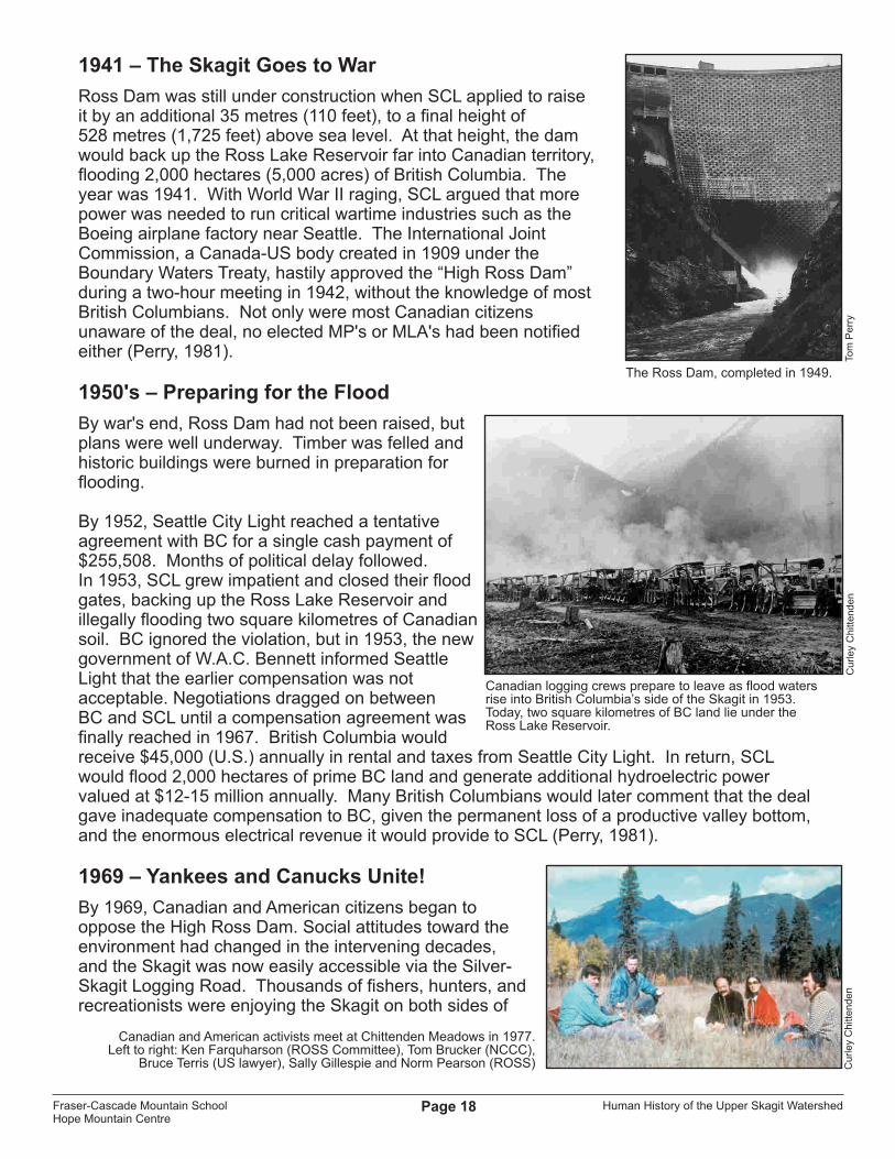
Back as far as 1916, Seattle City Light (SCL) had ambitious plans for the Skagit River. The boomtown of Seattle needed hydroelectric power, and the residents of the Lower Skagit wanted flood protection. SCL dammed the river at Gorge Creek and Diablo Canyon, and by 1937, a third dam was under construction at Ruby Creek. Called Ross Dam, it was designed to be built in four stages. When the third stage was completed in 1949, the Ross Dam stood 165 metres (540 ft.) high, at an elevation above sea level of 493 metres (1,615 feet). That is the Ross Dam's height today, creating the 35-kilometre-long Ross Lake Reservoir, which reached “full pool” in 1953. However, the Ross Dam was designed to grow even higher (Perry, 1981).
o
o
o
Charlie Howlett (right) at the Whitworth Ranch, 1929.
Construction began on the Ross Dam in 1937, one of three dams built on the American Skagit.
No
rth
Ca
sca
de
s N
atio
na
l Pa
rk S
erv
ice
Co
mp
lex
Bu
d H
ed
stro
m
Fraser-Cascade Mountain SchoolHope Mountain Centre
Human History of the Upper Skagit WatershedPage 18
1941 – The Skagit Goes to War
Ross Dam was still under construction when SCL applied to raise it by an additional 35 metres (110 feet), to a final height of 528 metres (1,725 feet) above sea level. At that height, the dam would back up the Ross Lake Reservoir far into Canadian territory, flooding 2,000 hectares (5,000 acres) of British Columbia. The year was 1941. With World War II raging, SCL argued that more power was needed to run critical wartime industries such as the Boeing airplane factory near Seattle. The International Joint Commission, a Canada-US body created in 1909 under the Boundary Waters Treaty, hastily approved the “High Ross Dam” during a two-hour meeting in 1942, without the knowledge of most British Columbians. Not only were most Canadian citizens unaware of the deal, no elected MP's or MLA's had been notified either (Perry, 1981).
1950's – Preparing for the Flood
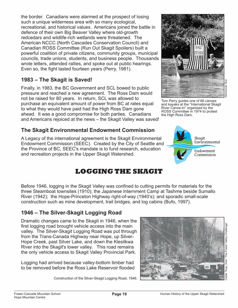
By war's end, Ross Dam had not been raised, but plans were well underway. Timber was felled and historic buildings were burned in preparation for flooding.
By 1952, Seattle City Light reached a tentative agreement with BC for a single cash payment of $255,508. Months of political delay followed. In 1953, SCL grew impatient and closed their flood gates, backing up the Ross Lake Reservoir and illegally flooding two square kilometres of Canadian soil. BC ignored the violation, but in 1953, the new government of W.A.C. Bennett informed Seattle Light that the earlier compensation was not acceptable. Negotiations dragged on between BC and SCL until a compensation agreement was finally reached in 1967. British Columbia would receive $45,000 (U.S.) annually in rental and taxes from Seattle City Light. In return, SCL would flood 2,000 hectares of prime BC land and generate additional hydroelectric power valued at $12-15 million annually. Many British Columbians would later comment that the deal gave inadequate compensation to BC, given the permanent loss of a productive valley bottom, and the enormous electrical revenue it would provide to SCL (Perry, 1981).
1969 – Yankees and Canucks Unite!
By 1969, Canadian and American citizens began to oppose the High Ross Dam. Social attitudes toward the environment had changed in the intervening decades, and the Skagit was now easily accessible via the Silver-Skagit Logging Road. Thousands of fishers, hunters, and recreationists were enjoying the Skagit on both sides of
The Ross Dam, completed in 1949.
Canadian logging crews prepare to leave as flood waters rise into British Columbia’s side of the Skagit in 1953. Today, two square kilometres of BC land lie under the Ross Lake Reservoir.
Canadian and American activists meet at Chittenden Meadows in 1977. Left to right: Ken Farquharson (ROSS Committee), Tom Brucker (NCCC),
Bruce Terris (US lawyer), Sally Gillespie and Norm Pearson (ROSS)
Tom
Pe
rry
Cu
rle
y C
hitt
en
de
nC
urle
y C
hitt
en
de
n
Fraser-Cascade Mountain SchoolHope Mountain Centre
Human History of the Upper Skagit WatershedPage 19
the border. Canadians were alarmed at the prospect of losing such a unique wilderness area with so many ecological, recreational, and historical values. Americans joined the battle in defence of their own Big Beaver Valley where old-growth redcedars and wildlife-rich wetlands were threatened. The American NCCC (North Cascades Conservation Council) and Canadian ROSS Committee (Run Out Skagit Spoilers) built a powerful coalition of private citizens, community groups, municipal councils, trade unions, students, and business people. Thousands wrote letters, attended rallies, and spoke out at public hearings. Even so, the fight lasted fourteen years (Perry, 1981).
1983 – The Skagit is Saved!
Finally, in 1983, the BC Government and SCL bowed to public pressure and reached a new agreement. The Ross Dam would not be raised for 80 years. In return, SCL was allowed to purchase an equivalent amount of power from BC at rates equal to what they would have paid had the High Ross Dam gone ahead. It was a good compromise for both parties. Canadians and Americans rejoiced at the news – the Skagit Valley was saved!
The Skagit Environmental Endowment Commission
A Legacy of the international agreement is the Skagit Environmental Endowment Commission (SEEC). Created by the City of Seattle and the Province of BC, SEEC's mandate is to fund research, education and recreation projects in the Upper Skagit Watershed.
LOGGING THE SKAGIT
Before 1946, logging in the Skagit Valley was confined to cutting permits for materials for the three Steamboat townsites (1910); the Japanese Internment Camp at Tashme beside Sumallo River (1942); the Hope-Princeton Highway right-of-way (1940’s); and sporadic small-scale construction such as mine development, trail bridges, and log cabins (Bufo, 1997).
1946 – The Silver-Skagit Logging Road
Dramatic changes came to the Skagit in 1946, when the first logging road brought vehicle access into the main valley. The Silver-Skagit Logging Road was put through from the Trans-Canada Highway near Hope, up Silver-Hope Creek, past Silver Lake, and down the Klesilkwa River into the Skagit's lower valley. This road remains the only vehicle access to Skagit Valley Provincial Park.
Logging had arrived because valley-bottom timber had to be removed before the Ross Lake Reservoir flooded
Tom Perry guides one of 66 canoes and kayaks at the “International Skagit River Canoe-In” organised by theROSS Committee in 1974 to protestthe High Ross Dam.
Construction of the Silver-Skagit Logging Road, 1946.
Va
nco
uve
r S
un
Ca
rte
r To
op
, fr
om
“T
he
Fra
ser
Va
lley
Ch
alle
ng
e”
Fraser-Cascade Mountain SchoolHope Mountain Centre

Human History of the Upper Skagit WatershedPage 20
the valley up to the Canada-US border. Most of the timber would be cut on the US side, but it was easier to access the timber via Canada than through the more-rugged American end. The Silver Skagit Logging Company was created to cut the timber and transport it to the Fraser River below Hope. From there, it was boomed down the river to sawmills in BC and Washington State. Logs from the American side of the reservoir were trucked to Washington (via Canada) for milling while Canadian logs were milled in BC. The two-square-kilometre portion of Canadian land that was drowned by the reservoir was logged by Canadian crews, under the supervision of Curley Chittenden. The Silver Skagit Logging Company was jointly owned by Decco Construction and Walton Lumber Company, both based in the United States. Local loggers in Hope often referred to the company as “Decco-Walton” (McCombs & Chittenden, 1990).
In 1946, gas-powered chain saws were still a new invention, and they made there debut in the Hope region during the logging of the Skagit. Another innovation by Decco-Walton was the use of large, rubber-tired trucks. The trucks were massive for that era, with 18 tires and 16-foot-wide log decks capable of carrying the huge old-growth logs that grew in the valley bottoms of the Skagit. The trucks were difficult to maintain, and a fleet of smaller trucks drove the road constantly, replacing blown tires and doing other general maintenance. The Decco-Walton operations continued until about 1954, shortly after the Ross Lake Reservoir reached “full pool” (McCombs & Chittenden, 1990; Steeves, 2007).
1950's and 60's – Selective Logging
Following construction of the Silver-Skagit Logging Road, the Canadian side of the Skagit Valley was selectively logged for merchantable timber during the 1950's and 60's. Small, family-owned “Gyppo” companies such as G&F Logging built spur roads off the mainline to access timber. With the expectation that the Ross Lake Reservoir would eventually flood the valley up to 26-Mile Bridge, much of the valley-bottom old-growth forest was cut on the Canadian side (Kolcun, 2007).
1950's – C.W. "Curley" Chittenden
Curley Chittenden was a Canadian logger, employed by Seattle City Light (SCL) in 1953 to supervise the clearing of the lower part of the Skagit Valley in preparation for flooding by the Ross Lake
Large rubber-tired trucks and gas-powered chain saws were new innovations used along the Silver-Skagit Road.
One of several Decco-Walton logging camps in the Skagit – this one near International Point Day Use on Ross Lake.
Wilfrid “Curley” Chittenden.
Cu
rle
y C
hitt
en
de
nC
urle
y C
hitt
en
de
n, “T
he
Fra
ser
Va
lley
Ch
alle
ng
e”
Cu
rle
y C
hitt
en
de
n, fr
om
“T
he
Fra
ser
Va
lley
Ch
alle
ng
e”
Fraser-Cascade Mountain SchoolHope Mountain Centre

Human History of the Upper Skagit WatershedPage 21
Reservoir. When that work was completed, SCL asked Chittenden to continue logging the valley upstream of the reservoir, in preparation for more flooding from the proposed “High Ross Dam”. Curley noticed the unusual mix of coastal and interior ecosystems in the Skagit, and was amazed to find Ponderosa Pines growing so far west of the BC Interior where they usually grow. He refused to cut down the pines. Curley was among the first people to begin publicly opposing the High Ross Dam. His memory is honoured by Chittenden Meadows and Chittenden Bridge.
Logging Evidence Today
The remains of a sawmill site dating from 1949 can be seen just south of the Whitworth Ranch on either side of the Silver-Skagit road. Lumber and cable are strewn about a large clearing.
At mile 28 on the Silver-Skagit Road, the remains of a logging camp can be seen at the end of a short skid road leading south-east off of a parking lot. At the end of the trail lies a two-storey bunkhouse, probably dating from the 1950's or 1960's. Along the way, discarded rubber tires and steel cable can be seen.
MODERN HIGHWAYS
1949 – Hope-Princeton Highway
The Hope-Princeton Highway (Highway #3) continues the long history of trail building in the Cascade Mountains, expressing our historic need to cross this barrier between BC's coast and interior. Construction began in 1929 using depression-era relief camp labour, but stopped in the early 1930's due to lack of funding. At this point, most of the
western section of the highway, ending 16 km west of Allison Pass, was complete. Construction started again during World War II. This time, labour came from the Princeton Relief Camps and the local Japanese Internment Camp at Tashme (now Sunshine Valley). In 1949, the highway was finally completed at a cost of approximately 12 million dollars. The official opening occurred on November 2, 1949, with great public fanfare. Premier Byron Johnson presided over the celebration at Allison Pass, attended by a crowd of six thousand. At the ceremony, old prospector Charlie Bonnevier became the first
Ruins of a logging-era bunkhouse canbe found at mile 28on the Silver-SkagitRoad, as well asdiscarded tires andsteel cable.
Grand opening of the Hope-Princeton Highway in 1949.
BC
Arch
ives #
F-0
76
48
Joh
n L
an
g
Joh
n L
an
g
Fraser-Cascade Mountain SchoolHope Mountain Centre

Human History of the Upper Skagit WatershedPage 22
person to officially cross Allison Pass on the new road. Wearing an old mackinaw shirt and a black hat, he led a packhorse through the evergreen-arched barrier and announced; “Fifty-four years I've waited for this day!”. Today, the highway is still a vital link between the Southern Interior and Lower Mainland (Fraser et al., 1989).
The Manning Park “Gallows”
When the Hope-Princeton Highway officially opened in 1949, the public was shocked by the bleak landscape of blackened timber that surrounded the road. The fire had been caused by three careless motorcyclists who were camping just west of Allison Pass in 1945, while the highway was still under construction. It is unclear whether a campfire or a careless cigarette started the blaze. The fire burned out of control for several days before fall rains finally extinguished it -- but not before over 2,000 hectares (5,000 acres) of forest were destroyed.
The barren landscape of the “Big Burn” became a familiar landmark to thousands of British Columbians traveling the Hope-Princeton Highway. This scene of devastation also inspired a fascinating cultural landmark that helped to enlist public support for “preventing forest fires”.
To raise public awareness of human-caused fires, a huge cigarette was hung from a mock gallows in the 1960's, declaring “THE ONE WHO DROPPED IT SHOULD ALSO BE HANGED”. Popularly known as “The Gallows”, this sign stood for many years and became a famous cultural landmark along Highway-3. In the words of one of the sign's creators, Ches Lyons (1991), “This was a car stopper for sure! It was photographed and displayed in magazines near and far. I don't think there has ever been a forest fire sign with more impact than that one!”. The sign was taken down in the 1970s, yet many people still remember it.
Relief Camp workers build the Hope-Princeton Highway during the early 1930’s.
The “Manning Park Gallows” was a famous forest fire sign alongHighway-3 in the 1960’s.
BC
Fo
rest
Se
rvic
e
Fo
rgin
g A
Ne
w H
op
e, P
ag
e 1
27
Fraser-Cascade Mountain SchoolHope Mountain Centre

Human History of the Upper Skagit WatershedPage 23
WILDERNESS CONSERVATION
Thanks to the passion of many people, significant portions of the North Cascades in British Columbia have been protected in provincial parks and recreation areas. No one cared more for these mountains than Martin Grainger, and his conservation vision of “a natural park like Banff or Yellowstone” has come to fruition. He nicknamed the mountains between Hope and Princeton “Arcadia” in reference to the blessed land from Greek mythology. Grainger would be pleased that over one million hectares of the North Cascades are now protected in Canada and the United States.
Martin Allerdale Grainger(1874-1941)
BC
Arc
hiv
es
# G
-08
66
9
Ma
p D
esi
gn
: M
ario
n S
yme
Fraser-Cascade Mountain SchoolHope Mountain Centre
Human History of the Upper Skagit WatershedPage 24
HISTORIC CHARACTERS & PLACE NAMES
Many landscape features of the Upper Skagit Watershed bare the names of interesting people and events that shaped the area's history.
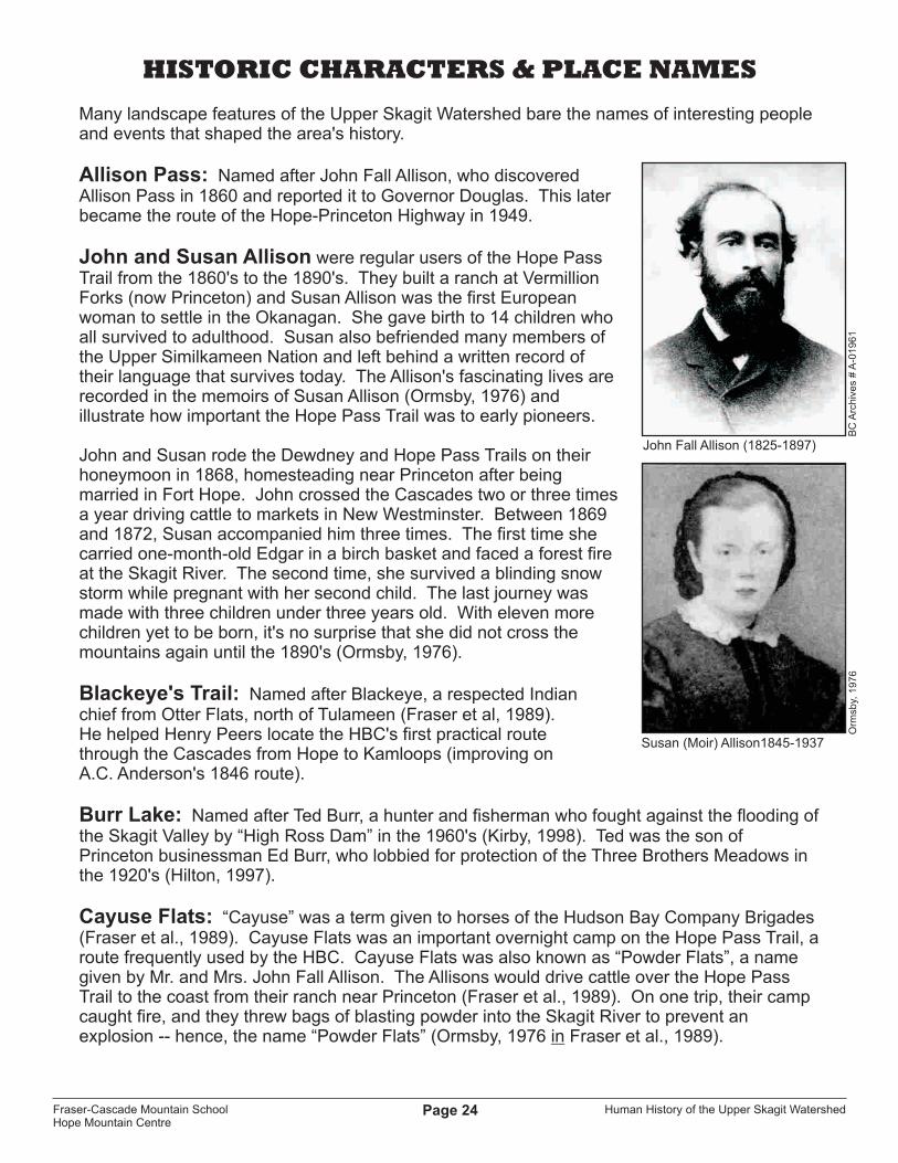
Allison Pass: Named after John Fall Allison, who discovered Allison Pass in 1860 and reported it to Governor Douglas. This later became the route of the Hope-Princeton Highway in 1949.
John and Susan Allison were regular users of the Hope Pass Trail from the 1860's to the 1890's. They built a ranch at Vermillion Forks (now Princeton) and Susan Allison was the first European woman to settle in the Okanagan. She gave birth to 14 children who all survived to adulthood. Susan also befriended many members of the Upper Similkameen Nation and left behind a written record of their language that survives today. The Allison's fascinating lives are recorded in the memoirs of Susan Allison (Ormsby, 1976) and illustrate how important the Hope Pass Trail was to early pioneers.
John and Susan rode the Dewdney and Hope Pass Trails on their honeymoon in 1868, homesteading near Princeton after being married in Fort Hope. John crossed the Cascades two or three times a year driving cattle to markets in New Westminster. Between 1869 and 1872, Susan accompanied him three times. The first time she carried one-month-old Edgar in a birch basket and faced a forest fire at the Skagit River. The second time, she survived a blinding snow storm while pregnant with her second child. The last journey was made with three children under three years old. With eleven more children yet to be born, it's no surprise that she did not cross the mountains again until the 1890's (Ormsby, 1976).
Blackeye's Trail: Named after Blackeye, a respected Indian chief from Otter Flats, north of Tulameen (Fraser et al, 1989). He helped Henry Peers locate the HBC's first practical route through the Cascades from Hope to Kamloops (improving on A.C. Anderson's 1846 route).
Burr Lake: Named after Ted Burr, a hunter and fisherman who fought against the flooding of the Skagit Valley by “High Ross Dam” in the 1960's (Kirby, 1998). Ted was the son of Princeton businessman Ed Burr, who lobbied for protection of the Three Brothers Meadows in the 1920's (Hilton, 1997).
Cayuse Flats: “Cayuse” was a term given to horses of the Hudson Bay Company Brigades (Fraser et al., 1989). Cayuse Flats was an important overnight camp on the Hope Pass Trail, a route frequently used by the HBC. Cayuse Flats was also known as “Powder Flats”, a name given by Mr. and Mrs. John Fall Allison. The Allisons would drive cattle over the Hope Pass Trail to the coast from their ranch near Princeton (Fraser et al., 1989). On one trip, their camp caught fire, and they threw bags of blasting powder into the Skagit River to prevent an explosion -- hence, the name “Powder Flats” (Ormsby, 1976 in Fraser et al., 1989).
John Fall Allison (1825-1897)
Susan (Moir) Allison1845-1937
Orm
sby,
19
76
BC
Arc
hiv
es
# A
-01
96
1
Fraser-Cascade Mountain SchoolHope Mountain Centre

Human History of the Upper Skagit WatershedPage 25
Coates Creek: Named after J.A. Coates, a geologist. His book, “Geology of the Manning Park Area”, is still the standard text on the subject. The book came out in 1974, six years after his death in a plane crash (Fraser et al., 1989).
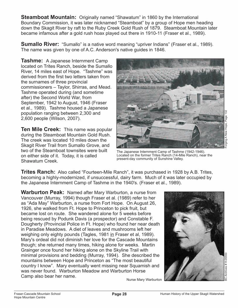
Fourteen-Mile Ranch: Later called “Trites Ranch”, it was an important stopover on the Dewdney Trail, located a reasonable day's horse ride (14 miles) east from Fort Hope. Johnston (1911) describes a “road house” there called “The Lake House”, where travelers could sleep or have a meal. The Fourteen-Mile Ranch was the homestead of Angus McLeod. Purchased in 1928 by A.B. Trites, it became a highly-modernized, if unsuccessful, dairy farm. Much of it was later occupied by the Japanese Internment Camp of Tashme in the 1940's (Walsh et al., 1984). It is known today as Sunshine Valley.
Grainger Creek: Named after Martin Allerdale Grainger, BC's Chief Forester from 1916-1920. Grainger was an avid backcountry horseman and authority on the Hope-Princeton area. He opposed grazing in the Three Brothers Meadows and lobbied the Grazing Commissioner in 1929 for park designation (Fraser et al., 1989). Grainger envisioned a park “as great as Banff or Yellowstone” protecting the Cascade Mountains as a “playground” for the Lower Mainland. He wrote letters, started petitions, and even led Vancouver newspaper reporters on tours through the high country (Murray, 1994). Grainger died in 1941, the same year that Manning Park was created. Sadly though, the new park was named after another Chief Forester named E.C. Manning who had also died that year, and Grainger's name faded into history in spite of his important contribution. Only “Grainger Creek” bears his name (a small tributary of the Skaist).
Grant Lake: Named after Captain John Marshall Grant, builder of the Royal Engineer's Road and the Hope Pass Trail. In 1860, Captain Grant designed Christ Church in Hope which remains today the oldest church on BC's mainland standing on its original foundation. Captain Grant Creek also bears his name.
Hilton Creek: Named after Joe Hilton, a well-known trapper and park ranger in the Manning Park area. Windy Joe Mountain in Manning Park is also named after him.
Holding Creek: Named after Dick Holding, a cowboy who ran cattle up Whipsaw Creek to Paradise Meadows each summer from 1948 until he retired in the 1960's. He worked for the Willis Ranch near Princeton (Hilton, 1997; Willis, 1998).
Hubbard Creek: Named after Carson Hubbard, a prospector and “moonshiner” from Virginia. He prospected in the Paradise Valley-Peers Creek area in the 1930's and 1940's (Hilton, 1997).
Manning Park: Named after Ernest C. Manning, Chief Forester of British Columbia from 1936 to 1941. Manning was born in Selwyn, Ontario, in 1890 and joined the BC Forest Service in 1918. He became a passionate advocate for sustained-yield forestry and believed trees should be re-planted after logging – a radical notion at the time. Manning also believed strongly in park creation and public enjoyment of the outdoors. He oversaw the creation of BC's first ski area at Mount Seymour, and helped to create some of BC's first provincial parks,
Martin Allerdale Grainger (1874-1941)
BC
Arc
hiv
es
# G
-08
66
9
Fraser-Cascade Mountain SchoolHope Mountain Centre

Human History of the Upper Skagit WatershedPage 26
including Little Qualicum Falls, Tweedsmuir, and Wells Gray. At that time, the BC Forest Service was responsible for parks. As Chief Forester, Manning put thousands of young men back to work in parks and forestry projects during the Great Depression and oversaw the improvement of timber harvesting practices. He was only 51 when he died in a plane crash in 1941. That year, E.C. Manning Provincial Park was created in his honour, centred around the Three Brothers Mountain Game Reserve (Fraser et al., 1989).
McColl Creek: Sergeant McColl of the Royal Engineers surveyed the Alexandra Bridge site near Spuzzum in 1861.
Mount Dewdney: Named after Edgar Dewdney (1835-1916), builder of the famous trail which bears his name.
Mount Hozomeen: Also spelled “Hozameen”, the mountain can be seen from many locations on either side of the Canada-US border. Hozomeen has a north and south peak, the tallest being the north peak at 2,459 m (8,066 ft). It towers over Ross Lake, in the Ross Lake National Recreation Area in Washington State. Hozomeen is mentioned often in the latter portions of Jack Kerouac’s 1958 novel “The Dharma Bums”, when the protagonist is stationed at a fire lookout on nearby Desolation Peak.
Mount Outram: Sir James Outram (1864-1925) was a British clergyman who became famous as a mountaineer in the Canadian Rockies. He made many first ascents, and there is a “Mount Outram” in Banff National Park named after him. He retired in Victoria, BC prior to his death in 1925 (Fraser et al., 1989).
Mowich Camp, Mowich Creek: From the Chinook word “Mowich”, meaning deer (Fraser et al., 1989).
Nicomen Lake, Nicomen Ridge: “Nicomen” is a native word meaning “near a small creek”, but it may have other meanings (Fraser et al., 1989).
Outram Lake: Also called “Beaver Lake”, it was an important stopover on the Dewdney Trail. The lake was buried by the Hope Slide in 1965.
Paradise Valley: Formerly known as the Garden of Eden (Harris, 1981 in Fraser et al, 1989), it may have been named after an early settler named Paradis.
Peers Creek: Named after Henry Newsham Peers, who established Fort Hope in 1848 and built the HBC Brigade Trail from Fort Hope to Otter Flats that same year.
Podunk Creek: This creek is located just north of the Cascade Recreation Area boundary and follows a section of the HBC Brigade Trail. The name “Podunk” comes from a famous prospector; Willard Albert “Podunk” Davis. Podunk came from Kentucky in
Ernest Charles Manning (1890-1941)
Willard Albert “Podunk” Davis.
BC
Pa
rks
“Rid
ing
th
e S
kylin
e”,
Mu
rra
y, 1
99
4
Fraser-Cascade Mountain SchoolHope Mountain Centre

Human History of the Upper Skagit WatershedPage 27
1890 (Murray, 1994) and prospected throughout the mountains between Hope and Princeton. Davis was described as being a tall, handsome man with a long beard, who made his own whiskey from potatoes. At the age of 67, he was as spry and agile as a mountain sheep. He is also remembered for helping to rescue Mary Warburton from starvation in Paradise Meadows in 1926 (Fraser et al., 1989; Murray, 1994).
Rhododendron Flats:As early as the 1860's, the bloom at Rhododendron Flats (in Manning Park) was already a famous sight to travelers on the Dewdney Trail (Ormsby, 1976). Pioneer Susan Allison described the blooms as “lovely” when she and her new husband (John Fall Allison, discoverer of Allison Pass) rode up the Dewdney Trail on their honeymoon in 1868. After being married in Fort Hope, they homesteaded near Princeton. Back then, the Allisons called the spot “Skagit Flats” (Ormsby, 1976).
Rhododendron Flats contains one of only two large stands of Pacific rhododendron found in B.C. The other is found nearby in Skagit Valley Provincial Park. A few smaller stands are dispersed across Southern BC, for example, in Chilliwack, Hope and south of Parksville on Vancouver Island, but they are found no farther north than Manning Park (Szczawinski 1962 in Fraser et al., 1989).
Roche River: An early name for the Similkameen River, after Lt. Richard Roche, RN, who headed the British survey of the International Boundary in the area in 1860 (Fraser et al., 1989).
Roach River Trail: An early name for the Skyline Trail (Fraser et al., 1989). This may be a misspelling of “Roche”, since the Skyline Trail connects the Skagit Valley to the “Roche River”, presently known as the Similkameen.
Ross Lake Reservoir: Named after James D. Ross, Seattle City Light's first superintendent. It was part of his grand design to build three dams on the U.S. side of the Skagit River to generate power for the City of Seattle. After building dams at Gorge Creek and Diablo Canyon, the Ross Dam was completed in 1949, creating the 35-kilometre-long Ross Lake Reservoir (Perry, 1981).
Shawatum Mountain: Known popularly as “Steamboat Mountain” from 1879 to 1911, but the name reverted to Shawatum after the Steamboat Gold Rush went bust in 1911. Shawatum was the name given in 1860 by the International Boundary Commission and its meaning is unknown (Fraser et al., 1989).
Sinnet Creek: Named after Corporal Charles Sinnet, a member of the Royal Engineers who settled in Princeton in 1860. He moved back to England in 1863.
Skagit River: The name "Skagit" is derived from the Upper Skagit First Nation's name for their language – "sqajit ucid". The original name for the people of this area is bastulekw, meaning “river people' (Bufo Inc., 1997).
Snass Creek: Snass is a native word for rain and was given by one of A.C. Anderson's native guides in 1846. Snass Mountain also bears this name (Fraser et al., 1989).
Fraser-Cascade Mountain SchoolHope Mountain Centre
Human History of the Upper Skagit WatershedPage 28
Steamboat Mountain: Originally named “Shawatum” in 1860 by the International Boundary Commission, it was later nicknamed “Steamboat” by a group of Hope men heading down the Skagit River by raft to the Ruby Creek Gold Rush of 1879. Steamboat Mountain later became infamous after a gold rush hoax played out there in 1910-11 (Fraser et al., 1989).
Sumallo River: “Sumallo” is a native word meaning “upriver Indians” (Fraser et al., 1989).The name was given by one of A.C. Anderson's native guides in 1846.
Tashme: A Japanese Internment Camp located on Trites Ranch, beside the Sumallo River, 14 miles east of Hope. “Tashme” was derived from the first two letters taken from the surnames of three provincial commissioners – Taylor, Shirras, and Mead. Tashme operated during (and sometime after) the Second World War, from September, 1942 to August, 1946 (Fraser et al., 1989). Tashme housed a Japanese population ranging between 2,300 and 2,600 people (Wilson, 2007).
Ten Mile Creek: This name was popular during the Steamboat Mountain Gold Rush. The creek was located 10 miles down the Skagit River Trail from Sumallo Grove, and two of the Steamboat townsites were built on either side of it. Today, it is called Shawatum Creek.
Trites Ranch: Also called “Fourteen-Mile Ranch”, it was purchased in 1928 by A.B. Trites, becoming a highly-modernized, if unsuccessful, dairy farm. Much of it was later occupied by the Japanese Internment Camp of Tashme in the 1940's. (Fraser et al., 1989).
Warburton Peak: Named after Mary Warburton, a nurse from Vancouver (Murray, 1994) though Fraser et al. (1989) refer to her as “Ada May” Warburton, a nurse from Fort Hope. On August 26, 1926, she walked from Ft. Hope to Princeton to pick fruit, but became lost on route. She wandered alone for 5 weeks before being rescued by Podunk Davis (a prospector) and Constable F. Dougherty (Provincial Police in Ft. Hope) who found her near death in Paradise Meadows. A diet of leaves and mushrooms left her weighing only eighty pounds (Tagles, 1981 in Fraser et al, 1989). Mary's ordeal did not diminish her love for the Cascade Mountains though; she returned many times, hiking alone for weeks. Martin Grainger once found her hiking alone on the Skyline Trail with minimal provisions and bedding (Murray, 1994). She described themountains between Hope and Princeton as “The most beautifulcountry I know”. Mary eventually went missing near Squamish and was never found. Warburton Meadow and Warburton Horse Camp also bear her name.
The Japanese Internment Camp of Tashme (1942-1946). Located on the former Trites Ranch (14-Mile Ranch), near the present-day community of Sunshine Valley.
Nurse Mary Warburton BC
Arc
hiv
es
# H
-05
55
0F
org
ing
A N
ew
Ho
pe
, P
ag
e 1
32
Fraser-Cascade Mountain SchoolHope Mountain Centre

Human History of the Upper Skagit WatershedPage 29
UPPER SKAGIT BIBLIOGRAPHY
Bufo Inc. 1997. Interpretive Theme Document for Skagit Valley Provincial Park. Victoria: Ministry of Environment Lands and Parks: (unpublished).
Fraser, D., D. Farr, L. Ramsay, and N. Turner. 1989. Natural and Human History Theme Document for Manning Provincial Park. Victoria: Ministry of Environment, Lands and Parks: 255p.
Harris, R.C. and H. R. Hatfield. 1982. Old Pack Trails in the Cascade Wilderness. Summerland: Okanagan Similkameen Parks Society: 35p.
Johnston, E.H.L. 1911. “Going Into Steamboat” In: B.C. Magazine, Vol. 7, No. 7, July, 1911.
Lyons, C. 1991. “Tough Going”. In: Manning Park Memories - Reflections of the Past. Victoria: Ministry of Lands and Parks: p. 42.
McCombs, A. and W.W. Chittenden. 1990. The Fraser Valley Challenge. Harrison Hot Springs: Treeline Publishing: 176p.
Murray, P. 1994. Riding the Skyline. Victoria: Horsdal & Schubart: 117p.
Ormsby, M.A. 1976. A Pioneer Gentlewoman in British Columbia: The Recollections of Susan Allison. Vancouver: UBC Press: p. x-li.
Patterson, T.W. 1977. “Steamboat Mountain – Tale of Three Cities”. In: British Columbia, the Pioneer Years.
Perry, T. 1981. A Citizen's Guide to the Skagit Valley. Vancouver: ROSS Committee: 85p.
Ramsey, B. 1963. “Steamboat Mountain”. In: Ghost Towns of BC
Ross, G. 1991. “High Times”. In: Manning Park Memories - Reflections of the Past. Victoria: Ministry of Lands and Parks: p. 49-52.
Sto:lo Nation (Keith Thor Carlson, Albert “Sonny” McHalsie). 2001. A Sto:lo Coast Salish Historical Atlas. Vancouver: Douglas & McIntyre: 208p. ISBN: 1-55054-812-3
Walsh, R., S. McLachlan, F. Thomas and E. Hopper. 1984. Forging a New Hope: Struggles and Dreams, 1848-1948. Hope: Hope & District Historical Society: 457p.
PERSONAL COMMUNICATIONS:
Hilton, Jim. 1997. Princeton resident, retired park ranger (son of Joe Hilton). Kirby, Shirley. 1998. Princeton resident, daughter of Ted Burr.Kolcun, Clarence. 2007. Hope Resident, former employee of G&F Logging.Rose, John. 1997. Area Supervisor, Manning Provincial Park.Schaepe, Dave. 2008. Sto:lo archaeologist, stationed at Sto:lo Nation office in Chilliwack.Steeves, Al. 2007. Hope resident, former employee of Decco-Walton.Willis, Abe. 1998. Princeton resident, acquaintance of Dick Holding.Wilson, Inge. 2007. Hope resident and manager of the Hope Museum & Visitor Centre.
o
Fraser-Cascade Mountain SchoolHope Mountain Centre