humanizing academia in the machine age: lewis mumford’s ... · humanizing academia in the machine...
TRANSCRIPT
Humanizing Academia in the Machine Age: Lewis Mumford’s Influence on
Circulation and Parking Planning at Stanford
by
Paul Yih
for
Art History 278: Seminar on the American Campus
Professor Paul V. Turner
December 15, 1999

2
Table of Contents
I. Introduction: Chaos in the Machine Age.................................................................... 1 II. Olmsted’s Plan and The Garden City........................................................................ 3 III. The Peripheral Circulation System .......................................................................... 4 IV. The Pedestrian Zone ................................................................................................ 7 V. Solutions for Parking ................................................................................................ 9 VI. Conclusion: Mumford’s Legacy Endures.............................................................. 12 VII. Acknowledgements .............................................................................................. 14 VIII. Bibliography ....................................................................................................... 15 IX. List of Figures........................................................................................................ 17

1
I. Introduction: Chaos in the Machine Age
“The new American religion is the religion of the automobile; the new aim of regional
planning is to open every area of the metropolis to the motorcar, giving it a ‘sacred right
to go anywhere, halt anywhere, and remain anywhere as long as its owner chooses.’”
(Lewis Mumford 480)
Lewis Mumford’s observation on the prevalence of automobiles in cities during the
Post-War period aptly describes the situation on the campus of Stanford University in the
1940s. A growing university population and regular use of the private motorcar by
faculty, staff, and students as means of transportation within and to and from campus
created a chaotic mix of cars, people, and buildings on campus. Few restrictions existed
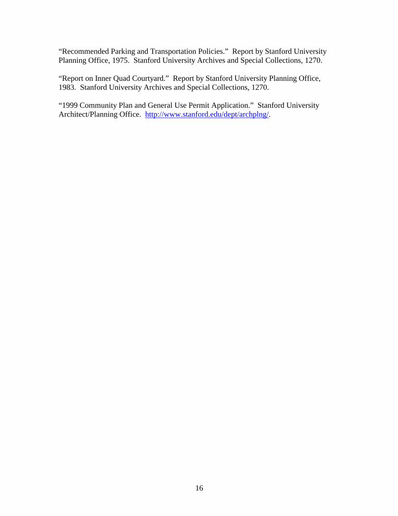
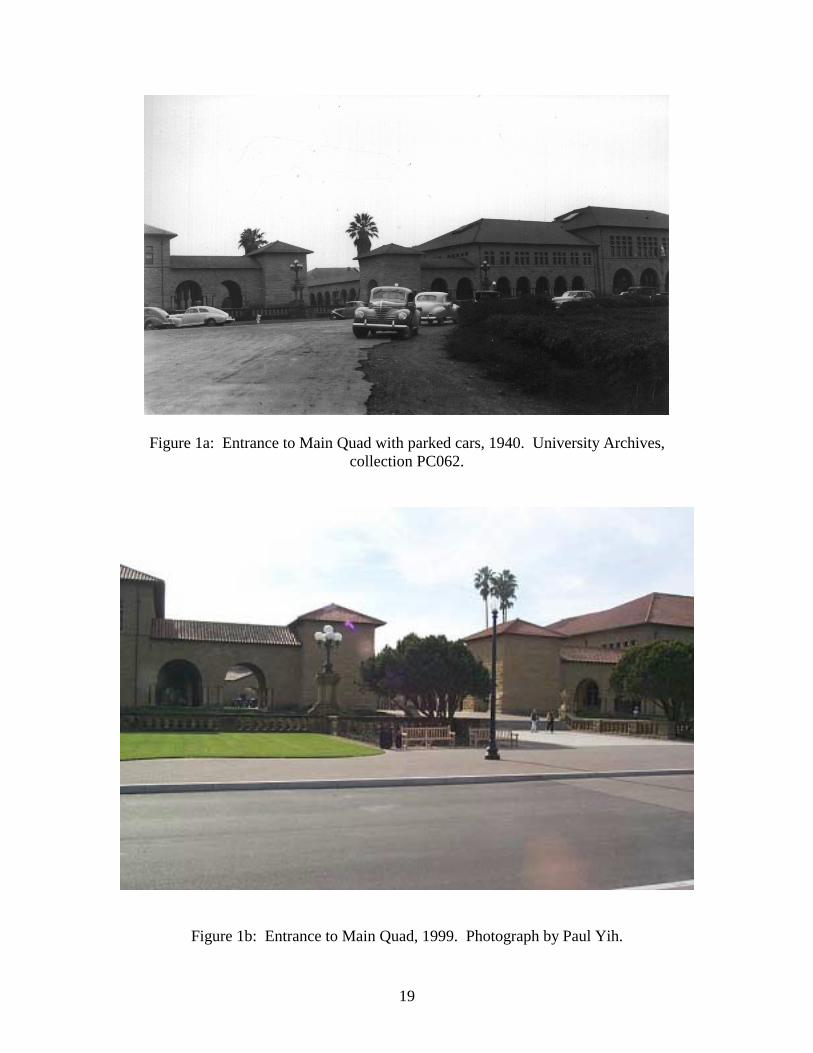
on where motorists could operate or park their vehicles (Figures 1a through 3a). By
permitting the free reign of motor vehicles on campus, the University’s approach
paralleled the trend in urban planning that Mumford called, “a curious compulsion to
serve the machine rather than to respond to human needs” (The Highway and the City
235). Mumford cited the invasion of cities by highways, bridges, tunnels, and parking
lots as a manifestation of the widespread belief that mechanical progress should proceed
at all cost. He insisted that such progress came at a great cost, however, to the quality of
life and the environment. More than an urban planner and architectural critic, Mumford
was also a writer and a thinker on culture, civilization, society, and technology. Contrary
to popular belief, Mumford was not against the automobile; he merely recognized that
society’s obsession with this new technology was taking its toll on the health of the city

2
and would eventually destroy any environment which it was allowed to overrun
unchecked—including the university campus.
Mumford’s professional relationship with Stanford University lasted only a few short
years during the Forties, first from 1942 to 1944 as a visiting professor in the School of
Humanities, then from 1946 to 1947 when president Donald Tressider (1944 to1948)
commissioned him to study future land use and development at Stanford (Stanford
University 82). At Mumford’s recommendation, Tressider established the University
Planning Office in 1945—the first of its kind—and appointed San Francisco architect and
Yosemite National Park planner, Eldridge T. Spencer, as its director (Donald Tressider
75). Defining the mission of the experimental Planning Office, Spencer wrote in an early
report: “It is strongly recommended that the University should no longer consider
temporary measures for the solution of its problems.” By “temporary” he meant, “hastily
planned from the point of view of a particular requirement without consideration of the
University as a whole” (“A Coordinated Plan,” 1947). For the first time, the University
began to view issues of circulation and land use for parking in conjunction with
architectural planning and the overall function of the University as an academic
institution.
Working with Tressider and the Planning Office, Mumford initiated an enduring plan
to control the rampant intrusion of automobiles into the heart of the University campus
and gradually return its use to the people. Relevant excerpts from “Campus Planning,”
his 1947 report to the University, are listed here:
Buildings should, in future operations, be conceived as a concentrated urban
group in a permanent rural setting. To make this concentration possible, the road
plan should be revamped, and every tendency toward scattering and suburban

3
isolation should be resisted as ruinous to the functions of the University. [The
three objectives of re-planning the road system are to] create a unified university
quarter, free from the invasion of traffic, with the land re-assembled in parcels
that will give the maximum use to university functions proper…give access to
every part of the University without the disturbance of unnecessary
traffic…differentiate the traffic function from the parking function.
The current circulation and parking system at Stanford bears the marks of Mumford’s
hand: the pedestrian zone, Campus Drive, and the separation of circulation and parking
functions can be attributed to his suggestions. More significantly, Mumford’s influence
extends beyond the physical campus; his ideas have been ingrained in the University’s
planning philosophy to the present day. A comparison between images of the Main
Quad today and those taken in 1940 reveals the striking transformation in character the
campus has undergone since Lewis Mumford’s days at Stanford (Figures 1b through 3b).
II. Olmsted’s Plan and The Garden City
“Compactness, uniformity of height, internal flexibility, and adaptation to climate were
Olmsted’s guiding principles in the design of Stanford… his design showed foresight and
originality of the highest order.” (Lewis Mumford in “Architecture and the University,”
1947)
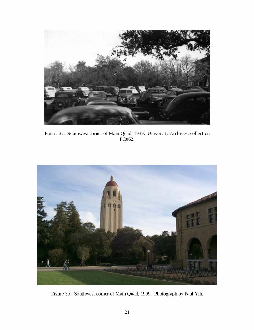
In “Campus Planning,” Mumford regarded Frederick Olmsted’s original concept of
the Stanford campus (Figure 4) as a paragon of “compactness, concentration, and unity.”
He called for a return to Olmsted’s values—the “concentrated urban grouping” of
buildings—and at the same time, urged the University to preserve its “rural setting,”

4
particularly as protection against the Peninsula’s encroaching suburban sprawl. This
emphasis on the combination of urban and rural characteristics suggests that Ebenezer
Howard’s garden city idea heavily influenced Mumford’s views on planning at Stanford.
Indeed, the premise of the garden city is to surround an active urban center, limited by
population, with an inviolable “green belt” of farmland or parkland, thus avoiding both
congestion and urban sprawl (Lewis Mumford 85). Mumford’s overall plan for Stanford
and many of its details, such as his frequent reference to permanent “green belts” around
University lands, reflect the garden city idea of urban planning.
III. The Peripheral Circulation System
“The basis of the University’s circulation should be a system of concentric roads… The
circulation proposed consists of peripheral roads forming a rectangle to service the
academic areas of the campus.” (“A Coordinated Plan,” 1947)
According to Spencer, “the University’s system of peripheral circulation was
anticipated in the Olmsted plan” (“Development of Circulation,” 1958). The peripheral
road pattern is readily apparent in the drawing of Olmsted’s plan (Figure 4), particularly
in the arms of the “Y” that reach toward either end of the rectangular academic area and
the corresponding curved road that connects the diagonally aligned residence areas.
Placing the academic buildings at the center of the campus and arranging faculty and
student housing around them, Olmsted’s plan was best served by a circulation pattern that
surrounds the central campus area rather than one that goes through it. Logically,
Mumford proposed that the main road system should follow the peripheral pattern. The

5
peripheral road system fits in with Mumford’s interpretation of the garden city idea:
“Arterial roads, ideally speaking, should engirdle the metropolitan area and define where
its greenbelt begins” (The Highway and the City, 249). At Stanford, such a road system
would define the boundaries of the academic and residential area. A 1956 diagram by
Spencer (Figure 5) shows how the peripheral road bounds the distinct university
functions of academics, housing, and athletics within a limited radius from the campus
center.
Another source of inspiration for the peripheral circulation system may have been the
quadrangular form of the Inner Quad and the pedestrian circulation patterns through its
arcades (Figure 6). A study of pedestrian circulation in the courtyard reveals definite
patterns along the arcaded periphery of the rectangular courtyard, as well as major and
minor paths crossing the interior of the courtyard (Figure 7). Spencer’s 1958 report,
“Development of Circulation and Parking Study, depicts the campus circulation pattern in
exactly the same context: major circulation routes lie along the periphery of a rectangle
while interior routes bisect the core of the rectangle (see Diagrams ‘A’ and ‘B’ in Figure
8).
Correspondence between Mumford and Tressider indicates that Mumford traveled to
Stanford to meet with Spencer at least once in February of 1947 (“Letter to Tressider,”
1947). Spencer and Mumford discussed a wide range of campus planning issues from
architectural style to dining halls, but Mumford was especially interested in the topic of
circulation: “the University’s circulation was the subject of most of Mumford’s
discussions” (notes from Spencer’s meeting with Mumford in “A Coordinated Plan,”

6
1947). In 1949, Spencer materialized Mumford’s ideas for circulation in a three-stage
plan. The plan called for the construction of three concentric road systems:
1. An inner loop around the core of campus would service the academic buildings
and residences.
2. An outer loop would service remaining residences and facilities.
3. A perimeter loop would service the adjacent community and prevent local traffic
from using campus streets as throughways.
Construction was to proceed in three stages (Figure 9 shows the existing circulation
system in 1949). Stage one included the eastern and southern portion of the inner loop
(Figure 10). Known as Campus Drive East today, most of it was completed in the 1950s.
The actual alignment, however, differed from Spencer’s initial diagram (see Figure 14).
Stage two included the western portion of the inner loop at the medical center (Figure
11). This section of Campus Drive was finished in 1961. Stage three, shown in Figure
12, was the outer loop, the Campus Drive extensions on the east and west sides to
Foothill Road (now known as Junipero Serra Boulevard). The eastern extension was
altered from the plan to align with Mayfield Avenue and renamed Campus Drive East.
The original Campus Drive to Lomita Drive was renamed Mayfield Avenue (see Figure
15). The Campus Drive West extension was not completed until 1982, although it was
approved for construction as early as 1968. The perimeter system (Figure 13) was to link
El Camino Real with Foothill Road (now Junipero Serra Boulevard) on either side of the
campus via Page Mill Road to the east and Sand Hill Road to the west. The recent
opening (1999) of the Sand Hill Road extension to El Camino Real completes the missing
link.

7
IV. The Pedestrian Zone
“No city can solve its transportation problem if it neglects the greatest self-propelling
vehicle of all: the pedestrian.” (The Highway and the City 119)
The inner loop, by providing reasonably close vehicular access to all points in the core
campus area (Main Quad, Near West, and Near East Region) short of direct access to
academic buildings, permitted a return to the “walking campus” that Mumford
envisioned. In the last fifty years, more and more of the central part of campus has been
designated as a pedestrian zone. Early on, Lasuen and Lomita Streets near the Main
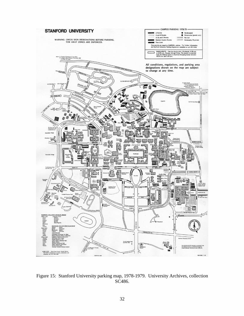
Quad were closed to vehicular traffic (Figure 14). They are now called Lasuen and
Lomita Mall. Subsequently, sections of Panama and Galvez Streets were turned into
pedestrian malls (Figure 15). Serra Street from Galvez Street to Campus Drive West has
been gradually transformed from a public through street to a parking area. Mumford
specifically mentioned in the 1947 report that the “use of Serra Street for parking should
be reserved for special occaisions.” In the 1980s, the aforementioned section of Serra
Street was completely closed to vehicular traffic except for the Marguerite shuttle bus. In
The Highway and the City, Mumford cites the example of Radburn, New Jersey, a town
planned exclusively for pedestrian living by the creation of “superblocks,” entire
neighborhoods fully insulated from automobile traffic (242). Closing University streets
to traffic has in effect turned the central campus area into a “superblock.”
The 1999-2000 Service and Delivery Map of Figure 16 clearly marks the extent of the
pedestrian zone by the shaded area. Although the pedestrian zone is closed to general

8
traffic, it must remain accessible to service, delivery, and emergency vehicles, as well as
vehicles carrying special permits. Mumford had an interesting solution to the problem of
delivering supplies to buildings within the pedestrian zone: he proposed that all goods
and supplies be unloaded at a designated transfer station and conveyed to their final
destinations by electric truck (“Campus Planning,” 1947). Somewhat inefficient,
Mumford’s idea was never implemented, but electric carts are commonly used today for
light duty work and internal transport.
Perhaps the most significant claim of a campus area for pedestrian use occurred in the
mid-1980s with the renovation of the Inner Quad courtyard. Prior to the renovation,
many people were dissatisfied with the poor condition of the courtyard pavement and the
resemblance of its concrete cross-axes to a freeway (“Report on Inner Quad,” 1983). In
fact, U.S. Postal Service vehicles and service vehicles frequently traversed the courtyard,
further deteriorating its historic character even as many areas outside the Quad were
being closed to traffic. The cross-axes were removed during the renovation, since they
were not in character with Olmsted’s original design, but there was still considerable
disagreement over the new paving material or whether the courtyard should simply be
planted with grass. Naturally, the disagreement gave rise to discussion on the symbolic
meaning of the Quad and how it should be used. The consensus was that the Quad is not
an activity center or gathering place—there are many other people-oriented spaces on
campus for the purpose of social interaction—but a place of quiet reflection, “dignified,
serious, and contemplative” (“A Coordinated Plan,” 1947). The Inner Quad courtyard
should be a place to “stop, ponder pause, sit, chat, and relax” (“Report on Inner Quad,”
1983). It was a place to walk but not hurry through, and more than any other location on

9
Stanford’s campus, a place for the pedestrian rather than the automobile. An important
decision that came out of the debate signified the ultimate victory for the pedestrian: all
vehicular traffic would be banned from the Inner Quad courtyard. During his days at
Stanford, Mumford made clear his admiration of the Inner Quad and urged preservation
for its historical and aesthetic value: “All in all, the original quadrangle at Stanford was a
miracle of coherent and expressive architectural form: one of the finest examples of
corporate building in the nineteenth century” (“Architecture and the University,” 1947).
By providing refuge from the chaos of the Machine Age we have returned the Inner Quad
to what many, including Mumford, believed was its sacred status as the “symbolic heart”
of the university.
V. Solutions for Parking
“The distribution of limited parking resources is a political, economic, and emotional
issue. At best, we may be able to achieve a relatively uniform distribution of
unhappiness.” (“Recommended Parking and Transportation Policies,” 1975)
In his 1947 report to the University, Mumford realized the need to incorporate parking
facilities into circulation and land use planning. He wrote as a key objective: “the traffic
function should be differentiated from the parking function” (“Campus Planning,” 1947).
In other words, automobiles should be stored in dedicated parking lots, not on the street.
The University’s policy of developing off-street parking and limiting curbside parking
reflects Mumford’s early recommendation. The report describes a system of minor
access roads branching off from the main circulation route and terminating into parking

10
areas. Such a system would provide close access to the inner campus area yet maintain
the coherence of the pedestrian zone. Mumford also encouraged the use of landscaping
to screen parking facilities and to reduce their contribution to visual chaos on the campus.
His overall goal for parking planning was to maintain a “quiet and aesthetic order” which
he felt was crucial to the University environment (“Campus Planning,” 1947).
Spencer’s 1958 “Development of Circulation and Parking Study” stressed, in
agreement with Mumford’s view, that motor vehicles were deleterious to the university
environment and their movement and storage should be controlled. Although Spencer
admitted that many faculty, staff, and off-campus students had no other choice but to
drive to campus, the free use of automobiles on campus “drains revenue and confuses
university function.” Statistics from 1957 indicated that there were about 8700 registered
cars on campus, and at an average value of $1500 per car, the total value of privately
owned vehicles on campus was $13 million. Spencer estimated that the university had to
invest an equal amount in land, road construction and maintenance, parking facilities,
curbs, and gutters. He questioned whether such a large amount of university resources
should be used to accommodate private vehicles, or if the money could be put toward
other alternatives such as subsidizing public transportation.
As an urban critic, Mumford voiced similar sentiments, but on a grander scale, about
the $26 billion cost of the 1956 Interstate Highway Act and the comparable expense of
extending these highways into cities (The Highway and the City 244). Spencer notes in
the report, “The requirements for circulation of vehicular traffic on the campus have
changed, and have always differed considerably from the more immediate solutions
typical of urban communities.” Perhaps he observed, as Mumford had, how cities
11
overreacted to congestion by initiating a frenzy of road building. His objectives for a
near-term parking plan reflected a distinctly different approach:
1. Decrease the use of campus roads by adjoining communities.
2. Decrease the visual chaos of vehicles on campus.
3. Increase circulation efficiency.
4. Channel money directly into education.
Spencer’s proposals to meet these objectives set the stage for Stanford’s current parking
policies, particularly in the type of parking facilities being built and the fee-based
distribution of parking privileges:
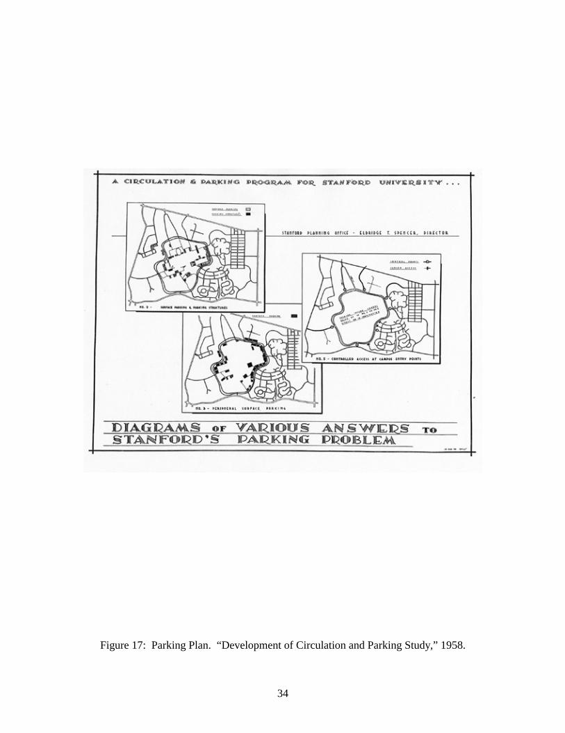
1. Restrict automobile ownership by resident students.
2. Utilize surface parking and parking structures within the loop road (Figure 17,
Plate 2).
3. Create peripheral surface parking (Figure 17, Plate 3).
4. Institute fee-supported parking ($30 per year).
5. Restrict access to campus at entry points (Figure 17, Plate 5).
Later reports, such as the 1965 “Parking Master Plan” sought to address both near-
term and long-term parking issues in light of the University’s rapid population growth,
facilities expansion, and diminishing amount of land available for parking. Proposals
ranged from the construction of a super underground structure, perhaps beneath the Oval,
to large remote lots served by transit service. The preferred approach through the years,
however, has been to turn unused campus land into permanent lots much as Mumford
originally proposed. The “Master Plan” conceded that if growth were to continue at the
present rate, meeting long-term parking demands would require far more drastic
12
measures. Heeding Mumford’s warning to plan with flexibility, it suggested an open-
ended approach to planning since future transportation systems might be very different:
“What kind of vehicles? How big? Atomic fuel? Air-borne?”
VI. Conclusion: Mumford’s Legacy Endures
Mumford’s influence on the direction of transportation planning is perhaps most
evident in the following excerpts from the University’s 1999 “Community Plan and
General Use Permit Application” circulation policies:
Maintain Stanford’s tradition of providing academic and residential land uses in
close proximity to one another to reduce commute distances and automobile
dependency.
Continue to apply campus design concepts and site development standards that
facilitate pedestrian, bicycle, and transit use.
Encourage walking and bicycling by maintaining the campus system of pedestrian
pathways and bikeways that connect places of living and work.
The concentration of University facilities and the elimination of vehicular traffic in the
central campus area are exactly what Mumford emphasized in his 1947 report to
Stanford. The current parking and transportation philosophy conforms to Mumford’s
ideas fifty years ago: pedestrians and bicycles have first priority, mass transit has second
priority, and the private motor vehicle has last priority. Mumford, Spencer, and his
successors in the Planning Office can be credited with reversing the prevailing mindset of
the times that the needs of the automobile supersede human needs. Instead, meeting
people’s needs for a safe, well designed walking environment and convenient, affordable
transportation systems through innovative programs (such as the Clean Air Rewards

13
Program, carpool and vanpool services, the Marguerite shuttle, and extensive bicycle
facilities) has become of paramount importance. Just as it did fifty years ago by
establishing the first Planning Office of its kind, Stanford has taken a leadership role in
developing transportation policies appropriate to modern concerns of traffic congestion,
energy conservation, and environmental pollution.

14
VII. Acknowledgements
Special thanks to Margaret Kimball, Stanford University archivist, for her assistance
in procuring the old photographs of campus.
15
VIII. Bibliography
Joncas, Richard, David J. Neuman, and Paul V. Turner. Stanford University. New York, NY: Princeton Architectural Press, 1999. Kiester, Edwin, Jr. Donald Tressider. Stanford, CA: Stanford Historical Society, 1992. Miller, Donald L. Lewis Mumford, A Life. New York, NY: Weidenfeld & Nicolson, 1989. Mumford, Lewis. The Highway and the City. New York, NY: The New American Library, 1963. “A Coordinated Plan for the University.” Report by Stanford University Planning Office, 1947. Stanford University Archives and Special Collections, SC486, 90-052 Box 1. “Campus Planning.” Report by Lewis Mumford submitted to Stanford University Planning Office, 6 March 1947. Stanford University Archives and Special Collections, SC151, Box 15. “Memorandum on Planning II.” Report by Lewis Mumford submitted to Stanford University Planning Office, 6 March 1947. Stanford University Archives and Special Collections, SC151, Box 15. “Letter to Donald Tressider.” Letter from Lewis Mumford, 26 May 1947. Stanford University Archives and Special Collections, SC151, Box 15. “Architecture and the University.” Article by Lewis Mumford submitted to Donald Tressider, 26 May 1947. Stanford University Archives and Special Collections, SC151, Box 15. “Planning at Stanford.” Report by Stanford University Planning Office, 1952. Stanford University Archives and Special Collections, SC486, 90-052 Box 2. “Report on Master Plan for Campus Land Use.” Report by Stanford University Planning Office, 1956. Stanford University Archives and Special Collections, SC486, 88-093 Box 2. “Development of Circulation and Parking Study.” Report by Stanford University Planning Office, 1958. Stanford University Archives and Special Collections, 1270. “Parking Master Plan.” Report by Stanford University Planning Office, 1965. Stanford University Archives and Special Collections, SC486, 88-115 Box 1.
16
“Recommended Parking and Transportation Policies.” Report by Stanford University Planning Office, 1975. Stanford University Archives and Special Collections, 1270. “Report on Inner Quad Courtyard.” Report by Stanford University Planning Office, 1983. Stanford University Archives and Special Collections, 1270. “1999 Community Plan and General Use Permit Application.” Stanford University Architect/Planning Office. http://www.stanford.edu/dept/archplng/.

17
IX. List of Figures
Figure 1a: Main Quad with parked cars, 1940. University Archives and Special Collections, PC062 Box 2 Folder 26. Figure 1b: Main Quad with parked cars, 1999. Photograph by Paul Yih. Figure 2a: Jordan Hall with parked cars, 1941. University Archives and Special Collections, PC062 Box 2 Folder 12. Figure 2b: Jordan Hall, 1999. Photograph by Paul Yih. Figure 3a: Southwest corner of Main Quad, 1940. University Archives and Special Collections, PC062 Box 2 Folder 80. Figure 3b: Southwest corner of Main Quad, 1999. Photograph by Paul Yih. Figure 4: Olmsted’s original plan for Stanford University. University Archives and Special Collections. Figure 5: Peripheral Road System. “Report on Master Plan.” Figure 6: Inner Quad arcades. Photograph by Paul Yih. Figure 7: Inner Quad circulation patterns. “Report on Inner Quad.” Figure 8: Circulation plan for Stanford University. “Development of Circulation and Parking Study.” Figure 9: Existing traffic circulation. University Archives and Special Collections, SC486, 90-052 Box 1. Figure 10: Traffic circulation plan, stage 1. University Archives and Special Collections, SC486, 90-052 Box 1. Figure 11: Traffic circulation plan, stage 2. University Archives and Special Collections, SC486, 90-052 Box 1. Figure 12: Traffic circulation plan, stage 3. University Archives and Special Collections, SC486, 90-052 Box 1. Figure 13: Perimeter circulation system. “Development of Circulation and Parking Study.”

18
Figure 14: Stanford University parking map, 1968-1969. University Archives and Special Collections, SC486, 90-052 Box 1. Figure 15: Stanford University parking map, 1978-1979. University Archives and Special Collections, SC486, 90-052 Box 1. Figure 16: Stanford University Service and Delivery Map, 1999-2000. Stanford University Parking and Transportation Office. Figure 17: Parking Plan. “Development of Circulation and Parking Study.”
19
Figure 1a: Entrance to Main Quad with parked cars, 1940. University Archives, collection PC062.
Figure 1b: Entrance to Main Quad, 1999. Photograph by Paul Yih.

20
Figure 2a: Jordan Hall with parked cars, 1941. University Archives, collection PC062.
Figure 2b: Jordan Hall, 1999. Photograph by Paul Yih.
21
Figure 3a: Southwest corner of Main Quad, 1939. University Archives, collection PC062.
Figure 3b: Southwest corner of Main Quad, 1999. Photograph by Paul Yih.
22
Figure 4: Olmsted’s original plan for Stanford University. University Archives, collection SC486.

23
Figure 5: Peripheral Road System. “Report on Master Plan,” 1956.

24
Figure 6: Inner Quad arcade, 1999. Photograph by Paul Yih.
Figure 7: Inner Quad circulation patterns. “Report on Inner Quad,” 1983.

25
Figure 8: Circulation plan for Stanford University. “Development of Circulation and Parking Study,” 1958.

26
Figure 9: Existing traffic circulation, 1949. University Archives, collection SC486.

27
Figure 10: Traffic circulation plan, stage 1. University Archives, collection SC486.

28
Figure 11: Traffic circulation plan, stage 2. University Archives, collection SC486.

29
Figure 12: Traffic circulation plan, stage 3. University Archives, collection SC486.

30
Figure 13: Perimeter circulation system. “Development of Circulation and Parking Study,” 1958.

31
Figure 14: Stanford University parking map, 1968-1969. University Archives, collection SC486.
32
Figure 15: Stanford University parking map, 1978-1979. University Archives, collection SC486.

33
Figure 16: Stanford University Service and Delivery Map, 1999-2000. Stanford University Parking and Transportation Office.
34
Figure 17: Parking Plan. “Development of Circulation and Parking Study,” 1958.